Embed Size (px)
Citation preview
0361-0128/11/3973/915-5 915
Geology and Mineral Deposits of the Hauraki GoldfieldThe five papers that follow describe diverse aspects of ep-
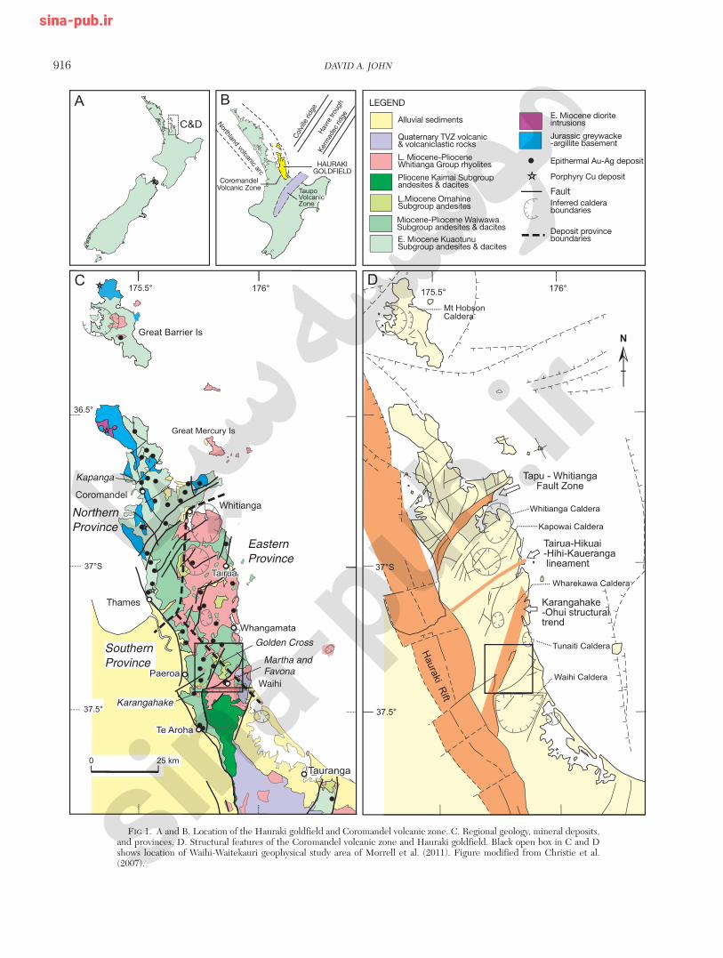
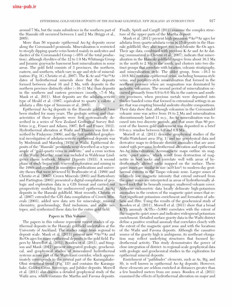
ithermal gold-silver deposits and genetically related hy-drothermal systems in the Hauraki goldfield on the Coro-mandel peninsula of the North Island of New Zealand (Fig.1). The Hauraki goldfield contains more than 50 Miocene andPliocene epithermal Au-Ag deposits and several porphyryCu-Au-Mo occurrences in a 200-km-long by 40-km-widenorth-south–trending belt (Fig. 1C; Christie et al., 2007).Production from these deposits between 1862 and 2009 to-taled approx. 335,000 kg (10.8 Moz) of Au and 1.6 million kg(51.4 Moz) of Ag (Mauk et al., 2011). The epithermal depositsare related to subaerial hydrothermal systems hosted in rocksof the early Miocene to late Pliocene (~18–1.9 Ma) Coro-mandel volcanic zone (Skinner, 1986).
Placer gold was first discovered near Coromandel townshipin 1852, but because of the small size of these placers, littlemining activity occurred until the discovery of Au-bearingquartz veins in 1861 at the site of the Kapanga mine (Fig. 1C).Prospecting elsewhere on the Coromandel peninsula resultedin the opening of mines at Thames in 1865, Karangahake in1875, and Waihi (Martha) in 1878. The major period of goldmining ended with the closure of the underground Marthamine at Waihi in 1952. Total production during this periodwas more than 250,000 kg (8.0 Moz) of Au and 1,100,000 kg(35.3 Moz) of Ag (Christie et al., 2007). Higher gold prices inthe 1980s led to renewed exploration, and the recent phase ofgold mining began in 1988 with opening of the Martha open-pit mine at Waihi. This was followed by a combined open-pitand underground operation at Golden Cross from 1991 to1998 and discovery of the Favona deposit, 1.5 km from theMartha open pit, which opened as an underground mine in2006. Mining continues today at the Martha mine, and theTrio deposit, which lies between the Martha and Favonamines, is being developed through underground workings ex-tending from the Favona mine. The Martha mine is by far thelargest producer in the Hauraki goldfield, with total produc-tion through 2009 of ~220,000 kg (7.1 Moz) of Au and1,430,000 kg (46 Moz) of Ag (Newmont Waihi Gold Limited,2010), which accounts for approximately 66 percent of the
total Au and 89 percent of the total Ag production of the Hau-raki goldfield. Other major past producers were the Thames,Golden Cross, and Karangahake mines.
The Coromandel peninsula is composed of Miocene andPliocene subaerial volcanic rocks and volcaniclastic depositsof the Coromandel volcanic zone that unconformably overlieLate Jurassic graywacke and argillite basement (Fig. 1C;Skinner, 1986; Christie et al., 2007). Rocks of the Coroman-del volcanic zone merge with and are overlain by Quaternaryvolcanic deposits of the Taupo volcanic zone at the southernend of the Coromandel peninsula. The Coromandel volcaniczone is a subduction-related magmatic arc whose eruptiveproducts are medium-K and calc-alkaline with compositionsthat range from basaltic andesite to rhyolite. The main orehosts are basaltic andesite, andesite, and dacite units in the 18to 2.5 Ma Coromandel Group (Booden et al., 2011). Theexact origin of the Coromandel volcanic zone is controversial.Mauk et al. (2011) summarize available evidence and inter-pretations and suggest that the Coromandel volcanic zonerepresents products of both the Northland and Colville arcsand that reorganization of these arcs may have occurred atabout 10 Ma, just prior to a shift from andesite-dacite to bi-modal andesite-rhyolite volcanism in the Coromandel vol-canic zone. The active Taupo volcanic zone is at the southwestend of the Tonga-Kermadec-Taupo volcanic zone arc (Fig.1B).
The Coromandel volcanic zone is cut by north-northwest–and north-northeast– to east-northeast–striking faults (Fig.1C). Most northeast- and east-northeast–striking faults aredownthrown to the south, thereby lowering the Jurassic base-ment to the south, thickening the volcanic sequence towardthe Taupo volcanic zone, and tilting these volcanic rocks gen-tly eastward. Several major structural corridors cross thepeninsula and may reflect major basement structures (Fig.1D). Morrell et al. (2011) describe geophysical features in theWaihi-Waitekauri area in the central part of the Karangahake-Ohui structural trend that may have localized numerous lateMiocene hydrothermal systems.
The Coromandel peninsula is bounded to the west by theHauraki rift (Fig. 1D), in which the Miocene to Pliocene vol-canic rocks are downthrown by 1 to 4 km (Hochstein and Bal-lance, 1993). The initiation of the Hauraki rift may have been
Epithermal Gold-Silver Deposits of the Hauraki Goldfield, New Zealand: An Introduction
DAVID A. JOHN†
U.S. Geological Survey, 345 Middlefield Road, Menlo Park, California 94025
† E-mail, [email protected]
©2011 by Economic Geology, Vol. 106, pp. 915–919
Economic GeologyBULLETIN OF THE SOCIETY OF ECONOMIC GEOLOGISTS
VOL. 106 September–October NO. 6
916 DAVID A. JOHN
0361-0128/98/000/000-00 $6.00 916
SouthernProvince
Karangahake
NorthernProvince
EasternProvince
Kapanga
Martha and Favona
Golden Cross
Quaternary TVZ volcanic & volcaniclastic rocks
E. Miocene diorite intrusions
Jurassic greywacke-argillite basement
Epithermal Au-Ag deposit
Porphyry Cu deposit
FaultInferred calderaboundaries
L. Miocene-Pliocene Whitianga Group rhyolites
Pliocene Kaimai Subgroup andesites & dacites
L.Miocene OmahineSubgroup andesites
Deposit province boundaries
Alluvial sediments
E. Miocene KuaotunuSubgroup andesites & dacites
LEGEND
CoromandelVolcanic Zone
Thames
Waihi
WhitiangaCoromandel
Miocene-Pliocene WaiwawaSubgroup andesites & dacites
HAURAKIGOLDFIELD
FIG 1. A and B. Location of the Hauraki goldfield and Coromandel volcanic zone. C. Regional geology, mineral deposits,and provinces. D. Structural features of the Coromandel volcanic zone and Hauraki goldfield. Black open box in C and Dshows location of Waihi-Waitekauri geophysical study area of Morrell et al. (2011). Figure modified from Christie et al.(2007).
around 7 Ma, but the main subsidence in the southern part ofthe Hauraki rift occurred between 1 and 2 Ma (Briggs et al.,2005).
More than 50 separate epithermal Au-Ag deposits occuralong the Coromandel peninsula. Mineralization is restrictedto steeply dipping quartz veins hosted mainly in andesites anddacites of the Coromandel Group (~95% of the total produc-tion), although rhyolites of the 12 to 1.9 Ma Whitianga Groupand Jurassic graywacke basement host mineralization in someareas. The gold field consists of 3 provinces, the northern,eastern, and southern, which vary in age and style of mineral-ization (Fig. 1C; Christie et al., 2007). The K-Ar and 40Ar/39Ardates of hydrothermal minerals show that the depositsformed between about 16 and 2 Ma, with deposits in thenorthern province distinctly older (~16–11 Ma) than depositsin the southern and eastern provinces (mostly ~7–6 Ma;Mauk et al., 2011). Most deposits are the adularia-sericitetype of Heald et al. (1987; equivalent to quartz ± calcite ±adularia ± illite type of Simmons et al., 2005).
Epithermal Au-Ag deposits in the Hauraki goldfield havebeen studied for many years. The geologic setting and char-acteristics of these deposits were first systematically de-scribed in a series of New Zealand Geological Survey Bul-letins (e.g., Fraser and Adams, 1907; Bell and Fraser, 1912).Hydrothermal alteration at Waihi and Thames was first de-scribed by Finlayson (1909), and the first published geophys-ical investigation of adularia-sericite epithermal deposits wasby Modriniak and Marsden (1938) at Waihi. Epithermal de-posits of the “Hauraki” peninsula were described as a type ex-ample of “gold-quartz veins in andesite,” and a cross sectionof the Waihi (Martha) mine was included in Waldemar Lind-gren’s classic textbook, Mineral Deposits (1933). A secondphase of study began with renewed exploration and mining inthe 1980s and resulted in numerous publications and univer-sity theses that were reviewed by Brathwaite et al. (1989) andChristie et al. (2007). Crown Minerals (2003) and Rattenburyand Partington (2003) presented a digital compilation of geo-logic and exploration data in a GIS format and carried outprospectivity modeling for undiscovered epithermal Au-Agdeposits in the Hauraki goldfield. Most recently, Christie etal. (2007) extended the GIS data compilation of Crown Min-erals (2003), added new data sets for mineralogy, mineralchemistry, geochronology, fluid inclusions, and stable iso-topes, and synthesized these data for the entire gold field.
Papers in This VolumeThe papers in this volume represent recent studies of ep-
ithermal deposits in the Hauraki goldfield undertaken at theUniversity of Auckland. The studies range from regional todeposit scale. Mauk et al. (2011) present new 40Ar/39Ar andRe/Os ages for many epithermal deposits in the gold field. Pa-pers by Morrell et al. (2011), Booden et al. (2011), and Simp-son and Mauk (2011) present integrated geologic, geochemi-cal, and geophysical studies of mineralized hydrothermalsystems across part of the Waitekauri corridor, which approx-imately corresponds to the central part of the Karangahake-Ohui structural trend (Fig. 1D) and contains the Karanga-hake, Golden Cross, Sovereign, and Jubilee deposits. Morrellet al. (2011) also discuss a detailed geophysical study of theWaihi area, which contains the Martha and Favona deposits.
Finally, Spörli and Cargill (2011) examine the complex struc-ture of the upper parts of the Martha deposit.
Mauk et al. (2011) present high-precision 40Ar/39Ar ages foradularia from quartz-adularia veins in 15 deposits in the Hau-raki goldfield; they also report two molybdenite Re-Os ages.Their age data, combined with previous K-Ar and Ar-Ar dat-ing (summarized in Christie et al., 2007), indicate that miner-alization in the Hauraki goldfield ranges from about 16.3 Main the north to 2 Ma in the south, and clusters into two dis-tinct groups that correlate with location, volcanic stratigraphy,and mineralization style. The older group, from ~16.3 to~10.8 Ma, contains epithermal veins, including bonanza-styleveins, and porphyry-style mineralization that formed in thenorthern province when arc magmatism was dominated byandesitic volcanism. The second period of mineralization oc-curred primarily from 6.9 to 6.0 Ma in the eastern and south-ern provinces, when precious metals were deposited intothicker banded veins that formed in extensional settings in anarc that was erupting bimodal andesite-rhyolite compositions.Their data show that, although volcanism in the Coromandelvolcanic zone was active from 18 to 2 Ma and mineralizationdiscontinuously lasted 11 m.y., Au-Ag mineralization was fo-cused into two discrete periods, and that more than 80 per-cent of the known gold endowment was deposited in a brief0.9-m.y. window between 6.0 and 6.9 Ma.
Morrell et al. (2011) describe geophysical studies of theWaihi-Waitekauri area (Fig. 1) and use geophysical data andderivative maps to delineate distinct anomalies that are asso-ciated with pervasive hydrothermal alteration and epithermalAu-Ag mineralization. Aeromagnetic maps outline six mag-netic “quiet zones,” which result from destruction of mag-netite in host rocks and correlate well with areas of hy-drothermally altered rocks mapped on the surface. Thesequiet zones are similar in size (≤10 km2) to modern-day geot-hermal systems in the Taupo volcanic zone. Larger zones ofrelatively low magnetic intensity that extend outward fromthe quiet zones are interpreted as areas of hydrothermally al-tered rock that lie beneath younger, unaltered volcanic cover.Airborne radiometric data locally delineate high-potassiumanomalies in the centers of the magnetic quiet zones that re-flect significant potassium enrichment and formation of adu-laria and illite. Using the results of the geochemical study ofBooden et al. (2011), Morrell et al. (2011) show that a broadK/Th anomaly (K/Th>~5,000) correlates with the extent ofthe magnetic quiet zones and indicates widespread potassiumenrichment. Detailed surface gravity data in the Waihi districtdefine a positive residual anomaly that correlates closely withthe extent of the magnetic quiet zone and with the locationsof the Waihi and Favona deposits. Although the causativesource of the gravity high is ambiguous, its northeast elonga-tion may reflect underlying structures that focused hy-drothermal activity. This study demonstrates the power ofclose integration of district- to regional-scale geophysical datawith geologic and geochemical studies in the exploration forepithermal mineral deposits.
Enrichment of “pathfinder” elements, such as As, Hg, andSb, is well known in epithermal Au-Ag deposits. However,these elements are seldom enriched at distances greater thana few hundred meters from ore zones. Booden et al. (2011)examined the effects of hydrothermal alteration on major and
EPITHERMAL GOLD-SILVER DEPOSITS OF THE HAURAKI GOLDFIELD, NEW ZEALAND: AN INTRODUCTION 917
0361-0128/98/000/000-00 $6.00 917
trace element compositions of Coromandel Group volcanicrocks that host epithermal mineralization in the Waitekauriarea, and the potential use of changes in major element com-position to extend the range of geochemical exploration forepithermal deposits to 1 to 10 km. They show that major ele-ment compositions of unaltered Coromandel Group volcanicrocks correlate with whole-rock Zr/TiO2 and that this ratio ispreserved during K metasomatism, which is the characteristicalteration related to epithermal mineralization in the area.They used Zr/TiO2 values in altered rocks to estimate initialrock composition and calculate mass balances for alteredrocks along a 3-km-wide section that extends from the centralWaitekauri fault to the periphery of the alteration zone. Thegreatest K and Si gains occur in adularia-rich rocks that sur-round Au deposits along the Waitekauri fault, whereas Kgains are progressively lower and Si gains are mostly small indeposits and prospects farther east where illite or interstrati-fied illite-smectite is the dominant K-bearing mineral. In con-trast, Na and Ca losses are commonly complete and thus donot increase significantly from the periphery to the core ofthe altered zone in the Waitekauri area. However, K and Sigains correlate with other measures of K metasomatism, in-cluding K/Sr and Rb/Sr values and molar K/(K+Na+2Ca) val-ues. Together, these parameters vector from the barren pe-riphery to the mineralized center of the Waitekauri area andare potentially useful for geochemical exploration in otheradularia-sericite-type hydrothermal systems.
Simpson and Mauk (2011) describe hydrothermal alter-ation in the Waitekauri area, which includes several small ep-ithermal deposits and prospects (Sovereign, Jubilee, Scimitar,Scotia, Teutonic, and Jasper Creek). Utilizing drill core sam-ples from the same 3-km-long composite cross sectionthrough the area studied by Booden et al. (2011), they de-scribe the spatial and temporal zonation of hydrothermal al-teration and veins. Using the distribution of hydrothermalminerals, vein assemblages, and fluid inclusion data, they es-timate the position of the paleowater table and suggest thatthese deposits and prospects formed over a 600-m vertical in-terval. They show that the Sovereign and Jubilee depositslikely formed in the main zone of fluid upflow along the Wait-ekauri fault, whereas the Teutonic and Jasper Creekprospects probably formed toward the margins of the hy-drothermal system. The greatest amount of erosion has oc-curred at the Jubilee and Sovereign deposits (~300–400 m),and these deposits may represent the roots of a more exten-sive vein network that has been mostly eroded. Fluid inclu-sion and stable isotope data indicate that hydrothermal fluidsare dominantly composed of dilute meteoric water.
Spörli and Cargill (2011) describe complex three-dimen-sional structure in the shallowest (now mined-out) levels ofthe Martha mine. They studied a northeast-striking block ofrock 360-m long and up to 100-m wide that was occupied bya complex vein network dominated by the northeast-strikingMartha and Welcome lodes, which were up to 30-m thick.Veins occupied fractures and followed a network of small-dis-placement (generally less than a few meters), mostly normalfaults. Variable vein and breccia textures indicate multiplestages of open-space filling by vein minerals that were associ-ated with changes in the physical and chemical conditions ofthe mineralizing fluid. Kinematic analysis of faults shows that
the veins formed in response to northwest-southeast, north-south, and east-west extension, thereby implying complexthree-dimensional strain. The overall tectonic control on veinformation is dominated by northwest-southeast extension anddip-slip deformation. Spörli and Cargill (2011) show thatthree-dimensional strain in this area is not only due to localinterference of differently oriented structural features, butalso to the superposition of regional north-northwest andnortheast tectonic trends associated with migration of a sub-duction zone past the Coromandel peninsula. This studydemonstrates that structural control of epithermal mineral-ization may originate from a variety of tectonic controls at dif-ferent scales.
Renewed mining in the late 20th and early 21st centuries inthe Hauraki goldfield has provided extraordinary opportuni-ties for research in some of the most classic epithermal de-posits of the Hauraki goldfield, including Martha, Favona,Golden Cross, Karangahake, and Broken Hills. This researchhas been strongly supported by mining and exploration com-panies in the region, which have provided access to data, drillcore, and mine workings, co-funding for research, and collab-orative input from mine and exploration staff into researchprojects. This gracious and generous sharing of data and thesecollaborative efforts have made the papers in this volume pos-sible, and ongoing collaborations continue to provide signifi-cant research opportunities. Close partnership between re-searchers and industry worldwide has enormous potential tosignificantly increase our understanding of Earth systems andresources.
AcknowledgmentsThis collection of papers on the Hauraki goldfield would
not have been possible without the timely and thorough re-views provided by Greg Arehart, Barney Berger, Bob Brath-waite, Steve Box, Mike Dentith, Nellie Olsen, Jim Saunders,Terry Spell, Peter Vikre, and Ian Warren. Peter Vikre and JeffMauk provided helpful comments on this introduction. Ithank Larry Meinert for supporting publication of this collec-tion of papers in Economic Geology.
REFERENCESBell, J.M., and Fraser, C., 1912, The geology of the Waihi-Tairua subdivision,
Hauraki division: New Zealand Geological Survey Bulletin 15, 192 p.Booden, M.A., Mauk, J.L., and Simpson, M.P., 2011, Quantifying metasoma-
tism in epithermal Au-Ag deposits: A case study from the Waitekauri area,New Zealand: ECONOMIC GEOLOGY, v. 106, p. 999–1030.
Brathwaite, R.L., Christie, A.B., and Skinner, D.N.B., 1989, The Haurakigoldfield—regional setting, mineralization and recent exploration: Aus-tralasian Institute of Mining and Metallurgy Monograph 13, p. 45–56.
Briggs, R.M., Houghton, B.F., McWilliams, M., and Wilson, C.N.J., 2005,40Ar/39Ar ages of silicic volcanic rocks in the Tauranga-Kaimai area, NewZealand: Dating the transition between volcanism in the Coromandel arcand the Taupo volcanic zone: New Zealand Journal of Geology and Geo-physics, v. 48, p. 459–469.
Christie, A.B., Simpson, M.P., Brathwaite, R.L., Mauk, J.L., and Simmons,S.F., 2007, Epithermal Au-Ag and related deposits of the Hauraki goldfield,Coromandel volcanic zone, New Zealand: ECONOMIC GEOLOGY, v. 102, p.785–816.
Crown Minerals, 2003, Epithermal gold in New Zealand: GIS data packageand prospectivity modeling: Ministry of Economic Development and Insti-tute of Geological and Nuclear Sciences (CD-ROM).
Finlayson, A.M., 1909, Problems in the geology of the Hauraki gold fields,New Zealand: ECONOMIC GEOLOGY, v. 4, p. 632–645.
Fraser, C., and Adams, J.H., 1907, Geology of the Coromandel subdivision,
918 DAVID A. JOHN
0361-0128/98/000/000-00 $6.00 918

Hauraki, Auckland: New Zealand Geological Survey Bulletin 4, 154 p.Heald, P., Foley, N.K., and Hayba, D.O., 1987, Comparative anatomy of vol-
canic-hosted epithermal deposits: Acid-sulfate and adularia-sericite types:ECONOMIC GEOLOGY, v. 82, p. 1–26.
Hochstein, M.P., and Ballance, P.F., 1993, Hauraki rift: A young, active, in-tracontinental rift in a back-arc setting, in Ballance, P.F., ed., South PacificSedimentary Basins, Sedimentary Basins of the World 2: Amsterdam, El-sevier, p. 295–305.
Lindgren, W., 1933, Mineral Deposits, 4th Edition: New York, McGraw-HillBook Company, Inc., 930 p.
Mauk, J.L., Hall, C.M, Chesley, J.T., and Barra, F., 2011, Punctuated evolu-tion of a large epithermal province: The Hauraki goldfield, New Zealand:ECONOMIC GEOLOGY, v. 106, p. 921–943.
Modriniak, N., and Marsden, E., 1938, Experiments in geophysical survey inNew Zealand: New Zealand Department of Scientific and Industrial Re-search Geological Memoirs, Memoir no. 4, p. 92.
Morrell, A.E., Locke, C.A., Cassidy, J., and Mauk, J.L., 2011, Geophysicalcharacteristics of adularia-sericite epithermal gold-silver deposits in theWaihi-Waitekauri region, New Zealand: ECONOMIC GEOLOGY, v. 106, p.1031–1041.
Newmont Waihi Gold Limited, 2010, Waihi Gold fact sheet: Field days June2010: http://www.hauraki-dc.govt.nz/news/Mining-issues/trio/Apx3-IIIfact-sheet.pdf, accessed 4/21/2011.
Rattenbury, M.S., and Partington, G.A., 2003, Prospectivity models and GISdata for the exploration of epithermal gold mineralization in New Zealand,in Epithermal gold in New Zealand: GIS data package and prospectivitymodelling: Crown Minerals, Ministry of Economic Development, and In-stitute of Geological and Nuclear Sciences (CD-ROM), 68 p.
Simmons, S.F., White, N.C., and John, D.A., 2005, Geological characteristicsof epithermal precious and base metal deposits: ECONOMIC GEOLOGY100TH ANNIVERSARY VOLUME, p. 485–522.
Simpson, M.P., and Mauk, J.L., 2011, Hydrothermal alteration and veins atthe epithermal Au-Ag deposits and prospects of the Waitekauri area, Hau-raki goldfield, New Zealand: ECONOMIC GEOLOGY, v. 106, p. 945–973.
Skinner, D.N.B., 1986, Neogene volcanism of the Hauraki volcanic region:Royal Society of New Zealand Bulletin 23, p. 21–47.
Spörli, K.B., and Cargill, H., 2011, Structural evolution of a world-class epithermal orebody: The Martha Hill deposit, Waihi, New Zealand: ECO-NOMIC GEOLOGY, v. 106, p. 975–998.
EPITHERMAL GOLD-SILVER DEPOSITS OF THE HAURAKI GOLDFIELD, NEW ZEALAND: AN INTRODUCTION 919
0361-0128/98/000/000-00 $6.00 919


![Goldfield 17FEB2014[1]](https://img.pdfslide.net/doc/110x75/577ccf241a28ab9e788efad7/goldfield-17feb20141.jpg)