Embed Size (px)
Citation preview

1
Ecosystem Management of the Texas A&M Range Area
Corbin Abshier
Word Count: 2437

2
INTRODUCTION
History
The Texas Range Area has been a part of Texas A&M University since 1946 at which
time the site was approximately 1,200 acres. When acquired by Texas A&M, this land
was eroded and it was cultivated prior to Texas A&M acquisition, and overgrazed. Since
1946 when the Range Area was given to Texas A&M it was used for a variety of
objectives. The Range Area is located on an area that was used to farm cotton because of
the soil richness and the location close to the Brazos River. During this time the land was
plowed changing the structure of the topsoil. After the agriculture production of cotton
seized to be a factor on the Range Area, cattle grazed the land for a long period ultimately
leading to be overgrazed and once again destroying the native vegetation. In 1823 there
wasn’t one piece of the range area that wasn’t being used for grazing cattle or other
animals. The suppression of the natural fire regime has caused the Post-oak Savanna to
become nearly converted to woodland dominated, causing the native grasses and
herbaceous species to disappear in frequency and density.
One major activity the site was used for once Texas A&M became the owner was to train
people on how to use heavy equipment, which caused a large disruption in the soil layers
and in vegetation life. It has also been altered through both ranching and farming studies
by the university. Along with the Heavy Equipment Training, the Easterwood Airfield,
Nuclear Science Center and the TEEX Brayton Fire Training Field have all taken
portions of the once 1,200 acre site down to approximately 700acres (Dean). The primary

3
use of the Range Area is now used as an educational resource to a variety to departments
within Texas A&M (Dean).
Issues
The main issues are the threat of a big disturbance happening and losing both the Little
Bluestem Hill and the Oldfield Threeawn Disturbed Site to a state of no return. Long-
term sustainability of the range area is not a condition present, which would cause a
disturbance to destroy the sites. Disruptions that occurred from the previous use of the
range area have caused severe problems to the topsoil, water cycle, and vegetation. At
both the Little Bluestem Hill and Oldfield Threeawn Disturbed Site the heavy equipment
training would push layers of topsoil up to the hill and down to the disturbed site.
Because of the major disruption to the topsoil erosion became a major problem. With
erosion becoming an issue, it also led to an issue with White Creek. Without a solid
topsoil layer no native grasses or herbaceous species can get established allowing
invasive species to take over these sites. Another issue is the loss of fire. With no fire
occurring the invasive species are allowed to dominate the area, which keeps the native
species from ever growing. The loss of fire also leads to more tree growth, and with more
trees the site loses the ability to support grazing animals. To establish long-term
sustainability and resiliency to the Range Area many conditions have to be met first.
Purpose

4
This report was constructed to evaluate the current condition of the Range Area and
provide guidelines for restoring and maintaining the site to be resilient to unpredictable
changes.
STUDY AREA DESCRIPTION
Location of Range Area
The Texas A&M Range Area (Fig. 1) is located south of College Station, Texas. It is
bordered by Easterwood Airfield to the north, TEEX Brayton Fire Training Field to the
east, Texas A&M Nuclear Science Center and other landowners (Dean).
Easterwood Airfield
TEEX Brayton Fire Training Field
Easterwood Airfield

5
Figure 1. Satellite image showing the borders of the Range Area in yellow and key
features of the Range Area.
Biophysical Description
To the west of the Pineywoods lies the Post Oak Savanna and it mixes with the Blackland
Prairies to the south. The land is gently rolling, with moderately fragmented wooded
plains. “The area covers around 6.85 million acres, and has an average annual rainfall of
30 to 45 inches (Agrilife).” It does not freeze for 235-280 days out of the year, and has an
elevation from 300 to 800 feet above sea level (Agrilife). The peak months of
precipitation occur during the warmth of the year in May and September. It is common to
have either long-term or short-term drought periods. The major soils of the Post Oak
Savanna are Alfisols, Vertisols and Ultisols (Agrilife). Post Oak, Blackjack Oak, and
elms are the dominant tree species of the Range Area. The plant species that are present
on the Range Area are listed in Table 1.
Trees Grasses Forbs
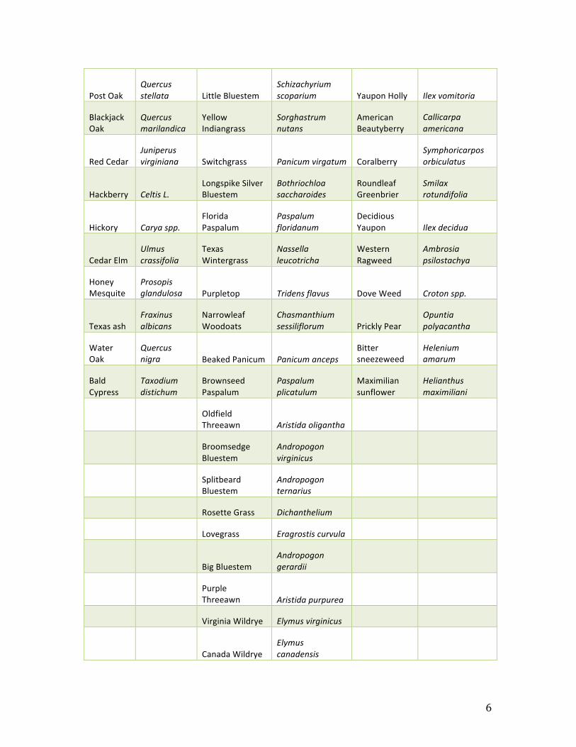
6
Post Oak Quercus stellata Little Bluestem
Schizachyrium scoparium Yaupon Holly Ilex vomitoria
Blackjack Oak
Quercus marilandica
Yellow Indiangrass
Sorghastrum nutans
American Beautyberry
Callicarpa americana
Red Cedar Juniperus virginiana Switchgrass Panicum virgatum Coralberry
Symphoricarpos orbiculatus
Hackberry Celtis L. Longspike Silver Bluestem
Bothriochloa saccharoides
Roundleaf Greenbrier
Smilax rotundifolia
Hickory Carya spp. Florida Paspalum
Paspalum floridanum
Decidious Yaupon Ilex decidua
Cedar Elm Ulmus crassifolia
Texas Wintergrass
Nassella leucotricha
Western Ragweed
Ambrosia psilostachya
Honey Mesquite
Prosopis glandulosa Purpletop Tridens flavus Dove Weed Croton spp.
Texas ash Fraxinus albicans
Narrowleaf Woodoats
Chasmanthium sessiliflorum Prickly Pear
Opuntia polyacantha
Water Oak
Quercus nigra Beaked Panicum Panicum anceps
Bitter sneezeweed
Helenium amarum
Bald Cypress
Taxodium distichum
Brownseed Paspalum
Paspalum plicatulum
Maximilian sunflower
Helianthus maximiliani
Oldfield Threeawn Aristida oligantha
Broomsedge Bluestem
Andropogon virginicus
Splitbeard Bluestem
Andropogon ternarius
Rosette Grass Dichanthelium
Lovegrass Eragrostis curvula
Big Bluestem
Andropogon gerardii
Purple Threeawn Aristida purpurea
Virginia Wildrye Elymus virginicus
Canada Wildrye
Elymus canadensis

7
Wild Indigo Baptisia australis
Cherokee sedge
Carex cherokeensis
Chasmanthium
Chasmanthium latifolium
Johnsongrass
Sorghum halepense
Bahiagrass
Paspalum notatum
Table 1. Plant species identified on the Range Area.
The topography of the range area is typical of the Post Oak Savanna,with rolling
moderately sloped terrain. Some of the site has been altered due to the use of bulldozers,
causing severe topsoil loss & erosion. The Range Area drains into White Creek which
originates on the west campus of Texas A&M. The creek has several issues ranging from
contamination from upstream users, to the loss of river bank stability due to frequent
high-energy flood events. White Creek is considered “dead” because of all the
contaminants that have been washed down from the university, which has caused the
creek to become categorized as mostly covered (White 2). But this was not the case in
earlier years; the creek was dead enough to the factor that no plants would grown
anywhere near the creek. It is said that someone could walk within fifteen feet of the
creek and could smell contaminates that were present in the creek. To help with the
runoff problem brought about by the heavy equipment destruction of the soil layers and
overgrazing degradation, reservoirs have been dug or built to help catch some of the
running water and slow the ground water movement. Many gullies are present on the
Range Area and have had major impacts on upland soil erosion to White Creek. One such
gully is on the northwest corner of the area which was greatly enlarged during the big

8
rains of 1957 and 1958, the gully was extended as much as 50 yards farther down and
ranged from five to fifteen feet in depth. To solve the problem of this great amount of soil
loss an abundance of cane was planted in and around the degraded site to help block the
head of the gully (Dean). The soils of the range area are considered to be Alfisols. The
trees of the range area are the post oak, blackjack oak, live oak, elm, water oak, texas ash,
red cedar, and bald cypress. The forbs and herbaceous species are yaupon, deciduous
yaupon, western ragweed, croton, prickly pear, honey mesquite, greenbriar, bitter
sneezeweed and maximilian sunflowers. The grasses that inhabit the range area are little
bluestem, big bluestem, sliptbeard bluestem, broomsedge bluestem, Oldfield Threeawn,
purple threeawn, king ranch bluestem, switch grass, Texas winter grass, long spike silver
bluestem, Virginia wildrye, Canada wildrye, wild indigo, lovegrass, Cherokee sedge,
Chasmanthium, Johnsongrass, bahiagrass, eastern gamagrass and yellow indiangrass
(Agrilife).
Stakeholders
The stakeholders involved with the Range Area is first and foremost is Texas A&M.
Their students take many classes that use the Range Area as an area for education and
research. Easterwood Airfield is also a big stakeholder because if they to expand the
airport they are going to need a piece of land that will come from the Range Area. The
airfield also has interest in what is being done to the Range Area at the present because of
the future possibility of expanding the airfield to have another runway. The Brayton Fire
School is a stakeholder in the range area because runoff from the site contributes to the

9
pollution damage to White Creek. Neighboring landowners adjacent to the Range Area
have an important interest because of invasive wildlife (hogs) and trespassers onto the
Range Area (Dean).
FIELD OBSERVATIONS
Data was taken from two different sites on the range area, one from the Little Bluestem
Hill which is east of the pond by the shed, and the other was the Oldfield Threeawn
Disturbed Site which is farther south of the Little Bluestem Hill. The plant cover on both
of these sites historically was disturbed by overgrazing and bulldozing in 1972, causing
the loss of most of the topsoil (Dean).
The first sampling method used was the step-point transect method, which was conducted
by following a straight line from one random starting point. From there we would walk
three steps along the line to reach the next sampling point, and use a pen to push down
into the ground.
Using the step-point transect method to assess vegetative cover (bare ground, rock, litter
or plant crown) on the Little Bluestem Hill we see a very low percentage in bare ground
and rocks. These results show that a majority of the ground cover on Little Bluestem Hill
is either litter or plant crowns (Figure 2). The same data collection method was
conducted on the Oldfield Threeawn site. The results of this show a lower percentage of
plant crowns compared with Little Bluestem Hill. The Oldfield Threeawn site data also
indicates that bare ground is decreasing and plant crowns is increasing which is a sign of
an increasing health of the site (Figure 2).

10
Figure 2. Results from the step-point transect method from the Little Bluestem Hill.
0.0%
10.0%
20.0%
30.0%
40.0%
50.0%
60.0%
70.0%
2007 2008 2010 2011 2012 2014 2015
Precent ground cover
Step-‐point Transect Little Bluestem Hill
Bare ground
Rock
Litter
Plant Crown

11
Figure 3. Results from the step-point transect method on the Oldfield Threeawn
Disturbed Site.
The second data collection method performed on these sites was the visual estimation of
dry matter standing crop on Little Bluestem Hill and Oldfield Threeawn Area using a
visual estimate from a photo guide. To perform this test one person would thrown an
object in a direct line and then a 0.5m2 quadrat was laid down to be the frame of our data
collection area. This was repeated a total of five times for each of the groups conducting
the test. The results from this data collection method indicate that the Little Bluestem has
continued to increase in lbs/ac over the nine years of testing, while the Oldfield Threeawn
has gone through an increase (Figure 4). These results indicate an increase in the overall
health and vegetative production of the Oldfield Threeawn site.
0.0%
10.0%
20.0%
30.0%
40.0%
50.0%
60.0%
2007 2008 2010 2011 2012 2014 2015
Precent of ground cover
Step-‐point Transect Old;ield Threeawn Site
Bare ground
Rock
Litter
Plant Crown

12
Figure 4. Test results from the dry matter estimation test performed on the little bluestem
hill and Oldfield Threeawn disturbed site. No data was recorded for the year 2006.
The resulting health of the banks is considered to be mostly covered and unstable (White
2). The health of White Creek is increasing, but overall it is still not healthy enough to
support substantional animal and plant life. Trash lies along the banks of the creek
making plant establishment difficult. The banks of the creek are severly eroded due to
runoff water from upstream impervious surfaces. Because of the increase in runoff water
the riparian banks have been cut back leaving high vertical banks along the creek.
DISCUSSION
0
500
1000
1500
2000
2500
2006 2007 2008 2010 2011 2012 2014
lbs/ac
Dry Matter Standing Crop
Little Bluestem
OldKield Threeawn

13
The Range Area is an important resource to many stakeholders as a rangeland
management educational site. The desired future condition of the Range Area is to have a
functioning, resilient ecosystem able to withstand changing conditions. To achieve this
objective many invasive plant species need to be removed from the site so the native
plants can grow in abundance and not have so much competing for water. Many areas of
the site have bare ground, which exacerbates erosion. Revegetating bare ground with
native plants will help reduce the erosion and also increase the water infiltration (Hays).
There are many wild hogs that live within the Range Area causing major disruptions to
the site by digging and uprooting many plants. The removal of such hogs by trapping and
hunting is a key to achieving the desired future condition. Renovations need to be made
to serve the needs of the various departments currently suing the Range Area. Two main
projects that need to be completed in order to achieve a more resilient area are; rebuilding
of the exterior fence for livestock experiments, and the roads need to be fixed so access to
all of the range area is accessible at all times.
Revegetation of the areas with bare ground is achievable by using seeding
techniques that will provide the greatest chance of success. But before the seeding of the
bare ground can be done there has to be a replacement of the lost topsoil lost to erosion.
Once the bare ground is growing with native grasses the ground infiltration will increase
to natural levels leading to an overall healthier area. Students and research faculty will
have educational opportunities to learn how the restoration and management activates are
working.
14
CONSLUSION
It is possible to achieve the desired goals and conditions of the Range Area..Signs of
increasing health are evident on both the Little Bluestem Hill and the Oldfield Threeawn
Degraded site. An increase in the vegetative production of both the sites over the nine-
year time period is evidence that the Range Area is recovering from past disturbances and
are helping to reduce erosion of the Range Area. However, many challenges
remain,Easterwood Airfield is planning to expand take more land from the Range Area,
the astronomy department plans to expand its observatory which would also take more
land form the Range Area. Though challenges will occur, through the use of proper
ecosystem management, these challenges can be faced and dealt with to ensure the
success of the Range Area.

15
LITERATURE CITED
Agrilife Extension. Welcome to the Post Oak Savannah Vegetational Area (area 3)
ESSM
Dean C.N. 1972. Development of the Range Department’s Grazing Land Unit (1000
acres) assigned to the department.
Hays K.B., Rector B.S., White L.D. Increasing Bare Ground Indicates Poor Watershed
Health. Rangeland Watershed Management for Texans.
Loucks C. 1999. East Central Texas Forests 2.2 Temperate Broadleaf and Mixed
Forests. Terrestrail Ecoregions of North America, 196-197
Rector B.S. 2000, Principles of Ecology and Range Management: Are You a Successful
Ecosystem Manager?
White L.D. a, Rector B.S., Hays K.B. Are Your Streams Healthy? Rangeland Watershed
Management for Texas.
White L.D. b, Rector B.S., Hays K.B. Reading Your Landscape: Are Your Pastures
Healthy? Rangeland Watershed Management for Texans.