Embed Size (px)
Citation preview
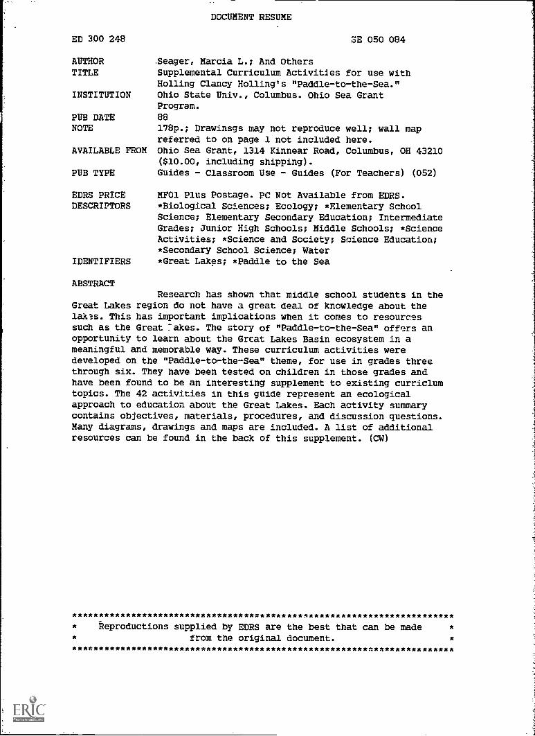
ED 300 248
AUTHORTITLE
INSTITUTION
PUB DATENOTE
AVAILABLE FROM
PUB TYPE
EDRS PRICEDESCRIPTORS
IDENTIFIERS
ABSTRACT
DOCUMENT RESUME
SE 050 084
Seager, Marcia L.; And OthersSupplemental Curriculum Activities for use withHolling Clancy Holling's "Paddle-to-the-Sea."Ohio State Univ., Columbus. Ohio Sea GrantProgram.
88
178p.; Drawinsgs may not reproduce well; wall mapreferred to on page 1 not included here.Ohio Sea Grant, 1314 Kinnear Road, Columbus, OH 43210($10.00, including shipping).Guides - Classroom Use - Guides (For Teachers) (052)
MFO1 Plus Postage. PC Not Available from EDRS.*Biological Sciences; Ecology; *Elementary SchoolScience; Elementary Secondary Education; IntermediateGrades; Junior High Schools; Middle Schools; *ScienceActivities; *Science and Society; Science Education;*Secondary School Science; Water*Great Lakes; *Paddle to the Sea
Research has shown that middle school students in theGreat Lakes region do not have a great deal of knowledge about thelakes. This has important implications when it comes to resourcessuch as the Great rakes. The story of "Paddle-to-the-Sea" offers anopportunity to learn about the Great Lakes Basin ecosystem in ameaningful and memorable way. These curriculum activities weredeveloped on the "Paddle-to-the-Sea" theme, for use in grades threethrough six. They have been tested on children in those grades andhave been found to be an interesting supplement to existing curriclumtopics. The 42 activities in this guide represent an ecologicalapproach to education about the Great Lakes. Each activity summarycontains objectives, materials, procedures, and discussion questions.Many diagrams, drawings and maps are included. A list of additionalresources can be found in the back of this supplement. (CW)
Reproductions supplied by EDRS are the best that can be madefrom the original document
***4
*
******** *****
SUPPLEMENTAL
Curriculum Activitiesfor use with
Holling Clancy Holling's
PADDLE-TO-THE-SEA
byMarcia L. Seager, The Ohio State University
Rosanne W. Fortner, The Ohio State UniversityTimothy A. Taylor, Muskingum County Schools
Al.magamin-
"PERMISSION TO REPRODUCE THISMATERIA IN MICROFICHE ONLYHAS 13 1 GRANTED BY
TO THE EDUCATIONAL RESOURCESINFORMATION CENTER (ERIC)."
U.S. DEPARTMENT OF EDUCATIONOffice of Educational Research and Improvement
EDUCATIONAL RESOURCES INFORMATIONCENTER (ERIC)
This document has been reproduced asreceived from the person or organizationoriginating it.
0 Minor changes have been made to improvereproduction quality
Points of view or opinions stated in this docu-mant do not necessarily represent officialOERI position or policy

EP-76
Copyright 0 The Ohio State University Research Foundation, 1988Permission is hereby granted to educators to reproduce worksheet portions of thismaterial for educational purposes. The U.S. Government is authorized to produce anddistribute reprints for governmental purposes notwithstanding any copyright notation thatmay appear hereon.
Cover illustration from Paddle-to-the-Sea by Holling C. Holling, copyright 1941 and0 renewed 1969 by Holling C. Holling. Reprinted by permission of Houghton MifflinCompany.
A cooperative publication ofthe Ohio Sea Grant Education Program,
The Ohio State Universityand the international Joint Commission
3
SUPPLEMENTAL
Curriculum Activitiesfor use with
Holing Clancy Holling's
PADDLE-TO-THE-SEA
byMarcia L. Seager, The Ohio State University
Rosanne W. Fortner, The Ohio State UniversityTimothy A. Taylor, Muskingum. County Schools
special thanks for his cooperation and input toJohn R. Vallentyne, International Joint Commission
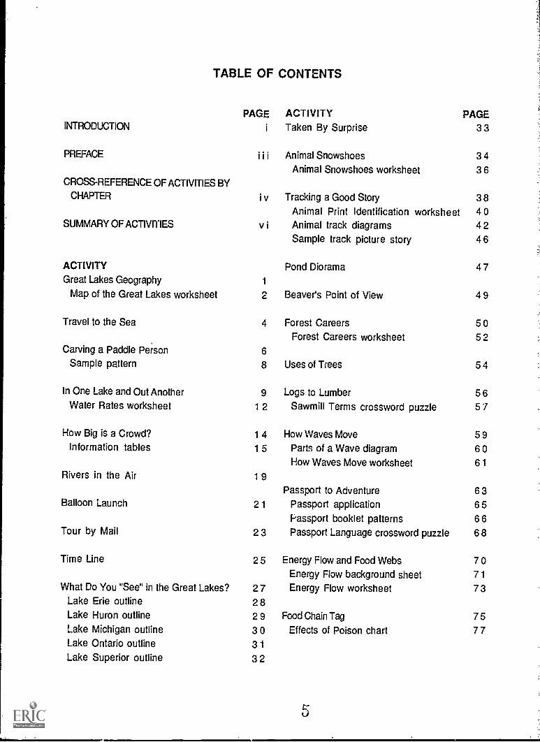
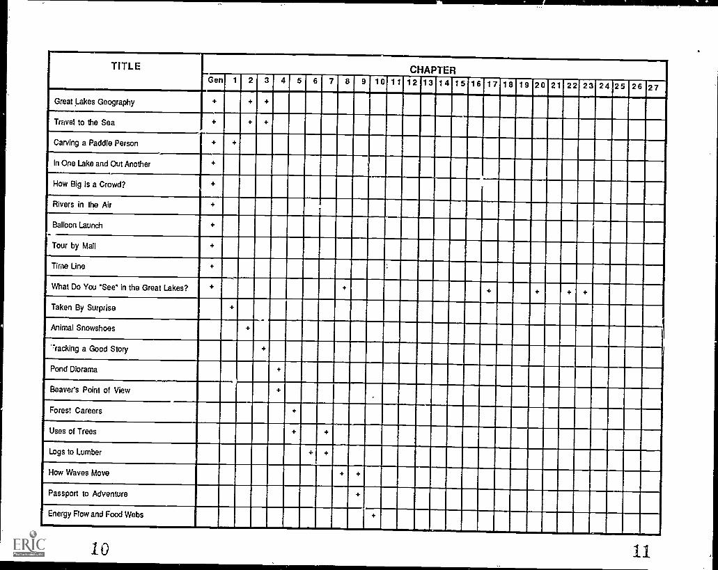
TABLE OF CONTENTS
PAGE ACTIVITY PAGEINTRODUCTION i Taken By Surprise 33
P R E F A C E I i i Animal Snowshoes 34Animal Snowshoes worksheet 36
CROSS-REFERENCE OF ACTIVITIES BY
CHAPTER i v Tracking a Good Story 38Animal Print Identification worksheet 40
SUMMARY OF ACTIVITIES v i Animal track diagrams 42Sample track picture story 46
ACTIVITY Pond Diorama 47Great Lakes Geography 1
Map of the Great Lakes worksheet 2 Beaver's Point of View 49
Travel to the Sea 4 Forest Careers 50Forest Careers worksheet 52
Carving a Paddle Person 6
Sample pattern 8 Uses of Trees 54
In One Lake and Out Another 9 Logs to Lumber 56Water Rates worksheet 12 Sawmill Terms crossword puzzle 57
How Big is a Crowd? 14 How Waves Move 59Information tables 15 Parts of a Wave diagram 60
How Waves Move worksheet 61Rivers in the Air 19
Passport to Adventure 63Balloon Launch 21 Passport application 65
Passport booklet patterns 66Tour by Mail 23 Passport Language crossword puzzle 68
Time Line 25 Energy Flow and Food Webs 70Energy Flow background sheet 71
What Do You "See" in the Great Lakes? 27 Energy Flow worksheet 73Lake Erie outline 28Lake Huron outline 29 Food Chain Tag 75Lake Michigan outline 30 Effects of Poison chart 77Lake Ontario outline 31Lake Superior outline 32
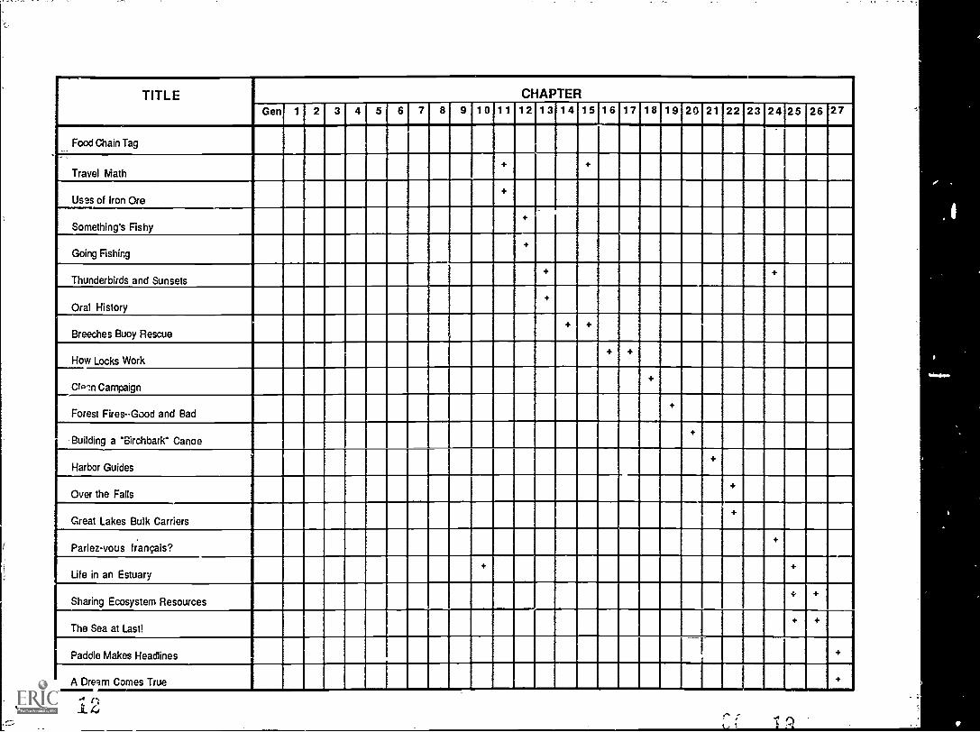
TABLE OF CONTENTS
ACTIVITY PAGE ACTIVITY PAGETravel Math 78 Parlez-vous frangais? 127
Scale and Perimeter worksheet 79 French Vocabulary list 128Distance, Rate and Time worksheet 83 French word puzzle 129
Voyageurs' song 131Uses of Iron Ore 85
Iron Ore worksheet 86 Life in an Estuary 132About Estuaries background sheet 133
Something's Fishy 88 Life in an Estuary worksheet 135Fish Anatomy diagram 89Fish Anatomy descriptions 90 Sharing Ecosystem Resources 137Fish Puzzle pieces 91 Categories of Nations 139Fish Anatomy worksheet 95 Role-playing cards 140
The Challenge of Chief Seattle 149Going Fishing 97
The Sea at Last! 152Thunderbirds and Sunsets 98
Weather Folklore background sheet 99 Paddle Makes Headlines 153Thunderbird outline 100
A Dream Comes True 154Oral History 101
Breeches Buoy Rescue 103 APPENDIXBuilding a Breeches Buoy diagram 104 Great Lakes Education Resources 155
How Locks Work 105How Locks Work diagram 106Building Your Own Lock diagrams 107
Clean Campaign 109
Forest Fires--Good and Bad 111
Building a "Birchbark" Canoe 11 2Canoe pattern 115
Harbor Guides 116
Over the Falls 117
Great Lakes Bulk Carriers 118Great Lakes Cargo worksheet 120Great Lakes Bulk Carrier diagram 124Great Lakes Bulk Carrier puzzle 125
Using Paddle-to-the-Sea
Holling Clancy Holling's talents are at their best in the classic Paddle-to-the-Sea. The story can be read, understood and enjoyed on at least threelevels of student ability, thanks to Holling's artistry with words andpictures. On the simplest level, the color illustrations alone can be usedto tell the story. Each chapter contains a full-page picture that perfectlyshows what the chapter is about. On a second level, the words of thechapter reveal the ideas, develop the characters and settings, and explainwhat the pictures are showing. For detailed study, the black-and-whitedrawings in the margins of the text offer an expanded view of main pointsin the story as well as teaching new material to enhance understanding.From these drawings we learn how locks work, see interim maps showingwhere Paddle is at each point, and compare the before and after of a forestfire. Enjoy Paddle on the level most appropriate for your class.
You may also wish to show the 1967 film, Paddle-to-the-Sea, which isdistributed by the National Film Board of Canada. The film is 28 minuteslong. Students who previewed it with us were attentive throughout.
Using this Curriculum Guide
These Curriculum Activities have been developed for use in grades 3 - 6.They have been tested among students and teachers in those grades andfound to be an interesting supplement to existing curriculum topics, aswell as an exciting way to teach those same topics. Choose any or all ofthe activities presented to reinforce the concepts introduced in the story.The time you will need to complete each activity varies; some activitiesrequire planning and preparation in advance. At the beginning of eachactivity, you will find a statement of objectives that may help you tochoose activities appropriate for your class.
i
PrefaceThe Ecosystem Approach
Research by the Ohio Sea Grant Education Program' has shown that middle school students in theGreat Lakes region do not have a great deal of knowledge about the lakes. In fact, 54% of the fifthgraders and 40% of the ninth graders tested in Ohio in 1983 could not identify Lake Erie on a mapof the Great Lakes. Even fewer could identify the other lakes. Those ninth graders are now voters,each with a vote equal to yours and mine. We cannot be satisfied with the implications of this levelof knowledge among our students when it comes to resources as vital as our Great Lakes. Lack ofknowledge is a symptom of a larger problem: a lack of holistic thinking about the ecosystem. We arean integral part of this system. What happens to it happens to all citizens of the world.
Paddle-to-the-Sea, a classic in children's literature, offers an opportunity to learn about theGreat Lakes Basin ecosystem in a meaningful and memorable way. On one level the story teachesabout the geography and economy of the region. On a higher level it provides a look at theinteractions of animals in the environment, of people with the environment, and of the ecosystem'simpact on all who live or even pass through this "long river reaching to the sea." On this level,Paddle is an example of the ecosystem approach2.
To approach something on an ecosystem level is to view it as a connected whole, to see theimportance of specific parts, but always in relation to the whole and with us in it. While it isinteresting to learn what animal tracks can tell us, or how a beaver's lodge is built, or how ironore is shipped on the Great Lakes, these should be viewed as environmental information that hasbeen designed to contribute to an understanding of the entire Great lakes Basin ecosystem. Thephysical conditions of the region -- its geography, its climate, its water quality -- define andinteract with the environments depicted in Paddle-to-the-S(41; in turn all those environments areinfluenced by people and influence them in return. Together it is an ecosystem.
There is a consensus among organizations and governments in the Great Lakes Basin that theLakes must be managed with an ecosystem approach. This not only requires an understanding ofwhat the individual parts to be managed actually are, but more importantly, an understanding ofhow those parts interrelate with each other and with the ecosystem as a whole. To teach about theGreat Lakes using the Curriculum Activities for Paddle-to-the-Sea is to take an ecosystemapproach. The authors and promoters of this work hope that teachers will find a place in thecurriculum to use most of the activities described here. Individually the activities can teach aboutthe environments Paddle visited, but together they convey the important concept that everything isconnected. It is our hope that students will carry away from this unit some of the awe and respectthat Holling Clancy Holling felt when he wrote about the Great Lakes, as well as a feeling of being apart of this remarkable ecosystem.
Rosanne W. Fortner, Associate ProfessorSchool of Natural Resources, The Ohio State University
I Fortner, Rosanne W. and Victor J. Mayer, 1983. Ohio students' knowledge and attitudes about the oceans and GreatLakes. Ohio Journal of Science 83(5): 218-224.
2 Vallentyne, John R. and Alfred M. Beeton, 1988. The ecosystem approach to managing human uses and abuses ofnatural resources in the Great Lakes Basin. Environmental Conservation. 15(1):58.62.
0
MMONUMMMOMMIUMMO MOOMMORIMI mommommummorm IMOMMOMMII
IMINEMIMMINIMMENUMEIMMI IMIMMEMENOMENEMMENIMMEMI
MEMMIMMEMOMMOMMOMM MEMO= MMIMMIMMOMMOIMMOM IMMO 1111 IMMIENNIMIMMMINIMIN OWN Al MOMMOMMOMMOMMOMMOOMOOMMOI
11 OM MOMMOMMOMMOMMOMMEMEMMI MOMOMMOMOMMOMOMMOOMMOMO MIMI
MOMMOIMOOMMONIMMOOMME MMINMEMOMMOOMMOMMOOMMOMMOR II 111111.111.11MMOMMOMMOMMEMOMM II
EAMMUMMINIMMINIMMIMMIIMI IMOLJMNIIMMIMMINI OMMOMMOOMMMI minumummumuuma ammummon 1111111M1111 MI MEI MIMMEMMIMUMMEMI MOMMOMOM
MMEMOMMOM OMMEMEMIWOMO OIMMOMMOMMOMMO MIMMEMMIMMIN RIM AMMON IMENIONNEMI INEMEMEMMIS0 0111111MERMIN OZ
I.
I.
III
I O.
:
Oil
Ill
:
: OS..
O. 4.0.
.
.
11111111111111111M 1 ° IMEIBINIMIREHMEMBEITEREEMU MN IN =IMF IIMIIIIIIIIIIIIMIEE11111111111011111111111
111111111111111111111111111111111111111
1111111111M1 11111111M111111M111111111111111 1111111111EIN
IMMIMMEMMOMMEM 1111111MINN 11111111111111--V-MIIII1.011.1111111111111/1111111.11111111
06 . :.1111.1.11111.11111111111111.11111111
1111111111.1MEM= I BEM in III MEM1111111111111111111111111111.111M111111111111111111111IBIBIUMMOIMI111111111111111111111111111111111111111111111111111111111111111111111111111111111111111111111111r'IMIIIMMIMINIENIMMI11111111111111111111111111111111MIMIMI 111111111111111111111111111111 MIME
-
a
SUMMARY OF ACTIVITIES
Great Lakes GeographyIdentify the shapes of the Great Lakes and surrounding states and
provinces on a map.
Travel to the SeaLearn how local streams or rivers merge with other waterways to reach
the ocean.
Carving a Paddle PersonLearn how to use scale patterns in making carved models and how to
carve safely.
In One Lake and Out AnotherStudy the hydrologic cycle. Compare the filling times of the Great
Lakes and the time it takes for pollutants to flow through.
How Big is a Crowd?Compare the number of people that live around each lake and
demonstrate how people must share and care for resources.
Rivers in the AirLearn how air currents act like rivers to carry floating objects.
Baboon LaunchLearn about prevailing winds and identify locations reached by balloons
launched from your community.
Tour by MailLearn how to write a business letter correctly and receive information
from various Great Lakes cities.
Time LineIllustrate the major events that occurred during each season of Paddle's
voyage and find out how long it took Paddle to reach the sea.
What Do You "See" in the Great Lakes?Use the shape of each lake to suggest the outline of familiar figures or
shapes.
vi14
Taken by SurpriseWrite a story about being taken by surprise while trying to finish a
project.
Animal SnowshoesLearn how feet can act like snowshoes and calculate foot area and
pressure for different animals.
Tracking a Good StoryIdentify pictures of animal tracks and make a track picture "story."
Pond DioramaMake a diorama illustrating the beaver pond.
Beaver's Point of ViewWrite a story about the pond from the old beaver's point of view.
Forest CareersFind out about job responsibilities in many types of forest careers.
Take a field trip (optional).
Uses of TreesLearn how trees are used and what products are made from them.
Logs to LumberFind out how a tree becomes lumber. Complete the puzzle using
vocabulary words from the story.
How Waves MoveLearn the parts of a wave and do an experiment to show how objects
move in waves.
Passport to AdventureLearn passport terminology, make your own "passports" and play a
travel game.
Energy Flow and Food WebsLearn how animals and plants interact in a food web using a pond food
web as an example.
vii
Food Chain TagPlay a game illustrating the effects of toxics on animals in a simple
food chain.
Travel MathWork with perimeter and distance-rate-time problems.
Uses of Iron OreLearn where iron ore is found, how it is processed and what products
are made from it.
Something's FishyLearn basic fish anatomy, play a game to identify parts of a fish, and
complete a fish puzzle.
Going FishingCreate your own fish with paper and paint.
Thunderbirds and SunsetsExplore folktales about weather and write your own story explaining a
weather event.
Oral HistoryInterview an older person about how things have changed over time.
Breeches Buoy RescueUse small pulleys and string to build a working model of a breeches
buoy.
How Locks WorkUse milk cartons to build a working model of a system of locks.
Clean CampaignOrganize a litter cleanup in your community and see how much
recyclable material you can collect.
Forest Fires - -Good and BadLearn how fires can benefit as well as harm the environment.
Building a "Birchbark" CanoeUse oaktag and yarn to make a model of a birchbark canoe.
viii
16
Harbor GuidesPlay a game to illustrate how ships move through busy harbors.
Over the FallsWrite a story about how Paddle might have felt as he fell over Niagara
Falls.
Great Lakes Bulk CarriersLearn the parts of a Great Lakes bulk carrier and find out what cargoes
are moved on the Great Lakes.
Parlez-vous frangais?Learn simple French words and phrases and complete a word puzzle.
Sing a voyageurs' song.
Life in an EstuaryLearn what an estuary is and why it is an important resource.
Sharing Ecosystem ResourcesUse role-playing to simulate a Law of the Sea conference. Compare it
with Chief Seattle's view of resource use.
The Sea at Last!Write about how Paddle might feel now that he has finally reached the
sea.
Paddle Makes HeadlinesWrite and illustrate an article that might have appeared in a French
newspaper when Paddle arrived in France.
A Dream Comes TrueWrite a story about how you might feel if your dreams really came true.
ix
Great Lakes Geography
Introduction: Holling compared the Great Lakes to bowls set on ahillside, water running from one "bowl" to another and on into a river thateventually reached the sea. The states and provinces of two countriessurround the Great Lakes and the St. Lawrence River which connects themto the Atlantic Ocean. These are among the largest lakes in the world, andthey are an important resource for all the people living along this "longriver reaching to the sea."
Objective: When students have completed this activity, they will be ableto identify the Great Lakes and the surrounding states and provinces on amap.
Materials: Map of the Great Lakes worksheet (master on page 2), wallmap (in pocket of back cover), stiff paper or oaktag, double-stick tape,labelled map of the Great Lakes area.
Procedure:1. Reproduce the student worksheet, Map of the Great Lakes. See how
many of the Lakes, states and provinces students can identify. Use alabelled map of the area as an identification guide when students havenamed as many of the shapes as possible on their own. (You may wantto repeat the worksheet as a post-test after finishing the story.)
2. Put up the wall-sized outline map of the Great Lakes area. You maywant to laminate this map for durability. Make tags from stiff paperor oaktag to lab& the lakes, states and provinces. Have students taketurns matching the names to the shapes on the map. Use double-sticktape to attach the tags to the map. As you read Paddle-to-the-Sea,you may want to make additional tags to label cities, rivers or otherareas mentioned in the story.
3. Use string or yarn to mark Paddle's progress as you read each chapter.Compare your map with the author's in the back of the original book.
4. Vary the drill daily as you read the story. For example, on one day havestudents draw labels out of a hat and place them in the correctlocations on the wall map. On another day, assign a route to be taken(for example, from Quebec to Gary, Indiana) and have students identifylakes, states, and cities along the chosen route. On a third day, taketurns guessing the name of a place from each other's descriptions ofits location on the map, size, shape, and so on.
1 1 8
NAME:
Map of the Great Lakes
Write the letter or number of each place on the map beside the correctname on the list below.
States and Provinces
IllinoisIndianaMichiganMinnesotaNew YorkOhioOntarioPennsylvaniaQuebecWisconsin
Great Lakes
Major Cities
BuffaloChicagoClevelandDetroit
Lake Erie DuluthLake Huron ErieLake Michigan MilwaukeeLake Ontario ToledoLake Superior Toronto
2
Answer Key -- Map of the Great Lakes
Write the letter or number of each place on the map beside the correctname on the list below.
States and Pr
K IllinoisL Indiana
MichiganQ,Minnesota
___a___ New YorkM Ohio
_EsOntario____Q___ Pennsylvania
B Quebec_E
Great Lakes
N Lake Erie_El Lake Huron
G Lake MichiganI Lake Ontario
_D Superior
3 e) --,,A.,U
Major Cities
___8____ Buffalo__ Chicago
___E__ Cleveland_4__ Detroit
1 Duluth7 Erie_2____. Milwaukee
5____ Toledo9 Toronto
Travel-to-the-Sea
Introduction: The Indian boy knew that his Paddle Person could reach thesea because he knew that the little stream near his home flowed into ariver, which in turn flowed into Lake Superior. He knew that Lake Superiorwas connected to the other Great Lakes and that these lakes emptied intoa river which reached the Atlantic Ocean. We can trace the flow of waterin any stream as it flows downstream to rivers, lakes, and finally to thesea.
Objective: When students have completed this activity, they will be ableto explain how their local stream or river merges with other waterwaysto eventually reach the ocean.
Materials: Map of local waterways (most detailed area road maps showstreams, rivers and lakes), map showing major rivers emptying into theoceans (from an atlas, for example).
ProcedUre:1. On the map of local waterways, locate the stream closest to your
school or town. Have students trace the route of the stream as itmerges -,ith other waterways until it reaches a major river. You willneed to know in which direction the water flows to be able to traceits route downstream (in the direction of the flow).
2. Identify the major river connected to your local stream. Find thisriver on the map of major rivers, and trace its route to the ocean. Youmay want to draw a diagram of the waterways between your streamand the ocean on the blackboard. If a river forks, there may be morethan one possible route to the sea. Trace out all of the possibleroutes. (A sample map on the following page traces one route fromColumbus, Ohio, to the sea.)
Discussion Questions:1. If we put a Paddle Person in our local stream, where would it go?
2. What waterways would carry our Paddle Person toward the ocean?
3. Is there anything along this route that could keep our Paddle Personfrom eventually reaching the ocean (a dam, for example)?
4 21
4. Would it be possible for our Paddle Person to travel by more than on9route? If so, where would the different routes carry our PaddlePerson?
5. What places would our Paddle Person pass by on the way to the ocean?
6. What ocean would our Paddle Person reach?
Extension Activity: Carve your own Paddle Person and release it in yourlocal stream. Directions for carving are on the next page.
Sample Map
Arrows show the directionin which water flows
5
Carving a Paddle Person
Introduction: The Indian boy carved his Paddle Person to look like a realperson in a canoe. To make his small model, the Indian boy used a scalepattern to make sure that the proportions in his model were the same asin real life. For example, if a real jan o e measured twelve feet long andtwo feet high, a model of the same canoe might be twelve inches long andtwo inches high. In this case the scale for the model is one inch to onefoot. A larger model might be twenty-four inches long and four incheshigh. In this case the scale is two inches to one foot. In both cases,though, the proportions of the model canoe remain the same as theproportions of the real one: all are six times longer than they are high.
Objectives: When students have completed this activity, they will beable to explain how to use scale patterns in making carved models and tolist carving safety rules.
Materials: Graph paper for making patterns, blocks of balsa wood (about2 X 4 X 8 inches, 'available at most craft shops), jack knives or sharpparing knives, sandpaper, acrylic paints and small paint brushes(optional).
Rules for Carving Safely
1. Always carve with the sharp edge of the blade pointing away from you.
2. Make sure there is plenty of space around you so that you don't bumpothers while carving.
3. Remove wood from the block a little bit at a time; never try to carveoff large chunks.
4. A sharp knife cuts wood more easily.
5. Always close a jack knife before carrying it; carry a paring knife withthe blade down and the sharp edge back.
Procedure:1. Read and discuss the carving safety rules. Be sure students understand
the importance of following these rules while they are carving.
6
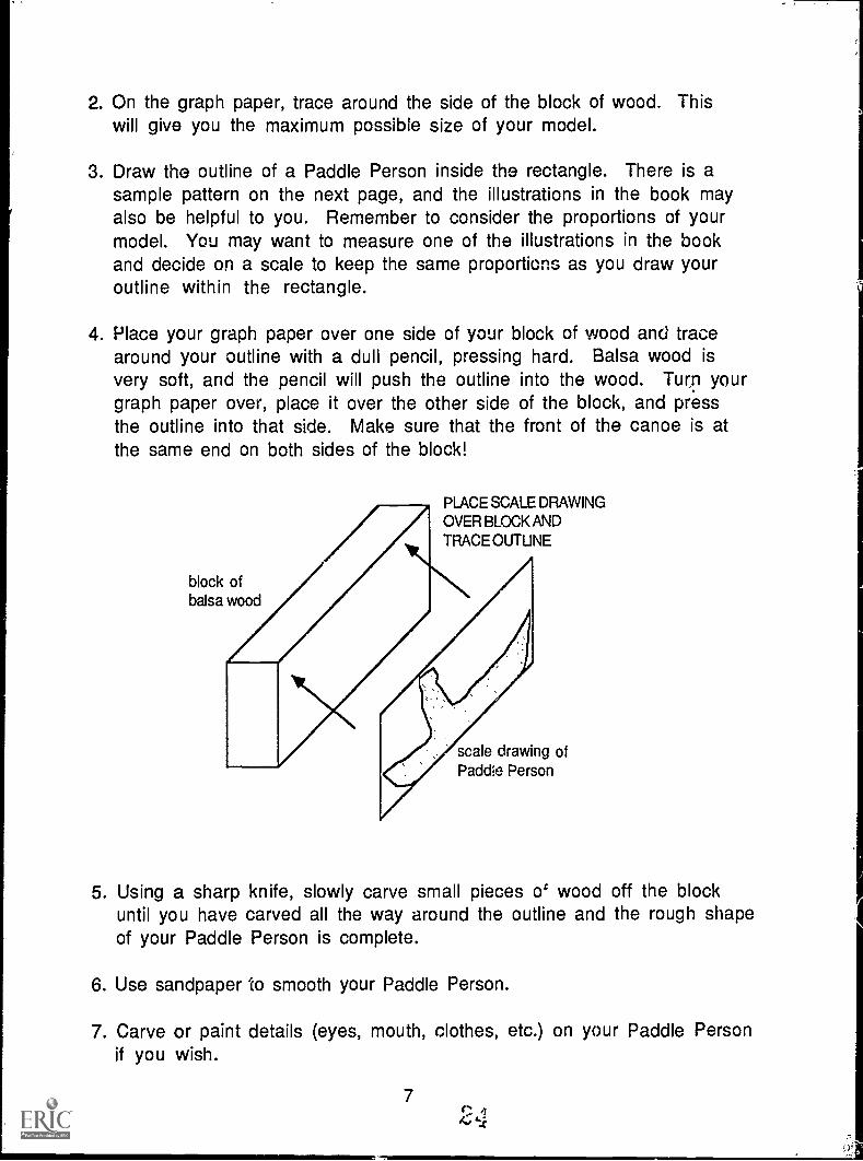
2. On the graph paper, trace around the side of the block of wood. Thiswill give you the maximum possible size of your model.
3. Draw the outline of a Paddle Person inside the rectangle. There is asample pattern on the next page, and the illustrations in the book mayalso be helpful to you. Remember to consider the proportions of yourmodel. You may want to measure one of the illustrations in the bookand decide on a scale to keep the same proportions as you draw youroutline within the rectangle.
4. Place your graph paper over one side of your block of wood and tracearound your outline with a dull pencil, pressing hard. Balsa wood isvery soft, and the pencil will push the outline into the wood. Turn yourgraph paper over, place it over the other side of the block, and pressthe outline into that side. Make sure that the front of the canoe is atthe same end on both sides of the block!
block ofbalsa wood
PLACE SCALE DRAWINGOVER BLOCK ANDTRACE OUTLINE
scale drawing ofPaddle Person
5. Using a sharp knife, slowly carve small pieces o' wood off the blockuntil you have carved all the way around the outline and the rough shapeof your Paddle Person is complete.
6. Use sandpaper to smooth your Paddle Person.
7. Carve or paint details (eyes, mouth, clothes, etc.) on your Paddle Personif you wish.
7
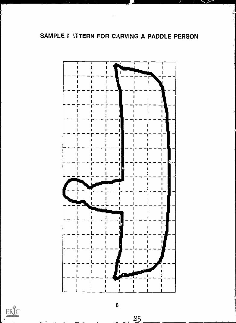
SAMPLE I ITTERN FOR CARVING A PADDLE PERSON
I I
I I
I I
r 1 rI I
I I
1
I I I
I I I
I I I
I I I
I I I
I I I
I I I
I I I
I I I
I I I
I I I
I L LI I I
I I I 1
1
1
I
i
I I
I I
I I
IMO eime OEM
8
:t
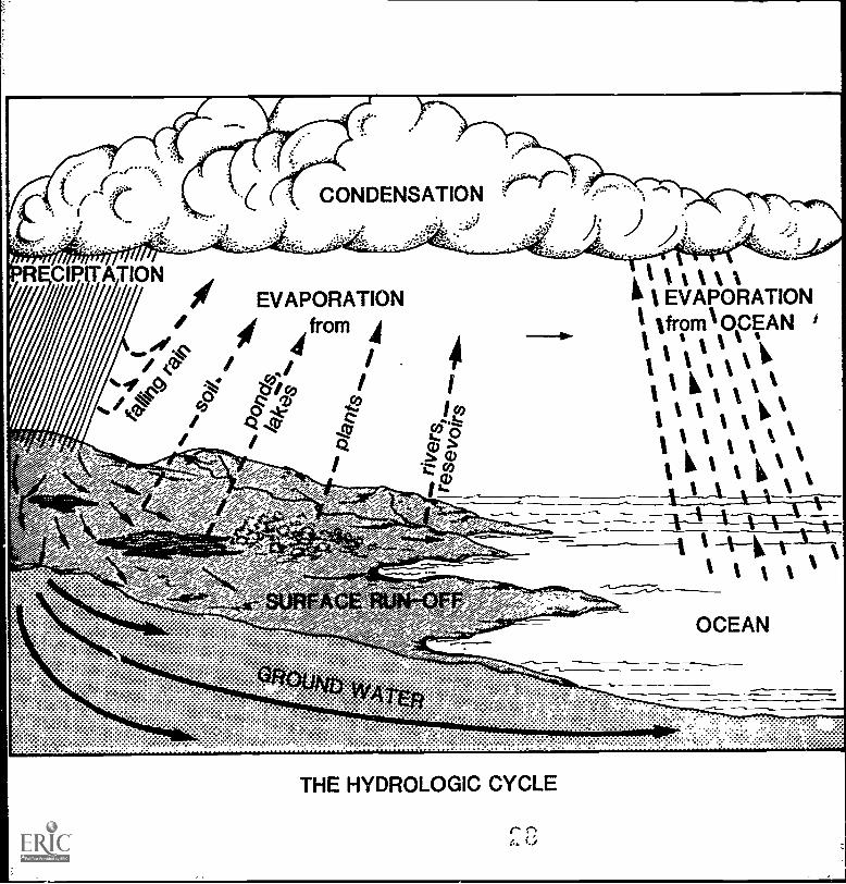
In One Lake and Out Another
Introduct2on: It took Paddle four years to travel through the Great Lakes,but it take.; much longer than that for water to move through the Lakes.Water is always coming into lakes from rivers and groundwater and fromthe atmosphere as rain or snow. Water is always running out of lakes andevaporating into the atmosphere. All these processes put together arecalled the hydrologic cycle. If a lot of water suddenly enters a largelake, it can spread out, so the water level does not change very much. If alot of water suddenly enters a small lake, it does not have room to spreadout, and floods can occur when the water level rises. As water flowsfrom one Great Lake to another, changes in the water levels of upper lakesaffect the water levels in lakes downstream.
Objectives: When students have completed this activity, they will beable to describe the hydrologic cycle, to explain reasons why lake levelsmay change and to demonstrate how changes in water levels in large lakesaffect the water levels in small lakes downstream.
Materials: Three different-sized milk cartons (for example, gallon, quartand pint), duct tape, measuring cup, ruler, India ink, Hydrologic Cyclediagram and Water Rates worksheet (masters on pages 11-12).
Procedure:1. Look at the Hydrologic Cycle diagram. Discuss the following
questions.
* How does water get into the Great Lakes?* Where does water go when it leaves the Great Lakes?* Does water disappear? Does "new" water ever appear?* What might change the amount of water entering or leaving a lake?
(For example, a dam, a diversion, ice and snow melting.)* What happens to a substance that can dissolve in water when it gets
into a lake?* How long do you think it takes for such a substance to wash out of a
lake?
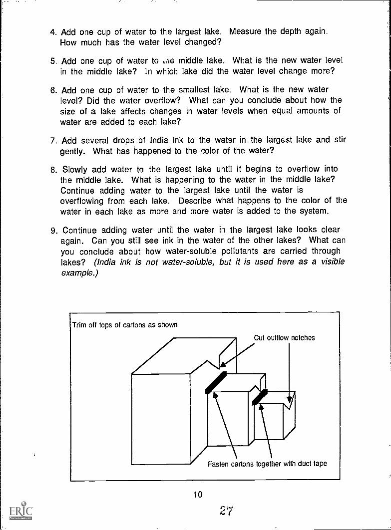
2. Cut milk cartons and fasten them together with duct tape to representa chain of three lakes. Cut a notch in each carton to allow water toflow down the chain. Use the diagram on the next page to help youbuild the model. Place the entire model in a sink or dishpan to catchwater that might overflow.
3. Use the measuring cup to fill each "lake" with water until the waterlevel is 3 centimeters be ow the bottom of the outflow notch in eachcarton. Use your ruler to measure the depth of the water in each lake.
9
4. Add one cup of water to the largest lake. Measure the depth again.How much has the water level changed?
5. Add one cup of water to LCie middle lake. What is the new water levelin the middle lake? In which lake did the water level change more?
6. Add one cup of water to the smallest lake. What is the new waterlevel? Did the water overflow? What can you conclude about how thesize of a lake affects changes in water levels when equal amounts ofwater are added to each lake?
7. Add several drops of India ink to the water in the largest lake and stirgently. What has happened to the color of the water?
8. Slowly add water to the largest lake until it begins to overflow intothe middle lake. What is happening to the water in the middle lake?Continue adding water to the largest lake until the water isoverflowing from each lake. Describe what happens to the color of thewater in each lake as more and more water is added to the system.
9. Continue adding water until the water in the largest lake looks clearagain. Can you still see ink in the water of the other lakes? What canyou conclude about how water-soluble pollutants are carried throughlakes? (India ink is not water-soluble, but it is used here as a visibleexample.)
Trim off tops of cartons as shown
Cut outflow notches
AdPrriFasten cartons together with duct tape
10
'
.
Name:
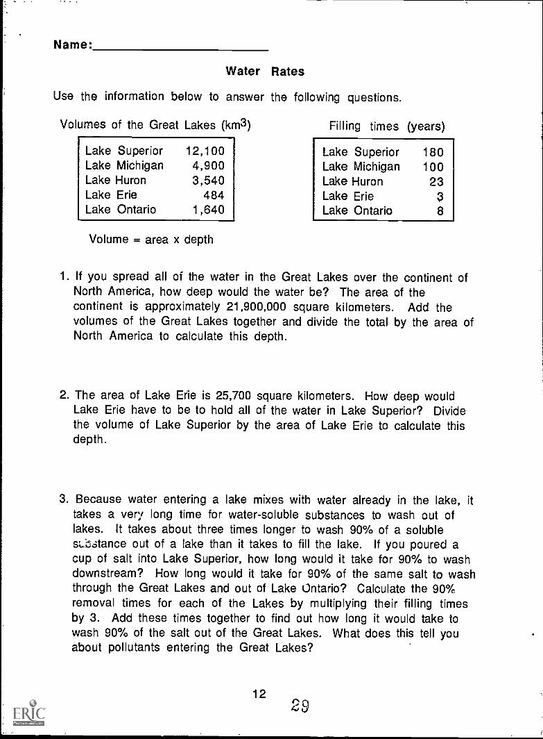
Water Rates
Use the information below to answer the following questions.
Volumes of the Great Lakes (km3)
Lake Superior 12,100Lake Michigan 4,900Lake Huron 3,540Lake Erie 484Lake Ontario 1,640
Volume = area x depth
Filling times (years)
Lake Superior 180Lake Michigan 100Lake Huron 23Lake Erie 3Lake Ontario 8
1. If you spread all of the water in the Great Lakes over the continent ofNorth America, how deep would the water be? The area of thecontinent is approximately 21,900,000 square kilometers. Add thevolumes of the Great Lakes together and divide the total by the area ofNorth America to calculate this depth.
2. The area of Lake Erie is 25,700 square kilometers. How deep wouldLake Erie have to be to hold all of the water in Lake Superior? Dividethe volume of Lake Superior by the area of Lake Erie to calculate thisdepth.
3. Because water entering a lake mixes with water already in the lake, ittakes a very long time for water-soluble substances to wash out oflakes. It takes about three times longer to wash 90% of a solublesLbstance out of a lake than it takes to fill the lake. If you poured acup of salt into Lake Superior, how long would it take for 90% to washdownstream? How long would it take for 90% of the same salt to washthrough the Great Lakes and out of Lake Ontario? Calculate the 90%removal times for each of the Lakes by multiplying their filling timesby 3. Add these times together to find out how long it would take towash 90% of the salt out of the Great Lakes. What does this tell youabout pollutants entering the Great Lakes?
124'39
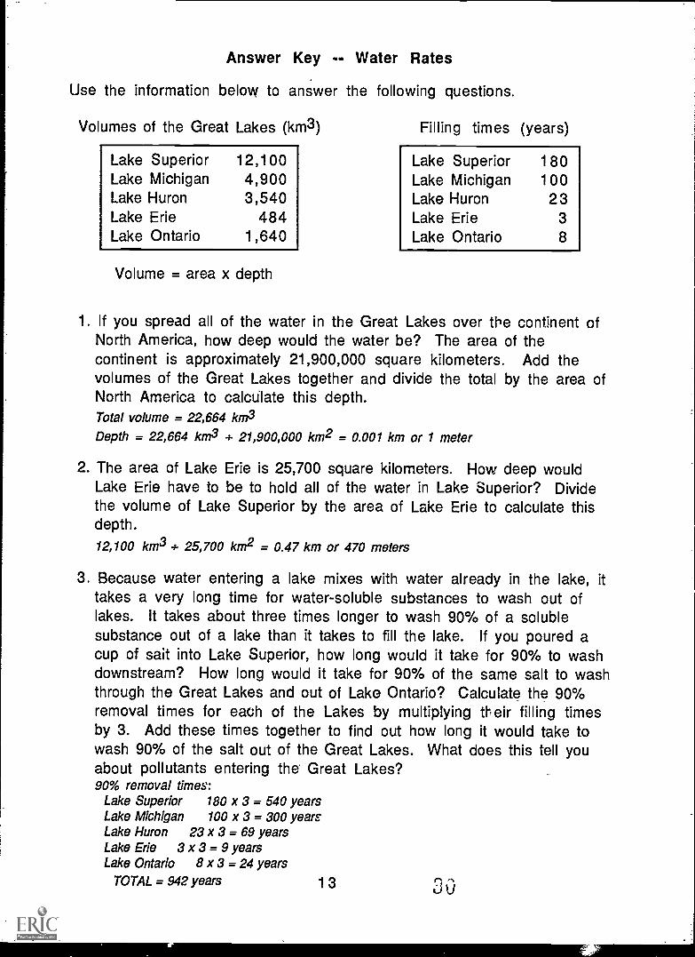
Answer Key -- Water Rates
Use the information below to answer the following questions.
Volumes of the Great Lakes (km3)
Lake Superior 12,100Lake Michigan 4,900Lake Huron 3,540Lake Erie 484Lake Ontario 1,640
Volume = area x depth
Filling times (years)
Lake Superior 180Lake Michigan 100Lake Huron 23Lake Erie 3Lake Ontario 8
1 If you spread all of the water in the Great Lakes over the continent ofNorth America, how deep would the water be? The area of thecontinent is approximately 21,900,000 square kilometers. Add thevolumes of the Great Lakes together and divide the total by the area ofNorth America to calculate this depth.Total volume = 22,664 km3
Depth = 22,664 km3 + 21,900,000 km2 = 0.001 km or 1 meter
2. The area of Lake Erie is 25,700 square kilometers. How deep wouldLake Erie have to be to hold all of the water in Lake Superior? Dividethe volume of Lake Superior by the area of Lake Erie to calculate thisdepth.
12,100 km3 + 25,700 km2 = 0.47 km or 470 meters
3. Because water entering a lake mixes with water already in the lake, ittakes a very long time for water-soluble substances to wash out oflakes. It takes about three times longer to wash 90% of a solublesubstance out of a lake than it takes to fill the lake. If you poured acup of sait into Lake Superior, how long would it take for 90% to washdownstream? How long would it take for 90% of the same salt to washthrough the Great Lakes and out of Lake Ontario? Calculate the 90%removal times for each of the Lakes by multiplying th eir filling timesby 3. Add these times together to find out how long it would take towash 90% of the salt out of the Great Lakes. What does this tell youabout pollutants entering the Great Lakes?90% removal times:
Lake Superior 180 x 3 = 540 yearsLake Michigan 100 x 3 = 300 yearsLake Huron 23 x 3 = 69 yearsLake Erie 3 x 3 = 9 yearsLake Ontario 8 x 3 = 24 years
TOTAL = 942 years 13
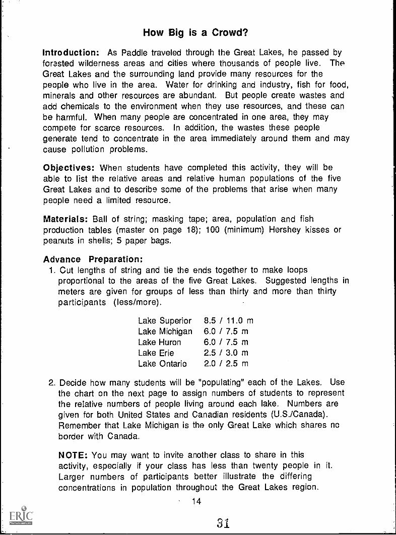
How Big is a Crowd?
Introduction: As Paddle traveled through the Great Lakes, he passed byforested wilderness areas and cities where thousands of people live. TheGreat Lakes and the surrounding land provide many resources for thepeople who live in the area. Water for drinking and industry, fish for food,minerals and other resources are abundant. But people create wastes andadd chemicals to the environment when they use resources, and these canbe harmful. When many people are concentrated in one area, they maycompete for scarce resources. In addition, the wastes these peoplegenerate tend to concentrate in the area immediately around them and maycause pollution problems.
Objectives: When students have completed this activity, they will beable to list the relative areas and relative human populations of the fiveGreat Lakes and to describe some of the problems that arise when manypeople need a limited resource.
Materials: Ball of string; masking tape; area, population and fishproduction tables (master on page 18); 100 (minimum) Hershey kisses orpeanuts in shells; 5 paper bags.
Advance Preparation:1. Cut lengths of string and tie the ends together to make loops
proportional to the areas of the five Great Lakes. Suggested lengths inmeters are given for groups of less than thirty and more than thirtyparticipants (less/more).
Lake Superior 8.5 / 11.0 mLake Michigan 6.0 / 7.5 mLake Huron 6.0 / 7.5 mLake Erie 2.5 / 3.0 mLake Ontario 2.0 / 2.5 m
2. Decide how many students will be "populating" each of the Lakes. Usethe chart on the next page to assign numbers of students to representthe relative numbers of people living around each lake. Numbers aregiven for both United States and Canadian residents (U.S./Canada).Remember that Lake Michigan is the only Great Lake which shares noborder with Canada.
NOTE: You may want to invite another class to share in thisactivity, especially if your class has less than twenty people in it.
Larger numbers of participants better illustrate the differingconcentrations in population throughout the Great Lakes region.
14
31
Number of peopleU.S./Canada
Total participants 15 20 25 130 35 40 45 50
Lake Superior 0/0 0/0 0/0 1/0 1/0 1/0 1/0 1/0
Lake Huron 1/0 1/1 1/1 1/1 1/1 2/1 2/1 2/1
Lake Ontario 1/2 1/3 2/3 2/4 2/4 2/5 3/5 3/6
Lake Erie 4/1 5/1 8/1 8/2 11/2 12/2 13/3 15/3
Lake Michigan 6/0 7/0 1 9/0 111/0 13/0 15/0 17/0 19/0
3. Divide Hershey Kisses or peanuts in shells into groups representing theproportional number of fish caught annually in each of the Great Lakes.You will need at least 100 Kisses or peanuts. One Kiss or peanutrepresents approximately 50 tons of fish. Label the five bags with thenames of the five Lakes and use the table below to put the correctnumber of "fish" in each bag. (For groups of less than 25 students, youmay want to halve these numbers.)
Lake Superior 8
Lake Michigan 35Lake Huron 5
Lake Erie 50Lake Ontario 2
Procedure:1. Look at the tables of information about the Great Lakes and discuss the
following questions:*Which of the lakes has the largest area? Which has the smallest?*Which lake has the largest population? Which has the smallest?*Are more people living near the eastern or the western lakes?*Are more people living near the United States or the Canadian shores?*Which lake produces the most fish? Which produces the least?*Where would you go if you wanted to catch fish?
15
2. Make an "international border" on the floor with a strip of tape.Arrange the loops of string which represent the five Great Lakes alongthe border from left to right according to the diagram below.
Lake Superior
Lake Michigan
Lake Erie Lake Ontario
4. Assign the appropriate numbers of participants to the United Statesand Canadian sides of each of the Lakes. (An alternative is to assignparticipants to each lake without specifying a country; in this caseyou do not need the tape border.) Each participant should put one footon the string "shore" of the lake. Where are people closest together?Did anyone have a hard time finding room to stand? On which lake orlakes do you think the biggest cities are located?
5. Pass the appropriate bag of "fish" around each lake. Each person takesONE Kiss or peanut each time the bag is passed to him or her until thebag is empty. (If you have no one assigned to Lake Superior, set asidethat bag and do not distribute those "fish" in the other lakes.) Whichlake had the most "fish"? In which lake did people catch the most?Why do you think this is so?
6. People create waste when they use resources, and much of that wasteis carried by water. Too much waste causes pollution problems. Openand eat your "fish." Put the foil wrappers or peanut shells on the floorinside the loop of string that is your lake. Which lake has the mostwaste (largest number of wrappers or shells)? In which lake is thewaste most concentrated (closest together)? Remember that thewater from each lake flows into the lake downstream (in this case, tothe right) of it. Which lake or lakes do you think might have the worstpollution problems? Why do you think so?
7. Clean up and discuss the activity together.
16
0 0
Discussion Questions:1. What relationships have you seen between population, resources and
waste?
2. What could you have done to make sure ALL participants got an equalnumber of "fish"? (Sell or trade for other resources or services, forexample.)
3. How do you think the amount of pollution in the Great Lakes could bereduced?
4. How could you reduce the amount of waste you produce?
Extension Activities: Play math games with Great Lakes areas andpopulations. For example, find out how many Lake Eries could fit in oneLake Superior, how many people per square meter there are in each lake,and so on. Or organize a Clean Campaign (page 109) to learn more aboutrecycling.
Additional Information:
The Great Lakes: An Environmental Atlas and Resource Book.Jointly produced by the U.S. Environmental Protection Agency andEnvironment Canada. Copies are available free of charge from:
Great Lakes National Program Office ,U.S. Environmental Protection Agency
230 South Dearborn StreetChicago, Illinois 60604
OR
Conservation and Protection, Ontario RegionGreat Lakes Environment Program
Environment Canada25 St. Clair Avenue East
Toronto, Ontario M4T 1M2
17
Water Surface Areas of the Great Lakes(km2)
Lake Area
Lake Superior 82,100Lake Michigan 57,800Lake Huron 59,600Lake Erie 25,700Lake Ontario 18,960
Great Lakes Population(as of 1981)
Lake Canada United States Total
Lake Superior 180,440 558,100 738,540Lake Michigan 0 13,970,900 13,970,900Lake Huron 1,051,119 1,321,000 2,372;419Lake Erie 1,621,106 11,347,500 12,968,606Lake Ontario 4,551,875 2,090,300 6,642,175
Average Annual Catch of Fish(tons)
Lake Annual Catch
Lake Superior 400
Lake Michigan 1,800
Lake Huron 280
Lake Erie 2,600
Lake Ontario 100
18
35
Rivers in the Air
Introduction: Throughout the story, Hol ling describes how Paddle iscarried along by currents. Currents in the water of the pond carriedPaddle around its shores; currents carried him around the shores of LakeSuperior and up the shore of Lake Michigan. Currents act like riverswithin a body of water such as a lake or pond. There are also currents inthe air, caused by winds. Air currents also act like rivers to carryfloating objects (balloons, for example) from place to place.
Objective: When they have completed this activity, students will be ableto explain how air currents act like rivers to carry floating objects.
Materials: Fan, soap bubbles (buy the bubble solution and bubble ring atmost stores where toys are sold, or make your own solution of dish soapand water, and use a small circle of thin wire as a bubble ring).
Procedure:1. Practice making bubbles with the bubble ring. Observe how the bubbles
float and move in the air. Try blowing the bubbles from place to placewith your breath. What happens to the bubbles?
2. Set up the fan in one corner of the room and turn it on to its lowestsetting. This simulates a steady current of wind in the classroom.
3. Make bubbles and release them in the current of air in front of the fan.Observe how the bubbles move in this air stream. Where do they go?How fast do they move? Do they always move in the same direction?
4. Try releasing the bubbles above the fan, below it, or beside it, as well asin front of it. Observe how the bubbles move now.
5. Turn the fan speed up and repeat the experiment. Now what happens tothe bubbles? Do they move in the same direction that they did at thelower speed? Do they move the same distance?
Discussion Questions:1. What happened to the bubbles you released in still air (before the fan
was turned on)?
2. What happened to the bubbles you released in front of the fan? How didthey move?
19
3. Was there any difference in the way the bubbles moved when youreleased them above, below, or beside the fan? Why do you think thismight be so?
4. Compare the way the bubbles moved in the air stream with the way youhave seen objects move in water currents. How does the wind act likea river in the air?
5. When the fan was turned to the higher setting, what happened to thebubbles? What does this tell you about the strength of the windcreated by the fan?
6. Paddle was carried along by water currents, but sometimes windspushed him backward. How do wind currents help people move fromone place to another? Ca.n you think of ways that wind currents mightkeep people from moving ahead?
7. How do people use the power of winds to do work? Some examples aresailboats, windmills to pump water or generate electricity, hanggliders.
8. Are wind currents and water currents related?
9. Suppose bubbles lasted forever. Would this create problems in ourworld?
Extension Activity: Organize a balloon launch to illustrate how windcurrents can carry objects to different locations. Directions are onthe next page.
2027
Balloon Launch
Introduction: Wind currents in the air carry floating objects likeballoons from place to place much as water currents carried Paddle alongon his voyage. Where the floating objects are carried depends upon thedirection the current is moving. Releasing balloons in the wind andfinding out where they land will help us discover what direction the windwas blowing when the balloons were released.
Objectives: When they have completed this activity, students will beable to list and identify on a map the different locations that the balloonsreached, and to tell the direction the wind was blowing on the day of thelaunch.
Materials: Balloons, string, helium tank for filling balloons, pre-stampedToo-St /cards (available from the post office).
Advance Preparation:1. Find a clear area to launch the balloons. Playgrounds, parking lots, or
open fields are good choices. Avoid areas with many wires and talltrees nearby.
2. Find out where to rent a helium tank, how much it will cost and how tooperate it. Check party supply stores or look for HELIUM listings in theYellow Pages of the phone book.
3. Ask for parent volunteers to help with chaperoning and transportationto the launch site.
4. Call your local newspaper and arrange coverage for this special event.Arrange for a follow-up article after your cards have been returned.
5. Complete a weather unit. Discuss wind speed, wind direction,forecasts. Consider contacting a local meteorologist to give aweather presentation to the class.
Procedure:1. Have each student address a post card to your class in care of your
school's address.
2. Prepare a brief message for students to write on the post cards. Hereis a sample message:
21
a
John Smith's class in (your town) launched this balloon on(month/day/year). Please fill in your name, address and thedate and place you found the halloos, then mail this card backto us. Thanks for helping us!
3. Laminate the cards to protect them from the weather and damplandings.
4. Fill the balloons with helium and attach a filled balloon to each cardwith a two- or three-foot length of string. Be very careful with thefilled balloons: they will brea:: easily if bumped and they will floataway if you let go of them. It is a good idea to have extras in caseaccidents do happen to some balloons before you reach your launch site.
5. A clear, breezy day is best for launching your balloons. Choose a launchday and an alternate in case of unexpected bad weather. Have fun!
6. Wait for your cards to come back in the mail. It could take weeks forthe cards to come back, and some will never come back at all. Youshould set an outside time limit for waiting, then go ahead and discussyour results.
Discussion Questions:1. Of the number of cards launched, how many were returned to you?
Prom how many different places were the cards returned?
3. Locate these places on a map of the area. Are they close together orfar apart? Are these places in roughly one direction from the launchsite or from all around it?
4. What does this tell you about the wind direction and speed on the dayof the launch?
NOTE: Many people now fear that balloon launches endanger marineanimals. Some animals like sea turtles mistake the plastic for thejellyfish they usually eat. Please consider all the impacts that thisactivity might have if wind currents from your area move out over theocean.
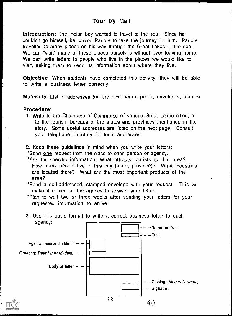
Introduction: The Indian boy wanted to travel to the sea. Since hecouldn't go himself, he carved Paddle to take the journey for him. Paddletravelled to many places on his way through the Great Lakes to the sea.We can "visit" many of these places ourselves without ever leaving home.We can write letters to people who live in the places we would like tovisit, asking them to send us information about where they live.
Objective: When students have completed this activity, they will be ableto write a business letter correctly.
Materials: List of addresses (on the next page), paper, envelopes, stamps.
Procedure:1. Write to the Chambers of Commerce of various Great Lakes cities, or
to the tourism bureaus of the states and provinces mentioned in thestory. Some useful addresses are listed on the next page. Consultyour telephone directory for local addresses.
2. Keep these guidelines in mind when you write your letters:*Send one request from the class to each person or agency.*Ask for specific information: What attracts tourists to this area?
How many people live in this city (state, province)? What industriesare located there? What are the most important products of thearea?
*Send a self-addressed, stamped envelope with your request. This willmake it easier for the agency to answer your letter.
*Plan to wait two or three weeks after sending your letters for yourrequested information to arrive.
3. Use this basic format to write a correct business letter to eachagency:
Agency name and address --
Dear Sir or Madam,
Body of letter
L
Return address
Date
i i
I i
Closing: Sincerely yours,
Signature
2340
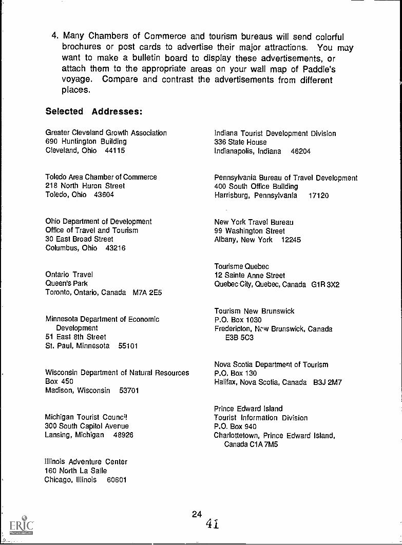
4. Many Chambers of Commerce and tourism bureaus will send colorfulbrochures or post cards to advertise their major attractions. You maywant to make a bulletin board to display these advertisements, orattach them to the appropriate areas on your wall map of Paddle'svoyage. Compare and contrast the advertisements from differentplaces.
Selected Addresses:
Greater Cleveland Growth Association690 Huntington BuildingCleveland, Ohio 44115
Toledo Area Chamber of Commerce218 North Huron StreetToledo, Ohio 43604
Ohio Department of DevelopmentOffice of Travel and Tourism30 East Broad StreetColumbus, Ohio 43216
Ontario TravelQueen's ParkToronto, Ontario, Canada M7A 2E5
Minnesota Department of EconomicDevelopment
51 East 8th StreetSt. Paul, Minnesota 55101
Wisconsin Department of Natural ResourcesBox 450Madison, Wisconsin 53701
Michigan Tourist Councq300 South Capitol AvenueLansing, Michigan 48926
Illinois Adventure Center160 North La SalleChicago, Illinois 60601
Indiana Tourist Development Division336 State HouseIndianapolis, Indiana 46204
Pennsylvania Bureau of Travel Development400 South Office BuildingHarrisburg, Pennsylvania 17120
New York Travel Bureau99 Washington StreetAlbany, New York 12245
Tourisme Quebec12 Sainte Anne StreetQuebec City, Quebec, Canada G1R 3X2
Tourism New BrunswickP.O. Box 1030Fredericton, Ncw Brunswick, Canada
E3B 5C3
Nova Scotia Department of TourismP.O. Box 130Halifax, Nova Scotia, Canada B3J 2M7
Prince Edward IslandTourist Information DivisionP.O. Box 940Charlottetown, Prince Edward Island,
Canada C1A 7M5
2441
Time Line
Introduction: Paddle's journey to the sea took a long time, and manythings happened to him on the way. We use calendars to help us keep trackof time and events, but they usually show us only one month at a time. Atime line is another way to keep track of time. It is a continuous recordof events that happen cver time, like planing the pages of a calendar sideby side instead of one on top of the other. A time line would show us at aglance how long it took Paddle to reach the sea and what kinds of thingshappened to Paddle during each season of his journey.
Objectives: When students have completed this activity, they will beable to tell how long it took Paddle to reach the sea and to list the majorevents that occurred during each season that passed. Note: You can makeone time line for the whole class or have each student make one.
Materials: Long strip of paper (rolls of newsprint, shelf paper orcomputer paper are idea!), markers or crayons.
Procedure:1. Begin your time line at the left edge of the paper. Since Paddle's
journey begins in the spring, write "Spring" at the beginning of yourtime line.
2. Working from left to right, add events and seasons to the time line asyou read the book. A summary of the major events in each season isprovided on the next page.
3. Illustrate the time line with drawings of Paddle's adventures.
Discussion Questions:1. How long did it take for Paddle to reach the sea?
2. What kinds of things happened to Paddle in each season?
3. What animals did Paddle meet? Where did he meet them?
4. What people did Paddle meet? What were they doing?
5. How many cities did Paddle visit?
6. In what order did Paddle pass through the Great Lakes?
7. Where did Paddle's journey finally end?
2542
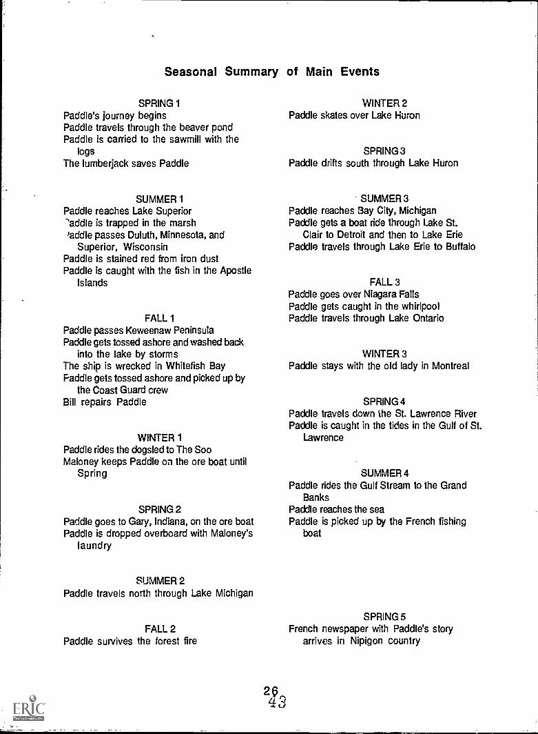
Seasonal Summary of Main Events
SPRING 1Paddle's journey beginsPaddle travels through the beaver pondPaddle is carried to the sawmill with the
logsThe lumberjack saves Paddle
SUMMER 1Paddle reaches Lake Superior-'addle is trapped in the marsh'addle passes Duluth, Minnesota, and
Superior, WisconsinPaddle is stained red from iron dustPaddle is caught with the fish in the Apostle
Islands
FALL 1Paddle passes Keweenaw PeninsulaPaddle gets tossed ashore and washed back
into the lake by stormsThe ship is wrecked in Whitefish BayPaddle gets tossed ashore and picked up by
the Coast Guard crewBill repairs Paddle
WINTER 1Paddle rides the dogsled to The SooMaloney keeps Paddle on the ore boat until
Spring
SPRING 2Paddle goes to Gary, Indiana, on the ore boatPaddle is dropped overboard with Maloney's
laundry
SUMMER 2Paddle travels north through Lake Michigan
FALL 2Paddle survives the forest fire
WINTER 2Paddle skates over Lake Huron
SPRING 3Paddle drifts south through Lake Huron
SUMMER 3Paddle reaches Bay City, MichiganPaddle gets a boat ride through Lake St.
Clair to Detroit and then to Lake EriePaddle travels through Lake Erie to Buffalo
FALL 3Paddle goes over Niagara FallsPaddle gets caught in the whirlpoolPaddle travels through Lake Ontario
WINTER 3Paddle stays with the old lady in Montreal
SPRING 4Paddle travels down the St. Lawrence RiverPaddle is caught in the tides in the Gulf of St.
Lawrence
SUMMER 4Paddle rides the Gulf Stream to the Grand
BanksPaddle reaches the seaPaddle is picked up by the French fishing
boat
SPRING 5French newspaper with Paddle's story
arrives in Nipigon country
What Do You "See" in the Great Lakes?
Introduction: As Paddle travels through each of the five Great Lakes,Holling describes a "picture" that he imagined in the outline of the shapeof each lake. Lake Superior made Holling think of a wolf's head, LakeMichigan appeared to be a squash with its leaves, and so on. Use yourimagination to see what Holling saw in the shape of each lake. Do you seeany different pictures in these outlines?
Objective: When they have completed this activity, students will be ableto identify the shape of each of the five Great Lakes.
Materials: Outlines of each lake (masters on pages 28-32) for eachstudent, sample pictures drawn by the author, markers or crayons.
Note: You may wish to complete this activity for all five Great Lakes aspart of a general introduction to the story. Or repeat the activity for eachlake as Paddle's travels carry him through it.
Procedure:1. Give each student an outline of one of the lakes. If you are using this
as a general introduction, you may wish either to have everyone usethe same shape at the same time (see how many different picturesstudents see in the same shape) or divide the class into groups to workon all five lakes at the same time.
2. Examine Holling's pictures of what he saw in each lake. Look for thedetails that help each outline to become a whole picture.
3. Think about what you can see in the shape of each lake. Draw detailsin the outline to complete your picture. Did you see any differentpictures than Holling did in each lake?
4. Share your lake picture(s) with the class. How many differentpictures did you discover for each lake?
5. Test your memory. Can you identify each lake by shape? Take turnschoosing a blank outline and have others name it, or name a lake andhave others choose the correct outline.
Extension: Look at maps in an atlas for other geographic features whoseshapes suggest pictures to you (examples: Italy looks like a boot, Lake St.Clair is heart-shaped). Trace the outlines of these features and fill indetails to complete new pictures from these shapes.
274 4,i
,
Lake Michigan
46
Lake Huron
47
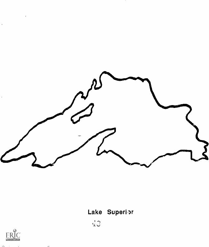
Lake Superiw
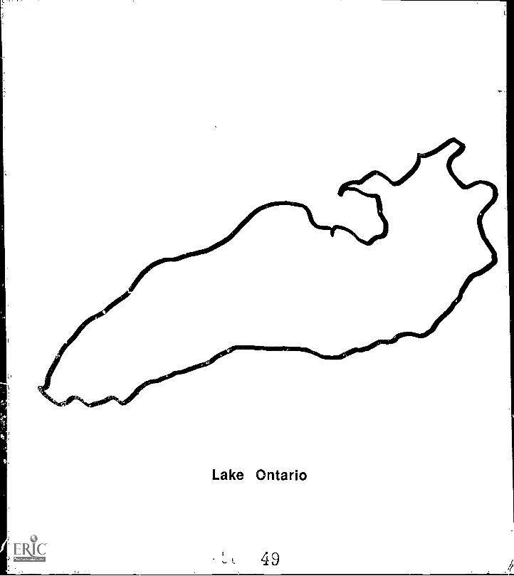
Lake Ontario
, E. 49
Taken by Surprise
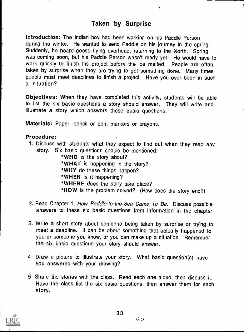
Introduction: The Indian boy had been working on his Paddle Personduring the winter. He wanted to send Paddle on his journey in the spring.Suddenly, he heard geese flying overhead, returning to the North. Springwas coming soon, but his Paddle Person wasn't ready yet! He would have towork quickly to finish his project before the ice melted. People are oftentaken by surprise when they are trying to get something dune. Many timespeople must meet deadlines to fin'sh a project. Have you ever been in sucha situation?
Objectives: When they have completed this activity, students will be ableto. list the six basic questions a story should answer. They will write andillustrate a story which answers these basic questions.
Materials: Paper, pencil or pen, markers or crayons.
Procedure:1. Discuss with students what they expect to find out when they read any
story. Six basic questions should be mentioned:*WHO is the story about?*WHAT is happening in the story?*WHY do these things happen?*WHEN is it happening?*WHERE does the story take place?*HOW is the problem solved? (How does the story end?)
2. Read Chapter 1, How Paddle-to-the-Sea Came To Be. Discuss possibleanswers to these six basic questions from information in the chapter.
3. Write a short story about someone being taken by surprise or trying tomeet a deadline. It can be about something that actually happened toyou or someone you know, or you can make up a situation. Rememberthe six basic questions your story should answer.
4. Draw a picture to illustrate your story. What basic question(s) haveyou answered with your drawing?
5. Share the stories with the class. Read each one aloud, then discuss it.Have the class list the six basic questions, then answer them for eachstory.
336u
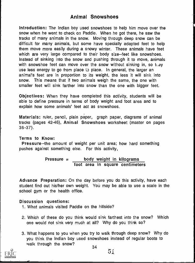
Animal Snowshoes
Introduction: The Indian boy used snowshoes to help him move over thesnow when he went to check on Paddle. When he got there, he saw thetracks of many animals in the snow. Moving through deep snow can bedifficult for many animals, but some have specially adapted feet to helpthem move more easily during a snowy winter. These animals have feetwhich are very large compared to their body size--feet like snowshoes.Instead of sinking into the snow and pushing through it to move, animalswith snowshoe feet can move over the snow without sinking in, so ti.ayuse less energy to go from place to place. In general, the larger ananimal's feet are in proportion to its weight, the less it will sink intosnow. This means that if two animals weigh the same, the one withsmaller feet will sink farther into snow than the one with bigger feet.
Objectives: When they have completed this activity, students will beable to define pressure in terms of body weight and foot area and toexplain how some animals' feet act as snowshoes.
Materials: ruler, pencil, plain paper, graph paper, diagrams of animaltracks (pages 42-46), Animal Snowshoes worksheet (master on pages36-37).
Terms to Know:Pressure -the amount of weight per unit area; how hard something
pushes against something else. For this activity,
Pressure = body weight in kilogramsfoot area in square centimeters
Advance Preparation: On the day before you do this activity, have eachstudent find out his/her own weight. You may be able to use a scale in theschool gym or the health office.
Discussion questions:1. What animals visited Paddle on the hillside?
2. Which of these do you think would sink farthest into the snow? Whichone would not sink very much at all? Why do you think so?
3. What happens to you when you try to walk through deep snow? Why doyou think the Indian boy used snowshoes instead of regular boots towalk through the snow?
34 r01
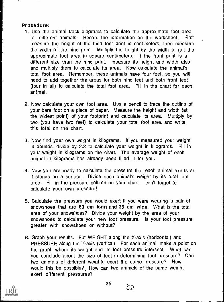
Procedure:1. Use the animal track diagrams to calculate the approximate foot area
for different animals. Record the information on the worksheet. Firstmeasure the height of the hind foot print in centimeters, then measurethe width of the hind print. Multiply the height by the width to get theapproximate foot area in square centimeters. If the front print is adifferent size than the hind print, measure its height and width alsoand multiply them to calculate its area. Now calculate the animal'stotal foot area. Remember, these animals have four feet, so you willneed to add together the areas for both hind feet and both front feet(four in all) to calculate the total foot area. Fill in the chart for eachanimal.
2. Now calculate your own foot area. Use a pencil to trace the outline ofyour bare foot on a piece of paper. Measure the height and width (atthe widest point) of your footprint and calculate its area. Multiply bytwo (you have two feet) to calculate your total foot area and writethis total on the chart.
3. Now find your own weight in kilograms. If you measured your weightin pounds, divide by 2.2 to calculate your weight in kilograms. Fill inyour weight in kilograms on the chart. The average weight of eachanimal in kilograms has already been filled in for you.
4. Now you are ready to calculate the pressure that each animal exerts asit stands on a surface. Divide each animal's weight by its total footarea. Fill in the pressure column on your chart. Don't forget tocalculate your own pressure!
5. Calculate the pressure you would exert if you were wearing a pair ofsnowshoes that are 60 cm long and 35 cm wide. What is the totalarea of your snowshoes? Divide your weight by the area of yoursnowshoes to calculate your new foot pressure. Is your foot pressuregreater with snowshoes or without?
6. Graph your results. Put WEIGHT along the X-axis (horizontal) andPRESSURE along the Y-axis (vertical). For each animal, make a point onthe graph where its weight and its foot pressure intersect. What canyou conclude about the size of feet in determining foot pressure? Cantwo animals of different weights exert the same pressure? Howwould this be possible?. How can two animals of the same weightexert different pressures?
3552
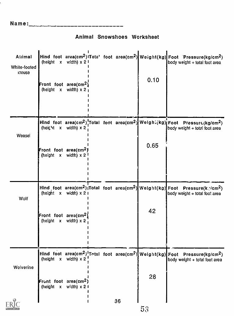
Name:
Animal Snowshoes Worksheet
1
At lima! Hind foot area(cm2)ITota" foot area(cm2) Weight(kg) Foot 'Pressure(kg/cm2)(height x width) x 2 I
iii
n iront foot area(cm2)(height x width) x 2
White-footedmouse
Weasel
-..,
Hind foot area(cm2) Total foot area(cm2) WeigKikg) Foot Pressurc(kg/cm2)(height x width) x 2
body weight + total foot area
0.10
ront foot area(cm21(height x width) x 2 I
i
i
1
i
i
Hind foot area(cm2)1Total foot area(cm2) Weight(kg) Foot Pressure(k slcm2)(height x width) x 2 i
Wolf I
i
i
Front foot area(cm2i(height x width) x 2 1
i
i
i
i
body weight + total foot area
0.65
Wolverine
IMMONNVM
body weight + total foot area
42
Hind foot area(cm2)'Tntal foot area(cm2) Weight(kg) Foot Pressure(kg/cm2)(height x width) x 2 I
1
1
i
1 28Frunt foot area(cm2)
(height x width) x 2 Ii
1
I 36
body weight + total foot area
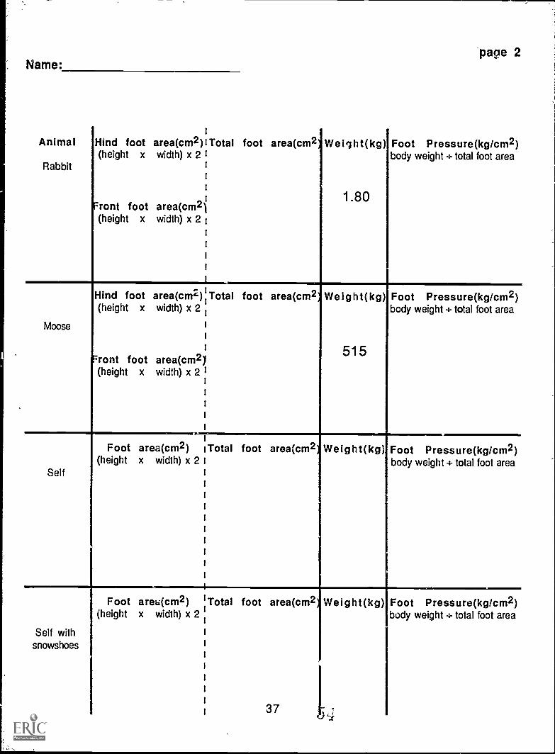
Name:
iAnimal Hind foot area(cm2)I Total
(height x width) x 2 I1
t
1
ront foot area(cm2i(height x width) x 2 1
Rabbit
Moose
page 2
foot area(cm2 Weig ht(kg)I Foot Pressure(kg/cm2)body weight + total foot area
1.80
Hind foot area(cm2) Total foot area(cm(height x width) x 2
Front foot area(cm2(height x width) x 2
Weight(kg)
515
Foot Pressure(kg/cm2)body weight + total foot area
Foot area(cm2) iTotal foot area(cm2 Weight(kg)(height x width) x 2
Self
Foot Pressure(kg/cm2)body weight + total foot area
Self withsnowshoes
Foot area(cm2) I Total foot area(cm(height x width) x 2
1
i
1
t
1
1
1
t 37
Weight(kg) Foot Pressure(kg/cm2)body weight ÷ total foot area
Tracking a Good Story
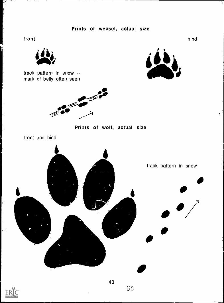
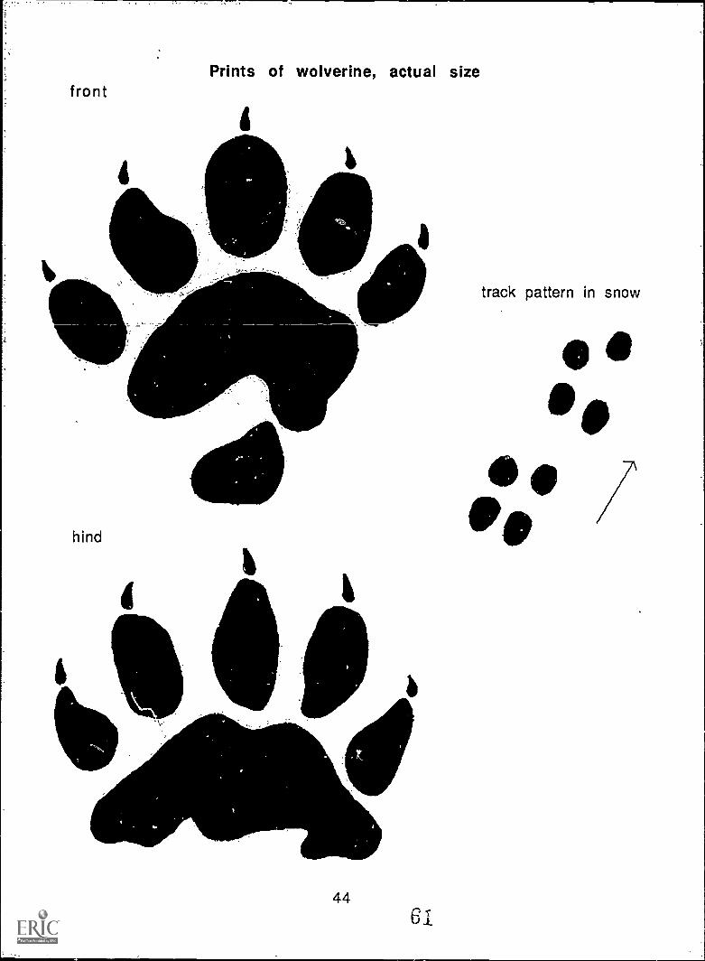
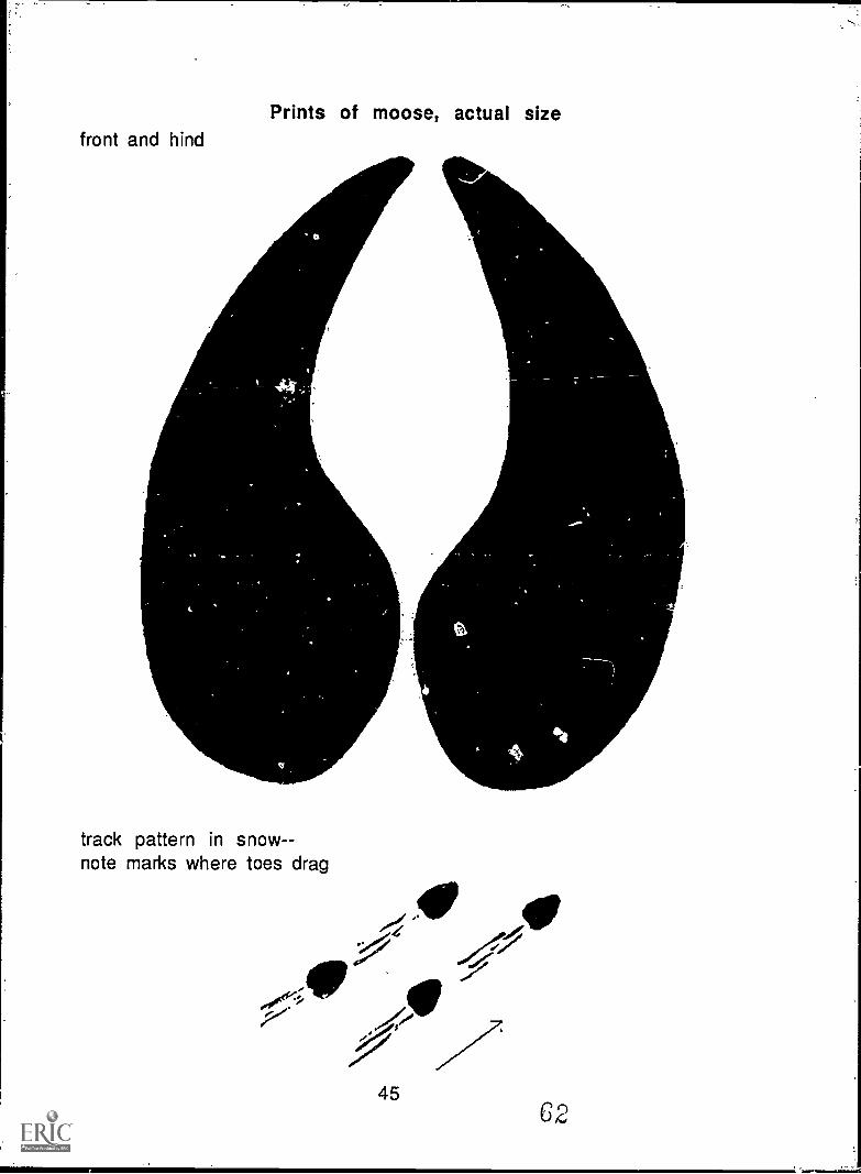
Introduction: Many animals came to look at Pa ' ile while he was on thesnowbank. The Indian boy, knew what animals hau been there beJause herecognized their tracks in the snow. Animal tracks tell a story. Tracksshow what animals have been in certain places, which way they weretravelling, how fast they were moving, and if they were alone or withothers. Look for animal tracks in snow during the winter or in muddyareas when there is no snow on the ground..
Objectives: When they have completed this activity, students wiil beable to identify pictures of tracks of the animals mentioned in Chapter 3and use pictures of animal tracks to tell a story.
Materials: Pictures of animal tracks and sample track picture story(pages 42-46), drawing paper and pencil for each student or group ofstudents, Animal Print Identification worksheet (master on page 40).
Terms to Know:Print - -mark left by a single pawTrack -set of prints; shows direction and speed of motion
Procedure:1. Study the pictures of animal prints and tracks. Toe marks in tracks
are a clue to the direction in which the animal was travelling; thetoe marks will be at the front of each print. The distance betweentracks is a clue to how fast the animal was moving; usually, thefarther apart the tracks, the faster the animal's speed.
2. Discuss the following questions:Are any of these prints similar to ones you have seen before? Which
ones?(For example, wolf is similar to dog, moose is similar to deer)
How are these prints and tracks alike and different?Two of these animals belong to the same family. Can you identify
them by comparing their prints?(Weasel and wolverine belong to the same family--both have fivetoes on front and hind feet)
3. Complete the Print Identification Worksheet.
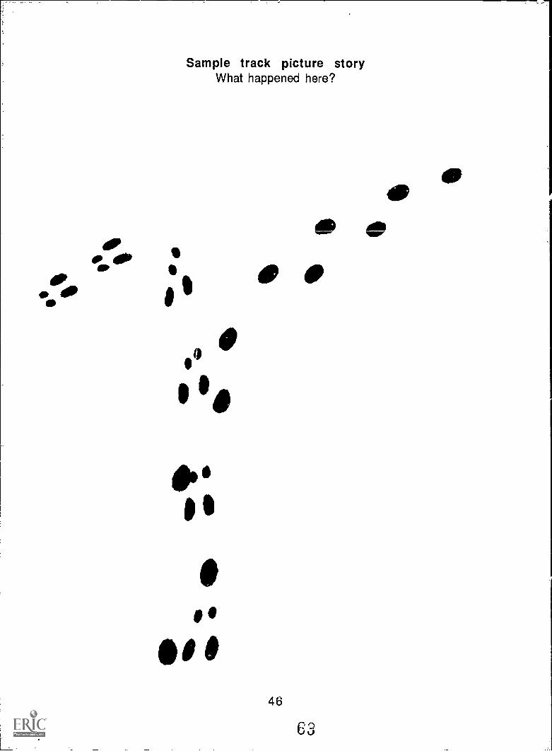
4. Study the sample track picture story. Discuss the followingquestions:
38
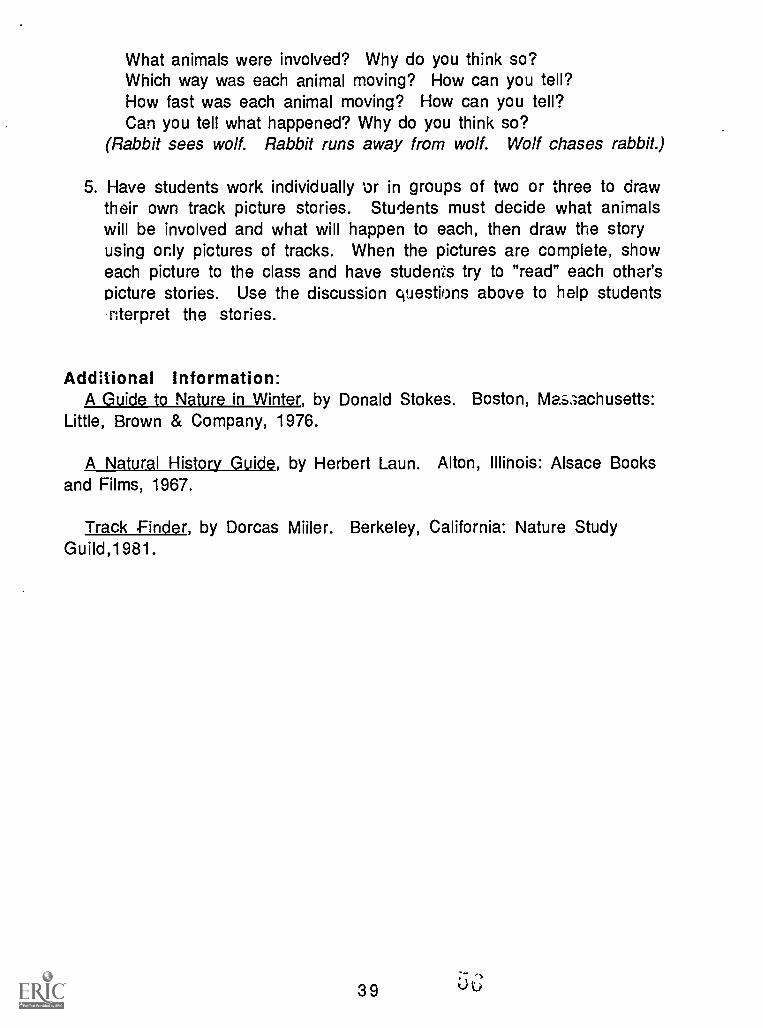
What animals were involved? Why do you think so?Which way was each animal moving? How can you tell?How fast was each animal moving? How can you tell?Can you tell what happened? Why do you think so?
(Rabbit sees wolf. Rabbit runs away from wolf. Wolf chases rabbit.)
5. Have students work individually 4or in groups of two or three to drawtheir own track picture stories. Students must decide what animalswill be involved and what will happen to each, then draw the storyusing only pictures of tracks. When the pictures are complete, showeach picture to the class and have students try to "read" each other'spicture stories. Use the discussion questions above to help studentsnterpret the stories.
Additional Information:A Guide to Nature in Winter, by Donald Stokes. Boston, Me.s3achusetts:
Little, Brown & Company, 1976.
A Natural History Guide, by Herbert Laun. Alton, Illinois: Alsace Booksand Films, 1967.
Track Finder, by Dorcas Miller. Berkeley, California: Nature StudyGuild,1981.
39
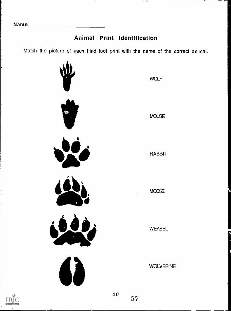
Name:
Animal Print Identification
Match the picture of each hind foot print with the name of the correct animal.
MIPP,IIPPIN,
di
k
4075
WOLF
MOUSE
RABBIT
MOOSE
WEASEL
WOLVERINE
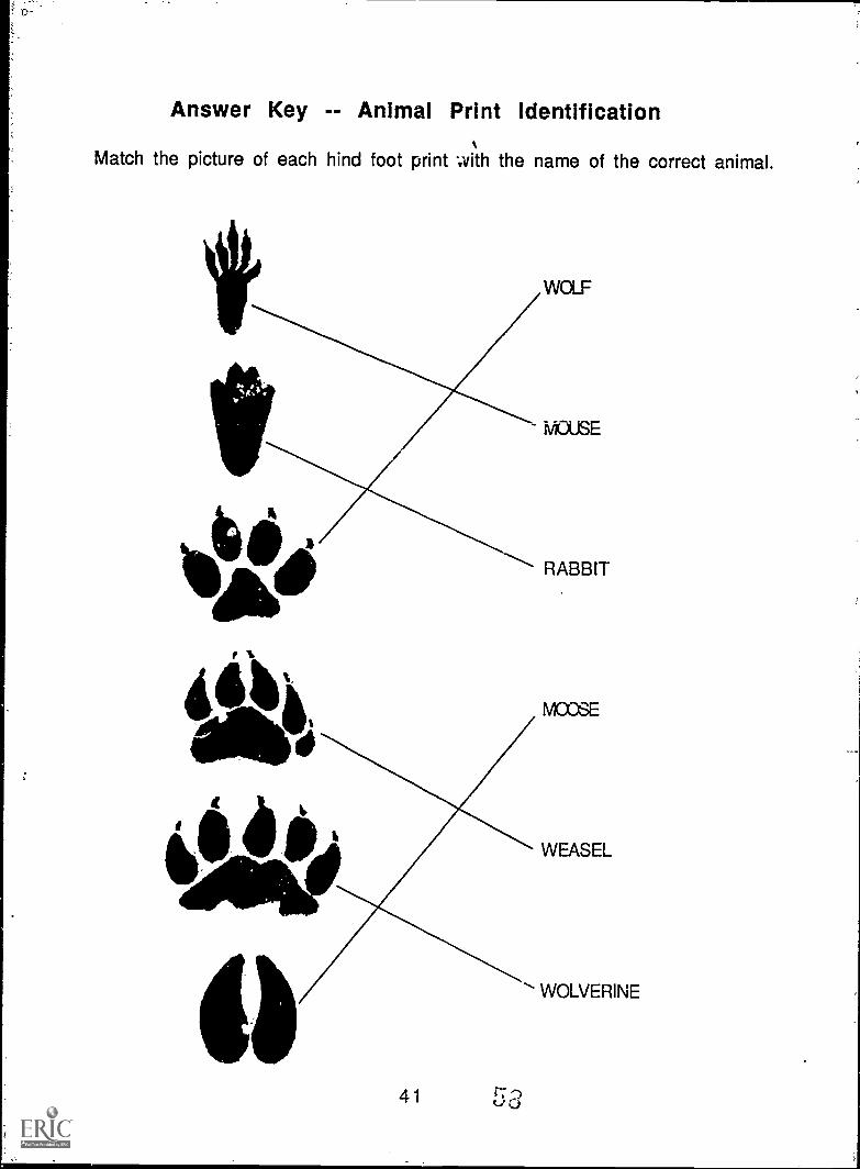
Answer Key -- Animal Print Identification
Match the picture of each hind foot print with the name of the correct animal.
WOLF
MOUSE
RABBIT
41
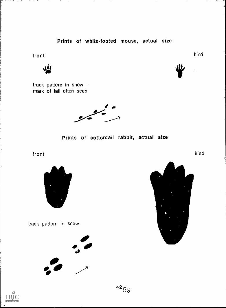
Prints of white-footed mouse, actual size
front hind
track pattern in snow --mark of tail often seen
1 op
..--------
Prints of cottontail rabbit, actual size
front hind
track pattern in snow
rh.
, ,
fro nt
aki
track pattern in snow --mark of belly often seen
front and hind
s of weasel, actual size
101.-"1".411
Off4.1
Prints of wolf, actual size
43
td
hind
track pattern in snow
a
9/
Prints of wolverine, actual sizefront
hind
44
a
track pattern in snow
Prints of moose, actual sizefront and hind
track pattern in snow- -note marks where toes drag
4"../ .,,--AIF,
456°4
"..........:;.....Ha
Imp O.
00 I
Sample track picture storyWhat happened here?
I
46
63
41,
Pond Diorama
Background: Read Chapter 4, Brook and Beaver Pond, and discuss thefollowing questions:
1. How did beavers make the pond? They built a dam across the stream.
2. What does the beavers' home look like? It is made of sticks heldtogether with mud. It looks like a small island in the pond.
3. What do the pond banks look like? There are many trees around thepond. There are stumps of trees that the beavers have cut down.
4. What animals are mentioned in the chapter? Beavers, deer, mink, fish,muskrat, skunk, porcupine.
5. Why would these animals need the pond? For food and water (all), fora home or protection from enemies (beaver, fish, muskrat).
Objectives: When they have completed this activity, students will beable to name animals which live in or near a northern pond and tell howthose animals use the pond.
Materials: Large shoe box or small carton for each diorama (have eachstudent make one, or collaborate on a larger one for the whole class),pictures of pond animals (cut from magazines or draw your own), stiffpaper or oaktag, paste, plain wood toothpicks or sr-all twigs, modellingclay, tempera paints and brushes, aluminum foil and cotton balls(optional).
Terms to Know:Diorama: a three-dimensional picture or sceneLodge: a beaver's home, built of sticks and mud in a pond
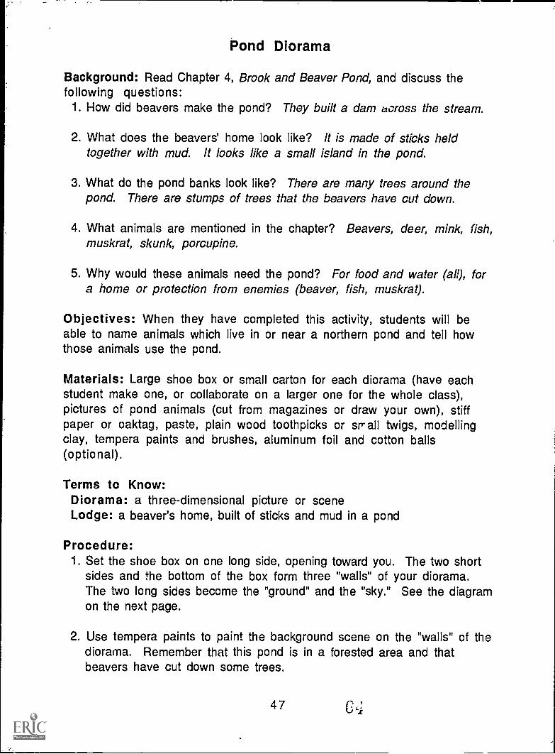
Procedure:1. Set the shoe box on one long side, opening toward you. The two short
sides and the bottom of the box form three "walls" of your diorama.The two long sides become the "ground" and the "sky." See the diagramon the next page.
2. Use tempera paints to paint the background scene on the "walls" of thediorama. Remember that this pond is in a forested area and thatbeavers have cut down some trees.
47 CL1
3. Paint the sky on the diorama. You may want to glue on cotton balls tomake clouds.
4. Paint the ground and the pond on the diorama. You may want to use apiece of aluminum foil to represent the water in the pond.
5. Make the beavers' dam and home (lodge). Use pieces of toothpicks ortwigs for the sticks. Use modelling clay to "glue" the sticks together.Position the dam along one side of the pond and the lodge in the centerof the pond. Use more clay to hold them in place. You may want to usepieces of twigs stuck in clay along the edges of the pond to representthe stumps of cut trees.
6. Cut from magazines or draw your own pictures of the pond animals.Cut out each animal and paste it to a piece of stiff papc:, leaving a tabof stiff paper at the bottom (see the diagram below). Position theanimals in the diorama by folding the tab underneath and gluing it tothe box; the animals will stand up. Your diorama is complete!
Diorama
48
stiffpaper
fold back
65
Beaver's Point ol View
Introduction: Paddle travelled down the brook and into a beaver pond.The author describes all the things Paddle "sees." He is writing fromPaddle's point of view. In the middle of the pond, an old beaver sits on topof his lodge. What might the beaver think of Paddle? What might he thinkof the other animals at the pond? How might he 'eel as he scratcheshimsels in the sun? The old beaver has a different point of view thanPaddle .does. Different things are important to him.
Objectives: When they have completed this activity, students will be ableto list the six basic questions a story should answer. They will write andillustrate a story which answers these basic questions.
Materials: Paper, pencil or pen, markers or crayons.
Procedure:1. Discuss with students what they expect to find out when they read any
story. Six basic questions should be mentioned:*WHO is the story about?*WHAT is happening in the story?*WHY do these things happen?*WHEN is it happening?*WHERE does the story take place?*HOW is the problem solved? (How does the story end?)
2. Read Chapter 4, Brook and Beaver Pond. Discuss what the old beaversees from the top of his lodge and how the beaver might feel aboutPaddle and the other animals. Try to answer the six basic questionsfrom the beaver's point of view as you talk about the chapter.
3. Pretend you are the old beaver and write a story about the pond fromhis point of view. Remember the six questions your story shouldanswer.
4. Draw a picture to illustrate your story. What basic question(s) haveyou answered with your drawing?
Extension Activities: Choose another animal mentioned in the chapterand write a story from its point of view. OR write a play about the pondand give a speaking part to each of the animals.
Forest Careers
Introduction: As Paddle floated down the river during the first Spring ofhis voyage, he was caught in a log jam and carried toward a sawmill. Thelogs had been piled along the rkcr banks by loggers, or lumberjacks. Thelumberjacks cut the trees in forested areas and sent them off to thesawmill. There are many careers related to growing;, harvesting and usingforests and trees.
Objective: When students have completed this activity, they will be ableto list and describe at least three forest-related careers.
Materialv: Forest Careers worksheet (master on page 52), pencil orpen.
Procedure:1. Ask students to think of jobs related to forests or trees. For earth iob
named, list at least one responsibility involved in that job. ;:orexample, a logger cuts down trees. A list of some forest-nelater,careers is on the following page. Did the class think of of liwivii4eDid you come up with any different ones?
2. Find out about forest-related jobs in your community or state. Thisinformation would be available from area colleges or universities,Cooperative Extension services, Chambers of Commerce or industries.Check your local telephone directory for phone numbers and addresses.Call or write to request information about different forest camers. If
you choose to write, use the suggestions for requesting informationand the business letter format found on page 23. Make a bulletin boardto display your information.
3. Invite a representative of one of the agencies you contacted to speakto the class about his/her job and related careers. Before the speakerarrives, think of questions to ask or issues you want to talk about andencourage students to interview the speaker. Encourage the speaker tobring informational handouts or ideas for activities to do with theclass that could enhance the speaker's presentatic.:n.
4. Complete the Forest Caol -.I. worksheet.
50
67

Examples of forest-related careers:
Arboretum employee--classifies and cares for woody plants includingtrees; may preserve samples for display.
Botanist -- studies the life cycles, growth, structure and classificationof plants.
Forester--studies the growth patterns, management and use of woodedareas; helps decide what trees should be planted to fulfill a given need(for lumber or to enhance wildlife habitat, for example).
Landscaper--plans where trees and other plants should be placed tofulfill specific functions (for decoration or to attract wildlife, forexample).
Logger--cuts down trees and prepares logs for transportation to mills.
Lumberyard employee- -sorts and stacks types of lumber for differentuses.
Paper mill employee -- performs any of a number of functions involvedin transforming wood chips into paper.
Park naturalist communicates information about the growth and use offorests and natural areas to the people who visit the park.
Research scientist-discovers new ways to use wood or wood products;studies how trees affect the environment and how they are affected bythe environment.
Sawmill operator-- processes logs into different types of lumber.
Tree farm operator -grows trees for sale, for example to landscapersor to Christmas tree suppliers.
Tree surgeon- -cares for trees; studies diseases of trees and how to curethem; cuts down dead branches cr trees.
Truck driver -- carries logs, trees and plants, or wood products from oneplace to another.
Wood products marketer--chooses and sells things made from wood tobusinesses and the general public (paper or furniture, for example).
51b
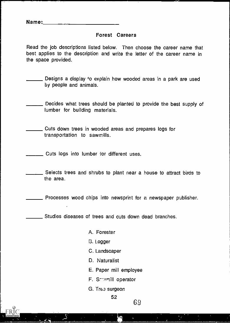
Name:
Forest Careers
Read the job descriptions listed below. Then choose the career name thatbest applies to the description and write the letter of the career name inthe space provided.
Designs a display +o explain how wooded areas in a park are usedby people and animals.
Decides what trees should be planted to provide the best supply oflumber for building materials.
Cuts down trees in wooded areas and prepares logs fortransportation to sawmills.
Cuts logs into lumber for different uses.
Selects trees and shrubs to plant near a house to attract birds tothe area.
Processes wood chips into newsprint for a newspaper publisher.
Studies diseases of trees and cuts down dead branches.
A. Forester
13. Logger
C. Landscaper
D. Naturalist
E. Paper mill employee
F. Sr---qmill operator
G. Tre3 surgeon
5269
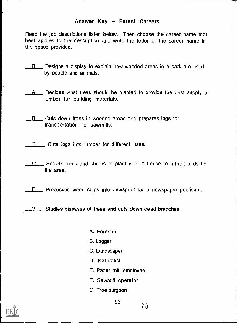
Answer Key -- Forest Careers
Read the job descriptions listed below. Then choose the career name thatbest applies to the description and write the letter of the career name inthe space provided.
D Designs a display to explain how wooded areas in a park are usedby people and animals.
A Decides what trees should be planted to provide the best supply oflumber for building materials.
B Cuts down trees in wooded areas and prepares logs fortransportation to sawmills.
F Cuts logs into lumber for different uses.
C Selects trees and shrubs to plant near a house to attract birds tothe area.
E Processes wood chips into newsprint for a newspaper publisher.
G Studies diseases of trees and cuts down dead branches.
A. Forester
B. Logger
C. Landscaper
D. Naturalist
E. Paper mill employee
F. Sawmill operator
G. Tree surgeon
5370
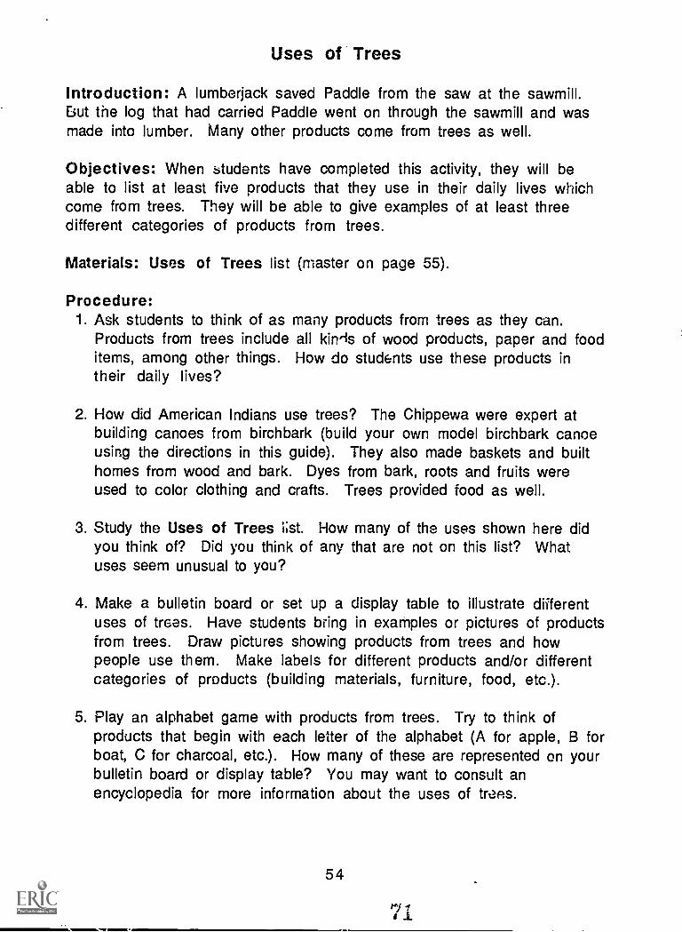
Uses of Trees
Introduction: A lumberjack saved Paddle from the saw at the sawmill.But the log that had carried Paddle went on through the sawmill and wasmade into lumber. Many other products come from trees as well.
Objectives: When students have completed this activity, they will beable to list at least five products that they use in their daily lives whichcome from trees. They will be able to give examples of at least threedifferent categories of products from trees.
Materials: Uses of Trees list (master on page 55).
Procedure:1. Ask students to think of as many products from trees as they can.
Products from trees include all kin'ls of wood products, paper and fooditems, among other things. How do students use these products intheir daily lives?
2. How did American Indians use trees? The Chippewa were expert atbuilding canoes from birchbark (build your own model birchbark canoeusing the directions in this guide). They also made baskets and builthomes from wood and bark. Dyes from bark, roots and fruits wereused to color clothing and crafts. Trees provided food as well.
3. Study the Uses of Trees 1;st. How many of the uses shown here didyou think of? Did you think of any that are not on this list? Whatuses seem unusual to you?
4. Make a bulletin board or set up a display table to illustrate differentuses of trees. Have students bring in examples or pictures of productsfrom trees. Draw pictures showing products from trees and howpeople use them. Make labels for different products and/or differentcategories of products (building materials, furniture, food, etc.).
5. Play an alphabet game with products from trees. Try to think ofproducts that begin with each letter of the alphabet (A for apple, B forboat, C for charcoal, etc.). How many of these are represented on yourbulletin board or display table? You may want to consult anencyclopedia for more information about the uses of traps.
54
..11Mb....../111111!.
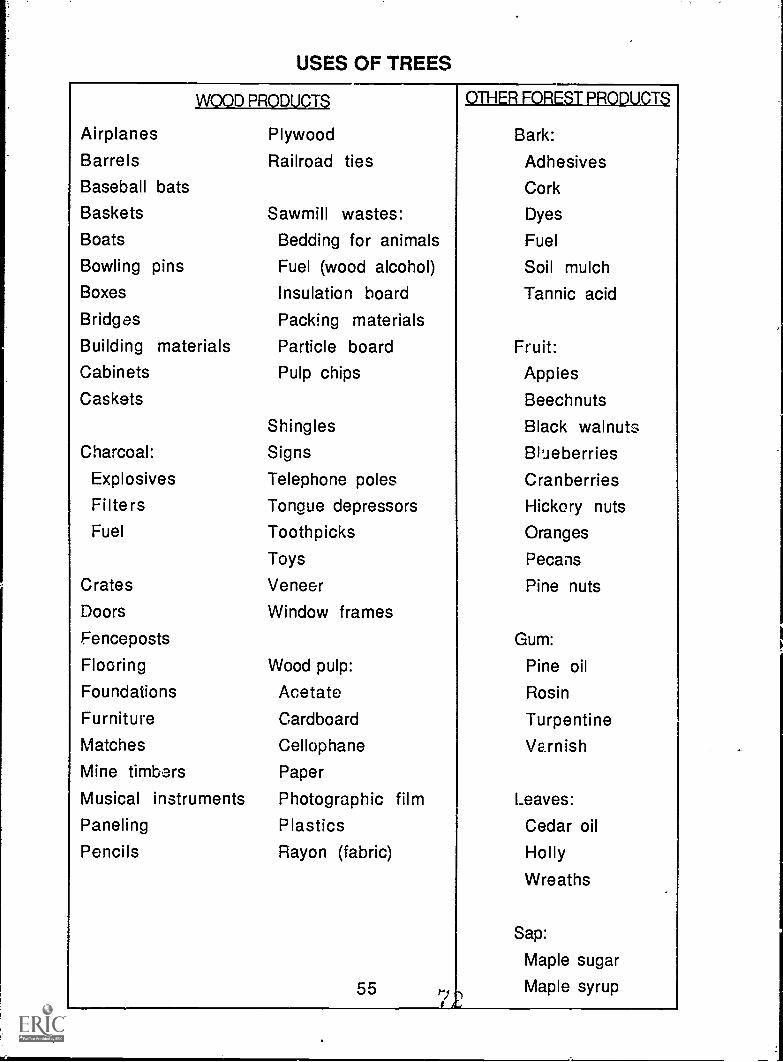
USES OF TREES
WOOD PRODUCTS
Airplanes Plywood
Barrels Railroad tiesBaseball bats
Baskets Sawmill wastes:Boats Bedding for animalsBowling pins Fuel (wood alcohol)Boxes Insulation boardBridges Packing materialsBuilding materials Particle boardCabinets Pulp chips
Caskets
Shingles
Charcoal: Signs
Explosives Telephone poles
Filters Tongue depressors
Fuel Toothpicks
Toys
Crates Veneer
Doors Window frames
Fenceposts
Flooring Wood pulp:
Foundations AcetateFurniture Cardboard
Matches Cellophane
Mine timbers Paper
Musical instruments Photographic filmPaneling PlasticsPencils Rayon (fabric)
OTHER FOREST PRODUCTS
Bark:
Adhesives
Cork
Dyes
Fuel
Soil mulch
Tannic acid
Fruit:Apples
Beechnuts
Black walnuts
Blueberries
Cranberries
Hickory nuts
Oranges
Pecans
Pine nuts
Gum:
Pine oil
Rosin
Turpentine
Varnish
Leaves:
Cedar oil
Holly
Wreaths
Sap:
Maple sugar
55 Maple syrup
Logs to Lumb6r
Introduction: How does a log become lumber? Read Chapter 7, PaddloMeets a Friend. Look at the diagram of the sawmill at the top of that page.The boom keeps other logs together in the water until they are pushedonto the bull-chain. Then the logs are carried through the saws and cutinto boards. Finished lumber and the leftover sawdust are shipped tolumberyards or factories to be made into other products.
Objective: When students have completed this activity, tiley will be ableto name and define terms related to sawmills and lumber.
Materials: Sawmill Terms Crossword Puzzle (master on page 57),pencil or pen.
Terms to Know:boom--barrier or fence made of logs attached end-to-end to keep loose
logs together in the waterbull- chain- -chain with spikes that carries logs through the runwaycarriage--moving platform that supports and shifts logs in the sawmillchute--tube or trough where waste materials are droppedlath narrow strip of woodlogs--trunks of trees that have been cut down and had their branches
removedlumber logs that have been sawed into boardsplane--to make smooth or levelrunway -- channel in which logs moveseason--to age wood to improve its durabilityslab--flat, broad, thick piece of woodtram--open railway car
Procedure:1. Study Holling's diagram of a sawmill. Find the vocabulary words on
the diagram. Can you figure out what each is by looking at thispicture?
2. Complete the Sawmill Terms Crossword Puzzle. All the wordsused are found in Chapter 7.
3. Why do you think the sawmill in the story is close to water? Whatother ways are there to carry logs to sawmills or to carry lumberfrom sawmills? Discuss what things you would need to run asuccessful sawmill.
56
73
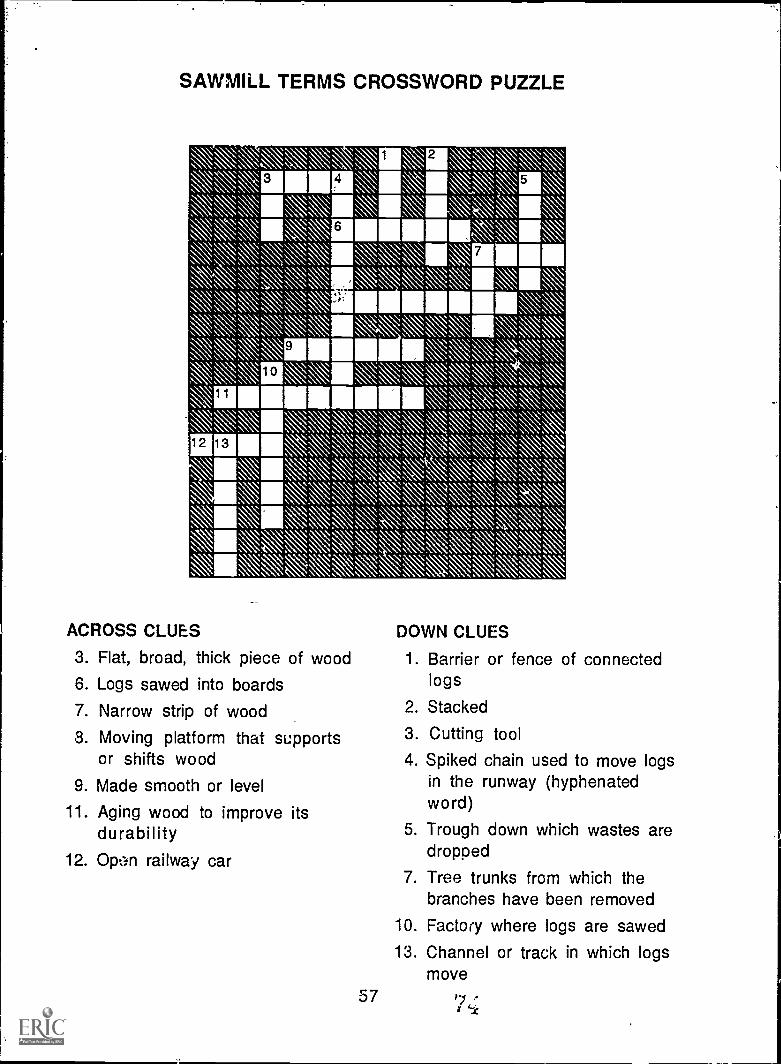
-a .
`S". 111 \ \11\ I
111011 1111\
NAIMMIIIII\ Nir'\ N:x 1117 N, \I\ RIMEAV, '% Ns\ `I\ \I\
\\ V\V 1111111111,\ ' 111 NX \,`\ REM \
10
9
": N
\ \ \Ammo'gamAi is
N N\ .
\X X Xs. \'N.. s. \X\ \ ,
\ X X. \
XN \
. . ' ..
. - .I I I
. .I I I
I
A I I I
o
9
I
4.
- I
- - 0 0
- -
. --
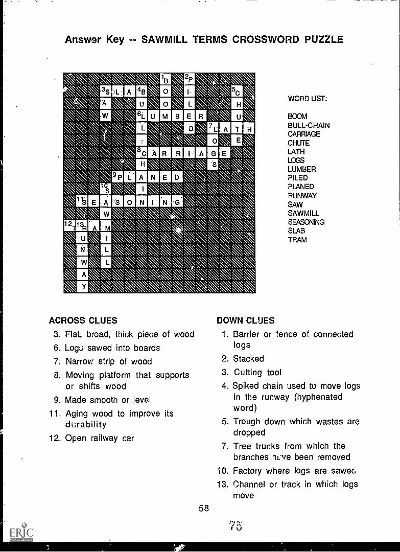
llst S 1
lin 2p
\\ ®g0 4B 0 NN, Imoxr,\sx, 111 0
\ \\ ®\ \ 11111© BErma
\, 0\\\.,inna nrumi%ss, Ns\
D
\\\ E9Plairlinn D x \a\,\\k, \ii\ v\ lak \\\\.\ \ \\
\ 'MEM 0 as ,,,,,:\,,s.,v,,,,,\\ ,N, \\ \. ,\ s
El amiN,\ \A, m v,v .
,15\ \Ivo\ \\ \\.;:, \.,, \\,,,s.v::\\-A l
:
. ,k, \,,:\ ,:,,,s:
NE \,,,,,\\11, \\\\:\,\N,,,, \\
alormA \\v, NE\ , \\\\\.\
S.
so ISowe 4" fie -
0 I0 . -I .. . -I
: .4 " . -0 ' 00
. 0' 11 . . . . "I
10 000 '
-
1
000'0IA IA
'0
00
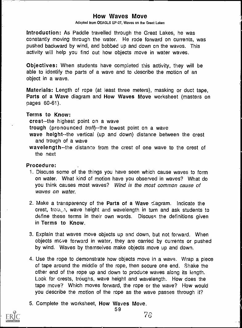
How Waves MoveAdapted from OEAGLS EP-27, Waves on the Great Lakes
Introduction: As Paddle travelled through the Great Lakes, he wasconstantly moving through the water. He rode forward on currents, waspushed backward by wind, and bobbed up and down on the waves. Thisactivity will help you find out how objects move in water waves.
Objectives: When students have completed this activity, they will beable to identify the parts of a wave and to describe the motion of anobject in a wave.
Materials: Length of rope (at least three meters), masking or duct tape,Parts of a Wave diagram and How Waves Move worksheet (masters onpages 60-61).
Terms to Know:crest -the highest point on a wavetrough (pronounced troft)--the lowest point on a wavewave height- -the vertical (up and down) distance between the crest
and trough of a wavewavelength -the distant-...e from the crest of one wave to the crest of
the next
Procedure:1. Discuss some of the things you have seen which cause waves to form
on water. What kind of motion have you observed in waves? What doyou think causes most waves? Wind is the most common cause ofwaves on water.
2. Make a transparency of the Parts of a Wave d;agram. Indicate thecrest, troL4,.), wave height and wavelength in turn and ask students todefine these terms in their own words. Discuss the definitions givenin Terms to Know.
3. Explain that waves move objects up and down, but not forward. Whenobjects move forward in water, they are carried by currents or pushedby wind. Waves by themselves make objects move up and down.
4. Use the rope to demonstrate how objects move in a wave. Wrap a pieceof tape around the middle of the rope, then secure one end. Shake theother end of the rope up and down to produce waves along its length.Look for crests, troughs, wave height and wavelength. How does thetape move? Which moves forward, the rope or the wave? How wouldyou describe the motion of the rope as the wave passes through it?
5. Complete the worksheet, How Waves Move.59
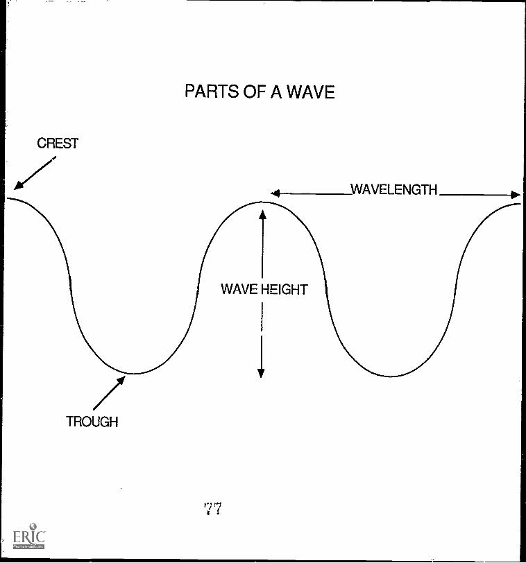
PARTS OF A WAVE
CREST
WAVELENGTH
1WAVE HEIGHT
1
/TROUGH
77
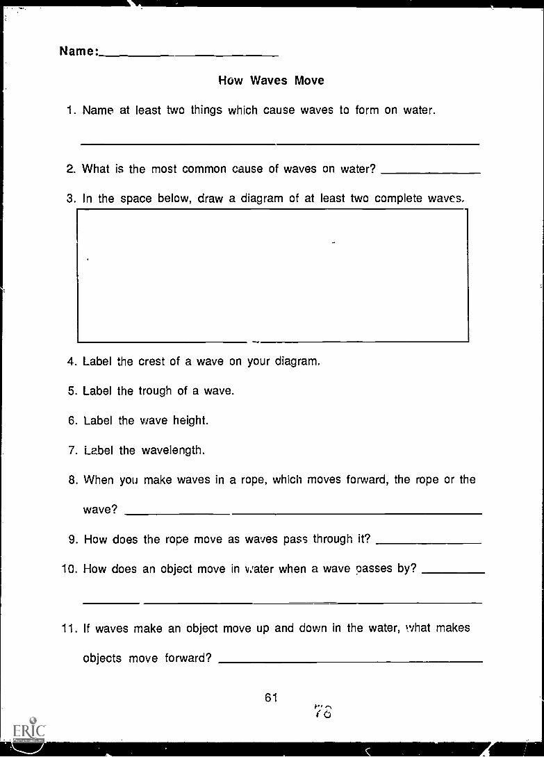
Name:
How Waves Move
1. Name at least two things which cause waves to form on water.
2. What is the most common cause of waves on water?
3. In the space below, draw a diagram of at least two complete waves.
4. Label the crest of a wave on your diagram.
5. Label the trough of a wave.
6. Label the wave height.
7. Label the wavelength.
8. When you make waves in a rope, which moves forward, the rope or the
wave?
9. How does the rope move as waves pass through it?
10. How does an object move in water when a wave passes by?
11. If waves make an object move up and down in the water, what makes
objects move forward?
611,-.,(0
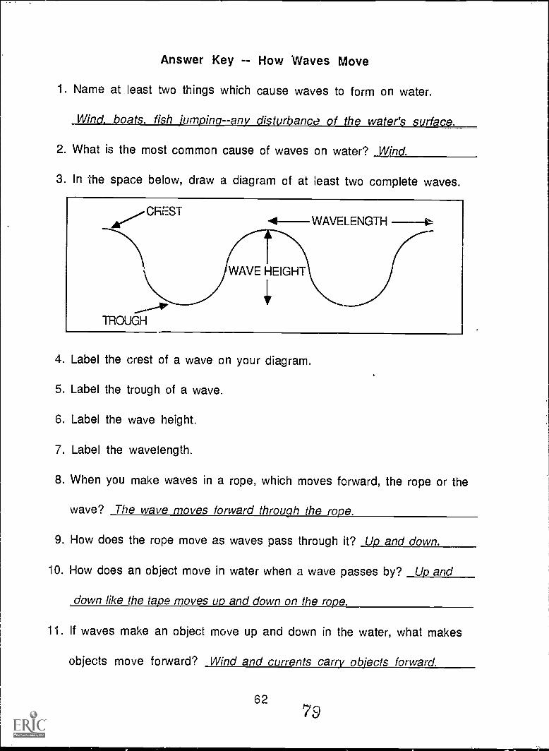
Answer Key -- How 'Waves Move
1. Name at least two things which cause waves to form on water.
Wind, boats, fish jumping- -any disturbance of the water's surface.
2. What is the most common cause of waves on water? Wind.
3. In the space below, draw a diagram of at least two complete waves.
CREST
TROUGH
4--WAVELENGTH
WAVE HEIGHT
4. Label the crest of a wave on your diagram.
5. Label the trough of a wave.
6. Label the wave height.
7. Label the wavelength.
8. When you make waves in a rope, which moves forward, the rope or the
wave? The wave moves forward through the rope.
9. How does the rope move as waves pass through it? Up and down.
10. How does an object move in water when a wave passes by? Up and
down like the tape moves up and down on the rope.
11. If waves make an object move up and down in the water, what makes
objects move forward? Wind and currents carry objects forward.
6279
Passport to Adventure
Introduction: As Paddle travelled through the Great Lakes, he crossedthe international border between Canada and the United States. In mostcases, people need passports issued by their governments in order totravel in foreign countries. Some countries issue visas--formalpermissions to enter or leave their borders--to travellers. Unlike people,animals, water and air do not recognize national boundaries. They do notrequire passports, yet as they travel, they carry resources and pollutantsfrom one country to another.
Objectives: When students have completed this activity, they will beable to explain how passports and visas are used in international travel.
Materials: Sample passport application and passport booklet (masters onpages 65-67), markers or crayons, pencil or pen, inkpads and objects touse for £tamps, Passport Language Crossword Puzzle (master on page68).
Terms to Know:bearer - -the person who owns the passportexpiration--date after which a passport is no longer v..,
minors--children under 18 years of agenationality- -the country of one's birthoccupation--job or professionrace--ethnic groupsignature--one's written name on a documentvalidateallow or make validvisa--formal permission to enter or leave a country
NOTE: Advancc preparation is needed. Fill out passport applications, makepassports and decide on borders for "countries" ahead of time.
Procedure:1. Fill out passport applications. Discuss any terms which are unfamiliar
to you. Why would a government request this information 1-..foreissuing a passport? Has anyone in the class ever travelled ,o a foreigncountry before?
2. Put together the passport booklets. Cut the pages apart along the'dotted lines. Design a seal for your "country" to decorate the cover.Glue a picture of yourself in the space indicated (use a photograph ordraw a self portrait). Fasten the pages together along the left edge innumerical order inside the cover.
6380
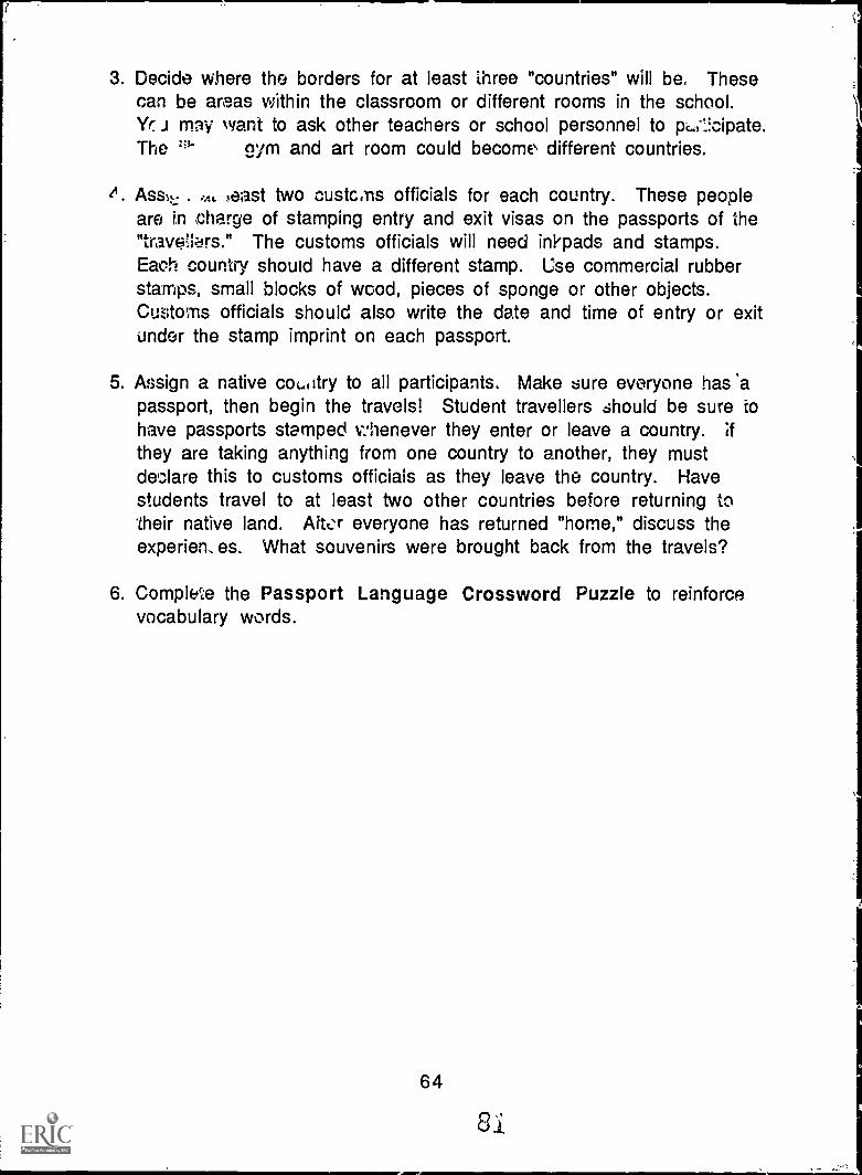
3. Decide where the borders for at least Three "countries" will be. Thesecan be areas within the classroom or different rooms in the school.Yr. J may want to ask other teachers or school personnel to p,..,-1!cipate.The nym and art room could become different countries.
As&t.- . 'At east two customs officials for each country. These peopleare in charge of stamping entry and exit visas on the passports of the"trave-lers." The customs officials will need inkpads and stamps.Eaoh country should have a different stamp. Use commercial rubberstamps, small blocks of wood, pieces of sponge or other objects.Customs officials should also write the date and time of entry or exitunder the stamp imprint on each passport.
5. Assign a native coLotry to all participants. Make sure everyone has 'apassport, then begin the travels! Student travellers should be sure tohave passports stamped v:henever they enter or leave a country. Ifthey are taking anything from one country to another, they mustdeclare this to customs officials as they leave the country. Havestudents travel to at least two other countries before returning to'their native land. Alwr everyone has returned "home," discuss theexperien. es. What souvenirs were brought back from the travels?
6. Complete the Passport Language Crossword Puzzle to reinforcevocabulary words.
64
Si
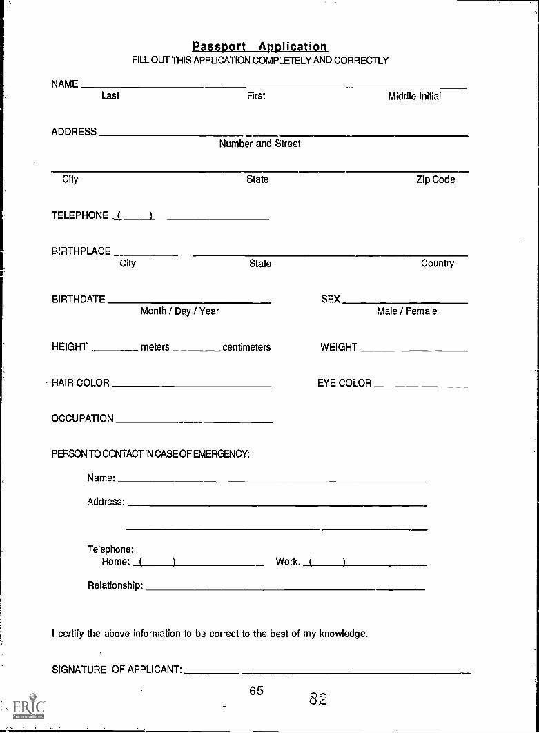
Passport ApplicationFILL OUT THIS APPUCATION COMPLETELY AND CORRECTLY
NAMELast
ADDRESS
First Middle Initial
Number and Street
City State Zip Code
TELEPHONE ( )
BIRTHPLACECity State Country
BIRTHDATE SEXMonth / Day / Year Male / Female
HEIGHT meters centimeters WEIGHT
HAIR COLOR EYE COLOR
OCCUPATION
PERSON TO CONTACT IN CASE OF EMERGENCY:
Name:
Address:
Telephone:Home: ( ) Work. ( )
Relationship:
I certify the above information to bo correct to the best of my knowledge.
SIGNATURE OF APPLICANT:
658 2,
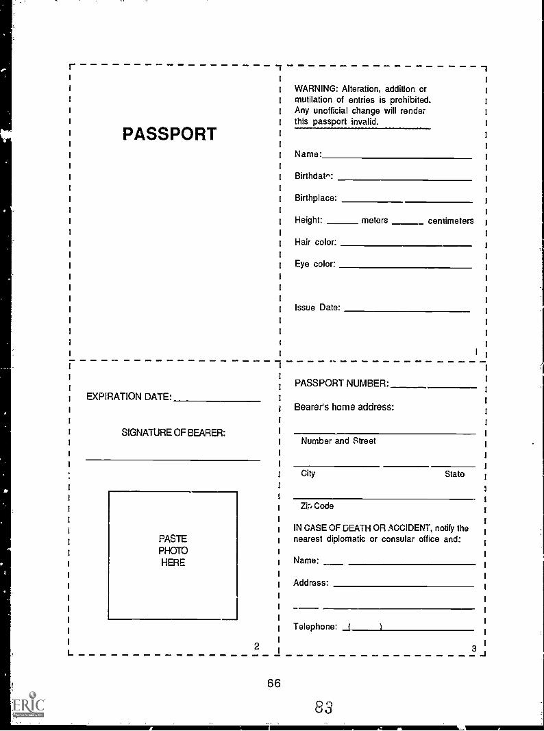
r
PASSPORT
-T -1
I I
I I
I I
I I
I I
I I
I I
I Name: I
I I
I Birthdat": I
I I
I Birthplace: I
I I
I Height: meters centimeters i
I I
Hair color: I
IEye color:
I
I
I
I
I
I
I
I
I 1
I
SS1PASSPORT NUMBER:1
1
I
1
I
I
I
I
I
I
I
I
I
EXPIRATION DATE: I
i
I
SIGNATURE OF BEARER: 1
I
I
I
I
I
,
I
I
I
PASTE 1
PHOTO I
HERE I
I
I
I
I
I
I
L2
I
I
66
WARNING: Alteration, addition ormutilation of entries is prohibited.Any unofficial change will renderthis passport invalid.
Issue Date:
1
Bearer's home address:1
I
1
Number and Street I
I
ICity Stato I
7
IZir, Code
I
IIN CASE OF DEATH OR ACCIDENT, notify the
1
nearest diplomatic or consular office and:I
iName:
1
IAddress:
I
I
I
ITelephone: 1 )I
I3
_I
83
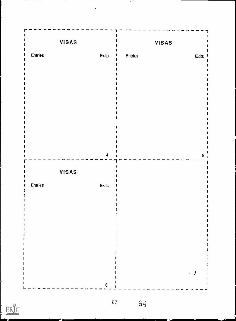
r Tr 1
VISAS VISAS
Entries Exits Entries Exits
4 5
L
VISAS
Entries Exits
6
67
..1
\\Ju© mow\\ \\\\ ,t,\
\,os\,0 \, Ivor\,Nr. "U \ \01111xm
mar v1 0:\ \\ \ \ \ \ \ \\\\ V, .\ \ 111
:,,, `: X. NEI XMI \ \'. \ \ '.X \ \. X X .11\ MI \ X X :\ .\111111111111111111111. 11 VC ::
\C X V \:,\ \\W, \ \\/1211111111.111111 \ s
Nk, 'M N: ; ' ; \\\ MN N M N
Z N a , \ \- m m : .;z.... m m. \
I
.
.
. - - - . . '. .
Al . .i ' .0 . ' "
" . . -
I. - - ."
. .
*
in no m3A &w, aPR
\\\ 413F\Erx\IIN 'D 5()A Via AI
E§ 0113x3 115\ 11.
o
\ ' -\\vAICIL \\©v y\N\xEL .
liv'iritionEEnvELE
Mg °ELF ,,, :411:r,\\gl.g."vaimall EIML,',=zoom . msAvAllwilemErimm
\N.\W ': -ME 11111 Wx'
k,,\ L vz\lormko,\
e*D
D'.,
I
- S. 00
. . '0 '
0 aft . 0
"
-
_
40 0 I a 0
. . ' .'
- - 0- I I -
D. - . - . S. -0' .
A O. .
Energy Flow and Food Webs
Introduction: While Paddle was in the beaver pond, a mink caught a fish.Later, Paddle met a moose feeding on water lilies in the marsh. The minkand the moose both found the food energy they needed to sun/lye. Thewater lilies used the sun's energy to grow. We can draw a diagram thatshows who eats what and where energy for life comes from.
Objectives: When students have completed this activity, they will beable to define what food chains and food webs are and to explain that thesun is the basic source of energy.
Materials: Energy Flow background sheet and worksheet (masters onpages 71-73), drawing paper, markers or crayons.
Terms to Know:Food chain -- diagram of who eats whatFood web -- several food chains connected togetherOrganism -- living thingProducer -- organism that can make its own food (green plant)Consumer -- organism that can not make its own foodHerbivore--consumer which eats plantsCarnivore--consumer which eats other consumersDecomposer--consumer which breaks down dead plants and animals
Procedure:1. Read the background sheets. Discuss and give examples of each of the
defined terms. Think of other possible food chains using the snimalsPaddle found in the beaver pond or the marsh.
2. Draw your own energy flow diagram. Remember that the sun is thesource of the energy plants need to grow. Each diagram should have atleast three food chains connected to make a food web within it. Try tothink of food chains you might find in envirrnments other than pondsor marshes. (Example: Sun Grass Cow - Person)
3. Complete the Energy Row Worksheet. Discuss the answers with theclass.
Extension Activity: Play the Food Chain Tag game described on page 75.
70
Energy Flow
4 chain is made of connected parts called links. The terms "food chain"and "food web" describe the paths of energy flow between plants andanimals in a natural community. A food chain is a simple diagram of whoeats what. Each plant and animal stands for a link of energy in a foodchain. Several food chains connected together make up a food web.
The sun is the first source of energy. Green plants use the sun's energyand nutrients in the soil to make their own food by the process ofphotosynthesis. Because green plants make their own food, they are calledproducers.
All other living things in a food chain are called consumers becausethey cannot make their own food. Consumers that eat plants to get theirenergy are called herbivores. Consumers that eat other consumers to gettheir energy are called carnivores, or meat-eaters.
Decomposers, usually bacteria or fungi, are a special group ofconsumers. They break down dead plants and animals, returning nutrientsto the soil where they can be rer;ycled by green plants.
Eielow is a diagram of the energy flow in a food chain you might find ina pond.
DECOMPOSERS
PRODUCERS
631
Algae'.1
HERBIVORESWaterfleas
71 88
CARNIVORE
Sunfish
Here is a diagram of the energy flow in a pond food web. Can youidentify the different food chains within the web?
DECOMPOSERS
PRODUCERS
Algae
HERE3IVORESANIL\
Leopardfrog
72
Sunfish
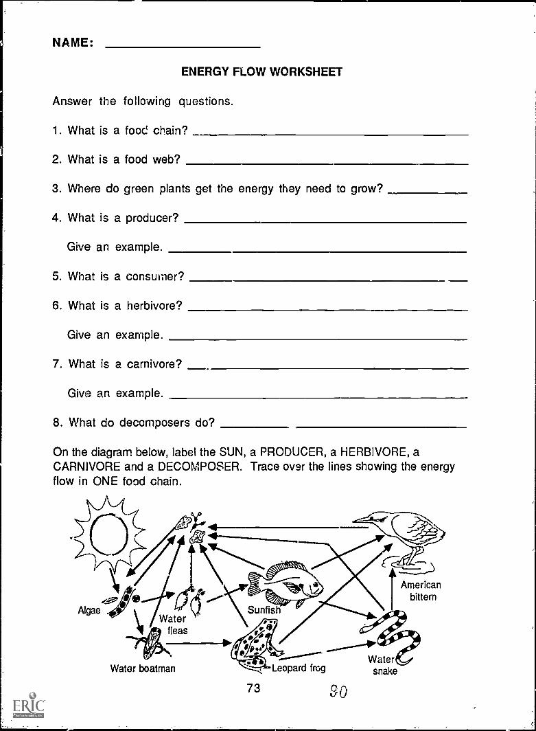
NAME:
ENERGY FLOW WORKSHEET
Answer the following questions.
1. What is a food chain?
2. What is a food web?
3. Where do green plants get the energy they need to grow?
4. What is a producer?
Give an example.
5. What is a consumer?
6. What is a herbivore?
Give an example.
7. What is a carnivore?
Give an example.
8. What do decomposers do?
On the diagram below, label the SUN, a PRODUCER, a HERBIVORE, aCARNIVORE and a DECOMPOSER. Trace over the lines showing the energyflow in ONE food chain.
Algae
..--
Americanbittern
Waterfleas
Water boatman
73
Leopard frog
SO
Watersnake
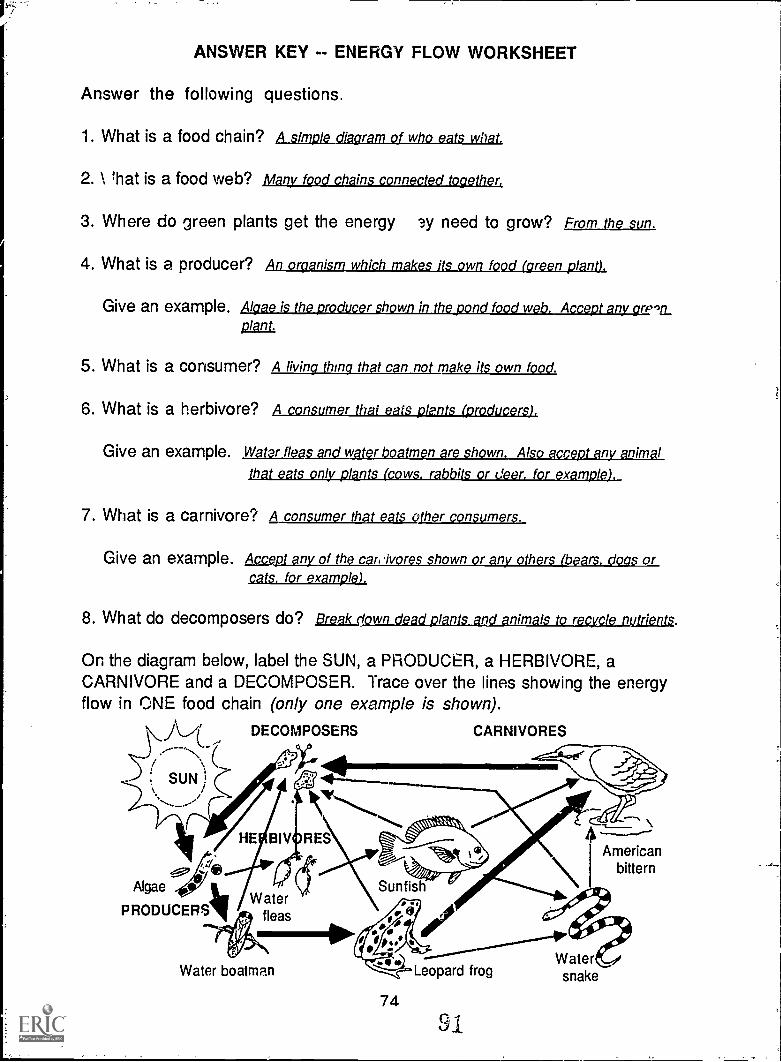
ANSWER KEY -- ENERGY FLOW WORKSHEET
Answer the following questions.
1. What is a food chain? A simple diagram of who eats what.
2. \ that is a food web? Marty food chains connected together,
3. Where do green plants get the energy ?,y need to grow? From the sun.
4. What is a producer? An organism which makes its own food (green plant).
Give an example. Algae is the producer shown in the pond food web. Accept any grpv_Plant.
5. What is a consumer? A living thing that can not make its own food.
6. What is a herbivore? A consumer that eats plants (producers).
Give an example. Water fleas and water boatmen are shown. Also accept any animal
that eats only plants (cows. rabbits or deer. for example)
7. What is a carnivore? A consumer that eats other consumers.
Give an example. cae,aay_LpQ2lipqcLysjes1225,IkasAnofhcarsivr shown or hr br orcats. for example).
8. What do decomposers do? Iliafirk I .n. IM
On the diagram below, label the SUN, a PRODUCER, a HERBIVORE, aCARNIVORE and a DECOMPOSER. Trace over the lines showing the energyflow in ONE food chain (only one example is shown).
DECOMPOSERS CARNIVORES
Americanbittern
Water boatman..
Leopard frog
74
91.
Watersnake
Food Chain Tag
Background and Discussion:1. Read and dig uss the Energy Flow background sheets (masters on pages
71-72) with your class.
2. Introduce the topic of poisons in the environment. Ask students toname some poisons they might have used or seen their parents use(examples are insecticides, weed killers, rat poison, etc.). Explainthat creatures; may be harmed by a poison intended for somethingelse. An example is the insecticide DDT, which was found to harm fishand birds as well as insects and was outlawed in thc. United States andCanada because) of this. Explain that even though a poison may not killan animal immediatel,, it could make the animal too sick to be able tosurvive or reproduce.
Objectives: When students have completed this activity, they will beable to describe how environmental poisons concentrate in a food chain.
Materials: Small squares of paper (at least 150 squares for a class of20-30 students), plastic sandwich bags (1 for each student), three coloraof yarn.
Preparation:1. Mark about 1/3 of the squares of paper with an X or a skull and
crossbones. Fold all of the squares in half so the marked ones appearidentical to the unmarked ones.
2. Divide the plastic bags into two groups of equal size. Divide one ofthose groups into thirds; separate one third from the other two. Younow have three groups of different sizes.
3. Put a piece of yarn into each bag. Use a different color for each group.The colors will help players identify each other during the game.
Procedure:1. Gather in a large open area, indoors or outside.
2. Give each student one of the plastic bags with yarn in it. The bagsrepresent the "stomachs" of the animals in the food chain. Thedifferent colors of yarn help students identify each other during thegame.
75
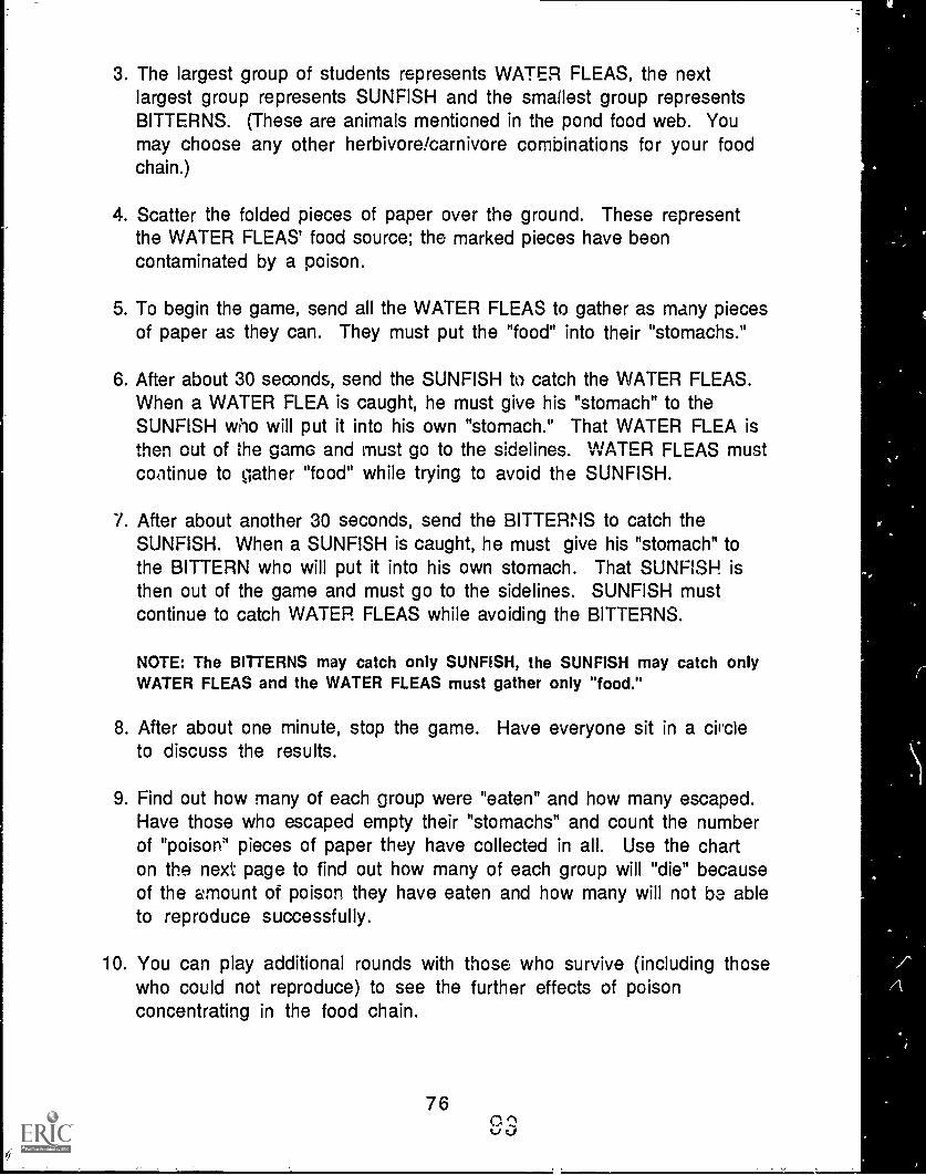
3. The largest group of students represents WATER FLEAS, the nextlargest group represents SUNFISH and the smallest group representsBITTERNS. (These are animals mentioned in the pond food web. Youmay choose any other herbivore/carnivore combinations for your foodchain.)
4. Scatter the folded pieces of paper over the ground. These representthe WATER FLEAS' food source; the marked pieces have beencontaminated by a poison.
5. To begin the game, send all the WATER FLEAS to gather as many piecesof paper as they can. They must put the "food" into their "stomachs."
6. After about 30 seconds, send the SUNFISH to catch the WATER FLEAS.When a WATER FLEA is caught, he must give his "stomach" to theSUNFISH who will put it into his own "stomach." That WATER FLEA isthen out of the game and must go to the sidelines. WATER FLEAS mustcontinue to gather "food" while trying to avoid the SUNFISH.
7. After about another 30 seconds, send the BITTERNS to catch theSUNFISH. When a SUNFISH is caught, he must give his "stomach" tothe BITTERN who will put it into his own stomach. That SUNFISH isthen out of the game and must go to the sidelines. SUNFISH mustcontinue to catch WATER FLEAS while avoiding the BITTERNS.
NOTE: The BITTERNS may catch only SUNFISH, the SUNFISH may catch onlyWATER FLEAS and the WATER FLEAS must gather only "food."
8. After about one minute, stop the game. Have everyone sit in a circleto discuss the results.
9. Find out how many of each group were "eaten" and how many escaped.Have those who escaped empty their "stomachs" and count the numberof "poison" pieces of paper they have collected in all. Use the charton the next page to find out how many of each group will "die" becauseof the amount of poison they have eaten and how many will not be ableto reproduce successfully.
10. You can play additional rounds with those who survive (including thosewho could not reproduce) to see the further effects of poisonconcentrating in the food chain.
76
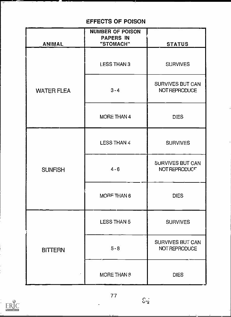
EFFECTS OF POISON
ANIMAL
NUMBER OF POISONPAPERS IN"STOMACH" STATUS
WATER FLEA
LESS THAN 3 SURVIVES
I
3 - 4
SURVIVES BUT CANNOT REPRODUCE
MORE THAN 4 DIES
SUNFISH
LESS THAN 4 SURVIVES
4 - 6SURVIVES BUT CAN
NOT REPRODUCE
MORF THAN 6 DIES
BITTERN
LESS THAN 5 SURVIVES
5 - 3SURVIVES BUT CAN
NOT REPRODUCE
MORE THAN Et DIES
77
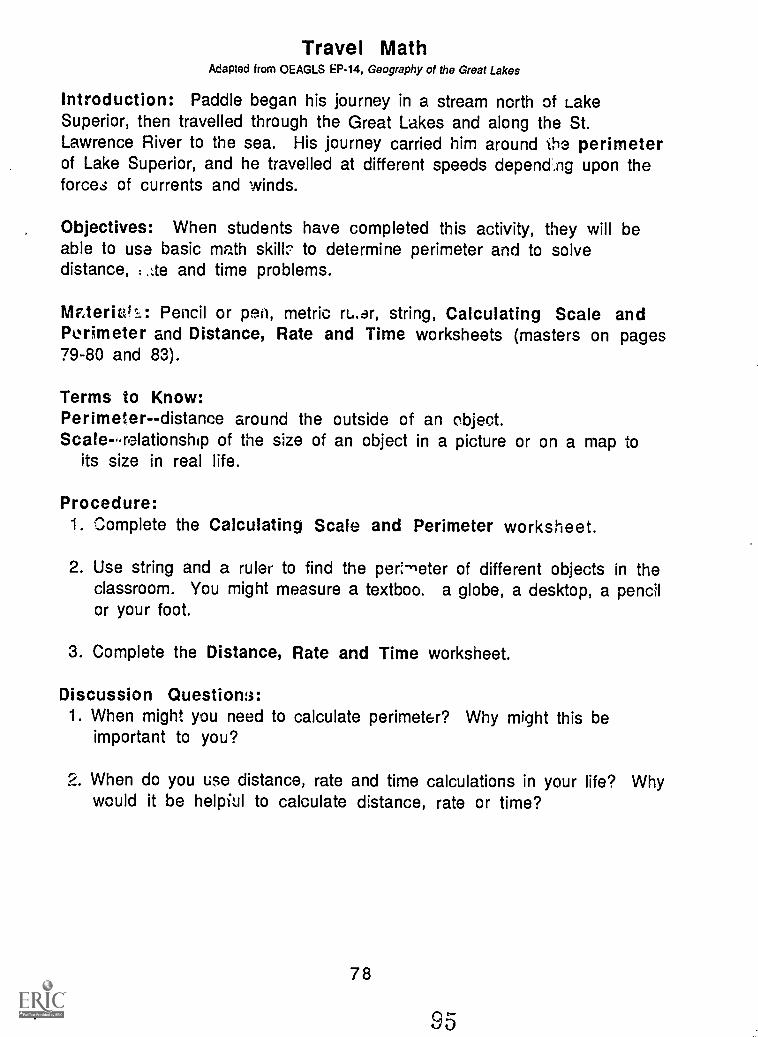
Travel MathAdapted from OEAGLS EP-14, Geography of the Great Lakes
Introduction: Paddle began his journey in a stream north of LakeSuperior, then travelled through the Great Lakes and along the St.Lawrence River to the sea. His journey carried him around the perimeterof Lake Superior, and he travelled at different speeds depencl.ng upon theforces of currents and winds.
Objectives: When students have completed this activity, they will beable to use basic math skill;. to determine perimeter and to solvedistance, :.:te and time problems.
NIzteriatv: Pencil or pen, metric ru.ar, string, Calculating Scale andPerimeter and Distance, Rate and Time worksheets (masters on pages79-80 and 83).
Terms to Know:Perimeter -- distance around the outside of an object.Scalerelationship of the size of an object in a picture or on a map to
its size in real life.
Procedure:1. Complete the Calculating Scale and Perimeter worksheet.
2. Use string and a ruler to find the peri-neter of different objects in theclassroom. You might measure a textboo. a globe, a desktop, a pencilor your foot.
3. Complete the Distance, Rate and Time worksheet.
Discussion Question::1. When might you need to calculate perimeter? Why might this be
important to you?
2. When do you use distance, rate and time calculations in your life? Whywould it be helpiul to calculate distance, rate or time?
78
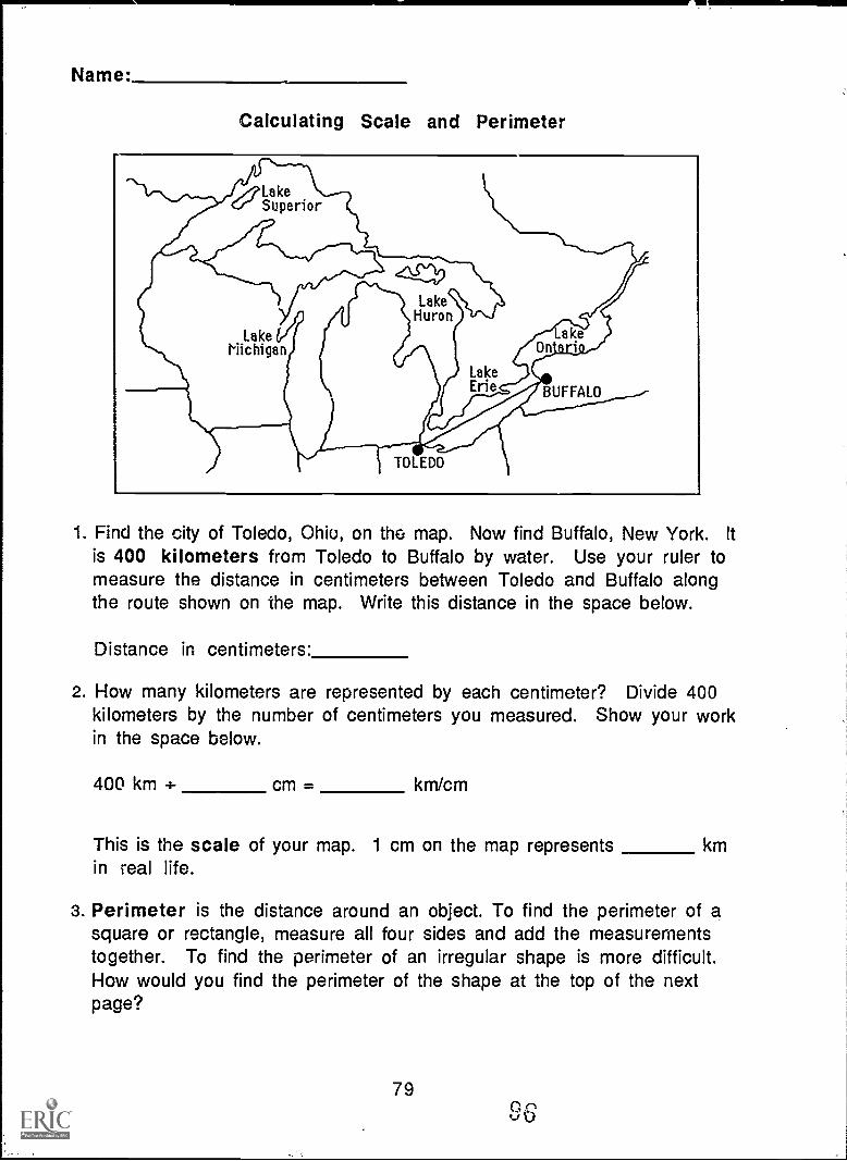
Name:
Calculating Scale and Perimeter
1. Find the city of Toledo, Ohio, on the map. Now find Buffalo, New York. Itis 400 kilometers from Toledo to Buffalo by water. Use your ruler tomeasure the distance in centimeters between Toledo and Buffalo alongthe route shown on the map. Write this distance in the space below.
Distance in centimeters:
2. How many kilometers are represented by each centimeter? Divide 400kilometers by the number of centimeters you measured. Show your workin the space below.
400 km 4- cm = km/cm
This is the scale of your map. 1 cm on the map represents kmin real life.
3. Perimeter is the distance around an object. To find the perimeter of asquare or rectangle, measure all four sides and add the measurementstogether. To find the perimeter of an irregular shape is more difficult.How would you find the perimeter of the shape at the top of the nextpage?
79
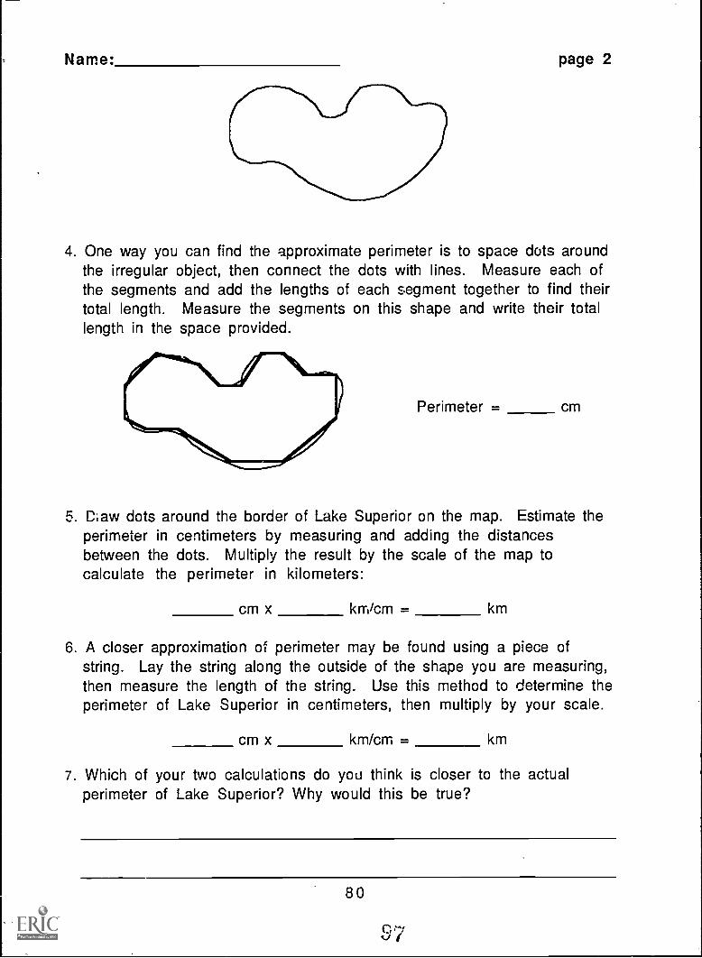
Name: page 2
4. One way you can find the approximate perimeter is to space dots aroundthe irregular object, then connect the dots with lines. Measure each ofthe segments and add the lengths of each segment together to find theirtotal length. Measure the segments on this shape and write their totallength in the space provided.
Perimeter = cm
5. Claw dots around the border of Lake Superior on the map. Estimate theperimeter in centimeters by measuring and adding the distancesbetween the dots. Multiply the result by the scale of the map tocalculate the perimeter in kilometers:
cm x km/cm = km
6. A closer approximation of perimeter may be found using a piece ofstring. Lay the string along the outside of the shape you are measuring,then measure the length of the string. Use this method to determine theperimeter of Lake Superior in centimeters, then multiply by your scale.
CM x km/cm = km
7. Which of your two calculations do you think is closer to the actualperimeter of Lake Superior? Why would this be true?
80
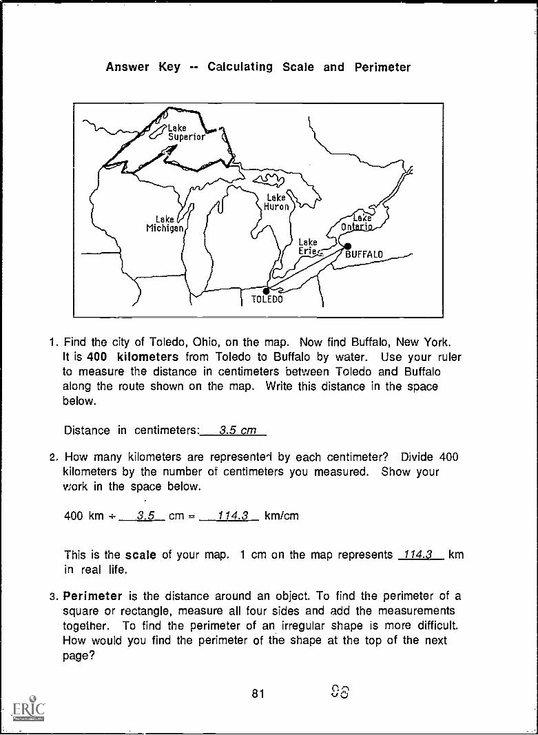
Answer Key -- Calculating Scale and Perimeter
Lakecc" Superior
LakeHuron
acen i
LakeErie( BUFFALO
TOLEDO
1. Find the city of Toledo, Ohio, on the map. Now find Buffalo, New York.It is 400 kilometers from Toledo to Buffalo by water. Use your rulerto measure the distance in centimeters between Toledo and Buffaloalong the route shown on the map. Write this distance in the spacebelow.
Distance in centimeters: 3.5 cm
2. How many kilometers are represented by each centimeter? Divide 400kilometers by the number of centimeters you measured. Show yourwork in the space below.
400 km 4- 3.5 cm = 114.3 km/cm
This is the scale of your map. 1 cm on the map represents 114.3 kmin real life.
3. Perimeter is the distance around an object. To find the perimeter of asquare or rectangle, measure all four sides and add the measurementstogether. To find the perimeter of an irregular shape is more difficult.How would you find the perimeter of the shape at the top of the nextpage?
81
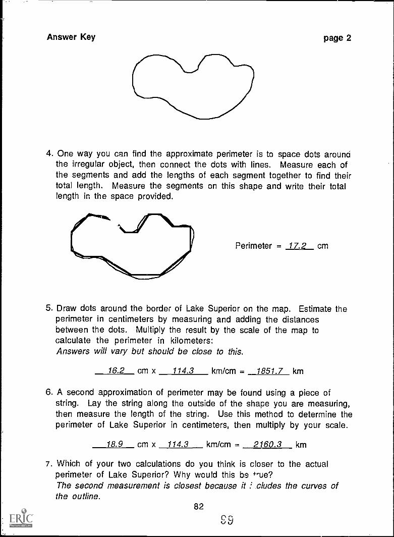
Answer Key
4. One way you can find the approximate perimeter is to space dots aroundthe irregular object, then connect the dots with lines. Measure each ofthe segments and add the lengths of each segment together to find theirtotal length. Measure the segments on this shape and write their totallength in the space provided.
Perimeter = 17.2 cm
5. Draw dots around the border of Lake Superior on the map. Estimate theperimeter in centimeters by measuring and adding the distancesbetween the dots. Multiply the result by the scale of the map tocalculate the perimeter in kilometers:Answers will vary but should be close to this.
16.2 cm x 114.3 km/cm = 1851.7 km
6. A second approximation of perimeter may be found using a piece ofstring. Lay the string along the outside of the shape you are measuring,then measure the length of the string. Use this method to determine theperimeter of Lake Superior in centimeters, then multiply by your scale.
18.9 cm x 114.3 km/cm = 2160.3 km
7. Which of your two calculations do you think is closer to the actualperimeter of Lake Superior? Why would this be +rue?The second measurement is closest because it f cludes the curves ofthe outline.
82
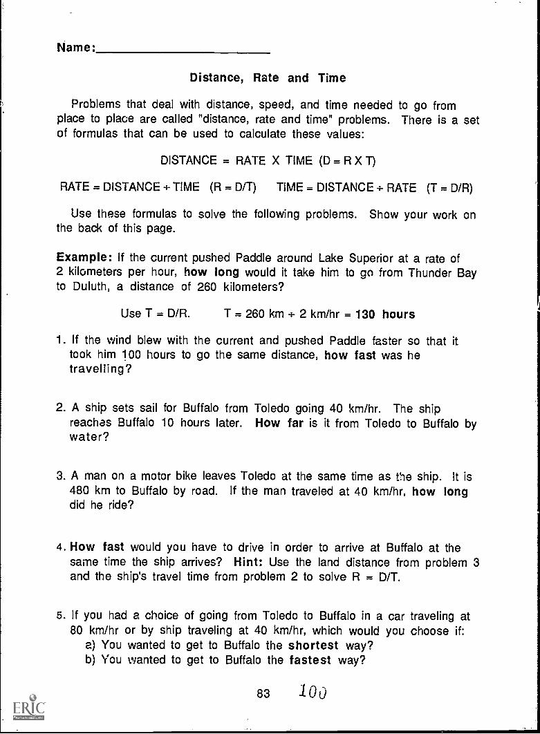
Name:
Distance, Rate and Time
Problems that deal with distance, speed, and time needed to go fromplace to place are called "distance, rate and time" problems. There is a setof formulas that can be used to calculate these values:
DISTANCE = RATE X TIME (D = R X T)
RATE = DISTANCE + TIME (R = D/T) TIME = DISTANCE + RATE (T = D/R)
Use these formulas to solve the following problems. Show your work onthe back of this page.
Example: If the current pushed Paddle around Lake Superior at a rate of2 kilometers per hour, how long would it take him to go from Thunder Bayto Duluth, a distance of 260 kilometers?
Use T = D/R. T = 260 km ÷ 2 km/hr = 130 hours
1. If the wind blew with the current and pushed Paddle faster so that ittook him 100 hours to go the same distance, how fast was hetravelling?
2. A ship sets sail for Buffalo from Toledo going 40 km/hr. The shipreaches Buffalo 10 hours later. How far is it from Toledo to Buffalo bywater?
3. A man on a motor bike leaves Toledo at the same time as the ship. It is480 km to Buffalo by road. If the man traveled at 40 km/hr, how longdid he ride?
4. How fast would you have to drive in order to arrive at Buffalo at thesame time the ship arrives? Hint: Use the land distance from problem 3and the ship's travel time from problem 2 to solve R = D/T.
5. If you had a choice of going from Toledo to Buffalo in a car traveling at80 km/hr or by ship traveling at 40 km/hr, which would you choose if:
a) You wanted to get to Buffalo the shortest way?b) You wanted to get to Buffalo the fastest way?
83 /00
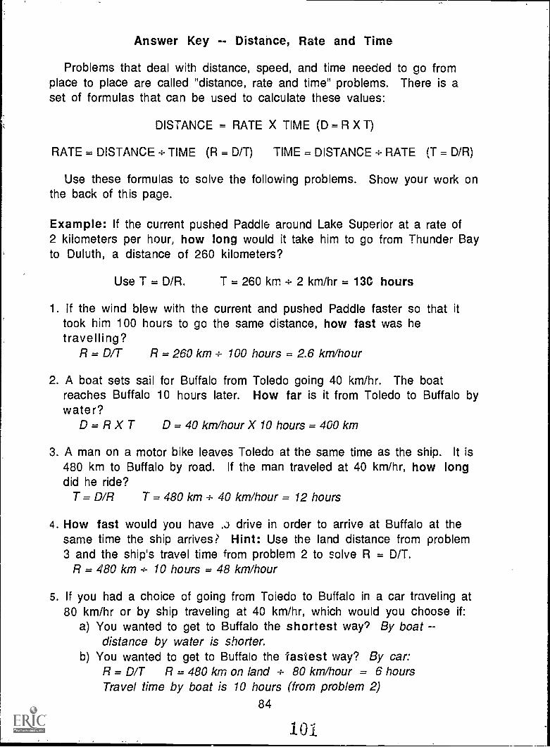
Answer Key -- Distance, Rate and Time
Problems that deal with distance, speed, and time needed to go fromplace to place are called "distance, rate and time" problems. There is aset of formulas that can be used to calculate these values:
DISTANCE = RATE X TIME (D = R X T)
RATE = DISTANCE = TIME (R = D/T) TIME = DISTANCE= RATE (T = D/R)
Use these formulas to solve the following problems. Show your work onthe back of this page.
Example: If the current pushed Paddle around Lake Superior at a rate of2 kilometers per hour, how long would it take him to go from Thunder Bayto Duluth, a distance of 260 kilometers?
Use T = D/R. T = 260 km = 2 km/hr = 13C hours
1. If the wind blew with the current and pushed Paddle faster so that ittook him 100 hours to go the same distance, how fast was hetravelling?
R = D/T R = 260 km 4- 100 hours = 2.6 km/hour
2. A boat sets sail for Buffalo from Toledo going 40 km/hr. The boatreaches Buffalo 10 hours later. How far is it from Toledo to Buffalo bywater?
D=RX T D = 40 km/hour X 10 hours = 400 km
3. A man on a motor bike leaves Toledo at the same time as the ship. It is480 km to Buffalo by road. If the man traveled at 40 km/hr, how longdid he ride?
T = D/R T = 480 km 4- 40 km/hour = 12 hours
4. How fast would you have ,j drive in order to arrive at Buffalo at thesame time the ship arrives? Hint: Use the land distance from problem3 and the ship's travel time from problem 2 to solve R = D/T.
R = 480 km 4- 10 hours = 48 km/hour
5. If you had a choice of going from Toledo to Buffalo in a car traveling at80 km/hr or by ship traveling at 40 km/hr, which would you choose if:
a) You wanted to get to Buffalo the shortest way'? By boatdistance by water is shorter.
b) You wanted to get to Buffalo the fastest way? By car:R = D/T R = 480 km on land 4- 80 km/hour = 6 hoursTravel time by boat is 10 hours (from problem 2)
84
101
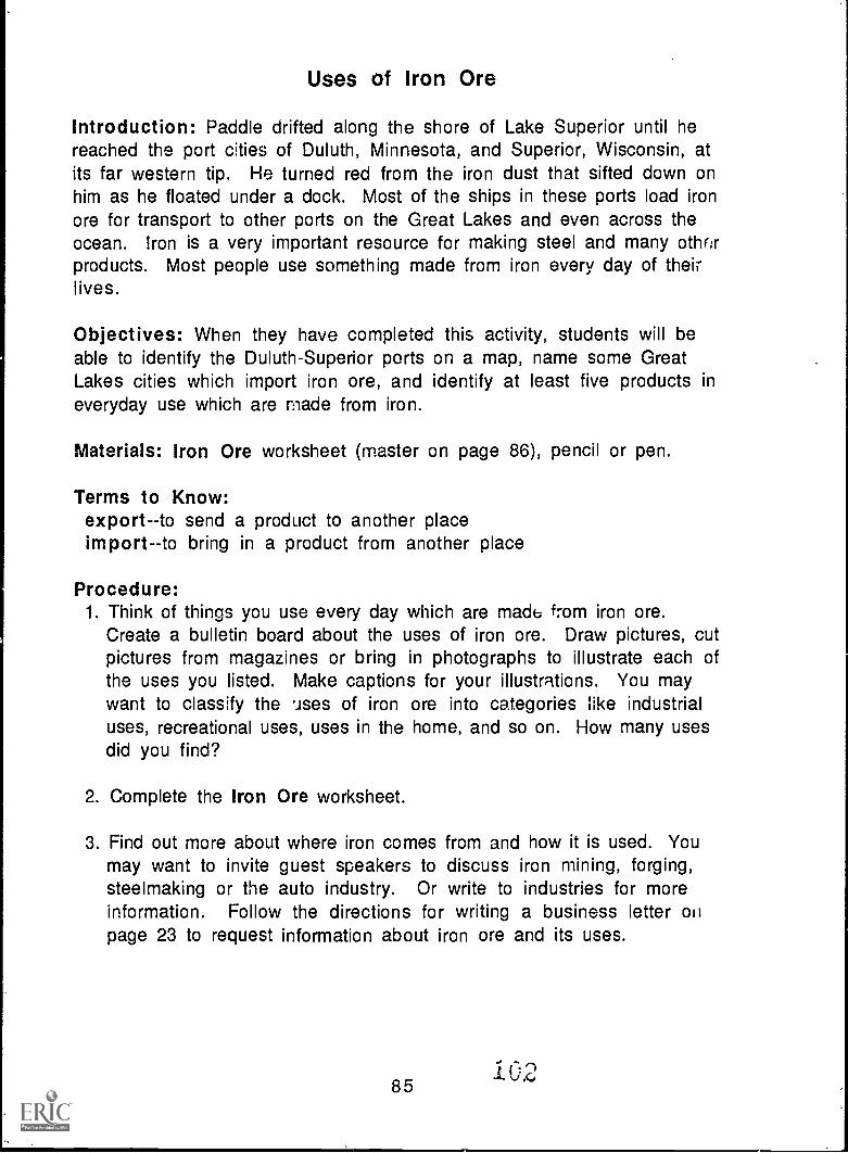
Uses of Iron Ore
Introduction: Paddle drifted along the shore of Lake Superior until hereached the port cities of Duluth, Minnesota, and Superior, Wisconsin, atits far western tip. He turned red from the iron dust that sifted down onhim as he floated under a dock. Most of the ships in these ports load ironore for transport to other ports on the Great Lakes and even across theocean. Iron is a very important resource for making steel and many othorproducts. Most people use something made from iron every day of theirlives.
Objectives: When they have completed this activity, students will beable to identify the Duluth-Superior ports on a map, name some GreatLakes cities which import iron ore, and identify at least five products ineveryday use which are made from iron.
Materials: Iron Ore worksheet (master on page 86), pencil or pen.
Terms to Know:export--to send a product to another placeimport--to bring in a product from another place
Procedure:1. Think of things you use every day which are made from iron ore.
Create a bulletin board about the uses of iron ore. Draw pictures, cutpictures from magazines or bring in photographs to illustrate each ofthe uses you listed. Make captions for your illustrations. You maywant to classify the uses of iron ore into categories like industrialuses, recreational uses, uses in the home, and so on. How many usesdid you find?
2. Complete the Iron Ore worksheet.
3. Find out more about where iron comes from and how it is used. Youmay want to invite guest speakers to discuss iron mining, forging,steelmaking or the auto industry. Or write to industries for moreinformation. Follow the directions for writing a business letter onpage 23 to request information about iron ore and its uses.
85102
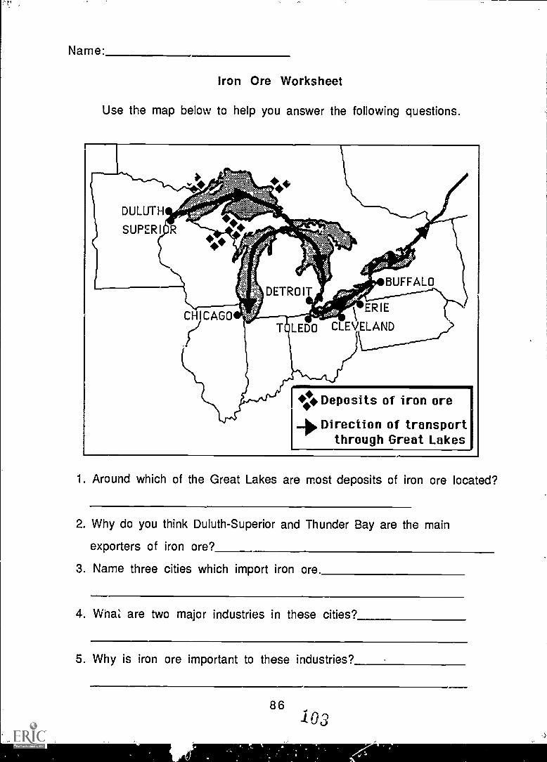
Name:
Iron Ore Worksheet
Use the map below to help you answer the following questions.
CHICAGO
.ij
Deposits of iron oreDirection of transport
through Great Lakes
1. Around which of the Great Lakes are most deposits of iron ore located?
2. Why do you think Duluth-Superior and Thunder Bay are the main
exporters of iron ore?
3. Name three cities which import iron ore.
4. WhaZ are two major industries in these cities?
5. Why is iron ore important to these industries?
86103
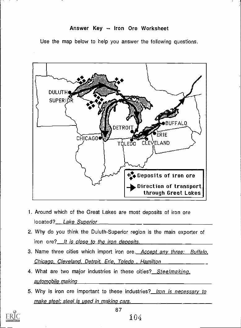
Answer Key -- Iron Ore Worksheet
Use the map below to help you answer the following questions.
O. Deposits of iron ore
Direction of transportthrough Great Lakes
1. Around which of the Great Lakes are most deposits of iron ore
located? Lake Superior
2. Why do you think the Duluth-Superior region is the main exporter of
iron ore? It is close to the iron deposits.
3. Name three cities which import iron ore. Accept any three: Buffalo.
Chicago. Cleveland. Detroit. Erie. Toledo . Hamilton
4. What are two major industries in these cities? Steelmaking.
automobile making
5. Why is iron ore important to these industries? Iron is necessary to
make steel: steel is used in making cars.
87
10 q
Something's FishyAdapted from OEAGLS EP-32, Build a Fish 'o Scale
Introduction: Fishing is an important business on the Great Lakes.Paddle met many fish on his journey. A fish thought Paddle would make agood dinner. Fishermen on Lake Superior pulled Paddle in with their catchand a French fishing boat carried him across the Atlantic Ocean.
Objective: When students have completed this activity, they will be ableto ideniify the basic parts of a fish's external anatomy.
Materials: Fish parts identification sheets and fish puzzle (master3 onpages 89-94), Fish Anatomy worksheet (master on page 95), tape ortacks.
Procedure:1. Make overhead transparencies of the fish parts identification pages.
Ask students to guess what each part does for the fish. Then reviewwritten descriptions of each part (p. 90) with the class.
2. Play a matching game with the fish puzzle pieces and the writtendescriptions of the fish parts. Make copies and cut out each part andeach description. Turn all the pieces face down and mix them up.Draw a piece at random. Have students name and describe the partpictured or name the part that is deslribed verbally.
3. Play "Pin the Fin on the Fish." Make copies and cut out each piece ofthe fish puzzle along its outline (the pieces will need to fit togetherexactly to complete the picture). Arrange the parts face up but not inany particular order. Draw a description of a part at random. Havestudents identify the part described. Tape or tack the picture of thatpart to the chalk board or bulletin board. The first piece may be placedanywhere, but each succeeding piece must be placed in its properlocation on the fish. Do this activity with the class as a whole ormake a set of puzzle pieces and description cards for each of two ormore teams and see which team first correctly completes the fishpicture. (Glue the puzzle pieces to lightweight cardboard or laminatethem for more durability.)
4. Complete the Fish Anatomy worksheet.
Extension Activity: Create your own fish. Directions are on page 97.
88
105
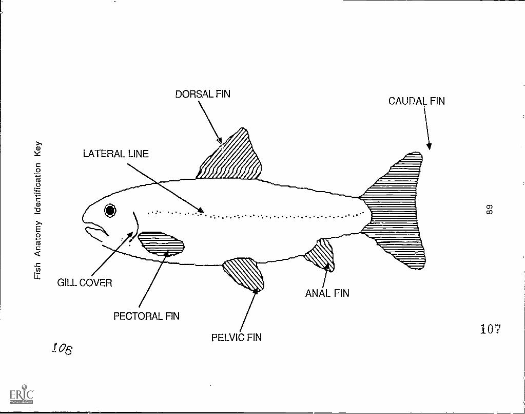
tLATERAL LINE
DORSAL FINCAUDAL FIN
GILL COVER
I 06
PECTORAL FIN
PELVIC FIN
ANAL FIN
corn
107
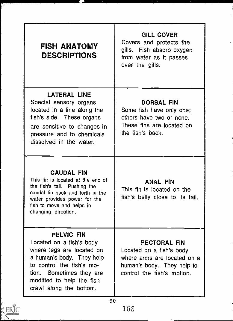
FISH ANATOMYDESCRIPTIONS
GILL COVERCovers and protects thegills. Fish absorb oxygenfrom water as it passesover the gills.
LATERAL LINESpecial sensory organslocated in a line along thefish's side. These organs
are sensitve to changes inpressure and to chemicalsdissolved in the water.
DORSAL FINSome fish have only one;others have two or none.These fins are located onthe fish's back.
CAUDAL FINThis fin is located at the end ofthe fish's tail. Pushing thecaudal fin back and forth in thewater provides power for thefish to move and helps inchanging direction.
ANAL FINThis fin is located on thefish's belly close to its tail.
PELVIC FINLocated on a fish's bodywhere legs are located ona human's body. They helpto control the fish's mo-tion. Sometimes they aremodified to help the fishcrawl a!ong the bottom.
PECTORAL FINLocated on a fish's bodywhere arms are located on ahuman's body. They help tocontrol the fish's motion.
90
108
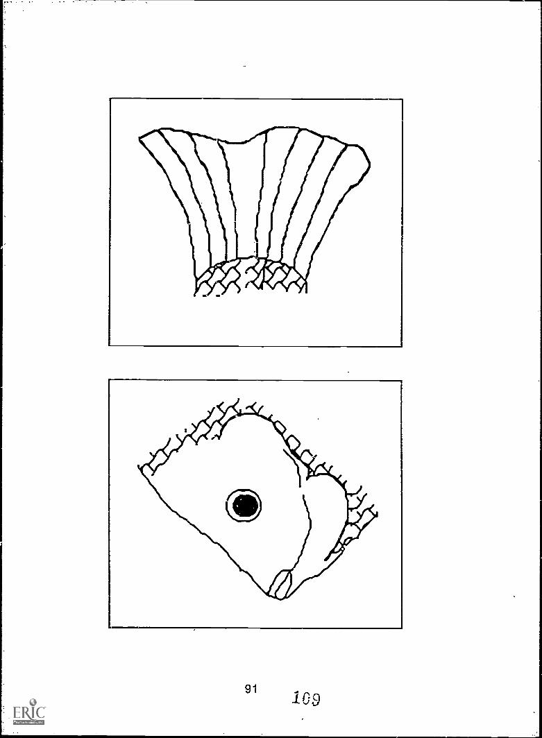
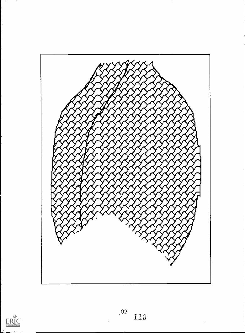
921.10
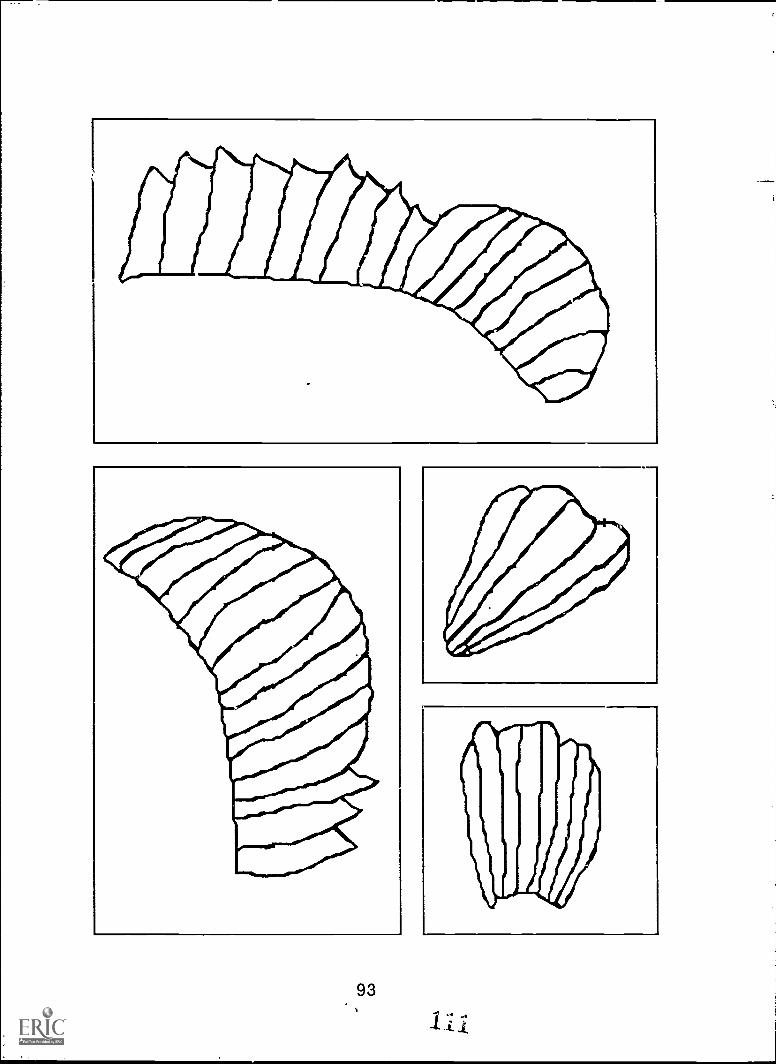
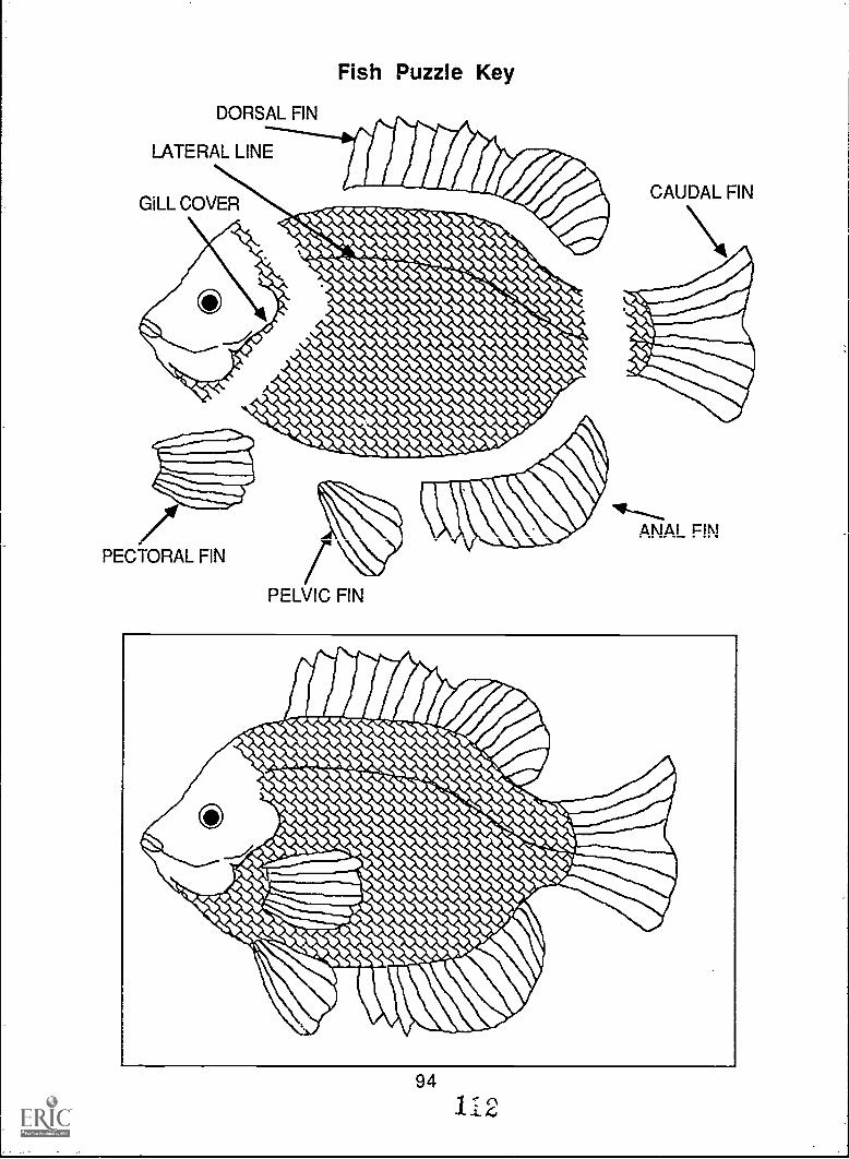
DORSAL FIN
Fish Puzzle Key
LATERAL LINE
GILL COVERCAUDAL FIN
/PECTORAL FIN
PELVIC FIN
ANAL FIN
94
11 2
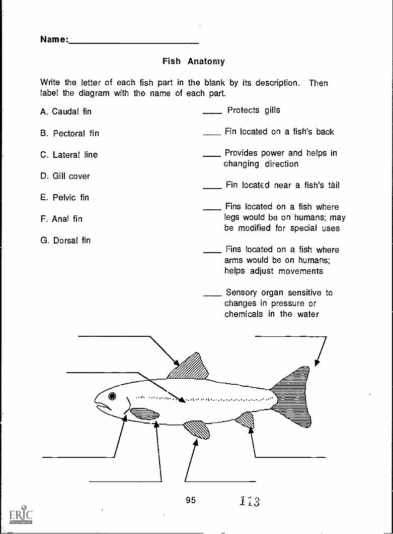
Name:
Fish Anatomy
Write the letter of each fish part in the blank by its description. Thenlabel the diagram with the name of each part.
A. Caudal fin
B. Pectoral fin
C. Lateral line
D. Gill cover
E. Pelvic fin
F. Anal fin
G. Dorsal fin
01.#
Protects gills
Fin located on a fish's back
Provides power and helps inchanging direction
Fin located near a fish's tail
Fins located on a fish wherelegs would be on humans; maybe modified for special uses
Fins located on a fish wherearms would be on humans;helps adjust movements
Sensory organ sensitive tochanges in pressure orchemicals in the water
. . .
95 1-L3
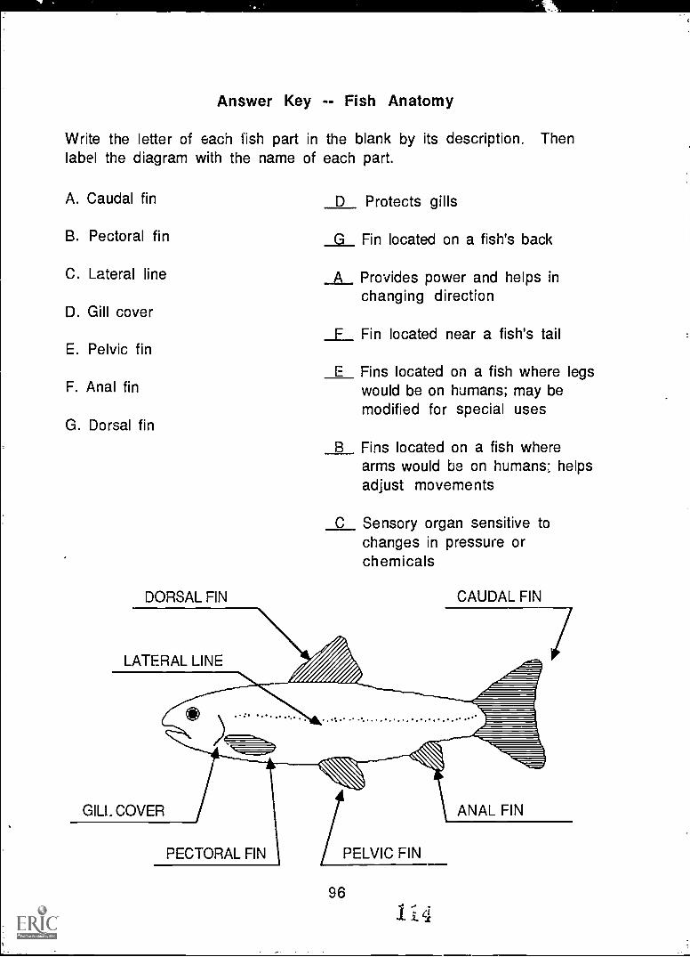
Answer Key -- Fish Anatomy
Write the letter of each fish part in the blank by its description. Thenlabel the diagram with the name of each part.
A. Caudal fin
B. Pectoral fin
C. Lateral line
D. Gill cover
E. Pelvic fin
F. Anal fin
G. Dorsal fin
DORSAL FIN
LATERAL LINE
D Protects gills
G Fin located on a fish's back
A Provides power and helps inchanging direction
F Fin located near a fish's tail
E Fins located on a fish where legswould be on humans; may bemodified for special uses
B Fins located on a fish wherearms would be on humans; helpsadjust movements
C Sensory organ sensitive tochanges in pressure orchemicals
CAUDAL FIN
GILL COVER
.: ........
#e)
...PECTORAL FIN PELVIC FIN
96
1i4
ANAL FIN
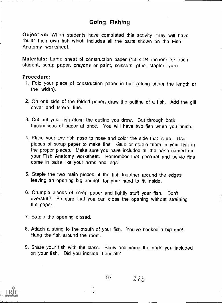
Going Fishing
Objective: When students have completed this activity, they will have"built" their own fish which includes all the parts shown on the FishAnatomy worksheet.
Materials: Large sheet of construction paper (18 x 24 inches) for eachstudent, scrap paper, crayons or paint, scissors, glue, stapler, yarn.
Procedure:1. Fold your piece of construction paper in half (along either the length or
the width).
2. On one side of the folded paper, draw the outline of a fish. Add the gillcover and lateral line.
3. Cut out your fish along the outline you drew. Cut through boththicknesses of paper at once. You will have two fish when you finisn.
4. Place your two fish nose to nose and color the side that is up. Usepieces of scrap paper to make fins. Glue or staple them to your fish inthe proper places. Make sure you have included all the parts named onyour Fish Anatomy worksheet. Remember that pectoral and pelvic finscome in pairs like your arms and legs.
5. Staple the two main pieces of the fish together around the edgesleaving an opening big enough for your hand to fit inside.
6. Crumple pieces of scrap paper and lightly stuff your fish. Don'toverstuff! Be sure that you can close the opening without strainingthe paper.
7. Staple the opening closed.
8. Attach a string to the mouth of your fish. You've hooked a big one!Hang the fish around the room.
9. Share your fish with the class. Show and name the parts you includedon your fish. Did you include them all?
97 115
Thunderbirds and Sunsets
Introduction: Today, meteorologists use barometers, computers r.ndsatellites to predict what the weather will be like days in advance. Butlong ago there were no meteorologists and no electronic tools to use.People made up stories to explain how different kinds of weatherhappened and invented sayings based on their observations of plants andanimals to predict the next day's weather. Chippewa legends say thatthunderstorms happen when the tl underbird flies in search of prey. Canyou think of any stories or sayings that you have heard which explain howweather events occur?
Objectives: When they have completed this activity, students will beable to relate some. weather legends and sayings. They will choose aweather event and make up an original "legend" to explain it.
Materials: Paper, pencil or pen, markers or crayons, Weather Folklorebackground sheet (master on page 99), Thunderbird picture (master onpage 100).
Procedure:1. Read the Weather Folklore background sheet and discuss the signs and
sayings. Which ones have you heard before? Which ones are new ioyou? Can you think of any other ones? What are they?
2. Discuss different types of weather--rain, fog, snow or thunder, forexample. Why do these things happen? What explanations might youimagine if you didn't know what caused them?
3. Choose your favorite weather event. Write a short "legend" to explainwhy this weather event occurs. Draw a picture to illustrate yourstory.
4. Choose some of the sayings you discussed earlier and illustrate them.
5. Color the Thunderbird picture. Use it as a cover for your collection ofillustrated weather sayings. Or collect the original legends from eachstudent and make your own class book of weather tales.
Extension Activities: Read other weather folk tales. You might enjoyWashington Irving's Rip Van Winkle. Check your school library and thepublic library for other folk tales and legends about weather. Ask olderpeople what weather folk tales they know; directions for learning aboutOral History are on pages 101 and 102.
98
1.,6
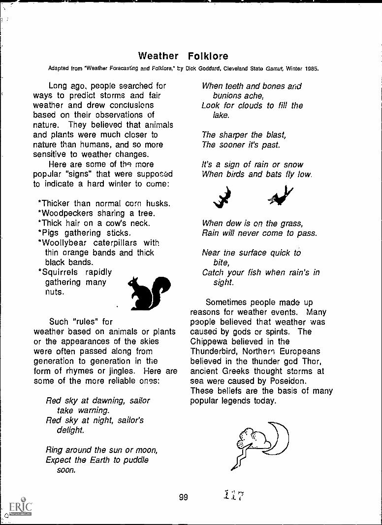
Weather FolkloreAdapted from "Weather Forecasting and Folklore," by
Long ago, people searched forways to predict storms and fairweather and drew conclusionsbased on their observations ofnature. They believed that animalsand plants were much closer tonature than humans, and so moresensitive to weather changes.
Here are some of thq morepopular "signs" that were supposedto indicate a hard winter to come:
*Thicker than normal corn husks.*Woodpeckers sharing a tree.*Thick hair on a cow's neck.*Pigs gathering sticks.*Woollybear caterpillars with
thin orange bands and thickblack bands.
*Squirrels rapidlygathering manynuts.
Such "rules" forweather based on animals or plantsor the appearances of the skieswere often passed along fromgeneration to generation in theform of rhymes or jingles. Here aresome of the more reliable ones:
Red sky at dawning, sailortake warning.
Red sky at night, sailor'sdelight.
Ring around the sun or moon,Expect the Earth to puddle
soon.
,c
Dick
99
Goddard, Cleveland State Gamut, Winter 1985.
When teeth and bones aridbunions ache,
Look for clouds to fill thelake.
The sharper the blast,The sooner it's past.
It's a sign of rain or snowWhen birds and bats fly low.
When dew is on the grass,Rain will never come to pass.
Near the surface quick tobite,
Catch your fish when rain's insight.
Sometimes people made upreasons for weather events. Manypeople believed that weather wascaused by gods or spirits. TheChippewa believed in theThunderbird, Northern Europeansbelieved in the thunder god Thor,ancient Greeks thought storms atsea were caused by Poseidon.These beliefs are the basis of manypopular legends today.
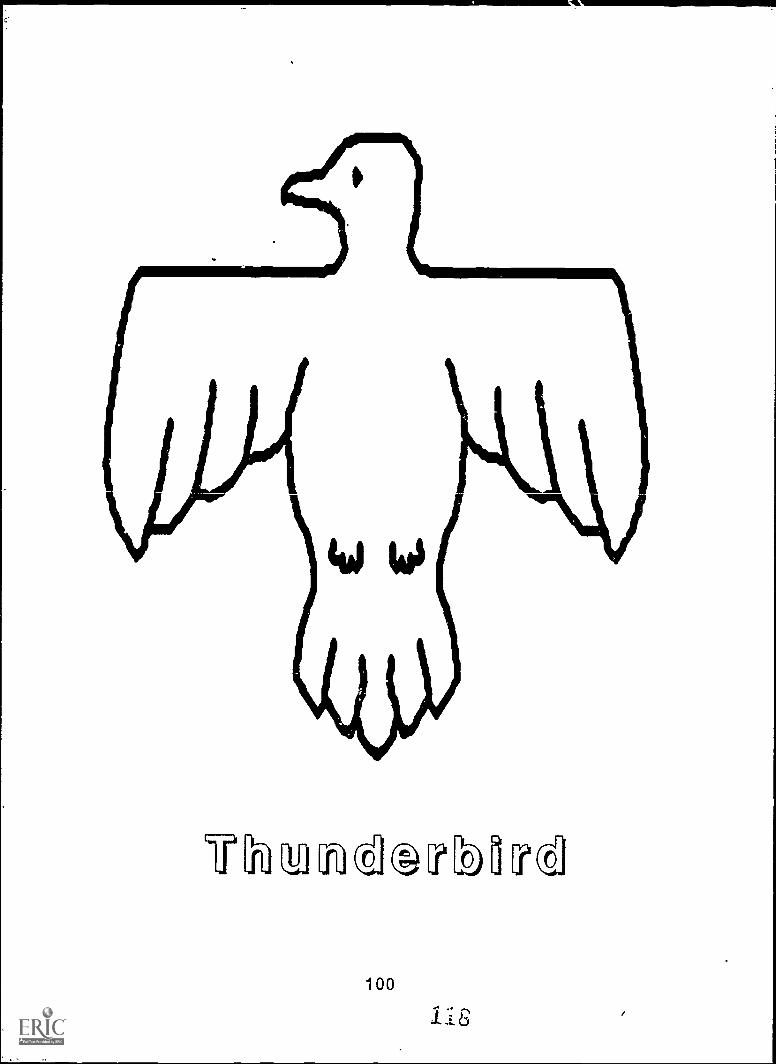
\in/1)4 lo to S\IV
LichaTCk;TIM[ed
100,
Oral History
Introduction: When Paddle spent the winter with an old lady nearMontreal, he heard her tell stories of the St. Lawrence River and itshistory. One of the most fascinating ways to learn history is by talking topeople who have lived it. A discussion with an older pui 'ln can providevaluable material for study and can also bring children closer to people inolder generations.
Objectives: When they have completed this activity, students will beable to conduct an informal interview to gather information on a historicor folk topic. They will be able to describe the value of learning frompeople who have lived with local history.
Materials: Paper and pencil; older students may wish to use a cassetterecorder as well.
Procedure:1. Organize a "Grandparents and Special Friends Day." Each student
invites one older person to come to school for an afternoon. Plan tohave a snack with the guests and let them observe or participate insome classroom activities.
2. In advance, work with students to develop some questions that theycan ask of their guests in personal conversations. Students shouldtake notes or record the interview and share the responses with theclass later. Some possible questions related to Paddle's adventuresare:
What kinds of sayings about the weather did you learn when youwere growing up? Which of the sayings seemed to come true?
Have you ever been fishing in the Great Lakes? What kinds offish did you catch? Did you eat them? What was the fishingtrip like?
When you were growing up, did your parents ever talk about theGreat Lakes? What kinds of things did they say? What kinds ofthings do you tell your grandchildren about the lakes?
- Do you remember the first time you saw one of the GreatLakes? What did you think of it?
101119
3. Stress to students the importance of being kind and patient with theperson who is interviewed. There are many stories to be told, and wemay hear even better ones than those we asked for in our questions.
4. As an alternative to inviting guests to the classroom, have studentsinterview a person in their neighborhood and report results to class.
5. Make an anthology of the stories you heard. Write down your questionsand your guests' responses. Illustrate the stories with drawings orphotographs and make a cover for your collection. Share your personalhistory books with other classes.
Discussion Questions:1. What can we learn about history from older people?
2. Why is this information valuable?
3. What similarities and differences did you notice in the stories you weretold in answer to your questions?
4. Imagine that you are 80 years old. What do you think you will tell yourchildren about when you are old?
5. How do the stories you would tell differ from the stories you were told?How are they alike?
102
120
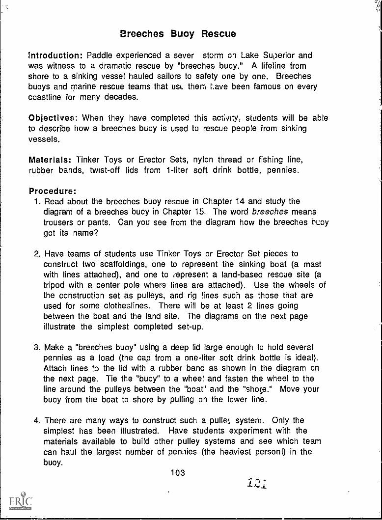
Breeches Buoy Rescue
Introduction: Paddle experienced a sever storm on Lake Superior andwas witness to a dramatic rescue by "breeches buoy." A lifeline fromshore to a sinking vessel hauled sailors to safety one by one. Breechesbuoys and marine rescue teams that usc. them Lave been famous on everycoastline for many decades.
Objectives: When they have completed this activity, students will be ableto describe how a breeches buoy is used to rescue people from sinkingvessels.
Materials: Tinker Toys or Erector Sets, nylon thread or fishing line,rubber bands, twist-off lids from 1-liter soft drink bottle, pennies.
Procedure:1. Read about the breeches buoy rescue in Chapter 14 and study the
diagram of a breeches bucy in Chapter 15. The word breeches meanstrousers or pants. Can you see from the diagram how the breeches N.:aygot its name?
2. Have teams of students use Tinker Toys or Erector Set pieces toconstruct two scaffoldings, one to represent the sinking boat (a mastwith lines attached), and one to represent a land-based rescue site (atripod with a center pole where lines are attached). Use the wheels ofthe construction set as pulleys, and rig !ines such as those that areused for some clotheslines. There will be at least 2 lines goingbetween the boat and the land site. The diagrams on the next pageillustrate the simplest completed set-up.
3. Make a "breeches buoy" using a deep lid large enough to hold severalpennies as a load (the cap from a one-liter soft drink bottle is ideal).Attach lines to the lid with a rubber band as shown in the diagram onthe next page. Tie the "buoy" to a wheel and fasten the wheel to theline around the pulleys between the "boat" and the "shore." Move yourbuoy from the boat to shore by pulling on the lower line.
4. There are many ways to construct such a pulle4 system. Only thesimplest has been illustrated. Have students experiment with thematerials available to build other pulley systems and see which teamcan haul the largest number of pen. lies (the heaviest person!) in thebuoy.
103..., ,1.4:_i_
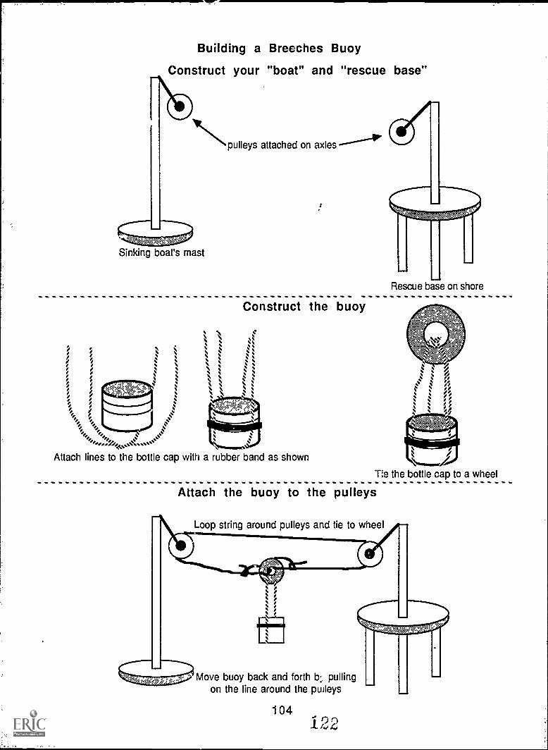
Building a Breeches Buoy
Construct your "boat" and "rescue base"
Npulleys attached on axles
Sinking boat's mast
Rescue base on shore
Construct the buoy
Attach lines to the bottle cap with a rubber band as shown
Tle the bottle cap to a wheel
Attach the buoy to the pulleys
Loop string around pulleys and tie to wheel
er,<??Move buoy back and forth b., pulling
on the line around the pulleys
1041 22
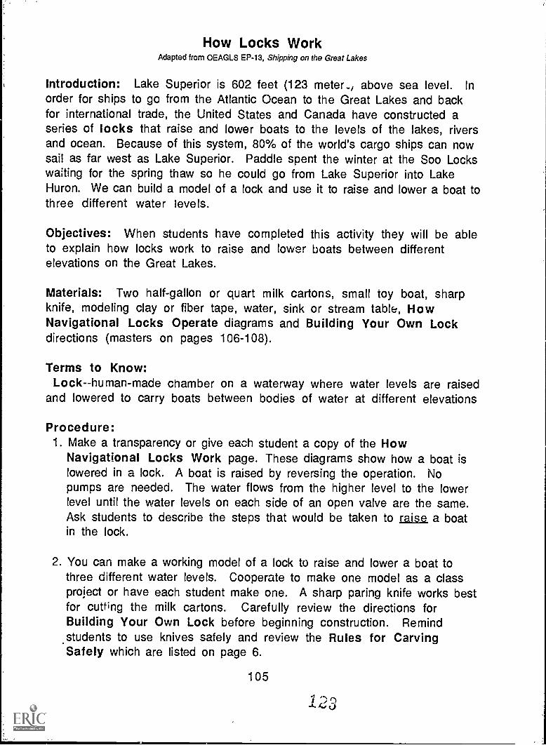
How Locks WorkAdapted from OEAGLS EP-13, Shipping on the Great Lakes
Introduction: Lake Superior is 602 feet (123 meter., above sea level. Inorder for ships to go from the Atlantic Ocean to the Great Lakes and backfor international trade, the United States and Canada have constructed aseries of locks that raise and lower boats to the levels of the lakes, riversand ocean. Because of this system, 80% of the world's cargo ships can nowsail as far west as Lake Superior. Paddle spent the winter at the Soo Lockswaiting for the spring thaw so he could go from Lake Superior into LakeHuron. We can build a model of a lock and use it to raise and lower a boat tothree different water levels.
Objectives: When students have completed this activity they will be ableto explain how locks work to raise and lower boats between differentelevations on the Great Lakes.
Materials: Two half-gallon or quart milk cartons, small toy boat, sharpknife, modeling clay or fiber tape, water, sink or stream table, HowNavigational Locks Operate diagrams and Building Your Own Lockdirections (masters on pages 106-108).
Terms to Know:Lock--human-made chamber on a waterway where water levels are raised
and lowered to carry boats between bodies of water at different elevations
Procedure:1. Make a transparency or give each student a copy of the How
Navigational Locks Work page. These diagrams show how a boat islowered in a lock. A boat is raised by reversing the operation. Nopumps are needed. The water flows from the higher level to the lowerlevel until the water levels on each side of an open valve are the same.Ask students to describe the steps that would be taken to raise a boatin the lock.
2. You can make a working model of a lock to raise and lower a boat tothree different water levels. Cooperate to make one model as a classproject or have each student make one. A sharp paring knife works bestfor cutting the milk cartons. Carefully review the directions forBuilding Your Own Lock before beginning construction. Remind
.students to use knives safely and review the Rules for CarvingSafely which are listed on page 6.
105

HOW NAVIGATIONAL LOCKS OPERATE
BOAT ENTERING FILLED LOCK CHAMBER
UPPER LEVEL Upper gatesOPEN
Lower gatesCLOSED
Filling valveOPEN
LOWER LEVELEmptying valve
CLUJED
BOAT BEING LOWERED IN LOCK CHAMBER
UPPER LEVEL Upper gatesCLOSED
Lower gatesCLOSED
Filling valveCLOSED
LOCK CHAMBER Water out
Lo. .f.fLOWER LEVEL114
Emptying valveOPEN
BOAT LEAVING LOCK CHAMBER AT LOWER LEVEL
UPPER LEVEL Upper gatesCLOSED
Lower gatesOPEN
LOCK CHAMBER
Filling valveCLOSED
LOWER LEVEL
Emptying valveOPEN
106124
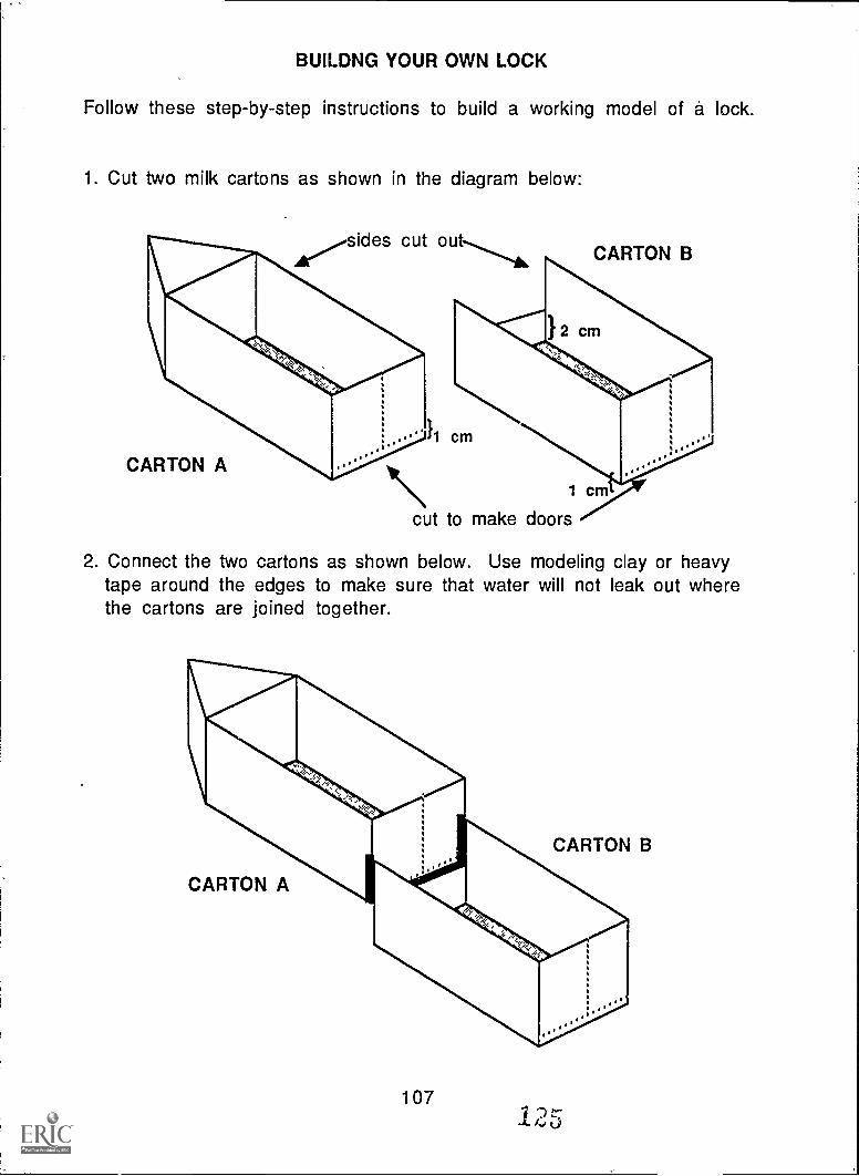
BUILDNG YOUR OWN LOCK
Follow these step-by-step instructions to build a working model of a lock.
1. Cut two milk cartons as shown in the diagram below:
sides cut out
CARTON
11111111cm
A
CARTON B
1 cm
cut to make doors
2. Connect the two cartons as shown below. Use modeling clay or heavytape around the edges to make sure that water will not leak out wherethe cartons are joined together.
107
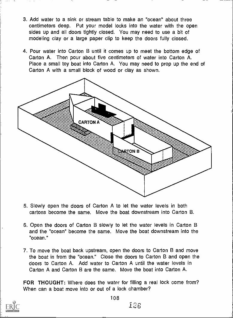
3. Add water to a sink or stream table to make an "ocean" about threecentimeters deep. Put your model locks into the water with the opensides up and all doors tightly closed. You may need to use a bit ofmodeling clay or a large paper clip to keep the doors fully closed.
4. Pour water into Carton B until it comes up to meet the bottom edge ofCarton A. Then pour about five centimeters of water into Carton A.Place a small toy boat into Carton A. You may need to prop up the end ofCarton A with a small block of wood or clay as shown.
5. Slowly open the doors of Carton A to let the water levels in bothcartons become the same. Move the boat downstream into Carton B.
6. Open the doors of Carton B slowly to let the water levels in Carton Band the "ocean" become the same. Move the boat downstream into the"ocean."
7. To move the boat back upstream, open the doors to Carton B and movethe boat in from the "ocean." Close the doors to Carton B and open thedoors to Carton A. Add water to Carton A until the water levels inCarton A and Carton B are the same. Move the boat into Carton A.
FOR THOUGHT: Where does the water for filling a real lock come from?When can a boat move into or out of a lock chamber?
108
126
Clean Campaign
Introduction: When Paddle was washed up onto a beach along LakeMichigan, he found himself among old bottles, boxes, rusty metal, and otherlitter. Many beaches and other natural areas as well as highways and citystreets are littered by careless people. Some of the litter can be recycledinto useful things, and the rest belongs in proper waste containers.
Objectives: When they have completed this activity, students will be ableto identify the types of litter and household trash that can be recycled.They will know proper disposal methods for other trash.
Materials: Plastic garbage bags, old gloves and old shoes.
Terms to Know:recyclable materials - materials like glass, paper and aluminum which
can be broken down and processed to make new glass, paper or aluminumwithout using new raw materials.
re-usable materials materials like glass bottles and plastics whichmay be washed, sterilized and used over and over without breaking down.
Procedure:1. Introduce the idea of recycling by inviting a guest speaker from a local
recycling firm. Or brainstorm with students to make a list of whatkinds of materials can be re-used or recycled. Make a classroom displayof recyclable and re-usable materials. Glass, newsprint, aluminum(cans or clean foil) are often recycled. Glass beverage containers (beeror soft drink bottles) are often re-used. Some states and provincesrequire people to pay a deposit when they buy re-usable or recyclablecontainers. This deposit is refunded when the empty containers arereturned to stores or collection sites.
2. Organize a clean-up campaign in a local area. Give your campaign acatchy name and make flyers to deliver to people in the area encouragingthem to participate in the clean-up effort. For example, "Clean UpSummers Street" has the initials CUSS. Flyers to people on the streetcould say, "It's enough to make you CUSS! Join the students at SummersSchool to help make our area beautiful again." Be sure to give the date,time and meeting place for your campaign. Decorate the flyers withdrawings of "BEFORE" and "AFTER" scenes.
109,
4.. LS 6
3. Wear old shoes and old Moves to protect your feet and hands when youare gathering trash. Teams of two can share a garbage bag. Collect allthe litter you find in your designated clean-up area.
4. Separate the re-usable and recyclable materials from the other litteryou collected. Take these materials to a recycling center. Materialsthat can not be re-used or recycled should be returned to their sourceif possible. Otherwise the remaining materials should be taken to asanitary landfill or carefully placed in appropriate containers forpick-up by regular trash collectors. You may wish to make a display ofhow much litter you collected.
Discussion Questions:1. What kinds of materials did you find in the litter you collected? How
much was recyclable or re-usable?
2. Where do you think these materials came from? Why would thesetypes of litter be where you found them?
3. What problems might be caused by littering?
4. What problems might be caused by cleaning up litter? (A majorproblem in many areas is the lack of available space to dispose ofsolid wastes.)
5. What benefits are there in cleaning up litter and recycling? (Somebenefits include making the area more scenic, reducing the amount ofraw materials used in manufacturing and direct economic benefits torecyclers -- most recycling centers pay for the materials which arebrought in.)
6. List thrpe things you can do to help reduce the amount of trash yougenerate each day. How can you re-use or recycle trash at home?
7. Does your state or province require a deposit on beverage containers?What else might a government do to reduce waste?
8. If you were a fish, what would you think of humans?
110
1.28
Forest Fires -- Good and Bad
Introduction: Paddle was trapped on an island during a forest fire. Everyyear fires destroy thousands of acres of forests. Sometimes the fires arecaused by people, sometimes by other parts of nature. Although forestfires do much damage, they also do some good.
Objectives: When they have completed this activity, students will beable to list some causes of forest fires and to describe both harmful andbeneficial effects of forest fires.
Materials: Paper, pencil or pen, markers or crayons.
Procedure:1. Discuss how forest fires start. Some start from natural causes such
as lightning. Some are started by people. Carelessness withcampfires, matches or cigarettes accidentally starts many fires.Sometimes fires are started deliberately. In many places, woodedareas are burned to clear land for farming. Firefighters set controlledfires around an area to keep forest fires from spreading outside thatarea.
2. Discuss the effects of forest fires. Chapter 19, Forest Fire, describessome of the harmful effects of forest fires. Trees and other plantsare destroyed, animals are killed or lose their homes. Sometimesfo'rest fires can be beneficial to ecosystems. The ashes in a burnedarea help fertilize the soil to make new plants grow better. The conesof the jack pine tree and some others do not open to release theirseeds until they have been burned. Without forest fires, the jack pinewould not survive.
3. Make a bulletin board about forest fires. Use both words and picturesto describe how fires start and what kinds of effects fires have onforests. Include measures you might take to prevent human-causedfires from occurring accidentally.
Extension Activities: Invite a firefighter to talk to the class about firesafety in general. Discuss fire safety rules for school and home. Planescape routes and conduct a fire drill at home or at school.
111
129
Building a "Birchbark" Canoe
Introduction: The Indians of North America were said to be the bestcanoe builders anywhere. They made some canoes by hollowing out logs(called "dugouts"). They made others by sewing together animal skins orpieces of tree bark over a wooden frame. Birchbark canoes wereespecially light and fast. To make one, the Indians sewed large pieces ofbark together with thin strips of twisted bark or leather. Soaking thebark first made it easier to bend it into the proper shapes. They put pinepitch along the seams where the pieces overlapped to help make thecanoes waterproof. We can build a simple model of a birchbark canoeusing paper, yarn and pipe cleaners.
Objective: When students have completed this activity, they will be ableto explain how a birchbark canoe is made.
Materials: 6" X 9" piece of oaktag and two yards of yarn or string foreach student, pipe cleaners, scissors, yarn needles (with large eyes),rulers and pencils, pattern (page 115), crayons or markers and Scotch tape(optional).
Procedure:1. Use pencil and ruler to copy the pattern onto your piece of oaktag.
Number the pieces as they are numbered on the pattern.
2. Cut the oaktag apart along the solid lines you drew. Throw away thepiece marked DISCARD.
3. If you wish, color your oaktag pieces to resemble tree bark.
4. Fold pieces 1, 2 and 3 along the dotted lines.
5. Fit the pieces together in your hand to get an idea of how the finishedcanoe will look. Piece 1 is the bottom of your canoe. Pieces 2 and 3are the ends of your canoe, and pieces 4 and 5 are the sides. Noticethat the end pieces are folded unevenly. Make sure that the longerparts of the end pieces are on OPPOSITE sides of the canoe. You maywant to use small pieces of Scotch tape to hold the pieces in placewhile you sew them together.
112
1:30
6. Sew the pieces together. Begin at one end of the bottom piece and sewthe end shut. Sew along one side of one end piece where it overlapsthe bottom. Continue sewing along the side piece of the canoe whereit overlaps the bottom. Join the second end piece where it overlapsthe bottom. When you get to the end of the bottom piece, sew it shut,then continue sewing along the edge of the end piece where it overlapsthe bottom. Sew the other side piece in place, then sew the remainingside of the first end piece and fasten the yarn securely. Now sewtogether the seams where the side and end pieces overlap. Thiscompletes the "skin" of the canoe.
7. Make a frame from pipe cleaners. Twist the ends of pipe cleanerstogether until you can make a loop that just fits inside the top of yourcanoe (it will be about 17 inches around). Attach three U-shapedpieces of pipe cleaner to this rim to make ribs that support the sidesof the canoe (each rib piece will be about 6 inches long). Lower theframe into the "skin" of your canoe.
sparfai,,,mma
Pipe cleaner frame
Paper "skin" stitchedwith yarn
113
131
8. Use a whip stitch to attach the top edge of the "skin" of the canoe tothe frame. Your canoe is complete!
Whip stitch
Additional Information:
Fortner, Rosanne W. and Victor J. Mayer, eds. The Great Lake Erie: AReference Text for Educators and Communicators. Columbus, Ohio: TheOhio State University.
Rogers, Edward S. Algonkians of the Eastern Woodlands. Montreal: RoyalOntario Museum.
114
PATTERN FOR "BIRCHBARK" CANOE
, DISCARD
2 3
1
4 5
115
133
Harbor Guides
Introduction: Paddle traveled by motorboat through the St. Clair River,through Detroit's busy harbor, and through the Detroit River. To get throughshallow waterways with many vessels coming and going, the boat used knownsights and sounds as a guide to safe passage. In major harbors there arebuoys that mark safe channels. The buoys stay in one place because they areanchored. They sometimer; have lights, bells, whistles or horns to make surethey are noticed even in fog or darkness.
Objectives: When they have completed this activity, students will be ableto describe what it is like to depend on sounds to guide a ship through thedarkness. They will note the importance of being able to depend on someoneor something besides themselves to be safe on the water.
Materials: Moveable tables and chairs or traffic cones; blindfolds.
Procedure:1. Set up the room or playground with a simple maze made up of tables and
chairs or traffic cones. This represents the channel of a harbor. Leaveplenty of room for two people to pass each other in the maze.
2. Play the Harbor Guide game as follows: Each student selects a partner.One person in each pair is blindfolded and placed at the entrance to theharbor to represent a boat approaching in the night. All "sighted"partners represent buoys. One is positioned outside of each turn orintersection of the maze. Each buoy makes a different noise to guide theboats through the harbor. Each boat listens for the nearest buoy and turnsaway from it when it is very near. All buoys make their sound at regularintervals, but the boat is guided by the nearest sound. Boats themselvesmay make noises to warn other boats of their presence.
3 When the first group of boats has made it through the channel, partnersswitch places so all can experience the guidance by buoys.
4. When all boats have safely navigated the harbor, discuss the experience.-In.-a real harbor, what obstacles might be present? How important is itfor a boat captain to be alert to buoys and other sounds?
Extension Activity: Look at a navigational chart. The legend shows thedifferent symbols that represent buoys. How far apart are the buoys on themap? What kinds are shown? Even if the buoy makes no sound, how can it bea useful aid to navigation? (Buoys are either red or green. The rule is thatall red buoys are kept on the right when returning to port: Red-Right-Returning, and on the left going out to sea.)
1 1 6
134
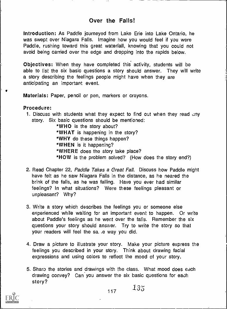
Over the Falls!
Introduction: As Paddle journeyed from Lake Erie into Lake Ontario, hewas swept over Niagara Falls. Imagine how you would feel if you werePaddle, rushing toward this great waterfall, knowing that you could notavoid being carried over the edge and dropping into the rapids below.
Objectives: When they have completed this activity, students will beable to list the six basic questions a story should answer. They will writea story describing the feelings people might have when they areanticipating an important event.
Materials: Paper, pencil or pen, markers or crayons.
Procedure:1. Discuss with students what they expect to find out when they read any
story. Six basic questions should be mentioned:*WHO is the story about?*WHAT is happening in the story?*WHY do these things happen?*WHEN is it happening?*WHERE does the story take place?*HOW is the problem solved? (How does the story end?)
2. Read Chapter 22, Paddle Takes a Great Fall. Discuss how Paddle mighthave felt as he saw Niagara Falls in the distance, as he neared thebrink of the falls, as he was falling. Have you ever had similarfeelings? In what situations? Were these feelings pleasant orunpleasant? Why?
3. Write a story which describes the feelings you or someone elseexperienced while waiting for an important event to happen. Or writeabout Paddle's feelings as he went over the falls. Remember the sixquestions your story should answer. Try to write the story so thatyour readers will feel the sa..e way you did.
4. Draw a picture to illustrate your story. Make your picture express thefeelings you described in your story. Think about drawing facialexpressions and using colors to reflect the mood of your story.
5. Sharo the stories and drawings with the class. What mood does eachdrawing convey? Can you answer the six basic questions for eachstory?
1351 1 7
'14
Great Lakes Bulk CarriersAdapted from 0EAGLS EP-13, Shipping on the Great Lakes
Introduction: On the Great Lakes, all floating vessels are called boats,no matter how big they are. Large boats specially adapted to carry heavycargoes of unpackaged freight (bulk cargo) travel through the GreatLakes. These bulk carriers bring needed products into Great Lakes portcities and carry away products for use in other parts of the world. TheGreat Lakes are very important routes for the transportation of grain,coal, iron ore and other products. Paddle passed many bulk carriers inbusy ports on his way through the Great Lakes.
Objectives: When students have completed this activity they will beable to name three major products transported on the Great Lakes and toidentify the parts of a bulk carrier.
Materials: Great Lakes Cargo worksheet (masters on pages 120-121),markers or crayons, Bulk Carrier Puzzle (masters on pages 125-126),legal-size envelope for each student, 9 x 12-inch sheets of lightweightcardboard (optional).
Terms to Know:bowfront part of a boatballast--weight (usually water or sand) used to balance a boatbulk carrier - -large boat adapted for carrying heavy cargoes of loose
materialbulkhead - -wal! separating storage compartments in a boatcargo -- products being carriedexport- -to send a product to another placeforward -- toward the front part of a boatfunnelon a boat, the smokestackhold - -part of a boat where cargo is stored (or held)hatch--covered opening into the hold for loading and unloading cargoimport--to bring in a product from another placerudder--flat piece of metal located at the stern; used to steer a boatstern--the back part of a boatwheelhouse - -room where the ship's steering wheel is ;ocated
Procedure:1. Review Chapter 11, Paddle Finds One End of Lake Superior, Chapter 21,
Paddle Reaches Lake Erie, and Chapter 22, Paddle Takes a Great Fall,for discussions of some Great Lakes products and descriptions of bulkcarriers.
118
136
2. Complete the Great Lakes Cargo worksheet.
3. If you made a wall map to keep track of Paddle's progress (Great LakesGeography, page 1), add tags to this map to indicate which productsare imported into and exported from each of the cities on theworksheet.
4. Identify the parts of a bulk carrier. Use the key on page 124 to helpyou. Why is ballast used? What products might be carried in the cargoholds? Is the rudder forward or at the stern? How is the boatsteered?
5. Color both pages of the Bulk Carrier Puzzle.
6. Cut the Puzzle pages into pieces. (If you want to make the puzzlesturdier, glue the pages to lightweight cardboard before cutting thepuzzle apart.) Put the pieces in an envelope to keep them together.
7. Trade your puzzle for a friend's and put it together.
Extension Activities: Make up a spelling and vocabulary quiz using thelist of Terms to Know. Or play a matching game with two teams ofstudents taking turns giving clues from the definitions and guessing theterms.
119
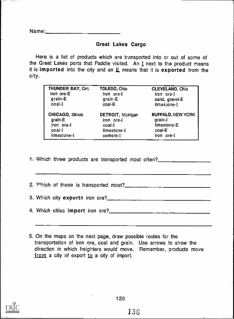
Name:
Great Lakes Cargo
Here is a list of products which are transported into or out of some ofthe Great Lakes ports that Paddle visited. An I next to the product meansit is imported into the city and an E. means that it is exported from thecity.
THUNDER BAY, Ont.iron ore-Egrain-Ecoal-I
CHICAGO, Illinoisgrain-Eiron ore-Icoal-Ilimestone-I
TOLEDO, Ohioiron ore-Igrain-Ecoal-E
DETROIT, Michiganiron ore-Icoal-Ilimestone-Icement-I
CLEVELAND, Ohioiron ore-Isand, gravel-Elimestone -I
BUFFALO, NEW YORKgrain-Ilimestone-Ecoal-Eiron ore-I
1-;---Which three products are transported most often?
2. Which of these is transported most?
3. Which city exports iron ore?
4. Which cities import iron ore?
5. On the maps on the next page, draw possible routes for thetransportation of iron ore, coal and grain. Use arrows to show thedirection in which freighters would move. Remember, products movefrom, a city of export 1.Q, a city of import.
120
133
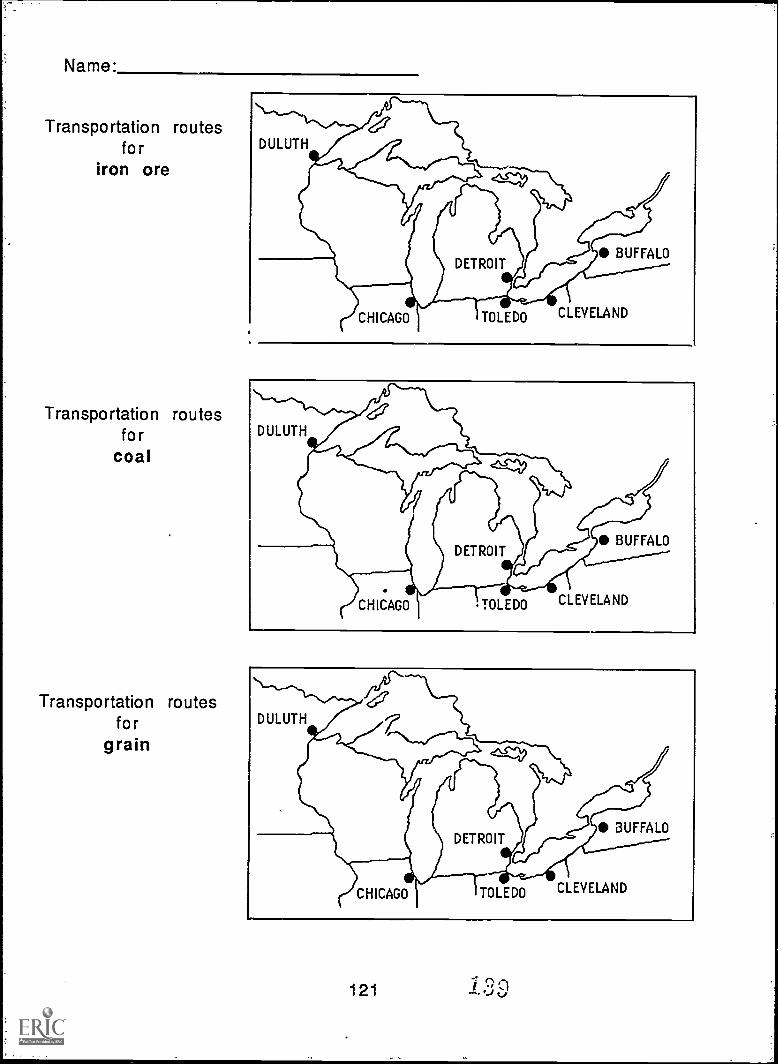
Name:
Transportation routesfor
iron ore
Transportation routesfor
coal
Transportation routesfor
grain
%\--'...-^%.
DULUTH
CHICAGO TOLEDO CLEVELAND
121
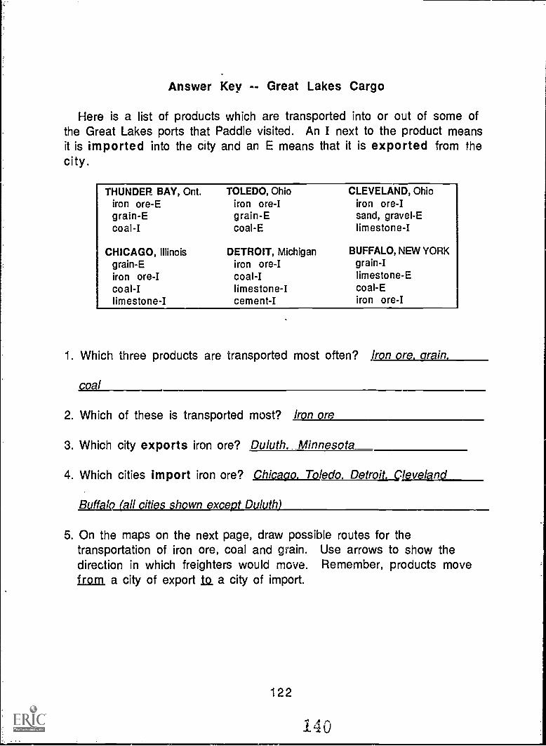
Answer Key -- Great Lakes Cargo
Here is a list of products which are transported into or out of some ofthe Great Lakes ports that Paddle visited. An I next to the product meansit is imported into the city and an E means that it is exported from thecity.
THUNDER BAY, Ont.iron ore-Egrain-Ecoal-I
CHICAGO, Illinoisgrain-Eiron ore-Icoal-Ilimestone-I
TOLEDO, Ohioiron ore-Igrain-Ecoal-E
DETROIT, Michiganiron ore-Icoal-Ilimestone-Icement-I
CLEVELAND, Ohioiron ore-Isand, gravel-Elimestone-I
BUFFALO, NEW YORKgrain-Ilimestone-Ecoal-Eiron ore-I
1. Which three products are transported most often? Iron ore. grain.
coal
2. Which of these is transported most? Iron or
3. Which city exports iron ore? Duluth. Minnesota
4. Which cities import iron ore? Chicago. Toledo. Detroit. Cleveland
Buffalo (all cities shown except Duluth)
5. On the maps on the next page, draw possible routes for thetransportation of iron ore, coal and grain. Use arrows to show thedirection in which freighters would move. Remember, products movefrom, a city of export la a city of import.
122
140
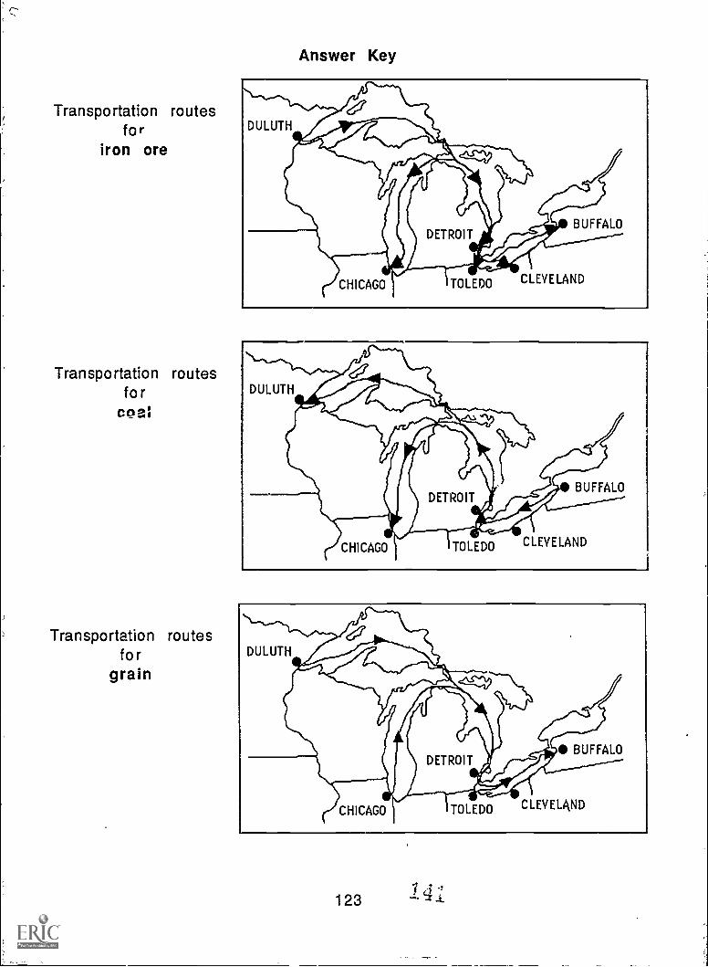
Transportation routesfor
iron ore
Transportation routesfo r
coal
Transportation routesfor
grain
Answer Key
CHICAGO TOLEDO CLEVELAND
BUFFALO
CHICAGO TOLEDO CLEVELAND
BUFFALO
CHICAGO TOLEDO
1231 3 -f.4. 'z .1.
CLEVELAND
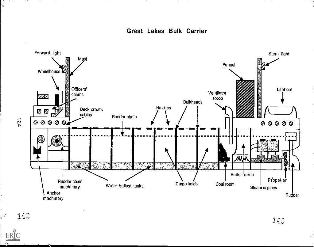
Forward lightMast
Great Lakes Bulk Carrier
Funnel
Stern light
Wheelhouse
Officers'cabins
Bulkheads
Ventilatorscoop
Lifeboat
Deck crew'scabins
Hatches
Rudder chain /
1 Rudder chainmachinery
Anchormachinery
142
Water ballast tanks
Boiler room
Cargo holds Coal roomPiopeller
Steam engines
14'3
Rudder
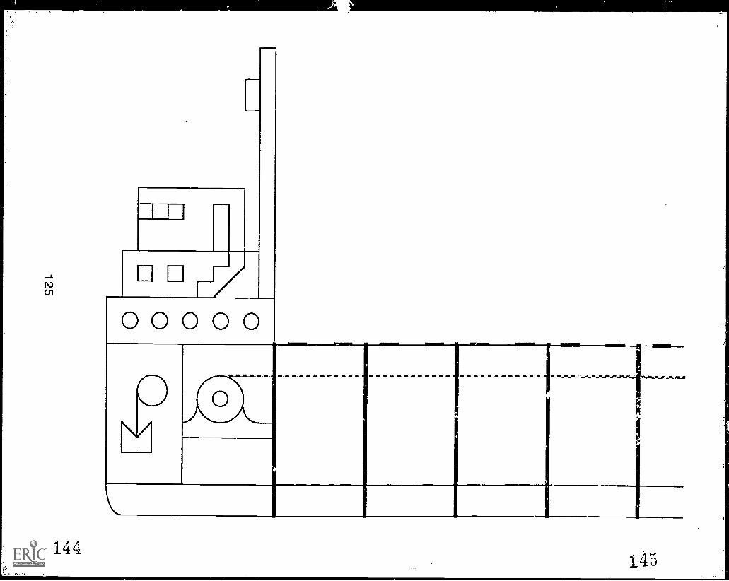
ACT
0 0 0 0 0
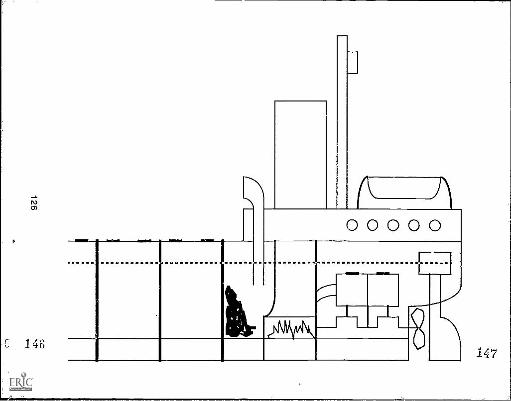
147
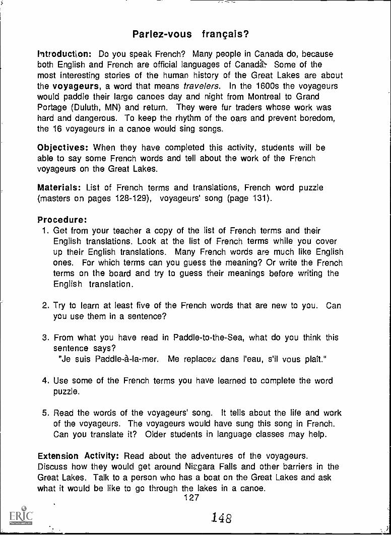
Parlez-vous francais?
litroducton: Do you speak French? Many people in Canada do, becauseboth English and French are official languages of Canada's, Some of themost interesting stories of the human history of the Great Lakes are aboutthe voyageurs, a word that means travelers. In the 1600s the voyageurswould paddle their large canoes day and night from Montreal to GrandPortage (Duluth, MN) and return. They were fur traders whose work washard and dangerous. To keep the rhythm of the oars and prevent boredom,the 16 voyageurs in a canoe would sing songs.
Objectives: When they have completed this activity, students will beable to say some French words and tell about the work of the Frenchvoyageurs on the Great Lakes.
Materials: List of French terms and translations, French word puzzle(masters on pages 128-129), voyageurs' song (page 131).
Procedure:1. Get from your teacher a copy of the list of French terms and their
English translations. Look at the list of French terms while you coverup their English translations. Many French words are much like Englishones. For which terms can you guess the meaning? Or write the Frenchterms on the board and try to guess their meanings before writing theEnglish translation.
2. Try to learn at least five of the French words that are new to you. Canyou use them in a sentence?
3. From what you have read in Paddle-to-the-Sea, what do you think thissentence says?
"Je suis Paddle-a-la-mer. Me replacez dans l'eau, s'il vous plait."
4. Use some of the French terms you have learned to complete the wordpuzzle.
5. Read the words of the voyageurs' song. It tells about the life and workof the voyageurs. The voyageurs would have sung this song in French.Can you translate it? Older students in language classes may help.
Extension Activity: Read about the adventures of the voyageurs.Discuss how they would get around Niv.gara Falls and other barriers in theGreat Lakes. Talk to a person who has a boat on the Great Lakes and askwhat it would be like to go through the lakes in a canoe.
127
148 j
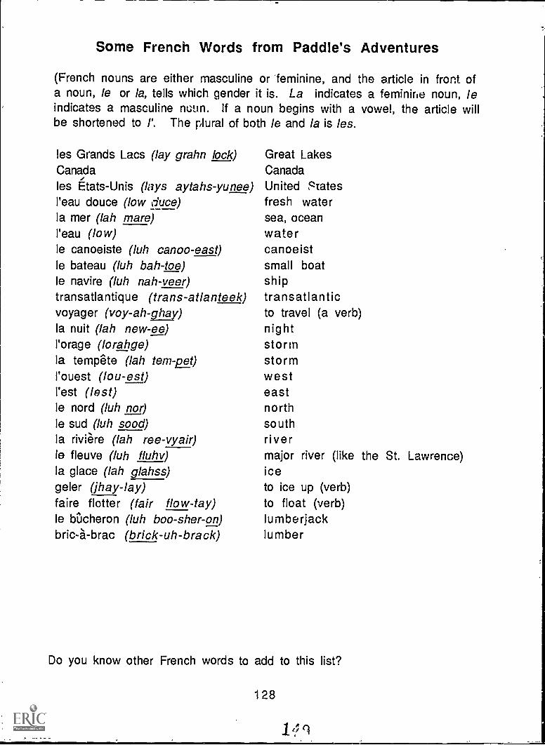
Some French Words from Paddle's Adventures
(French nouns are either masculine or feminine, and the article in front ofa noun, le or la, tells which gender it is. La indicates a feminine noun, leindicates a masculine noun. If a noun begins with a vowel, the article willbe shortened to I'. The plural of both /e and la is les.
les Grands Lacs (lay grahn lock)Canada
les Etats-Unis (lays aytahs-yunee)l'eau douce (low duce)la mer (lah mare)l'eau (low)le canoeiste (luh canoo-east)le bateau (luh bah-toe)le navire (luh nah-veer)transatlantique (trans-atlanteek)voyager (voy-ah-ghay)la nuit (lah new-ee)l'orage (lorahge)la tempete (lah tem-pet)I'ouest (lou-est)I'est (lest)le nord (luh nor)le sud (luh sood)la riviere (lah ree-vyair)le fleuve (luh fluhv)la glace (lah glahss)geler (jhay-lay)faire flotter (fair flow-tay)le biicheron (luh boo-sher-on)bric-a-brac (brick-uh-brack)
Great LakesCanadaUnited Statesfresh watersea, oceanwate rcanoeistsmall boatshiptransatlanticto travel (a verb)nightstormstormwesteastnorthsouthrivermajor river (like the St. Lawrence)iceto ice up (verb)to float (verb)lumberjacklumber
Do you know other French words to add to this list?
128
French Word Puzzle
The starting word is given. Work outward from that word to fill in wordsthat have the right number of letters and can link with the letters youalready have in place. For instance, there are five 3 -letter words, but onlyone ends in C to match the blocks near the given word. Do not use the spacesor hyphens to fill in the puzzle blocks. None of the puzzle words is writtenbackwards or diagonally.
3 letterseauestlacmersad
4 lettersnordnuit
5 lettersdoucegelerglaceorageouest
6 lettersbateaunavireCanadafleuve
7 lettersrivieretempetevoyager
8 letters!Acheroneau douce
9 lettersbric-a-braccanoeisteEtats-unis
12 lettersfaire flatter
1111401
11 all aII
129/5t^1
Answer Key -- French Word Puzzle
The starting word is given. Work outward from that word to fill in wordsthat have the right number of letters and can link with the letters youalready have in place. For instance, there are five 3-letter words, but onlyone ends in C to match the blocks near the given word. Do not use the spacesor hyphens to fill in the puzzle blocks. None of the puzzle words is writtenbackwards or diagonally.
3 letterseauestlacmersud
4 lettersnordnuit
FM
5 letters-doucegelerglaceorageouest
6 lettersbateaunavireCanadafleuve
D
E
Fro I Y
B
0R
A
GE
U C E.1A.,P5P,Vr S'00
E T
7 lettersrivieretempetevoyager
8 lettersbikheroneau douce
N 0 FR IDwe,A
J 3,Fmv.
I
L E
A TA tY,..MT
S N
9 lettersbric-a-braccanoeisteEtats-unis
12 lettersfaire flotter
0U VIE I
E
S IIU DT
A U
IG
T31
A GIET
E
A
U C H
D 0 U
At K>
R A N D S L A C SE
L
E
R
A IC0E
E RIOINI
T
HI
11MMIII
E
MP
C V
INTP V I R E
R A CID E
IB R I IC
130151
A B
S.A.T.I.
Iii--
A Song from the VoyageursFrom: The Waterloo Folksongs of Canada Series, Choral Edition No. 1, by Edith Fulton Fowke and Richard Johnston.
G1954, Waterloo Music Co., Ltd., Waterloo, Ontario. Pages 34-35. Used by permission.
A CANADIAN BOAT SONG
The Irish poet, Thomas Moore, wrote this song to o tune he heardvoyageurs sing when he visited Canada in 1804. St. Anne
vas the patron saint of travellers, and her church stood on thewestern tip of Montreal where the fur brigode) mode their lost
halt before heading into the wilderness.
Smoothly swaying
mr D A7
A CANADIAN BOAT SONG (Continued)
REFRAIN:
a tempo1) D A7 Dm1M1slIN W111111111= .r,===11=110/ 43// aMIniN//=..r WREMI,M=Ma
Al
1. Faint-ly as tolls the eve- ning chime, Our voi-ces keep tune and our2. Why should we yet our -nil un -furl? There is not a breath the blue3. Og - ta - wa's tide! This tcambling moon Shall see us float o - ver thy
-.1,1) 4 4/ stn....1 ;...1=111=f2MIL
..,: ..". .11---11 Al 11111MEr. MM, PINE
A7 D rig.
; 111,1N1141. =1.11=11.ar .I-PAIMIr fr 41I 1MB,-M as
A7 D a tempo
oars keep time, Our voi-ces keep tune and our oars keep time.waves to curl, There is not a breath the blue waves to curl.sur - ges soon, Shall see us float o - ver thy sur - ges soon.
Al 4kAM=.1Ii/INIM.0111 11111171.-11 Amr-v
1Mi im. ,1111.1MS.1rig. a tempo
Soon as the woods on shore look dim We'll sing of St. Anne's our port-ing hymn.But when the wind blows oft the shore, Oh, sweet-ly we'll rest our wea -ry oar.Saint of the green isle, hear our prayer, Grant us cool heav'ns and fav'r-ing air.
-7414 / J. -_"1)0 -ell
.w......, . :=Ds.-,.. ,Mill'.4111110.1.11.-.....1.011,
15 Ad
p
1. Raw, bro -thws, row,2.43. Blew, breez-es, the stream runs lost, The ro- pids are near and the day-light's post,
rig.urn D====
6.11M11=1:ir: i==11=1;
a tempoD D.C.
The ro- pids up' near and the day- light's past,
rig. a lam** D.C.
Life in an EstuaryAdapted from OEAGLS EP-16, The Estuary: A Special Place
Introduction: As Paddle travelled through Lake Superior, a wave tossedhim across the beach into a marsh. Such wetland areas often form wheiea stream flows into a lake or the ocean. To most people, an estuary(pronounced ga-chew-airy) is a place where fresh water meets the sea. In
its larger meaning, an estuary is that part of the mouth of a stream inwhich the water level is influenced by the lake or sea into which thestream flows. The Great Lakes have freshwater estuaries.
Objectives: When students have completed this activity, they will beable to describe the different plant communities that are found in anestuary and to explain how animals use these plant communities. Theywill be able to predict the effects of some human and environmentalforces on conditions in an estuary.
Materials: Green, blue and brown crayons or colored pencils, AboutEstuaries background sheets (masters on pages 133-134), Life in anEstuary worksheet (master on page 135).
Terms to Know:Estuary- -that part of the mouth of a stream in which the water level
is influenced by the lake or sea into which the stream flows.Ecologistspeople who study the inter-relationships between living
things and their environment.Submerged--underwater.Emergent -- sticking out of the water.Sediment--sand, soil and other particles carried by a stream.
Procedure:1. Read the About Estuaries background sheets with your class.
2. Refer to the background sheets and complete the worksheet, Life inan Estuary.
Discussion Questions:1. What are the three different types of environments found in an
estuary? What different types of plants are found in each?
2. Why do animals need plants? Why are so many different animals foundin estuaries?
3. How do you think human activity could affect an estuary?
Extension Activity: Play the Food Chain Tag game described on page 75to find out more about the effects of pollutant', on animals.
132
154
About Estuaries
An estuary is that part of the mouth of a stream in which the waterlevel is influenced by the lake or sea into which the stream flows. Thismeans that as the water level in the lake or sea changes, so does thewater level in the estuary. The amount of rainfall, tides or humanactivities like a water diversion or dredging a channel owl all affect thewater level in an estuary.
In an estuary, some areas are almost always under water, some areasare almost alwrys dry land, and some areas are between these twoextremes. Each of these ecosystems has a set of plants that can survivebest under the given conditions, and each set of plants has a special roleto play in the estuary.
The diagram below represents a cross-section of a typical estuary. Itshows examples of the types of plants found in each area of the estuary.Ecologists use a cross-section as a way to sample the populations ofliving things in a community. By naming and counting the plants along across-section, they get an idea of what the whole plant community is like,without counting and naming every organism in the whole community.
At the edge of the estuary are trees and shrubs rooted in fairly dry soil.Where the water is shallowest are emergent plants with their rootsunder water but their leaves sticking out of the water. In slightly deeperwater are plants which are totally submerged. Only in the open streamchannel are there no visible plants rooted in the stream bottom.
Each of the areas shown in the cross-section is able to support a groupof animals. Suppose you watched this estuary for one week. On the nextpage is a list of the larger animals that you might see and the differentactivities you might observe. Remember, these plant communities andtheir animal visitors are only being sampled. There are many moreorganisms in the estuary than we have mentioned here.
133155
Animals ohserved in a typical Great Lakesestuary during one week
ACTIVITY
a)a.ga) .0
HOW ... 6- :i:. .2Em as cu
ANIMAL MANY AREA i LU CC I 0Raccoon 1 forest edge X washing foodWhite-tail deer 2 forest X X drinkingFox 1 forest X XSongbirds 21 forest edge X X nestingBlack snake 1 forest X XAmerican egret 8 forest X nestingAmerican egret 15 marsh X XGreen heron 2 marsh X XKingfisher 4 marsh X X XWater snake 1 marsh X X swimmingSeagull 4 marsh X XCarp 8 marsh X XYellow perch 60 marsh X XYellow perch 12 open water X swimmingFreshwater drum 9 marsh XGizzard shad 150 marsh X swimmingGizzard shad 30 open water XClam 17 marsh mud X XEmerald shiner 42 open water XWalleye 84 marsh X X
The different types of environments within the estuary help manydifferent animals meet their basic needs. Animals might come to theestuary tc feed, drink, build nests, reproduce or to find protection fromenemies.
The plants in an estuary tend to slow down the steam's flow. Whenwater slows down, it cannot carry as much sediment, loose particlessuch as sand or soil. Therefore, much of the sediment carried by thestream sinks to the bottom of the shallow areas where plants are rootedin the water. Pollutants in the water may also settle out of the streamand be trapped in the estuary this way.
Pollutants can enter streams in many ways. Sometimes rain washeschemical fertilizers into streams from farmers' fields. Sometimes peopledump wastes into streams accidentally or on purpose. Many pollutants areharmful to plant and animal life. Even a small amount of a pollutant mightharm many living things.
134
156
Name:
Life in an EstuaryRefer to the background sheets if you need help answering the following questions.
1. Use colored pencils to shade in the following features on the diagrambelow: Green: Trees on the border of the estuary.
Brown: The marshy areas of the estuary.Blue: The open stream channel.
2. Which area on the diagram shows plants rooted in fairly dry soil?
3. What do these plants provide for the animals that live nearby?
4. Which area on the diagram has plants with emergent leaves?
5. Which area has plants which are totally submerged?
6. In which part of the estuary would you find the largest number of
animals?
7. What are the two main activities carried on by animals in this area?
8. Is the bottom of the estuary rocky or muddy?
Why do you think so?
9. How can human activity affect an estuary?
1 35
Answer Key -- Life in an EstuaryRefer to the background sheets if you need help answering the following questions.
1. Use colored pencils to shade in the following features on the diagrambelow: Green: Trees on the border of the estuary.
Brown: The marshy areas of the estuary.Blue: The open stream channel.
2. Which area on the diagram shows plants rooted in fairly dry soil?
The edge of the estuary. Trees are in dry soil.
3. What do these plants provide for the animals that live nearby?
Food. shelter,
4. Which area on the diagram has plants with emergent leaves?
The
5. Which area has plants which are totally submerged?
Most of the submerged plants are in the marsh.
R. In which part of the estuary would you find the largest number of
animals? In the marsh.
7. What are the two main activities carried on by animals in this area?
Most of the animals are feeding or reproducing.
8. Is the bottom of the estuary rocky or muddy? Muddy.
Why do you think so? Stream sediments settle to the bottom.
9. How can human activity affect an estuary? Change water levels by
diverting water or dredging channels or introduce pollutants which may
harm plants and animals.136 /58
Sharing Ecosystem ResourcesAdapted from OEAGLS EP22, It's Everyone's Sea: Or Is It?
Introduction: When Paddle finally reached the sea, he was near the GrandBanks, a region famous as a fishing ground. Paddle was picked up by aFrench fishing boat. Fishermen from many countries besides Canada andthe United States come to the Grand Banks. Many countries around theworld are in conflict over using the resources of the sea. Fish, petroleumand other minerals are found along coastlines and on the ocean floor. Dopeople own these resources? The United Nations Conference on the Law ofthe Sea has tried to establish rules which provide for a fair division ofocean resources. Chief Seattle voiced another view: that no one owns theearth's resources.
Objectives: When students have completed this activity, they will beable to describe the main provisions of the third Law of the Sea conferenceand to identify the interests nations have in using the sea. They will beable to discuss Chief Seattle's view of "ownership" of resources.
Materials: Categories of Nations background sheet (master on page139), role-playing cards (masters on pages 140-148), globe or map of theworld (optional), The Challenge of Chief Seattle (pages 149-151).
Note: At least two class periods are needed to complete this activity.Help mediate the procedure by setting time limits for group discussion,calling for presentation of group statements and asking for the final vote.
Procedure:1. Read c rd discuss the Categories of Nations background information.
2. To simulate a Law of the Sea conference, divide the class into groups,representing the countries described in the role-playing cards. Useeither Canada or the U.S. as one group, but not both. Allow time for thegroups to read and discuss their role-playing information. Where iseach country located? Into what category or categories does eachcountry fit? A globe or map of the world is helpful as a reference.
3. Have each group elect an ambassador who will present the group'sviewpoint to the conference.
4. Your Law of the Sea conference will consider four actions. Write theseon the board or post them where all students can see them during theconference. The actions to be considered are:
137 159
I. Establish a 12-mile Territorial Zone in which the customs,sanitary and financial laws of the country would be enforced.
II. Establish an Exclusive Economic Zone, 200 miles wide, inwh:_li the nation would have control over fish and mineralresources in the water and the seabed. Other nations wouldstill have freedom to sail through or fly over these areas.
III. Establish an International Seabed Authority which wouldexplore and develop the area beyond the Exclusive EconomicZone. Resources obtained by this Authority would be sharedwith countries that do not border on the ocean.
IV. Establish a Pollution Prevention Tribunal which would act toprevent, reduce and control pollution of the oceans.
5. Each group (country) will take an official stand on each of theproposed actions. Groups should discuss the four actions and decidewhich will be opposed and which supported based on the informationin their role-playing cards. Each group should write a position paperfor its country stating why it supports or opposes each action.
6. Ambassadors will present the position papers to the conference (theentire class). Which issues (if any) do all eight countries support?Which issues (if any) do all oppose? About which issues do countriesdisagree? Why? Were the views of Chief Seattle expressed by any?
7. Take a vote on each proposal. An action may not pass unless all groupsare in favor of it. If the vote on an action is not unanimous, discussthe issue. Try to persuade other groups to agree. Why might differentgroups disagree on these issues? After discussion, take another vote.Which of the actions did your conference pass? Which were defeated?
Discussion Questions:1. What are the basic interests that countries have in the oceans? Most
countries have economic interests in fish and/or mineral resources,transportation needs, and military (defense) interests.
2. Why must all actions taken by a Law of the Sea conference be passedunanimously? It would be difficult to enforce a law of the sea unlessall countries accepted it.
1 38
1G)
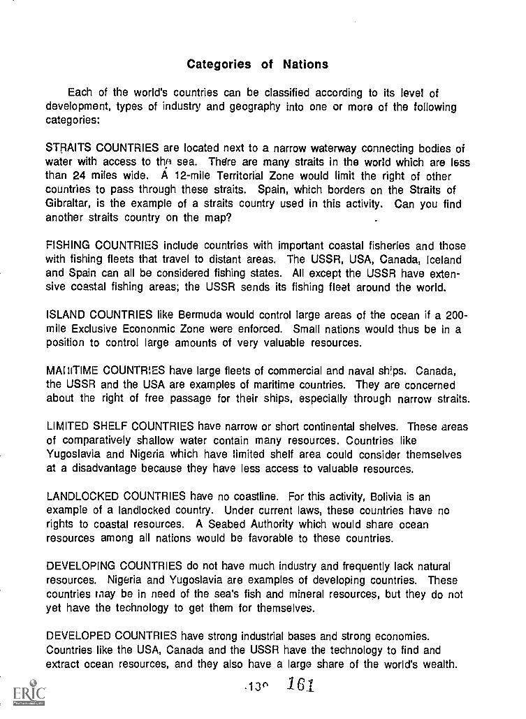
Categories of Nations
Each of the world's countries can be classified according to its level ofdevelopment, types of industry and geography into one or more of the followingcategories:
STRAITS COUNTRIES are located next to a narrow waterway connecting bodies ofwater with access to thp sea. There are many straits in the world which are lessthan 24 miles wide. A 12-mile Territorial Zone would limit the right of othercountries to pass through these straits. Spain, which borders on the Straits ofGibraltar, is the example of a straits country used in this activity. Can you findanother straits country on the map?
FISHING COUNTRIES include countries with important coastal fisheries and thosewith fishing fleets that travel to distant areas. The USSR, USA, Canada, Icelandand Spain can all be considered fishing states. All except the USSR have exten-sive coastal fishing areas; the USSR sends its fishing fleet around the world.
ISLAND COUNTRIES like Bermuda would control large areas of the ocean if a 200 -
mile Exclusive Econonmic Zone were enforced. Small nations would thus be in aposition to control large amounts of very valuable resources.
MAINTIME COUNTRIES have large fleets of commercial and naval ships. Canada,the USSR and the USA are examples of maritime countries. They are concernedabout the right of free passage for their ships, especially through narrow straits.
LIMITED SHELF COUNTRIES have narrow or short continental shelves. These areasof comparatively shallow water contain many resources. Countries likeYugoslavia and Nigeria which have limited shelf area could consider themselvesat a disadvantage because they have less access to valuable resources.
LANDLOCKED COUNTRIES have no coastline. For this activity, Bolivia is anexample of a landlocked country. Under current laws, these countries have norights to coastal resources. A Seabed Authority which would share oceanresources among all nations would be favorable to these countries.
DEVELOPING COUNTRIES do not have much industry and frequently lack naturalresources. Nigeria and Yugoslavia are examples of developing countries. Thesecountries may be in need of the sea's fish and mineral resources, but they do notyet have the technology to get them for themselves.
DEVELOPED COUNTRIES have strong industrial bases and strong economies.Countries like the USA, Canada and the USSR have the technology to find andextract ocean resources, and they also have a large share of the world's wealth.
13r% lel
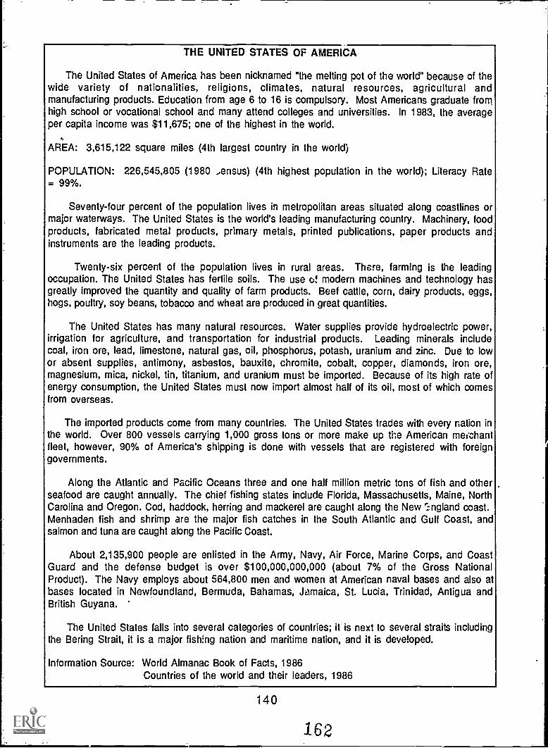
THE UNITED STATES OF AMERICA
The United States of America has been nicknamed "the melting pot of the world" because of thewide variety of nationalities, religions, climates, natural resources, agricultural andmanufacturing products. Education from age 6 to 16 is compulsory. Most Americans graduate fromhigh school or vocational school and many attend colleges and universities. In 1983, the averageper capita income was $11,675; one of the highest in the world.
AREA: 3,615,122 square miles (4th largest country in the world)
POPULATION: 226,545,805 (1980 Jensus) (4th highest population in the world); Literacy Rate= 99%.
Seventy-four percent of the population lives in metropolitan areas situated along coastlines ormajor waterways. The United States is the world's leading manufacturing country. Machinery, foodproducts, fabricated metal products, primary metals, printed publications, paper products andinstruments are the leading products.
Twenty-six percent of the population lives in rural areas. There, farming is the leadingoccupation. The United States has fertile soils. The use of modern machines and technology hasgreatly improved the quantity and quality of farm products. Beef cattle, corn, dairy products, eggs,hogs, poultry, soy beans, tobacco and wheat are produced in great quantities.
The United States has many natural resources. Water supplies provide hydroelectric power,irrigation for agriculture, and transportation for industrial products. Leading minerals includecoal, iron ore, lead, limestone, natural gas, oil, phosphorus, potash, uranium and zinc. Due to lowor absent supplies, antimony, asbestos, bauxite, chromite, cobalt, copper, diamonds, iron ore,magnesium, mica, nickel, tin, titanium, and uranium must be imported. Because of its high rate ofenergy consumption, the United States must now import almost half of its oil, most of which comesfrom overseas.
The imported products come from many countries. The United States trades with every nation inthe world. Over 800 vessels carrying 1,000 gross tons or more make up the American merchantfleet, however, 90% of America's shipping is done with vessels that are registered with foreigngovernments.
Along the Atlantic and Pacific Oceans three and one half million metric tons of fish and otherseafood are caught annually. The chief fishing states include Florida, Massachusetts, Maine, NorthCarolina and Oregon. Cod, haddock, herring and mackerel are caught along the New ri ngland coast.Menhaden fish and shrimp are the major fish catches in the South Atlantic and Gulf Coast, andsalmon and tuna are caught along the Pacific Coast.
About 2,135,900 people are enlisted in the Army, Navy, Air Force, Marine Corps, and CoastGuard and the defense budget is over $100,000,000,000 (about 7% of the Gross NationalProduct). The Navy employs about 564,800 men and women at American naval bases and also atbases located in Newfoundland, Bermuda, Bahamas, Jamaica, St. Lucia, Trinidad, Antigua andBritish Guyana.
The United States falls into several categories of countries; it is next to several straits includingthe Bering Strait, it is a major fish:ng nation and maritime nation, and it is developed.
Information Source: World Almanac Book of Facts, 1986Countries of the world and their leaders, 1986
140
162
CANADA
Canada is the second largest country in the world. It borders on the Atlantic, Pacific andArctic Oceans, and its largest cities and industrial areas are located along the Great Lakes andSt. Lawrence River. There are two official languages in Canada: Eno!:sh and French. About 45%of Canadians are of British descent, and about 29% are of French ancestry. In 1980 the percapita income was greater than $10,000.
AREAS 3,845,274 sq. mi. (9,959,219 sq km); second largest country in the world.
POrjLAT:ON: 25.142,000 (in 1984); 85% within the southern 200 mi (320 km). At ageLegin an eret-year elementary school and then at about age 14 almost all enter a regular
four or five-year secondary school.
Over 3/4 of Canadians live in cilia:: and towns. The largest cities, Quebec City and Toronto,are on the Great Lakes/St. Lawrence River. The main economic fields are service industriesand manufacturing. Canada's gross national product ranks among the top 10 in the world.Service industries like hospitals, schools, restaurants, data processing services and banksemploy about 2/3 of Canada's workers. Manufacturing consists mainly of food processing,transportation equipment and newsprint, all of which depend on the abundant natural resourcesof the country.
Canada is rich in natural resources. The fish, fur-bearing animals and forests that firstbrought settlers to Canada continue to be important to the economy. Canada leads the world inthe production of newsprint, is one of the world's leading wheat producers, and is third in theworld in generating hydroelectricity. Canada is the world's biggest exporter of minerals,leading the world in production of nickel and zinc. It ranks second in the world in asbestos,molybdenum, potash and uranium. More than half of Canada's income from minerals is rased onpetroleum and natural gas. Coal, copper, gold, iron ore, lead, magnesium, silver, titanium andtungsten are also mined.
The fishing industry is one of Canada's oldest industries. The Grand Banks area on theAtlantic coast is among the world's best fishing grounds: lobster, shellfish, cod and herring areabundant. On the Pacific coast, salmon is the main product.
Most of Canada's trade is with the U.S. and Japan. Canada has its own supplies of fossil fuels.Petroleum use is decreasing and natural gas is becoming more popular as a fuel because it isplentiful and relatively non-polluting. Hydroelectric and nuclear plants supply 28% ofCanada's energy needs.
Since 1968, Canada's air, ground and naval armed services have been merged into onemilitary for called the Canadian Armed Forces.
Canada, like the U.S. and USSR, falls into several categories of countries: it is a majorfishing and maritime nation, and it is developed.
Information source: World Book Encyclopedia, 1983Worlf' Almanac and Rook of Facts, 1986The New Encyclopedia Britannica, 1987.
1Po141 Jo
UNION OF SOVIET SOCIALIST REPUBLICS"RUSSIA"
Russia is the largest country in the world. It borders three major oceans; Atlantic, Pacificand Arctic. However, its only ports lie in high northern latitudes and are, therefore, closed byice during part of the year.
Russia was the first country to develop a communist government and today has alliances withmost other communist countries.
A governing council rules over 15 republics that make up the USSR. Each is almost like aseparate country since languages, customs and traditions vary greatly among the republics.
AREA: 8,549,500 square miles (3 times larger than the United Sta. .,, excluding Alaska)
POPULATION: In 1980 was 265.5 million. It ranks third in world population and has aLiterarcy Rate = 99.8%.
Russia is a developed country with an excellent educational system enrolling 55 millionfull-time students. Sixty-four percent of the population lives in cities and is employed inbusiness and industry. Thirty-six percent of the Russian people live in the country, most onfarms. A few farms are privately owned and operated, while most are state owned and operatedby 5 to 10 families apiece. The per capita income in 1980 was approximately $4,550 U.S.dollars.
Russia produces the fobwing agricultural products: barley, corn, flax, rye, cotton, oats,potatoes, sugar beets and livestock. Russia's leading natural resources are bauxite, coal,copper, gold, iron ore, lead, and forestry products. Russia is the largest oil producing nation inthe world. Besides oil, hydroelectric power and coal are the major energy sources. It also hasone of the world's largest fishing fleets. Fish provide a major source of protein in the Russiandiet.
Russia exports iron, steel, lumber, machinery, and petroleum. Since Russia is almost self-sufficient in most materials, only a few goods are imported--industrial equipment andconsumer goods. Russia's leading trading partners are Czechoslovakia, Japan, Italy, East andWest Germany, Poland, Bulgaria, Hungary, Romania, Cuba and the United States. Over 7,000vessels make up the Russian merchant fleet. The most important merchant sea ports are atVosochny in far eastern Russia, Girgorevsky on the Black Sea, Ventspils at Lativ and Murmanskand Archang.-- . used for Arctic traffic.
It has the largest armed forces in the world, employing over 3,375,000 persons. Thedefense budget is approximately 15% of the Gross National Product. Russia's navy is steadilyexpanding and progressively modernizing with over 500,000 officers and men. Naval ports arelocated in Nikolaiev and the Sevastopol on the Black Sea, Molotovsk on the White Sea,Komsomolsk on the Amur River and Leningrad.
P.us3ia is in several categories; it is next to several straits, including the Bering Strait; it isa fishing country with a world-wide fleet; a maritime country, and developed.
Information Source: World Almanac Book of Facts, 1986Countries of the world and their leaders, 1986
142
16
SPAIN
Spain occupies 5/6 of the Iberian Peninsula, with the remaining occupied by Portugal. It
boasts 3,340 miles of coastlines bordering both the Mediterranean Sea to the south and theAtlantic Ocean to the north and west. The climate is sunny and dry. The high central plateauregion has hot summers and cold winters. Along the coast, climatic conditions are not as severe.
AREA: 195,988 square miles (slightly larger than California)
POPULATION: 38,629,000 (est. 1985) (about 50% larger than California) Literacy Rate =97%.
It has grown to become a modern, industrial country. Today, half of Spain's population livesin cities, dwelling mostly in apartments. The per capita income in 1979 was $5,500 U.S.dollars. Most of the working force is employed in industry, farming, or fishing. Spain is one ofthe world's leading producers of automobiles and ships. In addition, cement, chemical products,clothing, shoes, cork products and steel are also major manufactured items. Most of theindustrial and energy resources must be imported since Spain lacks raw materials. A fewminerals such as coal, lignite, !ron ore, zinc ore and lead arc mined for industrial use orexported.
Farm production in most regions is low due to poor soil, dry climate and inferior farmingtechniques. Although livestock, cereals, vegetables, grapes, oranges, tobacco, honey and sugarcane are major farm products, much food must still be imported.
Spain is a leading fishing nation, catching over 1.2 million metric tons of fish each year,chiefly anchovies, codfich, hake, sardines and tuna. The Spanish fishing fleet includes 16,853vessels. The fish come primarily from the water off the northern coast of Spain. The mr Thantshipping fleet includes 3,040 vessels carrying over 3 million passengers and 49 million tons ofcargo annually to other parts of the world.
Spain has approximately 280,000 men in the armed forces. The Spanish fleet is undergoingmodernization.
Because of its position at the mouth of the Mediterranean, Spain would be considered a"straits" country. It is also a fishing nation and is becoming a developed country.
Information Source: World Almanac Book of Facts, 1986
143 P33
YUGOSLAVIA
The Socialist Federal Republic of Yugoslavia borders the Adriatic Sea in southeastern Europe.A communist country, it is influenced by the USSR. Its population is a mixture of manynationality groups with different cultures, religions, and languages. Much of the area ismountainous. Along the coast, over 740 islands and the indented coastline provide manyexcellent natural harbors. In northcentral Yugoslavia, the Danube River runs through thePannonian Plains region which is flat with rich soils, making this region the chief farming area.The climate along the coast is mild; however, more extreme climatic conditions occur inland.
AREA: 98,766 square miles (a little laror than Oregon)
POPULATION: 22,412,000 (1982 census) (ten times greater than Oregon). Literacy Rate =90%. Almost all attend Primary School.
The Yugoslavian standard of living is high. Most families own a car, television set and otherluxury items. They travel freely to other countries. In most cases, both the husband and wifehold full-time jobs. The per capita income is $3,109 U.S. dollars.
About 35% of the land is devoted to agriculture, providing high yields of corn, sugar beets,wheat, barley, oats, potatoes, tobacco, grapes, olives, plums, cattle and sheep. Forests cover35% of the land and forest products are a major export.
Mineral resources include bauxite, chromite, coal, copper, iron, lead, mercury, natural gas,petroleum and zinc. Yugoslavia trades mostly with Italy, East and West Germany, the SovietUnion and the United States. The major exports are forest products, livestock, machinery,metals, plastics and textiles. The chief imports include coal, crude oil, machinery, metals,plastics and textiles. The Yugoslavia shipping fleet consists of 432 vessels. Half of Yugoslavia'senergy comes from hydroelectric powe1. Coal is also widely used and a new nuclear power plantis near completion.
The principal product from the Adriatic Sea is fish. Yugoslavia owns more than 200motorized fishing vessels and over 1,700 sailing and rowing fishirig vessels. Fish catch in1981 was 71,000 metric tons.
The Yugoslavian armed forces consist of about 250,000 men, 27,000 of which are in thenavy. The defense budget is $1,300,000,000 or 8.5% of the Gross National Product. This is alarger percentage than many other countries.
Yugoslavia has limited shelf area and is on the verge of bei.ig a developed country.
Information Source: World Almanac Book of Facts, 1986
144 166
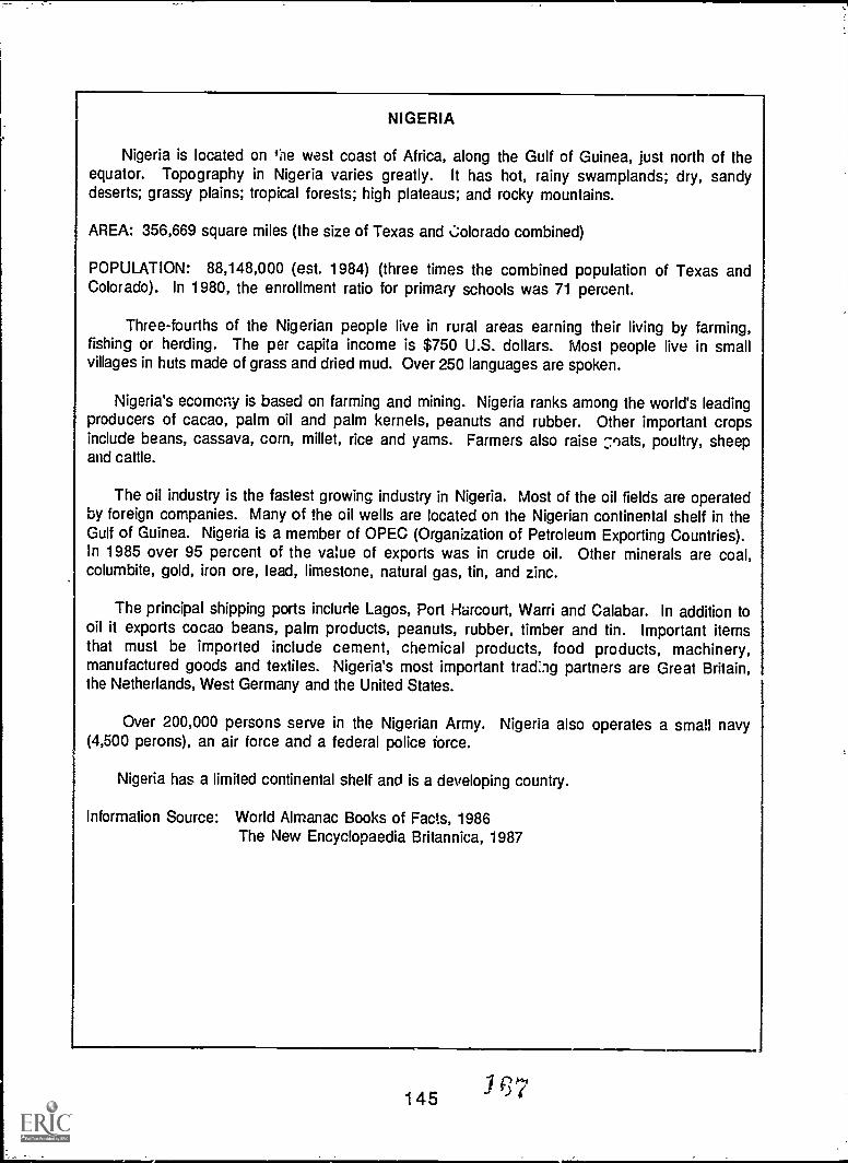
NIGERIA
Nigeria is located on tie west coast of Africa, along the Gulf of Guinea, just north of theequator. Topography in Nigeria varies greatly. It has hot, rainy swamplands; dry, sandydeserts; grassy plains; tropical forests; high plateaus; and rocky mountains.
AREA: 356,669 square miles (the size of Texas and Colorado combined)
POPULATION: 88,148,000 (est. 1984) (three times the combined population of Texas andColorado). In 1980, the enrollment ratio for primary schools was 71 percent.
Three-fourths of the Nigerian people live in rural areas earning their living by farming,fishing or herding. The per capita income is $750 U.S. dollars. Most people live in smallvillages in huts made of grass and dried mud. Over 250 languages are spoken.
Nigeria's ecommy is based on farming and mining. Nigeria ranks among the world's leadingproducers of cacao, palm oil and palm kernels, peanuts and rubber. Other important cropsinclude beans, cassava, corn, millet, rice and yams. Farmers also raise :-:,oats, poultry, sheepand cattle.
The oil industry is the fastest growing industry in Nigeria. Most of the oil fields are operatedby foreign companies. Many of the oil wells are located on the Nigerian continental shelf in theGulf of Guinea. Nigeria is a member of OPEC (Organization of Petroleum Exporting Countries).In 1985 over 95 percent of the value of exports was in crude oil. Other minerals are coal,columbite, gold, iron ore, lead, limestone, natural gas, tin, and zinc.
The principal shipping ports include Lagos, Port Harcourt, Ward and Calabar. In addition tooil it exports cocao beans, palm products, peanuts, rubber, timber and tin. Important itemsthat must be imported include cement, chemical products, food products, machinery,manufactured goods and textiles. Nigeria's most important trad:3g partners are Great Britain,the Netherlands, West Germany and the United States.
Over 200,000 persons serve in the Nigerian Army. Nigeria also operates a small navy(4,500 perons), an air force and a federal police force.
Nigeria has a limited continental shelf and is a developing country.
Information Source: World Almanac Books of Facts, 1986The New Encyclopaedia Britannica, 1987
145
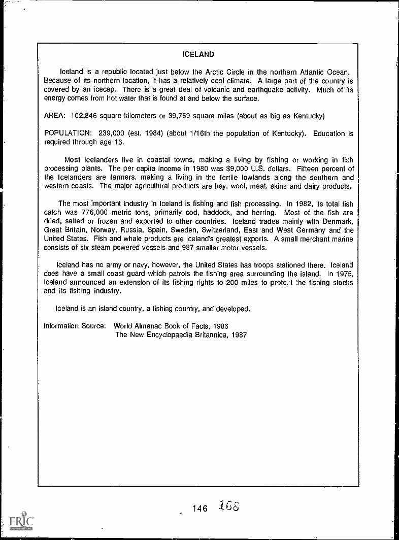
ICELAND
Iceland is a republic located just below the Arctic Circle in the northern Atlantic Ocean.Because of its northern location, it has a relatively cool climate. A large part of the country iscovered by an icecap. There is a great deal of volcanic and earthquake activity. Much of itsenergy comes from hot water that is found at and below the surface.
AREA: 102,846 square kilometers or 39,769 square miles (about as big as Kentucky)
POPULATION: 239,000 (est. 1984) (about 1/16th the population of Kentucky). Education isrequired through age 16.
Most Icelanders live in coastal towns, making a living by fishing or working in fishprocessing plants. The per capita income in 1980 was $9,000 U.S. dollars. Fifteen percent ofthe Icelanders are farmers, making a living in the fertile lowlands along the southern andwestern coasts. The major agricultural products are hay, wool, meat, skins and dairy products.
The most important industry in Iceland is fishing and fish processing. In 1982, its total fishcatch was 776,000 metric tons, primarily cod, haddock, and herring. Most of the fish aredried, salted or frozen and exported to other countries. Iceland trades mainly with Denmark,Great Britain, Norway, Russia, Spain, Sweden, Switzerland, East and West Germany and theUnited States. Fish and whale products are Iceland's greatest exports. A small merchant marineconsists of six steam powered vessels and 987 smaller motor vessels.
Iceland has no army or navy, however, the United States has troops stationed there. Icelanddoes have a small coast guard which patrols the fishing area surrounding the island. In 1975,Iceland announced an extension of its fishing rights to 200 miles to prote.-t the fishing stocksand its fishing industry.
Iceland is an island country, a fishing country, and developed.
Information Source: World Almanac Book of Facts, 1986The New Encyclopaedia Britannica, 1987
146 /6:6_
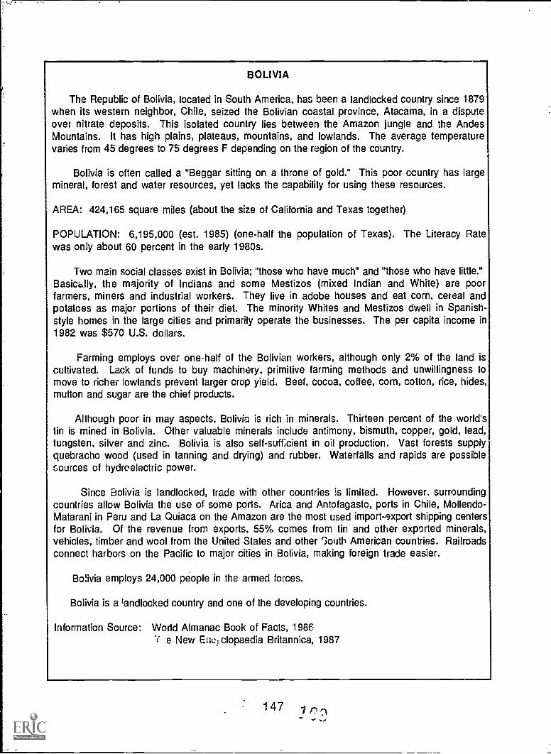
BOLIVIA
The Republic of Bolivia, located in South America, has been a landlocked country since 1879when its western neighbor, Chile, seized the Bolivian coastal province, Atacama, in a disputeover nitrate deposits. This isolated country lies between the Amazon jungle and the AndesMountains. It has high plains, plateaus, mountains, and lowlands. The average temperaturevaries from 45 degrees to 75 degrees F depending on the region of the country.
Bolivia is often called a "Beggar sitting on a throne of gold." This poor ccuntry has largemineral, forest and water resources, yet lacks the capability for using these resources.
AREA: 424,165 square miles (about the size of California and Texas together)
POPULATION: 6,195,000 (est. 1985) (one-half the population of Texas). The Literacy Ratewas only about 60 percent in the early 1980s.
Two main social classes exist in Bolivia; "those who have much" and "those who have little."Basically, the majority of Indians and some Mestizos (mixed Indian and White) are poorfarmers, miners and industrial workers. They live in adobe houses and eat corn, cereal andpotatoes as major portions of their diet. The minority Whites and Mestizos dwell in Spanish-style homes in the large cities and primarily operate the businesses. The per capita income in1982 was $570 U.S. dollars.
Farming employs over one-half of the Bolivian workers, although only 2% of the land iscultivated. Lack of funds to buy machinery, primitive farming methods and unwillingness tomove to richer lowlands prevent larger crop yield. Beef, cocoa, coffee, corn, cotton, rice, hides,mutton and sugar are the chief products.
Although poor in may aspects, Bolivia is rich in minerals. Thirteen percent of the world'stin is mined in Bolivia. Other valuable minerals include antimony, bismuth, copper, gold, lead,tungsten, silver and zinc. Bolivia is also self-suff;cient in oil production. Vast forests supplyquebracho wood (used in tanning and drying) and rubber. Waterfalls and rapids are possiblesources of hydroelectric power.
Since Bolivia is landlocked, trade with other countries is limited. However, surroundingcountries allow Bolivia the use of some ports. Arica and Antofagasto, ports in Chile, Mollendo-Matarani in Peru and La Quiaca on the Amazon are the most used import-export shipping centersfor Bolivia. Of the revenue from exports, 55% comes from tin and other exported minerals,vehicles, timber and wool from the United States and other South American countries. Railroadsconnect harbors on the Pacific to major cities in Bolivia, making foreign trade easier.
Bolivia employs 24,000 people in the armed forces.
Bolivia is a landlocked country and one of the developing countries.
Information Source: World Almanac Book of Facts, 1986"s* e New Ertel clopaedia Britannica, 1987
147 /
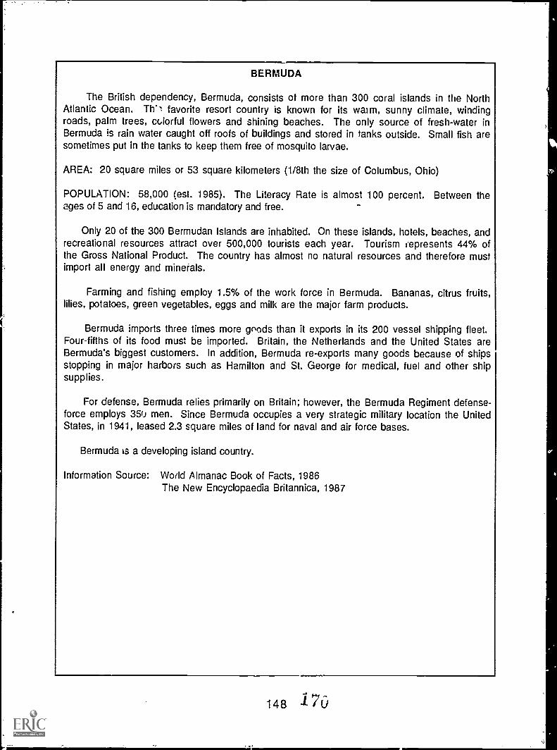
BERMUDA
The British dependency, Bermuda, consists of more than 300 coral islands in the NorthAtlantic Ocean. Th'l favorite resort country is known for its warm, sunny climate, windingroads, palm trees, miorful flowers and shining beaches. The only source of fresh-water inBermuda is rain water caught off roofs of buildings and stored in tanks outside. Small fish aresometimes put in the tanks to keep them free of mosquito larvae.
AREA: 20 square miles or 53 square kilometers (1/8th the size of Columbus, Ohio)
POPULATION: 58,000 (est. 1985). The Literacy Rate is almost 100 percent. Between theages of 5 and 16, education is mandatory and free.
Only 20 of the 300 Bermudan Islands are inhabited. On these islands, hotels, beaches, andrecreational resources attract over 500,000 tourists each year. Tourism represents 44% ofthe Gross National Product. The country has almost no natural resources and therefore mustimport all energy and minerals.
Farming and fishing employ 1.5% of the work force in Bermuda. Bananas, citrus fruits,lilies, potatoes, green vegetables, eggs and milk are the major farm products.
Bermuda imports three times more goods than it exports in its 200 vessel shipping fleet.Four-fifths of its food must be imported. Britain, the Netherlands and the United States areBermuda's biggest customers. In addition, Bermuda re-exports many goods because of shipsstopping in major harbors such as Hamilton and St. George for medical, fuel and other shipsupplies.
For defense, Bermuda relies primarily on Britain; however, the Bermuda Regiment defense-force employs 350 men. Since Bermuda occupies a very strategic military location the UnitedStates, in 1941, leased 23 square miles of land for naval and air force bases.
Bermuda is a developing island country.
Information Source: World Almanac Book of Facts, 1986The New Encyclopaedia Britannica, 1987
148 i7
The Challenge of Chief Seattle
Yonder sky that has wept tears ofcompassion upon our fathers for cr.nturiesuntold, and which to us looks eternal, maychange. Today it is fair. Tomorrow it maybe overcast with clouds.
My words are like the stars that never set.What Seattle says, the Great Chief atWashington can rely upon with as muchcertainty as our paleface brothers can relyupon the return of the seasons.
The son of the White Chief says his fathersends us greetings of friendship and goodwill. This is kind of him, for we know hehas little need of our friendship in returnbecause his people are many. They are likethe grass that covers the vast prairies,while my people are few, they resemble thescattering trees of a storm-swept plain.
The Great Chief in Washington sent wordthat he wishes to buy our land. How can youbuy or sell the sky, the warmth of the land?The idea is strange to us. If we do not ownthe freshness of the air and the sparkle ofthe water, how can you buy them?
Every part of this earth is sacred to mypeople. Every shining pine needle, everysandy shore, every mist in the dark woo, is,every olearing, and humming insect is holyin the memory and experience of my people.The sap vhich courses through the treescarries the memories of the red man.
The wl,ite man's dead forget the country oftheir birth when they go to walk among thestars. Our dead never forget this beautifulearth, for it is the mother of the red man.We are part of Me earth and it part of us.The perfumed flowers are our sister; thedeer, the horse, tho great eagle, these areour brothers. The rocky crests, the juicesin the meadows, the body heat of the pony,and man all belong to the same family.
149
So, when the Great Chief in Washingtonsends word that he wishes to buy our land,he asks much of us.
The great Chief sends word he will reserveus a place so that we can live comfortably toourselves. Ha will be our father and we willbe his children.
So we will consider your offer to buy ourland. But this will not be easy. For thisland is sacred to us.
This shining water that moves in thestreams and rivers is not just water but theblood of our ancestors. If we sell you land,you must remember tha. it is sacred, andyou must teach yc,r children that it issacred, and that each ghostly reflection inthe clear water of the lakes tells of eventsand memories in the life of my people. Thewater's murmur is the voice of my fathersfather.
The rivers are our brothers, they quenchour thirst. The rivers carry our canoes,and feed our children. If we sell you ourland, you must remember, and teach yourchildren, that the rivers are our brothers,and yours, and you must henceforth give therivers the kindness you would give mybrother.
The red man has always retreated before theadvancing white man, as the mist of themountain runs before the morning sun. Weknow that the white man does not understandour v:ays. One portion of land is the same tohim as the next, for he is a stranger whocomes in the night and takes from the landwhatever he needs. The earth is not hisbrother, but his enemy, and when he hasconquered it, he moves on. He leaves hisfathers graves behind, and does not care.He kidnaps the earth from his children. Hedoes not care. His father's graves and his
111
children's birthright are forgotten. Hetreats his mother, the earth, and hisbrother, the sky, as things to be bought,plundered, sold like sheep or bright beads.His appetite will devour the earth.
The sight of your cities pains the eyes of thered man. But perhaps it is because the redman is a savage and does not understand
There is no quiet place in the white man'scities. No place to hear the unfurling of theleaves in spring or the rustle of insect'swings. The clatter only seems to insult theears. And what is there to life if man cannothear the lonely cry of the whippoorwill orthe arguments of thk, frogs around a pond atnight? The Indian prefers the soft sound ofwind darting over the face of a pond, and thesmell of the wind itself, cleansed by amidday rain, or scented with the pinon pine.
The air it precious to the red man, for allthings share the same breath the beast,the tree, the man, they all share the samebreath. The white man does not seem tonotice the air he breathes. Like a man dyingfor many days, he is numb to the stench.But if we sell you our land, you mustremember that the air is precious to us,that the air shares its spirit with all life itsupports. The wind that gave ourgrandfather his first breath also receiveshis last sigh. And if we sell you our land,you must keep it apart and sacred, as a placewhere even the white man can go to taste thewind that is sweetened by the meadow'sflowers.
So we will consider your offer to buy ourland. If we decide to accept, I will make onecondition: The White man must treat thebeasts of this lard as his brothers. I haveseen a thousand rotting buffalo on theprairie, left by the white man who shotthem from a passing train. I am a savageand I do not understand how the smokingiron horse can be more important than thebuffalo that wa kill only to stay alive.
150
What is man without the beasts? If all thebeasts were gone, men would die from agreat loneliness of spirit. For whateverhappens to the beasts, soon happens to man.All things are connected.
You must teach your children that theground beneath their feet is the ashes of ourgrandfathers. So that they will respect theland, tell your children that the earth isrich with the lives of our kin. Teach yourchildren what we have taught our children,that the earth is our mother. Whateverbefalls the earth befalls the sons of theearth. If men spit upon the ground, theyspit upon themselves.
The earth does not belong to man; manbelongs to the earth. All things areconnected like the blood which unites onefamily.
Man did riot weave the web of life; he ismerely a strand in it. Whatever he does tothe web, he does to himself.
Our dead never forget this beautiful worldthat gave them being. They still love itswinding rivers, its great mountains and itssequestered vales, and they ever yearn intenderest affection over the lonely-heartedliving, and often return to visit, guide andcomfort them.
Day and night cannot dwell together. The redman has ever fled the approach of the whiteman as the changing mist on the mountainside flees before the blazing sun.
However, your proposition seems a justone, and I think that my people will accept itand will retire to the rese' iation you offerthem. There we will dwell apart in peace,for the words of the Great White Chief seemto be the voice of Nature, speaking to mypeople out of the thick darkness that is fastgathering round them like a dense fogfloating inward from a midnight sea.
1 7 2
.:_
Oue children have seen their fathershumbled in defeat. Our warriors have feltshame, and after defeat they turn their daysin idleness and contaminate their bodieswith sweet foods and strong drink.
It matters little where we pass the remnantof our days. They are not many. TheIndian's night promises to be dark. Nobright sta- hovers above his horizon. Sad-voiced wings moan in the distance. Somegrim Fate of our race is on the red man'strail, and wherever he goes he will stillhear the sure approaching footsteps of hisfell destroyer and prepare to stolidly meethis doom, as does the wounded doe that hearsthe approaching footsteps of the hunter.
A few more hours, a few more winters, andnone of the children of the great tribes thatonce lived on this earth or that roam now insmall bands in the woods will be left tomourn the graves of a people once aspowerful and hopeful as yours. But whyshould I mourn the passing of my people?Tribes are made of men, nothing more. Mencome and go, like the waves of the sea.
Even the white man, whose God walks andtalks with him as friend to friend, cannot beexempt from the common destiny. We maybe brothers after all; we shall see. Onething we know, which the white man mayone day discover our God is the same God.You may think now that you own Him as youwish to own our land; but you cannot. He isthe God of Man, and His compassion is equalfor the red man and the white. This earth isprecious to Him, a' I to harm the earth is toheap contempt on i', Creator. The white tooshall pass; perhaps sooner than all othertribes. Continue to contaminate your bed,and you will one night suffocate in your ownwaste.
But in your perishing you will shinebrightly, fired by the strength of the Godwho brought you to this land and for somespecial purpose gave you dominion over this
151
land and over the red man. That destiny is amystery to us, for we do not understandwhen buffalo are slaughtered, the wildhorses are tamed, the secret corners of theforest heavy with the scent of many men,and the view of the ripe hills blotted bytalking wires. Where is the thicket? Gone.Where is the eagle? Gone. And what is it tosay goodbye to the swift pony and the hunt?The end of living and the beginning ofsurvival.
When the last red man shall have perished,and the memory of my tribe shall havebecome a myth among the white man, theseshores will swarm with the invisible dead ofmy tribe, and when your children'schildren think themselves alone in the .field,the store, the shop, or in the silence of thepathless woods, they will not be alone. . . Atnight when the streets of your cities andvillages are silent and you think themdeserted, they will throng with thereturning hosts that once filled them andstill love this beautiful land. The white manwill never be alone. When the last red manhas vanished from this earth, and hismemory is only the shadow of a cloudmoving across the prairie, these shores andforests will still hold the spirits of mypeople. For they love this earth as thenewborn loves its mother's heartbeat. So ifwe sell you our land, love it as we've lovedit. Care for it as we've cared for it. Hold inyour mind the memory of the land as it iswhen you take it. And with all yourstrength, with ail your mind, with all youheart, preserve it for your children, andlove it . .. as God loves us all.
Bill Schneider, ed. Montana OutdoorsMblazine. The Minnesota Volunteer,
November-December, 1976 pp. 1-12.
1 73
The Sea At Last!
Introduction: After three years of adventures, Paddle finally reached thesea. Before he reached the open ocean, though, he was pulled back andforth by the tides in the Gulf of St. Lawrence. How do you think Paddlemight have felt as he was pushed closer to the sea and then pulledbackwards again? How do you think he felt when he finally arrived in theopen ocean?
Objectives: When they have completed this activity, students will beable to list the six basic questions a story should answer. They will writea story describing the feelings people might have when they finally reacha personal goal.
Materials: Paper, pencil or pen, markers or crayons.
Procedure:1. Discuss with students what they expect to find out when they read any
story. Six basic questions should be mentioned:*WHO is the story about?*WHAT is happening in the story?*WHY do these things happen?*WHEN is it happening?*WHERE does the story take place?*HOW is the problem solved? (How does the story end?)
2. Read Chapter 25, Rivers in the Sea. Discuss how Paddle might havefelt as he was pulled back and forth by the tides and when he finallyreached the sea. Have you ever had similar feelings? In whatsituations? Were these feelings pleasant or unpleasant? Why?
3. Write a story which describes how you or someone else felt aboutfinally reaching an important goal. Or write about Paddle's feelingswhen he reached the sea. Remember the six questions your storyshould answer. Try to write the story so that your readers will feelthe same way you did.
4. Draw a picture to illustrate your story. Make your picture express thefeelings you described in your story. Think about drawing facialexpressions and using colors to reflect the mood of your story.
5. S'iare the stories and drawings with the class. What mood does eachdrawing convey? an you answer the six basic questions for eachstory? Is it as important to work toward a goal as to reach it?
152 174
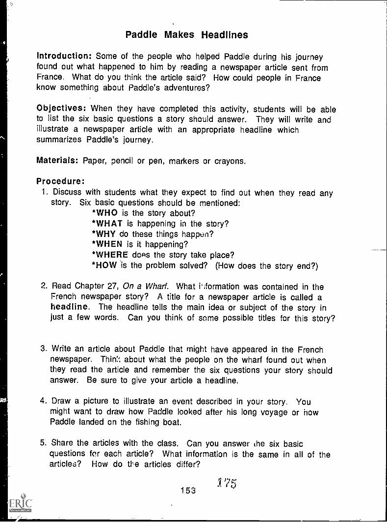
Paddle Makes Headlines
Introduction: Some of the people who helped Paddle during his journeyfound out what happened to him by reading a newspaper article sent fromFrance. What do you think the article said? How could people in Franceknow something about Paddle's adventures?
Objectives: When they have completed this activity, students will be ableto list the six basic questions a story should answer. They will write andillustrate a newspaper article with an appropriate headline whichsummarizes Paddle's journey.
Materials: Paper, pencil or pen, markers or crayons.
Procedure:1. Discuss with students what they expect to find out when they read any
story. Six basic questions should be mentioned:*WHO is the story about?*WHAT is happening in the story?*WHY do these things happLin?*WHEN is it happening?*WHERE does the story take place?*HOW is the problem solved? (How does the story end?)
2. Read Chapter 27, On a Wharf. What hformation was contained in theFrench newspaper story? A title for a newspaper article is called aheadline. The headline tells the main idea or subject of the story injust a few words. Can you think of some possible titles for this story?
3. Write an article about Paddle that might have appeared in the Frenchnewspaper. Think about what the people on the wharf found out whenthey read the article and remember the six questions your story shouldanswer. Be sure to give your article a headline.
4. Draw a picture to illustrate an event described in your story. Youmight want to draw how Paddle looked after his long voyage or howPaddle landed on the fishing boat.
5. Share the articles with the class. Can you answer the six basicquestions for each article? What information is the same in all of thearticles? How do the articles differ?
Y 75153

A Dream Comes True
Introduction: When the Indian boy found out that Paddle had arrived inFrance, he was very happy. Paddle had survived and had made the journeythat the boy was not able to make. The boy's dream for Paddle had becomea reality.
Objectives: When they have completed this activity, students will beable to list the six basic questions a story should answer. They will writea story describing the feelings people might have when their specialdream comes true.
Materials: Paper, pencil or pen, markers or crayons.
Procedure:1. Discuss with students what they expect to find out when they read any
story. Six basic questions should be mentioned:*WHO is the story about?*WHAT is happening in the story?*WHY do these things happen?*WHEN is it happening?*WHERE does the story take place?*HOW is the problem solved? (How does the story end?)
2. Read Chapter 27, On a Wharf. Discuss how the Indian boy felt when heoverheard the men discussing the newspaper story about Paddle. Whatwords in the chapter let you know how he felt? Why was he so happy?Have you ever had similar feelings'? In what situations?
3. Write a story which describes how you or someone else felt abouthaving a special dream come true. Or write about the Indian boy'sfeelings after he knew Paddle had survived his journey. Remember thesix questions your story should answer. Try to write the story so thatyour readers will feel the same way you did.
4. Draw a picture to illustrate your story. Make your picture express thefeelings you described in your story. Think about drawing facialexpressions and using colors to reflect the mood of your story.
5. Share the stories and drawings with the class. What kinds of dreamswere described in the stories? Can you answer the six basic questionsfor each story?
154 1 6
Seine Additional Resourcesfor Teaching About the Great Lakes
Ashworth, William. The Late. Great La, 'rk: Alfred A. Knopf, 1986.Wellwritten overview of economic as.. s.... ..rental develf)pment-, in the region. Tends to
emphasize negative aspects, however.
Barry, James P. The Fate 9f the LakeR.. New York, Bonanza Books, 1972.Color-illustrated review of environmental problems as they were in the 1970s. Use with
updated references for best effect. (Things are different now!)
Botts, Lee and Bruce Krushelnicki. The Great Lakes. An Environmental Atlas and Resource Book.Environment Canada and USEPA, 1987.
An excellent paperbound booklet of maps showing updated information about a range ufcharacteristics of the Great Lakes Basin. Includes a wall mlo. Full color. Available free tromyour nearest Environment Canada or USEPA office.
Burns, Noel M. Erie: The Lake That Survived. Totowa, NJ: Rowan and Allanheld, 1985.Well-written scientific approach to changes that have occurred in the Great Lakes, with Lake
Erie as the most v!.,ible example.
Fortner, Rosanne W. and Victor J. Mayer, eds. TheirgeaL aklier'. Columbus: The Ohio StateUniversity, 1987.
Sixteen papers (155 pp) by experts on the Fnience and social sttedies topics addressed in Paddle-to-the-Sea. Available from the School of Natural Resources at Ohio State, $15 plus 15% forpostage Ind handling.
Freshwater Society. The Gnat Lakes_Directory of_NRtural Resource_Adencies_an_d_Oraanizations.Chicago: Center for the Great Lakes, 1984/85. 210 pp.
Comprehensive listing and description of information sources. Good for identification of localresource groups. Can be purchased from the Centdr for the Great Lakes, 435 N. Michigan Ave..Chicago, IL 60611. 1985 vice $20.
Great Lake', Science Advisory Board. Directory of Great Lakes Education Material. Windsor,Ontario: International Joint Commission, 1988.
Description of print and audiovisual materials for teaching about the Great Lakes, as well assources of additional materials. Revised regularly. Does not contain evaluations or prices.Available free from IJC.
Rousmaniere, John, ed. The Endurina Great Lakes. New York: W.W. Norton, 1979.Adapted from an issue of NATURAL HISTORY magazine from the American Museum of Natural
History. Well written background information on the basic scientif rocearch involving the lakesand their life forms.
155
Other Activitiesavailable from the Ohio Sea Grant Education Program
for middle schools (5-9):
The Effect of Lake Erie on Ohio's TemperatureThe Effect of Lake Erie on ClimateAncient Shores of Lake ErieHow to Protect a RiverLake Erie and Changing Lake LevelsErosion Along the Great LakesCoastal Processes and ErosionPollution in Lake Erie: An IntroductionYellow Perch in Lake ErieEviderce of Ancient Seas in OhioTo Harvest a WalleyeOil Spill!Shipping on the Great LakesGeography of the Great LakesOhio CanalsThe Estuary: A Special PlaceThe Great Lakes TriangleKnowing the RopesGetting to Know Your Local Fis'.Shipping: The World ConnectionWe Have Met the EnemyIt's Everyone's Sea: Or Is It?PCBs in Fish: A Problem?A Great Lake VacationStorm SurgeRiver Trek
for primary grades (K-4):
Lake Erie -- Take a Bow!Build a Fish to ScaleA Day in the Life of a Fish
Ohio Sea (;rant EducationThe Ohio State University
059 Ramseyer Hall29 West Woodruff
Columbus, OH 43210(614) 292-1078
Write for a free catalogdescribing all Ohio Sea Grant
Education Publications.
Jeffrey M. Reutter, Acting Program DirectorRosanlie W. Fortner, Education Program Coordinator
Victor J. Mayer, Research CoordinatorDominica A. Rigby, Layout Editor
178