Embed Size (px)
Citation preview

Eddleston Water Project: introduction to research aims & monitoring
Eddleston Water:
• Eddleston Water scoping study
• Eddleston Water restoration Phase II
• Eddleston Water restoration Phase III
Chris Spray, Alan Werritty, Tom Ball, Andrew Black, Michael Bonell, Nicole Archer & students
HNS
Cbec Ltd
NFU(S)
Forest Research
Tweed Foundation
Environment Agency
Partnership project, begun in 2009
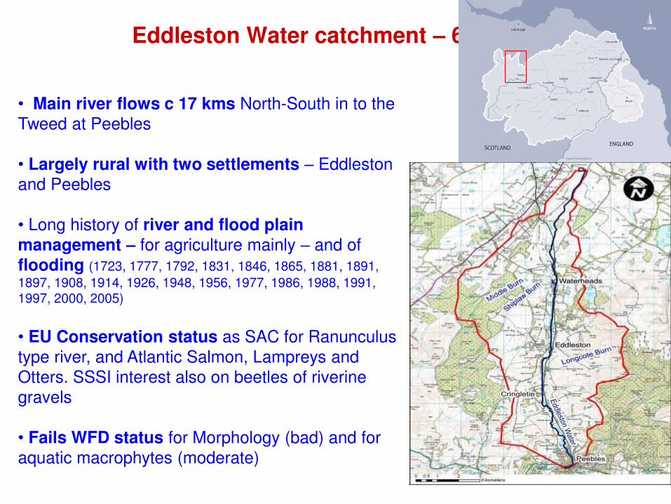
Eddleston Water catchment – 69 sq km
• Main river flows c 17 kms North-South in to the Tweed at Peebles
• Largely rural with two settlements – Eddleston and Peebles
• Long history of river and flood plain
management – for agriculture mainly – and of flooding (1723, 1777, 1792, 1831, 1846, 1865, 1881, 1891,
1897, 1908, 1914, 1926, 1948, 1956, 1977, 1986, 1988, 1991, 1997, 2000, 2005)
• EU Conservation status as SAC for Ranunculus
type river, and Atlantic Salmon, Lampreys and Otters. SSSI interest also on beetles of riverine gravels
• Fails WFD status for Morphology (bad) and for
aquatic macrophytes (moderate)

Policy drivers for river restoration: Eddleston Water
Two main policy drivers:
• EC Water Framework Directive => Water Environment and Water Services (Scotland) Act 2003: Eddleston Water characterised as
having “poor” ecological status
• EC Directive on the Assessment and Management of Floods => Flood Risk Management (Scotland) Act 2009: section 20 requires SEPA to assess whether the “alteration ... or restoration of natural features and
characteristics ... could contribute to management of flood risk” often referred to as natural flood management
Plus an over-riding Total Catchment Approach => added multiple benefits for other ecosystem services – water quality, fisheries,
biodiversity, recreation & tourism, etc
AND the question of stakeholders “permission to act”

Eddleston Water Project – initial scoping report 2010
Looked at the whole catchment, not just
flooding and habitats solely along the river
Output Recommendations:
• Characterisation of the catchment
• Locations and plans for physical restoration of
channel and floodplain
• Locations and plans for interventions to achieve
flood risk reductions
• Value for money and priorities for action
• Detailed monitoring
• Community consultation and engagement

Characterisation and current status:
landscapes, habitats, ecology.
Sources
Pathways

Proposed measures: locations and types
Selected groups of measures:
A: breach/set back embankments,
new fence margins, riparian
woodland, wet woodland, large
woody debris
C: re-meander channel, riparian
woodland
L: Reduced stocking density, tributary
woodland, floodplain forest
N: create ponds, wetlands, riparian
woodland block ditches, large woody
debris

Planting up hillsides & river banks
Log jams on tributaries
Working with Forestry Commission
Natural flood management: -
Influencing “sources” by intervention in the upper catchment, tributaries and hill slopes

Breach in embankments could permit temporary
flood storage on left bank during high flow events.
Re-meandering opportunities - Cringeltie
Natural flood management: Influencing “pathways” by interventions in the floodplain itself
Intensive monitoring programme

Proposed measures: flood storage u/s Eddleston (site A)

Natural flood management: -
Understanding the connectivity between hill-slopes, groundwater, floodplains and rivers
BGS and Dundee University joint study
Unique integrated hillslope-to-floodplain study

• Interviews with key stakeholders:
Scottish Govt, SEPA, Tweed Forum,
Scottish Borders Council, SNH, Tweed
Foundation, Scottish Water,
NFU(Scotland), Scottish Wildlife Trust,
RSPB, Country Landowners Business
Association.
• Interviews with landowners (three
floodplain and two upland famers)
middle-aged, male, long-term
landowners in the valley (>30 years) with
several sources of income.
• Literature review
Josselin Rouillard
Opportunities, constraints and barriers

Opportunities, constraints and barriers: farmers
• local expert knowledge must be
factored in to any planning;
• financial incentives must be set
at the right level – to sustain farm
units and to attract engagement;
• long-term, guaranteed
contractual arrangements to
deliver focused outcomes;
• simplicity in any contractual
arrangements.

Summary: - Aims & Objectives of Monitoring Strategy
Aim: to assess the effectiveness of the proposed measures for restoration
and natural flood management
Existing Monitoring programmes: - provided elements of the original Characterisation and baseline data
• Hydrometric monitoring – Shiplaw and March street; and Shiplaw rain gauge
• Landuse and habitat data – from aerial surveys done for SBC
• Water quality, ecology and fisheries data – for WFD water body compliance
Augmented and New Monitoring Networks: -
• Surface water monitoring
• Rainfall and weather
• Groundwater monitoring
• Hydro-geomorphology
• Detailed invertebrate, macrophyte, fishery, mammals.
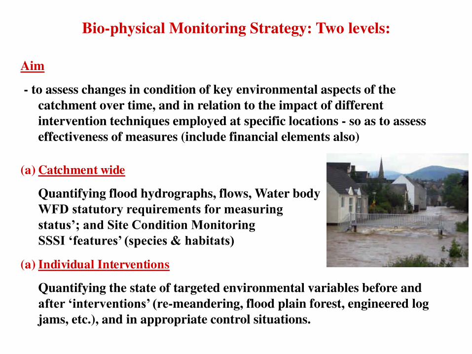
Bio-physical Monitoring Strategy: Two levels:
Aim
- to assess changes in condition of key environmental aspects of the
catchment over time, and in relation to the impact of different
intervention techniques employed at specific locations - so as to assess
effectiveness of measures (include financial elements also)
(a) Catchment wide
Quantifying flood hydrographs, flows, Water body and
WFD statutory requirements for measuring ‘Ecological status’; and Site Condition Monitoring for SAC and SSSI ‘features’ (species & habitats)
(a) Individual Interventions
Quantifying the state of targeted environmental variables before and
after ‘interventions’ (re-meandering, flood plain forest, engineered log
jams, etc.), and in appropriate control situations.
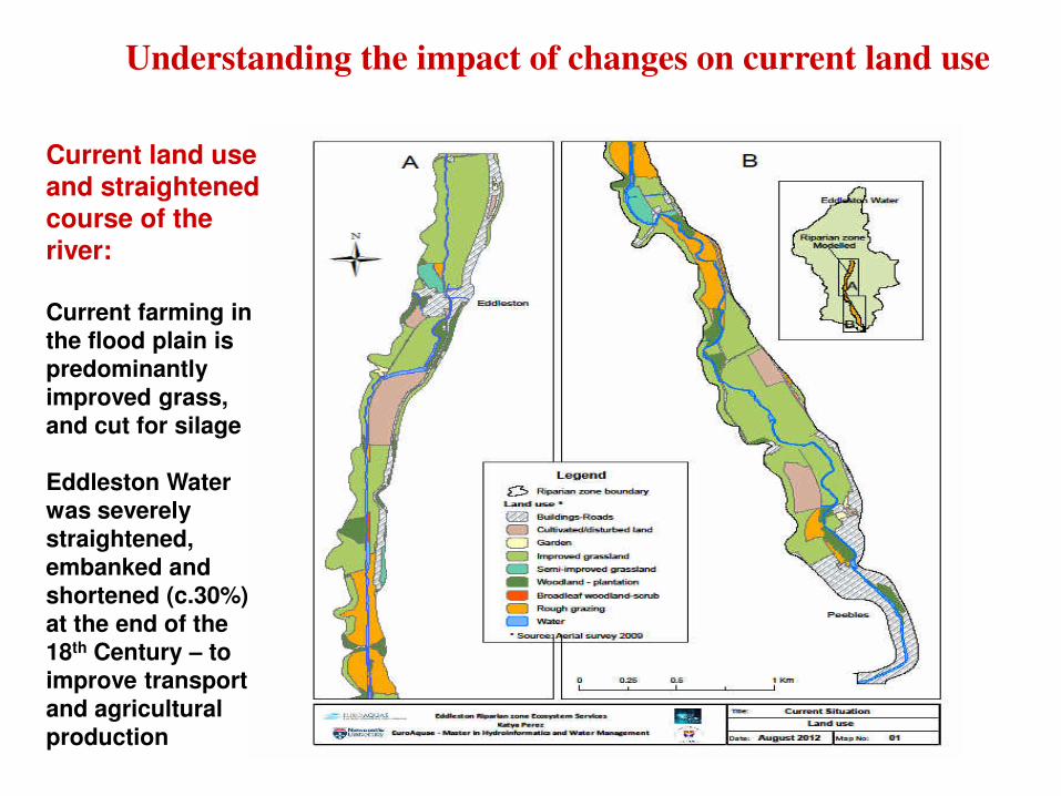
Understanding the impact of changes on current land use
Current land use and straightened course of the
river: Current farming in
the flood plain is
predominantly
improved grass,
and cut for silage
Eddleston Water
was severely
straightened,
embanked and
shortened (c.30%)
at the end of the
18th Century – to
improve transport
and agricultural
production

A potential projected (modelled) flood regulation land use scenario
Flood risk regulation scenario:
Farming in the
floodplain is
replaced by Wet
Valley Woodland -
max flood
retention & high
Mannings ‘n’
River course has
now been “re-
meandered”, based on course of
the old river pre-
intervention (from
old maps) and
embankments
“removed”

Results: Ecosystem service scores
Flood regulation enhanced: Food and timber provisioning services reduced
Other services also increased in new scenario:

Eddleston Water - detailed monitoring of a typical
pilot catchment – for testing interventions and models
Integrated Monitoring networks & engagement:
River flow gauges
Ground water surveys and boreholes
Rainfall and weather stations
River habitats and hydromorphology
River biology – fish, plants, invertebrates
Land-owner & community engagement
Ecosystem services initiative
Partnership Approach

Eddleston Hydrometric Monitoring
Chris Spray
Andrew Black
Tom Ball
University of Dundee
Photo © BGS

Hydrometric monitoring objectives
• Characterise baseline hydrological response
• Assess hydrological effect of measures
• In practice: – Travel times
– Quickflow response
– Baseflow response
– Total runoff volumes

Hydrometric
network • 13 gauging
stations
• 4 rainfall sites
• 1 AWS
• Bohehole clusters

Monitoring technologies

Principles & practice in NFM
monitoring
• Suggested principles:
– Establish the baseline before implementing measures. 2 years baseline is recommended.
– Select monitoring sites carefully - site selection
affects data accuracy.
– Aim to maximise accuracy: it's vital that uncertainty in data collection < magnitude of the change you're
trying to detect
– Monitor as comprehensively as possible from the outset: level, flow, rain, water temperature, stable isotopes.....?

Aspects of practice
• Water level recorder siting - much to consider! – Safe access/operations – Suitable location for the intended purpose – Sensitivity of level to flow – Control stability – Can full range of levels be recorded? – Avoidance of impact risks arising from entrained debris – Avoidance of waterfalls: severe hysteresis effects – Viable flow gauging opportunities – Proximity of vehicle access – Not visible or vulnerable to potential vandals – etc etc
Aspects of practice
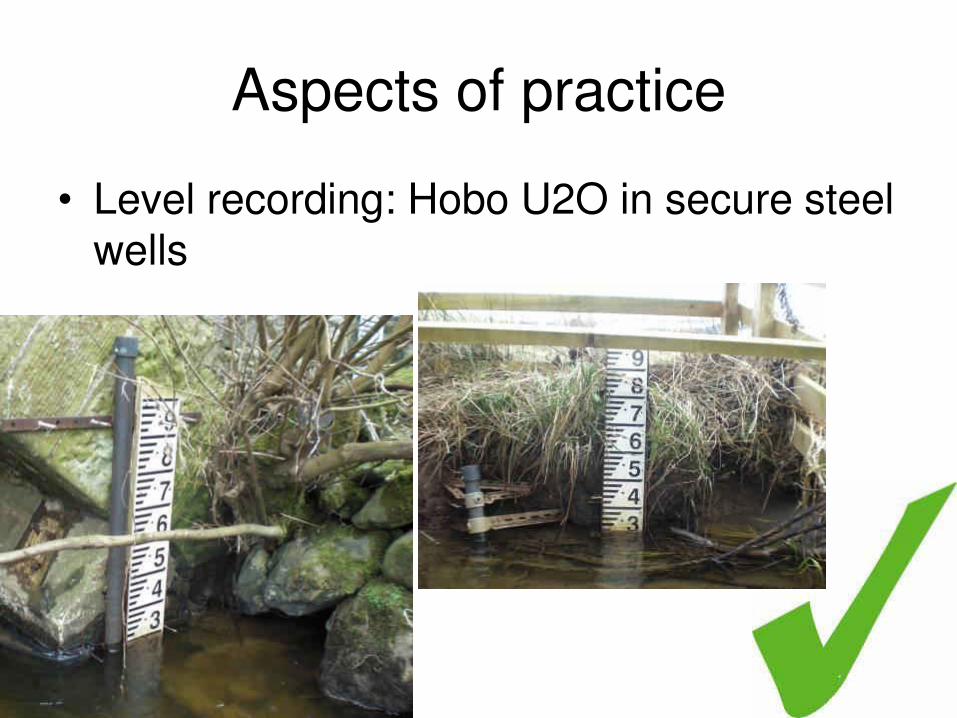
• Level recording: Hobo U2O in secure steel wells

Aspects of practice
• SonTek ADV for mid-range flow measurement
• Ott C-2 for shallow flows
• Or Valeport 802

Aspects of practice
• ADCP for high flow measurement
• Performance depends on water surface conditions

Aspects of practice
• Use of floats for validating velocities in peak flows

Aspects of practice
• Boreholoe network: surface water-groundwater interactions
Aspects of practice
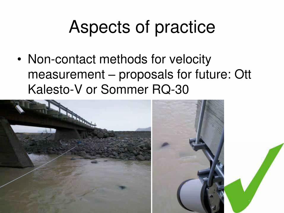
• Non-contact methods for velocity measurement – proposals for future: Ott Kalesto-V or Sommer RQ-30

Aspects of practice
• Time lapse photography, whether via telemetry or not…


Compementary to the stream level time series: surface
saturation and ponding: foreground and in distance on both flood plains (and before the stream rises: hourly pics, 31.1.13)


Aspects of practice
• Time lapse photography, whether via telemetry or not (cost)
Also recommended: supplementary pics; inexpensive but effective, non telemetry

Aspects of practice
• Campbell CR1000, 3G modem, Campbell LoggerNet + RTMC Webserver

Aspects of practice: gauging strategy:
being there at the right time ADCP: peak of 2nd-
highest event in 22 years
of record
Single visit: well worth staying on site in major
peak rather than moving to next site

Aspects of practice
• TBR pulse counter loggers: suspected power pack issues.
• Staffing for high flow gaugings
• Real-time prediction of stream flows
• Also, raingauge siting issues (exposure)

Eddleston Water: Use of the
stream gauging network in
hydrological modelling
Tributary assessments, sources,
integration
Tom Ball, Andrew Black, Josh Arnott, Ken Samson, Stanislav Ruman
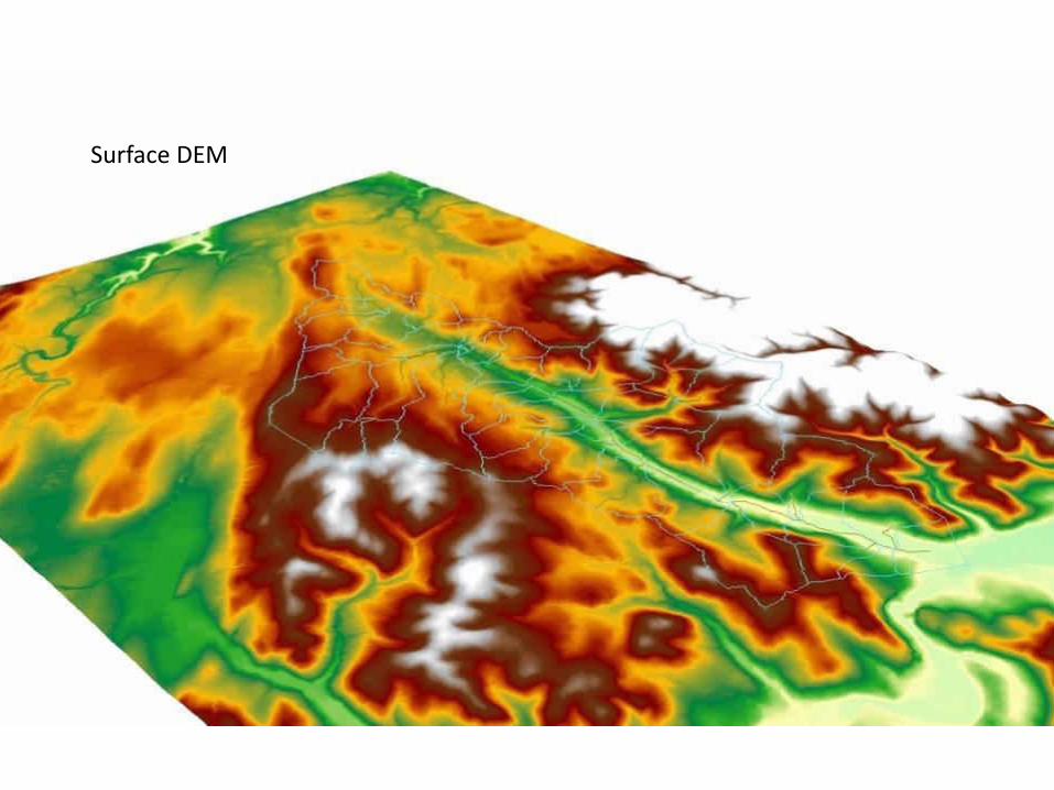
Surface DEM

Use of landcover information to inform surface parameterisation

Measured Hydrographs from August 10-12 2011 Event


Results

Modelling potential effects of
tributary NFM Interventions

Examining potential effects of tributary NFM Interventions
1. Middle Burn Flow restrictors

2. Longcote Burn
Floodplain
afforestation

Channel survey using dGPS

Run based on actual flow data August 10-12 2011 (peak observed h - 269.98)
2400 0600 1200 1800 2400 0600 1200 1800 2400 0600 1200 180010Aug2011 11Aug2011 12Aug2011
0.0
0.1
0.2
0.3
0.4
0.5
0.6
Plan: Plan 02 River: Middle Burn Reach: 2 RS: 2
Time
Flo
w (
m3
/s)
Legend
Flow
2400 0600 1200 1800 2400 0600 1200 1800 2400 0600 1200 180010Aug2011 11Aug2011 12Aug2011
0.0
0.1
0.2
0.3
0.4
0.5
0.6
Plan: Plan 02 River: Middle Burn Reach: 2 RS: 2
Time
Flo
w (
m3
/s)
Legend
Flow

August 11 2011 event – flow decoupling example

Intervention on
Junction 1 flow (m3/ s)
Junction 2 flow (m3/ s)
Junction 3 (main stem) flow (m3/ s)
Control (none)
1.56 2.28 3.32
Middle 1.52 2.22 3.25
Middle + Cowieslinn
1.55 2.23 3.25
Middle + Shiplaw
1.52 2.23 3.25
Middle + Cowieslinn + Shiplaw
1.55 2.27 3.28
Mid + Cowies + Shiplaw + Northern Part
1.52 2.24 3.27

Intervention on
Junction 1 flow (m3/ s)
Junction 2 flow (m3/ s)
Junction 3 (main stem) flow (m3/ s)
Control (none)
05:45 05:55 05:55
Middle 06:30 06:25 06:15
Middle + Cowieslinn
06:45 06:45 06:40
Middle + Shiplaw
06:30 06:50 06:40
Middle + Cowieslinn + Shiplaw
06:45 07:00 06:55
Mid + Cowies + Shiplaw + Northern Part
06:45 07:00 06:55