Embed Size (px)
Citation preview
Edinburgh Marina Granton Harbour Ltd
Edinburgh Marina
Volume 1: Environmental Impact Assessment Report
September 2018
Edinburgh Marina
Volume 1: Environmental Impact Assessment Report
Client: Edinburgh Marina Granton Harbour Ltd
Document number: 8170
Project number: 770288
Status: Final
Author: Various
Reviewer:
Date of issue: 28 September 2018
Glasgow Aberdeen Inverness Edinburgh
Craighall Business Park
8 Eagle Street
Glasgow
G4 9XA
0141 341 5040
www.envirocentre.co.uk
Banchory Business
Centre
Burn O’Bennie Road
Banchory
AB31 5ZU
01330 826 596
Alder House
Cradlehall Business Park
Inverness
IV2 5GH
01463 794 212
Suite 114
Gyleview House
3 Redheughs Rigg
Edinburgh
EH12 9DQ
0131 516 9530
This report has been prepared by EnviroCentre Limited with all reasonable skill and care, within the terms of
the Contract with Edinburgh Marina Granton Harbour Ltd (“the Client”). The report is confidential to the Client,
and EnviroCentre Limited accepts no responsibility of whatever nature to third parties to whom this report may
be made known.
No part of this document may be reproduced or altered without the prior written approval of EnviroCentre
Limited.
[Redacted]
Edinburgh Marina Granton Harbour Ltd September 2018
Edinburgh Marina; Volume 1: Environmental Impact Assessment Report
i
Contents Preface .................................................................................................................................................................... iv 1 Introduction ..................................................................................................................................................... 6
1.1 Introduction ............................................................................................................................................ 6 1.2 Planning History and Need for the Proposed Development ................................................................... 6 1.3 The Applicant .......................................................................................................................................... 8 1.4 Regulatory Context ................................................................................................................................. 8 1.5 Objectives and EIA Context ..................................................................................................................... 8 1.6 Key Terms ................................................................................................................................................ 9 1.7 The Project Team .................................................................................................................................. 10 1.8 Structure of the EIAR ............................................................................................................................. 11
2 Proposed Development ................................................................................................................................. 14 2.1 Site Description ..................................................................................................................................... 14 2.2 Description of the Proposed Development ........................................................................................... 16 2.3 Construction Methodology ................................................................................................................... 19 2.4 Alternatives Considered and Design Evolution ..................................................................................... 25
3 EIA Methodology and Scoping ....................................................................................................................... 27 3.1 Introduction .......................................................................................................................................... 27 3.2 General EIA Methodology ..................................................................................................................... 27 3.3 EIA Regulations 2017 ............................................................................................................................. 28 3.4 The EIA Process ..................................................................................................................................... 28 3.5 Screening and Scoping as part of the EIA Process ................................................................................. 31 3.6 Final Content and Structure of the EIA Report...................................................................................... 33
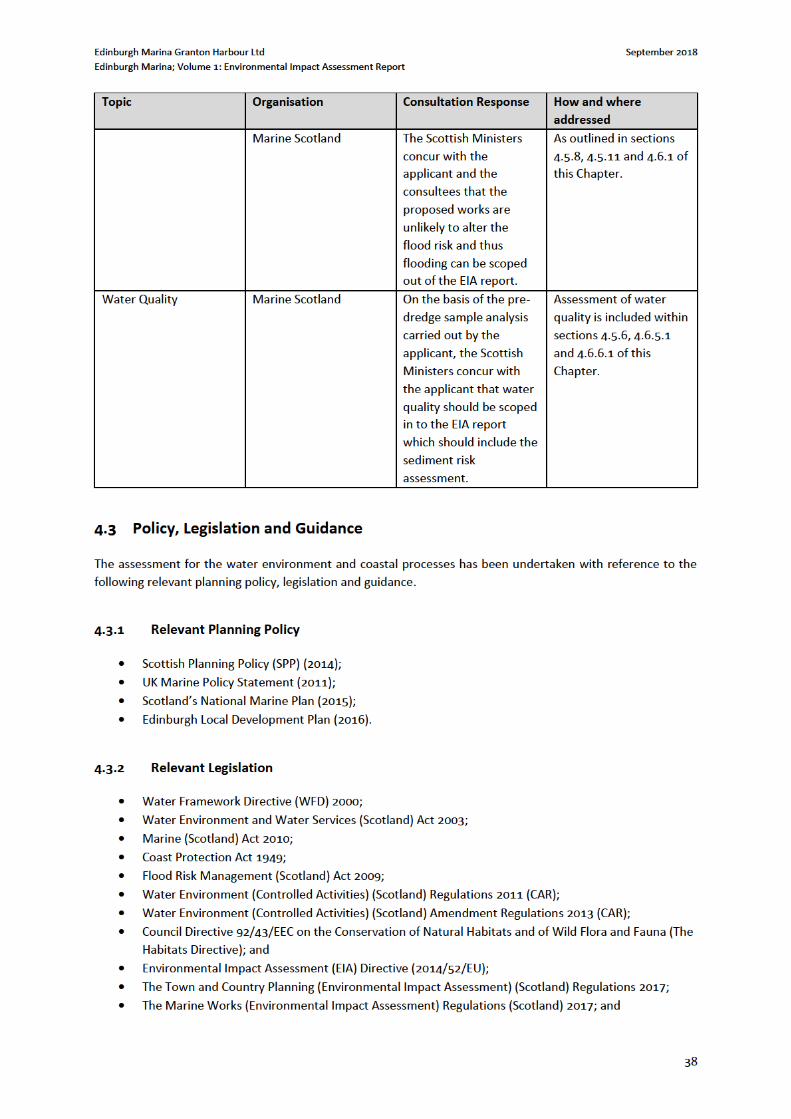
4 Water Environment & Coastal Processes ...................................................................................................... 35 4.1 Introduction .......................................................................................................................................... 35 4.2 Scoping and Consultation ...................................................................................................................... 35 4.3 Policy, Legislation and Guidance ........................................................................................................... 38 4.4 Methodology ......................................................................................................................................... 39 4.5 Baseline ................................................................................................................................................. 42 4.6 Impact Assessment ............................................................................................................................... 46 4.7 Mitigation and Monitoring .................................................................................................................... 51 4.8 Residual Effects ..................................................................................................................................... 54 4.9 Statement of Significance ..................................................................................................................... 57
5 Marine Ecology and Ornithology ................................................................................................................... 58 5.1 Introduction .......................................................................................................................................... 58 5.2 Scoping and Consultation ...................................................................................................................... 59 5.3 Policy, Legislation and Guidance ........................................................................................................... 67 5.4 Methodology ......................................................................................................................................... 68 5.5 Baseline Summary ................................................................................................................................. 76 5.6 Evaluation .............................................................................................................................................. 80 5.7 Assessment of Ecological Impacts ......................................................................................................... 81 5.8 Mitigation and Monitoring .................................................................................................................... 95 5.9 Residual Effects ................................................................................................................................... 100 5.10 Statement of Significance ................................................................................................................... 102
6 Other Issues ................................................................................................................................................. 103 6.1 Introduction ........................................................................................................................................ 103 6.2 Exportation of Dredge Material by Road ............................................................................................ 103 6.3 Air Quality ........................................................................................................................................... 105 6.4 Terrestrial Noise .................................................................................................................................. 106 6.5 Population and Human Health ............................................................................................................ 109 6.6 Navigation ........................................................................................................................................... 109
Edinburgh Marina Granton Harbour Ltd September 2018
Edinburgh Marina; Volume 1: Environmental Impact Assessment Report
ii
6.7 Climate Change ................................................................................................................................... 114 6.8 Natural Disasters ................................................................................................................................. 115 6.9 Major Accidents .................................................................................................................................. 115
7 Cumulative Effects ....................................................................................................................................... 117 7.1 Potential for Cumulative Effects ......................................................................................................... 117
8 Schedule of Mitigation................................................................................................................................. 119 8.1 Introduction ........................................................................................................................................ 119 8.2 Mitigation Measures ........................................................................................................................... 119
9 Conclusions .................................................................................................................................................. 136 9.1 Introduction ........................................................................................................................................ 136 9.2 Water Environment and Coastal Processes ........................................................................................ 136 9.3 Marine Ecology and Ornithology ......................................................................................................... 136 9.4 Other Issues......................................................................................................................................... 136 9.5 Cumulative Effects .............................................................................................................................. 136
Figures Figure 2-1 Granton Harbour Historic Plan............................................................................................................. 15 Figure 2-2 Granton Harbour Site ........................................................................................................................... 15 Figure 2-3 Typical Backhoe Dredger ..................................................................................................................... 21 Figure 2-4: Potential construction within a trench to sound formation ............................................................... 23 Figure 6-1 Main route from Hound Point Fairway Buoy to Leith Roads © Navionics ........................................ 111 Figure 6-2 Approach Channel route from Leith Roads to Marina Entrance © Navionics ................................... 112 Figure 6-3 Lights and marks at Marina Entrance © Navionic ............................................................................. 112
Tables
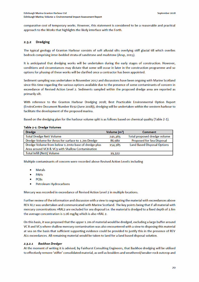
Table 1-1: Competent Expertise ............................................................................................................................ 10 Table 1-2: Structure of the ES ............................................................................................................................... 12 Table 2-1: Dredge Volumes ................................................................................................................................... 20 Table 2-2: Construction Phasing and Assumptions ............................................................................................... 24 Table 3-1: Summary of Scoping Responses ........................................................................................................... 32 Table 4-1: Summary of Consultation Responses ................................................................................................... 35 Table 4-2: Criteria for Assessing Receptor Sensitivity ........................................................................................... 40 Table 4-3: Criteria for Assessing Impact Magnitude ............................................................................................. 41 Table 4-4: Criteria for Assessing Effects ................................................................................................................ 41 Table 4-5: Tidal Levels at Leith .............................................................................................................................. 44 Table 4-6: Granton Harbour Extreme Sea Levels (SEPA Dataset) ......................................................................... 46 Table 4-7: Receptor Sensitivity ............................................................................................................................. 47 Table 4-8: Residual Effects .................................................................................................................................... 55 Table 5-1: Summary of Consultation Responses ................................................................................................... 59 Table 5-2: Phase of Works and Potential Impact .................................................................................................. 61 Table 5-3 Hearing Threshold for Representative Fish Species .............................................................................. 64 Table 5-4: IEFs and Respective Zone of Influence ................................................................................................. 66 Table 5-5: Legislation, Planning Policies, Conservation Initiatives and General Guidance Related to Ecology .... 67 Table 5-6: Geographical Level of Importance to be Applied to Ecological Features............................................. 69 Table 5-7: Geographical Level of Importance of Ecological Features (Ornithology) ............................................. 73 Table 5-8: Criteria for Describing Magnitude of Impact ....................................................................................... 74 Table 5-9: Designated Sites ................................................................................................................................... 76 Table 5-10: Evaluation of Important Ecological Features ..................................................................................... 80 Table 5-11: Summary of Effects on Important Ecological Features .................................................................... 100 Table 6-1 Dredge Volumes .................................................................................................................................. 104

Edinburgh Marina Granton Harbour Ltd September 2018
Edinburgh Marina; Volume 1: Environmental Impact Assessment Report
iii
Table 6-2 Predicted Trip Generation ................................................................................................................... 104 Table 6-3: Summary of Baseline Noise Monitoring Results; Approx. 50m South of Plots 8A & 8B .................... 107 Table 6-4: Assessment of Potential Effects – Major Accidents ........................................................................... 116 Table 7-1: Dredge Volumes ................................................................................................................................. 117 Table 7.2: Summary of Disposal Sites ................................................................................................................. 117 Table 7-3 Dredge material from Rosyth and Leith Maintenance Dredge ........................................................... 118 Table 8-1: Schedule of Mitigation ....................................................................................................................... 120

Edinburgh Marina Granton Harbour Ltd September 2018
Edinburgh Marina; Volume 1: Environmental Impact Assessment Report
v
The following documents have also been prepared to support the application. These form part of the overall
submission, but they do not form a physical part of the EIAR:
Applications for Marine Licences – these applications for dredging and construction in the marine
environment are required to consent activities below Mean Low Water Springs (MLWS) and are
accompanied by a Best Practicable Environmental Option (BPEO) appraisal;
Pre-Application Consultation Statement, required under Regulation 7(b) of the Marine Licensing (Pre-
Application Consultation) (Scotland) Regulations 2013 (Technical Appendix 1-1); and
Planning Statement – providing an assessment of the development relative to Scotland’s National Marine
Plan (Technical Appendix 1-2).
Electronic copies of the NTS are available for free from the following contact, whilst digital copies of the full
EIAR on disc can be obtained for £10.00. Full hard copies of the EIAR can be supplied for £500.00 per copy.
Cameron Planning
29 East Argyle Street
Helensburgh
G84 7EJ
[Redacted]
Edinburgh Marina Granton Harbour Ltd September 2018
Edinburgh Marina; Volume 1: Environmental Impact Assessment Report
6
1 INTRODUCTION
1.1 Introduction
EnviroCentre has been appointed by Edinburgh Marina Granton Harbour Ltd in respect of Environmental Impact
Assessment in relation to a proposed new development at Edinburgh Marina within the existing Granton
Harbour, the location of which is indicated by Figure 1, contained within Volume 2 of this EIAR. This
Environmental Impact Assessment Report (EIAR) comprises the written findings of the EIA process. The EIA has
been prepared under relevant EIA legislation to accompany applications for marine construction and dredging
and disposal licences
The relevant Regulations which underpin this EIAR are listed below and these are further discussed within section
1.4, and within Chapter 3: EIA Methodology and Scoping of this EIAR.
The Marine Works (Environmental Impact Assessment) (Scotland) Regulations 2017 (as amended) (‘the
Marine EIA Regulations’); and
The Environmental Impact Assessment (Miscellaneous Amendments Relating to Harbours, Highways
and Transport) Regulations 2017 (the ‘Miscellaneous EIA Regulations’).
The Marine Works Licence applications that this Environmental Impact Assessment Report relates to seek
consent for the formation of a new marina comprising space for 340 vessels and associated facilities at Edinburgh
Marina, Granton, via a Marine Licence Application for Construction Projects. The proposed development includes
provision for reclamation, dredging, construction of a quay wall, pontoons and an extension to the existing
breakwater. The associated marina facilities have the benefit of planning permission as noted in section 1.2
below. The dredging works included disposal at sea and are subject to a Marine Licence Application for Dredging
and Sea Disposal.
Edinburgh Marina, Granton, is located approximately 4km to the north of the centre of Edinburgh Refer to
Drawing No. The proposed marine works comprise the construction of a harbour quay wall, incorporating a 225m
length of sloping masonry revetment wall and a 110m length of vertical sheet extension to an existing quay wall
and associated backfilling; the laying out of a 340 berth marina including pontoon piles; construction of a 50m
extension to existing north mole and harbour dredging. Accordingly, the EIAR is concerned with providing
environmental evidence to support the marine licencing process. Full description of the proposed development
is contained within Chapter 2: Proposed Development of this EIAR, with the regulatory context set out within
section 1.4 and Chapter 3: EIA Methodology and Scoping.
1.2 Planning History and Need for the Proposed Development
As stated within the Edinburgh Local Development Plan (LDP) (2016), North Edinburgh has seen over 40 years of
decline in industrial activity and port-related use of land. The redevelopment of the Edinburgh Waterfront will
accommodate the city’s growth needs, particularly for new housing. The Granton Harbour development has been
designated within the LDP as a housing-led mixed use development on land owned by Forth Ports Limited and
others.
Edinburgh Marina Granton Harbour Ltd September 2018
Edinburgh Marina; Volume 1: Environmental Impact Assessment Report
7
The proposed development is part of the Granton Harbour regeneration development; a development that was
granted Outline Planning Permission (now Planning Permission in Principle) by City of Edinburgh Council in 2003
under planning application reference 01/00802/OUT, as detailed by the Report of Handling2.
The application was accompanied by an Environmental Statement (ES) produced by Robert Turley Associate on
behalf of Forth Properties Ltd. The application was granted permission subject to a number of planning
conditions including one requiring all Reserved Matters Applications to be submitted within 15 years from the
date of permission, i.e. by June 2018. Since the original planning permission was granted, a series of revisions to
the proposed site layout and development have remained as originally approved. As such, a number of Matters
Specified in Conditions (MSC) applications, formerly Reserved Matters Applications, have been submitted and
approved for various development plots, and some development plot approvals have already been implemented.
A Formal Screening Request was submitted by Cameron Planning for a Marine Licence application for the Marina
Development and associated works: MSC planning permission was granted pursuant to the original permission
in April 2017 for, “the formation of a new Marina Office with associated retail and café space, and new
community boat yard with associated dry stack”. Marine Scotland provided a Screening Opinion on the 16th
October 2017 and concluded that the proposed works fall under paragraphs 1(e), 10(m), and 12(a) of Schedule
2 of the EIA Regulations and as such, an EIA must be carried out.
Marine Scotland provided a Screening Opinion on the 16th October 2017 and concluded that the proposed works
fall under paragraphs 1(e), 10(m), and 12(a) of Schedule 2 of the EIA Regulations and as such, an EIA must be
carried out.
The proposed marine works associated with the Granton Harbour development comprises:
225m length of stone revetment to harbour;
110m length of vertical quay wall to harbour;
Backfilling of land protected by quay wall (c.1050m3) and stone revetment (c.5000m3);
Formation of 340 berth marina;
50m extension to existing north mole breakwater; and
Harbour dredging.
In discussion with Marine Scotland, a second screening request was submitted on the 28th November 2017.
Marine Scotland provided a second Screening Opinion on the 5th February 2018 concluding that the proposed
development is likely to have significant effects on the environment and therefore requires an EIA.
At a meeting with Victoria Bell and Louise Wilcox in Marine Scotland offices on 14th February 2018 advice was
provided that the EIA should focus on the principal issues identified in the 5th February, 2018 EIA Screening
Opinion, specifically sediment transportation and coastal processes alongside assessment work relative to the
Habitat Regulations Appraisal process.
The EIA Scoping Report submitted to Marine Scotland on 10th April 2018 was based upon the Screening Opinion
and subsequent Marine Scotland advice and set out the proposed EIA methodology upon which we requested a
formal notification from Marine Scotland within a five week time period as specified under regulation 14 (7) of
the EIA Regulations.
An EIA Scoping Opinion was issued on 14th June 2018 with detailed information provided in the specialist topic
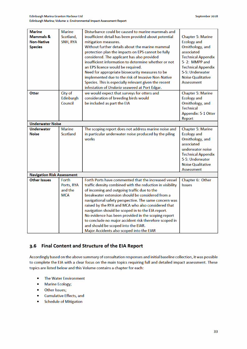
sections. The Scoping opinion scoped in the following:
Marine Ecology – Mammals & Non Native Species
2http://citydev-portal.edinburgh.gov.uk/idoxpa-web/files/00DB0FD94CC20316931B1A365C15AA5D/pdf/01_00802_OUT-REPORT_OF_HANDLING-3759387.pdf

Edinburgh Marina Granton Harbour Ltd September 2018
Edinburgh Marina; Volume 1: Environmental Impact Assessment Report
8
Water Environment & Coastal Processes – Waves
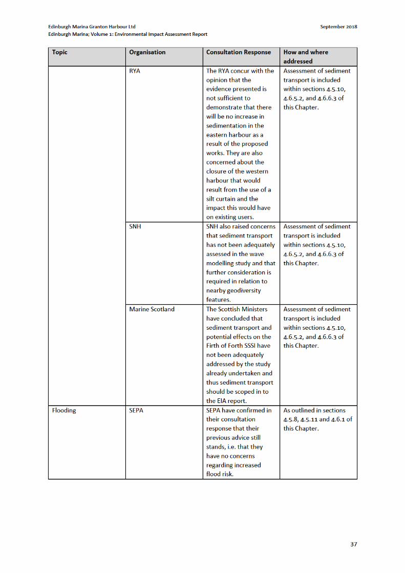
Water Environment & Coastal Processes – Sediment Transport
Water Environment & Coastal Processes – Water Quality
Marine Ecology - Otters
Marine Ecology – Ornithology
Noise (marine)
Major Accidents
Cumulative Assessment
Navigation
For further details of the Marine Scoping Opinion, refer to Chapter 3.
This EIAR sets out the environmental studies and assessment undertaken to provide an examination of the likely
significant effects
1.3 The Applicant
Edinburgh Marina Granton Harbour Ltd are progressing the Marina development which will regenerate and
restore Granton to a dynamic and inspiring place to live, work and visit, while returning it to being a jewel in
Scotland’s historic coastline.
1.4 Regulatory Context
The continued management and development of the Edinburgh Marina area is subject to European and national
legislation of which the following is the principal legislation relevant to the current development programme:
The Marine Works (Environmental Impact Assessment) (Scotland) Regulations 2017
The Marine (Scotland) Act 2010 (Marine Licences) – to be consented by Marine Scotland for the deposit
or removal of a substance or object below the mean high water springs mark.
Marine (Scotland) Act 2010.
Under Section 20(1) of the Marine (Scotland) Act 2010 (from 0 -12nm), a marine licence from Scottish Ministers
is required if organisations intend to carry out certain acts in the Scottish marine area.
Marine licences are required for the construction works, the deposit of the pontoons, the dredging and the
deposit of dredge spoil (sea disposal).
Chapter 3: EIA Methodology and Scoping discusses how the views of all consultees have been factored into
assessment, as well as in more detail within each individual chapter. Each chapter discusses those impacts which
are related to the marine environment, to the terrestrial environment, or both.
1.5 Objectives and EIA Context
The purpose of an EIA is to identify and evaluate the likely significant effects of a proposed development on the
environment and to identify measures to mitigate or manage any significant adverse effects before a planning
application or marine licence is determined. The EIA process provides an opportunity to ‘design out’ adverse
effects wherever possible. Where adverse effects cannot be designed out, mitigation measures can be proposed
to avoid, compensate or reduce significant environmental effects to an acceptable level. EIA is an iterative
Edinburgh Marina Granton Harbour Ltd September 2018
Edinburgh Marina; Volume 1: Environmental Impact Assessment Report
9
process which allows feedback from stakeholder consultation and the results from baseline studies to be fed into
the design process of the development.
The EIA carried out in relation to the proposed development has been undertaken by specialist environmental
and technical consultants on the basis of project information supplied by the Applicant and their engineers and
following consultation with statutory consultees, other bodies and members of the public.
The objectives of the EIAR are:
To establish a robust environmental baseline upon which to base environmental assessment,
incorporating field surveys, desk study and consultation;
To provide an assessment of the potential environmental impacts of the proposed development and to
determine which of these, if any, are likely to result in a significant effect on the receiving environment;
and
Where significant effects are predicted, to determine mitigation measures to reduce the residual effects
to acceptable levels.
The results and findings of the EIA are presented in this EIAR. The environmental information presented is derived through a systematic process of identification, prediction and evaluation of the likely significant environmental effects of the proposed development. Schedule 4 of the Marine EIA Regulations requires that the following information is provided:
A description of the location of development, its physical characteristics and land-use requirements
during construction and operation;
A description of the main characteristics of the operational phase of the development;
An estimate of residues and emissions produced during the construction and operation phases;
A description of reasonable alternatives, and an indication of the main reasons for selecting the chosen
option, including a comparison of the environmental effects;
A description of the relevant aspects of the current state of the environment and an outline of the likely
evolution thereof without implementation of the development as far as reasonable;
A description of environmental receptors likely to be significantly affected by the development;
A description of the likely significant effects of the development on the environment;
A description of the forecasting methods or evidence used to identify and assess the significant effects;
A description of the measures envisaged to mitigate significant effects;
A description of expected significant adverse effects deriving from the vulnerability of the development
to risks of major accidents and/or disaster; and
A non-technical summary of the aforementioned information.
This EIAR meets these requirements within each technical chapter, with the primary description of development comprising Chapter 2: Proposed Development, and a description of how the EIA Regulations have been addressed within Chapter 3: EIA Methodology and Scoping.
1.6 Key Terms
To ensure clarity and consistency through the EIAR, the following key terms have been used:
‘the proposed development’ refers to the construction of the proposed development as described in
Chapter 2: Proposed Development;
‘the site’ is the land and sea bound by the red-line boundary in which the proposed development lies, and
is illustrated within Drawing No. SK112C and 770288-001 within Volume 2 of this EIAR;
Edinburgh Marina Granton Harbour Ltd September 2018
Edinburgh Marina; Volume 1: Environmental Impact Assessment Report
14
2 PROPOSED DEVELOPMENT
2.1 Site Description
This chapter sets out the details of the proposed development upon which this EIAR is based. It is supplemented
by Figure A-P-00-G7-005 H within Volume 2 of this EIAR which illustrates the site layout
The information within this chapter has been supplied by the project team and prepared by EnviroCentre.
2.1.1 Site Location and Description
At present, the site comprises predominantly reclaimed land from the sea, consisting of vacant brownfield land
which is scheduled for development under the approved 2003 masterplan and a number of subsequent Matters
Specified in Conditions (MSC) permissions. The overall topography of the surrounding area is generally flat, with
the proposed marine works development situated at the edge, and within the extents of the harbour.
Edinburgh Marina sits within the Granton Harbour regeneration development area, approximately 4km north of
Edinburgh City Centre and fronting the Firth of Forth. It is approximately 9.5Ha, bounded to the north by the
Western Breakwater, to the east by the Eastern Harbour and to the south by wider regeneration proposals and
developments. The nearest residential development is situated on Merlin Avenue, approximately 90m south of
the proposed development.
Within the wider area there is a combination of brownfield land, commercial/industrial and residential premises,
which will be developed as part of the Granton Waterfront Development. Granton Waterfront is split into four
development quarters of (1) Central Development Area, (2) North Shore, (3) Forth Quarter, and (4) Granton
Harbour.
2.1.2 Historic Granton Harbour
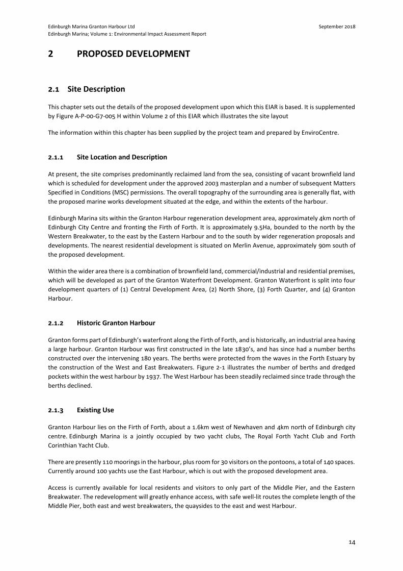
Granton forms part of Edinburgh’s waterfront along the Firth of Forth, and is historically, an industrial area having
a large harbour. Granton Harbour was first constructed in the late 1830’s, and has since had a number berths
constructed over the intervening 180 years. The berths were protected from the waves in the Forth Estuary by
the construction of the West and East Breakwaters. Figure 2-1 illustrates the number of berths and dredged
pockets within the west harbour by 1937. The West Harbour has been steadily reclaimed since trade through the
berths declined.
2.1.3 Existing Use
Granton Harbour lies on the Firth of Forth, about a 1.6km west of Newhaven and 4km north of Edinburgh city
centre. Edinburgh Marina is a jointly occupied by two yacht clubs, The Royal Forth Yacht Club and Forth
Corinthian Yacht Club.
There are presently 110 moorings in the harbour, plus room for 30 visitors on the pontoons, a total of 140 spaces.
Currently around 100 yachts use the East Harbour, which is out with the proposed development area.
Access is currently available for local residents and visitors to only part of the Middle Pier, and the Eastern
Breakwater. The redevelopment will greatly enhance access, with safe well-lit routes the complete length of the
Middle Pier, both east and west breakwaters, the quaysides to the east and west Harbour.
Edinburgh Marina Granton Harbour Ltd September 2018
Edinburgh Marina; Volume 1: Environmental Impact Assessment Report
15
Figure 2-1 Granton Harbour Historic Plan3
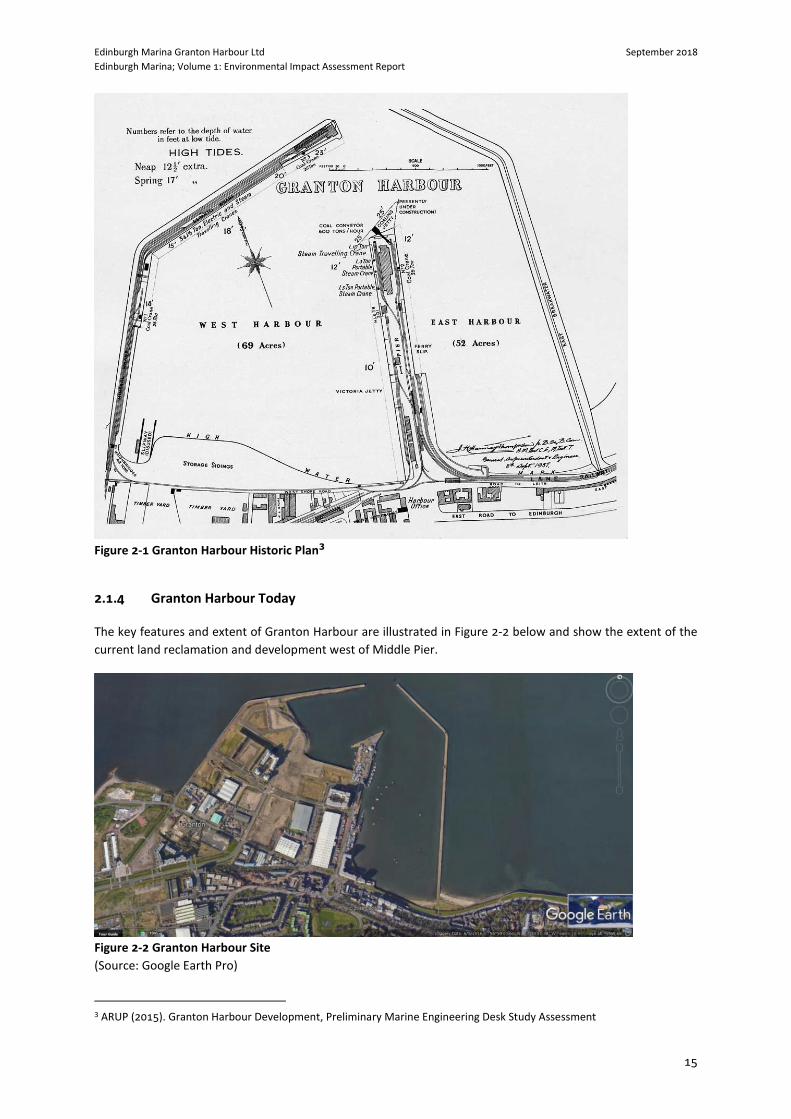
2.1.4 Granton Harbour Today
The key features and extent of Granton Harbour are illustrated in Figure 2-2 below and show the extent of the
current land reclamation and development west of Middle Pier.
Figure 2-2 Granton Harbour Site
(Source: Google Earth Pro)
3 ARUP (2015). Granton Harbour Development, Preliminary Marine Engineering Desk Study Assessment
Edinburgh Marina Granton Harbour Ltd September 2018
Edinburgh Marina; Volume 1: Environmental Impact Assessment Report
16
The Arup Preliminary Marine Engineering Desk Study Assessment (February 2015) indicates that the south
boundary of the current west basin is formed by a vertical sheet pile wall constructed to retain reclaimed land.
The west boundary is formed by a non-engineered, informal fill slope which lies at a varying angle along its length.
The fill slope is over-steepened near the ground surface level suggesting undercutting under wave action during
storm events.
The north boundary is formed by the existing listed Western Breakwater structure. This breakwater structure
was upgraded during the development works in the mid-2000s. The aim of the upgrade was to strengthen the
structure and provided protection to the planned adjacent property development from tidal flooding from
overtopping of waves in extreme north westerly storm events.
The extreme eastern end of the Western Breakwater is known as the North Mole.
2.1.5 Physical information
The harbour lies in the Forth Estuary tidal area and is subject to variations from tidal waters. The Fairhurst Report
“Edinburgh Marina –Feasibility Study for extension of North Revetment Wall Inception Report (May 2015)” states
that Granton is a Secondary Non-Harmonic port. The tide type is Semi-Diurnal. Predictions based on Leith which
is a standard port.
The Arup Preliminary Marine Engineering Desk Study Assessment (February 2015) indicates that siltation rates in
Granton Harbour can be reasonably significant, on the order of 300mm and 500mm. Studies indicate annual
sedimentation to be on the order of 0.75m/yr. However, sedimentation depends strongly on the type and
dimensions of the structure used for wave protection, so the sedimentation rate may change when the new
structure is built.
The historic deep area at Granton Harbour, referred to as the access channel, coincides with the area where the
breakwater requires to be extended. The future dredging level is indicated at – 2.5m CD but due to the likely rate
of sedimentation Arup recommended this to be -3.5m CD.
2.1.6 Geology
The typical geology of Granton Harbour consists of soft alluvial silts overlying stiff glacial till which overlies
bedrock comprising inter-bedded strata of sandstone and mudstone. The levels of the top of the glacial till strata
are consistently between -5.5mOD to -6.5mOD, except in the locations near the former wharves where the glacial
till deposits have been dredged to a greater depth (around -10mOD) to form berth pockets to accommodate the
types of ships that utilised the facilities (Arup, 2015).
A number of boreholes have been drilled to a sufficient depth to prove the underlying rock. The depths to rock
vary considerably across the site, ranging from -6.5mOD to -20mOD.
2.2 Description of the Proposed Development
2.2.1 Need for the Proposed Development
The wider Granton Waterfront Development is a 60-acre development along the Firth of Forth comprising 1,800
homes, 186-bed spa hotel and 18,500sq/m retail, leisure and commercial space and a 340-berth marina. The new
Edinburgh Marina development will include a wide range of high-end leisure and accommodation facilities,
situated adjacent to Edinburgh’s first ever purpose-built luxury marina.
Edinburgh Marina Granton Harbour Ltd September 2018
Edinburgh Marina; Volume 1: Environmental Impact Assessment Report
17
Edinburgh Marina has been designed to surpass the 5 Gold Anchors rating of the Yacht Harbour Association.
Once operational, the marina will offer 340 full-serviced berths, with visitor berths and additional dry berths for
boats up to 30m in length. Edinburgh Marina will offer 24 hour access to the sea. Marine services and an
extensive chandlery will be located in the new marina office sited within the fully equipped new boatyard. The
marina has been designed to accommodate the full-size range of yachts and cruisers, including some of the
largest of the world’s superyachts – the first time this has been possible on Scotland’s east coast.
Development associated with the proposed marina element of the Granton Harbour Regeneration Scheme,
comprises the construction of a harbour wall, incorporating a 225m length of sloping masonry revetment wall
and a 110m length of vertical sheet extension to existing quay wall and backfilling; the laying out of a 340 berth
marina; construction of an extension to existing north mole and harbour dredging. Figure 2 contained within
Appendix A provides the Masterplan layout for the Granton Harbour Regeneration Scheme. These elements
benefit from the original outline planning permission, with the adjoining boatyard and marina office now having
detailed planning permission. There are currently, (September 2018) further applications in relation to the
marina office and boatyard and also the aparthotel and public realm works to the north of that development;
these are pending determination.
The proposed development is the redevelopment of the existing harbour area to accommodate a new marina.
2.2.2 Summary of Component Parts
The proposed development encompasses four aspects of the marine works:
Harbour Dredging – To ensure efficient operation of the existing harbour, the harbour bed needs to be dredged
to the required depth. The potential for environmental impact during dredging works and as part of sea disposal
of sediment material will be addressed as part of the Marine Scotland Dredging Licence Application and the
supporting Best Practicable Environmental Option (BPEO) Report.
As part of the separate Marine Scotland Licence application, a Sediment Risk Assessment will be undertaken
along with a BPEO assessment for the dredging and disposal associated with the Edinburgh Marina Project (Refer
to Drawing No. 115875/0101 in Volume 2 of this EIAR).
Quay Wall Works – the existing quay wall is dilapidated and poorly defined. The proposed quay wall works aims
to formalise the water/land margin, providing the public with context to this area of wider regeneration
development. The location and extent of the proposed quay wall and revetment works are demonstrated in
Drawing 115875/021 contained within Volume 2 of this EIAR. The northern section of the works will reconstruct
the sloping masonry revetment, maintaining the connection to the existing northern breakwater, and will be
225m in length. The southern section of the works will comprise of a vertical quay wall with associated sheet
piling that will be 110m in length and situated adjacently to the proposed boatyard.
From the original planning application that was granted planning permission in principle in 2003, there is to be
an area of backfill to the west of the revetment and quay wall. This will form the public realm associated with
the new hotel and serviced apartments on Plot 35 of the masterplan (The current planning application reference
is 17/05306/AMC). The material to be used to backfill the quay wall has been previously stockpiled on site, and
the site to the west and south-west will be regraded to form the approved surface finish levels.
North Mole Extension – Granton Harbour is a long-established harbour which is protected by an existing sea wall
to the north. Drawing 115875/0027, contained within Volume 2 of this EIAR, demonstrates the spatial
relationship within the site boundary. The proposed marine works comprise further extension to the existing
North Mole structure in order to better protect the harbour mouth from excessive wave action. The proposed
linear extent of the North Mole extension is 50m. The extension will be vertical faced on the harbour side and
Edinburgh Marina Granton Harbour Ltd September 2018
Edinburgh Marina; Volume 1: Environmental Impact Assessment Report
18
sloping masonry on the seaward side as illustrated in Drawing 115875/0027, contained within Volume 2. A
method statement for the North Mole Extension is contained within Volume 3, Technical Appendix 2.1 of this
EIAR. The north mole is a partially Listed Building, at its western extremity, and as such, any works to this section
require to be considered under Listed Building Regulations. It is understood that any works proposed to this
western section will fall under repairs and maintenance to the existing structure.
New Marina – The proposed marina comprises 340 number of berths of different sizes to accommodate varying
sized vessels, the proposed layout as detailed by Figure A-P-00-G7-005H, contained within Volume 2 of this EIAR.
The linear extent of the berth is 4,407m and the marina development will extend approximately 32.1% of the
available useable water area within the harbour. The marina area will extend to approximately 22,879m2. The
marina will be formed through a series of floating berths and pontoons that will rise and fall with the tide (Refer
to Drawing No. 115875-0001-A and A-P-00-G7-005H within Volume 2: Figures of this EIAR).
At present, methods of construction and their timing are not formalised in detail. To ensure that risks of adverse
impacts are identified and kept to acceptable limits, construction management plans will be a requirement within
construction contracts for individual developers.
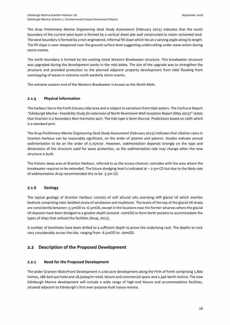
Edinburgh Marina from North Mole looking south
Edinburgh Marina – Looking towards North Mole
North Mole – Harbour Side
North Mole – Firth of Forth Side
Edinburgh Marina Granton Harbour Ltd September 2018
Edinburgh Marina; Volume 1: Environmental Impact Assessment Report
19
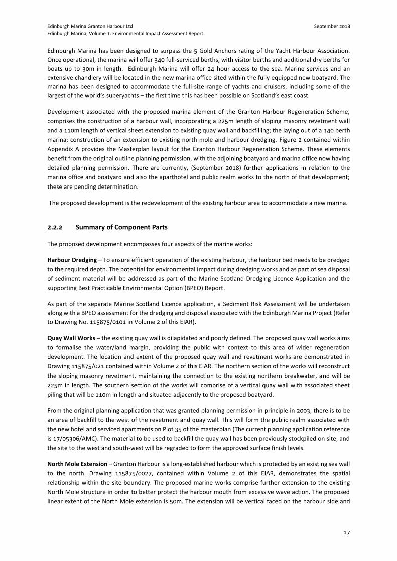
Location of Western Revetment from North Mole
North Mole from the Proposed Revetment
Southern Quay Wall looking east to Middle Pier
Looking east towards Middle Pier
2.3 Construction Methodology
Fairhurst were commissioned by Granton Central Developments Ltd to prepare a high level civil engineering
statement4 setting out the likely method of construction and various aspects of civil engineering works to support
the development and provide protection for Edinburgh Marina and Granton Harbour. These comprise an
extension to the North Mole breakwater, an internal quay wall and an internal harbour revetment. General
layout arrangements are demonstrated on Drawing No’s. A-P-00-G7-005H and 115875-0100 within Volume 2: of
this EIAR (Refer also to Technical Appendix 2-1: Civil Engineering Method Statement).
2.3.1 Assumptions
Typical geology of Granton Harbour consists of soft alluvial silts overlying stiff glacial till which overlies bedrock
comprising inter-bedded strata of sandstone and mudstone. Detailed Geotechnical Investigation is required to
inform the detailed design. This will be provided to the Contractor to inform the Temporary Works design as
required.
A Bathymetric Survey of the current bed levels has been carried out to inform the design, identify the current
extent of dredging and inform the construction methodology (Refer to Technical Appendix 4.1). The methodology
may vary depending on the preferred approach of the Contractor, the availability of marine plant and the
4 Fairhurst, Edinburgh Marina Civil Engineering Method Statement North Mole Extension, Inner Revetment and Quay Wall
14th September 2018
Edinburgh Marina Granton Harbour Ltd September 2018
Edinburgh Marina; Volume 1: Environmental Impact Assessment Report
21
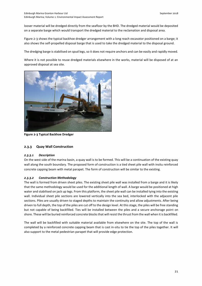
looser material will be dredged directly from the seafloor by the BHD. The dredged material would be deposited
on a separate barge which would transport the dredged material to the reclamation and disposal area.
Figure 2-3 shows the typical backhoe dredger arrangement with a long reach excavator positioned on a barge; it
also shows the self-propelled disposal barge that is used to take the dredged material to the disposal ground.
The dredging barge is stabilised on spud legs, so it does not require anchors and can be easily and rapidly moved.
Where it is not possible to reuse dredged materials elsewhere in the works, material will be disposed of at an
approved disposal at sea site.
Figure 2-3 Typical Backhoe Dredger
2.3.3 Quay Wall Construction
2.3.3.1 Description
On the west side of the marina basin, a quay wall is to be formed. This will be a continuation of the existing quay
wall along the south boundary. The proposed form of construction is a tied sheet pile wall with insitu reinforced
concrete capping beam with metal parapet. The form of construction will be similar to the existing.
2.3.3.2 Construction Methodology
The wall is formed from driven sheet piles. The existing sheet pile wall was installed from a barge and it is likely
that the same methodology would be used for the additional length of wall. A barge would be positioned at high
water and stabilised on jack up legs. From this platform, the sheet pile wall can be installed tying into the existing
wall. Individual sheet pile sections are lowered vertically into the sea bed, interlocked with the adjacent pile
sections. Piles are usually driven to staged depths to maintain the continuity and allow adjustments. After being
driven to full depth, the top of the piles are cut off to the design level. At this stage, the piles will be free standing
but not capable of being backfilled. Ties will be installed between the piles and a secure anchorage point on
shore. These will be buried reinforced concrete blocks that will resist the thrust from the wall when it is backfilled.
The wall will be backfilled with suitable material available from elsewhere on the site. The top of the wall is
completed by a reinforced concrete capping beam that is cast in-situ to tie the top of the piles together. It will
also support to the metal pedestrian parapet that will provide edge protection.
Edinburgh Marina Granton Harbour Ltd September 2018
Edinburgh Marina; Volume 1: Environmental Impact Assessment Report
22
2.3.4 North Mole Extension
2.3.4.1 Form of Construction
The North Mole extension requires a vertical internal face for a length of 50m to maximise space available for
the marina. An inclined seaward face of rock armour will provide protection from wave action. Several forms of
construction are possible for this structural layout but it is anticipated that a reinforced concrete wall would be
formed, resting on the seabed with a natural rock faced revetment to the seaward side. The Reinforced concrete
wall would be assembled from hollow pre-cast concrete boxes that can be filled on site with concrete and or
ballast rock. The concrete wall will extend for 50m, beyond which a 25m rock revetment will provide additional
protection.
2.3.4.2 Construction methodology
For the purposes of this method statement, it is assumed that all works will be carried out using marine based
plant. However, subject to an assessment of the existing Esparto Wharf and North Mole it may be possible to
create an access to allow some of the work to be undertaken by land, reducing marine based activity.
The overall steps in the construction process are
i. Locally reduce the level of the seabed to design dredge level
ii. Excavate further to the design formation level for the concrete wall
iii. Place a regulating layer of stone to land the concrete units on
iv. Place precast concrete foundation blocks
v. Build up the precast concrete wall units, sealing the joints as they are placed to control subsequent wet
concrete placement
vi. Place any binding reinforcement and drop in pre-formed reinforcement cages
vii. Fill concrete units with underwater mix concrete
viii. Backfill around concrete wall externally to revetment founding level, internally to bed level.
ix. Construct revetment on outer face of concrete wall, and for an additional 25m along the line of the wall.
2.3.4.3 Local Dredging
The area of the Western Harbour will be dredged to a finished dredge level sufficient for the planned operation
of the marina. The depth varies across the marina with shallower waters for smaller craft closed to the shore.
Dredging in advance of the north mole is likely to be by backhoe dredger. Sediment testing has been undertaken
across the marina site with some material identified as suitable for disposal at sea site at an approved site and
the remainder brought ashore for disposed or treatment and reuse.
2.3.4.4 Base Formation
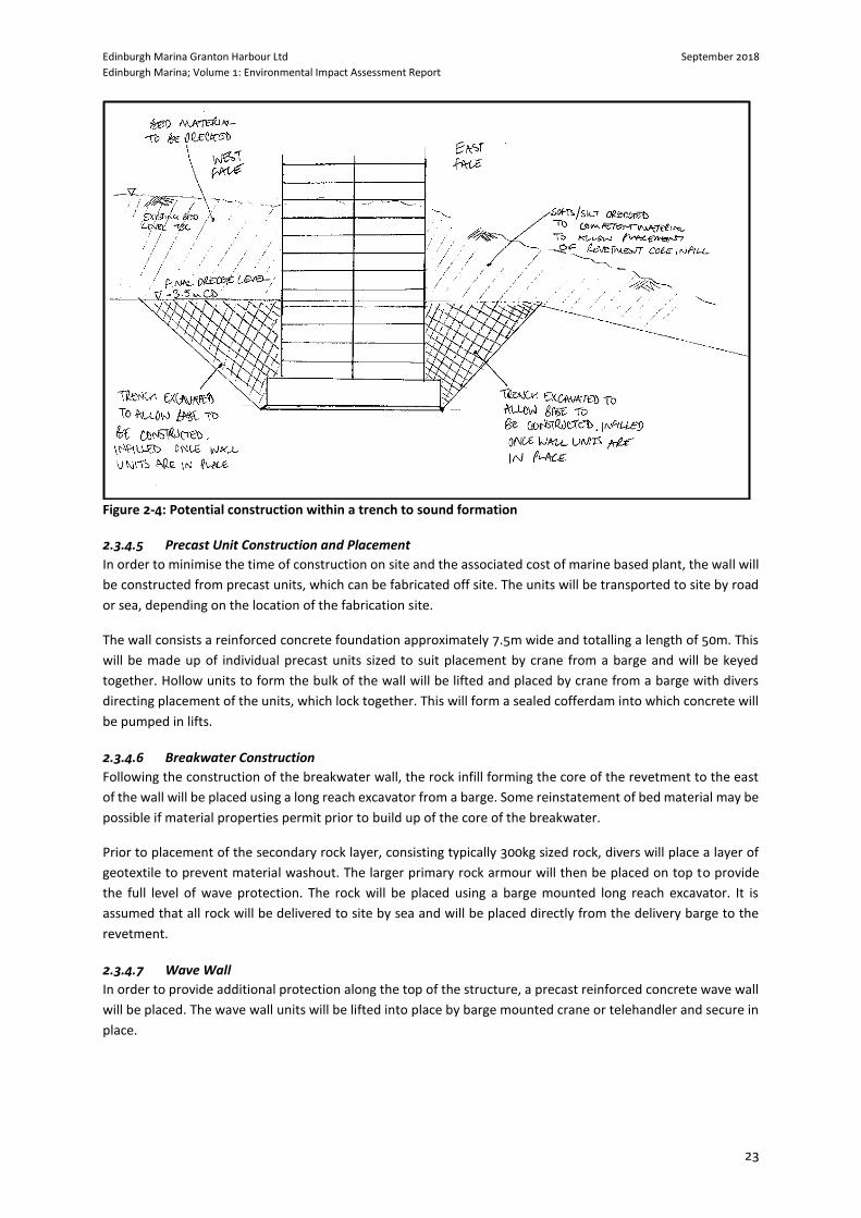
The wall of the breakwater is expected to be founded approximately 4.5m below final dredge level subject to
geotechnical investigation and design. A trench will be excavated from the dredge level to the base formation
level with sloped sides of a gradient dependent on the geotechnical properties of the bed material. Figure 2.4
below represents this construction phase.
A 250mm thick layer of Type 1 material will be placed on the base of the excavation and then levelled to allow
placement of the reinforced concrete foundation units. These solid units provide a solid and stable foundation
from which the wall can be supported. Divers will be employed to direct the placement and levelling of the units.
Once placed, a local bathymetric survey will be undertaken to confirm the base is at the correct level to receive
the precast units making up the wall.
Edinburgh Marina Granton Harbour Ltd September 2018
Edinburgh Marina; Volume 1: Environmental Impact Assessment Report
23
Figure 2-4: Potential construction within a trench to sound formation
2.3.4.5 Precast Unit Construction and Placement
In order to minimise the time of construction on site and the associated cost of marine based plant, the wall will
be constructed from precast units, which can be fabricated off site. The units will be transported to site by road
or sea, depending on the location of the fabrication site.
The wall consists a reinforced concrete foundation approximately 7.5m wide and totalling a length of 50m. This
will be made up of individual precast units sized to suit placement by crane from a barge and will be keyed
together. Hollow units to form the bulk of the wall will be lifted and placed by crane from a barge with divers
directing placement of the units, which lock together. This will form a sealed cofferdam into which concrete will
be pumped in lifts.
2.3.4.6 Breakwater Construction
Following the construction of the breakwater wall, the rock infill forming the core of the revetment to the east
of the wall will be placed using a long reach excavator from a barge. Some reinstatement of bed material may be
possible if material properties permit prior to build up of the core of the breakwater.
Prior to placement of the secondary rock layer, consisting typically 300kg sized rock, divers will place a layer of
geotextile to prevent material washout. The larger primary rock armour will then be placed on top to provide
the full level of wave protection. The rock will be placed using a barge mounted long reach excavator. It is
assumed that all rock will be delivered to site by sea and will be placed directly from the delivery barge to the
revetment.
2.3.4.7 Wave Wall
In order to provide additional protection along the top of the structure, a precast reinforced concrete wave wall
will be placed. The wave wall units will be lifted into place by barge mounted crane or telehandler and secure in
place.

Edinburgh Marina Granton Harbour Ltd September 2018
Edinburgh Marina; Volume 1: Environmental Impact Assessment Report
26
Accordingly, no alternative location was considered viable and was considered within this EIAR.
2.4.2.3 Alternative Development Components and Methods
Design evolution has occurred throughout project inception, which allows examination of alternatives within
this. Key design changes or selected options include:
Disposal and Recycling/Re-use options;
North Mole Design
Pontoon Berths
2.4.3 Dredge Disposal and Re-use
The proposed disposal routes for dredge materials are to be split with 37% of the total volume considered for
sea based disposal subject to agreement and the remaining 63% to be brought to land for a land based disposal
option.
Since the material below 1.2m is not considered suitable for a sea based disposal it will need to come to land for
disposal. As such the material will be subject to land based re-use or disposal. These activities will be undertaken
under appropriate SEPA licenses with respect to waste regulation. Initially it is proposed that the dredge arisings
are brought onto the Granton development site for dewatering and stockpiling, prior to subsequent re-use
and/or land based disposal.
Edinburgh Marina Granton Harbour Ltd September 2018
Edinburgh Marina; Volume 1: Environmental Impact Assessment Report
27
3 EIA METHODOLOGY AND SCOPING
3.1 Introduction
The purpose of an EIA is to identify and evaluate the likely significant effects of a proposed development on the
environment and to identify measures to mitigate or manage any significant adverse effects before a planning
application is determined. The EIA process provides an opportunity to ‘design out’ adverse effects wherever
possible. Where adverse effects cannot be designed out, mitigation measures can be proposed to avoid,
compensate or reduce significant environmental effects to an acceptable level. EIA is an iterative process which
allows feedback from stakeholder consultation and the results from baseline studies to be fed into the design
process of the proposed development.
As the proposed development contains elements which are below Mean High Water Spring (MHWS), consents
will be required from Marine Scotland under the Marine EIA Regulations.
In determining the requirement for an EIA, Schedule 1 of the Marine EIA Regulations sets out the types of
development for which EIA is a mandatory requirement, whilst Schedule 2 lists the projects where the need for
EIA is judged on a case-by-case basis, depending on whether a proposal is likely to cause significant
environmental effects or is located in a sensitive area as defined by the EIA Regulations.
In this instance, the proposed development is considered to constitute Schedule 2 development as defined by
the EIA Regulations as it falls under paragraphs 1(e), 10(m) and 12(a) (of both marine and onshore 2017 EIA
Regulations), which state the following:
Paragraph 1(e) -“Reclamation of land from the sea”;
Paragraph 10(m) -“Coastal work to combat erosion and maritime works capable of altering the coast
through the construction, for example, of dykes, moles, jetties and other sea defence works, excluding
the maintenance and reconstruction of such works”; and
Paragraph 12(a) - “marinas with an area of enclosed water surface exceeding 1,000m2”.
By virtue of its nature, size and location, the proposed development could potentially have (if unmitigated)
significant adverse effects on the environment. The proposed development has been subject to a Screening
Decision by Marine Scotland, and due to the size and potential impacts generated by the proposed development
EIA will be required. Schedule 4 of the EIA Regulations specifies the information that should be included in an
EIAR, and this chapter discusses where and how the EIAR meets the requirements of the EIA Regulations and the
scoping exercise.
3.2 General EIA Methodology
Whilst each environmental topic discussed within the EIAR establishes its own methodology based upon good
practice and relevant industry guidance, there is a basic methodological framework which is applied to EIA
chapters.
This EIAR identifies, describes and assesses the likely significant impacts and their effects of the proposed
development on the environment, both direct and indirect. The EIA process involves the following key stages:
Edinburgh Marina Granton Harbour Ltd September 2018
Edinburgh Marina; Volume 1: Environmental Impact Assessment Report
28
Baseline Studies – identification of existing environmental conditions through review of existing
information, monitoring and field studies as required, to provide a baseline against which to assess the
likely impacts of the proposed development;
Potential impacts – identification of potential impacts and their resulting effects across the construction
and operational phase (decommissioning of the proposed development itself is inappropriate to the
proposed development), in relation to the design mitigation already implemented and where applicable,
taking alternatives into account;
Significance Assessment – evaluation of the effects, resulting from the identified potential impacts, to
determine their significance, both positively and negatively, and incorporating cumulative effects;
Mitigation and Monitoring – the identification of measures to avoid, reduce or compensate likely
significant effects and the steps taken to monitor these potential environmental effects; and
Residual Effects – identification of residual effects assuming successful implementation of mitigation.
For consistency where possible, the same headings have been used within the technical sections of this EIAR.
3.3 EIA Regulations 2017
As the proposed development is seeking consent under the Marine EIA Regulations and the Scoping process was
commenced after the date the new Regulations were adopted, 16th May 2017, the 2017 Regulations supersede
the 2011 Regulations across all elements of this project.
Following guidance set out in the Scottish Government’s Planning Advice Note 1/2017, this EIAR follows the
amendments and additions to the EIA Regulations. Notable additions to the EIA Regulations include:
The requirement for the EIA to be based upon the Scoping Opinion which was provided (Regulation
6(3));
A requirement to consider a comparison of environmental effects when considering alternatives
(Regulation 6(2) (d));
A replacement of the environmental factors to be considered as been amended from ‘human being’ to
‘population and human health’, and ‘flora and fauna’ replaced by ‘biodiversity’ (Schedule 4(4)).
Discussion of the relevant baseline and predicted evolution of that baseline in the absence of the
proposed development (Schedule 4(3));
Cumulative assessment should take place in relation to existing and/or approved development
(Schedule 3(1)(b)); and
The requirement for a Competent Authority (i.e. Marine Scotland) to include a ‘reasoned conclusion’ on
the significant effects upon the environment within the Decision Notice published (Regulation 23(2)).
This EIAR discusses each of these points in turn within the relevant assessments, where applicable. It is the aim
of the EIAR to allow sufficient information to allow both Competent Authorities to meet a ‘reasoned conclusion’
on the significance of effects.
3.4 The EIA Process
3.4.1 Sensitivity/Importance of Receptors
The sensitivity of the baseline conditions/receptors was defined according to the relative importance of existing
environmental features on or in the vicinity of the site, or by the sensitivity of receptors which would potentially
be affected by the proposed development.
Edinburgh Marina Granton Harbour Ltd September 2018
Edinburgh Marina; Volume 1: Environmental Impact Assessment Report
29
Criteria for the determination of sensitivity (e.g. high, medium or low) or of importance (e.g. international,
national, regional or authority area) were established for each topic assessment based on prescribed guidance,
legislation, statutory designation and/or professional judgement. The criteria for each environmental parameter
are provided in the relevant specialist chapters of this EIAR and may differ between technical topics dependent
upon guidance which defines that approach (e.g. Chartered Institute of Ecology and Environmental
Management).
3.4.2 Magnitude of Impact/Change
The methods for predicting the nature and magnitude of potential impacts vary according to the subject area.
Quantitative methods of assessment can predict values that can be compared against published thresholds and
indicative criteria in Government guidance and standards. However, it is not always possible to ascribe values to
environmental assessments and therefore qualitative assessments are used. Such assessments rely on previous
experience and professional judgement. The methodologies used for assessing each topic area are described
within the specialist chapters of this EIAR.
In general terms, the magnitude of impact on environmental baseline conditions was identified through detailed
consideration of the proposed development, taking due cognisance of any legislative or policy standards or
guidelines, and/or the following factors:
The degree to which the environment is affected, e.g. whether the quality is enhanced or impaired;
The scale or degree of change from the existing situation;
Whether the impact is temporary or permanent, indirect or direct, short-term, medium-term or long-
term; and
Any in-combination effects and potential cumulative effects.
In some cases the likelihood of impact occurrence may also be relevant and, where this is a determining feature
of the assessment, this is clearly stated.
3.4.3 Significance of Effect
Significant effects are predicted where important resources, or numerous or sensitive receptors, could be subject
to impacts of considerable magnitude. Effects are unlikely to be significant where low value or non-sensitive
resources are subject to minor effects.
The criteria for determining the significance of an effect has been developed giving due regard to the following,
where applicable;
Sensitivity, importance or value of the resource or receptor;
Extent and magnitude and duration of the impact; and
Performance against environmental quality standards.
The criteria and assessment methodology used for each topic considered within this EIAR are set out within the
‘Methodology’ section of the respective EIAR chapter.
Unless otherwise stated, reported effects are considered to be adverse. It is however possible that some effects
may be positive and these are stated and explained where appropriate.
The EIAR reports on the significance of the environmental effects as per the EIA Regulations. Although a
significant effect does not always have to equate to an unacceptable effect, in order to ensure impartiality the
Edinburgh Marina Granton Harbour Ltd September 2018
Edinburgh Marina; Volume 1: Environmental Impact Assessment Report
30
EIAR does not comment on acceptability. The Planning Statement which accompanies this application (but is
separate to the EIA process) makes a judgement on the acceptability of significant effects.
3.4.4 Design Mitigation and Residual Effects
There is a widely accepted strategy for mitigation outlined in Planning Advice Note (PAN) 1/2013 (and continued
within Planning Circular 1/2017) which has been followed when considering the environmental effects of the
proposed development. This comprises (in order of preference): avoidance, reduction and offsetting. Through
the evolution of the design, the Applicant has sought to identify appropriate mitigation measures and strategies
as part of the proposed development.
Design mitigation is integral to providing an environmentally robust development whereby suggestions for
mitigation have been taken into the design prior to ‘design freeze’. This in-built mitigation represents, where
applicable, environmental good practice and places a responsibility upon the Applicant to provide
environmentally sustainable design solutions. Design rationale is further discussed within the Design and Access
Statement which accompanies the wider application, along with a section within each EIAR chapter that
comments on design mitigation incorporated into the development, and therefore individual assessments,
before assessment is carried out. Therefore, where design mitigation has been employed, the impact assessment
is carried out with this design mitigation in place as it forms a constituent part of the proposed development.
Residual effects are generally then the effects that follow the assessment of proposed development with design
incorporated.
Where complete avoidance of significant effects was not feasible during refinement of the site design, additional
measures are identified in the relevant specialist chapters to reduce or offset effects where practical to do so. If
no design mitigation has been identified, the assessment assumes no design mitigation and therefore effects are
prior to any mitigation.
Residual effects of the proposed development are those that remain, assuming successful implementation of the
identified mitigation measures. All remaining effects of the proposed development, following the application of
mitigation measures, are summarised clearly and their significance stated, within the ‘Residual Effects’ section
of each specialist chapter.
Where applicable, the EIAR also reports measures for enhancement which would be enshrined by
planning/marine licence condition.
3.4.5 Cumulative Effects
Consideration of cumulative effects is a requirement of the EIA Regulations. By definition these are effects that
result from incremental changes caused by past, present and reasonably foreseeable actions together with the
proposed development. There are different types of cumulative effects (such as in-combination and sequential
effects) and typically cumulative impact assessment is a key part of the EIA process which are assessed
throughout each chapter. The sites which are incorporated into cumulative assessment are clearly highlighted
within each technical chapter.
Cumulative assessment was discussed within the EIA Scoping Opinions issued by Marine Scotland. Phasing of the
terrestrial elements of the wider Granton Waterfront Development are currently unknown. Granton Central
Development Ltd has recently submitted (March 2018) a planning application (reference 18/01428/PPP) under
section 42 of the Planning Act 1997 to amend condition 1 of outline permission 01/00802/OUT. The applicant
wishes to extend the time period for submitting applications for the approval of matters specified in conditions
by 5 years to 23 June 2023. Refer to Chapter 7, for fuller discussion of cumulative Effects
Edinburgh Marina Granton Harbour Ltd September 2018
Edinburgh Marina; Volume 1: Environmental Impact Assessment Report
31
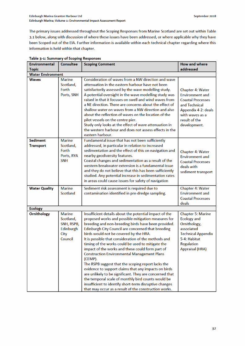
3.5 Screening and Scoping as part of the EIA Process
Schedule 1 of the Marine EIA Regulations lists developments for which an EIA must be undertaken where there
are likely to be significant effects on the environment by virtue of factors such as the nature, size or location of
a proposed development. Given the size and scale of the proposed development, the Applicant made the
decision to seek an EIA Screening Opinion and Scoping Opinion.
The sections below therefore sets out the EIA Screening and Scoping process and accordingly documents how
the EIAR was shaped into what is currently included and offers rationale to why other topics have been excluded,
based on the likelihood of likely potential significant effects.
3.5.1 Screening Requests and Responses
An initial Screening Request was submitted by Cameron Planning for a Marine Licence application for the Marina
Development and associated works (letter dated 16th August 2017). Planning permission was first granted for
the mixed use regeneration of the Granton Harbour area by City of Edinburgh Council in 2003, reference
01/00802/OUT. The planning permission included the formation of a new marina within Granton Harbour and
included in the approved works the formation of new quay walls, associated sheet piling and dredging of the
harbour. A subsequent Matters Specified in Condition (MSC) planning permission was granted pursuant to the
original parent permission in April 2017 for, “the formation of a new Marina Office with associated retail and
café space, and new community boat yard with associated dry stack”, reference 16/04409/AMC Marine Scotland
provided an initial Screening Opinion on the 16th October 2017 and concluded an EIA must be carried out in
respect of the proposed works.
The proposed marine works associated with the Granton Harbour development comprise:
Length of stone revetment to harbour;
Length of vertical quay wall to harbour;
Backfilling of land protected by quay wall and stone revetment;
Formation of marina;
Extension to existing north mole breakwater; and
Harbour dredging.
EnviroCentre prepared a second Screening Request on the 28th November 2017, submitted by Cameron Planning,
which re-screened and provided additional environmental information regarding the proposed works. A
Screening Opinion, dated 5th February 2018 determined that the proposed works could potentially have
significant effect on the environment and as such, an EIA would be required.
3.5.2 Scoping Requests and Responses
A request for a formal Scoping Opinion was submitted to Marine Scotland on 10 April 2018 under Part 4 (14), of
the EIA Regulations. This was accompanied by an EIA Scoping Report provided to assist the Marine Scotland and
statutory and non-statutory consultees to form an opinion upon the likelihood of potentially significant
environmental effects and hence the topics to be assessed in the EIA (i.e. those topics where significant
environmental effects could potentially result if unmitigated). The Scoping Report also provided an opportunity
for consultees to comment upon suggested methodologies for technical assessment.
A Scoping Opinion was provided by Marine Scotland dated 14 June 2018 and is included within Technical
Appendix 3.1 of this EIAR.

Edinburgh Marina Granton Harbour Ltd September 2018
Edinburgh Marina; Volume 1: Environmental Impact Assessment Report
34
For clarity, air quality, noise, Flooding cultural heritage and Landscape & Visual have been scoped out of EIA
assessment.
A sediment risk assessment has not been included as requested by the scoping opinion, as much of the dredge
material is now being disposed of on land, and following consultation with Marine Scotland they are satisfied
that the assessments carried out are sufficient and a full sediment risk assessment is not required.
The chapters which are scoped in are supported by technical assessment reports where necessary and which
comprise Volume 3: Technical Appendices of the EIAR. Those environmental topics which are not considered at
EIA level given the either the level of project information available at this stage, or based upon an unlikely event
of significant effects, are included for information within Chapter 6: Other Issues. This includes discussion of
human health and population, navigation, air quality, terrestrial noise, natural disasters and major disasters.
Chapter 7 addresses cumulative effects.
The EIAR also contains chapters on the schedule of mitigation associated with the EIA (Chapter 8) and a brief
chapter (Chapter 9: Conclusions) which summarises the EIA and contains a statement of significance.
Edinburgh Marina Granton Harbour Ltd September 2018
Edinburgh Marina; Volume 1: Environmental Impact Assessment Report
39
The Environmental Impact Assessment (Miscellaneous Amendments Relating to Harbour, Highways
and Transport) Regulations 2017
4.3.3 Relevant Guidance
Guidelines for Water Pollution Prevention from Civil Engineering Contracts;
Pollution Prevention Guidance 1 (PPG): General guide to the prevention of pollution;
PPG3: Use and design of oil separators in surface water drainage systems (to be read in conjunction
with ‘Oil Separator Manufacturers – Version 7 – November 19th 2007);
PPG 6: Working at construction and demolition sites;
PPG 7: Refuelling facilities;
PPG 18: Managing for water and major spillages;
PPG 22: Incident response – dealing with spills;
PPG26: Storage & handling of drums & intermediate bulk containers;
Guidance for Pollution Prevention (GPP) 2: Above ground oil storage tanks;
GPP 5: Works and maintenance in or near water;
GPP 8: Safe storage and disposal of used oils;
GPP 21: Pollution incident response planning;
WAT-SG-26: Good Practice Guide – Sediment Management;
WAT-SG-29: Good Practice Guide – Construction Methods;
The Green Guide For Marinas;
The Green Guide to Pump Out Systems;
The Green Guide to Boat Washdown Systems; and
CIRIA C753 – The SuDS Manual.
4.4 Methodology
4.4.1 General
The assessment follows standard EIA procedures which include:
Desk based review of the design of the proposed development in relation to the local water
environment and coastal processes;
Consultation with key stakeholders to obtain relevant information and to ensure their concerns are
addressed within the study;
Establishing the existing baseline conditions:
o Review topography and ground conditions at the site and environs;
o Review of hydrology, catchment characteristics, and water quality conditions;
o Review of coastal processes including bathymetry, tidal levels, river and tidal flow currents, wave
action, bed sediment type and distribution, sediment transport and deposition, geology;
o Wave modelling study to establish baseline and design conditions (Technical Appendix 4.2 within
Volume 3); and
o Reporting of baseline conditions to provide a basis for assessment of the potential impact.
Impact Assessment:
o Identification of sensitive receptors and environmental constraints;
o Identification of potential impacts;
o Assessment of impact magnitude;
o Identification and assessment of mitigation measures to reduce or avoid any potential impacts of
the proposed development; and
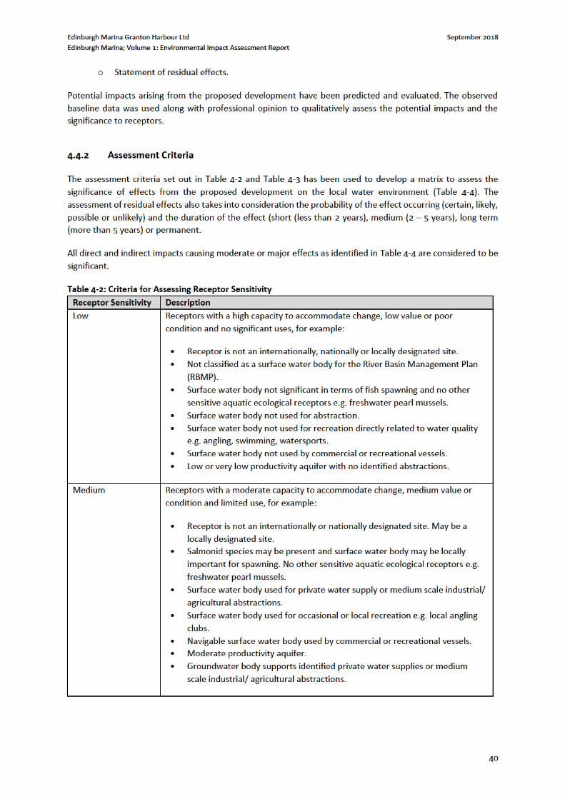
Edinburgh Marina Granton Harbour Ltd September 2018
Edinburgh Marina; Volume 1: Environmental Impact Assessment Report
42
4.5 Baseline
4.5.1 Site Description
Granton Harbour is located on the south coast of the Firth of Forth, around 2km west of Leith as shown in Figure
770288-001, Volume 2 of the EIAR. The harbour has two basins, referred to as the western and eastern harbours,
these are formed by two breakwaters, known as the western and eastern breakwaters, separated by a large
central pier. All of these key elements of harbour infrastructure were constructed between 1830 and 1870.
The western harbour has been historically (post-1945) partially infilled and is now of significantly smaller extent
than the eastern harbour. The eastern harbour is used for yacht mooring, including on pontoons installed along
the eastern face of the central pier. Intertidal mudflats are present in the southern part of the eastern harbour.
The proposed development site is located in the western harbour and entrance channel as shown in Drawing No.
A-P-00-G7-007 Rev Z-5H, Volume 2 of the EIAR.
Granton Harbour has been subject to varying dredge regimes since construction. The admiralty chart from 18605
indicates water depths in the navigation channel of between 2.8 – 3.2m, which would correspond to around -2
to -2.5mCD. During the 1930s the navigation channel and berths were dredged to around -7mCD (around -
10mOD). More recently dredging has been undertaken by the two sailing clubs which use Granton Harbour to
ensure access at all states of tide to the berths in the eastern harbour.
4.5.2 Designated Areas
Designated areas within 5km of the proposed development include (refer to Chapter 5 and Drawing No.
770003-008, Volume 2 of the EIAR, and include:
Firth of Forth Special Protection Area (SPA), Ramsar Site, and Site of Special Scientific Interest (SSSI);
Forth Islands (SPA).
Within Granton Harbour the SPA Ramsar Site and SSSI designation protected features fall into three groups,
birds, wetlands and geodiversity, associated with the intertidal mudflats and coastline bedrock on the southern
margin of the eastern harbour. The designations are also associated with the coastline to the east of the eastern
breakwater, and west of the western breakwater. The proposed development is not within any of these
designated areas.
The geodiversity protected feature in this location is Arthropoda (excluding insects & trilobites), fossils present
within the local bedrock.
Further details of designated areas are presented in the Habitats Regulations Appraisal (HRA), Technical
Appendix 5-4, Volume 3 of the EIAR, and within Chapter 5 of the EIAR.
4.5.3 Bathymetry
A multi-beam bathymetric survey of Western Granton Harbour was undertaken by Aspect Land & Hydrographic
Surveys Ltd on 19th May 2017. The existing dredging regime maintains access to the harbour, resulting in a
deeper access channel extending from the western breakwater tip at the harbour mouth, towards the central
pier. Existing bathymetry within this channel ranges in depth between 3 and 4 metres below chart datum. The
bathymetry shallows into both the eastern and western harbours. The western harbour bed lies at levels
5 National Library of Scotland: https://maps.nls.uk/geo/explore/#zoom=15&lat=55.9856&lon=-3.2247&layers=101942630&b=1
Edinburgh Marina Granton Harbour Ltd September 2018
Edinburgh Marina; Volume 1: Environmental Impact Assessment Report
43
generally below chart datum with limited intertidal areas present, whilst the eastern harbour has significant
intertidal areas above chart datum. The bathymetric survey is further described in Technical Appendix 4-1,
Volume 3 of the EIAR.
4.5.4 Geology and Sediment
Granton Harbour is underlain by sedimentary bedrock cycles (sandstones and mudstones) of the Gullane
Formation. These rocks were formed in the Carboniferous Period in a coastal setting (swamps, estuaries and
deltas)6.
Within the western harbour sub-tidal sediment predominantly consists of silts (Technical Appendix 4-3, Volume
3 of the EIAR), whilst the narrow intertidal harbour fringe is coarser material derived from historic infill associated
with land reclamation. Previous site investigations indicate that silt deposits within the harbour are underlain by
glacial till, the top of which was found to occur between -5.5mOD and -6.5mOD (-8.4mCD and -9.4mCD). Bedrock
(as described above) is found at varying depths below the glacial till deposits (up to -20mOD or -22.9mCD).
Within the eastern harbour sub-tidal sediment also predominantly consists of silts. The eastern harbour has not
been subject to land reclamation processes and exhibits significant intertidal extents, with silt again the dominant
sediment. Dredging has been historically undertaken within Granton Harbour, most recently for access to the
eastern face of the central pier.
A narrow coastal fringe of sandy beach deposits are present along the eastern harbour southern shoreline, with
bedrock outcrops associated with the SSSI designation (see section 4.5.2), consistent with the coastline
immediately to the east of the harbour, and representative of the pre-harbour coastal sediment character.
4.5.5 Hydrology and Hydrogeology
A review of Ordnance Survey mapping for the site indicates that there are no fresh-water inflows to the harbour,
and no watercourses in the immediate vicinity. A pond is associated with recent development on reclaimed land
in the former western harbour.
British Geological Survey (BGS) mapping shows Granton Harbour to be underlain by a multi-layered moderately
productive aquifer. The aquifer will yield up to 10l/s locally through fracture flow7.
4.5.6 Water Quality, Sediment Quality and Water Body Status
The coastal waters of the Firth of Forth at Granton Harbour are classified under the Water Framework Directive
(WFD) monitoring programme as a coastal waterbody. The waterbody is classified as being of overall ‘Good’
status in 2016, with an overall chemistry status of ‘Pass’, and a hydromorphological status of ‘Good’.
Sediment quality within the subtidal silt of the western harbour has been assessed during a recent sampling
exercise as part of the Best Practicable Environmental Option (BPEO) report (Technical Appendix 4-3, Volume 3
of the EIAR). ). Sediment cores were collected at 11 locations, producing a total of 31 samples for chemical
analysis. All 31 samples exceed Marine Scotland Revised Action Level 1 (RAL1) levels for certain contaminants
including metals, Tributyl Tin (TBT), Polyaromatic Hydrocarbons (PAHs), Polychlorinated Biphenyls (PCB) and
Total Hydrocarbons (THC). Additionally 13 of the 31 samples recorded mercury levels above RAL2. Contaminated
sediment is located at depth, associated with historical deposition, whilst recently deposited sediment towards
the surface is considered to be ‘clean’.
6 British Geological Survey 1:50,000 scale geology: http://mapapps.bgs.ac.uk/geologyofbritain/home.html 7 BGS. Geoindex Onshore: http://mapapps2.bgs.ac.uk/geoindex/home.html
Edinburgh Marina Granton Harbour Ltd September 2018
Edinburgh Marina; Volume 1: Environmental Impact Assessment Report
45
conditions originating from the outer firth and North Sea. Modelling results indicate that the worst conditions
are expected from the north-east (45 – 90°N wind direction and a 90 – 225°N wave direction), whilst the
assessment has also considered wave action generated over a smaller fetch from the north-west. Model results
indicate that during a 1 in 200 year storm event from the north-east, a significant wave height of 3.2m with peak
period of 7.2s would be a representative wave condition approaching the harbour mouth (see Figure 3.6,
Technical Appendix 4.2, Volume 3 of the EIAR).
Given the orientation of the breakwaters and harbour mouth, the eastern harbour is more sheltered and subject
to less significant wave action than the western harbour during storm conditions. Wave action is most significant
at the harbour mouth, reducing further into the more sheltered waters of the harbour.
4.5.10 Sediment Processes
On the southern shore of the Firth of Forth wave action drives a net western longshore transport of beach
sediment. However, in the vicinity of the site the eastern breakwater of Granton Harbour acts as a barrier to
westward transport of beach material. This results in a deficit of material to the west of Granton Harbour. Fine
material transported in suspension into Granton Harbour settles out within the low energy environment of the
harbour, creating intertidal mudflats as evident in the eastern harbour10. Re-suspension of finer material occurs
with tidal currents, and during periods of wave activity.
Sediment deposition rates are observed to be greatest in recently and historically dredged areas, whilst gradual
accumulation occurs elsewhere, including within the SSSI designated area of the eastern harbour. Comparison
of recent bathymetric survey from 2017 (see section 4.5.3) with an earlier survey dating from 2003 indicates that
deposition depths within the western harbour over a 14 year period range between 2 and 4.5 metres. The
greatest deposition depths are observed to have occurred within the deeper dredge pockets, associated with the
main navigation channel, historic berths associated with the former Esparto Wharf to the north, and the Middle
Pier to the south. Based on the observed deposition depths it is suggested that sedimentation rates within the
western harbour can range from 0.14 to 0.32 metres per year, with sedimentation rate a function of water depth.
Review of the Dynamic Coast: Scotland’s Nation Coastal Change Assessment (NCCA) indicates that the coastline
in the vicinity of the site is stable, with no significant erosion or deposition identified from historic mapping, and
significant change in the local coastline since 1890 is limited to land reclamation within the western harbour11.
However, as outlined above, the presence of the Granton Harbour breakwaters prevents the westward transport
of beach material, and therefore there is a deficit of sediment supply further west. It can be expected that some
local erosion will occur as a result of this supply deficit where preventative engineering measures are not present.
Evidence of such erosion can be observed at the small beach to the west of General’s Rock.
4.5.11 Flood Risk
A review of Ordnance Survey mapping for the site indicates that there are no fresh-water inflows to the harbour,
and no watercourses in the immediate vicinity. A pond is associated with recent development on reclaimed land
in the former western harbour. The SEPA Flood Risk Management Maps show the site is not at risk of fluvial or
surface water flooding.
10 Ramsay, D. L., & Brampton, A. H. (2000). Coastal Cells in Scotland: Cell 1 - St Abb’s Head to Fife Ness (No. RSM No 143). SNH. 11 The Scottish Government (2017). Dynamic Coast: Scotland’s National Coastal Change Assessment. Retrieved from http://www.dynamiccoast.com/webmap.html
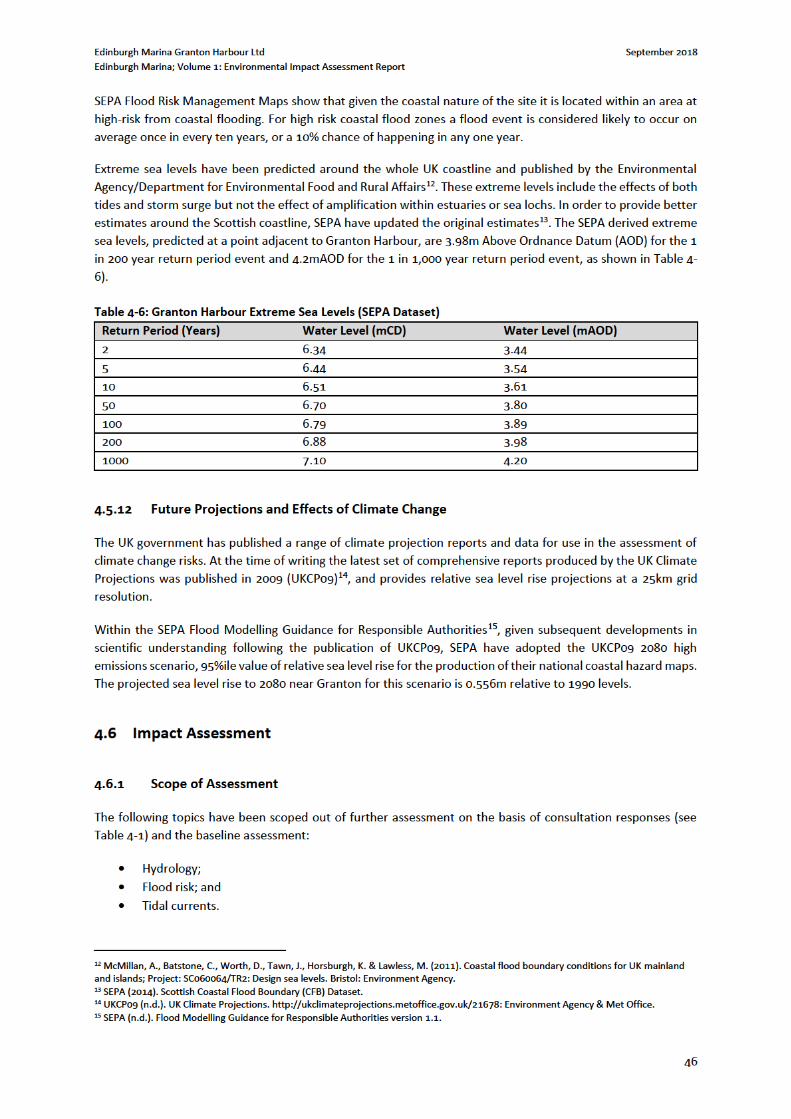
Edinburgh Marina Granton Harbour Ltd September 2018
Edinburgh Marina; Volume 1: Environmental Impact Assessment Report
48
The potential interactions between water environment impacts and ecology are assessed within Chapter 5:
Marine Ecology.
The following sections consider the potential impacts and provide an assessment of likely level of significance.
4.6.5 Construction Phase
The potential impacts identified are assessed under the following headings:
Water and sediment quality;
Wave climate; and
Sediment transport.
The degree of potential environmental impact is provided as appropriate.
4.6.5.1 Water and Sediment Quality
Sediment Discharge and Dispersion from Dredging Works
The proposed dredging works could potentially cause plumes of suspended solids and a reduction in water
quality with a resultant impact on aquatic life.
As outlined in section 0 and Technical Appendix 4-3, Volume 3 of the EIA, the sampling information available
indicates that the bed sediments within the proposed dredge pocket consist of silts. As highlighted in section 0,
and Technical Appendix 4-3, Volume 3 of the EIA, contaminated sediment is present within the proposed dredge
pocket. The key contaminants with potential to impact water quality are considered to be metals as these have
the potential to dissolve/desorb from sorption sites, whereas the organic contaminants (PAHs and PCBs) have a
greater affinity for the organic materials which they are bound to, and are more likely to remain strongly bound
to the sediment, or if they become dissolved, quickly adsorbed onto organic matter. Although there are
contaminants of concern, it is considered that the levels will not contribute to an overall degradation of water
quality as the potential for dilution in the Firth of Forth is very considerable.
The key potential impact is considered to be an increase in turbidity/suspended solids during the dredging
activity and during disposal, although this is likely to cause localised degradation in water quality, it is considered
that this will be a short term, localised event.
Overall it is considered that prior to mitigation the magnitude of impact of sediment discharge and dispersion
from dredging works will be low within the dredge area and immediate surrounds.
Pollution Incidences
During construction there is a risk of accidental pollution incidences affecting the water environment (i.e. coastal
waters and sediment) from the following sources:
Spillage or leakage of oils and fuels stored on site;
Spillage or leakage of oils and fuels from construction machinery or site vehicles;
Spillage of oil or fuel from refuelling machinery on site;
Suspended solids from construction works; and
The use of concrete and cement in construction works.
The main risk is considered to be posed by refuelling activities. Oil or fuel spillages to the water environment
would be detrimental to water/sediment quality and could affect fauna and flora. Concrete (specifically the
cement component) is generally highly alkaline and any spillage to the water environment and/or soils could be
Edinburgh Marina Granton Harbour Ltd September 2018
Edinburgh Marina; Volume 1: Environmental Impact Assessment Report
49
detrimental to water/sediment quality, fauna and flora. Suspended solids generated during construction works
could lead to an increase in turbidity and resultant degradation in water quality.
The effect of the potential pollution incidences during construction on water quality would be dependent on the
scale and nature of the incident, therefore the magnitude of impact prior to mitigation may range from low to
high.
4.6.5.1 Wave Climate
The proposed development, including the capital dredge requirement, could result in alterations to the local
wave climate within Granton Harbour, and immediate surrounds of the Firth of Forth. A wave modelling study
has been undertaken by DHI (UK) Ltd, involving both Spectral and Boussinesq wave modelling using the MIKE by
DHI software platform, to assess existing wave conditions within Granton Harbour, and look at the impact of the
development proposals (Technical Appendix 4.2, Volume 3 of the EIAR).
As outlined in Section 4.5.9, the proposed development site is exposed to wave penetration during storm events,
particularly waves generated over a large fetch from the outer firth to the north-east. Lower magnitude waves
generated over a shorter fetch to the north-west can also penetrate Granton Harbour.
The wave disturbance modelling undertaken for the proposed construction indicates that the new breakwater
will result in a reduction in significant wave height within the western harbour of up to -1m compared with
existing conditions during a 1 in 50 year storm event from the north-east (see Figure 4.5, Technical Appendix 4.2,
Volume 3 of the EIAR). Smaller reductions in significant wave height (-0.1 to -0.5m) are predicted in the vicinity
of the middle pier, whilst negligible change is predicted within the eastern harbour (-0.1 to +0.1m). Immediately
outside the Granton Harbour entrance modelling indicates that wave reflection from the new breakwater will
produce minor increases in significant wave height during a 1 in 50 year storm from the north-east. During a 1 in
1 year storm event from the north-east a similar pattern of impact, but of lower magnitude, is observed for all
areas of the harbour (see Figure 4.6, Technical Appendix 4.2, Volume 3 of the EIAR).
Wave disturbance modelling of storm events from the north-west has also been undertaken to assess the impact
of the proposed breakwater. During a 1 in 50 year storm event from the north-west the modelling results indicate
that the breakwater construction will result in slight reductions in significant wave height within both the western
(-0.05 to -0.3m) and eastern (-0.05 to -0.1m) harbours as a result of attenuation of wave energy (see Figure 4.9,
Technical Appendix 4.2, Volume 3 of the EIAR). The breakwater will produce a slight increase in significant wave
height within the approaches to the harbour as a result of wave reflection. During a 1 in 1 year storm event from
the north-west a similar pattern of impact, but of lower magnitude, is observed for all areas of the harbour (see
Figure 4.10, Technical Appendix 4.2, Volume 3 of the EIAR).
The wave modelling study (Technical Appendix 4.2, Volume 3 of the EIAR) makes several recommendations in
relation to possible further modelling and design refinement. These recommendations include clarification that
the modelling undertaken has not parameterized the floating pontoons, but highlighting that it is anticipated
that the presence of a floating pontoon grid will further reduce wave height in the area of interest. It is noted
that any future upgrades of the middle pier should take into account the potential impact on the proposed
marina through wave reflection. The study highlights that alternative breakwater designs including an extended
breakwater length would further reduce wave activity and produce improved conditions within the proposed
marina. It is stated that further refinement of the pontoon layout, and/or berthing arrangements, could improve
conditions for occupants during periods of increased wave activity. It is however considered that these
recommendations do not impact this assessment. This assessment has considered impact relating to the
proposed development, whilst the recommendations relate to alternative designs, possible future works, and
operational mitigation.
Further details of the wave modelling methodology and results is presented within Technical Appendix 4.2,
Volume 3 of the EIAR.
Edinburgh Marina Granton Harbour Ltd September 2018
Edinburgh Marina; Volume 1: Environmental Impact Assessment Report
50
Overall, the impact of the proposed development on the wave climate within Granton Harbour is considered to
be of negligible magnitude.
4.6.5.2 Sediment Transport
Coastal sediment transport is driven by wave action and tidal currents. As outlined in section 4.5.10, the existing
Granton Harbour breakwaters form a barrier to the westward longshore transport of beach sediment, whilst fine
sediment (silt) is transported in suspension into the harbour. Silt drops out of suspension within the sheltered
waters of the harbour, with significant intertidal deposits particularly apparent in the eastern harbour.
Deposition rates within the harbour are considered to be a function of water depth, with higher rates of
deposition observed in deeper berths.
The proposed development is limited to the western harbour, and extension of the western breakwater further
into Granton Harbour. Given that the development is confined to the existing sheltered extents of Granton
Harbour, and will therefore not extend out further into the Firth of Forth, it is considered that there will be no
significant impacts to tidal currents out with the harbour. Additionally, the proposed alignment of the breakwater
extension maintains the existing harbour entrance width, and connectivity with the eastern harbour, whilst the
proposed dredge will result in entrance channel depths in line with those currently and previously observed
within Granton Harbour. Therefore it is considered that there will also be no significant impacts to tidal currents
within the harbour extents. Through the scoping consultation process further consideration of the impact on
tidal currents has been scoped out of the EIA.
As described in section 0 above, the results of the wave modelling study undertaken for this EIA (Technical
Appendix 4.2, Volume 3 of the EIA) highlight that the proposed breakwater extension is likely to reduce significant
wave heights within the western harbour, and have negligible impact on significant wave height within the
eastern harbour.
In the absence of significant impacts to the drivers of sediment transport, it is considered that there are unlikely
to be significant impacts to ongoing sediment transport processes. It is anticipated that the existing processes of
transport of silt under suspension into Granton Harbour, and deposition within both the eastern and western
harbours, would continue to occur. Deposition rates would be expected to continue to be a function of water
depth, as currently observed, and re-suspension of surface layers to occur with tidal and wave action.
Overall, the impact of the proposed development on sediment transport processes within Granton Harbour is
considered to be of negligible magnitude.
4.6.6 Operational Phase
The potential impacts identified are assessed under the following headings:
Water and sediment quality;
Wave climate; and
Sediment transport.
The degree of potential environmental impact is provided as appropriate.
4.6.6.1 Water and Sediment Quality
During the operational phase there is likely to be a requirement for maintenance dredging, given the existing
supply of fine sediment into the harbour. Should maintenance dredging be required the potential impacts would
be of a similar nature to those of the capital dredge during construction. However, it is anticipated that any
maintenance dredge arising would likely be both smaller in volume, and uncontaminated or ‘clean’. The source
Edinburgh Marina Granton Harbour Ltd September 2018
Edinburgh Marina; Volume 1: Environmental Impact Assessment Report
51
of existing contamination is understood to be historic, with existing contaminated sediment situated at depth,
below more recently deposited ‘clean’ sediment.
The potential risk of pollution from accidental spillages will remain during the operational phase.
The impacts on water quality would therefore range from low to high magnitude prior to mitigation measures.
4.6.6.2 Wave Climate
The impact of the proposed development during the operational phase on the wave climate within Granton
Harbour is considered to be the same as during the construction phase. Therefore the magnitude of impact on
the wave climate is considered to be negligible.
4.6.6.3 Sediment Transport
The impact of the proposed development during the operational phase on sediment transport within Granton
Harbour is considered to be the same as during the construction phase. Therefore the magnitude of impact on
sediment transport is considered to be negligible.
4.6.7 Cumulative Assessment
In addition to the proposed marina works within the marine environment (assessed above), there are related
terrestrial proposals as part of a wider proposed development at Granton Harbour. These terrestrial proposals
are part of separate planning applications, and are therefore not assessed within this EIA. However, the
terrestrial components of the wider development will be designed and operated in line with current best practice
guidance, and will be subject to appropriate mitigation measures, in order to prevent significant impacts to the
water environment.
Overall it is considered that the cumulative impacts of the proposed development and the above wider
developments would not significantly impact the water environment or coastal processes of the Firth of Forth.
The cumulative effects are therefore considered to be of negligible magnitude. It is however recommended that
the Construction Environmental Management Plan (CEMP) and associated site monitoring plan takes into
consideration the presence of the above proposals and related mitigation.
4.7 Mitigation and Monitoring
Mitigation aims to avoid, manage, control and further minimise environmental impacts. Two forms of mitigation
are applicable to the potential impacts predicted:
Design led active mitigation; and
Procedural and best practice mitigation.
4.7.1 Design Mitigation
Design led mitigation that has been applied can be summarised as follows:
Wave modelling has been undertaken to refine the design of the proposed development, and inform
the impact assessment (Refer to Technical Appendix 4-2, Volume 3 of this EIAR).
Site investigation has determined the nature of dredge sediments, dredge material will be disposed
offshore to a designated disposal ground where it is considered suitable. Any contaminated portion of
the dredge arising will be taken off site for land based disposal under licence. Further details of site
Edinburgh Marina Granton Harbour Ltd September 2018
Edinburgh Marina; Volume 1: Environmental Impact Assessment Report
52
investigation and dredge disposal are presented in the Best Practicable Environmental Option (BPEO)
report, Technical Appendix 4-3, Volume 3 of the EIAR.
4.7.2 Construction Phase Mitigation
4.7.2.1 Dredging Mitigation
The BPEO (Technical Appendix 4-3, Volume 3) identifies the key proposed mitigation measures for the dredge
works as follows:
Dredging method to be designed to limit release of sediment during works.
Physical Barrier – a physical silt barrier will be placed between dredging within the western harbour and
Eastern harbours/Firth of Forth.
Turbidity Monitoring – to ensure that material is not being widely displaced. A baseline would need to
be established for contaminant levels within the eastern harbour sediments as well as baseline turbidity
levels prior to dredging to enable direct comparisons.
4.7.2.2 General Management
A Construction Environmental Management Plan (CEMP) will be developed to ensure that the mitigation
measures outlined in the EIA are followed during the proposed construction works. The CEMP will include
pollution prevention measures (e.g. Pollution Prevention Plan), and will be in place during construction and
operation. The CEMP will remain a live document and will be continually updated as the work progresses. The
CEMP will be developed as a practical tool to facilitate the management of environmental mitigation measures
and to provide a clear roadmap of the key roles and responsibilities during construction. All mitigation measures
will be incorporated into the CEMP, which will include detailed Construction Method Statements (CMS). The
CEMP will be submitted prior to commencement of the works for approval by City of Edinburgh Council (CEC), in
consultation with SEPA and other relevant agencies.
A suitably qualified Environmental Clerk of Works (EnvCoW) will monitor the construction works to ensure that
the CEMP and associated mitigation measures are being implemented effectively.
Best practice will be adopted throughout all phases of development, following current guidance as listed in
Section 4.3. The programme of works, including timing, direction and method of capital dredge, will be planned,
monitored and managed to minimise the potential negative environmental impacts. Proposed dredge mitigation
includes the use of a silt curtain to isolate the western harbour during dredging operations.
A pollution incident response plan will be set out in the CEMP relating to the construction of the proposed
development, statutory requirements and identification of areas of highest sensitivity. This will provide site spill
response procedures, emergency contact details and equipment inventories and their location. All staff will be
made aware of this document and its content during site induction. A copy will be available in the site office at
all times.
It is anticipated that a monitoring plan will be implemented. The aim of this will be to characterise the baseline
conditions prior to construction works commencing and to continue throughout the construction phase to
confirm that the mitigation measures are performing as expected. The monitoring plan will be established and
implemented with the agreement of SEPA and Marine Scotland, and will be incorporated into the CEMP.
It is considered that the following elements would be included within the agreed monitoring plan:
Regular visual inspection of:
o Harbour waters, more frequent during periods of dredging activity, in order to monitor levels
of sediment suspension and dispersion.
Edinburgh Marina Granton Harbour Ltd September 2018
Edinburgh Marina; Volume 1: Environmental Impact Assessment Report
53
Water quality monitoring: A monitoring plan, covering baseline, construction and post-construction will
be agreed with SEPA and Marine Scotland.
Monitoring as required to satisfy the conditions of any future discharge licence(s) or other
environmental legislation.
Monitoring following any pollution incidents.
On-going liaison with SEPA and Marine Scotland as required during construction.
All activities with potential to affect the water environment require to be authorised under the Water
Environment (Controlled Activities) (Scotland) Regulations 2011 (CAR). The level of authorisation required is
dependent on the anticipated environmental risk posed by the activity to be carried out. These activities could
include construction drainage.
4.7.2.3 Concrete
There is unlikely to be concrete batching undertaken on-site. However, in the case that batching was to be
undertaken on-site the following mitigation measures would be implemented to minimise the potential impact
of concrete batching on the water environment in line with PPG6:
Concrete batching will take place on an impermeable designated area and at least 10m from any
waterbody.
Equipment and vehicles will be washed out in a designated area that has been specifically designed to
contain wet concrete/ wash water.
A closed loop system will be used for wash waters. Wash waters will be stored in a contained lined pond
for settlement before being reused (e.g. for mixing and washing).
No discharge of wash waters will occur on-site. All excess wash water that cannot be reused will be
disposed of off-site.
The following mitigation is proposed for concrete handling and placement:
Pouring of concrete will take place within well shuttered pours to prevent egress of concrete from the
pour area.
Pouring of concrete during adverse weather conditions will be avoided.
The CEMP will include a Pollution Incident Response Plan, and drivers of vehicles carrying concrete will
be informed so as to raise awareness of potential effects of concrete and of the procedures for clean-
up of any accidental spills.
Concrete acidity (pH) will be as close to neutral (or site-specific pH) as practicable as a further precaution against
spills or leakage.
4.7.2.4 Oil, Fuel, Site Vehicle Use and Storage
The risk of oil contamination will be minimised by good site working practice (further described below) but should
a higher risk of oil contamination be identified then installation of an oil separator will be considered.
The storage of oil is considered a Controlled Activity which will be deemed to be authorised if it complies with
the Regulations. The mitigation measures to minimise any risk of contaminant release are in line with SEPA PPG
and GPP documents and include the following:
Storage:
o Storage for oil and fuels on site will be designed to be compliant with GPP 2 and 8.
o The storage and use of loose drums of fuel on site will be not permitted.
o The bund will provide storage of at least 110% of the tank’s maximum capacity.
Refuelling and maintenance:
Edinburgh Marina Granton Harbour Ltd September 2018
Edinburgh Marina; Volume 1: Environmental Impact Assessment Report
54
o Fuelling and maintenance of vehicles and machinery, and cleaning of tools, will be carried out
in a designated area where possible in line with PPG 7.
o Multiple spill kits will be kept on site.
o Drip trays will be used while refuelling.
o Regular inspection and maintenance of vehicles, tanks and bunds will be undertaken.
Emergency procedure: The Pollution Incident Response Plan will include measures to deal with accidental
spillages.
4.7.3 Operational Phase Mitigation
4.7.3.1 General Management
An Environmental Management Plan (EMP) will be in place throughout the operational phase. Best practice will
be followed throughout the operational phase, with reference to the SEPA Guidance for Pollution Prevention
(GPPs), and best practice outlined in The Green Blue: The Green Guide for Marinas, as outlined in Section 4.3.3.
A Pollution Incident Response Plan will be prepared for the operational phase, and included within the EMP,
taking full consideration of best practice, statutory requirements and identification of areas of highest sensitivity.
This will provide site spill response procedures, emergency contact details and equipment inventories and their
location. All operation staff will be made aware of this document, and its contents, and it will be available in the
marina office. Appropriate spill kits and absorbent materials will be stored in a suitable location which is easy to
access. Staff/contractors will be trained in the use of spill kits and other pollution control equipment and the
operation of pollution control devices.
Pump out facilities will be provided to enable berth holders and visitors to empty holding tanks.
4.7.3.2 Oil, Fuel, Site Vehicle Use and Storage
Fuel, oil and chemical storage will be sited on an impervious base within a bund and secured area. All wastes will
be stored in designated areas that are bunded to contain any spillage. Refuelling facilities will be inspected
regularly and the maintenance record will be available for inspection, whilst fuel collars and drip trays will be in
operation to reduce the risk of spillages. Weekly inspections will be undertaken of oil storage bunds, tanks and
pipework for signs of damage. The boat hoist will be inspected on a weekly basis to check for signs of hydraulic
oil and fuel leakage.
4.8 Residual Effects
The residual effects expected to arise following implementation of the mitigation measures detailed above are
summarised within Table 4-8. These residual effects reflect receptor sensitivity, the post-mitigation magnitude
and detail the resultant effect on each receptor. The residual effects are considered to be either minor or
negligible, and accordingly no significant effects have been identified.
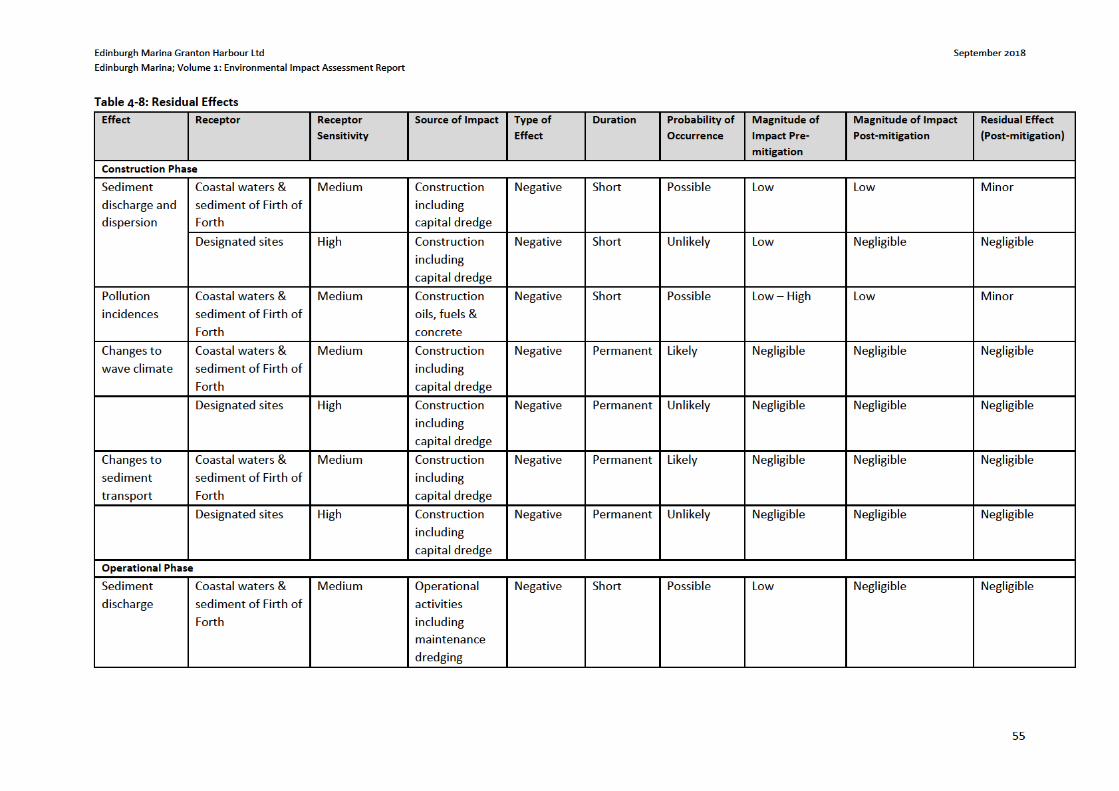
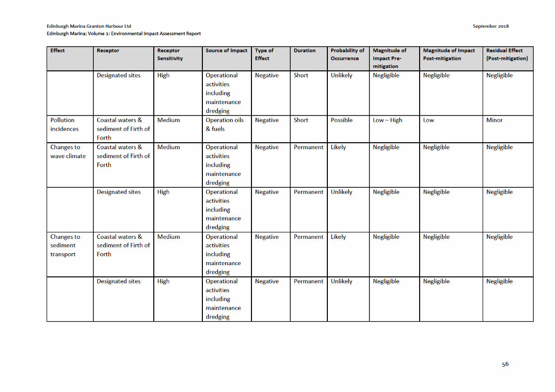

Edinburgh Marina Granton Harbour Ltd September 2018
Edinburgh Marina; Volume 1: Environmental Impact Assessment Report
57
4.9 Statement of Significance
Overall the effects of the proposed development on the water environment and coastal processes are not considered to be significant.
Edinburgh Marina Granton Harbour Ltd September 2018
Edinburgh Marina; Volume 1: Environmental Impact Assessment Report
58
5 MARINE ECOLOGY AND ORNITHOLOGY
5.1 Introduction
EnviroCentre Ltd was commissioned by Granton Central Developments Ltd to undertake an Ecological Impact
Assessment (EcIA) of the Edinburgh Marina development proposal in order to identify and describe any likely
significant effects to be anticipated upon the site’s ecology and that of the wider area. This chapter lists the
specialist studies undertaken and utilised to inform this assessment. The EcIA has been completed according to
guidance produced by the Chartered Institute of Ecology and Environmental Management (CIEEM) by
experienced and competent ecologists who are all Members of CIEEM and follow its Code of Professional
Conduct. The primary author of the chapter is Douglas Blease, Principal Ecologist for EnviroCentre Ltd.
The following Technical Appendices informing the assessment are included in this document and can be found
within Volume 3 of this EIAR:
Technical Appendix 5-1: Otter Survey;
Technical Appendix 5-2: Marine Mammal Protection Plan;
Technical Appendix 5-3: Marine Non-native Species Survey
Technical Appendix 5-4: Habitat Regulations Appraisal
Technical Appendix 5-5: Underwater Noise
5.1.1 Site Details
Drawings SK112C and 770288-001 and within Volume 3 of this EIAR show the site boundary, which is referred to
as ‘the site’ throughout this chapter.
For a description of the site Refer to Chapter 2 of this EIAR.
5.1.2 Proposed Development
A description of the proposed development can be found in Chapter 2.
5.1.3 Objectives
The purpose of this chapter is to:
Identify and describe all potentially significant ecological effects associated with the proposed
development;
Set out the mitigation measures required to ensure compliance with nature conservation legislation and
to address any potentially significant ecological effects;
Identify how mitigation measures will be secured;
Provide an assessment of the significance of any residual effects; and
Set out the requirements for post-construction monitoring.
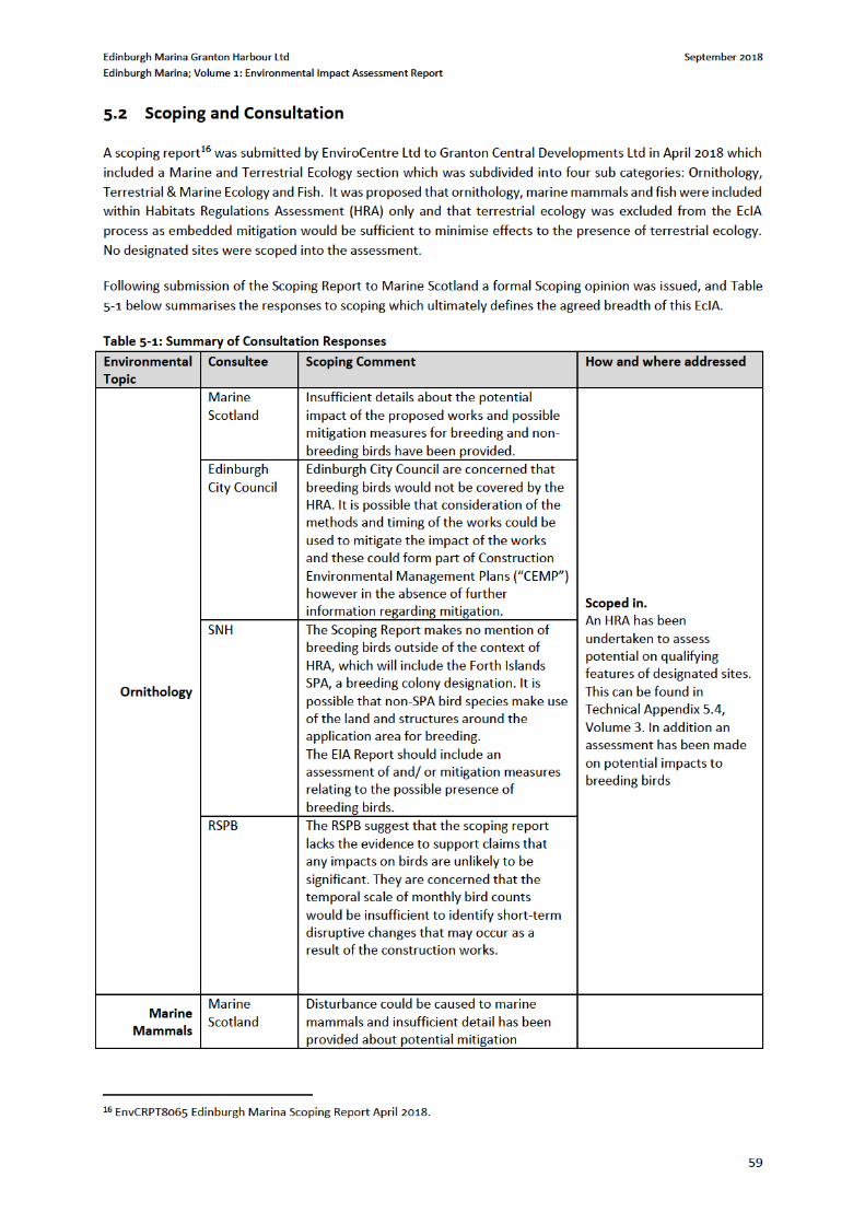
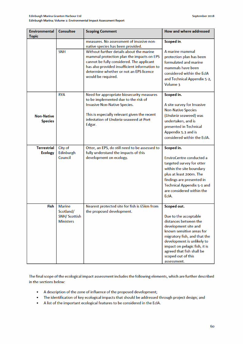
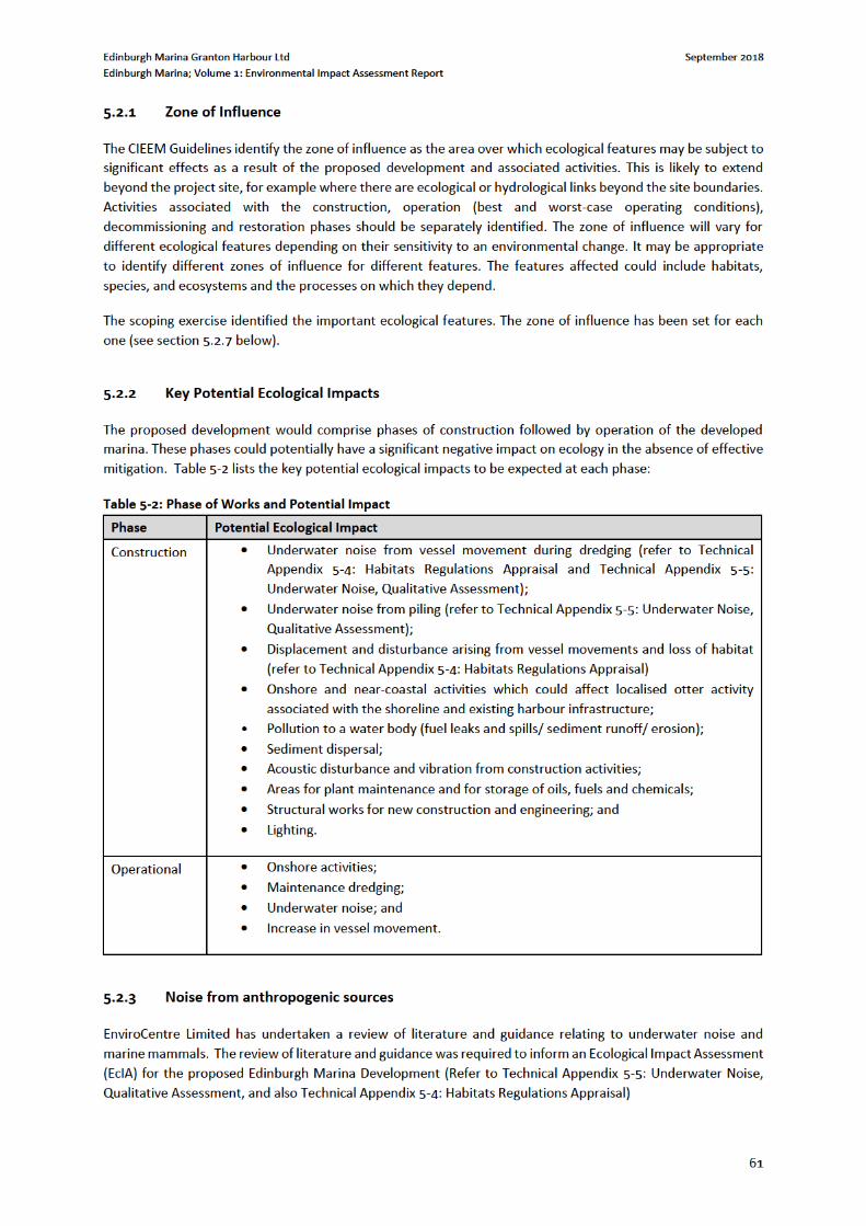
Edinburgh Marina Granton Harbour Ltd September 2018
Edinburgh Marina; Volume 1: Environmental Impact Assessment Report
62
Marine construction noise at Edinburgh Marina could be generated in the audible frequency range of fish and
sea mammals. Acoustic impacts will occur due to the noise generated by vessel operations, dredging, placement
of rock and piling.
It is anticipated that construction generated noise will be intermittent and temporary i.e. only during the
construction phase.
Vessel movements are predicted to be highest during the excavation of the marina basin, construction of the
quay wall extension to the North Mole and placement of rock. During this period small vessels (e.g. a safety
launch) will be active for approximately the same period.
Intensity will vary during this period but will peak during the dredging, piling and placement of rock when the
noise generated by these activities will combine with that of construction vessel e.g. tenders and vessels.
5.2.4 Underwater noise descriptors: Measured or received levels
Noise descriptors that are commonly used in underwater acoustics to present measured or received levels
include the following:
Sound pressure level (SPL) – Average noise level over the measurement period expressed in dB re 1 µPa. For
impulsive sources, such as impact piling and blasts, the measurement period is the time period that contains
90% of the sound energy (Southall et al. 2007). Continuous sources, such as vibropiling and shipping, are
commonly described in terms of an SPL.
Sound exposure level (SEL) – Total noise energy over the measurement period expressed in dB re 1 µPa2 ⋅s.
The SEL is commonly used for impulsive sources because it allows a comparison of the energy contained in
impulsive signals of different duration and peak levels.
Peak level – Maximum noise level recorded during the measurement period expressed in dB re 1 µPa. The
peak level is commonly used as a descriptor for impulsive sources.
Peak-to-peak level – Difference between the maximum and minimum noise level recorded during the
measurement period, expressed in dB re 1 µPa. The peak-to-peak level is used as a descriptor for impulsive
sources.
SPLs and SELs can be presented either as overall levels or as frequency dependent levels showing the frequency
content of a source.
Overall SPLs and SELs present the total average noise and energy level of a source within a given frequency
bandwidth, which usually is the band that contains most of the signal’s energy. Frequency dependent
representations include spectral density levels, one-third octave band levels, or octave band levels. Spectral
density levels give a greater frequency resolution, which is sometimes desirable for identifying narrowband
sources such as rotating machinery, and are expressed in unit of dB re 1 µPa2 /Hz. One-third octave and octave
band levels are expressed in units of dB re 1 µPa.
The sound generated by such vessels will typically be the same as that given for other small vessels operating in
the area e.g. in the range 151 to 170 (dB re 1μPa) at 0.037 to 50 KHz.
Excavation of sediment will be carried out with a backhoe dredger which will work for approximately three
months on site. The extension to North Mole and rock placement will most likely be undertaken from the existing
breakwater using terrestrial plant where possible.
The following discusses examples of underwater noise generated from marine plant during construction.
Measurements of noise from a working trailer suction hopper dredger indicated that, whilst dredging, a sound
Edinburgh Marina Granton Harbour Ltd September 2018
Edinburgh Marina; Volume 1: Environmental Impact Assessment Report
63
level of 120 to 140 dB was recorded underwater (Clarke et al 2004)17. The operation of a clam dredger is
estimated to peak at 124 dB re 1 μPa. Measurement of sound during construction work (drilling and excavation)
in Fraserburgh Harbour, for example, recorded a mean sound level (SL) of 177.8 dB/μPa/m (Urquhart and Hall
2005)18. In the same study the peak SL recorded during rock blasting was estimated as 246.4 dB (relative to 1
μPa at 1 m) and the rms level for the whole 3.8 s period of the double blast as 238.1 dB. Blasting is not part of
this project, these data are provided as a conservative worst case for noise disturbance as discussed below.
The broadband peak sound pressure level during pile-driving was 189 dB0-p re 1 μPa (SEL =166 dB re 1 μPa2. s)
at 400 m distance, resulting in a peak broadband source level of 228 dB0-p re 1 μPa at 1 m (SEL = 206 dB re 1
μPa2. s at 1 m) (Thompson et al 2006)19. Piling methods are not yet known, but if piling is completed by
vibropiling to ‘refusal’ (estimated at 60 minutes per pile) then a short period of impact piling directly (estimated
at 1 minute per pile. Consequently the period of the highest noise generation will be for short period for each
pile.
Noise can have a number of different effects on organisms as follows:
Physical damage - e.g. permanent hearing threshold shift, temporary hearing threshold shift;
Behavioural – e.g. gross interruption/modification of normal behaviour (i.e. behaviour acutely changed
for a period of time) and behavioural modification, displacement from area (short or long term);
Masking of communication with con-specifics and other biologically important noises;
Interference with ability to acoustically interpret environment;
Indirect – e.g. reduced availability of prey; and
Increased vulnerability to predation or other hazards, such as collisions with fishing gear, strandings etc.
The severity of these effects depends on the character, frequency and power of the noise produced, local
conditions which affect attenuation and the sensitivity of species.
5.2.5 Physical Damage due to Noise
Urquhart and Hall (2005) provide estimates of a ‘danger zone’ for bottle-nosed dolphins (Tursiops truncatus) of
1600m for blasting (as an example of extreme noise) and 280m for excavation and drilling within which
temporary threshold shift (TTS) may occur. In the case of the Edinburgh Marina there is no it is unlikely that the
construction will not generate noise of this magnitude. However these data give a conservative indication of the
distances at which TSS may occur.
TTS in fish has been recorded at sound pressure levels of greater than 140 (dB re1μPa) for various species and
permanent threshold shift at between 153 and 180 dB re 1 μPa in marine species including cod (Gadus morhua)
and clupeids (the herring family) (Thompson et al 2006).
5.2.6 Behavioural Effects
The main behavioural effects of noise are startle behaviour and masking of vocalisations or echolocation. Based
on the attenuation of in water pile driving noise with distance from the source the potential distances at which
fish may exhibit startle behaviours were estimated to range from 80m (source noise 144 dB re 1 μPa) to 800m
17 Clarke D, Dickerson C., Reine K. 2004 Characterisation of Sounds Produced by Dredgers US Army Corps of Engineers 18 Urquhart D. and Hall C. 2005 A study of underwater noise generated during civil engineering works at Fraserburgh Harbour. Fisheries Research Services Collaborative Report No 07/05 19 Thomsen F., Ludemann K., Kafemann R. And Piper W (2006). Effects of offshore wind farm nose on marine mammals and fish COWRIE Ltd
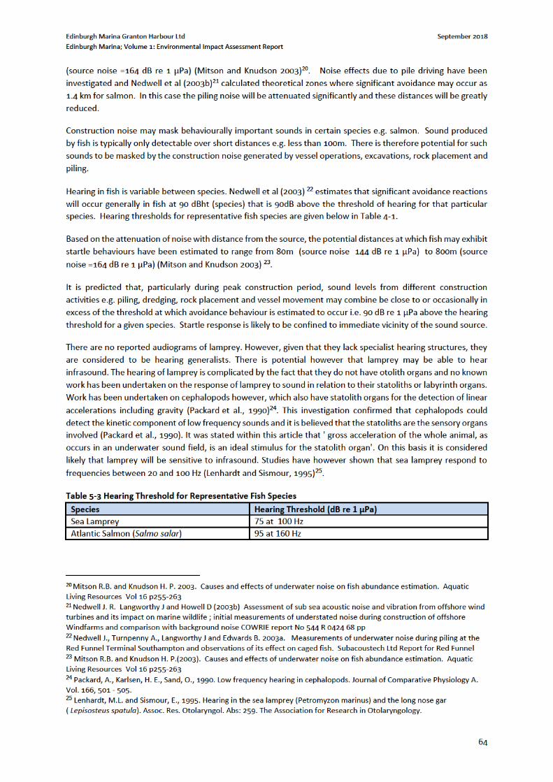
Edinburgh Marina Granton Harbour Ltd September 2018
Edinburgh Marina; Volume 1: Environmental Impact Assessment Report
65
Construction noise may also mask behaviourally important sounds in certain species e.g. salmon. Sound
produced by fish is typically only detectable over short distances e.g. less than 100m. There is therefore potential
for such sounds to be masked by the construction noise generated by piling, vessel operations and excavations.
It is anticipated therefore that there could be a local reduction in the abundance of prey species such as fish, and
this would be greatest within 100 m. The study area is already subject to regular vessel movement so some
degree of acclimatisation to vessel noise is anticipated.
Cetacean echo location is at a higher frequency (120 – 150 kHz), than the majority of construction noise (e.g.
vessel movement) (Thomsen et al 2006) except pile driving which is discussed below.
Pile driver noise could therefore interfere with environmental sounds that cetaceans and seals listen to and
underwater noise could startle or displace animals and prey as discussed above. Data analysed as part of an
offshore wind development reported that – as a result of piling activities - harbour porpoises either avoided the
construction area to a large extent or the animals used their echolocation signals much less due to noise from
construction activities (Carstensen et al (2006)26. A review of noise effects of piling on harbour porpoise by
(Thompson et al 2006) indicated that mild behavioural reactions can be expected to occur between 7 and 20 km
distant from piling activity. At 9 kHz, pile driving noise is capable of masking strong vocalisations within 10–15km
and weak vocalisations up to approximately 40 km (David 2006)27. The masking radius reduces as the frequency
increases: 6 km at 50 kHz and 1.2km at 115 kHz. The impacts of masking are expected to be limited by the
intermittent nature of pile driver noise which in this case will be greatly reduced due to the design and piling
method, the dolphin’s directional hearing, their ability to adjust vocalisation amplitude and frequency, and the
structured content of their signals. Startle response due to sudden noise (e.g. from rock placement) cannot be
discounted but is likely to be intermittent, occasional and of low importance.
Seals are not as sensitive to noise as cetaceans. Like cetaceans, seals use noise to communicate and to identify
prey (by listening for prey generated noise) but they do not echolocate. Götz (2008)28 identified that seals
become habituated to continuous noise sources but are most affected by sudden noise which causes a startle
response. Seal calls are however in the same frequency band as some construction generated noise and masking
of seal calls is therefore possible.
Potentially seals may detect source level of 175 dB re 1μPa @ 1m at distances of 1.4 km to 2.9 km in low ambient
noise conditions (Terhune et al. 2002)29 although at these distances the sound it not likely to be sufficient to
cause a startle response.
Based on the above behavioural effects on individual cetaceans and seals it is estimated to be confined to the
duration of the construction operations and be intermittent. The most significant effects will be for animals that
are within 500 m of the site. In addition the area where the most severe noise effects will occur is not recognised
to be of particular importance for seals or cetaceans.
26 Carstensen J, Henriksen OD and Teilmann J (2006). Impacts of offshore wind farm construction on harbour porpoises: acoustic monitoring of echolocation activity using porpoise detectors (T-PODs) Marine Ecological Press Series, Vol. 321: 295–308 27 David J.A (2006) Likely sensitivity of bottlenose dolphins to pile-driving noise. Water and Environment Journal 20 p48-54 28 Götz, T., 2008 Aversiveness of sound in marine mammals : Psycho-physiological basis, behavioural Correlates and potential applications. Phd Thesis University of St Andrews 29 Terhune, J.M., Hoover, C.L. & Jacobs, S.R. (2002) Potential detection and deterrence ranges by harbour seals of
underwater acoustic harassment devices (AHD) in the Bay of Fundy, Canada. Journal of the World Aquaculture Society, 33,
176-183.
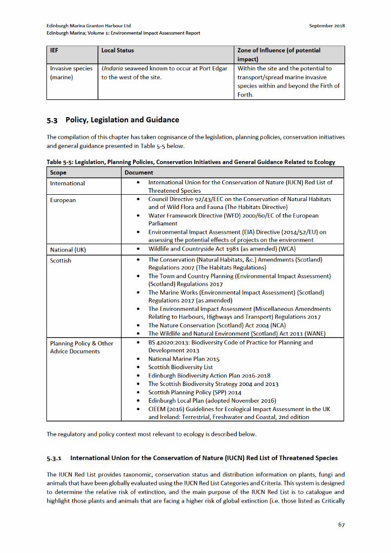
Edinburgh Marina Granton Harbour Ltd September 2018
Edinburgh Marina; Volume 1: Environmental Impact Assessment Report
68
Endangered, Endangered and Vulnerable). The IUCN Red List also includes information on plants, fungi and
animals that are categorized as Extinct or Extinct in the Wild; on taxa that cannot be evaluated because of
insufficient information (i.e., are Data Deficient); and on plants, fungi and animals that are either close to meeting
the threatened thresholds or that would be threatened were it not for an ongoing taxon-specific conservation
programme (i.e., are Near Threatened).
5.3.2 Council Directive 92/43/EEC on the Conservation of Natural Habitats and of Wild Flora and
Fauna (The Habitats Directive)
Adopted in 1992, the Habitats Directive aims to promote the maintenance of biodiversity, taking account of
economic, social, cultural and regional requirements. It forms the cornerstone of Europe's nature conservation
policy with the Birds Directive and establishes the EU wide Natura 2000 ecological network of protected areas,
safeguarded against potentially damaging developments.
Over 1,000 animal and plant species, as well as 200 habitat types, listed in the Directive's Annexes are protected
in various ways:
Annex II species (about 900): core areas of their habitat are designated as Sites of Community
Importance (SCIs) and included in the Natura 2000 network. These sites must be managed in accordance
with the ecological needs of the species.
Annex IV species (over 400, including many Annex II species): a strict protection regime must be applied
across their entire natural range within the EU, both within and outside Natura 2000 sites.
Annex V species (over 90): Member States must ensure that their exploitation and taking in the wild is
compatible with maintaining them in a favourable conservation status.
5.4 Methodology
5.4.1 Desk Study
In order to inform the scoping report a desk study was undertaken using the following sources:
A review of bird survey data gathered at monthly intervals between 2004 and 2012 for Granton Harbour;
SNH Sitelink30 for details of site designated sites within 5km and their qualifying features;
A list of Seal Haul-out sites in Scotland31 and
Information on marine mammals known to occur within the Firth of Forth from the following sources:
o The Joint Nature Conservation Committee (JNCC)32 & 33;
o Seawatch Foundation34;
o Scottish Natural Heritage (SNH)35;
o Cetacean Research and Rescue Unit36
30 SNH Sitelink available at: https://gateway.snh.gov.uk/sitelink/ accessed 1/11/2017 31 List of seal Haul-out sites available at: http://www.gov.scot/Topics/marine/marineenvironment/ species/19887/20814/haulouts/list accessed 01/11/2017 32 JNCC Statutory Nature Conservation Agency Protocol for Minimising the Risk of Injury to Marine Mammals from Piling Noise (2010) available at: http://jncc.defra.gov.uk/pdf/JNCC_Guidelines_Piling%20protocol_August%202010.pdf last accessed 21/08/2018 33 Reid, J B, Evans, P G H, and Northridge, S P. JNCC Atlas of Cetacean Distribution in north-west European waters (2003) available at: http://jncc.defra.gov.uk/page-2713#download last accessed 21/08/2018 34 Seawatch Foundation Cetaceans of Western Scotland available at: http://seawatchfoundation.org.uk/wp-content/uploads/2012/07/WesternScotland.pdf last accessed 21/08/2018 35 SNH About Scotland’s Nature: Marine Mammals available at: http://www.snh.gov.uk/about-scotlands-nature/species/mammals/marine-mammals/ last accessed 21/08/2018 36 Cetacean Research and Rescue Unit website available at: http://www.crru.org.uk/index.asp last accessed 22/08/2018
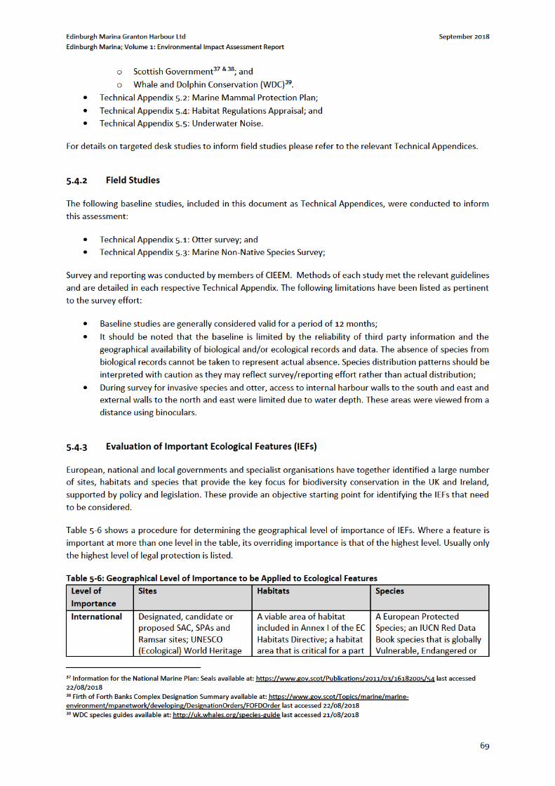
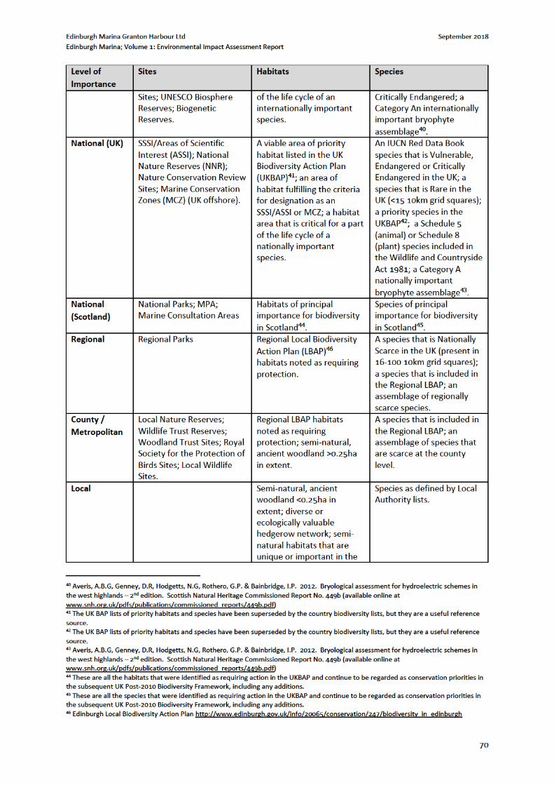
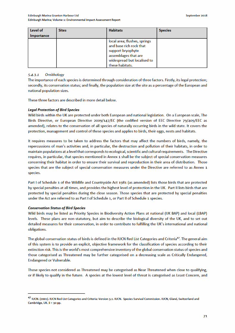
Edinburgh Marina Granton Harbour Ltd September 2018
Edinburgh Marina; Volume 1: Environmental Impact Assessment Report
72
widespread and abundant species are included in this category. When there is inadequate information to make
an assessment, a species may be categorised as Data Deficient.
The European conservation status of birds is determined by Birdlife International in their European Red List of
Birds48, which identifies priority species in order that conservation action can be taken to improve their status
taken from the IUCN Red List assessment of regional extinction risk. Such birds are described as European Red
List of Birds Species (ERLOB).
The national conservation status of birds is determined by their listing on the Red, Amber and Green lists of Birds
of Conservation Concern (BoCC), as defined by Eaton et al.49. The criteria used to assign a species to one of these
lists reflect each species’ global, European and UK status and measure the importance of the UK populations in
international terms.
BoCC Red List species are either globally Threatened using IUCN criteria; have suffered a severe decline since
1800 without substantial recent recovery; have suffered a severe decline in breeding or non-breeding population
of more than 50% over 25 years; or suffered a severe decline in breeding range of more than 50%, measured by
birds present in 10 km squares, over 25 years.
BoCC Amber List species must have been identified as an ERLOB; or have been Red listed for historical decline in
a previous review, but with a substantial recent recovery; or have a moderate (25%-50%) decline in breeding or
non-breeding populations or breeding range over the past 25 years; or have a UK breeding population of fewer
than 300 pairs, non-breeding population of fewer than 900 individuals; or have at least 50% of the UK breeding
or non-breeding population found in 10 or fewer sites; or be species of international importance with at least
20% of the European breeding or non-breeding population found in the UK.
BoCC Green List species comprise all regularly occurring species that do not qualify under any of the Red or
Amber criteria. The Green list also includes those species listed as recovering from historical decline in the last
review that have continued to recover and do not qualify under any of the other criteria.
Population Size at the Site
To establish the importance of the population size at the site, the size of the European and national populations
need to be estimated. In determining the size of the UK population, reference is made to the websites of three
organisations: the RSPB50, the British Trust for Ornithology (BTO)51 and the Joint Nature Conservation Committee
(JNCC)52. Scottish populations are determined using The Birds of Scotland53. Where there is variation between
the estimates provided by these organisations, the range of estimates is provided.
Table 5-7 shows a procedure for determining the geographical level of importance of bird species. Where a
feature is important at more than one level in the table, its overriding importance is that of the highest level.
Usually only the highest level of legal protection is listed.
48 BirdLife International (2015). European Red List of Birds. Office for Official Publications of the European Communities, Luxembourg. 49 Eaton MA, Aebischer NJ, Brown AF, Hearn RD, Lock L, Musgrove AJ, Noble DG, Stroud DA and Gregory RD (2015). Birds of Conservation Concern 4: the population status of birds in the United Kingdom, Channel Islands and Isle of Man. British Birds 108, 708–746. Available online at http://www.britishbirds.co.uk/wp-content/uploads/2014/07/BoCC4.pdf 50 RSPB (2012). http://www.rspb.org.uk/wildlife/birdguide/name. (Accessed on 13/09/18 ) 51 BTO (2012). http://www.bto.org/about-birds/birdfacts/find-a-species. (Accessed on 13/09/18) 52 JNCC (2012). http://jncc.defra.gov.uk/page-1419. (Accessed on 13/09/18) 53 Forrester, R.W., Andrews I.J., McInerny C.J., Murray R.D., McGowan R.Y., Zonfrillo B., Betts M.W., Jardine D.W. & Grundy D.S. (eds). 2012. The Birds of Scotland. Digital Version. The Scottish Ornithologists Club, Aberlady.
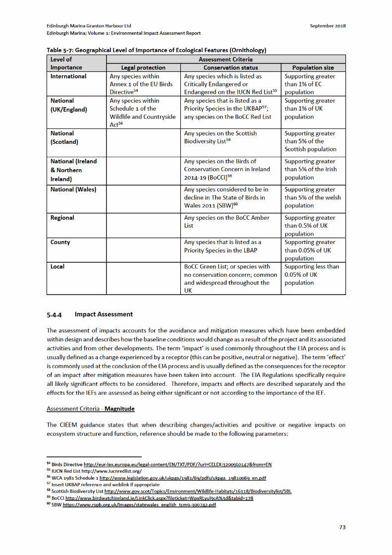
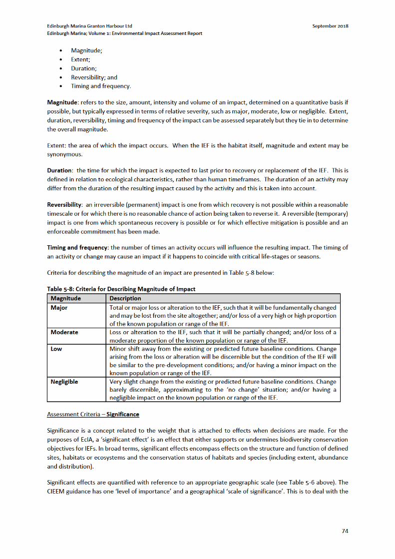
Edinburgh Marina Granton Harbour Ltd September 2018
Edinburgh Marina; Volume 1: Environmental Impact Assessment Report
75
fact that the geographical scale at which the effect is significant is not necessarily the same as the geographic
level of importance of the IEF.
Professional judgement is used to determine the significance of effects.
Assessment Criteria – Confidence in Predictions
CIEEM does not cover levels of confidence in predictions, therefore an approach has been adopted based on
river conservation evaluation61. A simple, qualitative index based on professional judgement is assigned to each
predicted effect as follows:
A: high confidence.
B: intermediate confidence.
C: low confidence.
Factors influencing confidence include:
• The frequency and effort of field sampling;
• Constraints to the field survey;
• The completeness of the data (field and desk);
• The age of the data (although recent data are not necessarily always more reliable than old data);
• The state of scientific knowledge relating to the predicted effects of development activities on the IEF
(the accuracy of the magnitude assessment); and
• The accuracy of the assessment of significance.
Cumulative Assessment
Significant cumulative effects can result from the individually insignificant but collectively significant effects of
actions taking place over a period of time or concentrated in a location, for example:
• Additive / incremental: multiple activities/projects (each with potentially insignificant effects) added
together to give rise to a significant effect due to their proximity in time and space; or
• Associated / connected - a development activity ‘enables’ another development activity e.g. phased
development as part of separate planning applications. Associated developments may include different
aspects of the project which may be authorised under different consent processes.
The combined magnitude of impact and significance is assessed for each IEF if construction events take place
simultaneously.
Assessment Criteria – Success of Mitigation
The word ‘mitigation’ has developed a wider meaning and common usage in environmental assessment than its
strict meaning related to reducing the severity of something. Mitigation can sometimes be used as a generic term
for a wide range of counter-acting measures, all of which, as the Directive and Regulations prescribe, are
intended to prevent, reduce and where possible offset any significant adverse effect on the environment.
Mitigation can be used to encompass measures intended to avoid, cancel or reduce adverse effects (this is the
‘mitigation hierarchy’).
Mitigation and compensation measures often carry a degree of uncertainty. The following objective scale is used
for the success of mitigation:
• Certain/near certain: probability estimated at 95% chance or higher.
61 SERCON: System for Evaluating Rivers for Conservation, Version 2, Technical Manual. Scottish Natural Heritage (2001).
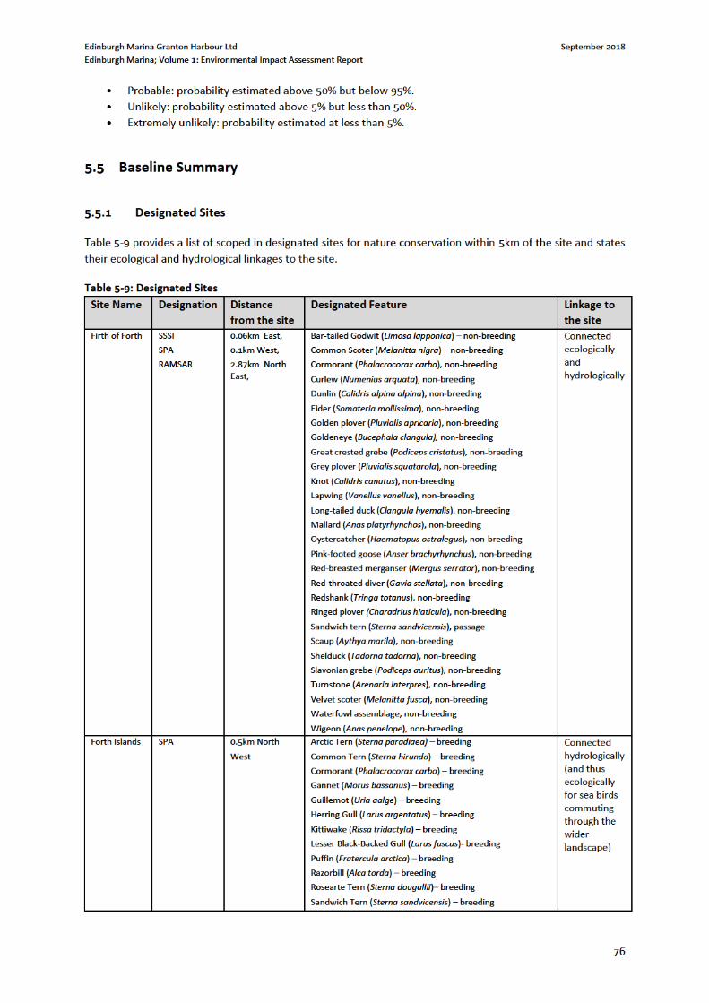
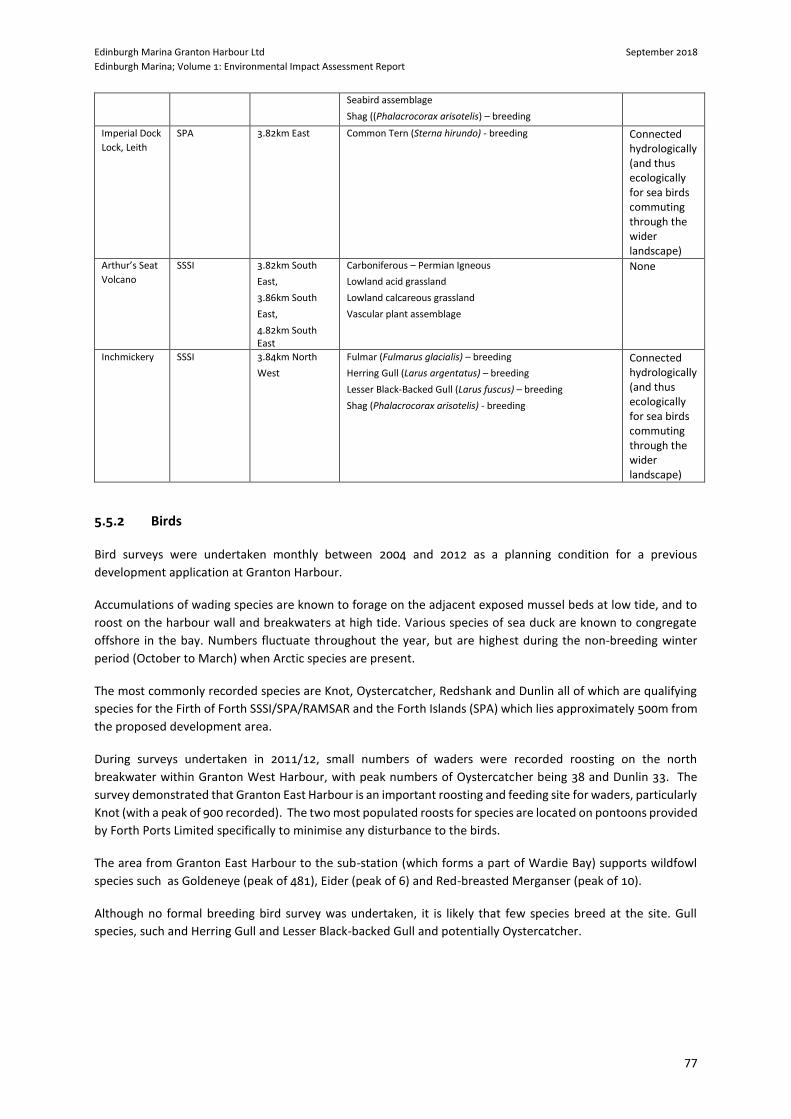
Edinburgh Marina Granton Harbour Ltd September 2018
Edinburgh Marina; Volume 1: Environmental Impact Assessment Report
77
Seabird assemblage
Shag ((Phalacrocorax arisotelis) – breeding
Imperial Dock
Lock, Leith SPA 3.82km East Common Tern (Sterna hirundo) - breeding Connected
hydrologically (and thus ecologically for sea birds commuting through the wider landscape)
Arthur’s Seat
Volcano
SSSI 3.82km South
East,
3.86km South
East,
4.82km South East
Carboniferous – Permian Igneous
Lowland acid grassland
Lowland calcareous grassland
Vascular plant assemblage
None
Inchmickery SSSI 3.84km North
West
Fulmar (Fulmarus glacialis) – breeding
Herring Gull (Larus argentatus) – breeding
Lesser Black-Backed Gull (Larus fuscus) – breeding
Shag (Phalacrocorax arisotelis) - breeding
Connected hydrologically (and thus ecologically for sea birds commuting through the wider landscape)
5.5.2 Birds
Bird surveys were undertaken monthly between 2004 and 2012 as a planning condition for a previous
development application at Granton Harbour.
Accumulations of wading species are known to forage on the adjacent exposed mussel beds at low tide, and to
roost on the harbour wall and breakwaters at high tide. Various species of sea duck are known to congregate
offshore in the bay. Numbers fluctuate throughout the year, but are highest during the non-breeding winter
period (October to March) when Arctic species are present.
The most commonly recorded species are Knot, Oystercatcher, Redshank and Dunlin all of which are qualifying
species for the Firth of Forth SSSI/SPA/RAMSAR and the Forth Islands (SPA) which lies approximately 500m from
the proposed development area.
During surveys undertaken in 2011/12, small numbers of waders were recorded roosting on the north
breakwater within Granton West Harbour, with peak numbers of Oystercatcher being 38 and Dunlin 33. The
survey demonstrated that Granton East Harbour is an important roosting and feeding site for waders, particularly
Knot (with a peak of 900 recorded). The two most populated roosts for species are located on pontoons provided
by Forth Ports Limited specifically to minimise any disturbance to the birds.
The area from Granton East Harbour to the sub-station (which forms a part of Wardie Bay) supports wildfowl
species such as Goldeneye (peak of 481), Eider (peak of 6) and Red-breasted Merganser (peak of 10).
Although no formal breeding bird survey was undertaken, it is likely that few species breed at the site. Gull
species, such and Herring Gull and Lesser Black-backed Gull and potentially Oystercatcher.
Edinburgh Marina Granton Harbour Ltd September 2018
Edinburgh Marina; Volume 1: Environmental Impact Assessment Report
78
5.5.3 Marine Mammals
A range of marine mammals are known to be active in the Firth of Forth but the available data62 has not
presented any records of marine mammals within the site boundary.
5.5.3.1 Bottlenose Dolphins
The most commonly sighted cetacean in the Firth of Forth, more specifically the area surrounding Granton,
appears to be bottlenose dolphin, however there are scarce estimates of the temporal and/or spatial distribution
of the species in The Firth of Forth available. Very high numbers of sightings of bottlenose dolphins (Tursiops
truncatus) exist on the northeast and eastern coast of Scotland; namely within the Moray Firth SAC which is
designated for bottlenose dolphin. Generally however, the frequency of sightings decreases once reaching the
Firth of Forth and surrounding area. Nonetheless it is thought that the range of the population of bottlenose
dolphin, resident of the Moray Firth, extends as far down as the Firth of Forth, and in which case would still be
protected as a feature of the SAC whether in the site or not.
There are occasional sightings of bottlenose dolphins in the Firth of Forth and East Lothian area, particularly
between May and December. During summer of 2017, 38 individual bottlenose dolphin sightings were recorded,
the closest of which was from Portobello beach, approximately 6km east of Granton where ten animals were
observed. However, the majority of sightings come from further along the coast to the east, towards Gullane and
Dunbar where the Firth becomes much wider. Since July 2018, 24 bottlenose dolphin sightings have been
recorded within 40km of the site; 8 animals off the coast of Kinghorn approximately 9km north, one animal
approximately 47km north east off the Isle of May, 8 and 15 off the coast of Anstruther, approximately 40km
north.
5.5.3.2 Harbour Porpoise
Harbour porpoise (Phocoena phocoena) are occasionally observed in the south east of Scotland where they occur
in small numbers in nearshore waters along the coasts of Tayside and East Lothian, and in the Firth of Forth. Most
sightings occur between July and September, although no sightings were recorded within or in proximity to The
Firth of Forth via Sea Watch Foundation during summer 2017 or 2018.
5.5.3.3 Minke Whale
Minke whale (Balaenoptera acutorostrata) are recorded in small numbers in the Firth of Forth and offshore
between June and September. One sighting of an individual minke whale was recorded in July 2017, the animal
was identified from The Isle of May which is approximately 47km to the north east of Granton. The closest
recorded sighting of minke whale to the site since during the summer of 2018 was off the coast of Pittenween,
approximately 39km to the north east of Granton.
5.5.3.4 Humpback Whales
Humpback Whales have been sighted in the Firth of Forth in the same locations for the last two years, between
Kinghorn and Inchmickery Island, which is approximately 6km north west of Granton, likely foraging on sprats
and herring.
5.5.3.5 Grey Seal
Grey seal pup production in the Firth of Forth is steadily increasing; in 2010 approximately 2000 pups were born
on the Isle of May 40km to the north east, approximately 1700 on the coast at Fast Castle 60km (straight line) to
the east and approximately 250 on Inchkeith Island 7km to the north.
62 Seawatch Foundation Recent Sightings available at: http://www.seawatchfoundation.org.uk/recentsightings/ last accessed 07/09/2019
Edinburgh Marina Granton Harbour Ltd September 2018
Edinburgh Marina; Volume 1: Environmental Impact Assessment Report
79
5.5.3.6 Harbour Seal
Harbour seal numbers along the east coast are thought to be declining and they are not frequently observed in
the Firth of Forth. However, because seals range widely in their search for food (40-50km), single seals of either
species might be spotted anywhere along the Scottish coastline.
5.5.3.7 Firth of Forth Banks Complex MPA
The Firth of Forth Banks Complex MPA lies approximately 47km offshore, to the north east of the site and covers
a highly productive and biologically rich area of sand and gravel banks which are considered significant to the
health of Scotland’s seas by supporting populations of small fish and creating conditions ideal for several types
of fish to breed. This source of food attracts many larger types of fish, seabirds, and marine mammals such as
dolphins and porpoises.
Taking into account the lack of information regarding distribution of cetaceans within the Firth of Forth as well
as the potential of The Firth of Forth Banks Complex to attract marine mammals, it is suggested that the following
species have the potential to be present within the zone of influence of the development: Bottlenose dolphin,
harbour porpoise, grey seal, harbour seal and minke whale.
5.5.4 Otter
Otter are present in the landscape, evident by the discovery of spraints at various locations within the site
boundary. No confirmed otter holts or temporary resting sites (couches) were noted however there is
opportunity for otter to rest at the site. Given the freshwater habitats of the River Almond to the west and Water
of Leith to the east, where otter are known to be present, it is likely that otter are regularly active along this
coastline exploiting food resources presented within the intertidal zone (Refer to Technical Appendix 5-1: Otter
Survey).
5.5.5 Invasive Non-Native Species
The Royal Yachting Association note that the invasive species Undaria is present at Port Edgar which is
approximately 11km west of the site. A desk study revealed that the following species were scoped into survey
effort as it was considered they could be present in the local area:
Japanese kelp, or Wakame (Undaria pinnatifada);
Japanese wireweed (Sargassum muticum);
Darwin’s barnacle (Austrominius modestus);
Green sea-fingers (Codium fragile subsp. fragile);
Red algae (Heterosiphonia japonica);
Japanese skeleton shrimp (Caprella mutica);
Leathery sea squirt (Syela clava);
Carpet sea-squirt (Didemnum vexillum);
Pacific oyster (Crassostrea gigas); and
Zebra mussel (Dreissena polymorpha).
No evidence of Invasive Non-Native Species were discovered within or adjacent to the site boundary.
5.5.6 Prediction of Future Baseline
If development does not occur, and there are no other external changes to the local environment, it is predicted
that the ecological baseline will remain the same as it is now, with any changes in ecological populations
occurring naturally.
Edinburgh Marina Granton Harbour Ltd September 2018
Edinburgh Marina; Volume 1: Environmental Impact Assessment Report
81
5.7 Assessment of Ecological Impacts
The following assessment takes account of all avoidance and mitigation measures embedded within the design
proposal as well as proven or standard mitigation included as recommendations following baseline study
presented within the Technical Appendices of this document. However a lack of construction and operational
detail as well as underwater noise predictions emanating from literature review reduces the level of confidence
in assessment for certain IEFs.
5.7.1 Predicted Negative Construction Impacts
5.7.1.1 Firth of Forth SSSI/SPA/RAMSAR
Nature of impact
As stated in the HRA (Technical Appendix 5-4: Habitats Regulations Appraisal), potential impacts include
disturbance through activities such as through dredging, piling (more specifically impact piling), movement of
rock armour and increased vessel movements. This could potentially impact on qualifying species, such as
Redshank, Knot, Dunlin, Oystercatcher, Bar-tailed Godwit, Turnstone, Golden Plover and Shelduck which could
forage in East Granton Harbour and surrounding waters. The proposed development may lead to contamination
of coastal water and sediments from accidental pollution incidents (See Chapter 4: Water Environment and
Coastal Processes). The main risk is posed by refuelling activities. Oil spillages to the water environment would
be detrimental to both water and sediment quality and could affect qualifying species that may be present in the
open water surrounding the harbour.
Duration of impact
The duration of this impact would be during the construction period. Following construction there is no reason
why the future baseline will not be similar to pre-development conditions thus any impact is temporary.
Importance of IEF
The Firth of Forth SPA is of International importance.
Magnitude
The Firth of Forth SSSI/SPA/RAMSAR comprises an area of 6317.69ha, extending from Alloa to the coasts of Fife
and East Lothian. Many of the qualifying species populations are large and the waterfowl assemblage exceeds
90,000 individuals. Granton Harbour does not support significant populations of these species.
The majority of potential impacts are of a temporary nature and would not affect population numbers in the
long term. It is possible that any qualifying species using the site would become habituated to both noise
disturbance and increased vessel traffic during construction. If this is not the case, it is considered that there is
sufficient alternative foraging habitat which could accommodate qualifying species within the SPA so as not to
affect the integrity of the site.
Potential pollution incidents would be controlled through mitigation set out in the CEMP.
Otter Yes Yes International
(UK)
European Protected Species.
Invasive Non-
Native Species
No Yes n/a Not evaluated due to negative biodiversity
importance.
Edinburgh Marina Granton Harbour Ltd September 2018
Edinburgh Marina; Volume 1: Environmental Impact Assessment Report
82
Therefore the magnitude of impacts are considered Low, with only a minor shift from existing baseline
conditions.
Significance of effect
The effects of construction works on the Firth of Forth SSSI/SPA/RAMSAR are not significant.
Confidence in Assessment
Through the findings of the HRA process, this is assessed as A: High Confidence
5.7.1.2 Forth Islands SPA
Nature of impact
As stated in the HRA (Technical Appendix 5-4: Habitats Regulations Appraisal), given the distance of the islands
from the proposed development, potential impacts through disturbance are not likely to affect breeding
qualifying species on these islands. There is the potential for disturbance and displacement away from foraging
areas in the vicinity of construction works for the qualifying species. The proposed development may lead to
contamination of coastal water and sediments from accidental pollution incidents (See Chapter 4: Water
Environment and Coastal Processes). The main risk is posed by refuelling activities. Oil spillages to the water
environment would be detrimental to both water and sediment quality and could affect qualifying species that
may be present in the open water surrounding the harbour.
Duration of impact
The duration of this impact would be during the construction period. Following construction there is no reason
why the future baseline will not be similar to pre-development conditions thus any impact is temporary.
Importance of IEF
The Forth Islands SPA is of International importance.
Magnitude
The majority of potential impacts are of a temporary nature and would not affect population numbers in the
long term. It is possible that any qualifying species using the site would become habituated to both noise
disturbance and increased vessel traffic during construction. If this is not the case, it is considered that there is
sufficient alternative foraging habitat which could accommodate qualifying species of the SPA so as not to affect
the integrity of the site.
Potential pollution incidents would be controlled through mitigation set out in the CEMP.
Therefore the magnitude of impacts are considered negligible.
Significance of effect
The effects of construction works on the Forth Islands SPA are not significant.
Confidence in Assessment
Through the findings of the HRA process, this is assessed as A: High Confidence
Edinburgh Marina Granton Harbour Ltd September 2018
Edinburgh Marina; Volume 1: Environmental Impact Assessment Report
83
5.7.1.3 Leith Docks SPA
Nature of impact
As stated in the HRA (Technical Appendix 5-4: Habitats Regulations Appraisal), given the distance of Leith Docks
(3.82km) from the proposed development, potential impacts through disturbance will not affect breeding
qualifying species at this site. There is the potential for disturbance and displacement away from foraging areas
in the vicinity of construction works for the qualifying species. The proposed development may lead to
contamination of coastal water and sediments from accidental pollution incidents (See Chapter 4: Water
Environment and Coastal Processes). The main risk is posed by refuelling activities. Oil spillages to the water
environment would be detrimental to both water and sediment quality and could affect qualifying species that
may be present in the open water surrounding the harbour.
Duration of impact
The duration of this impact would be during the construction period. Following construction there is no reason
why the future baseline will not be similar to pre-development conditions thus any impact is temporary.
Importance of IEF
The Leith Docks SPA is of International importance.
Magnitude
The majority of potential impacts are of a temporary nature and would not affect population numbers in the
long term. It is possible that any qualifying species using the site would become habituated to both noise
disturbance and increased vessel traffic during construction. If this is not the case, it is considered that there is
sufficient alternative foraging habitat which could accommodate qualifying species of the SPA so as not to affect
the integrity of the site.
Potential pollution incidents would be controlled through mitigation set out in a CEMP (Refer to Schedule of
Mitigation (Chapter 7).
Therefore the magnitude of impacts are considered negligible.
Significance of effect
The effects of construction works on the Leith Docks SPA are not significant.
Confidence in Assessment
Through the findings of the HRA process, this is assessed as A: High Confidence
5.7.1.4 Breeding Birds
Nature of impact
There is the potential for birds to be displaced from their preferred nesting areas in the vicinity of the proposed
development through the increase in noise and visual disturbance created during the construction activity.
Duration of impact
The duration of this impact will be temporary during the construction phase, depending on the levels of
construction activity within the marina, and the preferred locations of birds to establish a nest. However, due to
the small number of nesting birds present within the harbour, and the number of appropriate nesting locations
along the Lothian coast, most nesting birds are only likely to be displaced a short distance.
Edinburgh Marina Granton Harbour Ltd September 2018
Edinburgh Marina; Volume 1: Environmental Impact Assessment Report
84
Importance of IEF
Herring Gull is listed on the BoCC Red List, as a species of high conservation concern, and is considered to be of
National importance.
Oystercatcher and Lesser Black-backed Gull are listed on the BoCC Amber List, and are therefore considered to
be of Regional importance, although Lesser Black-backed Gull is one of the commonest breeding birds in the
urban environment around Edinburgh, as well as the islands within the Forth.
Other breeding species may include Rock Pipit (Anthus petrosus), which has no conservation concern, is
frequently encountered in rocky environments along the East coast of Scotland, and is considered to be of Local
importance.
Magnitude
The magnitude of impact on the limited nesting bird assemblage is considered negligible.
Significance of effect
The effects of the operational phase on breeding birds are not significant.
Confidence in Assessment
Through the findings of the HRA process, this is assessed as A: High Confidence
5.7.1.5 Harbour porpoise
Nature of impact
There is the potential to affect this species through the increase in turbidity and transmission of underwater
noise and vibration when dredging and piling. Underwater noise can affect the behaviour of species which use
echolocation to navigate, communicate and hunt.
Pollution events would also affect water quality and species which harbour porpoise feed upon which can lead
to illness or fatality.
Duration of impact
The duration is temporary, likely to last for a period of 6-8 months during construction and within restricted
working times and often determined by tide times.
Importance of IEF
Harbour porpoise is of international importance.
Magnitude
As the impacts are temporary in nature and only likely to affect a radius of 500m the magnitude of impact is
negligible.
Significance of effect
The effect of construction will be Not Significant.
Edinburgh Marina Granton Harbour Ltd September 2018
Edinburgh Marina; Volume 1: Environmental Impact Assessment Report
85
Confidence in assessment
Given a lack of construction information coupled with a lack of detailed noise modelling, but on the assumption
that such detail shall follow to further inform the design process, the assessment is given with B: Intermediate
Confidence.
5.7.1.6 Bottlenose dolphin
Nature of impact
There is the potential to affect this species through the increase in turbidity and transmission of underwater
noise and vibration when dredging and piling. Underwater noise can affect the behaviour of species which use
echolocation to navigate, communicate and hunt.
Pollution events would also affect water quality and species which bottlenose dolphin feed upon which can lead
to illness or fatality.
Duration of impact
The duration of dredging and piling is temporary, likely to last for a period of 6-8 months during construction and
within restricted working times and often determined by tide times.
Importance of IEF
Bottlenose dolphin is of international importance.
Magnitude
As the impacts are temporary in nature and only likely to affect a radius of 500m the magnitude of impact is
negligible.
Significance of effect
The effect of construction will be Not Significant.
Confidence in assessment
Given a lack of construction information coupled with a lack of detailed noise modelling, but on the assumption
that such detail shall follow to further inform the design process, the assessment is given with B: Intermediate
Confidence.
5.7.1.7 Minke whale
Nature of impact
There is the potential to affect this species through the increase in turbidity and transmission of underwater
noise and vibration when dredging and piling. Underwater noise can affect the behaviour of species which use
echolocation to navigate, communicate and hunt.
Pollution events would also affect water quality and species which minke whale feed upon which can lead to
illness or fatality.
Duration of impact
The duration of dredging and piling is temporary, likely to last for a period of 6-8 months during construction and
within restricted working times and often determined by tide times.
Edinburgh Marina Granton Harbour Ltd September 2018
Edinburgh Marina; Volume 1: Environmental Impact Assessment Report
86
Importance of IEF
Minke whale is of international importance.
Magnitude
As the impacts are temporary in nature and only likely to affect a radius of 500m the magnitude of impact is
negligible.
Significance of effect
The effect of construction will be Not Significant.
Confidence in assessment
Given a lack of construction information coupled with a lack of detailed noise modelling, but on the assumption
that such detail shall follow to further inform the design process, the assessment is given with B: Intermediate
Confidence.
5.7.1.8 Humpback whale
Nature of impact
There is the potential to affect this species through the increase in turbidity and transmission of underwater
noise and vibration when dredging and piling. Underwater noise can affect the behaviour of species which use
echolocation to navigate, communicate and hunt.
Pollution events would also affect water quality and species which Humpback whale feed upon which can lead
to illness or fatality.
Duration of impact
The duration of dredging and piling is temporary, likely to last for a period of 6-8 months during construction and
within restricted working times and often determined by tide times.
Importance of IEF
Humpback whale is of international importance.
Magnitude
As the impacts are temporary in nature and only likely to affect a radius of 500m the magnitude of impact is
negligible.
Significance of effect
The effect of construction will be Not Significant.
Confidence in assessment
Given a lack of construction information coupled with a lack of detailed noise modelling, but on the assumption
that such detail shall follow to further inform the design process, the assessment is given with B: Intermediate
Confidence.
Edinburgh Marina Granton Harbour Ltd September 2018
Edinburgh Marina; Volume 1: Environmental Impact Assessment Report
87
5.7.1.9 Grey seal
Nature of impact
There is the potential to affect this species through the increase in turbidity and transmission of underwater
noise and vibration when dredging and piling. Underwater noise can affect the behaviour of species which use
echolocation to navigate, communicate and hunt.
Pollution events would also affect water quality and species which Grey seal feed upon which can lead to illness
or fatality.
Duration of impact
The duration of dredging and piling is temporary, likely to last for a period of 6-8 months during construction and
within restricted working times and often determined by tide times.
Importance of IEF
Grey seal is of county/metropolitan importance.
Magnitude
As the impacts are temporary in nature and only likely to affect a radius of 500m the magnitude of impact is
negligible.
Significance of effect
The effect of construction will be Not Significant.
Confidence in assessment
Given a lack of construction information coupled with a lack of detailed noise modelling, but on the assumption
that such detail shall follow to further inform the design process, the assessment is given with B: Intermediate
Confidence.
5.7.1.10 Harbour seal
Nature of impact
There is the potential to affect this species through the increase in turbidity and transmission of underwater
noise and vibration when dredging and piling. Underwater noise can affect the behaviour of species which use
echolocation to navigate, communicate and hunt.
Pollution events would also affect water quality and species which harbour seal feed upon which can lead to
illness or fatality.
Duration of impact
The duration of dredging and piling is temporary, likely to last for a period of 6-8 months during construction and
within restricted working times and often determined by tide times.
Importance of IEF
Harbour seal is of national (UK) importance.
Edinburgh Marina Granton Harbour Ltd September 2018
Edinburgh Marina; Volume 1: Environmental Impact Assessment Report
88
Magnitude
As the impacts are temporary in nature and only likely to affect a radius of 500m the magnitude of impact is
negligible.
Significance of effect
The effect of construction will be Not Significant.
Confidence in assessment
Given a lack of construction information coupled with a lack of detailed noise modelling, but on the assumption
that such detail shall follow to further inform the design process, the assessment is given with B: Intermediate
Confidence.
5.7.1.11 Otter
Nature of impact
During construction the current behaviour of otter which includes accessing the site, depositing spraint and
potentially resting would be impacted from onshore and near coastal activities, pollution events, lighting and
traffic movements. Otter may also be foraging and socialising within the sheltered areas associated with the
harbour and again, this activity would be dissuaded by the construction and dredging processes. It is possible
that landscape scale dispersal, between such habitats as The Water of Leith and The River Almond, using the
coastline may be hindered at times of coastline construction or dredging.
Duration of impact
The duration of this impact would be during the construction period and within this timeframe only during
daytime working hours of 07:00 to 20:00 (assumed until formal construction programme developed). When the
site is inactive within the construction period, otter would be able to resume normal passage along the coastline.
Following construction there is no reason why the future baseline will not be similar to pre-development
conditions thus any impact is temporary.
Importance of IEF
Otter are of international importance.
Magnitude
The magnitude of impact during construction is considered to be Low as partial disruption to current site access
by otter will be a minor shift from the existing baseline conditions. Construction works shall cease during night
time hours when otter are most active and which mitigation can be applied to minimise impacts during the timing
of certain aspects of construction.
Significance of effect
Not significant. The type and structure and function of the coastal habitat which otter are exploiting will not
change and there will be no risk to the conservation status of the species.
Confidence in assessment
Due to the recent and thorough gathering of field evidence, minimal constraints to survey and knowledge of the
species applied, this assessment is made with A: High Confidence.
5.7.2 Predicted Negative Operational Impacts
5.7.2.1 Firth of Forth SSSI/SPA/RAMSAR
As stated in the HRA, potential impacts include disturbance through an increase in human presence and
increased vessel movements. This could potentially impact on qualifying species, such as Redshank, Knot, Dunlin,
Edinburgh Marina Granton Harbour Ltd September 2018
Edinburgh Marina; Volume 1: Environmental Impact Assessment Report
89
Oystercatcher, Bar-tailed Godwit, Turnstone, Golden Plover and Shelduck which could forage in East Granton
Harbour and surrounding waters.
Duration of impact
The duration of this impact would be permanent
Importance of IEF
The Firth of Forth SSSI/SPA/RAMSAR is of International importance
Magnitude
The Firth of Forth SPA comprises an area of 6317.69ha, extending from Alloa to the coasts of Fife and East
Lothian. Many of the qualifying species populations are large and the waterfowl assemblage exceeds 90,000
individuals. Granton Harbour does not support significant populations of these species.
There is already a variety of marine traffic associated with the existing harbour and the eastern harbour, and an
increase in vessel movements is likely to be habituated to by birds. Even if this is not the case, it is considered
that there is sufficient alternative foraging habitat which could accommodate qualifying species of the SPA so as
not to affect the integrity of the site.
Therefore the magnitude of impacts are considered Low, with only a minor shift from existing baseline
conditions.
Significance of effect
The effects of operational impacts (i.e. increased vessel movements) on the Firth of Forth SSSI/SPA/RAMSAR are
not significant.
Confidence in Assessment
Through the findings of the HRA process, this is assessed as A: High Confidence
5.7.2.2 Forth Islands SPA
Nature of impact
There is the potential for disturbance and displacement away from foraging areas in the vicinity of the proposed
development through the increase in human presence and vessels movements for the qualifying species.
Duration of impact
The duration of this impact would be during the operational phase would be permanent.
Importance of IEF
The Forth Islands SPA is of International importance.
Magnitude
There is already a variety of marine traffic associated with the existing harbour and the eastern harbour, and an
increase in vessel movements is likely to be tolerated by birds. Even if this is not the case, it is considered that
there is sufficient alternative foraging habitat which could accommodate qualifying species of the SPA so as not
to affect the integrity of the site.
Therefore the magnitude of impacts are considered negligible.
Edinburgh Marina Granton Harbour Ltd September 2018
Edinburgh Marina; Volume 1: Environmental Impact Assessment Report
90
Significance of effect
The effects of the operational phase on the Forth Islands SPA are not significant.
Confidence in Assessment
Through the findings of the HRA process, this is assessed as A: High Confidence
5.7.2.3 Leith Docks SPA
Nature of impact
There is the potential for disturbance and displacement away from foraging areas in the vicinity of the proposed
development through the increase in human presence and vessels movements for the qualifying species.
Duration of impact
The duration of this impact would be during the operational phase would be permanent.
Importance of IEF
The Leith Docks SPA is of International importance.
Magnitude
There is already a variety of marine traffic associated with the existing harbour and the eastern harbour, and an
increase in vessel movements is likely to be tolerated by birds. Even if this is not the case, it is considered that
there is sufficient alternative foraging habitat which could accommodate qualifying species of the SPA so as not
to affect the integrity of the site.
Therefore the magnitude of impacts are considered negligible.
Significance of effect
The effects of the operational phase on the Leith Docks SPA are not significant.
Confidence in Assessment
Through the findings of the HRA process, this is assessed as A: High Confidence
5.7.2.4 Breeding Birds
Nature of impact
There is the potential for disturbance and displacement away from nesting areas in the vicinity of the proposed
development through the increase in human presence and vessel movements.
Duration of impact
The duration of this impact has the potential to be permanent for some species during the operational phase,
depending on the levels of activity within the marina, and the preferred locations of birds to establish a nest.
However, due to the small number of nesting birds present within the harbour, and the number of appropriate
nesting locations along the Lothian coast, most nesting birds are only likely to be displaced a short distance.
Importance of IEF
Herring Gull is listed on the BoCC Red List, as a species of high conservation concern, and is considered to be of
National importance.
Edinburgh Marina Granton Harbour Ltd September 2018
Edinburgh Marina; Volume 1: Environmental Impact Assessment Report
91
Oystercatcher and Lesser Black-backed Gull are listed on the BoCC Amber List, and are therefore considered to
be of Regional importance, although Lesser Black-backed Gull is one of the commonest breeding birds in the
urban environment around Edinburgh, as well as the islands within the Forth.
Other breeding species may include Rock Pipit (Anthus petrosus), which has no conservation concern, is
frequently encountered in rocky environments along the East coast of Scotland, and is considered to be of Local
importance.
Magnitude
The magnitude of impact on the limited nesting bird assemblage is considered negligible.
Significance of effect
The effects of the operational phase on breeding birds are not significant.
Confidence in Assessment
Through the findings of the HRA process, this is assessed as A: High Confidence
5.7.2.5 Harbour porpoise
Nature of impact
The operation of the harbour would require scheduled maintenance dredging and would see an increase in the
frequency of vessel movements, potentially also an increase in the size of vessels. This would increase the risk
of collision with this species which would cause injury or fatality.
Duration of impact
The duration of impact would be temporary (dredging); and permanent (vessel use).
Importance of IEF
Harbour porpoise is of international importance.
Magnitude
The magnitude of the impact is deemed Low.
Significance of effect
The effects of the operational phase on harbour porpoise are not significant.
Confidence in assessment
As there is a lack of predicted operational information at this stage of the proposals, the assessment is given with
B: Intermediate Confidence.
5.7.2.6 Bottlenose dolphin
Nature of impact
The operation of the harbour would require scheduled maintenance dredging and would see an increase in the
frequency of vessel movements, potentially also an increase in the size of vessels. This would increase the risk
of collision with this species which would cause injury or fatality.
Edinburgh Marina Granton Harbour Ltd September 2018
Edinburgh Marina; Volume 1: Environmental Impact Assessment Report
92
Duration of impact
The duration of impact would be temporary (dredging); and permanent (vessel use).
Importance of IEF
Bottlenose dolphin is of international importance.
Magnitude
The magnitude of the impact is deemed Low.
Significance of effect
The effects of the operational phase on bottlenose dolphin are not significant.
Confidence in assessment
As there is a lack of predicted operational information at this stage of the proposals, the assessment is given with
B: Intermediate Confidence.
5.7.2.7 Minke whale
Nature of impact
The operation of the harbour would require scheduled maintenance dredging and would see an increase in the
frequency of vessel movements, potentially also an increase in the size of vessels. This would increase the risk
of collision with this species which would cause injury or fatality.
Duration of impact
The duration of impact would be temporary (dredging); and permanent (vessel use).
Importance of IEF
Minke whale is of international importance.
Magnitude
The magnitude of the impact is deemed Low.
Significance of effect
The effects of the operational phase on minke whale are not significant.
Confidence in assessment
The assessment is given with A: High Confidence.
5.7.2.8 Humpback whale
Nature of impact
The operation of the harbour would require scheduled maintenance dredging and would see an increase in the
frequency of vessel movements, potentially also an increase in the size of vessels. This would increase the risk
of collision with this species which would cause injury or fatality.
Edinburgh Marina Granton Harbour Ltd September 2018
Edinburgh Marina; Volume 1: Environmental Impact Assessment Report
93
Duration of impact
The duration of impact would be temporary (dredging); and permanent (vessel use).
Importance of IEF
Humpback whale is of international importance.
Magnitude
The magnitude of the impact is deemed Low.
Significance of effect
The effects of the operational phase on Humpback whale are not significant.
Confidence in assessment
As there is a lack of predicted operational information at this stage of the proposals, the assessment is given with
B: Intermediate Confidence.
5.7.2.9 Grey seal
Nature of impact
The operation of the harbour would require scheduled maintenance dredging and would see an increase in the
frequency of vessel movements, potentially also an increase in the size of vessels. This would increase the risk
of collision with this species which would cause injury or fatality.
Duration of impact
The duration of impact would be temporary (dredging); and permanent (vessel use).
Importance of IEF
Grey seal is of county/metropolitan importance.
Magnitude
The magnitude of the impact is deemed Low.
Significance of effect
The effects of the operational phase on Grey seal are not significant.
Confidence in assessment
As there is a lack of predicted operational information at this stage of the proposals, the assessment is given with
B: Intermediate Confidence.
5.7.2.10 Harbour seal
Nature of impact
The operation of the harbour would require scheduled maintenance dredging and would see an increase in the
frequency of vessel movements, potentially also an increase in the size of vessels. This would increase the risk
of collision with this species which would cause injury or fatality.
Edinburgh Marina Granton Harbour Ltd September 2018
Edinburgh Marina; Volume 1: Environmental Impact Assessment Report
94
Duration of impact
The duration of impact would be temporary (dredging); and permanent (vessel use).
Importance of IEF
Harbour seal is of international importance.
Magnitude
The magnitude of the impact is deemed Low.
Significance of effect
The effects of the operational phase on harbour seal are not significant.
Confidence in assessment
As there is a lack of predicted operational information at this stage of the proposals, the assessment is given with
B: Intermediate Confidence.
5.7.2.11 Otter
Nature of impact
It is anticipated that human activity and utilisation of the marina and its surrounds will increase as a result of this
development becoming operational. This increase may result in a reduction of otter activity at certain locations
where human activity may be concentrated. Otter activity in and around the marina may be impacted during
times of maintenance dredging.
Passage via the site between local habitats is likely to continue. Any opportunistic resting at the site in the future
may be reduced dependant on available sheltering resources.
Duration of impact
Otter are known to become accustomed to human presence and activities over time and as such a return to otter
being active across the site is expected. Therefore the duration of operational impact will be long term but
eventually returning close to similar baseline conditions.
Importance of IEF
Otter are of international importance.
Magnitude
The magnitude of impact is considered to be Negligible as a very slight change from existing baseline conditions
is expected.
Significance of effect
Not significant.
Confidence in assessment
As the fieldwork was conducted with minimal limitations and coupled with strong assumptions on how otter
utilise local freshwater habitats in conjunction with the coastal environment, this assessment is given with A:
High Confidence.
Edinburgh Marina Granton Harbour Ltd September 2018
Edinburgh Marina; Volume 1: Environmental Impact Assessment Report
95
5.7.3 Cumulative Assessment
In addition to the proposed marina works within the marine environment (assessed above), there are related
terrestrial proposals as part of a wider proposed development at Granton. These terrestrial proposals are part
of separate planning applications, and are therefore not assessed within this EIA. However, the terrestrial
components of the wider development will be designed and operated in line with current best practice guidance,
and will be subject to appropriate mitigation measures, in order to prevent significant impacts to the water
environment.
5.8 Mitigation and Monitoring
• An Ecological Clerk of Works (ECoW) and Marine Mammal Observer (MMO) shall be appointed to audit
and provide advice throughout the construction duration. Site attendance frequency will be agreed
with statutory consultees.
• The possible occasional presence of otter, marine mammals and a range of bird species on site and in
the wider landscape will be included in tool box talks and site induction for construction staff operating
in this area;
• Works associated with land above the high water mark shall be preceded by a pre-works check for otter
resting sites and nesting birds;
• If an otter is observed within the proposed working areas, guidance will be sought from the appointed
ECoW and do not commence works until the otter has dispersed. All observations of otter shall be
recorded and submitted to local biological records centres (Refer to Technical Appendix 5-1 Otter
Survey);
• Should an otter resting site be discovered, prior to or during works, said works shall be assessed by the
ECoW with regards to the need for additional mitigation species disturbance licensing (Refer to
Technical Appendix 5-1 Otter Survey);Potential otter holts and shelters should be checked prior to works
commencing by a qualified ecologist;
• The removal of boulders and concrete with the potential to shelter otter must be supervised by a
qualified ecologist;
• All site contractors should be made aware of the potential presence of otter in the locale, and in the
event that otter is discovered on site, all work in that area must stop immediately and a suitably qualified
ecologist contacted;
• The development design seeks to retain or create new otter sheltering habitat wherever possible;
• Works and related site mobilisations will commence no earlier than one hour after dawn and will cease
no later than one hour before sunset to avoid times where otter are likely to be active;
• Temporary lights used during construction must be fitted with shades to prevent light spillage outside
the working area. Temporary lights must not illuminate scrub and scattered trees as lighting can affect
commuting and foraging success of otter and other species;
• Any trenches or pits made during construction must be covered when unattended or a shallow angled
plank inserted to allow animals to escape, should they become trapped inside them. The ends of any
pipeline must be capped when unattended, or at the end of each working day to prevent animal access;
• Scottish Environment Protection Agency (SEPA) Guidance for Pollution Prevention (GPPs) would be
followed;
• In the event that any protected species is discovered all work in that area must stop immediately and a
suitably qualified Ecologist contacted. Details of the SNH Area Officer and Scottish Society for the
Prevention of Cruelty to Animals (SSPCA) relevant Officer could be held in site emergency procedure
documents.
• Refer to Technical Appendix 5-2: Marine Mammal Protection Plan for the Marine Mammal Mitigation
Protocol
• Artificial lighting shall be directed towards the working areas only in order to minimise the effects on
otter which can be more active between dusk and dawn;
Edinburgh Marina Granton Harbour Ltd September 2018
Edinburgh Marina; Volume 1: Environmental Impact Assessment Report
96
• Pollution of the marine environment will be prevented in order to safeguard water quality and marine life which otter rely on within these habitats; and
• The ECoW and MMO will keep accurate records of site observation monitoring, including compliance
and non-compliance details.
5.8.1 Construction Phase Mitigation
• Timing and duration – Avoid conducting piling activities during times when marine mammals and fish
are likely to be breeding, calving, feeding, or resting in biologically important habitats located within the
potential noise impact footprint.
• Piling method – Use low noise piling methods where practicable, such as vibropiling, instead of impact
piling methods where possible. Vibropiling methods produce lower noise levels and are not impulsive
in character. This reduces the likelihood of hearing injury to occur within marine mammals. The piling
method should be optimised taking into account time on-site and likely noise levels.
• Soft start - The use of a ‘soft start’ or ‘ramping up’ process, in which pile driving energy is gradually
increased to normal operating levels, gives nearby animals an opportunity to vacate the area before
sound levels increase to an extent that may cause injury. There is some concern that this technique may
actually attract animals, and so should be used with this is mind and always with trained marine
mammal observers present (Jefferson et al. 2009). Also, it is likely that behavioural changes and possibly
masking will still occur for nearby animals (Madsen et al. 2006).
• Contract documentation – Include the standard management and mitigation procedures, and any
additional measures to be put in place, in the contract documentation.
• Trained team – Ensure that a suitably qualified person is available during piling activities to conduct the
standard operational procedures outlined below. A suitably qualified person should have qualifications
in ecology or environmental sciences and demonstrated experience with the identification and
management of marine mammals. A briefing on environmental matters, including information on
guidelines, marine mammal identification and legal obligations should be provided to all staff involved
in the piling activities. Likely marine mammal concentration areas, key feeding sites, and other
aggregation areas should be identified during the planning stage and this information should be
provided to trained team members and the marine mammal observer to improve the identification and
observation of marine mammals.
• Bubble curtains - Demonstrated to significantly lower both pile driving sound pressure levels and peak frequencies. Typically a bubble curtain consists of a perforated hose that is anchored to the sea floor around the area where piling is taking place. Compressed air is pumped through the hose and a ‘curtain’ of bubbles produced. Bubble screens can reduce the sound pressure levels up to a biologically significant 25dB in the frequency range of concern for marine mammals. Other variations of bubble curtains such as screens and jackets are commonly used to reduce pile driving noise at offshore wind-farms (Evans 2008) and are worth considering.
The following good practice guidelines will be adhered to and incorporated into the CMS:
o GGP5: Works and maintenance in or near water;
o PPG 6: Working at construction and demolition sites;
o PPG 7: Safe Storage – The safe operation of refuelling facilities;
o GPP21: Pollution and incident response planning; and
o PPG22: Incident response – dealing with spills.
An Ecological Clerk of Works (ECoW) will be employed throughout the construction phase to audit adherence to the mitigation outlined in the CMS.
• The following good practice guidelines shall be adhered to and incorporated into the CEMP:
o GGP 5: Works and maintenance in or near water;
o PPG 6: Working at construction and demolition sites;
o PPG 7: Safe Storage – The safe operation of refuelling facilities;
o GPP 21: Pollution and incident response planning; and
o PPG 22: Incident response – dealing with spills.
Edinburgh Marina Granton Harbour Ltd September 2018
Edinburgh Marina; Volume 1: Environmental Impact Assessment Report
97
Bubble curtains can be used to significantly lower both pile driving sound pressure levels and peak frequencies
(Refer to Technical Appendix 5.5: Habitats Regulation Appraisal, Volume 3). Typically a bubble curtain consists
of a perforated hose that is anchored to the sea floor around the area where piling is taking place. Compressed
air is pumped through the hose and a ‘curtain’ of bubbles produced. Bubble screens can reduce the sound
pressure levels up to a biologically significant 25dB in the frequency range of concern for marine mammals.
Other variations of bubble curtains such as screens and jackets are commonly used to reduce pile driving noise
at offshore wind-farms and are worth considering.
A draft Marine Mammal Protection Protocol (MMPP) has been developed based upon current construction and
noise information and will be refined once full construction methods have been developed (Refer to Technical
Appendix 5-2: Marine Mammal Protection Plan, Volume 3). The MMPP will be implemented so that the
dredging and piling works do not cause injury or unnecessary disturbance to marine mammals. The following
information has been designed with reference to current JNCC guidance ‘Statutory nature conservation agency
protocol for minimising the risk of injury to marine mammals from piling noise’ (August 2010)64.
Impact piling protocol during the day and in sea conditions up to Sea State 4
The standard JNCC protocol is outlined below65 (please see Section 5.8.3 for deviations to this protocol to be
followed during times of sea states exceeding 4 or during periods of darkness and/or low visibility i.e. fog):
1. Impact piling will not commence during periods of darkness or poor visibility (such as fog) or during periods
when the sea state is not conducive to visual mitigation (above sea state 4 is considered not conducive66) as
there is a greater risk of failing to detect the presence of marine mammals67. Harbour porpoise have small dorsal
fins, therefore the Marnie Mammal Observer (MMO) shall take additional precautions if the sea state exceeds 2.
As works are scheduled to commence during the winter period it is likely that sea state 2 will be exceeded on a
regular basis. An elevated platform for the MMO to monitor from would be beneficial when the sea state is 2 or
above, the impact piling works could also be scheduled on a day where the sea is expected to be calm.
2. The mitigation zone will be monitored visually by the MMO for an agreed period prior to the commencement
of piling. This will be a minimum of 30 minutes.
3. The MMO will scan the waters using binoculars or a spotting scope and by making visual observations. Sightings
of marine mammals will be appropriately recorded in terms of date, time, position, weather conditions, sea state,
species, number, adult/juvenile, behavior, range etc. on the JNCC standard forms. Communication between the
MMO and the contractor and the start/end times of the activities will also be recorded on the forms.
4. Piling will not commence if marine mammals are detected within the mitigation zone or until 20 minutes after
the last visual detection. The MMO will track any marine mammals detected and ensure they are satisfied the
animals have left the mitigation zone before they advise the crew to commence piling activities.
5. A soft-start will be employed, with the gradual ramping up of piling power incrementally over a set time period
until full operational power is achieved. The soft-start duration will be a period of not less than 20 minutes. This
will allow for any marine mammals to move away from the noise source.
64 It should be noted that this protocol does not document measures to mitigate disturbance effects, but has been developed to reduce to negligible levels of risk of injury or death to marine mammals in close proximity to piling operations. 65 There is a ‘variation of standard piling protocol’ allowed in the guidance if required. 66 Detection of marine mammals, particularly porpoises, decreases as sea state increases. According to the JNCC guidance ideally sea states of 2 or less are required for optimal visual detection. 67 There is a ‘variation of standard piling protocol’ allowed in the guidance if required.
Edinburgh Marina Granton Harbour Ltd September 2018
Edinburgh Marina; Volume 1: Environmental Impact Assessment Report
98
6. If a marine mammal enters the mitigation zone during the soft-start then, whenever possible, the piling
operation will cease, or at least the power will not be further increased until the marine mammal exits the
mitigation zone and there is no further detection for 20 minutes.
7. When piling at full power this will continue if a marine mammal is detected in the mitigation zone (as it is
deemed to have entered voluntarily).
8. If there is a pause in the piling operations for a period of greater than 10 minutes, then the pre-piling search
and soft-start procedure will be repeated before piling recommences. If a watch has been kept during the piling
operation, the MMO should be able to confirm the presence or absence of marine mammals, and it may be
possible to commence the soft-start immediately. If there has been no watch, the complete pre-piling search
and soft-start procedure will be undertaken.
To prevent the need for the pre-piling search and therefore delays to the piling operations a noise generator
could be deployed, which is a metal, spring loaded hammer device which creates a continuous underwater noise,
mimicking the sound of the impact hammer; which would in turn deter marine mammals from entering the
mitigation zone. This should be used for no longer than 1 hour, or in exceptional circumstances 2 hours (i.e. a
breakdown of machinery), after which the standard soft-start procedure will commence. All uses of the noise
generator should be logged and handed to the MMO to include in the deck forms.
Passive Acoustic Monitoring (PAM) is of little value for monitoring species with low vocalisation rates, such as
seals and baleen whales, including minke whales which are often encountered in inshore waters, which is why
ADD are recommended in this instance.
As per the JNCC guidance, reports detailing the piling activity and marine mammal mitigation (the MMO reports)
will be sent to Marine Scotland at the conclusion of piling activity. Reports will include:
• Completed MMRFs;
• Date and location of the piling activities;
• A record of all occasions when piling occurred, including details of the duration of the pre-piling search
and soft-start procedures, and any occasions when piling activity was delayed or stopped due to
presence of marine mammals;
• Details of watches made for marine mammals, including details of any sightings, and details of the piling
activity during the watches;
• Details of any problems encountered during the piling activities including instances of non-compliance
with the agreed piling protocols; and
• Any recommendations for amendment of the protocols.
5.8.2 Impact piling and dredging protocol in darkness and at high sea states
The following protocol has been designed for use when:
Impact piling operations are to commence during hours of low visibility/night-time; and/or
The sea state exceeds 4.
Should works at Edinburgh Marina be scheduled during the winter months, it is anticipated that piling works will
be programmed during periods of low visibility or darkness. Impact piling at Edinburgh Marina presents low risks
to marine mammals due to the short duration of the works, the breakwater structure providing a buffer for the
noise and the low probability of large numbers of marine mammals occupying the working area; wherever
possible the standard JNCC MMO protocol will be adhered to. During periods when conditions are not conducive
to visual monitoring, a soft-start must be conducted, meaning a gradual ramp-up of power over a period of not
less than 20 minutes.
Edinburgh Marina Granton Harbour Ltd September 2018
Edinburgh Marina; Volume 1: Environmental Impact Assessment Report
99
The requirement of an MMO for dredging is not considered necessary due to the small TTS zones associated with
the noise generated. Instead, contractors should be made aware that marine mammals may be present within
the working area.
Construction techniques and methodologies would be fully incorporated into a Construction Environmental
Management Plan (CEMP) (including a Pollution Prevention Plan) and be fully developed once a competent
construction contractor is appointed.
If any dead cetacean is observed during construction or operation, it should be reported to the Scottish Marine
Animal Stranding Scheme (SMASS) (www.strandings.org) and live marine mammal strandings will be reported to
British Divers Marine Live Rescue (www.bdmlr.org.uk).
5.8.3 Operational Phase Mitigation
As for construction dredging, the requirement of an MMO for maintenance dredging is not considered necessary
due to the small TTS zones associated with the noise generated.
Leaflets on good practice to avoid disturbance to and / or collision with marine mammals could be made available
to marina users.
5.8.4 Success of Mitigation
The above mitigation measures are assessed as having a certain/near certain level of success. The measures have
been devised based on expert research SMRU Consulting have carried out. SMRU Consulting was set up in 2006
as the commercial arm of the academic Sea Mammal Research Unit (SMRU) at the University of St Andrews.
Although separate entities, they work closely together, and jointly bridge the gap between the academic and
commercial worlds. The academic Sea Mammal Research Unit carries out interdisciplinary marine mammal
research and provides the UK’s main science capability in the field of marine mammal biology.
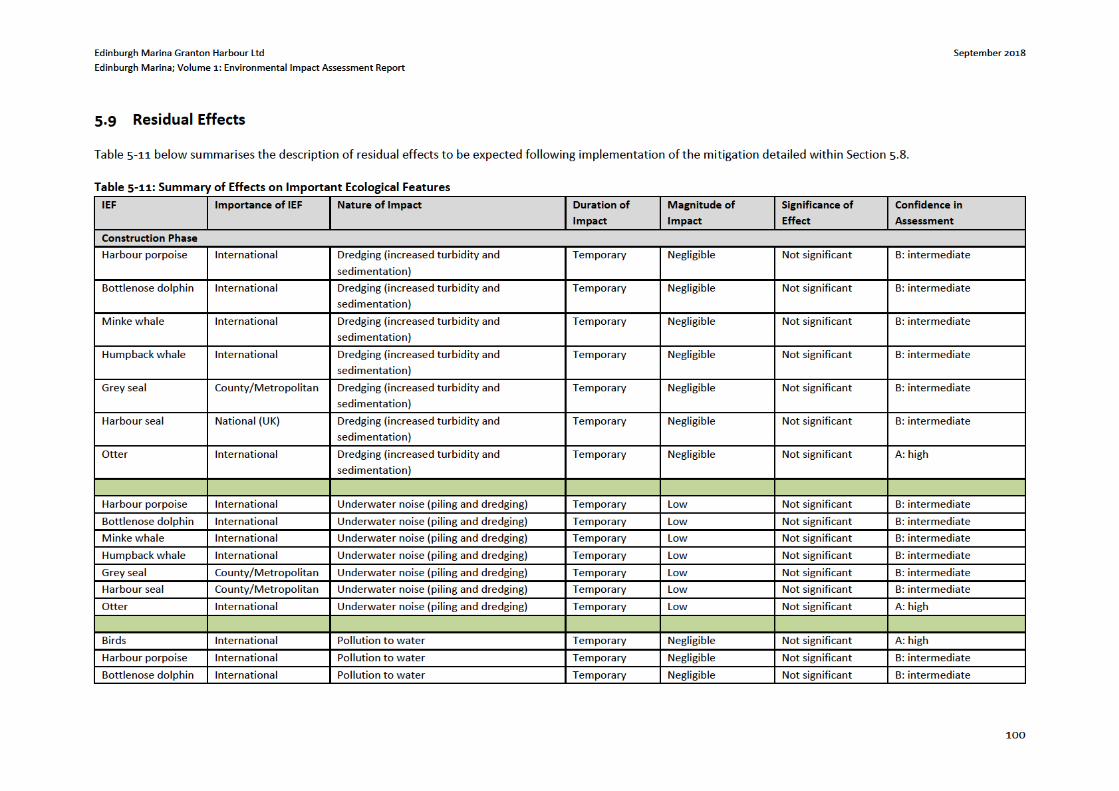
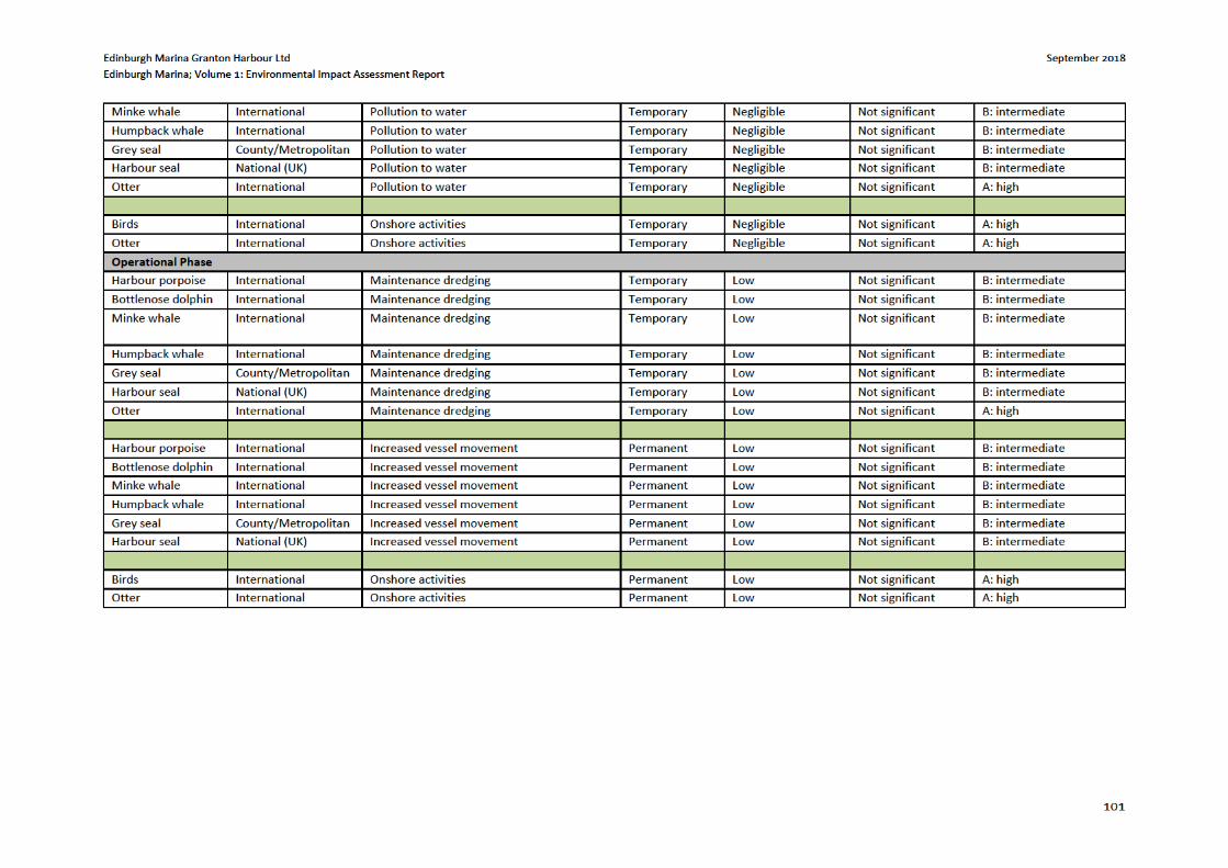

Edinburgh Marina Granton Harbour Ltd September 2018
Edinburgh Marina; Volume 1: Environmental Impact Assessment Report
102
5.10 Statement of Significance
This chapter concludes that by following the above described mitigation, which has been proposed based upon
a review of draft engineering design and predicted construction techniques, adverse effects will not be
significant.
Edinburgh Marina Granton Harbour Ltd September 2018
Edinburgh Marina; Volume 1: Environmental Impact Assessment Report
103
6 OTHER ISSUES
6.1 Introduction
This chapter provides a summary and assessment where applicable of additional potential environmental effects
or features which are relevant to the proposed development but have not been scoped into the full EIA given
significant effects were not deemed to be likely. These include effects or information associated with socio-
economics, air quality, navigation, population and human health, natural disasters and utilities. It is not the
purpose of this chapter to draw conclusions on the level of significance based upon detailed methodology (as
per the other chapters outlined throughout this EIAR), but instead offer a synopsis of relevant information, an
approach which has been agreed with Marine Scotland as per Technical Appendix 3.1 within Volume 3 of this
EIAR, alongside a relevant level of assessment specific to each feature of this chapter.
6.1.1 Scoping and Consultation
This chapter has been prepared based upon advice and consultation with the relevant consultees as illustrated
within Table 3-1 has been prepared under the requirements of the EIA Regulations in that it corresponds with,
and is based upon, the Scoping Opinion.
6.2 Exportation of Dredge Material by Road
6.2.1 Introduction
Vehicular access to the site is proposed from the existing roundabout junction of Granton Square, with a second
access on West Harbour Road. Close liaison with the traffic management section of City of Edinburgh Council
should be made in relation to the agreed routes and hours of working for construction vehicles.
6.2.2 Baseline Conditions
The proposed development is to upgrade the existing Granton Harbour (Edinburgh Marina) and associated Vessel
Berths (Pontoons). The works include the exportation of circa 154,385m3 of dredge material to land over a 3 year
period.
6.2.3 Potentially Significant Effects during Construction
Based on the dredging plan for the harbour which is provided in Appendix 2 of the Granton Harbour Dredging
2018 Best Practicable Environmental Option Report (September 2018), the volume split is as follows based on
chemical quality (Table 6-1)
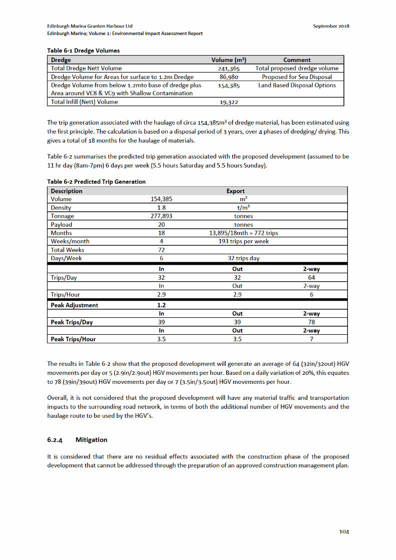
Edinburgh Marina Granton Harbour Ltd September 2018
Edinburgh Marina; Volume 1: Environmental Impact Assessment Report
105
6.3 Air Quality
6.3.1 Introduction
The site is situated on the northern boundary of the City of Edinburgh Council boundary area in a predominately
industrial area. The development has the potential to impact local air quality in a number of ways with the key
issues in relation to air quality being traffic emissions from the local road network both surrounding and accessing
the site and dust emissions during the construction phase.
6.3.2 Baseline Conditions
In order to inform the screening request, 1km background air quality concentration maps were obtained from
the Scottish Air Quality and DEFRA websites. The 2016 measured annual average concentrations of NO2, PM10
and PM2.5 are 15.86μg/m3, 10.28μg/m3 and 6.50μg/m3 respectively for background square (323500, 677500).
This indicates there was good air quality within the vicinity of the site with concentrations well below the relevant
National Air Quality Objectives of 40μg/m3, 18μg/m3 and 10μg/m3 respectively.
The 2017 Air Quality Annual Progress Report for the City of Edinburgh Council identifies six Air Quality
Management Areas (AQMA) designated within the Council area; Centre, Glasgow Road, St Johns Road, Great
Junction, Inverleith Road, and Salamander Street. The nearest AQMA to the development is the Inverleith Road
AQMA which is located ~2km to the South East of the site.
The automatic monitoring station closest to the proposed development is Salamander Street (Site ID 8) is located
approximately 3.5km east of the site at NGR 327615, 676333 and is therefore not considered to be representative
of site conditions.
The monitoring location closest to the proposed development is the NO2 diffusion tube at Trinity Crescent (Site
ID 14), located approximately 1.2km east of the site at NGR 324896, 676991). City of Edinburgh Councils 2017
Annual Progress Report lists the annual mean concentration for NO2 for 2016 as 27.5μg/m3 and details a steady
decrease in 2010 to 21.5 μg/m3 in 2016.
6.3.3 Potentially Significant Effects during Construction
Potential exists for an increase in traffic in the vicinity of the surrounding road network and in turn increases in
the pollutants NO2, PM10 and PM2.5 which are most commonly associated with traffic emissions. It is estimated
that the marina development will not lead to a significant increase in road traffic on the surrounding roads.
Further to this, with data indicating that air quality is good in the vicinity of the site it is anticipated that any
increase in exhaust emissions would have a negligible effect on air quality at sensitive receptors. This will
therefore not be assessed.
The main impact on air quality is considered to occur during the construction phase when fugitive dust can be
generated through construction activities. Dust associated with the proposed marina development will be
addressed within the Cumulative Effects section, and procedures to minimise dust arising during the construction
phase will be addressed within a Construction Environmental Management Plan (CEMP).
While at present traffic generation is not expected to change significantly, if any of the criteria identified above
is met then we would re-consult with City of Edinburgh Council Environmental Health Department to define the
scope of the air quality assessment. However, AQ is not considered to lead to significant environmental effects
and therefore no further study will be undertaken as part of the EIA.
Edinburgh Marina Granton Harbour Ltd September 2018
Edinburgh Marina; Volume 1: Environmental Impact Assessment Report
106
6.3.4 Potentially Significant Effects post-Completion
Potential exists for an increase in traffic in the vicinity of the surrounding road network and in turn increases in
the pollutants NO2, PM10 and PM2.5 which are most commonly associated with traffic emissions. This has the
potential to impact both existing and future residents.
It is estimated that the marina development will not lead to a significant increase in road traffic on the
surrounding road network. Further to this, with data indicating that air quality is good in the vicinity of the site it
is anticipated that any increase in exhaust emissions would have a negligible effect on air quality at sensitive
receptors.
6.3.5 Design and Mitigation
Construction of the proposed development is considered to be a temporary impact and can be controlled
through developing a site-specific Dust Management Plan as part of a Construction Environmental Management
Plan (CEMP). The dust impact assessment requires specific information on site operations during construction,
including preparatory earthworks, general construction and the potential for trackout during construction of the
proposed development. Currently this information is still being finalised. It is therefore proposed to defer the
construction dust assessment and formulation of a construction dust management plan until such time as details
on construction have been finalised.
In line with the decision notice associated with the outline planning application 01/00802/OUT which was
granted, with conditions, the following mitigation will be included where required:
Close liaison with the traffic management section of City of Edinburgh Council should be made in
relation to the agreed routes and hours of working for construction vehicles.
Haul routes to be located away from off-site sensitive properties and to be watered regularly (wet
suppression of dust) to ensure that any deposit of material on the local road network is minimised;
All site vehicles and plant to have upward-facing exhausts to minimise surface dust resuspension -
Bunds or screens may be constructed as wind breaks, to reduce wind speeds. Earth bunds should
be seeded as soon as possible prior to which they are to be maintained damp;
The aggregate stocking area should be located away from sensitive areas and residential properties;
- Stockpiles should also be watered and water curtains on any additionally be used at the site
boundaries near sensitive properties;
Off-site vehicles to be sheeted, their wheels and bodies to be cleaned and the access road to be
hard-surfaced and maintained damp; - Early paving of permanent roads;
Minimisation of drop heights, and the use of chutes to discharge material close to where it is
required - Vehicle wheel and chassis cleaning - Imposition of speed limits, to reduce dust emissions
from ground surfaces
6.4 Terrestrial Noise
The primary purpose of this exercise is to undertake a sufficient level of assessment to identify any environmental
effects of the proposed development associated with noise on the site and surrounding area.
6.4.1 Baseline Conditions
The site is located within the wider Granton Harbour Masterplan area, comprising of a mix of residential and
industrial/commercial uses. EnviroCentre carried out early morning and daytime baseline noise monitoring
approximately 50m to the south of Plot 8B, as part of a noise assessment carried out for a detailed planning
Edinburgh Marina Granton Harbour Ltd September 2018
Edinburgh Marina; Volume 1: Environmental Impact Assessment Report
108
Noise generating activities during the construction phase are understood to include;
Dredging of an area of the sea bed within. It is understood this may be carried out by a backhoe
dredger or suction dredger or on a hopper barge;
Land reclamation;
Extension of the western breakwater, also known as the north mole;
Piling of steel tubes into the sea bed as part of the extension and backfilling of the quay wall;
Creation of a new marina, including piling for pontoons; and,
HGV and construction plant movements in and around the site.
The closest existing noise sensitive receptors are the multi-storey flats located on Hesperus Broadway,
approximately 80m to the south-west of the south-western corner of Plot 8B. The closest future noise sensitive
receptors are noted as being the proposed flats within development Plot 8C, located approximately 20m from
the southern boundary of Plot 8B, and the proposed apartment hotel/flats located within development Plots 29
& 35 to the west.
Certain construction activities have the potential to impact upon existing and proposed noise sensitive receptors.
The assessment of construction noise requires detailed information on activities, items of plant, locations,
operating times etc. Once this information is known construction activities, if required, can be assessed in a
construction noise assessment, the results of which can be used to inform a construction noise management
plan. Construction noise will therefore be excluded at this stage.
6.4.3 Potentially Significant Effects post-Completion
There is the potential for noise generated by the proposed development during the operational phase to impact
on surrounding noise sensitive receptors.
The significance of operational noise from the marina at Plots 8A & 8B, at the closest existing and proposed
sensitive receptors was considered by EnviroCentre as part of the noise assessments carried out for detailed
planning applications for Plots 8C & 7B, and Plots 29 & 35 of the Granton Harbour Masterplan (refer to
EnviroCentre Report Nos. 7880 & 7881, dated 21st September 2017). The operational noise was found to meet
the Council’s noise criteria at the most exposed existing and proposed sensitive receptors with open windows.
It is acknowledged that during the construction phase of the marina development it will be necessary to
undertake some piling activities as part of the extension and backfilling of the quay wall, dredging etc. This impact
will be a short term temporary activity that will introduce a new noise source to the local area in addition to
other usual construction activities associated with transport and tipping of fill material.
The proposed development is set within an existing operational harbour where boats are moored and there is
limited commercial fishing activity i.e. crabs, accordingly, it is not considered that the proposed marina
development will have a significant environmental impact in terms of noise.
Taking the above into account it is considered that noise will not be significant and a Construction Environmental
Management Plan based on best practice noise control could be agreed with the authorities and this approach
would be appropriate in this instance.
6.4.4 Design and Mitigation
In line with the decision notice associated with the outline planning application 01/00802/OUT which was
granted, with conditions, the following noise mitigation measures will be included where required:
Edinburgh Marina Granton Harbour Ltd September 2018
Edinburgh Marina; Volume 1: Environmental Impact Assessment Report
109
Noise levels generated will be controlled by practicable means through contract specification, local
authority control and the use of temporary barriers and ‘quiet’ plant.
A construction noise management plan, can help mitigate any effects at the most exposed sensitive
receptors.
Acoustic double glazing
6.5 Population and Human Health
With reference to the Marine Works (Environmental Impact) (Scotland) Regulations 2017, assessment should be
proportionate. Therefore, the focus of population and human health issues within EIA focuses on whether the
potential impacts are likely to be significant. Where they are found likely to be significant, effort should focus on
identifying and gaining commitment to avoiding or reducing any adverse effects and to enhancing beneficial
effects. It should be noted that the potential effects on human health at Granton Harbour will principally be
associated with noise & vibration and air quality. As noted within sections 6.3 (air quality) and 6.4 (noise) these
will be short term impacts, and the effects on “Population and Human Health” will not be significant.
6.6 Navigation
This section assesses the potential impacts on navigation from the construction and operation of the proposed
development. In addition, it also proposes mitigation measures which can be applied to further reduce the
significance or likelihood of significant effects. Ensuring the safe operation of the harbour with particular respect
to existing marine traffic.
Granton Harbour was funded and developed by the 5th Duke of Buccleuch, who owned the site. Construction of
the middle pier began in 1837. Construction of Granton pier was completed by 1845.
In 1961 the harbour owners claimed 25 acres of land from the Western Harbour by infilling. This project took ten
years.
A bill was presented in parliament and in January 1968 Forth Ports Authority took over the management of most
of the ports of the Firth of Forth. At this time Granton was one of two ports in Britain making a profit. When
nationalised it employed 86 people, but by 1970 this had been reduced to two68.
The port was nationalised and came under the control of the new Forth Ports Authority from 1 January 1968, as
did other ports on the Firth of Forth. Much of the Western Harbour has been infilled and has recently been used
as the site for new properties under the same planning permission that approved the proposed marina
development.
6.6.1 Baseline
At present, the site comprises of predominantly reclaimed land from the sea, consisting of vacant brownfield
land which is scheduled for development under the approved 2003 masterplan and a number of subsequent
reserved matters and MSC permissions. The overall topography of the surrounding area is generally flat, with the
proposed marine works development situated at the edge, and within the extents of the harbour.
The proposed development is within the Granton Harbour regeneration development area, approximately 4km
north of Edinburgh City Centre and fronting the Firth of Forth. It is approximately 9.5Ha, bounded to the north
68 http://www.fcyc.org.uk/?page_id=169
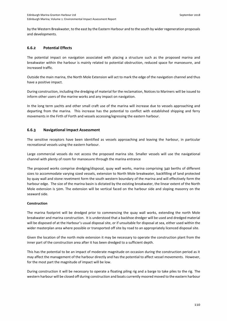
Edinburgh Marina Granton Harbour Ltd September 2018
Edinburgh Marina; Volume 1: Environmental Impact Assessment Report
110
by the Western Breakwater, to the east by the Eastern Harbour and to the south by wider regeneration proposals
and developments.
6.6.2 Potential Effects
The potential impact on navigation associated with placing a structure such as the proposed marina and
breakwater within the harbour is mainly related to potential obstruction, reduced space for manoeuvre, and
increased traffic.
Outside the main marina, the North Mole Extension will act to mark the edge of the navigation channel and thus
have a positive impact.
During construction, including the dredging of material for the reclamation, Notices to Mariners will be issued to
inform other users of the marine works and any impact on navigation.
In the long term yachts and other small craft use of the marina will increase due to vessels approaching and
departing from the marina. This increase has the potential to conflict with established shipping and ferry
movements in the Firth of Forth and vessels accessing/egressing the eastern harbour.
6.6.3 Navigational Impact Assessment
The sensitive receptors have been identified as vessels approaching and leaving the harbour, in particular
recreational vessels using the eastern harbour.
Large commercial vessels do not access the proposed marina site. Smaller vessels will use the navigational
channel with plenty of room for manoeuvre through the marina entrance
The proposed works comprise dredging/disposal, quay wall works, marina comprising 340 berths of different
sizes to accommodate varying sized vessels, extension to North Mole breakwater, backfilling of land protected
by quay wall and stone revetment form the south western boundary of the marina and will effectively form the
harbour edge. The size of the marina basin is dictated by the existing breakwater, the linear extent of the North
Mole extension is 50m. The extension will be vertical faced on the harbour side and sloping masonry on the
seaward side.
Construction
The marina footprint will be dredged prior to commencing the quay wall works, extending the north Mole
breakwater and marina construction. It is understood that a backhoe dredger will be used and dredged material
will be disposed of at the Harbour’s usual disposal site, or if unsuitable for disposal at sea, either used within the
wider masterplan area where possible or transported off site by road to an appropriately licenced disposal site.
Given the location of the north mole extension it may be necessary to operate the construction plant from the
inner part of the construction area after it has been dredged to a sufficient depth.
This has the potential to be an impact of moderate magnitude on occasion during the construction period as it
may affect the management of the harbour directly and has the potential to affect vessel movements. However,
for the most part the magnitude of impact will be low.
During construction it will be necessary to operate a floating piling rig and a barge to take piles to the rig. The
western harbour will be closed off during construction and boats currently moored moved to the eastern harbour
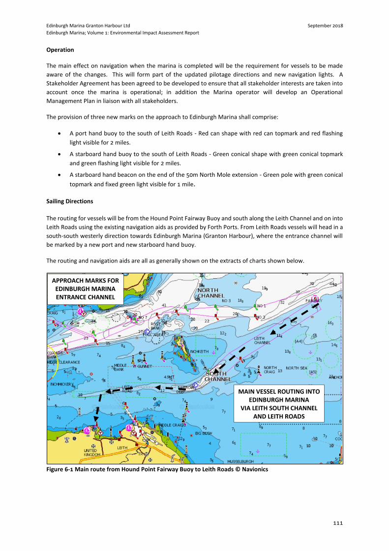
Edinburgh Marina Granton Harbour Ltd September 2018
Edinburgh Marina; Volume 1: Environmental Impact Assessment Report
111
Operation
The main effect on navigation when the marina is completed will be the requirement for vessels to be made
aware of the changes. This will form part of the updated pilotage directions and new navigation lights. A
Stakeholder Agreement has been agreed to be developed to ensure that all stakeholder interests are taken into
account once the marina is operational; in addition the Marina operator will develop an Operational
Management Plan in liaison with all stakeholders.
The provision of three new marks on the approach to Edinburgh Marina shall comprise:
A port hand buoy to the south of Leith Roads - Red can shape with red can topmark and red flashing
light visible for 2 miles.
A starboard hand buoy to the south of Leith Roads - Green conical shape with green conical topmark
and green flashing light visible for 2 miles.
A starboard hand beacon on the end of the 50m North Mole extension - Green pole with green conical
topmark and fixed green light visible for 1 mile.
Sailing Directions
The routing for vessels will be from the Hound Point Fairway Buoy and south along the Leith Channel and on into
Leith Roads using the existing navigation aids as provided by Forth Ports. From Leith Roads vessels will head in a
south-south westerly direction towards Edinburgh Marina (Granton Harbour), where the entrance channel will
be marked by a new port and new starboard hand buoy.
The routing and navigation aids are all as generally shown on the extracts of charts shown below.
Figure 6-1 Main route from Hound Point Fairway Buoy to Leith Roads © Navionics
MAIN VESSEL ROUTING INTO EDINBURGH MARINA
VIA LEITH SOUTH CHANNEL AND LEITH ROADS
APPROACH MARKS FOR EDINBURGH MARINA ENTRANCE CHANNEL
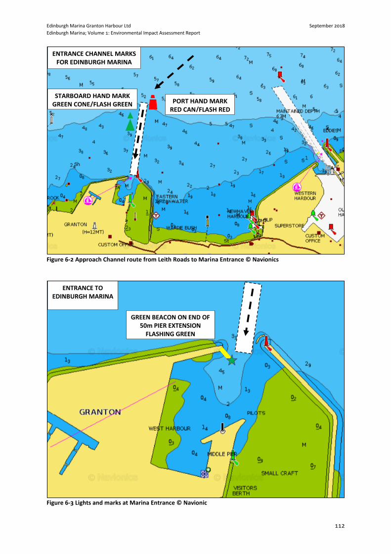
Edinburgh Marina Granton Harbour Ltd September 2018
Edinburgh Marina; Volume 1: Environmental Impact Assessment Report
112
Figure 6-2 Approach Channel route from Leith Roads to Marina Entrance © Navionics
Figure 6-3 Lights and marks at Marina Entrance © Navionic
PORT HAND MARK RED CAN/FLASH RED
STARBOARD HAND MARK GREEN CONE/FLASH GREEN
ENTRANCE CHANNEL MARKS FOR EDINBURGH MARINA
GREEN BEACON ON END OF 50m PIER EXTENSION
FLASHING GREEN
ENTRANCE TO EDINBURGH MARINA
Edinburgh Marina Granton Harbour Ltd September 2018
Edinburgh Marina; Volume 1: Environmental Impact Assessment Report
113
6.6.4 Assessment of Impact Significance
The quay wall works and piling activities are assessed as having a low to moderate impact on navigation within
the harbour for the short term as it will be necessary for vessels to operate in the navigation channel. The actual
approach will depend on the detailed design and preferred approach of the main contractor for the works.
6.6.5 Mitigation
A Construction Environmental Management Plan will incorporate navigation and the mitigation below (where
appropriate).
Mitigation with regard to the marina construction commences with the requirement for the successful
contractors to provide full methods, risk assessments and mitigation measures and to agree and amend these as
necessary.
Mitigation relates to correct lighting and buoyage during and post construction. New navigation lights shall be
installed as appropriate and buoyage may be deployed to ensure marina traffic follows a visible and shallow
entry angle into the main shipping channel.
Health and Safety during construction will be followed in accordance with The Construction (Design and
Management) Regulations 2015.
The following recommendations are generic and will be specified according to the construction method and type
of plant deployed.
Moving the piling barge/rig
To be handled be a competent vessel and crew at all times, advised to harbour and other traffic and co-ordinated
prior to commencement through a single contact.
Obstruction of channel
Ensure barge/jackup is on the ‘non’ channel side of the sheet pile installation if possible.
Foundering of barge in the channel
As above and additionally contractor emergency procedures to be in place, dovetailing with harbour
emergency procedures;
Contractor insurance;
Barge surveys; and
Best operating practice for the barge.
Collision with other vessels while engaged in dredging/disposal/piling
Navigational and minimum ambient lighting on barge;
Local Notice to Mariners;
Publicity in local press for recreational users, who are most likely to be affected.
Communication issues
VHF ch12 continuous monitoring; and
Mobile numbers of single contact point with emergency action responsibility on barge and vice versa
with Harbour contacts.
Edinburgh Marina Granton Harbour Ltd September 2018
Edinburgh Marina; Volume 1: Environmental Impact Assessment Report
114
Support vessels
Control of movement by harbour;
VHF ch12 continuous monitoring; and
Contractor methods and risk assessed boarding and transfer methods to barge/shore for all weather
conditions.
Wave/wash of passing vessels affecting passenger transfers or barge
Pre-planned and co-ordinated movements to lessen risk by contractor.
Damage to piling mid construction by vessels
Contractor to advise on fragility of structure when not complete and proposed mitigation should
irreparable damage be a risk.
Damage to vessels by piles mid construction
Lighting or other highlighting of danger areas to be used particularly during darkness;
Local Notice to Mariners; and
Publicity in local press for recreational users.
Contact with vessels passing by the operation of piling
Methods and risk assessments to be provided, agreed and adhered to (e.g. barge mounted crane jib
extending into navigational channel and the like).
The piling operation to be arranged in such a way that no physical encroachment can be made into the
navigational channel.
In addition to the foregoing, the marina operator is committed to complying with the Port Marine Safety Code
and 2018 Guide to Good Practice on Port Marine Operations.
6.7 Climate Change
Climate change has taken a prominent position within policy and legislation at a national level, with the Climate
Change (Scotland) Act 2009 creating a long-term framework for ensuring reduction in Scottish greenhouse gas
emissions of 80% by 2050.
Under Schedule 4(4), the EIA Regulations require “a description of the factors specified in 4(3) likely to be
significant affected by the development… (Including) climate (for example greenhouse gas emissions, impacts
relevant to adaption)”. In addition, Schedule 4(5) (f) of the EIA Regulations requires a “description of the likely
significant effects of the development on the environment resulting from…the impact of the project on climate
(for example the nature and magnitude of greenhouse gas emissions) and the vulnerability of the project to
climate change”.
It is considered that the proposed development would not result in a significant effect upon climate given the
nature of the development. Any increase in emissions created during either construction or operation is likely to
be negligible, and pollution and emissions control would be discussed within a detailed Construction
Environmental Management Plan (CEMP). Discussion of the vulnerability of the project to climate change is
primarily concerned with the water environment, including flood risk. Flooding is being scoped out of the EIA as
it does not constitute a significant environmental aspect.
Edinburgh Marina Granton Harbour Ltd September 2018
Edinburgh Marina; Volume 1: Environmental Impact Assessment Report
115
6.8 Natural Disasters
The proposed development is not located within an area of significant seismic activity, nor are climatic factors
prone to creating disasters such as tsunamis, hurricanes or catastrophic flooding. Accordingly consideration of
natural disasters was scoped out of the EIA.
6.9 Major Accidents
An assessment has been undertaken of any potentially significant adverse effects on the environment deriving
from the vulnerability of the development to risks of major accidents relevant to the project
Given a number of proposed design and operational measures, which are considered and reported in the
assessment, it is not anticipated that the Scheme is vulnerable to any major accidents and/ or disasters which
could result in significant effects on the environment.
As major accidents and disasters can potentially result in significant adverse environmental effects, it is prudent
for them to be considered at the planning stage of a development. Through identifying major accidents and
disasters at an early stage, it is possible to prevent such events from occurring, reduce the risk of this happening,
or decrease the extent of their potential harm in the local area and on local communities.
The structure of this chapter does not confirm to the typical chapter structure used elsewhere in this
Environmental Impact Assessment Report (EIAR) as it is recognised that existing legislation and health and safety
requirements already identify risks and help protect human beings and the environment69.
Legislation
Paragraph 18 of Directive 2014/52/EU70 states:
“In order to ensure a high level of protection of the environment, precautionary actions need to be taken for
certain projects which, because of their vulnerability to major accidents, and/or natural disasters (such as
flooding, sea level rise, or earthquakes) are likely to have significant adverse effects on the environment. For such
projects, it is important to consider their vulnerability (exposure and resilience) to major accidents and/or
disasters, the risk of those accidents and/or disasters occurring and the implications for the likelihood of
significant adverse effects on the environment.”
The above has been transposed into UK law under Schedule 4 (9) of the 2017 EIA Regulations71 which require:
“A description of the expected significant adverse effects of the development on the environment deriving from
the vulnerability of the development to risks of major accidents and/or disasters which are relevant to the project
concerned”.
Edinburgh Marina
The site is set within the wider Granton Development Area, and considered to be at negligible risk of Major
Accidents.
The Proposed Development will be designed to current best practice, in respect of safety and design.
69 Examples include the Construction Design and Management (CDM) 2015 Regulations 70 EU Directive 2014/52EU amending Directive 2011/92/EU on the assessment of the effects of certain public and private projects on the environment 71 The Marine Works (Environmental Impact Assessment) (Scotland) Regulations 2017 (as amended)
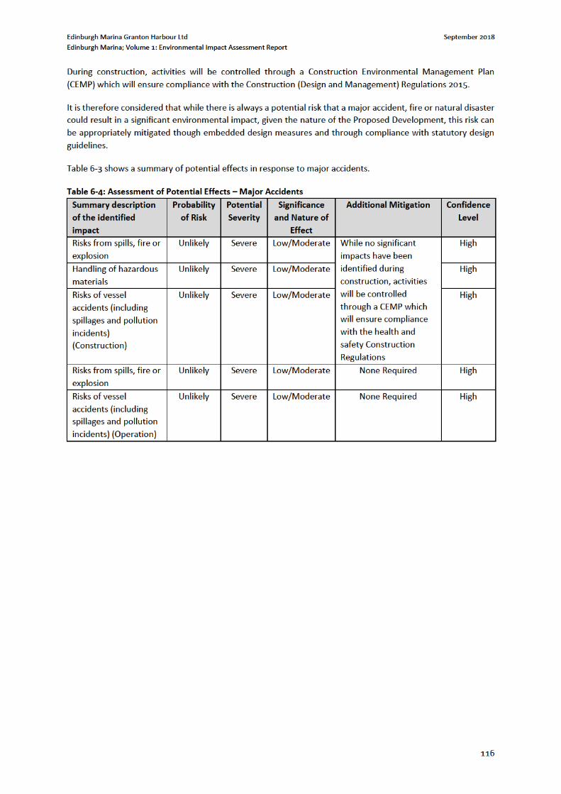
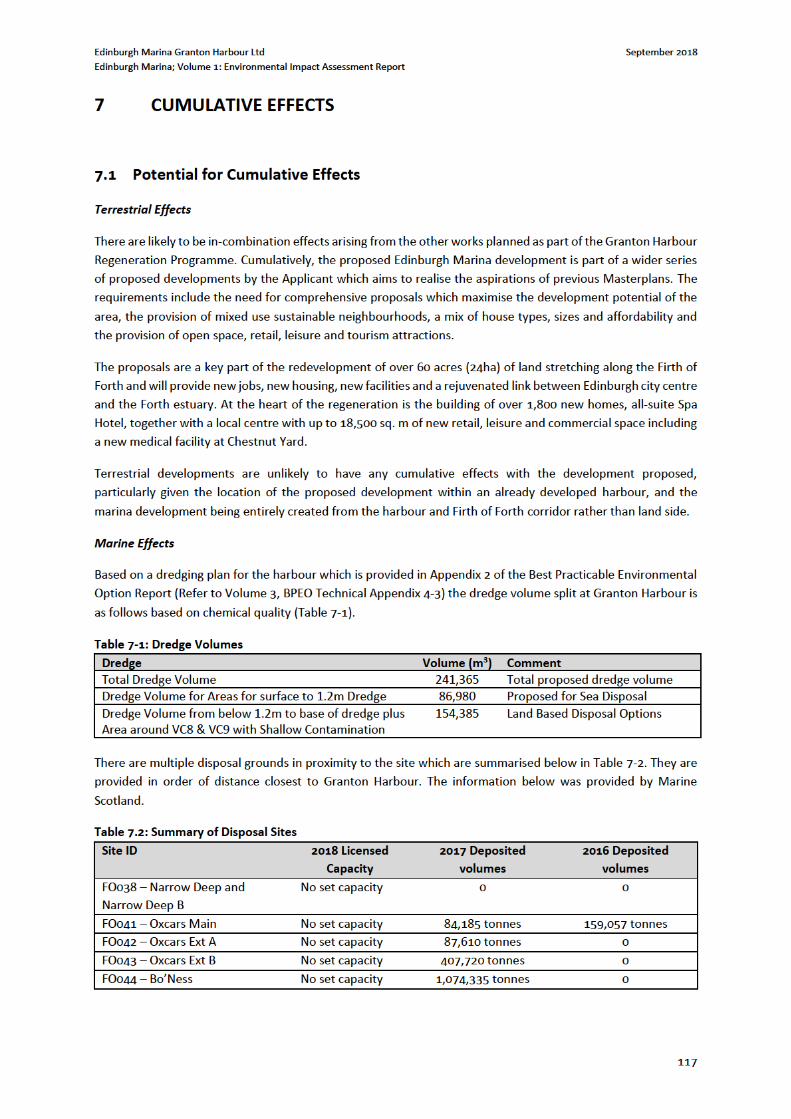
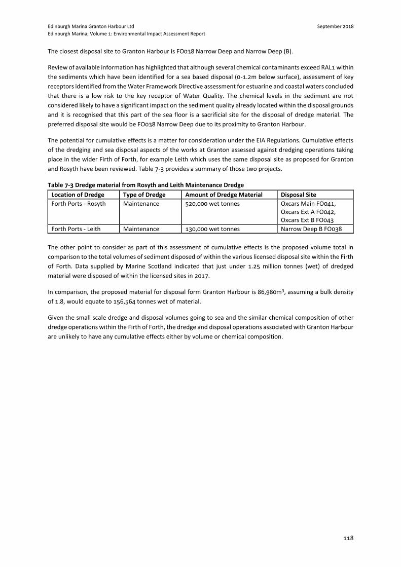
Edinburgh Marina Granton Harbour Ltd September 2018
Edinburgh Marina; Volume 1: Environmental Impact Assessment Report
118
The closest disposal site to Granton Harbour is FO038 Narrow Deep and Narrow Deep (B).
Review of available information has highlighted that although several chemical contaminants exceed RAL1 within
the sediments which have been identified for a sea based disposal (0-1.2m below surface), assessment of key
receptors identified from the Water Framework Directive assessment for estuarine and coastal waters concluded
that there is a low risk to the key receptor of Water Quality. The chemical levels in the sediment are not
considered likely to have a significant impact on the sediment quality already located within the disposal grounds
and it is recognised that this part of the sea floor is a sacrificial site for the disposal of dredge material. The
preferred disposal site would be FO038 Narrow Deep due to its proximity to Granton Harbour.
The potential for cumulative effects is a matter for consideration under the EIA Regulations. Cumulative effects
of the dredging and sea disposal aspects of the works at Granton assessed against dredging operations taking
place in the wider Firth of Forth, for example Leith which uses the same disposal site as proposed for Granton
and Rosyth have been reviewed. Table 7-3 provides a summary of those two projects.
Table 7-3 Dredge material from Rosyth and Leith Maintenance Dredge
Location of Dredge Type of Dredge Amount of Dredge Material Disposal Site
Forth Ports - Rosyth Maintenance 520,000 wet tonnes Oxcars Main FO041, Oxcars Ext A FO042, Oxcars Ext B FO043
Forth Ports - Leith Maintenance 130,000 wet tonnes Narrow Deep B FO038
The other point to consider as part of this assessment of cumulative effects is the proposed volume total in
comparison to the total volumes of sediment disposed of within the various licensed disposal site within the Firth
of Forth. Data supplied by Marine Scotland indicated that just under 1.25 million tonnes (wet) of dredged
material were disposed of within the licensed sites in 2017.
In comparison, the proposed material for disposal form Granton Harbour is 86,980m3, assuming a bulk density
of 1.8, would equate to 156,564 tonnes wet of material.
Given the small scale dredge and disposal volumes going to sea and the similar chemical composition of other
dredge operations within the Firth of Forth, the dredge and disposal operations associated with Granton Harbour
are unlikely to have any cumulative effects either by volume or chemical composition.
Edinburgh Marina Granton Harbour Ltd September 2018
Edinburgh Marina; Volume 1: Environmental Impact Assessment Report
119
8 SCHEDULE OF MITIGATION
8.1 Introduction
This chapter presents a summary of the mitigation and enhancement measures identified by the specialist
environmental studies through the EIA process. It indicates how these mitigation measure have or would be
implemented.
The mitigation and enhancement measures included in this EIAR would be implemented during one or more of
the following three broad phases of the proposed development:
Measures incorporated during the design process;
Measures required through the construction phase; and
Measures likely to be required during post-construction.
Table 8.1 below provides a summary of the mitigation measures proposed for each issue identified by the EIA
process. The measures are divided into the categories outlined above. It should be noted that the tables present
a summary only; further details on the mitigation and enhancement measures are included within each chapter
and the associated reports are included within Volume 3: Technical Appendices of this EIAR.
The Schedule is designed to provide a comprehensive summary of all construction or physical mitigation
measures that would require to be carried through into the construction and operation of the proposed
development, to ensure that the environmental assessment outcomes discussed throughout this EIAR are
reached, e.g. to ensure that significant adverse effects are avoided where applicable and possible.
It should be noted that enhancement measures have been suggested where appropriate throughout this EIAR,
however these are not items which have been included within the Schedule, given that whilst they are actions
or features which are encouraged, they are not mitigation which is required to alleviate potentially significant
effects.
8.2 Mitigation Measures
Mitigation detailed in each technical chapter has been summarised below in Table 8-1.
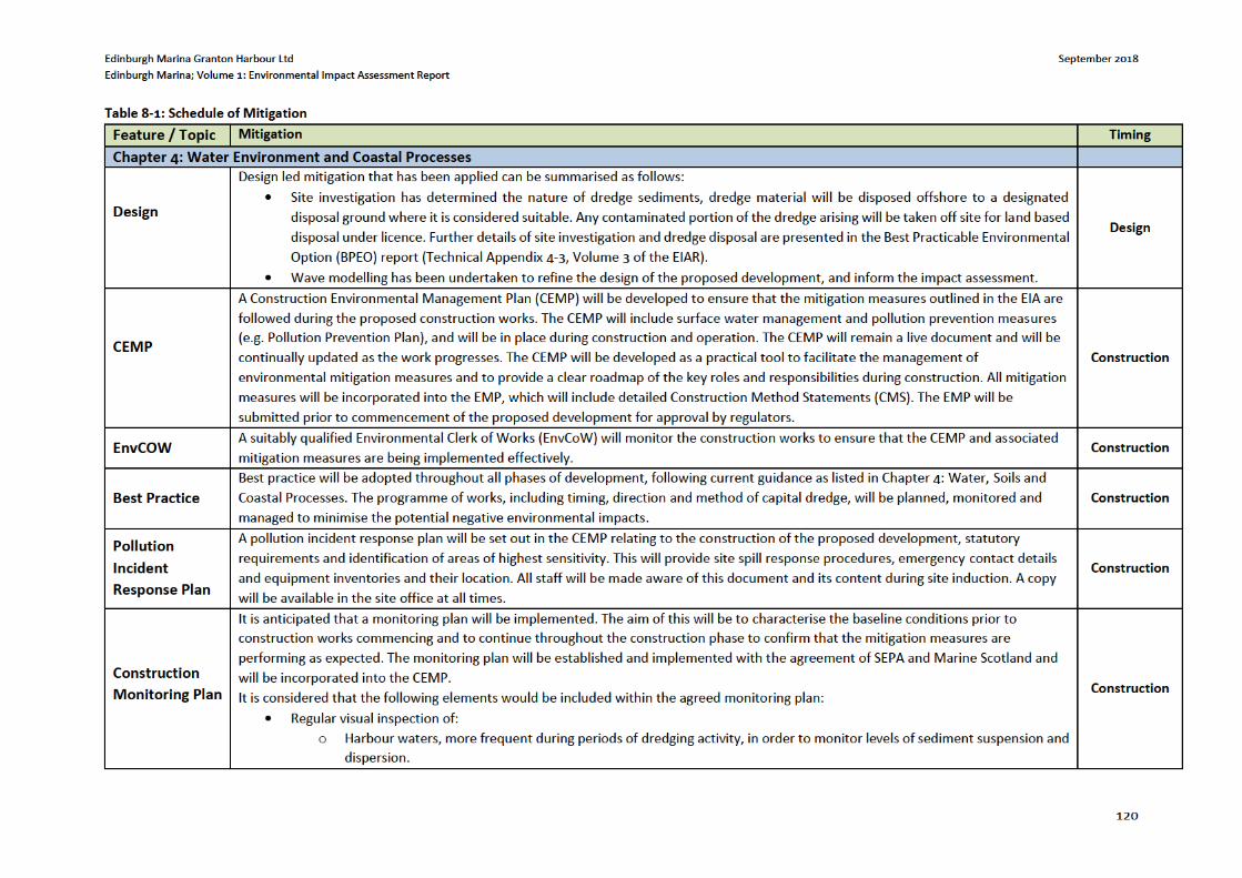
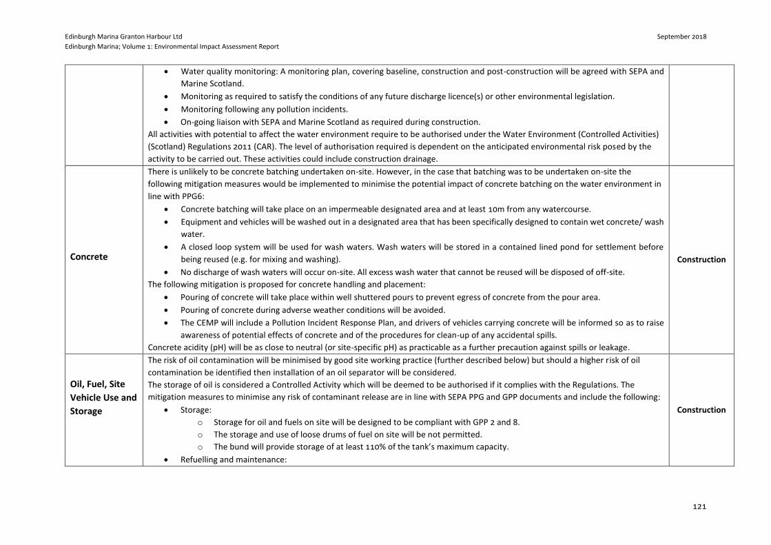
Edinburgh Marina Granton Harbour Ltd September 2018
Edinburgh Marina; Volume 1: Environmental Impact Assessment Report
121
Water quality monitoring: A monitoring plan, covering baseline, construction and post-construction will be agreed with SEPA and
Marine Scotland.
Monitoring as required to satisfy the conditions of any future discharge licence(s) or other environmental legislation.
Monitoring following any pollution incidents.
On-going liaison with SEPA and Marine Scotland as required during construction.
All activities with potential to affect the water environment require to be authorised under the Water Environment (Controlled Activities)
(Scotland) Regulations 2011 (CAR). The level of authorisation required is dependent on the anticipated environmental risk posed by the
activity to be carried out. These activities could include construction drainage.
Concrete
There is unlikely to be concrete batching undertaken on-site. However, in the case that batching was to be undertaken on-site the
following mitigation measures would be implemented to minimise the potential impact of concrete batching on the water environment in
line with PPG6:
Concrete batching will take place on an impermeable designated area and at least 10m from any watercourse.
Equipment and vehicles will be washed out in a designated area that has been specifically designed to contain wet concrete/ wash
water.
A closed loop system will be used for wash waters. Wash waters will be stored in a contained lined pond for settlement before
being reused (e.g. for mixing and washing).
No discharge of wash waters will occur on-site. All excess wash water that cannot be reused will be disposed of off-site.
The following mitigation is proposed for concrete handling and placement:
Pouring of concrete will take place within well shuttered pours to prevent egress of concrete from the pour area.
Pouring of concrete during adverse weather conditions will be avoided.
The CEMP will include a Pollution Incident Response Plan, and drivers of vehicles carrying concrete will be informed so as to raise
awareness of potential effects of concrete and of the procedures for clean-up of any accidental spills.
Concrete acidity (pH) will be as close to neutral (or site-specific pH) as practicable as a further precaution against spills or leakage.
Construction
Oil, Fuel, Site
Vehicle Use and
Storage
The risk of oil contamination will be minimised by good site working practice (further described below) but should a higher risk of oil
contamination be identified then installation of an oil separator will be considered.
The storage of oil is considered a Controlled Activity which will be deemed to be authorised if it complies with the Regulations. The
mitigation measures to minimise any risk of contaminant release are in line with SEPA PPG and GPP documents and include the following:
Storage:
o Storage for oil and fuels on site will be designed to be compliant with GPP 2 and 8.
o The storage and use of loose drums of fuel on site will be not permitted.
o The bund will provide storage of at least 110% of the tank’s maximum capacity.
Refuelling and maintenance:
Construction
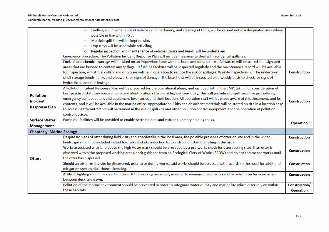
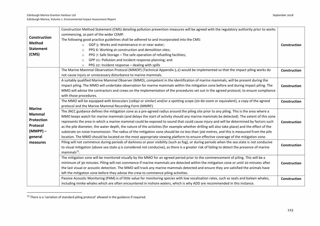
Edinburgh Marina Granton Harbour Ltd September 2018
Edinburgh Marina; Volume 1: Environmental Impact Assessment Report
123
Construction
Method
Statement
(CMS)
Construction Method Statement (CMS) detailing pollution prevention measures will be agreed with the regulatory authority prior to works
commencing, as part of the wider CEMP.
The following good practice guidelines shall be adhered to and incorporated into the CMS:
o GGP 5: Works and maintenance in or near water;
o PPG 6: Working at construction and demolition sites;
o PPG 7: Safe Storage – The safe operation of refuelling facilities;
o GPP 21: Pollution and incident response planning; and
o PPG 22: Incident response – dealing with spills
Construction
Marine
Mammal
Protection
Protocol
(MMPP) –
general
measures
The Marine Mammal Observation Protocol (MMOP) (Technical Appendix 5.2) would be implemented so that the impact piling works do
not cause injury or unnecessary disturbance to marine mammals. Construction
A suitably qualified Marine Mammal Observer (MMO), competent in the identification of marine mammals, will be present during the
impact piling. The MMO will undertake observation for marine mammals within the mitigation zone before and during impact piling. The
MMO will advise the contractors and crews on the implementation of the procedures set out in the agreed protocol, to ensure compliance
with those procedures.
Construction
The MMO will be equipped with binoculars (10X42 or similar) and/or a spotting scope (20-60 zoom or equivalent), a copy of the agreed
protocol and the Marine Mammal Recording Form (MMRF). Construction
The JNCC guidance defines the mitigation zone as a pre-agreed radius around the piling site prior to any piling. This is the area where a
MMO keeps watch for marine mammals (and delays the start of activity should any marine mammals be detected). The extent of this zone
represents the area in which a marine mammal could be exposed to sound that could cause injury and will be determined by factors such
as the pile diameter, the water depth, the nature of the activities (for example whether drilling will also take place) and the effect of the
substrate on noise transmission. The radius of the mitigation zone should be no less than 500 metres, and this is measured from the pile
location. The MMO should be located on the most appropriate viewing platform to ensure effective coverage of the mitigation zone.
Construction
Piling will not commence during periods of darkness or poor visibility (such as fog), or during periods when the sea state is not conducive
to visual mitigation (above sea state 4 is considered not conducive), as there is a greater risk of failing to detect the presence of marine
mammals72.
Construction
The mitigation zone will be monitored visually by the MMO for an agreed period prior to the commencement of piling. This will be a
minimum of 30 minutes. Piling will not commence if marine mammals are detected within the mitigation zone or until 20 minutes after
the last visual or acoustic detection. The MMO will track any marine mammals detected and ensure they are satisfied the animals have
left the mitigation zone before they advise the crew to commence piling activities.
Construction
Passive Acoustic Monitoring (PAM) is of little value for monitoring species with low vocalisation rates, such as seals and baleen whales,
including minke whales which are often encountered in inshore waters, which is why ADD are recommended in this instance. Construction
72 There is a ‘variation of standard piling protocol’ allowed in the guidance if required.
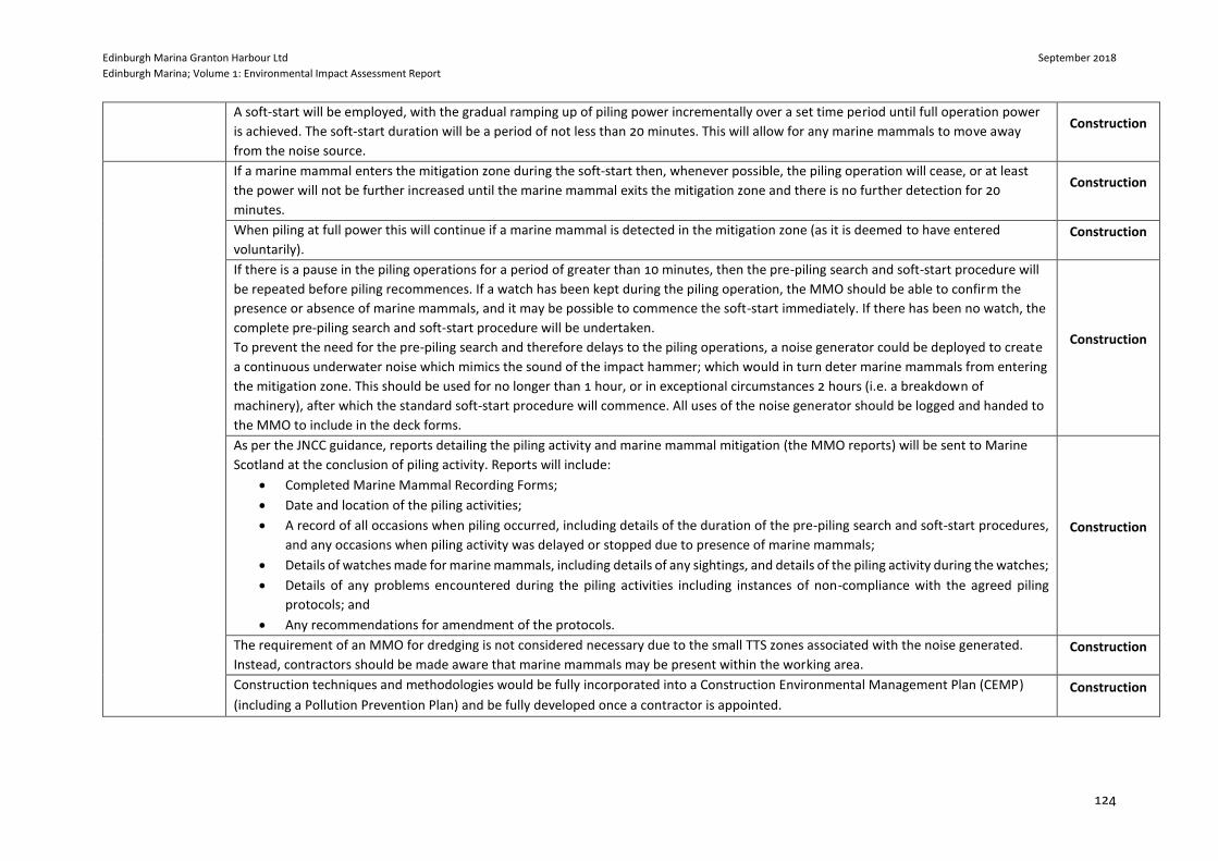
Edinburgh Marina Granton Harbour Ltd September 2018
Edinburgh Marina; Volume 1: Environmental Impact Assessment Report
124
A soft-start will be employed, with the gradual ramping up of piling power incrementally over a set time period until full operation power
is achieved. The soft-start duration will be a period of not less than 20 minutes. This will allow for any marine mammals to move away
from the noise source.
Construction
If a marine mammal enters the mitigation zone during the soft-start then, whenever possible, the piling operation will cease, or at least
the power will not be further increased until the marine mammal exits the mitigation zone and there is no further detection for 20
minutes.
Construction
When piling at full power this will continue if a marine mammal is detected in the mitigation zone (as it is deemed to have entered
voluntarily). Construction
If there is a pause in the piling operations for a period of greater than 10 minutes, then the pre-piling search and soft-start procedure will
be repeated before piling recommences. If a watch has been kept during the piling operation, the MMO should be able to confirm the
presence or absence of marine mammals, and it may be possible to commence the soft-start immediately. If there has been no watch, the
complete pre-piling search and soft-start procedure will be undertaken.
To prevent the need for the pre-piling search and therefore delays to the piling operations, a noise generator could be deployed to create
a continuous underwater noise which mimics the sound of the impact hammer; which would in turn deter marine mammals from entering
the mitigation zone. This should be used for no longer than 1 hour, or in exceptional circumstances 2 hours (i.e. a breakdown of
machinery), after which the standard soft-start procedure will commence. All uses of the noise generator should be logged and handed to
the MMO to include in the deck forms.
Construction
As per the JNCC guidance, reports detailing the piling activity and marine mammal mitigation (the MMO reports) will be sent to Marine
Scotland at the conclusion of piling activity. Reports will include:
Completed Marine Mammal Recording Forms;
Date and location of the piling activities;
A record of all occasions when piling occurred, including details of the duration of the pre-piling search and soft-start procedures,
and any occasions when piling activity was delayed or stopped due to presence of marine mammals;
Details of watches made for marine mammals, including details of any sightings, and details of the piling activity during the watches;
Details of any problems encountered during the piling activities including instances of non-compliance with the agreed piling
protocols; and
Any recommendations for amendment of the protocols.
Construction
The requirement of an MMO for dredging is not considered necessary due to the small TTS zones associated with the noise generated.
Instead, contractors should be made aware that marine mammals may be present within the working area. Construction
Construction techniques and methodologies would be fully incorporated into a Construction Environmental Management Plan (CEMP)
(including a Pollution Prevention Plan) and be fully developed once a contractor is appointed. Construction
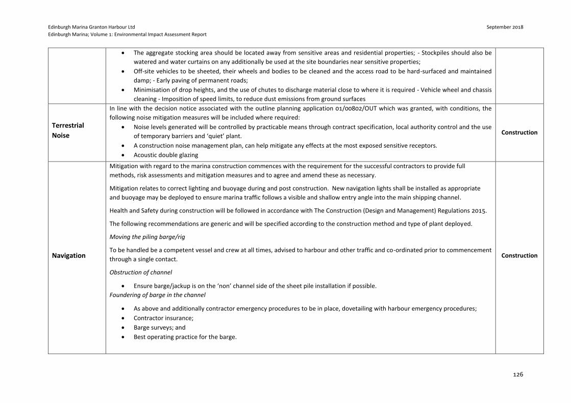
Edinburgh Marina Granton Harbour Ltd September 2018
Edinburgh Marina; Volume 1: Environmental Impact Assessment Report
126
The aggregate stocking area should be located away from sensitive areas and residential properties; - Stockpiles should also be
watered and water curtains on any additionally be used at the site boundaries near sensitive properties;
Off-site vehicles to be sheeted, their wheels and bodies to be cleaned and the access road to be hard-surfaced and maintained
damp; - Early paving of permanent roads;
Minimisation of drop heights, and the use of chutes to discharge material close to where it is required - Vehicle wheel and chassis
cleaning - Imposition of speed limits, to reduce dust emissions from ground surfaces
Terrestrial
Noise
In line with the decision notice associated with the outline planning application 01/00802/OUT which was granted, with conditions, the
following noise mitigation measures will be included where required:
Noise levels generated will be controlled by practicable means through contract specification, local authority control and the use
of temporary barriers and ‘quiet’ plant.
A construction noise management plan, can help mitigate any effects at the most exposed sensitive receptors.
Acoustic double glazing
Construction
Navigation
Mitigation with regard to the marina construction commences with the requirement for the successful contractors to provide full
methods, risk assessments and mitigation measures and to agree and amend these as necessary.
Mitigation relates to correct lighting and buoyage during and post construction. New navigation lights shall be installed as appropriate
and buoyage may be deployed to ensure marina traffic follows a visible and shallow entry angle into the main shipping channel.
Health and Safety during construction will be followed in accordance with The Construction (Design and Management) Regulations 2015.
The following recommendations are generic and will be specified according to the construction method and type of plant deployed.
Moving the piling barge/rig
To be handled be a competent vessel and crew at all times, advised to harbour and other traffic and co-ordinated prior to commencement
through a single contact.
Obstruction of channel
Ensure barge/jackup is on the ‘non’ channel side of the sheet pile installation if possible.
Foundering of barge in the channel
As above and additionally contractor emergency procedures to be in place, dovetailing with harbour emergency procedures;
Contractor insurance;
Barge surveys; and
Best operating practice for the barge.
Construction
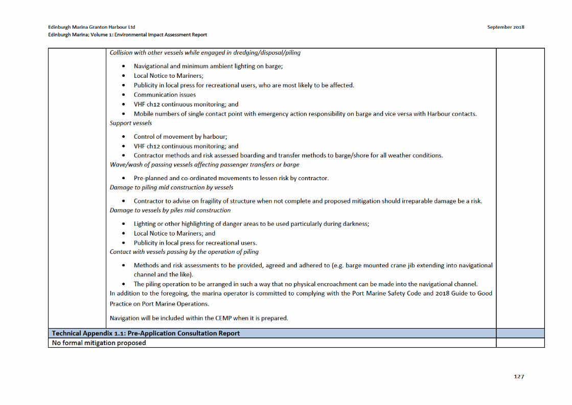
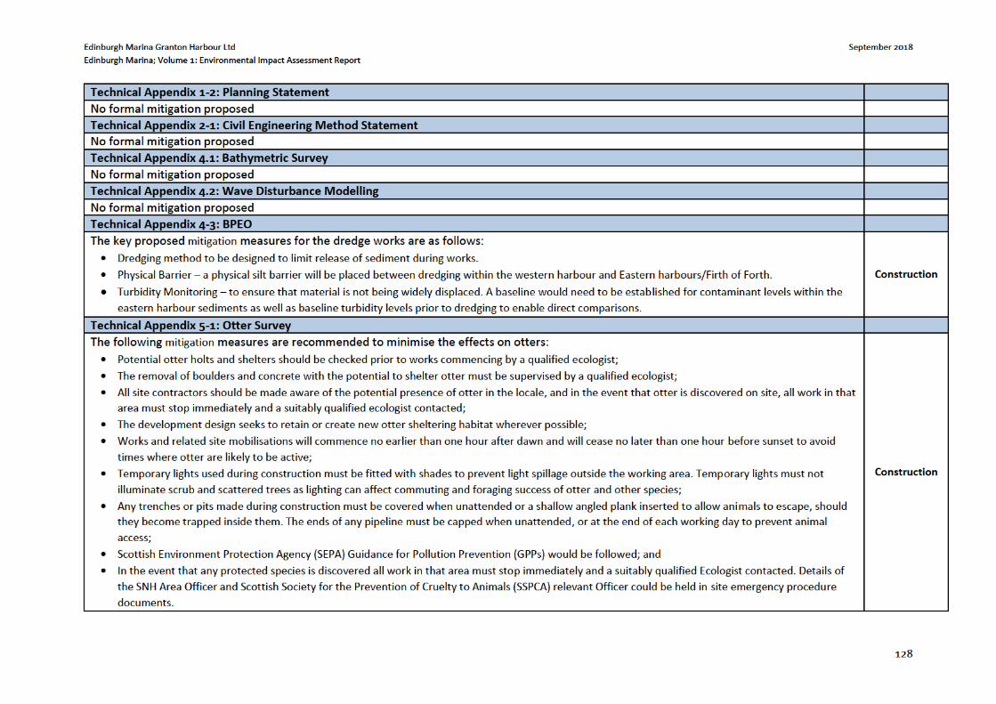
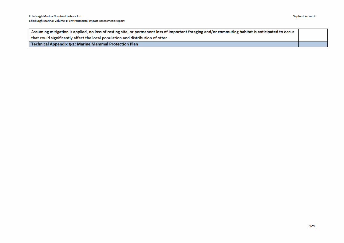
Edinburgh Marina Granton Harbour Ltd September 2018
Edinburgh Marina; Volume 1: Environmental Impact Assessment Report
130
Marine Mammal Observer Protocol – Impact Piling
Marine Mammal Observer: A suitably qualified Marine Mammal Observer (MMO), competent in the identification of marine mammals at sea,
will be present during the impact piling. The MMO will undertake observation for marine mammals within the mitigation zone before and during
impact piling and will be dedicated to that one task for the duration of any watch. The MMO will advise the contractors and crews on the
implementation of the procedures set out in the agreed protocol, to ensure compliance with those procedures.
The JNCC guidance provides the following definitions of an MMO:
MMO: Individual responsible for conducting visual watches for marine mammals. It may be requested that observers are trained, dedicated and/or experienced.
Trained MMO: Has been on a JNCC recognised course.
Dedicated MMO: Trained observer whose role on board a vessel is to conduct visual watches for marine mammals.
Experienced MMO: Trained observer with three years of field experience observing for marine mammals, and practical experience of implementing the JNCC guidelines.
The MMO will be land based and will be Trained. The identity and credentials of the MMO will be agreed with Marine Scotland.
MMO Equipment: The MMO will be equipped with binoculars (10X42 or similar) and/or a spotting scope (20-60 zoom or equivalent), a copy of the agreed protocol and the Marine Mammal Recording Form (MMRF), which is a Microsoft Excel spreadsheet containing embedded worksheets named Cover Page, Operations, Effort and Sightings. A Microsoft Word document named Deck forms is also available, and the MMO may prefer to use this when observing before transferring the details to the Excel spreadsheets. Although these forms were developed for seismic surveys, they can be used for piling operations, although many columns will not be applicable. The ability to determine the range of marine mammals is a key skill for MMOs, therefore a hand-held rangefinder will be used to verify the range.
All MMO forms, including a guide to completing the forms; and instructions on how to make a rangefinder are available on the JNCC website:
http://jncc.defra.gov.uk/marine/seismic survey
Communication: The contractor will be responsible for the communication channels between those providing the mitigation service and the crews working on the piling. A formal chain of communication from the MMO to the contractor, who will start/stop piling, will be established. In order to confirm the chain of communication and command the MMO will attend any relevant pre-mobilisation meetings.
Mitigation Zone: The JNCC guidance defines the mitigation zone as a pre-agreed radius around the piling site prior to any piling. This is the area where a MMO keeps watch for marine mammals (and delays the start of activity should any marine mammals be detected). The extent of this zone represents the area in which a marine mammal could be exposed to sound that could cause injury and will be determined by factors such
Construction
Edinburgh Marina Granton Harbour Ltd September 2018
Edinburgh Marina; Volume 1: Environmental Impact Assessment Report
131
as the pile diameter, the water depth, the nature of the activities (for example whether drilling will also take place) and the effect of the substrate on noise transmission.
The radius of the mitigation zone should be no less than 500 metres, and this is measured from the pile location. The mitigation zone is calculated following a review of underwater noise modelling; and reflects the risk zones of PTS and TTS for the species of concern, therefore cannot be defined at this time.
The MMO should be located on the most appropriate viewing platform to ensure effective coverage of the mitigation zone, during periods of rough seas, an elevated vantage point would be beneficial.
Impact Piling Protocol
The standard JNCC protocol is outlined below73 (please see the Acoustic Deterrent Device (ADD) protocol to be followed during times of sea states exceeding 4 (or 2 if deemed necessary by the MMO) or during periods of darkness and/or low visibility i.e. fog):
1. The MMO will not initiate this protocol during periods of darkness or poor visibility (such as fog) or during periods when the sea state is not conducive to visual mitigation (above sea state 4 is considered not conducive74) as there is a greater risk of failing to detect the presence of marine mammals. Harbour porpoise have small dorsal fins, therefore the MMO shall take additional precautions if the sea state exceeds 2. As works will occur over the winter period it is likely that sea state 2 will be exceeded on a regular basis. An elevated platform for the MMO to monitor from would be beneficial when the sea state is 2 or above, the impact piling works could also be scheduled on a day where the sea is expected to be calm.
2. The mitigation zone will be monitored visually by the MMO for an agreed period prior to the commencement of piling. This will be a minimum of 30 minutes.
3. The MMO will scan the waters using binoculars or a spotting scope and by making visual observations. Sightings of marine mammals will be appropriately recorded in terms of date, time, position, weather conditions, sea state, species, number, adult/juvenile, behavior, range etc. on the JNCC standard forms. Communication between the MMO and the contractor and the start/end times of the activities will also be recorded on the forms.
4. Piling will not commence if marine mammals are detected within the mitigation zone or until 20 minutes after the last visual detection. The MMO will track any marine mammals detected and ensure they are satisfied the animals have left the mitigation zone before they advise the crew to commence piling activities.
73 There is a ‘variation of standard piling protocol’ allowed in the guidance if required. 74 Detection of marine mammals, particularly porpoises, decreases as sea state increases. According to the JNCC guidance ideally sea states of 2 or less are required for optimal visual detection.
Edinburgh Marina Granton Harbour Ltd September 2018
Edinburgh Marina; Volume 1: Environmental Impact Assessment Report
135
Timing and duration – Avoid conducting piling activities during times when marine mammals are likely to be breeding, calving, feeding,
or resting in biologically important habitats located within the potential noise impact footprint.
Piling method – Use low noise piling methods, such as vibro-piling, instead of impact piling methods where possible. Vibro-piling
methods produce lower noise levels and are not impulsive in character. This reduces the likelihood of hearing injury to occur within
marine mammals. The piling method should be optimised taking into account time on-site and likely noise levels.
Soft start - The use of a ‘soft start’ or ‘ramping up’ process, in which pile driving energy is gradually increased to normal operating levels,
gives nearby animals an opportunity to vacate the area before sound levels increase to an extent that may cause injury. There is some
concern that this technique may actually attract animals, and so should be used with this is mind and always with trained marine
mammal observers present (Jefferson et al. 2009). Also, it is likely that behavioural changes and possibly masking will still occur for
nearby animals (Madsen et al. 2006).
Contract documentation – Include the standard management and mitigation procedures, and any additional measures to be put in place,
in the contract documentation.
Trained team – Ensure that a suitably qualified person is available during piling activities to conduct the standard operational procedures
outlined below. A suitably qualified person should have qualifications in ecology or environmental sciences and demonstrated
experience with the identification and management of marine mammals. A briefing on environmental matters, including information on
guidelines, marine mammal identification and legal obligations should be provided to all staff involved in the piling activities. Likely
marine mammal concentration areas, key feeding sites, and other aggregation areas should be identified during the planning stage and
this information should be provided to trained team members and the marine mammal observer to improve the identification and
observation of marine mammals.
Bubble curtains - Demonstrated to significantly lower both pile driving sound pressure levels and peak frequencies. Typically a bubble
curtain consists of a perforated hose that is anchored to the sea floor around the area where piling is taking place. Compressed air is
pumped through the hose and a ‘curtain’ of bubbles produced. Bubble screens can reduce the sound pressure levels up to a biologically
significant 25dB in the frequency range of concern for marine mammals. Other variations of bubble curtains such as screens and jackets
are commonly used to reduce pile driving noise at offshore wind-farms and are worth considering.
Edinburgh Marina Granton Harbour Ltd September 2018
Edinburgh Marina; Volume 1: Environmental Impact Assessment Report
136
9 CONCLUSIONS
9.1 Introduction
The predicted environmental effects related to the construction and operation of the proposed development at
Edinburgh Marina have been considered throughout the design and subsequent assessment of the development
layout. The views of statutory consultees have been taken into account as presented in Chapter 3: EIA
Methodology and Scoping. The final design of the proposed development has been subject to a detailed EIA
which has sought to minimise the effects resulting from the proposed development. Mitigation measures are
detailed within their respective specific chapters of this EIAR and summaries within Chapter 7: Schedule of
Mitigation of this EIAR.
9.2 Water Environment and Coastal Processes
Assessment of the impacts of the proposed development on the water environment and coastal processes in the
study area was undertaken and detailed within Chapter4. Overall, the effects of the proposed development on
the water environment, soils and coastal processes are not significant. The post-mitigation magnitude of any
residual effects are detailed within Chapter 4 and are considered either minor or negligible in this respect.
Accordingly, no significant adverse effects have been identified.
9.3 Marine Ecology and Ornithology
Assessment of the impacts of the proposed development on the Ecology in the study area was undertaken and
detailed within Chapter 5. Overall, the effects of the proposed development on ecology and ecological processed
processes are not significant. The post-mitigation magnitude of any residual effects are detailed within Chapter
5 and are considered either minor or negligible in this respect. Accordingly, no significant adverse effects have
been identified.
9.4 Other Issues
A range of other issues were explored, such as exportation of dredge material by road, air quality, terrestrial
noise, population and human health, navigation, climate change, natural disasters and major accidents. No
significant effects are predicted under any of these topics.
9.5 Cumulative Effects
The cumulative effects associated with the proposed development were assessed and No significant effects are
predicted