Embed Size (px)
Citation preview

www.wiley.com/wiley-blackwell
Also available as an e-book
The DicTionaryof PhysicalGeoGraPhyF O U R T H E D I T I O N
A companion website is available at:www.wiley.com/go/thomas/physicalgeography
Edited by David S. G. Thomas
The DicTionaryofPhysical GeoGraPhy
FOURTHEDITION
Thomas
Spine25mm
This fully revised comprehensive fourth edition covers the whole field of physicalgeography, including climate and atmosphere, geomorphology, biogeography, hydrology,oceans, Quaternary, environmental change, soils, remote sensing and GIS. This new editionreflects developments in the discipline during the last decade, with the expert advisorygroup providing an international perspective on the discipline of physical geography.
Over 2000 entries that are self-contained or cross-referenced include 200 that are newto this edition, over 400 that are rewritten and updated, and new supporting referencesand additional recommended reading in many others. Entries removed from the lastedition are available in the online resource. This volume is the essential reference pointfor students of physical geography and related environmental disciplines, lecturers andinterested individuals alike.
David Thomas is Professor of Geography at the University of Oxford, a Fellow of HertfordCollege, and is Honorary Professor at the Universities of Cape Town and Witwatersrand inSouth Africa. He is a geomorphologist who works in contemporary as well as Quaternarycontexts, especially in drylands and deserts. He has authored almost 200 papers inrefereed international journals and other volumes, and has authored or edited 10 books.
Filename: THOMAS_Physical Geography 4e_9781118782347_183602 • Size - 170 X 244mm (PBK)
The DicTionary of Physical GeoGraPhy F O U R T H E D I T I O N
Edited by David S. G. Thomas International Advisory Panel
David Dunkerley
Giles Foody
Andrew Goudie
Michael Meadows
David Montgomery
Sharon Nicholson
Tom Spencer


T H E D I C T I O N A R Y O F
Physical Geography


THE DICTIONARY OF
Physical Geography Fourth Edition
Edited by
David S.G. Thomas
International Advisory Panel
David Dunkerley (Australia) Giles Foody (UK) Andrew Goudie (UK) Michael Meadows (South Africa) David Montgomery (USA) Sharon Nicholson (USA) Tom Spencer (UK)

This edition first published 2016 2016 by John Wiley & Sons Ltd
First published 1985 by Blackwell Publishers Ltd; Second edition published 1994 by Blackwell Publishing Ltd; Third edition published 2000 by Blackwell Publishing Ltd
Registered office: John Wiley & Sons, Ltd, The Atrium, Southern Gate, Chichester, West Sussex, PO19 8SQ, UK
Editorial offices: 9600 Garsington Road, Oxford, OX4 2DQ, UK The Atrium, Southern Gate, Chichester, West Sussex, PO19 8SQ, UK 111 River Street, Hoboken, NJ 07030-5774, USA
For details of our global editorial offices, for customer services and for information about how to apply for permission to reuse the copyright material in this book please see our website at www.wiley.com/wiley-blackwell.
The right of the author to be identified as the author of this work has been asserted in accordance with the UK Copyright, Designs and Patents Act 1988.
All rights reserved. No part of this publication may be reproduced, stored in a retrieval system, or transmitted, in any form or by any means, electronic, mechanical, photocopying, recording or otherwise, except as permitted by the UK Copyright, Designs and Patents Act 1988, without the prior permission of the publisher.
Designations used by companies to distinguish their products are often claimed as trademarks. All brand names and product names used in this book are trade names, service marks, trademarks or registered trademarks of their respective owners. The publisher is not associated with any product or vendor mentioned in this book.
Limit of Liability/Disclaimer of Warranty: While the publisher and author(s) have used their best efforts in preparing this book, they make no representations or warranties with respect to the accuracy or completeness of the contents of this book and specifically disclaim any implied warranties of merchantability or fitness for a particular purpose. It is sold on the understanding that the publisher is not engaged in rendering professional services and neither the publisher nor the author shall be liable for damages arising herefrom. If professional advice or other expert assistance is required, the services of a competent professional should be sought.
Library of Congress Cataloging-in-Publication Data
Names: Thomas, David S. G. Title: The dictionary of physical geography / edited by David S.G. Thomas. Description: Fourth Edition. | Hoboken, NJ : John Wiley & Sons Inc., [2016] |
Includes index. Identifiers: LCCN 2015031859| ISBN 9781118782347 (Cloth) | ISBN 9781118782330
(Paper) Subjects: LCSH: Physical geography–Dictionaries. Classification: LCC GB10 .D53 2016 | DDC 910/.0203–dc23 LC record available at http://lccn.loc.gov/2015031859
A catalogue record for this book is available from the British Library.
Wiley also publishes its books in a variety of electronic formats. Some content that appears in print may not be available in electronic books.
Cover image: Erg Chebbi dunes in Morocco, Sahara desert Getty Images
Set in 9/10pt PlantinStd by Thomson Digital, Noida, India
1 2016
Contents
List of Contributors vi
Preface to the Fourth Edition x
Preface to the First Edition xi
Preface to the Second Edition xii
Preface to the Third Edition xiii
Acknowledgments xiv
About the Companion Website xvi
Introduction xvii
THE DICTIONARY OF PHYSICAL GEOGRAPHY 1
Index 581
v
Contributors
NOTE: This list of contributors, and their affiliations, was updated during production of the fourth edition. Some contributions were made for the first and subsequent editions, and contributor affiliations may have since changed. These have been updated where possible, but in some cases the affiliation at the time of contribution may remain.
AB Alison Banwell University of Cambridge
AD Angus Duncan University of Bedfordshire
AHP Allen H Perry Formerly of Swansea University
AH-S Ann Henderson-Sellers Emeritus, MacQuarie University
ALH A Louise Heathwaite University of Lancaster
AMG Angela M Gurnell Queen Mary University of London
AP Adrian Parker Oxford Brookes University
ARH Alan R Hill Formerly of York University, Ontario
ASG Andrew S Goudie Emeritus, University of Oxford
AW Andrew Watson DAI, Washington, DC
AWE Andrew W Ellis Virginia Tech
BAK
BGT
BJS
BWA
CAMK
CDC
CTA
DB
DES
DEW
Barbara A Kennedy Formerly of University of Oxford. Deceased.
Bruce G Thom University of Sydney
Bernie J Smith Formerly of Queen’s University of Belfast. Deceased
Bruce W Atkinson Emeritus, Queen Mary University of London
Cuchlain A M King Formerly University of Nottingham
Chris D Clark University of Sheffield
Clive T Agnew University of Manchester
Denys Brunsden Emeritus, King’s College London
David Sugden Emeritus, University of Edinburgh
Des E Walling Emeritus, University of Exeter
vi
CONTRIBUTORS
DW David Watts Formerly of University of Hull. Deceased.
DGT David G Tout Formerly of University of Manchester
DH David Higgitt University of Singapore
DJN David J Nash University of Brighton
DJS Douglas Sherman Texas A&M University
DLD David L Dunkerley Monash University
DRM David R Montgomery University of Washington
DSGT David S G Thomas University of Oxford
DTP David T Pugh IOS Deacon Laboratory, Godalming
ECB Eric C Barrett Formerly of University of Bristol
GCN Gerald C Nanson University of Wollongong
GFSW Giles F S Wiggs University of Oxford
GMF Giles M Foody University of Nottingham
HAV Heather Viles University of Oxford
HMF Hugh M French Emeritus, University of Ottawa
HVL
IAC
IB
IE
IGS
DSB
JAD
JAM
JAS
JEA
JEL
JET
JGL
Harry van Loon Formerly of National Center for Atmospheric Research, Boulder, CO
Ian A Campbell Formerly of University of Alberta. Deceased.
Ian Burton Emeritus, Meteorological Service of Canada
Ian Evans University of Durham
Ian G Simmons University of Durham
Doreen S Boyd University of Nottingham
John A Dearing University of Southampton
John A Matthews Formerly of Swansea University
John Shaffer Arizona State University
John E Allen Formerly Queen Mary University of London
Julie E Laity California State University
John E Thornes Emeritus, University of Birmingham
John G Lockwood Formerly of University of Leeds
vii
CONTRIBUTORS
JL John Lewin Emeritus, Aberystwyth University
JLB Jim Best University of Leeds
JM Judith Maizels Formerly University of Aberdeen
JO Julian Orford Queen’s University of Belfast
JSAG John S A Green Formerly University of East Anglia
KB Katherine Brown University of Tasmania
KEB Keith Barber University of Southampton
KEI Keith Idso Arizona State University
KJG Kenneth J Gregory University of Southampton
KJW Keith J Weston University of Edinburgh
KS Keith Smith Emeritus, University of Stirling
KSR Keith S Richards Emeritus, University of Cambridge
LN Lynn Newman Glendale Community College, Arizona
MAS Mike A Summerfield University of Edinburgh
MDB
MEM
MFT
MHU
MJK
MJS
MLH
NSA
NJM
NJS
PAB
PAF
PAS
PHA
PJC
Mark D Bateman University of Sheffield
Michael E Meadows University of Cape Town
Michael F Thomas Emeritus, University of Stirling
Michael H Unsworth Emeritus, Oregon State University
Mike J Kirkby University of Leeds
Michael J Selby Emeritus, University of Waikato
Mark L Hidebrandt Arizona State University
Neil S Arnold University of Cambridge
Nick J Middleton University of Oxford
Nancy J Selover Arizona State University
Peter A Bull University of Oxford
Peter A Furley Emeritus, University of Edinburgh
Philip A Stott Formerly School of Oriental and African Studies
Patrick H Armstrong University of Western Australia
Paul J Curran City University, London
viii

CONTRIBUTORS
PS Peter Smithson Emeritus, University of Sheffield
PSH Paul A Shaw Formerly of University of the West Indies
PWW Paul W Williams University of Auckland
RCB Robert C Balling Jr Arizona State University
RGB Roger G Barry University of Colorado, Boulder
RHS Rodney H Squires University of Minnesota, Minneapolis
RH-Y Roy Haines-Young University of Nottingham
RID Ronald I Dorn Arizona State University
RLJ Robert L Jones Formerly Coventry University
RR Ross Reynolds University of Reading
RSC Randell S Cerveny Arizona State University
RSW Richard S Washington University of Oxford
SAC Stanley A Changnon Formerly Illinois Department of Energy, Champaign, IL. Deceased
SEN
SLO
SMP
SMW
SNL
SS
TRO
TS
VM
WBW
WDS
WLG
Sharon E Nicholson Florida State University
Sarah L O’Hara University of Nottingham
Susan M Parker London
Stephen M Wise University of Sheffield
Stuart N Lane University of Lausanne
Stephen Stokes Formerly of University of Oxford. Deceased
Timothy R Oke University of British Columbia, Vancouver
Tom Spencer University of Cambridge
Vashu Mistra Florida State University
W Brian Whalley University of Sheffield
William D Sellers Formerly of University of Arizona. Deceased.
William L Graf Emeritus. Arizona State University
ix
Preface to the Fourth Edition
It is 15 years since the last edition of this dictionary was published. This edition represents a substantial revision. The entry list has been fully evaluated by the new International Advisory Panel. This has resulted in 152 entries being removed, 347 being updated or fully rewritten and 191 new entries being added. Most others have had their references updated, but with an eye kept on the fact that older references, especially formative ones, can provide critical and essential insights into a topic or a definition.
The decisions to remove or add were based on the group’s views of what terms are now less or little used (or too regional in usage to warrant inclusion) and what is new in physical geography. As the volume is finite in length, terms cannot simply keep being added: some have to be lost or reduced in length to make way for the new additions. The entries that have been removed have been retained, however, in a section in the online version of the dictionary.
There is an element of personal choice in what is included, but it is based on expert opinion: someone will inevitably write and say that ‘such and such’ should have been left in, or included, but as the saying goes, ‘the editor’s decision is final!’ The vast majority of rewriting and writing of new entries has been carried out by the advisory group; but thank you to the small number of additional new authors: as always, authors are identified by their initials and the new names are added to the list of contributors.
As was the case with the third edition, this has been a challenging and time consuming task. Thank you to the advisors, your help has been considerable and support most welcome. Thank you to Andrew Goudie, who started this Dictionary off in 1985. And thank you to Ian Francis, Kelvin Matthews and Delia Sandford at the publishers. Finally, why do we need this dictionary in the age of the internet and online lists? Well it is authoritative, and can’t be altered by random contributors!
DSGT
x

Preface to the First Edition
The preparation of a dictionary of this complexity has involved many people, and all deserve thanks for the efficiency with which they have prepared their material on time and in the format required. We have been fortunate in having as a model our companion volume, The Dictionary of Human Geography, which was so expertly edited by R.J. Johnston and his team. I would like to express particular thanks to Janet Godden for having taken over so much of the organizational burden, and to Andrew Watson for being willing to prepare many of the short entries.
ASG
xi

Preface to the Second Edition
In this second edition we have taken the opportunity to update many of the entries and their illustrations, and have added a substantial number of new entries. These new entries include some that should doubtless have been in the first edition, but most are entries that relate to new developments that have taken place in the discipline, especially with respect to increasing concerns over major environmental issues. We have also made substantial additions to the list of acronyms and abbreviations, and have updated many of the references and guides to further reading.
ASG
xii
Preface to the Third Edition
This edition of this dictionary represents substantial evolution from the second edition. Following consultation with the international advisory panel, whose composition reflects many key areas of physical geography, including biogeography, climatology, environmental change and key areas of geomorphology, 200 entries from the second edition have been removed and replaced with 450 new entries. These were chosen from an original list of possible new entries over twice this length, with the final selection representing changes within the discipline, an increased international flavour, and the need to maintain the final volume at a certain length. The total list of contributors is increased by 34, with new experts drawn in to add their knowledge to the volume.
Managing a volume of this size is a complex task, the size of which I did not quite realize when approached by John Davey, formerly of Blackwell Publishers, and Andrew Goudie. Completion of the task has been made much simpler due to the help of the advisory panel, the goodwill of contributors, and especially to the assistance of Jill Landeryou and Sarah Falkus at the publishers, and, in the final stages, the considerable help given in the preparation of the final manuscript by Lucy Heath. All are thanked enormously.
DSGT
xiii
Acknowledgements
The editors and the publishers wish to thank the following for permission to use copyright material or photographs in this fourth edition.
Alice Thomas for the photograph in arches, natural.
American Physical Society for the figure in core.
American Meteorological Society for the figure in El Nino.
Andrew Goudie for the figures in albedo, beach, eustasy, floristic realms, tropical cyclones and volcano.
Cambridge University Press for the figures in general atmospheric circulation, sea/ land breeze.
Cory Matthews for the figure in antecedent drainage.
David Brigland for the figure in river terrace, from Brigland et al. (eds) The Quaternary of the lower reaches of the Thames, a field guide. QRA 1995.
David Evans for the figure in crag and tails forms, from Benn and Evans, Glaciers and glaciation, 2010.
David Thomas for the photographs in alp, current ripples, entrenched meander, ephemeral stream, eutrophication, fairy circles, hoodoo, inselberg, insolation weathering, kopje, lava, mallee, palaeosol, pan, pediment, sand trap, slip face, strandline, talus, tephra, wadi, wetland.
Elsevier (and associated imprints) for the figures in Darcy’s law, North Atlantic deep water, pollen analysis, supercontinent, Walker circulation.
European Geophysical Union for the figure in Greenland ice sheet.
Geological Society of London for the figure in abyssal plain.
Intergovernmental Panel on Climate Change (IPCC) for the figure in Antarctic ice sheet.
Joel Cracraft and Niles Eldredge for the figure in cladistics.
John Wiley and Sons (and associated imprints) for the figures in anabranching, Ant
arctic bottom water, biofilm, carrying capacity, connectivity, drylands, El Nino, plate tectonics, rift valley, stress, sand seas.
Mair Thomas for the photograph in geyser.
M.A. Wilson for the photograph in bioerosion.
Oxford University Press for the figures in advection, drainage network, landslide, mass movement types, permafrost.
xiv

Acknowledgements
Peter Furley and the late Walter Newey for the figures in biogeochemical cycles, estuary, ocean.
Roy Haynes-Young for the figure in millennium ecosystem assessment.
Sharon Nicholson for the photograph in mesoscale cellular convection.
Society for Sedimentary Geology (SEPM) for the figure in delta.
Springer for the figure in carbonate budget, of coral reefs.
Tom Spencer for the photographs in algal ridge, flume, makatea, ridge and runnel topography.
xv

About the Companion Website
This book is accompanied by a companion website:
www.wiley.com/go/thomas/physicalgeography
The website includes: • Pdfs of entries from the third edition, not included in this book, for downloading • Powerpoints of all figures from the book for downloading • Pdfs of all tables from the book for downloading
xvi

Introduction
This dictionary provides definitions of terms and explanations of key ideas, concepts and issues in physical geography. It draws upon the wealth of knowledge of over 100 contributors and is aimed for the use of professionals, students, teachers and researchers in geography and allied environmental and life sciences.
Entries are organized alphabetically, but to aid further understanding, they are, where appropriate, cross-referenced to other relevant entries, which are shown in small capitals in the text. An index allows the identification of other entries in which a term is referred to, allowing a wider sense of its usage to be gained.
Many entries are referenced and/or accompanied by suggestions for further reading. Together, this allows source material, examples of usage and extended explanations to be explored.
xvii

A
abiotic The abiotic components of an ECO
SYSTEM are those which are not living. These include mineral soil particles, water, atmospheric gases and inorganic salts; sometimes, simple organic substances that have resulted from excretion or decomposition may be included. The term abiotic is also used for physical and chemical influences upon organisms; for example, humidity, temperature, pH and salinity. An abiotic environment is one that is devoid of life. PHA
ablation The process by which snow or ice is lost froma GLACIER, floating iceorsnow.Examples are melting and run-off, calving of icebergs, evaporation, sublimation and removal of snow by wind. Melting followed by refreezing at another part of a glacier is not regarded as ablation because the glacier does not lose mass. Melting is the most important process in temperate and subpolar regions and accounts for seasonal and diurnal meltwater floods. Most such ablation occurs at the glacier surface, and at the snouts of glaciers in manymid-latitudeareasit lowerstheicesurfaceby the order of 10 m each year. A small amount of melting occurs within and beneath glaciers whose ice isat thepressuremeltingpoint.IntheAntarctic the most important ablation process is the calving of ice shelves, thoughconsiderable losses may also occur through bottom melting of ice shelves and the removal of snow by offshore katabatic winds. DES
Reading Benn, D.I. and Evans, D.J.A. (2010) Glaciers & glaciation. London: Hodder Education.
abrasion The process of wearing down or wearing away by friction, as by windborne sand, material frozen into glacial ice, or sediment entrained in flowing water. DRM
abrupt climate change Climate is the long-term mean of weather, but considerable variation exists around this mean state. Even extreme conditions such as intense droughts or severe floods exist within the climatic ‘mean’. However,
nonlinear systems such as the atmosphere tend to fluctuate between two or more internal ‘mean’ states. Certain systems, termed ‘almost intransitive’ by the theoretician Ed Lorenz, can abruptly jump from one state to another and back again with no external forcing of the change. According to Lorenz, the atmosphere is such a system.
The possibility of abrupt change is very relevant to questions of global climate change. While the concept is largely theoretical, climate models do simulate such changes, at least when boundary conditions are changed. One possible example is the case of the emergence of the Sahara. Model simulations and some field evidence suggest that the savanna that prevailed in North Africa during the Holocene may have changed to extreme desert within a few hundred years. The idea is controversial, with other field evidence indicating a more gradual change. However, the concept receives support from ecosystem models that similarly predict that positive feedbacks within the system can lead to abrupt and even irreversible change of the surface vegetation cover. SEN
Reading Kröpelin, S., Verschuren, D., Lézine, A.M., et al. (2008) Climate-driven ecosystem succession in the Sahara: the past 6000 years. Science, 320, 765–768. � Claussen, M., Kubatzki, C., Brovkin, V., et al. (1999) Simulation of an abrupt change in Saharan vegetation in the mid-Holocene. Geophysical Research Letters, 26, 2037–2040. � Scheffer, M.M. and Carpenter, S.R. (2003) Catastrophic regime shifts in ecosystems: linking theory to observation. Trends in Ecology and Evolution, 18, 648–656.
absolute age The age of an event or rock, mineral or fossil, measured in years. In physical geography, and Quaternary studies in particular, this often relates to an age determined by a radiometric dating technique such as RADIOCARBON
DATING, URANIUM SERIES DATING or LUMINESCENCE
DATING. The term absolute (as opposed to RELATIVE
DATING) is, in reality, a misnomer since such ages are rarely absolute, being subject to various factors that contribute to uncertainly and errors. DSGT
The Dictionary of Physical Geography, Fourth Edition. Edited by David S.G. Thomas. © 2016 John Wiley & Sons, Ltd. Published 2016 by John Wiley & Sons, Ltd.
1
ABSTRACTION, OF WATER
abstraction,ofwater The removal or diver- to the absence of trenches, ice erosion delivers sion of water from the water environment, on abundant sediment supply. DLD
either a temporary or permanent basis. It can be carried out by a variety of means, including a pump, pipes, an engineering structure in a watercourse, a borehole or a well. Depending on the environmental legislation in the relevant country, controls may be placed on abstraction to limit the amount of water that can be removed. Overabstraction can lead to low river levels (or even complete loss of water conveyance) and/or the level of groundwater aquifers reducing unacceptably for the maintenance of human livelihoods, biodiversity and ECOSYSTEM GOODS AND
SERVICES. TS
abyss a. A deep part of the ocean, especially one more than about 3000 m below sea level. b. A ravine or deep gorge.
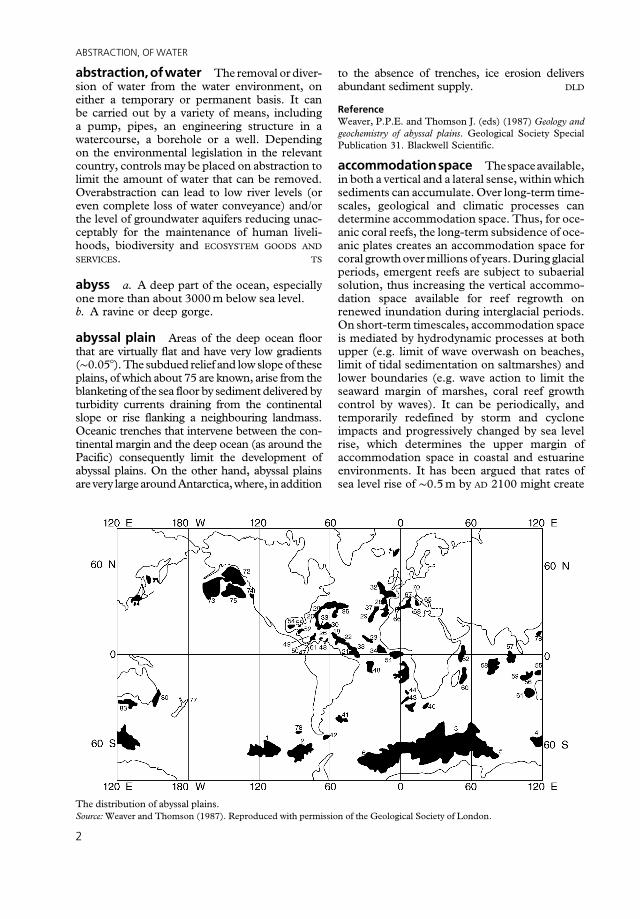
abyssal plain Areas of the deep ocean floor that are virtually flat and have very low gradients (∼0.05°). The subdued relief and low slope of these plains, of which about 75 are known, arise from the blanketing of the sea floor by sediment delivered by turbidity currents draining from the continental slope or rise flanking a neighbouring landmass. Oceanic trenches that intervene between the continental margin and the deep ocean (as around the Pacific) consequently limit the development of abyssal plains. On the other hand, abyssal plains are very large around Antarctica, where, in addition
Reference Weaver, P.P.E. and Thomson J. (eds) (1987) Geology and geochemistry of abyssal plains. Geological Society Special Publication 31. Blackwell Scientific.
accommodationspace Thespaceavailable, in both a vertical and a lateral sense, within which sediments can accumulate. Over long-term time-scales, geological and climatic processes can determine accommodation space. Thus, for oceanic coral reefs, the long-term subsidence of oceanic plates creates an accommodation space for coral growth over millions of years. During glacial periods, emergent reefs are subject to subaerial solution, thus increasing the vertical accommodation space available for reef regrowth on renewed inundation during interglacial periods. On short-term timescales, accommodation space is mediated by hydrodynamic processes at both upper (e.g. limit of wave overwash on beaches, limit of tidal sedimentation on saltmarshes) and lower boundaries (e.g. wave action to limit the seaward margin of marshes, coral reef growth control by waves). It can be periodically, and temporarily redefined by storm and cyclone impacts and progressively changed by sea level rise, which determines the upper margin of accommodation space in coastal and estuarine environments. It has been argued that rates of sea level rise of ∼0.5 m by AD 2100 might create
The distribution of abyssal plains. Source: Weaver and Thomson (1987). Reproduced with permission of the Geological Society of London.
2
ACCURACY
new accommodation space and switch reef vertical accretion back on, with carbonate production for the entire Great Barrier Reef rising from the current estimated 50 Mt a�1 to 70 Mt a�1 (Kinsey and Hopley, 1991). Human activities, such as the construction and maintenance of defence structures that prevent the full occupation of floodplainsby floodwatersor the landwardmigrationof coastal systems under sea-level rise, represent an artificial constriction of natural accommodation space.Thesettingbackofcoastaldefencestomore landward positions, or ‘managed realignment’, recreates intertidal accommodation space and reduces flood hazard. TS
Reading and References French, J.R. (2006) Tidal marsh sediment trapping and resilience to environmental change: exploratory modelling of tidal, sea-level and sediment supply forcing in predominantly allochthonous systems. Marine Geology, 235, 119–136. � Kinsey, D.W. and Hopley, D. (1991) The significance of coral reefs as global carbon sinks – response to greenhouse. Palaeogeography, Palaeoclimatology, Palaeoecology, 89, 363–377. � Townend, I. and Pethick, J. (2002) Estuarine flooding and managed retreat. Philosophical Transactions of the Royal Society of London, Series A, 360, 1477–1495.
accordant junctions, law of JohnPlayfair’s 1802statement of theobservation, known asPlayfair’s law, that tributary rivers generally join main rivers at the same elevation, with no sudden drop or waterfall at their confluence. Offered as direct evidence that rivers cut the valleys through which they flowed.
Every river appears to consist of a main trunk, fed from a variety of branches, each running in a valley proportioned to its size, and all of them together forming a system of vallies, communicating with one another, and having such a nice adjustment of their declivities, that none of them joins the principal valley, either on too high or too low a level; a circumstance which would be infinitely improbable, if each of these vallies were not the work of the stream that flows in it (Playfair, 1802: 102). DRM
Reference Playfair, J. (1802) Illustrations of the Huttonian theory of the Earth. London/Edinburgh: Cadell and Davies/William Creech.
accordant summits Parts of the landscape that are of low relief and which appear from their elevations and directions of slope to have formerly been connected as a part of a prior landsurface. When cutting across contrasting rock types, the interpretation that accordant summits reflect the dissection of a former low-relief land surface is
quite secure. However, within a geologically uniform region, it is possible that accordant summits develop in the ordinary course of landscape evolution, as a consequence of mutual adjustment of slope processes and stream incision rates within the context of uniform valley spacing. DLD
Reading Römer, W. (2008) Accordant summit heights, summit levels and the origin of the ‘upper denudation level’ in the Serra do Mar (SE-Brazil, Sao Paulo): a study of hillslope forms and processes. Geomorphology, 100, 312–327.
accretion a. The gradual increase in the area of land as a result of sedimentation. b. The process by which inorganic objects increase in size through the attachment of additional material to their surface as with the growth of hailstones.
accumulated temperature Normally the total number of days (or hours) since a given date during which the mean temperature has been above or below a given threshold. The threshold value for agriculture is usually 6 °C, and accumulated mean temperatures above this value can be correlated with the growth of vegetation. For heating purposes the threshold is usually 15.5 °C, and accumulated mean temperatures below this value can be correlated with energy use. Generally, accumulated temperature is used in agriculture, and DEGREE DAY
is used in energy management. JET
accuracy An indication of the quality of a data set. Accuracy indicates the degree of correctness or freedom from error in the data set measured relative to the truth.
Accuracy can be assessed from a range of perspectives and be estimated in a variety of ways to suit the particular needs of a study and the nature of the data being used. For example, accuracy may be estimated for continuous data (e.g. model-based predictions of river flow rate) from the difference between the observed and true values, and be summarized in terms of a measure such as the root-mean-square error. Alternatively, with nominal level data (e.g. land cover classes), accuracy may be estimated by comparing the observed class labels against truth and summarized by measures derived from their cross-tabulation in a confusion or error matrix. The latter is common in the evaluation of a THEMATIC MAP produced via a SUPERVISED CLASSIFICATION analysis of images acquired by REMOTE SENSING. A rigorous and credible accuracy assessment typically requires careful sampling and a gold standard reference
3
ACID DEPOSITION
to represent the truth. Deviation from the assumed conditions for an accuracy assessment can yield erroneous and misleading estimates of accuracy. GF
acid deposition Rainfall is naturally acid (pH 5.65) owing to the dissolution of carbon dioxide (CO2) in water (H2O) to give carbonic acid (H2CO3):
CO2 � H2O⇄H2CO3
Therefore, the functional definition of acid precipitationisapH<5.65.Acidityisgeneratedbythe presenceofhydrogenions(H+)andismeasuredin units of pH on a logarithmic scale. A one-unit differenceinsolutionpHisequivalenttoa10times difference in the concentration of H+ .
Acidifying substances may be deposited from the atmosphere by two main pathways: (1) wet deposition of material entrained in rain, snow and fog-water – often referred to as ACID PRECIPI
TATION; (2) dry deposition of particulate aerosols (any solid particulate matter transported through the atmosphere), and including uptake of certain gases by vegetation, soil and water surfaces. Atmospheric inputs occur mainly from point sources and are derived from human activities, such as fossil fuel combustion and intensive livestock holdings, and from natural sources, such as volcanic emissions. The balance between wet and dry deposition pathways varies geographically and according to the dominant wind direction. In general, wet deposition is more important in upland areas with higher rainfall amounts. In the north and west of the UK, for example, inputs of H+ in precipitation may exceed 1 kg ha�1 a �1. Dry deposition of sulphur dioxide (SO2) may exceed 2.4 kg ha�1 a �1
in industrial areas of the midlands and northern England and the major urban areas of the Scottish central lowlands (Fowler et al., 1985). In Europe, the relative contributions from wet and dry deposited sulphur change with distance from the coast, with wet deposition becoming relatively less important with distance south from the North Sea. Wet deposition may occur via two processes,
depending on where atmosphere scavenging occurs. Rainout describes acid inputs, which originate within the cloud system; washout describes the removal of solutes by falling precipitation. Mist and fog are generally more acidic than rain; thus, at high altitudes, acid deposition is enhanced by the contribution of mist, fog and cloud water.
Most of the excess acidity in precipitation is generated from sulphuric and nitric acids. The
presence of excess sulphur and nitrogen in the atmosphere is largely derived from anthropogenic sources from the oxidation of SO2 and NOx (nitrous oxide [NO]+nitrogen dioxide [NO2]). Key sources of SO2 include fossil fuel burning and metal smelting. Nitrogen oxides are generated during combustion by oxidation of atmospheric nitrogen; the main anthropogenic source is vehicle emissions. Whilst sources of SO2 have been controlled and atmospheric concentrations are decreasing, atmospheric NOx
continues to rise. Dry deposition occurs in the interval between
precipitation events. The physics of the mechanisms involved in dry deposition are complex and include gravitational settling and filtering of particulate aerosols together with the direct uptake of gases such as SO2 and NOx onto vegetation, water and/or soil surfaces. Factors such as surface wetness, and vegetation size, growth patterns and surface roughness are important controls on the magnitude of dry deposition. Acidity derived from dry deposition is often generated by secondary chemical reactions. Thus, dry-deposited SO2
is oxidized to the anion sulphite (SO32�) and
rapidly oxidized to sulphate (SO42�); electro
chemical balancing releases an equivalent number of H+, which in turn generates acidity. Similarly, dry-deposited NOx may be oxidized to nitrate (NO3
�), which again generates H+. The atmospheric sources are not necessarily acidic in themselves; thus, acidity may be generated at the ground surface where gaseous ammonia or the cation ammonium (NH4
+) is deposited and oxidized to NO3
�, which releases H+. Quantitative estimation of dry fluxes is difficult; thus, this pathway of acidification is less understood than that of wet deposition. Problems in measurement include wide spatial and temporal variations in atmospheric gases and particulates, and difficulties in estimating rates of deposition to natural ecosystems with inherently complex structures. Dry deposition is more affected by distance from emission source and tends to dominate close to source.
Acid deposition is not the only source of acidification of terrestrial and aquatic environments. Other sources include afforestation and forest clearance, livestock grazing, cultivation techniques on agricultural land and the use of fertilizers. ALH
References Fowler, D., Cape, J.N. and Leith, I.D. (1985) Acid inputs from the atmosphere in the United Kingdom. Soil Use and Management, 1, 70–72. � Howells, G. (1990) Acid rain and acid waters. Chichester: Ellis Horwood.
4
ACID PRECIPITATION
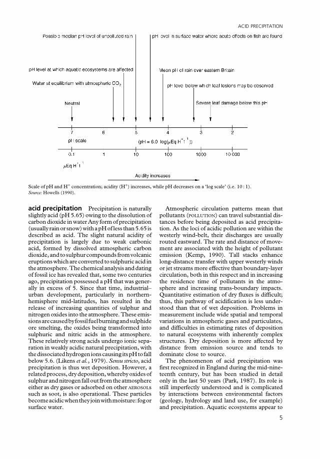
Scale of pH and H+ concentration; acidity (H+) increases, while pH decreases on a ‘log scale’ (i.e. 10 : 1). Source: Howells (1990).
acid precipitation Precipitation is naturally slightly acid (pH 5.65) owing to the dissolution of carbon dioxide in water Any form of precipitation (usually rain or snow) with a pH of less than 5.65 is described as acid. The slight natural acidity of precipitation is largely due to weak carbonic acid, formed by dissolved atmospheric carbon dioxide,andtosulphurcompounds fromvolcanic eruptions which are converted to sulphuric acid in theatmosphere. The chemical analysis and dating of fossil ice has revealed that, some two centuries ago, precipitation possessed a pH that was generally in excess of 5. Since that time, industrial– urban development, particularly in northern-hemisphere mid-latitudes, has resulted in the release of increasing quantities of sulphur and nitrogen oxides into the atmosphere. These emissionsarecausedbyfossil fuelburningandsulphide ore smelting, the oxides being transformed into sulphuric and nitric acids in the atmosphere. These relatively strong acids undergo ionic separation in weakly acidic natural precipitation, with thedissociatedhydrogen ionscausing itspHtofall below 5.6. (Likens et al., 1979). Sensu stricto, acid precipitation is thus wet deposition. However, a related process, dry deposition, whereby oxides of sulphur and nitrogen fall out from the atmosphere either as dry gases or adsorbed on other AEROSOLs such as soot, is also operational. These particles becomeacidicwhentheyjoinwithmoisture:fogor surface water.
Atmospheric circulation patterns mean that pollutants (POLLUTION) can travel substantial distances before being deposited as acid precipitation. As the loci of acidic pollution are within the westerly wind-belt, their discharges are usually routed eastward. The rate and distance of movement are associated with the height of pollutant emission (Kemp, 1990). Tall stacks enhance long-distance transfer with upper westerly winds or jet streams more effective than boundary-layer circulation, both in this respect and in increasing the residence time of pollutants in the atmosphere and increasing trans-boundary impacts. Quantitative estimation of dry fluxes is difficult; thus, this pathway of acidification is less understood than that of wet deposition. Problems in measurement include wide spatial and temporal variations in atmospheric gases and particulates, and difficulties in estimating rates of deposition to natural ecosystems with inherently complex structures. Dry deposition is more affected by distance from emission source and tends to dominate close to source.
The phenomenon of acid precipitation was first recognized in England during the mid-nineteenth century, but has been studied in detail only in the last 50 years (Park, 1987). Its role is still imperfectly understood and is complicated by interactions between environmental factors (geology, hydrology and land use, for example) and precipitation. Aquatic ecosystems appear to
5
ACID RAIN
respond more rapidly to acidification than terrestrial ones do. In 1991 it was estimated that 5% of all lakes in New England, USA, were excessively acidified, and this was widely attributed to acid precipitation effects. While often viewed as a problem of ‘old’ industrial nations, acid precipitation is a growing issue in emerging economies, such as China (Larssen et al., 2006) and India (Rodhe et al., 2002). Other impacts include reductions in biological productivity in water bodies, tree die-off, building stone damage, and human health issues associated with drinking water quality and inhalation. RLJ/DSGT
Reading and References Kemp, D.D. (1990) Global environmental issues: a climato
logical approach. London: Routledge. � Lane, C.N. (2003) Acid rain: overview and abstracts. New York: Nova Science Publishers (especially chapter 1). � Larssen, T., Lydersen, E., Tang, D. et al. (2006) Acid rain in China. Environmental Science and Technology, 40, 418–425. � Likens, G.E., Wright, R.F., Galloway, J.N. and Butler, T.J. (1979) Acid rain. Scientific American, 241, 39–47. � Park, C.C. (1987) Acid rain: rhetoric and reality. London: Methuen. � Rodhe, H., Dentener, F. and Schilz, M. (2002) The global distribution of acidifying wet deposition. Environmental Science and Technology, 36, 4382–4388.
acid rain See ACID PRECIPITATION.
acid rocks Commonly used term for igneous rocks that contain more than 66% silica, free or combined, or any igneous rock composed predominantly of highly siliceous minerals (see BASIC ROCKS).
acid susceptibility/acid neutralizing capacity Acid neutralizing capacity is the ability of a soil or water body to exhibit relatively stable pH in the face of additions of acidic compounds. Acid neutralizing capacity may be derived from carbonate compounds that can be dissolved and so raise the pH, with the release of carbonate and bicarbonate ions. Ion-exchange processes involving the clay minerals may also provide acid neutralizing capacity in soils. Soil materials that lack carbonates and clays, such as those derived from the weathering of granitic rocks, may have low acid neutralizing capacity. Acid susceptibility, the lack of acid neutralizing capacity, may also be very high in soils and sediments containing pyrite or other forms of iron sulphide. In the absence of oxygen, pyrite minerals remain stable, but when exposed to oxygen they form sulphuric acid. Drainage works, lowering of the groundwater table from the effects of mining or quarrying, or the use of sulphide soils in earthworks at the surface may all contribute to the oxidation of
the iron sulphides. The pH reduction then produced as a result of insufficient acid neutralizing capacity subsequently increases the solubility of other materials, including aluminium and heavy metals. These can have toxic effects when leached into waterways. DLD
Reading Mason, B.J. (1990) The surface waters acidification programme. Cambridge: Cambridge University Press. � Cresser, M. and Edwards, A. (1987) Acidification of fresh-waters. Cambridge: Cambridge University Press; p. 136. � Sammut, J., Melville, M.D., Callinan, R.B. and Fraser, G.C. (1995) Estuarine acidification: impacts on aquatic biota of draining acid sulphate soils. Geographical Research, 33, 89–100. � Unland, N.P., Taylor, H.L., Bolton, B.R. and Cartwright, I. (2012) Assessing the hydrogeochemical impact and distribution of acid sulphate soils, Heart Morass, West Gippsland, Victoria. Applied Geochemistry, 27, 2001–2009.
acidity profile The acid concentration in ice core layers as a function of depth as determined fromelectricalmeasurements. Themagnitudes of some volcanic eruptions in the northern hemisphere have been estimated from the acidity of annual layers in icecores taken inGreenland. This methodology is sometimes referred to as ‘acidity signal’ or ‘acidity record’. ASG
active layer The top layer of ground above the permafrost table that thaws each summer and refreezes each autumn. In temperature terms, it is thelayerthat fluctuatesaboveandbelow0 °Cduring the year. In permafrost areas, seasonally frozen and thawed ground can be equated with the active layer. Other synonyms include ‘depth of thaw’, ‘depth to permafrost’ and ‘annually thawed layer’. These terms are acceptable in areas where the active layer extends downwards to the permafrost table, but they are misleading where the active layer is separated from the permafrost by a layer of ground that remains in an unfrozen state throughout the year. The thickness of the active layer varies from as little as 15–30 cm in high latitudes to over 1.5 m in subarctic continental regions. Thickness depends on many factors, including the degree and orientation of the slope, vegetation, drainage, snow cover, soil and rock type, and ground moisture conditions.
Processes operating in the active layer include FROST CREEP and FROST HEAVE or cryoturbation, the lateral and vertical displacement of soil that accompanies seasonal and/or diurnal freezing and thawing. During thaw, water movement through the active layer assists various mass-wasting processes, especially GELIFLUCTION. Most patterned ground phenomena form in the active layer. HMF
6
ADSORPTION
Reading Brown, R.J.E. and Kupsch, W.O. (1974) Permafrost termi
nology. Publication 14274. Ottawa: National Research Council of Canada. � French, H.M. (2007) The periglacial environment. Chichester: John Wiley & Sons, Ltd.
active margin A continental margin that coincides approximately with a plate boundary. It has much more tectonic and igneous activity than a PASSIVE MARGIN does, which lies within a plate and on the edge of a spreading ocean basin such as the Atlantic, Indian, Arctic or Antarctic Oceans. Active margins rim most of the Pacific, where the volcanic activity gave rise to the term ‘Ring of Fire’: they show EARTHQUAKE activity at various depths in BENIOFF ZONEs or at shallow depths along transform faults. Plate motions are either convergent, with subduction at an orogen (the Andes and Central America) or at an island-arc (the Kurile Islands, Japan and the Philippines), or oblique, with a transform fault (the San Andreas in California or the Alpine in New Zealand). IE
Reading Summerfield, M.A. (2013) Global geomorphology. London: Routledge; chapter 3.
actualism See UNIFORMITARIANISM.
adaptation The ability of organisms to adapt to conditions in a particular environment as a result of hereditary features that have resulted from natural selection. Some organisms, called ‘extremophiles’, display the ability to withstand various relatively extreme environments – arid, hot, wet, acidic, salty, etc. The adaptive traits of organisms may be structural, behavioural or physiological. Structural adaptations are physical features of an organism (shape, body covering, etc.) Behavioural adaptations include miscellaneous instincts. Physiological adaptations permit the organism to perform special functions (for instance, making venom), but also more general functions such as growth and development and temperature regulation. The concept has been described as ‘slippery’ and ‘controversial’ and is still the subject of debate. One issue of current concern is the speed with which organisms may adapt to future climate changes. ASG
Reading Hoffmann, A.A. and Sgrò, C.M. (2011) Climate change and evolutionary adaptation. Nature, 470, 479–485. � Reeve, H. K. and Sherman, P.W. (1993) Adaptation and the goals of evolutionary research. Quarterly Review of Biology, 68, 1–32. � Rose, M.R. and Lauder, G.V. (eds) (1996) Adaptation. San Diego, CA: Academic Press.
adaptive capacity The capacity of a system to adapt if the environment where the system exists is changing. Adaptive capacity confers resilience to perturbation, giving ecological and human social systems the ability to reconfigure themselves with minimum loss of function. In ecological systems, this resilience shows as net primary productivity and maintenance of biomass and biodiversity, and the stability of hydrological cycles. The development of adaptive capacity is particularly important in the context of societal responses to global environmental change. See also PANARCHY. TS
adhesion ripple An irregular sand ridge transverse to wind direction, formed when dry sand is blown across a smooth, moist surface. It may be 30–40 cm long and a few centimetres high. The crest is symmetrical andmigrates upwind. The stoss (windward) side is steeper than the lee side. ASG
adhesion warts Small-scale aeolian BED
FORMS resulting from SALTATION over a wet sand surface. The moisture captures the falling grains, and capillary action wets that deposit. With unidirectional winds, adhesion ripples may form and migrate upwind. With polymodal winds, irregularly shaped and oriented adhesion warts result. DJS
Reading Goodall, T.M., North, C.P. and Glennie, K.W. (2000) Surface and subsurface sedimentary structures produced by salt crusts. Sedimentology, 47, 99–118.
adiabatic An adiabatic process is a thermodynamic change of state of a system in which there isno transferof heat or mass across theboundaries of the system. In the atmosphere the most commonlyrelatedvariables intheadiabaticprocessare temperature and pressure. If a mass of air experiences lower pressure than in its initial condition it will expand and do mechanical work on the surrounding air. The energy required to do this work is taken from the heat energy of the air mass and, consequently, the temperature of the air falls. Conversely, when pressure increases, work is done on the mass of air and the temperature rises. A diabatic process is a thermodynamic change of state of a system in which there is transfer of heat across the boundaries of the system. BWA
adsorption The process in which substances, often ions, leave a liquid and accumulate upon the surface of a solid. In the soil, adsorption occurs when ions and other charged entities move from the soil water and attach themselves close to the surfacesofCLAYparticles.Thistakesplacebecause theclaysurfacenormallycarriesanexcessnegative charge arising from ionic substitution within
7
ADVECTION
the lattice structure, and because of unsatisfied valence at crystal edges. Adsorbed materials are most commonly cations like Ca2+ and Mg2+, but may also include oxyanions like NO3
� as well as organic compounds. Adsorbed materials may be difficult to differentiate from precipitates, so that in some cases materials held on a surface may be referred to in a more all-encompassing way as sorbed. DLD
Reading Bradl, H.B. (2004) Adsorption of heavy metal ions on soils and soils constituents. Journal of Colloid Science, 277, 1–18. � Calvet, R. (1989) Adsorption of organic chemicals in soils. Environmental Health Perspectives, 83, 145–177. � Sposito, G. (1984) The surface chemistry of soils. Oxford: Oxford University Press.
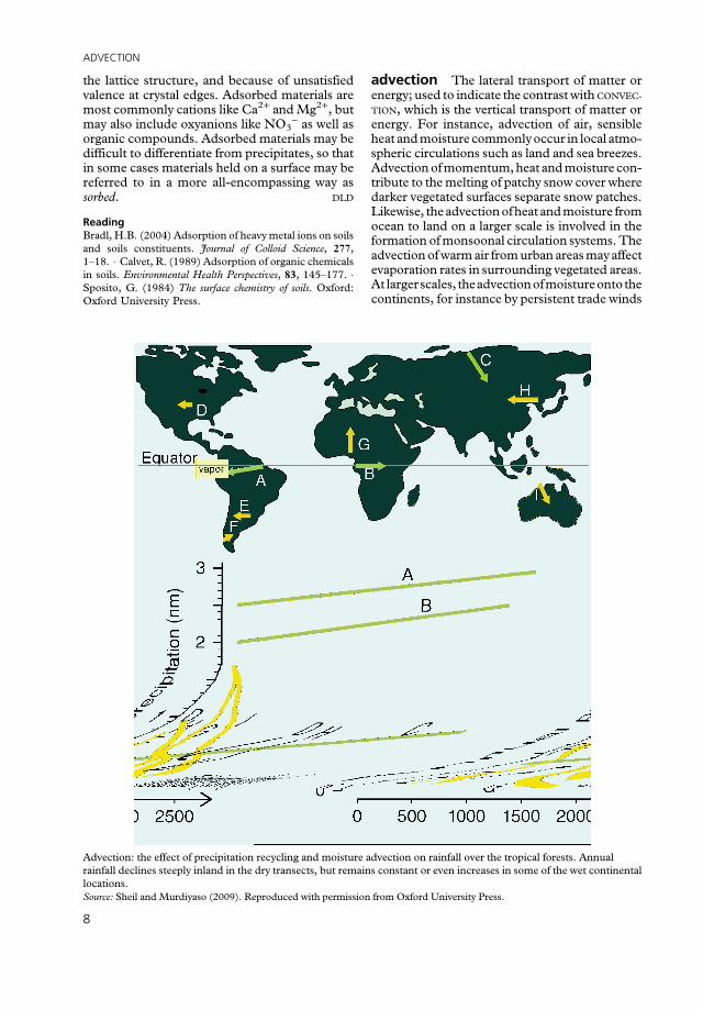
advection The lateral transport of matter or energy; used to indicate the contrast with CONVEC
TION, which is the vertical transport of matter or energy. For instance, advection of air, sensible heat and moisture commonly occur in local atmospheric circulations such as land and sea breezes. Advection of momentum, heat and moisture contribute to the melting of patchy snow cover where darker vegetated surfaces separate snow patches. Likewise, the advection of heat and moisture from ocean to land on a larger scale is involved in the formation of monsoonal circulation systems. The advection of warm air from urban areas may affect evaporation rates in surrounding vegetated areas. At largerscales, theadvectionofmoistureonto the continents, for instance by persistent trade winds
Advection: the effect of precipitation recycling and moisture advection on rainfall over the tropical forests. Annual rainfall declines steeply inland in the dry transects, but remains constant or even increases in some of the wet continental locations. Source: Sheil and Murdiyaso (2009). Reproduced with permission from Oxford University Press.
8
AEOLIANITE
or cyclones, is critical for the occurrence of precipitation over land. Within extensive vegetated areas like the tropical forests of South America, advection of moisture is pivotal to the process of precipitation recycling. DLD
Reading Drost, F. and England, M.H. (2008) Twentieth century trends in moisture advection over Australia. Meteorology and Atmospheric Physics, 100, 243–256. � Sheil, D. and Murdiyaso, D. (2009) How forests attract rain: an examination of anew hypothesis. BioScience, 59, 341–347. � Trenberth, K.E. (1999) Atmospheric moisture recycling: role of advection and local evaporation. Journal of Climate, 12, 1368–1381.
advection fog See FOG.
advective processes Processes for which the upslope drainage area influences rates of sediment transport through entrainment of material thatmovesalongwith(i.e. isadvectedby)the flow. Sediment transport Qs by advective processes is often cast in landscape evolution models as Q � KAmSn, where K is a (fluvial) rate parames
ter, A is drainage area (which may be replaced by discharge Q in some models), S is the slope, and m and n vary with the process under consideration. Advective processes tend to create relief through the incision of valleys. DRM
aeolation It has been suggested that in the late nineteenth and early twentieth centuries there was a tendency to identify AEOLIAN processes as the dominant geomorphic mechanism that shaped the world’s DESERTs, at the expense of considering the role of water and runoff. While for some desert environments, such as the American Southwest, the power of aeolian erosion may have been overemphasized, the past importance attached to the aeolation paradigm may itself have been overstressed in recent years. Today, aeolation and run-off erosion are not viewed as competing paradigms in the explanation of the formation of dryland landscapes. The expansion of process-based studies at the expense of simple description, the increase in data sources and the availability of high-resolution aerial imagery all allow the relative importance of different processes in space and time to be considered, rather than a unitary explanation of dryland evolution to be sought. DSGT
Reading Goudie, A.S. (2012) Charles Rolin Keyes and extravagant aeolation. Aeolian Research, 4, 51–53.
aeolian (eolian in the USA) Of the wind; hence aeolian processes and aeolian sediments and landforms. Derived from Aeolus, Greek god of the winds. DSGT
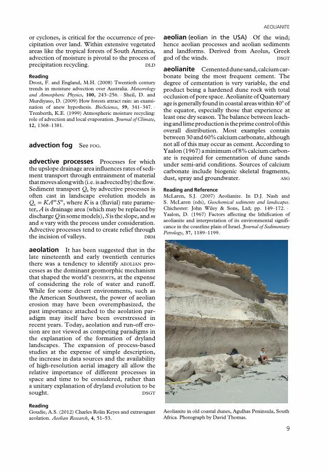
aeolianite Cementeddunesand,calciumcarbonate being the most frequent cement. The degree of cementation is very variable, the end product being a hardened dune rock with total occlusion of pore space. Aeolianite of Quaternary age is generally found in coastal areas within 40° of the equator, especially those that experience at least one dry season. The balance between leachingandlimeproductionis theprimecontrolof this overall distribution. Most examples contain between30and60%calcium carbonate,although not all of this may occur as cement. According to Yaalon (1967) a minimum of 8% calcium carbonate is required for cementation of dune sands under semi-arid conditions. Sources of calcium carbonate include biogenic skeletal fragments, dust, spray and groundwater. ASG
Reading and Reference McLaren, S.J. (2007) Aeolianite. In D.J. Nash and S. McLaren (eds), Geochemical sediments and landscapes. Chichester: John Wiley & Sons, Ltd; pp. 149–172. � Yaalon, D. (1967) Factors affecting the lithification of aeolianite and interpretation of its environmental significance in the coastline plain of Israel. Journal of Sedimentary Petrology, 37, 1189–1199.
Aeolianite in old coastal dunes, Agulhas Peninsula, South Africa. Photograph by David Thomas.
9

AERIAL PHOTOGRAPHY
aerial photography The action of taking photographs, of the Earth’s surface, from an airborne platform furnished with a camera placed at some distance above that surface. It is a tried and tested method of REMOTE SENSING. Common platformsdeployedincludeaircraft,helicopters,kites, blimps or unmanned aerial vehicles (i.e. drones). It is the most widely used type of remote sensing, developed extensively during the Second World War as a means of intelligence acquisition, and now most familiar to the public via a virtual globe, such as Google Earth. The photography is taken from three main angles: vertical, low oblique and high oblique. Vertical aerial photography results when the camera axis is pointing vertically downwards,andoblique aerialphotography is theresult when the camera axis is pointing obliquely downwards. Low oblique aerial photography incorporates the horizon into the photograph, while high oblique aerial photography does not. The latter providearealisticviewoftheobjectsontheEarth’s surface and coverage that is many times more than that in vertical aerial photographs at the same acquisition conditions (i.e. height of capture and focal length). Oblique photography is useful for applications such as wayfinding, but the variance inscaleacross theresultantphotographmake measurements difficult. It is the vertical aerial photographs that are most widely used for mapping and measurement, owing to their constant scale, assuming a flat surface across the photograph. Vertical photographs that are captured with an overlap between adjacent photographs afford a three-dimensional (3D) perspective of the Earth’s surface: a stereoscopic view can be created and measurements taken both horizontally and vertically. Recently, a new computing vision technique, structure from motion (SfM), was introduced that allows the extraction of 3D structure of an object by analysing motion signals over time. The SfM technique can be applied to large collections of overlapping photographs to obtain sparse point clouds for a wide range of objects, such as buildings and sculptures.
Aerial photographs are acquired at a wide range of spatial resolutions (scales), with a small-scale photograph at 1 : 50,000 affording a synoptic, low spatial resolution overview of a large area, and a large-scale aerial photograph at 1 : 2000 affording a detailed and high spatial resolution view of a small area. Traditionally, black-and-white film cameras were the sensor of choice; this has been superseded by colour film cameras, of which there are two main types: conventional colour film, where the near-infrared response appears red, red response appears
green and green response appears blue. Once obtained, aerial photographs are interpreted for the identification of objects and assessment of their significance. During this process the interpreters usually undertake several tasks of detection, recognition and identification, analysis, deduction, classification, idealization and accuracy determination. Recognition and identification of objects or areas comprise the most important link in this chain of events. An interpreter uses seven characteristics of the aerial photography to help with this stage: tone, texture, pattern, place, shape, shadow and size. Tone is the single most important characteristic of the aerial photograph as it represents a record of the electromagnetic radiation that has been reflected from the Earth’s surface onto the aerial film. Texture is the frequency of tonal changes that arise within an aerial photograph when several features are viewed together. Pattern is the spatial arrangement of objects on the aerial photograph. Place is a statement of an object’s position on the aerial photograph in relation to others in its vicinity. Shape is a qualitative statement of the general form, configuration or outline of an object on an aerial photograph. Shadows of objects on an aerial photograph are used to help in identifying them; for example, by enhancing geological boundaries. Size of an object is a function of the scale of the aerial photograph. The sizes of objects can be estimated by comparing them with objects for which the size is known. The common film cameras are now being replaced by digital aerial cameras adopting two main semiconductor technologies – charge-coupled device and complementary metal oxide semiconductor – that are used in airborne imaging. These airborne digital cameras are classified as either (i) small-format (up to 16 megapixels), (ii) medium-format (from 16 up to 50 megapixels) or (iii) large-format (greater than 50 megapixels) cameras and are rapidly changing the processing chain and applications using aerial photographic technology. DSB
Reading Arnold, R.H. (2004) Interpretation of airphotos and remotely sensed imagery. New York: Prentice Hall. � Falkner, E. and Morgan, D. (2001) Aerial mapping: method and applications, 2nd edition. Boca Raton, FL: CRC Press. � Paine, D.P. and Kiser, J.D. (2003) Aerial photography and image interpretation, 2nd edition. New Jersey: John Wiley & Sons, Inc. � Petrie, G. and Walker, A. (2007) Airborne digital imaging technology: a new overview. The Photogrammetric Record, 22, 203–225.
aerobic Describes either conditions of the environment or of a metabolic process in which
10