Embed Size (px)
Citation preview

Record 2014/16 | GeoCat 76782
EDM Height Traversing Levelling Survey ReportLautoka, Fiji Islands, February 2013
S. J. K. Yates, A. Lal
APPLYING GEOSCIENCE TO AUSTRALIA’S MOST IMPORTANT CHALLENGES www.ga.gov.au


EDM Height Traversing Levelling Survey Report Lautoka, Fiji Islands, February 2013
GEOSCIENCE AUSTRALIA RECORD 2014/16
S. J. K. Yates1, A. Lal2
1. National Geospatial Reference Systems, Minerals and Natural Hazards Division, Geoscience Australia GPO Box 378
Canberra ACT 2601 2. Secretariat of the Pacific Community (SPC)

Department of Industry Minister for Industry: The Hon Ian Macfarlane MP Parliamentary Secretary: The Hon Bob Baldwin MP Secretary: Ms Glenys Beauchamp PSM
Geoscience Australia Chief Executive Officer: Dr Chris Pigram This paper is published with the permission of the CEO, Geoscience Australia
© Commonwealth of Australia (Geoscience Australia) 2014
With the exception of the Commonwealth Coat of Arms and where otherwise noted, all material in this publication is provided under a Creative Commons Attribution 3.0 Australia Licence. (http://www.creativecommons.org/licenses/by/3.0/au/deed.en)
Geoscience Australia has tried to make the information in this product as accurate as possible. However, it does not guarantee that the information is totally accurate or complete. Therefore, you should not solely rely on this information when making a commercial decision.
Geoscience Australia is committed to providing web accessible content wherever possible. If you are having difficulties with accessing this document please email [email protected].
ISSN 2201-702X (PDF)
ISBN 978-1-925124-05-7 (PDF)
GeoCat 76782
Bibliographic reference: Yates, S. J. K. & Lal, A., 2014, EDM Height Traversing Levelling Survey Report: Lautoka, Fiji Islands, February 2013. Record 2014/16. Geoscience Australia, Canberra. http://dx.doi.org/10.11636/Record.2014.016

EDM Height Traversing Levelling Survey Report: Lautoka, Fiji Islands, February 2013 iii
Contents
1 Introduction ............................................................................................................................................ 1
2 The Survey ............................................................................................................................................ 2 2.1 Bench Mark Locality Diagram .......................................................................................................... 3 2.2 The Fiji Islands Datum ..................................................................................................................... 3 2.3 Equipment ........................................................................................................................................ 3 2.4 Method ............................................................................................................................................. 4 2.5 Lautoka 2013 Reduced Levels ........................................................................................................ 4 2.6 Survey Support ................................................................................................................................ 5 2.7 Issues ............................................................................................................................................... 5
3 Comparisons ......................................................................................................................................... 6 3.1 Comparisons between 2013 and 2011 EDM Surveys ..................................................................... 6 3.2 Combined Comparisons 1992 to 2013 ............................................................................................ 7 3.3 Time Series of Bench Mark Movement relative to Fixed Deep Bench Mark LAUTBM ................... 8
4 Deep Bench Mark Locality Diagrams ..................................................................................................12
5 LAUTBM and LAUT Reference Mark Locality Diagrams ....................................................................18
6 Temporary Holding Mark Locality Diagrams .......................................................................................22
7 References ..........................................................................................................................................30

iv EDM Height Traversing Levelling Survey Report: Lautoka, Fiji Islands, February 2013

EDM Height Traversing Levelling Survey Report: Lautoka, Fiji Islands, February 2013 1
1 Introduction
This report outlines the levelling survey completed during the visit to Lautoka, Fiji from 17th to 24th February 2013.
Personnel involved in the survey were Steve Yates, Project Officer, Geoscience Australia and Andrick Lal, Surveyor, Secretariat of the Pacific Community (SPC).
This is the sixth Electronic Distance Measurement (EDM) height traversing levelling survey of the deep bench mark array in Lautoka, Fiji, which runs approximately 3 km from the tide gauge sensor benchmark (SEAFRAME – Sea Level Fine Resolution Acoustic Measuring Equipment) at the wharf to the continuous GNSS (Global Navigation Satellite System) Station located in the Fiji Sugar Corporation (FSC) Compound. The previous levelling surveys using this technique were performed in 2005, 2007, 2008, 2010 and 2011.
Precise Differential Levelling surveys were performed on eight occasions between 1992 and 2003 by the National Tidal Centre Australia (NTCA) and the survey in 2005 included a comparison between the precise levelling and EDM height traversing technique. This report contains a comparison between the 2011 and 2013 EDM height traversing results as well as a combined comparison since the first levelling survey.

2 EDM Height Traversing Levelling Survey Report: Lautoka, Fiji Islands, February 2013
2 The Survey
The EDM Height Traversing levelling survey was carried out between the five deep driven bench marks and from the CGNSS Station to the SEAFRAME Station:
LAUTBM – CGNSS Benchmark
FIJ13 – SEAFRAME sensor benchmark
BM3244 – Deep Driven Benchmark
BM3245 – Deep Driven Benchmark
BM3246 – Deep Driven Benchmark
BM3247 – Deep Driven Benchmark
BM3248 – Deep Driven Benchmark
All the deep bench marks were located and found in good order and undisturbed except the primary benchmark BM3243 which, unfortunately is now covered with soil and a statute, making it impossible to recover and rendering it useless. Therefore, the LAUTBM was used as the primary, and fixed, benchmark and will be used as such for future surveys.
Included in the survey was the SEAFRAME tide gauge sensor bench mark, FIJ13 and the survey mark (project plaque) located adjacent to the tide gauge hut, FIJ12.
Also included in the survey were temporary holding marks – FIJ212, FIJ81, FIJ207, FIJ205, FIJ84, FIJ85, FIJ206, FIJ87, FIJ92, FIJ208, FIJ209, FIJ210, FIJ211 and FIJ214 (new mark) as well as the CGNSS bench mark – LAUTBM and the three CGNSS reference marks - RM1, RM2 and RM4 .
The EDM height traversing levelling technique was performed to the Class L2A specifications (ICSM, Standards and Practices for Control Surveys). After reduction an internal precision of 1mm√K or better was achieved, where K is distance in kilometres. This is well within the project specification of 2mm√K. A table of results and comparisons and the 2012 reduced levels are detailed later in this report.

EDM Height Traversing Levelling Survey Report: Lautoka, Fiji Islands, February 2013 3
2.1 Bench Mark Locality Diagram
2.2 The Fiji Islands Datum The Datum for the survey is Tide Staff Zero (TSZ). Reduction of the data has been calculated holding LAUTBM (the Reference Bench Mark for the CGNSS Pillar) fixed with a Reduced Level of 31.3403m, this value was determined by the SPSLCMP survey team in July 2011, computed from the previously held fixed bench mark BM3243.
2.3 Equipment • Leica total station model TM30 (Serial No: 361441)
• Leica precision prisms GPH1P (2).
• Leica rigid tripod.
• Stainless steel target poles supported by Leica telescopic bi-poles (2).
• Shortened stainless steel target pole for the SEAFRAME sensor BM connection.
• Leica cast iron change plates (2).
• Kestral 4000 pocket weather tracker

4 EDM Height Traversing Levelling Survey Report: Lautoka, Fiji Islands, February 2013
2.4 Method The “Leap-Frog” EDM height traversing technique was employed for the Lautoka tide gauge levelling survey. This technique involves setting up a total station (TCA1800L) midway between two target/reflectors (on reflector rods with struts). The targets remain at a particular change point for the back-sight and fore-sight observations. The instrument measures slope distances (±1mm) and vertical angle (1”) to derive height differences (between the instrument’s trunnion axis and the reflectors). In support of the slope distance observations, the ambient temperature, pressure and humidity are recorded (Kestral 4000 pocket weather tracker) and input into the instrument to apply the first velocity correction to the observed distances (Rüeger & Brunner, 1982). Four rounds of observations are taken to the back-sight and fore-sight targets from each instrument setup. All levelling runs started and finished with the same reflector and reflector rod, i.e. an even number of setups when the two reflector rod configuration was used. This eliminates any reflector rod zero error. This technique can also be performed using a single set-up / single rod configuration which is particularly useful when levelling between bench marks which are close together e.g. between the CGNSS RMs.
Reduction of the digital data was computed by the Geoscience Australia levelling program “leveling1.exe”. This program computes the height difference between the two reflectors.
2.5 Lautoka 2013 Reduced Levels
Table 2.1 Lautoka, Fiji – Reduced levels from the 2013 survey Date: 19th to 24th February 2013 Datum: Tide Staff Zero
Point ID Reduced Level 2013 Type
LAUTBM 31.3403 Stainless Steel Pillar Pin
*LAUT 32.2955 Pillar Plate (ARP)
FIJ92 26.2538 Stainless Steel Pin in Concrete
BM3247 20.9601 Stainless Steel Rod in Ground
BM3246 7.8256 Stainless Steel Rod in Ground
FIJ87 7.4018 Stainless Steel Pin in Concrete
FIJ206 4.6409 Stainless Steel Pin in Concrete
BM3244 4.1729 Stainless Steel Rod in Ground
FIJ211 4.2342 Stainless Steel Pin in Concrete
FIJ85 3.1427 Stainless Steel Pin in Concrete
FIJ84 3.0463 Stainless Steel Pin in Concrete
FJ210 3.2207 Stainless Steel Pin in Concrete
FJ205 5.3255 Stainless Steel Pin in Concrete
FJ212 3.1492 Stainless Steel Pin in Concrete
FJ81 2.6684 Stainless Steel Pin in Concrete

EDM Height Traversing Levelling Survey Report: Lautoka, Fiji Islands, February 2013 5
Point ID Reduced Level 2013 Type
FJ207 4.1709 Stainless Steel Pin in Concrete
FJ12 4.0713 Project Plaque Stainless Steel Pin
FJ13 4.4458 Stainless Steel Sensor Pin
BM3248 35.2356 Stainless Steel Rod in Ground
FJ208 30.9335 Stainless Steel Pin in Concrete
FJ209 25.0123 Stainless Steel Pin in Concrete
FJ214 16.8872 Masonry Nail in Concrete
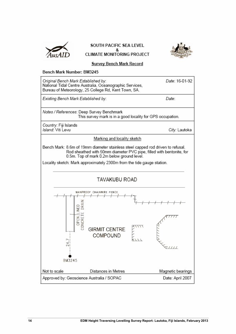
BM3245 16.6377 Stainless Steel Rod in Ground
*The RL of the Reference Point LAUT (ARP) is derived from adding the static height difference of 0.9552 m (LAUTBM to LAUT) to the levelled RL of LAUTBM.
2.6 Survey Support The survey team very much appreciated the assistance from staff of the Lands Department Lautoka Office, the Lautoka Ports and the Fiji Sugar Corporation.
Personnel consulted during the visit were:
Mr. Litia Navusolo, Divisional Surveyor, Lands Department
Mr. Jekope Tubukalou, Technical Officer – Surveys, Lands Department
Email: [email protected]; Phone (679) 9525570/ 6661800
Mr. Atunaisa Ralulu, Technical Officer – Surveys, Lands Department
Email: [email protected]; Phone (679) 9214167/ 6661800
Mr. Emosi Navusolo, Supervisor Administration – Lautoka Ports
Email: [email protected]; Phone (679) 9907125/ 6662160
Mr. Viliame Savou, Production Manager – Fiji Sugar Corporation, Lautoka.
Phone (679) 9922006
The Lautoka Lands and Survey Department have always had a keen interest in the SPSLCMP and are always supportive with any associated project matters.
2.7 Issues A security pass is required in order to access the Lautoka Ports area, where the tide gauge is located. This must be arranged prior to the survey through the Lands Department or SOPAC (SPC) staff. This is also a hard-hat zone. A letter to the Ports Authority for accessibility is necessary prior to the visit.

6 EDM Height Traversing Levelling Survey Report: Lautoka, Fiji Islands, February 2013
3 Comparisons
3.1 Comparisons between 2013 and 2011 EDM Surveys
Table 3.1 Lautoka, Fiji EDM Height Traversing Levelling Comparison 2013 – 2011. LAUTBM - adopted fixed height of 31.34031m
From To Levelled Ht. Diff. RL 2013 Misclose
(mm) Dist. (km) 1mm√k RL 2011 Difference (mm) 2013 - 2011
LAUTBM 31.34031
FIJ92 FIJ92 -5.086550 26.25376 -0.250 0.0697 0.264 26.25424 -0.48
BM3247 BM3247 -5.293656 20.96010 0.063 0.0932 0.305 20.95991 0.19
BM3246 BM3246 -13.134526 7.82558 -0.325 0.2184 0.467 7.82428 1.30
FIJ87 FIJ87 -0.423735 7.40184 -0.010 0.0809 0.284 7.39929 2.55
FIJ206 FIJ206 -2.760930 4.64091 0.265 0.2251 0.474 4.63804 2.87
BM3244 -0.468025 4.17289 0.075 0.0362 0.190 4.17025 2.64
FIJ206 4.64091
FIJ211 FIJ211 -0.406728 4.23419 -0.370 0.0985 0.314 4.23130 2.89
FIJ85 FIJ85 -1.091521 3.14266 -0.278 0.1784 0.422 3.14041 2.25
FIJ84 FIJ84 -0.096325 3.04634 0.230 0.0803 0.283 3.04341 2.93
FIJ210 FIJ210 0.174340 3.22068 0.100 0.0769 0.277 3.21697 3.71
FIJ205 FIJ205 2.104775 5.32545 -0.200 0.1287 0.359 5.32272 2.73
FIJ212 FIJ212 -2.176263 3.14919 0.275 0.1570 0.396 3.14549 3.70
FIJ81 FIJ81 -0.480819 2.66837 -0.363 0.1810 0.425 2.66568 2.69
FIJ207 FIJ207 1.502563 4.17094 -0.325 0.1724 0.415 4.16675 4.19
FIJ12 FIJ12 -0.099686 4.07125 0.238 0.0467 0.216 4.06708 4.17
FIJ13 0.374515 4.44577 0.010 0.0130 0.114 4.44091 4.86
LAUTBM 31.34031
BM3248 BM3248 3.895332 35.23564 0.388 0.1670 0.409 35.23661 -0.97
FIJ208 FIJ208 -4.302126 30.93352 -0.175 0.1972 0.444 30.93406 -0.54
FIJ209 FIJ209 -5.921169 25.01235 0.288 0.1909 0.437 25.01221 0.14
FIJ214 FIJ214 -8.125194 16.88715 0.188 0.1204 0.347 New Mark New Mark
BM3245 -0.249476 16.63768 0.000 0.2164 0.465 16.63951 -1.83

EDM Height Traversing Levelling Survey Report: Lautoka, Fiji Islands, February 2013 7
From To Levelled Ht. Diff. RL 2013 Misclose
(mm) Dist. (km) 1mm√k RL 2011 Difference (mm) 2013 - 2011
Misclose for all bays
levelled =
-0.177 2.748 1.658
LAUTBM 31.34031
RM1 -2.329155 29.01116 -0.070 0.0443 0.210 29.01115 0.00
LAUTBM 31.34031
RM2 -1.00255 30.33776 -0.040 0.0322 0.179 30.33782 -0.06
LAUTBM 31.34031
RM4 -0.70364 30.63667 0.000 0.0348 0.186 30.63639 0.28
All levelling was performed within the project specifications of 2√k
3.2 Combined Comparisons 1992 to 2013
Table.3.2 Lautoka, Fiji - Comparison of the RL's for Precise Differential Levelling (1992 – 2005) and EDM Height Traversing (2005 - 2013).
Year BM 3244 BM 3245 BM 3246 BM 3247 BM 3248 LAUTBM FIJ 13 FIJ 12
1992.8 4.1601 16.6280 4.4326 4.0591
1994.6 4.1597 16.6270 4.4336 4.0597
1995.9 4.1606 16.6293 4.4345 4.0606
1997.5 4.1607 16.6293 4.4341 4.0608
1998.9 4.1612 16.6243 4.4342 4.0606
2001.0 4.1630 16.6314 4.4352 4.0611
2002.2 4.1632 16.6313 7.8170 20.9526 35.2283 31.3337 4.4348 4.0603
2003.4 4.1635 16.6327 7.8179 20.9533 35.2294 31.3338 4.4368 4.0624
2005.4 4.1679 16.6362 7.8219 20.9571 35.2332 31.3375 4.4396 4.0657
Year BM 3244 BM 3245 BM 3246 BM 3247 BM 3248 LAUTBM FIJ 13 FIJ 12
2005.4 4.1674 16.6366 7.8217 20.9569 35.2334 31.3379 4.4395 4.0655
2007.1 4.1679 16.6365 7.8220 20.9572 35.2333 31.3384 4.4413 4.0664
2008.8 4.1690 16.6379 7.8234 20.9586 35.2360 31.3399 4.4416 4.0672
2010.2 4.1700 16.6371 7.8244 20.9586 35.2347 31.3390 4.4426 4.0678
2011.6 4.1703 16.6395 7.8243 20.9599 35.2366 31.3403 4.4409 4.0671
2013.1 4.1729 16.6377 7.8256 20.9601 35.2356 31.3403 4.4458 4.0713

8 EDM Height Traversing Levelling Survey Report: Lautoka, Fiji Islands, February 2013
3.3 Time Series of Bench Mark Movement relative to Fixed Deep Bench Mark LAUTBM Precise Differential Levelling: 1992 - 2005 EDM Height Traversing: 2005 onwards
The survey measured a significant movement on the Tide Gauge in Lautoka (+4.86mm) which indicates instability at the wharf. The deep driven benchmarks have also shown an unexplained movement between +1.3mm to +4.17mm range.

EDM Height Traversing Levelling Survey Report: Lautoka, Fiji Islands, February 2013 9
-4
-2
0
2
4
6
8
10
1990.0 1995.0 2000.0 2005.0 2010.0 2015.0
Rel
ativ
e M
ovem
ent o
f Ben
ch M
ark
(mm
)
Year of Levelling Survey
BM 3246
-4
-2
0
2
4
6
8
10
1990.0 1995.0 2000.0 2005.0 2010.0 2015.0
Rel
ativ
e M
ovem
ent o
f Ben
ch M
ark
(mm
)
Year of Levelling Survey
BM 3247

10 EDM Height Traversing Levelling Survey Report: Lautoka, Fiji Islands, February 2013
-4
-2
0
2
4
6
8
10
1990.0 1995.0 2000.0 2005.0 2010.0 2015.0Rel
ativ
e M
ovem
ent o
f Ben
ch M
ark
(mm
)
Year of Levelling Survey
BM 3248
-4
-2
0
2
4
6
8
10
1990.0 1995.0 2000.0 2005.0 2010.0 2015.0Rel
ativ
e M
ovem
ent o
f Ben
ch M
ark
(mm
)
Year of Levelling Survey
LAUTBM

EDM Height Traversing Levelling Survey Report: Lautoka, Fiji Islands, February 2013 11
-4
-2
0
2
4
6
8
10
12
14
16
1990.0 1995.0 2000.0 2005.0 2010.0 2015.0Rel
ativ
e M
ovem
ent o
f Ben
ch M
ark
(mm
)
Year of Levelling Survey
FIJ 13
-4-202468
1012141618
1990.0 1995.0 2000.0 2005.0 2010.0 2015.0Rel
ativ
e M
ovem
ent o
f Ben
ch M
ark
(mm
)
Year of Levelling Survey
FIJ 12

12 EDM Height Traversing Levelling Survey Report: Lautoka, Fiji Islands, February 2013
4 Deep Bench Mark Locality Diagrams

EDM Height Traversing Levelling Survey Report: Lautoka, Fiji Islands, February 2013 13
14 EDM Height Traversing Levelling Survey Report: Lautoka, Fiji Islands, February 2013

EDM Height Traversing Levelling Survey Report: Lautoka, Fiji Islands, February 2013 15

16 EDM Height Traversing Levelling Survey Report: Lautoka, Fiji Islands, February 2013

EDM Height Traversing Levelling Survey Report: Lautoka, Fiji Islands, February 2013 17

18 EDM Height Traversing Levelling Survey Report: Lautoka, Fiji Islands, February 2013
5 LAUTBM and LAUT Reference Mark Locality Diagrams

EDM Height Traversing Levelling Survey Report: Lautoka, Fiji Islands, February 2013 19

20 EDM Height Traversing Levelling Survey Report: Lautoka, Fiji Islands, February 2013

EDM Height Traversing Levelling Survey Report: Lautoka, Fiji Islands, February 2013 21

22 EDM Height Traversing Levelling Survey Report: Lautoka, Fiji Islands, February 2013
6 Temporary Holding Mark Locality Diagrams

EDM Height Traversing Levelling Survey Report: Lautoka, Fiji Islands, February 2013 23

24 EDM Height Traversing Levelling Survey Report: Lautoka, Fiji Islands, February 2013

EDM Height Traversing Levelling Survey Report: Lautoka, Fiji Islands, February 2013 25

26 EDM Height Traversing Levelling Survey Report: Lautoka, Fiji Islands, February 2013

EDM Height Traversing Levelling Survey Report: Lautoka, Fiji Islands, February 2013 27

28 EDM Height Traversing Levelling Survey Report: Lautoka, Fiji Islands, February 2013

EDM Height Traversing Levelling Survey Report: Lautoka, Fiji Islands, February 2013 29

30 EDM Height Traversing Levelling Survey Report: Lautoka, Fiji Islands, February 2013
7 References
Rüeger, J.M. & Brunner, F.K. 1982, ‘EDM Height Traversing versus Geodetic Levelling’, The Canadian Surveyor, vol. 36, no. 1, pp. 69-87.
Inter-Government Committee on Surveying and Mapping (ICSM) 2002, Standards and Practices for Control Surveys, SP1, Ver. 1.5, May 2002.