Embed Size (px)
Citation preview

Education and Geosciences Faculty Collaboration at West Virginia University (WVU) to Integrate Geospatial Tools into Preservice and Inservice Teacher Education
Jim Rye, Ph.D.,Curriculum & Instruction (Science Education), WVU <[email protected]>
Rick Landenberger, Ph.D., Geology & Geography (Director, WV View), WVU <[email protected]>

Target Audiences
•Preservice and inservice teachers in a graduate secondary science methods course
•Inservice teachers in an NSF funded project
•Need to Integrate geospatial thinking / learning tools
“This close coupling [spatial thinking and reasoning] is not present during the grades 9-12 experience.” (NRC, p. 131)
“Since it was introduced…there has been very little adaptation of GIS for K-12 education” (NRC, p.164)
-National Research Council (NRC) (2006) Learning to Think Spatially. Washington, D.C.: National Academy Press
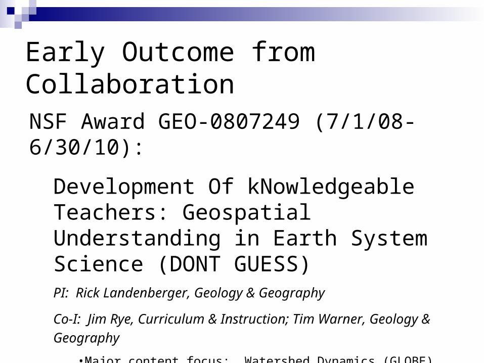
Early Outcome from Collaboration
NSF Award GEO-0807249 (7/1/08-6/30/10):
Development Of kNowledgeable Teachers: Geospatial Understanding in Earth System Science (DONT GUESS)PI: Rick Landenberger, Geology & Geography
Co-I: Jim Rye, Curriculum & Instruction; Tim Warner, Geology &
Geography •Major content focus: Watershed Dynamics (GLOBE)
•Sustained professional development combining technical skills with content area. (NRC, 2006)

The Science Educator’s Initial Experiences with GPS & GIS Increase physical activity opportunities in WV
communities; walkable communities Civil and environmental engineering resources CDC funding through WVBPH targeting cardiovascular disease
in underinsured WV women (Contract G040471) NIH & CDC funding to provide teacher professional development
and secondary student science/math enrichment along with health sciences career orientation (Contracts 2 R25 RR012329-07 & H75/CCH322130-01, respectively)
One to two day workshops on GPS and GIS Self-instructional modules Email/assistance from on-campus “experts” (WV GIS Center;
Geography/Geology/Engineering faculty)
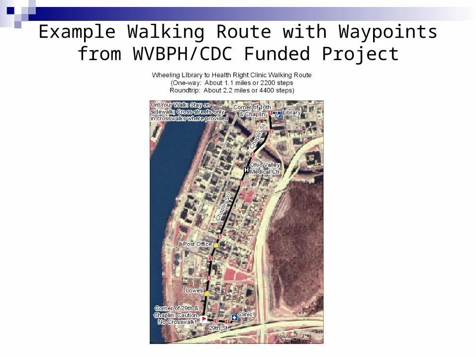
Example Walking Route with Waypoints from WVBPH/CDC Funded Project

Geosciences Collaboration & Integration in Graduate Science Methods Course WVU Geosciences faculty/WV View GLOBE Program/Protocols/Human Resources
(NASA Educational Resource Center) GPS
Garmin eTrex/cable/software GLOBE GPS Chapter/Protocol
GIS (AEJEE) (My World GIS) GPS/GIS software and data resources

Excerpts from “GPS/GIS Software and Data Resources” DocumentObtaining Geo-referenced Topographical and Aerial Photo Maps:1. WV GIS Technical Center site: http://www.wvgis.wvu.edu/.
• Select GIS data. Then select subjects “DRG” for topographical and “Photography” for Aerial maps.
2. Sample IMS Servers for Maps/Data: http://www.geographynetwork.com/ andhttp://www.mapwv.gov. Connect directly through GIS software.
Data Sources and Sites Related to GISo ACME Mapper: http://mapper.acme.com/o Geodata.gov: http://gos2.geodata.gov/wps/portal/goso GIS.com http://www.gis.com/o Global Land Cover Facility http://glcf.umiacs.umd.edu/index.shtml
On-line GIS “Map Making” (sample sites):o Geodata.gov http://gos2.geodata.gov/wps/portal/goso Google Earth: http://earth.google.com/o Maps Live http://maps.live.com/o National Atlas http://nationalatlas.gov/
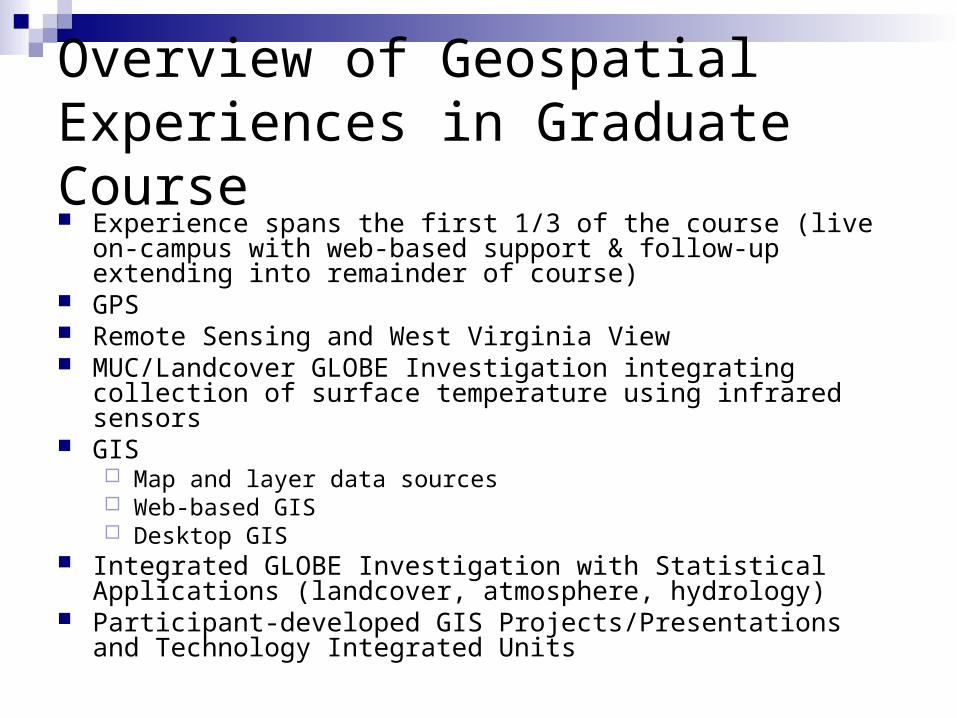
Overview of Geospatial Experiences in Graduate Course Experience spans the first 1/3 of the course (live on-campus with
web-based support & follow-up extending into remainder of course) GPS Remote Sensing and West Virginia View MUC/Landcover GLOBE Investigation integrating collection of
surface temperature using infrared sensors GIS
Map and layer data sources Web-based GIS Desktop GIS
Integrated GLOBE Investigation with Statistical Applications (landcover, atmosphere, hydrology)
Participant-developed GIS Projects/Presentations and Technology Integrated Units

GPS Sequence of Experiences Orientation and setting up GPS Unit to be GLOBE
ready Completing GLOBE Field Investigation Collecting waypoint and track data Downloading and saving data as projected shape
files Layering shape files from GPS over geo-
referenced aerial and topo maps in GIS program Follow-up assignment incorporating GPS, MUC,
and GIS.
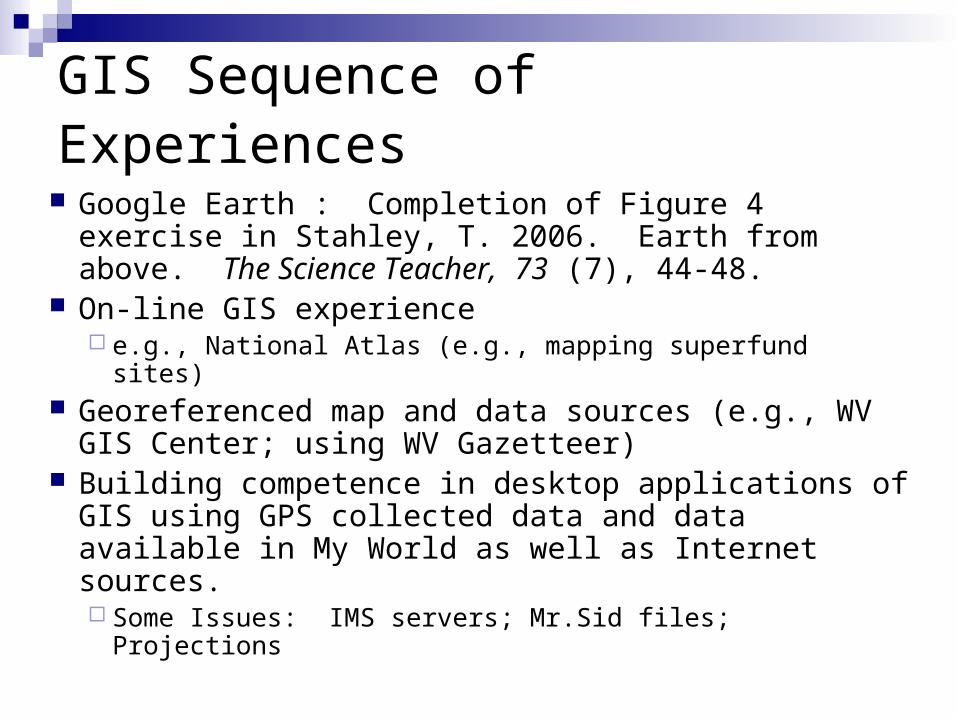
GIS Sequence of Experiences
Google Earth : Completion of Figure 4 exercise in Stahley, T. 2006. Earth from above. The Science Teacher, 73 (7), 44-48.
On-line GIS experience e.g., National Atlas (e.g., mapping superfund sites)
Georeferenced map and data sources (e.g., WV GIS Center; using WV Gazetteer)
Building competence in desktop applications of GIS using GPS collected data and data available in My World as well as Internet sources. Some Issues: IMS servers; Mr.Sid files; Projections
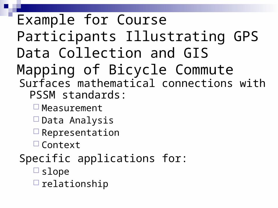
Example for Course Participants Illustrating GPS Data Collection and GIS Mapping of Bicycle Commute
Surfaces mathematical connections with PSSM standards: Measurement Data Analysis Representation Context
Specific applications for: slope relationship
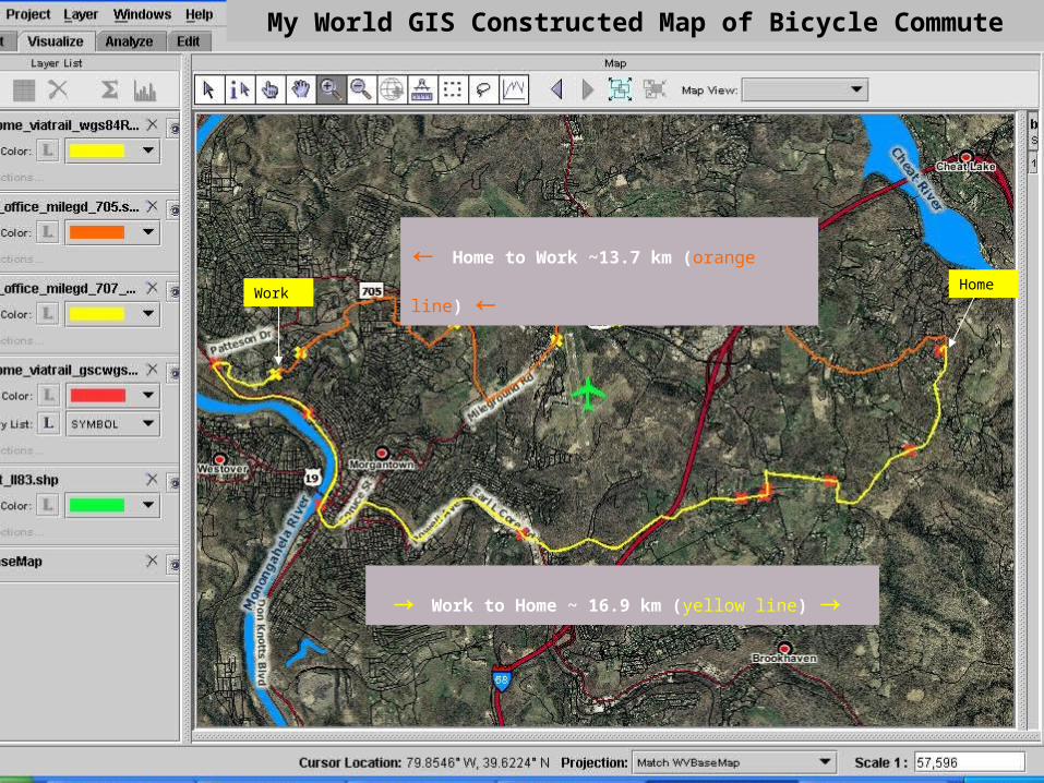
Bike Commute Two RoutesHome to Work (by Airport and on
Mileground) ~13.7 km (orange line)Home
Work
← Home to Work ~13.7 km (orange line) ←
→ Work to Home ~ 16.9 km (yellow line) →
My World GIS Constructed Map of Bicycle Commute

Describe the cyclist’s ride home in terms of “effort”.Waypoint # 1 shows “begin” altitude and Waypoint # 11 shows “end” altitude. (Note: Data to the right also can be obtained by using “Information” tool in My World.)
EndBegin
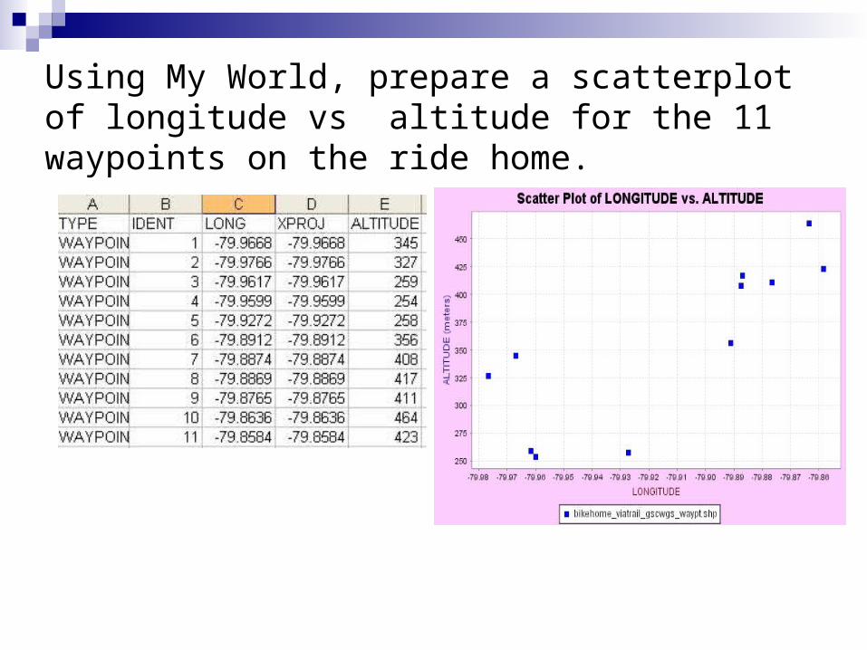
Using My World, prepare a scatterplot of longitude vs altitude for the 11 waypoints on the ride home.

Use My World to determine the correlation (r) and best fit line between longitude and altitude for the ride home

Use the measurement tool in My World and the data below to determine which portion (which 2 sequential waypoints) of the ride home has the steepest slope?

The distance between Waypoint # 6 and # 7 along Dughill Road has the greatest slope (grade)
•Rise = 52 m (408 m - 356 m altitude) •Run = 331 m •Slope (grade) ~ 16% (52/331 * 100)

GIS Investigations Created This Year:
Most frequently targeted water issues Included natural disasters (flooding),
mountain top removal, mineral resources, alternative energy (windmills), greenspace
Example (Mountaintop Removal and Watershed Impact) follows

Example GIS Investigation Map: Note layers for watersheds (blue), counties (black), & actual and potential mountaintop removal areas (yellow).
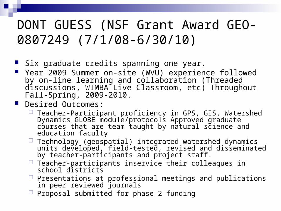
DONT GUESS (NSF Grant Award GEO-0807249 (7/1/08-6/30/10)
Six graduate credits spanning one year. Year 2009 Summer on-site (WVU) experience followed by on-line
learning and collaboration (Threaded discussions, WIMBA Live Classroom, etc) Throughout Fall-Spring, 2009-2010.
Desired Outcomes: Teacher-Participant proficiency in GPS, GIS, Watershed Dynamics
GLOBE module/protocols Approved graduate courses that are team taught by natural science and education faculty
Technology (geospatial) integrated watershed dynamics units developed, field-tested, revised and disseminated by teacher-participants and project staff.
Teacher-participants inservice their colleagues in school districts Presentations at professional meetings and publications in peer reviewed
journals Proposal submitted for phase 2 funding
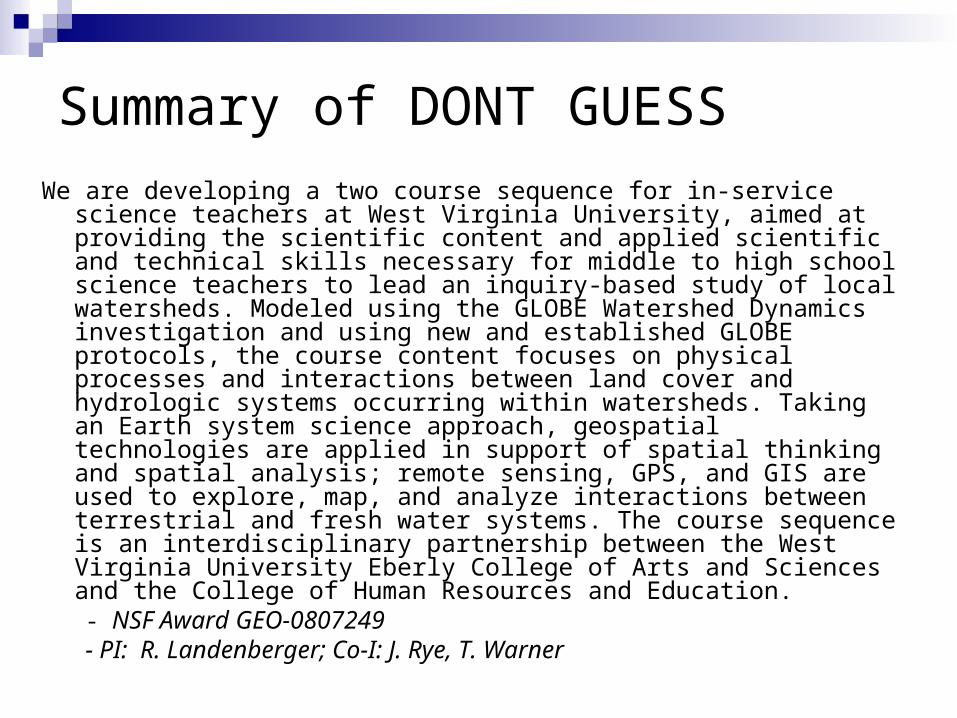
Summary of DONT GUESS
We are developing a two course sequence for in-service science teachers at West Virginia University, aimed at providing the scientific content and applied scientific and technical skills necessary for middle to high school science teachers to lead an inquiry-based study of local watersheds. Modeled using the GLOBE Watershed Dynamics investigation and using new and established GLOBE protocols, the course content focuses on physical processes and interactions between land cover and hydrologic systems occurring within watersheds. Taking an Earth system science approach, geospatial technologies are applied in support of spatial thinking and spatial analysis; remote sensing, GPS, and GIS are used to explore, map, and analyze interactions between terrestrial and fresh water systems. The course sequence is an interdisciplinary partnership between the West Virginia University Eberly College of Arts and Sciences and the College of Human Resources and Education.- NSF Award GEO-0807249 - PI: R. Landenberger; Co-I: J. Rye, T. Warner

Other Potentials
Honing students’ working knowledge of experimental design (especially variables)
Collaboration with mathematics education faculty Past collaborative work with pedometers Geometry Data analysis and statistics