Embed Size (px)
Citation preview
References-1
REFERENCES
Association of State Dam Safety Officials. 2013. “Introduction to Dams.” Dam Safety 101. Accessed 2017. http://www.damsafety.org/news/?p=e4cda171-b510-4a91-aa30-067140346bb2.
Brown, W. et al. 2001. U.S. Geological Survey (USGS). “Hazard Maps Help Save Lives and Property.” 2001. Accessed 2017. http://pubs.usgs.gov/fs/1996/fs183-96/fs183-96.pdf.
Cal-Adapt. 2016. “Exploring California’s Climate Change Research.” Accessed January 2017. http://cal-adapt.org/.
California Code of Regulations. 2017. http://leginfo.legislature.ca.gov/faces/codesTOCSelected.xhtml?tocCode=WAT&tocTitle=+Water+Code+-+WAT.
California Department of Conservation. 2010. “The Alquist-Priolo Earthquake Fault Zoning (AP) Act.” Accessed 2017. http://www.conservation.ca.gov/cgs/rghm/ap.
California Department of Finance, 2017. http://www.dof.ca.gov/research/demographic/reports/estimates/e-1/view.php “Forecasting.” Accessed February 2017. http://www.dof.ca.gov/Forecasting/Demographics/Estimates/.
California Department of Forestry and Fire Protection (CAL FIRE). 2017. “Incident Information.” Accessed April 2017. http://cdfdata.fire.ca.gov/incidents/incidents_archived.
California Department of Forestry and Fire Protection (CAL FIRE). 2017a. “FRAP Maps.” FRAP Projects. Accessed April 2017. http://frap.fire.ca.gov/.
California Department of Water Resources (DWR). 2005. The California Water Plan. Accessed February 2017. http://www.waterplan.water.ca.gov/docs/cwpu2009/0310final/v4c06a01_cwp2009.pdf.
California Department of Water Resources (DWR). 2013. The California Water Plan. Accessed February 2017. http://www.waterplan.water.ca.gov/docs/cwpu2013/Final/Vol2_SanFranciscoBayRR.pdf
California Department of Water Resources (DWR). 2016. “Listing of Dams”. Division of Safety of Dams. Accessed 2017. http://www.water.ca.gov/damsafety/damlisting/index.cfm.
California Department of Water Resources (DWR). 2017. “State Hydrologic Data.” Accessed March 2017. http://www.watersupplyconditions.water.ca.gov.
California Department of Water Resources (DWR). 2017a. Climate Change page of California DWR website. Accessed online at http://www.water.ca.gov/climatechange/
California Division of Safety of Dams. 2017. “Listing of Dams.” Accessed 2017. http://www.water.ca.gov/damsafety/damlisting/index.cfm.
California Environmental Protection Agency and Office of Environmental Health Hazard Assessment. 2015. CalEnviroScreen 3.0, California Communities Environmental Health Screening Tool.
City of Los Angeles 2017 Local Hazard Mitigation Plan References
Reference-2
California Emergency Management Agency (Cal EMA) et al. 2012. “California Adaptation Planning Guide.” Accessed 2017. http://resources.ca.gov/docs/climate/APG_Understanding_Regional_Characteristics.pdf.
California Governor’s Office of Emergency Services (Cal OES). 2013. State of California Multi-Hazard Mitigation Plan. Accessed November 2016. http://hazardmitigation.calema.ca.gov/plan/state_multi-hazard_mitigation_plan_shmp.
California Governor’s Office of Emergency Services (Cal OES). 2017. California State Warning Center Hazardous materials spill report data. http://www.caloes.ca.gov/cal-oes-divisions/warning-center
California Office of Traffic Safety. 2017. “Collison rankings and data.” Accessed April 2017. http://www.ots.ca.gov/Media_and_Research/Rankings/default.asp
Centers for Disease Control and Prevention (CDC). 2012. “Drought and Health.” Accessed February 2017. http://www.cdc.gov/nceh/drought/.
City of Los Angeles. 2011. City of Los Angeles Hazard Mitigation Plan Update. Accessed January 2017.
City of Los Angeles. 2015. Annexation Map; City of Los Angeles. Prepared by the City of Los Angeles Department of Public Works Bureau of Engineering. Available online at http://navigatela.lacity.org/common/mapgallery/pdf/annex34x44.pdf
City of Los Angeles. 2016. City of Los Angeles Floodplain Management Plan. City of Los Angeles Department of Public Works Bureau of Engineering.
City of Los Angeles. 2017. City of Los Angeles General Plan. Accessed February 2017. https://planning.lacity.org/GP_elements.html
City of Los Angeles. 2017. Los Angeles River Revitalization Website. Accessed March 2017. http://www.lariver.org/index.htm.
City of Los Angeles Department of Transportation (LADOT). 2016. LADOT Annual Report, 2015-2016.
City of Los Angeles Department of Water and Power. 2015. Urban Water Management Plan. Accessed January 2017.
City of Los Angeles Police Department. 2017. “Operation Archangel.” Accessed April 2017. http://www.lapdonline.org/emergency_services_division/content_basic_view/33044.
City of Los Angeles Stormwater Program. 2017. Enhanced Watershed Management Plans website. Accessed March 2017 at http://www.lastormwater.org/green-la/enhanced-watershed-management-plans/.
City of Los Angeles Sanitation (LASAN). 2017. “What We Do.” Accessed June 2017. https://www.lacitysan.org/san/faces/home/portal/s-lsh-wwd?_adf.ctrl-state=16q9keg5ti_4&_afrLoop=340566205060389#!
Danielson, T. 2015. “How to avoid the curse of ransomware.” Accessed April 2017. http://www.businessinsider.com/ransomware-is-everywhere-but-this-software-can-save-you-2015-10
Disaster Mitigation Act of 2000 (DMA 2000). Public Law 106-390. 42 U.S.C. §§ 5121 note et seq. October 30, 2000.
City of Los Angeles 2017 Local Hazard Mitigation Plan References
References-3
Federal Emergency Management Agency (FEMA). 1977. “Executive Order 11988.” Accessed 2016. https://www.fema.gov/laws-executive-orders.
Federal Emergency Management Agency (FEMA). 1997. “FEMA’s Multi-Hazard Identification and Risk Assessment (MHIRA).” Accessed 2016. http://www.fema.gov/library/viewRecord.do?id=2214.
FEMA. 1999. Flood Insurance Study; City of Los Angeles, California; Los Angeles County. Community Number 060137. Revised May 4, 1999.
Federal Emergency Management Agency FEMA. 2001. Understanding Your Risks; Identifying Hazards and Determining your Risks. FEMA (386-2). August 2001
Federal Emergency Management Agency FEMA. 2002. Getting Started; Building support for Mitigation Planning. FEMA (386-1). September 2002
Federal Emergency Management Agency FEMA. 2003. Developing the Mitigation Plan; Identifying Mitigation Actions and Implementing Strategies. FEMA (386-3). April 2003
Federal Emergency Management Agency FEMA. 2003a. Integrating Manmade Hazards Into Mitigation Planning. FEMA (386-7). September 2003.
Federal Emergency Management Agency FEMA. 2004. Using Hazus for Risk Assessment, How to Guide. FEMA (433). August 2004
Federal Emergency Management Agency (FEMA). 2004b. Federal Guidelines for Dam Safety. Accessed 2017. http://www.fema.gov/media-library-data/20130726-1516-20490-7951/fema-333.pdf.
Federal Emergency Management Agency (FEMA). 2004c. National Response Plan, Cyber Incident Annex. https://www.fema.gov/media-library-data/20130726-1825-25045-8307/cyber_incident_annex_2004.pdf
Federal Emergency Management Agency (FEMA). June 2009. Benefit Cost Analysis Reference Guide. https://www.fema.gov/media-library-data/20130726-1736-25045-7076/bca_reference_guide.pdf.
Federal Emergency Management Agency (FEMA). 2010. “Wind Zones in the United States.” http://www.fema.gov/safe-rooms/wind-zones-united-states.
Federal Emergency Management Agency (FEMA). 2013. “Why Dams Fail.” Accessed 2017. http://www.fema.gov/why-dams-fail.
Federal Emergency Management Agency (FEMA). 2013a. Engineering Principles and Practices. Accessed 2017. http://www.fema.gov/media-library-data/20130726-1506-20490-3574/fema259_ch2.pdf.
Federal Emergency Management Agency (FEMA). 2008. “Flood Insurance Study for City of Los Angeles, CA: Revised 2008.”
Federal Emergency Management Agency (FEMA). 2015a. “Federal Flood Risk Management Standard.” Accessed 2017. https://www.fema.gov/federal-flood-risk-management-standard-ffrms.
Federal Emergency Management Agency (FEMA). 2015b. “Flood Insurance Study for Contra Costa County, CA: Revised 2015.”
City of Los Angeles 2017 Local Hazard Mitigation Plan References
Reference-4
Federal Emergency Management Agency (FEMA). 2016. “NFIP Community Rating System Communities and their Classes.” Accessed January 2017. https://www.fema.gov/national-flood-insurance-program-community-status-book.
Federal Emergency Management Agency (FEMA). 2017. “Disaster Declarations-Open Government Dataset.” Accessed February 2017. https://www.fema.gov/disasters.
Federal Emergency Management Agency (FEMA). 2017a. “Policy and Claim Statistics for Flood Insurance.” Accessed January 2017. https://www.fema.gov/policy-claim-statistics-flood-insurance.
Federal Emergency Management Agency (FEMA) Region IX. 2016. “Report of Repetitive Losses.”
Intergovernmental Panel on Climate Change (IPCC). 2014. “Climate Change 2014: Impacts, Adaptation, and Vulnerability. Contribution of Working Group II to the Fifth Assessment Report of the Intergovernmental Panel on Climate Change. Parts A, B and Annexes.” Accessed January 2017. http://www.ipcc.ch/report/ar5/wg2/.
Intergovernmental Panel on Climate Change (IPCC). 2014a. “Climate Change 2014: Impacts, Adaptation, and Vulnerability. Contribution of Working Group II to the Fifth Assessment Report of the Intergovernmental Panel on Climate Change. Parts A, B and Annexes.” Accessed January 2017. http://www.ipcc.ch/report/ar5/wg2/.
International Strategy for Disaster Reduction. 2008. “Disaster Risk Reduction Strategies and Risk Management Practices: Critical Elements for Adaptation to Climate Change”
Keller, Edward A., and Robert H. Blodgett. Natural Hazards: Earth’s Processes as Hazards, Disasters, and Catastrophes. Upper Saddle River, NJ: Pearson/Prentice Hall, 2008. Print.
KPCC. 2017. Los Angeles metro area posted dip in housing building permits. Posted on KPCC website April 13, 2017: http://www.scpr.org/news/2017/04/13/70756/los-angeles-metro-area-posted-dip-in-housing/
Layne, James Gregg. 1935. Annals of Los Angeles 1769–1861, Special Publication No. 9. San Francisco: California Historical Society.
Los Angeles Almanac. 2017. “Employment and Income”. Accessed February 2017. http://www.laalmanac.com/employment/index.php.
McCawley, William. 1996. The First Angelinos: The Indians of Los Angeles. Banning, California: Malki Museum Press and Ballena Press Cooperative.
Morratt and Nichol. 2007. Tsunami Hazard Assessment for the Ports of Long Beach and Los Angeles.
National Aeronautics and Space Administration (NASA). 2004. “NASA Earth Observatory News.” Accessed January 2017. http://earthobservatory.nasa.gov/Newsroom/view.php?id=25145.
National Aeronautics and Space Administration (NASA). 2016. “NASA, NOAA Data Show 2016 Warmest Year on Record Globally.” Accessed February 2017. https://www.nasa.gov/press-release/nasa-noaa-data-show-2016-warmest-year-on-record-globally.
National Aeronautics and Space Administration (NASA). 2017. “Global Climate Change: Vital Signs of the Planet.” Accessed May 2017. http://climate.nasa.gov/vital-signs/carbon-dioxide/.
National Aeronautics and Space Administration (NASA). 2017a. “Global Climate Change: Vital Signs of the Planet.” Accessed May 2017. http://climate.nasa.gov/vital-signs/carbon-dioxide/.
City of Los Angeles 2017 Local Hazard Mitigation Plan References
References-5
National Aeronautics and Space Administration (NASA). 2017b. “Global Climate Change: Vital Signs of the Planet.” Accessed May 2017. http://climate.nasa.gov/vital-signs/carbon-dioxide/.
National Aeronautics and Space Administration (NASA). 2017c. “Global Climate Change: Vital Signs of the Planet.” Accessed May 2017. http://climate.nasa.gov/vital-signs/carbon-dioxide/.
National Aeronautics and Space Administration (NASA). 2017d. “Global Climate Change: Vital Signs of the Planet.” Accessed May 2017. http://climate.nasa.gov/vital-signs/carbon-dioxide/.
National Drought Mitigation Center. 2017. “Drought Impact Report for Contra Costa County.” Accessed February 2017. http://drought.unl.edu/MonitoringTools/DroughtImpactReporter.aspx.
National Drought Mitigation Center. 2017a. “Drought Affecting People.” Accessed February 2017. http://drought.unl.edu/droughtbasics/ensoandforecasting.aspx.
National Climate Assessment. 2014. Third National Climate Assessment Report for the United States. Accessed March 2017. http://www.globalchange.gov/browse/reports/climate-change-impacts-united-states-third-national-climate-assessment-0.
National Climate Assessment. 2014a. “Climate Change Impacts in the United States.” Accessed March 2017. http://nca2014.globalchange.gov/.
National Geophysical Data Center / World Data Service. 2017. Global Historical Tsunami Database. National Geophysical Data Center, NOAA. Accessed February 28, 2017. doi:10.7289/V5PN93H7.
National Oceanic and Atmospheric Administration (NOAA). 2015. Severe Weather 101; Thunderstorm Basics. Accessed October 2016. http://www.nssl.noaa.gov/education/svrwx101/thunderstorms/.
National Oceanic and Atmospheric Administration (NOAA). 2016. “National Centers for Environmental Information Estimated Tsunami Travel Times to Coastal Locations.” Accessed November 2016. https://maps.ngdc.noaa.gov/viewers/ttt_coastal_locations/.
National Oceanic and Atmospheric Administration (NOAA). 2016a. “Climate Data Online.” Accessed November 2016. https://www.ncdc.noaa.gov/cdo-web/.
National Oceanic and Atmospheric Administration (NOAA). 2017. “National Centers for Environmental Information Storm Events Database.” Accessed January 2017. https://www.ncdc.noaa.gov/stormevents/.
National Transportation Safety Board (NTSB). 2017. “Aviation Accident Database and Synopses.” Accessed June 2017. https://www.ntsb.gov/_layouts/ntsb.aviation/index.aspx
NOAA, National Weather Service (NWS). 2009. “National Weather Service Glossary.” Accessed 2017. http://w1.weather.gov/glossary/.
NOAA, National Weather Service (NWS). 2016. “NWS Heat Index.” Accessed March 2017. http://www.nws.noaa.gov/os/heat/heat_index.shtml.
National Weather Service (NWS). 2016a. “Introduction to Thunderstorms.” Accessed October 2016. http://www.srh.noaa.gov/jetstream/tstorms/tstorms_intro.html.
NOAA, NWS. 2017. “Climate Prediction Center, Palmer Crop Moisture Index.” Accessed March 2017. http://www.cpc.ncep.noaa.gov/products/monitoring_and_data/drought.shtml.
City of Los Angeles 2017 Local Hazard Mitigation Plan References
Reference-6
NOAA, NWS. 2017a. “Climate Prediction Center, Palmer Z Index.” Accessed March 2017. http://www.cpc.ncep.noaa.gov/products/monitoring_and_data/drought.shtml.
NOAA, NWS. 2017b. “Climate Prediction Center, Palmer Drought Severity Index.” Accessed March 2017. http://www.cpc.ncep.noaa.gov/products/monitoring_and_data/drought.shtml.
NOAA, NWS. 2017c. “Climate Prediction Center, Palmer Hydrological Drought Index.” Accessed March 2017. http://www.cpc.ncep.noaa.gov/products/monitoring_and_data/drought.shtml.
NOAA, NWS. 2017d. “Climate Prediction Center, Standard Precipitation Index.” Accessed March 2017. http://www.cpc.ncep.noaa.gov/products/Drought/Monitoring/spi.shtml.
OTA (Congressional Office of Technology Assessment). 1993. Preparing for an Uncertain Climate, Vol. I. OTA–O–567. U.S. Government Printing Office, Washington, D.C.
Press Telegram. 2015. New Census figures show nation is following Los Angeles in diversity. Posted on the Press-Telegram website June 25, 2015: http://www.presstelegram.com/social-affairs/20150625/new-census-figures-show-nation-is-following-los-angeles-in-diversity
Ready.gov. 2016. “Chemical threats.” Accessed December 2016. https://www.ready.gov/chemical-threats.
Stanford University National Performance of Dams Program. 2017. “NPDP Dams Database.” Accessed January 2017. https://npdp.stanford.edu/dams_database.
Gregory Lee Thompson. 1993. The Passenger Train in the Motor Age: California’s Rail and Bus Industries, 1910-1941
U.S. Army. 2005. “Civil Disturbance Operations.” FM 3-19.15. Accessed 2016. https://www.fas.org/irp/doddir/army/fm3-19-15.pdf.
U.S. Army Center for Health Promotion and Preventive Medicine. 2015. “Chlorine Improvised Explosive Devices and Preventive Medicine Actions.” Accessed 2016. https://mesl.apgea.army.mil/mesl/account/EHFileDownload%3FfileString%3D/webu03/meslp/webUploads/EH/moduleI/59476N.pdf+&cd=12&hl=en&ct=clnk&gl=us.
U.S. Army Corps of Engineers. 1997. “Annual Flood Damage Report to Congress for Fiscal Year 1997.”
U.S. Army Corps of Engineers. 2016. “Dam Safety Program.” Accessed March 2017. http://www.usace.army.mil/Missions/Civil-Works/Dam-Safety-Program/.
U.S. Army Corps of Engineers. 2017. National Inventory of Dams. Accessed March 2017. https://catalog.data.gov/dataset/national-inventory-of-dams.
U.S. Census. 2010. http://censtats.census.gov/data/CA/05006081.pdf.
U.S. Census. 2016. “2011-2015 American Community Survey 5-Year Estimates.” Accessed 2017. https://factfinder.census.gov/faces/tableservices/jsf/pages/productview.xhtml?src=bkmk.
U. S. Department of Agriculture (USDA), Natural Resources Conservation Service (NRCS). 2005. “Final Rule, 7 Code of Federal Rules Part 624. Emergency Watershed Protection Program.” Accessed November 2016. https://www.nrcs.usda.gov/wps/portal/nrcs/main/national/programs/landscape/ewpp/.
City of Los Angeles 2017 Local Hazard Mitigation Plan References
References-7
U.S. Department of Homeland Security. 2003. National Strategy for the Physical Protection of Critical Infrastructure of Critical Infrastructure and Key Assets.
U.S. Department of Homeland Security and National Academies. 2004. Chemical Attack Fact Sheet: Warfare Agents, Industrial Chemicals, and Toxins. Accessed January 2017. https://www.dhs.gov/publication/chemical-attack-fact-sheet .
U.S. Environmental Protection Agency (EPA). 2003. “Protecting Water Quality from Urban Runoff.” Publication EPA 841-F-03-003.
U.S. Environmental Protection Agency (EPA). 2016. “Climate Change Indicators in the United States.” 2016. https://www.epa.gov/climate-indicators/climate-change-indicators-atmospheric-concentrations-greenhouse-gases.
U.S. Environmental Protection Agency (EPA). 2016a. “Toxics Release Inventory (TRI) Program.” https://www.epa.gov/toxics-release-inventory-tri-program/learn-about-toxics-release-inventory.
U.S. Environmental Protection Agency (EPA). 2016b. “Climate Change Indicators in the United States.” 2016. EPA 430-R-16-004. www.epa.gov/climate-indicators.
U.S. Environmental Protection Agency (EPA). 2017. “Surf Your Watershed.” Accessed April 2017. https://cfpub.epa.gov/surf/county.cfm?fips_code=06013.
U.S. Geological Survey (USGS). 1987. The Morgan Hill, California, Earthquake of April 24, 1984, U.S. Geological Survey Bulletin 1639.
U.S. Geological Survey (USGS). 1989. The Severity of an Earthquake. U.S. Government Printing Office: 1989-288-913. Accessed 2017. http://pubs.usgs.gov/gip/earthq4/severity_text.html.
U.S. Geological Survey (USGS). 2008. An Atlas of ShakeMaps for Selected Global Earthquakes. U.S. Geological Survey Open-File Report 2008-1236. Prepared by Allen, T.I., Wald, D.J., Hotovec, A.J., Lin, K., Earle, P.S. and Marano, K.D.
U.S. Geological Survey (USGS). 2010. “PAGER—Rapid Assessment of an Earthquake’s Impact. U.S. Geological Survey Fact Sheet 2010-3036”.
U.S. Geological Survey (USGS). 2014. “Global Seismographic Network.” Earthquake Hazards Program. Accessed February 2017. http://earthquake.usgs.gov/monitoring/gsn/.
U.S. Geological Survey (USGS). 2016. “Search Earthquake Archives.” Earthquake Hazards Program. Accessed 2016. http://earthquake.usgs.gov/earthquakes/search/.
U.S. Geological Survey (USGS). 2017. “California Drought.” Accessed January 2017. https://ca.water.usgs.gov/data/drought/.
U.S. Geological Survey (USGS). 2017a. “Measuring Earthquakes FAQs.” Accessed February 2017. https://www2.usgs.gov/faq/categories/9828/3357.
U.S. Global Change Research Program (USGCRP). 2009. “Global Climate Change Impacts in the United States.” Thomas R. Karl, Jerry M. Melillo and Thomas C. Peterson, (eds.). Cambridge University Press. Accessed 2016. https://downloads.globalchange.gov/usimpacts/pdfs/climate-impacts-report.pdf.
U.S. Global Change Research Program (USGCRP). 2017. “Indicators of Change.” Accessed January 2017. http://www.globalchange.gov/.
City of Los Angeles 2017 Local Hazard Mitigation Plan References
Reference-8
U.S. Pipeline and Hazardous Materials Safety Administration National Pipeline Mapping System. 2017. https://www.npms.phmsa.dot.gov/GeneralPublic.aspx.
Western Regional Climate Center. 2017 “Temperature and Precipitation Summaries.” Accessed February 2017.
World Health Organization (WHO). 2014. “Geographic distribution of Ebola virus disease outbreaks in humans and animals.” Accessed 2016. http://www.who.int/csr/disease/ebola/ebola-map-humans-animals-2014.png?ua=1.
Glossary-1
GLOSSARY
ACRONYMS CCR—California Code of Regulations
CDBG-DR—Community Development Block Grant—Disaster Recovery
CEQA—California Environmental Quality Act
CFR—Code of Federal Regulations
CIP—Capital Improvement Plan
CRS—Community Rating System
DFIRM—Digital Flood Insurance Rate Maps
DMA —Disaster Mitigation Act
DSOD—Division of Safety of Dams
DTSC—Department of Toxic Substances Control
DWR—Department of Water Resources (California)
EDD—Employment Development Department (California)
EF— Enhanced Fujita Scale
EPA—U.S. Environmental Protection Agency
ESA—Endangered Species Act
FEMA—Federal Emergency Management Agency
FERC—Federal Energy Regulatory Commission
FIRM—Flood Insurance Rate Map
FHSZ—Fire hazard severity zone
GIS—Geographic Information System
Hazus—Hazards, United States
HMGP—Hazard Mitigation Grant Program
IBC—International Building Code
IRC—International Residential Code
LACDA—Los Angeles County Drainage Area
LADOT—Los Angeles Department of Transportation
LADWP—Los Angeles Department of Water and Power
City of Los Angeles 2017 Local Hazard Mitigation Plan Glossary
Glossary-2
LAPD—Los Angeles Police Department
LATCB— Los Angeles Tourism & Convention Board
MCI—Multi-casualty incident
MM—Modified Mercalli Scale
NCEI—National Centers for Environmental Information
NEHRP—National Earthquake Hazards Reduction Program
NIMS—National Incident Management System
NFIP—National Flood Insurance Program
NOAA—National Oceanic and Atmospheric Administration
NWS—National Weather Service
OES—Office of Emergency Services (California)
PDM—Pre-Disaster Mitigation Grant Program
PGA—Peak Ground Acceleration
SFHA—Special Flood Hazard Area
SPI—Standardized Precipitation Index
TRI—Toxics Release Inventory
UHI—Urban heat island
USGS—U.S. Geological Survey
WMD—Weapon of mass destruction
WRCC—Western Regional Climate Center
DEFINITIONS 100-Year Flood: The term “100-year flood” can be misleading. The 100-year flood does not necessarily occur once every 100 years. Rather, it is the flood that has a 1 percent chance of being equaled or exceeded in any given year. Thus, the 100-year flood could occur more than once in a relatively short period of time. The Federal Emergency Management Agency (FEMA) defines it as the 1 percent annual chance flood, which is now the standard definition used by most federal and state agencies and by the National Flood Insurance Program (NFIP).
Acre-Foot: An acre-foot is the amount of water it takes to cover 1 acre to a depth of 1 foot. This measure is used to describe the quantity of storage in a water reservoir. An acre-foot is a unit of volume. One acre foot equals 7,758 barrels; 325,829 gallons; or 43,560 cubic feet. An average household of four will use approximately 1 acre-foot of water per year.
Asset: An asset is any man-made or natural feature that has value, including people; buildings; infrastructure, such as bridges, roads, sewers, and water systems; lifelines, such as electricity and communication resources; and environmental, cultural, or recreational features such as parks, wetlands, and landmarks.
Base Flood: The flood having a 1% chance of being equaled or exceeded in any given year, also known as the “100-year” or “1% chance” flood. The base flood is a statistical concept used to ensure that all properties subject to the National Flood Insurance Program (NFIP) are protected to the same degree against flooding.
City of Los Angeles 2017 Local Hazard Mitigation Plan Glossary
Glossary-3
Basin: A basin is the area within which all surface water—whether from rainfall, snowmelt, springs, or other sources—flows to a single water body or watercourse. The boundary of a river basin is defined by natural topography, such as hills, mountains, and ridges. Basins are also referred to as “watersheds” and “drainage basins.”
Benefit: A benefit is a net project outcome and is usually defined in monetary terms. Benefits may include direct and indirect effects. For the purposes of benefit-cost analysis of proposed mitigation measures, benefits are limited to specific, measurable, risk reduction factors, including reduction in expected property losses (buildings, contents, and functions) and protection of human life.
Benefit/Cost Analysis: A benefit/cost analysis is a systematic, quantitative method of comparing projected benefits to projected costs of a project or policy. It is used as a measure of cost effectiveness.
Building: A building is defined as a structure that is walled and roofed, principally aboveground, and permanently fixed to a site. The term includes manufactured homes on permanent foundations on which the wheels and axles carry no weight.
Capability Assessment: A capability assessment provides a description and analysis of a community’s current capacity to address threats associated with hazards. The assessment includes two components: an inventory of an agency’s mission, programs, and policies, and an analysis of its capacity to carry them out. A capability assessment is an integral part of the planning process in which a community’s actions to reduce losses are identified, reviewed, and analyzed, and the framework for implementation is identified. The following capabilities were reviewed under this assessment:
• Legal and regulatory capability • Administrative and technical capability • Fiscal capability
Community Rating System (CRS): The CRS is a voluntary program under the NFIP that rewards participating communities (provides incentives) for exceeding the minimum requirements of the NFIP and completing activities that reduce flood hazard risk by providing flood insurance premium discounts.
Critical Area: An area defined by state or local regulations as deserving special protection because of unique natural features or its value as habitat for a wide range of species of flora and fauna. A sensitive/critical area is usually subject to more restrictive development regulations.
Critical Facility: Facilities and infrastructure that are critical to the health and welfare of the population. These become especially important after any hazard event occurs. For the purposes of this plan, critical facilities include:
• Structures or facilities that produce, use, or store highly volatile, flammable, explosive, toxic and/or water reactive materials;
• Hospitals, nursing homes, and housing likely to contain occupants who may not be sufficiently mobile to avoid death or injury during a hazard event.
• Police stations, fire stations, vehicle and equipment storage facilities, and emergency operations centers that are needed for disaster response before, during, and after hazard events, and
• Public and private utilities, facilities and infrastructure that are vital to maintaining or restoring normal services to areas damaged by hazard events.
• Government facilities.
Dam: Any artificial barrier or controlling mechanism that can or does impound 10 acre-feet or more of water.
City of Los Angeles 2017 Local Hazard Mitigation Plan Glossary
Glossary-4
Dam Failure: Dam failure refers to a partial or complete breach in a dam (or levee) that impacts its integrity. Dam failures occur for a number of reasons, such as flash flooding, inadequate spillway size, mechanical failure of valves or other equipment, freezing and thawing cycles, earthquakes, and intentional destruction.
Debris Flow: Dense mixtures of water-saturated debris that move down-valley; looking and behaving much like flowing concrete. They form when loose masses of unconsolidated material are saturated, become unstable, and move down slope. The source of water varies but includes rainfall, melting snow or ice, and glacial outburst floods.
Debris Slide: Debris slides consist of unconsolidated rock or soil that has moved rapidly down slope. They occur on slopes greater than 65 percent.
Disaster Mitigation Act of 2000 (DMA); The DMA is Public Law 106-390 and is the latest federal legislation enacted to encourage and promote proactive, pre-disaster planning as a condition of receiving financial assistance under the Robert T. Stafford Act. The DMA emphasizes planning for disasters before they occur. Under the DMA, a pre-disaster hazard mitigation program and new requirements for the national post-disaster hazard mitigation grant program (HMGP) were established.
Drainage Basin: A basin is the area within which all surface water- whether from rainfall, snowmelt, springs or other sources- flows to a single water body or watercourse. The boundary of a river basin is defined by natural topography, such as hills, mountains and ridges. Drainage basins are also referred to as watersheds or basins.
Drought: Drought is a period of time without substantial rainfall or snowfall from one year to the next. Drought can also be defined as the cumulative impacts of several dry years or a deficiency of precipitation over an extended period of time, which in turn results in water shortages for some activity, group, or environmental function. A hydrological drought is caused by deficiencies in surface and subsurface water supplies. A socioeconomic drought impacts the health, well being, and quality of life or starts to have an adverse impact on a region. Drought is a normal, recurrent feature of climate and occurs almost everywhere.
Earthquake: An earthquake is defined as a sudden slip on a fault, volcanic or magmatic activity, and sudden stress changes in the earth that result in ground shaking and radiated seismic energy. Earthquakes can last from a few seconds to over 5 minutes, and have been known to occur as a series of tremors over a period of several days. The actual movement of the ground in an earthquake is seldom the direct cause of injury or death. Casualties may result from falling objects and debris as shocks shake, damage, or demolish buildings and other structures.
Exposure: Exposure is defined as the number and dollar value of assets considered to be at risk during the occurrence of a specific hazard.
Extent: The extent is the size of an area affected by a hazard.
Fire Behavior: Fire behavior refers to the physical characteristics of a fire and is a function of the interaction between the fuel characteristics (such as type of vegetation and structures that could burn), topography, and weather. Variables that affect fire behavior include the rate of spread, intensity, fuel consumption, and fire type (such as underbrush versus crown fire).
Fire Frequency: Fire frequency is the broad measure of the rate of fire occurrence in a particular area. An estimate of the areas most likely to burn is based on past fire history or fire rotation in the area, fuel conditions, weather, ignition sources (such as human or lightning), fire suppression response, and other factors.
Flash Flood: A flash flood occurs with little or no warning when water levels rise at an extremely fast rate
City of Los Angeles 2017 Local Hazard Mitigation Plan Glossary
Glossary-5
Flood Insurance Rate Map (FIRM): FIRMs are the official maps on which the Federal Emergency Management Agency (FEMA) has delineated the Special Flood Hazard Area (SFHA).
Flood Insurance Study: A report published by the Federal Insurance and Mitigation Administration for a community in conjunction with the community’s Flood Insurance rate Map. The study contains such background data as the base flood discharges and water surface elevations that were used to prepare the FIRM. In most cases, a community FIRM with detailed mapping will have a corresponding flood insurance study.
Floodplain: Any land area susceptible to being inundated by flood waters from any source. A flood insurance rate map identifies most, but not necessarily all, of a community’s floodplain as the Special Flood Hazard Area (SFHA).
Floodway: Floodways are areas within a floodplain that are reserved for the purpose of conveying flood discharge without increasing the base flood elevation more than 1 foot. Generally speaking, no development is allowed in floodways, as any structures located there would block the flow of floodwaters.
Floodway Fringe: Floodway fringe areas are located in the floodplain but outside of the floodway. Some development is generally allowed in these areas, with a variety of restrictions. On maps that have identified and delineated a floodway, this would be the area beyond the floodway boundary that can be subject to different regulations.
Freeboard: Freeboard is the margin of safety added to the base flood elevation.
Frequency: For the purposes of this plan, frequency refers to how often a hazard of specific magnitude, duration, and/or extent is expected to occur on average. Statistically, a hazard with a 100-year frequency is expected to occur about once every 100 years on average and has a 1 percent chance of occurring any given year. Frequency reliability varies depending on the type of hazard considered.
Fujita Scale of Tornado Intensity: Tornado wind speeds are sometimes estimated on the basis of wind speed and damage sustained using the Fujita Scale. The scale rates the intensity or severity of tornado events using numeric values from F0 to F5 based on tornado wind speed and damage. An F0 tornado (wind speed less than 73 miles per hour (mph)) indicates minimal damage (such as broken tree limbs), and an F5 tornado (wind speeds of 261 to 318 mph) indicates severe damage.
Goal: A goal is a general guideline that explains what is to be achieved. Goals are usually broad-based, long-term, policy-type statements and represent global visions. Goals help define the benefits that a plan is trying to achieve. The success of a hazard mitigation plan is measured by the degree to which its goals have been met (that is, by the actual benefits in terms of actual hazard mitigation).
Geographic Information System (GIS): GIS is a computer software application that relates data regarding physical and other features on the earth to a database for mapping and analysis.
Hazard: A hazard is a source of potential danger or adverse condition that could harm people and/or cause property damage.
Hazard Mitigation Grant Program (HMGP): Authorized under Section 202 of the Robert T. Stafford Disaster Relief and Emergency Assistance Act, the HMGP is administered by FEMA and provides grants to states, tribes, and local governments to implement hazard mitigation actions after a major disaster declaration. The purpose of the program is to reduce the loss of life and property due to disasters and to enable mitigation activities to be implemented as a community recovers from a disaster
City of Los Angeles 2017 Local Hazard Mitigation Plan Glossary
Glossary-6
Hazards U.S. Multi-Hazard Loss Estimation Program (Hazus): Hazus is a GIS-based program used to support the development of risk assessments as required under the DMA. The Hazus software program assesses risk in a quantitative manner to estimate damages and losses associated with natural hazards. Hazus is FEMA’s nationally applicable, standardized methodology and software program and contains modules for estimating potential losses from earthquakes, floods, and wind hazards. Hazus has also been used to assess vulnerability (exposure) for other hazards.
Hydraulics: Hydraulics is the branch of science or engineering that addresses fluids (especially water) in motion in rivers or canals, works and machinery for conducting or raising water, the use of water as a prime mover, and other fluid-related areas.
Hydrology: Hydrology is the analysis of waters of the earth. For example, a flood discharge estimate is developed by conducting a hydrologic study.
Intensity: For the purposes of this plan, intensity refers to the measure of the effects of a hazard.
Inventory: The assets identified in a study region comprise an inventory. Inventories include assets that could be lost when a disaster occurs and community resources are at risk. Assets include people, buildings, transportation, and other valued community resources.
Landslide: Landslides can be described as the sliding movement of masses of loosened rock and soil down a hillside or slope. Fundamentally, slope failures occur when the strength of the soils forming the slope exceeds the pressure, such as weight or saturation, acting upon them.
Lightning: Lightning is an electrical discharge resulting from the buildup of positive and negative charges within a thunderstorm. When the buildup becomes strong enough, lightning appears as a “bolt,” usually within or between clouds and the ground. A bolt of lightning instantaneously reaches temperatures approaching 50,000ºF. The rapid heating and cooling of air near lightning causes thunder. Lightning is a major threat during thunderstorms. In the United States, 75 to 100 Americans are struck and killed by lightning each year (see http://www.fema.gov/hazard/thunderstorms/thunder.shtm).
Liquefaction: Liquefaction is the complete failure of soils, occurring when soils lose shear strength and flow horizontally. It is most likely to occur in fine grain sands and silts, which behave like viscous fluids when liquefaction occurs. This situation is extremely hazardous to development on the soils that liquefy, and generally results in extreme property damage and threats to life and safety.
Local Government: Any county, municipality, city, town, township, public authority, school district, special district, intrastate district, council of governments (regardless of whether the council of governments is incorporated as a nonprofit corporation under State law), regional or interstate government entity, or agency or instrumentality of a local government; any Indian tribe or authorized tribal organization, or Alaska Native village or organization; and any rural community, unincorporated town or village, or other public entity.
Magnitude: Magnitude is the measure of the strength of an earthquake, and is typically measured by the Richter scale. As an estimate of energy, each whole number step in the magnitude scale corresponds to the release of about 31 times more energy than the amount associated with the preceding whole number value.
Mass movement: A collective term for landslides, debris flows, and lahars.
Mitigation: A preventive action that can be taken in advance of an event that will reduce or eliminate the risk to life or property.
City of Los Angeles 2017 Local Hazard Mitigation Plan Glossary
Glossary-7
Mitigation Actions: Mitigation actions are specific actions to achieve goals and objectives that minimize the effects from a disaster and reduce the loss of life and property.
Objective: For the purposes of this plan, an objective is defined as a short-term aim that, when combined with other objectives, forms a strategy or course of action to meet a goal. Unlike goals, objectives are specific and measurable.
Peak Ground Acceleration: Peak Ground Acceleration (PGA) is a measure of the highest amplitude of ground shaking that accompanies an earthquake, based on a percentage of the force of gravity.
Preparedness: Preparedness refers to actions that strengthen the capability of government, residents, and communities to respond to disasters.
Presidential Disaster Declaration: These declarations are typically made for events that cause more damage than state and local governments and resources can handle without federal government assistance. Generally, no specific dollar loss threshold has been established for such declarations. A Presidential Disaster Declaration puts into motion long-term federal recovery programs, some of which are matched by state programs, designed to help disaster victims, businesses, and public entities.
Probability of Occurrence: The probability of occurrence is a statistical measure or estimate of the likelihood that a hazard will occur. This probability is generally based on past hazard events in the area and a forecast of events that could occur in the future. A probability factor based on yearly values of occurrence is used to estimate probability of occurrence.
Repetitive Loss Property: Any NFIP-insured property that, since 1978 and regardless of any changes of ownership during that period, has experienced:
• Four or more paid flood losses in excess of $1000.00; or • Two paid flood losses in excess of $1000.00 within any 10-year period since 1978 or • Three or more paid losses that equal or exceed the current value of the insured property.
Return Period (or Mean Return Period): This term refers to the average period of time in years between occurrences of a particular hazard (equal to the inverse of the annual frequency of occurrence).
Riverine: Of or produced by a river. Riverine floodplains have readily identifiable channels. Floodway maps can only be prepared for riverine floodplains.
Risk: Risk is the estimated impact that a hazard would have on people, services, facilities, and structures in a community. Risk measures the likelihood of a hazard occurring and resulting in an adverse condition that causes injury or damage. Risk is often expressed in relative terms such as a high, moderate, or low likelihood of sustaining damage above a particular threshold due to occurrence of a specific type of hazard. Risk also can be expressed in terms of potential monetary losses associated with the intensity of the hazard.
Risk Assessment: Risk assessment is the process of measuring potential loss of life, personal injury, economic injury, and property damage resulting from hazards. This process assesses the vulnerability of people, buildings, and infrastructure to hazards and focuses on (1) hazard identification; (2) impacts of hazards on physical, social, and economic assets; (3) vulnerability identification; and (4) estimates of the cost of damage or costs that could be avoided through mitigation.
Risk Ranking: This ranking serves two purposes, first to describe the probability that a hazard will occur, and second to describe the impact a hazard will have on people, property, and the economy. Risk estimates are based
City of Los Angeles 2017 Local Hazard Mitigation Plan Glossary
Glossary-8
on the methodology used to prepare the risk assessment for this plan. The following equation shows the risk ranking calculation:
Risk Ranking = Probability + Impact (people + property + economy)
Robert T. Stafford Act: The Robert T. Stafford Disaster Relief and Emergency Assistance Act, Public Law 100-107, was signed into law on November 23, 1988. This law amended the Disaster Relief Act of 1974, Public Law 93-288. The Stafford Act is the statutory authority for most federal disaster response activities, especially as they pertain to FEMA and its programs.
Special Flood Hazard Area: The base floodplain delineated on a Flood Insurance Rate Map. The SFHA is mapped as a Zone A in riverine situations and zone V in coastal situations. The SFHA may or may not encompass all of a community’s flood problems
Stakeholder: Business leaders, civic groups, academia, non-profit organizations, major employers, managers of critical facilities, farmers, developers, special purpose districts, and others whose actions could impact hazard mitigation.
Stream Bank Erosion: Stream bank erosion is common along rivers, streams and drains where banks have been eroded, sloughed or undercut. However, it is important to remember that a stream is a dynamic and constantly changing system. It is natural for a stream to want to meander, so not all eroding banks are “bad” and in need of repair. Generally, stream bank erosion becomes a problem where development has limited the meandering nature of streams, where streams have been channelized, or where stream bank structures (like bridges, culverts, etc.) are located in places where they can actually cause damage to downstream areas. Stabilizing these areas can help protect watercourses from continued sedimentation, damage to adjacent land uses, control unwanted meander, and improvement of habitat for fish and wildlife.
Steep Slope: Different communities and agencies define it differently, depending on what it is being applied to, but generally a steep slope is a slope in which the percent slope equals or exceeds 25%. For this study, steep slope is defined as slopes greater than 33%.
Thunderstorm: A thunderstorm is a storm with lightning and thunder produced by cumulonimbus clouds. Thunderstorms usually produce gusty winds, heavy rains, and sometimes hail. Thunderstorms are usually short in duration (seldom more than 2 hours). Heavy rains associated with thunderstorms can lead to flash flooding during the wet or dry seasons.
Tornado: A tornado is a violently rotating column of air extending between and in contact with a cloud and the surface of the earth. Tornadoes are often (but not always) visible as funnel clouds. On a local scale, tornadoes are the most intense of all atmospheric circulations, and winds can reach destructive speeds of more than 300 mph. A tornado’s vortex is typically a few hundred meters in diameter, and damage paths can be up to 1 mile wide and 50 miles long.
Vulnerability: Vulnerability describes how exposed or susceptible an asset is to damage. Vulnerability depends on an asset’s construction, contents, and the economic value of its functions. Like indirect damages, the vulnerability of one element of the community is often related to the vulnerability of another. For example, many businesses depend on uninterrupted electrical power. Flooding of an electric substation would affect not only the substation itself but businesses as well. Often, indirect effects can be much more widespread and damaging than direct effects.
Watershed: A watershed is an area that drains downgradient from areas of higher land to areas of lower land to the lowest point, a common drainage basin.
City of Los Angeles 2017 Local Hazard Mitigation Plan Glossary
Glossary-9
Wildfire: These terms refer to any uncontrolled fire occurring on undeveloped land that requires fire suppression. The potential for wildfire is influenced by three factors: the presence of fuel, topography, and air mass. Fuel can include living and dead vegetation on the ground, along the surface as brush and small trees, and in the air such as tree canopies. Topography includes both slope and elevation. Air mass includes temperature, relative humidity, wind speed and direction, cloud cover, precipitation amount, duration, and the stability of the atmosphere at the time of the fire. Wildfires can be ignited by lightning and, most frequently, by human activity including smoking, campfires, equipment use, and arson.
Windstorm: Windstorms are generally short-duration events involving straight-line winds or gusts exceeding 50 mph. These gusts can produce winds of sufficient strength to cause property damage. Windstorms are especially dangerous in areas with significant tree stands, exposed property, poorly constructed buildings, mobile homes (manufactured housing units), major infrastructure, and aboveground utility lines. A windstorm can topple trees and power lines; cause damage to residential, commercial, critical facilities; and leave tons of debris in its wake.
Zoning Ordinance: The zoning ordinance designates allowable land use and intensities for a local jurisdiction. Zoning ordinances consist of two components: a zoning text and a zoning map.

City of Los Angeles 2017 Local Hazard Mitigation Plan
Appendix A. Outreach Survey & Results

A-1
A. OUTREACH SURVEY & RESULTS
To Be Provided When Available

City of Los Angeles 2017 Local Hazard Mitigation Plan
Appendix B. Data Sources and Methods Used for Mapping

B-1
B. DATA SOURCES AND METHODS USED FOR MAPPING
DAM INUNDATION MAPPING Dam inundation area data provided by Los Angeles County, Chief Executive Office ITS, in 2014 for the City’s 2015 Floodplain Management Plan. No additional metadata is available.
EARTHQUAKE MAPPING
Liquefaction Zones Liquefaction zones data provided by the City of Los Angeles. This data originated with Los Angeles County and the California Department of Conservation as part of a seismic hazards zones dataset. The seismic hazards zones datasets includes areas where liquefaction may occur during a strong earthquake. Developers of properties falling within the zones may be required to investigate the potential hazard and mitigate its threat during the local permitting process. The data is used by cities and counties to regulate development and by property owners selling property within areas where seismic hazard zones have been identified. Local governments can withhold development permits until geologic or soils investigations are conducted for specific sites and mitigation measures are incorporated into development plans. Sellers of property use the data to check the location of their specific site and, if applicable, disclose to the buyer that the property lies within a seismic hazard zone as required by the Seismic Hazards Mapping Act of 1990 (Public Resources Code, Division 2, Chapter 7.8). This data may not show all areas that have potential for liquefaction. Also, a single earthquake capable of causing liquefaction will not uniformly affect the entire zone. The identification and location of liquefaction zones are based on the best available data. However, the quality of data used is varied. Zone boundaries have been drawn as accurately as possible at the map scale (1:24,000).
National Earthquake Hazard Reduction Program (NEHRP) Soils Soil classification data provided by the California Department of Conservation. The data is based on surficial geology published at a scale of 1:250,000. The surficial geologic units were grouped into composite units with similar average shear wave velocity to 30 meters depth (Vs30) values. This data was prepared as part of the Probabilistic Seismic Hazard Map of California (Petersen et. al., 1999)
Susceptibility to Deep-Seated Landslides Landslide susceptibility data provided by the California Geological Survey.
The map, and associated data, show the relative likelihood of deep-seated landsliding based on regional estimates of rock strength and steepness of slopes. On the most basic level, weak rocks and steep slopes are most likely to generate landslides. The map uses detailed information on the location of past landslides, the location and relative strength of rock units, and steepness of slope to estimate susceptibility to deep-seated landsliding (0 to X, low to high). The USGS 2009 National Elevation Dataset (NED) with 10-m grid size was used as the base map. This landslide susceptibility map is intended to provide infrastructure owners, emergency planners and the public with a general overview of where landslides are more likely to occur. (Wills, et. al., 2011)
City of Los Angeles 2017 Local Hazard Mitigation Plan Data Sources and Methods Used for Mapping
B-2
Shake Maps A shake map is designed as a rapid response tool to portray the extent and variation of ground shaking throughout the affected region immediately following significant earthquakes. Ground motion and intensity maps are derived from peak ground motion amplitudes recorded on seismic sensors (accelerometers), with interpolation based on both estimated amplitudes where data are lacking, and site amplification corrections. Color-coded instrumental intensity maps are derived from empirical relations between peak ground motions and Modified Mercalli intensity. For this plan, shake maps were prepared for five earthquake scenarios:
• An earthquake on the Newport-Inglewood fault with the following characteristics:
Magnitude: 7.2 Epicenter: N33.65 W117.97
• An earthquake on the Palos Verde fault with the following characteristics:
Magnitude: 7.3 Epicenter: N33.3 W117.93 Also identified as Fleet Week scenario
• An earthquake on the Puente Hills fault with the following characteristics:
Magnitude: 7.0 Epicenter: N34.13 W118.08 Also identified as DTLA direct hit
• An earthquake on the San Andreas fault with the following characteristics:
Magnitude: 7.8 Epicenter: N33.35 W115.71 Also identified as the ShakeOut scenario
• An earthquake on the Santa Monica fault with the following characteristics:
Magnitude: 6.8 Epicenter: N34.16 W118.36
FLOOD MAPPING For the City’s 2015 Floodplain Management Plan, flood hazard areas are mapped as depicted on the effective FEMA Digital Flood Insurance Rate Maps dated September 26, 2008 with last Letter of Map Revision incorporated on February 7, 2014. For this plan, the following letters of map revision were also incorporated into the flood mapping:
• 2/9/2015 • 7/27/2015 • 9/28/2016 • 9/30/2016 • 11/2/2016.
For the Floodplain Management Plan, repetitive flood loss data was provided by FEMA as of October, 2014.
City of Los Angeles 2017 Local Hazard Mitigation Plan Data Sources and Methods Used for Mapping
B-3
LANDSLIDE MAPPING See Susceptibility to Deep-Seated Landslides data description under earthquake mapping.
SEA LEVEL RISE MAPPING Coastal Storm Modeling System (CoSMoS) data provided by the U.S. Geological Survey. CoSMoS was developed by the U.S. Geological Survey and Deltares. CoSMoS is a suite of coupled hydrodynamic models that utilize a total water level approach which includes the following elements: sea level rise; tides; waves; storm surge; freshwater discharge from rivers; and seasonal influences such as El Niño. The full suite of CoSMoS results and data covering 40 scenarios for Southern California was released in fall 2016.
CoSMoS provides region-specific flood hazard projections at a detailed parcel scale from Point Conception to the Mexican border. It is based on an active scientific development approach that utilizes cutting-edge science to provide the optimum model outputs possible at this time. CoSMoS uses a combination of historic conditions and global climate models to project future conditions. It also provides flood projections specific for the bathymetry and topography of Southern California. Flood hazard projections include flooding extent, depth, duration, and uncertainty.
TSUNAMI INUNDATION MAPPING Tsunami inundation areas data provided by the California Governor’s Office of Emergency Services. Data was published in 2009.
Initial tsunami modeling was performed by the University of Southern California Tsunami Research Center funded through the California Emergency Management Agency by the National Tsunami Hazard Mitigation Program. The tsunami modeling process utilized the MOST (Method of Splitting Tsunamis) computational program (Version 0), which allows for wave evolution over a variable bathymetry and topography used for the inundation mapping (Titov and Gonzalez, 1997; Titov and Synolakis, 1998). The bathymetric/topographic data that were used in the tsunami models consist of a series of nested grids. Near-shore grids with a 3 arc-second (75- to 90-meters) resolution or higher, were adjusted to “Mean High Water” sea-level conditions, representing a conservative sea level for the intended use of the tsunami modeling and mapping. A suite of tsunami source events was selected for modeling, representing realistic local and distant earthquakes and hypothetical extreme undersea, near-shore landslides. Local tsunami sources that were considered include offshore reverse-thrust faults, restraining bends on strike-slip fault zones and large submarine landslides capable of significant seafloor displacement and tsunami generation. Distant tsunami sources that were considered include great subduction zone events that are known to have occurred historically (1960 Chile and 1964 Alaska earthquakes) and others which can occur around the Pacific Ocean “Ring of Fire.” In order to enhance the result from the 75- to 90-meter inundation grid data, a method was developed utilizing higher-resolution digital topographic data (3- to 10-meters resolution) that better defines the location of the maximum inundation line (U.S. Geological Survey, 1993; Intermap, 2003; NOAA, 2004). The location of the enhanced inundation line was determined by using digital imagery and terrain data on a GIS platform with consideration given to historic inundation information (Lander, et al., 1993). This information was verified, where possible, by field work coordinated with local county personnel. The accuracy of the inundation line shown on these maps is subject to limitations in the accuracy and completeness of available terrain and tsunami source information, and the current understanding of tsunami generation and propagation phenomena as expressed in the models. Thus, although an attempt has been made to identify a credible upper bound to inundation at any location along the coastline, it remains possible that actual inundation could be greater in a major tsunami event. This map does not represent inundation from a single scenario event. It was created by combining inundation results for an ensemble of source events affecting a given
City of Los Angeles 2017 Local Hazard Mitigation Plan Data Sources and Methods Used for Mapping
B-4
region. For this reason, all of the inundation region in a particular area will not likely be inundated during a single tsunami event. (State of California, 2009)
WILDFIRE MAPPING Fire Hazard Severity Zones in Local Responsibility Areas data were provided by the California Department of Forestry and Fire Protection. Government Code 51175-89 directs CAL FIRE to identify areas of very high fire hazard severity zones within Local Responsibility Areas (LRA). Mapping of the areas, referred to as Very High Fire Hazard Severity Zones (VHFHSZ), is based on data and models of, potential fuels over a 30-50 year time horizon and their associated expected fire behavior, and expected burn probabilities to quantify the likelihood and nature of vegetation fire exposure (including firebrands) to buildings. Local Responsibility Area VHFHSZ maps were initially developed in the mid-1990s and are now being updated based on improved science, mapping techniques, and data. This specific geographic information system dataset depicts final CAL FIRE recommendations for Very High FHSZs within the local jurisdiction. The process of finalizing these boundaries involved an extensive local review process. Local government has 120 days to designate, by ordinance, very high fire hazard severity zones within its jurisdiction after receiving the recommendation. Local government can add additional VHFHSZs. There is no requirement for local government to report their final action to CAL FIRE when the recommended zones are adopted.
In late 2005 to be effective in 2008, the California Building Commission adopted California Building Code Chapter 7A requiring new buildings in VHFHSZs to use ignition resistant construction methods and materials. These new codes include provisions to improve the ignition resistance of buildings, especially from firebrands. The updated very high fire hazard severity zones will be used by building officials for new building permits in LRA. The updated zones will also be used to identify property whose owners must comply with natural hazards disclosure requirements at time of property sale and 100 foot defensible space clearance.
REFERENCES Petersen, M., D. Beeby, W. Bryant, T. Cao, C. Cramer, J. Davis, M. Reichle, G. Saucedo, S. Tan G.,Taylor, T. Toppozada, J. Treiman, and C. Wills. 1999. Seismic Shaking Hazard Maps of California: California Division of Mines and Geology Map Sheet 48.
Intermap Technologies, Inc., 2003, Intermap product handbook and quick start guide: Intermap NEXTmap document on 5-meter resolution data, 112 p.
Lander, J.F., Lockridge, P.A., and Kozuch, M.J., 1993, Tsunamis Affecting the West Coast of the United States 1806-1992: National Geophysical Data Center Key to Geophysical Record Documentation No. 29, NOAA, NESDIS, NGDC, 242 p.
National Atmospheric and Oceanic Administration (NOAA), 2004, Interferometric Synthetic Aperture Radar (IfSAR) Digital Elevation Models from GeoSAR platform (EarthData): 3-meter resolution data.
State of California. 2009. Tsunami Inundation Map for Emergency Planning; produced by California Emergency Management Agency, California Geological Survey, and University of Southern California – Tsunami Research Center; dated December 9, 2009.
Titov, V.V., and Gonzalez, F.I., 1997, Implementation and Testing of the Method of Tsunami Splitting (MOST): NOAA Technical Memorandum ERL PMEL –112, 11 p.
Titov, V.V., and Synolakis, C.E., 1998, Numerical modeling of tidal wave runup: Journal of Waterways, Port, Coastal and Ocean Engineering, ASCE, 124 (4), pp 157-171.
City of Los Angeles 2017 Local Hazard Mitigation Plan Data Sources and Methods Used for Mapping
B-5
U.S. Geological Survey, 1993, Digital Elevation Models: National Mapping Program, Technical Instructions, Data Users Guide 5, 48 p.
USGS. 2006. Maps of Quaternary Deposits and Liquefaction Susceptibility in the Central San Francisco Bay Region, California. Open-File Report 2006-1037. Version 1.1. U.S. Geological Survey in cooperation with the California Geological Survey.
Wills C.J., Perez, F., Gutierrez, C. 2011. Susceptibility to deep-seated landslides in California: California Geological Survey Map Sheet 58.

City of Los Angeles 2017 Local Hazard Mitigation Plan
Appendix C. Review of Previous Plan Actions

C-1
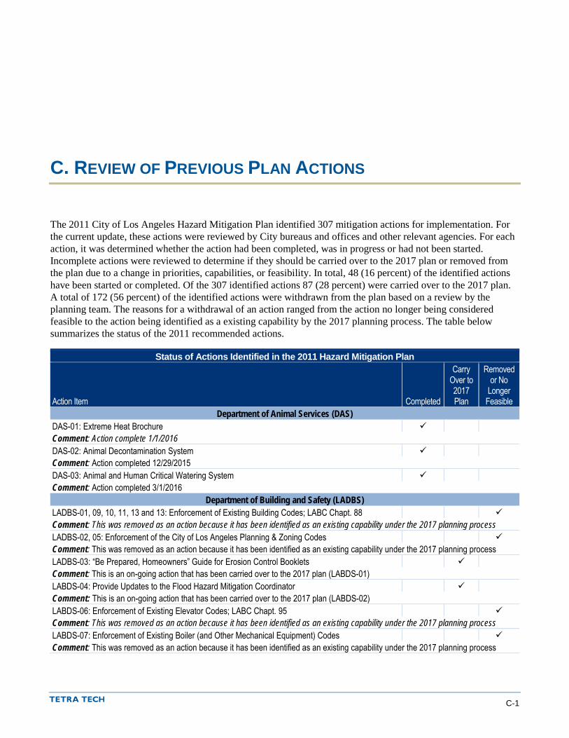
C. REVIEW OF PREVIOUS PLAN ACTIONS
The 2011 City of Los Angeles Hazard Mitigation Plan identified 307 mitigation actions for implementation. For the current update, these actions were reviewed by City bureaus and offices and other relevant agencies. For each action, it was determined whether the action had been completed, was in progress or had not been started. Incomplete actions were reviewed to determine if they should be carried over to the 2017 plan or removed from the plan due to a change in priorities, capabilities, or feasibility. In total, 48 (16 percent) of the identified actions have been started or completed. Of the 307 identified actions 87 (28 percent) were carried over to the 2017 plan. A total of 172 (56 percent) of the identified actions were withdrawn from the plan based on a review by the planning team. The reasons for a withdrawal of an action ranged from the action no longer being considered feasible to the action being identified as a existing capability by the 2017 planning process. The table below summarizes the status of the 2011 recommended actions.
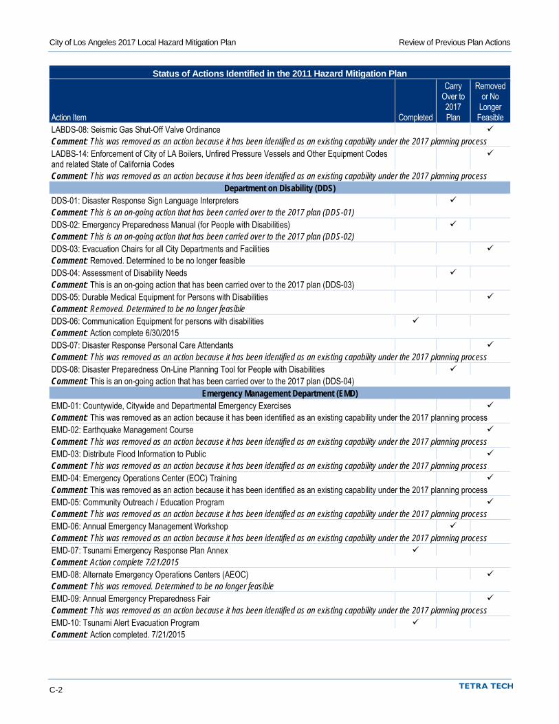
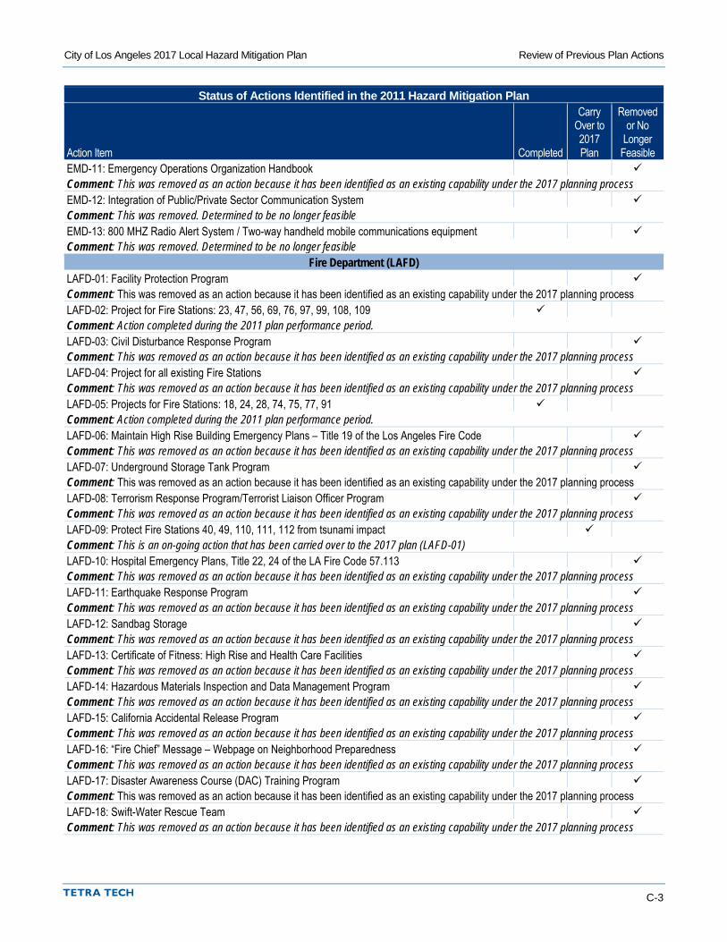
Status of Actions Identified in the 2011 Hazard Mitigation Plan
Action Item Completed
Carry Over to 2017 Plan
Removed or No
Longer Feasible
Department of Animal Services (DAS) DAS-01: Extreme Heat Brochure Comment: Action complete 1/1/2016 DAS-02: Animal Decontamination System Comment: Action completed 12/29/2015 DAS-03: Animal and Human Critical Watering System Comment: Action completed 3/1/2016
Department of Building and Safety (LADBS) LADBS-01, 09, 10, 11, 13 and 13: Enforcement of Existing Building Codes; LABC Chapt. 88 Comment: This was removed as an action because it has been identified as an existing capability under the 2017 planning process LADBS-02, 05: Enforcement of the City of Los Angeles Planning & Zoning Codes Comment: This was removed as an action because it has been identified as an existing capability under the 2017 planning process LADBS-03: “Be Prepared, Homeowners” Guide for Erosion Control Booklets Comment: This is an on-going action that has been carried over to the 2017 plan (LABDS-01) LABDS-04: Provide Updates to the Flood Hazard Mitigation Coordinator Comment: This is an on-going action that has been carried over to the 2017 plan (LABDS-02) LABDS-06: Enforcement of Existing Elevator Codes; LABC Chapt. 95 Comment: This was removed as an action because it has been identified as an existing capability under the 2017 planning process LABDS-07: Enforcement of Existing Boiler (and Other Mechanical Equipment) Codes Comment: This was removed as an action because it has been identified as an existing capability under the 2017 planning process
City of Los Angeles 2017 Local Hazard Mitigation Plan Review of Previous Plan Actions
C-2
Status of Actions Identified in the 2011 Hazard Mitigation Plan
Action Item Completed
Carry Over to 2017 Plan
Removed or No
Longer Feasible
LABDS-08: Seismic Gas Shut-Off Valve Ordinance Comment: This was removed as an action because it has been identified as an existing capability under the 2017 planning process LADBS-14: Enforcement of City of LA Boilers, Unfired Pressure Vessels and Other Equipment Codes and related State of California Codes
Comment: This was removed as an action because it has been identified as an existing capability under the 2017 planning process Department on Disability (DDS)
DDS-01: Disaster Response Sign Language Interpreters Comment: This is an on-going action that has been carried over to the 2017 plan (DDS-01) DDS-02: Emergency Preparedness Manual (for People with Disabilities) Comment: This is an on-going action that has been carried over to the 2017 plan (DDS-02) DDS-03: Evacuation Chairs for all City Departments and Facilities Comment: Removed. Determined to be no longer feasible DDS-04: Assessment of Disability Needs Comment: This is an on-going action that has been carried over to the 2017 plan (DDS-03) DDS-05: Durable Medical Equipment for Persons with Disabilities Comment: Removed. Determined to be no longer feasible DDS-06: Communication Equipment for persons with disabilities Comment: Action complete 6/30/2015 DDS-07: Disaster Response Personal Care Attendants Comment: This was removed as an action because it has been identified as an existing capability under the 2017 planning process DDS-08: Disaster Preparedness On-Line Planning Tool for People with Disabilities Comment: This is an on-going action that has been carried over to the 2017 plan (DDS-04)
Emergency Management Department (EMD) EMD-01: Countywide, Citywide and Departmental Emergency Exercises Comment: This was removed as an action because it has been identified as an existing capability under the 2017 planning process EMD-02: Earthquake Management Course Comment: This was removed as an action because it has been identified as an existing capability under the 2017 planning process EMD-03: Distribute Flood Information to Public Comment: This was removed as an action because it has been identified as an existing capability under the 2017 planning process EMD-04: Emergency Operations Center (EOC) Training Comment: This was removed as an action because it has been identified as an existing capability under the 2017 planning process EMD-05: Community Outreach / Education Program Comment: This was removed as an action because it has been identified as an existing capability under the 2017 planning process EMD-06: Annual Emergency Management Workshop Comment: This was removed as an action because it has been identified as an existing capability under the 2017 planning process EMD-07: Tsunami Emergency Response Plan Annex Comment: Action complete 7/21/2015 EMD-08: Alternate Emergency Operations Centers (AEOC) Comment: This was removed. Determined to be no longer feasible EMD-09: Annual Emergency Preparedness Fair Comment: This was removed as an action because it has been identified as an existing capability under the 2017 planning process EMD-10: Tsunami Alert Evacuation Program Comment: Action completed. 7/21/2015
City of Los Angeles 2017 Local Hazard Mitigation Plan Review of Previous Plan Actions
C-3
Status of Actions Identified in the 2011 Hazard Mitigation Plan
Action Item Completed
Carry Over to 2017 Plan
Removed or No
Longer Feasible
EMD-11: Emergency Operations Organization Handbook Comment: This was removed as an action because it has been identified as an existing capability under the 2017 planning process EMD-12: Integration of Public/Private Sector Communication System Comment: This was removed. Determined to be no longer feasible EMD-13: 800 MHZ Radio Alert System / Two-way handheld mobile communications equipment Comment: This was removed. Determined to be no longer feasible
Fire Department (LAFD) LAFD-01: Facility Protection Program Comment: This was removed as an action because it has been identified as an existing capability under the 2017 planning process LAFD-02: Project for Fire Stations: 23, 47, 56, 69, 76, 97, 99, 108, 109 Comment: Action completed during the 2011 plan performance period. LAFD-03: Civil Disturbance Response Program Comment: This was removed as an action because it has been identified as an existing capability under the 2017 planning process LAFD-04: Project for all existing Fire Stations Comment: This was removed as an action because it has been identified as an existing capability under the 2017 planning process LAFD-05: Projects for Fire Stations: 18, 24, 28, 74, 75, 77, 91 Comment: Action completed during the 2011 plan performance period. LAFD-06: Maintain High Rise Building Emergency Plans – Title 19 of the Los Angeles Fire Code Comment: This was removed as an action because it has been identified as an existing capability under the 2017 planning process LAFD-07: Underground Storage Tank Program Comment: This was removed as an action because it has been identified as an existing capability under the 2017 planning process LAFD-08: Terrorism Response Program/Terrorist Liaison Officer Program Comment: This was removed as an action because it has been identified as an existing capability under the 2017 planning process LAFD-09: Protect Fire Stations 40, 49, 110, 111, 112 from tsunami impact Comment: This is an on-going action that has been carried over to the 2017 plan (LAFD-01) LAFD-10: Hospital Emergency Plans, Title 22, 24 of the LA Fire Code 57.113 Comment: This was removed as an action because it has been identified as an existing capability under the 2017 planning process LAFD-11: Earthquake Response Program Comment: This was removed as an action because it has been identified as an existing capability under the 2017 planning process LAFD-12: Sandbag Storage Comment: This was removed as an action because it has been identified as an existing capability under the 2017 planning process LAFD-13: Certificate of Fitness: High Rise and Health Care Facilities Comment: This was removed as an action because it has been identified as an existing capability under the 2017 planning process LAFD-14: Hazardous Materials Inspection and Data Management Program Comment: This was removed as an action because it has been identified as an existing capability under the 2017 planning process LAFD-15: California Accidental Release Program Comment: This was removed as an action because it has been identified as an existing capability under the 2017 planning process LAFD-16: “Fire Chief” Message – Webpage on Neighborhood Preparedness Comment: This was removed as an action because it has been identified as an existing capability under the 2017 planning process LAFD-17: Disaster Awareness Course (DAC) Training Program Comment: This was removed as an action because it has been identified as an existing capability under the 2017 planning process LAFD-18: Swift-Water Rescue Team Comment: This was removed as an action because it has been identified as an existing capability under the 2017 planning process
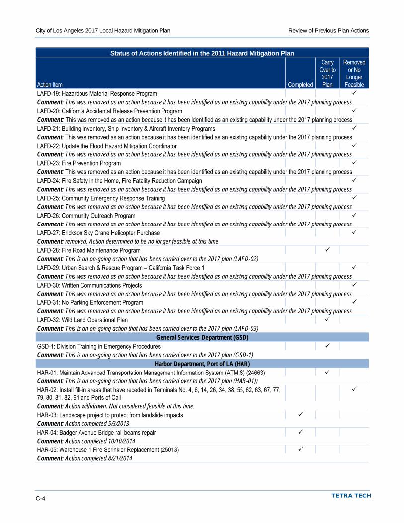
City of Los Angeles 2017 Local Hazard Mitigation Plan Review of Previous Plan Actions
C-4
Status of Actions Identified in the 2011 Hazard Mitigation Plan
Action Item Completed
Carry Over to 2017 Plan
Removed or No
Longer Feasible
LAFD-19: Hazardous Material Response Program Comment: This was removed as an action because it has been identified as an existing capability under the 2017 planning process LAFD-20: California Accidental Release Prevention Program Comment: This was removed as an action because it has been identified as an existing capability under the 2017 planning process LAFD-21: Building Inventory, Ship Inventory & Aircraft Inventory Programs Comment: This was removed as an action because it has been identified as an existing capability under the 2017 planning process LAFD-22: Update the Flood Hazard Mitigation Coordinator Comment: This was removed as an action because it has been identified as an existing capability under the 2017 planning process LAFD-23: Fire Prevention Program Comment: This was removed as an action because it has been identified as an existing capability under the 2017 planning process LAFD-24: Fire Safety in the Home, Fire Fatality Reduction Campaign Comment: This was removed as an action because it has been identified as an existing capability under the 2017 planning process LAFD-25: Community Emergency Response Training Comment: This was removed as an action because it has been identified as an existing capability under the 2017 planning process LAFD-26: Community Outreach Program Comment: This was removed as an action because it has been identified as an existing capability under the 2017 planning process LAFD-27: Erickson Sky Crane Helicopter Purchase Comment: removed. Action determined to be no longer feasible at this time LAFD-28: Fire Road Maintenance Program Comment: This is an on-going action that has been carried over to the 2017 plan (LAFD-02) LAFD-29: Urban Search & Rescue Program – California Task Force 1 Comment: This was removed as an action because it has been identified as an existing capability under the 2017 planning process LAFD-30: Written Communications Projects Comment: This was removed as an action because it has been identified as an existing capability under the 2017 planning process LAFD-31: No Parking Enforcement Program Comment: This was removed as an action because it has been identified as an existing capability under the 2017 planning process LAFD-32: Wild Land Operational Plan Comment: This is an on-going action that has been carried over to the 2017 plan (LAFD-03)
General Services Department (GSD) GSD-1: Division Training in Emergency Procedures Comment: This is an on-going action that has been carried over to the 2017 plan (GSD-1)
Harbor Department, Port of LA (HAR) HAR-01: Maintain Advanced Transportation Management Information System (ATMIS) (24663) Comment: This is an on-going action that has been carried over to the 2017 plan (HAR-01)) HAR-02: Install fill-in areas that have receded in Terminals No. 4, 6, 14, 26, 34, 38, 55, 62, 63, 67, 77, 79, 80, 81, 82, 91 and Ports of Call
Comment: Action withdrawn. Not considered feasible at this time. HAR-03: Landscape project to protect from landslide impacts Comment: Action completed 5/3/2013 HAR-04: Badger Avenue Bridge rail beams repair Comment: Action completed 10/10/2014 HAR-05: Warehouse 1 Fire Sprinkler Replacement (25013) Comment: Action completed 8/21/2014
City of Los Angeles 2017 Local Hazard Mitigation Plan Review of Previous Plan Actions
C-5
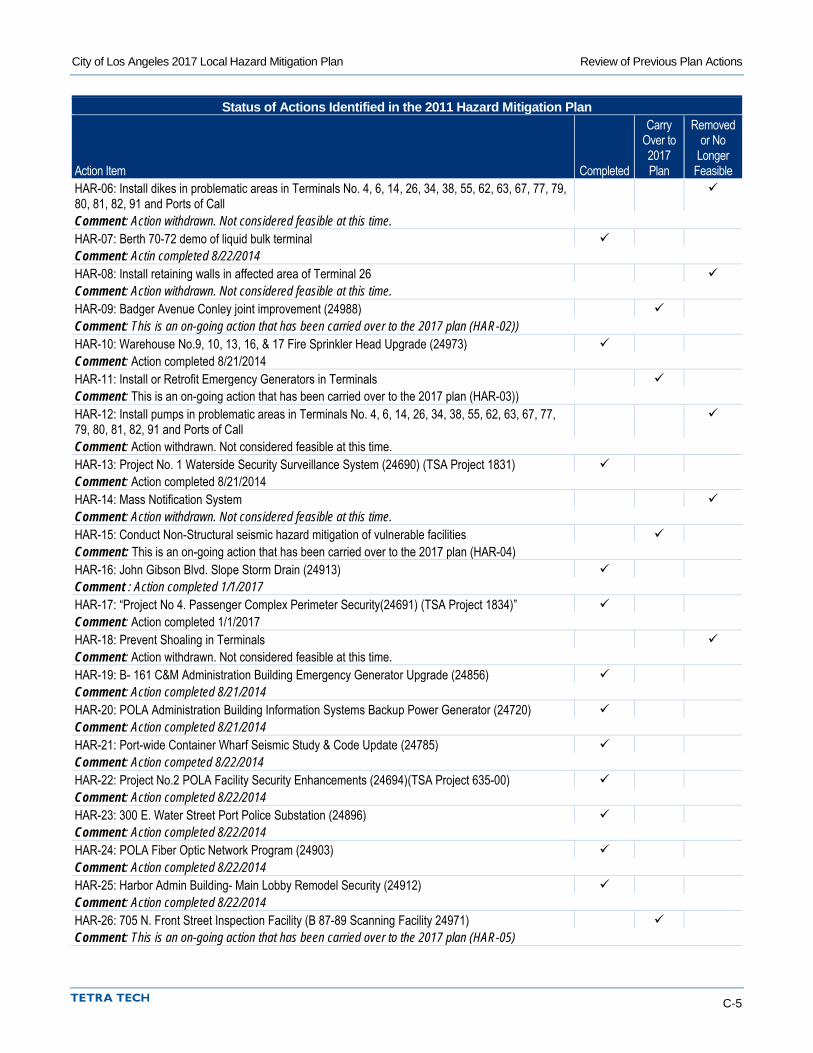
Status of Actions Identified in the 2011 Hazard Mitigation Plan
Action Item Completed
Carry Over to 2017 Plan
Removed or No
Longer Feasible
HAR-06: Install dikes in problematic areas in Terminals No. 4, 6, 14, 26, 34, 38, 55, 62, 63, 67, 77, 79, 80, 81, 82, 91 and Ports of Call
Comment: Action withdrawn. Not considered feasible at this time. HAR-07: Berth 70-72 demo of liquid bulk terminal Comment: Actin completed 8/22/2014 HAR-08: Install retaining walls in affected area of Terminal 26 Comment: Action withdrawn. Not considered feasible at this time. HAR-09: Badger Avenue Conley joint improvement (24988) Comment: This is an on-going action that has been carried over to the 2017 plan (HAR-02)) HAR-10: Warehouse No.9, 10, 13, 16, & 17 Fire Sprinkler Head Upgrade (24973) Comment: Action completed 8/21/2014 HAR-11: Install or Retrofit Emergency Generators in Terminals Comment: This is an on-going action that has been carried over to the 2017 plan (HAR-03)) HAR-12: Install pumps in problematic areas in Terminals No. 4, 6, 14, 26, 34, 38, 55, 62, 63, 67, 77, 79, 80, 81, 82, 91 and Ports of Call
Comment: Action withdrawn. Not considered feasible at this time. HAR-13: Project No. 1 Waterside Security Surveillance System (24690) (TSA Project 1831) Comment: Action completed 8/21/2014 HAR-14: Mass Notification System Comment: Action withdrawn. Not considered feasible at this time. HAR-15: Conduct Non-Structural seismic hazard mitigation of vulnerable facilities Comment: This is an on-going action that has been carried over to the 2017 plan (HAR-04) HAR-16: John Gibson Blvd. Slope Storm Drain (24913) Comment : Action completed 1/1/2017 HAR-17: “Project No 4. Passenger Complex Perimeter Security(24691) (TSA Project 1834)” Comment: Action completed 1/1/2017 HAR-18: Prevent Shoaling in Terminals Comment: Action withdrawn. Not considered feasible at this time. HAR-19: B- 161 C&M Administration Building Emergency Generator Upgrade (24856) Comment: Action completed 8/21/2014 HAR-20: POLA Administration Building Information Systems Backup Power Generator (24720) Comment: Action completed 8/21/2014 HAR-21: Port-wide Container Wharf Seismic Study & Code Update (24785) Comment: Action competed 8/22/2014 HAR-22: Project No.2 POLA Facility Security Enhancements (24694)(TSA Project 635-00) Comment: Action completed 8/22/2014 HAR-23: 300 E. Water Street Port Police Substation (24896) Comment: Action completed 8/22/2014 HAR-24: POLA Fiber Optic Network Program (24903) Comment: Action completed 8/22/2014 HAR-25: Harbor Admin Building- Main Lobby Remodel Security (24912) Comment: Action completed 8/22/2014 HAR-26: 705 N. Front Street Inspection Facility (B 87-89 Scanning Facility 24971) Comment: This is an on-going action that has been carried over to the 2017 plan (HAR-05)
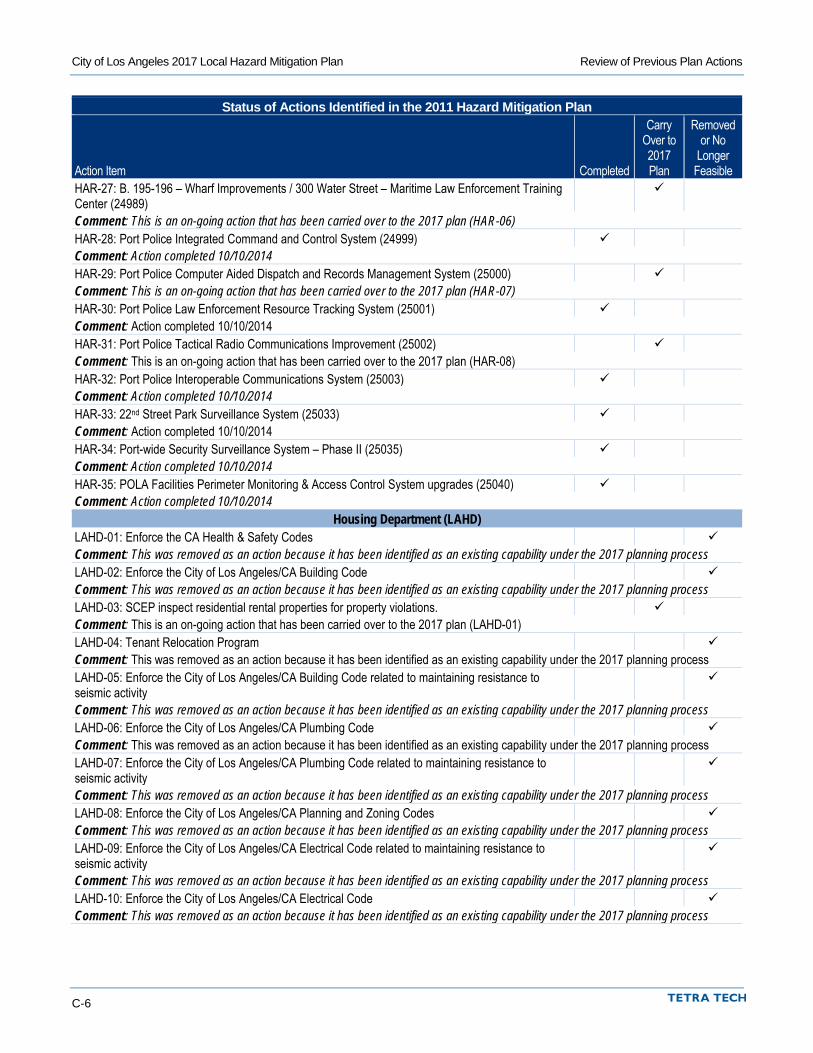
City of Los Angeles 2017 Local Hazard Mitigation Plan Review of Previous Plan Actions
C-6
Status of Actions Identified in the 2011 Hazard Mitigation Plan
Action Item Completed
Carry Over to 2017 Plan
Removed or No
Longer Feasible
HAR-27: B. 195-196 – Wharf Improvements / 300 Water Street – Maritime Law Enforcement Training Center (24989)
Comment: This is an on-going action that has been carried over to the 2017 plan (HAR-06) HAR-28: Port Police Integrated Command and Control System (24999) Comment: Action completed 10/10/2014 HAR-29: Port Police Computer Aided Dispatch and Records Management System (25000) Comment: This is an on-going action that has been carried over to the 2017 plan (HAR-07) HAR-30: Port Police Law Enforcement Resource Tracking System (25001) Comment: Action completed 10/10/2014 HAR-31: Port Police Tactical Radio Communications Improvement (25002) Comment: This is an on-going action that has been carried over to the 2017 plan (HAR-08) HAR-32: Port Police Interoperable Communications System (25003) Comment: Action completed 10/10/2014 HAR-33: 22nd Street Park Surveillance System (25033) Comment: Action completed 10/10/2014 HAR-34: Port-wide Security Surveillance System – Phase II (25035) Comment: Action completed 10/10/2014 HAR-35: POLA Facilities Perimeter Monitoring & Access Control System upgrades (25040) Comment: Action completed 10/10/2014
Housing Department (LAHD) LAHD-01: Enforce the CA Health & Safety Codes Comment: This was removed as an action because it has been identified as an existing capability under the 2017 planning process LAHD-02: Enforce the City of Los Angeles/CA Building Code Comment: This was removed as an action because it has been identified as an existing capability under the 2017 planning process LAHD-03: SCEP inspect residential rental properties for property violations. Comment: This is an on-going action that has been carried over to the 2017 plan (LAHD-01) LAHD-04: Tenant Relocation Program Comment: This was removed as an action because it has been identified as an existing capability under the 2017 planning process LAHD-05: Enforce the City of Los Angeles/CA Building Code related to maintaining resistance to seismic activity
Comment: This was removed as an action because it has been identified as an existing capability under the 2017 planning process LAHD-06: Enforce the City of Los Angeles/CA Plumbing Code Comment: This was removed as an action because it has been identified as an existing capability under the 2017 planning process LAHD-07: Enforce the City of Los Angeles/CA Plumbing Code related to maintaining resistance to seismic activity
Comment: This was removed as an action because it has been identified as an existing capability under the 2017 planning process LAHD-08: Enforce the City of Los Angeles/CA Planning and Zoning Codes Comment: This was removed as an action because it has been identified as an existing capability under the 2017 planning process LAHD-09: Enforce the City of Los Angeles/CA Electrical Code related to maintaining resistance to seismic activity
Comment: This was removed as an action because it has been identified as an existing capability under the 2017 planning process LAHD-10: Enforce the City of Los Angeles/CA Electrical Code Comment: This was removed as an action because it has been identified as an existing capability under the 2017 planning process
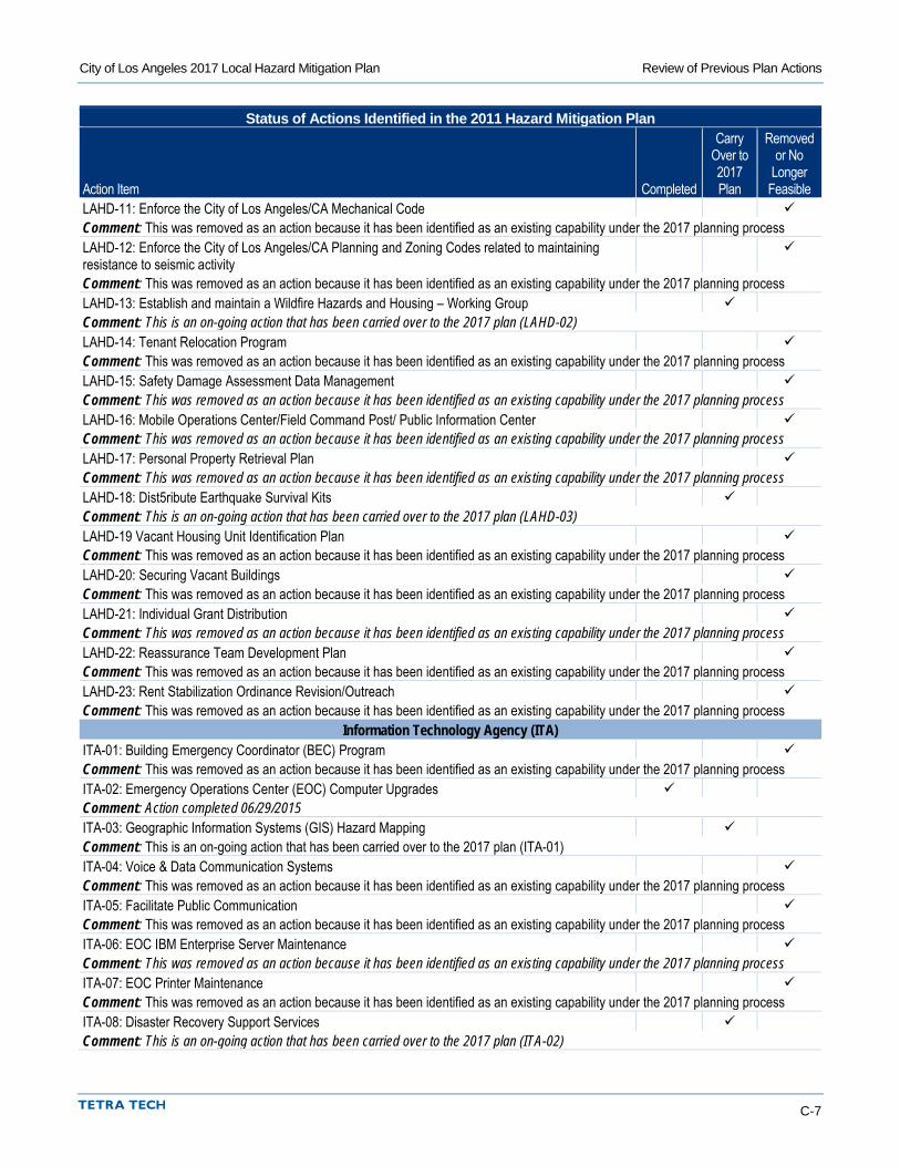
City of Los Angeles 2017 Local Hazard Mitigation Plan Review of Previous Plan Actions
C-7
Status of Actions Identified in the 2011 Hazard Mitigation Plan
Action Item Completed
Carry Over to 2017 Plan
Removed or No
Longer Feasible
LAHD-11: Enforce the City of Los Angeles/CA Mechanical Code Comment: This was removed as an action because it has been identified as an existing capability under the 2017 planning process LAHD-12: Enforce the City of Los Angeles/CA Planning and Zoning Codes related to maintaining resistance to seismic activity
Comment: This was removed as an action because it has been identified as an existing capability under the 2017 planning process LAHD-13: Establish and maintain a Wildfire Hazards and Housing – Working Group Comment: This is an on-going action that has been carried over to the 2017 plan (LAHD-02) LAHD-14: Tenant Relocation Program Comment: This was removed as an action because it has been identified as an existing capability under the 2017 planning process LAHD-15: Safety Damage Assessment Data Management Comment: This was removed as an action because it has been identified as an existing capability under the 2017 planning process LAHD-16: Mobile Operations Center/Field Command Post/ Public Information Center Comment: This was removed as an action because it has been identified as an existing capability under the 2017 planning process LAHD-17: Personal Property Retrieval Plan Comment: This was removed as an action because it has been identified as an existing capability under the 2017 planning process LAHD-18: Dist5ribute Earthquake Survival Kits Comment: This is an on-going action that has been carried over to the 2017 plan (LAHD-03) LAHD-19 Vacant Housing Unit Identification Plan Comment: This was removed as an action because it has been identified as an existing capability under the 2017 planning process LAHD-20: Securing Vacant Buildings Comment: This was removed as an action because it has been identified as an existing capability under the 2017 planning process LAHD-21: Individual Grant Distribution Comment: This was removed as an action because it has been identified as an existing capability under the 2017 planning process LAHD-22: Reassurance Team Development Plan Comment: This was removed as an action because it has been identified as an existing capability under the 2017 planning process LAHD-23: Rent Stabilization Ordinance Revision/Outreach Comment: This was removed as an action because it has been identified as an existing capability under the 2017 planning process
Information Technology Agency (ITA) ITA-01: Building Emergency Coordinator (BEC) Program Comment: This was removed as an action because it has been identified as an existing capability under the 2017 planning process ITA-02: Emergency Operations Center (EOC) Computer Upgrades Comment: Action completed 06/29/2015 ITA-03: Geographic Information Systems (GIS) Hazard Mapping Comment: This is an on-going action that has been carried over to the 2017 plan (ITA-01) ITA-04: Voice & Data Communication Systems Comment: This was removed as an action because it has been identified as an existing capability under the 2017 planning process ITA-05: Facilitate Public Communication Comment: This was removed as an action because it has been identified as an existing capability under the 2017 planning process ITA-06: EOC IBM Enterprise Server Maintenance Comment: This was removed as an action because it has been identified as an existing capability under the 2017 planning process ITA-07: EOC Printer Maintenance Comment: This was removed as an action because it has been identified as an existing capability under the 2017 planning process ITA-08: Disaster Recovery Support Services Comment: This is an on-going action that has been carried over to the 2017 plan (ITA-02)
City of Los Angeles 2017 Local Hazard Mitigation Plan Review of Previous Plan Actions
C-8
Status of Actions Identified in the 2011 Hazard Mitigation Plan
Action Item Completed
Carry Over to 2017 Plan
Removed or No
Longer Feasible
ITA-09: Communication Systems Support Comment: This was removed as an action because it has been identified as an existing capability under the 2017 planning process ITA-10: Emergency Operations Center (EOC) Incident Management System (IMS) Software Support Comment: This is an on-going action that has been carried over to the 2017 plan (ITA-03) ITA-11: Participate in and provide IT support to Citywide & Departmental Emergency Exercises Comment: This is an on-going action that has been carried over to the 2017 plan (ITA-04) ITA-12: Emergency Operations Center (EOC) & Department Operations Center (DOC) Training Comment: This was removed as an action because it has been identified as an existing capability under the 2017 planning process ITA-13: Annual Emergency Management Workshop (Arrowhead) Comment: This was removed as an action because it has been identified as an existing capability under the 2017 planning process
Los Angeles World Airports (LAWA) LAWA-01: Airport Response Coordination Center (ARCC) and Department Operations Center (DOC) Comment: Action completed 12/1/2010 LAWA-02: Improved LAX Airport Passenger Access and Airfield Modifications to Improve Safety and Efficiency (Airfield Expansions)
Comment: This is an on-going action that has been carried over to the 2017 plan (LAWA-01) LAWA-03: LAX LAFD Aircraft Rescue and Firefighting (ARFF) Station 80 Comment: Action completed 12/01/2010 LAWA-04: Security Program: Security Screening Checkpoint (SSCP) Modifications – Ontario Airport (ONT)
Comment: This was removed as an action because it has been identified as an existing capability under the 2017 planning process LAWA-05: In-line Baggage Screening System (ONT) Comment: This was removed as an action because it has been identified as an existing capability under the 2017 planning process
City Planning Department (PL) PL-01: Environmental Review Process Comment: This was removed as an action because it has been identified as an existing capability under the 2017 planning process
Police Department (LAPD) LAPD-01: Mobile Command Response Unit Comment: This is an on-going action that has been carried over to the 2017 plan (LAPD-01) LAPD-02: Terrorist Early Warning (TEW): “Response Information Folders” Comment: Action completed 9/8/2016 LAPD-03: Mobile Field Force (MFF) Wild-Urban Interface Fires Comment: This was removed as an action because it has been identified as an existing capability under the 2017 planning process LAPD-04: Standing Plans Comment: This was removed as an action because it has been identified as an existing capability under the 2017 planning process LAPD-05: Technological, Chemical, and Biological Detection Devices Comment: This is an on-going action that has been carried over to the 2017 plan (LAPD-02) LAPD-06: Technology – Explosive Detection Device Comment: This was removed as an action because it has been identified as an existing capability under the 2017 planning process LAPD-07: Special Events Planning Unit (SEPU), Major Events Planning Unit (MEPU), Task Force Comment: This was removed as an action because it has been identified as an existing capability under the 2017 planning process LAPD-08: Emergency Cyber Incident Response Program Comment: This is an on-going action that has been carried over to the 2017 plan (LAPD-03)
City of Los Angeles 2017 Local Hazard Mitigation Plan Review of Previous Plan Actions
C-9
Status of Actions Identified in the 2011 Hazard Mitigation Plan
Action Item Completed
Carry Over to 2017 Plan
Removed or No
Longer Feasible
LAPD-09: Terrorist Early Warning (TEW): “Play Book” Comment: Action completed 9/08/2016 LAPD-10: Department’s Emergency Operations Guide-Wildland-Urban Interface Fires Comment: Action completed 08/24/2015 LAPD-11: Technological, Chemical & Biological Detection Devices Comment: This was removed as an action because it has been identified as an existing capability under the 2017 planning process LAPD-12: Technology – Video Downlink/Video Surveillance & Monitoring Equipment Comment: This is an on-going action that has been carried over to the 2017 plan (LAPD-04) LAPD-13: Critical Asset Protection Program Comment: This is an on-going action that has been carried over to the 2017 plan (LAPD-05) LAPD-14: Incident Command Post Unit (ICPU) Comment: This was removed as an action because it has been identified as an existing capability under the 2017 planning process LAPD-15: Regional Video Command Center Equipment Comment: This is an on-going action that has been carried over to the 2017 plan (LAPD-06) LAPD-16: Technology – Explosive Detection Devices Comment: This is an on-going action that has been carried over to the 2017 plan (LAPD-07) LAPD-17: Brushfire Response Plan (Wildland-Urban Interface Fires) Comment: This is an on-going action that has been carried over to the 2017 plan (LAPD-08) LAPD-18: Personal Protective Equipment (PPE) Comment: This was removed as an action because it has been identified as an existing capability under the 2017 planning process LAPD-19: Major Crimes Division Comment: This was removed as an action because it has been identified as an existing capability under the 2017 planning process LAPD-20: Technology – Biometric Identification Verification Comment: This was removed as an action because it has been identified as an existing capability under the 2017 planning process LAPD-21: Special Events Planning Unit (SEPU), Major Events Planning Unit (MEPU), Task Force Comment: This was removed as an action because it has been identified as an existing capability under the 2017 planning process LAPD-22: Terrorist Early Warning Group-Civil Disturbance Comment: This is an on-going action that has been carried over to the 2017 plan (LAPD-09) LAPD-23: LAPD’s Hazardous Materials Unit Comment: This is an on-going action that has been carried over to the 2017 plan (LAPD-10) LAPD-24: Maintain Standing Plans Comment: This was removed as an action because it has been identified as an existing capability under the 2017 planning process LAPD-25: Mobile Command Response Unit Comment: Action completed 9/12/2016 LAPD-26: Terrorist Early Warning Group-Civil Disturbance Comment: This is an on-going action that has been carried over to the 2017 plan (LAPD-09) LAPD-27: LAPD’s Explosive Unit Bomb Squad Comment: This was removed as an action because it has been identified as an existing capability under the 2017 planning process LAPD-28: Public Outreach/Education Comment: This is an on-going action that has been carried over to the 2017 plan (LAPD-12) LAPD-29: Joint Terrorism Task Force (JTTF) Comment: Action completed 9/08/2016 LAPD-30: Police Department Emergency Operations Guide Comment: This is an on-going action that has been carried over to the 2017 plan (LAPD-13)
City of Los Angeles 2017 Local Hazard Mitigation Plan Review of Previous Plan Actions
C-10
Status of Actions Identified in the 2011 Hazard Mitigation Plan
Action Item Completed
Carry Over to 2017 Plan
Removed or No
Longer Feasible
LAPD-31: 24-Hour Tip Telephone Number: (877) A-THREAT Comment: Action Completed 09/08/2016 LAPD-32: Terrorism Threat Level System Comment: This was removed as an action because it has been identified as an existing capability under the 2017 planning process LAPD-33: Technology – Radiation Detection Device – Aerial Platform Comment: This was removed as an action because it has been identified as an existing capability under the 2017 planning process LAPD-34: Technology-Cellular Telephone Disruption Device Comment: This is an on-going action that has been carried over to the 2017 plan (LAPD-14) LAPD-35: Construction/Codes to Resist Conventional Weapons Comment: Action was withdrawn. Not considered to be feasible at this time. LAPD-36: Operational Archangel Comment: Action was withdrawn. Not considered to be feasible at this time.
Department of Public Works (DPW) DPW-01: Weed abatement private property Comment: This was removed as an action because it has been identified as an existing capability under the 2017 planning process DPW-02: Storm Water Facilities Comment: This is an on-going action that has been carried over to the 2017 plan (DPW-01) DPW-03: Prioritization for Capital Improvement Program Comment: This is an on-going action that has been carried over to the 2017 plan (DPW-02) DPW-04: Special Mobile Hazardous Waste Collection Comment: This was removed as an action because it has been identified as an existing capability under the 2017 planning process DPW-05: Accelerated Storm Sewer Repair Comment: This was removed as an action because it has been identified as an existing capability under the 2017 planning process DPE-06: Flood Zone Notification Comment: This is an on-going action that has been carried over to the 2017 plan (DPW-03) DPW-07: Weed abatement public property Comment: This was removed as an action because it has been identified as an existing capability under the 2017 planning process DPW-08: Bridge Improvement Program Comment: This is an on-going action that has been carried over to the 2017 plan (DPW-04) DPW-09: Provide dam inundation maps to the public Comment: This is an on-going action that has been carried over to the 2017 plan (DPW-05) DPW-10: Coordination with Other Agencies Comment: This was removed as an action because it has been identified as an existing capability under the 2017 planning process DPW-11: Spill Prevention Program at Industrial Waste Management Division Comment: This was removed as an action because it has been identified as an existing capability under the 2017 planning process DPW-12: Brush Clearance at City owned landfills Comment: This is an on-going action that has been carried over to the 2017 plan (DPW-06) DPW-13: Continue on-going Participation with Flood Organizations such as the CA Floodplain Management Association, Association of State Floodplain Managers, and National Association of Stormwater and Floodplain Managers
Comment: This is an on-going action that has been carried over to the 2017 plan (DPW-07) DPW-14: Load Checking Program at Central Los Angeles Recycling & Transfer Station (CLARTS) Comment: This was removed as an action because it has been identified as an existing capability under the 2017 planning process
City of Los Angeles 2017 Local Hazard Mitigation Plan Review of Previous Plan Actions
C-11
Status of Actions Identified in the 2011 Hazard Mitigation Plan
Action Item Completed
Carry Over to 2017 Plan
Removed or No
Longer Feasible
DPW-15: Mitigate vulnerable Wastewater Facilities Comment: This is an on-going action that has been carried over to the 2017 plan (DPW-08) DPW-16: Continue to support a Certified Flood Plain Manager initiative within DPW. Comment: This is an on-going action that has been carried over to the 2017 plan (DPW-09) DPW-17: Tree Maintenance Comment: This was removed as an action because it has been identified as an existing capability under the 2017 planning process DPW-18: Continue the implementation of the Seismic Bond Program Comment: This is an on-going action that has been carried over to the 2017 plan (DPW-10) DPW-19: Conduct National Flood Insurance Program Seminar for City staff with a role in floodplain management for the City.
Comment: This is an on-going action that has been carried over to the 2017 plan (DPW-11) DPW-20: Continue the implementation of a Channel/Basin Debris Removal program Comment: This is an on-going action that has been carried over to the 2017 plan (DPW-12) DPW-21: Standby/Emergency Power Generation for All Wastewater Pumping & Treatment Plants Comment: This is an on-going action that has been carried over to the 2017 plan (DPW-13) DPW-22: Structural/Nonstructural seismic retrofit of Personnel Building Comment: This is an on-going action that has been carried over to the 2017 plan (DPW-14) DPW-23: Update Procedures and Training Materials Comment: This was removed as an action because it has been identified as an existing capability under the 2017 planning process DPW-24: Hazard contract for Venice Canal maintenance Comment: This was removed as an action because it has been identified as an existing capability under the 2017 planning process DPW-25: Street Cleaning Comment: This was removed as an action because it has been identified as an existing capability under the 2017 planning process DPW-26: ICSD – Offsite Backup Tape Storage/Archiving for BOS Comment: This was removed as an action because it has been identified as an existing capability under the 2017 planning process DPW-27: Information Systems Control Division Data Backup Comment: This was removed as an action because it has been identified as an existing capability under the 2017 planning process DPW-28: La Fayette Park Comment: Action completed 9/1/2016 DPW-29: Hazard Mapping and Survey Support Comment: This is an on-going action that has been carried over to the 2017 plan (DPW-15) DPW-30: Emergency Street Repairs Comment: This was removed as an action because it has been identified as an existing capability under the 2017 planning process DPW-31: Manchester Jr. Arts Center Comment: This was removed as an action because it has been identified as an existing capability under the 2017 planning process DPW-32: GIS Mapping and Modeling for Storm Water Facilities Comment: This is an on-going action that has been carried over to the 2017 plan (DPW-16) DPW-33: Public Safety Facilities Comment: This was removed as an action because it has been identified as an existing capability under the 2017 planning process DPW-34: Structural Bridge Repairs Comment: This was removed as an action because it has been identified as an existing capability under the 2017 planning process DPW-35: Mid-Valley Multi-Purpose Center Comment: Action Completed 9/01/2016
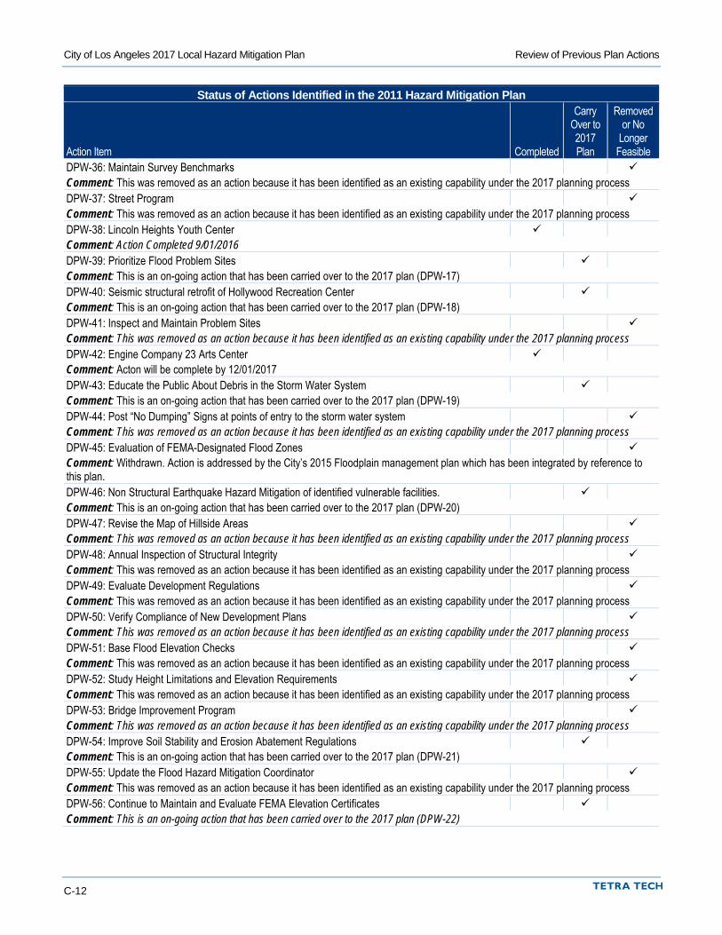
City of Los Angeles 2017 Local Hazard Mitigation Plan Review of Previous Plan Actions
C-12
Status of Actions Identified in the 2011 Hazard Mitigation Plan
Action Item Completed
Carry Over to 2017 Plan
Removed or No
Longer Feasible
DPW-36: Maintain Survey Benchmarks Comment: This was removed as an action because it has been identified as an existing capability under the 2017 planning process DPW-37: Street Program Comment: This was removed as an action because it has been identified as an existing capability under the 2017 planning process DPW-38: Lincoln Heights Youth Center Comment: Action Completed 9/01/2016 DPW-39: Prioritize Flood Problem Sites Comment: This is an on-going action that has been carried over to the 2017 plan (DPW-17) DPW-40: Seismic structural retrofit of Hollywood Recreation Center Comment: This is an on-going action that has been carried over to the 2017 plan (DPW-18) DPW-41: Inspect and Maintain Problem Sites Comment: This was removed as an action because it has been identified as an existing capability under the 2017 planning process DPW-42: Engine Company 23 Arts Center Comment: Acton will be complete by 12/01/2017 DPW-43: Educate the Public About Debris in the Storm Water System Comment: This is an on-going action that has been carried over to the 2017 plan (DPW-19) DPW-44: Post “No Dumping” Signs at points of entry to the storm water system Comment: This was removed as an action because it has been identified as an existing capability under the 2017 planning process DPW-45: Evaluation of FEMA-Designated Flood Zones Comment: Withdrawn. Action is addressed by the City’s 2015 Floodplain management plan which has been integrated by reference to this plan. DPW-46: Non Structural Earthquake Hazard Mitigation of identified vulnerable facilities. Comment: This is an on-going action that has been carried over to the 2017 plan (DPW-20) DPW-47: Revise the Map of Hillside Areas Comment: This was removed as an action because it has been identified as an existing capability under the 2017 planning process DPW-48: Annual Inspection of Structural Integrity Comment: This was removed as an action because it has been identified as an existing capability under the 2017 planning process DPW-49: Evaluate Development Regulations Comment: This was removed as an action because it has been identified as an existing capability under the 2017 planning process DPW-50: Verify Compliance of New Development Plans Comment: This was removed as an action because it has been identified as an existing capability under the 2017 planning process DPW-51: Base Flood Elevation Checks Comment: This was removed as an action because it has been identified as an existing capability under the 2017 planning process DPW-52: Study Height Limitations and Elevation Requirements Comment: This was removed as an action because it has been identified as an existing capability under the 2017 planning process DPW-53: Bridge Improvement Program Comment: This was removed as an action because it has been identified as an existing capability under the 2017 planning process DPW-54: Improve Soil Stability and Erosion Abatement Regulations Comment: This is an on-going action that has been carried over to the 2017 plan (DPW-21) DPW-55: Update the Flood Hazard Mitigation Coordinator Comment: This was removed as an action because it has been identified as an existing capability under the 2017 planning process DPW-56: Continue to Maintain and Evaluate FEMA Elevation Certificates Comment: This is an on-going action that has been carried over to the 2017 plan (DPW-22)
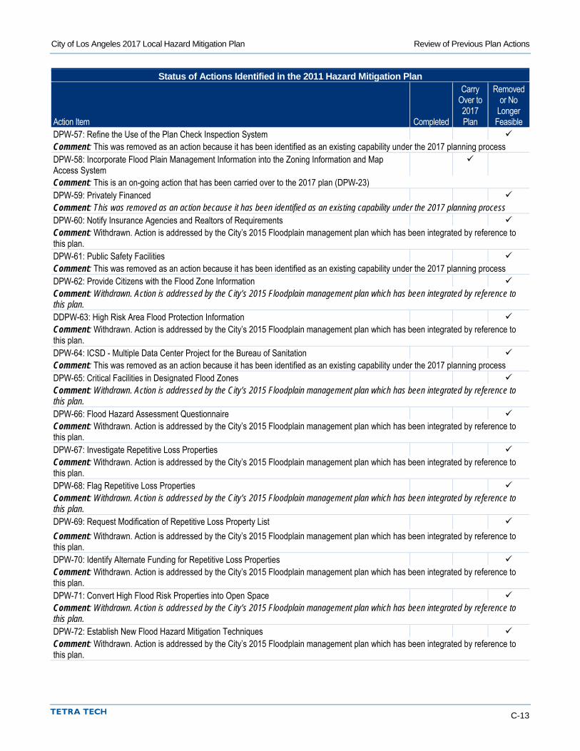
City of Los Angeles 2017 Local Hazard Mitigation Plan Review of Previous Plan Actions
C-13
Status of Actions Identified in the 2011 Hazard Mitigation Plan
Action Item Completed
Carry Over to 2017 Plan
Removed or No
Longer Feasible
DPW-57: Refine the Use of the Plan Check Inspection System Comment: This was removed as an action because it has been identified as an existing capability under the 2017 planning process DPW-58: Incorporate Flood Plain Management Information into the Zoning Information and Map Access System
Comment: This is an on-going action that has been carried over to the 2017 plan (DPW-23) DPW-59: Privately Financed Comment: This was removed as an action because it has been identified as an existing capability under the 2017 planning process DPW-60: Notify Insurance Agencies and Realtors of Requirements Comment: Withdrawn. Action is addressed by the City’s 2015 Floodplain management plan which has been integrated by reference to this plan. DPW-61: Public Safety Facilities Comment: This was removed as an action because it has been identified as an existing capability under the 2017 planning process DPW-62: Provide Citizens with the Flood Zone Information Comment: Withdrawn. Action is addressed by the City’s 2015 Floodplain management plan which has been integrated by reference to this plan. DDPW-63: High Risk Area Flood Protection Information Comment: Withdrawn. Action is addressed by the City’s 2015 Floodplain management plan which has been integrated by reference to this plan. DPW-64: ICSD - Multiple Data Center Project for the Bureau of Sanitation Comment: This was removed as an action because it has been identified as an existing capability under the 2017 planning process DPW-65: Critical Facilities in Designated Flood Zones Comment: Withdrawn. Action is addressed by the City’s 2015 Floodplain management plan which has been integrated by reference to this plan. DPW-66: Flood Hazard Assessment Questionnaire Comment: Withdrawn. Action is addressed by the City’s 2015 Floodplain management plan which has been integrated by reference to this plan. DPW-67: Investigate Repetitive Loss Properties Comment: Withdrawn. Action is addressed by the City’s 2015 Floodplain management plan which has been integrated by reference to this plan. DPW-68: Flag Repetitive Loss Properties Comment: Withdrawn. Action is addressed by the City’s 2015 Floodplain management plan which has been integrated by reference to this plan. DPW-69: Request Modification of Repetitive Loss Property List Comment: Withdrawn. Action is addressed by the City’s 2015 Floodplain management plan which has been integrated by reference to this plan. DPW-70: Identify Alternate Funding for Repetitive Loss Properties Comment: Withdrawn. Action is addressed by the City’s 2015 Floodplain management plan which has been integrated by reference to this plan. DPW-71: Convert High Flood Risk Properties into Open Space Comment: Withdrawn. Action is addressed by the City’s 2015 Floodplain management plan which has been integrated by reference to this plan. DPW-72: Establish New Flood Hazard Mitigation Techniques Comment: Withdrawn. Action is addressed by the City’s 2015 Floodplain management plan which has been integrated by reference to this plan.
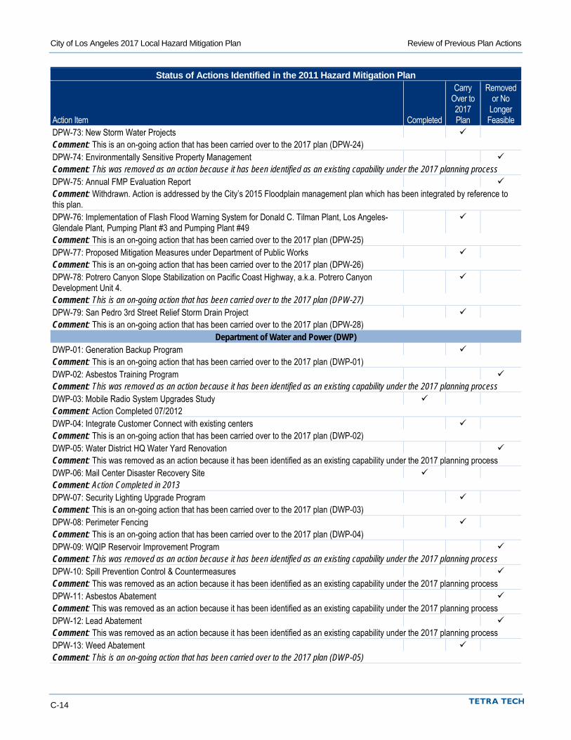
City of Los Angeles 2017 Local Hazard Mitigation Plan Review of Previous Plan Actions
C-14
Status of Actions Identified in the 2011 Hazard Mitigation Plan
Action Item Completed
Carry Over to 2017 Plan
Removed or No
Longer Feasible
DPW-73: New Storm Water Projects Comment: This is an on-going action that has been carried over to the 2017 plan (DPW-24) DPW-74: Environmentally Sensitive Property Management Comment: This was removed as an action because it has been identified as an existing capability under the 2017 planning process DPW-75: Annual FMP Evaluation Report Comment: Withdrawn. Action is addressed by the City’s 2015 Floodplain management plan which has been integrated by reference to this plan. DPW-76: Implementation of Flash Flood Warning System for Donald C. Tilman Plant, Los Angeles-Glendale Plant, Pumping Plant #3 and Pumping Plant #49
Comment: This is an on-going action that has been carried over to the 2017 plan (DPW-25) DPW-77: Proposed Mitigation Measures under Department of Public Works Comment: This is an on-going action that has been carried over to the 2017 plan (DPW-26) DPW-78: Potrero Canyon Slope Stabilization on Pacific Coast Highway, a.k.a. Potrero Canyon Development Unit 4.
Comment: This is an on-going action that has been carried over to the 2017 plan (DPW-27) DPW-79: San Pedro 3rd Street Relief Storm Drain Project Comment: This is an on-going action that has been carried over to the 2017 plan (DPW-28)
Department of Water and Power (DWP) DWP-01: Generation Backup Program Comment: This is an on-going action that has been carried over to the 2017 plan (DWP-01) DWP-02: Asbestos Training Program Comment: This was removed as an action because it has been identified as an existing capability under the 2017 planning process DWP-03: Mobile Radio System Upgrades Study Comment: Action Completed 07/2012 DWP-04: Integrate Customer Connect with existing centers Comment: This is an on-going action that has been carried over to the 2017 plan (DWP-02) DWP-05: Water District HQ Water Yard Renovation Comment: This was removed as an action because it has been identified as an existing capability under the 2017 planning process DWP-06: Mail Center Disaster Recovery Site Comment: Action Completed in 2013 DPW-07: Security Lighting Upgrade Program Comment: This is an on-going action that has been carried over to the 2017 plan (DWP-03) DPW-08: Perimeter Fencing Comment: This is an on-going action that has been carried over to the 2017 plan (DWP-04) DPW-09: WQIP Reservoir Improvement Program Comment: This was removed as an action because it has been identified as an existing capability under the 2017 planning process DPW-10: Spill Prevention Control & Countermeasures Comment: This was removed as an action because it has been identified as an existing capability under the 2017 planning process DPW-11: Asbestos Abatement Comment: This was removed as an action because it has been identified as an existing capability under the 2017 planning process DPW-12: Lead Abatement Comment: This was removed as an action because it has been identified as an existing capability under the 2017 planning process DPW-13: Weed Abatement Comment: This is an on-going action that has been carried over to the 2017 plan (DWP-05)
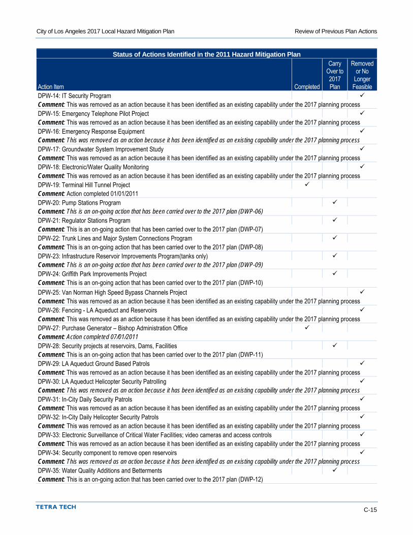
City of Los Angeles 2017 Local Hazard Mitigation Plan Review of Previous Plan Actions
C-15
Status of Actions Identified in the 2011 Hazard Mitigation Plan
Action Item Completed
Carry Over to 2017 Plan
Removed or No
Longer Feasible
DPW-14: IT Security Program Comment: This was removed as an action because it has been identified as an existing capability under the 2017 planning process DPW-15: Emergency Telephone Pilot Project Comment: This was removed as an action because it has been identified as an existing capability under the 2017 planning process DPW-16: Emergency Response Equipment Comment: This was removed as an action because it has been identified as an existing capability under the 2017 planning process DPW-17: Groundwater System Improvement Study Comment: This was removed as an action because it has been identified as an existing capability under the 2017 planning process DPW-18: Electronic/Water Quality Monitoring Comment: This was removed as an action because it has been identified as an existing capability under the 2017 planning process DPW-19: Terminal Hill Tunnel Project Comment: Action completed 01/01/2011 DPW-20: Pump Stations Program Comment: This is an on-going action that has been carried over to the 2017 plan (DWP-06) DPW-21: Regulator Stations Program Comment: This is an on-going action that has been carried over to the 2017 plan (DWP-07) DPW-22: Trunk Lines and Major System Connections Program Comment: This is an on-going action that has been carried over to the 2017 plan (DWP-08) DPW-23: Infrastructure Reservoir Improvements Program(tanks only) Comment: This is an on-going action that has been carried over to the 2017 plan (DWP-09) DPW-24: Griffith Park Improvements Project Comment: This is an on-going action that has been carried over to the 2017 plan (DWP-10) DPW-25: Van Norman High Speed Bypass Channels Project Comment: This was removed as an action because it has been identified as an existing capability under the 2017 planning process DPW-26: Fencing - LA Aqueduct and Reservoirs Comment: This was removed as an action because it has been identified as an existing capability under the 2017 planning process DPW-27: Purchase Generator – Bishop Administration Office Comment: Action completed 07/01/2011 DPW-28: Security projects at reservoirs, Dams, Facilities Comment: This is an on-going action that has been carried over to the 2017 plan (DWP-11) DPW-29: LA Aqueduct Ground Based Patrols Comment: This was removed as an action because it has been identified as an existing capability under the 2017 planning process DPW-30: LA Aqueduct Helicopter Security Patrolling Comment: This was removed as an action because it has been identified as an existing capability under the 2017 planning process DPW-31: In-City Daily Security Patrols Comment: This was removed as an action because it has been identified as an existing capability under the 2017 planning process DPW-32: In-City Daily Helicopter Security Patrols Comment: This was removed as an action because it has been identified as an existing capability under the 2017 planning process DPW-33: Electronic Surveillance of Critical Water Facilities; video cameras and access controls Comment: This was removed as an action because it has been identified as an existing capability under the 2017 planning process DPW-34: Security component to remove open reservoirs Comment: This was removed as an action because it has been identified as an existing capability under the 2017 planning process DPW-35: Water Quality Additions and Betterments Comment: This is an on-going action that has been carried over to the 2017 plan (DWP-12)
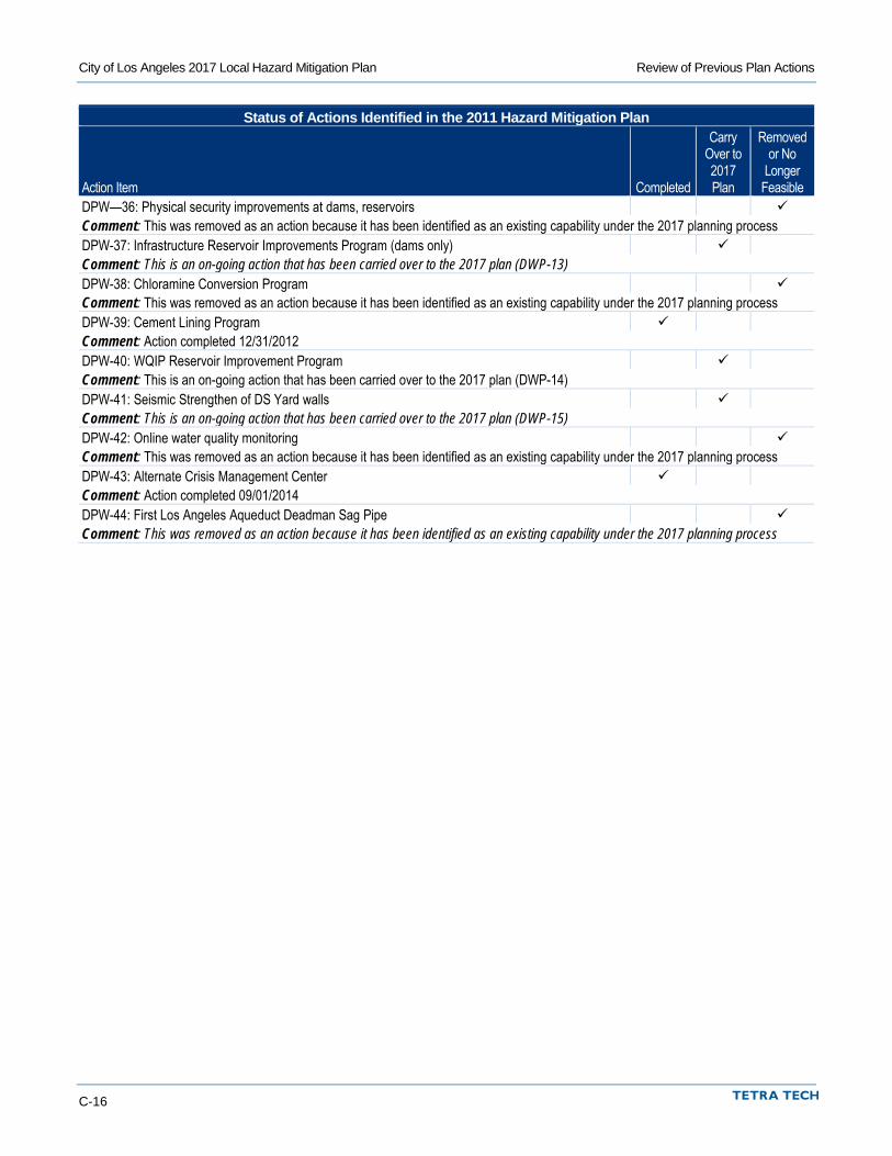
City of Los Angeles 2017 Local Hazard Mitigation Plan Review of Previous Plan Actions
C-16
Status of Actions Identified in the 2011 Hazard Mitigation Plan
Action Item Completed
Carry Over to 2017 Plan
Removed or No
Longer Feasible
DPW—36: Physical security improvements at dams, reservoirs Comment: This was removed as an action because it has been identified as an existing capability under the 2017 planning process DPW-37: Infrastructure Reservoir Improvements Program (dams only) Comment: This is an on-going action that has been carried over to the 2017 plan (DWP-13) DPW-38: Chloramine Conversion Program Comment: This was removed as an action because it has been identified as an existing capability under the 2017 planning process DPW-39: Cement Lining Program Comment: Action completed 12/31/2012 DPW-40: WQIP Reservoir Improvement Program Comment: This is an on-going action that has been carried over to the 2017 plan (DWP-14) DPW-41: Seismic Strengthen of DS Yard walls Comment: This is an on-going action that has been carried over to the 2017 plan (DWP-15) DPW-42: Online water quality monitoring Comment: This was removed as an action because it has been identified as an existing capability under the 2017 planning process DPW-43: Alternate Crisis Management Center Comment: Action completed 09/01/2014 DPW-44: First Los Angeles Aqueduct Deadman Sag Pipe Comment: This was removed as an action because it has been identified as an existing capability under the 2017 planning process
City of Los Angeles 2017 Local Hazard Mitigation Plan
Appendix D. Progress Report Template

D-1
D. PROGRESS REPORT TEMPLATE
To Be Provided with Final Draft