Embed Size (px)
Citation preview

Effort for Effective Flood
Management under Climate Change
by ICHARM
July 10, 2017 Langkawi, MALAYSIA
Tetsuya IKEDA PhD. Chief Researcher
International Centre for Water Hazard and Risk Management under the auspices of UNESCO,
Public Works Research Institute (PWRI), Japan
1

All the researchers’ profiles available on the ICHARM’s Websitehttp://www.icharm.pwri.go.jp/about/organization_and_staff.html
Self-Introduction
2
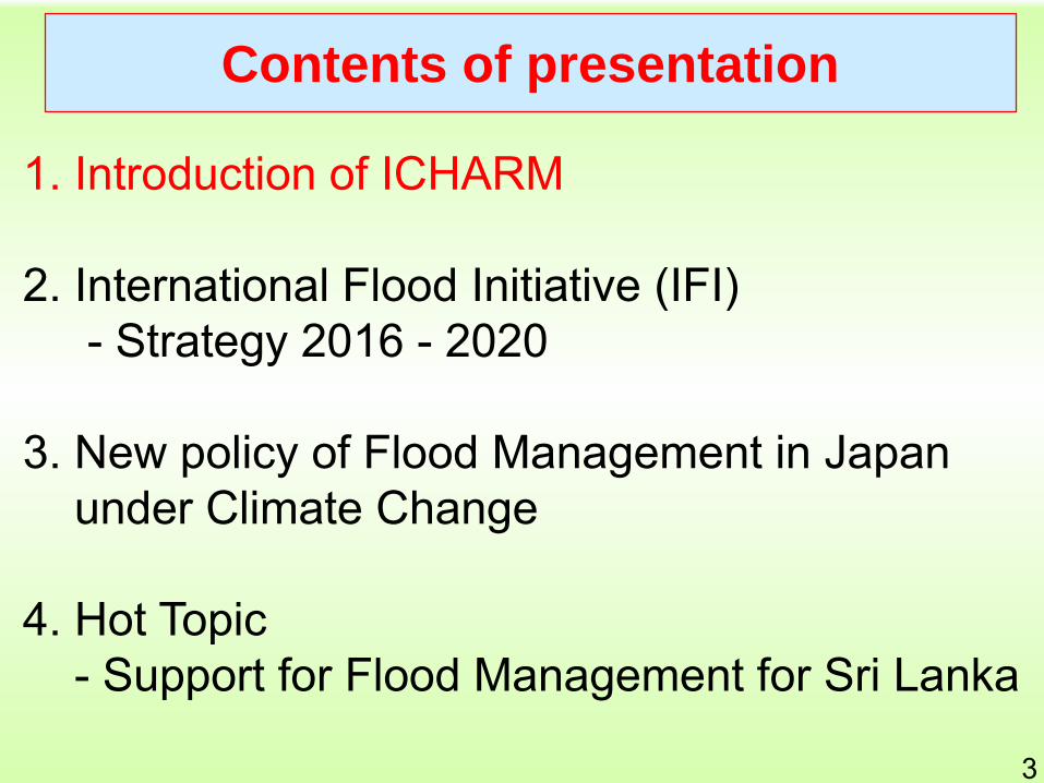
1. Introduction of ICHARM
2. International Flood Initiative (IFI)- Strategy 2016 - 2020
3. New policy of Flood Management in Japan under Climate Change
4. Hot Topic- Support for Flood Management for Sri Lanka
Contents of presentation
3

1984-2013, 5yr averagedAnnual Human Loss
1984-2013, 5yr averagedAnnual Economic Damage
Water-related Disaster in Asia-Pacific
Region
4

ICHARM’s Challenge: LocalismDelivering best available knowledge to local practices
Local Practices
Integrated
Flood Analysis
System (IFAS)
Flood risk assessment
under climate change
Supported by MEXT
Master Course
Short Courses FHM, IRBM, Early warning
IFI
WWAP
IFNet/GFAS
Sentinel Asia
Risk Monitoring
Indicators/Standard
WWF, APWF
The
1st Phase
Focus:
Flood-related
Risk
Management
Training Research
Ph.D. Course
Supported
by JICA
UNESCO
CentersIRDR
UNISDR
GP-GARWorking as a Knowledge
Hub on W&D: ADB TA,
UNESCO Pakistan pjt
RRI, BTOP
SOUSEI
IFI Flagship Project
UNSGAB
HELP
In corporation
with GRIPS
5

Data & Statistics
Risk Assessment
Risk Change Identification
Support in Community of Practice
Support in Sound Policy-making
Long-term Targets
6

020406080
100
<0.2 0.2-1.0 >1.0 2
Per
centa
ge
of
yie
ld l
oss
(%
)
Flood depth (m)
Vegetative stage
Flood duration= 1-2 days Flood duration= 3-4 days Flood duration= 5-6 days
Flood duration= 7 days Flood duration >7 days
0
20
40
60
80
100
0 0.2 0.4 0.6 0.8 1 1.2 1.4 1.6 1.8 2
Per
cen
tage
of
yie
ld l
oss
(%
)
Flood depth (m)
Vegetative stage
Flood duration= 1-2 days
Flood duration= 3-4 days
Flood duration= 5-6 days
Flood duration= 7 days
Flood duration >7 days
0
20
40
60
80
100
0 0.5 1 1.5 2
Per
centa
ge
of
yie
ld l
oss
(%
)
Flood depth (m)
Reproductive stage
Flood duration= 1-2 days
Flood duration= 3-4 days
Flood duration= 5-6 days
Flood duration= 7 days
Flood duration >7 days
0
20
40
60
80
100
0 0.5 1 1.5 2
Per
centa
ge
of
yie
ld l
oss
(%
)
Flood depth (m)
Maturity stage
Flood duration= 1-2 days
Flood duration= 3-4 days
Flood duration= 5-6 days
Flood duration= 7 days
Flood duration >7 days
0
20
40
60
80
100
0 0.5 1 1.5 2
Per
cen
tage
of
yie
ld l
oss
(%
)
Flood depth (m)
Ripening stage
Flood duration= 1-2 days
Flood duration= 3-4 days
Flood duration= 5-6 days
Flood duration= 7 days
Flood duration >7 days
Vegetative Stage
Maturity Stage Ripening Stage
Note: Green line and blue line are overlapped
Reproductive
Stage
Crop Damage Function
Data & Statistics
Risk Assessment
Risk Change Identification
Support in Community of Practice
Support in Sound Policy-making
Long-term Targets
7

Data & Statistics
Risk Assessment
Risk Change Identification
Support in Community of Practice
Support in Sound Policy-making
Long-term Targets
8

Data & Statistics
Risk Assessment
Risk Change Identification
Support in Community of Practice
Support in Sound Policy-making
Long-term Targets
9

Pampanga River
Labangan River
Angat River
Bag Bag River
Labangan River
Data & Statistics
Risk Assessment
Risk Change Identification
Support in Community of Practice
Support in Sound Policy-making
Long-term Targets
10

Capacity Development Programs
Short training courses • Hazard maps, IFAS & local preparedness (2004-, JICA)• Tsunami (2008, ISDR), CC adaptation (2010, JICA)• Pakistan Flood Workshops (2011-12 & 2016-17 UNESCO) etc.
Follow-up seminars at trainees local nations (2006- JICA)• Already 9 times, Kuala Lumpur 2007, Guangzhou 2008, Manila 2009,
Hanoi 2010, Bangkok 2012, Dhaka 2013, Kuala Lumpur 2014, Jakarta 2015, Manila 2016
Master Course on Water-related Disaster Management with GRIPS(National Graduate Institute for Policy Studies) supported by JICA• 10 (‘08), 7 (‘09), 12 (‘10), 12 (‘11), 19 (‘12), 12 (‘13), 12(‘14), 13(‘15),
13 (‘16), 8 (‘17) -> 110 graduates in these 10 years
Ph.D. Course on Disaster Management with GRIPS• 1 (‘13), 1(‘14), 2(‘15), 3 (‘16), 4 (‘17)
11
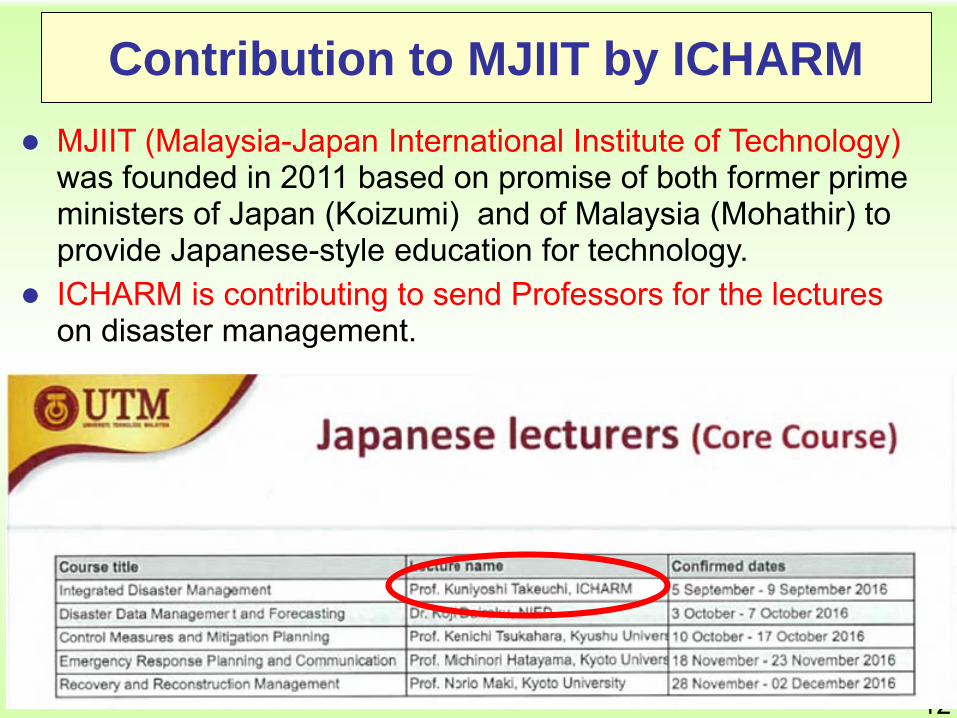
Contribution to MJIIT by ICHARM
MJIIT (Malaysia-Japan International Institute of Technology) was founded in 2011 based on promise of both former prime ministers of Japan (Koizumi) and of Malaysia (Mohathir) to provide Japanese-style education for technology.
ICHARM is contributing to send Professors for the lectures on disaster management.
12

1. Introduction of ICHARM
2. International Flood Initiative (IFI)- Strategy 2016 - 2020
3. New policy of Flood Management in Japan under Climate Change
4. Hot Topic- Support for Flood Management for Sri Lanka
Contents of presentation
13

IFI Strategy 2016-2022
- IFI next step for implementation-
14

18-22 Jan 2005Inauguration of IFI at WCDR in
KobeWMO/UNESCO/
UNISDR/UNU
15
The journey of the IFI initiative
2003
17-22 Jun : 15th UNESO-IHP
IGC Resolution XV-14 on Joint UNESCO/WMO Programme on Floods
2002
2004> 12-14 Jul : Preparatory meeting in
Tsukuba. A joint UNESCO/WMO task team (6 members) produced a concept paper "The Joint UNESCO/WMO Flood Initiative (JUWFI)"
> 20-24 Sep : 16th IHP-IGC approved the concept paper and renamed as "The International Flood Initiative (IFI)".
> 20-29 Oct : 12th WMO CHy discussed the Concept Paper
May: XIVth WMO Congress welcomed the initiative and suggested to establish a joint UNESCO/WMO Committee on Floods. The proposed ICHARM will constitute a global facility for this programme.
15

National level
National level
National level
IFI Partners
Phase-1 Demonstration: Existing Infrastructure
Phase-2 Prototyping: Install in Specific Areas
IFI Partners
Phase-3 Operation: Strengthen & Expanding
IFI PartnersRegional level
Regional level
Regional level
Country A Country B Country C Country ECountry D Country F
Country A Country B Country C Country ECountry D Country F
Country A Country B Country C Country ECountry D Country F
Regional Coordination Framework
National Coordination Framework
• Commonality & Priority• Sharing knowledge, best practice• Strengthening capability• Establishing a forum for promoting dialogue
• Locality• Institutional arrangements• Observation & data integration• Natural & Socio-economic• Communities of practice
IFI Implementation Framework 2016 - 2022
16

Data & Statistics
Risk AssessmentRisk Change
Identification
• Promoting data collection, storage, sharing, and statistics• Integrating local data, satellite observations and model outputs
• Developing integrated disaster risk assessment
• Identifying locality and commonality
• Monitoring and predicting changes in disaster risk
• Identifying locality and commonality
Support in Community of Practice
Support in Sound Policy-making
• Improving disaster literacy• Promoting co-design and co-
implementation among stakeholders
• Analyzing and formulating policies• Visualizing values of preparedness
and investment efficiency
IFI Implementation Framework
17

Integrated Flood Management (IFM)
Minimizing social, environmental
and economic risks
Maximizing net benefits from the
use of flood plains
Integrated Water Resources Management (IWRM)
SDGs
Sendai Framework
ParisAgreement
database
science & technology
capacity building
financial mechanisms
local, national, regional
initiatives
Expected Stakeholders
Academic Society Government Funding
AgenciesDB
operational supporters
IFIpromoters
Project investors &
ownersz
Focus Areas
Hazard Assessment
Vulnerability assessment and capacity building
Exposure Assessment
Finance and investment
Monitoring
Synthesis
Communication and engagement
supporting tools
IFI Strategic Structure
18

Formulate Flood Disaster Risk Reduction Strategies Preventive investment (Build Back
Better) Land use planning Contingency planning
Identify disaster risk reduction measures
Reduce Hazard (Dyke, Dam, Diversion
channel, etc.)
Reduce Exposure (Land use, etc.)
Reduce Vulnerability (Building code, Early
warning system, Emergency action, etc.)
Formulate Strategies
19

Country A
Hydro-Met
River Bureau
Disaster
University
Funding Agency
IFI Partners
UNISDR
WMO
UNESCO
ICHARM
UNU
IAHS, IAHR
Country B
Hydro-Met
River Bureau
Disaster
University
Funding Agency
Research Institute
Main support:
Sub-support:
Local Community Local Community
RBA
Hydro-Met
River Bureau
Disaster
University
Funding Agency
Research Institute
Local Community
NARBO
CEOS, APRSAF, GEO
Space AgencyExpected Partner Space Agency
Structure Image of Specific Support
20

Planning to promote IFI activities
21
Support Sri Lanka for effective flood management by using IFI National Platform
Continuously help establishing IFI National Platforms in Pakistan, Myanmar, Indonesia, Philippines etc.
Planning to organize the IFI-focused sessions on the regional/ national major events
• World Bosai Forum in Sendai, JAPAN (November 25 – 27, 2017)
* as Follow-up Forum of WCDRR in 2015
• APWS: Asia Pacific Water Summit in Yangon, MYANMAR (December 11 – 12, 2017)
* Regional Process toward WWF8
• WWF8: 8th World Water Forum in Brasilia, BRAZIL (March 18 –23, 2018)
• CECAR8: Civil Engineering Conference in Asian Region in Tokyo, JAPAN (April 16 – 19, 2019)

1. Introduction of ICHARM
2. International Flood Initiative (IFI)- Strategy 2016 - 2020
3. New policy of Flood Management in Japan under Climate Change
4. Hot Topic- Support for Flood Management for Sri Lanka
Contents of presentation
22

220
169
145
225
156140
230
186
110
157
103
188
251
190
295
156
112
256
131
158
94
177
331
275
244
206
173182
356
193
238
194
254
169
209
275282
237
0
50
100
150
200
250
300
350
400
1976 1981 1986 1991 1996 2001 2006 2011Annual number of occurrences of rainfall more than 50mm per hour (out of 1,000 Amedas observation sites)
(times/year)
1976 - 1985174 times per year
2004 - 2013241 times per year
Increase by 40%
Due to the recent climate change, the number of occurrences of heavy rainfall over 50mm per hour are increasing from the 1970s level by 40%.
This number is anticipated to increase by 3 times by the end of 21st Century.
Climate Change may increase the occurrence of heavy rain
23
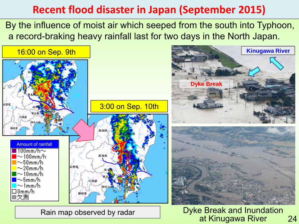
Recent flood disaster in Japan (September 2015)
16:00 on Sep. 9th
3:00 on Sep. 10th
Rain map observed by radar
By the influence of moist air which seeped from the south into Typhoon, a record-braking heavy rainfall last for two days in the North Japan.
Amount of rainfall
Dyke Break and Inundation at Kinugawa River
Kinugawa River
Dyke Break
24

25
23 Aug17 Aug 21 Aug
Tokachishimizu Town (08/2016 Hokkaido)
Three Typhoons sequentially hit Hokkaido region within a week, causing serious flood disaster in August 2016.
Recent flood disaster in Japan (August 2016)

Preparedness for unprecedented Mega-flood disasters due to climate change
> Structural measures need to be undertaken immediately.But…
> Due to the limited resources (budget, etc.), it seems to difficult to
protect human lives and assets for such flood
Focus on the non-structural measures. > Protect human lives as the TOP priority! > Avoid devastating damages on the socio-economy
even though such huge floods may happen.
“New Phase” has come.Climate change has changed the intensity and frequency of heavy rain, and Unprecedented Mega-flood will inevitably occur.
Target
26MLIT’s new policy “Rebuilding Flood-Conscious Society”

Rebuilding Flood-Conscious Society
Sluice gates
City A
City B
City D
Levee construction
Flooding zone
The anticipated flood risk zone under the risk of destruction of houses
3) Non-structural measures to raise awareness
1) Structural measures to prevent outflow
○ Set up the joint councils by concerned stakeholders (river managers, prefectural governments, municipalities, flood fighting corps etc.) in each region.○ Share the goal and cooperate to mitigate and promote the structural / non-structural
measures.
2) Structural measures for crisis management
27
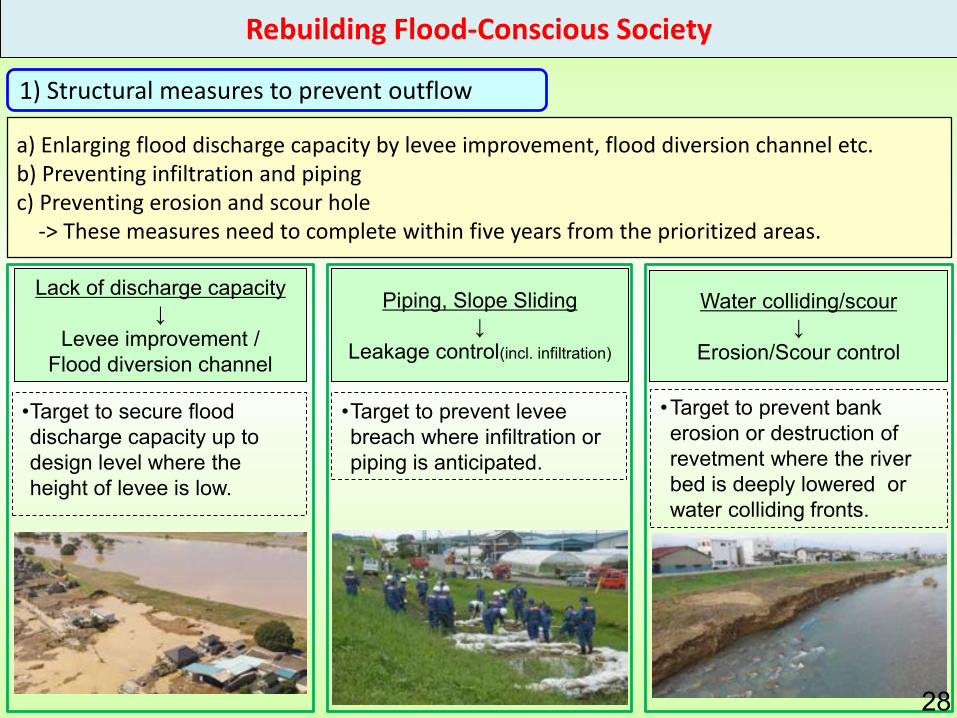
1) Structural measures to prevent outflow
Piping, Slope Sliding↓
Leakage control(incl. infiltration)
Lack of discharge capacity↓
Levee improvement /Flood diversion channel
Water colliding/scour↓
Erosion/Scour control
•Target to prevent bank erosion or destruction of revetment where the river bed is deeply lowered or water colliding fronts.
•Target to secure flood discharge capacity up to design level where the height of levee is low.
•Target to prevent levee breach where infiltration or piping is anticipated.
a) Enlarging flood discharge capacity by levee improvement, flood diversion channel etc.b) Preventing infiltration and piping c) Preventing erosion and scour hole
-> These measures need to complete within five years from the prioritized areas.
28
Rebuilding Flood-Conscious Society

Implement structural measures to delay levee breach in order to secure time for evacuation within five years where it takes long time for levee improvement levee despite of high risk of flooding.
2) Structural measures for crisis management
粘性土砂質土
粘性土
表土表土
砂質土粘性土
Covering the levee crest with asphalt or other materials in order to prevent rainwater infiltration of rain and to delay levee breach in case of overflow of floodwater.
Covering levee crest Covering levee foot on back slope
Covering the levee foot on the back slope with concrete blocks in order to delay scouring in case of overflow of floodwater.
Levee foot on the back slope is covered with concrete blocks
If levee crest is covered with asphalt or other materials, they will remain for a while in case of overflow of floodwater.
Asphalt, etc.
粘性土
29
Rebuilding Flood-Conscious Society
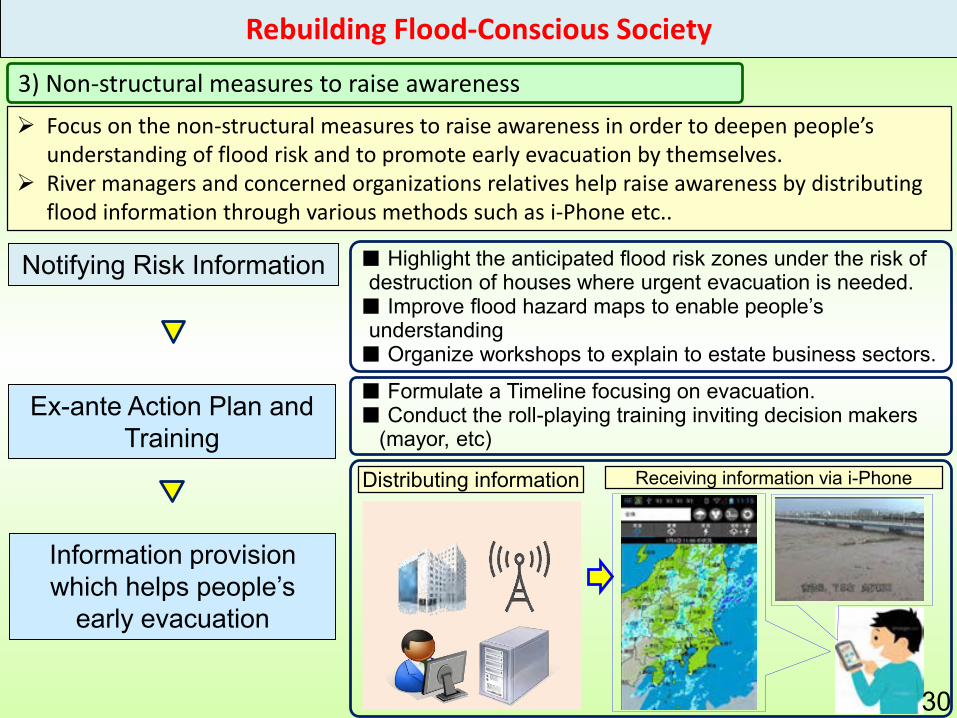
Focus on the non-structural measures to raise awareness in order to deepen people’s understanding of flood risk and to promote early evacuation by themselves.
River managers and concerned organizations relatives help raise awareness by distributing flood information through various methods such as i-Phone etc..
3) Non-structural measures to raise awareness
Notifying Risk Information
Ex-ante Action Plan and Training
Information provision which helps people’s
early evacuation
■ Highlight the anticipated flood risk zones under the risk of destruction of houses where urgent evacuation is needed.■ Improve flood hazard maps to enable people’s understanding■ Organize workshops to explain to estate business sectors.
■ Formulate a Timeline focusing on evacuation.■ Conduct the roll-playing training inviting decision makers
(mayor, etc)
Receiving information via i-PhoneDistributing information
30
Rebuilding Flood-Conscious Society

Improving information systems in order for municipalities and residents to get real-time flood information (such as rainfall data, water level), which urge early evacuation.
Via PC
Via i-Phone
Added browsing functions: River live camera viewing Added indication:
The anticipated inundation zones
The risk level of river water level : Indicated by its color Indication: River water level 31
Examples of Non-structural measures-> Improving and Delivering a real-time information
Rebuilding Flood-Conscious Society

32
Heavy rain on July 5, 2017 resulted in the record-breaking daily rainfall (336 mm/day) at some observation station in northern Kyusyu Region, and many areas are seriously damaged by dyke breaks and landslides occurred in many areas. So far more than 20 people dead and missing, and evacuation order issued to 270,000 residents.
Still, water-related disaster is threatening

1. Introduction of ICHARM
2. International Flood Initiative (IFI)- Strategy 2016 - 2020
3. New policy of Flood Management in Japan under Climate Change
4. Hot Topic- Support for Flood Management for Sri Lanka
Contents of presentation
34

Support for Flood Management
for Sri Lanka
• Background Large-scale flood disaster occurred in Sri Lanka in late May
2017, leaving over 300 people dead or missing. The Government of Japan dispatched the Japan Disaster Relief
(JDR) Expert Team to help emergency efforts upon the request of the Government of Sri Lanka, to which PWRI has contributed.
To prepare for the recurring flood disasters, ICHARM and EDITORIA will continuously provide useful information for flood management though newly developed Website on the DIAS, and will conduct capacity development for effective use of information.
• Expected Outcomes This will lead to human damage reduction and efficient
emergency recovery by disseminating effective flood forecasts and early evacuation alerts. 35

36

In-situ rain gauge data (6 numbers)
Collaboration with member organizations of disaster management platform
DisasterManagement
Center
IrrigationDepartment
MeteorologyDepartment
Member organizations of national platform
Satellite precipitation data(GSMaP)
On-line Information provision
on DIAS:In-situ rainfall, satellite rainfall,
calibrated and forecast rainfall, inundation simulations
Implemented by EDITORIA and ICHARM on
DIAS
ALOS © JAXA (2016)
Inundation
analysis by
using RRI in
DIAS
Simulation and forecasting of river
discharge, water level, inundation
extent
Inundation analysis results
Concept of RRI model
Ensemble forecasting rainfall for the next 16 days (max)
Himawari-8 cloud images
Inundation map by satellite data (ALOS-2)
Present situation: Test operation for rainy season Mind-term framework
4 hr latency data (NRT)
Real time data (NOW)
Universities
and others
Calibration
CollaborationInformation provision
Email alert messages
Evacuation advisory by early warning
Government of Sri Lanka(Disaster Management Center)
Damage reduction by pre-disaster measures
Government of Sri Lanka(Irrigation Department)
Sri Lanka disaster management platform
Capacity building for operation
• Promotion of research• Damage reduction
through implementation37

Prototype of Flood Early warning system
for Sri Lanka
• In-situ
Real-time in-situ rainfall• Satellite
GSMaP NOW (0 hour delay from observation) Himawari-8 GSMaP corrected data (using real time in-situ
data)• Prediction
Hourly 3 days rainfall prediction• Flood and Inundation
Calculated hourly flood and inundation
38

• In-situ : Real-time in-situ rainfall(Latest 24 hours, 3days, 30days)
39

• Satellite : GSMaP_NOW data (Available 0 hour delay form observation)
40

• Satellite : Himawari-8(Visible and Band 13)
41

• Satellite : GSMaP NRT corrected data (using real time in-situ rainfall data)
42

• Rainfall Prediction :(Hourly and 3days Prediction)
43
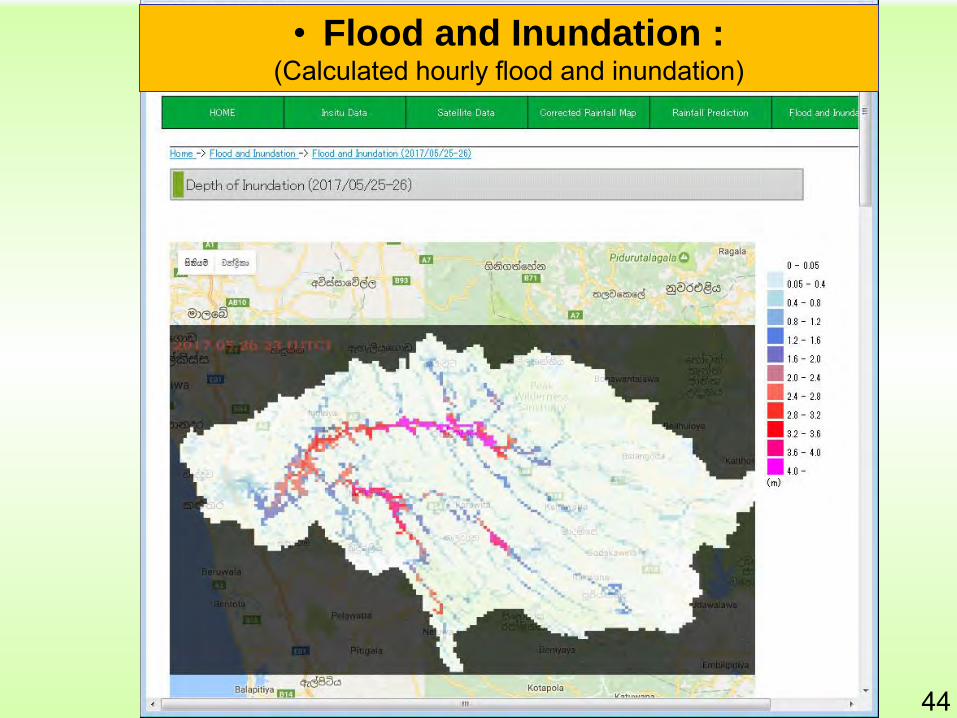
• Flood and Inundation :(Calculated hourly flood and inundation)
44

Sri LankaEstablishment of IFI National Platform in Sri Lanka
45