Embed Size (px)
Citation preview
EGNOS Performance Improvements Using Monitoring Stations in Romania
Vlad-Cosmin Vasile1, Georgiana Magu2, Romeo Cosnita2,
Corina Nafornita2, Alexandru Isar2, Monica Borda1
1 Technical University of Cluj-Napoca
2 Politehnica University of Timisoara
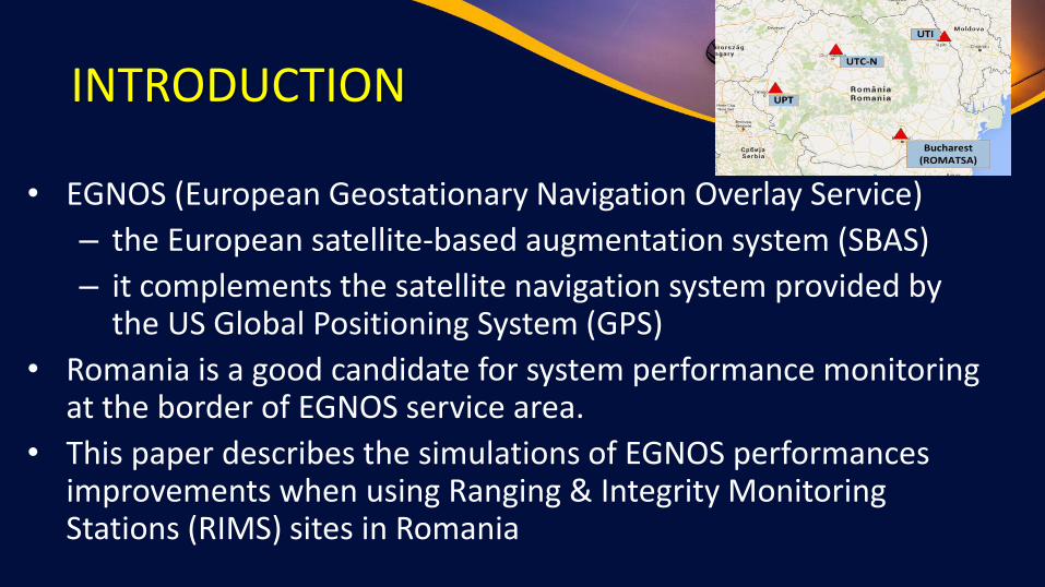
INTRODUCTION
• EGNOS (European Geostationary Navigation Overlay Service)
– the European satellite-based augmentation system (SBAS)
– it complements the satellite navigation system provided by the US Global Positioning System (GPS)
• Romania is a good candidate for system performance monitoring at the border of EGNOS service area.
• This paper describes the simulations of EGNOS performances improvements when using Ranging & Integrity Monitoring Stations (RIMS) sites in Romania
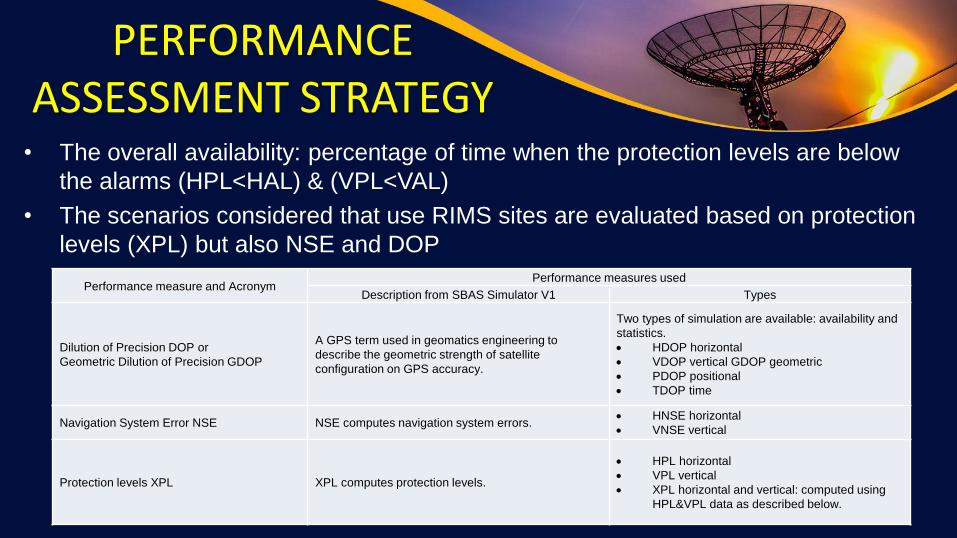
PERFORMANCE ASSESSMENT STRATEGY• The overall availability: percentage of time when the protection levels are below
the alarms (HPL<HAL) & (VPL<VAL)
• The scenarios considered that use RIMS sites are evaluated based on protection
levels (XPL) but also NSE and DOP
3
Performance measure and AcronymPerformance measures used
Description from SBAS Simulator V1 Types
Dilution of Precision DOP or
Geometric Dilution of Precision GDOP
A GPS term used in geomatics engineering to
describe the geometric strength of satellite
configuration on GPS accuracy.
Two types of simulation are available: availability and
statistics.
• HDOP horizontal
• VDOP vertical GDOP geometric
• PDOP positional
• TDOP time
Navigation System Error NSE NSE computes navigation system errors.• HNSE horizontal
• VNSE vertical
Protection levels XPL XPL computes protection levels.
• HPL horizontal
• VPL vertical
• XPL horizontal and vertical: computed using
HPL&VPL data as described below.
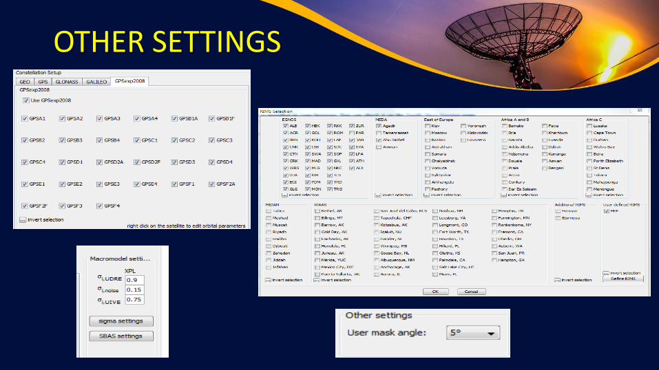
OTHER SETTINGS
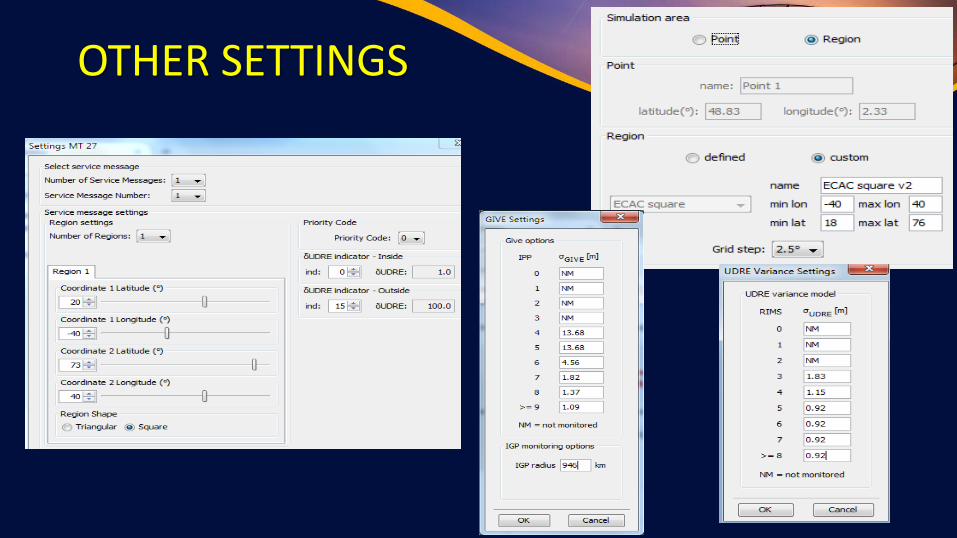
OTHER SETTINGS
6
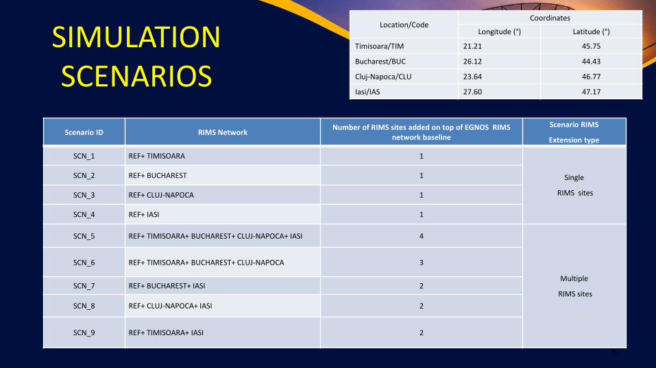
SIMULATION SCENARIOS
Location/CodeCoordinates
Longitude (°) Latitude (°)
Timisoara/TIM 21.21 45.75
Bucharest/BUC 26.12 44.43
Cluj-Napoca/CLU 23.64 46.77
Iasi/IAS 27.60 47.17
Scenario ID RIMS NetworkNumber of RIMS sites added on top of EGNOS RIMS
network baseline
Scenario RIMS
Extension type
SCN_1 REF+ TIMISOARA 1
Single
RIMS sites
SCN_2 REF+ BUCHAREST 1
SCN_3 REF+ CLUJ-NAPOCA 1
SCN_4 REF+ IASI 1
SCN_5 REF+ TIMISOARA+ BUCHAREST+ CLUJ-NAPOCA+ IASI 4
Multiple
RIMS sites
SCN_6 REF+ TIMISOARA+ BUCHAREST+ CLUJ-NAPOCA 3
SCN_7 REF+ BUCHAREST+ IASI 2
SCN_8 REF+ CLUJ-NAPOCA+ IASI 2
SCN_9 REF+ TIMISOARA+ IASI 2

SCN_1REFERENCE + TIMISOARA
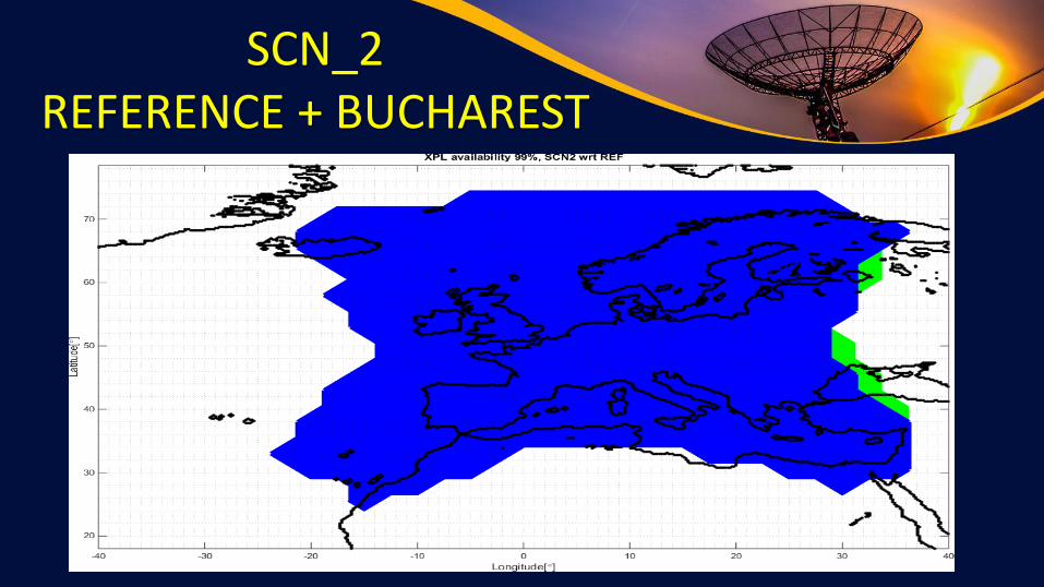
SCN_2REFERENCE + BUCHAREST

SCN_3REFERENCE + CLUJ-NAPOCA

SCN_4REFERENCE + IAŞI
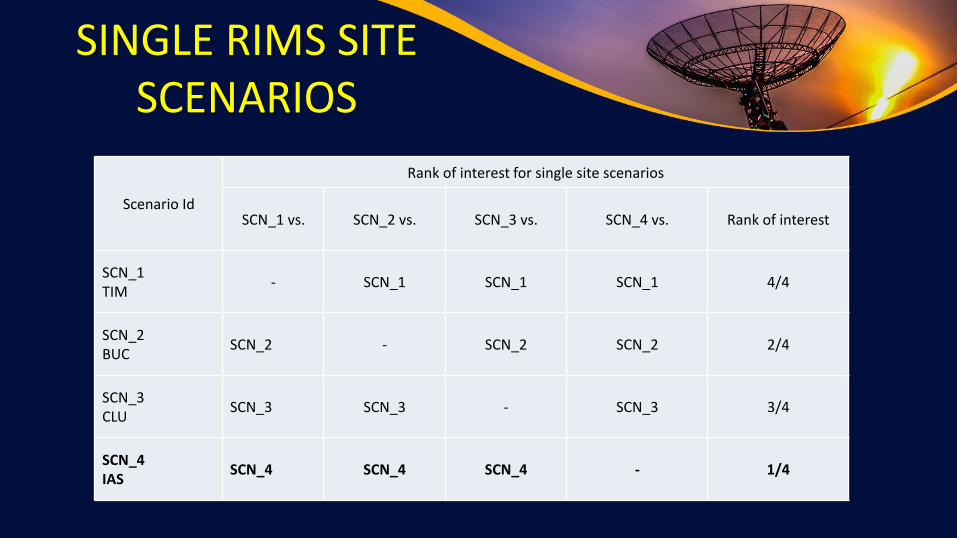
SINGLE RIMS SITE SCENARIOS
Scenario Id
Rank of interest for single site scenarios
SCN_1 vs. SCN_2 vs. SCN_3 vs. SCN_4 vs. Rank of interest
SCN_1TIM
- SCN_1 SCN_1 SCN_1 4/4
SCN_2BUC
SCN_2 - SCN_2 SCN_2 2/4
SCN_3CLU
SCN_3 SCN_3 - SCN_3 3/4
SCN_4IAS
SCN_4 SCN_4 SCN_4 - 1/4
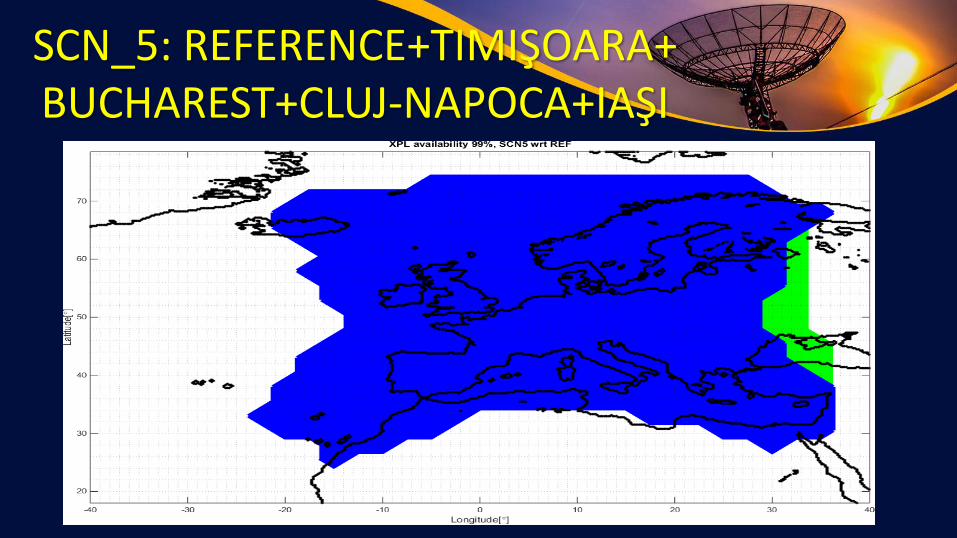
SCN_5: REFERENCE+TIMIŞOARA+ BUCHAREST+CLUJ-NAPOCA+IAŞI

SCN_6: REFERENCE + TIMIŞOARA+BUCHAREST
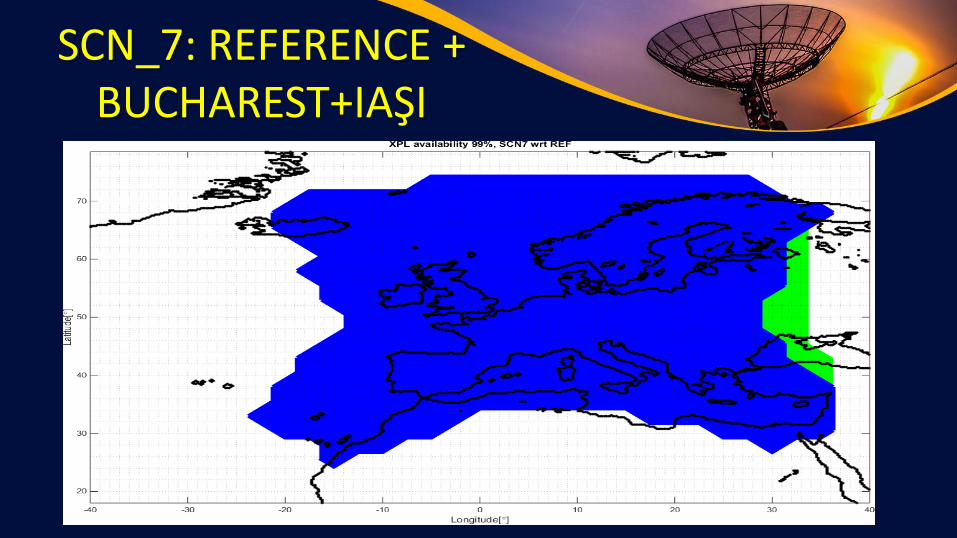
SCN_7: REFERENCE + BUCHAREST+IAŞI

SCN_8: REFERENCE + CLUJ-NAPOCA+IAŞI

SCN_9: REFERENCE + TIMIŞOARA+IAŞI
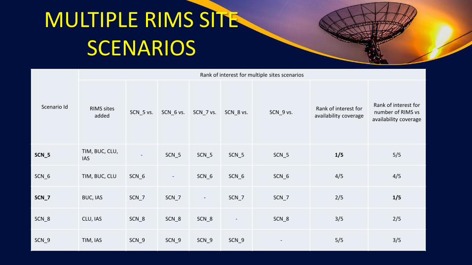
MULTIPLE RIMS SITE SCENARIOS
Scenario Id
Rank of interest for multiple sites scenarios
RIMS sites added
SCN_5 vs. SCN_6 vs. SCN_7 vs. SCN_8 vs. SCN_9 vs.Rank of interest for
availability coverage
Rank of interest for number of RIMS vs
availability coverage
SCN_5TIM, BUC, CLU, IAS
- SCN_5 SCN_5 SCN_5 SCN_5 1/5 5/5
SCN_6 TIM, BUC, CLU SCN_6 - SCN_6 SCN_6 SCN_6 4/5 4/5
SCN_7 BUC, IAS SCN_7 SCN_7 - SCN_7 SCN_7 2/5 1/5
SCN_8 CLU, IAS SCN_8 SCN_8 SCN_8 - SCN_8 3/5 2/5
SCN_9 TIM, IAS SCN_9 SCN_9 SCN_9 SCN_9 - 5/5 3/5
CONCLUSIONS
• We have studied the theoretical extension of coverage for the EGNOS performances when using monitoring stations located in Romania.
• We created scenarios with added RIMS sites and we studied the extension of EGNOS coverage in these cases.
• In the case of single RIMS site scenarios, we found out the best two locations are Iasi and Bucharest.
• With respect to the multiple RIMS sites scenarios case, the best coverage was provided by the scenario that includes all four RIMS locations.
• However, by looking at the efficiency coverage versus number of RIMS deployed, it was seen that the scenario with Iasi and Bucharest is the one with the best trade-off.

Thank you!