Embed Size (px)
Citation preview

Annex A1
EIA Application Form
Enquiries: C.D. Smuts/ A.T. Makaudi Private Bag X6102, Kimberley, 8300 E-mail: [email protected] Tel. (053) 8074800/Fax (053) 8313530
APPLICATION FORM FOR AUTHORIZATION
in terms of the National Environmental Management Act, 1998 (Act No. 107 of 1998), as amended and the Environmental Impact Assessment Regulations, 2006
Kindly note that:
1. This application form is current as of 1 July 2006. 2. The application must be typed within the spaces provided in the form. The sizes of the spaces provided are not
necessarily indicative of the amount of information to be provided. It is in the form of a table that can extend itself as each space is filled with typing.
3. Where applicable black out the boxes that are not applicable in the form.
4. Incomplete applications may be returned to the applicant for revision.
5. The use of “not applicable” in the form must be done with circumspection as if it is used in respect of material
information that is required by the competent authority for assessing the application, and may result in the rejection of the application as provided for in the regulations.
6. This application must be handed in at the offices of the Northern Cape Department of Tourism, Environment
and Conservation.
7. No faxed or e-mailed applications will be accepted.
8. The application must be completed by an independent environmental practitioner.
9. Unless protected by law, all information filled in on this application will become public information on receipt by the competent authority. Any interested and affected party should be provided with the information contained in this application on request, during any stage of the application process.
SITE IDENTIFICATION AND LINKAGE Please indicate all the Surveyor-General 21 digit site (erf/farm/portion) reference numbers for all sites (including portions of sites) that are part of the application. See attached as Appendix B.
If there are more than 10, please attach a list with the rest of the number (These numbers will be used to link various different applications, authorisations, permits etc. that may be connected to a specific site)
Northern Cape Province DEPARTMENT OF TOURISM,
ENVIRONMENT & CONSERVATION
Porofensi Ya Kapa Bokone LEFAPHA LA BOJANALA,
TIKOLOGO LE SHOMARELO
Enquiries: C.D. Smuts/ A.T. Makaudi Private Bag X6102, Kimberley, 8300 E-mail: [email protected] Tel. (053) 8074800/Fax (053) 8313530
1. BACKGROUND INFORMATION
Project applicant: Black Mountain Mining (PTY) Ltd Trading name (if any): Black Mountain Mining (PTY) Ltd Business reg. no./ID. no.: 2005/040096/07 Contact person: PD Venter Physical address: 1 Penge Road, Aggeneys Postal address: Private Bag X01 Postal code: 8893 Cell: 0828513091 Telephone: (054) 983-9256 Fax: (054) 983-9353 E-mail: [email protected] Project consultant/firm: Environmental Resources Management Southern Africa (Pty) Ltd Business reg. no./ID. no.: Contact person: Mr Stuart Heather-Clark and Mrs Tania Swanepoel Postal address: Block A Silverwood House, Steenberg Office Park, Cape Town Postal code: 7945 Cell: Telephone: 021 702 9100 Fax: 021 701 7900 E-mail: [email protected] Professional affiliation(s) (if any)
Landowner: Refer to Appendix B. Business reg. no./ID. no.: Contact person: Postal address: Postal code: Cell: Telephone: Fax: E-mail: In instances where there is more than one landowner, please attach a list of
landowners with their contact details to this application. District Municipality Namakwa District Municipality Local authority in whose jurisdiction the proposed activity will fall:
Khai – Ma Local Municipality
Contact person: Ms. Madeleinne Brandt (Municipal Manager – Namakwa District Municipality) Postal address: Private Bag X20, Van Riebeeck Street, Springbok Postal code: 8240 Cell: Telephone: 027 712 8000 Fax: 027 712 8040 E-mail: In instances where there is more than one local authority involved, please attach a
list of local authorities with their contact details to this application. Project title: Environmental and Social Impact Assessment (ESIA) for the Gamsberg Zinc
Mine and associated infrastructure in Northern Cape, South Africa. Brief project description
An EIA process was previously undertaken in 2000 and approval was received for the proposed project in 2001. However, as the validity period of the authorisation has expired, it is the intention of Black Mountain Mining (BMM) to undertake a new EIA process. The proposed project will include the following project components: • Establishment of the Gamsberg open pit Zinc Mine with an expected
output capacity of approximately 10 million tons per year (beneficiation tonnage). The proposed mine is expected to have a life span of approximately 19 years.
• Construction of a Zinc Concentrator Plant with a total processing capacity of 10 million tons per year.
• In order to manage the waste streams generated from the mining
process, BMM intends to construct one tailing dam and one waste rock dump.
• The proposed project is expected to result in the creation of
construction and operational phase employment opportunities. In order
Enquiries: C.D. Smuts/ A.T. Makaudi Private Bag X6102, Kimberley, 8300 E-mail: [email protected] Tel. (053) 8074800/Fax (053) 8313530
to house the expected workforce, BMM intends to construct approximately 1000 additional housing in the town of Aggeneys and/or Pofadder.
• To ensure project viability, BMM needs to transport the proposed zinc
concentrate from the mine to the Port of Saldanha for exportation to global markets. BMM have confirmed that two transport options will be yutilised during the ESIA process, which are as follows: • Transport Option 1: Zinc concentrate to be transported via an
existing gravel road from the proposed mine to Loop 10 of the existing Sishen - Saldanha railway line. At Loop 10, the concentrate will be loaded and transported by rail via the railway line to Port of Saldanha; or
• Transport Option 2: Load zinc concentrate onto trucks and transport the zinc concentrate via the existing N14 National Road to the Port of Saldanha.
A summary table of the Project Description is attached as Annex C. Please refer to Chapter 3 of the ESIA Report, for a more detailed description of all project infrastructure.
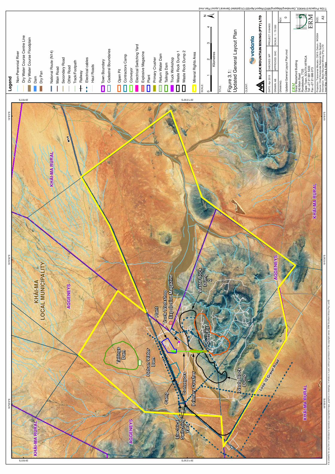
Project Location:
The proposed zinc mine will be located approximately 15 km east of Aggeneys, along the eastern border of the N14 National Road. Infrastructure that will be located outside of the mining license area include:
• Upgrading of the Aggeneys wastewater treatment works; • Construction of 1000 additional houses in Aggeneys; and • Upgrading of the existing facility at Loop 10 siding.
Please refer to Chapter 3 of the ESIA Report, for a more detailed description of all project infrastructure.
(Farm name, portion etc.) Where a large number of properties are involved (e.g. linear activities), please attach a full list to this application. See attached as Appendix B
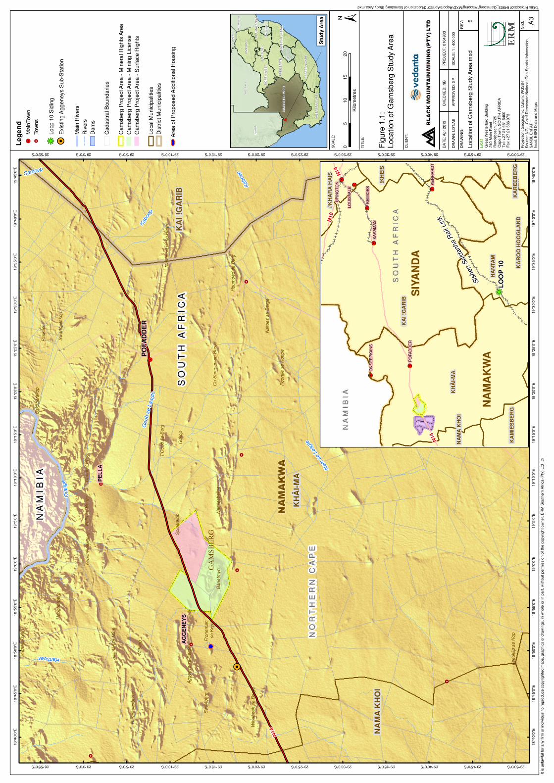
Closest Town(s) or district(s):
Aggeneys Distance (in km): 15 km east
Physical address: The proposed project will cover an expansive area (including the towns of Pofadder and Aggeneys). Refer to Locality Map attached as Appendix A for a general description of the project location.
In instances where there is more than one town or district involved, please attach a list of towns or districts to this application.
Current land-use zoning: See attached as Appendix B
In instances where there is more than one current land-use zoning, please attach a list of current land use zonings that also indicate which portions each use pertains to , to this application.
Coordinates: To be confirmed during the Scoping Phase
Latitude: 29 0 14’ 55” South Longitude: 18 0 50’ 41” East
Property size: See attached as Appendix B
Is a change of land-use or a consent use application required? YES NO
Enquiries: C.D. Smuts/ A.T. Makaudi Private Bag X6102, Kimberley, 8300 E-mail: [email protected] Tel. (053) 8074800/Fax (053) 8313530
Must a building plan be submitted to the local authority? The construction of the housing development would require approval from the local planning offices.
YES NO
Locality map:
A locality map must be attached to back of this document, as Appendix A. The scale of the locality map must be at least 1:50 000. The scale must be indicated on the map. The map must indicate the following: • an accurate indication of the project site position as well as the positions of the
alternative sites, if any; • road access from all major roads in the area; • road names or numbers of all major roads as well as the roads that provide
access to the site(s); • all roads within a 1km radius of the site or alternative sites; and • a north arrow.
Owners Consent In line with the requirements of EIA regulations, letters of consent of all landowners
or detailed explanation by the applicant explaining why consent is not possible must be attached to the back of this documents as Appendix B.
2. ACTIVITIES APPLIED FOR An application may be made for more than one listed or specified activity that, together, make up one development proposal. All the listed activities that make up this application must be listed. Government Notice R544 of 2010 Applicability to Project Activity 2 The construction of facilities or infrastructure for the storage of ore or coal that requires an atmospheric emissions license in terms of the National Environmental Management: Air Quality Act (Act No. 39 of 2004).
Construction of open stockpile areas for the storage ore.
Activity 9 The construction of facilities or infrastructure exceeding 1000 metres in length for the bulk transportation of water, sewage or storm water - . with an internal diameter of 0,36 metres or more; or . with a peak throughput of 120 litres per second or more, excluding where: a) such facilities or infrastructure are for bulk transportation
of water, sewage or storm water or storm water drainage inside a road reserve; or
b) where such construction will occur within urban areas but further than 32 metres from a watercourse, measured from the edge of the watercourse.
Construction of an off-take water pipeline (550 mm) from the existing PDWB water pipeline to the Gamsberg mine.
Activity 10 The construction of facilities or infrastructure for the transmission and distribution of electricity— . outside urban areas or industrial complexes with a capacity
of more than 33 but less than 275 kilovolts; or . inside urban areas or industrial complexes with a capacity
of 275 kilovolts or more.
Construction of new 66 kV transmission lines and 66 kV/11kV sub-stations.
Enquiries: C.D. Smuts/ A.T. Makaudi Private Bag X6102, Kimberley, 8300 E-mail: [email protected] Tel. (053) 8074800/Fax (053) 8313530
Government Notice R544 of 2010 Applicability to Project Activity 11 The construction of— . canals; . channels; i. bridges;
v. dams; v. weirs;
. bulk storm water outlet structures;
. marinas; i. jetties exceeding 50 square metres in size;
x. slipways exceeding 50 square metres in size; x. buildings exceeding 50 square metres in size; or
. infrastructure or structures covering 50 square metres or more,
where such construction occurs within a watercourse or within 32 metres of a watercourse, measured from the edge of a watercourse, excluding where such construction will occur behind the development setback line.
Mine infrastructure exceeding 50 m² will be located within 32 m of a watercourse.
Activity 12 The construction of facilities or infrastructure for the off-stream storage of water, including dams and reservoirs, with a combined capacity of 50 000 cubic metres or more, unless such storage falls within the ambit of activity 19 of Notice 545 of 2010.
On-site dams for raw water, potable water and dirty water will be constructed.
Activity 18 The infilling or depositing of any material of more than 5 cubic metres into, or the dredging, excavation, removal or moving of soil, sand, shells, shell grit, pebbles or rock or more than 5 cubic metres from: . a watercourse; . the sea; i. the seashore;
v. the littoral active zone, an estuary or a distance of 100 metres inland of the highwater mark of the sea or an estuary, whichever distance is the greater
but excluding where such infilling, depositing , dredging, excavation, removal or moving;
(a) is for maintenance purposes undertaken in accordance with a management plan agreed to by the relevant environmental authority; or
(b) occurs behind the development setback line.
Mining infrastructure such as, the open pit, the explosives magazine and the truck workshop will all be constructed within a watercourse. These will require the excavation of more than 5 cubic metres of soil and/or rock. In addition to this, the upgrading of the existing water pipeline (Gamsberg off-take pipeline) may require excavation and infilling into a watercourse that will exceed 5 m³.
Activity 22 The construction of a road, outside urban areas—
i. with a reserve wider than 13,5 meters or;
ii. where no reserve exists where the road is wider than 8 metres; or
iii. for which an environmental authorisation was
obtained for the route determination in terms of activity 5 in Government Notice 387 of 2006 or activity 18 in Notice 545 of 2010.
Internal haul roads within the Project area are expected to have a reserve wider than 13.5 m. Service roads with different reserves will also be constructed.
Enquiries: C.D. Smuts/ A.T. Makaudi Private Bag X6102, Kimberley, 8300 E-mail: [email protected] Tel. (053) 8074800/Fax (053) 8313530
Government Notice R544 of 2010 Applicability to Project Activity 23 The transformation of undeveloped, vacant or derelict land to—
i. residential, retail, commercial, recreational, industrial or institutional use, inside an urban area, and where the total area to be transformed is 5 hectares or more, but less than 20 hectares, or
ii. residential, retail, commercial, recreational,
industrial or institutional use, outside an urban area and where the total area to be transformed is bigger than 1 hectare but less than 20 hectares;
except where such transformation takes place—
i. for linear activities; or ii. for purposes of agriculture or afforestation, in
which case Activity 16 of Notice No. 545 applies.
The Project area exceeds 5 hectares.
Activity 24 The transformation of land bigger than 1000 square metres in size, to residential, retail, commercial, industrial or institutional use, where, at the time of the coming into effect of this Schedule or thereafter such land was zoned open space, conservation or had an equivalent zoning.
The development of the additional staff housing units at Aggeneys and the expansion of the Aggeneys Waste Water Treatment Plant.
Activity 26 Any process or activity identified in terms of Section 53 (1) of the National Environmental Management: Biodiversity Act, 2004 (Act No. 10 of 2004).
The Project will result in removal of and impact on sensitive vegetation, which will potentially constitute a restricted activity in terms of NEMBA.
Activity 37 The expansion of facilities or infrastructure for the bulk transportation of water, sewage or storm water where—
(a) the facility or infrastructure is expanded by more than 1000 metres in length; or
(b) where the throughput capacity of the facility or
infrastructure will be increased by 10% or more– excluding where such expansion:
i. relates to transportation of water, sewage or storm water within a road reserve; or
ii. where such expansion will occur within urban
areas but further than 32 metres from a watercourse, measured from the edge of the watercourse.
The expansion of the Aggeneys Waste Water Treatment Plant (WWTP). The construction/expansion of the 5km Gamsberg water off take pipeline from the existing PWB pipeline to the mine.
Activity 41 The expansion of facilities or infrastructure for the off-stream storage of water, including dams and reservoirs, where the combined capacity will be increased by 50,000 cubic metres or more.
44 ML reservoir (water supply) being constructed to the north of the N14, within the existing mining right area.
Activity 42 The expansion of facilities for the storage, or storage and handling, of a dangerous good, where the capacity of such storage facility will be expanded by 80 cubic metres or more.
Loop 10 or possible on site fuel storage.
Activity 47 The widening of a road by more than 6 metres, or the lengthening of a road by more than 1 kilometre—
i. where the existing reserve is wider than 13,5 meters; or
ii. where no reserve exists, where the existing road
is wider than 8 metres excluding widening or lengthening occurring inside urban areas.
Existing gravel roads within and around the site may need to be widened to accommodate for the traffic flow.
Enquiries: C.D. Smuts/ A.T. Makaudi Private Bag X6102, Kimberley, 8300 E-mail: [email protected] Tel. (053) 8074800/Fax (053) 8313530
Government Notice R545 of 2010 Applicability to project Activity 3 The construction of facilities or infrastructure for the storage, or storage and handling of a dangerous good, where such storage occurs in containers with a combined capacity of more than 500 cubic meters.
Proposed storage of fuel on-site that exceeds 500 m³.
Activity 5 The construction of facilities or infrastructure for any process or activity which requires a permit or license in terms of national or provincial legislation governing the generation or release of emissions, pollution or effluent and which is not identified in Notice No. 544 of 2010 or included in the list of waste management activities published in terms of section 19 of the National Environmental Management: Waste Act, 2008 (Act No. 59 of 2008) in which case that Act will apply.
The process of concentration will result in the production of effluent.
Activity 15 Physical alteration of undeveloped vacant or derelict land for residential, retail, commercial, recreational, industrial or institutional use where the total area to be transformed is 20 hectares or more; except where such physical alteration takes place for—
i. linear development activities; or
ii. agriculture or afforrestation where activity 16 in this Schedule will apply.
The Project area exceeds 20 hectares.
Activity 19 The construction of a dam, where the highest part of the dam wall, as measured from the outside toe of the wall to the highest part of the wall, is 5 metres or higher or where the high-water mark of the dam covers an area of 10 hectares or more.
On-site dams will be constructed that may exceed 5 m in height.
Activity 26 Commencing of an activity, which requires an atmospheric emission licence in terms of section 21 of the National Environmental Management: Air Quality Act, 2004 (No. 39 of 2004), except where such commencement requires basic assessment in terms of Notice No. R.544 of 2010.
The bulk storage of liquid fuel above ground, exceeding a capacity of 500 m³ will be required on site.
Government Notice R.546 of 2010 Applicability to project Activity 4 The construction of a road wider than 4 metres with a reserve less than 13,5 metres.
i. In an estuary; ii. In a protected area identified in terms of
NEMPAA, excluding conservancies; iii. Outside urban areas, in:
- National Protected Area Expansion Strategy
Focus areas;
- Sensitive areas as identified in an environmental management framework as contemplated in chapter 5 of the Act and as adopted by the competent authority;
- Sites or areas identified in terms of an
International Convention;
- Critical biodiversity areas as identified in systematic biodiversity plans adopted by the competent authority or in bioregional plans;
- Core areas in biosphere reserves;
Internal road networks will be constructed.
Enquiries: C.D. Smuts/ A.T. Makaudi Private Bag X6102, Kimberley, 8300 E-mail: [email protected] Tel. (053) 8074800/Fax (053) 8313530
Government Notice R.546 of 2010 Applicability to project
- Areas within 10 kilometres from national parks or world heritage sites or 5 kilometres from any other protected area identified in terms of NEMPAA or from the core area of a biosphere reserve; and
- Areas seawards of the development setback line
or within 1 kilometre from the high-water mark of the sea if no such development setback line is determined.
Activity 10 The construction of facilities or infrastructure for the storage, or storage and handling of a dangerous good, where such storage occurs in containers with a combined capacity of 30 but not exceeding 80 cubic metres.
i. In an estuary; ii. In a protected area identified in terms of
NEMPAA, excluding conservancies; iii. Outside urban areas, in:
- National Protected Area Expansion Strategy
Focus areas;
- Sensitive areas as identified in an environmental management framework as contemplated in chapter 5 of the Act and as adopted by the competent authority;
- Sites or areas identified in terms of an
International Convention;
- Critical biodiversity areas as identified in systematic biodiversity plans adopted by the competent authority or in bioregional plans;
- Core areas in biosphere reserves;
- Areas within 10 kilometres from national parks or
world heritage sites or 5 kilometres from any other protected area identified in terms of NEMPAA or from the core area of a biosphere reserve; and
- Areas seawards of the development setback line
or within 1 kilometre from the high-water mark of the sea if no such development setback line is determined.
The mine bulk storage tank farm is being established within the Gamsberg inselberg, which is a Critical Biodiversity Area (CBA) as identified in the Succulent Karoo Ecosystem Programme (SKEP).
Activity 12 The clearance of an area of 300 square metres or more of vegetation where 75% or more of the vegetative cover constitutes indigenous vegetation.
(a) Within any critically endangered or endangered ecosystem listed in terms of section 52 of the NEMBA or prior to the publication of such a list, within an area that has been identified as critically endangered in the National Spatial Biodiversity Assessment 2004;
(b) Within critical biodiversity areas identified in bioregional plans;
(c) Within the littoral active zone or 100 metres inland from high water mark of the sea or an estuary, whichever distance is the greater, excluding where such removal will occur behind the development setback line on erven in urban areas.
The proposed establishment of the mine may result in the loss of more than 300 m² of vegetation, with 75% being indigenous.
Activity 13 The clearance of an area of 1 hectare or more of vegetation where 75% or more of the vegetative cover constitutes
The proposed establishment of the mine
Enquiries: C.D. Smuts/ A.T. Makaudi Private Bag X6102, Kimberley, 8300 E-mail: [email protected] Tel. (053) 8074800/Fax (053) 8313530
Government Notice R.546 of 2010 Applicability to project indigenous vegetation, except where such removal of vegetation is required for:
(1) the undertaking of a process or activity included in the list of waste management activities published in terms of section 19 of the National Environmental Management: Waste Act, 2008 (Act No. 59 of 2008), in which case the activity is regarded to be excluded from this list.
(2) the undertaking of a linear activity falling below the
thresholds mentioned in Listing Notice 1 in terms of GN No. 544 of 2010.
In the following areas:
(a) Critical biodiversity areas and ecological support areas as identified in systematic biodiversity plans adopted by the competent authority.
(b) National Protected Area Expansion Strategy Focus
areas.
i. In an estuary; ii. Outside urban areas, the following:
(aa) A protected area identified in terms of NEMPAA, excluding conservancies; (bb) National Protected Area Expansion Strategy Focus areas; (cc) Sensitive areas as identified in an environmental management framework as contemplated in chapter 5 of the Act and as adopted by the competent authority; (dd) Sites or areas identified in terms of an International Convention; (ee) Core areas in biosphere reserves; ( ff ) Areas within 10 kilometres from national parks or world heritage sites or 5 kilometres from any other protected area identified in terms of NEMPAA or from the core area of a biosphere reserve; and (gg) Areas seawards of the development setback line or within 1 kilometre from the high-water mark of the sea if no such development setback line is determined.
and associated infrastructure will result in the loss of 1 hectare of vegetation, with more than 75% being indigenous.
Activity 14 The clearance of an area of 5 hectares or more of vegetation where 75% or more of the vegetative cover constitutes indigenous vegetation, except where such removal of vegetation is required for:
(1) purposes of agriculture or afforestation inside areas identified in spatial instruments adopted by the competent authority for agriculture or afforestation purposes;
(2) the undertaking of a process or activity included in
the list of waste management activities published in terms of section 19 of the National Environmental Management: Waste Act, 2008 (Act No. 59 of 2008) in which case the activity is regarded to be excluded from this list; and
(3) the undertaking of a linear activity falling below the
thresholds in Notice 544 of 2010.
The proposed establishment of the mine and associated infrastructure may result in the loss of 5 hectares of vegetation, with 75% being indigenous.
Enquiries: C.D. Smuts/ A.T. Makaudi Private Bag X6102, Kimberley, 8300 E-mail: [email protected] Tel. (053) 8074800/Fax (053) 8313530
Government Notice R.546 of 2010 Applicability to project Within the following areas:
i. All areas outside urban areas. Activity 16 The construction of:
i. jetties exceeding 10 square metres in size;
ii. slipways exceeding 10 square metres in size;
iii. buildings with a footprint exceeding 10 square metres in size; or
iv. infrastructure covering 10 square metres or
more where such construction occurs within a watercourse or within 32 metres of a watercourse, measured from the edge of a watercourse, excluding where such construction will occur behind the development setback line.
Within the following areas:
i. In an estuary;
ii. In a protected area identified in terms of NEMPAA, excluding conservancies;
iii. Outside urban areas, in:
- National Protected Area Expansion Strategy
Focus areas;
- Sensitive areas as identified in an environmental management framework as contemplated in chapter 5 of the Act and as adopted by the competent authority;
- Sites or areas identified in terms of an
International Convention;
- Critical biodiversity areas as identified in systematic biodiversity plans adopted by the competent authority or in bioregional plans;
- Core areas in biosphere reserves;
- Areas within 10 kilometres from national parks or
world heritage sites or 5 kilometres from any other protected area identified in terms of NEMPAA or from the core area of a biosphere reserve; and
- Areas seawards of the development setback line
or within 1 kilometre from the high-water mark of the sea if no such development setback line is determined.
Infrastructure exceeding 10 m² will be constructed within 32 m of a watercourse, within the Gamsberg inselberg, which located within a critical biodiversity area (CBA) as identified in the Succulent Karoo Ecosystem Programme (SKEP).
Activity 19 The widening of a road by more than 4 metres, or the lengthening of a road by more than 1 kilometre. Within the following areas:
i. In an estuary;
ii. In a protected area identified in terms of NEMPAA, excluding conservancies;
Existing road networks may need to be widened or lengthened by more than 4 m or 1 km, respectively.
Enquiries: C.D. Smuts/ A.T. Makaudi Private Bag X6102, Kimberley, 8300 E-mail: [email protected] Tel. (053) 8074800/Fax (053) 8313530
Government Notice R.546 of 2010 Applicability to project iii. Outside urban areas, in:
- National Protected Area Expansion Strategy Focus
areas;
- Sensitive areas as identified in an environmental management framework as contemplated in chapter 5 of the Act and as adopted by the competent authority;
- Sites or areas identified in terms of an
International Convention;
- Critical biodiversity areas as identified in systematic biodiversity plans adopted by the competent authority or in bioregional plans;
- Core areas in biosphere reserves;
- Areas within 10 kilometres from national parks or
world heritage sites or 5 kilometres from any other protected area identified in terms of NEMPAA or from the core area of a biosphere reserve; and
- Areas seawards of the development setback line or
within 1 kilometre from the high-water mark of the sea if no such development setback line is determined.
Please note that any authorisation that may result out of this application will only cover activities applied for. Omissions may render any authorisation that is based on incomplete information to be nil and void. 3. TYPE OF APPLICATION 3.1. Application for Basic Assessment Is this an application for conducting a basic assessment (as defined in the regulations)? YES NO If, YES, is a basic assessment report attached? YES NO If, NO, please indicate when the basic assessment report will be submitted: NOT APPLICABLE 3.2. Application for Scoping and Environmental Impact Assessment (EIA) Is this an application for Scoping and EIA (as defined in the regulations)? YES NO If, YES, is a Scoping Report and Plan of Study for EIA attached? YES NO If, NO, please indicate when the Scoping Report and Plan of Study for EIA will be submitted: The Final ESIA Report is attached, for ease of reference. The scoping report and/or the plan of study for EIA will be submitted YES NO after consultation with the competent authority: A consultation with the competent authority is hereby requested: YES NO
Enquiries: C.D. Smuts/ A.T. Makaudi Private Bag X6102, Kimberley, 8300 E-mail: [email protected] Tel. (053) 8074800/Fax (053) 8313530
4. Declarations 4.1. The independent Environmental Assessment Practitioner
I, Mr Stuart Heather-Clark, declare under oath that I –
• act as the independent environmental assessment practitioner in this application ; • do not have and will not have any financial interest in the undertaking of the activity, other than remuneration for
work performed in terms of the Environmental Impact Assessment Regulations, 2006; • have and will not have no vested interest in the proposed activity proceeding; • have no, and will not engage in, conflicting interests in the undertaking of the activity; • undertake to disclose, to the competent authority, any material information that have or may have the potential to
influence the decision of the competent authority or the objectivity of any report, plan or document required in terms of the Environmental Impact Assessment Regulations, 2006;
• will ensure that information containing all relevant facts in respect of the application is distributed or made available to interested and affected parties and the public and that participation by interested and affected parties is facilitated in such a manner that all interested and affected parties will be provided with a reasonable opportunity to participate and to provide comments on documents that are produced to support the application;
• will ensure that the comments of all interested and affected parties are considered and recorded in reports that are submitted to the competent authority in respect of the application, provided that comments that are made by interested and affected parties in respect of a final report that will be submitted to the competent authority may be attached to the report without further amendment to the report;
• will keep a register of all interested and affected parties that participated in a public participation process; and • will provide the competent authority with access to all information at my disposal regarding the application, whether
such information is favourable to the applicant or not. Signature of the Environmental Assessment Practitioner: ERM Southern Africa (Pty) Ltd Name of company: Date: Signature of the Commissioner of Oaths:
Date: Designation: Official stamp (below)
Enquiries: C.D. Smuts/ A.T. Makaudi Private Bag X6102, Kimberley, 8300 E-mail: [email protected] Tel. (053) 8074800/Fax (053) 8313530
4.2. The Applicant
I, Mr N Williams, declare under oath that I -
• Am, or represent, the applicant in this application; • appointed the environmental assessment practitioner as indicated under point 4.1 above to act as the independent
environmental assessment practitioner for this application; • will provide the environmental assessment practitioner and the competent authority with access to all information at
my disposal that is relevant to the application; • will be responsible for the costs incurred in complying with the Environmental Impact Assessment Regulations, 2006,
including but not limited to – costs incurred in connection with the appointment of the environmental assessment practitioner or any person
contracted by the environmental assessment practitioner; costs incurred in respect of the undertaking of any process required in terms of the regulations; costs in respect of any fee prescribed by the Minister or MEC in respect of the regulations; costs in respect of specialist reviews, if the competent authority decides to recover costs; and the provision of security to ensure compliance with conditions attached to an environmental authorisation,
should it be required by the competent authority; • will ensure that the environmental assessment practitioner is competent to comply with the requirements of these
regulations; • am responsible for complying with the conditions of any environmental authorisation issued by the competent
authority; • hereby indemnify, the government of the Republic, the competent authority and all its officers, agents and
employees, from any liability arising out of the content of any report, any procedure or any action for which the applicant or environmental assessment practitioner is responsible in terms of these regulations; and
• will not hold the competent authority responsible for any costs that may be incurred by the applicant in proceeding with an activity prior to an appeal being decided in terms of these regulations.
Signature of the applicant: Black Mountain Mining (PTY) Ltd Name of company: Date: Signature of the Commissioner of Oaths:
Date: Designation: Official stamp (below):

Enquiries: C.D. Smuts/ A.T. Makaudi Private Bag X6102, Kimberley, 8300 E-mail: [email protected] Tel. (053) 8074800/Fax (053) 8313530
Appendix A: Locality Map
01
23
4
Kilo
me
tre
s
N14
KH
ÂI-
MA
RU
RA
L
AG
GE
NE
YS
AG
GE
NE
YS
Tru
ck W
ork
sh
op W
ast
e R
ock
D
um
p2
Op
en
Pit
Wa
ste
Ro
ckD
um
p1
Pla
nt
Ex
po
los
ive
Mag
azi
ne
Taili
ng
s D
am
N14
AG
GE
NE
YS
KH
ÂI-
MA
RU
RA
L
KH
ÂI-
MA
RU
RA
L
Cam
p
Ret
urn
Wat
er
Dam
Co
nve
yors
Pri
ma
ry C
rus
her
Ele
ctr
ica
l S
wit
chin
g
Yar
d
KH
ÂI-
MA
RU
RA
L
Loop
10
Gra
vel R
oad
Pella
KH
ÂI-
MA
L
OC
AL
MU
NIC
IPA
LIT
Y
19
°6'0
"E
19
°6'0
"E
19
°0'3
0"E
19
°0'3
0"E
18
°55
'0"E
18
°55
'0"E
29°8'0"S
29°8'0"S
29°13'30"S
29°13'30"S
SIZ
E:
TIT
LE
:
DA
TE
: A
pr
20
13
DR
AW
N:
AB
CH
EC
KE
D:
MP
AP
PR
OV
ED
: S
HC
PR
OJE
CT
: 0
16
49
03
DR
AW
ING
:R
EV
:
A3
Fig
ure
3.1
:U
pd
ate
d G
en
era
l L
ayo
ut
Pla
n
Update
d G
enera
l Layout
Pla
n.m
xd
0
CLIE
NT
:
±S
CA
LE
:
T:\Gis Projects\0164903_Gamsberg\Mapping\MXD\Report\April2013\Updated General Layout Plan.mxd
Pro
jectio
n: T
ran
sve
rse
Me
cato
r, C
M1
9.
Da
tum
: W
GS
84
So
urc
e:
Ch
ief D
ire
cto
rate
Na
tio
nal G
eo
-Sp
atia
l In
form
atio
n.
Bla
ck M
ou
nta
in M
inin
g (
Pty
) LT
D
Inse
t M
ap
: E
sri D
ata
& M
ap
s
SC
AL
E: 1
: 7
0 0
00
It is u
nla
wfu
l fo
r a
ny fir
m o
r in
div
idu
al to
re
pro
du
ce
co
pyrig
hte
d m
ap
s,
gra
phic
s o
r dra
win
gs,
in w
hole
or
in p
art
, w
ith
out
pe
rmis
sio
n o
f th
e c
op
yri
ght
ow
ne
r, E
RM
So
uth
ern
Afr
ica
(P
ty)
Ltd
�
Leg
end
No
n-P
ere
nnia
l R
ive
r
Dry
Wa
ter
Co
urs
e C
entr
e L
ine
Dry
Wa
ter
Co
urs
e F
lood
pla
in
Da
m
Dry
Pa
n
Na
tion
al R
ou
te (
N1
4)
Ma
in R
oad
Se
con
da
ry R
oad
Oth
er
Ro
ad
Tra
ck/F
oo
tpa
th
Ra
ilwa
y
Ele
ctr
ica
l cab
les
Ha
ul R
oa
ds
To
wn
Bo
un
dary
Ca
dastr
al B
ou
nd
arie
s
Op
en P
it
Co
ntr
acto
rs C
am
p
Co
nve
yo
r
Ele
ctr
ica
l S
witchin
g Y
ard
Explo
siv
e M
ag
azin
e
Pla
nt
Pri
mary
Cru
she
r
Re
turn
Wate
r D
am
Ta
ilin
gs D
am
Tru
ck W
ork
sho
p
Waste
Ro
ck D
um
p 1
Waste
Ro
ck D
um
p 2
Min
era
l R
igh
ts A
rea
Gre
at
Weste
rford
Build
ing
240 M
ain
Road
Ronde
bosch,
7725
Cape T
ow
n, S
OU
TH
AF
RIC
AT
el: +
27 2
1 6
81 5
400
Fa
x +
27 2
1 6
86 0
73
ER
M
DR
AF
T C
OP
Y
Le
ge
nd
!.M
ain
To
wn
!ÇTo
wns
h gLo
op
10 S
idin
g
! HE
xis
tin
g A
gg
en
eys S
ub
-Sta
tio
n
Main
Riv
ers
Riv
ers
Dam
s
Cadastr
al B
ou
nd
arie
s
Gam
sb
erg
Pro
ject A
rea -
Min
era
l R
igh
ts A
rea
Gam
sb
erg
Pro
ject A
rea -
Min
ing
Lic
en
se
Gam
sb
erg
Pro
ject A
rea -
Surf
ace R
ights
Lo
cal M
unic
ipa
litie
s
Dis
tric
t M
un
icip
alit
ies
Are
a o
f P
rop
osed
Add
itio
na
l H
ou
sin
g
! H
!Ç
!Ç
!Ç
!Ç
!Ç
!Ç
!Ç
!Ç
!.
SO
UT
H A
FR
IC
AS
OU
TH
AF
RIC
A
NO
RT
HE
RN
C
AP
EN
OR
TH
ER
N C
AP
E
NA
MIB
IA
NA
MIB
IA
NAMAKWA
PE
LL
A
AG
GE
NE
YS
KH
ÂI-
MA
KA
I !G
AR
IB
NA
MA
KH
OI
Gifko
p
Pla
tko
p
Witberg
Bakensko
p
Spio
enkop
Sw
art
be
rg
Barie
tmynG
AM
SB
ER
G
Osko
pers
kop
Nam
iesb
erg
e
Hoogoo
rberg
Hart
beesberg
Sw
art
spitskop
Hara
moep
berg
e
Charles' P
ass T'G
oob s
e B
erg
Pella
se B
erg
e
Leeuklip
se K
op
Houm
oed s
e B
erg
Naro
es s
e B
erg
e
Fro
ne
man
se K
op
Gro
ot-
Pella
be
rg
Agge
nys s
e B
erg
e
Sill
iman
ite M
ine
Poort
jie s
e K
opp
e
Win
dhoek s
e B
erg
e
Ou S
am
oep s
e B
erg
e
Matthe
usgat se B
erg
eKab
oep
Ora
nge
Nam
se
Laag
te
Goob s
e L
aa
gte
Hartbees
Samoep
Kaboe
p
N14
PO
FAD
DE
R
19
°45
'0"E
19
°45
'0"E
19
°40
'0"E
19
°40
'0"E
19
°35
'0"E
19
°35
'0"E
19
°30
'0"E
19
°30
'0"E
19
°25
'0"E
19
°25
'0"E
19
°20'0
"E
19
°20'0
"E
19
°15
'0"E
19
°15
'0"E
19
°10
'0"E
19
°10
'0"E
19
°5'0
"E
19
°5'0
"E
19
°0'0
"E
19
°0'0
"E
18
°55
'0"E
18
°55
'0"E
18
°50'0
"E
18
°50'0
"E
18
°45
'0"E
18
°45
'0"E
18
°40
'0"E
18
°40
'0"E
28°55'0"S
28°55'0"S
29°0'0"S
29°0'0"S
29°5'0"S
29°5'0"S
29°10'0"S
29°10'0"S
29°15'0"S
29°15'0"S
29°20'0"S
29°20'0"S
29°25'0"S
29°25'0"S
29°30'0"S
29°30'0"S
29°35'0"S
29°35'0"S
29°40'0"S
29°40'0"S
29°45'0"S
29°45'0"S
29°50'0"S
29°50'0"S
SIZ
E:
TIT
LE
:
DA
TE
: A
pr
2013
DR
AW
N:
LD
T/A
B
CH
EC
KE
D:
NB
AP
PR
OV
ED
: S
P
PR
OJE
CT
: 0
164
90
3
SC
ALE
: 1 :
400 0
00
DR
AW
ING
:R
EV
:
A3
Fig
ure
1.1
:Lo
ca
tion
of G
am
sb
erg
Stu
dy A
rea
Location o
f G
am
sberg
Stu
dy A
rea.m
xd
5
CLIE
NT
:
ER
M
Gre
at W
este
rford
Build
ing
240
Ma
in R
oad
Ron
deb
osch
, 77
25
Cap
e T
ow
n, S
OU
TH
AF
RIC
AT
el: +
27 2
1 6
81 5
400
Fa
x +
27 2
1 6
86 0
73
±0
510
15
20
Kilo
me
tre
s
SC
ALE
:
T:\Gis Projects\0164903_Gamsberg\Mapping\MXD\Report\April2013\Location of Gamsberg Study Area.mxd
Pro
jection
: G
eog
rap
hic
, D
atu
m: W
GS
84
Sourc
e: N
GI
- C
hie
f D
irecto
rate
Natio
na
l G
eo-S
patial In
form
ation
,S
AN
BI, E
nP
AT
Inset: E
SR
I D
ata
and
Ma
ps
It is u
nla
wfu
l fo
r a
ny f
irm
or
indiv
idua
l to
repro
du
ce c
op
yrigh
ted m
ap
s, gra
ph
ics o
r dra
win
gs,
in w
hole
or
in p
art
, w
ith
ou
t pe
rmis
sio
n o
f th
e c
op
yrigh
t o
wne
r, E
RM
Sou
thern
Afr
ica
(P
ty)
Ltd
�
#*
NA
MIB
IA
BO
TS
WA
NA
NO
RT
HE
RN
CA
PE
LIM
PO
PO
EA
ST
ER
N C
AP
E
FR
EE
ST
AT
E
WE
ST
ER
N C
AP
E
NO
RT
H W
ES
T
MO
ZA
MB
IQU
E
KW
AZ
UL
U-N
AT
AL
MP
UM
AL
AN
GA
LE
SO
TH
O
ZIM
BA
BW
E
GA
UT
EN
G
SW
AZ
ILA
ND
Stu
dy
Are
a
h g
NA
MIB
IA
NA
MIB
IA
SO
UT
H A
FR
IC
AS
OU
TH
A
FR
IC
A
Sis
hen S
ald
anha R
ail
Lin
k
LO
OP
10
SIY
AN
DA
NA
MA
KW
A
KA
I !G
AR
IB
KH
ÂI-
MA
HA
NTA
M
!KH
EIS
//KH
AR
A H
AIS
KA
MIE
SB
ER
G
NA
MA
KH
OI
KA
RE
EB
ER
GK
AR
OO
HO
OG
LA
ND
N14
N10
N14
KE
IMO
ES
KA
KA
MA
S
UP
ING
TO
N KE
NH
AR
DT
PO
FA
DD
ER
LO
UIS
VA
LE
ON
SE
EP
KA
NS
Enquiries: C.D. Smuts/ A.T. Makaudi Private Bag X6102, Kimberley, 8300 E-mail: [email protected] Tel. (053) 8074800/Fax (053) 8313530
Appendix B: Directly Affected Properties
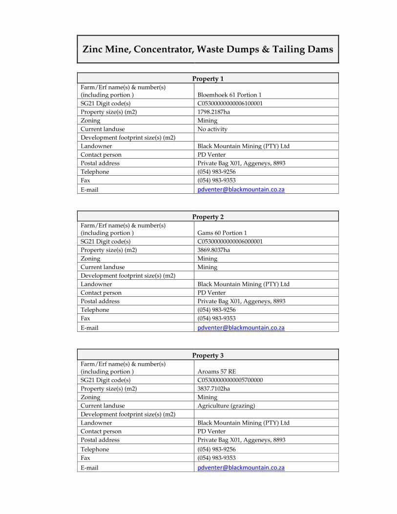
Zinc Mine, Concentrator, Waste Dumps & Tailing Dams
Property 1
Farm/Erf name(s) & number(s) (including portion ) Bloemhoek 61 Portion 1
SG21 Digit code(s) C05300000000006100001
Property size(s) (m2) 1798.2187ha
Zoning Mining
Current landuse No activity
Development footprint size(s) (m2)
Landowner Black Mountain Mining (PTY) Ltd
Contact person PD Venter
Postal address Private Bag X01, Aggeneys, 8893
Telephone (054) 983-9256
Fax (054) 983-9353
E-mail [email protected]
Property 2
Farm/Erf name(s) & number(s) (including portion ) Gams 60 Portion 1
SG21 Digit code(s) C05300000000006000001
Property size(s) (m2) 3869.8037ha
Zoning Mining
Current landuse Mining
Development footprint size(s) (m2)
Landowner Black Mountain Mining (PTY) Ltd
Contact person PD Venter
Postal address Private Bag X01, Aggeneys, 8893
Telephone (054) 983-9256
Fax (054) 983-9353
E-mail [email protected]
Property 3
Farm/Erf name(s) & number(s) (including portion ) Aroams 57 RE
SG21 Digit code(s) C05300000000005700000
Property size(s) (m2) 3837.7102ha
Zoning Mining
Current landuse Agriculture (grazing)
Development footprint size(s) (m2)
Landowner Black Mountain Mining (PTY) Ltd
Contact person PD Venter
Postal address Private Bag X01, Aggeneys, 8893
Telephone (054) 983-9256
Fax (054) 983-9353
E-mail [email protected]
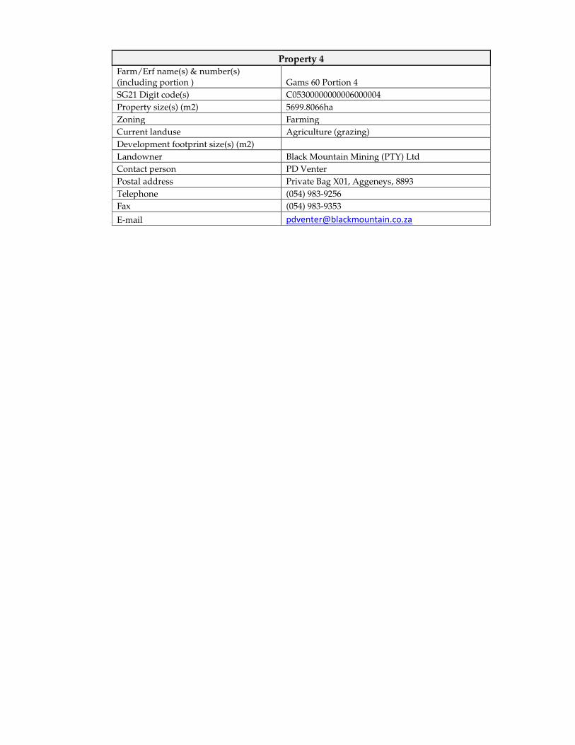
Property 4
Farm/Erf name(s) & number(s) (including portion ) Gams 60 Portion 4
SG21 Digit code(s) C05300000000006000004
Property size(s) (m2) 5699.8066ha
Zoning Farming
Current landuse Agriculture (grazing)
Development footprint size(s) (m2)
Landowner Black Mountain Mining (PTY) Ltd
Contact person PD Venter
Postal address Private Bag X01, Aggeneys, 8893
Telephone (054) 983-9256
Fax (054) 983-9353
E-mail [email protected]
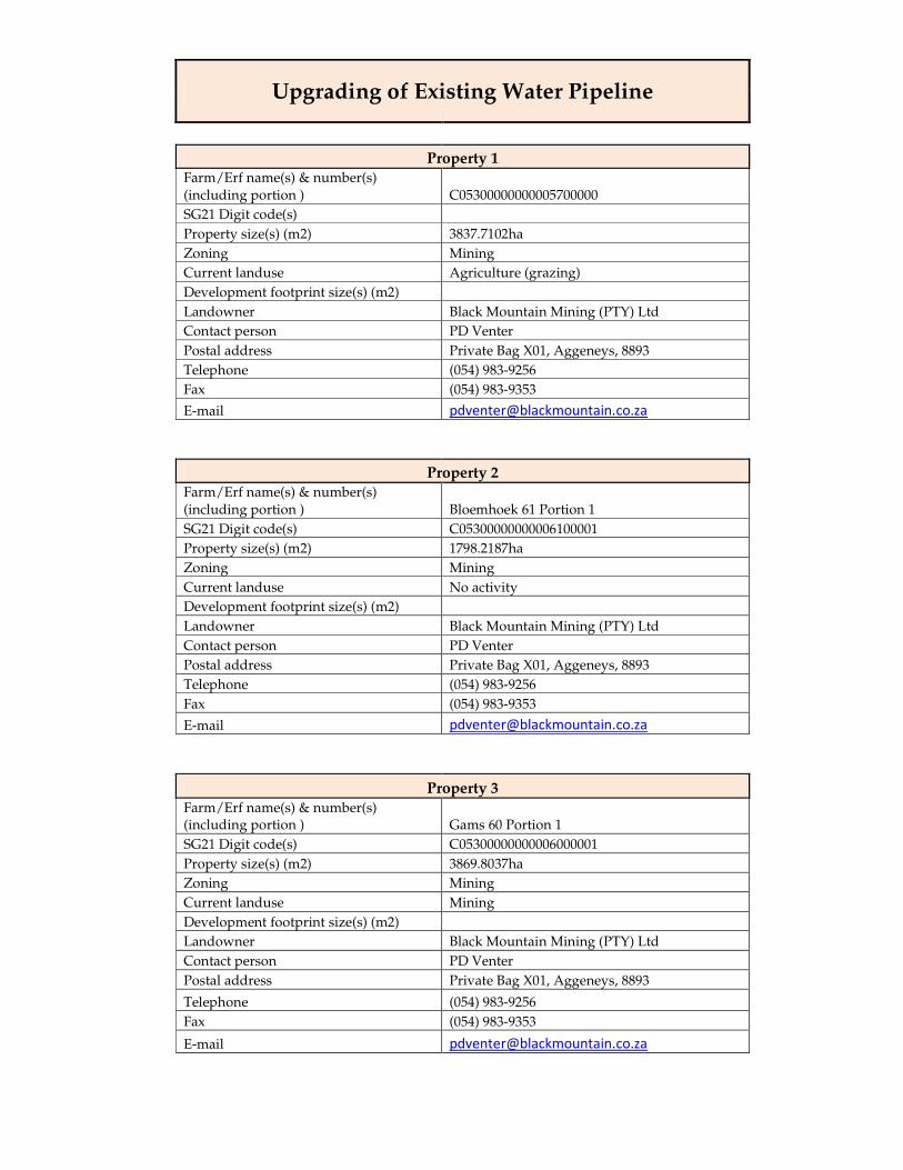
Upgrading of Existing Water Pipeline
Property 1
Farm/Erf name(s) & number(s) (including portion ) C05300000000005700000
SG21 Digit code(s)
Property size(s) (m2) 3837.7102ha
Zoning Mining
Current landuse Agriculture (grazing)
Development footprint size(s) (m2)
Landowner Black Mountain Mining (PTY) Ltd
Contact person PD Venter
Postal address Private Bag X01, Aggeneys, 8893
Telephone (054) 983-9256
Fax (054) 983-9353
E-mail [email protected]
Property 2
Farm/Erf name(s) & number(s) (including portion ) Bloemhoek 61 Portion 1
SG21 Digit code(s) C05300000000006100001
Property size(s) (m2) 1798.2187ha
Zoning Mining
Current landuse No activity
Development footprint size(s) (m2)
Landowner Black Mountain Mining (PTY) Ltd
Contact person PD Venter
Postal address Private Bag X01, Aggeneys, 8893
Telephone (054) 983-9256
Fax (054) 983-9353
E-mail [email protected]
Property 3
Farm/Erf name(s) & number(s) (including portion ) Gams 60 Portion 1
SG21 Digit code(s) C05300000000006000001
Property size(s) (m2) 3869.8037ha
Zoning Mining
Current landuse Mining
Development footprint size(s) (m2)
Landowner Black Mountain Mining (PTY) Ltd
Contact person PD Venter
Postal address Private Bag X01, Aggeneys, 8893
Telephone (054) 983-9256
Fax (054) 983-9353
E-mail [email protected]
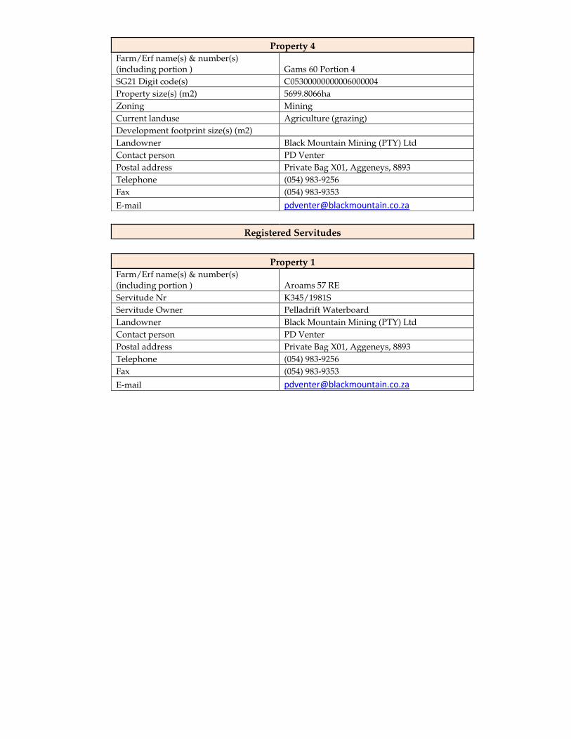
Property 4
Farm/Erf name(s) & number(s) (including portion ) Gams 60 Portion 4
SG21 Digit code(s) C05300000000006000004
Property size(s) (m2) 5699.8066ha
Zoning Mining
Current landuse Agriculture (grazing)
Development footprint size(s) (m2)
Landowner Black Mountain Mining (PTY) Ltd
Contact person PD Venter
Postal address Private Bag X01, Aggeneys, 8893
Telephone (054) 983-9256
Fax (054) 983-9353
E-mail [email protected]
Registered Servitudes
Property 1 Farm/Erf name(s) & number(s) (including portion ) Aroams 57 RE
Servitude Nr K345/1981S
Servitude Owner Pelladrift Waterboard
Landowner Black Mountain Mining (PTY) Ltd
Contact person PD Venter
Postal address Private Bag X01, Aggeneys, 8893
Telephone (054) 983-9256
Fax (054) 983-9353
E-mail [email protected]
New Transmission Line
Property 1
Farm/Erf name(s) & number(s) (including portion ) C05300000000005700000
SG21 Digit code(s)
Property size(s) (m2) 3837.7102ha
Zoning Mining
Current landuse Agriculture (grazing)
Development footprint size(s) (m2)
Landowner Black Mountain Mining (PTY) Ltd
Contact person PD Venter
Postal address Private Bag X01, Aggeneys, 8893
Telephone (054) 983-9256
Fax (054) 983-9353
E-mail [email protected]
Property 2
Farm/Erf name(s) & number(s) (including portion ) Bloemhoek 61 Portion 1
SG21 Digit code(s) C05300000000006100001
Property size(s) (m2) 1798.2187ha
Zoning Mining
Current landuse No activity
Development footprint size(s) (m2)
Landowner Black Mountain Mining (PTY) Ltd
Contact person PD Venter
Postal address Private Bag X01, Aggeneys, 8893
Telephone (054) 983-9256
Fax (054) 983-9353
E-mail [email protected]
Property 3
Farm/Erf name(s) & number(s) (including portion ) Gams 60 Portion 1
SG21 Digit code(s) C05300000000006000001
Property size(s) (m2) 3869.8037ha
Zoning Mining
Current landuse Mining
Development footprint size(s) (m2)
Landowner Black Mountain Mining (PTY) Ltd
Contact person PD Venter
Postal address Private Bag X01, Aggeneys, 8893
Telephone (054) 983-9256
Fax (054) 983-9353
E-mail [email protected]
Property 4
Farm/Erf name(s) & number(s) (including portion ) Gams 60 Portion 4
SG21 Digit code(s) C05300000000006000004
Property size(s) (m2) 5699.8066ha
Zoning Mining
Current landuse Agriculture (grazing)
Development footprint size(s) (m2)
Landowner Black Mountain Mining (PTY) Ltd
Contact person PD Venter
Postal address Private Bag X01, Aggeneys, 8893
Telephone (054) 983-9256
Fax (054) 983-9353
E-mail [email protected]
Registered Servitudes
Property 1 Farm/Erf name(s) & number(s) (including portion ) Aroams 57 RE
Servitude Nr K1117/2000S
Servitude Owner ESCOM
Landowner Black Mountain Mining (PTY) Ltd
Contact person PD Venter
Postal address Private Bag X01, Aggeneys, 8893
Telephone (054) 983-9256
Fax (054) 983-9353
E-mail [email protected]
Property 2
Farm/Erf name(s) & number(s) (including portion ) Gams 60 Portion 4
Servitude Nr K40/2001
Servitude Owner ESCOM
Landowner Black Mountain Mining (PTY) Ltd
Contact person PD Venter
Postal address Private Bag X01, Aggeneys, 8893
Telephone (054) 983-9256
Fax (054) 983-9353
E-mail [email protected]
Additional Housing
Property 1
Farm/Erf name(s) & number(s) (including portion ) Aggeneys 56 RE
SG21 Digit code(s) C05300000000005600000
Property size(s) (m2) 10316.7325ha
Zoning Housing
Current landuse
Development footprint size(s) (m2)
Landowner Black Mountain Mining (PTY) Ltd
Contact person PD Venter
Postal address Private Bag X01, Aggeneys, 8893
Telephone (054) 983-9256
Fax (054) 983-9353
E-mail [email protected]
Two Transport Options (Options 1 & 2)
Transport Option 1 - Property 1
Farm/Erf name(s) & number(s) (including portion ) Uitkyk 889 Portion 3
SG21 Digit code(s) C05300000000088900003
Property size(s) (m2) 35.5611ha
Zoning Rail siding and shed
Current landuse Railway loading
Development footprint size(s) (m2)
Landowner Black Mountain Mining (PTY) Ltd
Contact person PD Venter
Postal address Private Bag X01, Aggeneys, 8893
Telephone (054) 983-9256
Fax (054) 983-9353
E-mail [email protected]
Transport Option 1 - Property 2
Farm/Erf name(s) & number(s) (including portion ) F 197/Ptn 15
SG21 Digit code(s) C05300000000019700015
Property size(s) (m2) 4.4272ha
Zoning
Current landuse Storage of base metal products
Development footprint size(s) (m2)
Landowner
Contact person
Postal address
Telephone
Fax
Proclaimed Roads
Transport Option 1
Farm/Erf name(s) & number(s) (including portion ) Aroams 57 RE
Proclaimed Minor Road RL(P)5/2002
Servitude Owner PD Carstens
Landowner Black Mountain Mining (PTY) Ltd
Contact person PD Venter
Postal address Private Bag X01, Aggeneys, 8893
Telephone (054) 983-9256
Fax (054) 983-9353
E-mail [email protected]
Transport Option 2 - Property 1
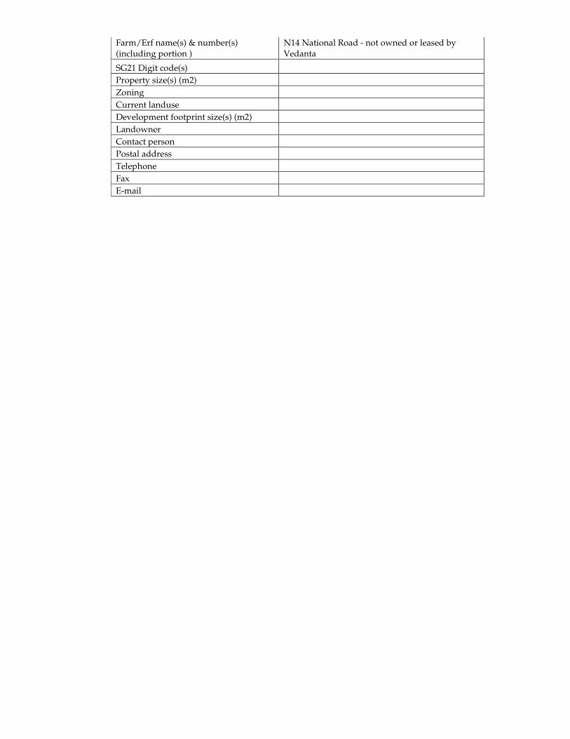
Farm/Erf name(s) & number(s) (including portion )
N14 National Road - not owned or leased by Vedanta
SG21 Digit code(s)
Property size(s) (m2)
Zoning
Current landuse
Development footprint size(s) (m2)
Landowner
Contact person
Postal address
Telephone
Fax
Enquiries: C.D. Smuts/ A.T. Makaudi Private Bag X6102, Kimberley, 8300 E-mail: [email protected] Tel. (053) 8074800/Fax (053) 8313530
Appendix C: Project Infrastructure Summary Table
TABLE 1.1 SUMMARY TABLE OF CONSTRUCTION PHASE PROJECT INFRASTRUCTURE
Project component Location Specification/ Detail
Construction Phase components Bulk Requirements Water: Off take from existing
bulk supply pipeline between Pella and Aggeneys.
• 2,000 m3 of water per day required. • Sourced from the Orange River via an
off take pipe of 5 km that extends from the Pella Water Board water pipeline, located to the north of the N14.
• The off take pipe will be 550 -750 mm in diameter and will be constructed aboveground from the discharge point to the mine, except for the section that crosses the N14.
• The off-take pipe covers an area of 0.5 hectares.
• 1 reservoir located along this pipeline. It will be located near to the plant construction site.
• The construction footprint of the pipeline is 1000 m2
Power: • The construction phase is expected to require a temporary 4 MVA supply point on the existing Gamsberg 11kV line using 21 million kilowatts hour per year.
• The electricity will be supplied to the construction site via a 5km overhead line and 4 x 500kVA miniature substations.
• One of the substations will be in a fixed position at the construction camp and the other 3 will be movable units on the construction site. One miniature substation has a footprint of about 4m2.
Sewage: Located near the Contractors Camp
• There will be one sewage plant constructed common for the construction and operation
Fuels and lubricants: Located within the contractors camp
Fuel: • 50 m2 bund area • Total storage of 100 m3 per day
Lubricants: • 10 m2 bund area • Total storage of 20 m3
Construction Camp Just on the South of the plant, west of inselberg.
A total area of 2 to 4 hectares, including the following facilities:
o Workshop o Office complex o Truck yard and vehicle parking o Washing and servicing of
equipment o Potential for storm-water capture
and re-use Temporary Staff Housing
Located within the contractors camp
• 5 000 construction jobs over a 30 month period
• Total area of approx. 30 hectares • Total of 500 units • 0.2 Million kW-hours per annum • Bulk water requirement of 250 m3 of
water/day Waste Management Facilities
Contractors’ camp Two separate contractors employed to collect and dispose domestic and hazardous wastes. Domestic wastes:
• Paper and plastics will be recycling • Disposed of at a registered landfill
facility –Existing landfill facility at BMM will be used
• Industrial waste include steel, packaging material and material off-cuts
• Total area of 200 m2 Hazardous wastes: • Mainly oil contaminated wastes • Storage facility capacity – 0.5 hectares • Disposed of at a registered hazardous
landfill facility • Collected and disposed of once in a
month • Total area of 100 m2
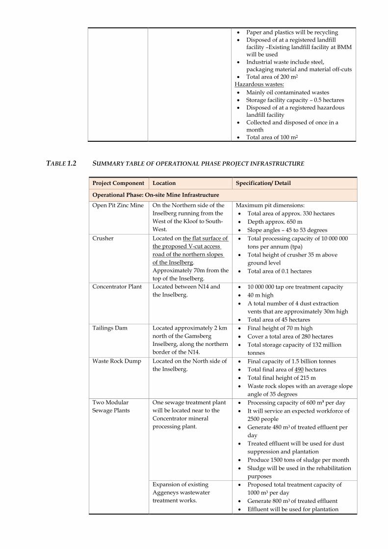
TABLE 1.2 SUMMARY TABLE OF OPERATIONAL PHASE PROJECT INFRASTRUCTURE
Project Component Location Specification/ Detail
Operational Phase: On-site Mine Infrastructure
Open Pit Zinc Mine On the Northern side of the Inselberg running from the West of the Kloof to South-West.
Maximum pit dimensions: • Total area of approx. 330 hectares • Depth approx. 650 m • Slope angles – 45 to 53 degrees
Crusher Located on the flat surface of the proposed V-cut access road of the northern slopes of the Inselberg. Approximately 70m from the top of the Inselberg.
• Total processing capacity of 10 000 000 tons per annum (tpa)
• Total height of crusher 35 m above ground level
• Total area of 0.1 hectares
Concentrator Plant Located between N14 and the Inselberg.
• 10 000 000 tap ore treatment capacity • 40 m high • A total number of 4 dust extraction
vents that are approximately 30m high • Total area of 45 hectares
Tailings Dam Located approximately 2 km north of the Gamsberg Inselberg, along the northern border of the N14.
• Final height of 70 m high • Cover a total area of 280 hectares • Total storage capacity of 132 million
tonnes Waste Rock Dump Located on the North side of
the Inselberg.
• Final capacity of 1.5 billion tonnes • Total final area of 490 hectares • Total final height of 215 m • Waste rock slopes with an average slope
angle of 35 degrees Two Modular Sewage Plants
One sewage treatment plant will be located near to the Concentrator mineral processing plant.
• Processing capacity of 600 m³ per day • It will service an expected workforce of
2500 people • Generate 480 m3 of treated effluent per
day • Treated effluent will be used for dust
suppression and plantation • Produce 1500 tons of sludge per month • Sludge will be used in the rehabilitation
purposes Expansion of existing Aggeneys wastewater treatment works.
• Proposed total treatment capacity of 1000 m3 per day
• Generate 800 m3 of treated effluent • Effluent will be used for plantation
• Generate 2500 tons of sludge per month. • Sludge will be used in the rehabilitation
purposes Sewerage collection sump
Near the Concentrator Plant • Expected to service mine work force of approximately 140 people
• Total capacity of 70 m³ (7 days storage) • Total area of 40 m²
Treated sewage effluent dam
Located near Sewage treatment plant
• 7 day capacity • HDPE lined pond • Total depth of 5m • Total height above ground is maximum
1.5 m • Total storage capacity of 1200 m³ • Total area of approx. 250 m²
Salvage Yard Located within the Plant. • Total footprint of 750 m2 • Total storage capacity of 1800 m3 for
general wastes • Maximum height of 3 m
Domestic Waste Facility
Located within the Plant. • Total footprint of 100m² • Total capacity of 150 m³ • Maximum height of 2 m • Waste to be disposed of at the
designated site. Temporary Hazardous Waste Management Facility
Located within the Plant. • Storage capacity of 100 m3 • Total area of 150 m2 • Maximum height of 2 m • All hazardous waste collected will be
transferred to the Vissershok hazardous waste disposal facility.
Internal Haul and Mine Area Roads
All haul and mine area roads are depicted on the map.
• 10 km of internal haul and mine area roads
• All haul roads, including the pit access road, is 45 m wide gravel road
• All mine roads would be 10 m wide • Slope angles of roads not more than 10
degrees • Gravel road, compacted with surface
material • Total footprint area of internal haul and
mine area roads 55 Ha • Surface material sourced from suitable
overburden material and/or available burrow pits at Lemoenplaas
• Length and width of any buffer areas, stormwater infrastructure, fencing etc. (i.e. any associated infrastructure)
• An existing approach road towards Western side of the Inselberg will be widened to 12 m width (including 2m shoulder on either side) as approach for start-up activities. Main & permanent approach road will be constructed from Northern side, once the permission is granted.
Plant Area Roads Plant area roads are located on the map.
• 4 km of total plant area road • 6 m and 8 m wide, depending on
function • The construction footprint of the plant
roads is maximum 12 m wide
• Total area of off-road parking 5000 m² • Access tracks for inspection and
maintenance: Total area of 1000 m² Material Laydown and Storage Area
Located within the Plant. • Total area of 2,500 m2
Equipment and Engineering Workshops
Workshop one located within the Plant.
• Total area of 1 Ha
Workshop two (heavy duty workshop) located between the process plant and waste rock dump sites, along the plains.
• Total area of 1.5 Ha
Ore Stockpiles
In-pit open stockpile area (prior to primary crushing). Location reflected on layout plan.
• Total area of 1 Ha • Maximum height of 4 m
Open stockpile area located within the Plant (prior to secondary crushing).
• There is no secondary crushing
Ore stockpiles (4 Nos – two ore, blended ore and one concentrate) area located within the Plant.
• Maximum height of 20 m • Width of 54 m • Length of 90 m for high grade, 72 m for
low grade and 60 m for blended. Zinc concentrate stockpile located within the Plant.
• Storage capacity of 7 days • Total area of 0.25 Ha • Maximum stockpile height of 12 m • 50 m in length
Administrative Office Block
Located within the Plant. • Total area of 1,500 m2 • Maximum height of 12 m • Expected to contain more than 100
employees, working 7 days a week Control Rooms Control room 1: Located
within the Plant. • Total area of approximately 300 m² • Maximum height of 12 m
Equipment Wash Area
Located within the Plant. • Total area of 750 m² • 45,000 m3 of water will be required
annually • The water will be sourced from recycled
water reservoirs only Explosives Storage Area and Ammonium Nitrate and Emulsion Silos
Located on the North of Inselberg, in the plain area.
• Total area of 20 hectares • Total height of 12m • 2 x 85 ton Emulsion silos and 2 x 50 ton
silos Parking Area Located adjacent to the
Plant. • Total area of 5,000 m2 • The material to tar the road will be
sourced from waste rock / borrow pit • It will accommodate 300-350 vehicles
Stormwater Management Infrastructure
Storm water dam to be constructed adjacent to and south of the Plant and along the western foothills of the Inselberg.
• There will be one storm water dam • Total storage capacity will be 5000 m3 • Each dam cover a total area of 1000 m2 • Wall height above ground of 3 m
(Partially below ground) Bulk Storage Tank Farms
Adjacent to the Plant as reflected on the layout plan.
• Store 100 m3 of diesel and petrol • Total area of 400 m2 (fuel, oil and
lubricants storage area) • 2 fuel supply points
Located adjacent to the mine workshop area (Fuel, oil & lubricant storage) as depicted on the layout plan.
• Store 500 m3 of diesel • Total area of 2,500 m2 • 6 re-fueling bays • 5,000 litres of lubricants
• Total area of 1,000 m² Medical clinic Located within the Plant. • Total area of 80 m2
• Total height of 6 m • Result in production of hazardous
wastes of 5-6 kg per month Internal Conveyor System
From the Primary crusher located at open pit to the northern face of the Inselberg up to the stockpiles
• Closed system; • The conveyor will be 2 m wide and
approximately 2.5 km long.
Raw water Storage Dam
Located within the Plant. • 1 dam • Storage capacity of 25, 000 m3 • Wall height of 4.5 m • Source of water: Orange River, via the
Pella Water Board water supply system. Process Water Dam Located within the Plant. • A total number of 1 dam
• Storage capacity of 25,000 m3 • Wall height of 4.5m • Sources of process water: recycled water
from the plant, treated water and make-up water from raw water dam
Dust Suppression Tank
Located in the plain area adjacent to the plant.
• There will be one metallic/concrete tank • Storage capacity of 1,000m3 • Max height of 4.5m • Source of water: raw water dam
Fire Control System Water from raw water storage dam is pumped to a clean water tank. From there it will be pumped to the fire hydrant pipe network
• There will be a tank with a storage capacity of 2000 m3
• Wall height of 5m • Source of water: raw water dam
Return water dams Located between the tailings dam and N14
• Three pollution control dams to be constructed adjacent to the tailings facility.
• A total cumulative storage capacity of 25 000 m3.
• Three meters high dam wall and cover a total area of half hectare.
• HDPE lined. Entrance and Exit Points
Main entrance/exit point will be Located along the southern border of the N14. Second entrance/exit point will be located along the western border of the inselberg, leading onto the existing Loop 10 gravel road.
• Main entrance/exit point: Total width of 45 m; Tar road.
• Second entrance/exit: Total width of 15 m; Compacted gravel road
• Surface material sourced from existing borrow pit located north of the inselberg.
Security and induction training areas
Near the main entrance, along the southern border of the N14.
• Security single storey building, covering a total area of approximately 120 m²
• Induction training area covering a total area of approximately 500 m²
Operational Phase: Off-site Mine Infrastructure
Power Infrastructure Including Sub-stations and Distribution Lines
Two sub-stations along the northern and southern border of the N14 and two connecting distribution lines.
• The 220kV/66V substation will cover a total area of 2 hectares and reach a total height of 8 m
• 66 kV/11kV sub-station • The 660kV/11KV substation will cover a
total area of 1 hectares and reach a total height of 8 m
• Two 66 kV distribution lines • The connecting distribution lines will
extend 3 km and require 12 pylons, with a span length of 6m each.
• The distribution lines will cover a total distance of 10 km and total footprint of 2 Ha.
Operational Phase Housing
Located in the town of Aggeneys, between the northern and southern township.
• An additional 1000 houses • Will cover a total area of 100 hectares • Require 12 Million kW-hour of power
per annum • Generation of approximately
1 200 m3 of additional sewage per day • Requires 1500 m3 of water per day
(sourced from Orange River) Transport Corridor:
Extends from proposed mine to Saldanha Bay Port, via two transport options.
Option 1: • Truck via the N14 and N7 to Saldanha
Bay Port. • No. of trucks required per day: Phase 1
= 30; Phase 2 = 30; Phase 3 = 45. Option 2: • Concentrate will be trucked 160 km
along the Loop 10 Gravel Road to Loop 10 siding and then loaded onto the Sishen-Saldanha Railway Line during phases 2 and 3.
• No. of trucks required per day: Phase 2 = 30; Phase 3 = 45.
Loop 10 Infrastructure for the storage and handling of zinc concentrate will be required at Loop 10
BMM has an existing offloading facility at Loop 10 siding. The existing storage shed at the siding covers a total area of 2000 m² and has a total height of 10 m. It is anticipated that additional facilities, located within the existing disturbed footprint will accommodate Phase 2 volumes of zinc concentrate generated by Gamsberg. However, due to the expected volumes at Phase 3 of production (500 000 Mtpa), additional infrastructure will be required at BMM’s existing Loop 10 siding facility, which is as follows: • Truck unloading and wash station; • Truck Loading Facilities and
Equipment (324nos of 67ton trucks per week);
• Truck Cue/Parking; • Concentrate Storage Facility; • Support Facilities/offices/lab; • Rail Wagon Loading Facilities and
Equipment; and • Rail Yard/Storage.