Embed Size (px)
Citation preview

EL DORADO COUNTY TRANSPORTATION COMMISSION
PREPARED FOR PREPARED BY
Active Transportation Connections Study

TABLE OF CONTENTS
PurposeActive transportation projects, such as new walkways and bikeways, are often funded by grants. The scoring rubric for these grants tend to emphasize - directly or indirectly - projects located near large population centers with dramatic safety issues and equity concerns, making it
.
for walking and bicycling as one of the County’s overarching transportation goals,1 but c
. Selecting projects that have the greatest probability of receiving funding helps maximize limited County resources.
El Dorado County Transportation Commission’s (EDCTC) Active Transportation Connections Study outlines a
and provides a preliminary prioritization of already adopted active transportation projects.
The Active Transportation Connections Study was funded by a State Highway Account - Sustainable Communities Transportation Planning Grant awarded by the California Department of Transportation.
1 | EDCTC Active Transportation Connections Study

CMAQ
ProcessTo identify which proposed projects in El Dorado County’s western slope would be the most competitive under various regional, state, and federal grant application criteria,
:
While the scoring varied among Caltrans’ Active Transportation Program (ATP), Caltrans’ Highway Safety Improvement Program (HSIP), and the federal Congestion Mitigation and Air Quality Improvement Program (CMAQ), each shared common evaluation areas:
.
These seven common evaluation areas form the foundation for this study.
. In the event that no locations in the county would perform well under
provided insight into a project’s ability to address local concerns. For example, proposed projects in El Dorado County typically perform poorly
income households or schools with a large percentage of students that are eligible for free and reduced lunches. In lieu of including an equity evaluation criterion that would align well with grant applications but show few eligible projects in El Dorado County, EDCTC and its advisory committee elected to select an equity evaluation criterion that would help with internal prioritization: the number of youths and seniors living near a proposed project. This approach allows EDCTC to identify projects that would have strong equity implications within the county even though they may not perform well under some grant application criteria.
2 | EDCTC Active Transportation Connections Study

76
77
10
43
9
70
62
56
6339
16
74
65
80
48
28
29
50
5532
64
79
12
11
8
61
1
38
18
36
67
51
30
54
75
40
20
27
33
7
78
53
52
73
37
84
5783
6
68
14
49
69
472
86
19
25
89
26
21
58
41
8113
82
85
84
88
71
66
59
59
31
35
34 45
24
44
4642
3
17
22
19
52
23
4715
Existing Bikeways/Paths
District 1District 2District 3District 4District 5
Proposed Bikeways/Paths
0 2.25 4.5 mi N
50
50
Existing & Adopted Projects
PROJECTSThe active transportation projects evaluated in this initial study were pulled from plans adopted by El Dorado County or other jurisdictions within the western slope of El Dorado County. These plans include the El Dorado County Bicycle Transportation Plan (2010) and the City of Placerville Non-Motorized Transportation Plan (2010). Because these plans focused on bicycle infrastructure, the projects evaluated were limited to on-street bikeways and multi-use paths, as shown in the map above. However, the
by the County or local jurisdiction. Any future update to this study should include a review of recently adopted or updated plans and their lists of proposed projects. Click here for the full list of projects evaluated in this initial study.
Click here for corresponding project names and descriptions
3 | EDCTC Active Transportation Connections Study
19349
50
49
50
POLLOCKPINES
GEORGETOWN
LOTUS
COLOMA
SMITHFLAT
CAMINO
DIAMONDSPRINGS
EL DORADO
PLACERVILLE
CAMERONPARK
EL DORADOHILLS
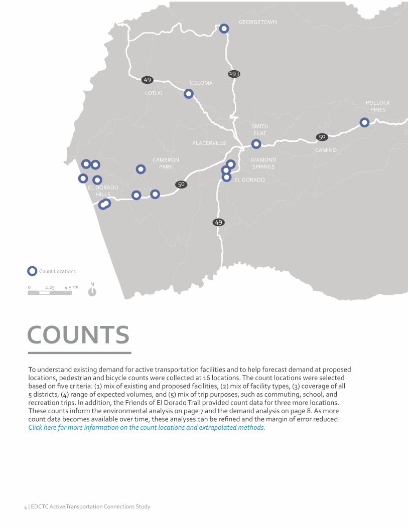
COUNTS
0 2.25 4.5 mi N
Count Locations
To understand existing demand for active transportation facilities and to help forecast demand at proposed locations, pedestrian and bicycle counts were collected at 16 locations. The count locations were selected
5 districts, (4) range of expected volumes, and (5) mix of trip purposes, such as commuting, school, and recreation trips. In addition, the Friends of El Dorado Trail provided count data for three more locations. These counts inform the environmental analysis on page 7 and the demand analysis on page 8. As more
Click here for more information on the count locations and extrapolated methods.
4 | EDCTC Active Transportation Connections Study

$
Criteria. The lone
common grant application requirements, so there was no need to consider
for each evaluation area and methodology are documented in separate memorandums linked below. The following section summarizes each evaluation area and the preferred evaluation criteria.
5 | EDCTC Active Transportation Connections Study

34%-35% 33% 32% 31%
9
3936
5
Percent of adults within 2 miles of projects that walk at least 150 minutes/ week (CHIS, 2014)
Evaluation Criterion: Physical Activity
below state average of 33%
MoreCompetitive
Less Competitive
Num
ber o
f P
ropo
sed
Proj
ects
HEALTH
Understanding the importance of transportation investments on health outcomes is a featured component in El Dorado County’s Regional Transportation Plan. It notes that if the design of new and/or rehabilitated facilities considers the needs of pedestrians and bicyclists, the transportation network can contribute to
B states, “EDCTC plans and programs will enhance the quality of life in the region by supporting transportation improvements that increase opportunities for a strong jobs-housing balance, environment, economy, education, , recreation, and civic involvement.”2
Projects that address public health are also more competitive in grant applications. The most recent cycle of Caltrans’ Active Transportation Program (ATP) focused on projects that address the health vulnerabilities of a proposed project’s targeted users and the potential of a proposed project to promote healthy communities.3
The preferred health evaluation criterion is the percent of adults within 2 miles of a proposed project that walked at least 150 minutes for transportation or leisure in the past week - the minimum level of physical activity recommended by the Centers for Disease Control and Prevention. Physical activity serves as a proxy for a variety of health concerns such as obesity, diabetes, heart disease, mental health, and other chronic diseases. When applied to the list of adopted projects, the average physical activity level of residents near 44 of the 89 proposed projects fell below the state average of 33%, while the remaining 45 proposed projects outperformed the state average. Click here to see the other health criteria considered.
The California Health Interview Survey (CHIS) is a statewide survey covering a variety of health behaviors and outcomes. Data is collected through a random-dial telephone survey and is conducted on a continuous basis, providing one-year estimates at the state, county, and zip code levels.4
6 | EDCTC Active Transportation Connections Study

Evaluation Criterion: Emissions Reductions
0 - 30,000 30,001- 70,000 70,001 - 116,000
46
Estimated annual greenhouse gas and criteria pollutant emissions reduced (lbs)
32
11
ENVIRONMENT
MoreCompetitive
Less Competitive
Num
ber o
f P
ropo
sed
Proj
ects
Transportation systems that support walking and bicycling reduce reliance on motor vehicles, especially for short trips, resulting in reduced emissions of greenhouse gases and other criteria pollutants. This not only improves air quality, but also reduces the potential for pollutants
and local waterways. Replacing driving trips with active transportation trips supports Guiding Principle B of El Dorado County’s Regional Transportation Plan and the State of California’s climate action goals.5,6
Projects that encourage sustainable transportation are also more competitive in grant applications such as the US DOT Transportation Investment Generating Economic Recovery (TIGER) discretionary grant,7 California’s Urban Greening Grant program,8 and Caltrans’ Sustainable Transportation Planning Grant program.9 These grant programs include application elements focused on estimated reduction in greenhouse gases or environmental sustainability.
The preferred environmental evaluation criterion is the estimated pounds of greenhouse gases and other criteria pollutants that would be removed from the atmosphere each year if the proposed projects were built. This criterion matches common grant application requirements, and, when applied to the adopted project list, it provides a clear distinction between projects. Among the 89 proposed projects, 11 would reduce greenhouse gas and criteria pollutant emissions over 70,000 pounds per year - that’s the equivalent savings of at least 3,500 gallons of gasoline consumed.10 Click here to see the other environmental criteria considered.
Estimated reductions in greenhouse gas and criteria pollutant emissions are a derived from vehicle-miles traveled reduction estimates. The method relies on demand analysis, national trip replacement, and national trip distance factors to understand how many new active transportation trips might replace motor vehicle trips and the average emissions produced by those vehicles.11
7 | EDCTC Active Transportation Connections Study

0 - 49 50 - 199 200 - 399 400+
2324
22
20
Estimated daily pedestrian and bicyclist demand/ day
Evaluation Criterion: Pedestrian/Bicycle Demand
MoreCompetitive
Less Competitive
DEMANDN
umbe
r of
Pro
pose
d Pr
ojec
ts
Forecasting demand helps identify projects that are more likely to be well used by local residents and visitors to El Dorado County. Projects that can demonstrate high future demand from pedestrians and/or bicyclists tend to be more competitive in grant applications, including the Caltrans’ Active Transportation Program (ATP), Caltrans’ Highway Safety Improvement Program (HSIP), and US DOT‘s TIGER grants. The most recent ATP application requirements assigned up to 35 out of 100 total points to projects that clearly and convincingly demonstrated a meaningful increase in the number of people walking and bicycling in the project area as a result of implementation.12
Funding and building projects with high anticipated user demand is also consistent with the goals of EDCTC’s Regional Transportation Plan, which calls for the development of an integrated multi-modal transportation system that supports the needs of its users and enhances
Objective C under Highways, Streets, and Regional/
demand, and prioritization for all travel modes and users.13
Forecasted demand estimates were based on counts of people walking or bicycling on paths or other travelways similar to the proposed project and on demographic and socioeconomic data about the people and surrounding environment where the facility is located. EDCTC collected pedestrian and bicycle count data at 19 locations and performed a regression analysis to forecast demand near the proposed project locations.
The pedestrian demand model for El Dorado County showed moderate to strong relationships between the number of people walking and 11 factors, including street density, lack of access to a motor vehicle, proximity to schools, and population 18-34 years old living near the proposed projects. The bicycle demand model showed moderate to strong relationships with 8 factors, including the number of activity centers, travel time to work, and mode share near the proposed projects. Click here to see how the models were developed and other factors considered.
8 | EDCTC Active Transportation Connections Study

0 - 160,500 106,501 - 254,000 254,001 - 383,250 383,251 - 1,233,000
1520
33
21
Estimated number of trips beginning and ending near proposed projects (2010)
Evaluation Criterion: Origins & Destinations
MoreCompetitive
Less Competitive
CONNECTIVITYN
umbe
r of
Pro
pose
d Pr
ojec
ts
Connectivity is a commonly featured criterion in active
projects that will have the greatest impact on increasing residents’ ability to walk and bicycle to destinations like work, grocery stores, community centers, schools, and shops. Pedestrians and bicyclists are more sensitive to disconnected travelways and long trip distances than motorists, making connectivity an important factor in the decision to walk or bicycle for a given trip.
Although connectivity is not often a quantitative component of common grant applications, some grants do look for qualitative descriptions about improved accessibility and the elimination of gaps in the pedestrian and bicycle network. For example, the last cycle of Caltrans’ Active Transportation Program (ATP) required a description of how a project improves connectivity for non-motorized transportation users.14
In addition, improving connectivity is also a major theme in EDCTC’s Regional Transportation Plan, which seeks to
transportation system which is part of a balanced overall transportation system for all users.”15
The preferred connectivity evaluation criterion is the annual existing number of trips that begin or end near the proposed project. This criterion serves as a proxy for how many people are likely to visit a project area by any mode of travel. When applied to the adopted list of projects, the estimated number of trips ranged between 0 and 1.233 million total trips per year by all modes. Click here to see the other connectivity criteria considered.
Estimates of the number of trips that begin or end near a given project were provided by El Dorado County’s travel demand model.16 The model divides the county into non-overlapping zones called Transportation Analysis Zones (TAZs). Using survey, land use, and demographic data, the model estimates the total number of trips that begin or end within each TAZ. For this evaluation criterion, proposed projects were assigned all of the estimated trips of the TAZs in which their alignment intersected.
9 | EDCTC Active Transportation Connections Study

1 2 3 4+
43
27
17
2
Number of safety barriers addressed by proposed projects
Evaluation Criterion: Safety Barriers
MoreCompetitive
Less Competitive
SAFETYN
umbe
r of
Pro
pose
d Pr
ojec
ts
travel behavior. Pedestrians and bicyclists face unique safety concerns resulting from roadway designs that often favor motor vehicle travel, and are relatively more vulnerable compared to people traveling inside a motor vehicle. This is especially true for those with physical disabilities. Improving safety conditions can make the transportation network more accessible and attractive to people of all ages and abilities, enabling more people to walk or bicycle.
Safety criteria are commonly featured in grant applications, and are often heavily weighted compared to other scoring categories. Applications for Caltrans’ Active Transportation Program (ATP) and its Highway Safety Improvement Program (HSIP) required projects to demonstrate how they will improve safety and reduce crashes and injuries.17,18 Additionally, safety is emphasized in El Dorado County’s Regional Transportation Plan under Guiding Principle F which states, “EDCTC will plan for transportation investments which improve and/or maintain the safety and security of the transportation system and its users.”19
The preferred safety evaluation criterion is the number of safety barriers that would be removed if a project was implemented. Unlike an evaluation criterion based solely on crash data at a location, this measure accounts for locations where barriers to safety may exist but no walking or bicycling activity is present. It is particularly suited to analyzing safety barriers in rural areas and helps
action. Click here to see the other safety criteria considered.
This performance measure relies on expert analysis to identify challenges presented by the existing design of a travelway and potential opportunities presented by the proposed project. It allows for a more nuanced view of safety in a rural area like El Dorado County, where low recorded numbers of walking or bicycling related collisions may not accurately represent challenges or capture how these challenges limit walking and bicycling.
10 | EDCTC Active Transportation Connections Study

0 - 2,000 2,001 - 3,000 3,000 - 4,000 4,001 - 7,200
16
29
23 21
Number of youths and seniors within 2 miles of proposed projects (ACS, 2011-2015)
Evaluation Criterion: Youths & Seniors
MoreCompetitive
Less Competitive
EQUITYN
umbe
r of
Pro
pose
d Pr
ojec
ts
Without access to multiple transportation options,
accessing healthy food, going to school, or engaging in social activities. Ensuring equitable access to walking and bicycling facilities for transportation is particularly important for communities that have historically been disadvantaged, do not have access to a motor vehicle, rely heavily on walking and bicycling for their daily transportation needs, or are otherwise disconnected from active transportation opportunities.
Caltrans’ Active Transportation Program (ATP) awarded points for projects that close a gap, provide a new
transportation network within a disadvantaged area.20 El Dorado County’s Regional Transportation Plan also promotes equity in Guiding Principle E: Diversity, which states, “EDCTC plans and programs will recognize the multitude of needs and the variety of perspectives and backgrounds of the people that live, work, and visit the region by promoting a range of equitable transportation choices that are designed with sensitivity to the desired context while preserving the unique character of each community or sub region.”21
The preferred equity evaluation criterion is the number ofyouths (18 years and under) and seniors (64 years and over) within 2 miles of a proposed project. Providing transportation options for these two demographic groups is a growing concern for the County as the overall population has seen a spike in the number of youths and seniors over the past 10 years.22 In addition to youths and seniors, providing transportation options for people with disabilities is a growing concern for the County. Because it is not a common grant criteria, it was not selected as the preferred equity evaluation criterion, but it must be considered in the design of funded facilities. Click here to see the other equity criteria considered.
The US Census Bureau provides demographic data, including age, for a wide variety of geographies from statewide down to individual Census block groups. This data is easily accessible, collected consistently across multiple years, and available at a scale that allows
23
11 | EDCTC Active Transportation Connections Study

Evaluation Criterion: Estimated Capital Costs
COST-EFFECTIVENESS
< $75k$75k - 149k$150k - $500k>$500k
13
22 23
58
Estimated Capital Costs of Proposed Projects
MoreCompetitive
Less Competitive
Num
ber o
f P
ropo
sed
Proj
ects
Health, environment, demand, connectivity, safety, and
its costs may be prohibitive to pursuing outside funding.
as other projects, but its relatively low cost may make it a
a combination of low-cost projects may have as large an impact as one project with a hefty price tag.
El Dorado County’s Regional Transportation Plan promotes the concept of Complete Streets because integrating sidewalks, bike lanes, and other multi-
design into a project from the start than to add after construction. Objective C of the plan calls for a focus
transportation system. Similarly, a common grant application requirement is to show a measure of cost-
ratio for HSIP grants to a more qualitative description in ATP grants.
estimated capital costs of the proposed projects. This
evaluation criteria with the amount of funding needed to construct a given project. The estimated capital costs of the proposed project list ranged roughly $10,000 to $1.9 million. considered.
For this analysis, the capital cost of Class I multi-use paths was assumed to be $480,000 per mile, and the capital cost of Class II on-street bicycle lanes was assumed to be $133,000 based on an analysis of pedestrian and bicycle costs conducted by the Pedestrian and Bicycle Information Center, Robert Wood Johnson Foundation, and Federal Highway Administration. These general
estimates as they become available.
12 | EDCTC Active Transportation Connections Study

54%
Trip PurposeThe majority of respondents who walk multiple days per week, walk for recreation or exercise
Trip DistanceThe majority of respondents who walk, travel less than one mile to their destination for non-recreational trips
TrTheesrav
milor
trip
Trrertttrmmmffotr
66%
Pavement Markings
Visibility
Pavement Condition
Vertical Protection
Safe Crossings
32%
48%
50%
57%
59%
59%
64%
“Very Important” Bike Safety Factors
DemandThe majority of respondents strongly agreed or somewhat agreed that they would like to walk or bike more for daily trips
DeTheesgrgrke
mo
Trreraaaaaaallim
65%
Feedbackmeans:
Online SurveyAdvisory CommitteePublic Workshop
The received 365 responses between August 2, 2016 and November 29, 2016 and was advertised through a project-
or stakeholder connected with the diverse members of the advisory committee. The purpose of the survey was to capture background information on existing walking and bicycling behavior and preferences to inform the selection of evaluation criteria or to support future active
of respondents’ walking and bicycling trips were for recreation or exercise, emphasizing respondents’ showed that the majority of respondents were not willing to walk more than a mile to their destination, emphasizing the
between active transportation infrastructure and major activity centers. Respondents also expressed a large range of safety
of safety concerns and the relative lack of existing non-recreational walking and bicycling trips suggested that
. However, the majority of respondents expressed a desire to walk or bicycle more for daily trips such as going to the grocery store, work, school, or to connect to transit. Taken together, this suggests that El Dorado County residents may make more walking and bicycling trips if infrastructure is built that provides the amenities of a recreational route, connections to multiple destinations, and decreases safety concerns. Click here to read more about the survey results.
An various public agencies in El Dorado County provided input in
and the selection of evaluation criteria. The committee met in person or by conference call six times to ensure each component
to-date and relevant data, and isolated the criteria most imitative of grant application requirements for which the County might be eligible. Click here to read the advisory committee meeting notes.
13 | EDCTC Active Transportation Connections Study

PUBLIC WORKSHOP
To collect feedback on the preferred evaluation criteria and their relative importance to El Dorado County residents, EDCTC hosted a at the Placerville Earth Day Festival on April 22, 2017. Attendees were asked to complete a prioritization exercise in which they
. For example, in a head-to-head match-up between health and demand, attendees indicated on a sliding scale that health was ‘much more important’, ‘slightly more important’, ‘slightly less important’, or ‘much less important’ than demand as a measure for deciding which active transportation projects should be prioritized for funding. This process, known as pairwise comparisons, allowed EDCTC to understand the weight that residents place on various components of pedestrian and bicycle projects and to contrast those weights with common grant application weighting schemes. Click here to read more about the public engagement process for this study.

Prioritiesmeans:
Online SurveyAdvisory CommitteePublic Workshop
The received 365 responses between August 2, 2016
webpage, the City’s website, and email blasts to interested listservs. The purpose of the survey was to capture background information on existing walking and bicycling behavior and preferences to inform the selection of evaluation criteria or to support future active transportation
respondents’ walking and bicycling trips were for recreation or exercise, emphasizing respondents’ fthat the majority of respondents were not willing to walk more than a mile to their destination, emphasizing the
between active transportation infrastructure and major activity centers. Respondents also expressed a large range of safety
of safety concerns and the relative lack of existing non-recreational walking and bicycling trips suggested that
. However, the majority of respondents expressed a desire to walk or bicycle more for daily trips such as going to the grocery store, work, school, or to connect to transit. Taken together, this suggests that El Dorado County residents may make more walking and bicycling trips if infrastructure is built that -provides the amenities of a recreational route, connections to multiple destinations, and decreases safety concerns. Click here to read more about the survey results.
An various public agencies in El Dorado County provided input on
and the selection of evaluation criteria. The committee met in person or by conference call six times to ensure each component
to-date and relevant data, and isolated the criteria most imitative of grant application requirements for which the County might be eligible. Click here to read the advisory committee meeting notes.
15 | EDCTC Active Transportation Connections Study

OVERALL
HEALTH [1]
ENVIRONMENT [1]
DEMAND [1]
CONNECTIVITY [1]SAFETY [1]
EQUITY [1]
COSTS [1]
Assumed Equal Weighting
16 | EDCTC Active Transportation Connections Study

PUBLIC WORKSHOP
HEALTH [13]
ENVIRONMENT [15]
DEMAND [11]
CONNECTIVITY [20]SAFETY [27]
EQUITY [13]
COSTS [0]
Focused on Safety & Connectivity
17 | EDCTC Active Transportation Connections Study

ATP
HEALTH [10]
ENVIRONMENT [0]
DEMAND [20]
CONNECTIVITY [15]SAFETY [25]
EQUITY [10]
COSTS [5]
Focused on Demand & Safety
18 | EDCTC Active Transportation Connections Study

HSIP
HEALTH [0]
ENVIRONMENT [0]
DEMAND [3]
CONNECTIVITY [0]SAFETY [10]
EQUITY [0]
COSTS [5]
Focused on Safety & Costs
19 | EDCTC Active Transportation Connections Study

CMAQ
HEALTH [0]
ENVIRONMENT [18]
DEMAND [15]
CONNECTIVITY [9]SAFETY [9]
EQUITY [0]
COSTS [9]
Focused on Environment & Demand
20 | EDCTC Active Transportation Connections Study

NEAR SCHOOLS
HEALTH [1]
ENVIRONMENT [1]
DEMAND [1]
CONNECTIVITY [1]SAFETY [1]
EQUITY [1]
COSTS [1]
Assumed Equal Weighting
OVERALL PROJECT BEGIN END ID CLASS1 Serrano Pkwy El Dorado Hills Blvd Bass Lake Rd 24 II2 Bass Lake Rd Country Club Dr Green Valley Rd 28 II3 Latrobe Rd Investment Blvd SPTC - El Dorado Trail 47 II4 El Dorado Hills Blvd Saratoga Way Governor Dr/ St Andrews Dr 13 II5 Country Club Dr (Phase 2) Bass Lake Rd Cambridge Rd 38 II
DISTRICT 1 PROJECT BEGIN END ID CLASS1 Serrano Pkwy El Dorado Hills Blvd Bass Lake Rd 24 II2 Bass Lake Rd Country Club Dr Green Valley Rd 28 II3 Latrobe Rd Investment Blvd SPTC - El Dorado Trail 47 II4 El Dorado Hills Blvd Saratoga Way Governor Dr/ St Andrews Dr 13 II5 Country Club Dr (Phase 2) Bass Lake Rd Cambridge Rd 38 II
DISTRICT 2 PROJECT BEGIN END ID CLASS1 Bass Lake Rd Country Club Dr Green Valley Rd 28 II2 Latrobe Rd Investment Blvd SPTC - El Dorado Trail 47 II3 Country Club Dr (Phase 2) Bass Lake Rd Cambridge Rd 38 II4 Mother Lode Dr (Phase 3) French Creek Rd Pleasant Valley Rd 65 II5 Golden Foothill Pkwy Latrobe Rd (North) Latrobe Rd (South) 27 II
DISTRICT 3 PROJECT BEGIN END ID CLASS1 Mother Lode Dr (Phase 2) Pleasant Valley Rd Lindberg Ave 61 II2 Mother Lode Dr (Phase 3) French Creek Rd Pleasant Valley Rd 65 II3 State Route 49 Placerville City Limit (Near Coloma Ct) Green St 86 II4 SPTC - El Dorado Trail (Phase 1) El Dorado Rd Missouri Flat Rd 11 I5 SPTC - El Dorado Trail (Phase 5) Halcon Rd Snows Rd 12 I
DISTRICT 4 PROJECT BEGIN END ID CLASS1 Green Valley Rd Cameron Park Dr Lotus Rd 39 II2 Lotus Rd Green Valley Rd State Route 49 43 II3 Meder Rd (Phase 2) Paloran Ct Ponderosa Rd 40 II4 Mother Lode Dr (Phase 3) French Creek Rd Pleasant Valley Rd 65 II5 Ponderosa Rd State Route 50 Meder Rd 37 II
21 | EDCTC Active Transportation Connections Study

NEAR TRANSIT
HEALTH [1]
ENVIRONMENT [1]
DEMAND [1]
CONNECTIVITY [1]SAFETY [1]
EQUITY [1]
COSTS [1]
Assumed Equal Weighting
OVERALL PROJECT BEGIN END ID CLASS1 Cambridge Rd Country Club Dr Green Valley Rd 32 II2 Bass Lake Rd Country Club Dr Green Valley Rd 28 II3 Country Club Drive (Phase 1) Cambridge Rd Cameron Park Dr 30 II4 Durock Rd Cameron Park Dr South Shingle Rd 36 II5 Latrobe Rd Investment Blvd SPTC - El Dorado Trail 47 II
DISTRICT 1 PROJECT BEGIN END ID CLASS1 Bass Lake Rd Country Club Dr Green Valley Rd 28 II2 Latrobe Rd Investment Blvd SPTC - El Dorado Trail 47 II3 Country Club Dr (Phase 2) Bass Lake Rd Cambridge Rd 38 II4 State Route 50 Crossing El Dorado Hills Village Shopping Center El Dorado Hills Town Center 5 I5 Bass Lake Bike Path Connection Covello Circle (East) Summer Dr 7 I
DISTRICT 2 PROJECT BEGIN END ID CLASS1 Cambridge Rd Country Club Dr Green Valley Rd 32 II2 Bass Lake Rd Country Club Dr Green Valley Rd 28 II3 Country Club Drive (Phase 1) Cambridge Rd Cameron Park Dr 30 II4 Durock Rd Cameron Park Dr South Shingle Rd 36 II5 Latrobe Rd Investment Blvd SPTC - El Dorado Trail 47 II
DISTRICT 3 PROJECT BEGIN END ID CLASS1 Mother Lode Dr (Phase 2) Pleasant Valley Rd Lindberg Ave 61 II2 Placerville Dr Green Valley Rd/ Ray Lawyer Dr State Route 50 82 II3 Cold Springs Rd Placerville City Limit (Near Caswell Rd) Placerville Dr 84 II4 Pierroz Rd Placerville Dr Cold Springs Rd 85 II5 State Route 49 Placerville City Limit (Near Coloma Ct) Green St 86 II
DISTRICT 4 PROJECT BEGIN END ID CLASS1 Cambridge Rd Country Club Dr Green Valley Rd 32 II2 Country Club Drive (Phase 1) Cambridge Rd Cameron Park Dr 30 II3 Green Valley Rd Cameron Park Dr Lotus Rd 39 II4 Cameron Park Dr Durock Rd State Route 50 29 II5 Meder Rd (Phase 1) Cameron Park Dr Paloran Ct 33 II
DISTRICT 5 PROJECT BEGIN END ID CLASS1 Pony Express Trail Carson Rd Sly Park Rd 70 II
22 | EDCTC Active Transportation Connections Study

transportation system for all users.” Final El Dorado County Regional Transportation Plan: 2015-2035. EDCTC. p. 41. <http://www.edctc.org/L/RTP%20FINAL-2015-2035.pdf>
- Final El Dorado County Regional Transportation Plan: 2015-2035. EDCTC. p. 39. <http://www.edctc.org/L/RTP%20FINAL-2015-2035.pdf>
- 2017 Active Transportation Program: Scoring Rubric. Caltrans. p. 21. <http://www.catc.ca.gov/programs/ATP/2017/2017_ATP_Scoring_Rubrics_for_Q1_Q7.pdf>
- California Health Interview Survey. <http://healthpolicy.ucla.edu/chis/data/Pages/overview.aspx> - Final El Dorado County Regional Transportation Plan: 2015-2035. EDCTC. p. 39. <http://www.edctc.org/L/RTP%20
FINAL-2015-2035.pdf> - AB 32: California Global Warming Solutions Act of 2006. California Environmental Protection Agency. <https://www.
arb.ca.gov/cc/ab32/ab32.htm> - Tiger Grant Application Resources. US Department of Transportation. <https://www.transportation.gov/tiger/
application-resources> - Urban Greening Grant Program. California Natural Resources Agency. <http://resources.ca.gov/grants/urban-
greening/> - Sustainable Transportation Planning Grant Program. Caltrans. <http://www.dot.ca.gov/hq/tpp/grants.html>
- Greenhouse Gas Equivalencies Calculator. Environmental Protection Agency. <https://www.epa.gov/energy/greenhouse-gas-equivalencies-calculator>
- National Household Travel Survey. FHWA (2009). <http://nhts.ornl.gov/> - 2017 Active Transportation Program: Scoring Rubric. Caltrans. p. 7. <http://www.catc.ca.gov/programs/
ATP/2017/2017_ATP_Scoring_Rubrics_for_Q1_Q7.pdf>- Final El Dorado County Regional Transportation Plan: 2015-2035. EDCTC. p. 41. <http://www.edctc.org/L/RTP%20
FINAL-2015-2035.pdf> - 2017 Active Transportation Program: Scoring Rubric. Caltrans. p. 3. <http://www.catc.ca.gov/programs/
ATP/2017/2017_ATP_Scoring_Rubrics_for_Q1_Q7.pdf> - Final El Dorado County Regional Transportation Plan: 2015-2035. EDCTC. p. 40. <http://www.edctc.org/L/RTP%20
FINAL-2015-2035.pdf> - Travel Demand Model. County of El Dorado. <https://www.edcgov.us/Government/Planning/Travel_Demand_
Model.aspx> - 2017 Active Transportation Program: Scoring Rubric. Caltrans. p. 11. <http://www.catc.ca.gov/programs/
ATP/2017/2017_ATP_Scoring_Rubrics_for_Q1_Q7.pdf> - Chapter 9 Highway Safety Improvement Program (HSIP) Guidelines. Caltrans. <http://www.dot.ca.gov/hq/
LocalPrograms/HSIP/2016/HSIP-Guidelines.pdf> - Final El Dorado County Regional Transportation Plan: 2015-2035. EDCTC. p. 40. <http://www.edctc.org/L/RTP%20
FINAL-2015-2035.pdf> - 2017 Active Transportation Program: Scoring Rubric. Caltrans. p. 3. <http://www.catc.ca.gov/programs/
ATP/2017/2017_ATP_Scoring_Rubrics_for_Q1_Q7.pdf> - Final El Dorado County Regional Transportation Plan: 2015-2035. EDCTC. p. 40. <http://www.edctc.org/L/RTP%20
FINAL-2015-2035.pdf> - The percent of the total El Dorado County population that was under 19 years old or over 64 years old incrased from
37 percent in 2005 to 42 percent in 2015, according to one-year estimates from the American Community Survey.
• A: Survey Results• B: Count Results• C: Health Analysis• D: Environmental Analysis• E: Demand Analysis• F: Connectivity Analysis
• G: Safety Analysis• H: Equity Analysis• • J: Proposed Projects• K: Public Engagement• L: Meeting Notes & Presentations
• M: Study Comment Log•