Embed Size (px)
Citation preview
Proceedings of EARSeL-SIG-Workshop LIDAR, Dresden/FRG, June 16 – 17, 2000
EARSeL eProceedings No. 1 139
ELEVATION ACCURACY OF LASER SCANNING-DERIVEDDIGITAL TERRAIN AND TARGET MODELS IN FOREST ENVIRONMENT
J. Hyyppä1, U. Pyysalo2, H.Hyyppä2 and A. Samberg2
1. Finnish Geodetic Institute, Department of Photogrammetry and Remote Sensing, P.O. Box 15,FIN-02431 Masala, Finland, Tel: +358-9-29555305, Fax: +358-9-29555200, Email: [email protected]
2. Helsinki University of Technology, FIN-02015 HUT, Finland
ABSTRACTThis paper evaluates and discusses the accuracy of laser scanner in DTM (digital terrain model)generation and digital 3-D height model generation in forested areas. High-pulse-rate laser scannersare capable of detecting single trees in a boreal forest zone, since a significant amount of the laserpulses reflect directly from the ground without any interaction with the canopy. This allows for adetailed investigation of forest areas and the creation of a 3-dimensional tree height model. Specialemphasis is laid on the optimisation of the selection of ground hits used for the creation of the DTMof future high-pulse-rate laser scanners. A novel DTM algorithm is depicted in detail. In order todevelop the algorithm, five phases were created: 1) Calculation of the original reference surface, 2)removal of the vegetation from the reference surface, 3) classification of the original cloud ofpoints, 4) calculation of the DTM based on the classified ground hits, and 5) interpolation of themissing points. A standard error of 15 cm was obtained for flat forest areas and the error increasedwith increasing terrain slope to the value of approximately 40 cm at the slope of 40 %. The averagestandard error for forest area was about 22 cm. The laser-derived DTM of the forest road deviatedfrom the true height by 8.5 cm only. An optimum performance for the DTM generation was ob-tained by averaging the ground hits which were located, at the maximum, 60 cm above the mini-mum terrain values. It was also shown that tree heights of individual trees in the dominating storeycan be obtained with less than 1 m standard error.
INTRODUCTIONThe topographic measurement of the land surface of the Earth has been a standard task of photo-grammetry. However, the automatic assessment of large-scale, high-quality topographic data in for-ested areas has been a difficult task to perform for a long time. Photogrammetric measurements suf-fered from very dark shadows on the ground and from difficulties in finding the same ground pointin two aerial images (1). Laser scanning is a relatively new method for direct measurement of digitalterrain models (DTM) from the air particularly suited for forest areas, as long as the laser pulses arecapable of at least partly penetrating the vegetation in order to reach the ground. Since the penetra-tion capability of signals at optical and infrared wavelengths is basically zero through any object, thepenetration requires gaps within the canopy layer. The requirement for DTM generation by laserscanning is a reasonable amount of laser pulses reflecting directly from the ground without any in-teraction with the canopy. These hits are evaluated as ground hits and the DTM is reconstructedusing them. As to the reflection of a laser pulse on vegetation, there are several possibilities. Thelaser pulse might directly reflect on the canopy or reach the ground undisturbed. Typically, part ofthe energy is dissipated in the vegetation and partly reflected at intermediate levels on its waythrough the vegetation, giving several distinguishable return signals. The laser scanners typicallyrecord the distances for the first and last echoes neglecting the intermediate returns. Previously, thepulse rate of the laser scanners was rather limited resulting in a low number of ground hits obtained.The typical assumption in DTM calculation is that the minimum heights correspond to terrainheights and the DTM is finalised by interpolations.
Proceedings of EARSeL-SIG-Workshop LIDAR, Dresden/FRG, June 16 – 17, 2000
EARSeL eProceedings No. 1 140
Today, the most advanced laser scanners can produce up to almost 100,000 samples per second withtwo pulse modes (first and last pulse) allowing for a more advanced optimisation and selection ofground hits for the creation of DTM, and not just looking for the minimum elevations. Previousstudies have shown that by using the last pulse mode there exist some reflections from beneath theterrain surface (partly due to multiple reflections). Thus, the use of minimum filters and last pulsemode data will result in a false interpretation of surface height. Additionally, the use of minimumvalues might result in a systematic shift in the DTM (typically a couple of tens of cm below the sur-face). However, despite the inaccuracy compared to the optimal system, the use of minimum filtersespecially with varying spatial window size is an economic way of calculating the DTM.
The airborne laser scanner may offer huge opportunities for rapidly estimating tree height, timbervolume, and forest biomass over extensive forest areas (2). Previously, laser systems applied forforest studies were profiling sensors capable of data collection merely along the flight track, such asin Nelson et al. (3), or the pulse rate of the laser scanner limited the capability of detecting individ-ual trees (4). However, the situation changes when the number of pulses transmitted by the laserscanner increases. In the boreal forest zone and in many forest areas, there exist gaps between theforest crowns. For example in Finland, roughly speaking more than 30 % of the first pulse data re-flects directly from the ground without any interaction with the canopy. By increasing the number ofpulses, it is possible to have samples from each individual tree and also from the gaps between thetrees. Basically this means that several laser pulses can be recorded per m2. This allows for a de-tailed investigation of forest areas and the creation of 3-dimensional tree height map. The treeheight map can be calculated from the digital terrain and crown models, both obtained with the laserscanner data. By analysing the 3-dimensional tree height model using image vision methods, it ispossible to locate individual trees, estimate individual tree heights, crown area and derive stem di-ameter, number of stems, basal area, and stem volume using those data. The use of aerial photo-graphs helps in the discrimination of tree species and improves the accuracy obtained.
This paper evaluates and discusses the elevation accuracy of laser scanner in DTM and 3-D treeheight model generation in forested areas.
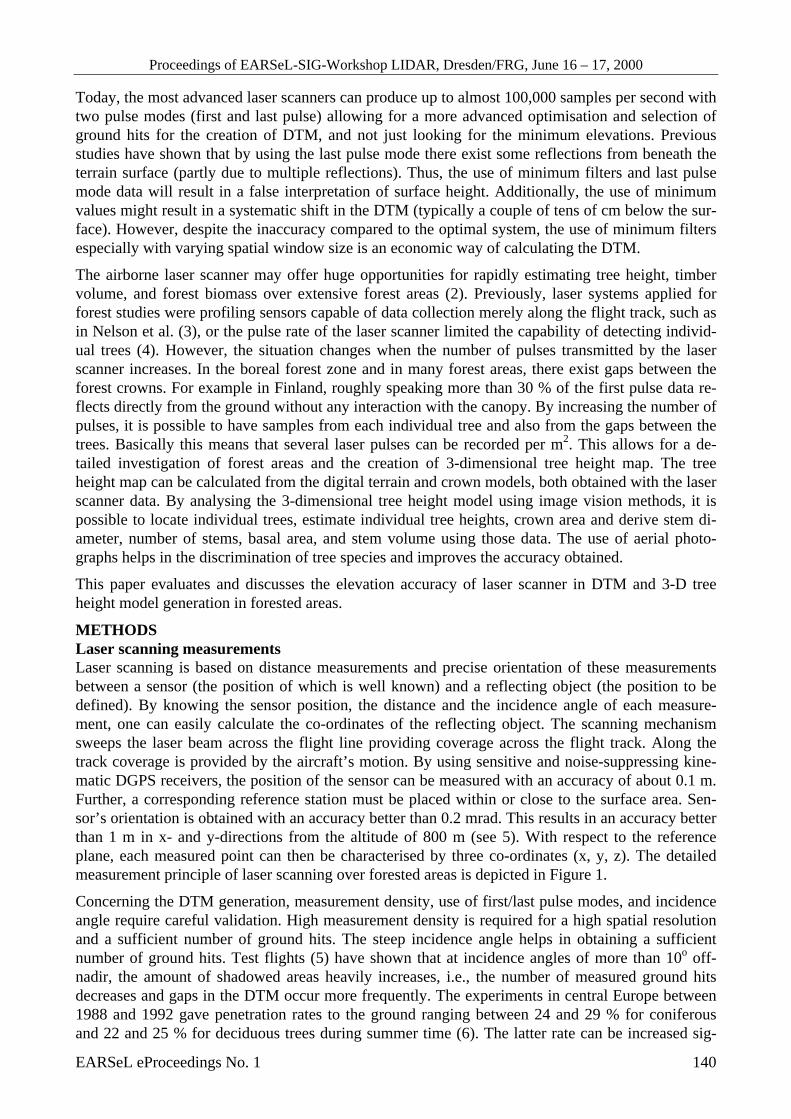
METHODSLaser scanning measurementsLaser scanning is based on distance measurements and precise orientation of these measurementsbetween a sensor (the position of which is well known) and a reflecting object (the position to bedefined). By knowing the sensor position, the distance and the incidence angle of each measure-ment, one can easily calculate the co-ordinates of the reflecting object. The scanning mechanismsweeps the laser beam across the flight line providing coverage across the flight track. Along thetrack coverage is provided by the aircraft’s motion. By using sensitive and noise-suppressing kine-matic DGPS receivers, the position of the sensor can be measured with an accuracy of about 0.1 m.Further, a corresponding reference station must be placed within or close to the surface area. Sen-sor’s orientation is obtained with an accuracy better than 0.2 mrad. This results in an accuracy betterthan 1 m in x- and y-directions from the altitude of 800 m (see 5). With respect to the referenceplane, each measured point can then be characterised by three co-ordinates (x, y, z). The detailedmeasurement principle of laser scanning over forested areas is depicted in Figure 1.
Concerning the DTM generation, measurement density, use of first/last pulse modes, and incidenceangle require careful validation. High measurement density is required for a high spatial resolutionand a sufficient number of ground hits. The steep incidence angle helps in obtaining a sufficientnumber of ground hits. Test flights (5) have shown that at incidence angles of more than 10o off-nadir, the amount of shadowed areas heavily increases, i.e., the number of measured ground hitsdecreases and gaps in the DTM occur more frequently. The experiments in central Europe between1988 and 1992 gave penetration rates to the ground ranging between 24 and 29 % for coniferousand 22 and 25 % for deciduous trees during summer time (6). The latter rate can be increased sig-
Proceedings of EARSeL-SIG-Workshop LIDAR, Dresden/FRG, June 16 – 17, 2000
EARSeL eProceedings No. 1 141
nificantly in winter times. Thus, last pulsemode measurements during winter time hasbeen increasingly used for the collection ofterrain elevation data especially in woodedareas.
There are few airborne laser scanners avail-able on the market today. Main providersare TopoSys, Optech, and Saab SurveySystems. The TopoSys laser scanner wasselected for the study due to its high meas-urement density and steep incidence angle.The performance of the TopoSys-1 laser isdepicted in Table 1.
Figure 1: The measurement principle of alaser scanner in forested area.
The laser scanner campaign was carried outearly in September 1998. The TopoSys-1laser scanner was installed in the local air-craft. Three DGPS receivers were employed
to record the carrying platform position: one on board the aircraft, and two as ground reference GPSstations (the first as basic receiver, the second for backup). A test site named Kalkkinen was se-lected in southern Finland, 130 km north of Helsinki. This rather typical boreal forest area was se-lected for the study in order to maximize the availability and adequacy of good field inventory dataand remote sensing data. An area of 100 hectares (2 km by 0.5) was measured with the TopoSys-1laser scanner. The test site is dominated by minor hills, otherwise it is flat and situated about 110 mabove the sea level. The main tree species are Norway spruce and Scots pine, while the mean standsize is 1.2 hectares. The test site was flown with the laser scanner from an altitude of 400 m. Thefirst pulse mode was applied in the analysis.
Table 1: TopoSys-1 laser scanner performance parameters.
Parameter Performance(s)Sensor pulse-modulated, TopoSys-1Laser pulse frequency 83 000 HzScan frequency 630 HzField of View ± 7.1 degreesMeasurement density 8…10 per m2 at 400 mThe number of shots per scan 128 parallel shots (one of which is the refer-
ence)Swath width at 800 m About 100 mPosition accuracy x, y < 1.0 mElevation accuracy (WGS84) z < 0.15 mLaser classification class 1 by EN 60825 (eye-safe)
Field-measured data for verificationIn Kalkkinen test site, a small forest area corresponding to about 1.4 hectare in size was selected fordetailed studies of DTM. The field data was obtained using a tachymeter for 750 points. The ta-chymeter measurements were transformed from the local coordinate system to the Finnish coordi-
X
YGPS
Reference station
Scan angle
Proceedings of EARSeL-SIG-Workshop LIDAR, Dresden/FRG, June 16 – 17, 2000
EARSeL eProceedings No. 1 142
nate system using GPS measurements of the Finnish Road Administration. In such a small area, theeffect of the Geoid can be neglected. 340,000 individual laser-derived points were obtained from thetest site resulting in an average measurement density of 24 measurements per m2.
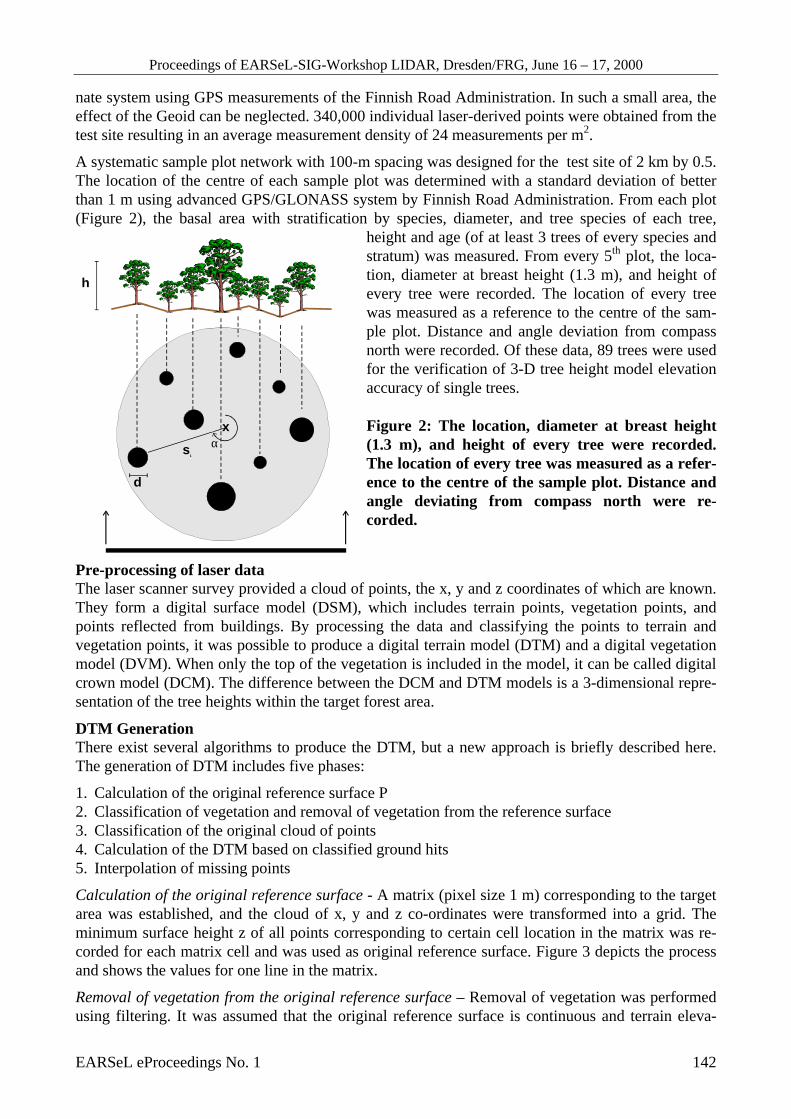
A systematic sample plot network with 100-m spacing was designed for the test site of 2 km by 0.5.The location of the centre of each sample plot was determined with a standard deviation of betterthan 1 m using advanced GPS/GLONASS system by Finnish Road Administration. From each plot(Figure 2), the basal area with stratification by species, diameter, and tree species of each tree,
height and age (of at least 3 trees of every species andstratum) was measured. From every 5th plot, the loca-tion, diameter at breast height (1.3 m), and height ofevery tree were recorded. The location of every treewas measured as a reference to the centre of the sam-ple plot. Distance and angle deviation from compassnorth were recorded. Of these data, 89 trees were usedfor the verification of 3-D tree height model elevationaccuracy of single trees.
Figure 2: The location, diameter at breast height(1.3 m), and height of every tree were recorded.The location of every tree was measured as a refer-ence to the centre of the sample plot. Distance andangle deviating from compass north were re-corded.
Pre-processing of laser dataThe laser scanner survey provided a cloud of points, the x, y and z coordinates of which are known.They form a digital surface model (DSM), which includes terrain points, vegetation points, andpoints reflected from buildings. By processing the data and classifying the points to terrain andvegetation points, it was possible to produce a digital terrain model (DTM) and a digital vegetationmodel (DVM). When only the top of the vegetation is included in the model, it can be called digitalcrown model (DCM). The difference between the DCM and DTM models is a 3-dimensional repre-sentation of the tree heights within the target forest area.
DTM GenerationThere exist several algorithms to produce the DTM, but a new approach is briefly described here.The generation of DTM includes five phases:
1. Calculation of the original reference surface P2. Classification of vegetation and removal of vegetation from the reference surface3. Classification of the original cloud of points4. Calculation of the DTM based on classified ground hits5. Interpolation of missing points
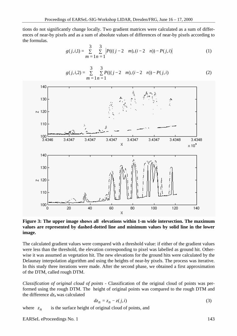
Calculation of the original reference surface - A matrix (pixel size 1 m) corresponding to the targetarea was established, and the cloud of x, y and z co-ordinates were transformed into a grid. Theminimum surface height z of all points corresponding to certain cell location in the matrix was re-corded for each matrix cell and was used as original reference surface. Figure 3 depicts the processand shows the values for one line in the matrix.
Removal of vegetation from the original reference surface – Removal of vegetation was performedusing filtering. It was assumed that the original reference surface is continuous and terrain eleva-
x
s1
α
h
d
Proceedings of EARSeL-SIG-Workshop LIDAR, Dresden/FRG, June 16 – 17, 2000
EARSeL eProceedings No. 1 143
tions do not significantly change locally. Two gradient matrices were calculated as a sum of differ-ences of near-by pixels and as a sum of absolute values of differences of near-by pixels according tothe formulas.
∑=
∑=
−+−+−=3
1
3
1),())2(),2((()1,,(
m nijPnimjPijg (1)
∑=
∑=
−+−+−=3
1
3
1),())2(),2((()2,,(
m nijPnimjPijg (2)
Figure 3: The upper image shows all elevations within 1-m wide intersection. The maximumvalues are represented by dashed-dotted line and minimum values by solid line in the lowerimage.
The calculated gradient values were compared with a threshold value: if either of the gradient valueswere less than the threshold, the elevation corresponding to pixel was labelled as ground hit. Other-wise it was assumed as vegetation hit. The new elevations for the ground hits were calculated by theDelaunay interpolation algorithm and using the heights of near-by pixels. The process was iterative.In this study three iterations were made. After the second phase, we obtained a first approximationof the DTM, called rough DTM.
Classification of original cloud of points - Classification of the original cloud of points was per-formed using the rough DTM. The height of original points was compared to the rough DTM andthe difference dzn was calculated
),( ijzzdz nn −= (3)where nz is the surface height of original cloud of points, and

Proceedings of EARSeL-SIG-Workshop LIDAR, Dresden/FRG, June 16 – 17, 2000
EARSeL eProceedings No. 1 144
z(j,i) is the surface height of corresponding pixel in the rough DTM.
According to the difference dzn, the decision was made whether the point represents the vegetationor the ground hit. The dzn values were classified with a 20-cm interval.
Calculation of the final DTM was performed using the mean and median values of classified groundhits. The missing surface heights were interpolated using the near-by heights and the Delaunay al-gorithm.
3-D tree height modelThe maximum value of all the points within the resolution cell was calculated. It was found to rep-resent the tree tops rather well. When there were holes (no data), the value for these points was ob-tained by interpolation and using the knowledge of near-by pixels. Diverging points (e.g. frombirds) in the digital crown model were detected by the gradient method and thresholding. The finalheight model was calculated as the difference between the DCM and the final DTM. The demon-stration was carried out using first pulse data, since it appeared that the first pulse mode was enoughto produce rather accurate DTMs. The use of both modes would be likely to further improve theresults obtained in this paper.
Figure 4: Digital tree height model ob-tained for a sample area (white areasrepresent tree heights of 35 m, blackones representing terrain heights) . In-dividual tree crowns can be easily seen.
EvaluationThe mean squared error was calculated inorder to evaluate the accuracy of the ter-rain and target heights. The differencebetween the field-measured terrain heightand the laser-derived terrain height wascalculated. The sum of the squares of thedifferences (γ ) is called the sum ofsquares error and is denoted by SSE.
2...23
22
21 NSSE γγγγ ++++= (4)
where N represents the number of samples. The mean squared error MSE corresponds to
1−
=NSSE
MSE (5)
The squared root of the MSE, denoted by RMSE (root mean squared error), corresponds to the accu-racy of the laser-derived surface height and can be divided into the bias (systematic), denoted by s,and random error, denoted by r:
22 rsMSE += (6)
Proceedings of EARSeL-SIG-Workshop LIDAR, Dresden/FRG, June 16 – 17, 2000
EARSeL eProceedings No. 1 145
RESULTS
Digital terrain modelThe difference between tachymeter measurements and laser measurements was compared as a func-tion of dzn values. The most accurate terrain models were those taking the average or median valueof all ground hits which were located at the maximum 60 cm (tolerance value) above the minimumvalues, resulting in a standard deviation of 22 cm. The 60 cm tolerance value can be consideredtypical ofo Finnish forest conditions. In areas of larger terrain slopes, larger values, e.g. 1 m shouldbe used. The question of whether to use the average or the median value of the hits was marginal.Also, the rough DTM was almost as accurate (std 25 cm) as the best model (std 22 cm). This hap-pens only for the first pulse mode data. Since the rough DTM was based on the minimum height ofeach pixel, it is very vulnerable to hits that may appear below the true ground level. Such bad re-flections were not observed with the first pulse mode, but they exist with the last pulse mode, eventhough the number of them was extremely limited (0.004 %). For the last pulse mode, the use ofminimum values is, therefore, a rough approximation and the described method is better applicableto last pulse mode data. The last pulse mode should be used in areas of dense vegetation (e.g. centralEurope). The algorithm can be simplified for operational use, if the tolerance value is known. Thepresent version can be used to define the optimum tolerance value.
The quality of the terrain affected the accuracy as expected. The laser-derived DTM of the forestroad differed from the true height by only 8.5 cm (standard deviation). While the tachymeter meas-urements were conducted, two types of terrain heights were recorded: those corresponding to bareforest ground and those corresponding to the height of the forest undervegetation. It was assumedthat the laser pulse reflects from the top of this layer. When these two sets were analyzed separately,it was noticed that the obtained standard error was equivalent (23 and 21 cm). The systematic shiftbetween these two data sets was 12 cm. This confirms that the laser pulse really reflected from thetop of the forest undervegetation in these cases.
The accuracy of the laser measurements was analysed as a function of terrain slope. It was found outlike in (1) that the errors increased with higher slope values. By grouping the data into separateclasses representing the slope, we obtained the standard error for each slope class. Over the flat ar-eas, the average standard error was about 15 cm, and with the slope of 40 %, the standard error wasmore than 40 cm. The observation was found to fit with the basic photogrammetric rule (7). Huisingand Gomes Pereira (8) concluded that standard errors of terrain heights are generally well within 15cm, but for hilly and flat terrains densely covered by vegetation, the accuracy estimates do not gen-erally fulfill the requirements.
The maximum distance between two nearest laser ground hits was calculated to be 4 m for bushes,10 m for dense coniferous forest, and 4 m for old mature coniferous forest. One should notice thatthese results were obtained using the first pulse mode.
Proceedings of EARSeL-SIG-Workshop LIDAR, Dresden/FRG, June 16 – 17, 2000
EARSeL eProceedings No. 1 146
Figure 5: Laser-derived tree heightscompared to field-measured treeheights of individualtrees.
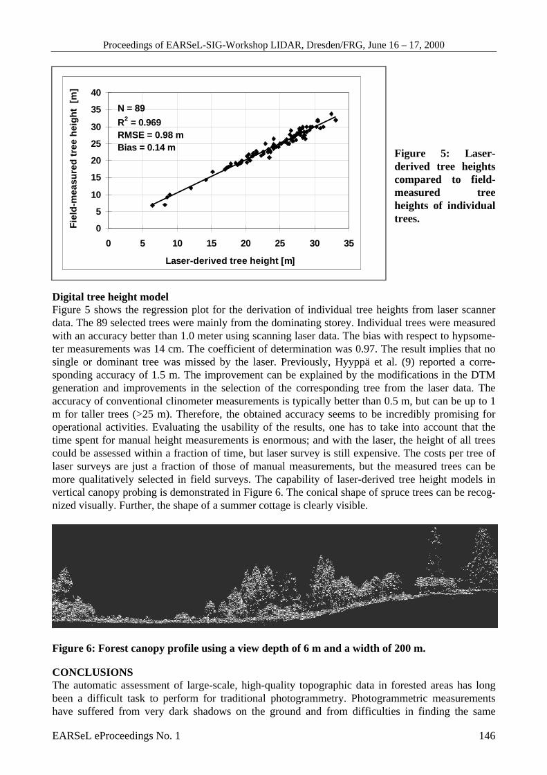
Digital tree height modelFigure 5 shows the regression plot for the derivation of individual tree heights from laser scannerdata. The 89 selected trees were mainly from the dominating storey. Individual trees were measuredwith an accuracy better than 1.0 meter using scanning laser data. The bias with respect to hypsome-ter measurements was 14 cm. The coefficient of determination was 0.97. The result implies that nosingle or dominant tree was missed by the laser. Previously, Hyyppä et al. (9) reported a corre-sponding accuracy of 1.5 m. The improvement can be explained by the modifications in the DTMgeneration and improvements in the selection of the corresponding tree from the laser data. Theaccuracy of conventional clinometer measurements is typically better than 0.5 m, but can be up to 1m for taller trees (>25 m). Therefore, the obtained accuracy seems to be incredibly promising foroperational activities. Evaluating the usability of the results, one has to take into account that thetime spent for manual height measurements is enormous; and with the laser, the height of all treescould be assessed within a fraction of time, but laser survey is still expensive. The costs per tree oflaser surveys are just a fraction of those of manual measurements, but the measured trees can bemore qualitatively selected in field surveys. The capability of laser-derived tree height models invertical canopy probing is demonstrated in Figure 6. The conical shape of spruce trees can be recog-nized visually. Further, the shape of a summer cottage is clearly visible.
Figure 6: Forest canopy profile using a view depth of 6 m and a width of 200 m.
CONCLUSIONSThe automatic assessment of large-scale, high-quality topographic data in forested areas has longbeen a difficult task to perform for traditional photogrammetry. Photogrammetric measurementshave suffered from very dark shadows on the ground and from difficulties in finding the same
N = 89
R2 = 0.969RMSE = 0.98 mBias = 0.14 m
0
5
10
15
20
25
30
35
40
0 5 10 15 20 25 30 35
Laser-derived tree height [m]
Fie
ld-m
easu
red
tre
e h
eig
ht
[m
]
Proceedings of EARSeL-SIG-Workshop LIDAR, Dresden/FRG, June 16 – 17, 2000
EARSeL eProceedings No. 1 147
ground point in two aerial images. Laser scanning is a relatively new method for direct measure-ment of digital terrain and target models and particularly suited for forested areas. This paper evalu-ates and discusses the accuracy of laser scanner in DTM and target model generation in forests.Special emphasis was laid on the optimisation of the selection of ground hits used for the creation ofthe DTM of future high-pulse-rate laser scanners. A novel DTM algorithm is depicted in detail.Even though it has not improved the results of using minimum elevations very much (3 cm), it im-proves the DTM significantly if hits below the ground level exist and it also corrects the systematicerrors. A standard error of 15 cm was obtained for flat forest areas and the error increased with in-creasing terrain slope to the value of approximately 40 cm with the slope of 40 %. The averagestandard error in DTM for forest area was about 22 cm. The laser-derived DTM of the forest roaddeviated from the true height by only 8.5 cm. An optimum performance for DTM generation wasobtained by averaging the ground hits located at the maximum 60 cm above the minimum terrainvalues. It was also shown that tree heights of individual trees can be obtained with less than 1 mstandard error using high-pulse rate laser scanners.
ACKNOWLEDGEMENTSThe authors are grateful to the European Commission for financial support (HIGH-SCAN project).The authors want to acknowledge the HIGH-SCAN project partners: Helsinki University of Tech-nology (Finland), Joanneum Research (Austria), University of Freiburg (Germany), TopoSys GmbH(Germany), Scherrer Ingenieurbüro AG (Switzerland) and Forestry Development Centre Tapio(Finland).
REFERENCES1. Kraus, K. and Pfeifer N. 1998. “Determination of terrain models in wooded areas with airborne
laser scanner data”. ISPRS J. of P. & Rem.& Sens. 53:193-203.2. Hyyppä, J., Inkinen, M., 1999. “Detecting and estimating attributes for single trees using laser
scanner, The photogrammetric journal of Finland, 16:27-42.3. Nelson, R. Krabill W. and Tonelli J. 1988. "Estimating forest biomass and volume using air-
borne laser data". Rem. Sens. Env. 24: 247-267.4. Nässet, E. 1997. “Estimating timber volume of forest stands using airborne laser scanner data”.
Rem. Sens. Env. 61:246-253.5. TopoSys. 1996 Digital elevation models. Services and Products. 10 p.6. Ackerman, F. 1997. “Airborne laser scanning for elevation models”. GIM. 2 p.7. Kraus, K. 1987. Photogrammetrie. Band 2. 2nd edition. Dümmler. Bonn..8. Huising, E.J. and Gomes Pereira L.M. 1998. “Errors and accuracy estimates of laser data ac-
quired by various laser scanning systems for topographic applications”. ISPRS J. of P. & Rem.Sens. 53:245-261.
9. Hyyppä, J., Hyyppä H. and Samberg A. 1999. “Assessing Forest Stand Attributes by LaserScanner”. Laser Radar Technology and Applications IV. Proceedings of SPIE. 3707:57-69.