Embed Size (px)
Citation preview

TS08D - Vertical Reference Systems, 5704 David Dodd and Jerry Mills Ellipsoidally Referenced Surveys Separation Models (5704) FIG Working Week 2012 Knowing to manage the territory, protect the environment, evaluate the cultural heritage Rome, Italy, 6-10 May 2012
1/20
Ellipsoidally Referenced Surveys Separation Models
David DODD - Canada
Jerry MILLS - USA
Key words: Hydrography, Ellipsoid, Chart Datum Summary One of the most significant issues in hydrography today is using the ellipsoid as the vertical reference for surveying measurements. High-accuracy GNSS is used to vertically position hydrographic data collection platforms, relating bathymetric observations directly to the ellipsoid. Models are then used to translate those observations to another datum. The use of high-accuracy vertical GNSS and translation models to replace traditional tidal correctors is relatively new to the hydrographic community and, as such, requires some discussion. Even though individual components of the process are well understood in their particular field, it is their amalgamation and application to hydrography that requires explanation, clarification and evaluation. The FIG, under Commission 4, established working group 4.1 to develop “best practices” for Ellipsoidally Referenced Surveying (ERS). In previous papers, working group members have outlined the issues associated with ERS and discussed the technical aspects of data collection and processing. The application of separation models is the final step in the process, and is the least well developed aspect of ERS. As hydrographic organizations move forward with the use of ERS, the development and validation of separation models is, by far, providing the greatest challenge. In this paper, the working group members discuss various methods for the development of separation models, which are used to translate depths from being referenced to the ellipsoid to being referenced to chart datum. Options range from using a simple single translation value to multiple grid surfaces that include geoid models, topography of the sea surface models and hydrodynamic models. Other innovative techniques that are discussed include the use of tidal observations in conjunction with ERS and tidal zoning models.

TS08D - Vertical Reference Systems, 5704 David Dodd and Jerry Mills Ellipsoidally Referenced Surveys Separation Models (5704) FIG Working Week 2012 Knowing to manage the territory, protect the environment, evaluate the cultural heritage Rome, Italy, 6-10 May 2012
2/20
1 Introduction
Many of the groups using ellipsoidally references surveying (ERS) techniques have developed their internal standard operating procedures (SOP) through in-house testing and experience (trial and error). It is this wealth of experience that is being drawn upon to help develop a set of "best practices" for the hydrographic industry. The development of ERS best practices is being conducted by FIG working group 4.1 under Commission 4. Previous papers developed by this working group include:
• “Hydrographic Surveying Using the Ellipsoid as the Vertical Reference Surface” paper for FIG Congress 2010, April 11-16, Sydney, Australia (Dodd et al, 2010). This paper contained an overview of the issues surrounding ERS including discussions on; high-accuracy GNSS, effects of vessel motion, data collection, and data processing and separation surfaces.
• “Ellipsoidally Referenced Surveys (ERS); Issues and Solutions” paper for US Hydro 2011 and published in the International Hydrographic Review, November 2011 on-line edition (Dodd and Mills, 2011). This paper summarized the results of a questionnaire sent to the ERS user community.
This paper looks at the development of separation models (SEP) necessary for the translation of GNSS derived vertical positions to chart datum. Section two gives a brief overview of the background information necessary for development of an SEP. Section three suggests steps for developing SEP models, given five scenarios ranging from a simplistic vertical shift to complex surfaces derived from hydrodynamic models and ocean topography. The fourth section gives examples of some national vertical datum model programs and the fifth section presents a very brief discussion on surface uncertainly and validation. The final section presents conclusions and offers some recommendations. The final “ERS Best Practices” document to be delivered to FIG Commission 4 will be compiled from this paper as well as the two previous papers mentioned above.
2 Background
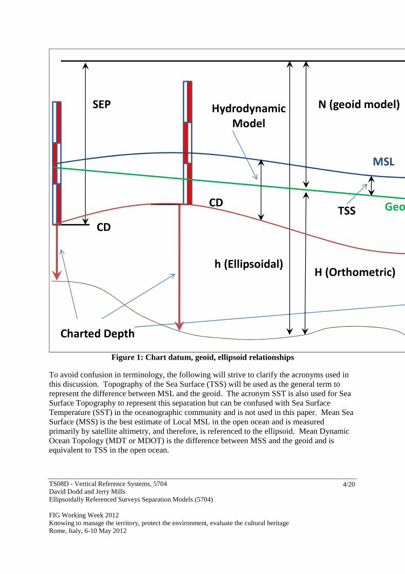
The transformation of depths from the ellipsoid to chart datum is the most challenging aspect of the ERS process. Finding models for relating the ellipsoid to the geoid is relatively straight forward. The main problem comes when translating from the geoid to chart datum. The most straight forward method is to establish an ellipsoid height at a tidal benchmark. This will establish a directly observed separation (SEP) between chart datum and the ellipsoid. In this paper, the term “water level gauge” will be used instead of the more commonly used term “tide gauge” to more accurately describe what is being measured As the area in question gets larger, and/or the ocean dynamics become more complex, the chart datum to geoid models must also become more complex. Separation models will include (see Figure 1):
• chart datum (CD) to mean sea level (MSL), established by observation onshore (at water level gauge locations) and hydrodynamic models offshore,

TS08D - Vertical Reference Systems, 5704 David Dodd and Jerry Mills Ellipsoidally Referenced Surveys Separation Models (5704) FIG Working Week 2012 Knowing to manage the territory, protect the environment, evaluate the cultural heritage Rome, Italy, 6-10 May 2012
3/20
• MSL to the geoid (Topography of the Sea Surface [TSS]), established by observation onshore (at water level gauge locations), and satellite altimetry (Mean Dynamic Topography [MDT]) offshore,
• geoid to ellipsoid (N), established through satellite and terrestrial gravity modeling. The various vertical datums and their relationships are discussed in greater detail in Dodd et al, 2010. The United Kingdom Hydrographic Office (UKHO) has developed VORF (Vertical Offshore Reference Frame) separation models for their coastal waters (see Adams, 2006). The National Oceanic and Atmospheric Administration (NOAA) has developed VDatum for all USA coastal waters except for Alaska and Hawaii (see Gesch and Wilson, 2001). Of particular importance to the hydrographic community is total propagated uncertainty (TPU). TPU models have been developed for all aspects of the ERS process except for the SEP translation process. A discussion of TPU and VDatum can be found at the website: http://vdatum.noaa.gov/docs/est_uncertainties.html
TS08D - Vertical Reference Systems, 5704 David Dodd and Jerry Mills Ellipsoidally Referenced Surveys Separation Models (5704) FIG Working Week 2012 Knowing to manage the territory, protect the environment, evaluate the cultural heritage Rome, Italy, 6-10 May 2012
4/20
Figure 1: Chart datum, geoid, ellipsoid relationships
To avoid confusion in terminology, the following will strive to clarify the acronyms used in this discussion. Topography of the Sea Surface (TSS) will be used as the general term to represent the difference between MSL and the geoid. The acronym SST is also used for Sea Surface Topography to represent this separation but can be confused with Sea Surface Temperature (SST) in the oceanographic community and is not used in this paper. Mean Sea Surface (MSS) is the best estimate of Local MSL in the open ocean and is measured primarily by satellite altimetry, and therefore, is referenced to the ellipsoid. Mean Dynamic Ocean Topology (MDT or MDOT) is the difference between MSS and the geoid and is equivalent to TSS in the open ocean.
SEP
Charted Depth
CD
CD
MSL
TSS
Geoid
H (Orthometric)
N (geoid model)
h (Ellipsoidal)
Hydrodynamic
Model

TS08D - Vertical Reference Systems, 5704 David Dodd and Jerry Mills Ellipsoidally Referenced Surveys Separation Models (5704) FIG Working Week 2012 Knowing to manage the territory, protect the environment, evaluate the cultural heritage Rome, Italy, 6-10 May 2012
5/20
Satellite altimetry is only valid in the offshore because of the size of the satellite’s radar sensor footprint. In shore of ~15 km, the radar beam interacts with the land, contaminating the sea surface height estimation (Vignudelli et al, 2008). Near shore TSS is determined by directly measuring mean sea level (MSL) with respect to the geoid at water level gauge locations. The near shore and offshore are stitched together through interpolation.
3 Separation Model Development
There are many methods of developing a separation model (SEP). This section is divided into five sub-sections, the first presenting the simplest method of directly observing the SEP at locations where chart datum is known and applying that SEP to depth observations in the local area. The second method describes the use of SEP observations at multiple locations around the survey area and interpolating between. The third sub-section looks at a refinement to the second method where interpolation of the SEP between water level gauge locations is performed using a geoid model. Sub-section four discusses the special case of a river survey. The final sub-section discusses the inclusion of geoid, TSS and hydrodynamic models. The simple shift, simple interpolation and interpolations with a geoid model are reasonably straight forward to develop and use and therefore, are ideal for local surveys near shore. Incorporating MSS and hydrodynamic models are important when the region of responsibility becomes larger, such as the development of national programs. It is also important to incorporate MSS and hydrodynamic models in the offshore where direct SEP observations are difficult (or impossible) and the CD/geoid/TSS relationship varies.
3.1 Simple Shift
A simple SEP shift can be determined by establishing the ellipsoid height at a known chart datum (CD) location. This can be done by taking GNSS observations at a tidal benchmark and adding the chart datum height to it. This single value can be used in the local area only, where the assumption that the spatial variation in chart datum, geoid and TSS is at a minimum. For example; in the case of a wharf survey:
1. Establish CD in the wharf area. 2. Establish ellipsoid height at CD locations through static GNSS observations or model
(N) interpolation. If using a model, the CD location must be referenced to the same geoid reference as the model. For example, in the USA the “Geoid03” model can be used to determine geoid/ellipsoid undulation “N” if the NAVD88 height at the CD location is known. The Geoid03 model provides the NAD83 ellipsoid to NAVD88 geoid undulation “N”. In this example the resulting SEP value will be between the NAD83 ellipsoid and chart datum (also see 4.1.2).
3. Check the geoid model to ensure that the change of the geoid/ellipsoid separation in the survey area is within an acceptable range.

TS08D - Vertical Reference Systems, 5704 David Dodd and Jerry Mills Ellipsoidally Referenced Surveys Separation Models (5704) FIG Working Week 2012 Knowing to manage the territory, protect the environment, evaluate the cultural heritage Rome, Italy, 6-10 May 2012
6/20
3.2 Interpolate between known SEP locations
In areas where the CD to ellipsoid separation can be established at more than one location, SEP values can be interpolated with distance weighting. It is assumed that the change in the geoid in the area is insignificant. For example; in the case of a harbor survey:
1. Established SEP at known CD locations using GNSS observations or a geoid model (See section 3.1).
2. Estimate SEP values for survey positions by weighting the established SEP values by distance.
3.3 Interpolate Between SEP Locations with a Geoid Model
In most cases, the geoid varies more rapidly than either TSS or CD. It is a relatively simple procedure to use an existing geoid model to help interpolate between established SEP locations. One can think of the process as shifting and warping a geoid model to fit established SEP sites. For example; In the case of a lake survey (see Figure 2):
1. Establish CD with respect to a geodetic datum at multiple locations around the survey area and create a triangular irregular network (TIN) from these points.
2. Create a regular grid of “N” values using a geoid model covering the survey area. 3. The CD and N models must be combined to create the SEP model. In order to
accomplish this, it may be necessary to create a regular grid from the CD model (see Figure 3).
4. Combining the CD TIN with the N model will create a regular grid of SEP. 5. In this example, the geodetic datum to CD is ~175 meters (North America Great
Lakes area), N is ~-35 m and the resulting SEP model is ~140 m.
Note 1: In this example, the CD is ~175m above sea-level and the area is non-tidal. Water level charges are due to weather, runoff and hydraulic effects. The same method can be used in tidal areas.
Note 2: Care should be taken when using geoid models to ensure the proper references are used. In North America, some geoid models include deviations from the geoid heights due to leveling errors and subsidence.

TS08D - Vertical Reference Systems, 5704 David Dodd and Jerry Mills Ellipsoidally Referenced Surveys Separation Models (5704) FIG Working Week 2012 Knowing to manage the territory, protect the environment, evaluate the cultural heritage Rome, Italy, 6-10 May 2012
7/20
Figure 2: Survey Area and CD location for the Lake Survey SEP Example
Figure 3: CD Regular Grid Model for Lake Survey Example
3.4 River SEP
Chart datums along non-tidal rivers are usually sloped. The methods for developing an SEP are essentially the same as those described in section 3.3. The CD to geodetic distance can be established at water level locations along the river. A TIN model of CD datum can be created from these locations and then combined with a geoid model. For example; Figure 4 shows the vertical relationship between the various datums for two water level gauge locations along the St. Clair River in the Great lakes region of Canada.
Survey Area
CD Locations

TS08D - Vertical Reference Systems, 5704 David Dodd and Jerry Mills Ellipsoidally Referenced Surveys Separation Models (5704) FIG Working Week 2012 Knowing to manage the territory, protect the environment, evaluate the cultural heritage Rome, Italy, 6-10 May 2012
8/20
The example shows benchmarks (LAMB and SARN) from two water level gauge locations and their relationships to:
• Height of BM with respect to the sloping Chart Datum, • North American Datum of 1983 (NAD 83) (1997 epoch) ellipsoid, • International Great Lakes Datum of 1985 (IGLD85), • Canadian Geodetic Vertical Datum of 1928 (CGVD28), • Geoid undulation (N), which includes variations from the geoid.
3.5 Use of MSS, TSS and Hydrodynamic Models
For small near shore surveys, the methods of SEP development discussed above are probably sufficient. For national programs or surveys further from shore, it may be necessary to incorporate MSS and hydrodynamic models. MSS models derived from satellite altimetry are limited to the offshore, due primarily to the contamination of the signal by the inclusion of land in the footprint (Vignudelli et al, 2008). Offshore examples of global MSS models include the Danish National Space Center’s DNSC08MSS and the Centre National d'Etudes Spatiales MSS_CNES_CLS_11. Both models are derived from averaging more than 7 years of satellite altimetry data. These models can be incorporated into the SEPs developed above by interpolating between the
LAMB
IGLD85
CD
NAD83 (97)
SARN
SEP = 139.778
N (NTv2) = -34.852
CD = 1.89
SEP = 140.830 Pub = 178.194
N (NTv2) = -34.790
CD = 2.544
CGVD28
Pub = 176.54
-0.02 -0.03
Figure 4: St. Clair River Datums

TS08D - Vertical Reference Systems, 5704 David Dodd and Jerry Mills Ellipsoidally Referenced Surveys Separation Models (5704) FIG Working Week 2012 Knowing to manage the territory, protect the environment, evaluate the cultural heritage Rome, Italy, 6-10 May 2012
9/20
MDT derived from them and the TSS calculated at a water level gauge (difference between local MSL and geoid). Note: Care must be taken to ensure that the MSS model reference corresponds to your SEP reference. Some MSS models are referenced to their own ellipsoids (e.g. Topex), which must be adjusted to coincide with the traditional GNSS ellipsoids (WGS84, ITRF, NAD83 …) Given the complexity and processing load, only national organizations tend to include hydrodynamic model surfaces in SEP development. Examples of national programs are NOAA’s VDatum and the UKHO’s VORF, both of which are discussed in the following section.
4 National SEP Development Examples
The following provides a brief overview of some large scale SEP development projects. Included are the US VDatum, UKHO VORF, North Sea states BLAST and Australian AUSHYDROID projects.
4.1 VDatum
NOAA’s National Ocean Service has developed a software application called VDatum which provides the ability to easily transform data that is referenced to one vertical reference surface to another (tidal, orthometric, and ellipsoid-based 3D reference systems). While VDatum supports vertical datum transformations between numerous tidal datums, orthometric datums and 3D datums, the following discussion will only focus on transforming hydrographic survey data acquired on the ellipsoid to chart datum (in the U.S. this is MLLW - Mean Lower Low Water). VDatum models are developed on a regional basis with the goal of attaining seamless coverage for all U.S. near-coastal waters. Three or four steps are needed to transform hydrographic survey data, depending on which vertical datum is it referenced to during acquisition.
1. If base stations (also called reference stations) are referenced to ITRFxx, then the resulting hydrographic survey data will need to be transformed to the NAD83 (NSRS2007/CORS96) primary ellipsoidal datum. If the base stations are already referenced to NAD83, then no transformation should be necessary.
2. Transformation between the NAD83 ellipsoid and the NAVD 88 primary orthometric datum.
3. Transformations between NAVD 88 and the Mean Sea Level (MSL) primary tidal datum.
4. Transformations between MSL and MLLW
4.1.1 Transformations from ITRFxx to the NAD83 Conversions between ITRFxx and the NAD83 ellipsoid apply 14-parameter Helmert transformations which ascribe the three-dimensional distance, rotation, and scale changes. The 14-parameter Helmert transformations are an extension of the classical 7-parameter Helmert transformation which is augmented with their time derivatives to better

TS08D - Vertical Reference Systems, 5704 David Dodd and Jerry Mills Ellipsoidally Referenced Surveys Separation Models (5704) FIG Working Week 2012 Knowing to manage the territory, protect the environment, evaluate the cultural heritage Rome, Italy, 6-10 May 2012
10/20
accommodate time-dependent changes such as plate tectonics and other geophysical phenomena. In 2009/2010 NOAA field units used the NAD83 ellipsoid coordinates for base stations so no transformations were necessary. The following year, it was suggested that better accuracy might be obtained by using ITRF coordinates for the base stations. Some of the vessels did do this and then transformed the resulting data to NAD83. However, this process was very time consuming. Tests will be run during 2012 using both ITRF and NAD83 positions for the base stations and, after transforming the IRTF referenced data to NAD83, comparing the results. It is expected that the differences will be negligible and the use of ITRF coordinates for base stations and subsequent laborious transformation of the resulting data from IRTF to NAD83 will not be necessary.
4.1.2 Geoid Models of the NAD83 Ellipsoid to NAVD88 Separation The geoid is a specified equipotential surface, defined in the Earth's gravity field, which best fits, in a least squares sense, global mean sea level (MSL). It is undulate, smooth and continuous, fictitiously extending under the continents at the same level, and by definition perpendicular at any point to the direction of gravity. It should be noted that due to effects such as atmospheric pressure, temperature, prevailing winds and currents, and salinity variations, MSL can depart from an equipotential surface by a meter or more. The geoid is a complex, physically based surface, and can vary by up to 100 meters in height from a geocentric ellipsoid. Thus, national and regional vertical datums around the world, which are locally tied to MSL, are significantly different from one another when considered on a global basis. In addition, due to the realization and orthometric height approximations of various vertical datums, other departures at the meter level or more will be found when comparing elevations to a global geoid reference. For the United States, the GEOIDxx geoid models have been developed based on observations by the National Geodetic Survey (NGS). These geoid models (e.g., GEOID 90, GEOID 93, GEOID 96, GEOID 99, GEOID 03, GEOID09, etc.) provide the separation distance from which the ellipsoid height of the hydrographic data from the NAD 83 three dimensional datum can be directly converted to the NAVD 88 orthometric height of the hydrographic data above the geoid. More details about NGS geoid models can be found at http://www.ngs.noaa.gov/GEOID/.
4.1.3 Topography of the Sea Surface The Topography of the Sea Surface (TSS) is defined as the elevation of the North American Vertical Datum of 1988 (NAVD88) relative to local mean sea level (LMSL). This elevation difference is primarily caused by ocean currents and variations in ocean temperature and salinity. NOAA’s method of determining TSS for VDatum includes calculating the difference between orthometric height (height above the geoid – NAVD88) and MSL on bench marks at NOAA water level gauges in the region under consideration. From these observed differences a regional TSS field can be generated by spatial interpolation using the Surfer© software’s minimum curvature algorithm. Along open coasts the regional TSS field is derived via extrapolation. The regional TSS field is then applied to the hydrographic data which in the previous step was referenced to the geoid.
TS08D - Vertical Reference Systems, 5704 David Dodd and Jerry Mills Ellipsoidally Referenced Surveys Separation Models (5704) FIG Working Week 2012 Knowing to manage the territory, protect the environment, evaluate the cultural heritage Rome, Italy, 6-10 May 2012
11/20
4.1.4 Tide Modeling to Compute Tidal Datums A tidal datum is a base elevation from which relative heights and depths may be determined (Gill and Schultz, 2001). It can be computed by analyzing a time series of water levels from observational data. Mean sea level (MSL) is an example of a tidal datum, taken as the arithmetic mean of hourly water level observations over a 19-year National Tidal Datum Epoch (presently the 1983-2001 National Tidal Datum Epoch). Other tidal datums are calculated from the recorded high or low water level values, including MHHW, MHW, MLW, MLLW, DTL and MTL. Since each of these datums depends upon the tidal characteristics of a particular location, there is a spatial variation in the fields in between observation locations. For VDatum, hydrodynamic models are used to simulate tides to facilitate the computation of the spatially varying tidal datum fields. As part of the effort to adopt standard procedures for development of each VDatum regional application, ADCIRC (Advanced Circulation Model; Luettich et al., 1992) has been the primary model used to simulate tides for computing the tidal datum fields. ADCIRC uses unstructured grids in its solution of the hydrodynamic equations for time- and spatially-varying parameters such as water levels and velocities. ADCIRC uses the generalized wave continuity equation to solve for water levels and the momentum equations to solve for depth-averaged velocities. Time steps used by the model vary according to the smallest size of triangles in a grid, and they are typically on the order of a few seconds or less. Simulations are normally carried out for two months, and the model must therefore process several million time steps for completion. Due to these computational requirements, NOAA’s Earth System Research Laboratory (ESRL) granted access to their high performance computing system to run the tide models using the parallel version of the ADCIRC model. The models are first calibrated to best reproduce observed datums by adjusting such model input parameters as bottom friction, viscosity, the connectivity and shapes of the triangular elements, and the representation of the bathymetry on the grid. The boundary of the grid along the open ocean is used to force the tides into the model through specification of amplitudes and phases for the M2, S2, N2, K2, K1, O1, P1, and Q1 tidal constituents. These tidal boundary conditions must be obtained from a larger area model of the tides. Regional models for the Eastern North Pacific (Foreman et al., 2000) and Western North Atlantic (Mukai et al., 2001) are ideally suited for providing this information to the more localized VDatum modeling applications. After the model parameters have been calibrated, simulations are made to adjust the bathymetry to be vertically referenced to MSL. As bathymetry in the U.S. is referenced to MLLW, an initial guess of the MSL to MLLW difference is made to correct the bathymetry for a tide simulation. After that initial simulation is complete, the model output is used to compute new MLLW-MSL differences that are then used as a new correction to the bathymetry. The process is repeated until the computed corrections do not change from one simulation to the next.

TS08D - Vertical Reference Systems, 5704 David Dodd and Jerry Mills Ellipsoidally Referenced Surveys Separation Models (5704) FIG Working Week 2012 Knowing to manage the territory, protect the environment, evaluate the cultural heritage Rome, Italy, 6-10 May 2012
12/20
A final hydrodynamic model simulation with the calibrated parameters and corrected bathymetry is then made, and time series of the modeled water levels are analyzed at each node in the grid to compute spatially varying tidal datum fields. The modeled datums at NOAA’s NWLON (National Water Level Observation Network) stations are compared with those derived from observations. Model-data differences are spatially interpolated using TCARI (Hess, 2002; Tidal Constituent And Residual Interpolation), a software tool based on solution of Laplace’s equation using the shoreline as a boundary. Most of the model-data differences are less than 10 cm for all of the VDatum regions, though there are some instances where the errors may be slightly larger. The values of these differences are identified in the VDatum reports for each of the regional projects. These interpolated differences are used as correction fields to the modeled tidal datums, such that the corrected modeled datums will now match exactly at locations where observations are available. VDatum incorporates the corrected version of the modeled tidal datums through the use of a marine grid. This is a regularly spaced set of data points, onto which the corrected model results are interpolated. Using the high resolution shoreline data, each marine grid point is evaluated as to whether it falls inside (land) or outside (water) this shoreline. A small buffer is also taken into account, such that marine grid points that fall just slightly on the land (within 0.1 nautical miles) may still be assigned a tidal datum value. The final marine grid of tidal datum fields is provided as input to the VDatum software. Then user-supplied reference datum, elevation, and longitude/latitude pair data may be entered into VDatum, which will interpolate the desired tidal datum from the marine grid. VDatum is then used to transform the hydrographic data from the previous step which was referenced to MSL to Chart Datum (MLLW in the U.S.).
4.2 Ellipsoidally Referenced Zoned Tides (ERZT)
VDatum models are currently available for all near shore waters of the U.S. except Alaska and Hawaii where additional gravity and water level data are needed. Completion of VDatum models in those states will not be completed until after 2020. However, because there is a significant improvement in the quality and consistency of hydrographic data acquired relative to the ellipsoid, NOAA has begun developing a procedure to measure the water level datum relative to the ellipsoid (Rice and Riley, 2011) thereby developing a SEP model during data acquisition. Traditional hydrographic water level modeling methods use some form of “zoning” (constant offset, discrete zones, or continuous surface) to define areas of similar water level regimes. The process described here uses ship-based measurements relative to the ellipsoid and tidal zoning to create discrete SEP “zones”. Hence the name adopted for this process is ellipsoidally referenced zoned tides, or ERZT. Conventional hydrographic surveying techniques apply corrections for tides, static draft and vessel dynamics directly to sounding data. Tide corrections are typically determined from the above mentioned tidal zoning. Static draft is determined when the vessel is at rest and monitored for change during the survey due to vessel loading. Vessel dynamics include heave due to wave action and settlement and squat which reflect changes due to a vessel’s

TS08D - Vertical Reference Systems, 5704 David Dodd and Jerry Mills Ellipsoidally Referenced Surveys Separation Models (5704) FIG Working Week 2012 Knowing to manage the territory, protect the environment, evaluate the cultural heritage Rome, Italy, 6-10 May 2012
13/20
movement through the water (changes in trim are called squat and changes in height relative to the water’s surface at rest is called settlement). For ERS surveys these corrections are not applied to the sounding data. Rather, the sounding data (after sound velocity corrections have been made) is directly referenced to the ellipsoid creating a very consistent coherent surface. Developing the SEP model for transforming this smooth ellipsoidally referenced sea floor surface to chart datum using ERZT can be done in three steps: 1. During data acquisition the vessel’s GPS antenna height (as well as the ship’s Reference Point (RP) and other offset points on the vessel) above/below the ellipsoid is continually recorded resulting in a vessel ellipsoid height time series. This time series reflects vertical changes due to the above mentioned tides, changes in static draft and vessel dynamics. By removing the static draft changes and the effects of vessel dynamics, a time series can be created that reflects only vertical changes due to changes in water level (tides plus weather induced changes). These are removed just as they are in conventional hydrography. Changes in draft, while generally minor, are corrected for and accurate heave is extracted from the vessel’s inertial navigation system data. Low frequency motion due to settlement and squat must be modeled. (Note: Ideally this should be done relative to speed through the water but has historically been calculated in NOAA relative to speed over ground. In areas of little or no current, the error induced from this is negligible but may induce an error or up to one or two feet in shallow areas with high currents.) The result of applying these corrections is a time series of the in situ water level relative to the ellipsoid. 2. Corrections for variations in water level for conventional hydrographic surveys use zones, each of which has a specific phase offset and amplitude or range ratio from the predicted water level at a control water level gauge. Therefore, for every zone and for every point in each zone, the predicted water level relative to the chart datum (MLLW for the U.S.) can be calculated. The resulting difference is then subtracted from the above time series of in situ water level relative to the ellipsoid to yield a time series of in situ water level relative to MLLW. 3. This time series can then be processed in the spatial domain to create a gridded surface by averaging over appropriately sized bins which results in a SEP model of the survey area. Care must be taken in choosing the size of the bins so as to minimize any offsets between bins but maximize the data “noise” reduction in the individual in situ SEP measurements. A one kilometer bin seems to best achieve this although a different bin size may be more appropriate in some areas. While the estimates associated with this process incorporate the somewhat imprecise vessel dynamic waterline and zoned/interpolated water level reducer model, averaging over a large number of repeated measurements forms a relatively smooth SEP surface of reduced uncertainty. Conventional hydrographic surveys require time-delayed analysis of water level gauge data to produce final water leveling zoning using actual water level measurements from control

TS08D - Vertical Reference Systems, 5704 David Dodd and Jerry Mills Ellipsoidally Referenced Surveys Separation Models (5704) FIG Working Week 2012 Knowing to manage the territory, protect the environment, evaluate the cultural heritage Rome, Italy, 6-10 May 2012
14/20
water level gauges and any subordinate gauges required by the survey. This analysis results in final zoning which is often significantly different from preliminary zoning. In such cases the sounding data needs to be reprocessed, and quality controlled in the field. Using ERZT, rather than the sounding data being reprocessed, the SEP needs to be recalculated which may eventually take less effort and can take place away from the field unit. Comparisons between ERZT and VDatum SEPs have been quite favorable (mean difference near 1 centimeter with a standard deviation of 3-5 centimeters). As such, ERZT can likely be used to check/validate VDatum models where they exist. Additional testing is needed along with further development of software tools and procedures to increase efficiency.
4.3 United Kingdom Hydrographic Office VORF
The UKHO’s Vertical Offshore Reference Frame (VORF) is a collection of surfaces used to transform between various datums for the entire United Kingdom and Irish continental shelves. Each surface is referenced to the WGS84 ellipsoid. Surfaces include HAT, MHWS, MSL, MLWS, LAT, Chart Datum and Ordinance Survey Datums. The standard surface grid resolution is 0.008°, with 0.003° resolution in complex tidal regimes and in rivers. (Howlett, 2009) The OSGM05 gravity model was used to establish the geoid to WGS84 ellipsoid undulation (N). TSS, relative to the WSG84 ellipsoid, was established through water level gauge observations (near shore) and satellite altimetry (off shore). The connection between MSL and LAT was achieved through observation at water level gauges and hydrodynamic modeling (Adams et al, 2006). Permanent and temporary water level gauges along the shoreline were used to establish a link between the geoid, MSL, LAT and CD. Chart datums (CD) are local and often derived from short term observations and there is no consistent connection to LAT. The CD surfaces were developed by establishing deviations from LAT at know CD locations (Howlett, 2009). GNSS observations at selected gauges were used to establish a link to the WGS84 reference ellipsoid. The WGS84 ellipsoid, OSGM05 geoid model, satellite altimetry model and hydrodynamic models were used to propagate the various surfaces into the offshore.
4.4 BLAST
One of the aims of the North Sea vertical datum project “Bringing Land and Sea Together” (BLAST) is to develop a standard set of datums, and associated translation grids, covering the North Sea. Participants include groups from Norway, Sweden, Germany, Denmark, Netherlands, Belgium, France and the United Kingdom. BLAST has established five vertical reference surfaces (see Figure 5):
• Reference Ellipsoid: WGS 84 • VREF (land leveling reference) European Vertical Reference Frame 2007
(EVRF2007) • Geoid: European Gravimetric Geoid 2008 (EGG2008) • LAT: common Lowest Astronomic Tide for CD reference
TS08D - Vertical Reference Systems, 5704 David Dodd and Jerry Mills Ellipsoidally Referenced Surveys Separation Models (5704) FIG Working Week 2012 Knowing to manage the territory, protect the environment, evaluate the cultural heritage Rome, Italy, 6-10 May 2012
15/20
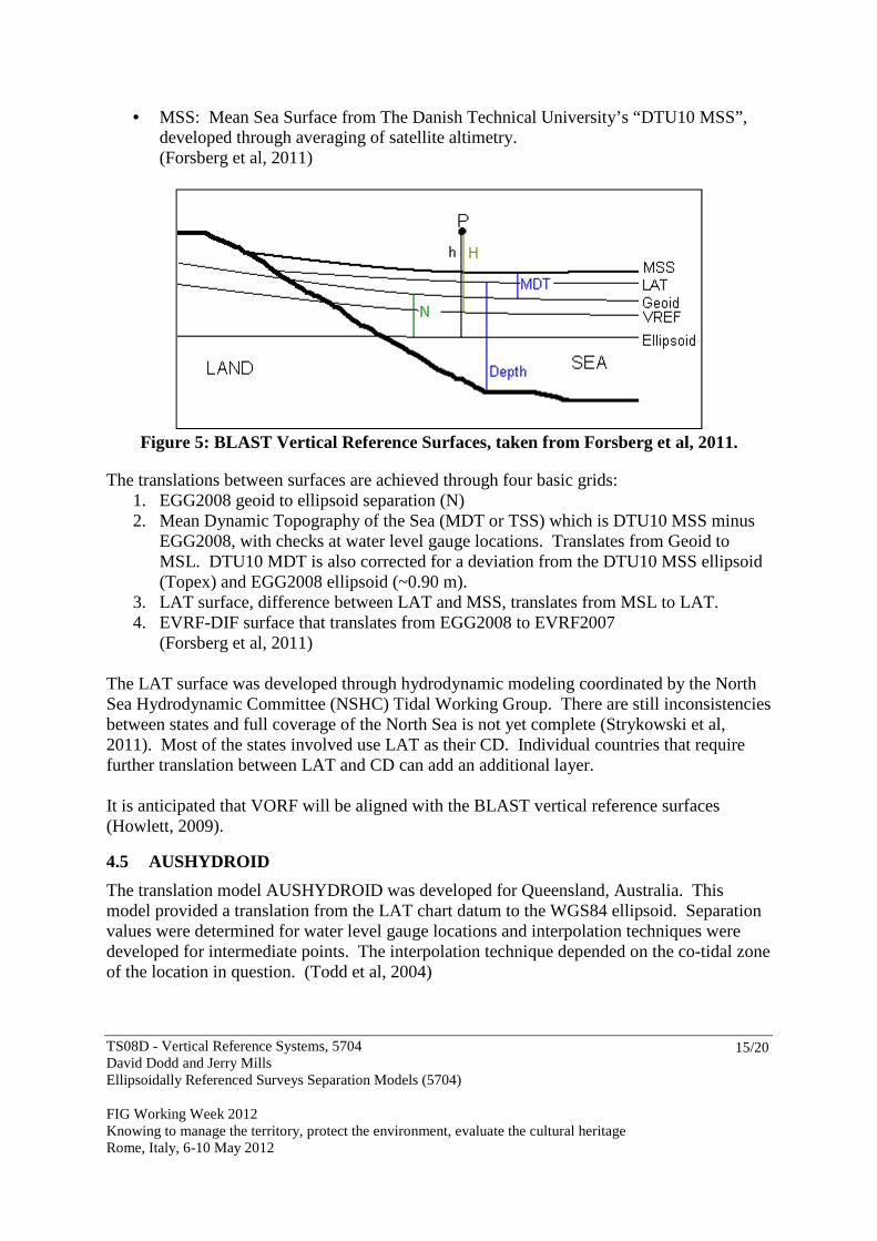
• MSS: Mean Sea Surface from The Danish Technical University’s “DTU10 MSS”, developed through averaging of satellite altimetry. (Forsberg et al, 2011)
Figure 5: BLAST Vertical Reference Surfaces, taken from Forsberg et al, 2011.
The translations between surfaces are achieved through four basic grids: 1. EGG2008 geoid to ellipsoid separation (N) 2. Mean Dynamic Topography of the Sea (MDT or TSS) which is DTU10 MSS minus
EGG2008, with checks at water level gauge locations. Translates from Geoid to MSL. DTU10 MDT is also corrected for a deviation from the DTU10 MSS ellipsoid (Topex) and EGG2008 ellipsoid (~0.90 m).
3. LAT surface, difference between LAT and MSS, translates from MSL to LAT. 4. EVRF-DIF surface that translates from EGG2008 to EVRF2007
(Forsberg et al, 2011)
The LAT surface was developed through hydrodynamic modeling coordinated by the North Sea Hydrodynamic Committee (NSHC) Tidal Working Group. There are still inconsistencies between states and full coverage of the North Sea is not yet complete (Strykowski et al, 2011). Most of the states involved use LAT as their CD. Individual countries that require further translation between LAT and CD can add an additional layer. It is anticipated that VORF will be aligned with the BLAST vertical reference surfaces (Howlett, 2009).
4.5 AUSHYDROID
The translation model AUSHYDROID was developed for Queensland, Australia. This model provided a translation from the LAT chart datum to the WGS84 ellipsoid. Separation values were determined for water level gauge locations and interpolation techniques were developed for intermediate points. The interpolation technique depended on the co-tidal zone of the location in question. (Todd et al, 2004)

TS08D - Vertical Reference Systems, 5704 David Dodd and Jerry Mills Ellipsoidally Referenced Surveys Separation Models (5704) FIG Working Week 2012 Knowing to manage the territory, protect the environment, evaluate the cultural heritage Rome, Italy, 6-10 May 2012
16/20
5 SEP Uncertainty, Validation and Metadata
In order to assign appropriate uncertainty to charted soundings it is necessary to include the uncertainty associated with all aspects of the sounding derivation process, including those associated with the separation surfaces. Uncertainly associated with VDatum surfaces is discussed in the NOAA, 2011 document “Estimation of Vertical Uncertainties in VDatum.” Uncertainties are associated with each surface, as well as the uncertainty associated with the translation between surfaces. An example of uncertainties associated with VDatum in the Chesapeake Bay region is shown in Figure 6. A single uncertainty value for an SEP is sufficient for a first estimate. However, a more realistic representation would be an uncertainty surface accompanying a SEP surface. Uncertainty at water level gauge locations will be at a minimum and increase with distance from these locations. Uncertainty will also increase in areas of high tidal dynamics. Uncertainty in the SEP surface will also increase if hydrodynamic modeling and TSS modeling are not used. This subject requires more investigation and discussion.
Figure 6: Uncertainly schematic for Chesapeake Bay VDatum region, taken from
NOAA, 2011
SEP surface validation can be performed in coastal regions by installing a water level gauge. The ellipsoid height is established through observation and chart datum through water level transfer. SEP validation in the offshore can be performed by deploying a GPS buoy and establishing the chart datum relative to the ellipsoid through water level transfer from an existing shore gauge. This process is discussed in Dodd et al, 2009. Bottom mounted gauges can also be used to validate SEP surfaces in the offshore. GNSS observations from a vessel on the water surface above these gauges must be taken in order to connect the gauge observations to the reference ellipsoid.
TS08D - Vertical Reference Systems, 5704 David Dodd and Jerry Mills Ellipsoidally Referenced Surveys Separation Models (5704) FIG Working Week 2012 Knowing to manage the territory, protect the environment, evaluate the cultural heritage Rome, Italy, 6-10 May 2012
17/20
One of the advantages of ERS is the ability to apply new separation models as they are refined or as new datum epochs are developed. As long as the data are stored relative to the original reference ellipsoid, or can be easily translated back to that ellipsoid through the original SEP model, then any SEP can be applied. For hydrographic surveys in areas where no SEP exists, a reasonably simple model can be developed for initial data processing. This model can be replaced as longer term tidal observations become available, or with the addition or refinement of hydrodynamic and TSS models. For this flexibility to be effective, it is essential that the models include metadata that can be used to determine how they were developed and what reference surfaces were used. Also, any hydrographic data that were translated using an SEP model must be tagged with the appropriate metadata so that the translation can be undone in order to apply a new SEP epoch. SEP models should have clearly defined naming conventions and associated references surfaces. In the absence of a national program the following reference surfaces would suffice:
• WGS84(2004) ellipsoid reference, • EGM08 geoid (N), • DTU10 MSS (adjusted for difference between Topex and WGS84 ellipsoids), • LAT, as defined at water level gauge locations with GNSS ties and established
TSS/EGM08 separations.
6 Recomendations
It is relatively a simple task to develop a SEP surface for a small regional survey. The process becomes more complex when dealing with a national program. Whatever method is used to develop multiple or single separation surfaces, it is essential that the references for all surfaces be clearly defined, and that a mechanism is in place to track any translations that are applied to hydrographic data. The following is a list of recommendations:
1. Unless the area is very small, always include a geoid model for interpolation between water level gauges
2. When applying Topography of the Sea Surface (TSS), water level gauge observation can be used near shore and MDT (derived from MSS) from satellite altimetry for the offshore
3. MSL to CD is the most problematic translation. Water level gauges provide the primary link at discrete locations along the shore, with interpolation and/or hydrodynamic modeling for intermediate locations, and hydrodynamic modeling for extrapolation into the offshore.
4. SEP surfaces should be validated through water level gauge observation on shore and water level gauge buoy (or bottom mounted gauge) observations in the offshore.
5. It is essential that a SEP naming convention be developed and metadata be attached to the surfaces as well as depth data that have been translated by a SEP surface.
6. The uncertainty contribution of SEP surfaces and translation processes to resulting depth data requires much more discussion.

TS08D - Vertical Reference Systems, 5704 David Dodd and Jerry Mills Ellipsoidally Referenced Surveys Separation Models (5704) FIG Working Week 2012 Knowing to manage the territory, protect the environment, evaluate the cultural heritage Rome, Italy, 6-10 May 2012
18/20
References Adams, R., J. Iliffe, M. Ziebart, J. Turner and J. Oliveira, (2006). “Joining up Land and Sea.”
GIM International, December 2006, volume 10, number 10. Dodd D., B. Mehaffey, G. Smith, K. Barbor, S. O’Brien, M. van Norden (2009). “Chart
Datum Transfer Using a GPS Tide Gauge Buoy in Chesapeake Bay.” International Hydrographic Review, November 2009 on-line edition. (http://www.iho-ohi.net/mtg_docs/IHReview/2009/IHR_Intro.htm)
Dodd D., J. Mills, D. Battilana, M. Gourley (2010). “Hydrographic Surveying Using the Ellipsoid as the Vertical Reference Surface.” Proceedings of the FIG Congress 2010, April 11-16, Sydney, Australia
Dodd D. and J. Mills, (2011). “Ellipsoidally Referenced Surveys (ERS); Issues and Solutions.” International Hydrographic Review, November 2011 on-line edition.
Forsberg, R., G. Strykowski, O. Andersen (2011). “Final VRF Grids.” BLAST project reference document. Taken from http://blast-project.eu/?page=articles&artid=167, accessed February 24, 2012.
Gesch, D. and R. Wilson (2001). "Development of a Seamless Multisource Topographic / Bathymetric Elevation Model for Tampa Bay." Marine Technology Society Journal, 35(4):58-64, Winter 2001/2002. Taken from http://dl.cr.usgs.gov/net_prod_download/public/gom_net_pub_products/doc/mtsjournal.pdf.
Gill, S.K. and J.R. Schultz (2001). “Tidal Datums and Their Applications”, NOAA Special Publication NOS CO-OPS 1.
Hess, K.W. (2002). “Spatial interpolation of tidal data in irregularly-shaped coastal regions by numerical solution of Laplace’s equation”, Estuarine, Coastal and Shelf Science, 54, 175 – 192.
Howlett, C. (2009). “VORF: A Model for Surveying to the Ellipsoid.” Presentation to the Hydrographic Society, November 26, 2009. Aberdeen. Taken from http://www.ths.org.uk/, access February 23, 2012.
Luettich, R.A., J.J Westerink and N.W. Scheffner (1992). ADCIRC: An Advanced Three-Dimensional Circulation Model for Shelves, Coasts, and Estuaries, Technical Report DRP-92-6, U.S. ACE Waterways Experiment Station, Vicksburg, MS.
Milbert, D. G. (2002). "Documentation for VDatum and a datum tutorial: Vertical datum transformation software, version 1.06."
Mukai, A., J.J. Westerink, R.A. Luettich and D. Mark (2001). “A Tidal Constituent Database for the Western North Atlantic Ocean, Gulf of Mexico and Caribbean Sea. Technical Report”, U.S. Army Engineer Research and Development Center, Vicksburg, MS.
NOAA, (2011). “Estimation of Vertical Uncertainties in VDatum.” NOAA Vertical Datum Transformation document. Taken from http://vdatum.noaa.gov/download/publications/Estimation_of_Vertical_Uncertainties_in_VDatum_7_2011.pdf, accessed February 24, 2012
Rice, Glen and Riley, Jack (2011). “Measuring the Water Level Datum Relative to the Ellipsoid During Hydrographic Survey”, U.S. Hydrographic Conference 2011 Proceedings, Tampa, Florida (http://www.thsoa.org/hy11/0427A_08.pdf)

TS08D - Vertical Reference Systems, 5704 David Dodd and Jerry Mills Ellipsoidally Referenced Surveys Separation Models (5704) FIG Working Week 2012 Knowing to manage the territory, protect the environment, evaluate the cultural heritage Rome, Italy, 6-10 May 2012
19/20
Strykowski G., O.B. Andersen, I. Einarsson, R. Forsberg, L. Doorst, T. Ligteringen (2011). “BLAST Vertical Datums: Overview, Conventions and Recommendations.” BLAST project reference document. Taken from http://blast-project.eu/?page=articles&artid=167, accessed February 24,
2012. Todd, P., RJ. Martin, GJ. Broadbent (2004). “Infrastructure Supporting Mapping of Tidal
Planes and Lines.” Paper for the 4th Trans Tasman Surveyors Conference 2004. Auckland, NZ.
Vignudelli, S., P. Berry, L. Roblou,(2008). “Satellite Altimetry Near Coasts - Current Practices and a Look at the Future.” Submitted to the book “15 Years of Progress in Radar Altimetry” (16 April 2008). Taken from http://www.alticore.eu/Publications/paper_vignudelli_et_al_ESA_2008.pdf, accessed February 20, 2012.
Biographical notes David Dodd is a research scientist with the University of Southern Mississippi's Hydrographic Science Research Center. He has a B.Sc. and M.Sc. in Surveying Engineering from the University of New Brunswick and a PhD in Marine Science from the University of Southern Mississippi (USM). He spent many years working in land surveying and is a Commissioned Canada Lands Surveyor, and Professional Engineer. Over the last 15 years he has been involved with offshore surveying as a field hydrographer, trainer, professor and researcher. He spent 8 years as the Director of the USM Master’s program before moving to the Research Center. Jerry Mills is a technical assistant in the Hydrographic Surveys Division (HSD) under NOAA's Office of Coast Survey and has been involved in hydrographic surveying for over 40 years. He has a B.A. in Mathematics from Washington State University and an M.S. in Oceanography (Hydrography) from the Naval Postgraduate School (NPS). During a 22 year career as a commissioned officer in the NOAA Corps he served aboard three hydrographic surveying vessels, mainly in Alaska and was the Deputy Chief of the Nautical Charting Research and Development Lab and Chief of the Ocean Mapping Section which produced bathymetric maps from early 1990’s multibeam sonar data. Since retiring as a Commander in 1993, he has provided technical advice on hydrography and conducted productivity analyses for hydrographic surveying and processing operations. He has also served on numerous working groups for the International Hydrographic Organization (IHO), is currently on the U.S. Hydrographer Certification Board and is the U.S. delegate to the International Federation of Surveyors (FIG) Commission 4 (Hydrography).

TS08D - Vertical Reference Systems, 5704 David Dodd and Jerry Mills Ellipsoidally Referenced Surveys Separation Models (5704) FIG Working Week 2012 Knowing to manage the territory, protect the environment, evaluate the cultural heritage Rome, Italy, 6-10 May 2012
20/20
Contacts David Dodd - Research Scientist Hydrographic Science Research Center The University of Southern Mississippi 1020 Balch Blvd Stennis Space Center, MS 39529 Phone: 228-688-1274 E-mail: [email protected] Jerry Mills – Technical Advisor NOAA/NOS - Office of Coast Survey Hydrographic Surveys Division – N/CS3x2 1315 East-West Highway – Room 6842 Silver Spring, Maryland 20910-3282 Phone: 301-713-2780 x116 E-mail: [email protected]