Embed Size (px)
Citation preview
Excavations at STRUELL WELLS, County Down 2012
Emily Murray and Finbar McCormick
With a contribution by Sapphire Mussen
Queen’s University Belfast (QUB)
CAF DSR 089
NI-SMR DOW 038:002
NGR J5117044220
Excavation Licence No. AE/12/60
Dates of excavation 7th–19
th June 2012
22nd
March 2013
Contents
List of tables ........................................................................................................................................................ 3
List of figures ....................................................................................................................................................... 3
List of plates ........................................................................................................................................................ 3
1 Summary...................................................................................................................................................... 5
2 Introduction ................................................................................................................................................. 5
3 Historical and archaeological background .................................................................................................. 6
3.1 Introduction ......................................................................................................................................... 6
3.2 The main buildings and features of the site ......................................................................................... 6
3.3 The water system and drainage ........................................................................................................... 8
4 Resistivity survey by Sapphire Mussen ....................................................................................................... 8
4.1 Introduction ......................................................................................................................................... 8
4.2 The survey ............................................................................................................................................ 8
4.3 Earth resistance survey results .......................................................................................................... 10
5 The 2012 excavation .................................................................................................................................. 13
5.1 Introduction ....................................................................................................................................... 13
5.2 Methodology ...................................................................................................................................... 13
5.3 Account of the excavation .................................................................................................................. 13
6 The finds .................................................................................................................................................... 19
7 Radiocarbon dates ..................................................................................................................................... 20
8 Discussion.................................................................................................................................................. 20
8.1 The ‘burnt mound’ material .............................................................................................................. 20
8.2 Early structural remains: church and the Drinking Well .................................................................. 22
8.3 Made ground and the post-medieval church ..................................................................................... 22
8.4 Modern twentieth-century developments ........................................................................................... 22
9 Recommendations ..................................................................................................................................... 24
9.1 Specialist reports ............................................................................................................................... 24
9.2 Further excavations ........................................................................................................................... 24
9.3 Publication ........................................................................................................................................ 24
10 Acknowledgements ............................................................................................................................... 24
11 References ............................................................................................................................................. 25
APPENDIX 1: LISTS OF CONTEXTS, SAMPLES AND FINDS ................................................................................... 26
APPENDIX 2: HARRIS MATRICES ....................................................................................................................... 32
FIGURES ............................................................................................................................................................. 36
PLATES ............................................................................................................................................................... 57
List of tables
Table 1 Details of the equipment and methodology employed for the earth resistance
survey.
Table 2 Earth resistance survey results
Table 3 (App. 1) Context registers for Trenches 1-4.
Table 4 (App. 1) List of bulk samples.
Table 5 (App. 1) Catalogue of field drawings.
Table 6 (App. 1) Catalogue of glass and pottery by weight and context.
Table 7 (App.1) Catalogue of coins from the Drinking Well.
List of figures
Figure 1 Location map
Figure 2 Map of the main features at Struell Wells.
Figure 3 Detail from the OS 6-inch 1st Edition map of Struell Wells, 1834.
Figure 4 Detail from the OS 6-inch 2nd
Edition map of Struell Wells, 1831-1904.
Figure 5 Detail from the OS 6-inch 3rd
Edition map of Struell Wells, 1857-1932.
Figure 6 Detail from the OS 6-inch 4th Edition map of Struell Wells, 1901-1957.
Figure 7 An illustration of the church and Eye Well at Struell from Hardy’s 1836 The Holy Wells of
Ireland.
Figure 8 Sketch-plan of proposed maintenance and building work at Struell, 1963-1964.
Figure 9 Schematic plan of Struell Wells showing the location of manholes and pipe systesm (not
dated).
Figure 10 Location and outline of survey areas, Areas A-D.
Figure 11 Shade plot of raw resistance data.
Figure 12 Shade relief plot of resistance data.
Figure 13 Shade plot of resistance data following the application of High Pass Filter.
Figure 14 Simplified interpretation of the earth resistance survey results.
Figure 15 Struell Wells showing the location of the four trenches excavated in 2012.
Figure 16 Trench 1: mid-excavation plan showing the stony horizon (C.1004) and mortar (C.1005 and
C.1006).
Figure 17 Trench 1: west-facing section drawing.
Figure 18 Trench 1: north-facing section drawing.
Figure 19 Trench 2: Plan showing the metalled roadway and cobbled path.
Figure 20 Trench 2: west-facing section drawing.
Figure 21 Trench 3: plan showing the drain and cobbled path.
Figure 22 Trench 3: east-facing section drawing.
Figure 23 Trench 3: north-facing section drawing.
Figure 24 Trench 4: west-facing section drawing.
Figure 25 Trench 4: plan showing location of skeletons.
List of plates
Plate 1 Trench 1: after removal of the sod (C.1001).
Plate 2 Trench 1: the stony horizon (C.1004), after removal of the gravel horizon (C.1003).
Plate 3 Trench 1: mortar (C.1005) at the base of the internal face of the northern side-wall of the
church overlying the stony horizon (C.1004).
Plate 4 Trench 1: mortar (C.1006) at the base of the internal face of the southern side-wall of the
church, overlying stone layer (C.1004).
Plate 5 Trench 1: stone linear feature (C.1009) below the stony horizon (C.1004).
Plate 6 Trench 1: the internal side of the southern long-wall of the church showing the stratigraphy
below the wall.
Plate 7 Trench 2: after removal of the sod (C.2001), with the gravel layer (C.2002 and C.2003) mid-
excavation.
Plate 8 Trench 2: the surface of the stony layer (C.2004) after removal of the sod (C.2001), gravel
(C.2002 and C.2003) and mortar (C.2005) showing the distinct curving line of sub-
rectangular stones.
Plate 9 Trench 2 extension (south-eastern corner): remains of the stone cobble path (C.2010) leading
to the entrance of the Drinking Well.
Plate 10 Trench 2 extension (south-western corner): the clay-mortar spread (C.2007), at the base of the
boundary wall.
Plate 11 Trench 2: after removal of C.2004, revealing an earlier layer of the metalled roadway
(C.2013, C.2012). Test Trench 1 (mid-excavation) also shown.
Plate 12 Trench 2: stone linear feature (C.2012) set above the stony deposit (C.2016)
Plate 13 Trench 2: Test Trench 1 under excavation showing the top of the stony voided layer (C.2014).
Plate 14 Trench 2: Test Trench 1 showing the test-pit dug down through C.2014 with the water and
clay visible underneath.
Plate 15 Trench 2: extension at north-eastern corner of the trench as far as the church wall showing the
mortar (C.2018), below the church wall and above C.2006.
Plate 16 Trench 2: after the removal of C.2006 and C.2013 showing the stone revetment/wall (C.2022)
and mixed deposits north of the well (C.2021).
Plate 17 Trench 2: showing stone feature (C.2022) and stony deposit (C.2011).
Plate 18 Trench 2: vertical photo of the stone-built feature (C.2022).
Plate 19 Trench 3: the mixed dump layer with extensive root disturbance (C.3002) exposed after the
removal of the sod (C.3001).
Plate 20 Trench 3: Sandy mortar deposit (C.3003) in the northwestern corner of the trench.
Plate 21 Trench 3: stones (C.3007) and mortar (C.3004) at the base of the boundary wall at the north-
eastern corner of the trench.
Plate 22 Trench 3: the surface of C.3005 with large boulders and stones emerging around the base of
the well.
Plate 23 Trench 3: the cobbled surface (C.3008), which runs under the wall, stones (C.3007) and
mortar (C.3004), the drain (dashed line) and mixed build-up deposits (C.3011) west of it.
Plate 24 Trench 3: box-section through the cobbles (C.3008) at the southeastern corner of the trench
showing the underlying deposit C.3021 and large stones (bedrock?).
Plate 25 Trench 3: loose stones and slate overlying the capstones of the drain (C.3012).
Plate 26 Trench 3: capstones of the drain (C.3012) and outline of the drain cut (C.3010) fully exposed.
Plate 27 Trench 3: rubbish recovered from amongst loose stones overlying the drain adjacent to the
well.
Plate 28 Trench 3: the drain with a couple of the capstones removed
Plate 29 Trench 3: Mid-excavation photo of C.3011.
Plate 30 Trench 3: Excavation of the box-section west of the drain down to the water table.
Plate 31 Trench 4: Surface of C.4004 after removal of the sod (C.4001) and sandy gravel (C.4002).
Plate 32 Trench 4: mid-excavation photo of C.4008 with the plastic sample bags protecting the skeletal
remains and burnt layer (C.4005).
Plate 33 Trench 4: the burnt-mound deposit with charcoal and heat-reddened stones (C.4005) and
section cut down through it to reveal the stony clay layers (C.4012 and C.4013), below.
Struell Wells (AE/12/60) DOW 038:002
5
1 Summary
A geophysical survey and a four-week archaeological excavation were undertaken at the complex of wells
and bathhouses at Struell Wells, Co. Down over May and June, 2012. The excavation was run as a
training dig for undergraduate students from Queen’s University Belfast (QUB). Four trenches were
opened - two inside the ruins of the church (both approx. 6m x 3m) and one either side of the Drinking
Well (each 5m x 5m). In the trench at the western end of the church (Trench 4) articulated skeletons,
orientated east-west, were uncovered at a depth of 0.5m. The skeletal remains overlay a ‘burnt mound’
type deposit comprising heat-shattered and reddened stones and charcoal. No finds were recovered from
this layer or associated with the overlying skeletal remains. Covering the skeletons and extending across
the area of the site investigated, as encountered in Trenches 1, 2 and 4, was a built-up stony deposit, 0.2-
0.5m thick, containing fragments of creamware and other post-medieval pottery. The church walls were
built above this stony horizon and therefore post-date it. Presumably the stones were laid down to provide
firmer footings and dryer ground for its construction. Above this stony layer in Trench 2 was a roughly
metalled roadway leading across the stream, contemporary with the eighteenth/nineteenth-century
settlement at Struell. In the fourth trench (Trench 3) south of the Drinking Well a stone-built drain,
extending southwards from the well was uncovered. This was also clearly detected in the geophysical
survey. The drain had been pointed with concrete internally and the ground to the west of it was disturbed
and loose and contained modern rubbish. This intrusive work dates to the twentieth century when the site
came under State Care and files held by the NIEA (MBR) indicate on-going problems with drainage at
the site. Along the eastern side of the drain the linear cut for the drain cut through a cobbled path that
leads to the entrance of the Drinking Well. The main finds from the excavation were coins and fragments
of drainpipes – all modern. A selection of post-medieval ceramics was recovered from the four trenches,
along with fragments of glass, some slate, quartz, rosary beads (modern), clay-pipe stems and a small
assemblage of Souterrain Ware principally from Trench 1. The four trenches were back-filled and sods
reinstated on completion of the four-week excavation.
2 Introduction
Struell Wells (DOW 038:002) is a complex of wells, bathhouses and a church (ruinous) located in the
townland of Struell approximately 3km east of Downpatrick (J5117044220; Figure 1). The site occupies a
roughly triangular area of relatively flat land within a small narrow valley. It is bordered along its north-
eastern extent by a stream (‘An tStruthail’) which terminates in a pond some 400m north-east of the site.
Immediately adjacent to and west of the stream and contained within a nineteenth-century stone wall
(‘boundary wall’) are four stone-built buildings – the Drinking Well, Eye Well and two bathhouses
(Figure 2). Northwest of the Drinking Well and boundary wall are the ruins of a church and to either end
of it, and also to the south of the main complex, are the footings and ruins of eighteenth/nineteenth-
century cottages. The locations and footings of these houses are best illustrated on the Ordnance Survey
maps from the period (Figures 3-6) and are also depicted on the site plan (Figure 2).The area enclosed by
the stone wall, along with the church, is owned by the NIEA and is in State Care since 1936.
On the steep slopes of the hill to the south of the site is a natural rock outcrop known as St Patrick’s chair
(Figure 2). This is referred to in early literature on the site and is decorated with carved graffiti including
various crosses and inscriptions.
The site of Struell Wells has recently been the focus of detailed historical research by Finbar McCormick
of QUB (McCormick 2009 and 2011). This research led to the rediscovery of St Patrick’s chair,
previously buried in heavy overgrowth, and encouraged the undertaking of the 2012 investigations.
Struell Wells (AE/12/60) DOW 038:002
6
3 Historical and archaeological background
3.1 Introduction
Struell Wells has been the focus of pilgrimage throughout the medieval period and into the nineteenth
century. The pilgrimages are centred on midsummer, or St John’s Eve, and also on the Friday before
Lammas (1st August) (Harris 1744, 25). The earliest reference to the wells is in a hymn or poem to St
Patrick attributed to St Fíacc and dated to the eight-century but which survives in an eleventh- or twelfth-
century compilation the Liber Hymnorum (McCormick 2009, 56-7). Much of the more recent history of
the site, in particular the bathing wells and associated rituals appear to have their origins in the Counter
Reformation (McCormick 2009, 45). There is, however, strong evidence that the origins of Struell date
back to pre-Christian times (ibid. 58). The church took an active part in the pilgrimages and proceedings
at Struell up until the eighteenth century but by the early nineteenth-century the church turned away from
the site and its pagan proclivities, which included naked bathing. Formal pilgrimages, however, continued
until the 1860s and people continue to visit the wells to get bottles of ‘holy water’ for cures (McCormick
2011, 24-35).
3.2 The main buildings and features of the site
The main buildings at Struell are the two wells, the Drinking Well and Eye Well, the two bathhouses,
men’s and women’s and the church. The two other main features of the site are the rock outcrop known as
St Patrick’s chair and the boundary wall enclosing the open grassy area, bathhouses and wells with the
stream bordering the eastern side. Formerly there were also cairns and an altar, now removed.
The Drinking Well is considered the main well and the one principally associated with St Patrick. Father
MacCana, writing in 1643 about Struell, refers to ‘the ruins of a chapel’ and, between it and the
bathhouse, a ‘fountain...artificially enclosed with stone, which is commonly called the Tub... In this tub
the holy man, our Patrick... used to spend a great part of the night, stark naked, singing psalms and
spiritual songs’ (quoted in O’Laverty 1878, 249). The Drinking Well is roughly oval shaped in plan and
is enclosed with a corbelled roof – thus lending itself to the appellation of ‘the tub’. The wickerwork
impressions on the internal mortar of the corbelled roof suggest a later medieval date for the construction
of the present building (McCormick 2009, 46). The single doorway, on the eastern side, has fragments of
carved sandstone mouldings of a thirteenth to fifteenth century date range (ibid.). Due to the extensive re-
pointing and possibly the partial rebuilding of the structure, it is unclear if these derive from the earlier
medieval church, as suggested in the Down Survey (Jope 1966, 310), or are original to the well as
proposed by McCormick (2009, 46). Set into the external face of the north wall of the well is a stone with
a simple incised cross, possibly early medieval in date, that was found between the church and the well
during ‘improvements’ at the site in the early twentieth century (McCormick 2011, 7).
Towards the centre of the site is the Eye Well. This is a small rectangular stone building with corbelled
stone roof and is fed by an inflow culvert from the Drinking Well. This well is probably eighteenth-
century in date (McCormick 2009, 47). Further south again are the two bathhouses. The women’s
bathhouse is a rectangular stone-built building now unroofed. Inside there is a spout built into the
northern gable wall, set at about 1m in height, which continuously streams water fed by an inflow culvert
from the stream. Carved sandstone mouldings also survive in the women’s bathhouse, and like those in
the Drinking Well, can also be dated to sometime between the thirteenth and fifteenth century
(McCormick 2009, 48). West of and set at right angles to the women’s bathhouse is the largest building
on the site, the men’s bathhouse. This has three rooms; one with benches that functioned as a changing
room, a second inter-connected room with a large sunken bath and steps leading down into it. A third
outer room has a separate entrance opposite the ladies bathhouse and functioned as a changing room for
Struell Wells (AE/12/60) DOW 038:002
7
it. The construction of the men’s bathhouse has been attributed to Lady Elizabeth Cromwell and has been
dated to c. 1700 (McCormick 2009, 50).
North of the Drinking Well are the unroofed walls of a plain rectangular-plan church with two entrances
– one in the western gable and one midway along the southern side-wall. The eastern gable wall is
missing and the two side-walls end just to the west of the stream. This could suggest that the church once
straddled it with the eastern gable set on the opposite side of the water which would have placed the altar
above the stream. The 1306 record of taxation indicates that Struell was then a separate parish and it
therefore seems probable that it had a church (McCormick 2009, 51). The ruins of a chapel at Struell are
mentioned in 1643 by Father MacCana (quoted in O’Laverty1878, 249) and in the mid-eighteenth century
by Harris ‘… All these vaults seem to be very ancient, and near one of them are the ruins of a small
chappel [sic.] dedicated to St. Patrick’ (Harris 1744, 25). O’Laverty also notes that the Catholics repaired
‘the ruins of this chapel’ in 1750 (O’Laverty 1878, 248). The unroofed church at Struell must post-date
MacCanna, Harris and O’Lavertys’ references to chapel ruins at Struell and therefore date to 1750 at the
earliest. As the ruined church is all of one build O’Laverty’s remark of ‘repair’ could be taken as meaning
a complete ‘rebuild’ and therefore date it to 1750. The OS Memoirs from 1836 record that local tradition
held that the church was never completed and was left unroofed (quoted in McCormick 2011, 23).
Hardy’s early nineteenth-century illustration of Struell, which depicts an unroofed church but with an
upstanding eastern gable (Figure 7), may therefore be an accurate representation of the ‘completed’
building.
The church that now stands must have replaced an earlier medieval church, the ruins of which these
references allude to, and which was probably much smaller. Fragments of two medieval carved stone
windows, were recovered during DoE works at the site in the early 1960s and which most probably derive
from this earlier building (Jope 1966, 310). These architectural fragments were subsequently built into the
boundary wall adjacent to the Drinking Well (see McCormick 2009, figure 12).
On a rocky outcrop overlooking the site to the south, is a natural rock formation that has been
appropriated as ‘St Patrick’s chair’. It is covered in graffiti, the earliest recorded written date on the
chair is 1711, and a number of incised crosses (McCormick 2009, 52). Climbing up to the chair,
circumnavigating and sitting on it, was part of the pilgrims’ circuit (O’Laverty 1878, 251).
There were also a series of cairns on what O’Laverty (1878, 250-1) refers to as ‘Struell Green’, i.e. the
open grassy area between the church and the bathhouses. O’Laverty (ibid. 250-1) records that the site was
much altered when the enclosing or boundary wall was built, presumably sometime in the nineteenth-
century, when the cairns were also removed. The enclosing wall is depicted on all of the OS maps of the
area which date from the mid-1830s (Figures 3- 6) indicating that it was built sometime during or before
1829. O’Laverty describes the circuit that pilgrims took, on their feet or knees, around the cairns, wells
and up the hill to St Patrick’s chair after which they descended and prayed sometime at the altar ‘which
was arranged on the outside of the south sidewall of the chapel’ and then bathed in one of the wells
(O’Laverty 1878, 251-2). No traces of the altar now survive.
Lastly there are the remains of a clachan at Struell comprising both dwellings and agricultural buildings
and the footprints of these structures are illustrated on the nineteenth-century OS maps (Figures 2-6). On
the first and second edition maps the footprints of these house are the most distinctive buildings
illustrated with their removal and ruinous condition (rectangular box with no infill) tracked in the later
two maps (Figures 5 and 6). A couple of the cottages are also shown in Hardy’s 1836 illustration of the
site (Figure 7) and in photos taken by W.A. Green in the early twentieth-century (see McCormick 2011).
Struell Wells (AE/12/60) DOW 038:002
8
3.3 The water system and drainage
The Eye Well and the two bathhouses are fed by water from culverts and are not ‘true’ wells with the
water ‘conveyed by subterraneous aqueducts from one to the other’ (Harris 1744, 25). Hardy (1836, 38-9)
in explaining the drainage of the site observes that the sacred stream arrives at Struell and then flows ‘by
a channel covered over with flags and large stones, and supplies in its course two of the four wells it
originally fed’. The ground north of the bathhouses has clearly been artificially built up so as to bury the
culverts and allow the water to feed into the spouts in the two bathhouses. The Drinking Well is the only
potential spring well (McCormick 2009, 53; Jope 1966, 310).
A QUB MSc student carried out a GPR survey of the site, supervised by Alastair Ruffell, in which she
assessed the drainage system (Allen 2011). The survey indicated that it was quite complex and that it had
been modified on more than one occasion (McCormick 2009, 53). This is confirmed by the DoE files held
in Hill Street which indicate that many of the old stone culverts were replaced by glazed pipes in the
twentieth century (Figures 8 and 9). Hand-written notes held on file (NIEA SM7 files) record that ‘drains
were investigated and trench drain installed and completed in 1956’ while further notes, made in June of
1958, indicate that the recently fitted drains in 1956 were blocked and that a new pipe was then fitted. In
October 1963 flooding was reported and a ‘6`` pipe fitted’ with a new water supply to ‘the ladies and
gents bathhouse’ laid the following year and ‘150ft of 6`` sewer pipe procured’ (NIEA SM7 files). A
sketch plan (Figure 8) accompanies these notes. A second plan showing the location of manholes (MH)
and an associated pipe system is also included in the files (Figure 9). This plan is undated.
4 Resistivity survey by Sapphire Mussen
4.1 Introduction
An electrical earth resistance survey of Struell Wells was carried out in May 2012 (14th – 18
th). The main
objectives were to determine the layout and extent of the subterranean culvert system which transports
water to and from the wells and bathhouses at the site and hopefully to locate the remains of earlier
church foundations. The survey area included the enclosed walled area surrounding the wells and
bathhouses, a 20m wide strip of the grassed field immediately to the west of the site, the area inside the
ruined church building, and the grassed area leading up to the church building (Figure 10). The
topography of the entire site slopes gradually downwards in a general south to north direction and the
grounds are well maintained and under grass although waterlogged in places. Both high and low
resistance anomalies of interest were detected during the course of the survey.
4.2 The survey
On first visit to the site it was deemed that the setting up of one survey grid would be almost impossible
and of little use due to the presence of buildings, walls, pathways, trees and the unusual shape of the main
enclosed area. As a result the survey site was split into four smaller gridded areas (Areas A-D) which
were then surveyed separately and the results amalgamated to form an overall image of the site (Figure
11). A few mature trees are also located within this area but were of little hindrance to the survey. Fields
to the north and west of the site are used for cultivation and grazing. A section of the western field was
included in the survey and was lying fallow at the time. The topography of this field comprised stonier
ground in the south, sloping down towards much more waterlogged land alongside the stream to the
north. The local geology is Hawick group sandstone.
All grids were set out with 20m intervals and covered a total area of approximately 0.36 hectares. Area A
covered a strip of field to the west of the site, Area B comprised the interior of the church building, and
Struell Wells (AE/12/60) DOW 038:002
9
Area C covered the area leading up to the church, between the field to the west and the walled area
containing the wells. Area D encompassed the whole of the area enclosed by the boundary wall where the
wells and bathhouses are situated.
Table 1 (below) provides the details of the equipment and methodology employed for the earth resistance
survey. The survey was carried out using a Geoscan RM15 meter and MPX15 multiplexer and conducted
using a traverse interval of 0.5m and sampling interval of 0.5m. The results of the resistance survey are
graphically presented in Figures 11-13 and an interpretation of these results is given in table format
(Table 2; Section 4.5), which should be read in conjunction with Figure 14 which gives an interpretative
illustration of the resistance survey data. During the course of the survey, the weather was mild with some
rainfall.
Survey type Electrical Earth Resistance
Instrumentation Geoscan RM15 resistance meter and MPX15 multiplexer
Probe/sensor configuration Parallel twin (3-probe)
Probe/sensor spacing 0.5m
Grid size 20m x 20m
Traverse interval 0.5m
Sample interval 0.5m
Traverse pattern Zig-Zag
Spatial accuracy Grids set out using a Leica TPS 705 series total station
Table 1 Details of the equipment and methodology employed for the earth resistance survey
Struell Wells (AE/12/60) DOW 038:002
10
4.3 Earth resistance survey results
The earth resistance survey results are listed by code (see Figure 14) and described and discussed in Table 2 below.
Table 2 Earth resistance survey results
Code Description Interpretation
r1 Sub-rectangular anomaly of mid-high level resistance
with a maximum length of 30m north-south. It disappears
off the edge of the survey area to the east.
The rectangular appearance of this anomaly suggests that it could represent
the foundations of a structure, possibly the remains of an earlier church
building at the site. However, without knowing the full extent of this
anomaly it is not possible to say with much certainty what it may represent.
It also lacks clear definition and may be imaging geological responses or the
remains of an earlier field boundary. No evidence for a structure here is
recorded on the nineteenth-century OS maps of the site but an old field
boundary can be noted crossing field in rough correspondence with the
northernmost edge of this anomaly (Figures 3-6).
r2 Amorphous area of very high resistance along the eastern
edge of the survey area, north of r1.
This high resistance anomaly is likely to be indicative of stone or rock close
to or on the surface. This could potentially be from field clearance, removal
of an old field boundary, demolition of nearby structures or simply a
geological rock outcrop. Its position also corresponds roughly with the
alignment of a boundary depicted on Ordnance Survey maps of the site
(Figure 3-6).
r3 Very high resistance running along the inside of the
enclosing wall of the eastern field.
This anomaly respects the stone field boundary and is likely to be
representative of stony rubble from the construction of the road and/or field
walls.
r4 Sub-rectangular area running north-northeast to south-
southwest. Total length of area approximately 20m and
10m at its maximum recorded width. Within this area lie
a number of anomalies ranging from low to very high
levels of resistance, including some high resistance linear
anomalies and very high resistance amorphous
anomalies.
The area of r4 is situated directly over a raised rectangular platform of earth
and stone, which is a likely cause for the mixed range of readings in this
area. The linear anomalies within the area r4 may correspond to interior
walls of an earlier building which once stood at the site. The northernmost
edge of area r4 takes the form of a linear, short and very steep bank. The
ground is hard underfoot in this area and building stone can be seen on the
surface. The eastern edge of the area r4 drops off into a steep grass covered
bank, getting gradually higher towards the southern end, maintaining a level
platform at the top. The foundations of a building running in line with this
Struell Wells (AE/12/60) DOW 038:002
11
are preserved immediately south of this area. It is most likely that a building
once stood covering the area of r4, the high and low resistance levels
representing rubble and infill from demolition of the structure. Buildings are
shown at this location on Ordnance Survey maps of the area (Figures 3-6).
By 1932 it appears that the northernmost end of these buildings have been
reduced to foundation level and by 1957 it appears that only foundations
exist for the entire row of buildings.
r5 Area of mixed high and low level resistance within the
walls of the ruined church building.
Interpretation of this area is difficult due to the close proximity of the walls
of the church, the foundations of which may be have some impact on the
readings in this area. The patches of high resistance may represent rubble
infill from the walls of the church or the remains of an earlier church which
may have stood on the site. The low resistance may indicate that the church
is situated quite close to the surface of bedrock and subject to poor drainage.
The close proximity of this area to the stream may also be a factor in the
resultant readings.
r6 Linear anomaly of mid-level, fairly homogenous
resistance readings and flanked on either side by faint
low resistance readings. Runs in a north-northeast to
south-southwest direction towards the church building
and Drinking Well. Maximum width of approximately
4m.
The mid-range homogenous readings of this anomaly are typical of those
associated with hardcore surfacing and pathways. Its regular width and
course, passing between the church building and the Drinking Well also
point to it being a possible path or metalled routeway. A path here may have
been constructed at the same time as the eighteenth-century cottages or may
be much earlier in date providing access for pilgrims to the site.
r7 Mid-high level resistance anomaly directly east of the
Drinking Well measuring approximately 5m across.
Due to the proximity of this anomaly to the surrounding walls and stream it
is difficult to say with any certainty what is being imaged. The high
resistance here may be representative of rubble material from construction
of associated walls and pathways. The second edition map of 1904 (Figure
4) shows what may be a small building at this location. O’Laverty (1878,
251-2) also alludes to a rough stone altar near the Drinking Well and church.
r8 Sub-circular high resistance anomalies with a maximum
diameter of approximately 12m.
Possible earth resistance responses to the underlying geology of the site.
Another possibility is that they are imaging the remnants of stone cairns that
no longer survive.
r9 Linear high resistance anomalies running in northeast to
southwest and northwest to southeast directions across
the site between the Drinking Well and the Eye Well. For
the most part these appear to be interlinked and of the
same width (less than 0.5m). They range in length from
These anomalies most likely represent a subterranean drainage system
across the site. Such drains may not have anything to do with the wells and
have been constructed while the site was in use for agricultural purposes.
Their confinement to the area between the Drinking Well and the Eye Well
may simply indicate that this is where drainage was most needed in order to
Struell Wells (AE/12/60) DOW 038:002
12
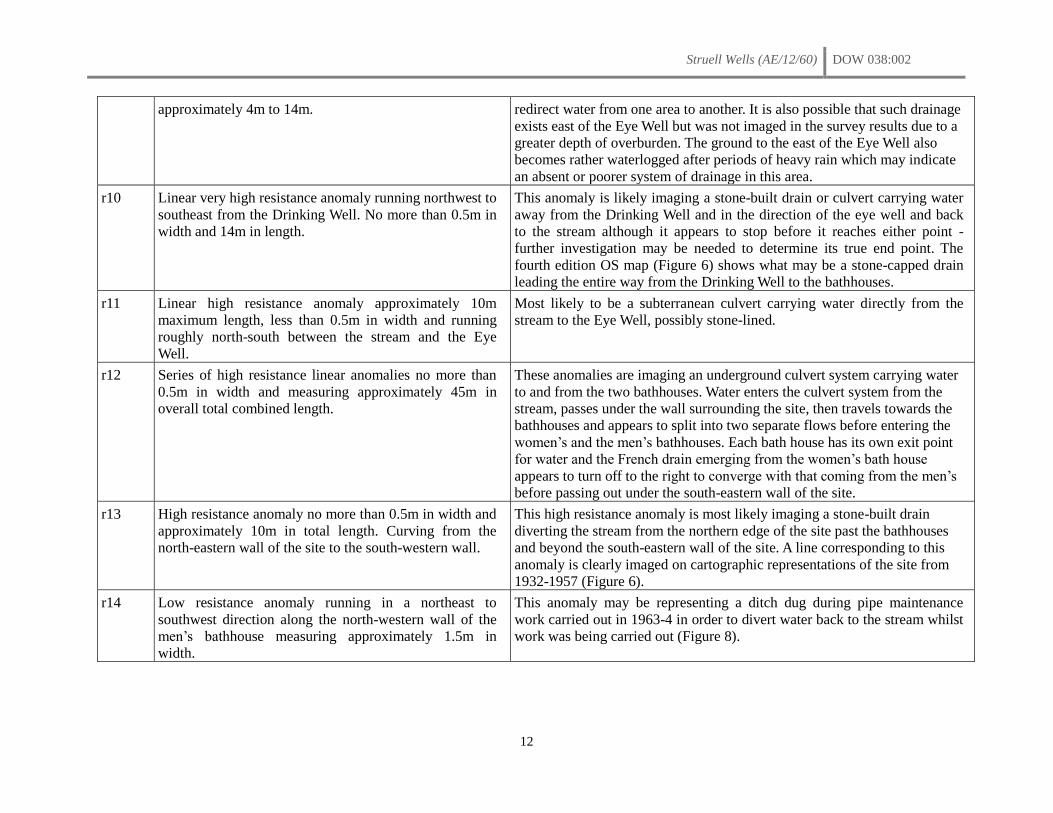
approximately 4m to 14m. redirect water from one area to another. It is also possible that such drainage
exists east of the Eye Well but was not imaged in the survey results due to a
greater depth of overburden. The ground to the east of the Eye Well also
becomes rather waterlogged after periods of heavy rain which may indicate
an absent or poorer system of drainage in this area.
r10 Linear very high resistance anomaly running northwest to
southeast from the Drinking Well. No more than 0.5m in
width and 14m in length.
This anomaly is likely imaging a stone-built drain or culvert carrying water
away from the Drinking Well and in the direction of the eye well and back
to the stream although it appears to stop before it reaches either point -
further investigation may be needed to determine its true end point. The
fourth edition OS map (Figure 6) shows what may be a stone-capped drain
leading the entire way from the Drinking Well to the bathhouses.
r11 Linear high resistance anomaly approximately 10m
maximum length, less than 0.5m in width and running
roughly north-south between the stream and the Eye
Well.
Most likely to be a subterranean culvert carrying water directly from the
stream to the Eye Well, possibly stone-lined.
r12 Series of high resistance linear anomalies no more than
0.5m in width and measuring approximately 45m in
overall total combined length.
These anomalies are imaging an underground culvert system carrying water
to and from the two bathhouses. Water enters the culvert system from the
stream, passes under the wall surrounding the site, then travels towards the
bathhouses and appears to split into two separate flows before entering the
women’s and the men’s bathhouses. Each bath house has its own exit point
for water and the French drain emerging from the women’s bath house
appears to turn off to the right to converge with that coming from the men’s
before passing out under the south-eastern wall of the site.
r13 High resistance anomaly no more than 0.5m in width and
approximately 10m in total length. Curving from the
north-eastern wall of the site to the south-western wall.
This high resistance anomaly is most likely imaging a stone-built drain
diverting the stream from the northern edge of the site past the bathhouses
and beyond the south-eastern wall of the site. A line corresponding to this
anomaly is clearly imaged on cartographic representations of the site from
1932-1957 (Figure 6).
r14 Low resistance anomaly running in a northeast to
southwest direction along the north-western wall of the
men’s bathhouse measuring approximately 1.5m in
width.
This anomaly may be representing a ditch dug during pipe maintenance
work carried out in 1963-4 in order to divert water back to the stream whilst
work was being carried out (Figure 8).
Struell Wells (AE/12/60) DOW 038:002
13
5 The 2012 excavation
5.1 Introduction
The 2012 excavation was undertaken over four weeks starting on June 6th and was run as a QUB
undergraduate student training dig. It was staffed by members of the CAF and directed by Emily Murray
and Finbar McCormick under a joint licence (AE/12/60). The excavation was supported by the Northern
Ireland Environmental Agency (NIEA) with permission from the landowners (Mr and Mrs Turley, Down
District Council and NIEA). The excavation was open to members of the public to visit and on Saturday
16th June as part of NIEA’s Archaeology Days programme of events and the Downpatrick Branch of the
YAC visited the site and took part in the excavation of the Drinking Well. Four students from De La Salle
College, Belfast, participated in the excavation during the third week.
Four trenches were opened – two inside the church (Trenches 1 and 4) and two either side of the Drinking
Well (Trenches 2 and 3). The interior of the Drinking Well was also cleared out and a photographic
survey of St Patrick’s Chair was undertaken by Tony Corey of NIEA. The main aims of the investigation
were;
to try and locate any surviving early medieval and possible pre-Christian features at the Drinking
Well, probably the ‘original’ and main well of the site (Trenches 2 and 3).
to find the foundations of the early church, thought to be located on the same site as the present
church (Trenches 1, 2 and 4). The early medieval stone with the incised cross (now built into the
wall of the Drinking Well) was found between the well and the church (McCormick 2009, 46)
and human remains were also reportedly found in this area when repair works were carried out at
the site in the 1920s (McCormick 2009, 53). Medieval stone-carved windows were also recovered
and are now built into the boundary wall. These discoveries all support the probability that the
early church was located in the vicinity of the post-medieval church.
to locate and uncover culverts and drains in and around the church and Drinking Well (Trenches
1-4)
to recover cultural artefacts from pagan, early medieval and/or post-medieval activities at the site
(Trenches 1-4)
to examine and record St Patrick’s chair in greater detail
5.2 Methodology
All excavations were conducted by hand and the trenches were back-filled and re-sodded on completion
of the excavation. The site context record was created using the standard context recording method.
Features were planned (scale 1:20cm) and photographed. Individual negative features were excavated by
putting a box-section through the feature to recover information about its profile and fill and were
recorded with a section drawing (scale 1:10cm). In addition to the photography and illustration, the
principal site records consisted of context sheets augmented by diaries for each Trench. A register of
samples taken was also maintained. Temporary fences were erected around the excavation trenches and
signage, warning of an open excavation, was displayed. Secure steel containers were hired to store tools
and finds on site.
5.3 Account of the excavation
Trench 1
Trench 1 was opened inside the church at the eastern end immediately inside, to the east, of the southern
entrance (Figure 15). It extended across the full width of the church (approx. 6.16m) and measured 3m in
Struell Wells (AE/12/60) DOW 038:002
14
width (east-west). The sod was removed (C1001; 0.03-0.05m) which exposed a matting of tree roots
(Plate 1). These were cut to reveal a mid-brown loamy topsoil which produced some pieces of glass and
pottery (C1002; 0.03m). On removal of C.1002, a fine sandy gravel horizon, orange-brown in colour, was
exposed which extended across the trench (C.1003; 0.03-0.09m). It yielded some coins and beads along
with pieces of pottery and glass. Roots continued down through this horizon which contained occasional
angular stones and patches of mortar and sand. Excavation of the sandy-gravel layer (C.1003) revealed an
angular-stone layer with the stones contained by a mid-brown loamy soil (C.1004; 0.09-0.3m) again
disturbed by roots. Finds from this deposit included pieces of clay pipe, fragments of glass and pottery
and corroded pieces of metal (modern). The surface of this layer was uneven and there was a notable
linear depression and relative absence of stones towards the centre of the trench (Plate 2). Along the
internal faces at the base of both long walls, were irregular linear spreads of mortar, partially collapsed
and slumped over the stones in C.1004; C.1005 ran along the inside face of the northern wall (Plate 3) and
C.1006 against the inside face of the southern wall (Plate 4). Both ranged between 0.04-0.06m in
thickness with fairly even level surfaces. The even surfaces would suggest that these could represent
remains of the contemporary floor surface, since removed, or alternatively, they could derive from the
pointing of the internal faces of the two walls, either when first in use or at a later date when taken into
State Care.
Excavation of the stony layer C.1004 revealed a lower stony clay-loam horizon (C.1007 - Figure 16)
across the northern two-thirds of the trench and an irregular spread of larger angular stones at the southern
end (C.1008). Excavation down through these deposits indicated that they were the same deposit with no
features or differential make-up discerned. The three were therefore conflated and considered as one
context, C.1004. This stony layer extended underneath the side walls of the church. Finds from this stony
horizon were mostly of nineteenth- and twentieth-century date and the ceramics included Scottish
spongeware, Castle Espie ware, creamwares and earthen wares. In addition to these finds, and in
increasing frequency with depth, a number of sherds of early medieval Souterrain Ware were also
recovered (approx. 40 sherds from C.1007) although these were clearly residual as they were found
alongside glazed wares.
Below the heterogeneous stone layer C.1004/C.1007/C.1008, at the south-eastern end of the trench, an
irregular stone linear feature emerged (C.1009) running on an east/southeast – west/northwest alignment
(Plate 5). It measured 2.62m in length and on average 1.12m in width with the large stones between
0.15m – 0.5m in size. Extending across the rest of the trench was a sticky brown clay deposit with
charcoal flecks (C.1010; 0.03-0.2m) which yielded modern pottery and glass. Further excavations within
Trench 1 were confined to the southernmost 3m of the trench. To the west of the stone feature (C.1009)
was an orange-brown sticky clay with small (0.02mm) angular stones (C.1011). Removal of C.1009
revealed further patches of this orange-brown clay C.1011 beneath the stones which in turn overlay a
dark-grey clay layer, (C.1012; 0.06-0.3m). Below this was a blue-grey clay with small angular stones
(C.1013). This was excavated down to a depth of 0.6m below the modern surface to where the water table
was reached and excavation in the trench ceased. No finds were recovered from any of the deposits below
the charcoal layer C.1010. The west-facing (Figure 17; Plate 5) and north-facing (Figure 18; Plate 6)
sections were drawn and the trench was back-filled.
Trench 2
A 5m x 5m trench, Trench 2, was opened to the northern side of the Drinking Well, immediately north of
the enclosing boundary wall and south of the church (Figure 15). The trench was opened primarily to
locate any earlier building remains associated with the well but also with the possibility of uncovering
early church remains. The square-plan trench was set approximately 0.5m north of the boundary wall but
was later extended southwards up to the wall.
Struell Wells (AE/12/60) DOW 038:002
15
The sod (C.2001; 0.03-0.09m) was removed to expose a loose gravel horizon (C.2002; 0.03-0.1m) across
the trench. The quarry gravel was angular and had a blue-black hue. Finds from C.2002 included lumps of
mortar, charcoal and quartz, the heel of a shoe and fragments of glass and pottery. The overlying sod
layer (C.2001) also yielded sherds of modern glass and nails. A spread (approx. 1.55m N/S x 2.7m E/W)
of smaller more rounded pea gravel, mottled grey/white in colour, was differentiated in the north-eastern
corner of the trench (C.2003; 0.01-0.03m). Some of the angular gravel was also mixed-in with the pea
gravel and this gravel horizon yielded fragments of pottery and glass and the crucifix from a rosary (Plate
7). On removal of the gravel a stony layer of larger, medium-sized mostly angular stones (C.2004) was
exposed. Within this deposit was a distinct curving line or arc of flat stones running from mid-way along
the eastern side of the trench to the north-western corner (Plate 8). This appeared to mark the edge of a
more regular area of the stony surface with larger stones to the south of the curving line. It seems
probable that this represents part of a roughly metalled path or roadway that runs over the stream towards
the cottages on the opposite side.
In the south-eastern corner of the trench, below the gravel (C.2002) and sitting over the metalled surface
(C.2004), was a discrete irregular spread of mortar (C.2005) covering an area of approximately 1m across
and between 0.07m and 0.01m thick. The creamy beige colour and consistency of the mortar was similar
to the mortar used in the boundary wall. This close comparison and its comparative shallowness suggest
that it is relatively recent and relates to the construction and/or re-pointing of this wall.
The trench was subsequently extended southwards to the boundary wall either side of the well. In the
south-eastern corner, a stony, ‘flagged’ and cobbled surface leading to the well entrance was uncovered
(C.2010 – Plate 9) presumably a continuation of the cobbled path (C.3008) revealed south of the
boundary wall in Trench 3 (see below). This was exposed in plan but not excavated. In the south-western
extension a sandy, grey-brown clay loam was uncovered (C.2007). It stretched from the western edge of
the trench as far as the well (approx. 1.14m) and northwards for approximately 0.7m at its widest extent.
It contained some small stones and fragments of slate and appeared to continue under the boundary wall
indicating that it relates to the construction of the wall (Plate 10). Excavation of the clay (C.2007),
exposed a loose stony deposit made-up of small to medium sized angular stones, many flat (C.2008),
bonded by a greyish brown clay loam.
Removal of the gravel (C.2002 and C.2003) and the mortar (C.2005) and the looser stones across the
surface of C.2004, including the curving line of sub-rectangular stones (one-course thick and not bonded),
uncovered another angular stony horizon (C.2013). There were no clearly identifiable features although
there was still a noticeable difference in the size and density of the stones either side the line previously
marked by the curving line of stones (Plate 11). It seems probable that the area south of this line (C.2013;
2-2.25m wide N/S) represented the path or roadway which aligns with the ‘bridge’ over the stream, and
which became more compacted with use. Rosary beads were found impressed into this surface (C.2013)
towards the eastern side of the trench. North of this line, and seemingly running under C.2013, the stones
were on average smaller and less compacted (C.2006). Along the southern ‘edge’ of this path was a
distinctive linear arc of relatively large rectangular flat stones (C.2012) echoing the curve of the well,
approximately 0.6m south of it. This was much more substantial than the curving line of smaller
rectangular stones present in the overlying layer (C.2004). This ill-defined feature, C.2012, was
originally thought to be part of a wall, as it appeared to be bonded with a hard gravelly clay that was hard
to excavate. After planning and excavation of a section north of the stone feature, it was found to be
insubstantial and just one-course high (Plate 12), set into and above a hard stony deposit (C.2016; 0.02-
0.05m) containing small stones and gravel. The stone feature C.2012 may therefore simply be another
constituent of the metalled path or roadway.
Subsequent excavation down through the lower stony deposit C.2006 indicated that it was marginally
deeper towards the northern side of the trench (0.1-0.5m). It yielded pieces of broken modern glass and
Struell Wells (AE/12/60) DOW 038:002
16
pottery, a coin, a few fragments of brick and plastic. This stony material was probably laid to alleviate the
drainage, possibly as a primary layer for the roadway (i.e. C.2004, C.2013 and C.2012).
A 1m-wide sondage or box-section (Test Trench 1; Plates 12 and 13) was opened along the northern edge
of the trench to determine the nature and depth of this stony layer (C.2006). Below C.2006 was a gravelly
yellow-brown clay loam with small stones and sand (C.2011). The only finds from this deposit were a
human tooth and fragment of human bone. This lay above a voided large angular stone and boulder
deposit with lumps of sticky yellow- brown clay (C.2014) and with the stones impressed into a pure
yellow-brown sticky clay beneath the stone layer (not excavated). Some of the stones were lifted towards
the western end of the Test Trench, but at a depth of approximately 0.6m water was reached (Plate 14)
which was flowing in a southerly direction. It was also not clear whether the voided stone horizon
(C.2014) was natural or man-made and part of the extensive build-up and dump material (the stones had a
blue-black colouration and angular facets). No finds were recovered from C.2014.
A second box-trench (Test Trench 2) was opened along the eastern side of the trench with a 0.5m-wide
extension at the north-eastern corner, extending as far as the church wall. The differentiation in section of
C.2006 and the path proper, C.2013 could not be determined. Excavation down through the gravel-clay
horizon C.2011 (initially identified as C.2020 in TT2; 0.08-0.2m) below C.2006 at this side of the trench
uncovered a shallow layer of grey brown clay with red/orange burnt stones and charcoal (C.2015),
sandwiched between the voided stone layer below, C.2014, and C.2011 above. A piece of dark-green
bottle glass was found at the interface of C.2011 and C.2015 (labelled C.2011). This burnt layer (C.2015;
0.02-0.16m) increased in thickness from the northern edge of the trench towards the well, while the
overlying stone dump layer, C.2006, did the opposite, and thinned out southwards. C.2015 produced a
flint scraper.
Test Trench 2 was extended as far as the church wall at its northern end. This uncovered a light-brown
sandy mortar layer with inclusions of fine angular gravel (C.2018; 0.09- 0.22m) below the church wall
and overlying the extensive stone build-up (C.2006 – Plate 15). In the south-eastern extension of the
trench, excavation of the gravel (C.2002) north of the path (C.2010) and south of the linear stone
alignment C.2012 and an outcrop of bedrock exposed an irregular stony layer of small to medium-sized
stones (C.2023 – Figure 20). This was excavated to a depth of a maximum of 0.18m when bedrock was
encountered.
Excavation down through the lower stone layer (C.2016 – possibly contemporary or same as C.2006)
towards the southern side of the trench, unveiled ill-defined patches of a brown clay-loam, a reddish
brown clay loam and a blackish-brown clay loam against the north face of the well (C.2021- Plate 16).
Below this was the stony/gravel horizon C.2011 (Plate 17). Below the angular stony deposit C.2008 in the
south-eastern extension, a linear stone feature, a wall or revetment was exposed in plan (C.2022 – Plates
16, 17 and 18) and partially in section (0.22-0.24m in height). Excavation down through C.2008 indicated
that it was built above C.2011 as too is the well suggesting that the two stone-built features are
contemporary.
In summary, the excavation of Trench 2 revealed a series of dumped stone deposits and extensive ‘made-
ground’. Presumably the stones were laid down to alleviate drainage both for the construction of the
church and for paths and routeways and around and through the site. The latest phase of this sequence
was represented by a layer of gravel quarry below the sod which probably dates from an earlier period of
State Care. Part of the path that leads to the well from the direction of the Eye well and bathhouses was
also uncovered. This path was found to continue in trench 3 and the stone boundary wall was built above
it. Adjacent to the Drinking Well there were a series of ill-defined stone and clay deposits abutting the
wall. This suggests that the wall was built at a lower level and then buttressed up external with dumped
material. The stone built feature C2022 east of the wall appears to be contemporary with the well though
Struell Wells (AE/12/60) DOW 038:002
17
as only a sub-section of it was revealed it will require further investigation to identify its full form and
function. The pottery and other finds from the trench, in particular from the stone layer that continues
under the church wall will require specialist analysis.
Trench 3
Trench 3 (5m x 5m) was opened immediately south of the Drinking Well and boundary wall (Figure 15).
The sod (C.3001; 0.04-0.14m) was removed to expose a loose dark brown sandy-loam with quarried
stones and gravel, and modern rubbish – fragments of broken ridged terracotta waterpipe, glass, clay-pipe
stems, sherds of creamware and small marine shells (flat winkles) derived from decayed mortar (C.3002).
It was deeper on the northern side of the trench and there was much disturbance caused by roots from
trees growing along the edge of the stream to the west of the trench (Plate 19). Excavation down through
C.3002 exposed a discrete spread (0.71m E/W x 0.44m N/S) of a light greyish-brown sticky clay with
gravel and sand (C.3003; 0.03-0.05m) in the north-western corner of the trench bounded by the boundary
wall to the north and flagged surface of the pedestrian gate to the west (Plate 20). Its location adjacent to
the southern face of the wall suggests that it relates to the construction or re-pointing of the wall. It is
probably the same depositas C.2007 uncovered on the opposite side of the wall in Trench 2. Excavation
of C.3002 also exposed large stones and boulders, ‘footings’ to the wall of the well.
Immediately east of the well, at the northern side of the trench a line of angular stones (C.3007) and
mortar (C.3004) emerged on the removal of C.3002 along the southern face of the boundary wall (Plate
21). The mortar (C.3004; 0.02-0.05m), a mottled light-greyish brown with inclusions of gravel, was firm
and similar to the mortar spread on the opposite side of the wall (C.2003). It produced a couple of
fragments of modern window-glass. Excavation of the stones (C.3007; 0.08-0.12m) and mortar (C.3004)
showed that they did not run under the wall but abutted it, representing packing stones and fill at the base
of the wall. The stones included a mixture of angular and rounded stones, one course high and one to two
stones deep. The boundary wall (C.3006- Plate 22) east of the well abuts the wall of the well but predates
the pink-mortar re-pointing of the well. The wall is of random-rubble construction, 1.36m in height and
0.6m in width with a rounded on top.
Excavation of C.3002 across the rest of the trench exposed a dark reddish-brown, clay-loam (C.3005;
0.3m) with bits of coal, stone and roots and more fragments of the ridged terracotta waterpipe. Generally
there were less finds than in C.3002, and it became increasingly stonier and firmer with depth (Plate 22).
Excavation down through C.3005 revealed a cobbled stony surface, C.3008, along the eastern side of the
trench (Plate 23). It measured 1.6m in width, extending westwards from the eastern edge of the trench. It
also extended across the full length of the trench, 4.3m north-south, south of the boundary wall (C.3006).
The stones on average measured 0.1m across. The stones and mortar (C.3007 and C.3004) at the base of
the boundary wall and the boundary wall itself were both built above the cobbling which continued
northwards, under the wall. The cobbling had a relatively even surface with three east-west linear gullies
or depressions. The cobbled surface was cut by a linear trench for a drain (C.3010) running southwards
from the well, leaving the cobbling with a ragged irregular edge, slumping and dipping downwards into
the cut (Plates 22 and 23). A small section was cut through the cobbles (C.3008) at the SW corner of the
trench were the cobbling was less regular (Plate 24). Below the cobbles (0.14-0.08m) were large angular
stones and a mid-brown clay loam (C.3021; 0.12-0.16m) with root disturbance. This layer produced one
piece of brown-glazed ware. Below C.3021 was a blackish brown clay loam with small and medium-sized
stones and ‘burnt stones’ (C.3023). This was only partially excavated due to the narrowness of box-
section and presence of large stones (Plate 24).
West of the cobbling was the stone-built drain (C.3012) and blackish-brown loamy fill (C.3009) both
within a linear cut (C.3010). A 4.57m length of the stone-built drain was exposed (Plates 22, 23, 25 and
26). It measured 0.5m in width and height externally and was capped with large angular relatively flat
Struell Wells (AE/12/60) DOW 038:002
18
stones (0.67m x 0.32m and 0.07m thick). The fill of the drain-cut (C.3009) in around the stones was loose
and contained some charcoal and bits of mortar along with modern rubbish (crisp packets etc. – Plate 27),
a marble, broken glass and animal bone. The fill was partly excavated to expose the capstones of the
drain. A couple of the capstones of the drain at the southern end were lifted to expose the interior of the
drain which measured 0.44m in width and 0.35m in height internally (Plate 28). The internal walls of the
drain had also been re-pointed with concrete and clear water, emanating from the Drinking Well, flowed
through it.
North of the drain was a heterogeneous deposit (C.3011) within which were ill-defined spreads of looser
more disturbed lenses, and areas with a higher concentration of stones and clay, especially close to the
well, but no definite features could be discerned (Plates 23, 25 and 26). When C.3005 was first removed a
series of discrete areas were originally differentiated (C.3011, C.3013, C.3014, C.3015, C.3016). These
represented poorly defined irregular possible cuts, fills and lenses but on investigation were found to be
all part of a mixed, modern composite made-up deposit, with stones and fragments of ridged terracotta
water pipe (as found in C.3002), present throughout. The contexts were therefore conflated and excavated
as one (C.3011). Both the drain and cobbled surface were cleaned back, and C.3011 was excavated to an
arbitrary even level, and the trench was planned (Figure 21).
The heterogeneous build-up deposit, C.3011, was mattocked-off which exposed a large piece of modern
ceramic drainpipe wedged underneath one of the large boulders around the base of the well wall (Plate
29). This demonstrated that there were multiple mixed dumps of material deposited around the same time.
Removal of C.3011 uncovered a loose earthy dark brown clay-loam (C.3018; 0.19-0.2m) which yielded a
complete glass wine bottle, plastic bottle tops, corroded bits of iron and creamware, along with more
fragments of terracotta drain pipe as were also found in the layers stratified above it (C.3011, C.3005 and
C.3002). The mixed and often loose nature of the deposits west of the drain and presence of modern
detritus throughout to a depth of around 0.6-0.7m, indicates extensive modern disturbance. A sondage or
box-section was opened through this modern material perpendicular to the drain. Below C.3018 was a
thin, blackish-brown clay with gravel and small stones (C.3019; 0.01-0.09m) which lay above a sticky
mid- to light-brown waterlogged greenish-brown clay (C.3020) which abutted the external side-wall of
the drain. Due to waterlogging and the reaching of the water-level excavation of C.3020 ceased at
approximately 0.7m, below the modern ground surface (Plate 20). No positive cut for the drain through
the clay was identified. The ground, however, was waterlogged and the presence or absence of a cut could
not be determined with certainty
The east-facing (Figure 22) and north-facing (Figure 23) sections of the trench were drawn and the trench
was then back-filled by hand and re-sodded.
Trench 4
Trench 4 was opened across the full width of the church (6.15m x 3m) at the western end, 2m east of the
western gable wall. The sod (C.4001; 0.05-0.07m) was cut to expose a loose dark-brown loamy topsoil
(C.4002; 0.03-0.4m) with stones and roots and lenses of sand which yielded modern finds – plastic,
modern glass, creamware and a rusted holy medal. Below this was an orange-brown sandy-gravel layer
(C.4003) equivalent to C.1003 in Trench 1 and which produced some pieces of pottery and glass.
Removal of C.4003 exposed a stony mid-brown loam horizon (C.4004; 0.22-0.3m) with glass and pottery,
equivalent to C.1004 in Trench 1. The stony horizon did not extend across the full length of the trench –
at the southern end C.4004 extended north from the southern wall for 1.5-2m with a gap of 1m and with
C.4004 extending north from it (Plate 31).
At the southern end of the trench 0.5m north of the southern wall, a box-section, the full width (3m) of the
trench and 1m wide was opened. Excavation down through C.4004 exposed a charcoal-flecked grey-
brown clay loam, 0.55m below the sod, with fragments of human bone and stone (C.4008; 0.2m). On
Struell Wells (AE/12/60) DOW 038:002
19
exposure of C.4008 and presence of bone, the trench was widened and extended 1.5 to the north to give it
a total width of 2.5m (box-trench = 2.5m x 3m). Within C.4008 were poorly preserved discrete ‘samples’
of disarticulated human remains - C.4006 and C.4007 both of which were bagged as ‘bulk samples’. At
the southern edge of the trench within C.4008, were the partial remains of in situ articulated skeletons
C.4009, C.4010 and C.4011, orientated east-west and running into the north-facing baulk. Skeleton
C.4009 was represented by the left femur, proximal end of the left tibia and bones of the left hand. The
other skeletons were represented by long-bones aligned on the same orientation but were all poorly
preserved (Figure 24).
The articulated remains were at the base of the C.4008 layer, and were sitting on the surface of an intense
black gritty-loam with burnt orange/red-coloured stones throughout (C.4005; 0.28-0.27m – Plate 32).
Multiple samples of this relatively loose and friable ‘burnt mound’ type material were taken for
processing in the lab to recover samples suitable for radiocarbon dating including a discrete sample of
preserved charcoaled twigs at the base of the deposit. No artefacts were recovered from this horizon nor
were any found in association with the skeletons in the overlying deposit, C.4008. A 1m-wide section was
excavated down through C.4005 to reveal a large angular stone and boulder layer, C.4012. The black
loam was excavated from around the stones (C.4012) which were sitting on, and pressed-into a sticky
blue-grey clay horizon (C.4013) possibly the natural subsoil. The trench was photographed but the lower
deposits, C.4012 and C.4013 were not excavated (Plate 33). The water-table was reached at this depth
(0.9m below the modern surface) and excavation within the trench ceased. The west-facing section
(Figure 25) was drawn and the trench was back-filled and re-sodded.
The Drinking Well
A water pump was used to try and drain the Drinking Well but it was found that the well filled-up as
quickly as the pump drained it out. The fill of the well was lifted out by bucketfuls and sieved in the
adjacent river. The majority of the finds were coins – the oldest dating to 1955 (Table 6, Appendix 1).
Other finds included bits of broken glass, bottle tops, ring pulls, a nail, a teaspoon and some fragments of
pottery. The well also had modern, imported red-coloured quartz gravel. The presence of the gravel and
the modern coins indicates that the well must have been cleared-out on at least one occasion relatively
recently.
St Patrick’s Chair
The weeds and growth around the chair were cleaned back by hand and Tony Corey (NIEA) visited the
site and took a series of high-resolution detailed photos (NIEA archive).
6 The finds
Finds recovered during the excavations have been sorted and washed in the labs at QUB, and partly
catalogued, by work-experience secondary school students supervised by Mr David Brown (QUB). The
principal finds were fragments of pottery and bottle glass (Table 6, Appendix 1) and coins from the
Drinking Well (Table 7, Appendix 1). The majority of the coins (No. 116; 95%) were of sterling and
ranged in date from 1955 to 2009. A few Euro (No. 3) and old Irish pence (No. 3) coins were also
represented. A collection of corroded iron objects and other miscellaneous finds were also recovered but
have not been catalogued.
Small quartz stones were found in Trench 3 and these were kept. Hardy (1836, 38-9), in describing the
rituals performed at Struell notes of those climbing up to St Patrick’s chair that ‘the more respectable…
keep their reckoning beads; while the poorer sort lift a pebble to mark each ascent’. While on the plain
the pilgrims had to carry a stone which they then added to one of the cairns (ibid.). It is possible that this
collection of quartz stones from Trench 3 were left by pilgrims’ visiting the well.
Struell Wells (AE/12/60) DOW 038:002
20
7 Radiocarbon dates
Bulk samples of the ‘burnt mound’ material in Trench 4 (C.4005) were sampled and have been processed
in the wet-prep lab at QUB. The majority of the charcoal that was floated off is finely particulated with
very few single-entity pieces suitable for radiocarbon dating. The largest fragment of charcoal (unid.)
recovered from the bulk samples (C.4005) was submitted for dating (UBA-22718) to the CHRONO
radiocarbon lab at QUB. It returned a radiocarbon age of 3848±34 BP which calibrates at the 2-sigma
range (95.4%) to cal. BC 2459-2205. As neither the species nor the age of the specimen could be
identified from the small sample, this very early date (Late Neolithic) could be misleading. The sample
may derive from the heartwood of a potentially long-lived specimen (e.g. oak) and therefore centuries
older than when the tree was actually felled creating an ‘old wood effect’ (Lanting and Brindley 1991,
26). This result contrasts with that of a twig dated from the same context. During the excavation of the
burnt layer (C.4005) a distinct cluster of twigs was noted at the base of the deposit and sampled
separately. This sample comprises a collection of short-lived twigs (15-17 years old), identified as ash
(Fraxinus sp.) by David Brown (QUB). One of these returned a radiocarbon age of 613±27 BP which
calibrates, at the 2-sigma range, to cal. AD 1296-1400 (UBA-22403). A third sample, of human bone
(fragment of femur) from one of the articulated skeletons (SK4009) overlying the burnt horizon (C.4005),
was also submitted for radiocarbon dating. This returned a radiocarbon age of 945±29 BP, which
calibrates at the 2-sigma range (95.4%) to cal. AD 1025-1156 (UBA-22411).
The date returned for the skeleton is therefore several centuries older than that returned for the ash twig
which was stratified below it. Meanwhile the sample of charcoal recovered from the same deposit as the
twig, but not necessarily of a short-lived specimen, is millennia older. Even given the possibility of the
old wood effect for which there is no general ‘correction factor’ (Lanting and Brindley 1991, 26) the
margin of error would only push the date a few centuries earlier. At best the radiocarbon results provide a
terminus post quem for activity at the site and a maximum date range though the picture is far from clear.
More dates will be needed to tease-out the true chronology of the site. A second sample from the ash twig
collection from C.4005 has been submitted for dating (UBA-22403).
8 Discussion
The excavation, although unsuccessful in locating the early church was successful in other ways. The
most exciting and unexpected discovery was the ‘burnt mound’ material which was stratified below
articulated skeletons though the results returned from the radiocarbon analysis are as yet, indeterminate
(see above). The extent to which the ground was artificially built up in and around the church and
Drinking Well was also not previously appreciated while a cobbled path leading into the Drinking Well
was re-discovered. The majority of artefacts that were recovered were post-medieval in date but a small
assemblage of sherds of early medieval Souterrain Ware was recovered, principally from Trench 1, along
with a flint scraper from Trench 2.
8.1 The ‘burnt mound’ material
The most exciting and significant discovery was the articulated skeletal remains and the ‘burnt mound’
material below them in Trench 4 (C.4005). This deposit, 0.3m in depth, comprised heat-shattered stones,
many also distinctly reddened from being burnt, and a dense concentration of charcoal. Traces of this
material were also found to extend southwards into Trench 2 (C.2015/2017) as far as the Drinking Well
suggesting that it is quite an extensive deposit. A couple of disarticulated human bones were also
recovered from the overlying deposit in Trench 2 (C.2011).
Struell Wells (AE/12/60) DOW 038:002
21
The heat-shattered stones and charcoal are the typical characteristics of burnt mounds or ‘fulachta fiadh’,
widely recorded from sites across Ireland and elsewhere in Europe (O’Neill 2003-4, 82; Barfield and
Hodder 1987, 370). The associated apparatus – hearths, pits dug in the ground and wooden or stone
troughs or basins, are only occasionally found (O’Neill 2003-4, 83). These site types are commonly
located in proximity to water and are typically devoid of artefacts including food debris, and generally
lack settlement evidence (Barfield and Hodder 1987, 371) all of which the evidence from Struell is
consistent with.
The interpretation of these burnt mounds are that stones, heated in a fire, are then placed in water to boil it
thereby producing heated water for cooking or bathing or, if contained by a structure of some sort, steam.
Documentary sources from Ireland include a number of accounts that describe the boiling of liquids using
heated stones - an activity that would yield the burnt mound material as recorded in the archaeological
record (O’Neill 2003-4). However, radiocarbon analyses of burnt mounds from Ireland show that few,
less than 5%, are contemporary with these historical descriptions (O’Neill, 2003-4, 83). The majority of
the burnt mound sites in Ireland date to the first and second millennium BC, a pattern also recorded in
Scotland, England and Scandinavia (ibid.).
There has been much discussion about burnt mounds and whether they represent the remains of cooking
or bathing (Barfield and Hodder 1987; Ó Drisceoil 1988; O’Neill 2003-4). Barfield and Hodder (1987)
argue that they represent the remains from sweat houses (sauna) or sweat-bathing of some form. They
also note that the primary period of use of burnt mounds coincides with a ‘water-based’ religion found
across Europe which includes the deposition of objects in watery locations such as streams, pools and
lakes (Barfield and Hodder 1987, 378). They therefore argue that saunas may have had a ritual function of
purification as part of the religious practices and beliefs at this time (ibid.). The tradition associated with
many saunas and sweathouses, including in Ireland, are that they are accompanied by a cold plunge after
leaving the sauna (Barfield and Hodder 1987, 372). At Struell this could have been performed by bathing
in the stream or an early incarnation of the Drinking Well, a probable true, spring well. Ó Drisceoil
(1988), however, argues for their primary use as cooking although he concedes to the possibility of their
use as sweathouses where there is ‘the presence of a water supply, burnt stones and the possibility of
adjacent enclosed structures’ (Ó Drisceoil 1988, 679). He also suggests that the presence of a trough
strongly argues against the use of the site for sweating or sweat bathing (ibid.).
What makes Struell different from many other places of pilgrimage is the practice of naked bathing,
which St Patrick also reputedly took part in (McCormick 2009, 55). This practice may be a survival of
pre-Christian Pagan practices. The main date of pilgrimage to the site, on Midsummer’s Eve, is also
unusual as pilgrimages to holy wells are more traditionally held on the feast day of the saint to whom they
were dedicated (McCormick 2009, 56). The date of pilgrimage at Struell could also therefore have its
origins in the earlier history of the site. McCormick (2009, 58) has shown that naked bathing on
Midsummer’s was a widespread practice across Europe and North Africa dating back to pre-Christian
times. The ‘burnt mound’ material discovered at Struell could therefore derive from saunas and ritual
bathing which, along with the date of pilgrimage and practice of naked bathing, suggest that Struell Wells
and the Christian pilgrimage is a likely survival of a pagan midsummer festival before it acquired
Christian status and associations.
At Struell, the discovery of the burnt mound horizon at a site that became a famous, and infamous,
complex of wells and bathhouses, and included a visit by St Patrick and the papal nuncio in 1515
(McCormick 2009, 50), is highly significant. The stratification of the burnt horizon immediately below
the burials, which are orientated east-west and presumably Christian, strongly supports the contention
(pace McCormick 2009, 58) that it has pre-Christian origins. The visit by St Patrick to the complex as
recorded in the early medieval documents essentially demonstrates that he was symbolically
Christianising an important Pagan site (McCormick 2011, 11) which arguably, the archaeological
Struell Wells (AE/12/60) DOW 038:002
22
evidence now clearly supports. The radiocarbon dating of both the burnt mound horizon and the
articulated skeletons is therefore anxiously awaited.
8.2 Early structural remains: church and the Drinking Well
One of the objectives of the 2012 excavations was to try and locate the foundations of the early church.
No positive structural remains of a church were encountered but the presence of burials, apparently in
situ, suggests that the earlier church building was probably located in the vicinity of the present ruinous
church, possibly further west. The discovery of human remains during the course of repair work in the
1920s is also documented and these were reportedly found in the area between the church and Drinking
Well (McCormick 2009, 53). Human bones were also sometimes unearthed during ploughing in recent
years which has led to local tradition of a graveyard lying immediately northwest of the ruined church
(McCormick 2009, 53).
The other aim of the excavation was to determine if there were any earlier structural remains or other
features associated with the Drinking Well which documentary evidence suggests is the original and
primary well of the site. In Trench 3, opened south of the well and boundary wall, the extensive modern
disturbance indicates that little if any early remains survive. In Trench 2, north of the well the picture is
more complicated where various linear arrangements of stones and ‘flags were. The main feature of any
consequence was the stone-built wall or revetment (C.2022) uncovered at the eastern edge of the trench
and which appeared to be contemporary with the wall of the well. As only a small area of this feature was
exposed it is not possible to determine its form or function. In the geophysical survey plots (Figures 11-
13) there is a faint linear high-resistance anomaly in this location which may be imaging the same feature
(C.2022) partly uncovered in the excavation trench. Further excavations would be required to determine
the full extent of this feature.
8.3 Made ground and the post-medieval church
The excavations, in particular in Trenches 1, 2 and 3, have demonstrated that there is an extensive amount
of ‘made ground’ at this eastern end of the site. The building-up of the ground further south towards the
bathhouse is evident but the extent of build-up at the northern end had not previously been recognised.
This build up is principally of quarried stone and was presumably laid to provide better drainage and
firmer footing for the church and the route ways in and around the site.
The principal build-up of stone runs under, and predates, the construction of the post-medieval church
(C.2006 and C.1004). The cobbled path, leading from the direction of the bathhouses to the Drinking
Well (in Trenches 2 and 3) also appears to overly the built-up layer, and may be contemporary with the
church. This could suggest an extensive revamp and re-presentation of the site contemporary with the
erection of the new church. The construction of the church in the eighteenth-century is not precisely
dated. The analysis of the pottery and other finds recovered from the extensive build-up layer underlying
the church wall in Trenches 1 and 2, is therefore of interest.
8.4 Modern twentieth-century developments
The re-surfacing and metalling of the roadway, leading east across the stream postdates the deposition of
the main stony build-up layer (C.2006). The gravel layers (C.2002 and C.2003) just below the sod
probably date to an earlier phase of presentation of the site when in State Care. Traces from other more
recent works at the site were also recorded including lime mortar from the construction of the boundary
wall (Trenches 2 and 3) and the discovery of the concrete lining of the stone-built drain leading south
from the Drinking Well (Trench 3). There has also evidently been at least one occasion when the land to

Struell Wells (AE/12/60) DOW 038:002
23
the south of the Drinking Well was dug-out, possibly when it was lined with concrete. The well has also
evidently been cleared out in recent times.
The concrete pointing of the drain and presence of crisp packets and other modern waste around the drain
indicates that it must have been accessed in the late twentieth century. The loose make up of the soil west
of the drain, and presence of modern rubbish throughout, in particular fragments of the same modern
ceramic ridged drainpipe, suggests that a large area west of the drain must also have been dug away
around this time also – by hand or machine. Perhaps the area had become waterlogged and boggy due to
the blockage of the drain? The linear cut for the drain (C.3010) must also be a modern ‘re-cut’.
The geophysical survey detected a number of linear anomalies that can probably be best interpreted as
drains or culverts of some form. Some of these (r11 and r12 – Figure 14) correspond with the pipes
depicted on the proposed plans of maintenance for the site in the 1960s and later (Figures 8 and 9). This
would suggest that the proposed plans were in fact executed. The disturbed ground west of the stone-lined
drain in Trench 3 could well date to this period of maintenance at the site. This drain was clearly imaged
in the geophysical survey results (Figures 11-13) although it seems to abruptly stop after a length of 13-
14m. This matches the presumably late plan of drainage at the site which shows the presence of a
manhole at approximately this location (Figure 9). The other linears (the r9 anomaly) do not relate
directly to the wells or bathhouses. They may be simple stone-lined drains inserted to help with the better
drainage of the site, perhaps when it was under crop (see McCormick 2011).
8.5 Phasing
A broad outline of phasing for activity at the site can be suggested. The earliest stratum (Phase 1) is the
sterile voided stone horizon, set above a natural clay layer, and probable subsoil, at the level of the water
table. It was not determined if this was a natural or artificial horizon. Overlying this was the burnt mound
material, as yet undated (Phase 2). This was succeeded by the burial horizon (Phase 3) presumably
Christian as the skeletons are orientated east-west and possibly contemporary with the as yet unlocated
medieval church. A radiocarbon date suggests that these are eleventh-twelfth century in date.
Straddled between the burnt mound horizon (Phase 2) and the later stone dump layers (Phase 4) is the
construction of the well and adjacent stone-wall feature uncovered in Trench 2. The relationship between
the burial horizon (Phase 3a) and these structural remains (Phase 3b) was not determined and could
therefore be contemporary, predate or post-date the burials. All of these features can be grouped together
into Phase 3.
Overlying this burial horizon and stone-built features are the multiple extensive stone dumps of post-
medieval date (Phase 4). Analysis of the glass and pottery will determine a better date range but cursory
examination suggests a late eighteenth or early nineteenth century date. The construction of the church
can be assigned to this phase (Phase 4b) along with the cobbled path and the earliest metalled roadway
running between the church and well and across the stream.
Historical records date the construction of the enclosing boundary wall, and removal of the cairns, to the
early nineteenth century (Phase 5). Re-metalling of the roadway could date to this and/or a later phase
along with the building of the clachan which dates to the eighteenth-nineteenth centuries. The most recent
twentieth-century activities can all be assigned to the latest phase, Phase 6 and include the modern
drainage works, gravel surfaces of the paths and subsequent laying of the sod.

Struell Wells (AE/12/60) DOW 038:002
24
9 Recommendations
9.1 Specialist reports
It is recommended that the small assemblage of human bones is examined by a human osteologist and the
assemblage of pottery, which includes medieval (Souterrain Ware) and post-medieval types, is examined
by a pottery specialist. Analysis of the finds from the build-up layer underlying the walls of the church is
of particular interest to provide a terminus post quem for the construction of the church which is not
tightly dated. Much of the metalwork, coins and glass along with the miscellaneous finds (rosary beads
etc.), are modern and do not require specialist analysis although it is recommended that they are given a
summary overview. These finds, apart from the metalwork, have all been washed and catalogued in part
(see Appendix 1).
9.2 Further excavations
The most significant discoveries of the 2012 excavations were the articulated skeletal remains and the
dense black layer, and possible ‘burnt mound’ material, underlying them. The orientation of the skeletons
suggested that they are Christian burials and the single radiocarbon date would indicate that they date to
the eleventh-twelfth century AD. The location of the burials at the western end of the eighteenth-century
church could also suggest that an earlier church, associated with the burials, was located further west. The
earlier finds of the incised cross, architectural pieces and bone also all coincide with the discoveries of the
2012 excavation. It would therefore be of interest to revisit this area of the site and undertake an
excavation in the area west of the church ruins. Extension of Trench 2 to the west to investigate the stone-
built feature C.2022 would also be of interest.
Given the extent of modern disturbance and made ground at the eastern end of the site, as encountered in
Trenches 2 and 3, and the recorded build-up of ground further south towards the bathhouses, it is not
recommended that any further excavations are undertaken in these areas of the site.
9.3 Publication
A brief summary of the results of this excavation have been submitted to Isabel Benet for inclusion in the
annual Excavations Bulletin. Publication in a peer review journal, and possibly also a summary of the
results in a local journal (e.g. Lecale Review), is recommended after the return of radiocarbon dates.
10 Acknowledgements
Our main thanks go to the QUB undergraduate students who excavated the site often working in
extremely wet and muddy conditions. Sarah Gormley (CAF) and Ruairi O Baoill (CAF) were both
supervisors at the site and Sapphire Mussen (CAF) conducted the geophysical survey and completed a
report on the same. She was assisted on-site by Stuart Alexander (CAF) and Grace McAlister (CAF).
The drawings (plans and sections) were prepared by Libby Mulqueeny, QUB and permission to excavate
at the site was provided by the landowners – the NIEA, Mr and Mrs Turley of Struell House and Down
District Council. The NIEA also provided financial support for the excavation. The finds from the site
were washed by secondary school students on placement in the School of GAP, supervised by Mr David
Brown.
Struell Wells (AE/12/60) DOW 038:002
25
11 References
Allen, J. 2011 The hydrology and hydrogeology of Struell Wells, Downpatrick, Co. Down. Unpublished
MSc thesis. School of Geography, Archaeology and Palaeoecology, QUB.
Barfield, L. and Hodder, M. 1987 Burnt mounds as saunas, and the prehistory of bathing. Antiquity 61,
370-79.
Hardy, P. D. 1836 The holy wells of Ireland. Dublin. Philip Dixon Hardy
Harris, W. 1744 The ancient and present state of the county of Down. Dublin. A. Reilly.
Jope, M. (ed.) 1966 An archaeological survey of County Down. Belfast. HMO, Northern Ireland, Ministry
of Finance.
Lanting, J. and Brindley, A. 1991 Radiocarbon. Archaeology Ireland 5(1), 24-6.
McCormick, F. 2009 Struell Wells: pagan past and Christian present. Journal of the Royal Society of
Antiquaries of Ireland 139, 45-62.
McCormick, F. 2011 Struell Wells (Lecale Review Monograph 1). Lecale and Downe Historical Society.
O Laverty, J. 1878 An historical account of the diocese of Down and Connor ancient and modern. Vol. 1.
Dublin. James Duffy & Sons.
Ó Néill, J. 2003-4 Lapidibus in igne calefactis coquebatur: the historical burnt mound ‘tradition’. The
Journal of Irish Archaeology 12/13, 79-85.
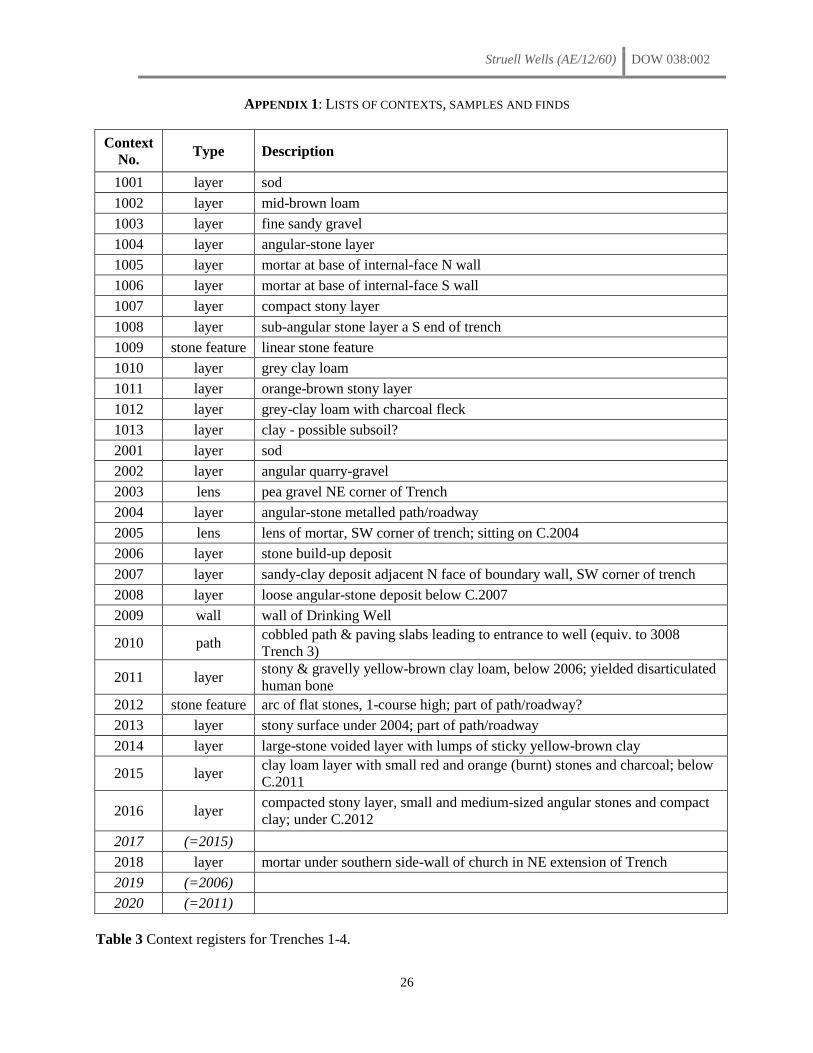
Struell Wells (AE/12/60) DOW 038:002
26
APPENDIX 1: LISTS OF CONTEXTS, SAMPLES AND FINDS
Context
No. Type Description
1001 layer sod
1002 layer mid-brown loam
1003 layer fine sandy gravel
1004 layer angular-stone layer
1005 layer mortar at base of internal-face N wall
1006 layer mortar at base of internal-face S wall
1007 layer compact stony layer
1008 layer sub-angular stone layer a S end of trench
1009 stone feature linear stone feature
1010 layer grey clay loam
1011 layer orange-brown stony layer
1012 layer grey-clay loam with charcoal fleck
1013 layer clay - possible subsoil?
2001 layer sod
2002 layer angular quarry-gravel
2003 lens pea gravel NE corner of Trench
2004 layer angular-stone metalled path/roadway
2005 lens lens of mortar, SW corner of trench; sitting on C.2004
2006 layer stone build-up deposit
2007 layer sandy-clay deposit adjacent N face of boundary wall, SW corner of trench
2008 layer loose angular-stone deposit below C.2007
2009 wall wall of Drinking Well
2010 path cobbled path & paving slabs leading to entrance to well (equiv. to 3008
Trench 3)
2011 layer stony & gravelly yellow-brown clay loam, below 2006; yielded disarticulated
human bone
2012 stone feature arc of flat stones, 1-course high; part of path/roadway?
2013 layer stony surface under 2004; part of path/roadway
2014 layer large-stone voided layer with lumps of sticky yellow-brown clay
2015 layer clay loam layer with small red and orange (burnt) stones and charcoal; below
C.2011
2016 layer compacted stony layer, small and medium-sized angular stones and compact
clay; under C.2012
2017 (=2015)
2018 layer mortar under southern side-wall of church in NE extension of Trench
2019 (=2006)
2020 (=2011)
Table 3 Context registers for Trenches 1-4.
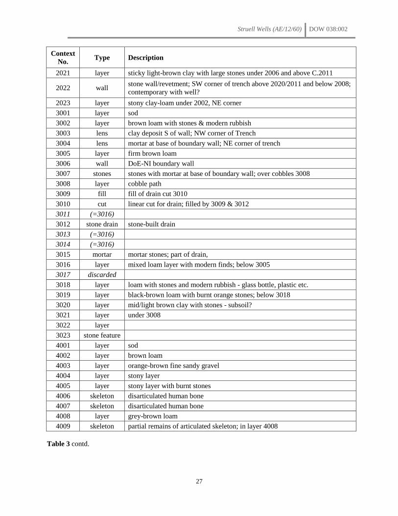
Struell Wells (AE/12/60) DOW 038:002
27
Context
No. Type Description
2021 layer sticky light-brown clay with large stones under 2006 and above C.2011
2022 wall stone wall/revetment; SW corner of trench above 2020/2011 and below 2008;
contemporary with well?
2023 layer stony clay-loam under 2002, NE corner
3001 layer sod
3002 layer brown loam with stones & modern rubbish
3003 lens clay deposit S of wall; NW corner of Trench
3004 lens mortar at base of boundary wall; NE corner of trench
3005 layer firm brown loam
3006 wall DoE-NI boundary wall
3007 stones stones with mortar at base of boundary wall; over cobbles 3008
3008 layer cobble path
3009 fill fill of drain cut 3010
3010 cut linear cut for drain; filled by 3009 & 3012
3011 (=3016)
3012 stone drain stone-built drain
3013 (=3016)
3014 (=3016)
3015 mortar mortar stones; part of drain,
3016 layer mixed loam layer with modern finds; below 3005
3017 discarded
3018 layer loam with stones and modern rubbish - glass bottle, plastic etc.
3019 layer black-brown loam with burnt orange stones; below 3018
3020 layer mid/light brown clay with stones - subsoil?
3021 layer under 3008
3022 layer
3023 stone feature
4001 layer sod
4002 layer brown loam
4003 layer orange-brown fine sandy gravel
4004 layer stony layer
4005 layer stony layer with burnt stones
4006 skeleton disarticulated human bone
4007 skeleton disarticulated human bone
4008 layer grey-brown loam
4009 skeleton partial remains of articulated skeleton; in layer 4008
Table 3 contd.
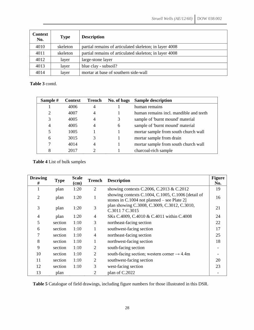
Struell Wells (AE/12/60) DOW 038:002
28
Context
No. Type Description
4010 skeleton partial remains of articulated skeleton; in layer 4008
4011 skeleton partial remains of articulated skeleton; in layer 4008
4012 layer large-stone layer
4013 layer blue clay - subsoil?
4014 layer mortar at base of southern side-wall
Table 3 contd.
Sample # Context Trench No. of bags Sample description
1 4006 4 1 human remains
2 4007 4 1 human remains incl. mandible and teeth
3 4005 4 3 sample of 'burnt mound' material
4 4005 4 6 sample of 'burnt mound' material
5 1005 1 1 mortar sample from south church wall
6 3015 3 1 mortar sample from drain
7 4014 4 1 mortar sample from south church wall
8 2017 2 1 charcoal-rich sample
Table 4 List of bulk samples
Drawing
# Type
Scale
(cm) Trench Description
Figure
No.
1 plan 1:20 2 showing contexts C.2006, C.2013 & C.2012 19
2 plan 1:20 1 showing contexts C.1004, C.1005, C.1006 [detail of
stones in C.1004 not planned – see Plate 2] 16
3 plan 1:20 3 plan showing C.3008, C.3009, C.3012, C.3010,
C.3011 7 C.3015 21
4 plan 1:20 4 SKs C.4009, C.4010 & C.4011 within C.4008 24
5 section 1:10 3 northeast-facing section 22
6 section 1:10 1 southwest-facing section 17
7 section 1:10 4 northeast-facing section 25
8 section 1:10 1 northwest-facing section 18
9 section 1:10 2 south-facing section -
10 section 1:10 2 south-facing section; western corner → 4.4m -
11 section 1:10 2 southwest-facing section 20
12 section 1:10 3 west-facing section 23
13 plan
2 plan of C.2022 -
Table 5 Catalogue of field drawings, including figure numbers for those illustrated in this DSR.
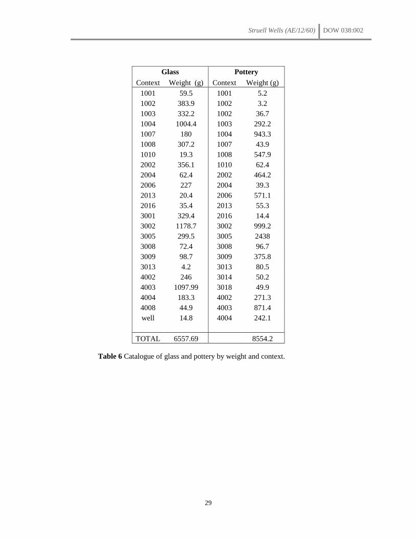
Struell Wells (AE/12/60) DOW 038:002
29
Glass Pottery
Context Weight (g) Context Weight (g)
1001 59.5 1001 5.2
1002 383.9 1002 3.2
1003 332.2 1002 36.7
1004 1004.4 1003 292.2
1007 180 1004 943.3
1008 307.2 1007 43.9
1010 19.3 1008 547.9
2002 356.1 1010 62.4
2004 62.4 2002 464.2
2006 227 2004 39.3
2013 20.4 2006 571.1
2016 35.4 2013 55.3
3001 329.4 2016 14.4
3002 1178.7 3002 999.2
3005 299.5 3005 2438
3008 72.4 3008 96.7
3009 98.7 3009 375.8
3013 4.2 3013 80.5
4002 246 3014 50.2
4003 1097.99 3018 49.9
4004 183.3 4002 271.3
4008 44.9 4003 871.4
well 14.8 4004 242.1
TOTAL 6557.69 8554.2
Table 6 Catalogue of glass and pottery by weight and context.
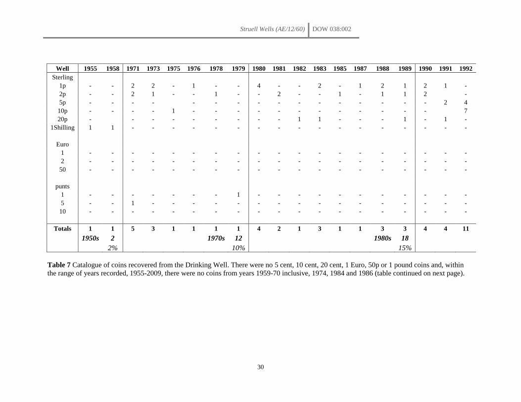
Struell Wells (AE/12/60) DOW 038:002
30
Well 1955 1958 1971 1973 1975 1976 1978 1979 1980 1981 1982 1983 1985 1987 1988 1989 1990 1991 1992
Sterling
1p - - 2 2 - 1 - - 4 - - 2 - 1 2 1 2 1 -
2p - - 2 1 - - 1 - - 2 - - 1 - 1 1 2
-
5p - - - -
- - - - - - - - - - - - 2 4
10p - - - - 1 - - - - - - - - - - - -
7
20p -
- - - - - - - - 1 1 - - - 1 - 1 -
1Shilling 1 1 - - - - - - - - - - - - - - - - -
Euro
1 - - - - - - - - - - - - - - - - - - -
2 - - - - - - - - - - - - - - - - - - -
50 - - - - - - - - - - - - - - - - - - -
punts
1 - - - - - - - 1 - - - - - - - - - - -
5 - - 1 - - - - - - - - - - - - - - - -
10 - - - - - - - - - - - - - - - - - - -
Totals 1 1 5 3 1 1 1 1 4 2 1 3 1 1 3 3 4 4 11
1950s 2
1970s 12
1980s 18
2% 10% 15%
Table 7 Catalogue of coins recovered from the Drinking Well. There were no 5 cent, 10 cent, 20 cent, 1 Euro, 50p or 1 pound coins and, within
the range of years recorded, 1955-2009, there were no coins from years 1959-70 inclusive, 1974, 1984 and 1986 (table continued on next page).
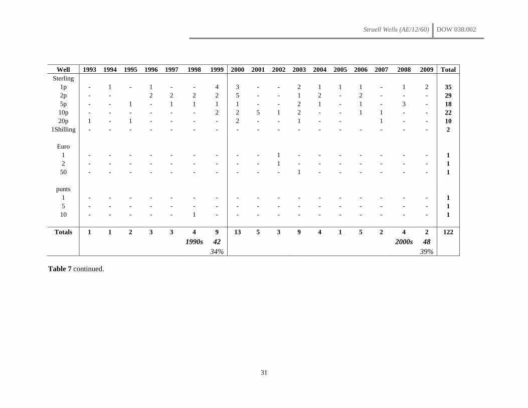
Struell Wells (AE/12/60) DOW 038:002
31
Well 1993 1994 1995 1996 1997 1998 1999 2000 2001 2002 2003 2004 2005 2006 2007 2008 2009 Total
Sterling
1p - 1 - 1 - - 4 3 - - 2 1 1 1 - 1 2 35
2p - -
2 2 2 2 5 - - 1 2 - 2 - - - 29
5p - - 1 - 1 1 1 1 - - 2 1 - 1 - 3 - 18
10p - - - - - - 2 2 5 1 2 - - 1 1 - - 22
20p 1 - 1 - - - - 2 - - 1 - -
1 - - 10
1Shilling - - - - - - - - - - - - - - - - - 2
Euro
1 - - - - - - - - - 1 - - - - - - - 1
2 - - - - - - - - - 1 - - - - - - - 1
50 - - - - - - - - - - 1 - - - - - - 1
punts
1 - - - - - - - - - - - - - - - - - 1
5 - - - - - - - - - - - - - - - - - 1
10 - - - - - 1 - - - - - - - - - - - 1
Totals 1 1 2 3 3 4 9 13 5 3 9 4 1 5 2 4 2 122
1990s 42
2000s 48
34% 39%
Table 7 continued.
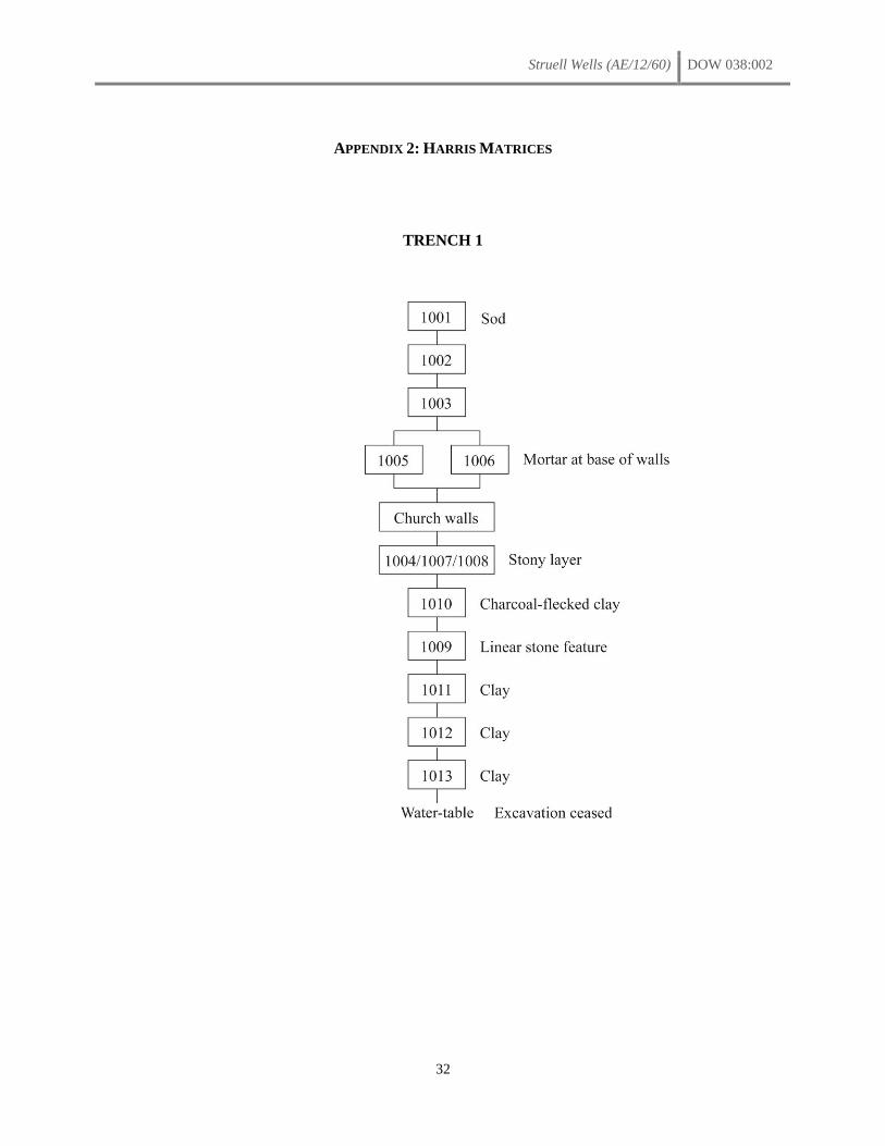
Struell Wells (AE/12/60) DOW 038:002
32
APPENDIX 2: HARRIS MATRICES
TRENCH 1
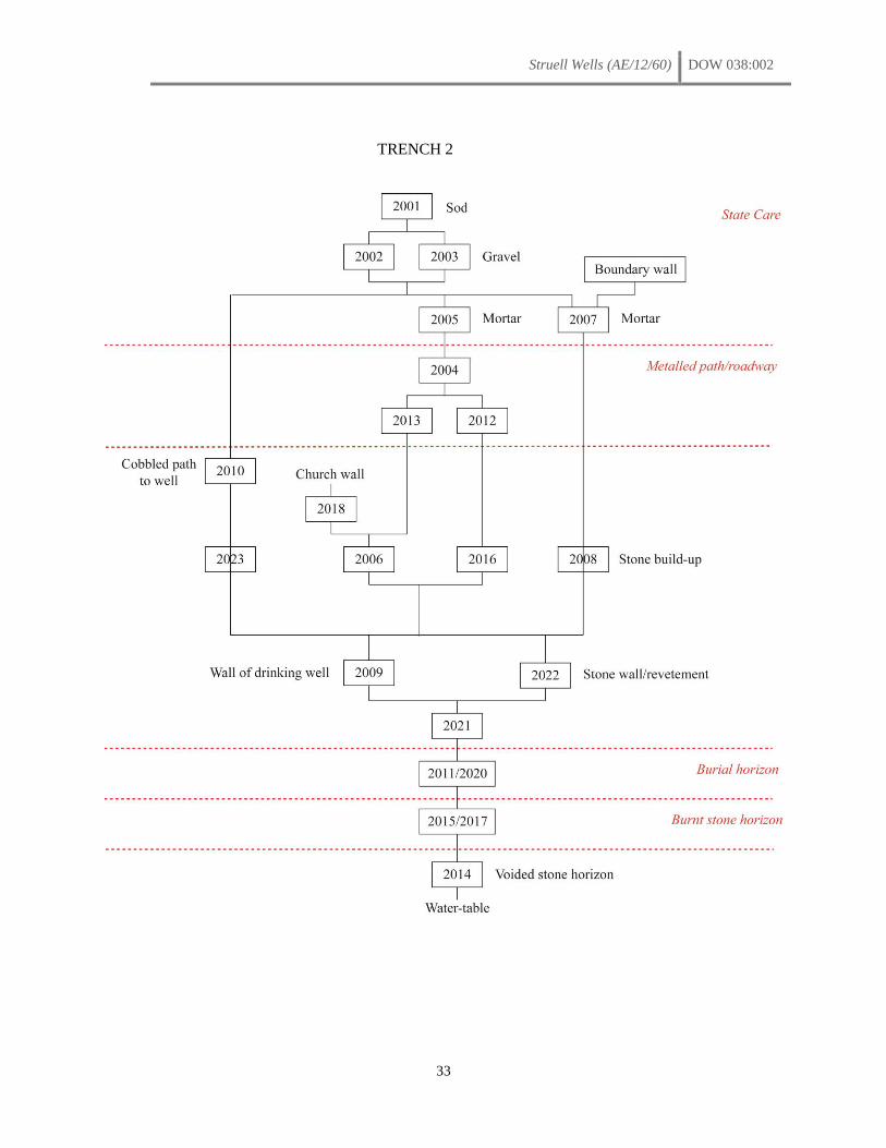
Struell Wells (AE/12/60) DOW 038:002
33
TRENCH 2

Struell Wells (AE/12/60) DOW 038:002
34
TRENCH 3
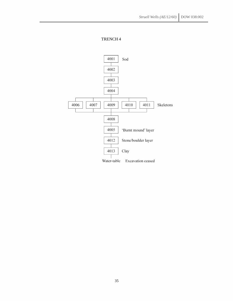
Struell Wells (AE/12/60) DOW 038:002
35
TRENCH 4
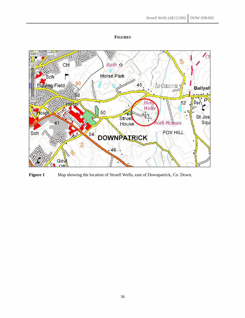
Struell Wells (AE/12/60) DOW 038:002
36
FIGURES
Figure 1 Map showing the location of Struell Wells, east of Downpatrick, Co. Down.
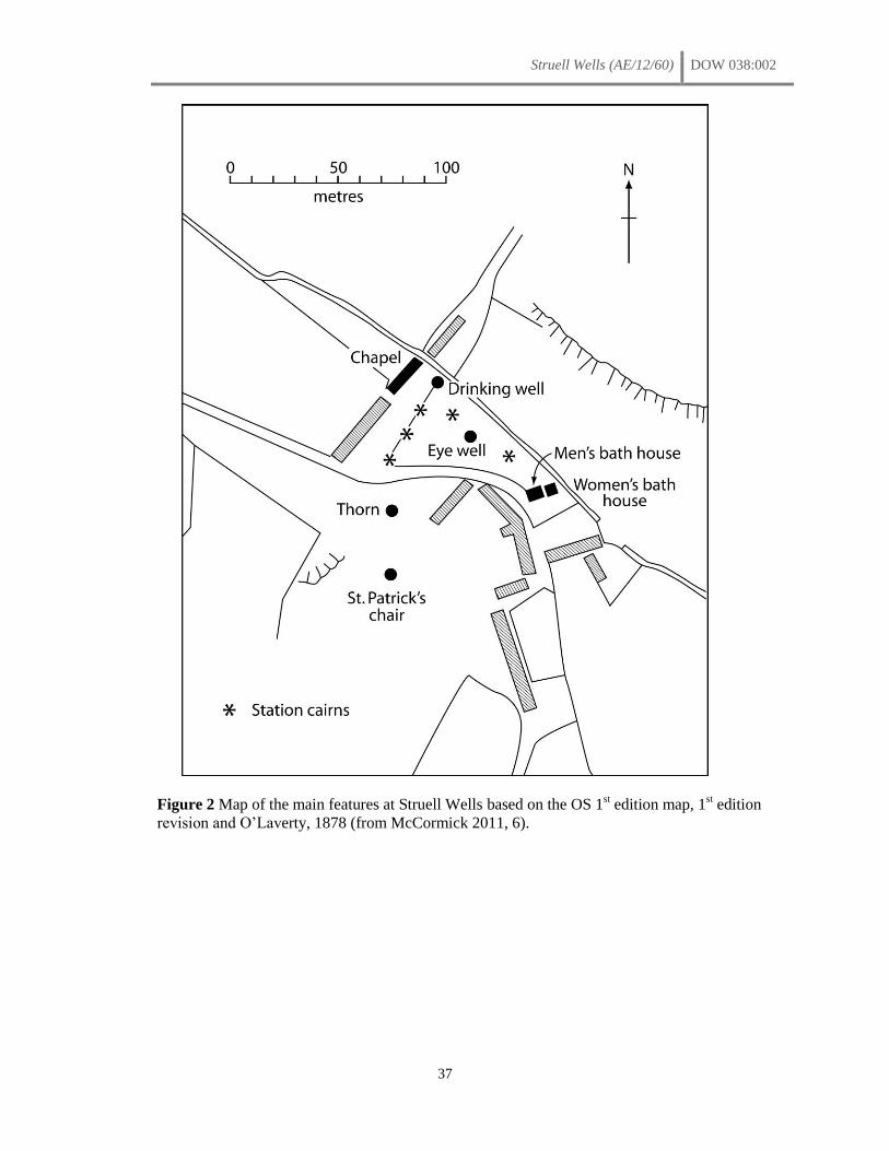
Struell Wells (AE/12/60) DOW 038:002
37
Figure 2 Map of the main features at Struell Wells based on the OS 1st edition map, 1
st edition
revision and O’Laverty, 1878 (from McCormick 2011, 6).
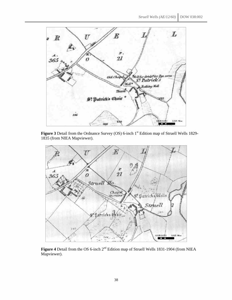
Struell Wells (AE/12/60) DOW 038:002
38
Figure 3 Detail from the Ordnance Survey (OS) 6-inch 1st Edition map of Struell Wells 1829-
1835 (from NIEA Mapviewer).
Figure 4 Detail from the OS 6-inch 2nd
Edition map of Struell Wells 1831-1904 (from NIEA
Mapviewer).
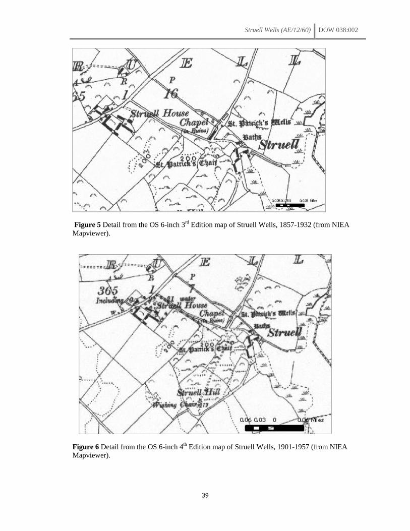
Struell Wells (AE/12/60) DOW 038:002
39
Figure 5 Detail from the OS 6-inch 3rd
Edition map of Struell Wells, 1857-1932 (from NIEA
Mapviewer).
Figure 6 Detail from the OS 6-inch 4th Edition map of Struell Wells, 1901-1957 (from NIEA
Mapviewer).

Struell Wells (AE/12/60) DOW 038:002
40
Figure 7 An illustration of the church, Drinking Well and Eye Well at Struell from Hardy’s 1836 The Holy Wells of Ireland (copied from
McCormick 2009, 51).
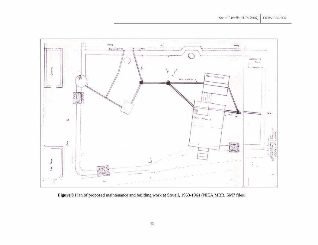
Struell Wells (AE/12/60) DOW 038:002
41
Figure 8 Plan of proposed maintenance and building work at Struell, 1963-1964 (NIEA MBR, SM7 files).
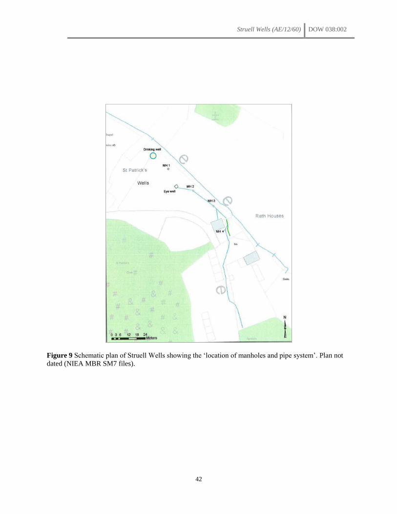
Struell Wells (AE/12/60) DOW 038:002
42
Figure 9 Schematic plan of Struell Wells showing the ‘location of manholes and pipe system’. Plan not
dated (NIEA MBR SM7 files).
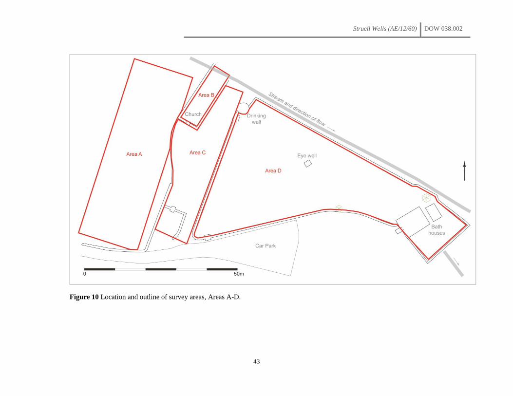
Struell Wells (AE/12/60) DOW 038:002
43
Figure 10 Location and outline of survey areas, Areas A-D.
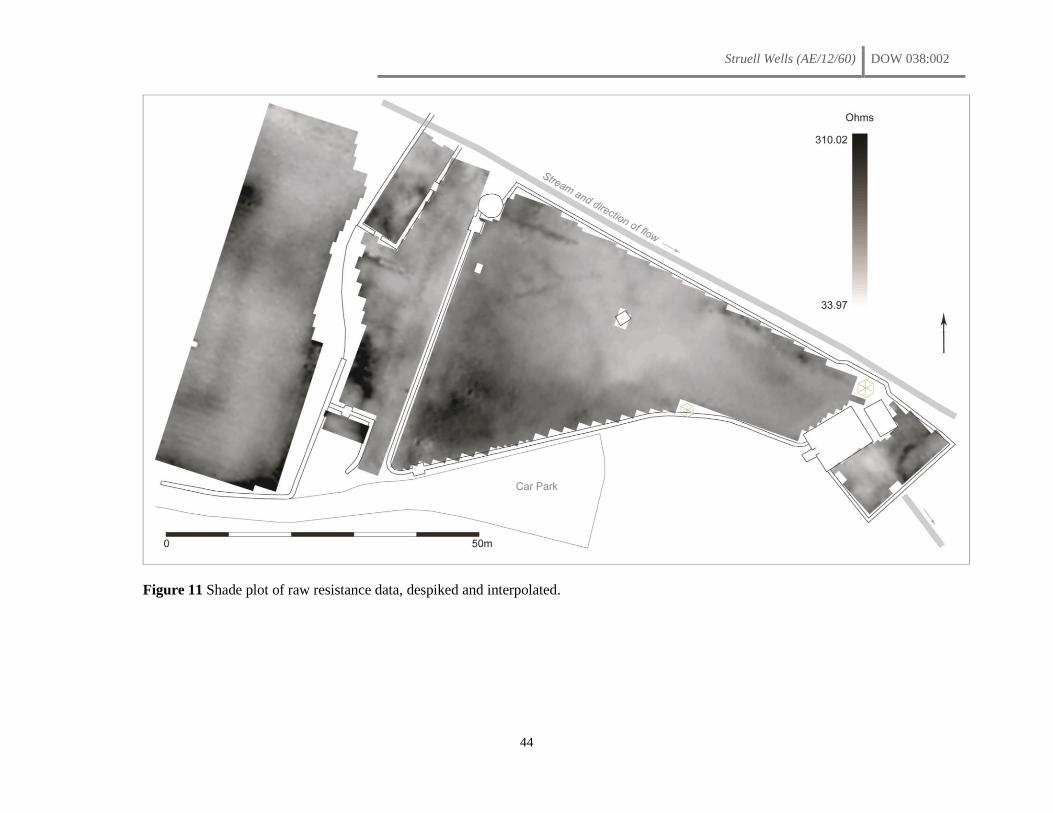
Struell Wells (AE/12/60) DOW 038:002
44
Figure 11 Shade plot of raw resistance data, despiked and interpolated.

Struell Wells (AE/12/60) DOW 038:002
45
Figure 12 Shade relief plot of resistance data.
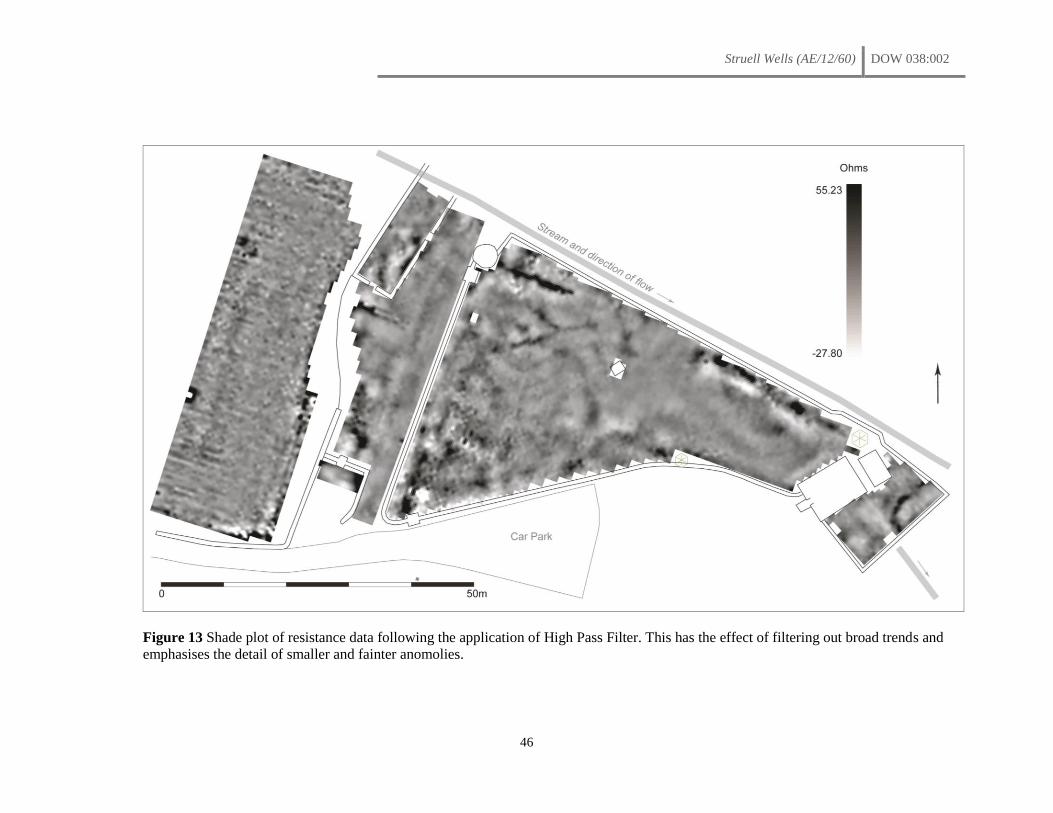
Struell Wells (AE/12/60) DOW 038:002
46
Figure 13 Shade plot of resistance data following the application of High Pass Filter. This has the effect of filtering out broad trends and
emphasises the detail of smaller and fainter anomolies.
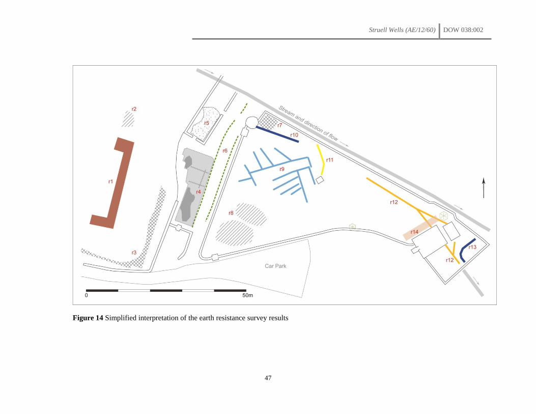
Struell Wells (AE/12/60) DOW 038:002
47
Figure 14 Simplified interpretation of the earth resistance survey results
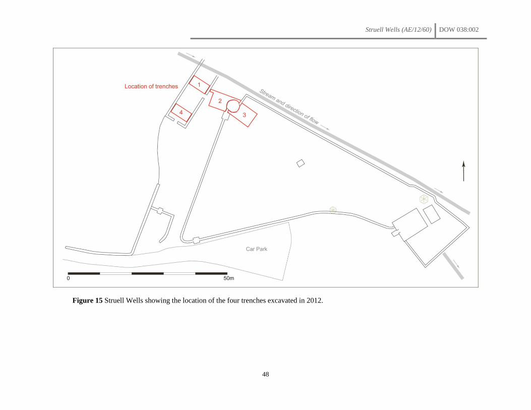
Struell Wells (AE/12/60) DOW 038:002
48
Figure 15 Struell Wells showing the location of the four trenches excavated in 2012.
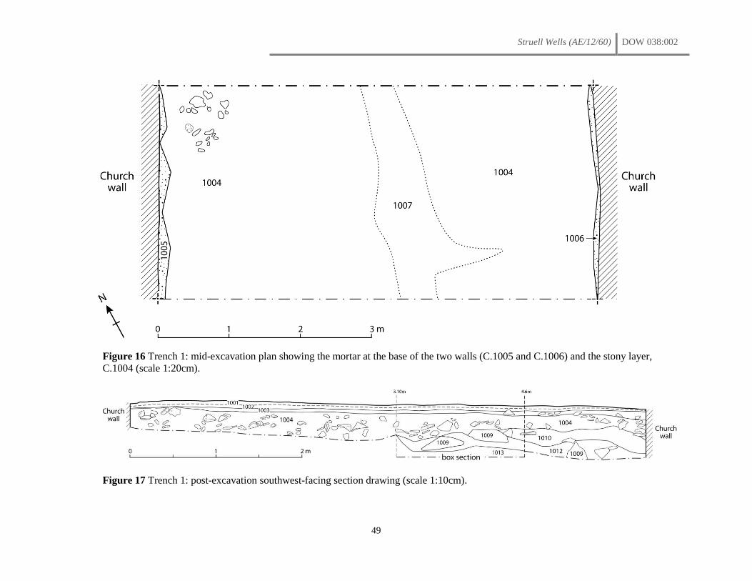
Struell Wells (AE/12/60) DOW 038:002
49
Figure 16 Trench 1: mid-excavation plan showing the mortar at the base of the two walls (C.1005 and C.1006) and the stony layer,
C.1004 (scale 1:20cm).
Figure 17 Trench 1: post-excavation southwest-facing section drawing (scale 1:10cm).
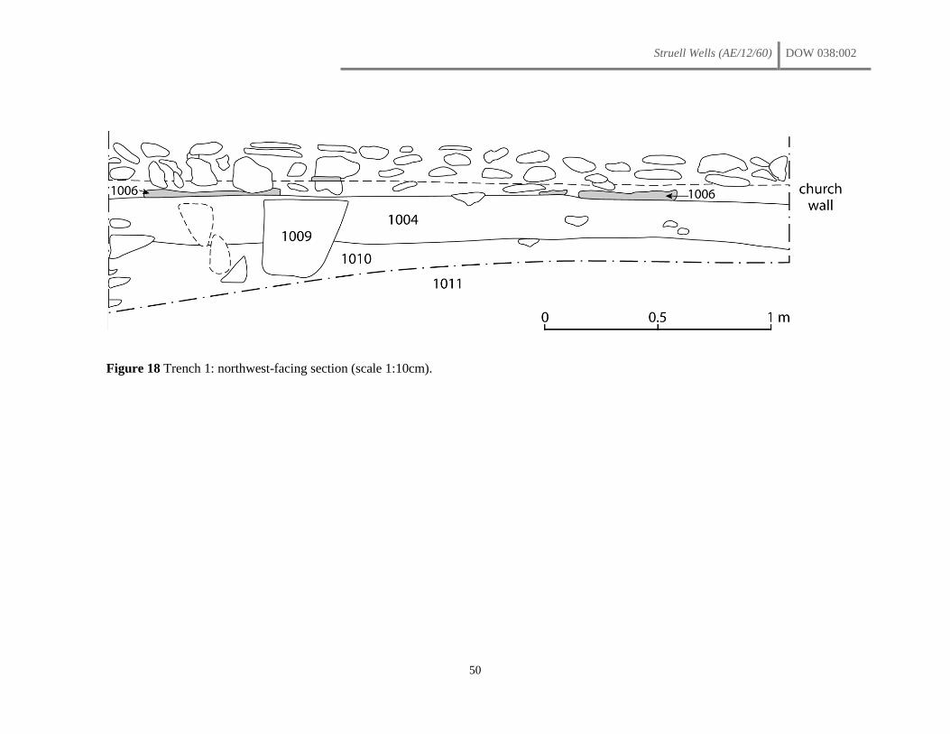
Struell Wells (AE/12/60) DOW 038:002
50
Figure 18 Trench 1: northwest-facing section (scale 1:10cm).
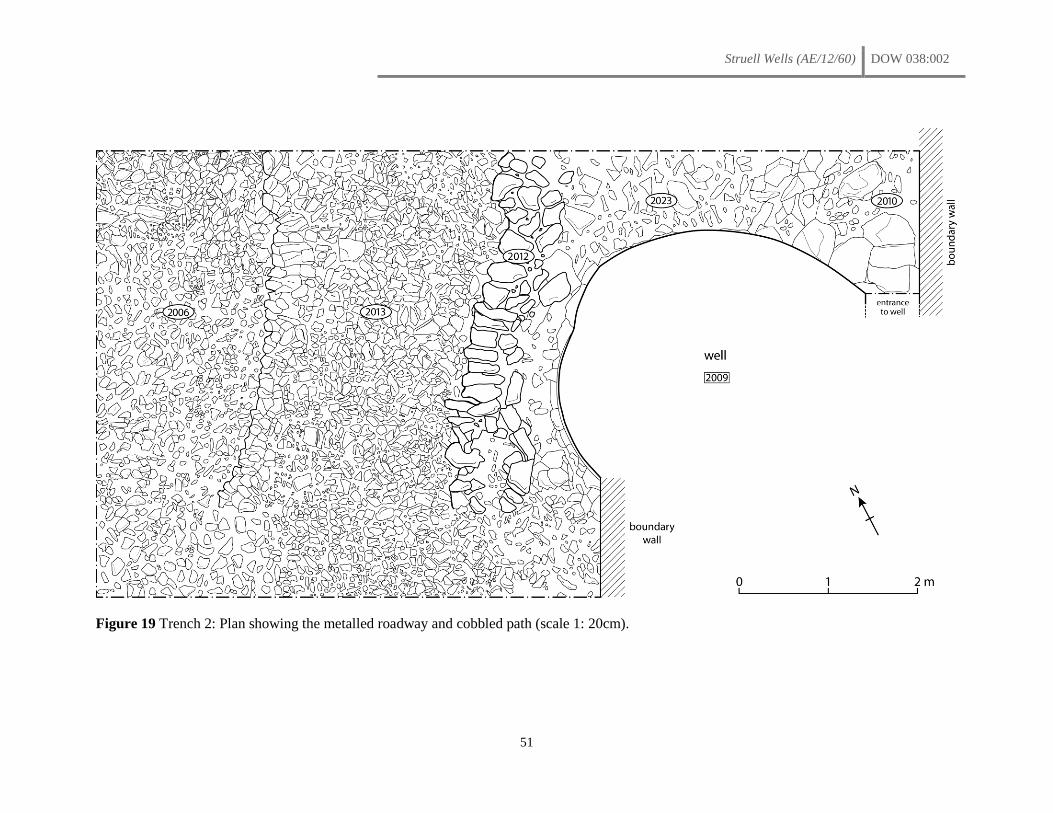
Struell Wells (AE/12/60) DOW 038:002
51
Figure 19 Trench 2: Plan showing the metalled roadway and cobbled path (scale 1: 20cm).
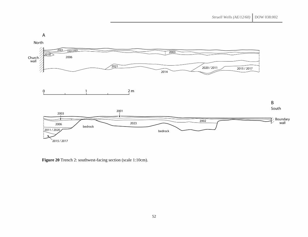
Struell Wells (AE/12/60) DOW 038:002
52
Figure 20 Trench 2: southwest-facing section (scale 1:10cm).
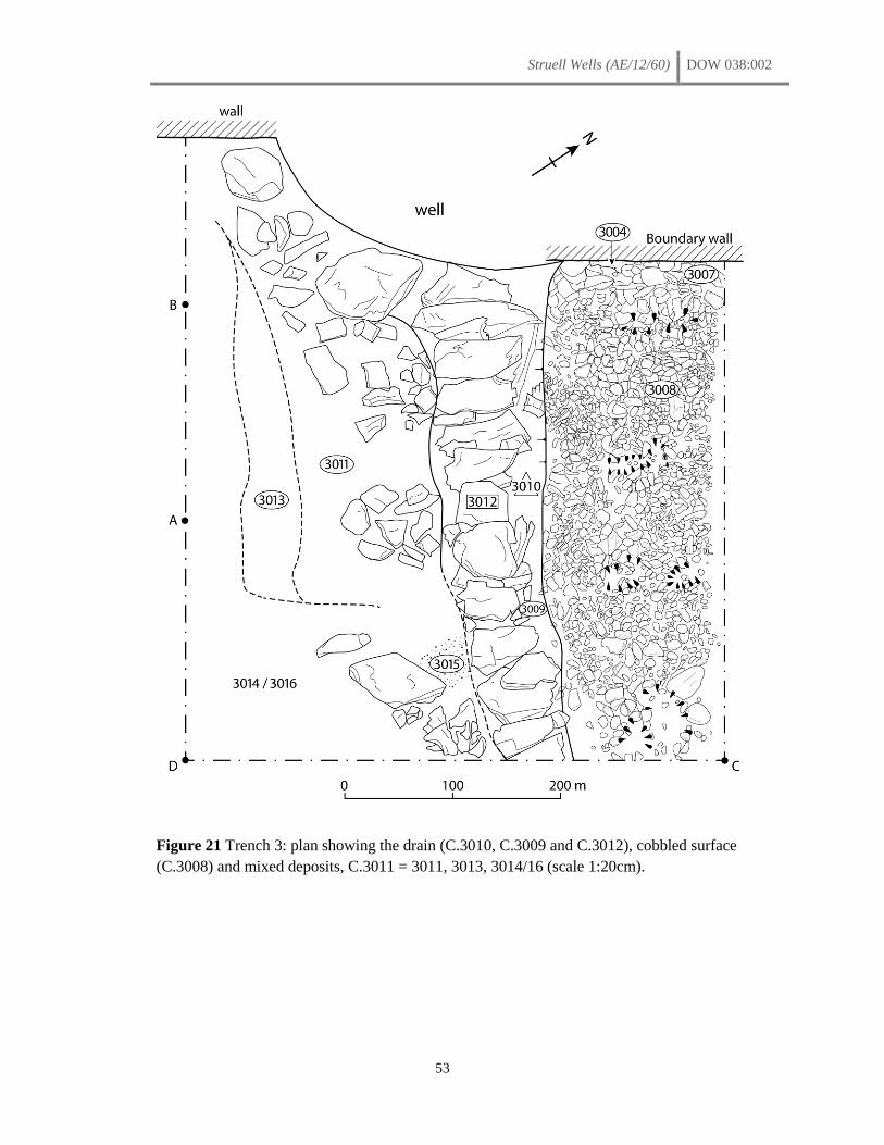
Struell Wells (AE/12/60) DOW 038:002
53
Figure 21 Trench 3: plan showing the drain (C.3010, C.3009 and C.3012), cobbled surface
(C.3008) and mixed deposits, C.3011 = 3011, 3013, 3014/16 (scale 1:20cm).
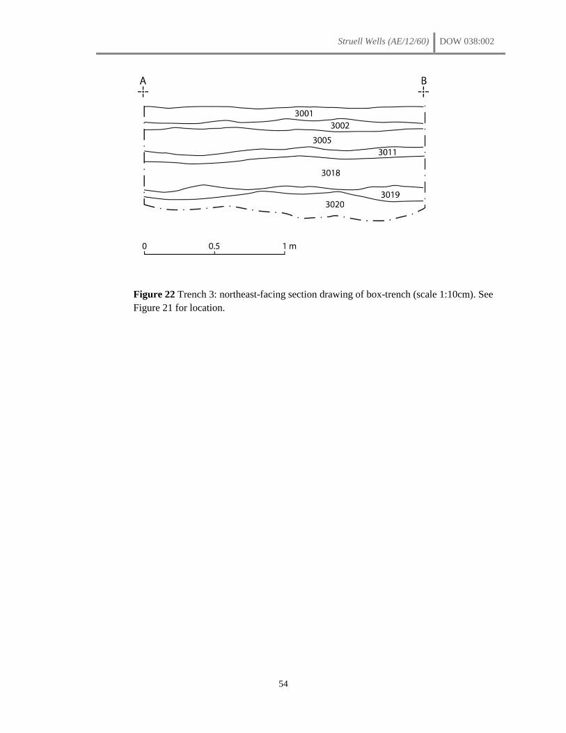
Struell Wells (AE/12/60) DOW 038:002
54
Figure 22 Trench 3: northeast-facing section drawing of box-trench (scale 1:10cm). See
Figure 21 for location.
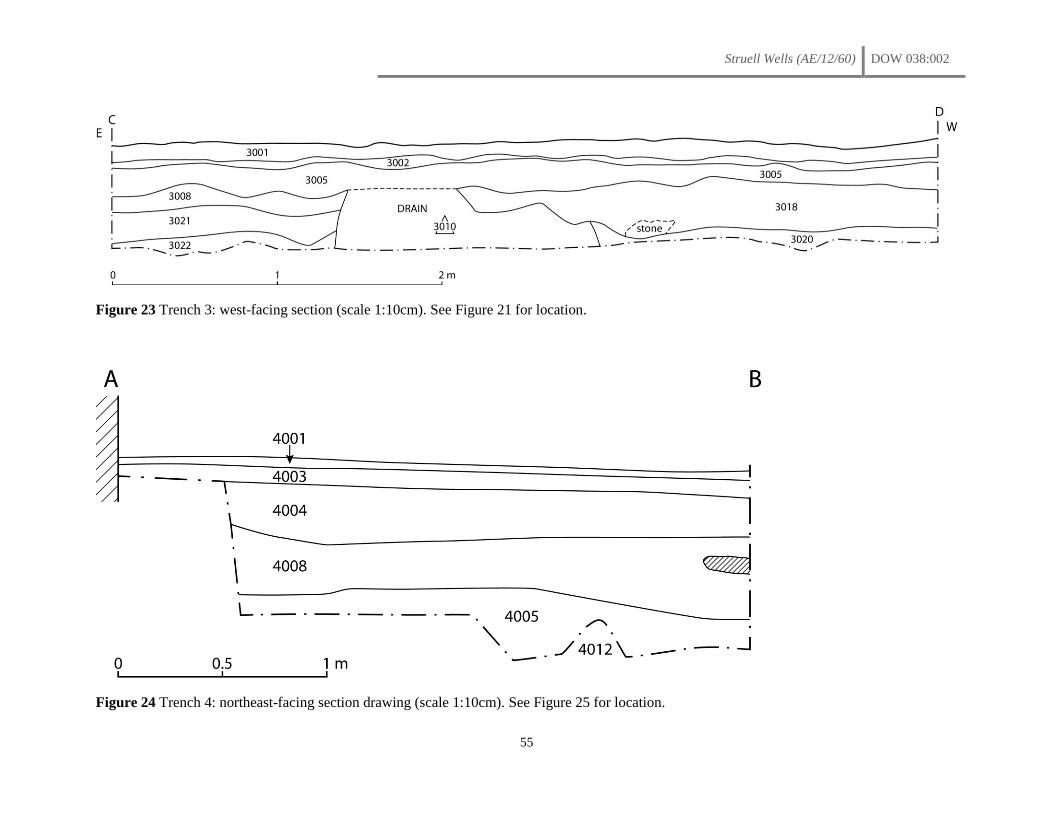
Struell Wells (AE/12/60) DOW 038:002
55
Figure 23 Trench 3: west-facing section (scale 1:10cm). See Figure 21 for location.
Figure 24 Trench 4: northeast-facing section drawing (scale 1:10cm). See Figure 25 for location.
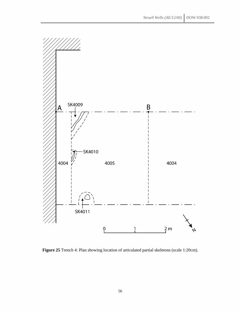
Struell Wells (AE/12/60) DOW 038:002
56
Figure 25 Trench 4: Plan showing location of articulated partial skeletons (scale 1:20cm).

Struell Wells (AE/12/60) DOW 038:002
57
PLATES