Embed Size (px)
Citation preview

1
Empire Station Complex Project Final Scope of Work for the Preparation of an
Environmental Impact Statement December 2020
This document is the final scope of work (Final Scope) for a Draft Environmental Impact Statement (DEIS) to inform the environmental review process for the Empire Station Complex, a comprehensive redevelopment initiative to create a revitalized, transit-oriented commercial district centered around New York’s Pennsylvania Station (Penn Station) (the Proposed Project). This Final Scope has been prepared to describe the Proposed Project (as defined below), present the proposed framework and methodologies for the DEIS analysis, and discuss the procedures to be followed in the preparation of the DEIS. The DEIS will be prepared pursuant to the State Environmental Quality Review Act (SEQRA) and its implementing regulations at 6 NYCRR Part 617. The New York State Urban Development Corporation d/b/a Empire State Development (ESD) is serving as the lead agency under SEQRA.
A draft scope of work (Draft Scope) for the project was issued on July 1, 2020. Oral and written comments were received during the scoping meeting held by ESD on July 20, 2020, which was conducted virtually due to the COVID-19 pandemic and the resulting restrictions on large gatherings. Written comments were accepted from the issuance of the Draft Scope through the public comment period, which ended August 20, 2020. This Final Scope reflects changes made in response to relevant public comments on the Draft Scope. Appendix A, “Responses to Comments on the Draft Scope of Work,” summarizes and responds to substantive comments received during the public comment period.
This Final Scope reflects changes made in response to relevant public comments on the Draft Scope, as well as additional information on the Proposed Project. Deletions are not shown in this document. However, additions to text not found in the Draft Scope have been incorporated into the Final Scope and are indicated by double-underlining.
A. INTRODUCTION In January 2020, Governor Andrew M. Cuomo announced the Empire Station Complex project among his State of the State initiatives, establishing the proposed blueprint for an integrated public transportation complex to revitalize Penn Station area and give New York City the world-class intercity transportation hub it deserves. The first step in realizing this vision is the soon-to-be-completed Moynihan Train Hall, which will breathe new life into the historic Farley Post Office, transforming it into an iconic, state-of-the-art infrastructure gateway for the National Railroad Passenger Corporation d/b/a Amtrak (Amtrak) and the Long Island Rail Road (LIRR). The other components of the Governor’s vision include a reimagined and expanded Penn Station, currently being planned by the Metropolitan Transportation Authority (MTA) in conjunction with Amtrak and New Jersey Transit (NJT), which would, among other things, modernize the facility and significantly increase its track and platform capacity.

Empire Station Complex
2
The relocation of Amtrak’s operations to Moynihan Train Hall provides the opportunity to overhaul Penn Station, including opening up its confined concourses and creating bold new entrances, inviting in natural light, improving retail and other user amenities, increasing safety and security, consolidating support functions, rationalizing pedestrian flows, and making it easier for passengers to navigate within the station as well as connect to their destinations beyond. The railroads are also undertaking planning for the proposed southward expansion of Penn Station into Block 780, and parts of Blocks 754 and 806, to accommodate up to nine additional tracks and five new platforms. Both the reconstruction and expansion of Penn Station are essential infrastructure projects for the future of New York, long talked about but finally achievable under the leadership of Governor Cuomo.
The Proposed Project, a comprehensive redevelopment initiative to create a revitalized, transit-oriented commercial district centered around Penn Station, is critical to fulfilling the Empire Station Complex vision. The Proposed Project would address substandard and insanitary conditions in the Project Area (as defined below) by facilitating redevelopment to create a cohesive, transit-oriented commercial district and would introduce much-needed public transportation and public realm improvements in the area. Specifically, the Proposed Project would result in the development of ten new buildings on eight development sites in the Project Area. The Proposed Project’s new developments would incorporate new onsite entrances and access ways to Penn Station and public transit. It would revitalize the Project Area by introducing public realm improvements to address pedestrian, bicycle, and vehicular circulation and enhance the surrounding streetscape.
The Proposed Project would also support the reconstruction and expansion of Penn Station, which would be accomplished through separate but related projects that would be undertaken by one or more of the involved railroads (MTA, Amtrak, and/or NJT). Commercial development facilitated by the Proposed Project would generate essential revenue for substantial improvements at Penn Station, subway stations and other transit facilities in the Project Area, as well as the proposed expansion of Penn Station. The Proposed Project would accommodate the expansion of Penn Station into the blocks south of the existing station to allow for the creation of new, below-grade tracks and platforms, significantly increasing the station’s capacity. The additional rail infrastructure would be built beneath three of the proposed development sites, and the Proposed Project’s approvals would require that the commercial development accommodate the proposed expansion at these sites and beneath adjoining streets. The design, construction, and operation of an expanded Penn Station would be assumed by one or more of the involved public transportation entities: MTA, Amtrak, and/or NJT. The specific assignment of responsibilities for those tasks is the subject of ongoing collaboration and planning among MTA, Amtrak, and NJT.
The area of the Proposed Project is generally bounded by Sixth and Ninth Avenues to the east and west, and by West 30th and West 34th Streets to the south and north in Midtown Manhattan, Community Districts 4 and 5 (the Project Area). The Project Area includes all or portions of nine Manhattan tax blocks—Blocks 754, 755, 780, 781, 783, 806, 807, 808, and 809—that encompass Penn Station, Madison Square Garden (MSG), Moynihan Train Hall (see Figure 1), and surrounding blocks. However, the Proposed Project would not result in any new commercial buildings at the existing Penn Station, MSG, or Moynihan Train Hall. As shown in Figure 2, the Project Area is centrally located in Manhattan, near Hudson Yards and the Midtown Central Business District, proximate to passenger rail service at Penn Station and subway service at three major stations, with unmatched connections to other portions of New York City and the region.

11.19.20
Project LocationFigure 1
Existing Penn Station
Development Sites
Project Area
MADISONSQUAREGARDEN
MOYNIHAN TRAIN HALL
FARLEY OFFICE
BUILDING
BLOCK 780SITE 2
BLOCK806
SITE 3
BLOCK 754SITE 1
BLOCK 809
SITE 6
BLOCK 808
SITE 7
BLOCK 808
SITE 8
BLOCK783
SITE 4
BLOCK783
SITE 5
BLOCK 781BLOCK 755
BLOCK 807
W 33RD ST
W 31ST ST
W 30TH ST
W 29TH ST
W 34TH ST
W 35TH ST
9TH
AV
E
8TH
AV
E
7TH
AV
E
6TH
AV
E
BR
OA
DW
AY
Sour
ce: F
XCol
labo
rativ
e Ar
chite
cts
LLP
EMPIRE STATION COMPLEX

5 Av/59 St
Lexington Av/59 St Roosevelt
Island49 St
57 St
Delancey St
3 Av
Lower EastSide-2 Av
34 St-PennStation
Astor Pl
Grand St
Bowery
Essex St
Houston St
8 St-NYU
Canal St
Canal St
Canal St
Spring St
Prince St
Spring St Bleecker St
28 St
6 Av
8 Av
VernonBlvd-Jackson Av
Nassau Av
Greenpoint Av
Bedford Av
1 Av
5 Av/53 St
28 St
51 St
33 St
23 St
28 St
5 Av
50 St
21 St
77 St
86 St72 St
72 St
59 St-ColumbusCircle
ChristopherSt-Sheridan Sq
Pavonia/ Newport
Hoboken
33rd St
23rd St
14th St
9th St
Christopher St
14 St-Union Sq
Times Sq-42 St
34 St-Herald Sq
42 St-Port AuthorityBus Terminal
Long Island CityLong Island City
HU
DS
ON
RI V
ER
EA
ST
RIV
ER
H U D S O NY A R D S
M I D T O W N
0 5,000 FEET
EMPIRE STATION COMPLEX
Regional ContextFigure 2
5.21
.20
Grand Central42nd St
Penn Station
N e w J e r s e y
Project Area
Long Island Rail RoadMetro North RailroadPATH
New Jersey Transit
Amtrak
New York City Transit Subway
Subway Station

Final Scope of Work
3
The Proposed Project is a critical component of the Governor’s vision for the Empire Station Complex, as it would create a revitalized commercial district that would benefit Penn Station and support the City’s goal of encouraging high-density development around a world-class transportation hub. The Proposed Project would promote the economic recovery of New York City and the region in the aftermath of the COVID-19 pandemic by supporting economic activity associated with the growth of Midtown and investments in regional rail and transit infrastructure.
Commercial redevelopment under the Proposed Project would capitalize on the Project Area’s transit-rich location, strengthen the area’s standing as a premier commercial office district, provide for public transportation and public realm improvements essential for a dynamic business district, and complement other transformative initiatives that have reshaped the Far West Side and Midtown over the past 20 years. Furthermore, the Proposed Project would reflect a public commitment to the area commensurate with the essential infrastructure investments already underway (Moynihan Train Hall, East End Gateway) and planned for the future (the reconstruction and expansion of Penn Station). In summary, the Proposed Project would create a vibrant, high-density commercial district with a functional public realm that would complement long-term development initiatives and reinforce the major infrastructure investments in the reconstruction and expansion of Penn Station.
SUMMARY OF PROPOSED PROJECT
In overview, the Proposed Project includes:
• Creation of a revitalized, transit-oriented commercial district to benefit Penn Station and revitalize the surrounding area. The Proposed Project would result in approximately 20 million gross square feet (gsf) of primarily Class A commercial office, retail, and hotel space on eight development sites within the Project Area (see Figure 1).
• Improvements to area subway stations and transit connections with Penn Station. ESD, through the GPP and in collaboration with MTA, would require the completion of transit im-provements at each development site in connection with new building construction. It is anticipated that transit improvements would be implemented at the following subway stations: 34th Street–Penn Station (Eighth Avenue A/C/E Lines), 34th Street–Penn Station (Seventh Avenue 1/2/3 Lines), and 34th Street–Herald Square (Sixth Avenue B/D/F/M/N/Q/R/W Lines and Port Authority Trans-Hudson [PATH] train service). Additional public transportation im-provements under consideration include creating a below grade east–west corridor between the 34th Street–Penn (1/2/3 Lines) and 34th Street–Herald Square subway stations, new station entrances, new stairways, widening existing stairways and platforms, consideration of below-grade north–south circulation east of Seventh Avenue, and other improvement measures.
• Implementation of public realm improvements. ESD, through the GPP, would require the completion of public realm improvements in the Project Area in connection with the proposed developments. Improvements under consideration include widening sidewalks adjoining the Proposed Project buildings and creating new plaza spaces in the Project Area. The public realm improvements are described in more detail below under “Description of the Proposed Project.” Additional public realm improvements are under consideration in coordination with DOT.
In addition, the Proposed Project would support separate but related projects to improve and expand Penn Station. These projects would be undertaken separately by one or more of the

Empire Station Complex
4
involved railroads (MTA, Amtrak, and/or NJT) and would be subject to their own environmental reviews and approvals, as appropriate. Specifically, the Proposed Project would:
• Support reconstruction of the existing Penn Station. Revenue from the Proposed Project’s new development would fund substantial improvements to the existing Penn Station as identified through a Penn Station Master Plan under development by MTA, Amtrak, and NJT.
• Support the expansion of Penn Station. The Proposed Project would support the planned expansion of Penn Station by (i) providing a potential source of funding for the proposed expansion and improvement of Penn Station and (ii) facilitating, through ESD’s proposed GPP for the Empire Station Complex, transit-oriented development above the below-grade expansion of tracks and platforms south of the existing Penn Station. Such an expansion of Penn Station would increase the overall station capacity for train operations and passenger flow. The expanded facility would incorporate eight or nine tracks (depending on final configuration) to substantially increase Penn Station’s existing track and platform capacity. As currently envisioned, and subject to ongoing collaboration and planning among the involved public transportation providers (MTA, Amtrak, and NJT) and any required federal approvals and federal environmental reviews, the expansion of Penn Station would occupy the below-grade levels of Block 780 and portions of Blocks 754 and 806. The Proposed Project would be designed and constructed to accommodate rail infrastructure for the proposed station expansion.
Section C, “Project Description,” provides a more detailed description of the multiple elements of the Proposed Project.
To allow for the implementation of the Proposed Project, ESD is proposing to seek its Directors’ approval of a General Project Plan (GPP) that would, among other things, authorize ESD to override certain provisions of the New York City Zoning Resolution and other local laws, as applicable, in accordance with the New York State Urban Development Corporation Act (the UDC Act). At this time, a determination has not been made as to whether the property acquisitions needed for the Penn Station expansion (consisting of Block 780 and portions of Block 754 and Block 806) would be undertaken, in whole or in part, by ESD or by another entity, such as MTA or Amtrak. Decisions about property acquisition, including which public entity or entities would be responsible for those property acquisitions, would be made only in the event that the Penn Station expansion site currently contemplated is selected as the locally preferred alternative for that project in the ongoing federal approval process, as the planning and design of the Proposed Project develops, and ESD’s collaboration with the involved railroads continues. The acquisition of property would be by negotiated purchase with the property owners and/or through the exercise of eminent domain. In addition, ESD and the City of New York would cooperate as contemplated by the UDC Act in connection with the construction of the public realm improvements located within City-owned mapped streets. Affirmation of the proposed GPP for the Empire Station Complex, the actions that may be taken to acquire the property interests as necessary to facilitate the Proposed Project, and other actions authorized by the UDC Act in furtherance of the Proposed Project are collectively referred to as the “Proposed Actions.”
ESD is working closely with the City of New York to accomplish the Proposed Project’s devel-opment goals and the implementation of public realm and public transportation improvements for the area. The planning, design, and implementation of public realm improvements are a collabor-ative effort of ESD with the New York City Department of City Planning (DCP) and the New York City Department of Transportation (DOT). ESD is collaborating with MTA, Amtrak, and

Final Scope of Work
5
NJT with respect to the proposed expansion of Penn Station and implementation of public trans-portation improvements. To facilitate implementation of the Proposed Project, ESD is also working with Vornado Realty Trust (Vornado), the owner of a significant number of properties in the Project Area that contain connections (or potential future connections) to Penn Station.
The Proposed Actions require discretionary approvals subject to environmental review under SEQRA and its implementing regulations. Pursuant to SEQRA, ESD, as the SEQRA lead agency for the Proposed Project, has determined that the Proposed Actions may have significant adverse environmental impacts and a DEIS should be prepared. This Final Scope of Work provides a de-scription of the Proposed Project and the analyses and methodologies to be undertaken in the DEIS.
B. BACKGROUND Penn Station is the main intercity railroad station and a major commuter railroad station in New York City. Connections are available within Penn Station to the MTA New York City Transit’s (NYCT) Seventh Avenue Line station, serving the 1, 2, and 3 trains, and the Eighth Avenue Line station, serving the A, C, and E trains. These subway stations, and the Herald Square Subway Station and 33rd Street PATH Station located one block to the east of Penn Station at Sixth Avenue, are among the most heavily used subway stations in the City. With nearly 600,000 rail and subway trips per day, Penn Station is the busiest passenger transportation hub in North America and offers unmatched connectivity between intercity rail service, commuter rail service, and local subway service. The station is located entirely underground between Seventh and Eighth Avenues and West 31st and West 33rd Streets.
The original Penn Station was built by the Pennsylvania Railroad and opened in 1910. It was a classic Beaux Arts-style building designed by the famed architecture firm of McKim, Mead, & White and featured an ornate marble and granite station house above ground covering the entire double superblock from West 31st to West 33rd Streets and Seventh to Eighth Avenues. The station was considered a masterpiece of the Beaux-Arts style and one of the great architectural works of New York City. The station was part of the Pennsylvania Railroad’s New York Improvement and Tunnel Extension, which also included the tunnels and track connections extending from Weehawken, New Jersey, beneath the Hudson River, Manhattan, and the East River to Long Island City, Queens. Once completed, this massive engineering project enabled direct rail access to New York City from points south for the first time.
Passenger volumes began to decline after World War II—a time when America was investing in automobiles, highways, and suburban infrastructure rather than rail and subways. In the 1950s, the declining Pennsylvania Railroad sold the air rights to the property and reduced the size of the railroad station. In 1963, the above-ground train station was demolished. Over the next nine years, the below-grade concourses and waiting areas were reconstructed, creating the Penn Station that commuters and visitors use today, while MSG and the high-rise office buildings at 1 Penn Plaza and 2 Penn Plaza, between West 31st and West 34th Streets and Seventh and Eighth Avenues, were constructed above. The current station has three underground levels: concourses on the upper two levels and train platforms on the lowest. The two levels of concourses were original to the 1910 station but were extensively modified during the construction of MSG into the cramped, poorly organized, and substandard corridors that exist today.
At the time Penn Station was demolished and replaced in the 1960s, the facility was meant mainly to serve intercity rail customers at an anticipated capacity of 200,000 passengers per day. Today,

Empire Station Complex
6
Penn Station is owned by Amtrak, a federally chartered corporation created under federal law. Penn Station is located on Amtrak’s Northeast Corridor, a vital passenger rail link over which Amtrak provides rail service from New York City to Boston, Philadelphia, Baltimore, Washington, D.C., and intermediate points, with connections to Amtrak’s national intercity commuter rail network. But the largest number of rail passengers using Penn Station today, comprising approximately 65 percent of Penn Station’s nearly 600,000 daily trips on a typical day, are MTA, LIRR, and NJT commuters. MTA Metro-North Railroad (Metro-North) service to Penn Station is projected to begin in 2023 after the Moynihan Train Hall is completed and MTA completes the East Side Access Project, which will temporarily free up track capacity at Penn Station by providing direct LIRR service to Grand Central Terminal.1
LIRR’s services are operated in the lower concourse level of the station, which LIRR leases from Amtrak and operates under a joint facilities agreement. Although it is now confined to the lower level of Penn Station, LIRR’s portion of the station alone is the second busiest rail station in the nation, second only to Grand Central Terminal. LIRR provides 237,000 daily trips on more than 450 daily trains within its platforms, concourses, and exits. During the weekday morning peak hour alone, LIRR’s concourse accommodates more than 35,000 customers. Similarly, NJT’s portion of Penn Station serves approximately 172,000 daily trips. LIRR and NJT customers also make heavy use of the adjacent NYCT subway stations to complete their journeys to and from workplaces or other destinations. Approximately one-half of commuting daily customers enter or leave the railroad station via the busy Seventh Avenue or Eighth Avenue subway stations, which accommodate 177,000 and 174,700 daily trips, respectively.
In the last decade, the number of average weekday Penn Station riders on Amtrak, LIRR, and NJT has grown by 26 percent and subway ridership on the Seventh and Eighth Avenue lines has increased by 34 percent. Although they operate at capacity today, Amtrak, MTA (LIRR and Metro-North), and NJT ridership is expected to increase.2
Despite its status as the busiest rail and transit hub in the nation, commercial office development around Penn Station has been limited by an overburdened transit infrastructure, aging building stock, and poor pedestrian circulation. Even with these challenges, the Project Area presents a significant opportunity for sustainable growth in New York City, thanks to its unparalleled rail and transit access.
Over the past two decades, the public and private sectors have embarked on transformative transit and land development proposals at Penn Station, the Far West Side, and East Midtown to improve transit infrastructure and sustain Manhattan as the nation’s center of commerce and business. The
1 MTA is a New York State public authority and public benefit corporation that manages and develops
commuter transportation serving New York City and a New York metropolitan transportation district that also embraces the counties of Nassau, Suffolk, Westchester, Putnam, Rockland, Orange, and Dutchess. MTA oversees various subsidiary and affiliated operating entities, which together with MTA, are managed by the same chairperson and board. These include, among others: NYCT, which operates subway service in New York City; LIRR, which operates commuter rail service between Long Island and New York City; and Metro-North, which operates rail service into Grand Central Terminal from points north of the City.
2 The statistics cited in this section are based on recent data prior to the COVID-19 pandemic, which has changed short-term ridership patterns. It is reasonable to expect that as the pandemic subsides such ridership patterns will resume.

Final Scope of Work
7
Empire Station Complex presents a unique opportunity to rehabilitate and expand Penn Station and reinvigorate the area that surrounds it.
PENN STATION OPERATIONS
Penn Station has a total of 11 platforms and 21 platform tracks shared by Amtrak, LIRR, and NJT. The platform tracks are connected to a network of tracks to the east and west. On the west, Amtrak and NJT trains enter and leave the station using the two tracks of the existing North River Tunnel; Amtrak trains from the Empire Line serving Albany and points north also connect into Penn Station on the west.
The blocks west of Penn Station are occupied by approach tracks that provide access to and from the station. These tracks are used for cross-Hudson rail service to the station for Amtrak’s Northeast Corridor Line, NJT lines, and LIRR’s rail connections to MTA’s John D. Caemmerer West Side Yard, which is bounded by Tenth Avenue, Twelfth Avenue, West 30th Street, and West 33rd Street, and is used by LIRR for midday train storage and light maintenance. Tracks east of the station proceed eastward to the four-track East River Tunnels which provide a continuing connection for Amtrak’s Northeast Corridor Line to New England, and for LIRR’s rail lines to Queens and Long Island. The East River Tunnels also provide access to Sunnyside Yard in Queens, a large Amtrak train storage and maintenance yard that is also used for midday train storage by NJT.
Over the past several years, the three railroads have performed extensive operations analyses and implemented infrastructure improvements that have allowed the railroads to increase service frequency. Today, the three railroads use the full capacity of the tracks and platforms in Penn Station during the peak hours of travel.
Penn Station has two levels of passenger space above the tracks and platforms. The main passenger hall, Amtrak ticketing and waiting area, and NJT concourse are located on the upper passenger level. The upper level also provides connections to street level. The lower passenger level consists of LIRR’s concourse in the station, with connections to the Seventh and Eighth Avenue subway lines and NJT passenger access to its platforms. Several connecting concourses lead from LIRR’s main passenger space to provide access to the track space below. The Penn Station Service Building is located at 236-248 West 31st Street, directly across from Penn Station. This building was constructed in 1908 and originally supplied electricity to the electric locomotives going in and out of Penn Station. The Penn Station Service Building houses mechanical, electrical, and plumbing systems that serve Penn Station, including steam piping and chiller units, as well as systems that service tracks, including switches and compressors, which control train movements beyond Penn Station. The electricity that powers the tunnel ventilation system originates in the Service Building. This powers Amtrak infrastructure that extends from Long Island to New Jersey.
MOYNIHAN TRAIN HALL
The need for improvements to Penn Station has been recognized almost since the original station building was demolished in 1963. In the past two decades, a number of highly visible improve-ments have been made. Most notable among these is the new Moynihan Train Hall being devel-oped at the James A. Farley Building (Farley Building), which will bring a monumental above-ground passenger space back to Penn Station.
ESD is nearing completion of the new Moynihan Train Hall in the landmark Farley Building, across Eighth Avenue from Penn Station as part of ESD’s Moynihan Station Civic and Land Use

Empire Station Complex
8
Improvement Project. This building was constructed around the time of the original Penn Station, and its architecture is evocative of the now-demolished 1910 station building. Since many of Penn Station’s existing tracks and platforms are located directly below the Farley Building, the location of the Farley Building and its related below-grade improvements (including the expanded West End Concourse and ramps that connect the Farley Building to Penn Station and can be accessed at-grade from the west side of Eighth Avenue) offer a unique opportunity to create a new above-ground train hall serving Amtrak and LIRR passengers. When open in 2021, the Moynihan Train Hall will become the primary boarding and ticketing facility for Amtrak and an additional facility for LIRR. The train hall will have a monumental, sky-lit passenger space with state-of-the-art wayfinding, information displays, and other visitor amenities. Moynihan Train Hall will expand Penn Station’s passenger concourse space by 50 percent, and the shift of Amtrak’s daytime passenger services to the new Moynihan Train Hall will, in turn, open space for other uses in the existing Penn Station.
Despite this improvement, the majority of train cars and passengers arriving at Penn Station will land beneath the unrenovated part of the station east of Eighth Avenue and will continue to have to navigate the substandard corridors and egress through those areas to exit the station.
OTHER PENN STATION IMPROVEMENTS
In addition to the Moynihan Train Hall, MTA, Amtrak, and NJT are currently completing other improvements at Penn Station. These include LIRR’s planned East End Gateway and Concourse (currently under construction), which is creating a new entrance to LIRR’s Penn Station concourse at West 33rd Street west of Seventh Avenue, and a wider reconstructed passenger concourse to improve access, egress, and circulation, and relieve overcrowding. NJT is conducting preliminary design work for the Central Concourse Extension, a proposed corridor to provide additional access to Tracks 1 through 12. In addition, Amtrak is undertaking an ongoing series of repairs and upgrades to tracks and switches at Penn Station, collectively referred to as the Penn Station Infrastructure Renewal Project.
PENN STATION ACT
The New York Pennsylvania Station Public Safety Improvements Act (Penn Station Act), adopted in 2018 as Part MMM of Chapter 59 of the Laws of 2018 (enacted into law by the New York State Legislature), identified the rehabilitation of Penn Station and its connectivity to the surrounding areas as “a pressing public safety and transportation issue and is a major objective for the State to resolve and should be made a top priority.” In particular, the Penn Station Act stated that the rehabilitation of Penn Station would require “improvements to access and egress and to the surrounding areas to position such areas to accommodate and attract passengers and evolving technological and business and commercial needs and practices” and directed ESD and other governmental, community, and business entities to collaborate on solutions. The Proposed Project would help to achieve the goals of the Penn Station Act.
PENN STATION MASTER PLAN
As discussed in more detail below, Penn Station suffers from a number of design and operational deficiencies. To create a framework for addressing these problems, MTA, Amtrak, and NJT are preparing a Master Plan for Penn Station, which includes a number of separate, but complementary projects, including the reconstruction of the existing station, the new Moynihan Train Hall, and the proposed Penn Station expansion. The planning process for the Penn Station Master Plan is
Final Scope of Work
9
expected to continue under the leadership of the involved railroads. The Penn Station Master Plan will provide for the integration of the different station components functionally, operationally, and architecturally to produce a cohesive station complex that will improve circulation and connections to the surrounding district. Key goals of the Penn Station Master Plan include:
• Increasing station capacity and accommodating increased train service; • Integrating the components of the Empire Station Complex, including the new Moynihan
Train Hall and the proposed expansion of Penn Station; • Integrating the Empire Station Complex with the surrounding area; • Rationalizing station functions and systems; • Improving pedestrian circulation; and • Increasing revenue generation to support the station.
The Proposed Project would support the implementation of the Penn Station Master Plan by facilitating the expansion of Penn Station and generating revenue from the new development to be applied towards the implementation of the plan.
REGIONAL RAIL INITIATIVES
Several rail improvement projects are currently planned that will change rail operations at Penn Station in the future. These include capital projects planned or proposed by LIRR, Metro-North, Amtrak, and NJT. These improvement projects are separate and independent from the Proposed Project.
LIRR EAST SIDE ACCESS
MTA is currently constructing the East Side Access Project, which will allow LIRR service to Grand Central Terminal in East Midtown. The project includes a new passenger terminal beneath Grand Central’s existing passenger spaces as well as new tunnels, track connections, and rail storage and support spaces. When this project is complete, LIRR will serve both Penn Station and Grand Central Terminal. In combination with other LIRR initiatives, including the Main Line expansion (a new third track on the LIRR Main Line and new double track on Ronkonkoma Branch), this will allow LIRR to provide substantially more service across Long Island for its customers. With the introduction of service to Grand Central Terminal, LIRR will reduce its train frequency at Penn Station, freeing capacity for other rail movements there.
METRO-NORTH PENN STATION ACCESS
MTA is proposing to bring Metro-North service to Penn Station, taking advantage of train capacity freed by the East Side Access Project. The Penn Station Access Project would create a new connection for Metro-North’s New Haven Line service, making use of Amtrak’s Hell Gate line (on its Northeast Corridor route) through the Bronx, Queens, and Penn Station. This project would create four new Metro-North stations in the East Bronx in areas not well-served by rail transit today.
GATEWAY PROGRAM
The Gateway Program proposes a comprehensive program of phased rail infrastructure improve-ments to increase track, tunnel, bridge, and station capacity, eventually creating four mainline tracks between Newark, New Jersey and Penn Station, that will allow the doubling of passenger

Empire Station Complex
10
trains (including Amtrak and NJT service) on the Northeast Corridor between Newark, New Jersey and Penn Station. While the specific details of most of the capacity-enhancing elements are still under development, these improvements include a new two-track Hudson River tunnel to supple-ment the existing North River Tunnel, an upgraded replacement bridge over the Hackensack River in New Jersey (Portal North Bridge), the addition of a new, two-track bridge over the Hackensack River (Portal South Bridge), and the proposed Penn Station expansion. In addition, for NJT to increase rail service to Penn Station, new rail infrastructure and a new rail storage yard in New Jersey are needed. A connection at Secaucus Station would provide direct rail service to New York for a number of rail lines that currently terminate at Hoboken Terminal. All of these capacity improvements are necessary to significantly increase Amtrak and NJT rail service to Penn Station.
In addition to capacity expansion, the Gateway Program also includes preservation projects to update and modernize existing infrastructure and make repairs to infrastructure elements that are damaged due to age or events such as Superstorm Sandy.
HUDSON TUNNEL PROJECT
One key component of the Gateway Program, the Hudson Tunnel Project, has independent utility as a resiliency project.3 The Hudson Tunnel Project will create a new two-track tunnel under the Hudson River for Amtrak and NJT service on the Northeast Corridor and will rehabilitate the existing North River Tunnel, which was severely damaged during Superstorm Sandy. Having the new tunnel in place will allow Amtrak and NJT to divert train service from the existing tunnel so that it can be repaired. The new tracks will connect to Penn Station immediately south of the connections from the existing North River Tunnel and Amtrak’s Empire Line service, and will require modifications to the approach track geometry and switches.
EAST RIVER TUNNELS REHABILITATION
Amtrak is planning the rehabilitation of the East River Tunnels that were damaged during Superstorm Sandy. The rehabilitation will occur one tube at a time to minimize disruption to rail service, but closure of one tube will nonetheless require service changes for Amtrak, LIRR, and NJT.
PLANNING CONTEXT
In New York City, planning initiatives often link high-density development with transit and public realm improvements. Notable examples of this approach include the Hudson Yards Rezoning and No. 7 Subway Line Extension and the Greater East Midtown Rezoning, which have facilitated high-density development coupled with investment in transit improvements and the public realm.
HUDSON YARDS REZONING AND NO. 7 SUBWAY LINE EXTENSION
Planning for Hudson Yards, an area of Manhattan bounded by West 42nd/West 43rd Streets, Seventh/Eighth Avenues, West 28th/West 30th Streets, and Hudson River Park, began in 2001. Since that time, the City of New York, MTA, and the State of New York have collaborated on planning initiatives to create a development program to transform Hudson Yards into a new
3 U.S. Department of Transportation Federal Railroad Administration and NJT. Hudson Tunnel Project
Draft Environmental Impact Statement and Draft Section 4(f) Evaluation. Hudson County, NJ and New York County, NY. June 2017. Available at http://www.hudsontunnelproject.com/deis.html

Final Scope of Work
11
mixed-use district accommodating job growth and new housing for New York City’s growing population.
The heart of the Special Hudson Yards District is the John D. Caemmerer West Side Yard, spanning the superblocks between West 30th and West 33rd Streets and Tenth and Twelfth Avenues. The rezoning allowed the rail yard to be decked over with a new platform to allow for construction of new buildings. Bisected by Eleventh Avenue, the sites over the Caemmerer Rail Yard are known as the Eastern Rail Yard site and Western Rail Yard site.
As rezoned, the Special Hudson Yards District has the capacity for approximately 26 million square feet (sf) of new office development, 20,000 units of housing, 2 million sf of retail, and 3 million sf of hotel space. To support the new neighborhood, MTA extended the No. 7 subway line from 42nd Street-Times Square to a new terminal station in Hudson Yards at 34th Street and Eleventh Avenue. Since the adoption of the rezoning in 2005, several developments have been constructed and more are underway—most notably the development on the Eastern Rail Yard site, which opened in 2019 with almost 12 million sf of development in four office buildings, two residential buildings, a shopping mall, an arts center called the Shed, and an art installation known as the Vessel. It is anticipated that the Western Rail Yard site will be developed with up to 6.4 million sf of mixed-used development, providing residential and commercial uses (retail and office or hotel space), a new public school, and publicly accessible open space overlooking the High Line.
GREATER EAST MIDTOWN REZONING
In 2017, the City of New York approved the Greater East Midtown Rezoning. The rezoning will facilitate new, modern office buildings needed to spur jobs and keep New York a global capital of commerce. The plan ties that growth directly to improvements in the district’s public transit and public space network, so as new buildings are developed, major investments in infrastructure like subway stations and public plazas will also be implemented. The rezoning affected 78 blocks between Third and Madison Avenues and East 39th and East 57th Streets.
The zoning changes will enable the development of new Class A commercial buildings, cementing East Midtown’s position as a world-class business district that offers modern amenities and a range of office types. Buildings would be able to achieve higher densities provided the developments support enhancements to the area’s public realm by providing transit improvements and/or pur-chasing unused floor area from the district’s landmarks. The zoning framework is expected to generate 6.8 million sf of new commercial office space, along with an additional 6.6 million sf that will be upgraded into Class A office space. In “Transit Improvement Zones” near transit hubs, new buildings may utilize additional floor area when developers undertake or pay for major subway station improvements.
C. PROJECT DESCRIPTION
PURPOSE AND NEED FOR THE PROPOSED PROJECT
The primary purpose of the Proposed Project is to transform a substandard and insanitary area in and around Penn Station into a revitalized, transit-oriented commercial district. The Proposed Project would generate revenue to help fund improvements to Penn Station and support economic growth in New York City and the region by providing substantial new high-density commercial development proximate to Penn Station and public transportation and public realm improvements

Empire Station Complex
12
to the area. In addition, the Proposed Project would support the reconstruction and expansion of Penn Station.
The following section describes the challenges facing the Penn Station area and Penn Station itself and provides more detail on the goals and objectives of the Proposed Project.
THE PENN STATION AREA
Despite its adjacency to the busiest transit hub in North America, commercial office development in the vicinity of Penn Station has been limited by overburdened and degraded transit infrastructure, aging building stock, and poor pedestrian circulation. The last major building in the Project Area (1 Penn Plaza) was constructed almost 50 years ago (1970–1972). Aside from the recent ESD-led transformation of the underutilized Farley Building into the Moynihan Train Hall and new commercial development, the neighborhood immediately surrounding Penn Station is characterized by outmoded office buildings, bland nondescript retail offerings, congested sidewalks, and limited publicly accessible open space. Yet the Project Area provides a significant opportunity for sustainable growth in New York City due to its unmatched access to the region’s rail and transit network with the potential for future development to incorporate sustainable, resilient, and energy-efficient infrastructure.
The Project Area is one of the most transit-rich areas in the City, but the public realm, both above- and below-grade, is substandard and deters redevelopment. The subway stations that serve Penn Station along Sixth, Seventh, and Eighth Avenues are collectively the busiest subway stations in the City, with nearly 300,000 riders on an average weekday in 2019.4 Entrances are often difficult to locate, with small, inconspicuous entryways. Below-grade, subway infrastructure is overbur-dened with narrow stairs and corridors, crowded platforms, and poor accessibility. Above-grade, public realm spaces, including sidewalks and pedestrian circulation spaces, are overcrowded, and sidewalk widths are too narrow to accommodate the high volume of pedestrians in the area.
PENN STATION
Penn Station is located at the center of the Project Area. The combination of the low-cost construction redesign in the 1960s, inadequate investment in the station over time, and a steady rise in ridership has strained the station’s infrastructure and systems and degraded the user experience. Almost 60 years after the demolition and underground reconstruction of Penn Station, the facility is substandard, poorly configured, and in dire need of major investment to maintain operations, renew its infrastructure, improve its revenue stream, and re-establish itself as the premier rail transportation center in the region. A substantially improved Penn Station, along with the soon-to-be-completed Moynihan Train Hall across Eighth Avenue, would anchor the economic revival of the surrounding area.
Nearly 600,000 trips per day are navigated through Penn Station’s narrow underground corridors (more than three times the number of daily trips in the 1960s), which are devoid of natural light, consistent wayfinding, or sufficient waiting areas.
MTA, in collaboration with Amtrak and NJT, is conducting a comprehensive study of the existing conditions at Penn Station as part of the Penn Station Master Plan. The Penn Station Master Plan’s preliminary findings indicate that commuters experience congested platforms and concourse
4 https://new.mta.info/agency/new-york-city-transit/subway-bus-facts-2019

Final Scope of Work
13
levels, poor pedestrian accessibility (entrance and egress points are particularly difficult for persons with mobility issues to navigate), a lack of sufficient passenger waiting and overflow space, and a lack of sufficient public restroom facilities. The overall customer experience is universally perceived as very poor, particularly on the lower level, due to low ceiling heights, narrow corridors and concourses, poor lighting, and outdated and inadequate wayfinding and passenger information systems.
Furthermore, robust growth in ridership into Penn Station is projected in the future as rail service is expanded and the population in the LIRR, NJT, Amtrak, and Metro-North service areas continues to grow. Penn Station train operations are currently at or near capacity, constrained by the number of tracks and platforms in the station and by the condition and capacity of the North (Hudson) River and East River Tunnels that serve it. Ridership through Penn Station, though impacted in the short term by the COVID-19 pandemic, is projected to continue to increase as service is expanded and the population in the LIRR, NJT, Amtrak, and Metro-North service areas continues to grow. Responding to this growing need, Amtrak, NJT, MTA, and New York State are planning and implementing extensive investments to alleviate these constraints, expand service, and extend existing service to new locations.
Although recent initiatives like the new Moynihan Train Hall and West End Concourse beneath the Farley Building will improve the passenger experience in Penn Station, the station will still operate well beyond its capacity in terms of both trains and passengers and will remain overcrowded and confusing for passengers. Frequent transit delays, confusing wayfinding, and aesthetically uninviting concourse levels are synonymous with Penn Station, and frustrate thousands of commuters every day. In the future, without any expansion to the station itself, overcrowding will continue to worsen as the number of commuters grows.
To address these issues, on January 8, 2020, Governor Andrew M. Cuomo announced an initiative to create a new commercial transit district (the Proposed Project) and expand Penn Station southward. The Empire Station Complex would build upon the recent improvements to Penn Station, and facilitate the transformation of the Project Area to a revitalized commercial transit district.
GOALS AND OBJECTIVES
The goals and associated objectives for the Proposed Project are as follows:
• Goal 1: Revitalize the area surrounding Penn Station with new, sustainable, high-density commercial development Provide a substantial amount of new commercial development to create a cohesive,
transit-oriented district that will capitalize on the Project Area’s central Manhattan location proximate to passenger rail service at Penn Station and three major subway stations;
Eliminate substandard and insanitary conditions in the Project Area; Foster and support economic growth and tax revenue through the creation of jobs and
economic activity during construction, and through the provision of new commercial office space to accommodate New York City’s long-term growth targeting the modern needs of commercial tenants (i.e., generous column spacing, large ceiling heights and upgraded mechanical systems); and
Maximize incorporation of sustainable design practices to achieve environmentally superior performance in the new buildings.

Empire Station Complex
14
• Goal 2: Improve passenger rail and transit facilities and pedestrian circulation, access, and safety Implement transit improvements at the 34th Street–Penn Station–Eighth Avenue [A/C/E],
34th Street–Penn Station–Seventh Avenue [1/2/3], and 34th Street–Herald Square–Sixth Avenue [B/D/F/M/N/Q/R/W/PATH] subway stations to better accommodate passenger volumes in these stations;
Create a below grade east-west corridor connecting the 34th Street–Herald Square and the 34th Street-Penn Station-Seventh Avenue subway stations;
Widen sidewalks in the Project Area; and Create publicly accessible passive open space to serve residents, workers, and visitors in
the area. • Goal 3: Support improvements to address substandard conditions in Penn Station
Maximize revenue generated by the new development to fund, in part, improvements to Penn Station by MTA, Amtrak, and NJT; and
Utilize the adjacency of certain development sites to expand Penn Station ingress and egress and increase identifiable entrances.
• Goal 4: Support and accommodate future capacity increases at Penn Station Maximize revenue generated by the new development to fund, in part, the proposed
expansion of Penn Station to accommodate new, below-grade tracks and platforms, to be designed, constructed and operated per arrangements among MTA, Amtrak, and NJT. Such expansion is anticipated to significantly increase the station’s overall platform capacity.
Accommodate the proposed southward expansion of Penn Station in the design and construction of the development sites on the blocks comprising the proposed expansion.
DESCRIPTION OF THE PROPOSED PROJECT
The Proposed Project is a comprehensive redevelopment initiative to create a revitalized, transit-oriented commercial district centered around Penn Station. It would address substandard and insanitary conditions in the Project Area by introducing much-needed public transportation and public realm improvements to the area and facilitating high-density redevelopment of nearby parcels to create a cohesive, transit-oriented commercial district. The primary components of the Proposed Project—creation of a transit-oriented commercial district and public transportation and public realm improvements—are described in more detail below. The following section also describes the improvement and expansion of Penn Station, which would be supported and accommodated by the Proposed Project.
TRANSIT-ORIENTED COMMERCIAL DISTRICT
The Proposed Actions would facilitate redevelopment on the blocks surrounding Penn Station within the Project Area, setting the stage to transform a poorly planned and underutilized area with outmoded buildings into a cohesive commercial district incorporating sustainability measures. The GPP would facilitate the construction of approximately 20 million gsf of new Class A commercial office space, retail, and hotel space on eight development sites within the Project Area. The new developments would provide new entrances and connections for both Penn Station and the subway system, further increasing transit access for the area. In consultation with the City of New York, a value-capture framework would include Payments In Lieu of Taxes (PILOTs) and other
Final Scope of Work
15
revenues generated by the new development to help fund improvements to and expansion of Penn Station and its environs.
The development sites are shown in Figure 1 and described below.
• Site 1: a 64,189-sf site at 403-415 Eighth Avenue, between West 30th and West 31st Streets (Block 754, Lots 34–41, 44, 51, and 63);
• Site 2: a 158,000-sf site that occupies the full block bounded by West 30th and West 31st Streets and Seventh and Eighth Avenues (Block 780, all lots);
• Site 3: a 44,436-sf site at 363-371 Seventh Avenue between West 30th and West 31st Streets (Block 806, Lots 1, 3, 6, 9, 69, and 76);
• Site 4: a 34,807-sf site on the east side of Eighth Avenue between West 33rd and West 34th Streets (Block 783, Lot 1 and part of Lot 70);
• Site 5: 45,425-sf site on the west side of Seventh Avenue between West 33rd and West 34th Streets (Block 783, Lot 34, 48 and part of Lot 70);
• Site 6: a 54,313-sf site at 435 Seventh Avenue between West 33rd and West 34th Streets (Block 809, Lots 1, 3, 4, 5, 8, 16, 17, 69, 73, 80, and 82);
• Site 7: a 79,000-sf site on the east side of Seventh Avenue between West 32nd and West 33rd Streets (Block 808, Lot 7501); and
• Site 8: a 79,000-sf site on the west side of Sixth Avenue between West 32nd and West 33rd Streets (Block 808, Lot 40).
Sites 1 through 8 would be developed in accordance with design guidelines referenced in the GPP. The development sites are shown in Figure 1. The Proposed Actions would override use, bulk, density, and potentially other requirements of the New York City Zoning Resolution. ESD would prepare Design Guidelines for the Proposed Project, which would specify the parameters for permitted development in lieu of zoning. Illustrative building massings for each development site are shown in Figure 3 and Table 1. The GPP would limit the overall floor area of each building. However, consistent with zoning in other high-density commercial areas of New York City, it would not impose height limits. If constructed, the buildings could be taller and slimmer or shorter and bulkier than shown in Figure 3. Several factors have been taken into consideration to determine the development program and inform the illustrative depictions of the buildings, including the size of the development sites, the floorplate size necessary to accommodate modern office developments, the amount of floor area necessary to achieve high-density commercial buildings that also provide space for on-site transit and public realm improvements, and the floor-to-ceiling heights sought by tenants of Class A office buildings.
As noted above, an objective of the Proposed Project is to incorporate sustainable design practices to achieve environmentally superior performance in the new buildings. The development on Sites 1, 2, and 3 would meet this objective as energy efficient measures and sustainable design elements would be required criteria in the request for proposals (RFP) for these sites.
The proposed development program with the Proposed Project (the With Action condition) is summarized in Table 1.

Figure 3
12.21.20
Illustrative Building Massings
Sour
ce: F
XCol
labo
rativ
e Ar
chite
cts
LLP
NOTE: FOR ILLUSTRATIVE PURPOSES ONLY
SITE 3
SITE 2
SITE 1
SITE 4
SITE 5
SITE 6
SITE 7
SITE 8
Office
Retail
Hotel
Open Space
EMPIRE STATION COMPLEX

Empire Station Complex
16
Table 1 Proposed Project Development Program (With Action Condition)
Site Lot
Area Illustrative
Heights (in feet) Total GSF
Total Commercial
GSF Office GSF Retail GSF
Hotel (Rooms)
Garage GSF
Parking Spaces
Non-Program
Area1 12 64,189 748 (Eighth Ave)
235 (Midblock) 1,283,460 1,039,602 751,999 6,000 563 0 0 243,857
2 158,000 1,040 (Seventh Ave) 1,300 (Eighth Ave) 6,292,118 5,096,615 5,060,615 36,000 0 0 0 1,195,503
3 44,436 936 1,769,598 1,433,375 1,421,375 12,000 0 0 0 336,224 4 34,807 664 1,100,000 866,000 289,160 100,000 734 25,000 100 209,000 5 45,425 1,018 1,900,000 1,539,000 1,418,436 120,564 0 0 0 361,000 6 54,313 1,130 2,100,000 1,676,000 1,554,500 121,500 0 25,000 100 399,000 7 79,000 1,270 2,600,000 2,081,000 1,879,000 202,000 0 25,000 100 494,000 8 79,000 975 2,600,000 2,081,000 1,875,000 206,000 0 25,000 100 494,000
Total 559,170 -- 19,645,176 15,812,592 14,250,085 804,064 1,297 100,000 400 3,732,583 Notes: 1) Non-program area includes space for building mechanicals, circulation space associated with transit improvements on the
ground and sublevels, back-of-house areas (e.g., hallways and corridors to the building core), certain building core space, and lobby and loading space on the ground and sublevels.
2) Site 1 (Block 754) may be developed with an alternate no-hotel commercial development program comprised of approximately 1,013,000 gsf office and 16,000 gsf retail. For this site, the program identified in the table above represents the more conservative scenario for the EIS analyses.
PUBLIC TRANSPORTATION AND PUBLIC REALM IMPROVEMENTS
Public Transportation Improvements The Proposed Project would include public transportation improvements consisting of improve-ments to passenger rail facilities at Penn Station and transit facilities at area subway stations. ESD, through the GPP and in collaboration with MTA, would require the completion of certain public transportation improvements as part of certain new building construction in the Project Area. It is anticipated that transit improvements would be implemented at the 34th Street–Penn Station–Eighth Avenue [A/C/E], 34th Street–Penn Station–Seventh Avenue [1/2/3], and 34th Street–Herald Square–Sixth Avenue [B/D/F/M/N/Q/R/W/PATH] subway stations. The proposed public transpor-tation improvements under consideration are shown in Figures 4 and 5 and summarized below: • Sites 1, 2, and 3 (Block 780 and portions of Blocks 754 and 806) – New Penn Station
connections with publicly accessible in-building connections on Seventh and Eighth Avenues. • Site 4 (east side of Eighth Avenue between West 33rd and West 34th Streets) – New Penn
Station entrance at the corner of Eighth Avenue and West 33rd Street incorporating a new West 33rd Street subway entrance; new West 34th Street subway entrance; and widening of the uptown local C/E platform between West 33rd and West 34th Streets. These improvements would be made to the 34th Street–Penn Station (Eighth Avenue) Subway Station.
• Site 5 (west side of Seventh Avenue between West 33rd and West 34th Streets) – New Penn Station entrance on West 34th Street; new West 33rd Street subway entrance possibly incorporated in the new Penn Station entrance; new West 34th Street subway entrance; and widen the downtown local No. 1 platform between West 33rd and West 34th Streets. These improvements would be made to the 34th Street–Penn Station (Seventh Avenue) Subway Station.
• Site 6 (Block 809 on the east side of Seventh Avenue between West 33rd and West 34th Streets) – Widen the uptown local No. 1 platform between West 33rd and West 34th Streets; new West 33rd Street subway entrance and new West 34th Street subway entrance. These

Figure 4
11.24.20
Potential Public Transportation Improvements - Below-Grade Components
Existing Penn Station
Public Transit Improvements Areas
Expansion of Penn StationDevelopment Sites
Project Area
34th St Herald Square
•Add new station entrances•Add new stairways•Recon�gure fare control areas•Widen existing stairways
•Add new station entrances•Add new stairways•Widen platform
34th St Penn Station34th St Penn Station34th St Penn Station Proposed Below-GradeEast-West Corridor(Final Location TBD)
•Widen existing stairways•Add new stairways•Widen platform•Add new station entrances•Add ADA compliant elevator
A C E 1 2 3 B D F M N Q R W
MADISONSQUAREGARDEN
MOYNIHAN TRAIN HALL
FARLEY OFFICE
BUILDING
SITE 2 SITE 3SITE 1
SITE 6
SITE 7 SITE 8
SITE 4 SITE 5
W 33RD ST
W 31ST ST
W 30TH ST
W 29TH ST
W 34TH ST
W 35TH ST
9TH
AV
E
8TH
AV
E
7TH
AV
E
6TH
AV
E
BR
OA
DW
AY
Sour
ce: F
XCol
labo
rativ
e Ar
chite
cts
LLP
Note: In addition to the improvements shown on this figure, a potential north-south below-grade concourse east of Seventh Avenue, between approximately West 30th Street and West 34th Street, two new crossings below Seventh Avenue to connect Penn Station to the potential north-south concourse, and an underground passage from the proposed expansion of Penn Station to Moynihan Train Hall are under consideration subject to additional analysis for engineering feasibility.
EMPIRE STATION COMPLEX

Figure 5
12.21.20
Potential Public Transportation Improvements — Above-Grade Components
Existing or Planned Penn Station Entry (Separate from the Proposed Project)
Existing Subway AccessNew Penn Station Entry
Relocated Subway Stair
Development Sites
Project Area
Existing Penn Station
Proposed Transportation Access Improvements
MADISONSQUAREGARDEN
MOYNIHAN TRAIN HALL
FARLEY OFFICE
BUILDING
SITE 2 SITE 3SITE 1
SITE 6
SITE 7 SITE 8
SITE 4 SITE 5
W 29TH ST
W 33RD ST
W 31ST ST
W 30TH ST
W 34TH ST
W 35TH ST
9TH
AV
E
8TH
AV
E
7TH
AV
E
6TH
AV
E
BR
OA
DW
AY
Sour
ce: F
XCol
labo
rativ
e Ar
chite
cts
LLP
EMPIRE STATION COMPLEX

Final Scope of Work
17
improvements would be made to the 34th Street–Penn Station (Seventh Avenue) Subway Station.
• Site 7 – Widen the uptown local No. 1 platform between West 32nd and West 33rd Streets; replace the West 32nd Street subway entrance just east of Seventh Avenue; and replace the West 33rd Street subway entrance just east of Seventh Avenue and add a new ADA-compliant elevator adjacent to this entrance. These improvements would be made to the 34th Street–Penn Station (Seventh Avenue) Subway Station.
• Site 8 – Reconstruct the street level stairs at West 32nd Street and Sixth Avenue and add new street level stairs at West 33rd Street and Sixth Avenue; reconstruct two mezzanine stairs connecting the N/Q/R/W and B/D/F/M; and reconfigure the fare control area at the B/D/F/M mezzanine level; and replace the PATH-related elevator in the current building on Site 8. These improvements would be made to the 34th Street–Herald Square Subway Station.
• Establish an east-west underground corridor connecting the 34th Street–Herald Square and the 34th Street-Penn Station (Seventh Avenue) Subway Stations and providing direct access to Sites 7 and 8.
• Other joint transit improvements at the 34th Street–Penn Station (Seventh Avenue) Subway Station – Widen the downtown local No. 1 stairs to Penn Station Level A; and new express No. 2/3 platform stairs at the south end of the station.
In addition, a potential north–south below-grade concourse east of Seventh Avenue (between approximately West 30th and West 34th Streets), one or two new crossings below Seventh Avenue to connect Penn Station to the potential new north–south concourse, and an underground passage from the proposed expansion of Penn Station to Moynihan Train Hall are under consideration subject to additional analysis for engineering feasibility. The proposed public transportation improvements described above are under consideration, and new or different improvements may be identified as additional planning, design, and transportation analyses are undertaken during the EIS process.
Public Realm Improvements ESD, through the GPP, would require the implementation of above-grade public realm improve-ments in the Project Area in connection with the proposed developments. The above-grade public realm improvements include sidewalk widenings, new passive open space, enhancements to existing open space, the creation of shared streets and the installation of protected bike lanes, and potentially, a publicly accessible sky concourse above Plaza 33 with access through the 1 Penn Plaza and 2 Penn Plaza office buildings.
Sidewalk Widenings Sidewalks would be widened on the property adjoining the City-owned mapped streets at the locations listed below and shown in Figure 6.
• The entire north side of West 30th Street between Seventh and Eighth Avenues, and portions of the north side of West 30th Street, between Eighth and Ninth Avenues and Seventh and Eighth Avenues;
• The entire south side of West 31st Street between Seventh and Eighth Avenues, and portions of the south side of West 31st Street, between Eighth and Ninth Avenues and Seventh and Eighth Avenues;
• Both sides of West 33rd Street between Sixth and Seventh Avenues (all of the south side and western portion of the north side);

Figure 6
12.28.20
Potential Public Realm Improvements
Sidewalk Widenings
5’
15’10’
Shared Street
Proposed Bike Lanes
Proposed Open Space
Other Planned Open Space
Existing Penn Station
Development Sites
Project Area
MADISONSQUAREGARDEN
MOYNIHAN TRAIN HALL
FARLEY OFFICE
BUILDING
Plaza 33
SITE 2 SITE 3SITE 1
SITE 6
SITE 7 SITE 8
SITE 4 SITE 5
W 33RD ST
W 31ST ST
W 33RD ST
W 34TH ST
W 32ND ST
W 31ST ST
W 30TH ST
W 29TH ST
W 28TH ST
W 34TH ST
W 35TH ST
W 36TH ST
9TH
AV
E
8TH
AV
E
7TH
AV
E
6TH
AV
E
BR
OA
DW
AY
Sour
ce: F
XCol
labo
rativ
e Ar
chite
cts
LLP
EMPIRE STATION COMPLEX

Empire Station Complex
18
• Both sides of Eighth Avenue between West 30th and West 31st Streets, and the east side of Eighth Avenue between West 33rd and West 34th Streets;
• Both sides of Seventh Avenue between West 30th and West 31st Streets, both sides of Seventh Avenue between West 33rd and West 34th Streets, and the east side of Seventh Avenue between West 32nd and West 33rd Streets; and
• West side of Sixth Avenue between West 32nd and West 33rd Streets.
Open Space The Proposed Project would introduce a new through-block open space on Site 2 between West 30th and West 31st Streets. The proposed open space would be a public plaza constructed in con-nection with the commercial buildings on Site 2. The plaza would be approximately 30,800 sf (0.71 acres) and would provide a variety of hard- and soft-scape features to support passive recre-ation and provide a midblock pedestrian connection between West 30th and West 31st Streets. Although a detailed design for the proposed plaza has not yet been developed, the plaza is expected to include a variety of seating typologies and a mix of paved and planted areas. At least 35 percent of the plaza would consist of planting beds (surface and/or raised) with ground cover, flower beds, shrubs or lawn. A minimum of 1 tree per 1,500 sf of plaza area would be provided (approximately 20 trees). In addition, the plaza is expected to include access and egress points to the expanded Penn Station. The proposed public plaza on Site 2 would provide new open space amenities directly above a modernized and expanded Penn Station, and would serve the new commercial district surrounding Penn Station and the surrounding neighborhoods. The new public plaza would provide passive open space for residents, workers, and visitors to the area.
Plaza 33 is an existing public plaza on West 33rd Street west of Seventh Avenue that is currently closed for construction of the East End Gateway, the new entrance to the LIRR Penn Station concourse at West 33rd Street and Seventh Avenue. Upon completion of the East End Gateway, Plaza 33 is expected to reopen to the public with reconstructed seating areas and landscaping. With the Proposed Project, the planned improvements to the plaza would be substantially improved with a bosque of eight larger trees, large fixed planters, moveable seating, and upgraded granite paving. The improvements to Plaza 33 with the Proposed Project would provide an enhanced environment for passive recreation, programming, and pedestrian circulation. With the Proposed Project, the improvements to the plaza would be integrated with other public realm improvements in the vicinity of Plaza 33 such as the wider sidewalk along the west of Seventh Avenue and the potential shared street on West 33rd Street that would extend to Ninth Avenue. The improvements are intended to create an inviting open space amenity with a clear hierarchy and organization of space that carefully balances the pedestrian circulation and passive recreation functions of the plaza.
Shared Streets The Proposed Project envisions the future provision of “shared streets” to relieve sidewalk crowding and provide space for functional elements such as seating, plantings, and furniture. A “shared street” is a roadway designed for slow travel speeds where pedestrians and cyclists share the right-of-way with slow-moving vehicles. Shared streets are designed to accommodate high pedestrian volumes and low traffic volumes and speeds.
Shared street corridors are contemplated along West 32nd Street between Sixth and Seventh Avenues, and West 33rd Street between Sixth and Ninth Avenues. These street segments would potentially be converted to shared streets, which would enhance the pedestrian experience and provide an opportunity for passive recreation for residents, workers, and visitors to the area.

Final Scope of Work
19
Access to all buildings and businesses would be maintained, allowing for servicing, loading, and deliveries.
Shared streets could be developed through a variety of means, either temporary (e.g., roadway painting, moveable planters and street furniture) or permanent (e.g., a rebuilt street with the roadway flush from building line to building line, rather than with a typical curb line grade separation). ESD would coordinate with DOT regarding the development of shared streets within City-owned mapped streets, and any such shared street would require approval by and cooperation with DOT.
Some of the possible design features of shared streets are raised intersections, chicanes, and neckdowns. A chicane is a serpentine curve in a street. A neckdown is an angled narrowing of the roadway and widening of the pavement. All three design elements are used as traffic calming measures. In addition, shared streets can feature raised roadbeds, signage indicating pedestrian priority, a maximum shared road width of 16 feet, and a posted speed limit of 5 miles per hour (mph). Unlike traditional streets, shared streets typically lack stop bars (or stop lines) painted on the road’s surface. Shared streets feature design elements to distinguish areas intended solely for pedestrians and the shared road. They typically include the installation of a tactile warning surface between the pedestrian-only areas and the shared road to guide people with visual impairments. Gutters or drainage inlets to handle stormwater are commonly located between the pedestrian-only zone and the shared road to define the spaces and manage stormwater runoff. Pedestrian areas are programmed with furniture such as seating and planters, and bike infrastructure such as bike racks and bike-share stations. Considerations are typically made to create a safe environment for pedestrians and cyclists. For example, a common strategy is to place bike arrows on the pavement to remind drivers that they are sharing the road with cyclists.
Protected Bicycle Lanes The Proposed Project would facilitate the installation of protected bicycle lanes along Seventh and Eighth Avenues and West 31st Street within the Project Area. In recent years, DOT has added different types of bicycle lanes across the City. Along Seventh Avenue, the existing bicycle lane, which currently terminates at West 30th Street, is expected to be extended north by DOT. On Eighth Avenue, a bicycle lane already exists and will be maintained. The Proposed Project would enhance bicycle lane infrastructure within the Project Area along these two corridors. As part of the development of Sites 1, 2, and 3, the Proposed Project would add two-way bicycle lanes be-tween Seventh and Eighth Avenues, and one-way bicycle lanes between Sixth and Seventh Avenues, and between Eighth and Ninth Avenues. DOT may consider extending these bicycle lanes along West 31st Street beyond the Project Area.
PENN STATION RECONSTRUCTION AND EXPANSION
The Proposed Project would generate financial support for the proposed expansion of Penn Station and would be designed and constructed to accommodate an integrated below-grade expansion of tracks and platforms south of the existing Penn Station. The design, construction and operation of an expanded Penn Station would be assumed by one or more of the involved public transportation entities: MTA, Amtrak, and/or NJT. The expansion would substantially increase the station’s plat-form capacity—addressing critical infrastructure constraints at Penn Station. The proposed expan-sion of Penn Station would alleviate the limitations on train operations within Penn Station and would be integrated with Penn Station, including Moynihan Train Hall, to create the Empire Station Complex (see Figures 4 and 5). Subject to federal approvals, the expansion of Penn Station would

Empire Station Complex
20
encompass Block 780 immediately to the south (bounded by Seventh and Eighth Avenues and West 30th and West 31st Streets), the western portion of Block 806 on the east side of Seventh Avenue, and the eastern portion of Block 754 on the west side of Eighth Avenue. Due to construction requirements, development of an expanded Penn Station may require the removal of all buildings currently existing on these blocks within the Project Area. The expanded station would add eight or nine new tracks and five new platforms—the exact number and configuration will be determined by service operations and engineering studies currently in progress. The new tracks and platforms are expected to primarily serve NJT, whose rail operations are currently the most constrained of the three railroads using Penn Station. NJT also anticipates the highest rate of service growth in mid- and long-term projections. The addition of these tracks would free up capacity on existing tracks in Penn Station.
The platforms and stairways in the proposed expansion of Penn Station would be considerably wider than the existing platforms and stairways in Penn Station, allowing for ample passenger circulation to avoid potential crowding. The track spacing would accommodate the structure and foundations required to support high-density development over an expanded Penn Station.
The proposed expansion of Penn Station would likely include a mezzanine level to connect passengers to Level A (the lower level) of the existing Penn Station under West 31st Street and could house mechanical and electrical systems and back-of-house space. Entrances to an expanded Penn Station would be integrated into the proposed developments on Sites 1, 2, and 3.
The proposed expansion of Penn Station is assumed to be completed by 2028. The full capacity of the expansion would not be realized until the new two-track Hudson River tunnel and Gateway Program are fully operational. The Hudson River tunnel project and all elements of the Gateway Program except the proposed expansion of Penn Station are separate and independent projects from the Proposed Project. The proposed expansion of Penn Station is the only element of the Gateway Program that could potentially receive funding generated by the Empire Station Complex—all other components of the Gateway Program would be funded by other sources.
In addition to accommodating an expanded Penn Station, the Proposed Project would support the reconstruction of the existing Penn Station. Specifically, development under the Proposed Project would generate revenue to fund substantial improvements to Penn Station as identified through the Penn Station Master Plan. As noted above, improvements under the Penn Station Master Plan would address the functionality, operations, capacity, and safety of the current station and integrate the three primary locations that would comprise the Empire Station Complex into a single, well-functioning, multi-modal complex. As noted above, the implementation of the Penn Station Master Plan is a separate but related project to the Proposed Project, and it would be undertaken separately by one or more of the involved railroads (MTA, Amtrak, and/or NJT).
REQUIRED APPROVALS
The Proposed Project is expected to require the following discretionary actions and approvals, which collectively comprise the Proposed Actions:
EMPIRE STATE DEVELOPMENT
In order to implement the Proposed Project, ESD must adopt and affirm a GPP in accordance with the UDC Act, which would, among other things, provide for new commercial development to fund improvements to Penn Station, subway stations and other transit facilities in the Project Area, as well as the proposed expansion of Penn Station. The GPP would also require that the commercial

Final Scope of Work
21
development be designed and constructed to accommodate the proposed Penn Station expansion at three of these sites and beneath adjoining streets. The GPP would allow for the override of use, bulk, density and other provisions of New York City’s Zoning Resolution and possibly other local laws, codes, and requirements. As discussed below, any involvement by ESD in commercial development on the proposed Penn Station expansion sites (Sites 1, 2, and 3) would be contingent on those sites first being approved as the preferred alternative for a station expansion by or for Amtrak, MTA, and NJT under processes separate and apart from ESD’s SEQRA and GPP processes for the Proposed Project, including any federal approvals that the public transportation entities may require. Although ESD has no authority to approve or dictate the location of a Penn Station expansion, it has included Sites 1, 2, and 3 within the proposed GPP boundaries in order to (i) preserve the opportunity to facilitate joint commercial development with the rail facilities on those sites, should the station expansion proceed at those locations; and (ii) include the station expansion, if constructed on those sites, and potentially other elements of the above- and below-grade pedestrian circulation network in the vicinity of Penn Station, as elements of Penn Station that could receive proceeds from the Proposed Project’s revenues that would be collected to fund eligible transportation improvements. In the event a preferred alternative different from a Penn Station expansion on Sites 1, 2, and 3 emerges from any federal approval process, ESD would consider whether to modify the proposed GPP as appropriate to achieve the goals of revitalizing the area and improving Penn Station, and would undertake additional environmental review as necessary and appropriate.
At this time, a determination has not been made as to which public entity or entities would acquire the property interests needed for the proposed expansion of Penn Station or which entity or entities would construct the expanded station. If the Penn Station expansion proceeds on Sites 1, 2, and 3, it is anticipated that the portions of these properties (and the development rights above them) that are not needed for the proposed expansion of Penn Station or to service the rail network would subsequently be conveyed or leased for commercial redevelopment. However, ESD would not exercise its override of zoning or other local laws or enter into binding development arrangements for Sites 1, 2, and 3 unless and until the involved public transportation entities become committed to constructing a Penn Station expansion at those locations and all necessary approvals to do so are in place.
METROPOLITAN TRANSPORTATION AUTHORITY
MTA would take such actions as are necessary to implement its responsibilities under the Penn Station Master Plan, including requisite agreements with NJT and Amtrak and, potentially, MSG. There may also be an agreement between ESD and MTA relating the use of proceeds from the Proposed Project’s revenues to fund eligible improvements at Penn Station and the adjoining subway stations, new or refurbished below-grade pedestrian passageways connecting to Penn Station, or the proposed expansion of Penn Station. It is anticipated that the expansion of Penn Station will be subject to an environmental impact statement prepared under the National Environmental Policy Act (NEPA). The expansion may involve a funding agreement with the U.S. Department of Transportation or one of its agencies, and it may require agreements among MTA (which also could involve MTA’s operating entities NYCT, LIRR, and Metro-North) and other as-yet-unknown developer(s) of Sites 1, 2, and 3 regarding project design, construction phasing, and leasing arrangements.

Empire Station Complex
22
CITY OF NEW YORK
ESD will consult with the City as required by the UDC Act in connection with the GPP, including, among other things, with respect to design and program parameters in lieu of zoning and construc-tion of the public realm improvements within City-owned mapped streets, which would involve coordination with DOT and consultation with DCP.
NEW JERSEY TRANSIT
NJT will likely operate the largest number of trains and would carry the largest passenger volumes on the tracks and platforms comprising the proposed expansion of Penn Station. It is anticipated that NJT would need to enter into agreements with Amtrak (and potentially the as-yet-unknown developer[s] of the land above the proposed Penn Station expansion) regarding project design, construction phasing, and operations. NJT may also need to modify existing agreements governing NJT obligations and use of Penn Station facilities.
AMTRAK
As the owner of Penn Station, Amtrak would enter into development, construction, and leasing agreements with ESD, MTA, NJT, or others as necessary.
PORT AUTHORITY OF NEW YORK AND NEW JERSEY
The Port Authority of New York and New Jersey (PANYNJ) would be involved in the design and construction of transportation improvements affecting the 33rd Street PATH station.
APPROVALS REGARDING THE PROPOSED PENN STATION EXPANSION
Although the sites constituting a proposed expansion of Penn Station are included within ESD’s GPP boundaries, the siting, planning, environmental review, property acquisition, and construc-tion of a Penn Station expansion into the sites identified as Site 1 (part of Block 754), Site 2 (Block 780), and Site 3 (part of Block 806) would be subject to separate actions and approvals by or for the involved public transportation agencies—Amtrak, MTA, and NJT. In the likely event that a Penn Station expansion project would be contingent on some level of federal funding, such actions and approvals may include:
• Designation of a federal lead agency (most likely the Federal Railroad Administration and/or the Federal Transit Administration), participating public transportation entities, and any other involved agencies;
• Environmental review under the NEPA, including—but not limited to—an identification of the locally preferred alternative and any other reasonable and feasible alternatives;
• Determination of the scope of the environmental review; • Acceptance by the lead federal agency of the NEPA EIS and publication of a federal Record
of Decision upon completion of the NEPA review; and • Review under federal historic preservation laws.
PROPERTY ACQUISITION
At this time, a determination has not been made as to which public entity or entities would procure the property interests needed for the proposed expansion of Penn Station or which entity or entities would construct the expanded station. Property acquisitions by Amtrak would be governed by

Final Scope of Work
23
applicable federal law, while property acquisitions by ESD, MTA, or NJT would be governed by applicable state laws, including (if undertaken by ESD or MTA) the New York Eminent Domain Procedure Law. If the proposed expansion of Penn Station becomes a project that receives federal funding or is dependent on federal approvals, the property acquisitions also would comply with the Uniform Relocation Assistance and Real Property Acquisition Policies Act (42 U.S.C. § 4601 et seq.) and regulations promulgated under 49 C.F.R. Part 24 (collectively, the “Uniform Act”).
In accordance with applicable federal or state law, owners of properties that would be acquired would be compensated at fair market value and would be provided all other benefits and assistance required by law. Residents of affected properties, whether owners or rental tenants, also would be entitled to receive relocation aid that could include assistance in finding and moving to comparable replacement housing.
RELATIONSHIP OF STATE AND CITY ENVIRONMENTAL QUALITY REVIEW
The state approvals required for the Proposed Project are subject to SEQRA. Because the Proposed Project is located within New York City, the DEIS will generally follow City Environmental Quality Review (CEQR) guidance. Although it is not subject to CEQR, when undertaking envi-ronmental review in New York City, ESD generally utilizes the methodologies and impact criteria established in the CEQR Technical Manual and will do so in this case as and to the extent it deems appropriate. SEQRA and CEQR require a lead agency to take a hard look at the environmental impacts of a proposed action, consider alternatives, and, to the maximum extent practicable, avoid or mitigate potentially significant adverse impacts on the environment, consistent with social, economic, and other essential considerations. The environmental review process will inform the lead agency and involved agencies as they make decisions on the actions noted above, including affirmation of the GPP.
The SEQRA process begins with selection of a lead agency for the review. The lead agency is generally the governmental agency that is most responsible for the decisions to be made on a proposed action and that is also capable of conducting the environmental review. ESD will serve as the SEQRA lead agency.
For the Proposed Project, ESD has circulated a notice indicating its intention to serve as the lead agency for the preparation of a DEIS. Involved or interested agencies under SEQRA for the environmental review process will include MTA, NYCT, LIRR, and DOT. Although Amtrak and NJT will not be involved agencies under SEQRA, they will each have a substantial role in the project and will participate in the review process. Similarly, PANYNJ will participate in the review process but will not be an involved agency under SEQRA. In addition, certain City agencies will participate in the preparation of the DEIS as interested agencies. ESD has determined that the Proposed Project could create significant adverse environmental impacts and, therefore, has determined that a DEIS must be prepared. A public scoping of the content and technical analyses to be included in the DEIS is an early step in its preparation. Following completion of the scoping process, the lead agency will complete and issue the DEIS for public review.
The scoping process is intended to focus the DEIS on those issues most pertinent to the Proposed Project. The process at the same time allows other agencies and the public a voice in framing the scope of the DEIS. ESD issued the Draft Scope of Work for the Empire Station Complex on July 1, 2020. Oral and written comments were received during the virtual scoping meeting held by ESD on July 20, 2020. A virtual scoping meeting, rather than an in-person scoping meeting, occurred in light of the COVID-19 pandemic and resulting limitations on large public meetings. While the meeting record normally remains open for 10 days following the meeting, because of

Empire Station Complex
24
the unusual circumstances ESD extended the period for submission of written comments, which remained open for 30 days after the meeting. This Final Scope of Work incorporates all relevant comments made on the draft scope and revises the extent or methodologies of the studies, as appropriate, in response to comments made during scoping. The DEIS will be prepared in accordance with the Final Scope of Work for the DEIS.
ANALYSIS FRAMEWORK
RELATIONSHIP OF PROPOSED PROJECT AND RELATED PROJECTS
The Proposed Project consists of the development of approximately 20 million gsf of new com-mercial office space, retail, and hotel space on eight development sites within the Project Area, as well as public transportation and public realm improvements associated with the new commercial developments. The DEIS will assess the potential environmental impacts of the new commercial development, public transportation, and public realm improvements of the Proposed Project.
In addition, the Proposed Project would support and accommodate the reconstruction and expansion of Penn Station, which would be undertaken as separate but related projects. As noted above, other state and federal entities are considering taking actions with respect to the possible expansion of Penn Station. While the information necessary for a detailed examination of the impacts of those separate actions is not yet available, the DEIS will evaluate the construction and transportation impacts of the proposed Penn Station expansion at a generic level. This analysis will account for the potential impacts to the extent they can be reasonably identified based on the information available at this time. To the extent that new information regarding Penn Station expansion (e.g., more specific design information, etc.) becomes available in the future, additional environmental analyses and findings will thereafter be prepared to the extent appropriate by one or more of the governmental sponsors prior to any final action by ESD with respect to such expansion.
With respect to the reconstruction of the existing Penn Station, the Penn Station Master Plan is expected to create a framework for addressing the station’s design and operational deficiencies and integrating the different station components. In particular, the Penn Station Master Plan is examining existing and future ridership at Penn Station and will identify potential circulation improvements that would be necessary to accommodate the projected future ridership. The Penn Station Master Plan may recommend a variety of improvements to the station, such as creation of new or enlarged entrances, architectural enhancements to increase natural daylight, consolidation of back-of-house circulation and support space, provision of new mechanical systems, improve-ments to fire safety systems, or other measures, but the details of these recommendations are not yet available. The DEIS will not assess the potential environmental impacts of the operational plan for Penn Station because those are separate matters to be undertaken by MTA and the railroads in accordance with their statutory powers and exemptions. However, where appropriate, the DEIS will account for interior Penn Station activities under the Penn Station Master Plan; for instance, the DEIS will describe qualitatively how certain project-related impacts could be mitigated with the implementation of recommendations from the Penn Station Master Plan and the DEIS construction analysis will account for potential concurrent construction activities for both the Proposed Project and the Penn Station Master Plan (both the proposed expansion and the reconstruction of the existing station).

Final Scope of Work
25
ANALYSIS YEAR
SEQRA requires analysis of a project’s effects on its environmental setting. Because the Proposed Project would be completed and become operational at a future date, the environmental setting is the environment as it would exist at project completion and operation. Consequently, future conditions must be projected for a particular year, the “analysis year.” The analysis year is the year when a project is assumed to be substantially operational, and when the effects of the project would occur. The Proposed Project is assumed to be constructed over approximately 16 years. For analysis purposes, the DEIS will assess an interim analysis year (Phase 1) of 2028 and a final analysis year (Phase 2) of 2038. The exact schedule of the Proposed Project cannot be predicted with certainty, but the use of these analysis years will allow the DEIS to disclose the environmental impacts of the Proposed Project and allow for the identification of any appropriate environmental mitigation of such impacts.
By 2028, it is assumed that the proposed expansion of Penn Station on Block 780 and portions of Blocks 754 and 806 will have been constructed, and the tracks and train platforms would be in use. In addition, one of the proposed developments north of West 31st Street would be completed and operational by 2028. By 2038, it is assumed that all components of the Proposed Project would be completed and fully operational, including the commercial developments on Sites 1 through 8, the expansion of Penn Station and other Penn Station improvements, and all public transportation and public realm improvements.
Chapter 2, “Analysis Framework,” of the DEIS will identify relevant transportation projects, including the Gateway program, affecting Penn Station as well as a list of other developments expected in the surrounding area by the 2028 and 2038 analysis years. As indicated by PANYNJ, the completion of a two-track Hudson River tunnel as part of the Gateway Program is assumed by 2028, and completion of the Gateway Program is expected by 2035.
Notwithstanding current disruptions associated with the COVID-19 pandemic, the proximity of the Proposed Project’s buildings to abundant transportation service is likely to make them attractive to prospective office tenants over the coming decades. If demand for office space within the Project Area is insufficiently robust to warrant the completion of each of the Proposed Project’s office buildings by the 2038 analysis year, then construction and occupancy of the Proposed Project office buildings would be deferred. If the development of the Proposed Project extends beyond 2038, then many of the economic benefits and environmental impacts of the construction and operation of the Proposed Project would not occur until a later date. The DEIS will include a qualitative assessment of the potential environmental impacts in the event completion of the Proposed Project were to occur after the assumed 2038 analysis year.
REASONABLE WORST-CASE DEVELOPMENT SCENARIO
In order to assess the possible effects of the Proposed Project, a reasonable worst-case develop-ment scenario (RWCDS) was prepared for future conditions with and without the Proposed Pro-ject. The incremental difference between the future absent the Proposed Project (the No Action condition) and the With Action condition will serve as the basis for the impact analyses in the EIS.
The Future Without the Proposed Project (No Action Condition) In the future without the Proposed Project, the development sites are assumed to either remain unchanged from existing conditions or be redeveloped pursuant to existing zoning or, in the case of Site 4, previous approvals through the Moynihan Station Civic and Land Use Improvement Project GPP. Specifically, Sites 1 through 3, 6, and 8 are assumed to remain unchanged from
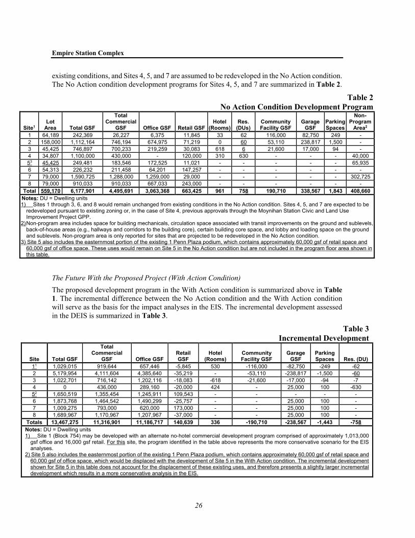
Empire Station Complex
26
existing conditions, and Sites 4, 5, and 7 are assumed to be redeveloped in the No Action condition. The No Action condition development programs for Sites 4, 5, and 7 are summarized in Table 2.
Table 2 No Action Condition Development Program
Site1 Lot
Area Total GSF
Total Commercial
GSF Office GSF Retail GSF Hotel
(Rooms) Res.
(DUs) Community Facility GSF
Garage GSF
Parking Spaces
Non-Program
Area2 1 64,189 242,369 26,227 6,375 11,845 33 62 116,000 82,750 249 - 2 158,000 1,112,164 746,194 674,975 71,219 0 60 53,110 238,817 1,500 - 3 45,425 746,897 700,233 219,259 30,083 618 6 21,600 17,000 94 - 4 34,807 1,100,000 430,000 - 120,000 310 630 - - - 40,000 53 45,425 249,481 183,546 172,525 11,021 - - - - - 65,935 6 54,313 226,232 211,458 64,201 147,257 - - - - - - 7 79,000 1,590,725 1,288,000 1,259,000 29,000 - - - - - 302,725 8 79,000 910,033 910,033 667,033 243,000 - - - - - -
Total 559,170 6,177,901 4,495,691 3,063,368 663,425 961 758 190,710 338,567 1,843 408,660 Notes: DU = Dwelling units 1) Sites 1 through 3, 6, and 8 would remain unchanged from existing conditions in the No Action condition. Sites 4, 5, and 7 are expected to be
redeveloped pursuant to existing zoning or, in the case of Site 4, previous approvals through the Moynihan Station Civic and Land Use Improvement Project GPP.
2) Non-program area includes space for building mechanicals, circulation space associated with transit improvements on the ground and sublevels, back-of-house areas (e.g., hallways and corridors to the building core), certain building core space, and lobby and loading space on the ground and sublevels. Non-program area is only reported for sites that are projected to be redeveloped in the No Action condition.
3) Site 5 also includes the easternmost portion of the existing 1 Penn Plaza podium, which contains approximately 60,000 gsf of retail space and 60,000 gsf of office space. These uses would remain on Site 5 in the No Action condition but are not included in the program floor area shown in this table.
The Future With the Proposed Project (With Action Condition) The proposed development program in the With Action condition is summarized above in Table 1. The incremental difference between the No Action condition and the With Action condition will serve as the basis for the impact analyses in the EIS. The incremental development assessed in the DEIS is summarized in Table 3.
Table 3 Incremental Development
Site Total GSF
Total Commercial
GSF Office GSF Retail GSF
Hotel (Rooms)
Community Facility GSF
Garage GSF
Parking Spaces Res. (DU)
11 1,029,015 919,644 657,446 -5,845 530 -116,000 -82,750 -249 -62 2 5,179,954 4,111,604 4,385,640 -35,219 - -53,110 -238,817 -1,500 -60 3 1,022,701 716,142 1,202,116 -18,083 -618 -21,600 -17,000 -94 -7 4 0 436,000 289,160 -20,000 424 - 25,000 100 -630 52 1,650,519 1,355,454 1,245,911 109,543 - - - - - 6 1,873,768 1,464,542 1,490,299 -25,757 - - 25,000 100 - 7 1,009,275 793,000 620,000 173,000 - - 25,000 100 - 8 1,689,967 1,170,967 1,207,967 -37,000 - - 25,000 100 -
Totals 13,467,275 11,316,901 11,186,717 140,639 336 -190,710 -238,567 -1,443 -758 Notes: DU = Dwelling units 1) Site 1 (Block 754) may be developed with an alternate no-hotel commercial development program comprised of approximately 1,013,000
gsf office and 16,000 gsf retail. For this site, the program identified in the table above represents the more conservative scenario for the EIS analyses.
2) Site 5 also includes the easternmost portion of the existing 1 Penn Plaza podium, which contains approximately 60,000 gsf of retail space and 60,000 gsf of office space, which would be displaced with the development of Site 5 in the With Action condition. The incremental development shown for Site 5 in this table does not account for the displacement of these existing uses, and therefore presents a slightly larger incremental development which results in a more conservative analysis in the EIS.

Final Scope of Work
27
D. PROPOSED SCOPE OF WORK FOR THE EIS Because the Proposed Project would affect various areas of environmental concern and was found to have the potential for significant adverse impacts in a number of impact categories, pursuant to the Environmental Assessment Form (EAF) and Positive Declaration, an EIS will be prepared that will analyze all areas of environmental concern. The EIS will be prepared in conformance with all applicable laws and regulations, including SEQRA (Article 8 of the New York State Environmen-tal Conservation Law). Because the area affected by the Proposed Actions is within New York City, the DEIS will generally follow the guidance of the 2014 CEQR Technical Manual, as and to the extent appropriate, as determined by ESD. The DEIS will include:
• A description of the Proposed Project and its environmental setting; • A statement of the environmental impacts of the Proposed Project, including short- and long-
term effects and typical associated environmental effects; • An identification of any adverse environmental effects that cannot be avoided if the Proposed
Project is implemented; • A discussion of reasonable alternatives to the Proposed Project; • An identification of irreversible and irretrievable commitments of resources that would be
involved in the Proposed Project, should it be implemented; and • A description of mitigation proposed to eliminate or minimize any significant adverse
environmental impacts.
The specific technical areas to be included in the EIS, as well as their respective tasks and methodologies, are described below. The analyses of the Proposed Project will be performed for two years of project occupancy: an assumed initial analysis year of 2028 (Phase 1) and an assumed final analysis year of 2038 (Phase 2).
Based on the preliminary screening assessments contained in the EAF, the Proposed Project is not expected to require a detailed analysis of natural resources. Therefore, this analysis will not be provided in the DEIS.
TASK 1. PROJECT DESCRIPTION
The Project Description introduces the reader to the Proposed Project and provides the project data from which impacts are assessed. The chapter will contain a brief history of the Project Area, a description of the Proposed Project and the Purpose and Need, and a discussion of the approvals required. The role of the lead agency for SEQRA will also be described as well as the environ-mental review process to aid in decision-making. This chapter is key to understanding the Pro-posed Project and the potential significant adverse impacts and provides the public and decision-makers a framework from which to evaluate the Proposed Project against the No Action condition.
TASK 2. ANALYTICAL FRAMEWORK
This chapter will discuss the framework for the EIS technical analyses. It will identify the analysis years, project phasing, and the proposed development program. This chapter will also define the No Action and With Action conditions and the increment for analysis in the EIS. This chapter will identify the planned rail and development projects affecting the Project Area or that fall within the study areas for EIS analysis. The chapter will summarize the actions required to develop the Proposed Project and describe the role of the public agencies in the approval process. The role of

Empire Station Complex
28
the EIS as an environmental disclosure document to aid in decision-making will be identified and its relationship to any other approval procedures will be described.
TASK 3. LAND USE, ZONING, AND PUBLIC POLICY
A land use analysis characterizes the uses and development trends in the area that may be affected by a proposed action and determines whether a proposed action is either compatible with those conditions or whether it may affect them. Similarly, the analysis considers the action’s compliance with, and effect on, the area’s zoning and other applicable public policies. This chapter will analyze the potential impacts of the Proposed Project on land use, zoning, and public policy, pursuant to the methodologies presented in the CEQR Technical Manual.
The primary land use study area will consist of the Project Area, where the potential effects of the Proposed Project would be directly experienced. The secondary land use study area will include neighboring areas within a ¼-mile boundary from the primary study area (see Figure 7). The analysis will include the following tasks:
• Provide a brief development history of the primary (i.e., Project Area) and secondary study areas (as applicable).
• Provide a description of land use, zoning, and public policy in the study areas discussed above (a more detailed analysis will be conducted for the Project Area). Recent trends will be noted. Other public policies that apply to the study areas will also be described such as Vision Zero, applicable business improvement districts (BIDs), OneNYC, the City’s Climate Mobilization Act, and New York State’s Climate Leadership and Community Protection Act.
• Based on field surveys and prior studies, identify, describe, and graphically portray predominant land use patterns for the balance of the study areas. Describe recent land use trends in the study areas and identify major factors influencing land use trends.
• Describe and map existing zoning and recent zoning actions in the study areas. • Based on the list of future development projects in the study areas presented in Chapter 2,
“Analytical Framework,” identify and discuss future land use trends within the study area. Also, identify known pending zoning actions or other public policy actions that could affect land use patterns and trends in the study areas. Based on these planned projects and initiatives, assess future land use and zoning conditions in the future without the Proposed Project.
• Describe the proposed zoning overrides and potential land use changes that would result from the Proposed Project.
• Discuss the Proposed Project’s potential effects related to issues of compatibility with surrounding land use, the consistency with zoning and other public policies, and the effect of the Proposed Project on development trends and conditions in the primary and secondary study areas.
• Assess the Proposed Project’s consistency with adopted public policies. The EIS will also discuss relevant area planning documents and their implications for existing land use and future development.
• If necessary, mitigation measures to avoid or reduce potential significant adverse impacts will be identified.

UV9A
UV495
W 34th St
W 25th St
W 35th St
W 31st St
W 26th St
Ten
th A
ve
E 24th St
E 27th St
E 25th St
E 31st St
Nin
th A
ve
E 26th St
E 30th St
W 33rd St
Dye
r A
ve
E 29th St
E 28th St
E 32nd St
Sev
enth
Ave
E 34th St
W 24th St
W 37th St
E 36th St
E 37th St
Par
k A
ve
E 35th St
E 39th St
E 38th St
W 30th St
W 29th St
Lincoln Tunnel
Mad
iso
n A
ve
Ele
ven
th A
ve
Joe
Dim
aggioH
wy
Twelfth A
ve
W 38th St
W 27th Dr
W 36th St
W 39th St
W 27th St
Six
th A
ven
ue
(Ave
nu
e o
f th
e A
mer
icas
)
Fift
h A
ve
Broadw
ay
W 32nd St
W 28th St
Lex
ing
ton
Ave
Par
k A
ve S
Eig
hth
Ave
Hu
dso
n B
lvd
EE 33rd St
HUDSONRIVER
Chelsea Park
EMPIRE STATION COMPLEX
Existing Land UseFigure 7
0 1,000 FEET
Project Area/Primary Study Area
Secondary Study Area (1/4-mile perimeter)
Penn Station (Below Grade)
Commercial and Office Buildings
Hotels
Industrial and Manufacturing
Open Space and Outdoor Recreation
Parking Facilities
Public Facilities and Institutions
Residential
Residential with Commercial Below
Transportation and Utility
Vacant Land
Vacant Building
Under Construction
10.12.20
Dat
a so
urce
: NY
C D
ept.
of
City
Pla
nnin
g M
apP
LUTO
20v
2 an
d A
KR
F st
udy
area
sur
vey

Final Scope of Work
29
TASK 4. SOCIOECONOMIC CONDITIONS
The socioeconomic character of an area includes its population, housing, and economic activity. Socioeconomic changes may occur when a project directly or indirectly impacts any of these elements. Even when socioeconomic changes would not result in impacts, they are disclosed if they would affect land use patterns, low-income populations, the availability of goods and services, or economic investment in a way that changes the socioeconomic character of the area. As detailed below, the analyses will study both the potential adverse socioeconomic effects and the expected economic benefits of the Proposed Project.
POTENTIAL ADVERSE SOCIOECONOMIC EFFECTS
The analyses of potential adverse socioeconomic effects will apply the methodologies of the CEQR Technical Manual, supplemented by additional analyses as warranted based on input from ESD, reviewing agencies, and public comments on the Draft Scope of Work. According to the CEQR Technical Manual, the five principal issues of concern with respect to socioeconomic conditions are whether the Proposed Project would result in significant impacts due to: (1) direct residential displacement; (2) direct business displacement; (3) indirect residential displacement due to increased rents; (4) indirect business displacement due to increased rents or due to retail market saturation; and (5) adverse effects on specific industries. The following sections describe the anticipated scope of analysis for each of these principal issues of socioeconomic concern. For each area of concern, if necessary, mitigation measures to avoid or reduce potential significant adverse impacts will be identified.
Direct Residential Displacement Direct residential displacement is the involuntary displacement of residents from a site directly affected by a project. The concern under SEQRA and CEQR is whether a project would directly displace residential population to the extent that the socioeconomic character of the neighborhood would be substantially altered. According to the CEQR Technical Manual, displacement of less than 500 residents would not typically be expected to alter the socioeconomic character of a neighborhood in a manner warranting assessment.
The Proposed Project would directly displace an estimated 208 residents living within 128 units: 62 units located on Block 754; 60 units located on Block 780; and 6 units located on Block 806. While the total number of displaced residents would not exceed the 500-person CEQR threshold warranting full assessment and thus would not be expected to alter socioeconomic character, an assessment will be conducted to confirm whether this assumption is correct using the following preliminary assessment methodology:
• Estimate the number of existing residents who would likely be directly displaced by the Proposed Project, and estimate their demographic profile, including income, household incomes and household characteristics (including specific identification of any homeless shelters and/or single-room occupancy [SRO] units), rents, or home values in those buildings to be directly displaced. The demographic characteristics of displaced residents will be estimated based on publicly available data, including U.S. Census data and field investigations, and/or interviews.
• Based on the guidelines of the CEQR Technical Manual, determine if displaced residents represent a sizable portion of future population in an approximately ¼-mile study area (generally interpreted to mean greater than five percent), and if so, if a population with a similar profile would not be able to relocate within the study area.

Empire Station Complex
30
• Determine if the loss of existing populations and the number of units to be displaced is substantial, and whether the loss would result in a significant change in the socioeconomic profile or housing character of the study area.
• Identify the applicable laws that govern property acquisition and relocation assistance for the displaced landlords, homeowners, and residential tenants. The analysis will consider the Uniform Relocation Act as it applies to direct displacement.
Direct Business Displacement Direct business displacement is the involuntary displacement of businesses from a site directly affected by a project. The Proposed Project would directly displace over 9,000 office, retail, hotel, and community facility employees from the development sites. The number of employees displaced by the Proposed Project exceeds the CEQR threshold of 100 employees warranting assessment. Based on CEQR Technical Manual guidelines, the analysis will begin with a preliminary assessment that will:
• Identify the number of employees and number and types of businesses in the Project Area that would likely be displaced by the Proposed Project, utilizing field surveys, online research, and information from property owners when available.
• Describe the operational characteristics of the businesses to be displaced, as well as their products, markets, and employment characteristics. This discussion would be based on available data from public sources such as the New York State Department of Labor (DOL) and the U.S. Census Bureau, private data sources such as Esri’s ArcGIS Business Analyst and Reference USA, and/or field investigation.
• Determine whether the businesses to be displaced provide essential products or services to the local economy that would no longer be available in its “trade area” to local residents or businesses due to the difficulty of either relocating the businesses or establishing new, comparable businesses.
• Determine whether a category of businesses to be displaced is the subject of regulations or publicly adopted plans to preserve, enhance, other otherwise protect it.
• Identify the applicable laws that govern property acquisition and relocation assistance for the displaced landlords, businesses, and employees.
If the preliminary assessment cannot rule out the potential for significant adverse impacts due to direct business displacement, then a more detailed analysis will be conducted. The detailed analysis, if determined to be warranted, would describe existing and anticipated future conditions to a level necessary to understand the operational characteristics of the displaced businesses, determine whether they can be relocated, and assess whether the potential loss of the businesses from the study area could result in changes that would be significant and adverse.
Indirect Residential Displacement Due to Increased Rents Indirect (or secondary) residential displacement is the involuntary displacement of residents that may result from a change in socioeconomic conditions created by a project. The concern is whether a project could lead to increases in property values, and thus rents, making it difficult for some residents to afford their homes. The objective of the indirect residential displacement assessment is to determine whether the Proposed Project would either introduce a trend or accelerate a trend of changing socioeconomic conditions that may potentially displace a vulnerable population to the extent that the socioeconomic character of the neighborhood would change. According to CEQR Technical Manual guidance, an assessment of indirect residential

Final Scope of Work
31
displacement should be conducted for actions that result in the incremental development of more than 200 residential dwelling units. The Proposed Project would not introduce more than 200 residential dwelling units over the No Action condition and therefore an assessment of indirect residential displacement due to increased rents is not warranted.
Indirect Business Displacement Due to Increased Rents Similar to indirect residential displacement, the concern with respect to indirect business displacement is whether a project could lead to increases in property values, and thus rents, making it difficult for some businesses to afford their rent. The Proposed Project would result in commercial development exceeding the 200,000-sf threshold warranting analysis. The analysis will begin with a preliminary assessment that describes and characterizes conditions and trends in employment and businesses within an approximately ¼-mile study area surrounding the Project Area, using the most recent available data from such sources as DOL and the U.S. Census Bureau, as well as private sources such as Esri’s ArcGIS Business Analyst and real estate brokerage firms, as necessary. This information will be used to consider:
• Whether the Proposed Project would introduce enough of a new economic activity to alter existing economic patterns;
• Whether the Proposed Project would add to the concentration of a particular sector of the local economy enough to alter or accelerate existing economic patterns; and
• Whether the Proposed Project would directly displace any type of use that either directly supports businesses in the area or brings a customer base to the area for local businesses, or if it indirectly displaces residents, workers, or visitors who form the customer base of existing businesses in the area.
If the preliminary assessment cannot rule out the potential for significant adverse impacts due to indirect business displacement, then a more detailed analysis will be conducted. The detailed analysis would utilize more in-depth demographic analysis and field surveys, as appropriate, to characterize existing business conditions; identify businesses at risk for displacement; and assess potential impacts on any identified businesses at risk.
Indirect Business Displacement Due to Retail Market Saturation An analysis of indirect business displacement due to retail market saturation (i.e., competitive effects) is not warranted. Based on CEQR Technical Manual guidelines, for projects such as this, where development is located on multiple sites located across a project area, a preliminary assessment of retail market saturation (i.e., competitive effects) is warranted for retail develop-ments on a single site in excess of 200,000 gsf or if the project as a whole includes in excess of 200,000 sf that are considered “regional-serving” (i.e., not the type of retail that primarily serves the local population). In the With Action condition, the Proposed Project as a whole has an increment of less than 200,000 gsf of regional-serving retail. In the case of the Manhattan Mall site (Site 8), which currently has 243,000 gsf of regional-serving retail, there would be a net reduction of 37,000 gsf of regional-serving retail with the Proposed Project. The retail with the Proposed Project would primarily serve local residents’ day-to-day needs, existing workers and the Proposed Project’s worker population, and commuters who are going to and from Penn Station. As a central transportation hub of Manhattan’s Central Business District, hundreds of thousands of people pass through the Project Area each day; the retail with the Proposed Project would serve as a critical amenity to serve this population.

Empire Station Complex
32
Adverse Effects on Specific Industries A preliminary assessment of effects on specific industries will be conducted to determine whether the Proposed Project would significantly affect business conditions in any industry or category of businesses within or outside the study area, or whether the Proposed Project would substantially reduce employment or impair viability in a specific industry or category of businesses.
If the preliminary assessment cannot rule out the potential for significant adverse impacts due to indirect business displacement, then a detailed analysis will be conducted. The detailed analysis would utilize more in-depth analysis of businesses’ operations and industry trends, additional field surveys, and interviews with business owners and/or industry experts; identify categories of businesses at risk for displacement; and assess potential impacts on any identified categories of businesses at risk.
ECONOMIC BENEFITS ANALYSIS
In addition to rail, transit, and public realm improvements, the Proposed Project will introduce new office, retail, and hotel uses to the study area that will generate employment during construction and operations. These benefits will be assessed and disclosed so that the Proposed Project’s economic benefits and potential adverse effects can be compared.
Economic Benefits of Construction The economic benefits generated during construction will be estimated, with estimates of the employment, employee compensation, and total economic output associated with the construction. The analysis will use either the RIMS II or IMPLAN (IMpact analysis for PLANning) economic input-output modeling system. The input-output modeling will allow reporting of the “ripple effect” in the City and state economies in terms of direct, indirect, and induced impacts:
• Direct effects representing the initial benefits to the economy of a specific new investment; this would include direct construction cost and the resulting demand in employment and changes in employee compensation;
• Indirect effects representing spending impacts generated by inter-industry purchasing due to the direct investment; and
• Induced effects representing the impacts caused by increased income in a region.
The economic modeling for construction benefits will be based on a construction cost estimate for the Proposed Project. The assessment will estimate the Proposed Project’s economic benefits for New York City and for New York State.
Economic Benefits During Operations The annual economic benefits generated during fully stabilized operations will be analyzed for the Proposed Project. The input-output modeling of impacts during annual operations will use as its “input” estimates of direct (on-site) employment. Similar to the construction benefits analysis scope detailed above, this modeling will estimate the direct, indirect, and induced employment, employee compensation, and economic output generated by the Proposed Project within New York City and New York State. The assessment will also qualitatively discuss economic benefits associated with anticipated improvements in rail and transit facilities, and how the additional density finances the rail, transit and public realm improvements; this discussion will be developed in consultation with ESD, MTA, and other relevant stakeholder agencies and property owners.

Final Scope of Work
33
TASK 5. COMMUNITY FACILITIES
As defined for CEQR analysis, community facilities are public or publicly funded schools, libraries, child care centers, health care facilities and fire and police protection. Based on the preliminary thresholds presented in the CEQR Technical Manual, the Proposed Project is not expected to trigger detailed analyses of public schools, public libraries, or child care centers serving the Project Area. In addition, while the Proposed Project is not expected to warrant detailed analyses of potential impacts on police/fire stations and health care services, for informational purposes, a description of existing police, fire, and health care facilities serving the Project Area will be provided in the EIS. The community facilities analysis will also include an assessment of potential impacts from the direct displacement of community facility uses on the development sites, including the Antonio Olivieri Drop-In center at 257 West 30th Street, St. John the Baptist Roman Catholic Church at 213 West 30th Street, and Touro College at 320 West 31st Street, as appropriate. If necessary, mitigation measures to avoid or reduce potential significant adverse impacts will be identified.
TASK 6. OPEN SPACE
If a project may add population to an area, demand for existing open space facilities would typically increase. Indirect effects may occur when the population generated by the Proposed Project would be sufficiently large to noticeably diminish the ability of an area’s open space to serve the future population. For the majority of projects, an assessment is conducted if the Pro-posed Project would generate more than 200 residents or 500 employees, or a similar number of other uses. The Proposed Project would generate a net increase of more than 500 employees. However, the need for an open space assessment may vary in certain areas of the City that are considered either underserved or well-served by open space; if a project is located in an under-served area, an open space assessment should be conducted if that project would generate more than 50 residents or 125 workers. The Project Area exceeds the respective worker analysis thresholds. Therefore, an assessment of nonresidential open space is warranted and will be pro-vided in the EIS.
The open space analysis will consider passive open space resources. Passive open space ratios will be assessed within a nonresidential (¼-mile radius) study area. The study area would generally comprise those census tracts that have 50 percent or more of their area located within the ¼-mile radius of the Project Area.5
The detailed open space analysis in the EIS will include the following tasks:
• Characteristics of the open space user group (workers/daytime users and residents) will be determined. As the study area will include a workforce and daytime population that may use open spaces, the number of employees and daytime workers in the study areas will also be calculated, based on Longitudinal Employer-Household Dynamics [LEHD] data obtained from the Census-on-the-Map application. In addition, the residential population in the study area will be compiled from the 2013–2018 American Community Survey (ACS) data.
• Existing active and passive open spaces within the ¼-mile open space study area will be inventoried and mapped. The condition and usage of existing facilities will be described based
5 ¼-mile radius adjusted to be coterminous with the boundaries of census tracts with existing populations
that have 50 percent of their area within the radius; the ¼-mile radius was not adjusted to be coterminous with census tracts without existing populations (e.g., census tracts entirely comprised of open space).

Empire Station Complex
34
on the inventory, prior studies, and, if appropriate given COVID-19 conditions, field visits.. Acreages of these facilities will be determined, and the total study area acreages will be calculated. The percentage of active and passive open space will also be calculated.
• Based on the inventory of facilities and study area populations, total, active, and passive open space ratios will be calculated for the worker populations and compared to City guidelines to assess adequacy. Open space ratios are expressed as the amount of open space acreage (total, passive, and active) per 1,000 user population. The residential population within the study area may also utilize passive open spaces, therefore this population will be considered in the analysis.
• Expected changes in future levels of open space supply and demand in the analysis year will be assessed, based on other planned development projects within the open space study areas. Any new open space or recreational facilities that are anticipated to be operational by the analysis year will also be accounted for. Open space ratios will be calculated for the No Action condition and compared with exiting ratios to determine changes in future levels of adequacy.
• Effects on open space supply and demand resulting from increased worker population added under the development program associated with the Proposed Project will be assessed. The assessment of the Proposed Project’ impacts will be based on a comparison of open space ratios for the No Action versus With Action conditions. In addition to this quantitative analysis, a qualitative analysis will be performed to determine if the changes resulting from the Proposed Project constitute a substantial change (positive or negative) or an adverse effect to open space conditions. The qualitative analysis will assess whether or not the study areas are sufficiently served by open space, given the type (active vs. passive), capacity, condition, and distribution of open space, and the profile of the study area populations.
• If necessary, mitigation measures to avoid or reduce potential significant adverse impacts will be identified.
TASK 7. SHADOWS
In accordance with the CEQR Technical Manual a shadows assessment will be prepared for the Proposed Project because it would result in new structures (or additions to existing structures) greater than 50 feet in height or located adjacent to, or across the street from, a sunlight-sensitive resource. Sunlight-sensitive resources include publicly accessible parks and plazas, historic re-sources with sunlight-sensitive features, and natural resources. Shadows falling on streets and sidewalks or other buildings generally are not considered significant, nor are shadows occurring within an hour-and-one-half of sunrise or sunset.
The Proposed Project would result in the development of several new buildings in the Project Area that would exceed the CEQR Technical Manual threshold for a shadows analysis. The Project Area is in proximity to a number of publicly accessible plazas and parks, such as Herald Square and Greeley Square Park, and historic resources with sunlight-dependent features, such as the Moynihan Train Hall (also known as the Farley Building) and the stained-glass windows of the Church of the Holy Apostles at Ninth Avenue and West 28th Street. Therefore, a shadow study will be conducted to determine the extent, duration, and effects of any project-generated incre-mental shadows and whether any project-generated incremental shadows could reach any publicly accessible open spaces, sunlight-sensitive historic architectural features, or other sunlight-sensi-tive resources of concern, accounting for existing (and future planned) intervening buildings. The shadow study will assess the potential effects of any new project-generated shadows on sunlight-sensitive resources in the vicinity of the Project Area. To provide for a conservative analysis, each

Final Scope of Work
35
of the proposed buildings will be modeled with an additional 150 feet of height above the illustrative massings that were developed to illustrate the potential height and bulk of the proposed buildings. The analysis will follow the methodology described in the CEQR Technical Manual, and would include the following tasks:
• Develop a base map illustrating the Project Area in relationship to publicly accessible open spaces, historic resources with sunlight-dependent features, and natural resources in the area.
• Determine the longest possible shadows that could result from the Proposed Project to delineate the study area and determine which sunlight-sensitive resources could potentially be affected.
• Develop a three-dimensional computer model of the elements of the base map developed in the preliminary assessment, including the illustrative potential massings of the proposed developments and neighboring buildings.
• Refine the study area that could be reached by project-generated shadow by assessing four specific representative days in each season and using the modeling software to determine the maximum extent of shadow over the course of each representative day.
• For any remaining sunlight-sensitive resources for which the possibility of new project-generated shadow cannot be eliminated, conduct a detailed analysis to determine the extent and duration of new shadows that would be cast on sunlight-sensitive resources as a result of the Proposed Project on four representative days of the year, accounting for intervening and surrounding structures.
• Document the detailed analysis with graphics comparing shadows resulting from the No Action condition with shadows resulting from the Proposed Project, with incremental shadow highlighted in a contrasting color. Include a summary table listing the entry and exit times and total duration of incremental shadow on each applicable representative day for each affected resource.
• Assess the significance of any shadow impacts on sunlight-sensitive resources. If necessary, mitigation measures to avoid or reduce potential significant adverse impacts will be identified.
TASK 8. HISTORIC AND CULTURAL RESOURCES
Historic and cultural resources are districts, buildings, structures, sites, and objects of historical, aesthetic, cultural, and archaeological importance. This includes properties listed on the State/National Registers of Historic Places (S/NR) or contained within a district listed on or formally determined eligible for S/NR listing; properties recommended by the New York State Board for Historic Preservation for listing on the S/NR; National Historic Landmarks; designated NYC Landmarks (NYCLs); properties calendared for consideration as landmarks by the New York City Landmarks Preservation Commission (LPC); and properties not identified by one of the programs listed above, but that meet their eligibility requirements. There are a number of known historic architectural resources in the Project Area that include the James A. Farley Complex (S/NR, NYCL), the Hotel Pennsylvania (S/NR-eligible), the Stewart Hotel at 371-377 Seventh Avenue (S/NR-eligible), and the following five S/NR-eligible properties on Block 780—the Church and Rectory of St. John the Baptist at 207-215 West 30th Street, Fairmont Building at 239-241 West 31st Street, loft building at 247 West 31st Street, loft building at 259-261 West 31st Street, and the Penn Station Service Building at 236 West 30th Street (which is also NYCL-eligible). Because the Proposed Project would result in above-ground construction resulting in ground disturbance, and the removal of all the foregoing historic buildings other than the Farley Complex, a historic and cultural resources analysis will be prepared. Consultation with the New

Empire Station Complex
36
York State Office of Parks, Recreation, and Historic Preservation (OPRHP) and LPC will be undertaken as part of the historic and cultural resources analysis.
As described above, under “Required Approvals,” although the sites constituting a proposed expansion of Penn Station are included as part of ESD’s GPP, the siting, planning, property acquisition, and construction of the Penn Station expansion on Sites 1, 2, and 3 would be subject to separate actions and approvals by or for the involved public transportation agencies and would be subject to environmental review under NEPA and Section 106 of the National Historic Preservation Act. The development of Sites 4, 5, 6, 7, and 8 under the GPP is subject to review under SEQRA and Section 14.09 of the New York State Historic Preservation Act. The national and state historic preservation acts both require consultation with OPRHP; under Section 106, OPRHP acts in its capacity as the State Historic Preservation Office (SHPO).
ARCHAEOLOGICAL RESOURCES
As the first step in the archaeology analysis, OPRHP and LPC will be consulted to request their preliminary determination of the potential archaeological sensitivity of each development site. As necessary, supporting information including historical maps and information from previous archaeological investigations and previously issued archaeological determination letters will be submitted to OPRHP and LPC, as necessary, as part of the initial consultation. If, based on that review, OPRHP and/or LPC determine that a development site is not potentially archaeologically sensitive, no further analysis of archaeological resources will be undertaken. If OPRHP and/or LPC determine that a development site is potentially archaeologically sensitive and that additional archaeological analysis is warranted, a Phase 1A Archaeological Documentary Study will be prepared for that development site. The Phase 1A investigation will outline the precontact and historic contexts, environmental setting, development history, and past disturbance of the location to identify any potential resource types that may be present. The Phase 1A study will also make a determination as to whether or not additional archaeological investigations (e.g., Phase 1B testing) are needed at any of the development sites. The conclusions of the Phase 1A Archaeological Documentary Study (or studies) will be summarized in the DEIS, and potential impacts on any archaeological resources will be assessed in the No Action and With Action condition.
ARCHITECTURAL RESOURCES
Impacts on architectural resources will be considered within the Project Area and in a 400-foot radius area surrounding the Project Area. Longer contextual views available beyond the 400-foot study area will also be considered as appropriate in coordination with the Urban Design and Visual Resources task. The architectural resources analysis will include the following tasks:
• Map and briefly describe known architectural resources in the study area. • Conduct a field survey of the study area to identify any potential architectural resources that
could be affected by the Proposed Project and map and briefly describe any such resources; • Assess the potential impacts of the Proposed Project on architectural resources, including
direct physical impacts and visual and contextual changes and impacts relating to significant new shadows on sunlight-sensitive resources; and
• If the results of the impact analysis identify a potential for significant adverse impacts, potential practicable mitigation measures to avoid or reduce those significant adverse impacts will be developed in consultation with OPRHP and LPC.

Final Scope of Work
37
TASK 9. URBAN DESIGN AND VISUAL RESOURCES
This section of the EIS will assess changes in urban design patterns and visual resources of the study area as a result of the Proposed Project. According to the methodologies of the CEQR Technical Manual, if an action would result in physical changes to a project site beyond those allowable by existing zoning and which could be a observed by a pedestrian from street level, a preliminary assessment of urban design and visual resources should be prepared with a detailed analysis, if warranted, based on the preliminary assessment. As described in the CEQR Technical Manual, examples of actions that may require a detailed analysis are those that would make substantial alterations to the streetscape of a neighborhood by noticeably changing the scale of buildings, potentially obstruct view corridors, or compete with icons on the skyline. As the Proposed Project would allow a substantial density increase in the Project Area, a detailed urban design and visual resources analysis will be prepared. The detailed analysis will draw on information from field visits to the study area and visual materials prepared for the Proposed Project and will present, as warranted, illustrative sketches or renderings of the future With Action condition for existing views; context and conceptual site plans; floor area calculations; street wall and building heights; building setbacks; and birds-eye views of proposed development. The study area for the assessment of urban design and visual resources would be the same as that used for the land use analysis and would account for other longer views, as appropriate. The analysis will describe the urban design and visual resources of the Project Area and the surrounding area. The analysis will describe the potential changes that could occur to urban design and visual resources with the Proposed Project in comparison to the future No Action condition, focusing on the changes that could negatively affect a pedestrian’s experience of the area. The analysis will also describe measures intended to improve the pedestrian experience as well as assess the presence of the new buildings on the development sites in the midtown skyline. If necessary, mitigation measures to avoid or reduce potential significant adverse effects will be identified.
TASK 10. HAZARDOUS MATERIALS
The hazardous materials chapter will include a detailed discussion of existing environmental conditions at the development sites. It is anticipated that the Proposed Project would involve some combination of demolition and excavation/soil disturbance at the development sites (and potentially in other areas where in-ground disturbance associated with the Proposed Project could occur), potentially resulting in hazardous materials being encountered in the existing structures or in the subsurface. The hazardous materials chapter will focus on review and incorporation of previous studies that are available for the development sites (and any other areas where in-ground disturbance associated with the Proposed Project could occur). Previous studies to be consulted include available Phase I Environmental Site Assessments (ESAs), Phase II Subsurface investiga-tions, and other reports including documentation related to asbestos-containing materials and lead-based paint in existing structures. A Phase I ESA is a non-intrusive study that evaluates the poten-tial presence of hazardous materials based on historical uses and regulatory information related to a site and its vicinity, as well as, where possible, a site inspection.
For some of the development sites for which Phase I ESAs are available, an update may be necessary. In the event that no Phase I ESA is available for a development site, a screening assessment will be prepared in general conformance with current industry standards, including ASTM 1527-13: Standard Practice for Environmental Site Assessment: Phase I Environmental Site Assessment Process.

Empire Station Complex
38
In addition to summarizing existing conditions, the chapter will address requirements for subsurface testing and/or other necessary remedial measures required prior to or during construction and/or during operation of each development site, in order to avoid the potential for significant adverse impacts. This chapter will also include a general discussion of the health and safety measures to be implemented during project construction to protect workers and the surrounding community. Finally, the chapter will identify the binding mechanisms to ensure that testing and other measures are performed, including, where necessary, the implementation of site-specific Remedial Action Plans and Construction Health and Safety Plans (RAPs and CHASPs).
TASK 11. WATER AND SEWER INFRASTRUCTURE
The water and sewer infrastructure assessment determines whether a proposed action may adversely affect the City’s water distribution or sewer system and, if so, assess the effects of such actions to determine whether their impact is significant. The CEQR Technical Manual outlines thresholds for analysis of an action’s water demand and its generation of wastewater and stormwater. For the Proposed Project, an analysis of water supply is warranted as the development program associated with the Proposed Project is expected to result in a water demand of more than one million gallons per day (mgpd) compared with the No Action condition. A preliminary assessment of the Proposed Project’s potential effects on wastewater and stormwater infrastructure is warranted because it is expected to result in more than 250,000 sf of non-residential develop-ment, the applicable threshold for combined sewer areas in Manhattan. Therefore, the DEIS will analyze the Proposed Project’s potential effects on water, wastewater and stormwater infra-structure. The water and sewer infrastructure analysis will consider the potential for significant adverse impacts resulting from the Proposed Project.
WATER SUPPLY
• The existing water distribution system serving the Project Area will be described based on information obtained from the New York City Department of Environmental Protection’s (DEP) Bureau of Water Supply.
• The water demand generated by the existing uses in the Project Area will be estimated. • Water demand will be projected for No Action and With Action conditions. • The effects of the incremental demand on the City’s water supply system will be assessed to
determine if there would be impacts to water supply or pressure. The incremental water demand will be the difference between the water demand in the With Action condition and the demand in the No Action condition. The analysis will determine whether there would be adequate service and infrastructure to meet the incremental water demand based on the information on the existing water distribution system serving the Project Area as provided by DEP, as well as projections for the No Action and With Action conditions in the Project Area.
WASTEWATER AND STORMWATER INFRASTRUCTURE
• The Project Area’s directly affected area is located within the service area of the North River Wastewater Treatment Plant (WWTP). The study area will include the WWTP and the affected sewer conveyance system, as appropriate.
• The existing stormwater drainage system and surfaces (pervious or impervious) on the development sites will be described, and the amount of stormwater generated on those sites will be estimated using DEP’s volume calculation worksheet.

Final Scope of Work
39
• The existing sewer system serving the development sites will be described based on records obtained from DEP. The existing flow to the North River WWTP, which serves the directly affected area, will be obtained for the latest 12-month period available, and the average dry weather monthly flow will be presented.
• Changes to the stormwater drainage plan, sewer system, and surface area expected in the No Action condition will be described, as warranted.
• Future stormwater generation from the development sites will be assessed in accordance with the CEQR Technical Manual. Changes to the development sites’ surface area will be de-scribed, runoff coefficients and runoff for each surface type/area will be presented, and peak discharge rates and volume from the development sites will be determined based on the DEP volume calculation worksheet.
• Sanitary sewage generation from the Proposed Project will also be estimated. The effects of the incremental demand on the system will be assessed to determine if there will be any impact on operations of the North River WWTP. Existing work plans under DEP would be consulted.
A more detailed assessment may be required if increased sanitary or stormwater discharges associated with the Proposed Project are predicted to affect the capacity of portions of the existing sewer system, exacerbate combined sewer overflow (CSO)6 volumes/frequencies, or contribute greater pollutant loadings in stormwater discharged to receiving water bodies. If necessary, mitigation measures to avoid or reduce potential significant adverse impacts will be identified.
TASK 12. SOLID WASTE AND SANITATION SERVICES
A solid waste assessment determines whether an action has the potential to cause a substantial increase in solid waste production that may overburden available waste management capacity or otherwise be inconsistent with the City’s Solid Waste Management Plan or with state policy related to the City’s integrated solid waste management system. The Proposed Project would induce new development that would require sanitation services. If a project’s generation of solid waste in the With Action condition would not exceed 50 tons per week, it may be assumed that there would be sufficient public or private carting and transfer station capacity in the metropolitan area to absorb the increment, and further analysis generally would not be required. As the Proposed Project is expected to result in a net increase of more than 50 tons per week, compared with the No Action condition, an assessment of solid waste and sanitation services is warranted. This chapter will provide an estimate of the additional solid waste expected to be generated by the proposed developments assess its effects on the City’s solid waste and sanitation services. This assessment will:
• Describe existing and future New York City solid waste disposal practices. • Estimate solid waste generation by the Proposed Project for existing, No Action, and With
Action conditions. • Assess the impacts of the Proposed Project’s solid waste generation (from the development
sites) on the City’s collection needs and disposal capacity. The Proposed Project’s consistency 6 A combined sewer overflow is the discharge from a combined sewer system (i.e., a system that carries
stormwater runoff and domestic sewage in a single pipe for conveyance to a wastewater treatment facility) that is caused by stormwater runoff. Combined sewers are designed to overflow during wet weather, when the capacity of the sewer system may be exceeded. During these events, which are referred to as combined sewer overflow, the excess water is discharged directly to a waterbody.

Empire Station Complex
40
with the City’s Solid Waste Management Plan, the City’s Zero Waste initiative, and the recent promulgation of the Commercial Waste Zone Plan will also be assessed. If necessary, mitigation measures to avoid or reduce potential significant adverse impacts will be identified.
TASK 13. ENERGY
The EIS will include a discussion of the effects of a Proposed Project on the use and conservation of energy, if applicable and significant, in accordance with CEQR. In most cases, an action does not need a detailed energy assessment, but its operational energy is projected. A detailed energy assessment is limited to actions that may significantly affect the transmission or generation of energy. For other actions, in lieu of a detailed assessment, the estimated amount of energy that would be consumed annually as a result of the day-to-day operation of the buildings and uses resulting from an action is disclosed, as recommended in the CEQR Technical Manual.
An analysis of the anticipated incremental demand from the Proposed Project will be provided in the EIS. The EIS will disclose the projected amount of energy consumption during long-term operation resulting from the Proposed Project. The projected amount of energy consumption during long-term operation will be estimated based on the average and annual whole-building energy use rates for New York City. If warranted, the Mayor’s Office of Sustainability (MOS) and/or the power utility serving the area (Con Ed) will be consulted. If necessary, mitigation measures to avoid or reduce potential significant adverse impacts will be identified.
TASK 14. TRANSPORTATION
As described above, the Project Area is situated in Midtown Manhattan, adjacent to Penn Station, a major transit hub in New York City. Development of the Proposed Project is expected to span over 16 years and, for purposes of this EIS, assumed to be developed in two phases—an interim analysis year (Phase 1/2028) and a final analysis year (Phase 2/2038). Using guidance from the CEQR Technical Manual as appropriate, a detailed transportation impact analysis assessing the Proposed Project’s anticipated effects on the surrounding roadways, transit services, and pedestrian facilities will be prepared for the Phase 1 analysis year and the Phase 2 analysis year. The specific transportation scope is described below.
TRAVEL DEMAND FACTORS (TDF)
The evaluation of potential transportation-related impacts will begin with the preparation of travel demand estimates and transportation analysis screening assessments. Detailed trip estimates will be prepared using standard sources, including the CEQR Technical Manual, U.S. census data, approved studies, and other references. The trip estimates (Level 1 screening assessment) will be summarized by peak hour (weekday AM, midday, and PM peak hours), mode of travel, and person vs. vehicle trips for the Proposed Project’s final analysis year (Phase 2). The trip estimates will also identify the number of peak hour person trips made by transit and the numbers of pedestrian trips traversing the area’s sidewalks, corner reservoirs, and crosswalks. In addition to the trip estimates, detailed vehicle, transit, and pedestrian trip assignments (Level 2 screening assessment) will be prepared, to determine the study areas requiring quantified operational analyses. The results of these estimates will be summarized in a TDF memorandum.
TRAFFIC
Based on the TDF memo’s preliminary travel demand estimates, the specific number of traffic analysis intersections will be determined for detailed analysis for the weekday AM, midday, and

Final Scope of Work
41
PM peak periods. The corresponding analysis peak hours within these study periods will be 8–9 AM, 12–1 PM, and 5–6 PM, respectively. Figure 8 shows the anticipated traffic analysis study locations. Due to the current COVID-19 conditions, City agencies are not allowing data collection efforts to be undertaken at this time, because the data would not be representative of typical transportation conditions. Therefore, traffic volumes at the study area intersections will be based on previously collected data for other on-going and approved projects. These traffic volumes will be adjusted as necessary to develop the Proposed Project’s existing baseline traffic volumes for analysis. Future No Action and With Action traffic volumes will account for background growth, projects to be developed absent the Proposed Project, as well as programming associated with the Proposed Project, and ridership increases anticipated from regional transit improvement initiatives and those related to the Proposed Project. The existing baseline conditions and the two analysis years’ No Action and With Action conditions will be prepared by applying methodologies based on the Highway Capacity Manual (HCM), a publication of the Transportation Research Board of the National Academy of Sciences, to assess potential significant adverse traffic impacts. Where appropriate, feasible improvement measures will be explored to alleviate or mitigate these impacts.
RAIL AND TRANSIT
The Project Area is served by a wealth of public transportation options including the largest transportation hub in New York City. The rail and rapid transit options include the LIRR, NJT, Amtrak, as well as the A/C/E/1/2/3 Subway Lines at Penn Station, the B/D/F/M/N/Q/R/W Subway Lines at the Herald Square Station, and the PATH train at the 33rd Street Station. There are also numerous bus routes serving residents, commuters, and visitors traveling to and from the area. These include the M34/34A SBS, M1, M4, M5, M7, M11, M20, M55, and Q32 local bus routes, several inter-borough express bus routes, and regional bus routes at the Port Authority Bus Terminal. A detailed analysis of circulation and control area elements at the above subway stations will be prepared. Because current passenger counts would not be representative of normalized conditions, existing baseline pedestrian data at the station analysis elements will be developed based on previously collected data in consultation with NYCT for the weekday commuter AM and PM peak periods. For the same reason, existing ridership data of selected subway lines and bus routes that are expected to require detailed analysis will be obtained from NYCT for evalu-ation. Future No Action and With Action transit volumes will account for background growth, projects to be developed absent the Proposed Project, as well as programming associated with the Proposed Project, and ridership increases anticipated from regional transportation improvement initiatives and those related to the Proposed Project. The existing baseline conditions and the two analysis years’ No Action and With Action conditions will be prepared pursuant to CEQR and NYCT guidelines to assess potential significant adverse transit impacts. Potential station improvements that have been preliminarily identified, as depicted in Figures 4 and 5, will be incorporated into the With Action analysis. Where impacts are identified, conceptual improvement measures and/or service frequency increases will be explored for NYCT consideration.
The DEIS will include a discussion of existing and future ridership (including the Proposed Project’s incremental rail demand) at Penn Station. Incremental railroad trips resulting from the Proposed Project will be distributed to commuter railroad options including Metro-North, LIRR, NJT, and Amtrak. The Penn Station Master Plan, undertaken separately by MTA, is examining existing and future ridership at Penn Station and will identify potential circulation improvements that would be necessary to accommodate the projected future ridership. The DEIS will also incorporate the incremental railroad trips in its analyses and describe qualitatively how certain

W 48th St
W 47th St
Lincoln Tunnel
FDR
DR
S l P nott uS
W 57th St
W 56th St
W 55th St
W 54th St
W 53rd St
W 56th St/W 54th St Inset
Laight St
Huds
on S
t
Varic
k St
W Houston St
Canal St
Holland Tunnel Inset
Broadway
W 39th St
W 40th St
W 34th St
W 29th St
W 28th St
evA r
eyD
W 27th St
W 33rd St
W 44th St
W 46th St
W 26th St
W 45th St
W 42nd St
W 41st St
W 25th St
W 36th St
W 35th St
W 38th St
W 37th St
W 43rd St
W 30th St
A9 et uoR
FD
R Dr
ive
A9 et uoR
ev A ht 9
ev A dr 3
ev A ht 6
ev A nosi daM
ev A not gni xeL
ev A dn2
ev A kr aP
ev A ht 5
ev A t s1
ev A ht 7
ev A ht 8
ev A ht 01
ev A ht 11ev A ht 11
W 24th St
W 23rd St
W 32nd St
QMT
Entra
nce
W 31st St
0 0.25 0.5 Miles
EMPIRE STATION COMPLEX Figure 8
Project Area Study Intersection
Traffic Study Locations

Empire Station Complex
42
project-related impacts could be mitigated with the implementation of recommendations from the Penn Station Master Plan.
PEDESTRIANS
Project-generated pedestrian trips are expected to concentrate at each of the development sites and assumed to be distributed throughout the Project Area. A quantified pedestrian analysis will be conducted for a study area of pedestrian elements determined by the assignment of project-gener-ated trips for the weekday AM, midday, and PM peak hours. As with the baseline traffic volume data described above, due to the current COVID-19 conditions, existing baseline pedestrian volumes at the study area analysis elements will be based on previously collected data for other on-going and approved projects. These pedestrian volumes will be adjusted as necessary to devel-op the Proposed Project’s baseline pedestrian volumes for analysis. Future No Action and With Action pedestrian volumes will account for background growth, projects to be developed absent the Proposed Project, as well as programming associated with the Proposed Project, and ridership increases anticipated from regional transportation improvement initiatives and those related to the Proposed Project. The existing baseline conditions and the two analysis years’ No Action and With Action conditions will be prepared by applying HCM methodologies, to assess potential significant adverse pedestrian impacts. Figure 9 shows the anticipated pedestrian analysis study elements. Potential public realm improvements that have been preliminarily identified, as depicted in Figure 6, will be incorporated into the With Action analysis. Where impacts are identified, feasible improvement measures will be explored to alleviate or mitigate these impacts.
VEHICULAR AND PEDESTRIAN SAFETY
Crash data for the study area intersections and other nearby sensitive locations from the most recent three-year period will be obtained from DOT. These data will be analyzed to determine if any of the studied locations may be classified (per CEQR criteria) as high vehicle or high pedes-trian/bike crash locations and whether trips and changes resulting from the Proposed Project would adversely affect vehicular and pedestrian safety at these locations. If any high crash locations are identified, feasible improvement measures will be explored to alleviate potential safety issues.
PARKING
Located in the heart of Midtown Manhattan, there is currently an abundance of off-street parking resources within and surrounding the project area. Nevertheless, because the Proposed Project is expected to eliminate a substantial number of adjacent parking spaces, generate a notable level of new parking demand, and provide a limited number of parking spaces to serve project-generated demand, an off-street parking analysis will be prepared. As part of developing inputs for the preliminary travel demand estimates described above, a pre-COVID off-street parking supply and utilization survey was conducted for an area within ½-mile of the project area to inventory existing parking levels at these facilities. Building on this baseline, projections of future No Action and With Action utilization levels, and comparison of these projections to future anticipated parking supply (including changes resulting from the Proposed Project) will be developed to determine the potential for a parking shortfall. This shortfall, if materialized, however, is not considered a significant adverse parking impact under CEQR for the area surrounding the Project Area, due the abundance of nearby transportation options.

S S
S S
S
S
X
X
X X
X X
X X
C
C
SSX X
CC
CC
SSX X
CC
CC
SS
X
X
S
X
X X
C
C
S
C
CC
C
C C
S S
C C
SS
X X
C
CC
C
S
S S
C
C
C
C
C
C
C
C
C
C
C
C
C
C
C
CC
C
C
C
C
C
C
C
C
C
C
C
C
C
C
C
C
C
C
C
C
C
C
C
C
C
C
C
C
C
C
C
C
C
C
C
C
C
C
C
C
C
C
X XX
X
X
X
X
X X
XX
X
X X
X
XX X
XX
X
X
X
X
X
X
X
X
X
X
X
X
X
X
XX X
X
X X
XX X
X X
X X
X
X
X
X X
XX
X
S
S
S
SS
S
SS
S
SS S
S
S
S
S
S S
S
S
S
S SS
S
SS
SS S
S
S
S
S
S
S
SS
SS
SS
SS
S
SS
SS
SS
S
S
S S
SS
SS
S
SS
S
S
SS
S
WEST 39 STREET
WEST 35 STREET
WEST 40 STREET
WEST 37 STREET
WEST 34 STREET
WEST 29 STREET
WEST 30 STREET
WEST 38 STREET
WEST 33 STREET
WEST 31 STREET
DY
ER
AV
EN
UE
7 A
VE
NU
E
9 A
VE
NU
E
WEST 36 STREET
AVEN
UE
OF
TH
E A
ME
RIC
AS
8 A
VE
NU
E
5 A
VE
NU
E
MA
DIS
ON
AV
EN
UE
EAST 39 STREET
EAST 38 STREET
WEST 32 STREET
BR
OA
DW
AY
EAST 30 STREET
EAST 29 STREET
EAST 31 STREET
EAST 34 STREET
EAST 35 STREET
EAST 32 STREET
EAST 33 STREET
EAST 37 STREET
EAST 40 STREET
EAST 36 STREET
WEST 33 STREET
10.16.20
0 500 FEET
Figure 9
Pedestrian Analysis LocationsEMPIRE STATION COMPLEX
Project Area
C
X
S
Corner Element
Crosswalk Element
Sidewalk Element

Final Scope of Work
43
TASK 15. AIR QUALITY
MOBILE SOURCE ANALYSIS
The number of vehicle trips generated by the Proposed Project is projected to exceed the CEQR Technical Manual carbon monoxide (CO) analysis screening threshold of 140 vehicles in the peak hour at one or locations in the traffic study area. In addition, the projected number of vehicles will likely exceed the applicable PM2.5 screening threshold based on the screening procedure referenced in the CEQR Technical Manual. Therefore, a microscale analysis of CO and PM mobile source emissions is necessary. Using computerized dispersion modeling techniques, the effects of project-generated traffic on CO and PM concentrations at critical intersection locations will be determined. Potential air quality impacts due to emissions of nitrogen dioxide (NO2) are expected to be evaluated on a qualitative basis.
The mobile source air quality analysis will include the following tasks:
• Gather existing air quality data. Collect and summarize existing ambient air quality data for the study area. Specifically, ambient air quality monitoring data published by the New York State Department of Environmental Conservation (DEC) will be compiled for the analysis of existing and future conditions.
• Determine receptor locations for the microscale analysis. Select critical intersections in the study area, representing the locations with the highest potential total and incremental pollution impacts, based on data obtained from the traffic analysis prepared for the Project Area. At these intersections, multiple receptor locations will be analyzed in accordance with CEQR Technical Manual guidelines.
• Select dispersion models. The refined U.S. Environmental Protection Agency (EPA) AERMOD model is proposed to predict the maximum change in CO and PM2.5 concentrations, consistent with current EPA modeling guidance .
• Emission calculation methodology and worst-case meteorological conditions. Vehicular cruise and idle emissions for the dispersion modeling will be computed using EPA’s MOVES model. Compute re-suspended road dust emission factors based on CEQR guidance and the EPA procedure defined in AP–42.
• At each microscale receptor site, calculate for each applicable peak period the maximum 1- and 8-hour average CO concentrations and maximum 24-hour and annual average PM2.5 concentrations for No Action and With Action conditions, for each of the analysis years for the Proposed Project. Concentrations will be determined for up to three peak periods for CO.
• Perform an analysis for the RWCDS parking facilities. The analysis will apply the procedures outlined in the CEQR Technical Manual for assessing potential impacts of CO and PM from proposed parking facilities with the greatest potential for air quality impacts. Cumulative impacts from on-street sources and emissions from parking facilities will be calculated, where appropriate.
• Evaluate results. Future pollutant levels with and without the Proposed Project will be compared with the CO National Ambient Air Quality Standards (NAAQS), and the CEQR Technical Manual CO and PM2.5 de minimis guidance criteria, to determine the impacts of the Proposed Project.
• Mitigation. For locations where significant adverse air quality impacts are predicted, identify and analyze appropriate mitigation measures.

Empire Station Complex
44
STATIONARY SOURCE ANALYSIS
The stationary source air quality impact analysis will determine the effects of emissions from heating and hot water systems, as well as other sources of emissions (such as cogeneration plants) for the Project Area on criteria pollutant levels (i.e., PM and/or nitrogen dioxide concentrations). In addition, since portions of the Project Area are located within 400 feet of a manufacturing zoned district, an analysis of emissions from any existing industrial sources will be performed, as per the CEQR Technical Manual. Large and major sources of emissions within 1,000 feet of the Project Area will also be examined, as described in the CEQR Technical Manual. Specifically, the stationary source air quality analysis will include the following tasks:
• A refined modeling analysis of the development sites’ fossil fuel-fired systems will be prepared using the AERMOD model. This will include heating and hot water systems, as well as potential new or existing combined heat and power (CHP) plants that would supply energy needs for development sites. Five recent years of meteorological data from the nearest representative National Weather Service (NWS) station (LaGuardia Airport) and concurrent upper air data will be utilized for the simulation program. Concentrations of NO2, sulfur dioxide (SO2) (if assuming fuel oil), and particulate matter (PM10 and PM2.5) will be determined at off-site and on-site (project) receptor locations. Predicted concentrations will be compared with NAAQS and the CEQR Technical Manual de minimis criteria for PM2.5. In the event that exceedances of standards and/or criteria are predicted, design measures to reduce pollutant levels to within standards will be examined.
• An analysis of uses surrounding the development sites will be conducted to determine the potential for impacts from any industrial emissions. A field survey will be performed to determine if there are any manufacturing or processing facilities within 400 feet of the development sites. In addition, a search of federal and state air permits, and the DEP’s Bureau of Environmental Compliance (BEC) files will be performed to determine if there are permits for any sources of toxic air compounds from industrial processes. If manufacturing or processing facilities are identified within 400 feet of the Project Area, an industrial stationary source air quality analysis, as detailed in the CEQR Technical Manual, will be performed. EPA’s AERMOD refined dispersion model will be used to estimate the short-term and annual concentrations of critical pollutants at sensitive receptor locations. Predicted values will be compared with the short-term guideline concentrations (SGC) and annual guideline concentrations (AGC) reported in DEC’s DAR-1 AGC/SGC Tables guidance document to determine the potential for significant impacts.
• Large and major sources of emissions within 1,000 feet of the development sites will be evaluated, as described in the CEQR Technical Manual. If any sources are identified, a detailed stationary source analysis will be performed using the EPA AERMOD dispersion model to estimate the potential impacts on the proposed developments from nearby existing or proposed stationary sources. For this analysis, five years of meteorological data, consisting of surface data from LaGuardia Airport NWS, and concurrent upper air data from Brookhaven, New York, will be used for the simulation modeling. Concentrations of the air contaminants of concern (i.e., PM, SO2, and NO2) will be determined at ground level receptors as well as elevated receptors representing floors of the development sites. Predicted values will be compared with NAAQS, and the CEQR Technical Manual PM2.5 de minimis criteria to determine the impacts of the Proposed Project.

Final Scope of Work
45
TASK 16. GREENHOUSE GAS EMISSIONS/CLIMATE CHANGE
In accordance with the CEQR Technical Manual, greenhouse gas (GHG) emissions generated by the Proposed Project will be quantified, and an assessment of consistency with New York State and New York City’s established GHG reduction goals will be prepared. Emissions will be esti-mated for the Phase 2 analysis year and reported as carbon dioxide equivalent (CO2e) metric tons per year. GHG emissions other than carbon dioxide (CO2) will be included if they would account for a substantial portion of overall emissions, adjusted to account for the global warming potential.
Relevant measures to reduce energy consumption and GHG emissions that could be incorporated into the Proposed Project will be discussed, and the potential for those measures to reduce GHG emissions associated with the Proposed Project will be assessed to the extent practicable.
GREENHOUSE GAS EMISSIONS EVALUATION
• Direct Emissions—GHG emissions from on-site boilers used for heat and hot water, natural gas used for cooking, and fuel used for on-site electricity generation, if any, will be quantified. Emissions will be based on available information regarding the expected fuel use under the Proposed Project or the appropriate carbon intensity factors specified for components under New York City’s Local Law 97 where such information is not available.
• Indirect Emissions—GHG emissions from purchased electricity and/or steam generated off-site and consumed on-site during the operation of development pursuant to the Proposed Project will be estimated.
• Indirect Mobile Source Emissions—GHG emissions from vehicle trips to and from the Project Area will be quantified using trip distances and vehicle emission factors provided in the CEQR Technical Manual.
• Emissions from the Proposed Project’s construction and emissions associated with the extraction or production of construction materials will be quantitatively assessed, and both construction activity emissions and emissions from the production and transport of construction materials will be included. Opportunities for reducing GHG emissions associated with construction will be considered.
• Design features and operational measures to reduce energy use and GHG emissions from development pursuant to the Proposed Project will be discussed and quantified to the extent that information is available.
• Consistency with the City’s GHG reduction goal will be assessed. While the City’s overall goal is to reduce GHG emissions by 30 percent below 2005 levels by 2025 and net zero emissions by 2050, project consistency is evaluated based on building energy efficiency, proximity to transit, on-site renewable power and distributed generation, efforts to reduce on-road vehicle trips and/or to reduce the carbon fuel intensity or improve vehicle efficiency for project-generated vehicle trips, and other efforts to reduce the Proposed Project’s carbon footprint.
• Consistency with recently passed New York City and New York State climate legislation will be assessed. New York City’s Climate Mobilization Act and New York State’s Climate Leadership and Community Protection Act have established additional GHG reduction goals along with required GHG reduction measures (i.e., building emission intensities, and requirements for rooftop solar photovoltaic installation where practicable) and emissions will be quantified with implementation of these measures.
Empire Station Complex
46
TASK 17. NOISE
The noise impact analysis will examine the impacts of project-generated traffic and stationary sources on noise-sensitive land uses near the Project Area and the effects of noise generated by existing noise sources and project-generated stationary sources on Proposed Project buildings.
Specifically, the analysis will include the following tasks:
• Select appropriate noise descriptors. Appropriate noise descriptors to describe the existing noise environment will be selected. The Leq and L10 levels will be the primary noise descriptors used for the noise analysis, including both the analysis of noise from mobile sources (i.e., traffic) resulting from the Proposed Project and the building attenuation analysis for new buildings on the development sites.
• Select noise receptor locations. Receptor locations will include locations in immediate proximity to the Project Sites and/or along roadways leading to and from the Project Sites.
• Determine existing noise levels at the receptor locations. Because of atypical traffic and operating conditions in New York City associated with the 2020 COVID-19 pandemic, measurements of typical existing condition noise levels would not be possible. Consequently, existing noise levels at nearby noise receptors and the Project Sites on which noise-sensitive development would occur will be estimated based on measured noise levels from previously completed noise analyses in the vicinity of the Project Sites. Existing noise levels will be based on measured levels from analyses previously conducted according to New York City and New York State environmental review guidance. To the extent possible, the existing noise levels will include data for each of the typical weekday AM, midday, and PM peak periods. Where necessary, measurements will be supplemented by mathematical model results to determine an appropriate base of existing noise levels.
• Determine future noise levels without and with the Proposed Project. At each of the receptor locations identified above, noise levels will be determined for the future condition both with and without the Proposed Project. The future noise level projections will be based on existing noise levels, stationary sources introduced by the Proposed Project, acoustical fundamentals, and acoustical model results.
• Compare existing noise levels and future noise levels, accounting for noise level changes both with and without the Proposed Project associated with both stationary and mobile sources, to applicable noise standards, guidelines, and impact criteria. This includes CEQR noise impact criteria, New York City Noise Control Code restrictions, and New York City Mechanical Code restrictions.
• Determine the level of attenuation necessary to satisfy CEQR criteria in the new buildings on the development sites. The level of building attenuation necessary to satisfy CEQR requirements is a function of exterior noise levels and will be determined. The building attenuation study will identify the level of building attenuation required to satisfy CEQR requirements by building and façade. Recommendations regarding general noise attenuation measures needed for the Proposed Project to achieve compliance with standards and guideline levels will be made. The attenuation requirements will be based on projected noise levels in the future with the Proposed Project, including contributions from future increases in traffic.
• If the results of the impact analysis identify a potential for significant adverse impacts, potential practicable mitigation measures to avoid or reduce those significant adverse impacts will be identified.

Final Scope of Work
47
TASK 18. PUBLIC HEALTH
Public health is the organized effort of society to protect and improve the health and well-being of the population through monitoring; assessment and surveillance; health promotion; prevention of disease, injury, disorder, disability, and premature death; and reducing inequalities in health status. The goal of SEQRA with respect to public health is to determine whether adverse impacts on public health may occur as a result of a proposed action, and, if so, to identify measures to mitigate such effects.
A public health assessment may be warranted if an unmitigated significant adverse impact is identified in other analysis areas, such as air quality, hazardous materials, or noise. If unmitigated significant adverse impacts are identified for the Proposed Project in any of these technical areas, a public health assessment may be warranted, and an analysis will be provided for the relevant technical area(s).
TASK 19. NEIGHBORHOOD CHARACTER
The character of a neighborhood is established by numerous factors, including land use patterns, the scale of its development, the design of its buildings, the presence of notable landmarks, and a variety of other physical features that include traffic and pedestrian patterns, and noise. The Proposed Project would alter certain elements contributing to the affected area’s neighborhood character. Therefore, a neighborhood character analysis will be provided in the EIS.
A preliminary assessment of neighborhood character will be provided in the EIS to determine whether changes expected in other technical analysis areas—land use, zoning, and public policy; socioeconomic conditions; open space; historic and cultural resources; urban design and visual resources; transportation; and noise—may affect a defining feature of neighborhood character. The preliminary assessment will:
• Identify the defining features of the existing neighborhood character. • Summarize changes in the character of the neighborhood that can be expected in the With
Action condition and compare to the No Action condition. • Evaluate whether the Proposed Project has the potential to affect these defining features, either
through the potential for a significant adverse impact or a combination of moderate effects in the relevant technical areas.
If the preliminary assessment determines that the Proposed Project could affect the defining features of neighborhood character, a detailed analysis will be conducted. If necessary, mitigation measures to avoid or reduce potential significant adverse impacts will be identified.
TASK 20. CONSTRUCTION
Construction impacts, though temporary, can have a disruptive and noticeable effect on the adjacent community, as well as people passing through the area. The construction assessment will focus on areas where construction activities may pose specific environmental problems. As described above, the Project Area comprises all or portions of nine blocks in Midtown Manhattan, including Penn Station, a major transit hub in New York City. While the overall period of construction cannot be precisely predicted for a project of this magnitude at this early stage of planning, for the purposes of analysis construction is assumed to span over approximately 16 years and is delineated into two phases with completion years of 2028 and 2038. Although the Project Area is largely a transit-oriented commercial district, there would still be substantial and extended

Empire Station Complex
48
construction effects on the environment and sensitive receptors from the large-scale construction activities anticipated through the final analysis year. Pursuant to guidance from the CEQR Technical Manual, a detailed assessment of the potential impacts of construction activities on transportation, air quality, and noise will be prepared.
The construction analysis will involve the development of a preliminary conceptual construction schedule and logistics as well as an examination of the anticipated on-site construction activities. Unlike single building development projects that have been designed and planned for a reasonably defined construction duration, the planning and design efforts for the Proposed Project’s individual developments sites are still in the early stages. In addition, there is uncertainty as to the sequence and schedule by which the actual construction of the Proposed Project buildings would occur. The illustrative construction information developed for the Proposed Project will be a reasonably conservative representation of the concurrent construction conditions that may occur during the construction of the Proposed Project, representing a reasonable worst case construction scenario for analysis purposes. Consideration will be given to the likely sequencing of activities, potential construction staging areas, truck routes to/from the construction areas, any necessary lane closure schedules, construction work hours, and safety and security measures to protect the public during construction.
The construction impact assessment will evaluate the duration and severity of the disruption or inconvenience to nearby sensitive receptors and will be based on the Proposed Project’s conceptual construction schedule, preliminary logistics, on-site construction activities, and other relevant activities, such as the disposition of spoils from the construction of the proposed Penn Station expansion. For each of the technical areas, appropriate construction analysis year(s) will be selected to represent reasonable worst-case conditions relevant to that technical area, which can occur at different times for different analyses. Technical areas to be assessed include the following:
• Transportation Systems. This assessment will consider the Proposed Project’s anticipated effects on the surrounding roadways, transit services, and pedestrian facilities during construction, and identify the increase in vehicle trips from construction workers and trucks. Issues concerning construction worker parking and truck staging will also be addressed. With a two-phase construction period spanning approximately 16 years, the illustrative construction information described above will provide an understanding of the varying degrees of activities that may materialize during the project’s construction. The transportation assessment prepared to evaluate potential impacts during construction will focus on representative peak construction activities over a reasonable duration (likely one or two years) and identify a corresponding analysis year for each development phase. Projected vehicle trips (including construction worker vehicles and truck deliveries) for peak construction will be assigned to the surrounding traffic network and available parking locations. Based on the assignment results, a subset of the locations analyzed for the operational traffic analysis will be assessed. For these locations, operational traffic volumes will be extrapolated to arrive at representative baseline traffic volumes for the construction peak hours. The estimated peak-hour trips associated with the construction activities under the Proposed Project for the peak construction years will then be overlaid onto the future baseline condition traffic networks and compared to the impact criteria outlined in the CEQR Technical Manual to determine the potential for significant adverse traffic impacts. If significant adverse impacts are found, measures will be developed to mitigate the impacts to the extent practicable. The above analyses will be undertaken for peak construction for both Phases 1 and 2 of the Proposed Project. For Phase 2, the analyses will also account for operational trips that would be expected to materialize from completed and occupied buildings from the Phase 1 development. In addition to the above detailed

Final Scope of Work
49
construction traffic analysis, an evaluation of parking supply and demand during construction will be provided. Given that the project area is located in the center of Midtown, and is served by numerous transit options, it is expected that the majority of construction workers would travel to/from the area via public transportation. This travel, however, would be made largely outside of the commuter peak hours when the background transit and pedestrians levels are substantially higher. With the wealth of transit infrastructure and pedestrian connections that already exist in this area, construction worker trip-making is unlikely to result in the potential for any significant adverse transit and pedestrian impacts. A qualitative discussion will be provided to describe how these worker trips are expected to be distributed across the various commuter rail, subway, and bus options in the area and how they are expected to traverse the area’s pedestrian paths to connect with the development sites within the project area.
• Air Quality. A detailed dispersion analysis of construction sources will be performed for the representative worst-case construction periods to determine the potential for air quality impacts on sensitive receptor locations. Air pollutant sources would include combustion exhaust associated with non-road construction engines (e.g., cranes, excavators) and trucks, operating on-site, construction-generated traffic on local roadways, as well as onsite activities that generate dust (e.g., excavation, demolition). The pollutants of concern include CO, PM, and NO2. The potential for significant impacts will be determined by a comparison of model predicted total concentrations to NAAQS, or by comparison of the predicted increase in concentrations to interim guidance thresholds. The air quality section will also include a discussion of the strategies to reduce project-related air pollutant emissions during construction activities. These strategies would be required as conditions of the Proposed Project and accounted for in the analysis of potential air quality impacts.
• Noise and Vibration. The construction noise impact section will contain a quantitative (modeling) analysis of noise from Proposed Project’s construction activity. The detailed analysis will estimate construction noise levels based on projected activity and equipment usage for various phases of construction in the Project Area. The projected construction noise levels will be compared to existing condition noise levels. The noise analysis will identify potential construction noise impacts based on the intensity, duration, and location of emissions relative to nearby sensitive locations. The noise section will also include a discussion of the strategies to reduce project-related noise emissions during construction activities. These strategies would be required as conditions of the Proposed Project and accounted for in the analysis of potential noise impacts. Appropriate recommendations will be made to comply with DEP Rules for Citywide Construction Noise Mitigation and the New York City Noise Control Code.
• Construction activities have the potential to result in vibration levels that may result in structural or architectural damage, and/or annoyance or interference with vibration-sensitive activities. A construction vibration assessment will be performed to determine critical distances at which various pieces of equipment may cause damage or annoyance to nearby buildings based on the type of equipment, the building construction, and applicable vibration level criteria. Should it be necessary for certain construction equipment to be located closer to a building than its critical distance, vibration mitigation options will be proposed.
• Other Technical Areas. As appropriate, other areas of environmental assessment for potential construction-related impacts will be discussed, including but not limited to historic and cultural resources, hazardous materials, open space, socioeconomic conditions, community facilities, and land use and neighborhood character.
If necessary, mitigation measures to avoid or reduce potential significant adverse impacts will be identified.

Empire Station Complex
50
TASK 21. ALTERNATIVES
Alternatives to the Proposed Project are required under SEQRA. The EIS will consider reasonable alternatives that have the potential to reduce or eliminate the Proposed Project’s significant adverse impacts and that are feasible. Additional alternatives and variations of the project may be identified based on any significant adverse impacts identified in the EIS. Alternatives to be analyzed in the EIS include a No Action Alternative, a No Unmitigated Significant Adverse Impacts Alternative, a Residential Alternative, and a Lower Density Alternative.
TASK 22. MITIGATION
Where significant adverse impacts have been identified in the analyses discussed above, measures will be described to mitigate those impacts. These measures will be developed and coordinated with the responsible agencies, as necessary. Where impacts cannot be fully mitigated, they will be disclosed as unavoidable adverse impacts.
TASK 23. EIS SUMMARY CHAPTERS
EXECUTIVE SUMMARY
Once the EIS technical sections have been prepared, an executive summary will be drafted. The executive summary will use relevant material from the body of the EIS to describe the Proposed Actions and Proposed Project, significant adverse environmental impacts, measures to mitigate those significant adverse impacts, and alternatives to the Proposed Project.
UNAVOIDABLE SIGNIFICANT ADVERSE IMPACTS
Those significant adverse impacts, if any, which could not be avoided and could not be practicably mitigated, will be described in this chapter.
GROWTH-INDUCING ASPECTS OF THE PROPOSED PROJECT
This chapter will focus on whether the Proposed Project would have the potential to induce new development within the surrounding area.
IRREVERSIBLE AND IRRETRIEVABLE COMMITMENTS OF RESOURCES
This chapter focuses on those resources, such as energy and construction materials, that would be irretrievably committed should the Proposed Project be built.