Embed Size (px)
Citation preview

Enchanted Forest Estates
Community Wildfire Protection Plan
2015
Prepared for and by:
Enchanted Forest Estates Property Owners Association
Bayfield, CO 81122 And
Upper Pine River Fire Protection District

iii
Table of Contents Enchanted Forest Estates CWPP
Executive Summary………………………………………………………….……. v 1. BACKGROUND and HISTORY………………………….……………….…… 1 1.1 Location…………………………………………………………………………. 2 1.2 Local Fire History and Characteristics……………………………………….. 3 1.3 Recent Wildfire Preparedness Activities………………………………………. 5 2. CWPP AREA 2.1 Description of Area…………………………………………………………..… 6 2.2 Boundaries……………………………………………………………………… 6 2.3 Private Land Characteristics………………………………………………….. 6 2.4 Public Land Characteristics…………………………………………………… 8 2.5 Fire Protection………………………………………………………………….. 8 3. FIRE POLICIES AND PROGRAMS………………………………………….. 10 4. DESCRIPTION OF PARTNERS AND COMMITTEES……………………. . 11 5. THE PLANNING PROCESS…………………………………………………… 12 6. DESCRIPTION OF THE COMMUNITY 6.1 Natural Environment…………………………………………………………. . 13 6.2 Subdivision Characteristics……………………………………….................... 13 6.3 Road System………………………………………………………………...….. 14 6.4 Land Uses…………………………………………............................................ .. 14 7. WILDFIRE RISK ASSESSMENT 7.1 Fire Hazard 7.1.1 Vegetation Type, Density and Natural Fire Regime…………………………. 15 7.1.2 History of Fire Occurrences…………………………………………………. 17 7.1.3 Topography………………………………....................................................... 17 7.1.4 Seasonal Weather Patterns……………………………………………………. 17 7.2 Structural Vulnerability………………………………………………………… 18 7.3 Protection Capabilities………………………………………………………….. 18 7.4 Fire Risk…………................................................................................................. 19 7.5 Values at Risk......................................................................................................... 21

iv
8. EMERGENCY MANAGEMENT 8.1 Fire District Capabilities – Response Time…………………………………….. 22 8.2 Inventory of Fire Protection Resources………………………………………… 22 8.3 Local Wildland Fire Management Policies........................................................... 22 8.4 Training Resources and Needs............................................................................. 22 8.5 Mutual Aid Agreements…………………………………………………………. 23 8.6 Evacuation Information…………………………………………………………. 23 9. MITIGATION ACTION PLAN 9.1 Education and Community Outreach 9.1.1 Audience……………………………………………………………………… 24 9.1.2 Outreach Methods and Activities…………………………………………….. 24 9.1.3 Resources Needed……………………………………………………………. 25 9.1.4 Safety………………………………………………………………………… 25 9.2 Fuels Reduction 9.2.1 Strategies for Hazardous Fuels Treatments and Methods................................. 25 9.2.2 Current and Past Fuel Reduction Projects......................................................... 28 9.2.3 Ongoing and Future Projects…………………………………………………. 29 9.3 Policies of Covenants 9.3.1 Existing Authorities that Govern Land Use and Fuels Management………… 36 9.3.2 Additional Policy Tools Needed to Reduce Fire Risk....................................... 36 9.3.3 Resources Needed……………………………………………………………. 36 10. MONITORING AND EVALUATION................................................................ 37 11. GLOSSARY........................................................................................................ .. 38 12. LITERATURE CITED....................................................................................... 40 13. USEFUL LINKS……………………………………………………………….. 42 APPENDICES
v
EXECUTIVE SUMMARY The Enchanted Forest Estates (EFE) subdivision lies in an incredibly beautiful part of Colorado. The Board of Directors of the Enchanted Forest Estates Property Owners Association recognizes that the subdivision is at risk from wildfires moving into, or originating within, the subdivision. An effort to educate property owners about fire risk, and to mitigate around structures, has been underway for several years. As stewards of the land and survivors of the Missionary Ridge Fire, EFE residents are aware of the risk of wildfire and many have voluntarily carried out mitigation activities on their property. Development of a Community Wildfire Protection Plan is an important step in protecting forest and property values not only in EFE and adjacent subdivisions, but also across the broader landscape, including the forests of the public lands that are contiguous with EFE. Completion of the EFE Community Wildfire Protection Plan is an important link in providing comprehensive wildfire mitigation and preparedness across the local landscape. The adjacent subdivisions of Los Ranchitos (2012), ‘Tween’ Lakes (2012), Forest Lakes (2011), Vallecito (2014) and La Plata County (2006) have already completed CWPPs. Completion and approval of this document - and following its recommendations - will join EFE in the overall effort to protect our communities and valuable forests. The Healthy Forests Restoration Act (HFRA) of 2003 authorizes the development of Community Wildfire Protection Plans (CWPPs). HFRA places renewed emphasis on local community wildfire protection and response planning by extending a variety of benefits to communities with a wildfire protection plan in place. Some of the benefits include: the ability to participate in establishment of fuels treatment priorities for both federal and non-federal lands surrounding communities, establishment of a local definition and boundary for the Wildland-Urban Interface (WUI), and enhanced opportunities for cost-sharing of community-based fuels treatments. This CWPP was developed for the EFE subdivision with guidance and support from the Colorado State Forest Service, San Juan National Forest, Bureau of Land Management – Southwest District, La Plata County Office of Emergency Management, Upper Pine River Fire Protection District, FireWise Council of Southwest Colorado, and the Enchanted Forest Estates POA Board of Directors. The CWPP was developed according to the guidelines set forth by the Healthy Forests Restoration Act (2003) and the Colorado State Forest Service’s Minimum Standards for Community Wildfire Protection Plans (2009). This plan is consistent with the goals and strategies described within the La Plata County CWPP (2006), and provides strategic and tactical direction specific to wildfire protection and mitigation for the EFE community. What is the Enchanted Forest Community Wildfire Protection Plan? The Enchanted Forest Estates CWPP is a blueprint for improving wildfire preparedness and protecting community values. The recommendations and projects suggested in this CWPP are voluntary and are not required. The CWPP is a plan for action and depends upon homeowners and partnerships to carry it forward. The CWPP provides the following:

vi
● A foundation for coordination and collaboration among residents and federal, state, county, and local agencies to reduce the risk of wildfire.
● Recommendations for actions residents and the Property Owners Association can take to reduce the risk and impacts of wildfire.
● Tangible evidence of EFE’s dedication to wildfire preparedness, which can increase competitive advantage in securing future grant funding.
● A proactive guide for ongoing action and community involvement to create a safer community and to improve EFE’s wildfire preparedness.
Why Develop a Community Wildfire Protection Plan? The ultimate goals of a CWPP are to improve wildfire preparedness and to protect lives and property. Many benefits accompany the creation of a CWPP. Through the process of developing the EFE CWPP, the Enchanted Forest Estates community was able to:
● improve coordination and communication between emergency response agencies and EFE;
● define and map the Wildland-Urban Interface (WUI) specific to EFE; ● identify and prioritize projects that will increase wildfire preparedness; ● identify community values; ● assess wildfire risk; ● increase competitive advantage in securing grant funding; ● reduce the risk and impacts of wildfire; ● create healthier, more resilient conditions in local forests; and ● improve neighborhood communications.
Who Participated in Developing the Plan? The Enchanted Forest Board of Directors recognizes that reducing the risk and potential impacts of wildfire requires a proactive approach that includes collaboration with federal, state, county, and local agencies. The Enchanted Forest Estates POA created a CWPP Team to oversee and guide the development of the CWPP. The Team was a collaborative group responsible for making decisions and agreeing upon the final contents of the plan. The Team was comprised of EFE residents, members of the EFE Board of Directors, and representatives from the following agencies:
● Bureau of Land Management (BLM) ● Colorado State Forest Service (CSFS) ● La Plata County Office of Emergency Management (OEM) ● Upper Pine River Fire Protection District (UPRFPD) ● FireWise Council of Southwest Colorado (FireWise)
Enchanted Forest Estate residents were contacted, consulted, and provided updates whenever possible during the development of this CWPP. Several meetings were held to ensure collaboration and to gain input from potential stakeholders. In order to obtain formal recognition, the EFE CWPP went through an approval process in which the CSFS, OEM, UPRFPD, and the
vii
President of the EFE Board of Directors agreed to, and signed off on, the final contents of the CWPP. How Will the Plan be Implemented? The CWPP is a recommended plan for voluntary action and places no requirements upon its parties; however, the effectiveness of the plan will be contingent upon actual implementation of the plan and the prioritized projects identified herein. Monitoring and evaluation of the implementation process will include:
● An annual report (including “Lessons Learned”) of fuels mitigation projects and activities which will be submitted to the EFE property owners, FireWise, and CSFS.
● An annual review of the CWPP, with adjustments to the plan in the form of revisions, which will be submitted to the EFE property owners, FireWise, and CSFS.
● A formal update to the CWPP will be conducted every 5 years (or less) and submitted to the EFE property owners, FireWise, and CSFS.
Enchanted Forest Estates CWPP committee members: Jack Cannon [email protected]
Diane Legner [email protected]
Bill Buck [email protected]
Dan/Amy Paylor [email protected]
Marilyn Myers [email protected]
Janis Pielech [email protected]
CWPP Email: [email protected]

1
1. BACKGROUND AND HISTORY This Community Wildfire Protection Plan (CWPP) covers the Enchanted Forest Estates (EFE) subdivision and the associated Wildland-Urban Interface (WUI) defined herein. Enchanted Forest Estates is approximately mid-way between Bayfield and Durango, in La Plata County, Colorado. La Plata County La Plata County is situated in the southwest corner of Colorado. It is home to 51,334 residents and approximately 22,000 housing units, and encompasses 1,692 square miles (1.08 million acres). It is a region with stunning landscapes ranging from high alpine peaks and meadows in the north to arid plateaus, sage plains and mesas in the south. Land ownership in La Plata County is displayed in Table 1. Table 1: La Plata County Land Ownership (Source: La Plata County CWPP) Land Ownership Number of Acres Private 461,185 US Forest Service 396,050 State of Colorado 23,287 Bureau of Land Management 21,823 Southern Ute Indian Tribe 179,055 Ute Mountain Ute Indian Tribe 1,685 Total 1,083,085 The beauty of the area attracts people from all over the world. Many decide to build their lives and their homes in the heart of the forested landscape, which is at high risk for catastrophic wildfire. The population of La Plata County has had varied rates of growth but averaged a rate of 3.6% annually from 1990 to 2000. Much of the growth is happening in the WUI, which is broadly described as the zone where structures and other features of human development meet and intermingle with flammable wildland or vegetative fuels. More specifically the WUI is defined as those areas extending 1½ miles from the boundary of an at-risk community (defined by the USFS and BLM’s inventory) and which lack emergency access routes; are in poor proximity to water sources; have areas with steep slopes; have high risk vegetation types; and/or that are in close proximity to fuels on public lands. EFE meets the definition of a WUI and is an at-risk community. Enchanted Forest Estates Enchanted Forest Estates is a residential community with 78, three-plus acre lots, and one parcel of one acre. Fifty-five homes have been built and 23 lots are vacant. Approximately 66 percent of the homeowners are full-time residents and 33 percent are seasonal. There are about 3.8 miles
2
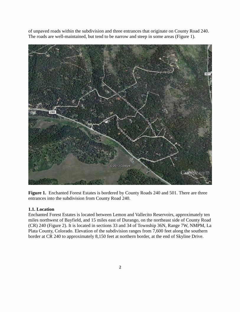
of unpaved roads within the subdivision and three entrances that originate on County Road 240. The roads are well-maintained, but tend to be narrow and steep in some areas (Figure 1).
Figure 1. Enchanted Forest Estates is bordered by County Roads 240 and 501. There are three entrances into the subdivision from County Road 240. 1.1. Location Enchanted Forest Estates is located between Lemon and Vallecito Reservoirs, approximately ten miles northwest of Bayfield, and 15 miles east of Durango, on the northeast side of County Road (CR) 240 (Figure 2). It is located in sections 33 and 34 of Township 36N, Range 7W, NMPM, La Plata County, Colorado. Elevation of the subdivision ranges from 7,600 feet along the southern border at CR 240 to approximately 8,150 feet at northern border, at the end of Skyline Drive.

3
Figure 2. Enchanted Forest Estates is located between Lemon Lake and Vallecito Reservoir, northeast of Durango, and northwest of Bayfield, La Plata County, CO. 1.2 Local Fire History and Characteristics From 1972 to 2012, 34 small fires have been documented within the 36 square miles of the township and range where EFE is located (Township 36N, Range 7W, NMPH). Thirty of these fires were less than one acre, 3 were between 1-4 acres, and one was 35 acres. Twenty-nine of these fires were caused by lightning, 2 by campfires, 1 by a cigarette, and 2 were of unknown cause. None of these fires occurred within Enchanted Forest Estates. However, 3 lightning-caused fires did start in sections 27 and 28, north of the subdivision. In addition to the 34 small fires, the 73,000 acre Missionary Ridge Fire (2002) burned approximately 100 acres (portions of 31 lots) within the subdivision. The WUI map (Figure 5) shows the outline of the Missionary Ridge Fire boundary (in yellow) and the cross-hatched area shows the where the fire burned within EFE.

4
Approximately 31% of the acreage burned during the Missionary Ridge Fire was considered stand replacing, meaning all trees and shrubs were burned and 39% was a moderate to low-intensity underburn. Cause of the fire remains unknown. The lots affected by the Missionary Ridge Fire were those on the eastern boundary of the subdivision. Although all homes were saved, sheds, equipment, decks, and forested lands were lost. EFE residents were evacuated for seven days. Most of the stand replacement burned area has regenerated to Gambel oak and aspen (Figure 3). The consequences of the Missionary Ridge Fire included mudslides, erosion, road closures, and unstable snags along trails.
Figure 3. Gambel oak is regenerating on east-facing slope in EFE burned in Missionary Ridge Fire. Other large wildfires have occurred in La Plata County over the past twenty years. Examples include the Black Ridge Fire (1994) that burned over 10,000 acres in piñon/juniper approximately 25 miles southwest of the subdivision, the Sambrito 2 Fire (2011) that burned 500 acres of ponderosa pine and piñon/juniper 30 miles southeast of the subdivision, and the Red Creek Fire that burned approximately 33 acres of mixed-conifer forest six miles southwest of

5
Enchanted Forest in 2010. In 2012, the 1400-acre Vallecito Fire, burned an area of standing dead and down material that had burned in the Missionary Ridge Fire, approximately 6 miles to the northeast of EFE. 1.3. Recent Wildfire Preparedness Activities Individual efforts – Approximately one third of the homeowners have thinned and pruned vegetation in wildfire defense Zones 1 and 2 around their residences, and approximately one quarter have obtained and posted standardized reflective blue address signs (Figure 4). Approximately 30% have filled out questionnaires regarding values at risk, personal resources available in case of fire (e.g. cistern capacity), and hours devoted to fuels mitigation.
Figure 4. Standardized blue reflective signs make it easier for emergency personnel to find addresses when visibility is poor. Community efforts – In the past few years, there have been several community work days to clear brush, trees and grass from the road side or on obstructed corners. In addition, an EFE CWPP committee was formed to gather information for all homeowners and to create this CWPP document. The committee has met nearly every month since July 2013. These meetings are summarized under “5. The Planning Process.” Four residents volunteered to be FireWise Ambassadors. They have shared information from the FireWise meetings with the POA at the quarterly meetings.
6
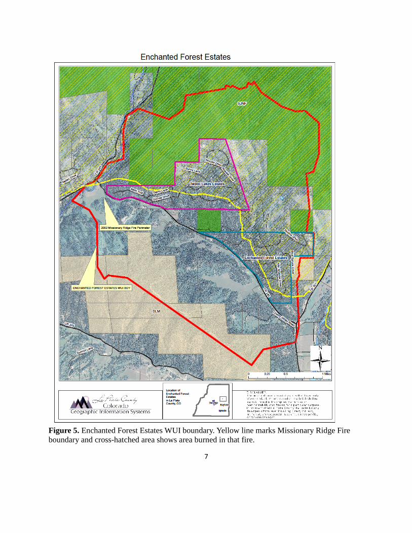
Information and training meetings – There have been several meetings to inform and educate owners and to explain programs offered by the federal and state government in cooperation with UPRFPD. Other meetings were to educate owners about wildfire defense zones and Firewise design and materials. Links to websites and videos regarding the importance of defensible space, how to create defensible space, and characteristics of healthy forests have been distributed to EFE homeowners. 2. CWPP AREA 2.1 Description of Area The CWPP covering the WUI area was developed collaboratively with the EFE POA, subdivision residents, the Colorado State Forest Service, Upper Pine River Fire Protection District, FireWise of Southwest Colorado, and the Bureau of Land Management. The WUI area is based on the area centered on the subdivision likely to burn in high fire danger conditions during a single burning period if pushed by 20-mph winds. 2.2 Boundaries The WUI boundaries are from the intersection of the Florida River and CR 240 by “Helen’s Corner” northeast along CR 243 one mile then east up a ridge to a bench at the 9,000 foot elevation, then northeast along the 9,000 foot contour to the head of the tributary to Spring Gulch, then southeast along the 9,000 foot contour to the divide between Spring Gulch and the Los Pinos River, then south along the divide to CR 501, then south along CR 501 past the mouth of Spring Gulch to the top of the divide between Spring Gulch and the West Fork Texas Creek, then northwest along the divide to the Florida River and then north to Helen’s Corner. Total WUI area is 3,315 acres and is shown in Figure 5. Private land in the WUI covers approximately 2,067 acres. The remaining 1,248 acres are public lands; 345 acres managed by the Bureau of Land Management and 903 acres of National Forest System lands. 2.3 Private Land Characteristics The 2,067 acres of private land within the WUI boundary includes the 249 acre Enchanted Forest Estates subdivision with 78 lots, the 392-acre ‘Tween Lakes subdivision, and 47 parcels outside those subdivisions. Parcel sizes range from approximately 0.1 acre to over 250 acres. Many of the private parcels outside the subdivisions have residences, garages, barns and sheds on them. Land uses are generally residential, agricultural (pasture and hay production) and non-industrial business.
7
Figure 5. Enchanted Forest Estates WUI boundary. Yellow line marks Missionary Ridge Fire boundary and cross-hatched area shows area burned in that fire.
8
The vegetation type is primarily mixed-conifer forestland (Figure 6). The forest stands are dominated by ponderosa pine (Pinus ponderosa), with components of Douglas-fir (Pseudotsuga menziesii), white fir (Abies concolor), and blue spruce (Picea pungens). Aspen (Populus tremuloides) is found throughout the conifer-dominated forests and exists in nearly pure stands in the northern part of the WUI due to the Missionary Ridge Fire. Species like narrowleaf cottonwood (Populus augustifolia), aspen and blue spruce with an understory including willows (Salix spp.), horsetail (Equisetum arvense), and chokecherry (Prunus virginiana var. melanocarpa) are found along the Pine River. Grasses include native species like sedges (Caryx spp.), little bluestem (Schizachyrium scoparium) and slender wheatgrass (Agropyron trachycauum). Montane shrubs include Gambel oak (Quercus gambelii), serviceberry (Amelanchier spp.), and whitethorn (Ceanothus cordulatus). Private lands outside the subdivision, but within the WUI area, have similar cover types. 2.4. Public Land Characteristics Public lands in the EFE WUI include 345 acres managed by the Bureau of Land Management located to the south of the subdivision and 903 acres of National Forest System lands. Most of the National Forest inside the WUI burned in the 2002 Missionary Ridge Fire (Figure 5), and approximately 80% of the fire in that area was stand replacement. The regenerating forest is dominated by Gambel oak and aspen with scattered ponderosa pine. The remaining National Forest is mixed-conifer forest. The BLM lands in the WUI are mixed-conifer forest (Figure 6). 2.5. Fire Protection Structural and wildland fire protection is provided by the Upper Pine River Fire Protection District (UPRFPD). Both structural and wildland fire engines resources are available. The UPRFPD maintains eight fire stations, three are staffed 24 hours (Stations 1, 2, and 5), and one is staffed 40 hours per week. The fire district minimum staffing is 7 personnel daily. The fire district also has a seasonal Type III fire engine positioned near EFE from March 1 to October 31. During wildfire season from March to October seasonal firefighters reside in Fire Station 3 on Florida Road (CR 240), Fire Station 6 on CR 502, and Fire Station 4 at Lake Vallecito. The UPRFPD maintains a 10-person fuels crew in the summer to assist in mitigation of private property and to fight wildland fires, if needed. Station locations and a map of the fire district are provided in Appendix A. Other wildland fire resources are available through Durango Interagency Dispatch Center. Wildland fire resources include engines and crews from the US Forest Service, Bureau of Land Management, Mesa Verde National Park, Colorado Division of Fire Prevention and Control (DFPC), Bureau of Indian Affairs and the Southern Ute and Ute Mountain Ute Tribes. An air tanker base is located at Durango - La Plata Regional Airport - and additional aerial wildfire support can be provided by the Mesa Verde National Park initial attack helicopter at Hesperus, the Ute Mountain Ute initial attack helicopter at Towaoc and air resources from the Division of Fire Prevention and Control. The counties, federal land management agencies, DFPC and fire protection districts in southwest Colorado operate under the La Plata County Annual Operating Plan (AOP) for wildfire protection.

9
Figure 6. Vegetation types within the Enchanted Forest Estates WUI.
10
3. FIRE POLICIES AND PROGRAMS The Enchanted Forest Estates CWPP has been developed in response to the Healthy Forests Restoration Act of 2003 (HFRA). This legislation established unprecedented incentives for communities to develop comprehensive wildfire protection plans in a collaborative, inclusive process. Furthermore, this legislation directs the Departments of Interior and Agriculture to address local community priorities in fuel reduction treatments, on both federal and non-federal lands. The HFRA emphasizes the need for federal agencies to collaborate with communities in developing hazardous fuel reduction projects and places priority on treatment areas identified by communities themselves through development of a CWPP. Priority areas include the WUI, municipal watersheds, areas impacted by windthrow, or insect/disease epidemics, and critical wildlife habitat that would be negatively impacted by a catastrophic wildfire. In compliance with Title 1 of the HFRA, the CWPP requires agreement among local government, local fire departments, and the state agency responsible for forest management (in Colorado, the CSFS District Forester). The CWPP must also be developed in consultation with interested parties and the applicable federal agency managing the land surrounding the at-risk communities. The State of Colorado is concerned about the size and intensity of wildfires occurring across the state in recent years. The State Legislature enacted House Bill 1110 in 2008, creating a five-year program running from 2009 to 2014 (since extended) that allows landowners to deduct a portion of the actual costs of their wildfire mitigation from their state income tax. The program allows each landowner to get credit for fifty percent of the cost of wildfire mitigation up to a total of $2,500. To get the full credit the total mitigation costs must be $5,000 or greater. The work must be done in accord with an existing Community Wildfire Protection Plan to qualify. The UPRFPD has conducted mitigation projects in neighboring subdivisions that have completed CWPPs. The fire district is actively engaged in partnering with home owners to mitigate their property. The Colorado State Forest Service conducted a Statewide Forest Resource Assessment and released a Statewide Forest Resource Strategy in 2010. One of the themes for the Assessment and Strategy is “Protect Forests from Harm.” The identified threats relevant to Enchanted Forest are: Wildfire in the Wildland-Urban Interface and Insects and Diseases Affecting Community Forests. The area around the subdivision has been identified as having High Wildfire Susceptibility based on weather, historic fire occurrence, topography, surface fuels and canopy closure. The applicable strategies identified to address the threats are:
● Focus forest management activities to reduce impacts of wildfire, forest insects and diseases.
● Coordinate forest management implementation among all parties affected by the CWPP. ● Advocate landscape approaches to protect communities.

11
● Collaborate with land management agencies, fire protection districts and insurance organizations to develop improved standards that lead to protection of homes in the WUI.
● Expand the use of the Good Neighbor Authority in Colorado. The County, Colorado Division of Fire Prevention and Control (DFPC), and federal land management agencies, both approve and operate under the guidelines set forth in an Annual Fire Operating Plan (AOP) for wildfire. This plan is acknowledged by the Upper Pine River Fire Protection District(s), the FPD with jurisdiction over EFE. The AOP addresses how the participating parties will work together in regard to wildfire prevention, preparedness, response, and payment. Included in the plan are provisions for mutual aid between agencies, significantly enhancing initial and extended attack capabilities through the rapid convening of fire protection resources for managing a wildfire. The La Plata County AOP is tiered to the “Agreement for Cooperative Wildfire Protection in La Plata County” between La Plata County and DFPC. This in turn is tiered to the 2014 “Colorado Statewide Cooperative Wildland Fire Management and Stafford Act Response Agreement” between the federal resource management agencies and DFPC. La Plata County is a voluntary member of the Colorado Emergency Fire Fund (EFF), which helps the County manage and pay for wildfires that exceed its ability to control. The fund is comprised of annual fees assessed to each member county. The County must request EFF designation for an incident that meets EFF criteria, and then the Director of DFPC, or his designee, must approve it. The San Juan National Forest and BLM-Tres Rios Field Office Land and Resource Management Plans and associated Fire Management Plan describe the role of fire in the native ecosystems in SW Colorado. These plans outline the strategies that the USFS and BLM will utilize to manage wildland fire and fuels on these federal lands in SW Colorado. The San Juan National Forest and San Juan Resource Area Fire Management Plan (2007) specifically describes objectives and strategies to manage fire and fuels on federal lands near communities within the WUI. This EFE CWPP tiers to the La Plata County CWPP approved in 2010. This plan is consistent with the goals and strategies described within the La Plata County CWPP and provides further strategic and tactical direction specific to wildfire protection and mitigation for the EFE community. 4. DESCRIPTION OF PARTNERS AND COMMITTEES In July 2013, the EFE homeowners created a CWPP committee to bring greater awareness of fire safety, forest health, and mitigation practices to the homeowners within the subdivision. Jack Cannon, Amy Paylor, and Janis and Joe Pielech are our FireWise Ambassadors. They attend the FireWise Council meetings, present information at the POA meetings, and are members of the CWPP committee. Other homeowner members of the committee include Bill Buck, Diane

12
Legner, Dan Paylor, and Marilyn Myers. In addition, the POA board members have promoted and participated in the dissemination of information regarding fire safety and the CWPP. Brian Crowley of the UPRFPD attended POA meetings to provide information and also met with individual home owners to provide advice on recommended mitigation projects. Melody Walters and Pam Wilson of FireWise have provided guidance, and technical support throughout the CWPP document development. In 2007, Kent Grant, Colorado State Forest Service (CSFS) prepared an Enchanted Forest Subdivision Fire Mitigation Report, which documented current conditions within the subdivision and recommended treatments. He has continued to provide technical assistance to the CWPP process. Lindsay Gartner, CSFS, updated the Fire Mitigation report in May 2013. 5. THE PLANNING PROCESS
An EFE community meeting was held on July 20, 2013. The purpose of this meeting was to introduce Brian Crowley, UPRFPD, who offered to assist us in writing the CWPP. In addition, volunteers for the CWPP committee were solicited. All attendees were extremely interested and deeply concerned about fire mitigation for their individual properties and the community of EFE. A group of interested individuals volunteered to be on the committee. Since forming, the CWPP committee has met on almost a monthly basis. Meeting minutes are available upon request.
The committee met on August 5, September 8, October 20, and December 8 in 2013. In 2014 they met on February 9, March 2, April 6, and May 12, July 12, July 31, and October 5. The purpose of the July 12 meeting was to assign duties so that EFE could apply for a KickStarter grant offered by FireWise. We submitted our grant application on July 21. The draft CWPP was submitted to agency personnel on August 8, 2014. The committee began receiving agency comments in March 2015. We met on March 29, 2015 and again on May 2 with Pam Wilson to discuss comments, make plans to obtain updated maps, and to update the projects table (Table 2).
In these meetings, it was decided what information to disseminate to property owners, contents of the CWPP were discussed, assignments regarding the CWPP document were made, a questionnaire for the residents was developed, the WUI boundary was developed with partners, potential fire mitigation projects were discussed, and a CWPP email address was established to facilitate communication between property owners and the CWPP committee. In addition, information regarding mitigation work that had been completed, responses to questionnaires, the number of blue reflective signs that have been posted, and updates on community participation and response were summarized by the committee chair, Amy Paylor.
The regular meetings, the application, receipt and completion of a KickStarter project, and the completion of this document indicate that EFE has a dedicated core of volunteers willing to improve fire safety, fire preparedness, and forest health within their community. It is anticipated that mitigation projects, communication, and information distribution will continue to be a high priority for the homeowners within this subdivision.
13
6. DESCRIPTION OF THE COMMUNITY
6.1 Natural Environment Enchanted Forest Estates is located in a mixed-conifer/Gambel oak forest type. Tree species include ponderosa pine (Pinus ponderosae), Douglas-fir (Pseudotsuga menziezii), white fir (Abies concolor), subalpine fir (Abies lasiocarpa), blue spruce (Picea pungens), quaking aspen (Populus tremuloides), and Gambel oak (Quercus gambelii). In general, homeowners choose to retain native trees and shrubs during construction of the residences, and most have native vegetation extending up to the structures. The wildlife present in the area includes all the species expected in the lower montane areas of the central Rocky Mountains. Mule deer (Odocoileus hemionus), elk (Cervus elaphus), black bear (Ursus americanus), cougar (Felis concolor), coyote (Canis latrans), porcupine (Erethizon dorsatum), skunk (Spilogale spp), ermine (Mustela erminea), and piñon mouse (Peromyscus truei) are some of the mammalian species. Merriam’s turkey (Meleagris gallopavo merriami), common raven (Corvus corax), golden eagle (Aquila chrysaetos), red-tailed hawk (Buteo jamaicensis), horned owl (Bubo virginianus), mountain and western bluebirds (Sialia currucoides and S. Mexicana), piñon jay (Gymnorhinus cyanocephalus), downy woodpecker (Picoides pubescens), white-breasted nuthatch (Sitta carolinensis), juniper titmouse (Baeolophus ridgwayi), and mountain chickadee (Parus Gambeli) are some of the avian species. The American bald eagle (Haliaeetus leucocephalus) and red-tailed hawks (Buteo jamaicensis) are commonly seen soaring on thermals over the eastern edge of the subdivision, along the Pine River valley. No U.S. Fish and Wildlife Service listed “Threatened” or “Endangered” species are known to inhabit the subdivision. There are no permanent streams or lakes in the subdivision; however, there are intermittent streams that flow in the winter and spring. The Pine River is the nearest permanent stream and Vallecito Reservoir is the closest and largest permanent body of water. There is no water supply within the subdivision for fire suppression, either wildfire or structural. There are no fire hydrants, central water system, water storage facility, ponds, or lakes within EFE. 6.2 Subdivision Characteristics EFE covers approximately 249 acres with 78, three-plus acre lots and one parcel of one acre. Fifty-five homes have been built and 23 lots are vacant. Approximately 66 percent of the homeowners are full-time residents and 33 percent are seasonal. Building of new homes is occurring gradually, with four new homes built in the last 10 years. The residences are single-family structures with exterior finishes including hardboard siding, logs, and stucco. Roof coverings are most often metal or asphalt shingle. Most homes have wood decks and porches. The water supply for the subdivision is supplied by individual wells; there is no central water system.
14
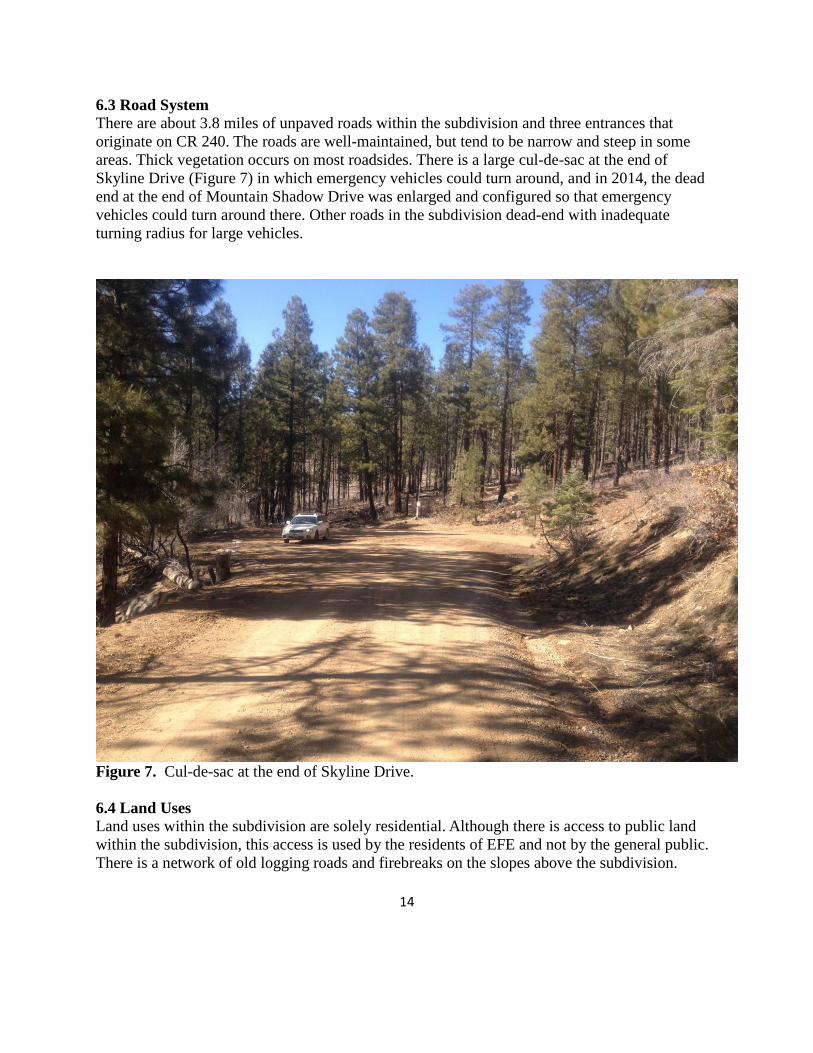
6.3 Road System There are about 3.8 miles of unpaved roads within the subdivision and three entrances that originate on CR 240. The roads are well-maintained, but tend to be narrow and steep in some areas. Thick vegetation occurs on most roadsides. There is a large cul-de-sac at the end of Skyline Drive (Figure 7) in which emergency vehicles could turn around, and in 2014, the dead end at the end of Mountain Shadow Drive was enlarged and configured so that emergency vehicles could turn around there. Other roads in the subdivision dead-end with inadequate turning radius for large vehicles.
Figure 7. Cul-de-sac at the end of Skyline Drive. 6.4 Land Uses Land uses within the subdivision are solely residential. Although there is access to public land within the subdivision, this access is used by the residents of EFE and not by the general public. There is a network of old logging roads and firebreaks on the slopes above the subdivision.
15
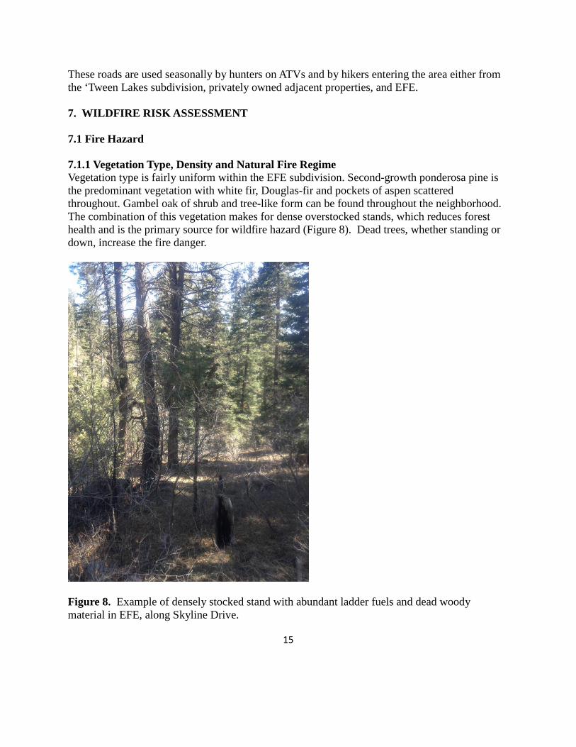
These roads are used seasonally by hunters on ATVs and by hikers entering the area either from the ‘Tween Lakes subdivision, privately owned adjacent properties, and EFE. 7. WILDFIRE RISK ASSESSMENT 7.1 Fire Hazard 7.1.1 Vegetation Type, Density and Natural Fire Regime Vegetation type is fairly uniform within the EFE subdivision. Second-growth ponderosa pine is the predominant vegetation with white fir, Douglas-fir and pockets of aspen scattered throughout. Gambel oak of shrub and tree-like form can be found throughout the neighborhood. The combination of this vegetation makes for dense overstocked stands, which reduces forest health and is the primary source for wildfire hazard (Figure 8). Dead trees, whether standing or down, increase the fire danger.
Figure 8. Example of densely stocked stand with abundant ladder fuels and dead woody material in EFE, along Skyline Drive.

16
Overcrowding of trees reduces their ability to repel insect and disease agents because their resources are diverted towards competing with other vegetation. Bark beetles are present in the area and have the potential to reach outbreak proportions if the conditions are right; for instance, a prolonged drought. The ponderosa pine forests in SW Colorado have undergone major changes in ecological structure, composition, and process because of human activities over the last 100 years. Livestock grazing, logging, fire suppression, road construction, and exotic species altered these forests from conditions that had prevailed for thousands of years (Allen et al. 2002). These changes have dramatically increased the vulnerability of these forests to large destructive crown fires. Historically, the development and maintenance of ponderosa pine forests was favored by non-lethal fires ignited by both humans and lightning (Graham and Jain 2005). These fires burned in a patchwork, and isolated areas existed where ponderosa pine regenerated (i.e., old rotten logs, locations where the soil conditions were optimal). As a result ponderosa pine, more than any other tree species, were often clumped into small groups (Graham and Jain 2005). The ability of ponderosa pine to survive low severity wildfires is one of its most unique characteristics. Historically, a variety of age classes were represented across the landscape. Fires of varying intensity occurred, but the large scattered trees generally did not allow for a fire to access the crowns. Low intensity ground fires prepared the ground for ponderosa pine seedling regeneration by reducing the competition from oakbrush and grasses, as well as lessening the thick layer of litter covering the soil. As early settlers arrived, many of the large ponderosa pines were harvested. Smaller trees were left behind and their density increased as all fires were suppressed. In a natural fire regime, these small trees, which are sensitive to fire, would be killed. With fire suppression, they survive in unnaturally dense stands (Schoennagel et al. 2004). Areas of mixed conifer (white and Douglas fir) contribute to the fire danger as ladder fuels. Firs have branches that reach to the ground, unlike the ponderosa pine which naturally self-prunes its lower branches when they are shaded. The firs are shade-tolerant, so they can regenerate under the cover of the ponderosa pine. If left unchecked, the white fir can eventually replace the ponderosa pine as the dominant species because the ponderosa pine needs open sunlight to reproduce successfully. There are pockets of aspen that are considered to be of low fire hazard. They die easily when exposed to fire, but quickly recover by sending up suckers from their root system. Due to fire suppression, unnaturally dense stands of ponderosa pine are common. Fuel loads have increased as more trees are crowded together and dead trees fall to the ground. Decay is slow in the southwest due to the arid climate contributing to increased fuel loads. In addition, the fir and Gambel oak have grown unchecked for many years. These species increase both the horizontal and vertical continuity of fuels. Their role as ladder fuels increases the chance for a crown fire and their contribution to fuel load increases the likelihood of greater fire intensity.
17
Ponderosa pine is sensitive to drought and warmer temperatures in warm dry locations, such as SW Colorado, making this species prone to fire and insect/disease effects (Williams et al. 2010). High mortality rates due to fire or drought is likely greatest in dense stands where fuel build up is high. Active intervention (fuels reduction) should be prioritized in these locations (Williams et al. 2010). 7.1.2 History of Fire Occurrences Before successful fire suppression, ponderosa pine forests burned at relatively frequent (e.g., less than 40 years) intervals in drier sites based on temperature and precipitation patterns and natural and human ignitions (Agee 1993, Hann et al. 1997). Cultural burning by Native Americans augmented and even dominated burning in several locations (Barrett and Arno 1982, Stewart 1951). The driest settings, ponderosa pine and/or woodlands, had the fewest fires because of discontinuous surface fuels (Bradley et al. 1992). Nevertheless, historically, wildfires most likely burned through most ponderosa pine forests on a regular interval creating a variety of species compositions and vegetative structures (Graham and Jain 2005) and this pattern was likely true of the ponderosa pine forest within which EFE is located based on its topography and location. As described in Section 1.2 above, there has been only one documented fire within EFE, the Missionary Ridge Fire in 2002. Over the 40 years between 1972 and 2012, 34 small fires started within the 36 square miles of our township (Township 36N, Range 7W, NMPM); 85% of which were caused by lightning. Based on the amount of fuel present within EFE, forest fire suppression successfully prevented understory burning over the last 100 years. 7.1.3 Topography Elevation of the subdivision ranges from 7,600 feet along the southern border at County Road 240 to approximately 8,150 feet at northern border. Slopes face primarily to the south and east and some are greater than 20% (Figure 9). 7.1.4 Seasonal Weather Patterns Annual precipitation for the area is approximately 30 inches, with the wettest months being July, August and September. May and June are relatively dry, with a summer “monsoon” in July and August. Early monsoonal storms are often characterized by dry thunderstorms with lightning and strong, variable outflow winds. The largest wildfires in the past 20 years in La Plata County have occurred from early June into early August. Climate change appears to be having an effect on seasonal temperatures. When looking at average seasonal temperatures for the period 2001–2010 versus those for the twentieth century, greater warming (i.e., larger differences) occurred during the spring and summer than occurred during the other seasons, especially winter (Hoerling et al. 2013). These warmer temperatures are leading to earlier snowmelt and runoff (Stewart et al. 2005). An earlier snowmelt can lead to an earlier, longer dry season, providing greater opportunities for large fires due both to the longer period in which ignitions could potentially occur and to the greater drying of soils and vegetation

18
(Westerling et al. 2006). In 2012, the fire season in SW Colorado was about two months longer in both the spring and the fall. 7.2 Structural Vulnerability Residential structure ignitability is generally moderate. Siding material for the residences includes stucco, hardboard, wood planking, rock, and logs. There are sheds that are sided with wood or metal. Fences, porches and decks are generally of wood construction. Roofing is metal “propanel” type material or asphalt shingles. The major vulnerability issues are flammable vegetation like grass, brush or trees within 15 feet (Zone 1) of the structures. Pine needles and leaves on the roofs are issues for some residences. Access to individual homes varies from excellent to poor, depending on driveway steepness, width, vegetation encroachment, and distance from one of the main roads. Approximately 25 of the 78 lots within EFE have either had fuels treatment or were so affected by the Missionary Ridge Fire that the property was effectively treated. 7.3 Protection Capabilities The EFE subdivision is served by the Upper Pine River Fire Protection District. The UPRFPD maintains eight fire stations, three that are staffed 24 hours, and one that is staffed 40 hours per week (Appendix A). There is a 10-person seasonal wildfire crew, a 3-person seasonal Type III engine, and a minimum daily staffing of 7 firefighters with National Wildfire Coordinating Group wildland firefighting qualifications. The fire district headquarters and EOC is located on the west side of the town of Bayfield along County Road 501. The closest fire substation (Substation 3) is 2 road miles southwest of the Skyline Drive subdivision entrance on CR 240. Substation 5 is 2.5 miles from the lower Enchanted Forest Drive entrance. Forest Service and Bureau of Land Management fire crews and aerial wildfire support by the Mesa Verde National Park initial attack helicopter at Hesperus and the Ute Mountain Ute initial attack helicopter at Towaoc are available under the mutual aid agreement. Wildland fires occurring on private lands are generally managed for full suppression. Wildfires on National Forest System lands, BLM-managed lands, and Tribal lands in La Plata County are managed with policies that may involve full suppression, point suppression, confinement or containment strategies. The lack of hydrants, dedicated cisterns, or ponds within the subdivision is problematic. However, there are hydrants and a certified water system approximately 3.1 road miles from Skyline Drive and 2.5 miles from the lower Enchanted Forest Drive, at 7580 CR 501 and in the River Ranches Estates. Water can also be drafted from the Pine River approximately 1 mile east of the subdivision or from Vallecito or Lemon Reservoirs. Use of helicopters with dip buckets would be a timely method of delivery, if needed. Evacuation of the subdivision in an emergency would be made easier by the three access points onto CR 240 and the fact that there are only approximately 66 full-time residents. However, subdivision roads tend to be narrow which would hamper evacuation, especially if emergency vehicles were trying to enter at the same time residents were trying to evacuate. Residents living
19
at the upper end of Skyline Drive are particularly vulnerable because there is only one road out until they reach Mountain Shadow Drive. Evacuation actions are the responsibility of the La Plata County Sheriff’s Office and the La Plata County Emergency Manager. 7.4 Fire Risk Scattered forest management has occurred throughout the area (Figure 9). Several landowners have completed defensible-space activities around their houses and many are diligently working to reduce the number of trees and oak brush across their property. The Missionary Ridge fire in 2002 burned as a ground fire in the northeastern part of the subdivision (Figures 5 and 9). Gambel oak has re-sprouted with as much or more vigor than before, and will eventually return to its previous density unless controlled (Figure 3). The land is generally facing southwest, but with many varied aspects within the area. Slopes are moderately steep, with some being greater than 20% (Figure 9). Steep slopes increase both the intensity and rate at which a fire will spread. Referencing Fahnestock’s Wildfire Hazard Classes, almost the entire subdivision falls under Hazard Class C – Severe Timber (Figure 9). The expected fire behavior is high intensity with long duration; flare-ups higher than trees frequent to continuous; spread up to several hundred acres per hour; fire front impassable and spotting several hundred yards common, possible to a mile or more. Where landowners have thinned, there are small pockets of B – Moderate Intensity hazard class where intermittent flare-ups occur to many feet above tree tops and short and medium-range spotting common. Three lots are in Hazard Class A because they were severely affected by the Missionary Ridge Fire (Figure 9). However, there is not enough continuity in Hazard Classes A and B to bring a crown fire down to the ground if there were such a situation, especially if the fire was coming upslope from along the county road. It should be noted that a low rating does not mean that the chance of a wildfire occurring is slight, but should a fire occur, the anticipated damage it would do and difficulty in controlling it would not be as great as in a fuel type with a higher rating. Conversely, a severe rating does not mean that there is a greater likelihood of a wildfire occurring, but if one did, it could potentially do significant damage and be difficult to control. The risk of wildfire occurrence caused by humans is greatest along County Roads 501 and 240. Carelessness from a passing motorist with a cigarette butt could ignite a fire that would quickly run through the dense vegetation upslope. Carelessness from property owners unaware of the fire danger could also start a fire. Based on the statistics of fire starts in the general area, the potential of lightning strike fires is high. Eighty-five percent of fires within T35N, R7W have been started by lightning strikes. Fire coming from the north is less likely to result in a crown fire because so much of that area burned in the Missionary Ridge fire. The decade 2001–2010 was the warmest and the fourth driest in the Southwest of all decades from 1901 to 2010 (Hoerling et al. 2013). The areal extent of drought over the Southwest during

20
2001–2010 was the second largest observed for any decade from 1901 to 2010 (Hoerling et al. 2013), and the drought continues. In addition, average annual temperature increased 1.6°F (+/- 0.5°F) over the Southwest during 1901–2010 (Hoerling et al. 2013). Changes in climate have been associated with changes in the frequency, extent, duration, and severity of fires and outbreaks of forest pathogens (Westerling et al. 2006; Bentz 2008). The area of forest and woodland burned in the western United States by wildfires that actively were suppressed was more than five times larger during the period 1987–2003 than during 1970–1986, and was associated with increases in temperature and earlier spring snowmelt (Westerling et al. 2006). Regional incidence of forest wildfires is generally associated with drought. These indicators all point towards an increased risk of catastrophic wildfire currently and into the foreseeable future. Increased fuel loads, changes in land-use patterns, drought, longer fire seasons, and warmer temperatures increase the fire danger dramatically within the WUI. A large number of people with different attitudes and values have come together to live and recreate in a relatively small area, increasing the probability of human-caused fires. The need for informed and proactive fuels management has never been greater.
Figure 9. Wildfire Hazard Classes within EFE. Note steep slope on eastern boundary.
21
7.5 Values at Risk The residents of EFE were asked through a questionnaire what values were at risk from wildfire. First and foremost was the safety of the residents and emergency personnel. There are approximately 66 permanent residents and 37 seasonal residents (who occupy their second homes in EFE primarily in summer, the fire-prone months). Consequently, approximately 103 lives could be at risk during a catastrophic wildfire. However, this number could vary substantially based on visitors present or homeowners who might be away on vacation or not occupying their home for any other reason. In addition, many of the residents have pets which are very much part of their families, and they would also be at risk in the event of a wildfire. There are 55 homes in EFE and many of these have detached garages, workshops, or other outbuildings that could also be lost to a wildfire. Next to human life and safety, loss of one’s personal residence and belongings was of greatest importance to the residents. In addition, many felt that property values would be negatively affected by the effects of a wildfire. Loss of privacy and loss of aesthetics were noted in particular. The setting of EFE is rural forestland, so loss of the trees and shrubs from wildfire would have a significant impact to the ambiance of the community, even if no structures were lost. Many residents noted the value of the forest itself and wildlife it supports. The residents recognize the importance of the forest in maintaining a healthy watershed, one in which the soil is protected by vegetation and forest duff, and erosion of soil into creeks is minimal. Wildfire can adversely affect soil quality, reducing water permeability, increasing bulk density and removing organic matter. In extreme instances, the soil can be sterilized by high temperatures. The loss of nutrients, seed sources, and inability of the soil to hold water leads to barren soil susceptible to erosion and an area that may take years for plants to recolonize. EFE is located in the Pine River watershed. Municipal water for Bayfield is sourced from the Pine River. Intermittent streams located in EFE flow into the Pine River. Soot and sediment entering these waterways due to a wildfire within the watershed compromise water quality in the Pine River and increase water treatment costs for Bayfield. A healthy forest provides diverse habitat types and supports many more species than a forest destroyed by catastrophic wildfire. No threatened or endangered species are known to inhabit the subdivision itself, but rare plants may occur within the WUI area. Having the opportunity to view wildlife in one’s own yard or neighborhood is an experience EFE residents value. A healthy forest also provides a more enjoyable recreational experience for all who travel through the forest by whatever means (e.g. foot, bike, skis) for whatever purpose (e.g. bird watching, exercise, backpacking, hunting). Preserving these values is important to the residents of EFE.

22
8. EMERGENCY MANAGEMENT
8.1 Fire District Capabilities – Response Time Three of the eight stations of the UPRFPD are within 5.5 miles of EFE (Appendix A). Station 3 is 2.3 miles from the middle entrance and it would take approximately 4 minutes for an emergency vehicle to drive to that entrance. Station 5 is 2.7 miles away from the middle entrance and it would take about 4 minutes to drive that distance also. Station 2 is 5.4 miles away and it would take approximately 7 minutes for an emergency vehicle to reach the middle entrance. Stations 2 and 5 are manned 24/7, all year long, so it would be anticipated that under normal circumstances we could expect a response time of about 10 minutes or less to the subdivision, except in the rare cases when the manned stations were unavailable due to other emergency calls, or being out of the district for training or detail assignments. 8.2 Inventory of Fire Protection Resources Listed below are the resources readily available at the three closest fire stations: Station 3- 13407 County Road 240 Apparatus = B63-Type 6 Brush Truck (300 gallon tank, 120 gallons per minute) E63-Type 2 Engine (1000 gal, 1250 gpm's) T63-Water Tender (2100 gal, 500 gpm's) Service 65-F250 4X4 (25 gal, 20 gpm's) Station 5 - 6891 County Road 501 Apparatus = B65-Type 6 Brush Truck (300 gal, 120 gpm's) E65-Type 2 Engine (1000 gal, 1250 gpm's) T65-Water Tender (2100 gal, 500 gpm's) EMS 60-Paramedic Squad Truck Station 2 - 13100 County Road 501 Apparatus = B62-Type 3 Brush Truck (600 gal, 500 gpm's E62-Type 1 Engine (800 gal, 1250 gpm's) T62-Water Tender (2100 gal, 500 gpm's) Medic 62- Transport Ambulance
8.3 Local Wildland Fire Management Policies Wildland fires occurring on private lands are generally managed for full suppression. Wildfires on National Forest System lands and BLM-managed lands, and Tribal lands in La Plata County are managed with policies that may involve full suppression, point suppression, confinement or containment strategies depending on the fire location and the resources at risk. 8.4 Training Resources and Needs No training resources or needs have been identified by the UPRFPD. Personnel are well trained and have excellent training opportunities. All local and national training standards are met. The
23
UPRFPD has several NWGG credentialed Engine Bosses and all personnel are trained in S-130 and S-190. 8.5 Mutual Aid Agreements La Plata County, Colorado Division of Fire Prevention and Control (DFPC), and federal land management agencies, both approve and operate under the guidelines set forth in an Annual Fire Operating Plan (AOP) for wildfire. This plan provides is acknowledged by the Upper Pine River Fire Protection District(s), the FPD with jurisdiction in EFE. The AOP addresses how the participating parties will work together in regard to wildfire prevention, preparedness, response, and payment. Included in the plan are provisions for mutual aid between agencies, significantly enhancing initial and extended attack capabilities through the rapid convening of fire protection resources for managing a wildfire. The La Plata County AOP is tiered to the “Agreement for Cooperative Wildfire Protection in La Plata County” between La Plata County and DFPC. This in turn is tiered to the 2014 “Colorado Statewide Cooperative Wildland Fire Management and Stafford Act Response Agreement” between the Federal resource management agencies and DFPC. The La Plata Wildland Fire Agreement is a Local Cooperative Agreement designed to provide a collaborative approach to managing Local Responsibility Fires in La Plata County. The Agreement specifies the participants’ operational and financial responsibilities. Differing from previous similar agreement and Annual Operating Plans, this Local Cooperative Agreement unifies the operational response to all wildland fires occurring in La Plata County outside of the jurisdictional boundaries of the USFS San Juan National Forest, BLM Southwest District, BIA Southern Ute Agency, BIA Ute Mountain Ute Agency, or Bureau of Reclamation Upper Colorado Region (i.e. the distinction between district fires, sheriff fires, and county fires are no longer relevant pursuant to the Local Cooperative Agreement). 8.6 Evacuation Information The EFE POA maintains a database of the residents, lot owners, their addresses, phone numbers, and email addresses. Property owners have been contacted and encouraged to identify their property using the standardized blue reflective signs, and many have posted their signs. Efforts continue to encourage all property owners to use these signs. Residents are also being informed about and encouraged to register for the emergency notification system. A telephone tree with emergency contact numbers is being developed. Because there are three entrances to the subdivision, and a fire could occur anywhere within EFE, it is not possible to create a formal evacuation plan. If a fire were to occur within EFE, residents would need to follow the directions given by emergency personnel for evacuation. Residents are being encouraged to use alternate routes when entering and exiting the subdivision to become familiar with all roads. A list of families who need help in case of evacuation, and families with pets that may be home alone, needs to be developed and updated annually.
24
9. MITIGATION AND IMPLEMENTATION PLAN
9.1 Education and Community Outreach
9.1.1 Audience This CWPP Mitigation and Implementation Plan covers all lot owners within the subdivision of EFE. The audience also includes immediately bordering and nearby land owners, subdivisions and public lands (including Bureau of Land Management and the US Forest Service). The audience also includes all agencies that will benefit from mitigation treatments within the subdivision including emergency responders, local fire departments and local law enforcement agencies at all levels. Government agencies, non-profit, and private agencies providing grants and/or matching funds to promote EFE landowners’ mitigation efforts are also included. 9.1.2 Outreach Methods and Activities The methods and actions used to reach our audiences are:
● Wildfire mitigation information is distributed at regularly scheduled and special POA meetings and delivered/mailed to existing and new lot owners.
● Advertising and attending Upper Pine River Fire Protection District, FireWise of SW Colorado, USFS, subdivision and community workshops.
● Making sure all lot owners are aware of state tax incentives for wildfire hazard mitigation (Colorado House Bill 1110).
● Sharing information about the FireWise Chipper Rental Rebate Program and other incentives that come available.
● Schedule lot/home owner events throughout the year to share individual experiences and knowledge regarding fuel reduction activities.
● Educational training for POA lot owners with respect to wildfire behavior and containment on their individual lots.
● Mass emails announcing local subdivision and county/community events, CWPP general membership meetings, seasonal fire restrictions, burning permit requirements, wildfire related media coverage, etc.
● Creation of a EFE CWPP email to facilitate communication.
Current education and prevention activities include:
1. CWPP Committee / Upper Pine Fire Protection District special meetings for EFE property owners regarding the establishment of a CWPP for the subdivision
2. Distribution of FireWise materials at regularly scheduled property owner meetings (in prepared bags).
3. List of CWPP committee members and FireWise Neighborhood Ambassadors with their contact information distributed via FireWise bags and updated on the EFE Website.
4. Emailing of CWPP General POA Membership meeting notes (also included on EFE website).

25
9.1.3 Resources Needed Listed below are the resources needed for educational costs and volunteer efforts:
1. Postage for mailings to community members without email access. 2. Electronic and hardcopy wildfire/mitigation materials/information for distribution to
residents. 3. Local agency volunteers (UPFPD, FireWise, CSFS, USFS, BLM, community members)
for community training and educational events. 4. Loaner copies of educational DVDs for neighborhood viewing events.
9.1.4 Safety Widening the cul-de-sacs to the platted widths of 100 to 120 feet would help emergency vehicle access and response times. The cul-de-sac at the end of Skyline Drive is of sufficient width to accommodate emergency vehicles (Figure 7) and in 2014, a hammerhead turnaround was created at the end of Mountain Shadow Drive. Three other subdivision roads end in cul-de-sacs that are too narrow for emergency vehicles to turn around (Figure 12). Cul-de-sacs, hammerheads, or T turnarounds need to be created at these dead-ends. “Dead end” signs were posted throughout EFE in 2014 so that visitors and emergency personnel would not mistakenly think these roads were exits during an emergency. Subdivision residents should be offered a general emergency situation safety awareness session annually to update emergency communication trees, gathering points, and who needs help in case evacuation is necessary. In addition, encouraging residents to prepare a “Go Bag” with essential items to take in case of evacuation should be done. Items to be included in the “Go Bag” are in Appendix B. Annual training could also include “Home Ignition Training” to inform residents of what they can do to identify, reduce, and/or eliminate sources of home ignition. 9.2 Fuels Reduction 9.2.1 Strategies for Hazardous Fuels Treatments and Methods To reduce the risk of catastrophic fire, increase the level of safety for emergency personnel and residents, and to create a healthier forest, fuels management needs to occur on homeowners’ lots, along the roads within the subdivision, and along CR 240. It is important to be aware of ignition sources when thinking about protecting one’s property. The ignition of a home might occur from one or more of these sources:
1. Big flames from a crown fire or intense surface fire. One objective in treating the home ignition zone (HIZ - the home and a 200-foot radius around the structure) is to keep crown fire and high intensity surface fire at a distance of 100-200 feet or more from homes and other potential hazards (flammables, buildings, etc.).
2. Small flames from a surface fire. Another objective of treating the HIZ is to keep small flames at a distance of 30 feet or more from homes and flammable attachments such as decks.
26
3. Firebrands or embers. A final - and essential - objective of treating the HIZ is to eliminate beds of fine fuel and entry points for firebrands on and near homes.
Creation of defensible space is one of the primary goals of fuels mitigation. Defensible space is an area around a structure where fuels and vegetation are reduced to slow the spread of wildfire towards the structure. A house is more likely to withstand a wildfire if grasses, brush, trees, and other common forest fuels are managed to reduce a fire’s intensity. It also reduces the chance of a structure fire moving from the building to the surrounding forest. Defensible space provides room for firefighters to effectively and safely do their jobs. Due to limited resources, firefighters must make decisions regarding safety and defensibility during fire events. They will likely pass up trying to defend a property/structure that has minimal defensible space and go to another location where their efforts would be more successful and it would be safer for them to make a stand. Defensible space can also make it safer for residents to “shelter in place” if it is necessary or they chose to do so. It can help a house or other structure survive even if the subdivision is evacuated, or if firefighters are not present to fight the fire when it arrives, or if a burning ember starts a new fire near the structure. The measure of fuel hazard refers to its continuity, both horizontal (across the ground) and vertical (from the ground up into the crowns of vegetation). Fuels with a high degree of both vertical and horizontal continuity are the most hazardous, particularly when they occur on steep slopes. Heavier fuels (brush and trees) are more hazardous (i.e., produce a more intense fire) than light fuels such as grass. Mitigation of wildfire hazards focuses on breaking up the continuity of horizontal and vertical fuels. Additional distance between fuels is required on slopes. The construction of defensible space involves developing a series of management zones in which different treatment techniques are used. The actual design and development of defensible space depends on several factors: size and shape of buildings, materials used in their construction, the slope of the ground upon which the structures are built, surrounding topography, and sizes and types of vegetation on the property. The following recommendations below are consistent with Creating Wildfire-Defensible Zones (Dennis 2012) (Appendix C). Flammable vegetation or shrubs are discouraged within 15 feet of residences (Zone 1). If desirable trees, shrubs or other plants are in this area, dead branches, stems and leaf litter should be removed and the zone extended accordingly. Tree branches should be pruned up at least 10 feet above the ground on mature trees or to retain 30% of the crown on younger trees. Xeriscaping, using plants and materials with low flammability, can reduce the risk of flames adjacent to structures. It is recommended that landscaping within three to five feet of structures consist of gravel, rock or other non-flammable materials. Wood chips should not be used as mulch under flammable shrubs within Zone 1. Because most homes catch fire from flying embers, not from the flaming fire front, when building and/or remodeling, residents are strongly encouraged to use fire-resistant materials. Use of unpainted rough wood products including wood shake roof shingles is discouraged since those materials are very receptive to sparks and flame. Roof materials such as metal, cement or

27
cement-fiber shingles, and tile resist sparks, flame and heat. Enclosing soffits with metal also discourages ignition of roofs and eaves. Detailed fire-resistant construction guidelines are found in Firewise Construction: Site Design and Building Materials (CSFS, 12/2012) (Appendix D). EFE has an architectural committee that reviews plans for all new home construction. Because EFE is in a high fire risk area, the committee should encourage all new home builders and those remodeling to use fire-resistant materials and to create defensible space when the home site is cleared. Woodpiles and propane tanks should be located at least 30 feet from structures and uphill of the structures if possible. Remove flammable vegetation at least 10 feet away from woodpiles and propane tanks. Enclose the underside of wood decks (metal screening of 1/8” or less) and porches so that embers and flames cannot get underneath them. Screening or enclosure can also reduce weed growth and the accumulation of needles and leaves under decks. In Zone 2, from15 to 100 feet of the residence, trees taller than 15 feet should be thinned to a spacing of 10-20 feet between crowns. Trees selected for retention should have at least 50% live crowns. Branches lower than five feet from the ground surface should be pruned on trees up to 25 feet tall and 10 feet from the ground on trees taller than 25 feet. Trees shorter than 15 feet tall should be spaced no closer than five feet from the edge of adjacent tree crown edges. Oak clumps should be spaced no closer than two times shrub height to other clumps or trees. Grasses should be mowed or cut to a maximum of six to eight inches, especially by fall when grasses are dry. Zone 3 extends from the outer edge of Zone 2 to the individual property boundary or up to 200 feet. This area should be managed by keeping grasses mowed to six-inch stubble height to reduce wildfire spread rates and intensities. Wooded areas should be managed to minimize tree mortality from insects and diseases and reduce the possibility of large scale stand-replacement wildfires. Crown fires are the primary type of stand-replacement wildfire in mixed-conifer forests, so thinning over-dense clumps to stand densities of no more than 80 trees per acre and reducing downed woody fuels can reduce wildfire risk. Slash from thinning and fuels reduction activities should be chipped and the chips removed from the site or the slash piled for burning when snow is present or soils and surrounding vegetation are damp. All juniper trees within 10 feet of ponderosa pine tree crowns should be removed in the thinning. The interior road system in the subdivision can serve as shaded fuelbreaks by thinning trees to no more than 60 trees per acre, pruning up at least 10 feet, and removing brush and small trees under remaining trees. This type of treatment will also improve driver visibility along the roads and provide sunlight for melting ice, helping traffic safety. In addition, shaded fuelbreaks need to be created at the three subdivision entrances, along CR 240. Ideally, a 15- to 30-foot shaded fuel break will be created in the six lots abutting the entrances (Lots: 3, 6, 39, 40, 62, and 80), along CR 240 and along the subdivision roads.

28
9.2.2 Current and Past Fuel Reduction Projects
Many lots within EFE have had fuels treatment. Some individual lot owners have hired professional contractors to thin their lots and others are actively mitigating their own properties (Figure 11). Fuel loading and mitigation strategies are being assessed by Brian Crowley, UPRFPD, at individual lot owner’s request. Currently, 27 properties have signed up for mitigation assessments, 13 mitigation reports have been completed, and some additional field assessments have been done but await final reports.
Figure 11. Homeowner has reduced fuels at this residence in EFE. Creating a shaded fuel break along CR 240 and the subdivision roads is considered a high priority. A shaded fuelbreak is an easily accessible strip of land in which fuel density is reduced, thus improving the possibility of fire control. As opposed to a firebreak which is completely void of vegetation, a shaded fuelbreak is a strategically thinned strip of land where vegetation is modified to reduce vertical and horizontal continuity. Timber stands are thinned, and remaining trees are pruned to remove ladder fuels. Brush, heavy ground fuels, snags, and dead trees are
29
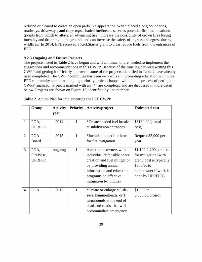
reduced or cleared to create an open park-like appearance. When placed along boundaries, roadways, driveways, and ridge tops, shaded fuelbreaks serve as potential fire-line locations (points from which to attack an advancing fire), increase the possibility of crown fires losing intensity and dropping to the ground, and can increase the safety of ingress and egress during wildfires. In 2014, EFE received a KickStarter grant to clear reduce fuels from the entrances of EFE. 9.2.3 Ongoing and Future Projects The projects listed in Table 2 have begun and will continue, or are needed to implement the suggestions and recommendations in this CWPP. Because of the time lag between writing this CWPP and getting it officially approved, some of the projects identified in Table 2 have already been completed. The CWPP committee has been very active in promoting education within the EFE community and in making high priority projects happen while in the process of getting the CWPP finalized. Projects marked with an “*” are completed and are discussed in more detail below. Projects are shown on Figure 12, identified by line number. Table 2. Action Plan for implementing the EFE CWPP
Group Activity year
Priority Activity/project Estimated cost
1 POA, UPRFPD
2014 1 *Create shaded fuel breaks at subdivision entrances
$3130.00 (actual cost)
2 POA Board
2015 1 *Include budget line item for fire mitigation
Request $5,000 per year
3 POA, FireWise, UPRFPD
ongoing 1 Assist homeowners with individual defensible space creation and fuel mitigation by providing annual information and education programs on effective mitigation techniques
$1,100-1,200 per acre for mitigation (with grant, cost is typically $600/ac to homeowner if work is done by UPRFPD)
4 POA 2015 1 *Create or enlarge cul-de-sacs, hammerheads, or T turnarounds at the end of dead-end roads that will accommodate emergency
$1,500 to 3,000.00/project

30
vehicles
5 POA, UPRFPD
2015 1 Develop a subdivision emergency notification phone tree. Encourage residents to sign up for “Code Red” notification system
$0
6 POA ongoing 1 Familiarize residents with evacuation routes and protocols. Encourage practicing alternate exit routes.
$0
7 POA, County
2015 1 *Erect “dead-end” signs $125.00
8 POA, UPRFPD
2016 2 Create shaded fuel breaks along subdivision roads through fuels reduction
$16,500/mile of road treated (assuming 15’ on each side of road)
9 POA 2015, ongoing
2 Contact and work with owners of vacant lots to initiate fuels treatments and maintenance
$100.00/year
10 POA 2015 2 Community workdays $0
11 CWPP committee, FireWise
2015, ongoing
2 Provide new residents to EFE a package that includes pertinent FireWise information, links to websites, and introduces them to what they need to know to be fire safe and prepared
$200.00/year
12 POA 2015 2 Make a contribution to $100.00/yr
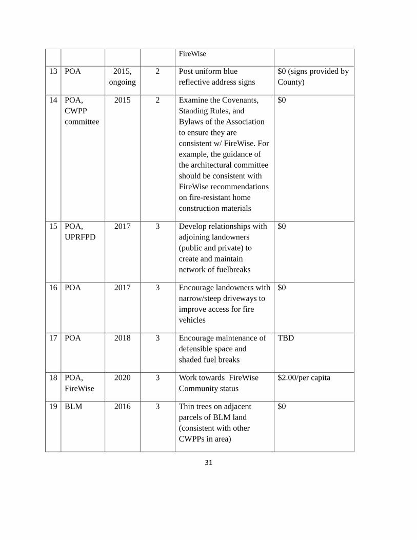
31
FireWise
13 POA 2015, ongoing
2 Post uniform blue reflective address signs
$0 (signs provided by County)
14 POA, CWPP committee
2015 2 Examine the Covenants, Standing Rules, and Bylaws of the Association to ensure they are consistent w/ FireWise. For example, the guidance of the architectural committee should be consistent with FireWise recommendations on fire-resistant home construction materials
$0
15 POA, UPRFPD
2017 3 Develop relationships with adjoining landowners (public and private) to create and maintain network of fuelbreaks
$0
16 POA 2017 3 Encourage landowners with narrow/steep driveways to improve access for fire vehicles
$0
17 POA 2018 3 Encourage maintenance of defensible space and shaded fuel breaks
TBD
18 POA, FireWise
2020 3 Work towards FireWise Community status
$2.00/per capita
19 BLM 2016 3 Thin trees on adjacent parcels of BLM land (consistent with other CWPPs in area)
$0

32
20 POA, UPRFPD, La Plata County
2020 3 Create shaded fuel break along CR 240
TBD
Completed projects and selected projects are discussed in more detail below. Project number corresponds to the projects listed above in Table 2. Project 1. Create shaded fuel breaks at entrances. In 2014, EFE requested and was awarded a KickStarter Grant from FireWise. We requested $4,500 and received $3,130 to create a shaded fuel break at the middle entrance to the subdivision, which was the entrance most in need of work. One tree was also removed from the lower entrance. At the upper entrance Jack Cannon worked with the homeowner and the homeowner hired a contractor to create a shaded fuel break at that location. In addition to 96 volunteer hours applied to the grant, the POA fronted the $3,130.00 and was later reimbursed by the grant. The CWPP committee did the final clean up at the middle and lower entrances. Project 2. Include budget line item for fire mitigation. The budget for 2015 has already been set. The annual POA meeting will occur in August. At that time the CWPP will make a formal request for a line item to be included in budget for $5,000.00. This money will be used when a grant opportunity arises and we are required to provide matching funds. Sometimes volunteer hours can be used for a match, or a partial match, but often there is an actual dollar amount that POA needs to match. In some years, the funds may not be used and in others the whole amount may be needed. But the CWPP committee will request that each year $5,000.00 be available. Project 3. Assist homeowners in creating defensible space. Once this CWPP is signed and approved, EFE will become eligible for grant money that is not available to us now. The UPRFPD has been doing mitigation work in adjacent subdivisions with signed CWPPs. Typically, mitigation work costs about $1,100 to $1,200 per acre. Grants that have been available recently have cut the cost to homeowners in half. The work includes cutting down beetle-killed, defective, and dead trees, leaving oak brush in clumps and thinning to about 50 trees per acre. Firewood can be left or removed. Slash is either burned or chipped. Project 4. Create or enlarge cul-de-sacs. In 2014, using money set aside for the road budget, we were able to have a hammerhead turn-around created at the end of Mountain Shadow Drive. Cost of this project was about $1,500.00. Three other dead-ends need better turn around space (Figure 12). The intersection of Blue Spruce Court with BLM land may provide the opportunity for a cooperative project between EFE and BLM, a win-win situation for both. Having a turn-around at that location would make it safer for emergency personnel and also provide better access to BLM land in case of a fire.
33
Project 5. Encourage residents to sign up for “Code Red”. Code Red is an emergency notification system operated by La Plata County. Individuals sign up and then are automatically notified of emergency situations or critical community alerts such as: evacuation notices, bio-terrorism alerts, and missing child reports. Although a community phone tree can also be helpful, the Code Red notification will come immediately and directly to all individuals who are signed up. Project 7. Erect “dead end” signs. This project was completed in 2014. The signs will hopefully prevent any visitors or emergency personnel from entering a road mistakenly thinking they could exit the subdivision during an emergency. Project 8. Create shaded fuel breaks along subdivision roads. A portion of the subdivision roads are safe and have acceptable fuel loads. In other places high fuel loads extend right up to the edge of the road (e.g. Figure 8). Although the cost of treatment is high, we anticipate that grant money can be obtained to help with the cost. In the event of a grant award, the CWPP committee will talk with homeowners along the treated areas to see if they would want additional mitigation work to extend beyond the 15 feet next to road. Having the equipment and personnel on-site, would likely reduce the cost of additional mitigation work. Project 9. Contact owners of vacant lots. Just over 20, 3-acre lots are vacant within EFE. Typically, these lots are overgrown with vegetation and pose a threat to the fire safety of the entire subdivision. Vacant lot owners have little incentive to do mitigation work with no physical structures to protect. However, if provided the opportunity to have the work done with little or no cost to themselves (through grants awarded to EFE) they might be willing to allow the work to be done. We need to find those homeowners that would be willing to have mitigation work done, so in the event that an appropriate grant opportunity appears, we will be ready to act on it. Project 10. Community workdays. Community workdays are an effective way to get smaller projects done. For example, after the hammerhead was completed at the end of Mountain Shadow, there was a large amount of slash and downed wood that needed to be removed. A community workday was the solution. In addition, members of the CWPP committee cleaned up the remaining slash after the shaded fuel break was done at the middle entrance. We anticipate that community workdays will continue to be an effective means of completing smaller mitigation projects within EFE. Projects 11 and 12. Education. Education is key in protecting our community. The CWPP committee continues to provide hard copies and links to electronic information about fire safety, mitigation, and what to do in an emergency evacuation. FireWise provides an abundance of pertinent information that we will continue to distribute to the residents. Project 13. Post blue reflective signs. These signs allow for quick and easy location of an address, even in smoky or dark conditions. They are provided free-of-charge by the county. All a homeowner has to do is go to Durango and pick up their address and then post it in an easily

34
visible site. If it saves emergency personnel minutes or even seconds to find the location of an emergency, it is worth it. Project 15. Develop relationships with adjoining landowners. EFE is surrounded by forested land. Although we can do as much as we can to make our subdivision less fire prone, we are still at risk if our neighbors do not control fuel levels on their property. Creating good relationships and having open lines of communication will lead to a larger landscape that is less at risk from catastrophic fire. Project 17. Encourage maintenance of defensible spaces. There has been a lot of momentum recently to encourage residents to reduce fuel levels and create defensible space in EFE. However, these defensible spaces have to be maintained over time or fuel levels will revert to unsafe levels. There will need to be a continual effort over time to keep fire safety a high priority among residents. Project 18. Work towards FireWise Community status. Several criteria are involved in becoming a FireWise Community. They are as follows:
• Enlisting a wildland/urban interface specialist to complete an assessment and create a plan that identifies locally agreed-upon solutions that the community can implement.
• Sponsoring a local Firewise committee which maintains the Firewise Community program and tracks its progress or status.
• Observing a Firewise Communities/USA Day each year that is dedicated to a local Firewise project.
• Investing a minimum of $2.00 annually per capita in local Firewise Communities/USA efforts. Work by municipal employees or volunteers using municipal and other equipment can be included, as can state/federal grants dedicated to that purpose.
• Submitting an annual report to Firewise Communities/USA, documenting continuing compliance with the program.
There are a number of benefits to becoming a FireWise Community, including: creation of defensible space that prevents fires from advancing and endangering homes and lives; improving property value while reducing risk of loss; improving community relationships with local fire staff, since firefighters can concentrate their efforts on fighting wildfires rather than devoting limited resources to protecting homes – which may ultimately be lost if the fire can’t be contained; encouraging good neighbors, since the more homes within a community that adopt “Firewise” practices, the greater the impact on reducing the heat and speed of the fire. EFE is well on its way to becoming a FireWise Community. Project 19. Thin trees on adjacent BLM land. There is one parcel of BLM land that is contiguous with EFE and another large parcel that is not contiguous but is just south of CR 240. Thinning trees to the recommended stocking rate, reducing dead trees and ladder fuels, and creating a shaded fuel break along our common border would reduce the risk of catastrophic fire in and near EFE.

35
Project 20. Create a fuel break along CR 240. A likely source of an accidental fire is from CR 240 which runs along our southern boundary. Traffic on CR 240 increases in the summer as vacationers travel to local destinations such as Vallecito Lake or wilderness areas. Protecting our boundary area with a shaded fuel break would reduce the risk that a fire start along the road would quickly and uncontrollably enter the subdivision.
Figure 12. Locations of mitigation projects within EFE. 9.3 Policies or Covenants
9.3.1 Existing Authorities that Govern Land Use and Fuels Management Existing authorities governing land use and fuels management activities include individual lot owners and the Enchanted Forest Estates Property Owners Association. Lot owners are responsible for fuel mitigation on their personal properties. The EFE POA has authority and is responsible for community roads and road easements.

36
EFE POA Bylaws, Covenants, and Standing Rules may govern specific fuel mitigation regulations (Reference EFE POA website for current document) https://sites.google.com/site/enchantedforestestatespoa/
9.3.2 Additional Policy Tools Needed to Reduce Fire Risk
POA dues have traditionally been used solely for road maintenance (i.e. snow removal, gutter clearing). Use of HOA budget resources for fuels mitigation (debris removal, see below) would be a deviation from the traditional types of road maintenance. However, maintaining a safe corridor along the subdivision roads could fall within the category of road maintenance. Including a line item in the annual POA budget for fire mitigation is important for several reasons. It would send a message to all property owners about the importance of fire mitigation and how seriously the Board takes this issue. The money could provide funds for the annual maintenance that will be needed at the entrances and along the roads. It could provide a source of funds for the 25% match hich is often needed to qualify for fire mitigation grants. Although volunteer hours are sometimes valued towards matching funds, often they are not. In those cases, the POA must have matching funds available. Having the funds available could mean the difference between qualifying for a grant or not. 9.3.3 Resources Needed The resources needed for hazardous fuel treatments within EFE primarily revolve around the removal of the fuels from the site. Removal of debris from fuels treatment is one of our biggest challenges. While some of the material can be burned, the weather, moisture conditions, and season are not always conducive to burning and large diameter trees are impractical and wasteful to burn on site. Ideally, fuels removed for mitigation would be used in a biomass facility, but the only one available in Colorado is at Gypsum in Eagle County, too far away to be practical. We need funds to have large trash bins delivered and hauled away on community work days, to hire contractor(s) to cut trees and remove the debris they create, and/or to rent a chipper to masticate smaller-sized debris.

37
10. MONITORING AND EVALUATION The completion of this CWPP for EFE is only the first step in creating a safer, fire adapted community. Continued efforts will be needed not only to maintain the progress made, but also to move ahead and include more residents and lot owners in the effort. To ensure that the subdivision continues to move in the right direction and to assure granters that their money is being used as expected, monitoring is necessary. Monitoring and evaluation of outreach, education, and mitigation efforts are important parts of this CWPP. The monitoring actions, responsible parties, and frequency are shown in Table 3. Table 3. EFE CWPP Monitoring Actions and Schedule Party Action Frequency
POA Annual Report to the Community, FireWise Council of SW CO, Colorado State Forest Service
Annually
CSFS Monitoring of mitigation for work covered by grants
As required
POA/ UPRFPD Inspection of recommendations to EFE for roads, driveways, defensible spaces
Bi-annually
POA Annual report will include “Lessons Learned” from mitigation projects completed the preceding year
Annually
POA Review CWPP and measure progress using benchmarks
Annually
POA/CSFS Update CWPP No more than 5 years
38
11. GLOSSARY acre: an area of land containing 43,560 square feet. A square acre is 209 feet by 209 feet. A circular acre would have a radius of 117.75 feet. basal area: the cross-sectional area of a single stem, including the bark, measured at breast height (4.5 feet above the ground) For example, the basal area of a tree 13.5 inches in diameter at breast height is about 1 square foot. Basal area = 0.005454 times diameter squared. (b) of an acre of forest: the sum of basal areas of the individual trees on the area. For example, a well-stocked pine stand might contain 70 to 90 square feet of basal area per acre. canopy: the foliage formed by the crowns of trees in a stand. defensible space: an area around a structure where fuels and vegetation are treated, cleared or reduced to slow the spread of wildfire towards the structure. diameter at breast height (dbh): the diameter of a stem of a tree at 4 ½ feet above the ground. downed fuels: the accumulated woody and vegetative material on the forest floor from leaf/needle fall, natural pruning and breakage that serves as fuel for wildfire. ecosystem: A spatially explicit, relatively homogenous unit of the earth that includes all interacting organisms (plants, animals, microbes) and components of the abiotic environment within its boundaries. An ecosystem can be of any size: a log, pond, field, forest, or the earth's biosphere. fire hazard: A fuel complex, defined by volume, type, condition, arrangement, and location that determines the degree of ease of ignition and the resistance to control (NWCG, 2003). fuel loading: the oven-dry weight of fuel per unit area. ladder fuels: combustible material that provides vertical continuity between vegetation strata and allows fire to climb into the crowns of trees or shrubs with relative ease. litter: the surface layer of a forest floor that is not in an advanced stage of decomposition, usually consisting of freshly fallen leaves, needles, twigs, stems, bark, and fruits. lop and scatter: a hand method of removing the upward facing branches from tips of felled trees to keep slash low to the ground, to increase rate of decomposition, lower fire hazard, or as a pre-treatment prior to burning. sapling: a usually young tree larger than a seedling but smaller than a pole.
39
shaded fuelbreak: A strategically located strip or block of land (of varying width) depending on fuel and terrain, in which fuel density is reduced, thus improving fire control opportunities. The stand is thinned and remaining trees are pruned to remove ladder fuels. Most brush, heavy ground fuels, snags and dead trees are removed and an open park-like appearance established. silviculture: the art, science, and practice of establishing, tending, and reproducing forest stands of desired characteristics. It is based on knowledge of species characteristics and environmental requirements. slash: the residue of treetops and branches left on the ground after logging or accumulating as a result of storms, fire, girdling or delimbing. snag: a standing, generally unmerchantable dead tree from which the leaves and most of the branches have fallen. stand: a contiguous group of trees sufficiently uniform in age-class distribution, composition, and structure, and growing on a site of sufficiently uniform quality, to be a distinguishable unit. thinning: a cultural treatment made to reduce stand density of trees primarily to improve growth, enhance forest health, or recover potential mortality. wildland-urban interface (WUI): The geographical meeting point of two diverse systems - wildland and structures. In the WUI, structures and vegetation are sufficiently close so that a wildland fire could spread to structures or a structure fire could ignite vegetation. Definitions except defensible space, fire hazard, shaded fuelbreak and wildland-urban interface from The Dictionary of Forestry, John A. Helms, editor.

40
12. LITERATURE CITED Agee, James K. 1993. Fire ecology of Pacific Northwest forests. Washington, DC: Island Press. 493 p. Allen, C.D. and others. 2002. Ecological Restoration of Southwestern Ponderosa Pine Ecosystems, a Broad Perspective. Ecological Applications 12:1418-1433. Barrett, S.W.; Arno, S.F. 1982. Indian fires as an ecological influence in the Northern Rockies. Journal of Forestry 80 (10): 647-651. Bentz, B. 2008. Western U.S. bark beetles and climate change. N.p.: U.S. Forest Service, Climate Change Resource Center. http://www.fs.fed.us/ccrc/topics/bark-beetles.shtml. Bonfils, C., B. D. Santer, D. W. Pierce, H. G. Hidalgo, G. Bala, T. Das, T.P. Barnett, et al. 2008. Detection and attribution of temperature changes in the mountainous western United States. Journal of Climate 21:6404–6424. Bradley, Anne F.; Noste, Nonan V.; Fischer, William C. 1992. Fire ecology of forests and woodlands in Utah. Gen. Tech. Rep. INT-287. Ogden, UT: Intermountain Forest and Range Experiment Station, Forest Service, U.S. Department of Agriculture; 128 p. Dennis, F.C. 2012. Creating Wildfire-Defensible Zones. Colorado State University Cooperative Extension Resource Publication no. 6.302. 6 p. Graham, R.T. and T.B. Jain. 2005. Ponderosa pine ecosystems. Pp. 1-32. In M.W. Ritchie, D.A. Maguire, and A Youngblood, Technical editors, Proceedings of the Symposium on Ponderosa Pine: Issues, Trends, and Management. USDA Forest Service General Technical Report, PSW-GTR-198. Helms, J.A., ed. 1998. The Dictionary of Forestry. The Society of American Foresters. Bethesda, MD. 210 p. Hoerling, M. P., M. Dettinger, K. Wolter, J. Lukas, J. Eischeid, R. Nemani, B. Liebmann, and K. E. Kunkel. 2013. “Present Weather and Climate: Evolving Conditions.” In Assessment of Climate Change in the Southwest United States: A Report Prepared for the National Climate Assessment, edited by G. Garfin, A. Jardine, R. Merideth, M. Black, and S. LeRoy, 74–100. A report by the Southwest Climate Alliance. Washington, DC: Island Press. La Plata County Community Wildfire Protection Plan. 2006. La Plata County, Colorado. 12 p. Schoennagel, T., T.T.Veblen, and W.H. Romme. 2004. The Interaction of Fire, Fuels, and Climate across Rocky Mountain Forests. BioScience 54:661-676.

41
Slack, P. 2012. Firewise Construction, Design and Materials. Colorado State Forest Service, Ft. Collins, CO. 38 p. 23 Stewart, I. T. Cayan, D.R. and M.D, Dettinger. 2005. Changes toward earlier streamflow timing across Western North America. Journal of Climate 18:1136-1155. Stewart, O.C. 1951. Burning and natural vegetation in the United States. Geographical Review 41: 317-320. Westerling, A. L., H. G. Hidalgo, D. R. Cayan, and T. W. Swetnam. 2006. Warming and earlier spring increases western U.S. forest wildfire activity. Science 313:940–943.
Williams, A. P. et al. 2010. Forest responses to increasing aridity and warmth in the Southwestern United States. Proceedings of the National Academy of Science USA 107:21298–21294.
42
13. USEFUL LINKS
CSFS
Protecting Your Home from Wildfire – Creating Wildfire-Defensible Zones: http://static.colostate.edu/client-files/csfs/pdfs/FIRE2012_1_DspaceQuickGuide.pdf/
Fuelbreak Guidelines for Forested Subdivisions & Communities: http://static.colostate.edu/client-files/csfs/pdfs/fuelbreak_guidelines.pdf/
FireWise Construction: Site Design & Building Materials: http://static.colostate.edu/client-files/csfs/pdfs/firewise-construction2012.pdf/
FireWise Plant Materials: http://static.colostate.edu/client-files/csfs/pdfs/06305.pdf/
Fire-Resistant Landscaping: http://static.colostate.edu/client-files/csfs/pdfs/06303.pdf/
Forest Home Fire Safety: http://static.colostate.edu/client-files/csfs/pdfs/06304.pdf/
Home Fire Protection: http://static.colostate.edu/client-files/csfs/pdfs/home_fire_protection_brochure.pdf/
Living with Fire: http://static.colostate.edu/client-files/csfs/pdfs/LWF51303.pdf/
Preparing a CWPP Handbook: http://static.colostate.edu/client-files/csfs/pdfs/cwpphandbook.pdf/
Leaders Guide to Developing a CWPP: http://static.colostate.edu/client-files/csfs/pdfs/CWPP_LG.pdf/
CWPP Evaluation Guide: http://static.colostate.edu/client-files/csfs/pdfs/eval_9-8-08_web.pdf/
Community Guide to Preparing and Implementing a CWPP: http://static.colostate.edu/client-files/csfs/pdfs/CWPP_Report_Aug2008.pdf/
Colorado Wildfire Risk Assessment Portal: http://www.coloradowildfirerisk.com/
Colorado State Forest Service: http://csfs.colostate.edu/
FireWise of Southwest Colorado
FireWise SW Colorado: http://www.southwestcoloradofires.org/
Chipper rebate form: http://www.southwestcoloradofires.org/news/2015-chipper-rental-rebate-application/
43
Enchanted Forest Estates
Enchanted Forest Estates website: https://sites.google.com/site/enchantedforestestatespoa/
La Plata County
PRIOR TO BURNING, ALL PERMIT HOLDERS must call Central Dispatch at (970) 385-2900 for authorization and to be advised of Red Flag conditions.
Other
Be Ember Aware: http://www.unce.unr.edu/publications/files/nr/2009/fs0905.pdf
44
Appendices
A. Upper Pine River Fire Protection District Map and Station Locations
B. Suggested Contents for Go Bags
C. Protecting your Home from Wildfire: Creating Wildfire –Defensible Zones
D. FireWise Construction: Site Design and Building Materials