Embed Size (px)
Citation preview
VTBS Alt .HrfEC'l'S
.,.-.--,. j . i ~ CUN~
5¥·9 M ► -MMMM lri111ln1 flw••st■r tiHlitr h•m•
0 STAR HARBOR
I A c,
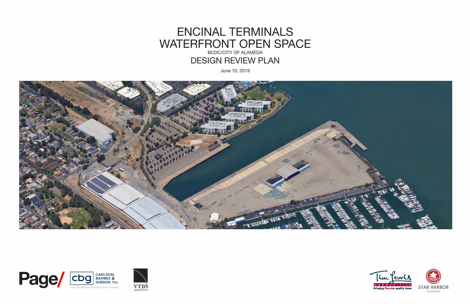
ENCINAL TERMINALS WATERFRONT OPEN SPACE
BCDC/CITY OF ALAMEDA
DESIGN REVIEW PLAN June 10, 2019
1 JUNE 10, 2019
STAR HARBOR --r-=iu.r~
lri111ln1 fiwe-1t■r 11••litr hon1• All.MEDI,
CARLSON, BARBEE & GIBSON, Inc.
OVIL ENGINEERS • SURVEYORS • PLANNERS ! Page/
ARCHHeC-11S
Y
ALAM
EDA/
OAKL
AND
ESTU
AR
(EXI
STIN
G)
CLEM
ENT A
VENU
E
CLEM
ENT A
VENU
E (N
EW S
EGME
NT)
FORTMAN BASIN
ENTRANCE ROAD (NEW SEGMENT)
ALASKA BASIN
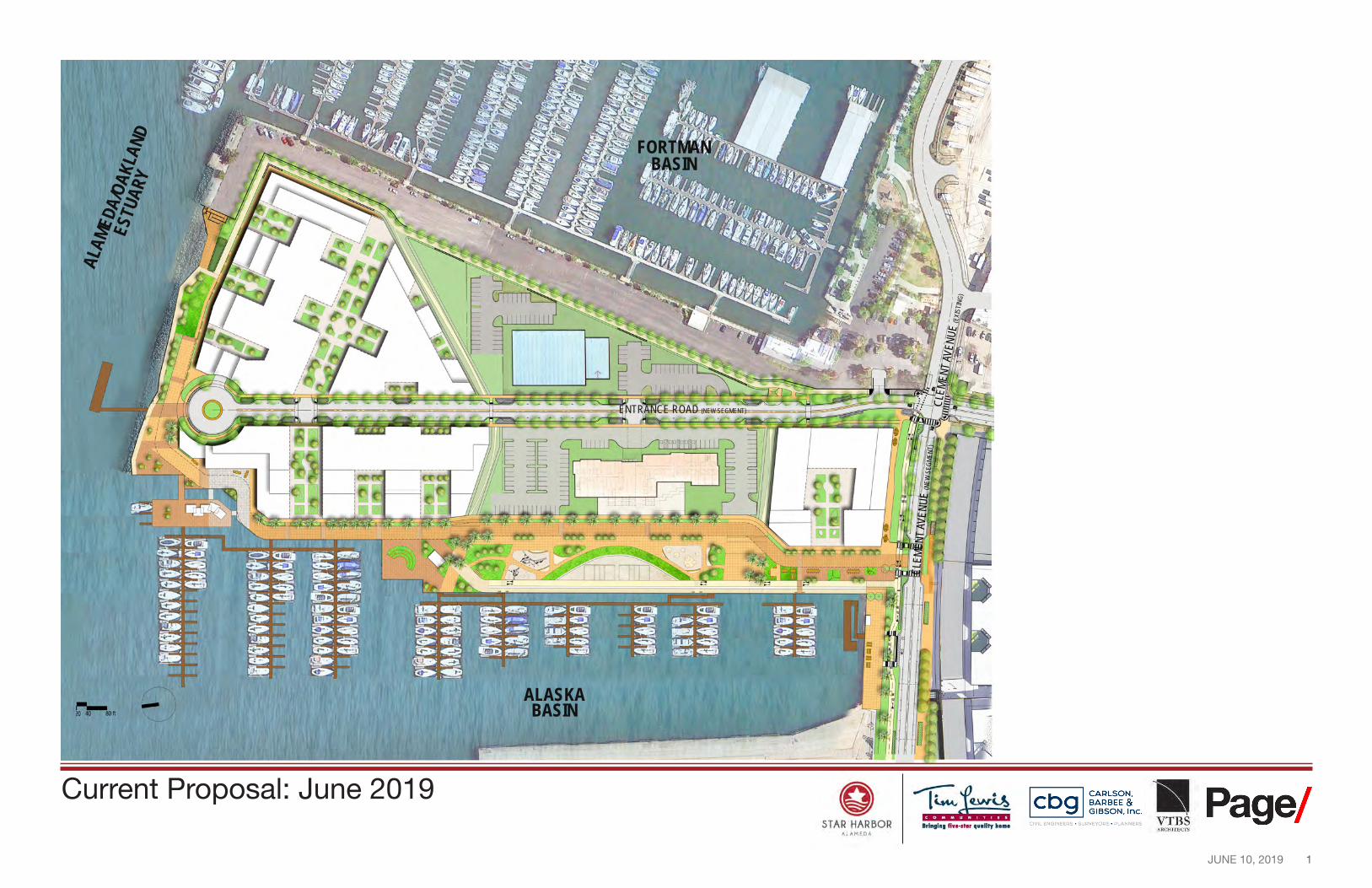
Current Proposal: June 2019
2 JUNE 10, 2019
STAR HARBOR --r-=iu.r~
lri111ln1 fiwe-1t■r 11••litr hon1• All.MEDI,
CARLSON, BARBEE & GIBSON, Inc.
OVIL ENGINEERS • SURVEYORS • PLANNERS ! Page/
ARCHHeC-11S
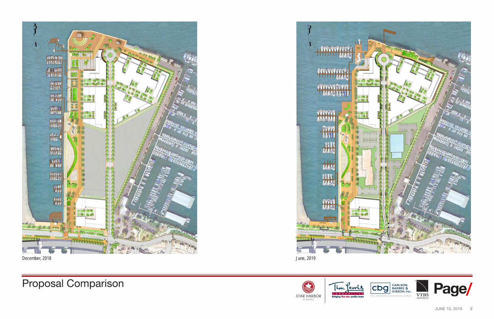
December, 2018 June, 2019
Proposal Comparison
JUNE 10, 2019
Source: Esri, DigitalGlobe, GeoEye, Earthstar Geographics, CNES/Airbus DS, USDA, USGS, AeroGRID, IGN, and the GIS User Community
0 2,100 4,2001,050Feet¢
OAKLAND
ALAMEDA
BAY FARM ISLAND
COAST GUARD ISLAND
SAN FRANCISCO BAY
ALAMEDA/OAKLAND ESTUARY
0
.... ...... ...... ...... ...... --.. , ' ' ~, --------------
T
®
@
-//Ill .............
--r .. , --:___. .... .... _
STAR HARBOR All.MEDI,
2
STAR
WAKE
FIELD
EAGLE
MARINA VILLAGE ICAR
US CAMPBELL
BEAR
HUDSON
SPENCER
DENNISON
W I N D R I V E R
IND E P E N C E CHALLENGER ATLAN TI C
E N T R
A N C E
CLEMENT
SHERMAN
ST C H A R L E S OHLO
NE CONSTITUTION
BAY
CHAPIN
EAGLE
9TH
WOOD
EAGLE 8TH
NASON ARBO
R JA Y
BUEN A VISTA
PARU
BUENA VISTA
HIBB
ARD
EAGLE
SCHI
LLER
MIN
TURN
STAN
FORD
BLAN
UNIO
N D PACIFIC
STAN
TON PACIFIC
POW
ERS
LAFA
YETT
E
CHES
TNUT
MUL
BERR
Y
CLEMENT ELM
CONCORD IA
LINCOLN LINCOLN
WILL
OW
WE BSTER
SEABORN
WAL
NUT
MASTICK
EAGLE
VERDI
MOZA RT SANTA CLARA
BUENA VISTA OAK
COTT
AGE
SANTA CLARA
PARU
BEN TON
PARK
ST
GRAN
D SHER MA N
MOR TON
ST CH A RLES LAFA
YETT
E
LEA
UNIO
N PACIFIC T
TAYLOR CENTRAL
L BAY
CHES
TNUT
FOPAGE
CAROLIN E
LINCOLN CLARA CENTRAL ALAMEDA
9TH
WILL
OW
TIMES
8TH AYLOR FA IR OAKS
WALN
UT
T SANTA CLARA ENCINAL WEB
CENTENN IAL C R O LLCENTR AL
BURBAN K PARK
ST
OAK SAN ANTONIO
S GARDEN
ST CHARLE S
BAY
SHERMAN EV
ERET
T CAROLINE
HAWTH ORNE
CENTRAL
WEBER
9TH
PARU
SAN JOSE PORTOLA
MCKAY
PARK
AVE
GRAN
D
ALAMEDA
REGE
NT
FAYE
TTE
UNIO
N
CLINTON
STNU
T
ISL E
CR ENCINAL DAY A
Oakland Ferry Terminal
Jack London Square
Alameda Ferry Terminal
Jack London San AntonioAquatic Center ParkEstuary Park
Shoreline Park Neptune Park
1/4 Mile 1/2 Mile 1MileJean Sweeney Open Space Park
Grand Avenue Boat Ramp Union Point
Marina Cove Park Waterfront ParkLittlejohn Park
Regional Map Thompson Field
Encinal Beach and Boat Launch
Ferry Terminal Crown Memorial DOWNTOWN ALAMEDA
Ferry Route State Beach NDE
Boat Launch DoolittleMU-1 MU-6 Boat LaunchWalking Radius
MU-6 MU-4 San Francisco Bay Trail (Existing) MU-5MU-4 San Francisco Bay Trail (Proposed)
Parks & BCDC Jurisdiction LimitMU-5Public Open Space
Specified Mixed Use Site
Residential Wetland
Business Park Park
Public/Institutional/ School
City of Alameda Zoning Map, 2016
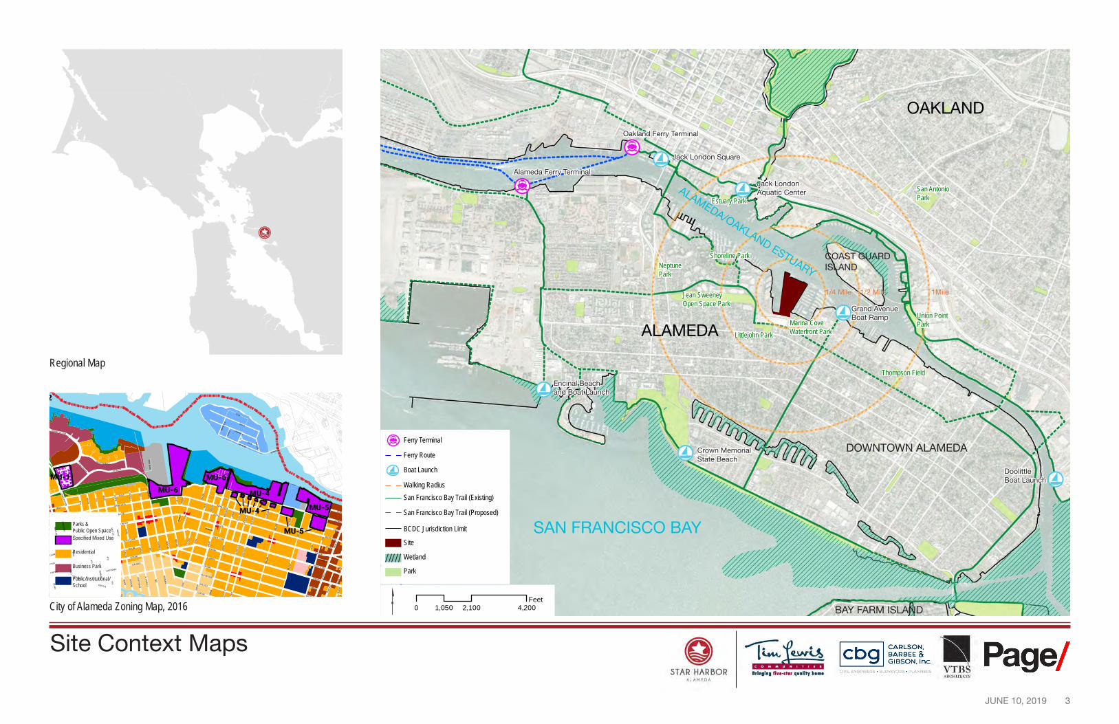
Site Context Maps
3
4 JUNE 10, 2019
STAR HARBOR ALAMEDA
O' 500' 1,500' 2,000'
I r 11,11110111111j111u 111 IIUUIIIIIIIIII I I
1111111ijjj111111111 11111jjlj 1l 1j 1ll 1
CALE: I" : 500'
--r-=iu.r~ lri111ln1 fiwe-1t■r 11••litr hon1•
CARLSON, BARBEE & GIBSON, Inc.
OVIL ENGINEERS • SURVEYORS • PLANNERS
LEGEND
---- ENCINAL TERMINALS BOUNDARY
REGIONAL ARTERIAL
1••- FUTURE ARTERIAL
ISLAND & TRANSITIONAL ARTERIAL
••••• BIKE FACILITY - - AC TRANSIT SERVICE
-0--- CROSS ALAMEDA TRAIL - - BAY TRAIL
! Page/ ARCHHeC-11S
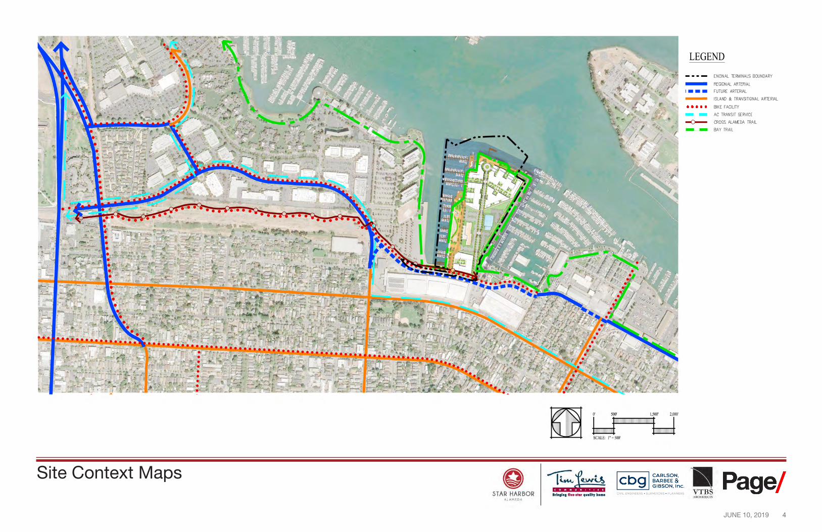
Site Context Maps
5 JUNE 10, 2019
0' 100' 3 00, 400'
I IIIIIIIIIIIIIIIIIIIIIIIIIIIIIIIIIIIIIIIIIIIIIIIIII I IIIIIIIIIIIIIIIIIIIIIII IIIIIIIIIIIIIIIIIIIIIII 2018
SCALE: 1"=100' DATE:NOVEMBER29,
0 STAR HARBOR
All.MEDI,
--r-=iu.r~ lri111ln1 fiwe-1t■r 11••litr hon1•
CARLSON, BARBEE & GIBSON, Inc.
OVIL ENGINEERS • SURVEYORS • PLANNERS ■ Page/ VTBS
ARCHHeC-1'S
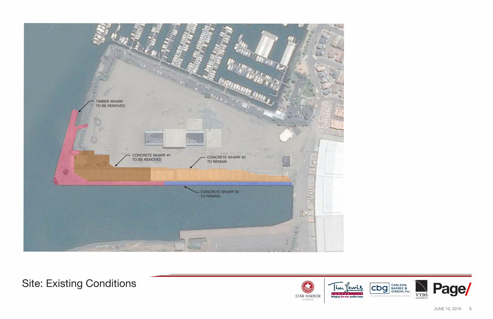
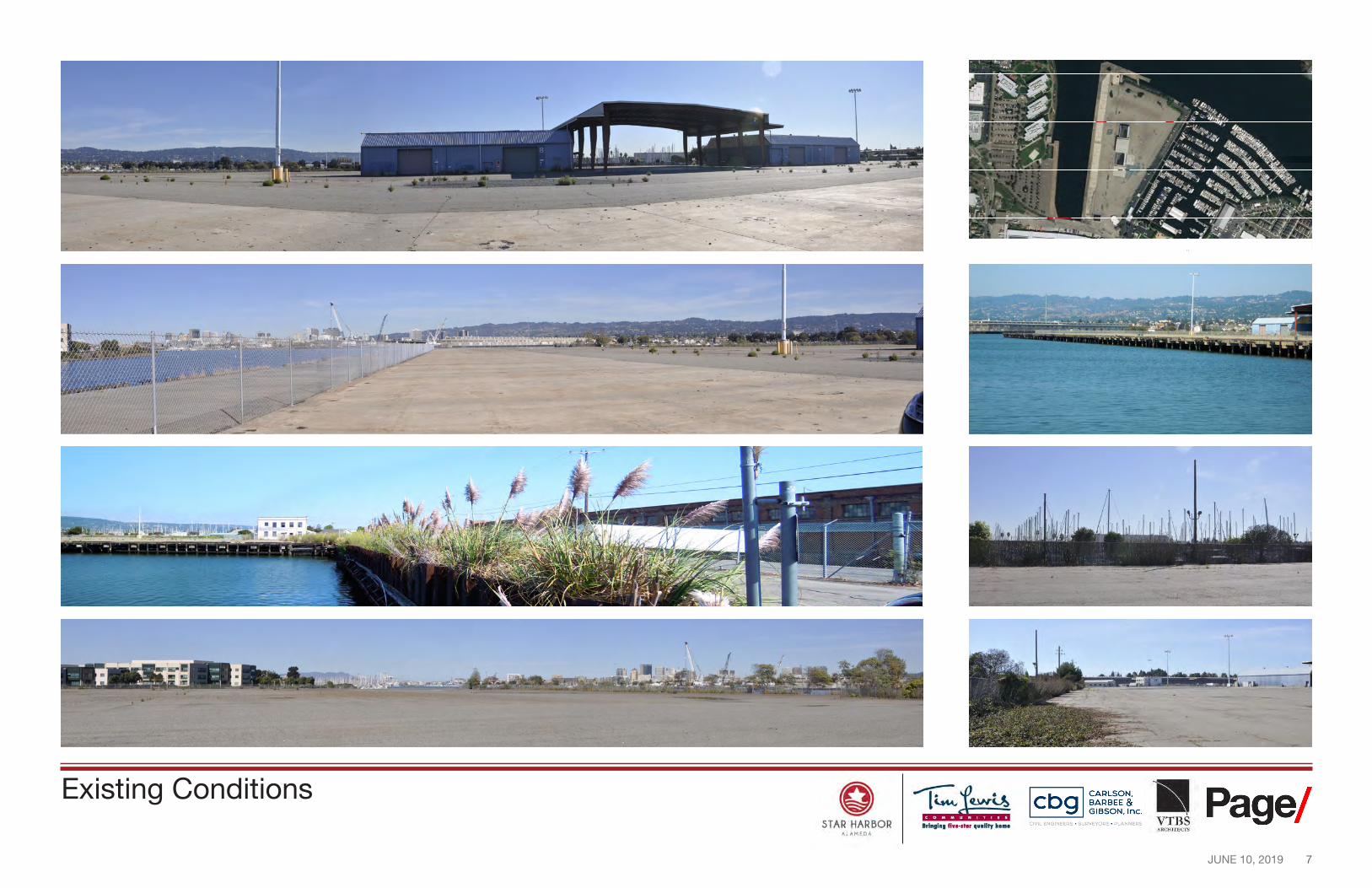
Site: Existing Conditions
TIMBER WHARF TO BE REMOVED
CONCRETE WHARF #1 TO BE REMOVED
CONCRETE WHARF #2 TO REMAIN
CONCRETE WHARF #3 TO REMAIN
6 JUNE 10, 2019
Downtown Oakland Brooklyn Basin Oakland HIiis
Coast Guard Island
Fortman 1
Marina
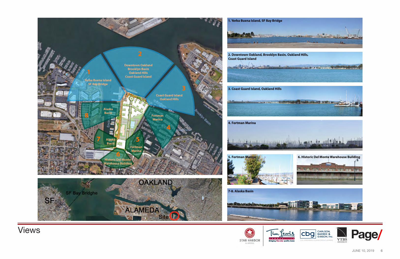
1. Verba Buena Island, SF Bay Bridge
2. Downtown Oakland, Brooklyn Basin, Oakland Hills, Coast Guard Island
3. Coast Guard Island, Oakland Hills
4. Fortman Marina
7-8. Alaska Basin
STAR HARBOR --r-=iu.r~
lri111ln1 fiwe-1t■r 11••litr hon1•
~ ~1~~~~i ■ Page{ ~ GIBSON. Inc. OYIL ENGINEERS . SURVEYORS . PLANNERS VTB s
All.MEDI,
Views
7 JUNE 10, 2019
Source: Esri, D g talGlobe, GeoEye, Earthstar Geographics, CNES/Airbus DS, USDA, USGS, AeroGRID, IGN, and the GIS User Community
1
2 5
6
7
1
3
3
5 7
6
4
4 2
·-
- -
- -
-
STAR HARBOR --r-=iu.r~
lri111ln1 fiwe-1t■r 11••litr hon1• All.MEDI,
CARLSON, BARBEE & GIBSON, Inc.
OVIL ENGINEERS • SURVEYORS • PLANNERS
I
! Page/ ARCHHeC-11S
i i
Existing Conditions
8 JUNE 10, 2019
I
\ \ \
'/
I I
I
I I L-/-----
1 I
I --
----~ • • . ,: / , ____________________ '' / _ ----------------------------------/ / ----~ / I ~----, ...
I ••
0 STAR HARBOR
--r-=iu.r~ lri111ln1 fiH•lt■r 11u•litr hom•
All.MEDI,
..
-------C]
c::::J
IZZ2I
IZZ2I
CARLSON, BARBEE & GIBSON, Inc.
OVIL ENGINEERS • SURVEYORS • PLANNERS ! Page/
ARCHHeC-11S
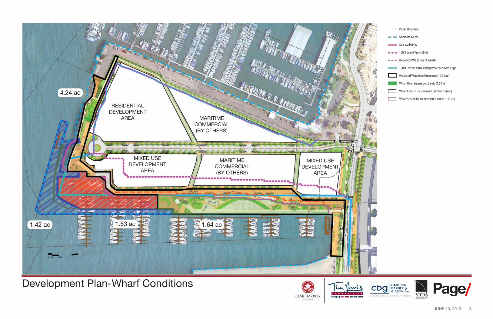
Public Boundary
Shoreline/MHW
Sea Wall/MHW
100 ft Inland From MHW
Retaining Wall (Edge of Wharf)
100 ft Offset From Existing Wharf or Shore Edge
Proposed Waterfront Promenade (4.24 ac)
Wharf Over Submerged Lands (1.64 ac)
Wharf Area To Be Removed (Timber, 1.42ac)
Wharf Area to Be Removed (Concrete, 1.53 ac) 4.24 ac
MIXED USE DEVELOPMENT
AREA
RESIDENTIAL DEVELOPMENT
AREA
MIXED USE DEVELOPMENT
AREA
MARITIME COMMERCIAL (BY OTHERS)
MARITIME COMMERCIAL (BY OTHERS)
1.42 ac 1.64 ac1.53 ac
Development Plan-Wharf Conditions
9 JUNE 10, 2019
--
ESTUARY PROMENADE
WATER TRANSIT DOCKING FACILITY
' 0
------ I -*
0 STAR HARBOR
All.MEDI\
~ ~1~~~~1 ■ Pagel ' ~ GIBSON. Inc. VTBS f OVIL ENGINEERS · SURVEYORS · PLANNERS
ARCHrfEC'J'S
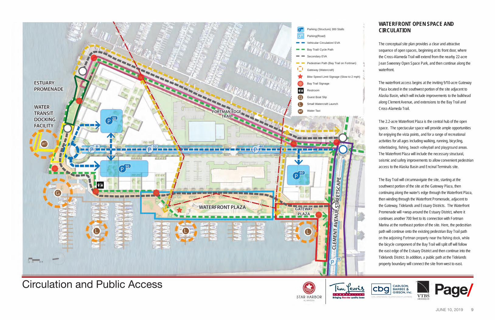
P
P --
L
G
WT
Parking (Structure) 300 Stalls
Parking(Road)
Vehicular Circulation/ EVA
Bay Trail/ Cycle Path
Secondary EVA
Pedestrian Path (Bay Trail on Fortman)
Gateway (Watercraft)
Bike Speed Limit Signage (Slow to 2 mph)
Bay Trail Signage
Restroom
Guest Boat Slip
Small Watercraft Launch
Water Taxi
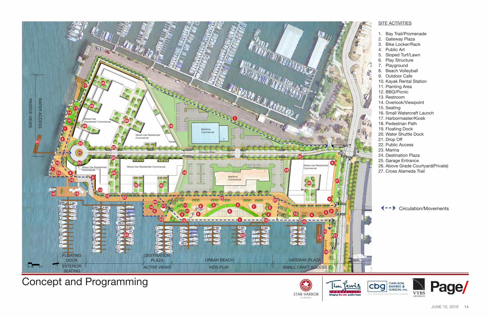
WATERFRONT OPEN SPACE AND CIRCULATION
The conceptual site plan provides a clear and attractive sequence of open spaces, beginning at its front door, where the Cross-Alameda Trail will extend from the nearby 22-acre Jean Sweeney Open Space Park, and then continue along the waterfront.
The waterfront access begins at the inviting 9/10-acre Gateway Plaza located in the southwest portion of the site adjacent to Alaska Basin, which will include improvements to the bulkhead along Clement Avenue, and extensions to the Bay Trail and Cross-Alameda Trail.
The 2.2-acre Waterfront Plaza is the central hub of the open space. The spectacular space will provide ample opportunities for enjoying the vista points, and for a range of recreational activities for all ages including walking, running, bicycling, rollerblading, fishing, beach volleyball and playground areas. The Waterfront Plaza will include the necessary structural, seismic and safety improvements to allow convenient pedestrian access to the Alaska Basin and Encinal Terminals site.
The Bay Trail will circumnavigate the site, starting at the southwest portion of the site at the Gateway Plaza, then continuing along the water’s edge through the Waterfront Plaza, then winding through the Waterfront Promenade, adjacent to the Gateway, Tidelands and Estuary Districts. The Waterfront Promenade will +wrap around the Estuary District, where it continues another 700 feet to its connection with Fortman Marina at the northeast portion of the site. Here, the pedestrian path will continue onto the existing pedestrian Bay Trail path on the adjoining Fortman property near the fishing dock, while the bicycle component of the Bay Trail will split off will follow the east edge of the Estuary District and then continue into the Tidelands District. In addition, a public path at the Tidelands property boundary will connect the site from west to east.
Circulation and Public Access
10 JUNE 10, 2019
As a result, there will be more than 4 acres of public open space within the Master Plan, comprised of
• Gateway Plaza (outlined in red): approximately 9/10-acres • Waterfront Plaza (outlined in blue), approximately 2.2 acres • Waterfront Promenade, Public Access Path and Bay Trail area: approximately 1.1 acres
Other features of the waterfront include: • A docking facility to encourage waterborne modes of transportation on the north central portion of the site
• Opportunities for a public human powered/non-motorized boat launch facility for kayaks and stand up paddle boards in Alaska Basin and/or off the northern edge of the site
• Physical and visual connections between Alameda and the waterfront to the extent possible to support and enhance public access to the waterfront
• Public use areas along the shoreline clearly delineated with “Public Shore” signs, planting and/or special features
• Public amenities including, bike racks, benches, trash containers, restrooms, and drinking fountains for public use within the shoreline public access areas
• Public art and public view areas within the public areas
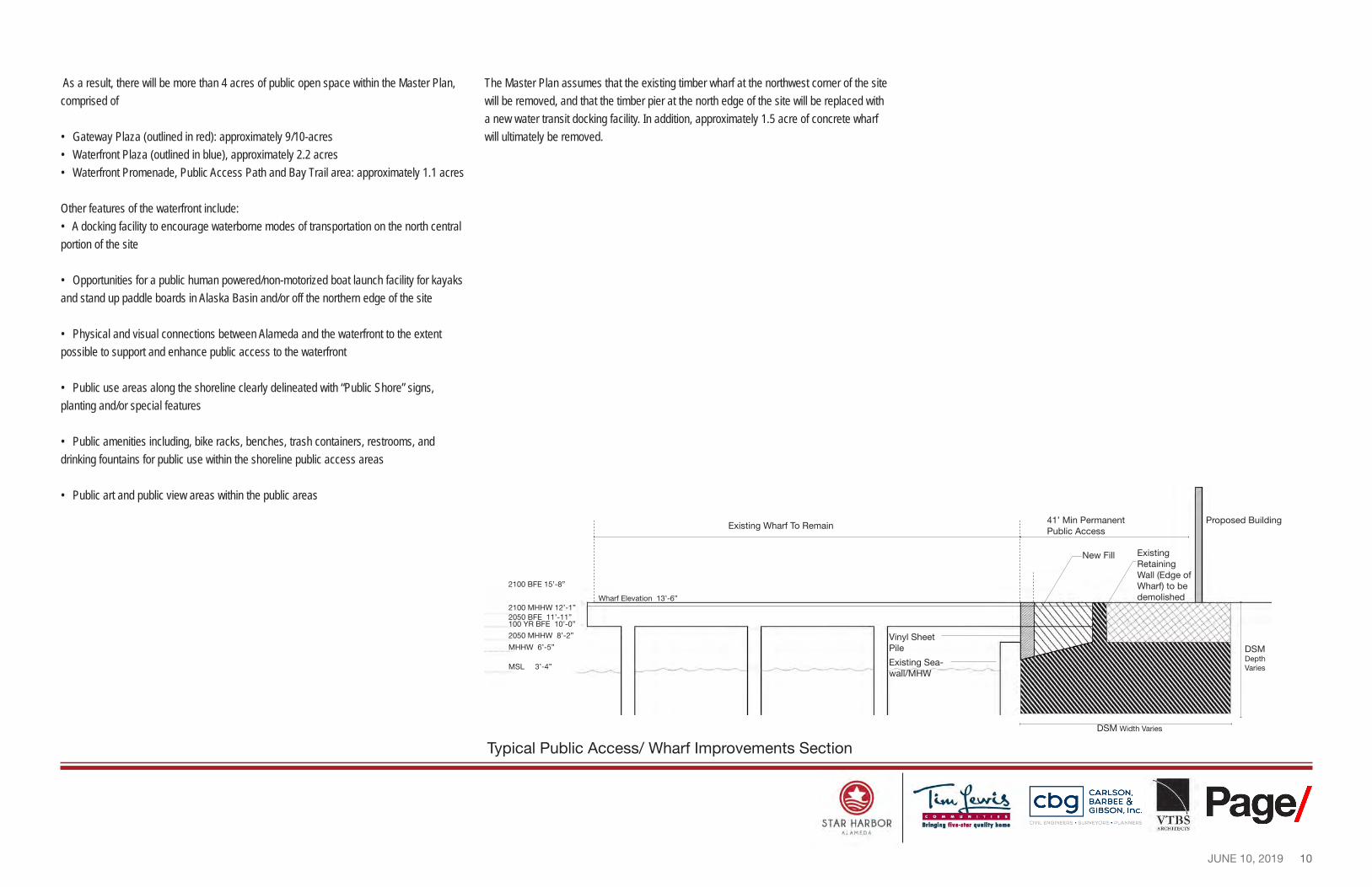
The Master Plan assumes that the existing timber wharf at the northwest corner of the site will be removed, and that the timber pier at the north edge of the site will be replaced with a new water transit docking facility. In addition, approximately 1.5 acre of concrete wharf will ultimately be removed.
-----
STAR HARBOR --r-=iu.r~
lri111ln1 fiwe-1t■r 11••litr hon1• All.MEDI,
CARLSON, BARBEE & GIBSON, Inc.
OVIL ENGINEERS • SURVEYORS • PLANNERS ! Page/
ARCHHeC-11S
41’ Min Permanent Proposed Building Existing Wharf To Remain
Public Access
Existing Retaining Wall (Edge of
2100 BFE 15’-8”
New Fill
Wharf) to be Wharf Elevation 13’-6” demolished
2100 MHHW 12’-1” 2050 BFE 11’-11” 100 YR BFE 10’-0”
2050 MHHW 8’-2” Vinyl Sheet MHHW 6’-5” Pile
Existing Sea-MSL 3’-4” wall/MHW
DSM Width Varies
Typical Public Access/ Wharf Improvements Section
DSM Depth Varies
11 JUNE 10, 2019
.. 11- •rm:, u,· - ----- -..-('- . ..-,
,.._ --?-0 4-0 00 ft
STAR HARBOR --r-=iu.r~
lri111ln1 fiwe-1t■r 11••litr hon1•
~ ~1~~~~i ■ Page{ ~ GIBSON. Inc. OVPL ENGPNEERS . SURVEYORS . PLANNERS VTB s
All.MEDI,
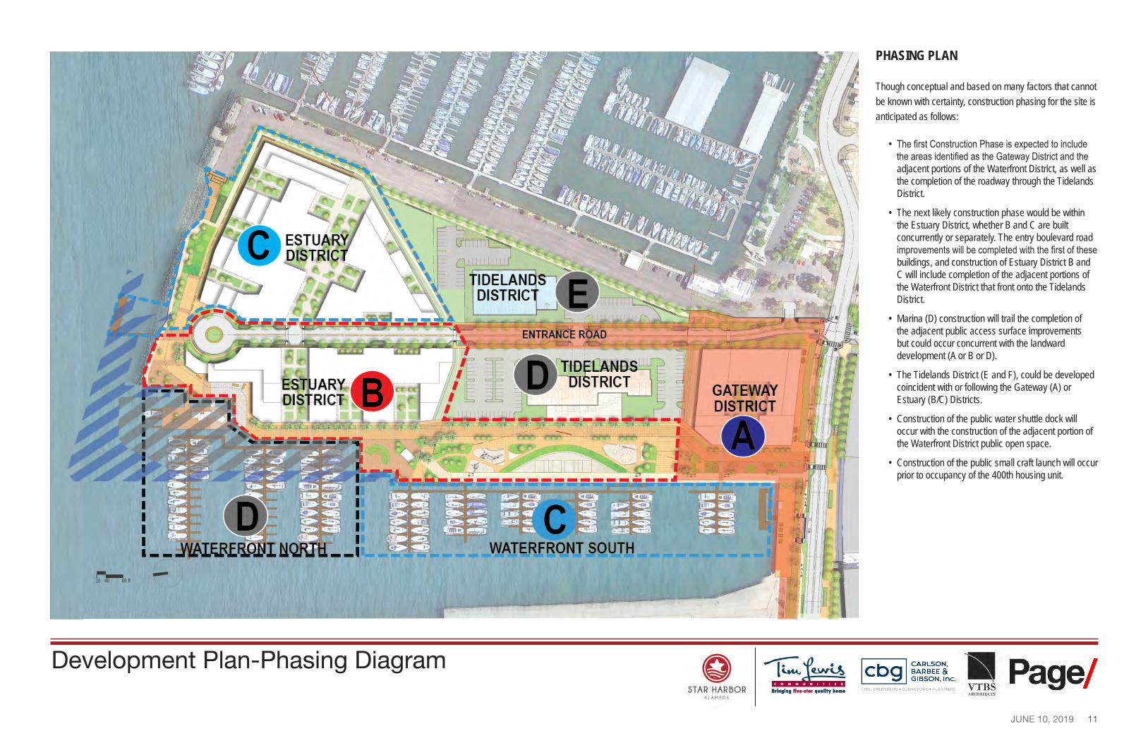
Development Plan-Phasing Diagram
PHASING PLAN
Though conceptual and based on many factors that cannot be known with certainty, construction phasing for the site is anticipated as follows:
• The first Construction Phase is expected to include the areas identified as the Gateway District and the adjacent portions of the Waterfront District, as well as the completion of the roadway through the Tidelands District.
• The next likely construction phase would be within the Estuary District, whether B and C are built concurrently or separately. The entry boulevard road improvements will be completed with the first of these buildings, and construction of Estuary District B and C will include completion of the adjacent portions of the Waterfront District that front onto the Tidelands District.
• Marina (D) construction will trail the completion of the adjacent public access surface improvements but could occur concurrent with the landward development (A or B or D).
• The Tidelands District (E and F), could be developed coincident with or following the Gateway (A) or Estuary (B/C) Districts.
• Construction of the public water shuttle dock will occur with the construction of the adjacent portion of the Waterfront District public open space.
• Construction of the public small craft launch will occur prior to occupancy of the 400th housing unit.
12 JUNE 10, 2019
STAR HARBOR --r-=iu.r~
lri111ln1 fiH•lt■r 11u•litr hon1• All.MEDI,
CARLSON, BARBEE & GIBSON, Inc.
OVIL ENGINEERS • SURVEYORS • PLANNERS ! Page/
ARCHHeC-11S
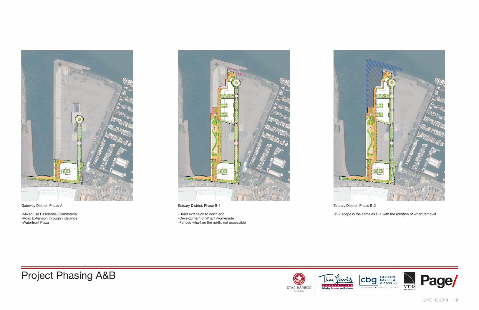
Gateway District, Phase A Estuary District, Phase B-1 Estuary District, Phase B-2
-Mixed use Residential/Commercial -Road extension to north end -B-2 scope is the same as B-1 with the addition of wharf removal -Road Extension through Tidelands -Development of Wharf Promenade -Waterfront Plaza -Fenced wharf on the north, not accessible
Project Phasing A&B
13 JUNE 10, 2019
( \
STAR HARBOR --r-=iu.r~
lri111ln1 fiH•lt■r 11u•litr hon1•
~ ~1~~~~i ■ Page{ ~ GIBSON. Inc. OYIL ENGINEERS . SURVEYORS . PLANNERS VTB s
All.MEDI,
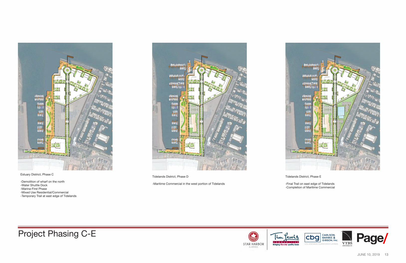
Estuary District, Phase C Tidelands District, Phase D Tidelands District, Phase E
-Demolition of wharf on the north -Water Shuttle Dock -Marina-First Phase
-Maritime Commercial in the west portion of Tidelands -Final Trail on east edge of Tidelands -Completion of Maritime Commercial
-Mixed Use Residential/Commercial -Temporary Trail at east edge of Tidelands
Project Phasing C-E
14 JUNE 10, 2019
~--➔
c-'r-aoft
0 STAR HARBOR
All.MEDI\
~ ~1~~~~1 ■ Pagel' ~ GIBSON. Inc. VTBS f OVIL ENGINEERS · SURVEYORS · PLANNERS
ARCHrfEC'J'S
WATE
R A
CC
ES
S
PAS
SIV
E V
IEW
S
1
1
27
8 2
9
9
9
3
10
16
4 4
21
21
5
222222
6
6
13
26
26
25
25
25
25 25
26
26 26 26
26
26
23 23
15
15
15
15
15
15
15
14
14 7
20
24 17
12
1
5
5
5
5 511
11
11
11
1515
Mixed Use Residential/ Commercial
Mixed Use Residential/ Commercial
9
15
19 15
Maritime Commercial
Mixed Use Residential/ Commercial
1
18
Entrance Road
Mixed Use Residential/Mixed Use Residential/ Commercial
18 18
Commercial
Maritime Commercial
SITE ACTIVITIES
1. Bay Trail/Promenade 2. Gateway Plaza 3. Bike Locker/Rack 4. Public Art 5. Sloped Turf/Lawn 6. Play Structure 7. Playground 8. Beach Volleyball 9. Outdoor Cafe 10. Kayak Rental Station 11. Planting Area 12. BBQ/Picnic 13. Restroom 14. Overlook/Viewpoint 15. Seating 16. Small Watercraft Launch 17. Harbormaster/Kiosk 18. Pedestrian Path 19. Floating Dock 20. Water Shuttle Dock 21. Drop Off 22. Public Access 23. Marina 24. Destination Plaza 25. Garage Entrance 26. Above Grade Courtyard(Private) 27. Cross Alameda Trail
Circulation/Movements
FLOATING DOCK
DESTINATION PLAZA URBAN BEACH GATEWAY PLAZA
EXTERIOR ACTIVE VIEWS KIDS PLAY SMALL CRAFT ACCESS SEATING
Concept and Programming
15 JUNE 10, 2019
93’
100’
133’
69’
71’
I I
......... __ E)
L----------, I I I I I I I I
I
0 STAR HARBOR
All.MEDI\
CARLSON. BARBEE & GIBSON. Inc.
OVIL ENGINEERS . SURVEYORS . PLANNERS ■ Page/ VTBS
ARCHrfEC'J'S
9
9 12
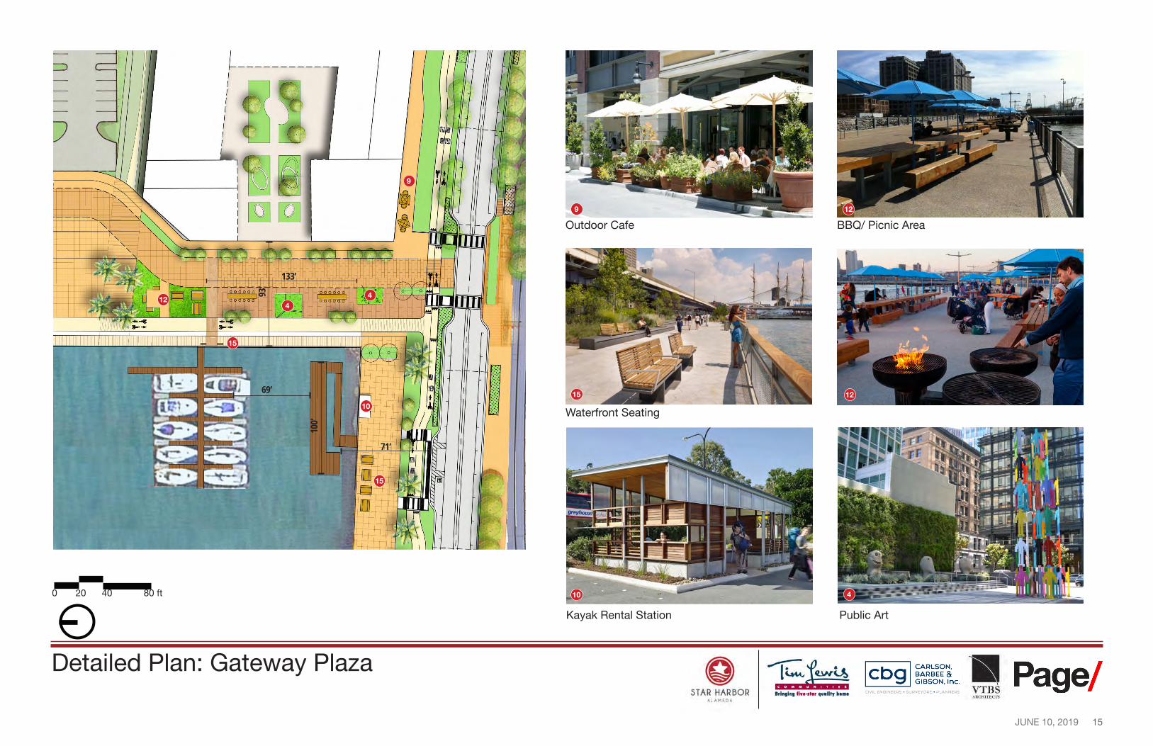
Outdoor Cafe BBQ/ Picnic Area
12
15
4
4
15 12
10 Waterfront Seating
15
4
Public Art
0 20 40 80 ft 10
Kayak Rental Station
Detailed Plan: Gateway Plaza
16 JUNE 10, 2019
61’
17’
49’
26’
235’
56’
Planting Area
12
E)
0 STAR HARBOR
All.MEDI\
• CARLSON. BARBEE & GIBSON. Inc.
OVIL ENGINEERS . SURVEYORS . PLANNERS ■ Page/ VTBS
ARCHrfEC'J'S
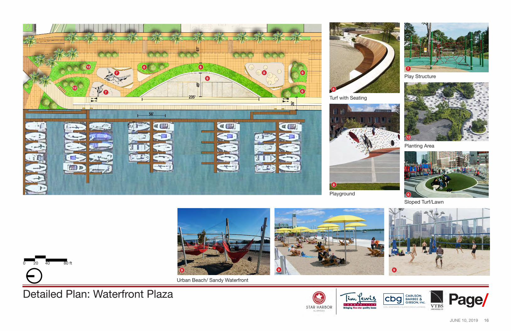
Play Structure 87
7
7 6
6
612
9
6
612
Turf with Seating
8
Playground 6
Sloped Turf/Lawn
0 20 40 80 ft
9 9 9
Urban Beach/ Sandy Waterfront
Detailed Plan: Waterfront Plaza
17 JUNE 10, 2019
118’ 79
’
60’ Turf Slope
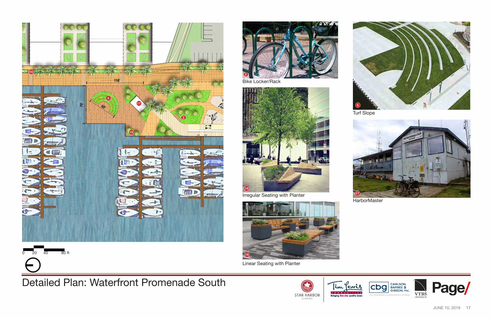
5
Irregular Seating with Planter
15
15
5
17
17
3
Bike Locker/Rack
3
15
15
Linear Seating with Planter
. - ·i~ •. I!- -~ " , _..., 1, ' . . ..
......... __ E)
0 STAR HARBOR
All.MEDI\
CARLSON. BARBEE & GIBSON. Inc.
OVIL ENGINEERS . SURVEYORS . PLANNERS ■ Page/ VTBS
ARCHrfEC'J'S
HarborMaster
0 20 40 80 ft
Detailed Plan: Waterfront Promenade South
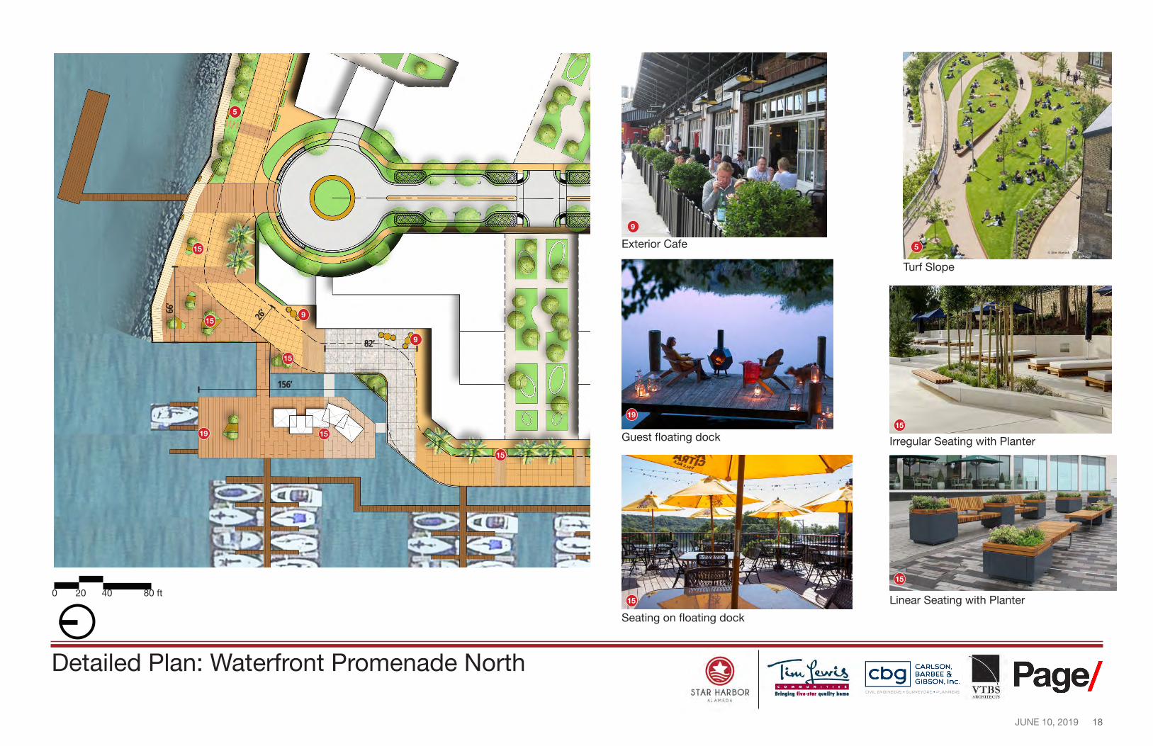
18 JUNE 10, 2019
156’
26’
82’
66’
15
15
Linear Seating with Planter
E)
0 STAR HARBOR
All.MEDI\
CARLSON. BARBEE & GIBSON. Inc.
OVIL ENGINEERS . SURVEYORS . PLANNERS ■ Page/ VTBS
ARCHrfEC'J'S
5
9
15 Exterior Cafe 5
Turf Slope
15
15 9
9
19 15
Guest foating dock Irregular Seating with Planter 1519
15
Seating on foating dock
0 20 40 80 ft
Detailed Plan: Waterfront Promenade North
19 JUNE 10, 2019
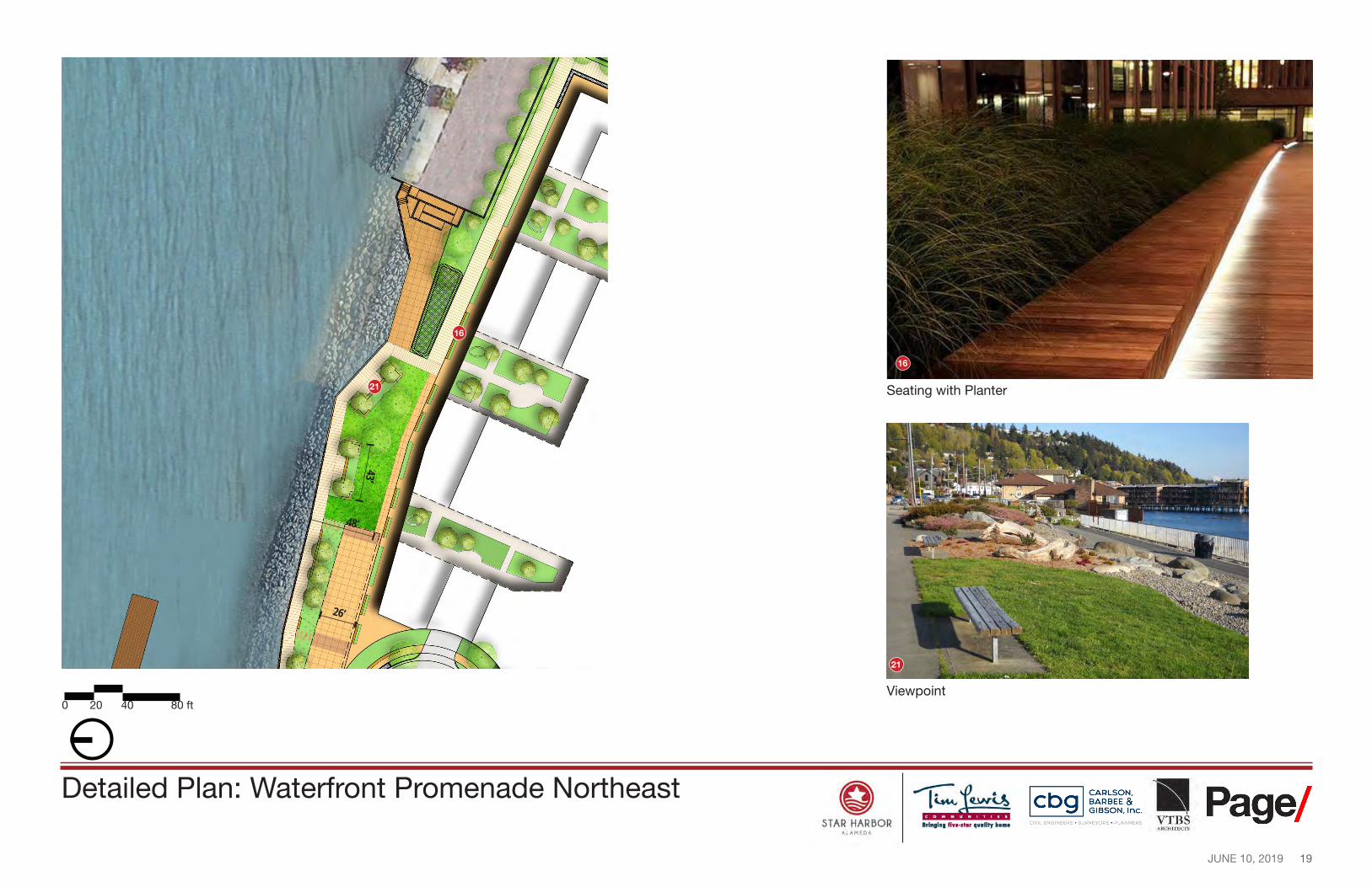
48’
26’
43’
E)
0 STAR HARBOR
All.MEDI\
CARLSON. BARBEE & GIBSON. Inc.
OVIL ENGINEERS . SURVEYORS . PLANNERS ■ Page/ VTBS
ARCHrfEC'J'S
Seating with Planter
16
21
16
21
Viewpoint 0 20 40 80 ft
Detailed Plan: Waterfront Promenade Northeast
20 JUNE 10, 2019
STAR HARBOR --r-=iu.r~
lri111ln1 fiwe-1t■r 11••litr hon1• All.MEDI,
CARLSON, BARBEE & GIBSON, Inc.
OVIL ENGINEERS • SURVEYORS • PLANNERS ! Page/
ARCHHeC-11S
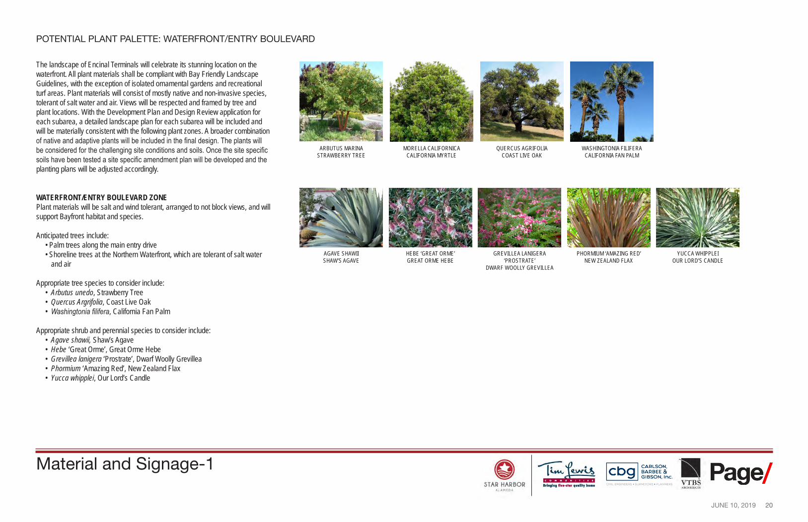
POTENTIAL PLANT PALETTE: WATERFRONT/ENTRY BOULEVARD
The landscape of Encinal Terminals will celebrate its stunning location on the waterfront. All plant materials shall be compliant with Bay Friendly Landscape Guidelines, with the exception of isolated ornamental gardens and recreational turf areas. Plant materials will consist of mostly native and non-invasive species, tolerant of salt water and air. Views will be respected and framed by tree and plant locations. With the Development Plan and Design Review application for each subarea, a detailed landscape plan for each subarea will be included and will be materially consistent with the following plant zones. A broader combination of native and adaptive plants will be included in the final design. The plants will be considered for the challenging site conditions and soils. Once the site specific soils have been tested a site specific amendment plan will be developed and the planting plans will be adjusted accordingly.
WATERFRONT/ENTRY BOULEVARD ZONE Plant materials will be salt and wind tolerant, arranged to not block views, and will support Bayfront habitat and species.
Anticipated trees include: • Palm trees along the main entry drive • Shoreline trees at the Northern Waterfront, which are tolerant of salt water
and air
Appropriate tree species to consider include: • Arbutus unedo, Strawberry Tree • Quercus Argrifolia, Coast Live Oak • Washingtonia filifera, California Fan Palm
Appropriate shrub and perennial species to consider include: • Agave shawii, Shaw’s Agave • Hebe ‘Great Orme’, Great Orme Hebe • Grevillea lanigera ‘Prostrate’, Dwarf Woolly Grevillea • Phormium ‘Amazing Red’, New Zealand Flax • Yucca whipplei, Our Lord’s Candle
ARBUTUS MARINA STRAWBERRY TREE
MORELLA CALIFORNICA CALIFORNIA MYRTLE
QUERCUS AGRIFOLIA COAST LIVE OAK
WASHINGTONIA FILIFERA CALIFORNIA FAN PALM
AGAVE SHAWII SHAW’S AGAVE
HEBE ‘GREAT ORME’ GREAT ORME HEBE
GREVILLEA LANIGERA ‘PROSTRATE’
DWARF WOOLLY GREVILLEA
PHORMIUM ‘AMAZING RED’ NEW ZEALAND FLAX
YUCCA WHIPPLEI OUR LORD’S CANDLE
Material and Signage-1
21 JUNE 10, 2019
32
Limonium californicum, Sea Lavender
Dichelostemma congestum, Ookow
Muhlenbergia rigens, Deer Grass Baccharis pilularis “pilularis”, Dwarf Coyote Bush Ceanothus thyrsiflorus repens, Creeping Blue Blossom
I. i. I• • •· .•• ~. , . ,·•~ --- ' . ~, , r -~:-l> -.~ ··. ;;:~)] : ·._ ... {}~~-->~~,~~;___ ·, .. ✓ • j ' ~~-,-'1}[{ ~~ <·, -- , ,\,; ' J.t ,, ~ '"" \-111,. • .,
. Ii- • , __ , ... '.... 11. .... ·.~ . ~~-,.,,i ,,,.,_;.' 7,_.<,...
STAR HARBOR --r-=iu.r~
lri111ln1 fiwe-1t■r 11••litr hon1• ALAMEDA
CARLSON, BARBEE & GIBSON, Inc.
OVIL ENGINEERS • SURVEYORS • PLANNERS ! Page/
ARCHHeC-11S
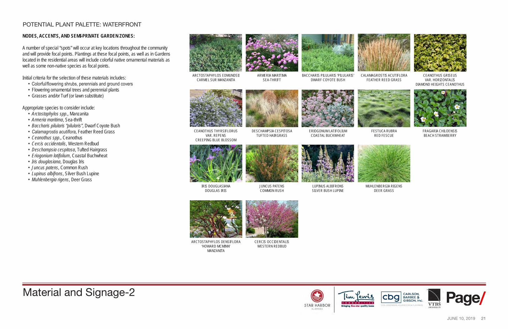
POTENTIAL PLANT PALETTE: WATERFRONT
NODES, ACCENTS, AND SEMI-PRIVATE GARDEN ZONES:
A number of special “spots” will occur at key locations throughout the community and will provide focal points. Plantings at these focal points, as well as in Gardens located in the residential areas will include colorful native ornamental materials as well as some non-native species as focal points.
Initial criteria for the selection of these materials includes: • Colorful/flowering shrubs, perennials and ground covers • Flowering ornamental trees and perennial plants • Grasses and/or Turf (or lawn substitute)
Appropriate species to consider include: • Arctostaphylos spp., Manzanita • Armeria maritima, Sea-thrift • Baccharis pilularis “pilularis”, Dwarf Coyote Bush • Calamagrostis acutiflora, Feather Reed Grass • Ceanothus spp., Ceanothus • Cercis occidentalis, Western Redbud • Deschampsia cespitosa, Tufted Hairgrass • Eriogonium latifolium, Coastal Buchwheat • Iris douglasiana, Douglas Iris • Juncus patens, Common Rush • Lupinus albifrons, Silver Bush Lupine • Muhlenbergia rigens, Deer Grass
ARCTOSTAPHYLOS EDMUNDSII CARMEL SUR MANZANITA
ARMERIA MARITIMA SEA-THRIFT
BACCHARIS PILULARIS ‘PILULARIS’ DWARF COYOTE BUSH
CALAMAGROSTIS ACUTIFLORA FEATHER REED GRASS
CEANOTHUS GRISEUS VAR. HORIZONTALIS
DIAMOND HEIGHTS CEANOTHUS
CEANOTHUS THYRSIFLORUS VAR. REPENS
CREEPING BLUE BLOSSOM
DESCHAMPSIA CESPITOSA TUFTED HAIRGRASS
ERIOGONUM LATIFOLIUM COASTAL BUCKWHEAT
FESTUCA RUBRA RED FESCUE
FRAGARIA CHILOENSIS BEACH STRAWBERRY
IRIS DOUGLASIANA DOUGLAS IRIS
JUNCUS PATENS COMMON RUSH
LUPINUS ALBIFRONS SILVER BUSH LUPINE
MUHLENBERGIA RIGENS DEER GRASS
ARCTOSTAPHYLOS DENSIFLORA ‘HOWARD MCMINN’
MANZANITA
CERCIS OCCIDENTALIS WESTERN REDBUD
Material and Signage-2
22 JUNE 10, 2019
0 5 10 20ft
---- -
STAR HARBOR --r-=iu.r~
lri111ln1 fiwe-1t■r 11••litr hon1• All.MEDI,
CARLSON, BARBEE & GIBSON, Inc.
OVIL ENGINEERS • SURVEYORS • PLANNERS ! Page/
ARCHHeC-11S
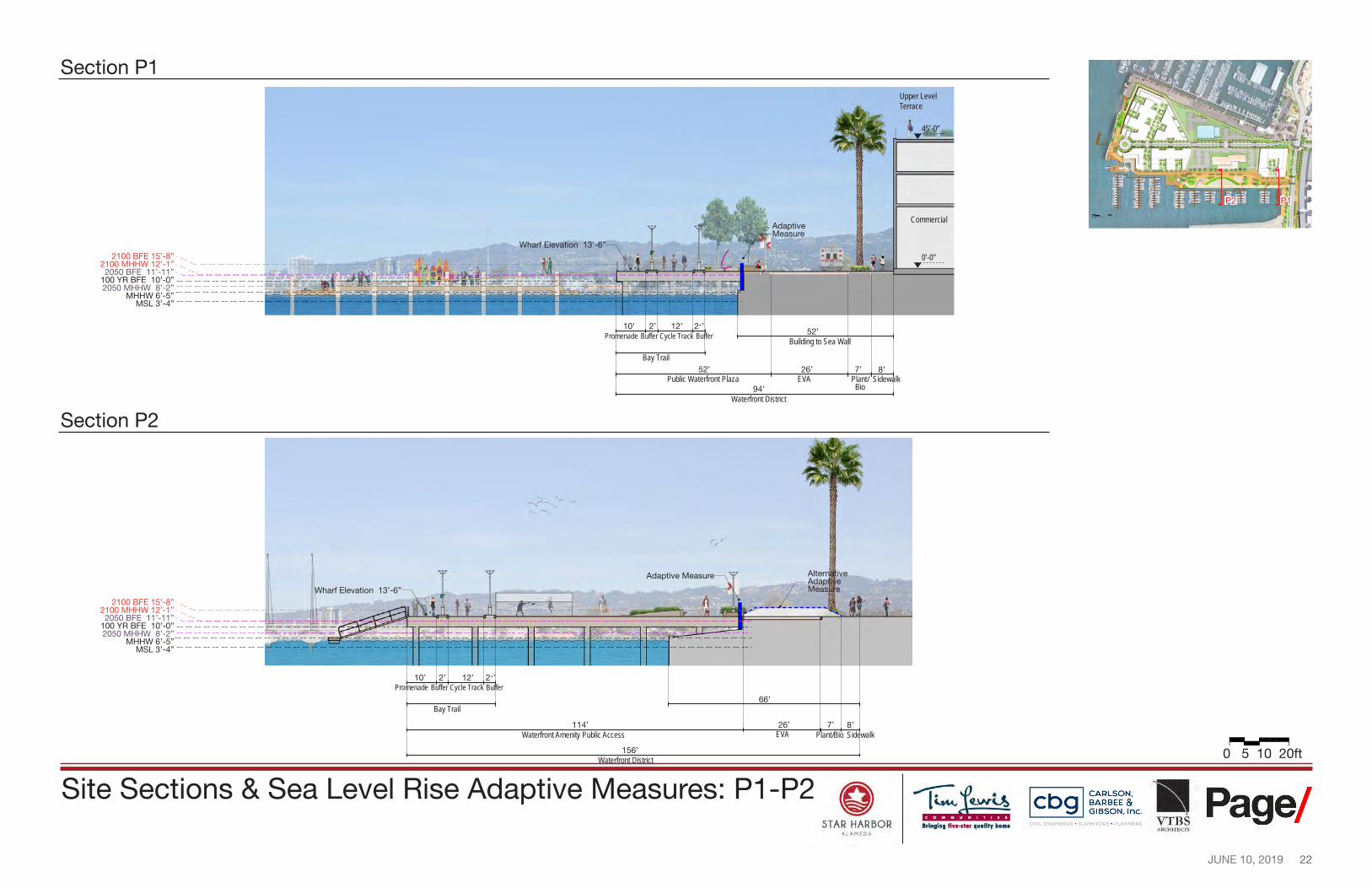
Section P1 Upper Level Terrace
45’-0”
P1P2
Commercial Adaptive Measure
Wharf Elevation 13’-6” 2100 BFE 15’-8” 0’-0”
2100 MHHW 12’-1” 2050 BFE 11’-11”
100 YR BFE 10’-0” 2050 MHHW 8’-2”
MHHW 6’-5” MSL 3’-4”
10’ 2’ 12’ 2+’ 52’Promenade Buffer Cycle Track Buffer Building to Sea Wall
Bay Trail 52’ 26’ 7’ 8’
Public Waterfront Plaza EVA Plant/ Sidewalk Bio
Waterfront District 94’
Section P2
Alternative Adaptive
Wharf Elevation 13’-6” Measure
Adaptive Measure
2100 BFE 15’-8” 2100 MHHW 12’-1” 2050 BFE 11’-11”
100 YR BFE 10’-0” 2050 MHHW 8’-2”
MHHW 6’-5” MSL 3’-4”
10’ 2’ 12’ 2+’ Promenade Buffer Cycle Track Buffer
66’ Bay Trail
114’ 26’ 7’ 8’ Waterfront Amenity Public Access EVA Plant/Bio Sidewalk
156’ Waterfront District
Site Sections & Sea Level Rise Adaptive Measures: P1-P2
23 JUNE 10, 2019
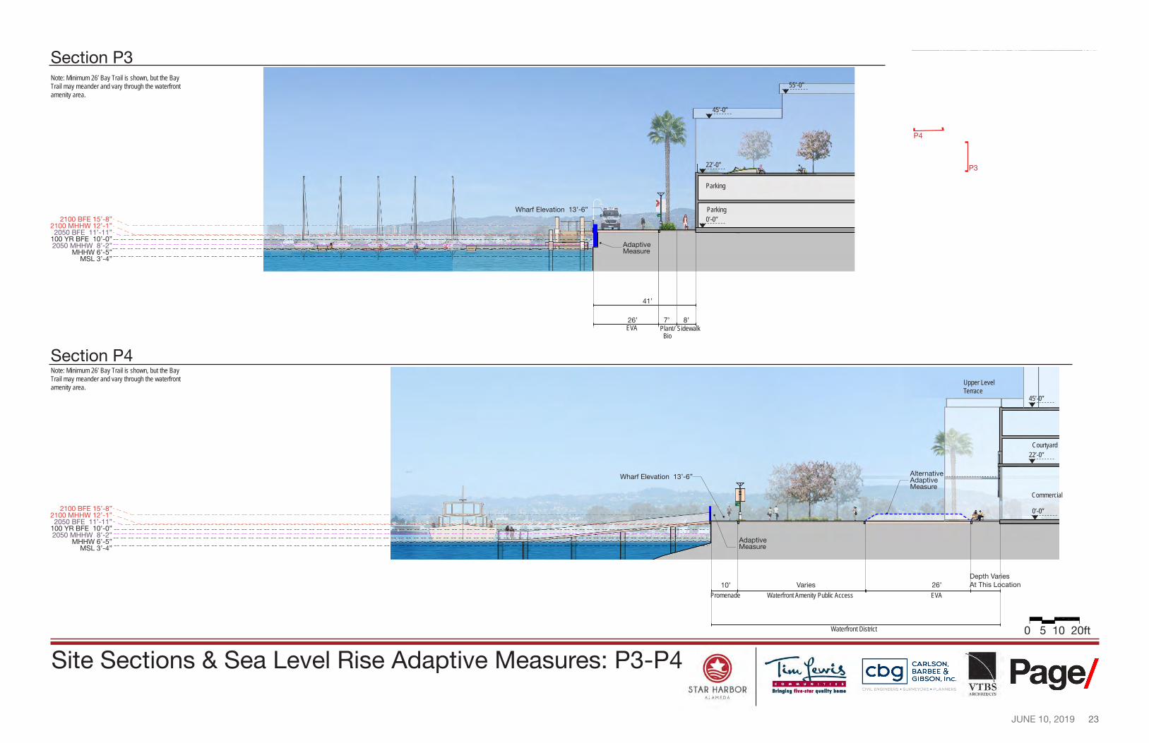
Section P4
45’-0”
22’-0”
0’-0”
Commercial
Courtyard
Upper Level Terrace
Note: Minimum 26’ Bay Trail is shown, but the Bay Trail may meander and vary through the waterfront amenity area.
0 5 10 20ft
Alternative Adaptive Measure
Adaptive Measure
Varies 26’
EVA
Depth Varies At This Location
Waterfront Amenity Public Access 10’
Promenade
STAR HARBOR --r-=iu.r~
lri111ln1 fiwe-1t■r 11••litr hon1• All.MEDI,
,., ------
, .. __ [ _______ _
----,
CARLSON, BARBEE & GIBSON, Inc.
OVIL ENGINEERS • SURVEYORS • PLANNERS ! Page/
ARCHHeC-11S
Section P3 Note: Minimum 26’ Bay Trail is shown, but the Bay Trail may meander and vary through the waterfront amenity area.
2100 BFE 15’-8” 2100 MHHW 12’-1” 2050 BFE 11’-11”
100 YR BFE 10’-0” 2050 MHHW 8’-2”
MHHW 6’-5” MSL 3’-4”
EVA Plant/ Sidewalk Bio
55’-0”
45’-0”
22’-0”
0’-0”
Parking
Parking
41’
26’ 7’ 8’
Wharf Elevation 13’-6”
AdaptiveMeasure
P3
P4
Wharf Elevation 13’-6”
2100 BFE 15’-8” 2100 MHHW 12’-1” 2050 BFE 11’-11”
100 YR BFE 10’-0” 2050 MHHW 8’-2”
MHHW 6’-5” MSL 3’-4”
Waterfront District
Site Sections & Sea Level Rise Adaptive Measures: P3-P4
24 JUNE 10, 2019
0 5 10 20ft
PrimaryAdaptive Measure
Secondary Adaptive Measure
--..:
(' / r
/ ----------------
0 STAR HARBOR
All.MEDI\
y -------
4
CARLSON. BARBEE & GIBSON. Inc.
OVIL ENGINEERS · SURVEYORS · PLANNERS ■ Page/
ARCHrfEC'J'S
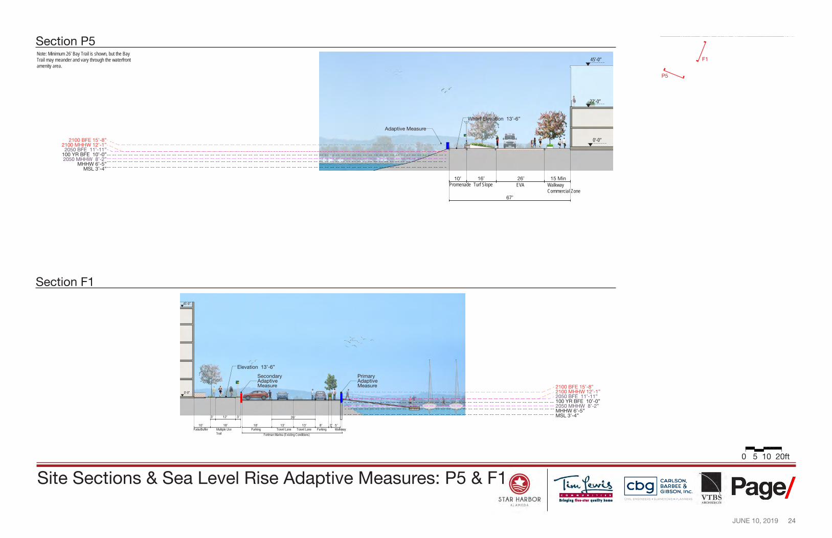
Section P5 Note: Minimum 26’ Bay Trail is shown, but the Bay Trail may meander and vary through the waterfront amenity area.
2100 BFE 15’-8” 2100 MHHW 12’-1” 2050 BFE 11’-11”
100 YR BFE 10’-0” 2050 MHHW 8’-2”
MHHW 6’-5” MSL 3’-4”
Promenade Turf Slope EVA Walkway Commercial Zone
67’
45’-0”
22’-0”
0’-0”
Wharf Elevation 13’-6”
Adaptive Measure
26’ 15 Min10’ 16’
Section F1
F1
P5
45’-0”
Elevation 13’-6”
2100 BFE 15’-8” 2100 MHHW 12’-1”0’-0” 2050 BFE 11’-11” 100 YR BFE 10’-0” 2050 MHHW 8’-2” MHHW 6’-5”
3’ 12’ 3’ 26’ MSL 3’-4”
10’ 18’ 18’ 13’ 13’ 8’ 2’ 5’ Patio/Buffer Multiple Use Parking Travel Lane Travel Lane Parking Walkway
Trail Fortman Marina (Existing Conditions)
Site Sections & Sea Level Rise Adaptive Measures: P5 & F1
25 JUNE 10, 2019
0 5 10 20ft
PrimaryAdaptive Measure
Secondary Adaptive Measure
PrimaryAdaptive Measure
11
' '-----------
\ I
\_ -,, - __________ .,. ___ ...
== ~ - -- -- -- -- -- -- -- -- -- -- -- -- -- -- -- -- -- -- -- -- --
IDDIDI□~
0 STAR HARBOR
All.MEDI\
CARLSON. BARBEE & GIBSON. Inc.
OVIL ENGINEERS · SURVEYORS · PLANNERS ■ Page/
ARCHrfEC'J'S
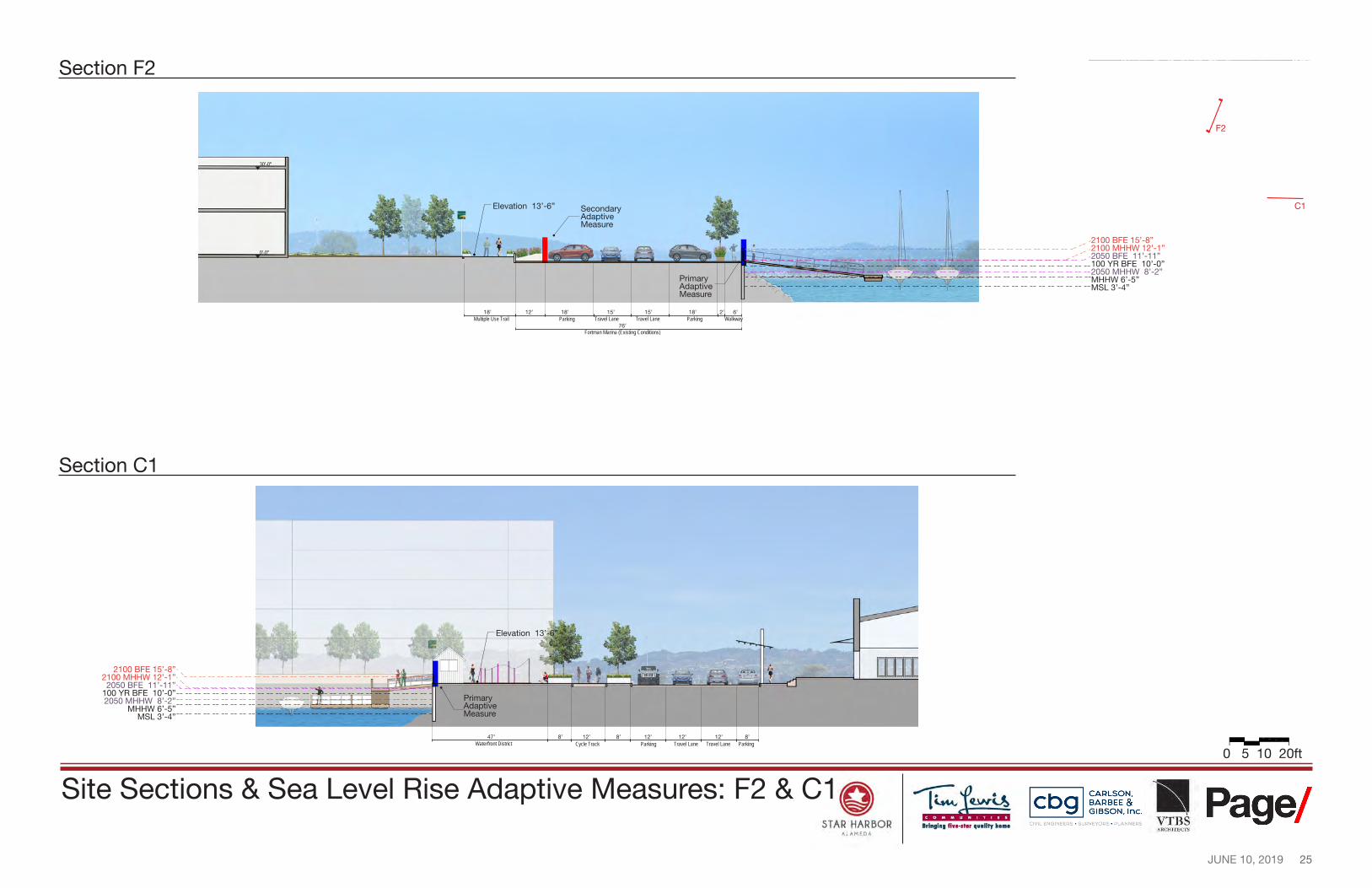
Section F2
30’-0”
Elevation 13’-6”
2100 BFE 15’-8”
F2
C1
2100 MHHW 12’-1”0’-0” 2050 BFE 11’-11” 100 YR BFE 10’-0” 2050 MHHW 8’-2” MHHW 6’-5” MSL 3’-4”
18’ 12’ 18’ 15’ 15’ 18’ 2’ 6’ Multiple Use Trail Parking Travel Lane Travel Lane Parking Walkway
76’ Fortman Marina (Existing Conditions)
Section C1
Elevation 13’-6”
2100 BFE 15’-8” 2100 MHHW 12’-1” 2050 BFE 11’-11”
100 YR BFE 10’-0” 2050 MHHW 8’-2”
MHHW 6’-5” MSL 3’-4”
47’ 8’ 12’ 8’ 12’ 12’ 12’ 8’ Waterfront District Cycle Track Parking Travel Lane Travel Lane Parking
Site Sections & Sea Level Rise Adaptive Measures: F2 & C1
STAR HARBOR ALAMEDA
![Warrnambool OPEN SPACE STRATEGY 2014 · WARRNAMBOOL OPEN SPACE STRATEGY 2014 [3] ... Environmental Sustainability: ... The Warrnambool Open Space Strategy considers the open space](https://img.pdfslide.net/doc/110x75/5b14c4a67f8b9ab6778bd350/warrnambool-open-space-strategy-warrnambool-open-space-strategy-2014-3-.jpg)