Embed Size (px)
Citation preview

ENHANCED BIODIVERSITY MONITORING PLAN (EBMP) KHAUZAK-SHADY Project
Prepared By LUKOIL Uzbekistan Operating Company LLC
May 2013
Khauzak-Shady Enhanced Biodiversity Monitoring Plan i
ENHANCED BIODIVERSITY MONITORING PLAN (EBMP) KHAUZAK-SHADY Project
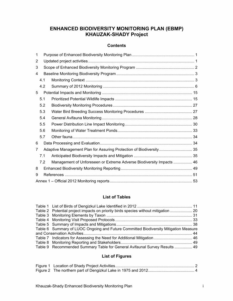
Contents
1 Purpose of Enhanced Biodiversity Monitoring Plan ......................................................... 1
2 Updated project activities. ................................................................................................ 1
3 Scope of Enhanced Biodiversity Monitoring Program ..................................................... 2
4 Baseline Monitoring Biodiversity Program ....................................................................... 3
4.1 Monitoring Context ................................................................................................... 3
4.2 Summary of 2012 Monitoring ................................................................................... 6
5 Potential Impacts and Monitoring .................................................................................. 15
5.1 Prioritized Potential Wildlife Impacts ...................................................................... 15
5.2 Biodiversity Monitoring Procedures ........................................................................ 27
5.3 Water Bird Breeding Success Monitoring Procedures ........................................... 27
5.4 General Avifauna Monitoring .................................................................................. 28
5.5 Power Distribution Line Impact Monitoring ............................................................. 30
5.6 Monitoring of Water Treatment Ponds .................................................................... 33
5.7 Other fauna ............................................................................................................. 34
6 Data Processing and Evaluation .................................................................................... 34
7 Adaptive Management Plan for Assuring Protection of Biodiversity .............................. 35
7.1 Anticipated Biodiversity Impacts and Mitigation ..................................................... 35
7.2 Management of Unforeseen or Extreme Adverse Biodiversity Impacts ................. 46
8 Enhanced Biodiversity Monitoring Reporting ................................................................. 49
9 References .................................................................................................................... 51
Annex 1 – Official 2012 Monitoring reports ........................................................................... 53
List of Tables Table 1 List of Birds of Dengizkul Lake Identified in 2012 .................................................. 11 Table 2 Potential project impacts on priority birds species without mitigation .................... 20 Table 3 Monitoring Elements by Taxon .............................................................................. 31 Table 4 Monitoring Visit Proposed Protocols ...................................................................... 33 Table 5 Summary of Impacts and Mitigations ..................................................................... 38 Table 6 Summary of LUOC Ongoing and Future Committed Biodiversity Mitigation Measure and Conservation Activities ................................................................................................... 44 Table 7 Indicators for Assessing the Need for Additional Mitigation ................................... 46 Table 8 Monitoring Reporting and Stakeholders ................................................................. 49 Table 9 Recommended Summary Table for General Avifaunal Survey Results ................ 49
List of Figures
Figure 1 Location of Shady Project Activities ........................................................................ 2 Figure 2 The northern part of Dengizkul Lake in 1975 and 2012 .......................................... 4
Khauzak-Shady Enhanced Biodiversity Monitoring Plan ii
Figure 3 Satellite Imagery Vegetation Changes in northern Dengizkul ................................ 4 Figure 4 Approximate Extent of Lake Water Surface at Elevation 182m (blue line) .............. 6 Figure 5 Location of Ornithological Survey Stations at Dengizkul Lake in 2012 ................... 7 Figure 6 2012 Principal Nesting and Breeding Areas of Waterbirds at Lake Dengizkul ....... 9 Figure 7 Views of the Bridge at the Strait leading to North-west Bay ................................. 17 Figure 8 Location of Ornithological Survey Points at Dengizkul Lake................................. 29 Figure 9 Monitoring Points at the North-west Bay .............................................................. 29 Figure 10 Location of Transmission Line Transects (orange lines) .................................... 30 Figure 11 Location of Transects in Bridge Area .................................................................. 31 Figure 12 Reeds and Suggested 1km Wide Protective Zone around Reeds in North Part of Dengizkul Lake (green– reed; red–proposed protective zone; dark blue– water level mark 182m above sea level) .......................................................................................................... 37
Khauzak-Shady Enhanced Biodiversity Monitoring Plan 1
1 PURPOSE OF ENHANCED BIODIVERSITY MONITORING PLAN
This document is an Enhanced Biodiversity Monitoring Plan (EBMP) for identifying and monitoring wildlife impacts potentially resulting from the Khauzak–Shady natural gas development around Lake Dengizkul, Uzbekistan. The EBMP supplements and is an essential component of the Biodiversity Action Plan (BAP) (LUOC, 2012), prepared by the project proponent LUKOIL Uzbekistan Operating Company LLC (LUOC). The EBMP and the BAP are designed to ensure compliance of the proposed development with Performance Standard 6 (2006) of the International Finance Corporation (IFC)/ Multilateral Investment Guarantee Agency (MIGA). The EBMP provides an update regarding project-related activities near Lake Dengizkul, and presents more detail on the protocols, methodologies, schedules, and resources that together comprise a robust monitoring program. The EBMP also outlines an adaptive management process that will use the monitoring information to identify and implement any mitigation actions needed to address significant project-related impacts.
The International Finance Corporation (IFC) has developed a series of Performance Standards (2006) that aim at protecting the environment. Performance Standard 6 “recognizes that protecting and conserving biodiversity—the variety of life in all its forms, including genetic, species and ecosystem diversity—and its ability to change and evolve, is fundamental to sustainable development. The components of biodiversity, as defined in the Convention on Biological Diversity, include ecosystems and habitats, species and communities, and genes and genomes, all of which have social, economic, cultural and scientific importance. This Performance Standard reflects the objectives of the Convention on Biological Diversity to conserve biological diversity and promote use of renewable natural resources in a sustainable manner. This Performance Standard addresses how clients can avoid or mitigate threats to biodiversity arising from their operations as well as sustainably manage renewable natural resources.” (IFC, October 2007) The Performance Standards are updated from time to time, most recently in 2012. The BAP and this EBMP have been developed pursuant to the 2006 Performance Standards which were applicable at the time. The Performance Standards also encompass social and environmental sustainability. LUOC recognizes the importance of Lake Dengizkul and its global significance. Through the BAP (LUOC, 2012) and this EBMP, LUOC is taking steps to develop this project in an ecologically responsible manner.
2 UPDATED PROJECT ACTIVITIES.
Drilling of wells on the Western Shady field was completed in 2012, and 9 wells were put into operation (4 wells were put into operation in 4th quarter 2011). Works on utilization of drill cuttings and closure of waste pits, provision of the necessary facilities for well pads of holes and multiple-well platforms, and disturbed land reclamation have been carried out prior to putting wells into operation.
Works on construction of the bridge, power transmission lines and fiber-optic cable across the strait of the Dengizkul Lake, executed in one corridor, were completed in 2012. Crossing of the strait of the Dengizkul Lake was made in the narrowest place, provided with water discharge facility, sufficient for unobstructed water flow and not changing the hydrological regime of the lake.
Khauzak-Shady Enhanced Biodiversity Monitoring Plan 2
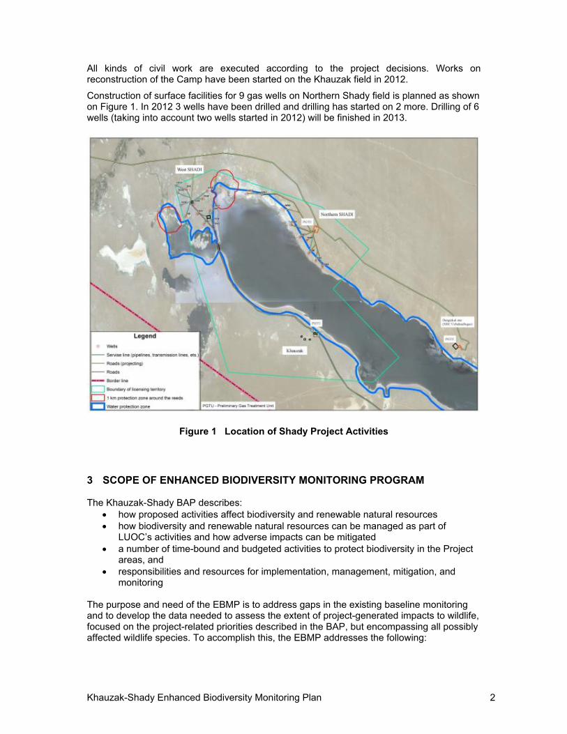
All kinds of civil work are executed according to the project decisions. Works on reconstruction of the Camp have been started on the Khauzak field in 2012.
Construction of surface facilities for 9 gas wells on Northern Shady field is planned as shown on Figure 1. In 2012 3 wells have been drilled and drilling has started on 2 more. Drilling of 6 wells (taking into account two wells started in 2012) will be finished in 2013.
Figure 1 Location of Shady Project Activities
3 SCOPE OF ENHANCED BIODIVERSITY MONITORING PROGRAM The Khauzak-Shady BAP describes:
how proposed activities affect biodiversity and renewable natural resources how biodiversity and renewable natural resources can be managed as part of
LUOC’s activities and how adverse impacts can be mitigated a number of time-bound and budgeted activities to protect biodiversity in the Project
areas, and responsibilities and resources for implementation, management, mitigation, and
monitoring The purpose and need of the EBMP is to address gaps in the existing baseline monitoring and to develop the data needed to assess the extent of project-generated impacts to wildlife, focused on the project-related priorities described in the BAP, but encompassing all possibly affected wildlife species. To accomplish this, the EBMP addresses the following:
Khauzak-Shady Enhanced Biodiversity Monitoring Plan 3
Identification of Significant Impacts—this includes all wildlife biology impacts that have been determined as potentially resulting from the project. Pollution, disease, soil, and other impacts are treated separately in the BAP in an indicator section. Wildlife biology impacts covered in this EBMP include direct mortality from collision or electrocution with power lines and other structures, habitat loss, fragmentation, behavioral disturbance, impacts to breeding success, and habitat utilization.
Mitigation of Significant Impacts—the EBMP covers all proposed mitigation measures currently being implemented to avoid, minimize or compensate for the significant impacts listed in the BAP. In addition, the EBMP provides for an adaptive management approach to deal with new or unexpected impacts.
Taxa—Includes prioritization, i.e., how consideration of criteria for all taxa occurring in the region resulted in a prioritization of taxa for the EBMP on the basis of the global and regional significance of the predicted impacts on wildlife from the proposed project
Content—The EBMP provides specifics on what, when, where, and how for each specific monitoring protocol to be employed as a component of the EBMP, based on the “why” derived from the prioritization
4 BASELINE MONITORING BIODIVERSITY PROGRAM
4.1 Monitoring Context
Dengizkul Lake was originally the end point of the Zeravshan River. It covered approximately 120 km2 in 1914 but had dried up completely by the mid-1950s due to over-extraction from the river. A lake was re-established in the mid-1960s from surplus irrigation water.
Dengizkul Lake is currently fed by two sources (1) a small canal bringing surplus water from the Amu-Bukhara Canal and (2) a separate, and smaller, collector that brings agricultural waste water that may contain varying amounts of chemicals. The volume of water entering the lake from both sources is variable and unpredictable and fluctuations in water levels affect marginal vegetation and other shoreline habitats.
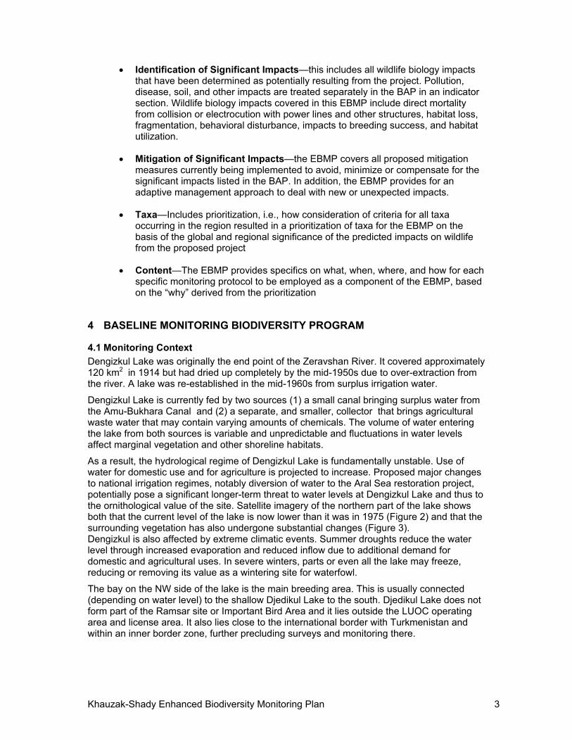
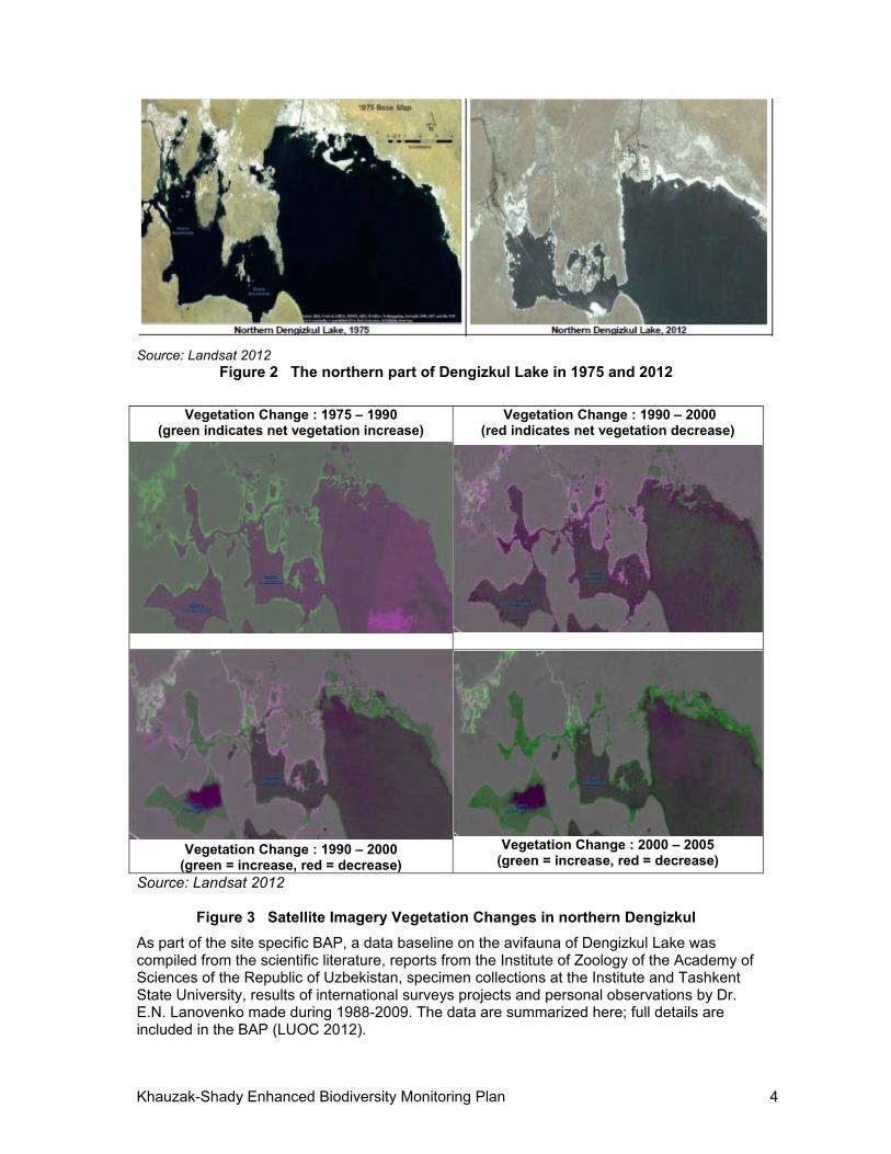
As a result, the hydrological regime of Dengizkul Lake is fundamentally unstable. Use of water for domestic use and for agriculture is projected to increase. Proposed major changes to national irrigation regimes, notably diversion of water to the Aral Sea restoration project, potentially pose a significant longer-term threat to water levels at Dengizkul Lake and thus to the ornithological value of the site. Satellite imagery of the northern part of the lake shows both that the current level of the lake is now lower than it was in 1975 (Figure 2) and that the surrounding vegetation has also undergone substantial changes (Figure 3). Dengizkul is also affected by extreme climatic events. Summer droughts reduce the water level through increased evaporation and reduced inflow due to additional demand for domestic and agricultural uses. In severe winters, parts or even all the lake may freeze, reducing or removing its value as a wintering site for waterfowl.
The bay on the NW side of the lake is the main breeding area. This is usually connected (depending on water level) to the shallow Djedikul Lake to the south. Djedikul Lake does not form part of the Ramsar site or Important Bird Area and it lies outside the LUOC operating area and license area. It also lies close to the international border with Turkmenistan and within an inner border zone, further precluding surveys and monitoring there.
Khauzak-Shady Enhanced Biodiversity Monitoring Plan 4
Source: Landsat 2012 Figure 2 The northern part of Dengizkul Lake in 1975 and 2012
Vegetation Change : 1975 – 1990
(green indicates net vegetation increase)
Vegetation Change : 1990 – 2000 (red indicates net vegetation decrease)
Vegetation Change : 1990 – 2000 (green = increase, red = decrease)
Vegetation Change : 2000 – 2005 (green = increase, red = decrease)
Source: Landsat 2012
Figure 3 Satellite Imagery Vegetation Changes in northern Dengizkul
As part of the site specific BAP, a data baseline on the avifauna of Dengizkul Lake was compiled from the scientific literature, reports from the Institute of Zoology of the Academy of Sciences of the Republic of Uzbekistan, specimen collections at the Institute and Tashkent State University, results of international surveys projects and personal observations by Dr. E.N. Lanovenko made during 1988-2009. The data are summarized here; full details are included in the BAP (LUOC 2012).
Khauzak-Shady Enhanced Biodiversity Monitoring Plan 5
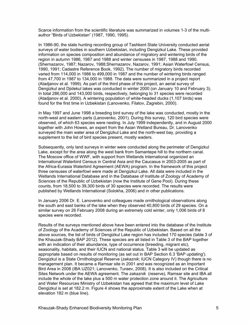
Scarce information from the scientific literature was summarized in volumes 1-3 of the multi-author “Birds of Uzbekistan” (1987, 1990, 1995). In 1986-90, the state hunting recording group of Tashkent State University conducted aerial surveys of water bodies in southern Uzbekistan, including Dengizkul Lake. These provided information on species composition and abundance of migratory and wintering birds of the region in autumn 1986, 1987 and 1988 and winter censuses in 1987, 1988 and 1990. (Shernazarov, 1987; Nazarov, 1988;Shernazarov, Nazarov, 1991; Asian Waterfowl Census, 1990, 1991; Cadastre Reference Book, 1992). The number of migratory birds recorded varied from 114,000 in 1986 to 499,000 in 1987 and the number of wintering birds ranged from 47,700 in 1987 to 134,000 in 1988. The data were summarized in a project report (Atadjanov et al. 1999). As part of the third phase of this project, an aerial survey of Dengizkul and Djidekul lakes was conducted in winter 2000 (on January 10 and February 3). In total 286,000 and 143,000 birds, respectively, belonging to 31 species were recorded (Atadjanov et al. 2000). A wintering population of white-headed ducks (1,107 birds) was found for the first time in Uzbekistan (Lanovenko, Filatov, Zagrebin, 2000). In May 1997 and June 1998 a breeding bird survey of the lake was conducted, mostly in the north-west and eastern parts (Lanovenko, 2001). During this survey, 120 bird species were observed, of which 63 species were nesting. In July 1999 independently, and in August 2000 together with John Howes, an expert from the Asian Wetland Bureau, Dr. Lanovenko surveyed the main water area of Dengizkul Lake and the north-west bay, providing a supplement to the list of bird species present, mostly waders. Subsequently, only land surveys in winter were conducted along the perimeter of Dengizkul Lake, except for the area along the west bank from Samantepe hill to the northern canal. The Moscow office of WWF, with support from Wetlands International organized an International Waterbird Census in Central Asia and the Caucasus in 2003-2005 as part of the Africa-Eurasia Waterbird Agreement (AEWA) program. In the framework of this project three censuses of waterfowl were made at Dengizkul Lake. All data were included in the Wetlands International Database and in the Database of Institute of Zoology of Academy of Sciences of the Republic of Uzbekistan (now the Institute of Gene Pool). During these counts, from 18,500 to 39,300 birds of 30 species were recorded. The results were published by Wetlands International (Solokha, 2006) and in other publications. In January 2006 Dr. E. Lanovenko and colleagues made ornithological observations along the south and east banks of the lake when they observed 40,800 birds of 29 species. On a similar survey on 26 February 2008 during an extremely cold winter, only 1,006 birds of 8 species were recorded. Results of the surveys mentioned above have been entered into the database of the Institute of Zoology of the Academy of Sciences of the Republic of Uzbekistan. Based on all the above sources, the list of birds of Dengizkul Lake region has included 170 species (table 3 of the Khauzak-Shady BAP 2012). These species are all listed in Table 3 of the BAP together with an indication of their abundance, type of occurrence (breeding, migrant etc), seasonality, habitats, and their IUCN and national status. Table 3 will be updated as appropriate based on results of monitoring (as set out in BAP Section 6.3 'BAP updating'). Dengizkul is a State Ornithological Reserve (zakaznik; IUCN Category IV) though there is no management plan. It became a Ramsar site in 2001 and was recognized as an Important Bird Area in 2008 (IBA UZ021; Lanovenko, Turaev, 2008). It is also included on the Critical Sites Network under the AEWA agreement. The zakaznik (reserve), Ramsar site and IBA all include the whole of the lake plus a 500 m water protection zone around it. The Agriculture and Water Resources Ministry of Uzbekistan has agreed that the maximum level of Lake Dengizkul is set at 182.2 m. Figure 4 shows the approximate extent of the Lake when at elevation 182 m (blue line).
Khauzak-Shady Enhanced Biodiversity Monitoring Plan 6
Source: Lanovenko 2012 (Annex 1)
Figure 4 Approximate Extent of Lake Water Surface at Elevation 182m (blue line)
4.2 Summary of 2012 Monitoring
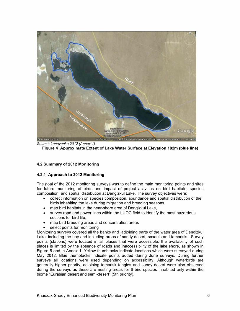
4.2.1 Approach to 2012 Monitoring The goal of the 2012 monitoring surveys was to define the main monitoring points and sites for future monitoring of birds and impact of project activities on bird habitats, species composition, and spatial distribution at Dengizkul Lake. The survey objectives were:
collect information on species composition, abundance and spatial distribution of the birds inhabiting the lake during migration and breeding seasons,
map bird habitats in the near-shore area of Dengizkul Lake, survey road and power lines within the LUOC field to identify the most hazardous
sections for bird life, map bird breeding areas and concentration areas select points for monitoring
Monitoring surveys covered all the banks and adjoining parts of the water area of Dengizkul Lake, including the bay and including areas of sandy desert, saxauls and tamarisks. Survey points (stations) were located in all places that were accessible; the availability of such places is limited by the absence of roads and inaccessibility of the lake shore, as shown in Figure 5 and in Annex 1. Yellow thumbtacks indicate locations which were surveyed during May 2012. Blue thumbtacks indicate points added during June surveys. During further surveys all locations were used depending on accessibility. Although waterbirds are generally higher priority, adjoining tamarisk tangles and sandy desert were also observed during the surveys as these are nesting areas for 6 bird species inhabited only within the biome “Eurasian desert and semi-desert” (5th priority).

Khauzak-Shady Enhanced Biodiversity Monitoring Plan 7
May 2012 May 2012
June and September 2012
November 2012
Source: GoogleEarth 2012 and Lanovenko 2012 (see Annex 1)
Figure 5 Location of Ornithological Survey Stations at Dengizkul Lake in 2012
The basic field survey method was by visual observation using 10x binoculars and a Viking telescope with 60x magnification. Bird species were identified in accordance with "Birds of Europe" (Mullarney, Swensson, Zetterstrom, Grant, 1999) and with the help of photographs taken with a Sony digital camera. Survey points were fixed by GPS (Garmin E-Trex). Satellite images made in 2012 by Google Earth (version 6.1) were used as the cartographic base for mapping of survey points, habitats, and locations of migrant concentration and bird breeding. The main technique used consisted of fixed point counts from each survey point. Duration of counts depends on number of species, number of birds and identification ability. These were of short duration (5-10 minutes), except where concentrations of large numbers of birds required more prolonged observation to estimate numbers present and species composition. The length of time varied according to the number of birds present. A few line transects up to a maximum of 500 m were carried out where waders were scattered along a stretch of shoreline. Results of such transects counts were added to results of general counts on nearest survey points. To define the higher risk areas for water birds along the 25 km of power transmission line, 9-12 transects, each 1 km long and 40 m wide (20 m on each side of the power line) were walked and visually surveyed. All birds observed within the strip and perching on the lines and power transmission poles were recorded. Bird movements in the area of the bridge/strait were conducted early in the morning and in a second half of the day until dark during each

Khauzak-Shady Enhanced Biodiversity Monitoring Plan 8
visit. Duration of surveys depended on duration of counts on points located in this area. In the process, the following were recorded: number and species of birds flying above, under and between the power transmission lines; height of flight. Birds that perished from collision with lines and their remains were also searched for. 20 km of motor road were also surveyed to assess potential impact of the road and traffic on migrating birds. Ten transects, including the road and the adjacent 20m strip on each side, were walked. These transects were 1km long and located side-by-side with power line transects. They were surveyed during each of the visits (May, June, September, November). Points of transects are shown in Minute 2 in appendices of official monitoring report (Annex 1). The following data were recorded: bird species flying in the survey strip, numbers, and flight height. Birds that perished from collision with vehicles and their remains were also searched for.
4.2.2 Year 2012 Monitoring Results Annex 1 presents the official 2012 monitoring reports developed by Dr. E. Lanovenko, Dr. E. Shernazarov (Associate Professor of Biology, expert-ornithologist), A. Filatov expert-ornithologist, S.Zagrebin expert-ornithologist and E.Filatova expert-ornithologist-ecologist and responsible for official acts and protocols under Contract No. 17/2012-Л with State Specialized Inspection of Analytical Control of State Committee for Nature Protection of the Republic of Uzbekistan with participation of A. Kh. Tukhsanov and K.R. Achmedov - LUOC Environmental Engineers. The report is summarized here. In 2012 ornithological monitoring was carried out during the following basic biological life stages of hydrophilic birds: spring migration (April – early May), beginning of breeding season (early May), end of breeding season (late June), autumn migration of early migrants (September) and autumn migration of late migrants, which this year took place comparatively late (November). Winter surveys in 2013 were conducted on 25-26th of January. Critical wintering area varies from year to year depending on general weather conditions such as temperature (mild or cold winter) and particular factors like ice formation, wind, etc. Hydrophilic species of birds use the following habitats at the Dengizkul Lake: water area and shoals for feeding and rest, the strip along the shore as feeding and rest area, islands and shallows for breeding and rest, reed thickets for breeding and shelter. The fluctuation of water surface level, caused by unstable water inflow and natural evaporation that are not connected with the project activity, results in growing level of salinity, shallowing and salinification of lakeshores and has great impact on the habitat viability for hydrophilic birds, especially shoals and reed thickets. This was observed in the north and south-west parts of the Lake and in the north-west bay. Project activity in the vicinity of reed thickets and other breeding areas, especially those used by globally threatened species (1-2 priority groups of BAP) and species registered in the national Red Book (3rd priority group of BAP), may disturb and affect success of breeding of these species. In order to avoid negative impact of construction works in the northern part of the lake it is necessary to provide preventive measures, as discussed in Section 7.1. Results from the 2012 monitoring identified the areas highlighted in Figure 6 as the principal nesting and breeding areas for Great egret, Little egret, Grey heron, Great cormorant, Pygmy cormorant, Mute swan and Red-crested pochard. Nests of these species were found, broods of Red-crested pochard and Mute swan were observed. Also young birds of Great and Pygmy cormorants, Yellow-legged and Slender-billed gulls were registered. This territory includes not only little strip of reeds, but shallows and sand bars where swans,

Khauzak-Shady Enhanced Biodiversity Monitoring Plan 9
egrets, herons, cormorants made their nests using branches of tamarisk, saxaul and other plants. Highest priority species (White-headed duck, Marbled teal and Ferruginous duck) did not breed at Dengizkul Lake in 2012 but if this occurs in future it will be presumably in reeds within outlined area.
Figure 6 2012 Principal Nesting and Breeding Areas of Waterbirds at Lake Dengizkul
Only waterbird habitats on the shores of the bay, connecting the lake and north-west bay, were altered significantly due to Khauzak-Shady project activities. As a result of bridge construction and laying of the pipeline, heavy machinery completely destroyed the topsoil and vegetation there, so later leveling of sandy soil surface was carried out. However, according to the results of the 2012 surveys, this feeding area has not lost its value for hydrophilic birds (ducks, sandpipers, seagulls and others) which were observed during monitoring at all seasons. During winter aerial counts in 2000 1107 White-headed ducks were registered in a bay near Samantepe (central part of the Lake). 5136, 713, 1094 and 1178 White-headed ducks were registered in 2003-2006 between Alat manifold and canal from the Hamza pumping station. Aggregations of Mallard were registered here also (database of Institute of Zoology of Uzbekistan and E. Lanovenko personal observations). During 2012 monitoring aggregations of White-headed duck, Pochard, Red-crested pochard, Mallard and Dalmatian pelican were observed in this area. On the west shore of Dengizkul Lake within Khauzak-Shady field concession territory, plots of sandy desert, mostly outside water protection area, were allotted for wells and other facilities. One drilling rig was erected, five drilling rigs were dismantled and a number of wells and other facilities were completed there during ornithological monitoring. The basic impact of field construction and development was observed to be reduction of habitats of desert species of birds whose area of distribution is limited by biome "Eurasian Deserts and Near-deserts". These belong to the fifth priority group: the Desert Finch, Egyptian Nightjar, Desert Warbler, Scrub Warbler, etc. However, reduction of the area of habitats of these species of birds is not critical as they have been displaced to extensive adjacent desert areas.
Khauzak-Shady Enhanced Biodiversity Monitoring Plan 10
It is established that in Uzbekistan in the south-east and south-west parts of Kyzyl Kum desert in spring bulk of migrating birds flies north and north-east, and in autumn they fly south-west. When birds fly in the territory of a water body, especially during spring and autumn migration, power distribution lines pose potential threat to hydrophilic species. In the area of the Khauzak-Shady field the distribution power distribution line is about 25 km long and goes parallel to the Dengizkul Lakeshore and perpendicular to direction of migratory movement of birds. This theoretically increases risk of bird collisions with the power distribution lines. In spring and autumn the 2012 monitoring observed movements of migrating hydrophilic birds between the Djedykul and Dengizkul Lakes and most actively between Dengizkul Lake and its north-west bay. The monitoring team frequently observed flocks of ducks, gulls and other waterbirds flying in close proximity to power distribution lines. The monitoring team did not find the remains of any waterbirds that perished from collision with power distribution line, though many of them are night migrants. Only in November there was found the Common Chiffchaff, night migrant from Passeriformes order, that perished from collision with a power distribution line. We may assume that at night hydrophilic birds make main trips over land above the power distribution line. 95 species of birds were registered during 2012 monitoring which is equal to about 53% of the species richness recorded during the baseline surveys (170 species of the BAP baseline and 9 new species registered during 2012). Among them there were top priority birds: the White-headed Duck (priority 1), Ferruginous Duck (1), Dalmatian Pelican (2), Asian Dowitcher (2), Pallid Harrier (2), Greater Spotted Eagle (2); 17 species registered in the Red Book of the Republic of Uzbekistan; 6 species belonging to fourth priority group (representing a substantial part of ecogeographic population): the Mallard, Pochard and Red-crested Pochard, Coot, to them the Great Cormorant and Shelduck were added; and also three species whose area of distribution is limited by biome " Eurasian Deserts and Near-deserts" (the Southern Booted Warbler, Scrub Warbler and Desert Finch) (Table 1). At the same time nine new species were added to general list of birds. Among 5 hydrophilic species there are species of the second (Asian Dowitcher), and third (Flamingo) priority groups. The Lesser Kestrel belonging to the third priority group was also registered. So far, there is no evidence to show that the general project activity of Khauzak-Shady gas-condensate field has any critical or significant negative impact on avifauna of the Dengizkul Lake Ramsar site and the adjacent desert. However ornithological monitoring must be continued and special measures for mitigation of negative impact of project activity on birds must be worked out in order to prevent potential undesirable impacts on birds and their habitats. Table 1, adapted from the 2012 Final Report, shows the numbers of birds identified during each of the four monitoring months.
Khauzak-Shady Enhanced Biodiversity Monitoring Plan 11
Table 1 List of Birds of Dengizkul Lake Identified in 2012
P
rio
rity
Species
Rea
son
of
pre
sen
ce
Pro
tect
ion
sta
tus
of
the
spe
cie
Month
May
Jun
e
Sep
tem
ber
November
25.1
1.20
12
7.11
.201
2*
Podicipediformes
n/l Great Crested Grebe Podiceps cristatus*
N 2 17 34 8
n/l Black-necked Grebe Podiceps nigricollis
M, W 600 59 15
n/l Little Grebe
Podiceps ruficollis M, W 2
Pelecaniformes
2 Dalmatian Pelican Pelecanus crispus*
RDBUz VU IUCN VU
11 60 409
3 White Pelican
Pelecanus onocrotalus M RDBUz VU 20
4 Greater Cormorant
Phalacrocorax carbo* N 78 463 1641 672 215
3 Pygmy Cormorant
Phalacrocorax pygmeus* N RDBUz NT 79 48 33 11 1
Ciconiiformes
3 Little Egret
Egretta garzetta* N RDBUz VU 4 19 39
n/l Great Egret
Egretta alba* N 22 79 3 19
n/l Grey Heron
Ardea cinerea* N 14 62 25 13 1
3 Glossy Ibis
Plegadis falcinellus* M, N RDBUz VU 1 127
3 Spoonbill
Platalea leucorodia* M RDBUz VU 9 14
Phoenicopteriformes
3 Greater Flamingo
Phoenicopterus roseus M,S RDBUz VU 58 48 3
Anseriformes
3 Mute Swan
Cygnus olor* R RDBUz NT 151 227 183 208 46
n/l Greylag Goose
Anser anser N?M 10 3 30 15
4 Shelduck
Tadorna tadorna* N, M 13 44 12 1335 250
n/l Ruddy Shelduck
Tadorna ferruginea* N, M 8 7 10
4 Mallard
Anas platyrhynchos N, W 41 976 110
n/l Gadwall
Anas strepera* N, M 2 3 24
n/l Pintail Anas acuta
M 6
n/l Shoveler Anas clypeata*
N?, M 80 3 18
Khauzak-Shady Enhanced Biodiversity Monitoring Plan 12
Pri
ori
ty
Species
Rea
son
of
pre
sen
ce
Pro
tect
ion
sta
tus
of
the
spec
ie
Month
May
Jun
e
Sep
tem
ber
November
25.1
1.20
12
7.11
.201
2*
n/l Teal Anas crecca
M, W 62 99
n/l Eurasian Wigeon Anas penelope
M, W 21 50
4 Red-crested Pochard
Netta rufina* N, W 299 742 151 910
4 Pochard
Aythya ferina N,M, W 75 6716 1420 3
1 Ferruginous Duck
Aythya nyroca* M, W
RDBUz NT, IUCN NT
3 8
n/l Tufted Duck
Aythya fuligula* M, W 6 6 369 100
1 White-headed Duck
Oxyura leucocephala M, W
RDBUz EN, IUCN EN
312
4 Goosander
Mergus merganser M, W 3
Falconiformes
2 Pallid Harrier
Circus macrourus M
RDBUz NT, IUCN NT
2
n/l Marsh Harrier
Circus aeruginosus R 1 4 2 1
n/l Long-legged Buzzard
Buteo rufinus R 1
n/l Common Buzzard
Buteo buteo M 1
3 White-tailed Sea Eagle
Haliaeetus albicilla M, W RDBUz VU 14 7
2 Greater Spotted Eagle
Aquila clanga M
RDBUz VU, IUCN VU
2
3 Golden Eagle
Aquila chrysaetos S RDBUz VU 1
3 Lesser Kestrel
Falco naumanni M RDBUz NT, 1
n/l Common Kestrel Falco tinnunculus
N,M 2 1
Galliformes
n/l Pheasant
Phasianus colchicus R 1
Gruiformes
4 Coot
Fulica atra* M, W 1386 32 1168
Charadriiformes
n/l European Golden Plover
Pluvialis apricaria* M 2 3
n/l Ringed Plover Charadrius hiaticula*
M 5
n/l Little Ringed Plover Charadrius dubius*
M, N 13 43 5
n/l White-tailed Lapwing Vanelochettusia leucura*
N 2
Khauzak-Shady Enhanced Biodiversity Monitoring Plan 13
Pri
ori
ty
Species
Rea
son
of
pre
sen
ce
Pro
tect
ion
sta
tus
of
the
spec
ie
Month
May
Jun
e
Sep
tem
ber
November
25.1
1.20
12
7.11
.201
2*
n/l Black-winged Stilt Himantopus himantopus*
N 37 339
n/l Pied Avocet Recurvirostra avocetta*
N 21
n/l Common Greenshank Tringa nebularia*
M, W 23 3
n/l Common Redshank Tringa totanus*
M, W 12 107 23 2
n/l Common Sandpiper Actitis hypoleucos
M 3
n/l Marsh Sandpiper Tringa stagnatilis*
M 17 2
n/l Little Stint Calidris minuta*
M 16
n/l Dunlin Calidris alpina*
M 358 574
2 Eurasian Curlew
Numenius arquata* M IUCN NT 7 1
2 Black-tailed Godwit
Limosa limosa* M IUCN NT 1 18
2 Asian Dowitcher
Limnodromus semipalmatus*
M RDBUz VU,
IUCN NT 2
n/l Collared Praticole Glareola pratincola
N 9
n/l Yellow-legged Gull Larus cachinnans*
N,М,W 17 133 214 105 2
n/l Slender-billed Gull Larus genei*
N, M,W 355 88 3194 98
n/l Black-headed Gull Larus ridibundus
N,M 15
n/l Caspian Tern Hydroprogne caspia*
S 13 5
n/l Gull-billed Tern Gelochelidon nilotica
N 3
n/l Common Tern Sterna hirundo*
N 3 21 1
n/l Little Tern Sterna albifrons
N 22
Columbiiformes n/l Black-bellied Sandgrouse
Pterocles orientalis R 1 1
n/l Rock Dove Columba livia
R 8 2
Cuculiformes
n/l Common Cuckoo Cuculus canorus
N, M 1
Strigiformes
n/l Little Owl
Athene noctua R 2
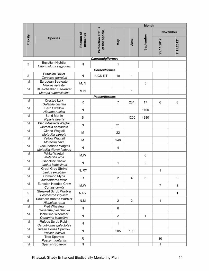
Khauzak-Shady Enhanced Biodiversity Monitoring Plan 14
Pri
ori
ty
Species
Rea
son
of
pre
sen
ce
Pro
tect
ion
sta
tus
of
the
spec
ie
Month
May
Jun
e
Sep
tem
ber
November
25.1
1.20
12
7.11
.201
2*
Caprimulgiformes
5 Egyptian Nightjar
Caprimulgus aegyptius N 1
Coraciiformes
2 Eurasian Roller
Coracias garrulus N IUCN NT 10 1
n/l European Bee-eater Merops apiaster
M, N 3
n/l Blue-cheeked Bee-eater Merops superciliosus
M,N 1
Passeriformes n/l Crested Lark
Galerida cristata R 7 234 17 6 8
n/l Barn Swallow Hirundo rustica
N 1700
n/l Sand Martin Riparia riparia
S 1206 4880
n/l Pied (Masked) Wagtail Motacilla personata
N 21
n/l Citrine Wagtail Motacilla citreola
M 22
n/l Yellow Wagtail Motacilla flava
M 248
n/l Black-headed Wagtail Motacilla (flava) feldegg
N 4
n/l White Wagtail Motacilla alba
M,W 6
n/l Isabelline Shrike Lanius isabellinus
N 1 2
n/l Great Grey Shrike Lanius excubitor
N, R? 1
n/l Common Myna Acridotheres tristis
R 2 4 6 2
n/l Eurasian Hooded Crow Corvus cornix
M,W 7 3
5 Streaked Scrub Warbler
Scotocerca inquieta N,R? 1
5 Southern Booted Warbler
Hippolais rama N,M 2 2 1
n/l Pied Wheatear Oenanthe pleschanka
N 6
n/l Isabelline Wheatear Oenanthe isabellina
N 2 1
n/l Rufous Scrub Robin Cercotrichas galactotes
N 1
n/l Indian House Sparrow Passer indicus
N 205 100
n/l Tree Sparrow Passer montanus
R 30
n/l Spanish Sparrow N 1
Khauzak-Shady Enhanced Biodiversity Monitoring Plan 15
Pri
ori
ty
Species
Rea
son
of
pre
sen
ce
Pro
tect
ion
sta
tus
of
the
spec
ie
Month
May
Jun
e
Sep
tem
ber
November
25.1
1.20
12
7.11
.201
2*
Passer hispaniolensis n/l Common Chaffinch
Fringilla coelebs M,W 1
n/l Eurasian Siskin Spinus spinus
M 1
5 Desert Finch
Rhodospiza obsoleta R 4 14 26
n/l Corn Bunting
Emberiza calandra M,W 4
Total birds / waterbirds 3601 /3062
4437/2860
20662/ 14040
7921/ 7826
971/ 946
Total species /
waterbird species 53/ 35 45/ 32 39/ 27 44/ 32 29/ 18
Notes. Priority species in groups 1-5 as identified in BAP. n/l = not listed in one of those groups. Reason of presence: N- nesting, R- resident, M- migrating, W- wintering, S- summering
(making summer migrations). Protection status in accordance with the Red Book of the Republic of Uzbekistan (2009)
and Red List of IUCN (2012): EN- Endangered; VU- Vulnerable; NT- Near-Threatened. * - partial survey is carried out in four points only (from the bridge on either side, at point 57
and in the bay near the road after the bridge)
5 POTENTIAL IMPACTS AND MONITORING
5.1 Prioritized Potential Wildlife Impacts
The main potential impacts were identified in the BAP as follows: Power line collision and electrocution A set of three 10Kv power distribution lines runs north-south and poses a potential collision risk to flying birds, especially large-bodied species that lack manoeuvrability. The risk is increased because the road is aligned N-S and across the NW-SE/SE-NW direction of the main migration route. The poles and insulators supporting the wires pose an additional risk of electrocution to perching birds. The power lines are set at a height of 10-15 m. This is well below the height of most migrating species that overfly the site and do not stopover. Some vulnerable groups such as bustards occur infrequently: among three species recorded at Dengizkul Houbara Bustard is rare, Great and Little Bustard are very rare in the Lake area. The highest collision risk is faced by water birds moving between feeding and roosting areas in the NW bay and the main lake. The periods of highest risk are during the fall and spring migrations and in winter when large concentrations may occur. Cross-arms on support poles have been fitted with insulators in line with usual LUOC practice. Deflectors have been installed on power lines across the bridge to alert approaching birds. It is recommended that these are fitted every 10 m, extending from 100 m south of the bridge to 500 m north of it. Using a mixture of brightly coloured and reflective
Khauzak-Shady Enhanced Biodiversity Monitoring Plan 16
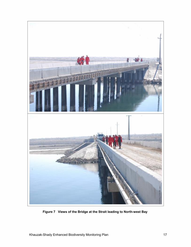
patterns (more effective at night), hanging loose on the lines will increase the deterrent effect. No dead birds were found below the power lines or the poles on 9 km of transects on either of the spring and summer monitoring visits in 2012. Habitat loss The total footprint of disturbance (temporary and permanent) from company infrastructure (buildings, roads, well heads, pipelines, storage facilities) is very low (estimated at between 1-5% of the total survey block area) (of the LUOC concession). The area occupied by well-heads inside the Water Protection Zone is even lower. As a result, the impact on desert breeding birds (species restricted to the “Eurasian Deserts and Near-deserts” biome; priority level 5) is as assessed as very low. None of these species is included in a threatened category on the IUCN Red List or listed in the Uzbekistan national Red Data Book. Fragmentation The principal fragmentation risk to the avifauna of the site was isolation of the NW bay (main breeding area) from the main lake. However, the bridge carrying the road northwards across the narrow strait between the two water bodies has been constructed on the basis of the maximum water level of 182.2 m with culverts designed to ensure water flow between the bay and main body of the lake. LUOC modified the original design of the bridge based on an evaluation of potential environmental risks, and chose a design to allow unimpeded water flow and preclude changing the hydrological regime of the lake. Water flow between the two sections of the lake was clearly visible during the field visit on 7 November 2012, demonstrating continued connectivity between the bay and the main lake (see Figure 7). The limited extent of reed beds and areas of bushes used for nesting by herons, egrets and cormorants, and their location relative to project activities, together make fragmentation of this habitat unlikely. Construction of buildings, gas field infrastructure and roads has inevitably destroyed some areas of desert habitats but the overall ‘infrastructure footprint’ comprises a very small proportion of the concession area and any damage caused is considered insignificant. The current network of roads and surface pipelines is insufficient to cause meaningful fragmentation of the desert habitats, especially for birds that are sufficiently mobile to cross these barriers. Planned extensions to road and pipeline networks are not extensive and are not anticipated to result in further fragmentation impacts on birds. The IBA description says “….Because of the proximity of the State border on the southwest coast, the construction of special buildings and new roads resulted in significant destruction of coastal habitats. For example - partial loss of habitats (about 15% of coastal sandy desert with good bushes of saxaul and no grazing) and a reduction in the number of biome’s CA04b species." The evidence base for this statement is unknown. Disturbance The site lies not far from the Uzbekistan-Turkmenistan border and the main access road from the south passes within 100 m of the ‘inner border fence’ where a border post controls access. Travel along this road is restricted to those vehicles and passengers with permits. Disturbance from routine company operations (drilling, construction of pipelines, maintenance, transport) is subject to strict controls and these are also applied to contractors working on the site. Disturbance as a factor will be most acute during drilling operations that take place within the WPZ and potentially affect birds feeding along the shore or in the water close by. It is essential that any such operations are restricted to the minimum duration possible and are timed to occur when they will have least impact. This should be done in consultation with the monitoring team led by Dr. E. Lanovenko who possesses the most detailed knowledge of the Lake’s avifauna.
Khauzak-Shady Enhanced Biodiversity Monitoring Plan 17
Figure 7 Views of the Bridge at the Strait leading to North-west Bay
Khauzak-Shady Enhanced Biodiversity Monitoring Plan 18
According to 2012 surveys wells on West and North Shady are not located in an important breeding and feeding zones for priority species. At present drilling operations are going on as planned on schedule. If further monitoring reveals any significant impact, correction measures on timing and duration of drilling operations will be considered and implemented. Impacts on breeding birds The most important areas for breeding birds is the NW bay, in particular the reed beds where two species in priority category 1 (Marbled teal, Ferruginous duck) have bred or have been observed during the breeding season. A third species (White-headed duck) could potentially breed in this habitat but it has so far only been recorded in winter at Dengizkul. Other species (cormorants, herons, egrets, swans, waders) breed on islands and in bushes around the bay. The breeding sites are most vulnerable from late spring, from the time when the reeds begin to grow and birds begin prospecting for nest sites, through to summer when the young birds have fledged and dispersed away from the breeding areas. It is essential to avoid any disturbance to these critical areas throughout this time. No company operations are planned in and around the bay. The road and bridge across the strait is at least 400 m from the site of the known reed beds and highly unlikely to have an impact on birds breeding there. Movement of heavy vehicles and people over the bridge at the time of the field visit on 7 November 2012 had no visible effect on feeding and resting birds. The NW bay is surrounded by ‘solonchaks’ – saline flats and marshes that are extremely difficult to negotiate by vehicle and which therefore provide some protection from disturbance from the landward side. No access on foot should be allowed to the periphery of the NW bay and especially the reed beds during the breeding season and controls imposed on unofficial access, whether by company employees, contractors, or outsiders. Signs prohibiting access have been posted in this area and near the water protection zones. The principal threat to breeding birds derives from fluctuating water level due to unpredictable inflows from the two water supply sources . No reed beds formed in 2012 around the bay as a result of low water levels, so no suitable breeding habitat was available. Reeds also grow close to the point where the feeder canal from the Amu- Bukhara canal and Alat collector enters the main lake and NW bay, but here they form relatively narrow strips and no priority species have been recorded breeding here so far (see Figure 6). The map represents the situation in 2012, but it will be basis for comparison in future years. Poaching In the past, fishermen have operated at the north end of the lake, using nets. These pose a serious threat to birds feeding under water and the presence of fishermen is an additional source of disturbance to birds feeding along the shore or in the lake. This activity is illegal within the WPZ without authority or permission (which is provided by the Khokimiat) and should be controlled by the State inspectorate (GosBioKontrol), and the company within its area of operations. Table 2 is adapted from the BAP and presents a summary of potential impacts (without mitigation) which may occur as a result of the project (based on normal operating circumstances) for prioritized species. This summary is the prioritization used as the basis for the monitoring program defined later in the EBMP. The table also identifies priority species as follows: Top priority species:
1 - Globally threatened species, considerable part of whose world population is found at the lake;
2 - other globally threatened species
Khauzak-Shady Enhanced Biodiversity Monitoring Plan 19
3 - species listed in the Red Data Book of the Republic of Uzbekistan (not in the List of Threatened Species of International Union for Conservation of Nature and Natural Resources)
4 - species for which the lake is of ecogeographical importance, 5 – species which distribution is restricted by “Eurasian Deserts and Near-deserts”
biome, affected by the project. Threats to population:
G – High Global threats; E – High Local Ecological threats from project-related activities; High threats (not any changes in structure of habitat, but there is high level of
disturbance from project-related activities); Low threats (not any changes in structure of habitat, low level of disturbance
from project-related activities).
Khauzak-Shady Enhanced Biodiversity Monitoring Plan 20
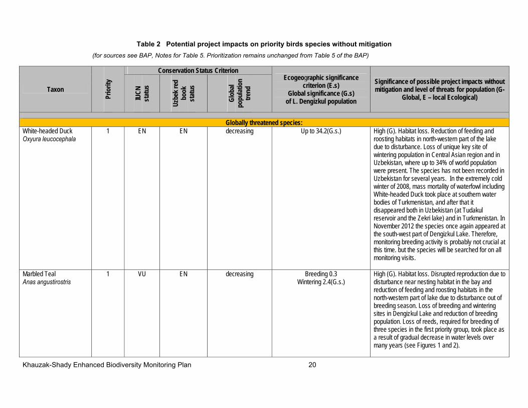
Table 2 Potential project impacts on priority birds species without mitigation
(for sources see BAP, Notes for Table 5. Prioritization remains unchanged from Table 5 of the BAP)
Taxon
Prio
rity
Conservation Status Criterion Ecogeographic significance
criterion (E.s) Global significance (G.s)
of L. Dengizkul population
Significance of possible project impacts without mitigation and level of threats for population (G-
Global, E – local Ecological) IUCN
st
atus
Uzbe
k red
bo
ok
stat
us
Glob
al po
pulat
ion
trend
Globally threatened species:
White-headed Duck Оxуurа leucocephala
1 EN EN decreasing Up to 34.2(G.s.) High (G). Habitat loss. Reduction of feeding and roosting habitats in north-western part of the lake due to disturbance. Loss of unique key site of wintering population in Central Asian region and in Uzbekistan, where up to 34% of world population were present. The species has not been recorded in Uzbekistan for several years. In the extremely cold winter of 2008, mass mortality of waterfowl including White-headed Duck took place at southern water bodies of Turkmenistan, and after that it disappeared both in Uzbekistan (at Tudakul reservoir and the Zekri lake) and in Turkmenistan. In November 2012 the species once again appeared at the south-west part of Dengizkul Lake. Therefore, monitoring breeding activity is probably not crucial at this time. but the species will be searched for on all monitoring visits.
Marbled Teal Anas angustirostris
1 VU EN decreasing Breeding 0.3 Wintering 2.4(G.s.)
High (G). Habitat loss. Disrupted reproduction due to disturbance near nesting habitat in the bay and reduction of feeding and roosting habitats in the north-western part of lake due to disturbance out of breeding season. Loss of breeding and wintering sites in Dengizkul Lake and reduction of breeding population. Loss of reeds, required for breeding of three species in the first priority group, took place as a result of gradual decrease in water levels over many years (see Figures 1 and 2).

Khauzak-Shady Enhanced Biodiversity Monitoring Plan 21
Taxon
Prio
rity
Conservation Status Criterion Ecogeographic significance
criterion (E.s) Global significance (G.s)
of L. Dengizkul population
Significance of possible project impacts without mitigation and level of threats for population (G-
Global, E – local Ecological) IUCN
st
atus
Uzbe
k red
bo
ok
stat
us
Glob
al po
pulat
ion
trend
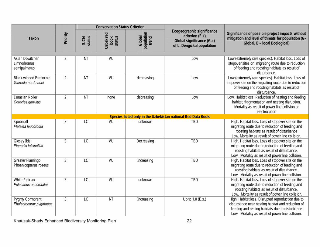
Ferruginous Duck Aythya nyroca
1 NT NT decreasing TBD High (G). Habitat loss. Disrupted reproduction due to disturbance near nesting habitat in the bay and reduction of feeding and resting habitats in the
north-western part of lake due to disturbance out of breeding seasons. Loss of breeding and wintering sites in Dengizkul Lake and reduction of breeding
population. Dalmatian Pelican Pelecanus crispus
2 VU VU decreasing TBD High. Habitat loss. Loss of stopover site on migration route due to reduction of feeding and
roosting habitats in the north-western part of lake as result of disturbance and power line collision
Pallid Harrier Circus macrourus
2 NT NT decreasing Low Low (rarely occur individual birds). Mortality as result of power line collision or electrocution.
Pallas' Sea Eagle Haliaeetus leucoryphus
2 VU EN decreasing Low Low (extremely rare, occasional occurrences) Habitat loss. Reduction of feeding and resting areas in north-western part of the lake. Mortality as result
of power line collision or electrocution. Egyptian Vulture Neophron реrсnорterus
2 EN none decreasing Low Low (rare species). Habitat loss. Reduction of feeding and resting areas. Mortality as result of
power line collision or electrocution. Saker Falcon Falco cherrug
2 EN NT decreasing Low Low (rare species). Habitat loss. Reduction of feeding and resting areas. Mortality as result of
power line collision or electrocution Great Bustard Otis tarda
2 VU CR decreasing Low Low (extremely rare species). Power line collision. Habitat loss due to disturbance.
Houbara Bustard Chlamуdotis undulata
2 VU VU Decreasing Low Low (rare species).Power line collision. Habitat loss due to disturbance.
Little Bustard Tetrax tetrax
2 NT VU Low Low (rare species).Power line collision. Habitat loss due to disturbance.
Eurasian curlew Numenius arquata
2 NT none decreasing Low Low (scarce species). Habitat loss. Loss of stopover site on the migrating route due to reduction of
feeding and roosting habitats as result of disturbance.
Khauzak-Shady Enhanced Biodiversity Monitoring Plan 22
Taxon
Prio
rity
Conservation Status Criterion Ecogeographic significance
criterion (E.s) Global significance (G.s)
of L. Dengizkul population
Significance of possible project impacts without mitigation and level of threats for population (G-
Global, E – local Ecological) IUCN
st
atus
Uzbe
k red
bo
ok
stat
us
Glob
al po
pulat
ion
trend
Asian Dowitcher Limnodromus semipalmatus
2 NT VU Low Low (extremely rare species). Habitat loss. Loss of stopover sites on migrating route due to reduction
of feeding and roosting habitats as result of disturbance.
Black-winged Pratincole Glareola nordmanni
2 NT VU decreasing Low Low (extremely rare species). Habitat loss. Loss of stopover site on the migrating route due to reduction
of feeding and roosting habitats as result of disturbance.
Eurasian Roller Coracias garrulus
2 NT none decreasing Low Low. Habitat loss. Reduction of nesting and feeding habitat, fragmentation and nesting disruption.
Mortality as result of power line collision or electrocution
Species listed only in the Uzbekistan national Red Data Book: Spoonbill Platalea leucorodia
3 LC VU unknown
TBD High. Habitat loss. Loss of stopover site on the migrating route due to reduction of feeding and
roosting habitats as result of disturbance Low. Mortality as result of power line collision.
Glossy Ibis Plegadis falcinellus
3 LC VU Decreasing TBD High. Habitat loss. Loss of stopover site on the migrating route due to reduction of feeding and
roosting habitats as result of disturbance. Low. Mortality as result of power line collision.
Greater Flamingo Phoenicopterus roseus
3 LC VU Increasing TBD High. Habitat loss. Loss of stopover site on the migrating route due to reduction of feeding and
roosting habitats as result of disturbance. Low. Mortality as result of power line collision.
White Pelican Pelecanus onocrotalus
3 LC VU unknown
TBD High. Habitat loss. Loss of stopover site on the migrating route due to reduction of feeding and
roosting habitats as result of disturbance. Low. Mortality as result of power line collision.
Pygmy Cormorant Phalacrocoraх pygmaeus
3 LC NT Increasing Up to 1.0 (E.s.) High. Habitat loss. Disrupted reproduction due to disturbance near nesting habitat and reduction of feeding and resting habitats due to disturbance Low. Mortality as result of power line collision.
Khauzak-Shady Enhanced Biodiversity Monitoring Plan 23
Taxon
Prio
rity
Conservation Status Criterion Ecogeographic significance
criterion (E.s) Global significance (G.s)
of L. Dengizkul population
Significance of possible project impacts without mitigation and level of threats for population (G-
Global, E – local Ecological) IUCN
st
atus
Uzbe
k red
bo
ok
stat
us
Glob
al po
pulat
ion
trend
Little Egret Egretta garzetta
3 LC VU Increasing Low High. Habitat loss. Disrupted reproduction due to disturbance near nesting habitat and reduction of feeding and resting habitats due to disturbance. Low. Mortality as result of power line collision.
Mute Swan Cygnus olor
3 LC NT Increasing 1.0-3.0 (E.s.) High. Habitat loss. Disrupted reproduction due to disturbance near nesting habitat and reduction of
feeding and resting habitats due to shallowing and salinization.
Low. Mortality as result of power line collision. Whooper Swan Суgnus cygnus
3 LC VU unknown
Up to 1.0 (E.s.) High. Habitat loss. Reduction of feeding and resting areas during migration and in winter.
Low. Mortality as result of power line collision. Osprey Pandion haliaetus
3 LC VU Increasing Low Low (rare species). Habitat loss. Mortality as result of power line collision or electrocution
Golden Eagle Aquila chrysaetos
3 LC VU stable Low Low (scarce species). Habitat loss. Mortality as result of power line collision or electrocution
Steppe Eagle Aquila rapax
3 LC NT decreasing Low Low (scarce species). Habitat loss. Mortality as result of power line collision or electrocution
White-tailed Eagle Haliaeetus albicilla
3 LC VU Increasing Medium Low (alights predominantly on the ground). Mortality as result of power line collision or electrocution
Lesser Kestrel Falco naumanni
3 LC NT Increasing ?? Low (scarce species). Habitat loss. Mortality as result of power line collision or electrocution
Other waterfowl including species represented by more than 1% of the biogeographical populations: Greater Cormorant Phalacrocorax carbo
4 LC none increasing ?? High. Habitat loss. Reduction of feeding and resting areas during migration and in winter as result of disturbance.
Common Crane Grus grus
4 LC none unknown
TBD Low. Mortality as result of power line collision
Demoiselle Crane Anthropoides virgo
4 LC none increasing TBD Low. Mortality as result of power line collision
Common Shelduck Tadorna tadorna
4 LC none increasing ?? High. Habitat loss. Reduction of feeding and resting areas during migration and in winter as result of
disturbance.
Khauzak-Shady Enhanced Biodiversity Monitoring Plan 24
Taxon
Prio
rity
Conservation Status Criterion Ecogeographic significance
criterion (E.s) Global significance (G.s)
of L. Dengizkul population
Significance of possible project impacts without mitigation and level of threats for population (G-
Global, E – local Ecological) IUCN
st
atus
Uzbe
k red
bo
ok
stat
us
Glob
al po
pulat
ion
trend
Mallard Anas platyrhynchos
4 LC none decreasing 1.22 (E.s.) High. Habitat loss. Reduction of feeding and resting areas during migration and in winter as result of
disturbance. Red-crested Pochard Netta rufina
4 LC none unknown
1.84 (E.s.) High. Habitat loss. Reduction of feeding and resting areas during migration and in winter as result of
disturbance. Reduction of population Pochard Aythya ferina
4 LC none decreasing Up to 8.3 (E.s.) High. Habitat loss. Reduction of feeding and resting areas during migration and in winter as result of
disturbance. Perhaps wintering population move to other site.
Smew Mergellus albellus
4 LC none decreasing Up to 1.2 (E.s.) High. Habitat loss. Reduction of feeding and resting areas during migration and in winter as result of
disturbance. Perhaps wintering population move to other site.
Coot Fulica atra
4 LC none decreasing Up to 10.0 (E.s.) High. Habitat loss. Reduction of feeding and resting areas during migration and in winter as result of
disturbance. Disrupted reproduction due to disturbance near nesting habitat in breeding season
Species restricted to the Eurasian Deserts and Semideserts biome: Egyptian Nightjar Caprimulgus aegyptius
5 LC none decreasing Low High (E). Habitat loss. Reduction and destruction of nesting and feeding habitat, fragmentation and
disruption of reproduction due to disturbance near nesting habitat. Mortality as result of vehicle
accidents Southern Booted Warbler Hippolais rama
5 LC none stable Low High (E). Habitat loss. Reduction and destruction of nesting and feeding habitat, fragmentation and
disruption of reproduction due to disturbance near nesting habitat.
Brown-necked Raven Corvus ruficollis
5 LC none Increasing Low Low (scarce species). Habitat loss. Reduction of feeding and nesting areas during breeding season.
Mortality as result of power line collision or electrocution
Desert Warbler 5 LC none stable Low Low (rare species). Habitat loss. Reduction of
Khauzak-Shady Enhanced Biodiversity Monitoring Plan 25
Taxon
Prio
rity
Conservation Status Criterion Ecogeographic significance
criterion (E.s) Global significance (G.s)
of L. Dengizkul population
Significance of possible project impacts without mitigation and level of threats for population (G-
Global, E – local Ecological) IUCN
st
atus
Uzbe
k red
bo
ok
stat
us
Glob
al po
pulat
ion
trend
Sylvia nana nesting and feeding habitat, fragmentation and
disruption of reproduction due to disturbance near nesting habitat.
Streaked Scrub Warbler Scotocerca inquieta
5 LC none decreasing Low Low (scarce species). Habitat loss. Reduction of nesting and feeding habitat, fragmentation and
disruption of reproduction due to disturbance near nesting habitat.
Turkestan Tit Parus bokharensis
5 none none unknown This taxon is not recognized by BirdLife International or IUCN who
consider it as conspecific with Great Tit Parus major
Low (scarce species). Habitat loss. Reduction of nesting and feeding habitat, fragmentation and
disruption of reproduction due to disturbance near nesting habitat. At present there is no suitable
habitat for this species at the lakeshore Desert Finch Rhodospiza obsoleta
5 none none unknown High (E). Habitat loss. Reduction and destruction of nesting and feeding habitat, fragmentation and
disruption of reproduction due to disturbance near nesting habitat.
Other non-listed waterfowl
5 none none N.A. N.A. High. Habitat loss. Loss of stopover site on the migrating route due to reduction of feeding and
roosting habitats in the north-western part of lake as result of disturbance and power line collision
Other non-listed raptors 5 none none N.A. N.A. High. Habitat loss. Loss of stopover site on the migrating route due to reduction of feeding and
roosting habitats in the north-western part of lake as result of disturbance. Power line collision and
electrocution. Other
non-listed shorebirds 5 none none N.A. N.A. High. Habitat loss. Reduction of nesting and feeding
habitat, fragmentation and disruption of reproduction due to disturbance near nesting habitat. Reduction
of stopover places Other
non-listed songbird species
5 none none N.A. N.A. High. Habitat loss. Reduction of nesting and feeding habitat, fragmentation and disruption of reproduction
due to disturbance near nesting habitat.
Khauzak-Shady Enhanced Biodiversity Monitoring Plan 26
TBD – “to be determined”. The absence of data to score ecogeographic criterion underscores the lack of current scientific understanding of the basic ecology and population biology of bird species in this region, and thus the uncertainty related to the likelihood of project-generated risks from this specific project. This uncertainty will be addressed through appropriate monitoring. N.A. – Not applicable
Khauzak-Shady Enhanced Biodiversity Monitoring Plan 27
5.2 Biodiversity Monitoring Procedures
Ornithological monitoring will consist of three main elements: water bird breeding success, general avifauna surveys, and power line impacts. Each is described in greater detail below. Table 3 lists all bird species included in priority categories 1-5 together with the monitoring element to be applied to each one. Table 4 summarizes the annual schedule of monitoring visits to be implemented. During 2012 a series of survey points was established and their locations were fixed by GPS as the basis for the monitoring program. It is recommended that annual monitoring is carried out for a minimum of five years to take into account known variations in the occurrence of birds at Dengizkul Lake. Monitoring is led by Dr. E. Lanovenko, senior ornithologist at the Institute of Gene Pool of the Uzbekistan Academy of Sciences, and the foremost authority on the avifauna of the site. She is accompanied by two ornithologist assistants and a driver. A qualified ornithologist/driver is engaged whenever possible, to increase the amount of expertise available. Equipment required: 1 4x4 vehicle, 2 telescopes (20-60 zoom, and with an objective lens between 77 and 80 mm to ensure adequate light-gathering capacity); 2 good quality tripods; 4 binoculars (10x magnification); 2 hand-held GPS units (Garmin Etrex); 2-3 digital/tape recorders, and 1 digital camera. High-quality optical equipment is required and will be obtained as necessary to supplement Dr. Lanovenko’s existing equipment: manufacturers of telescopes of the required quality include Leica, Nikon, Opticron, Swarowski. Data will be entered onto standardized field recording forms. These also record the GPS location of each survey point, duration of survey, start/finish times, habitat, and weather conditions. Summarization of this information for reporting purposes is discussed in Section 8 of this EBMP. Monitoring information will continue to be shared with the State Committee on Nature Protection (government authority).
5.3 Water Bird Breeding Success Monitoring Procedures
The NW bay is the focus of the breeding water bird monitoring effort. The two principal target species are (which has bred in reed beds) and (observed in the same area at the beginning of the breeding season). A third species, White-headed Duck, has occurred in winter but has not yet been recorded breeding though it is possible that it may do so in future should appropriate reed habitat conditions develop. Egrets, herons and cormorants nest on islands and in bushes around the NW bay. Methods to detect breeding of Priority 1 species will involve careful and systematic scanning of all potential breeding sites from a range of vantage points and at appropriate distances to avoid disturbing the birds at this sensitive time. Monitoring will be based on fixed point surveys of reed bed habitat using telescopes and binoculars. Survey point locations include the bridge and other points around the periphery of the bay offering clear views of the reeds. Spring visit 2 (end-April-May):
Determine presence and location of growing reeds Map and record location of reeds with GPS Record all occurrences and numbers of each target species present from first to
fourth priority (see BAP table 5). The two top priority nesting duck species are very secretive as well as skittish, and require extensive surveillance from an unobservable position, Other nesting duck species of fourth priority are cautious too. Colonial
Khauzak-Shady Enhanced Biodiversity Monitoring Plan 28
nesters, whose nests are relatively simple to search for are comparative tolerant. So observer can stay in comfortable place which enable to survey birds behavior
Record evidence of breeding behavior (courtship displays, mating, nest-building) Fix approximate location of all suspected nests and more exactly for colonial nesting
birds/ Summer visit 1(end-June-July):
Record numbers of each target species present Record number of broods, number of young birds and approximate stage of
development
Both survey visits: Record any evidence of disturbance (vehicle tracks, footprints, presence of people) Enter all sightings onto standard recording forms NOTE: if no reeds are present on spring visit 1, as in 2012, further monitoring effort for priority breeding species is not required.
5.4 General Avifauna Monitoring
General avifauna monitoring includes all seasons of the year and covers breeding, spring and fall migrating and wintering bird species. Winter visit 1 (January):
Record all occurrences and numbers of each target species present Map and record location of priority species and bird aggregations with GPS Describe current habitat conditions
Spring visit 1 (March): Record all occurrences and numbers of each target species present Map and record location of priority species and bird aggregations with GPS Describe current habitat conditions
Spring visit 2 (end of April and May) – as described above for the breeding season Summer visit 1 (end June-July) – as described above for the breeding season Fall visit 2 (September and October or November)
Record all occurrences and numbers of each target species present Map and record location of priority species and bird aggregations with GPS Describe current habitat conditions
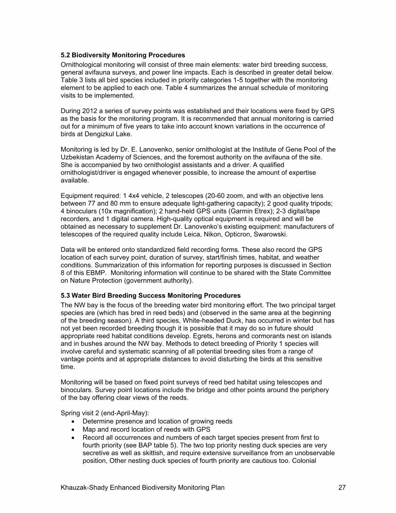
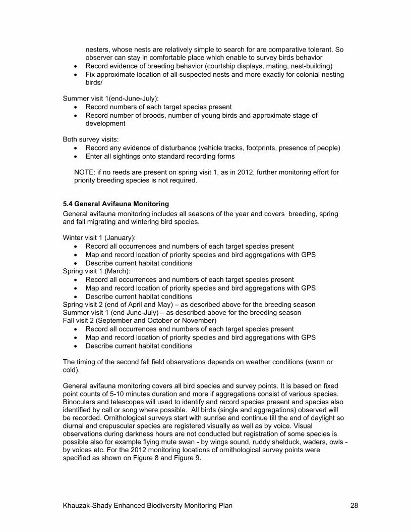
The timing of the second fall field observations depends on weather conditions (warm or cold). General avifauna monitoring covers all bird species and survey points. It is based on fixed point counts of 5-10 minutes duration and more if aggregations consist of various species. Binoculars and telescopes will used to identify and record species present and species also identified by call or song where possible. All birds (single and aggregations) observed will be recorded. Ornithological surveys start with sunrise and continue till the end of daylight so diurnal and crepuscular species are registered visually as well as by voice. Visual observations during darkness hours are not conducted but registration of some species is possible also for example flying mute swan - by wings sound, ruddy shelduck, waders, owls - by voices etc. For the 2012 monitoring locations of ornithological survey points were specified as shown on Figure 8 and Figure 9.
Khauzak-Shady Enhanced Biodiversity Monitoring Plan 29
Figure 8 Location of Ornithological Survey Points at Dengizkul Lake
These points cover all area around the lake. Monitoring points of the North-west bay (main breeding area) are shown below. Total number of points is 31.
Figure 9 Monitoring Points at the North-west Bay
For winter concentrations of waterfowl, survey duration will extend over a longer period to ensure the most accurate estimates of the numbers of each species present. In addition to number and species present, record any evidence of breeding (singing males, courtship displays, mating, nest building, presence of nests and clutches, adults carrying food, adults feeding newly fledged young).
Record all species seen or heard from each survey point and the number present Record birds that cannot be identified to species level with as much precision as
possible (e.g. ‘unidentified ducks’)
Khauzak-Shady Enhanced Biodiversity Monitoring Plan 30
Record any indication of breeding activity (as listed above) Enter all data onto standard field forms along with associated data (habitat, timing,
weather)
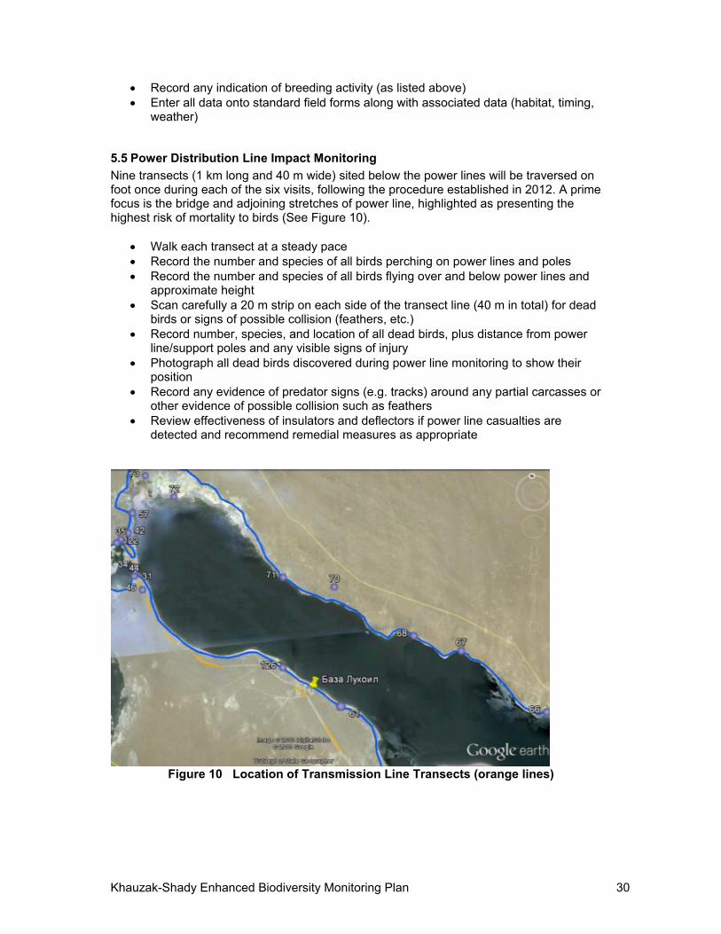
5.5 Power Distribution Line Impact Monitoring
Nine transects (1 km long and 40 m wide) sited below the power lines will be traversed on foot once during each of the six visits, following the procedure established in 2012. A prime focus is the bridge and adjoining stretches of power line, highlighted as presenting the highest risk of mortality to birds (See Figure 10).
Walk each transect at a steady pace Record the number and species of all birds perching on power lines and poles Record the number and species of all birds flying over and below power lines and
approximate height Scan carefully a 20 m strip on each side of the transect line (40 m in total) for dead
birds or signs of possible collision (feathers, etc.) Record number, species, and location of all dead birds, plus distance from power
line/support poles and any visible signs of injury Photograph all dead birds discovered during power line monitoring to show their
position Record any evidence of predator signs (e.g. tracks) around any partial carcasses or
other evidence of possible collision such as feathers Review effectiveness of insulators and deflectors if power line casualties are
detected and recommend remedial measures as appropriate
Figure 10 Location of Transmission Line Transects (orange lines)
Khauzak-Shady Enhanced Biodiversity Monitoring Plan 31
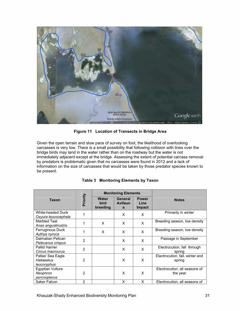
Figure 11 Location of Transects in Bridge Area
Given the open terrain and slow pace of survey on foot, the likelihood of overlooking carcasses is very low. There is a small possibility that following collision with lines over the bridge birds may land in the water rather than on the roadway but the water is not immediately adjacent except at the bridge. Assessing the extent of potential carcass removal by predators is problematic given that no carcasses were found in 2012 and a lack of information on the size of carcasses that would be taken by those predator species known to be present.
Table 3 Monitoring Elements by Taxon
Taxon
Pri
ori
ty Monitoring Elements
Notes Waterbird
breeding
General Avifaun
a
Power Line
Impact White-headed Duck Оxуurа leucocephala
1 X X Primarily in winter
Marbled Teal Anas angustirostris
1 X X X Breeding season, low density
Ferruginous Duck Aythya nyroca
1 X X X Breeding season, low density
Dalmatian Pelican Pelecanus crispus
2 X X Passage in September
Pallid Harrier Circus macrourus
2 X X Electrocution, fall through
spring Pallas' Sea Eagle Haliaeetus leucoryphus
2 X X Electrocution, fall, winter and
spring
Egyptian Vulture Neophron реrсnорterus
2 X X Electrocution, all seasons of
the year
Saker Falcon 2 X X Electrocution, all seasons of
Khauzak-Shady Enhanced Biodiversity Monitoring Plan 32
Taxon
Pri
ori
ty Monitoring Elements
Notes Waterbird
breeding
General Avifaun
a
Power Line
Impact Falco cherrug the year Great Bustard Otis tarda
2 X X Collision. Fall, spring
Houbara Bustard Chlamуdotis undulata
2 X X Collision. Fall, spring
Little Bustard Tetrax tetrax
2 X X Collision. Fall, spring
Eurasian curlew Numenius arquata
2 X Collision. Fall, spring
Black-winged Pratincole Glareola nordmanni
2 X Collision. Fall, spring
Eurasian Roller Coracias garrulus
2 X Electrocution, spring, summer
and fall Spoonbill Platalea leucorodia
3 X X X Collision. Fall, spring
Glossy Ibis Plegadis falcinellus
3 X X X Collision. Fall, spring
White Pelican Pelecanus onocrotalus
3 X X Collision. Fall, spring
Pygmy Cormorant Phalacrocoraх pygmaeus
3 X X X Collision, all seasons of the
year
Little Egret Egretta garzetta
3 X X X Collision. spring, summer and
fall Mute Swan Cygnus olor
3 X X X Collision, all seasons of the
year Whooper Swan Суgnus cygnus
3 X X Collision. Fall, winter, spring
Osprey Pandion haliaetus
3 X X Electrocution during migration
Golden Eagle Aquila chrysaetos
3 X X Electrocution all seasons of
the year Steppe Eagle Aquila rapax
3 X X Electrocution during migration
White-tailed Sea Eagle Haliaeetus albicilla
3 X X Electrocution during winter
Eurasian Crane Grus grus
4 X X Collision during migration
Demoissele Crane Anthropoides virgo
4 X X Collision during migration
Mallard Anas platyrhynchos
4 X X Collision, fall, winter and
spring Red-crested Pochard Netta rufina
4 X X Collision, fall winter, and
spring Pochard Aythya ferina
4 X X Collision, fal, winter and spring
Smew Mergelus albellus
4 X X Collision during winter
Coot Fulica atra
4 X X Collision all seasons of the
year Egyptian Nightjar Caprimulgus aegyptius
5 X Collision during breeding
season Southern Booted 5 X Collision during migration
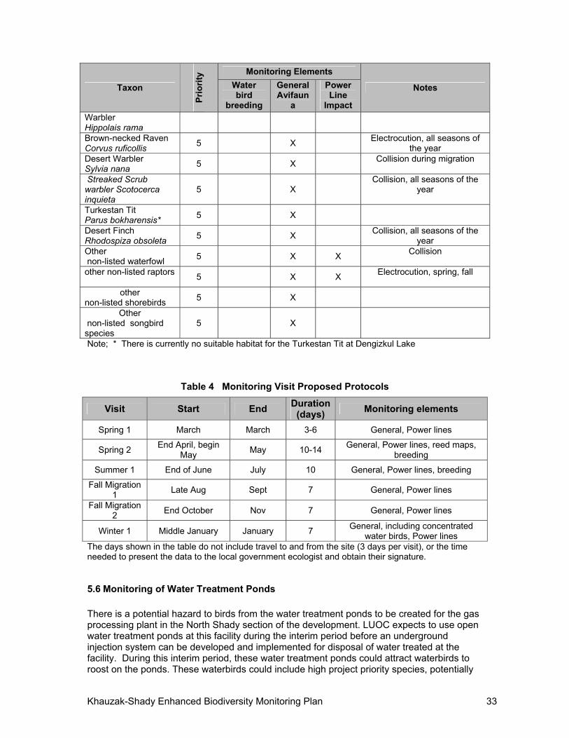
Khauzak-Shady Enhanced Biodiversity Monitoring Plan 33
Taxon
Pri
ori
ty Monitoring Elements
Notes Waterbird
breeding
General Avifaun
a
Power Line
Impact Warbler Hippolais rama Brown-necked Raven Corvus ruficollis
5 X Electrocution, all seasons of
the year Desert Warbler Sylvia nana
5 X Collision during migration
Streaked Scrub warbler Scotocerca inquieta
5 X Collision, all seasons of the
year
Turkestan Tit Parus bokharensis*
5 X
Desert Finch Rhodospiza obsoleta
5 X Collision, all seasons of the
year Other non-listed waterfowl
5 X X Collision
other non-listed raptors
5 X X Electrocution, spring, fall
other non-listed shorebirds
5 X
Other non-listed songbird species
5 X
Note; * There is currently no suitable habitat for the Turkestan Tit at Dengizkul Lake
Table 4 Monitoring Visit Proposed Protocols
Visit Start End Duration
(days) Monitoring elements
Spring 1 March March 3-6 General, Power lines
Spring 2 End April, begin
May May 10-14
General, Power lines, reed maps, breeding
Summer 1 End of June July 10 General, Power lines, breeding
Fall Migration 1
Late Aug Sept 7 General, Power lines
Fall Migration 2
End October Nov 7 General, Power lines
Winter 1 Middle January January 7 General, including concentrated
water birds, Power lines The days shown in the table do not include travel to and from the site (3 days per visit), or the time needed to present the data to the local government ecologist and obtain their signature.
5.6 Monitoring of Water Treatment Ponds
There is a potential hazard to birds from the water treatment ponds to be created for the gas processing plant in the North Shady section of the development. LUOC expects to use open water treatment ponds at this facility during the interim period before an underground injection system can be developed and implemented for disposal of water treated at the facility. During this interim period, these water treatment ponds could attract waterbirds to roost on the ponds. These waterbirds could include high project priority species, potentially
Khauzak-Shady Enhanced Biodiversity Monitoring Plan 34
exposing them to risk of mortality from poisoning depending upon the water quality in these ponds. Because these ponds will not be easily accessible to the ornithologists who will be conducting the avian monitoring efforts outlined in the EBMP, and because such monitoring will only occur during six site visits per year, formal avian monitoring of this part of the facility will be difficult. LUOC will provide monitoring for these ponds in the form of surveillance of the pond by the operators of the treatment ponds who will be present at the facility on a continual or near continual basis during its operation. Where necessary such programs using trained O&M staff have been incorporated into other avian protection plans for a variety of energy facilities and other large utility developments internationally. In order that this part of the monitoring program is successful, LUOC will provide sufficient training on a regular basis to the plant’s O&M staff, assisted in special cases by Dr. Lanovenko. A clear and formal incident response and reporting procedure will be developed so that project ornithologists who are conducting monitoring for the EBMP are informed of any incidents. In addition, these treatment ponds will be designed so than no emergent vegetation will be allowed to grow, which could attract waterbirds and other wildlife to the ponds. LUOC will require that any wildlife mortalities and injuries observed by the O&M staff (including security staff) are reported to the LUOC environmental department to ensure robust ongoing monitoring. Training will be provided to the O&M staff with respect to observation of wildlife mortality or injury.
5.7 Other fauna
The BAP identified the most significant potential impacts on the biodiversity of the site as on Dengizkul Lake itself and the breeding, migratory and wintering birds that use it, which are of global, regional and national importance. The lake and surrounding Water Protection Zone together comprise the internationally-recognized Ramsar site and Important Bird Area. Therefore, mitigation measures, and the bird monitoring program, are focused on those potential impacts. The other fauna (mammals, reptiles) and flora occurring in the wider Khauzak-Shady block represents a lower biodiversity priority as assessed against the criteria of globally threatened species, species included in the Uzbekistan Red Book, and species represented by a significant proportion of their global population. The main exception is the Goitered Gazelle Gazella subgutturosa (globally Vulnerable), but this species occupies very large home ranges and there is no significant resident population on the site. The infrastructure footprint is estimated to occupy 1-5% of the total LUOC concession operating area so habitat loss is very low. Responsibility for the monitoring of other fauna and flora rests with a joint team organized by LUOC and the State inspectorate (GosBioKontrol); monitoring visits are conducted twice a year. LUOC’s personnel and environmental officers also are responsible for generally observing and monitoring operations interactions / impacts with wildlife.
6 DATA PROCESSING AND EVALUATION
All data recorded on each monitoring visit will be entered onto standardized record forms as stated in section 5.2. Specific details recorded to include observation point ID number, GPS location, weather conditions, start and finish time of observations; species seen and numbers. Any evidence of breeding behavior will be recorded separately. Dead birds found below power lines, and signs of collision, will also be recorded separately, stating the
Khauzak-Shady Enhanced Biodiversity Monitoring Plan 35
species, precise location (GPS), proximity to power lines (in meters) and any visible signs of external injury.
Data from field forms will be converted to electronic tabular format following each monitoring visit. Electronic versions of the forms will be retained by the monitoring team and copies forwarded to LUOC, the State Committee for Nature Protection (GosKomPriroda), and the independent reviewer. Data will also be entered into the database of the Institute of Gene Pool of the Academy of Sciences of the Republic of Uzbekistan.
Breeding sites of priority species will be mapped as accurately as possible.
Results of each monitoring visit will be reviewed and assessed by monitoring teem following the visit, with particular attention paid to the high priority breeding species, globally threatened species, power line casualties and winter bird concentrations. Numbers and species recorded will be compared to those previously recorded at the site and in reference to their global and ecogeographical significance.
An annual summary of the findings of all six monitoring visits will be produced (see Section 8). Species data will also be summarized annually for each year of monitoring,
Results will be assessed by the Environmental Manager of LUOC in consultation with the Principal Ornithologist and the International Biodiversity Specialist in an adaptive management framework such that significant events, such as the occurrence of priority breeding species in new parts of the site, informs the monitoring schedule and allows amendments to observation points and timings as appropriate. The adaptive management process is discussed in Section 7, below.
Presence of collision or electrocution casualties will be assessed and modifications to the existing preventive measures recommended as appropriate.
Dr. Lanovenko (Principal Ornithologist) has responsibility for quality control of field observations, data entry and for the initial analysis. Independent review is provided by Dr. David Mallon (International Biodiversity Specialist).
7 ADAPTIVE MANAGEMENT PLAN FOR ASSURING PROTECTION OF BIODIVERSITY
7.1 Anticipated Biodiversity Impacts and Mitigation
Sections 4.2.3 and 4.5 of the BAP present numerous mitigation measures designed to protect biodiversity at Dengizkul Lake. In particular Table 6 of the BAP presents potential impacts and mitigation measures. The table is reproduced below as Table 5, updated based on information gathered during field visits during 2012. In addition to the mentioned mitigation measures, the BAP presents a number of existing and new measures that LUOC commits to carry out to reduce or eliminate potential impacts. These are summarized in Table 6, together with new mitigation measures identified during the production of the EBMP and the 2012 monitoring, as discussed below. Based on new information since the preparation of the BAP, the following two mitigation measures are added to the list of commitments by LUOC:
1. Gas from Kuvachi-Alat (a satellite field located approximately 60 km to the north of Lake Dengizkul) will be treated at the Kuvachi-Alat preliminary gas processing unit, and then transported via a 60 km buried pipeline to the North Shady preliminary gas
Khauzak-Shady Enhanced Biodiversity Monitoring Plan 36
processing unit before entering the tie-in to the Dengizkul-Mubarek collection system. Condensate will be transported by truck to the commercial condensate receiving unit at Khauzak preliminary gas processing unit. To prevent the possibility of a spill of hazardous substances into the Lake in the vicinity of the bridge, LUOC will use the existing national road system going around the eastern and south eastern portion of Lake Dengizkul, and not across the project’s bridge in the northwest part of the Lake.
2. LUOC is installing flare systems along pipeline routes which no longer require the
pilot light to continually burn. Some of these flare systems are already installed at the emergency shut off points along the pipelines. As explained in the BAP, continuously-burning flares discourage birds from approaching the flares therefore reducing the potential for mortality of birds perching on the flares. Since there will not be a continuously-burning pilot flame in the future, LUOC will install appropriate measures (if needed) to prevent perching on the flares prior to the installation of the automatic flare ignition systems, which are expected to be put into operation at linear part of pipelines for the Khauzak-Shady project in the second quarter of 2014.
3. Reinjection is not covered in this EBMP but will be discussed in LUOC reports at the timeit is implemented. Water pits and other facilities which may be hazardous to birds will be monitored as soon as they are built.
Further, the monitoring program carried out in 2012 resulted in a series of recommendations that will be implemented by LUOC, as follows:
Some of the project field facilities are near reed areas in the northern part of the Lake and the northwest bay. This year active project drilling and field development works were performed near north-east extremity of the lake. Next year such works will continue at North Shady block. Therefore, to prevent disturbance of the birds inhabiting reeds, a 1 km wide protective zone will be established and marked in the field as shown on Figure 12 and will be included on internal survey maps and project layout drawings used by the company.
Put markers at a distance of 500m from water edge at maximum water level, registered within recent years, indicating protective zone around the north-west bay, being concentration and breeding area of many bird species.
In connection with commencement of construction works at “North Shady” block measures must be taken to prevent disturbance to birds in the near-shore strip, for that purpose it is advisable to put markers, indicating protective zone, at a distance of 500m from lakeshore.
In order to prevent possibility of migrating bird collisions with the power transmission line, detection of the most dangerous areas must be continued during monitoring and markers must be put at detected dangerous areas. At present such areas are bridge and adjacent sections of the power transmission line: at a distance of 1km before the bridge and 3km after it.
For mitigation of negative impact of motor road and traffic: prevention of bird mortality, caused by collision, established speed limit must be observed and bridge guard rail must be painted in contrasting colors to make it visually noticeable.
Ornithological monitoring must be continued to study condition of habitats and populations of various species of birds, reveal their concentration areas during various seasons of year and factors influencing them.
At present water protection zone markers are put near all drilling wells in the Northern Shady block. All insulators on the PTL towers along the lake are equipped with special protective cases for the purpose of prevention of birds’ death because of electrocution. Diverters are put in the highest risk zone - on wires crossing on the bridge. Development of new additional diverters is in progress.
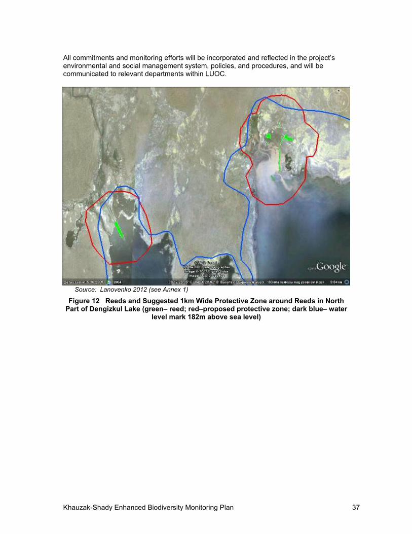
Khauzak-Shady Enhanced Biodiversity Monitoring Plan 37
All commitments and monitoring efforts will be incorporated and reflected in the project’s environmental and social management system, policies, and procedures, and will be communicated to relevant departments within LUOC.
Source: Lanovenko 2012 (see Annex 1)
Figure 12 Reeds and Suggested 1km Wide Protective Zone around Reeds in North Part of Dengizkul Lake (green– reed; red–proposed protective zone; dark blue– water
level mark 182m above sea level)
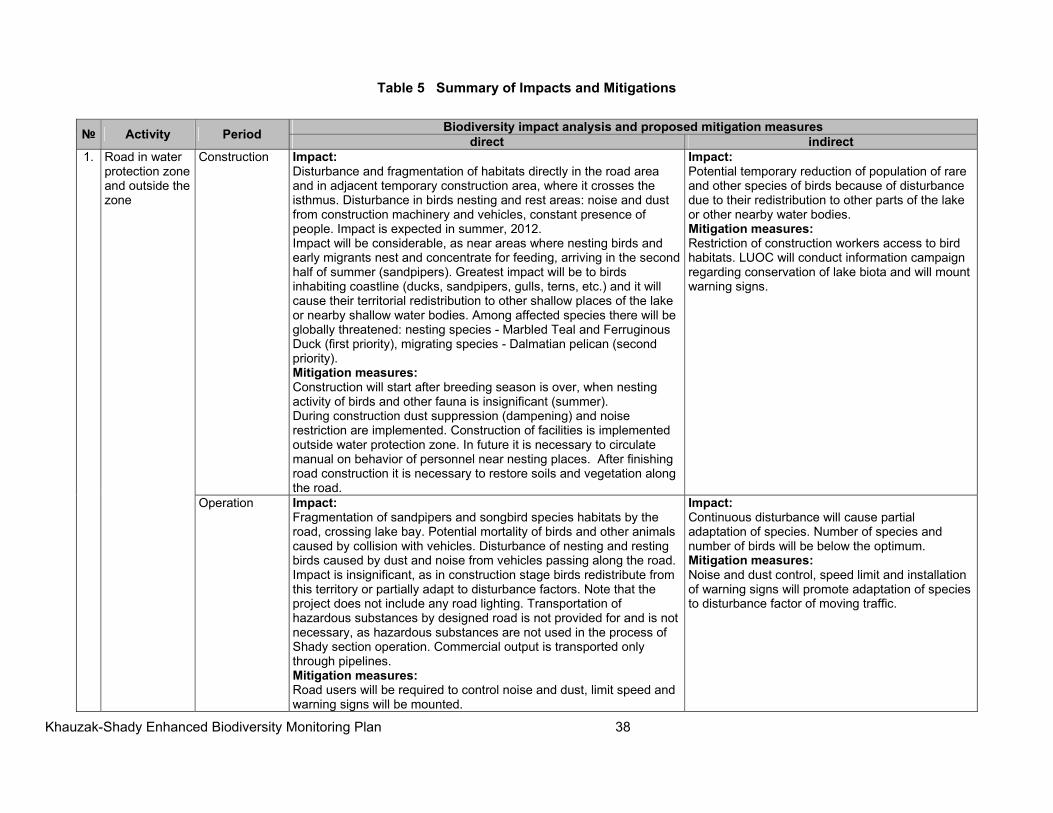
Khauzak-Shady Enhanced Biodiversity Monitoring Plan 38
Table 5 Summary of Impacts and Mitigations
№ Activity Period Biodiversity impact analysis and proposed mitigation measures
direct indirect1. Road in water
protection zone and outside the zone
Construction Impact:Disturbance and fragmentation of habitats directly in the road area and in adjacent temporary construction area, where it crosses the isthmus. Disturbance in birds nesting and rest areas: noise and dust from construction machinery and vehicles, constant presence of people. Impact is expected in summer, 2012. Impact will be considerable, as near areas where nesting birds and early migrants nest and concentrate for feeding, arriving in the second half of summer (sandpipers). Greatest impact will be to birds inhabiting coastline (ducks, sandpipers, gulls, terns, etc.) and it will cause their territorial redistribution to other shallow places of the lake or nearby shallow water bodies. Among affected species there will be globally threatened: nesting species - Marbled Teal and Ferruginous Duck (first priority), migrating species - Dalmatian pelican (second priority). Mitigation measures: Construction will start after breeding season is over, when nesting activity of birds and other fauna is insignificant (summer). During construction dust suppression (dampening) and noise restriction are implemented. Construction of facilities is implemented outside water protection zone. In future it is necessary to circulate manual on behavior of personnel near nesting places. After finishing road construction it is necessary to restore soils and vegetation along the road.
Impact:Potential temporary reduction of population of rare and other species of birds because of disturbance due to their redistribution to other parts of the lake or other nearby water bodies. Mitigation measures: Restriction of construction workers access to bird habitats. LUOC will conduct information campaign regarding conservation of lake biota and will mount warning signs.
Operation Impact:Fragmentation of sandpipers and songbird species habitats by the road, crossing lake bay. Potential mortality of birds and other animals caused by collision with vehicles. Disturbance of nesting and resting birds caused by dust and noise from vehicles passing along the road. Impact is insignificant, as in construction stage birds redistribute from this territory or partially adapt to disturbance factors. Note that the project does not include any road lighting. Transportation of hazardous substances by designed road is not provided for and is not necessary, as hazardous substances are not used in the process of Shady section operation. Commercial output is transported only through pipelines. Mitigation measures: Road users will be required to control noise and dust, limit speed and warning signs will be mounted.
Impact:Continuous disturbance will cause partial adaptation of species. Number of species and number of birds will be below the optimum. Mitigation measures: Noise and dust control, speed limit and installation of warning signs will promote adaptation of species to disturbance factor of moving traffic.
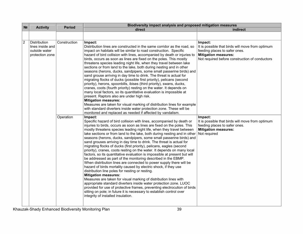
Khauzak-Shady Enhanced Biodiversity Monitoring Plan 39
№ Activity Period Biodiversity impact analysis and proposed mitigation measures
direct indirect
2 Distribution lines inside and outside water protection zone
Construction Impact:Distribution lines are constructed in the same corridor as the road, so impact on habitats will be similar to road construction. Specific hazard of bird collision with lines, accompanied by death or injuries to birds, occurs as soon as lines are fixed on the poles. This mostly threatens species leading night life, when they travel between lake sections or from land to the lake, both during nesting and in other seasons (herons, ducks, sandpipers, some small passerine birds) and sand grouse arriving in day time to drink. The threat is actual for migrating flocks of ducks (possible first priority), pelicans (second priority), herons, spoonbills, ibises (third priority), swans, ducks, cranes, coots (fourth priority) resting on the water. It depends on many local factors, so its quantitative evaluation is impossible at present. Raptors also are under high risk. Mitigation measures: Measures are taken for visual marking of distribution lines for example with standard diverters inside water protection zone. These will be monitored and replaced as needed if affected by vandalism.
Impact:It is possible that birds will move from optimum feeding places to safer ones. Mitigation measures: Not required before construction of conductors
Operation Impact: Specific hazard of bird collision with lines, accompanied by death or injuries to birds, occurs as soon as lines are fixed on the poles. This mostly threatens species leading night life, when they travel between lake sections or from land to the lake, both during nesting and in other seasons (herons, ducks, sandpipers, some small passerine birds) and sand grouses arriving in day time to drink. The threat is actual for migrating flocks of ducks (first priority), pelicans, eagles (second priority), cranes, coots resting on the water. It depends on many local factors, so its quantitative evaluation is impossible at present but will be addressed as part of the monitoring described in the EBMP. When distribution lines are connected to power supply there will be hazard of birds mortality caused by electric shock, if they use distribution line poles for nesting or resting. Mitigation measures: Measures are taken for visual marking of distribution lines with appropriate standard diverters inside water protection zone. LUOC provided for use of protective frames, preventing electrocution of birds sitting on pole; in future it is necessary to establish control over integrity of installed insulation.
Impact:It is possible that birds will move from optimum feeding places to safer ones. Mitigation measures: Not required
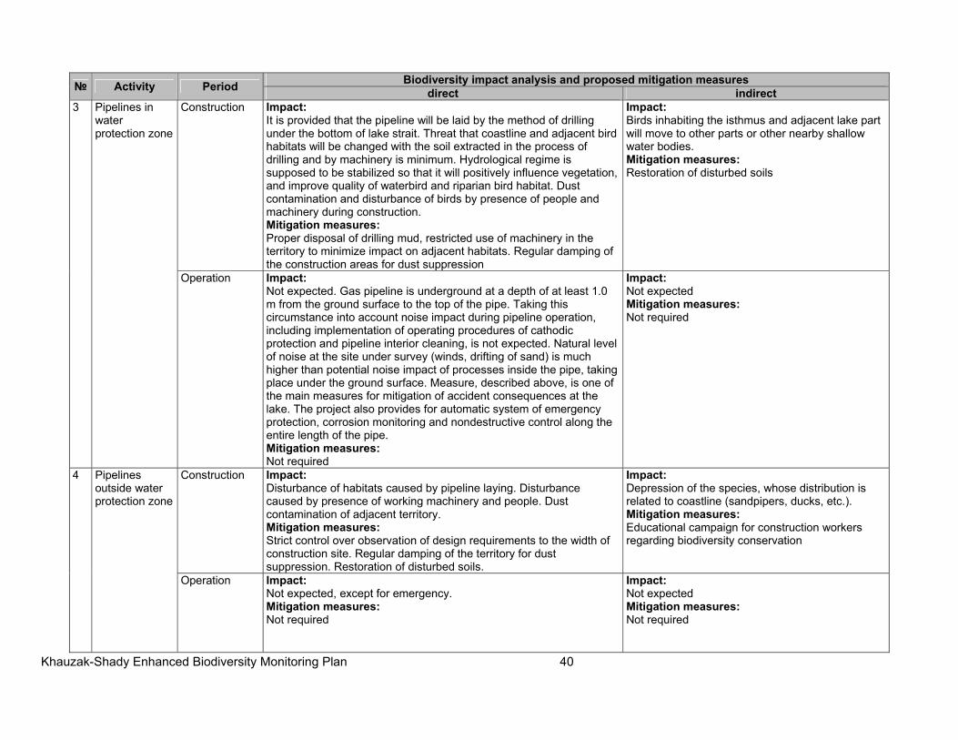
Khauzak-Shady Enhanced Biodiversity Monitoring Plan 40
№ Activity Period Biodiversity impact analysis and proposed mitigation measures
direct indirect3 Pipelines in
water protection zone
Construction Impact:It is provided that the pipeline will be laid by the method of drilling under the bottom of lake strait. Threat that coastline and adjacent bird habitats will be changed with the soil extracted in the process of drilling and by machinery is minimum. Hydrological regime is supposed to be stabilized so that it will positively influence vegetation, and improve quality of waterbird and riparian bird habitat. Dust contamination and disturbance of birds by presence of people and machinery during construction. Mitigation measures: Proper disposal of drilling mud, restricted use of machinery in the territory to minimize impact on adjacent habitats. Regular damping of the construction areas for dust suppression
Impact:Birds inhabiting the isthmus and adjacent lake part will move to other parts or other nearby shallow water bodies. Mitigation measures: Restoration of disturbed soils
Operation Impact:Not expected. Gas pipeline is underground at a depth of at least 1.0 m from the ground surface to the top of the pipe. Taking this circumstance into account noise impact during pipeline operation, including implementation of operating procedures of cathodic protection and pipeline interior cleaning, is not expected. Natural level of noise at the site under survey (winds, drifting of sand) is much higher than potential noise impact of processes inside the pipe, taking place under the ground surface. Measure, described above, is one of the main measures for mitigation of accident consequences at the lake. The project also provides for automatic system of emergency protection, corrosion monitoring and nondestructive control along the entire length of the pipe. Mitigation measures: Not required
Impact:Not expected Mitigation measures: Not required
4 Pipelines outside water protection zone
Construction Impact:Disturbance of habitats caused by pipeline laying. Disturbance caused by presence of working machinery and people. Dust contamination of adjacent territory. Mitigation measures: Strict control over observation of design requirements to the width of construction site. Regular damping of the territory for dust suppression. Restoration of disturbed soils.
Impact:Depression of the species, whose distribution is related to coastline (sandpipers, ducks, etc.). Mitigation measures: Educational campaign for construction workers regarding biodiversity conservation
Operation Impact:Not expected, except for emergency. Mitigation measures: Not required
Impact:Not expected Mitigation measures: Not required
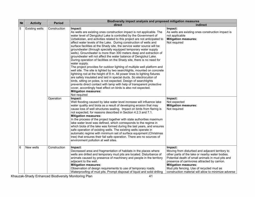
Khauzak-Shady Enhanced Biodiversity Monitoring Plan 41
№ Activity Period Biodiversity impact analysis and proposed mitigation measures
direct indirect5 Existing wells Construction Impact:
As wells are existing ones construction impact is not applicable. The water level of Dengizkul Lake is controlled by the Government of Uzbekistan, and activities related to this project are not anticipated to affect water levels of the Lake. During construction of wells and surface facilities at the Shady site, the service water source will be groundwater (through specially equipped temporary water supply wells). Groundwater is more than 300 meters deep and extraction of groundwater will not affect the water balance of Dengizkul Lake. During operation of facilities on the Shady site, there is no need for water supply. The project provides for outdoor lighting of multiple well platform and well site. The site is lighted by two searchlights, mounted on concrete lightning rod at the height of 8 m. All power lines to lighting fixtures are safely insulated and laid in special ducts. So electrocution of birds, sitting on poles, is not expected. Design of searchlights prevents direct contact with lamp with help of transparent protective cover, accordingly heat effect on birds is also not expected. Mitigation measures: Not required
Impact:As wells are existing ones construction impact is not applicable Mitigation measures: Not required
Operation Impact: Well flooding caused by lake water level increase will influence lake water quality and biota as a result of developing erosion that may cause loss of well structures sealing. Impact on birds from flaring is not expected, for reasons described in Section 4.2.3 and 7.1. Mitigation measures: In the process of the project together with state authorities maximum lake water level was defined, which corresponds to the regime in which biota of the lake was formed during the last years, and ensures safe operation of existing wells. The existing wells operate in automatic regime with minimum set of surface equipment (Christmas tree) that ensures their fail safe operation. There are no sources of environment pollution at well sites.
Impact:Not expected Mitigation measures: Not required
6 New wells Construction Impact:Decreased area and fragmentation of habitats in the places where wells are drilled and temporary mud pits are located. Disturbance of animals caused by presence of machinery and people in the territory adjacent to the well. Mitigation measures: Observation of design requirements to use of temporary roads. Waterproofing of mud pits. Prompt disposal of liquid and solid drilling
Impact:Moving from disturbed and adjacent territory to other parts of the lake or nearby water bodies. Potential death of small animals in mud pits and presence of carnivores attracted by carrion. Mitigation measures: Mud pits fencing. Use of recycled mud as construction material will allow to minimize adverse
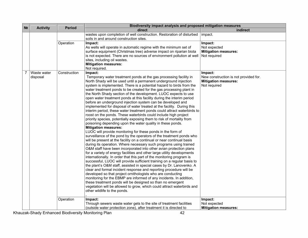
Khauzak-Shady Enhanced Biodiversity Monitoring Plan 42
№ Activity Period Biodiversity impact analysis and proposed mitigation measures
direct indirectwastes upon completion of well construction. Restoration of disturbed soils in and around construction sites.
impact.
Operation Impact:As wells will operate in automatic regime with the minimum set of surface equipment (Christmas tree) adverse impact on riparian biota is not expected. There are no sources of environment pollution at well sites, including oil wastes. Mitigation measures: Not required.
Impact:Not expected Mitigation measures: Not required
7 Waste water disposal
Construction Impact: Temporary water treatment ponds at the gas processing facility in North Shady will be used until a permanent underground injection system is implemented. There is a potential hazard to birds from the water treatment ponds to be created for the gas processing plant in the North Shady section of the development. LUOC expects to use open water treatment ponds at this facility during the interim period before an underground injection system can be developed and implemented for disposal of water treated at the facility. During this interim period, these water treatment ponds could attract waterbirds to roost on the ponds. These waterbirds could include high project priority species, potentially exposing them to risk of mortality from poisoning depending upon the water quality in these ponds. Mitigation measures: LUOC will provide monitoring for these ponds in the form of surveillance of the pond by the operators of the treatment ponds who will be present at the facility on a continual or near continual basis during its operation. Where necessary such programs using trained O&M staff have been incorporated into other avian protection plans for a variety of energy facilities and other large utility developments internationally. In order that this part of the monitoring program is successful, LUOC will provide sufficient training on a regular basis to the plant’s O&M staff, assisted in special cases by Dr. Lanovenko. A clear and formal incident response and reporting procedure will be developed so that project ornithologists who are conducting monitoring for the EBMP are informed of any incidents. In addition, these treatment ponds will be designed so than no emergent vegetation will be allowed to grow, which could attract waterbirds and other wildlife to the ponds. .
Impact:New construction is not provided for. Mitigation measures: Not required
Operation Impact:Through sewers waste water gets to the site of treatment facilities (outside water protection zone), after treatment it is directed to
Impact:Not expected Mitigation measures:
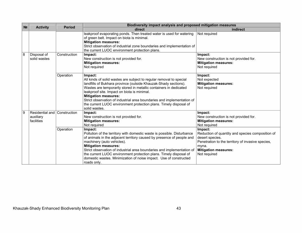
Khauzak-Shady Enhanced Biodiversity Monitoring Plan 43
№ Activity Period Biodiversity impact analysis and proposed mitigation measures
direct indirectleakproof evaporating ponds. Then treated water is used for watering of green belt. Impact on biota is minimal. Mitigation measures: Strict observation of industrial zone boundaries and implementation of the current LUOC environment protection plans.
Not required
8 Disposal of solid wastes
Construction Impact:New construction is not provided for. Mitigation measures: Not required
Impact:New construction is not provided for. Mitigation measures: Not required
Operation Impact: All kinds of solid wastes are subject to regular removal to special landfills of Bukhara province (outside Khauzak-Shady sections). Wastes are temporarily stored in metallic containers in dedicated leakproof site. Impact on biota is minimal. Mitigation measures: Strict observation of industrial area boundaries and implementation of the current LUOC environment protection plans. Timely disposal of solid wastes.
Impact:Not expected Mitigation measures: Not required
9 Residential and auxiliary facilities
Construction Impact:New construction is not provided for. Mitigation measures: Not required
Impact:New construction is not provided for. Mitigation measures: Not required
Operation Impact:Pollution of the territory with domestic waste is possible. Disturbance of animals in the adjacent territory caused by presence of people and machinery (auto vehicles). Mitigation measures: Strict observation of industrial area boundaries and implementation of the current LUOC environment protection plans. Timely disposal of domestic wastes. Minimization of noise impact. Use of constructed roads only.
Impact:Reduction of quantity and species composition of desert species. Penetration to the territory of invasive species, myna. Mitigation measures: Not required
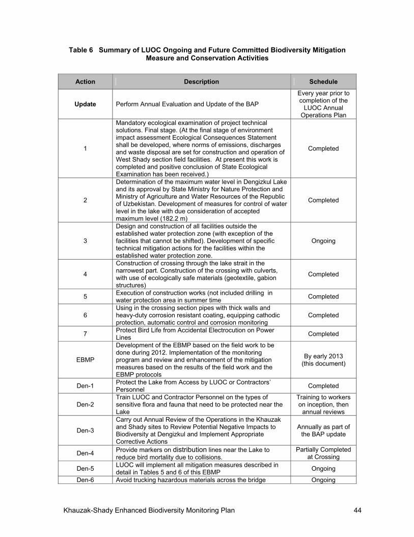
Khauzak-Shady Enhanced Biodiversity Monitoring Plan 44
Table 6 Summary of LUOC Ongoing and Future Committed Biodiversity Mitigation Measure and Conservation Activities
Action Description Schedule
Update Perform Annual Evaluation and Update of the BAP
Every year prior to completion of the
LUOC Annual Operations Plan
1
Mandatory ecological examination of project technical solutions. Final stage. (At the final stage of environment impact assessment Ecological Consequences Statement shall be developed, where norms of emissions, discharges and waste disposal are set for construction and operation of West Shady section field facilities. At present this work is completed and positive conclusion of State Ecological Examination has been received.)
Completed
2
Determination of the maximum water level in Dengizkul Lake and its approval by State Ministry for Nature Protection and Ministry of Agriculture and Water Resources of the Republic of Uzbekistan. Development of measures for control of water level in the lake with due consideration of accepted maximum level (182.2 m)
Completed
3
Design and construction of all facilities outside the established water protection zone (with exception of the facilities that cannot be shifted). Development of specific technical mitigation actions for the facilities within the established water protection zone.
Ongoing
4
Construction of crossing through the lake strait in the narrowest part. Construction of the crossing with culverts, with use of ecologically safe materials (geotextile, gabion structures)
Completed
5 Execution of construction works (not included drilling in water protection area in summer time
Completed
6 Using in the crossing section pipes with thick walls and heavy-duty corrosion resistant coating, equipping cathodic protection, automatic control and corrosion monitoring
Completed
7 Protect Bird Life from Accidental Electrocution on Power Lines
Completed
EBMP
Development of the EBMP based on the field work to be done during 2012. Implementation of the monitoring program and review and enhancement of the mitigation measures based on the results of the field work and the EBMP protocols
By early 2013 (this document)
Den-1 Protect the Lake from Access by LUOC or Contractors’ Personnel
Completed
Den-2 Train LUOC and Contractor Personnel on the types of sensitive flora and fauna that need to be protected near the Lake
Training to workers on inception, then
annual reviews
Den-3
Carry out Annual Review of the Operations in the Khauzak and Shady sites to Review Potential Negative Impacts to Biodiversity at Dengizkul and Implement Appropriate Corrective Actions
Annually as part of the BAP update
Den-4 Provide markers on distribution lines near the Lake to reduce bird mortality due to collisions.
Partially Completed at Crossing
Den-5 LUOC will implement all mitigation measures described in detail in Tables 5 and 6 of this EBMP
Ongoing
Den-6 Avoid trucking hazardous materials across the bridge Ongoing
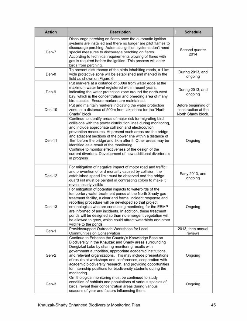
Khauzak-Shady Enhanced Biodiversity Monitoring Plan 45
Action Description Schedule
Den-7
Discourage perching on flares once the automatic ignition systems are installed and there no longer are pilot flames to discourage perching. Automatic ignition systems don't need special measures to discourage perching on flares. According to technical requirements blowing of flares with gas is required before the ignition. This process will deter birds from perching.
Second quarter 2014
Den-8 To prevent disturbance of the birds inhabiting reeds, a 1 km wide protective zone will be established and marked in the field as shown on Figure 6.
During 2013, and ongoing
Den-9
Put markers at a distance of 500m from water edge at the maximum water level registered within recent years, indicating the water protection zone around the north-west bay, which is the concentration and breeding area of many bird species. Ensure markers are maintained.
During 2013, and ongoing
Den-10 Put and maintain markers indicating the water protection zone, at a distance of 500m from lakeshore for the “North Shady” block
Before beginning of construction at the North Shady block.
Den-11
Continue to identify areas of major risk for migrating bird collisions with the power distribution lines during monitoring, and include appropriate collision and electrocution prevention measures. At present such areas are the bridge and adjacent sections of the power line within a distance of 1km before the bridge and 3km after it. Other areas may be identified as a result of the monitoring. Continue to monitor effectiveness of the design of the current diverters. Development of new additional diverters is in progress
Ongoing
Den-12
For mitigation of negative impact of motor road and traffic: and prevention of bird mortality caused by collision, the established speed limit must be observed and the bridge guard rail must be painted in contrasting colors to make it reveal clearly visible
Early 2013, and ongoing
Den-13
For mitigation of potential impacts to waterbirds of the temportary water treatment ponds at the North Shady gas treatment facility, a clear and formal incident response and reporting procedure will be developed so that project ornithologists who are conducting monitoring for the EBMP are informed of any incidents. In addition, these treatment ponds will be designed so than no emergent vegetation will be allowed to grow, which could attract waterbirds and other wildlife to the ponds.
Ongoing
Gen-1 Provide/support Outreach Workshops for Local Communities on Conservation
2013, then annual reviews
Gen-2
Continue to Enhance the Country’s Knowledge Base on Biodiversity in the Khauzak and Shady areas surrounding Dengizkul Lake by sharing monitoring results with government authorities, appropriate academic institutions, and relevant organizations. This may include presentations of results at workshops and conferences, cooperation with academic biodiversity research, and providing opportunities for internship positions for biodiversity students during the monitoring.
Ongoing
Gen-3
Ornithological monitoring must be continued to study condition of habitats and populations of various species of birds, reveal their concentration areas during various seasons of year and factors influencing them.
Ongoing
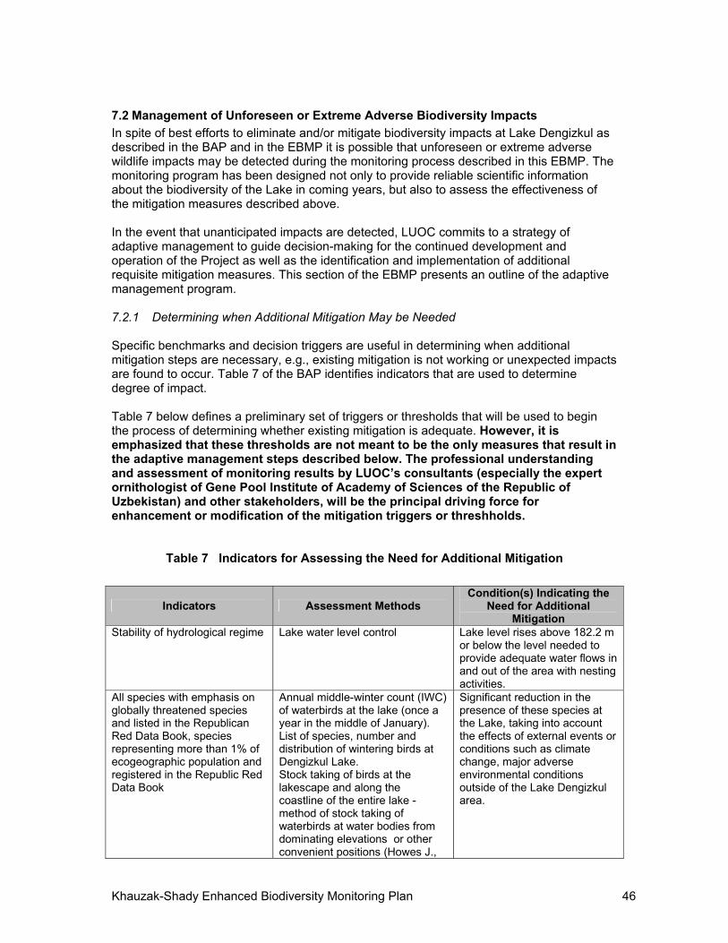
Khauzak-Shady Enhanced Biodiversity Monitoring Plan 46
7.2 Management of Unforeseen or Extreme Adverse Biodiversity Impacts
In spite of best efforts to eliminate and/or mitigate biodiversity impacts at Lake Dengizkul as described in the BAP and in the EBMP it is possible that unforeseen or extreme adverse wildlife impacts may be detected during the monitoring process described in this EBMP. The monitoring program has been designed not only to provide reliable scientific information about the biodiversity of the Lake in coming years, but also to assess the effectiveness of the mitigation measures described above. In the event that unanticipated impacts are detected, LUOC commits to a strategy of adaptive management to guide decision-making for the continued development and operation of the Project as well as the identification and implementation of additional requisite mitigation measures. This section of the EBMP presents an outline of the adaptive management program. 7.2.1 Determining when Additional Mitigation May be Needed Specific benchmarks and decision triggers are useful in determining when additional mitigation steps are necessary, e.g., existing mitigation is not working or unexpected impacts are found to occur. Table 7 of the BAP identifies indicators that are used to determine degree of impact. Table 7 below defines a preliminary set of triggers or thresholds that will be used to begin the process of determining whether existing mitigation is adequate. However, it is emphasized that these thresholds are not meant to be the only measures that result in the adaptive management steps described below. The professional understanding and assessment of monitoring results by LUOC’s consultants (especially the expert ornithologist of Gene Pool Institute of Academy of Sciences of the Republic of Uzbekistan) and other stakeholders, will be the principal driving force for enhancement or modification of the mitigation triggers or threshholds.
Table 7 Indicators for Assessing the Need for Additional Mitigation
Indicators Assessment Methods Condition(s) Indicating the
Need for Additional Mitigation
Stability of hydrological regime Lake water level control Lake level rises above 182.2 m or below the level needed to provide adequate water flows in and out of the area with nesting activities.
All species with emphasis on globally threatened species and listed in the Republican Red Data Book, species representing more than 1% of ecogeographic population and registered in the Republic Red Data Book
Annual middle-winter count (IWC) of waterbirds at the lake (once a year in the middle of January). List of species, number and distribution of wintering birds at Dengizkul Lake. Stock taking of birds at the lakescape and along the coastline of the entire lake - method of stock taking of waterbirds at water bodies from dominating elevations or other convenient positions (Howes J.,
Significant reduction in the presence of these species at the Lake, taking into account the effects of external events or conditions such as climate change, major adverse environmental conditions outside of the Lake Dengizkul area.
Khauzak-Shady Enhanced Biodiversity Monitoring Plan 47
Indicators Assessment Methods Condition(s) Indicating the
Need for Additional Mitigation
Bakewell D., 1989) at permanent monitoring points, which will be distributed along the lake shore and will cover different stations. Points of concentration will be defined with help of GPS and mapped with use of Google. A report with survey results will be drawn up. Outline map of wintering bird geographical distribution at the lake will be prepared.
All species with emphasis on globally threatened species, listed in the Republic Red Data Book, and whose distribution area is limited by “Eurasian Deserts and Neardeserts” Also Red-crested Pochard, Coot
Annual Ornithological survey of the lake in order to record birds nesting at the lake (in the first half of May) and define if nesting is successful (at the end of June). List of birds, nesting at the lake, will be prepared - lakescape and lakeshore will be surveyed at specified observation points and counting at transects in different stations will be conducted. Search for nesting pairs, their nesting places, young birds at the project site and shallow lake, overgrown with rushes. Nesting places in north-west part of the lake will be mapped. Ornithological survey of the area near linear facilities in order to find out possible cases of bird mortality (conducted in different seasons at the same time with above activities). A report with survey results will be drawn up. Outline map of bird nesting places at the lake will be prepared.
Significant reduction in the presence of these species at the Lake, taking into account the effects of external events or conditions such as climate change, major adverse environmental conditions outside of the Lake Dengizkul area.
Habitats
Types of habitats at each station will be defined. Description of vegetation (geobotanical method of research) and soil condition. Marking of sites and definition of boundaries on map with geographic coordinates. Control over impact on lake habitats and project site (control of occupied area and quality), conducted in different seasons at the same time with above activities. A report with survey results will be drawn up. Outline map of lake habitats will be prepared with use of satellite
Significant reduction in suitable habitat for species described above, with due regard for habitat changes that occur due to activities not under the control of LUOC.
Khauzak-Shady Enhanced Biodiversity Monitoring Plan 48
Indicators Assessment Methods Condition(s) Indicating the
Need for Additional Mitigation
images of the territory (Google), seasonal aspect.
Note: Names of globally threatened species, listed in the Republic Red Data Book, representing more than 1% of ecogeographic population and whose distribution area is limited by “Eurasian Deserts and Near-deserts” biome are given in the BAP.
Globally threatened species: Dalmatian Pelican Pelecanus crispus, Marbled Teal Marmaronetta angustrostris, Ferruginous Duck Aythya nyroca, White-headed Duck Oxyura leucocephala, Pallas's Sea Eagle Haliaeetus leucoryphus, Pallid Harrier Circus macrourus, Egyptian Vulture Neophron percnopterus, Saker Falcon Falco cherrug, Great Bustard Otis tarda, Houbara Bustard Chlamydotis undulata, Little Bustard Tetrax tetrax, Eurasian Curlew Numenius arquata, Black-winged Pratincole Glareola nordmanni, Eurasian Roller Coracias garrulus.
Species, registered in the Red Data Book of the Republic of Uzbekistan: European White Pelican Pelecanus onocrotalus, Dalmatian Pelican Pelecanus crispus, Little Cormorant Phalocrocorax pygmaeus, Little Egret Egretta garzetta, Spoonbill Platalea leucorodia, Glossy Ibis Plegadis falcinellus,, Mute Swan Cygnus olor, Whooper Swan Cygnus cygnus, Marbled Teal Marmaronetta angustirostris, Ferruginous Duck Aythya nyroca,White-headed Duck Oxyura leucocephala, Osprey Pandion haliaetus, Pallas' Fish Eagle Haliaeetus leucoryphus, White-tailed Eagle Haliaeetus albicilla , Golden Eagle Aquila chrysaetos, Steppe Eagle Aquila nipalensis, Pallid Harrier Circus macrourus, Saker Falcon Falco cherrug, Great Bustard Otis tarda, Houbara Bustard Chlamydotis undulata, Little Bustard Tetrax tetrax, Black-winged Pratincole Glareola nordmanni. (The globally threatened species listed above are also included in the Red Book of Uzbekistan, except for Egyptian Vulture, Eurasian Curlew, Eurasian Roller).
Species, representing 1% or more of ecogeographic population: Dalmatian Pelican Pelecanus crispus, Marbled Teal Marmaronetta angustirostris, Great Bustard Otis tarda, Houbara Bustard Chlamydotis undulata, Little Bustard Tetrax tetrax, Ferruginous Duck Aythya nyroca, White-headed Duck Oxyura leucocephala, Mallard Anas platyrhynchos, Red-crested Pochard Netta rufina, Common Pochard Aythya ferina, Smew Mergellus albellus, Coot Fulica atra.
Species, whose area of distribution is limited by the biome "Eurasian Deserts and Near-deserts": Egyptian Nightjar Caprimulgus aegyptius, Brown-necked Raven Corvus ruficollis, Southern Booted Wabler Hippolais rama, Desert Warbler Sylvia nana, Streaked Scrub Warbler Scotocerca inquieta, Bokhara Tit Parus bokharensis, Desert Finch Rhodospiza obsoleta.
This table uses recommendations of "Biodiversity Indicators for Monitoring Impacts and Conservation Actions. The Energy & Biodiversity Initiative"
”Significance” to be defined by the experts on the basis of the Lake’s viability in supporting the species.
7.2.2 Identifying and Implementing Additional Mitigation Due to the uncertainty surrounding the potential unanticipated impacts of unforeseen or extreme events it is not feasible to anticipate every eventuality and potential mitigation in this document. When a situation described in Table 7 presents itself as a result of the monitoring program, and the professional judgment of LUOC’s consultants, the relevant Government agencies, or MIGA, LUOC will support the following steps:
Distribute the annual monitoring reports to the relevant Government Agencies and MIGA. In the event that an urgent unforeseen event occurs, LUOC will distribute a brief report on the event and potential impacts as soon as possible after the event occurs and LUOC’s consultants have visited the site and assessed the seriousness of the situation.
After a review period, LUOC will convene a meeting of the interested stakeholders to discuss the monitoring results and/or the unanticipated event(s). Depending on the urgency and scope of the concern this meeting may be held as a teleconference or an in-person meeting at convenient location. LUOC will make its consultants and relevant staff available at this meeting.
Khauzak-Shady Enhanced Biodiversity Monitoring Plan 49
The result of the meeting will be agreement on what, if any, additional mitigation measures will be required to address the identified unanticipated adverse conditions. LUOC will provide necessary technical inputs and make available for the meeting their engineers, managers, or others who will be responsible for the implementation of the new mitigation measures.
LUOC and its consultants will apply for any new permits or approvals for carrying out the new mitigation from the relevant Government Agencies.
LUOC will update the BAP and EBMP by issuing and disclosing a technical addendum to these reports documenting the new mitigation measures, and providing a schedule for their implementation.
8 ENHANCED BIODIVERSITY MONITORING REPORTING Reporting of the results of the EBMP will be accomplished through the following processes:
Access by selected stakeholders to the reporting database to be maintained by LUOC
Periodic technical reports covering each of six annual monitoring periods Comprehensive annual report submitted by LUOC Ad hoc interim reports documenting unforeseen or emergency conditions
Feedback or comments from NGOs and the public are welcome. These groups may get LUOC's reports on request, and their comments or feedback will be addressed through LUOC's official website. Table 8 shows the established reporting plan.
Table 8 Monitoring Reporting and Stakeholders
Report Type Frequency Review / Modify / Approve Authority
MIGA Zoo NGOs Public
Database Updated as information becomes available
R A
Monitoring Visit Technical Reports
30 days after each monitoring visit (see Table 4)
R M R R
Comprehensive Annual Report
Annually, by end February
A R R R
Ad hoc interim reports Unscheduled; as soon as possible after any emergency event
R M R R
Notes: MIGA = Multilateral Investment Guarantee Agency (World Bank Group) Zoo = the Institute of Zoology of the Academy of Sciences of the Republic of Uzbekistan A = Approval; R = Review and Comment; M = Develop/modify reports
Starting with the 2013 monitoring activities, results will be reported using a format similar to that shown in Table 9, as recommended by MIGA. The information in the table was obtained by Dr. C. Gordon (Normandeau Associates) during the site visit of November 2012, and is presented as a sample of expected data. In addition to the tables, LUOC’s consultants will develop and submit written reports explaining, summarizing, and enhancing the information as appropriate. It is important to note that this table only covers the general avifaunistic surveys. Summary tables and/or figures will also be included in the reports to cover the other two monitoring elements: reed-nesting bird breeding success monitoring, and power line impact monitoring.
Table 9 Recommended Summary Table for General Avifaunal Survey Results

Khauzak-Shady Enhanced Biodiversity Monitoring Plan 50
Location name Bridge over straight
Observation point W of
the NE collector
mouth
E shore of Bay just N of
bridge
Khauzak field camp,
O&M campus
Visit Total Bird
Observations
Location number (corresponding to obs point numbers on map)
T31 T44
Date 7 November, 2012
7 November, 2012
7 November, 2012
7 November, 2012
Start time 11:40 13:30 14:30 15:50 End time 12:50 14:00 15:20 16:05 Sky conditions clear clear clear clear Distance traveled during observation (km)
0.5 0.1 1 0.1
wind <5 mph <5 mph <5 mph <5 mph temperature ≈150C ≈150C ≈150C ≈150C Equipment used 20-60x
telescope, 10x
binoculars
20-60x telescope, 10x
binoculars
20-60x telescope,
10x binoculars
20-60x telescope,
10x binoculars
Observer(s) E. Lanovenko, C. Gordon, D.
Mallon, (others)
E. Lanovenko, C. Gordon, D.
Mallon, (others)
E. Lanovenko,C. Gordon, D.
Zanewich
C. Gordon
Graylag Goose 15 15Mute Swan 25 6 15 46Ruddy Shelduck 10 10Common Shelduck
250 250
Eurasian Wigeon
50 50
Mallard 60 30 20 110Common Teal 75 20 4 99Common Pochard
3 3
Tufted Duck 100 100Unidentified duck
100 400 500
Great Crested Grebe
8 8
Black-necked Grebe
15 15
Great Cormorant
15 200 215
Pygmy Cormorant
1 1
Gray Heron 1 1 Eurasian Marsh-harrier
1 1
White-tailed Eagle
4 2 1 7
Common Buzzard
1 1
Common Redshank
2 2
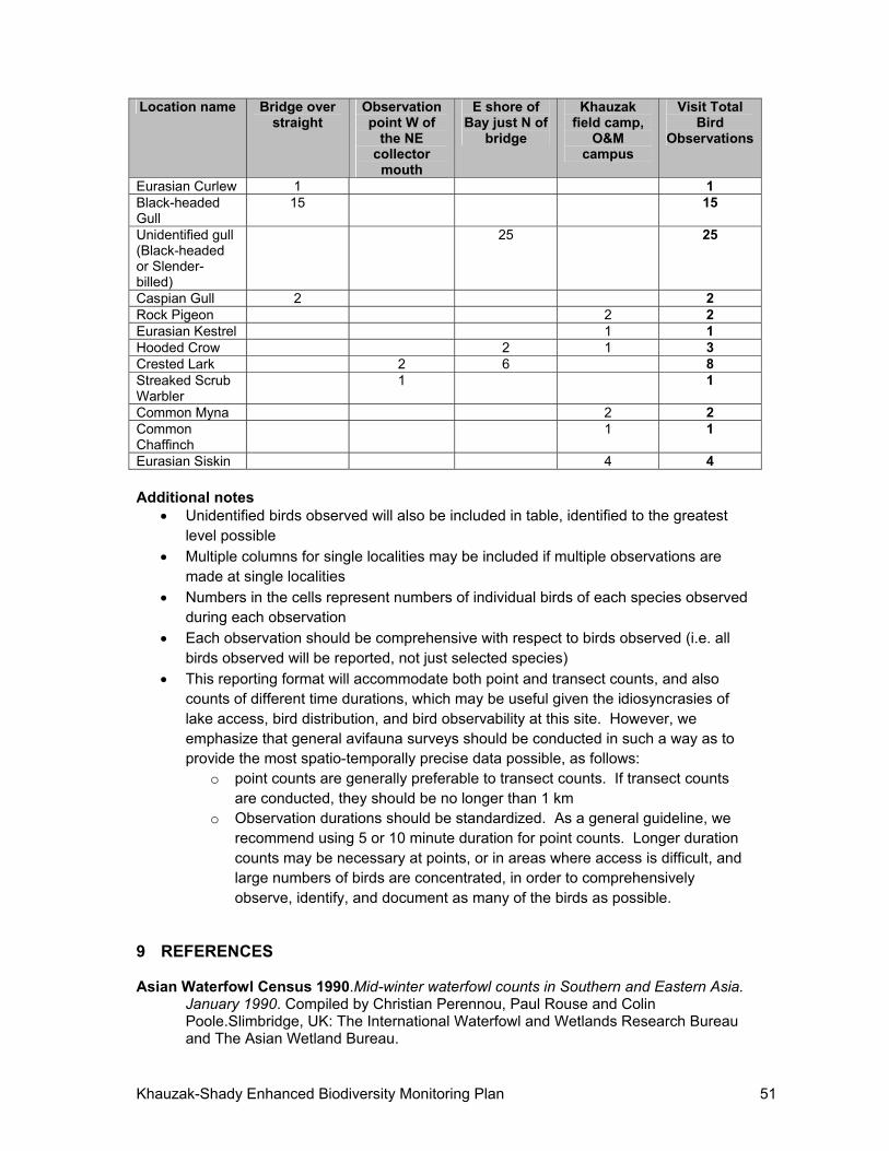
Khauzak-Shady Enhanced Biodiversity Monitoring Plan 51
Location name Bridge over straight
Observation point W of
the NE collector
mouth
E shore of Bay just N of
bridge
Khauzak field camp,
O&M campus
Visit Total Bird
Observations
Eurasian Curlew 1 1 Black-headed Gull
15 15
Unidentified gull (Black-headed or Slender-billed)
25 25
Caspian Gull 2 2 Rock Pigeon 2 2 Eurasian Kestrel 1 1 Hooded Crow 2 1 3 Crested Lark 2 6 8 Streaked Scrub Warbler
1 1
Common Myna 2 2 Common Chaffinch
1 1
Eurasian Siskin 4 4 Additional notes
Unidentified birds observed will also be included in table, identified to the greatest level possible
Multiple columns for single localities may be included if multiple observations are made at single localities
Numbers in the cells represent numbers of individual birds of each species observed during each observation
Each observation should be comprehensive with respect to birds observed (i.e. all birds observed will be reported, not just selected species)
This reporting format will accommodate both point and transect counts, and also counts of different time durations, which may be useful given the idiosyncrasies of lake access, bird distribution, and bird observability at this site. However, we emphasize that general avifauna surveys should be conducted in such a way as to provide the most spatio-temporally precise data possible, as follows:
o point counts are generally preferable to transect counts. If transect counts are conducted, they should be no longer than 1 km
o Observation durations should be standardized. As a general guideline, we recommend using 5 or 10 minute duration for point counts. Longer duration counts may be necessary at points, or in areas where access is difficult, and large numbers of birds are concentrated, in order to comprehensively observe, identify, and document as many of the birds as possible.
9 REFERENCES Asian Waterfowl Census 1990.Mid-winter waterfowl counts in Southern and Eastern Asia.
January 1990. Compiled by Christian Perennou, Paul Rouse and Colin Poole.Slimbridge, UK: The International Waterfowl and Wetlands Research Bureau and The Asian Wetland Bureau.
Khauzak-Shady Enhanced Biodiversity Monitoring Plan 52
Asian Waterfowl Census 1991.Mid-winter waterfowl counts January 1991. Compiled by Christian Perennou and TaejMundkur.Slimbridge, UK: IWRB, AWB.
Atadjanov A., Filatov A., Lanovenko Ye., Safronov L., Zagrebin S., Kashkarov D., Khodjaev D., Goncharov G. 1999. Summary of existing data on past waterfowl surveys in Uzbekistan. Report Phase 2 of the project of Ramsar Small Grants Fund for Wetland Conservation and Wise Use “Protection of Uzbekistan’s wetlands and their waterfowl” (July, 1999).
Atadjanov A., Filatov A., Lanovenko Ye., Chernogaev E., Khodjaev J. 2001. Aerial survey of wetlands in Uzbekistan (winter, 2000). Report Phase 2 of the project of Ramsar Small Grants Fund for Wetland Conservation and Wise Use “Protection of Uzbekistan’s wetlands and their waterfowl” (June, 2001).
Cadastre Reference Book of Game Animals of Uzbekistan.1992. Tashken: Fan. 102 pp.
International Finance Corporation. Performance Standard 6 Biodiversity Conservation and Sustainable Natural Resource Management. April 30, 2006.
International Finance Corporation 2007.Guidance Note 6 - Biodiversity Conservation and Sustainable Natural Resource Management. July 31, 2007.
Lanovenko E.N. 2001.On the study of the ornithological fauna ofDengizkul Lake.Works of Uzbekistan Reserves 3: 110-120.
Landsat 2012. United States Geological Service and National Aeronautics and Space Administration.
Lanovenko, E.N., Filatov, A., Zagrebin, S. 2000. White-headed duck at Dengizkul Lake, Uzbekistan.TWSG News. The Bulletin of the Threatened Waterfowl Specialist Group 12:16.
LanovenkoYe.N.,Turaev M.M.2008. Dengizkul Lake. Pp.102-104 in: Important Bird Areas in Uzbekistan. Priority Sites for Conservation. Tashkent.
Lanovenko E.N., Shernazarov E., Filatova Е.А., Filatov А.K., Zagrebin S.V., 2012 Ornithological Monitoring At Khauzak-Shady Block of Dengizkul Field In 2012—Final Report, (December 25, 2012)
LUOC 2012.Khauzak-Shady Biodiversity Action Plan.
Nazarov А.P. 1988.Regarding Distribution and Abundance of Water Birds in Uzbekistan. Pp.49-51 in: Ecology, Protection and Sound Management of Birds of Uzbekistan. Tashkent: Fan.
Shernazarov E.1987. Information about Bird Nesting Areas at some Water Bodies of Uzbekistan Pp.113-114 in: Mammals and Birds of Uzbekistan. Tashkent: Fan.
Shernazarov E., Nazarov А.P.1991.Current Status of Abundance and Distribution of Water and Wading Birds of the Basin of the Zaravshan River and Middle Course of the Amu Darya River. Tashkent: Summary UzNIINTI.
Solokha A.2006. Results from the International Waterbird Census in Central Asia and the Caucasus 2003-2005.Wageningen, The Netherlands: Wetlands International.
Uzbekistan Birds v.1.1987, v.2.1990, v.3. 1995. Tashkent.

ANNEX 1 – OFFICIAL 2012 MONITORING REPORTS
54
STATE BIOLOGICAL CONTROL STATE COMMITTEE FOR NATURE PROTECTION Of
THE REPUBLIC OF UZBEKISTAN
"APPROVE" Acting Head of State Biological Control
State Committee for Nature Protection of the Republic of Uzbekistan _______________Grigoryants А.А.
December 25, 2012
ORNITHOLOGICAL MONITORING AT KHAUZAK-SHADY BLOCK OF DENGIZKUL
FIELD IN 2012 UNDER CONTRACT NO 17/2012-Л DATED FEBRUARY 17, 2012
BETWEEN STATE SPECIALIZED INSPECTION OF ANALYTICAL CONTROL OF STATE COMMITTEE FOR NATURE PROTECTION OF THE REPUBLIC OF
UZBEKISTAN AND STATE BIOLOGICAL CONTROL OF STATE COMMITTEE FOR NATURE PROTECTION OF THE REPUBLIC OF UZBEKISTAN
FINAL REPORT
Research Manager: Lanovenko E.N., Candidate of Science, Head
Tashkent - 2012
Prepared by:
Shernazarov E., Doctor of Science
Ornithologist
Filatova Е.А.
Ecologist
Filatov А.K.
Ornithologist
Zagrebin S.V. Ornithologist
55
INTRODUCTION Implementation of oil-gas field construction and development projects always entails a
certain level of impact from project activities on natural ecosystems and their components. An especially notable effect is produced on the condition of habitats of animals and plants.
The contract area of Khauzak-Shady field is localized at Dengizkul Lake Ramsar site. In this case, bird monitoring is important for mitigatng the impact of project activity on the birds.
At Khauzak-Shady Block of Dengizkul field during bird monitoring in May 2012 drilling of new wells and completion of operating ones was still under way and the lake shore adjacent to the bridge, connecting the road through the bay, were consolidated.
Monitoring surveys mean special field surveys of birds inhabiting the Dengizkul Lake that may become exposed to project impacts. The bird monitoring in 2012 entailed a baseline field survey meant to define which monitoring points and main sites if regularly surveyed, will reflect impact of project activities on bird habitats, species composition, spatial distribution and type of stay at Dengizkul Lake.
Main survey objectives for the period: Furnish information on species composition, abundance and spatial distribution of birds
inhabiting the lake, including seasonal aspect (breeding, migration and wintering seasons). Map bird habitats in near-shore area of Dengizkul Lake. Select monitoring points for comparative data acquisition during all seasons of the annual
cycle. Survey road and distribution power transmission lines in the field that potentially threaten
bird life. Survey changes in avifauna composition covering the entire area of the lake and connected
with regular movements of birds between breeding, feeding and resting areas, and because Dengizkul Lake is a Ramsar site.
Main surveys of project impacts on the avifauna shall be carried out during the breeding and wintering seasons.
Map bird breeding at Dengizkul Lake. As Dengizkul is a water body of international importance as a concentration area of
wintering and migrating waterbirds, it is necessary to monitor the birds in their feeding and resting areas.
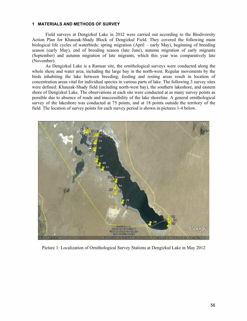
56
1 MATERIALS AND METHODS OF SURVEY
Field surveys at Dengizkul Lake in 2012 were carried out according to the Biodiversity Action Plan for Khauzak-Shady Block of Dengizkul Field. They covered the following main biological life cycles of waterbirds: spring migration (April – early May), beginning of breeding season (early May), end of breeding season (late June), autumn migration of early migrants (September) and autumn migration of late migrants, which this year was comparatively late (November).
As Dengizkul Lake is a Ramsar site, the ornithological surveys were conducted along the whole shore and water area, including the large bay in the north-west. Regular movements by the birds inhabiting the lake between breeding, feeding and resting areas result in location of concentration areas vital for individual species in various parts of lake. The following 3 survey sites were defined: Khauzak-Shady field (including north-west bay), the southern lakeshore, and eastern shore of Dengizkul Lake. The observations at each site were conducted at as many survey points as possible due to absence of roads and inaccessibility of the lake shoreline. A general ornithological survey of the lakeshore was conducted at 75 points, and at 18 points outside the territory of the field. The location of survey points for each survey period is shown in pictures 1-4 below.
Picture 1: Localization of Ornithological Survey Stations at Dengizkul Lake in May 2012
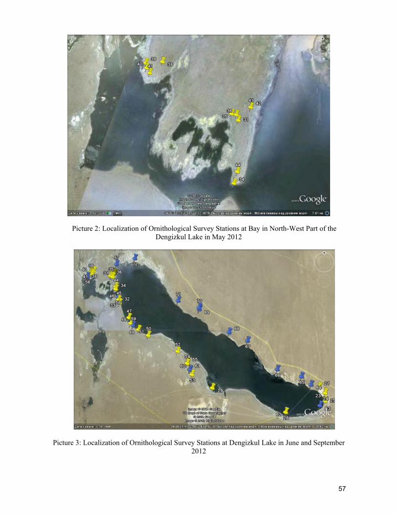
57
Picture 2: Localization of Ornithological Survey Stations at Bay in North-West Part of the Dengizkul Lake in May 2012
Picture 3: Localization of Ornithological Survey Stations at Dengizkul Lake in June and September 2012
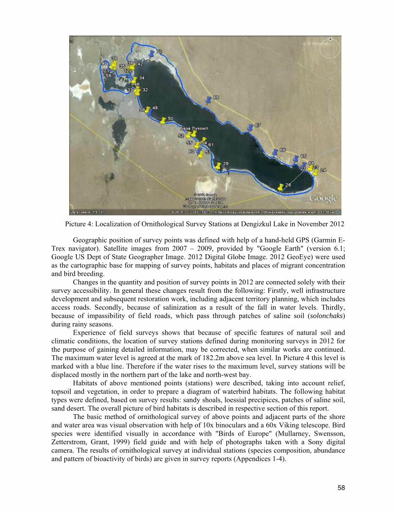
58
Picture 4: Localization of Ornithological Survey Stations at Dengizkul Lake in November 2012
Geographic position of survey points was defined with help of a hand-held GPS (Garmin E-Trex navigator). Satellite images from 2007 – 2009, provided by "Google Earth" (version 6.1; Google US Dept of State Geographer Image. 2012 Digital Globe Image. 2012 GeoEye) were used as the cartographic base for mapping of survey points, habitats and places of migrant concentration and bird breeding.
Changes in the quantity and position of survey points in 2012 are connected solely with their survey accessibility. In general these changes result from the following: Firstly, well infrastructure development and subsequent restoration work, including adjacent territory planning, which includes access roads. Secondly, because of salinization as a result of the fall in water levels. Thirdly, because of impassibility of field roads, which pass through patches of saline soil (solonchaks) during rainy seasons.
Experience of field surveys shows that because of specific features of natural soil and climatic conditions, the location of survey stations defined during monitoring surveys in 2012 for the purpose of gaining detailed information, may be corrected, when similar works are continued. The maximum water level is agreed at the mark of 182.2m above sea level. In Picture 4 this level is marked with a blue line. Therefore if the water rises to the maximum level, survey stations will be displaced mostly in the northern part of the lake and north-west bay.
Habitats of above mentioned points (stations) were described, taking into account relief, topsoil and vegetation, in order to prepare a diagram of waterbird habitats. The following habitat types were defined, based on survey results: sandy shoals, loessial precipices, patches of saline soil, sand desert. The overall picture of bird habitats is described in respective section of this report.
The basic method of ornithological survey of above points and adjacent parts of the shore and water area was visual observation with help of 10x binoculars and a 60x Viking telescope. Bird species were identified visually in accordance with "Birds of Europe" (Mullarney, Swensson, Zetterstrom, Grant, 1999) field guide and with help of photographs taken with a Sony digital camera. The results of ornithological survey at individual stations (species composition, abundance and pattern of bioactivity of birds) are given in survey reports (Appendices 1-4).

59
According to the Bird Monitoring Program within the framework of the Biodiversity Action Plan for Khauzak-Shady field in order to define places that are “dangerous” year round for water birds during field work in the territory of the field we surveyed the 20-km long power transmission line. In the process 9-12 transects, each 1km long, and a 20m wide strip on each side of the power line, were walked and visually surveyed. All birds, observed within the strip and sitting on the lines and power transmission poles, were recorded. Bird movements in different parts of day were also surveyed with special attention paid to the Bridge area: in the morning after dawn, late in the morning, in the daytime and in the evening before sunset. The results of these surveys are given in survey reports (Appendix 2).
In accordance with the above program 20km of motor road was also surveyed to define probable impacts of the road and traffic on migrating waterbirds. Ten transects, including the road and adjacent 20m strip, were walked and surveyed. In the process of the survey the following were registered: bird species flying within the strip under survey, their number, flight height and type of movements, birds that perished from collision with vehicles and their remnants were also searched for. The results of road survey are given in the survey report (Appendix 3).
Generally accepted scientific Latin names of birds by K.Mullarney, L.Swensson, D.Zetterstrom, P.Grant (1999) and Russian names according to the “Summary of the USSR Avifauna” (Stepanyan, 1990) are used in this report.
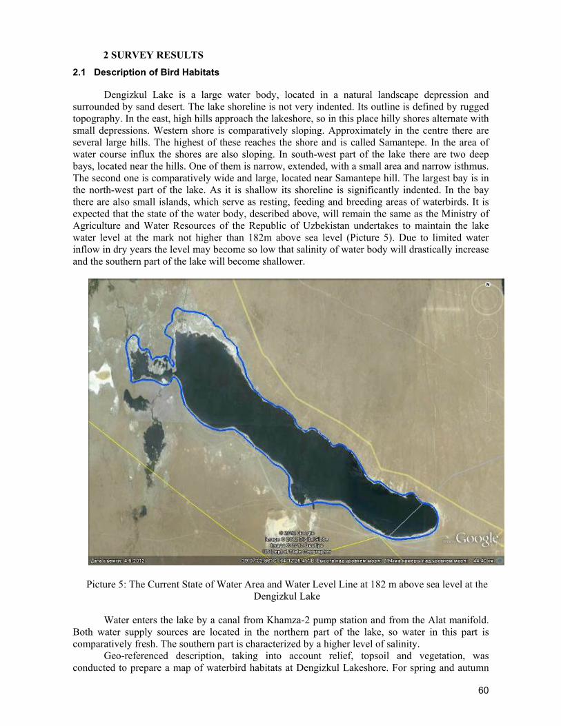
60
2 SURVEY RESULTS
2.1 Description of Bird Habitats
Dengizkul Lake is a large water body, located in a natural landscape depression and surrounded by sand desert. The lake shoreline is not very indented. Its outline is defined by rugged topography. In the east, high hills approach the lakeshore, so in this place hilly shores alternate with small depressions. Western shore is comparatively sloping. Approximately in the centre there are several large hills. The highest of these reaches the shore and is called Samantepe. In the area of water course influx the shores are also sloping. In south-west part of the lake there are two deep bays, located near the hills. One of them is narrow, extended, with a small area and narrow isthmus. The second one is comparatively wide and large, located near Samantepe hill. The largest bay is in the north-west part of the lake. As it is shallow its shoreline is significantly indented. In the bay there are also small islands, which serve as resting, feeding and breeding areas of waterbirds. It is expected that the state of the water body, described above, will remain the same as the Ministry of Agriculture and Water Resources of the Republic of Uzbekistan undertakes to maintain the lake water level at the mark not higher than 182m above sea level (Picture 5). Due to limited water inflow in dry years the level may become so low that salinity of water body will drastically increase and the southern part of the lake will become shallower.
Picture 5: The Current State of Water Area and Water Level Line at 182 m above sea level at the
Dengizkul Lake
Water enters the lake by a canal from Khamza-2 pump station and from the Alat manifold. Both water supply sources are located in the northern part of the lake, so water in this part is comparatively fresh. The southern part is characterized by a higher level of salinity.
Geo-referenced description, taking into account relief, topsoil and vegetation, was conducted to prepare a map of waterbird habitats at Dengizkul Lakeshore. For spring and autumn
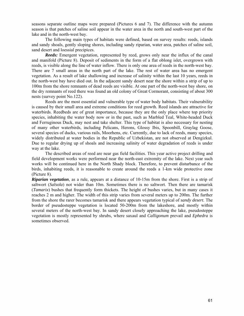
61
seasons separate outline maps were prepared (Pictures 6 and 7). The difference with the autumn season is that patches of saline soil appear in the water area in the north and south-west part of the lake and in the north-west bay.
The following main types of habitats were defined, based on survey results: reeds, islands and sandy shoals, gently sloping shores, including sandy riparian, water area, patches of saline soil, sand desert and loessial precipices.
Reeds: Emergent vegetation, represented by reed, grows only near the influx of the canal and manifold (Picture 8). Deposit of sediments in the form of a flat oblong islet, overgrown with reeds, is visible along the line of water inflow. There is only one area of reeds in the north-west bay. There are 7 small areas in the north part of the lake. The rest of water area has no emergent vegetation. As a result of lake shallowing and increase of salinity within the last 10 years, reeds in the north-west bay have died out. In the adjacent sandy desert near the shore within a strip of up to 100m from the shore remnants of dead reeds are visible. At one part of the north-west bay shore, on the dry remnants of reed there was found an old colony of Great Cormorant, consisting of about 300 nests (survey point No.122).
Reeds are the most essential and vulnerable type of water body habitats. Their vulnerability is caused by their small area and extreme conditions for reed growth. Reed islands are attractive for waterbirds. Reedbeds are of great importance, because they are the only place where top priority species, inhabiting the water body now or in the past, such as Marbled Teal, White-headed Duck and Ferruginous Duck, may nest and take shelter. This type of habitat is also necessary for nesting of many other waterbirds, including Pelicans, Herons, Glossy Ibis, Spoonbill, Graylag Goose, several species of ducks, various rails, Moorhens, etc. Currently, due to lack of reeds, many species, widely distributed at water bodies in the Republic of Uzbekistan, are not observed at Dengizkul. Due to regular drying up of shoals and increasing salinity of water degradation of reeds is under way at the lake.
The described areas of reed are near gas field facilities. This year active project drilling and field development works were performed near the north-east extremity of the lake. Next year such works will be continued here in the North Shady block. Therefore, to prevent disturbance of the birds, inhabiting reeds, it is reasonable to create around the reeds a 1-km wide protective zone (Picture 8). Riparian vegetation, as a rule, appears at a distance of 10-15m from the shore. First is a strip of saltwort (Salsola) not wider than 10m. Sometimes there is no saltwort. Then there are tamarisk (Tamarix) bushes that frequently form thickets. The height of bushes varies, but in many cases it reaches 2 m and higher. The width of this strip varies from several meters up to 200m. The further from the shore the rarer becomes tamarisk and there appears vegetation typical of sandy desert. The border of pseudosteppe vegetation is located 50-200m from the lakeshore, and mostly within several meters of the north-west bay. In sandy desert closely approaching the lake, pseudosteppe vegetation is mostly represented by shrubs, where saxaul and Calligonum prevail and Ephedra is sometimes observed.
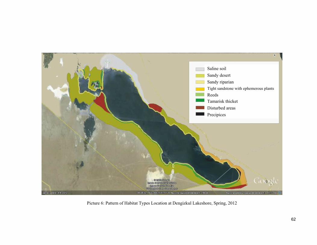
62
Picture 6: Pattern of Habitat Types Location at Dengizkul Lakeshore, Spring, 2012
Saline soil
Sandy desert
Sandy riparian
Tight sandstone with ephemerous plants
Reeds
Tamarisk thicket
Disturbed areas
Precipices
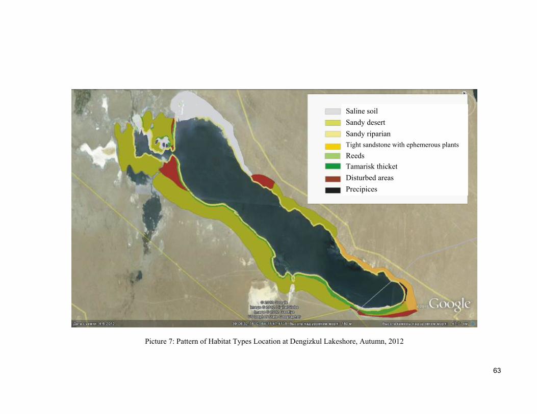
63
Picture 7: Pattern of Habitat Types Location at Dengizkul Lakeshore, Autumn, 2012
Saline soil
Sandy desert
Sandy riparian
Tight sandstone with ephemerous plants
Reeds
Tamarisk thicket
Disturbed areas
Precipices
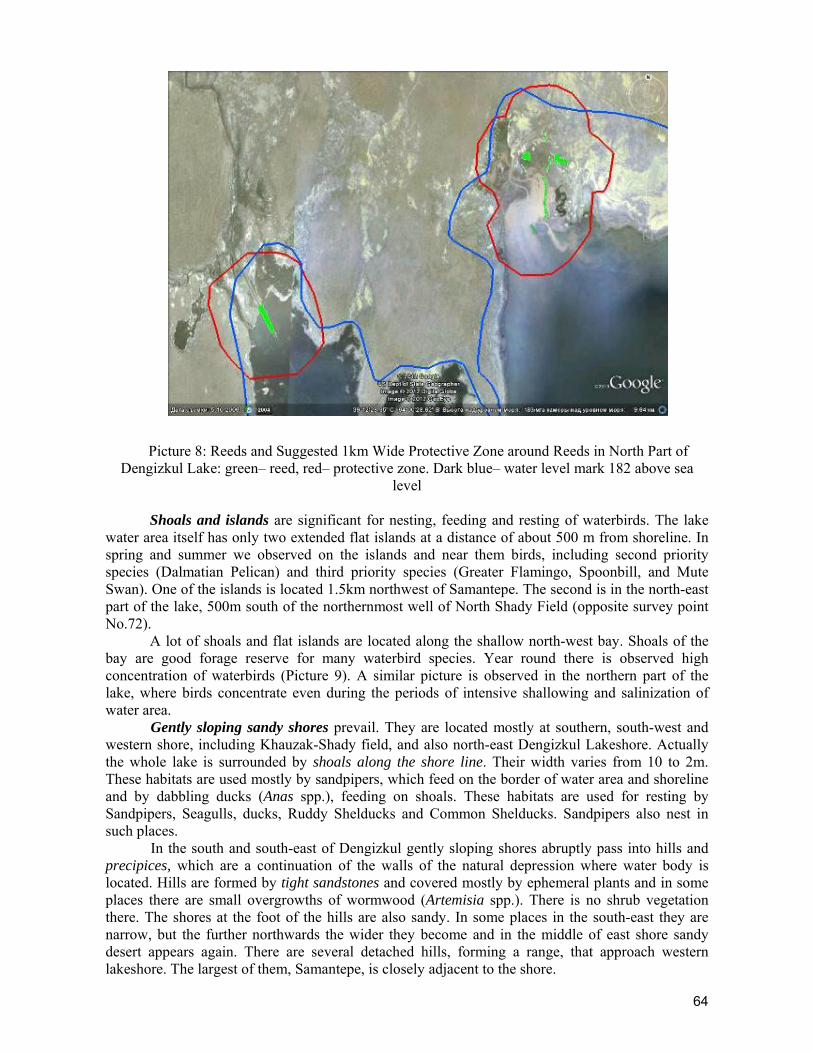
64
Picture 8: Reeds and Suggested 1km Wide Protective Zone around Reeds in North Part of Dengizkul Lake: green– reed, red– protective zone. Dark blue– water level mark 182 above sea
level
Shoals and islands are significant for nesting, feeding and resting of waterbirds. The lake water area itself has only two extended flat islands at a distance of about 500 m from shoreline. In spring and summer we observed on the islands and near them birds, including second priority species (Dalmatian Pelican) and third priority species (Greater Flamingo, Spoonbill, and Mute Swan). One of the islands is located 1.5km northwest of Samantepe. The second is in the north-east part of the lake, 500m south of the northernmost well of North Shady Field (opposite survey point No.72).
A lot of shoals and flat islands are located along the shallow north-west bay. Shoals of the bay are good forage reserve for many waterbird species. Year round there is observed high concentration of waterbirds (Picture 9). A similar picture is observed in the northern part of the lake, where birds concentrate even during the periods of intensive shallowing and salinization of water area.
Gently sloping sandy shores prevail. They are located mostly at southern, south-west and western shore, including Khauzak-Shady field, and also north-east Dengizkul Lakeshore. Actually the whole lake is surrounded by shoals along the shore line. Their width varies from 10 to 2m. These habitats are used mostly by sandpipers, which feed on the border of water area and shoreline and by dabbling ducks (Anas spp.), feeding on shoals. These habitats are used for resting by Sandpipers, Seagulls, ducks, Ruddy Shelducks and Common Shelducks. Sandpipers also nest in such places.
In the south and south-east of Dengizkul gently sloping shores abruptly pass into hills and precipices, which are a continuation of the walls of the natural depression where water body is located. Hills are formed by tight sandstones and covered mostly by ephemeral plants and in some places there are small overgrowths of wormwood (Artemisia spp.). There is no shrub vegetation there. The shores at the foot of the hills are also sandy. In some places in the south-east they are narrow, but the further northwards the wider they become and in the middle of east shore sandy desert appears again. There are several detached hills, forming a range, that approach western lakeshore. The largest of them, Samantepe, is closely adjacent to the shore.

65
Picture 9: Breeding and Concentration Areas of Hydrophilic Birds of 2 and 3 Priorities on the Shoals and Islands in the North-West Bay and North Part of Dengizkul Lake: pink signs – breeding
areas, blue – concentration areas
Sometimes patches of saline soil of various sizes and nature reach the shore. Their origin is first of all caused by changes in water level of the lake. Patches of saline soil on the shore, surveyed by us, were comparatively small. Among them there were both wet (near Samantepe), and dried up “sand dust”. The greatest developments of saline soil were observed near north-west bay and near north-east lakeshore. On the south-west shore the narrow saline strip runs along the water edge near small cape (survey point No.26). Saucer-shaped wet saline soil patches are present not far from Samantepe hill on both sides. We did not observe any birds at any of these saline soil patches.
In the second half of summer and in autumn the water body shallows and process of water area salinization starts. During this period the area of the saline ground swiftly extends. Salinization of water area is especially swift in the northern part of the lake and north-west bay due to shallowing of the water body, caused both by natural water evaporation in hot months, and by stopping of water inflow from both sources (Picture 10).
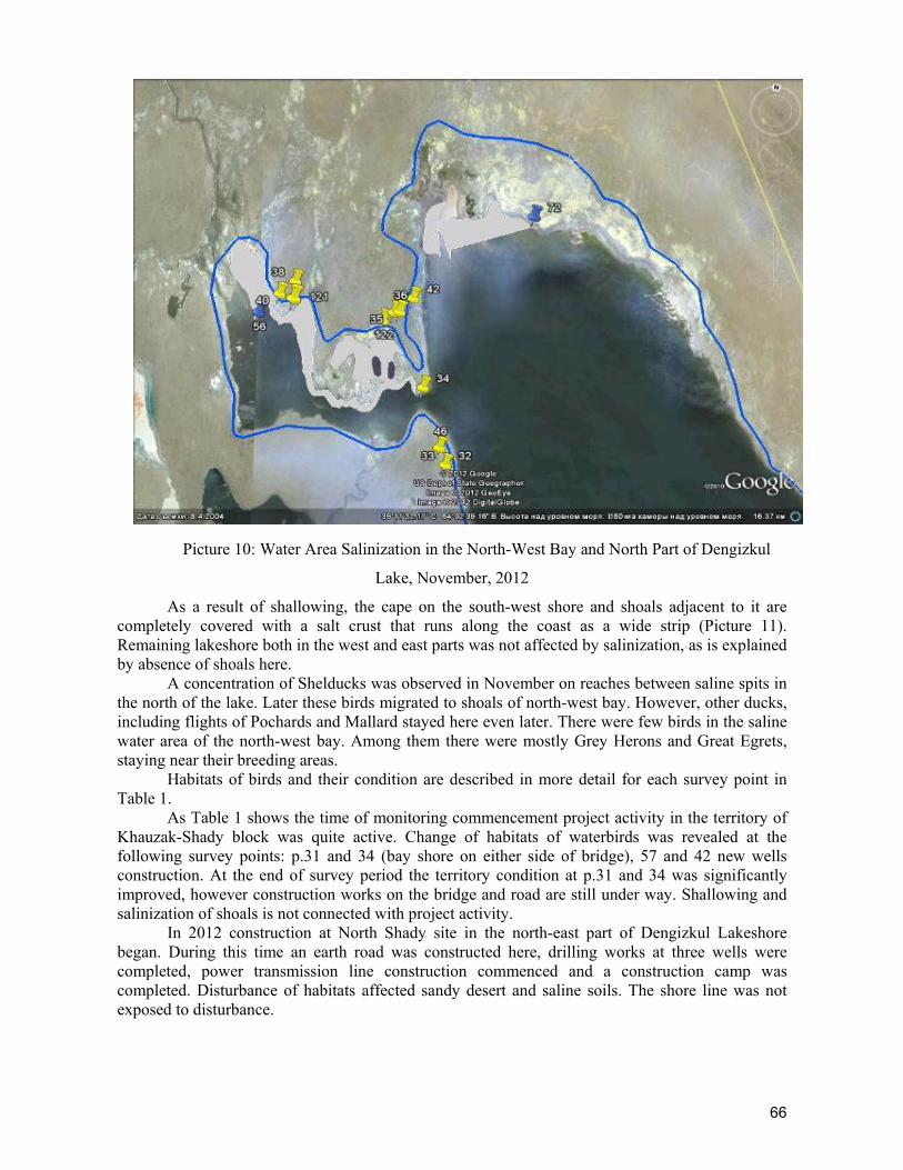
66
Picture 10: Water Area Salinization in the North-West Bay and North Part of Dengizkul
Lake, November, 2012
As a result of shallowing, the cape on the south-west shore and shoals adjacent to it are completely covered with a salt crust that runs along the coast as a wide strip (Picture 11). Remaining lakeshore both in the west and east parts was not affected by salinization, as is explained by absence of shoals here.
A concentration of Shelducks was observed in November on reaches between saline spits in the north of the lake. Later these birds migrated to shoals of north-west bay. However, other ducks, including flights of Pochards and Mallard stayed here even later. There were few birds in the saline water area of the north-west bay. Among them there were mostly Grey Herons and Great Egrets, staying near their breeding areas.
Habitats of birds and their condition are described in more detail for each survey point in Table 1.
As Table 1 shows the time of monitoring commencement project activity in the territory of Khauzak-Shady block was quite active. Change of habitats of waterbirds was revealed at the following survey points: p.31 and 34 (bay shore on either side of bridge), 57 and 42 new wells construction. At the end of survey period the territory condition at p.31 and 34 was significantly improved, however construction works on the bridge and road are still under way. Shallowing and salinization of shoals is not connected with project activity.
In 2012 construction at North Shady site in the north-east part of Dengizkul Lakeshore began. During this time an earth road was constructed here, drilling works at three wells were completed, power transmission line construction commenced and a construction camp was completed. Disturbance of habitats affected sandy desert and saline soils. The shore line was not exposed to disturbance.
67
Table 1: Distribution and Description of Habitat Types near Dengizkul Lake Survey station
N.
Station No by GPS
Coordinates Referencing Habitat Description Habitat Condition
May September-November May September-November
Khauzak-Shady field
Dengizkul Lake
11 31 N 39 11 06,1 E 64 01 21,4
Bridge over the isthmus (beginning) Isthmus between Dengizkul and bay. Bridge over the isthmus (beginning)
Shore is gently sloping, sandy. No vegetation.
Sandy desert and shore severely disturbed.
Bad. Because of earthworks the vegetation is fully defoliated.
Bay and lake shore near to the bridge are protected and soil covered with earth with rubbles. Road construction works and dam fortification are continued with the use of heavy equipment.
12 34 N 39 10 00,8 E 64 01 46,7
Bridge over the isthmus (beginning)
Shore is gently sloping, sandy. No vegetation.
Sandy desert and shore severely disturbed. There are shoals and small flat island in bay
Behind the bridge on the side of the bay there is parking lot for heavy equipment, movements of equipment raise much dust that thickly covers vegetation and birds in adjacent area.
Parking lot of equipment is dismantled. There was conducted soil planning. Road construction is continued. Bridge shores protection works are continued.
13 57 N 39 12 12,1 E 64 01 44,0
New well opposite reed covered island on the lake
Gently sloping sandy shore. Waterside tamarisk thicket
The same Severe disturbance of soil and vegetation
There was conducted soil planning.
18 42 N 39 11 23,9 E 64 01 31,1
Lakeshore. Near drill tower, 300m from the shore. Next access to the south on the side of p.57.
Gently sloping shore. Sawyers, promontories. Sandy shore front is up to 20 m long. Behind it there is thinly growing tamarisk and then 100m away there is saxaul.
There was conducted planning and access to the lake became impossible.
The shores are in good condition. In the distance of 150m from the shore topsoil and vegetation are severely disturbed.
The same
123 N 39 11 47,8 E 64 01 30,5
Turning between p.57 and p.42. Now it is a survey point instead of p.42 and p.57 to which there was no turning.
Gently sloping shore. Sawyers, promontories. Sandy shore front is up to 20 m long. Behind it there is thinly growing tamarisk and then 100m
The same Good The same
68
away there is saxaul.
19 46 N 39 09 05,1 E 64 02 08,3
Near well 1009 and well 1008. In water there is sunken old well.
Gently sloping shore. Sand dust. There grows saltwort, anabasis, rarely Peganum. 10-15m of the shore there occur tamarisk bushes
There was carried out planning of traces from the water intake in near-shore part.
Sand desert is severely disturbed as a result of well construction.
Better. There was conducted well planning and infrastructure development
47 N 39 07 32,0
E 64 03 21,1
The shore is visible on the side of road 3.5km to the south from p.46
Bare gently sloping sandy shore with saltwort. Tamarisk is thick in good condition 500 m of the shore. Behind them there is sandy desert.
The same Good The same
20 55 N 39 03 42,9 E 64 09 52,7
Earth road turns to well 1026 and to the left without road to the shore
Bare gently sloping sandy shore with saltwort. Tamarisk is thick in good condition 500 m of the shore. Behind them there is sandy desert.
The shore is not changed. In adjacent sandy desert across the shore the pipeline is constructed
Good The same
The North-West Bay
15 35 N 39 11 10,0 E 64 01 09,5
Bay, not far from the road. On foot from the road to the drilling site.
Shoals with adjacent sand desert
Saltwort and cut-off water bodies with adjacent sandy.
Good Worsened as a result of water area shallowing and salinization
16 39 N 39 11 28,4 E 63 58 52,6
Bay. From station 37 (cluster) by the road to the left and then to station 38 (thermal well) and from it road to the bay. Edge of the bay. Saline
Shoal with sawyers. On the shores there are tamarisk, ephedra, blooming Calligonum bushes. In the depressions of sand desert there are patches of saline soil and dry remnants of reed.
Shallowed saline shoals and saline soil patches.
Good. Scarcely trodden road goes through hilly sands.
Worsened as a result of water area shallowing and salinization
40 N 39 11 23,7 E 63 58 56,1
Bay. p.40 is located 20m from p.39. View on the water area is better.
Shoal with sawyers. On the shores there is tamarisk, ephedra, blooming Calligonum bushes. In the depressions of sand desert there are patches of saline soil and dry remnants of reed. Water area of the bay, far off there is an island and
There was shallowing and salinization of water area near shore. Islands became more.
Good. Scarcely trodden road goes through hilly sands
Due to extension of the area of islands there are more resting places for hydrophilic birds. Due to shallowing and salinization of shores the shallow-water area was reduced.
69
small strip of reed - it is place of Alat manifold influx.
56
N 39 11 05,4 E 63 58 32,1 p. 56 at influx of Alat
manifold into bay.
Shoal, the small strip of reeds, water area with island and near-shore part – patch of saline soil. No traces of people presence.
Shallowed and saline shoals.
Satisfactory It became worse for birds due to shores salinization
South Dengizkul Lakeshore
1 21
N 39 01 49,8 E 64 24 04,7
Descent of earth-road to the lake 1 km west of flowing (water) well
Gently sloping near-shore strip and rather narrow shoal. Hills covered with ephemeral plants and bushes of ferula, ephedra, saxaul stop 200m of sandy shoal are adjacent to them. In the depression there are ephemeral plants and scarce bushes of tamarisk
The same
Satisfactory with traces of grazing of cattle. It is used by local people for recreation.
The same
2 23 N 39 01 21,3 E 64 24 42,9
Road along south end of the lake, flowing (water) well
Gently sloping shore with well with recently built concrete birdbaths. Small ground on artificial raised platform and nearby basin is made for collection of water. Used as drinking place for domestic cattle.
The same
Bad. Plant and topsoil is disturbed. Drinking place that existed for many years and was used not only by domestic cattle, but also by wild animals (Persian gazelle, etc.) and birds, is destroyed. The territory early used for the purpose of recreation is lost.
The same
3 24 N 39 01 21,6 E 6424 42,9
Along the road after well under the middle of precipice
Gently sloping shore. Behind it there is a depression passing into sandy shoal, and further Loessial precipice about 10-15 m high.
The same Good, , there are a lot of young tamarisk bushes
The same
4 25 N 39 00 41,4 E 6424 40,0
sheep pen Depression overgrown with tamarisk up to the gently sloping shore.
The same
Good, there are a lot of young tamarisk bushes. There were found no traces of recent grazing of
The same
70
cattle.
63 N 39 03 42,9 E 64 09 52,7
Last at the south shore after well under precipice
Gently sloping shore. Behind it there is wide strip of tamarisk
The same Good, there are a lot of young tamarisk bushes
5 26 N38 59 45,2 E64 20 26,3
After the first frontier guard on the way to the lake
Sloping shore, saline soil without outcrops of salt, rare bushes of tamarisk, spit. Along the road there is sand desert.
Shallow sloping shore covered with salt. Spit and shoals around it are covered with white salt. Nearby along the shore there are rare bushes passing into sandy desert.
Good, no traces of people presence
Good, no traces of people presence
9 29 N 39 01 41,3 E 64 12 36,3
Lakeshore near Samantepe
Disturbed sand desert with saxaul and tamarisk bushes. Shore is sloping. 500m from the shore there is an island with tamarisk bushes.
The same
Bad. High level of disturbance. Causeway with an old ditch goes up to the lakeshore.
The same
East Dengizkul Lakeshore
64 N 39 03 42,9 E 64 09 52,7
To the north from earth falling gradient to the lake 2.5km northward of artesian flow well
Hills covered with ephemeral plants closely approach sandy shoal. At foots of hills there grow scarce suppressed bushes of tamarisk as narrow strip.
The same
Vegetation is suppressed. It seems that the territory is exposed to overexploitation
The same
65 N 39 02 41,0
E 64 22 12,3 Middle part of wide bay
Hills are located nearby sandy shore. Shore is steep, the long cape not far from it.
The same Good The same
66 N 39 03 15,7
E 64 19 35,9
Under flares of North Urtabulak located on the hills. The road near shore goes along barely trodden rut to well.
Sloping shore under hills steeping near water area edge. In strip 200m width there is wet patch of saline soil. There grow saltwort, glasswort and a little bit of suppressed tamarisk.
The same
Severely disturbed territory with complex of roads.
Around well there is natural revegetation, however, it still underdeveloped
67
N 39 05 38,9 E 64 16 23,9
Next wide bay on the road to the north. Almost opposite to Samantepe hillock on
Sandy desert with small barchans (dunes). The shore is sandy, waved, is limited from sandy desert
The same Vegetation and topsoil condition is good
The same
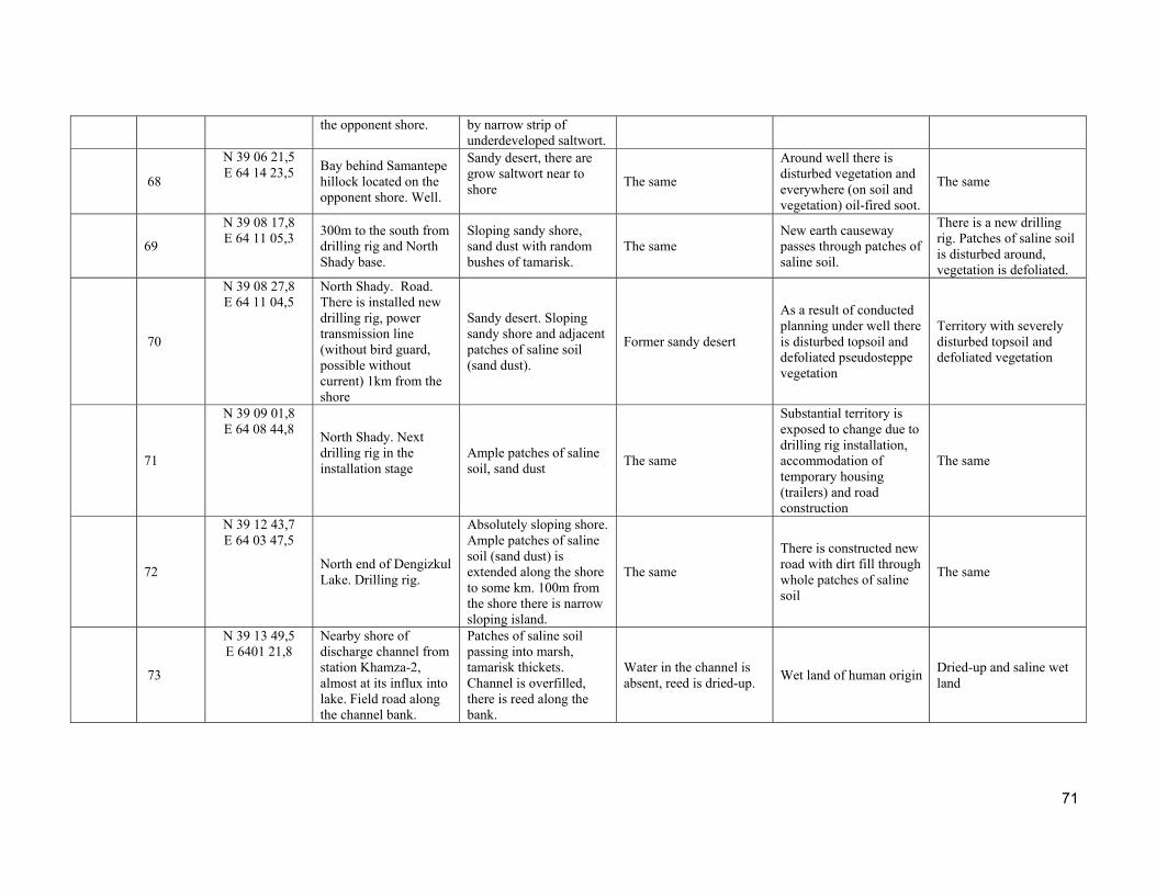
71
the opponent shore. by narrow strip of underdeveloped saltwort.
68
N 39 06 21,5 E 64 14 23,5 Bay behind Samantepe
hillock located on the opponent shore. Well.
Sandy desert, there are grow saltwort near to shore
The same
Around well there is disturbed vegetation and everywhere (on soil and vegetation) oil-fired soot.
The same
69
N 39 08 17,8 E 64 11 05,3
300m to the south from drilling rig and North Shady base.
Sloping sandy shore, sand dust with random bushes of tamarisk.
The same New earth causeway passes through patches of saline soil.
There is a new drilling rig. Patches of saline soil is disturbed around, vegetation is defoliated.
70
N 39 08 27,8 E 64 11 04,5
North Shady. Road. There is installed new drilling rig, power transmission line (without bird guard, possible without current) 1km from the shore
Sandy desert. Sloping sandy shore and adjacent patches of saline soil (sand dust).
Former sandy desert
As a result of conducted planning under well there is disturbed topsoil and defoliated pseudosteppe vegetation
Territory with severely disturbed topsoil and defoliated vegetation
71
N 39 09 01,8 E 64 08 44,8
North Shady. Next drilling rig in the installation stage
Ample patches of saline soil, sand dust
The same
Substantial territory is exposed to change due to drilling rig installation, accommodation of temporary housing (trailers) and road construction
The same
72
N 39 12 43,7 E 64 03 47,5
North end of Dengizkul Lake. Drilling rig.
Absolutely sloping shore. Ample patches of saline soil (sand dust) is extended along the shore to some km. 100m from the shore there is narrow sloping island.
The same
There is constructed new road with dirt fill through whole patches of saline soil
The same
73
N 39 13 49,5 E 6401 21,8
Nearby shore of discharge channel from station Khamza-2, almost at its influx into lake. Field road along the channel bank.
Patches of saline soil passing into marsh, tamarisk thickets. Channel is overfilled, there is reed along the bank.
Water in the channel is absent, reed is dried-up.
Wet land of human origin Dried-up and saline wet land
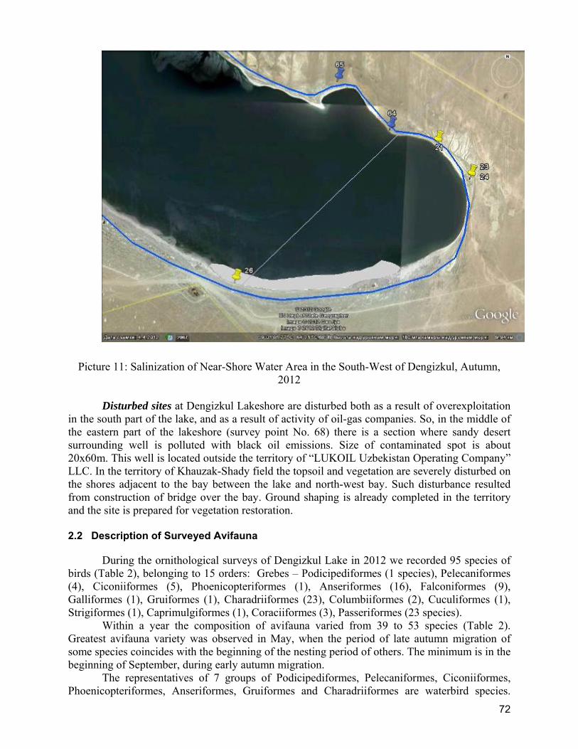
72
Picture 11: Salinization of Near-Shore Water Area in the South-West of Dengizkul, Autumn, 2012
Disturbed sites at Dengizkul Lakeshore are disturbed both as a result of overexploitation
in the south part of the lake, and as a result of activity of oil-gas companies. So, in the middle of the eastern part of the lakeshore (survey point No. 68) there is a section where sandy desert surrounding well is polluted with black oil emissions. Size of contaminated spot is about 20x60m. This well is located outside the territory of “LUKOIL Uzbekistan Operating Company” LLC. In the territory of Khauzak-Shady field the topsoil and vegetation are severely disturbed on the shores adjacent to the bay between the lake and north-west bay. Such disturbance resulted from construction of bridge over the bay. Ground shaping is already completed in the territory and the site is prepared for vegetation restoration.
2.2 Description of Surveyed Avifauna
During the ornithological surveys of Dengizkul Lake in 2012 we recorded 95 species of birds (Table 2), belonging to 15 orders: Grebes – Podicipediformes (1 species), Pelecaniformes (4), Ciconiiformes (5), Phoenicopteriformes (1), Anseriformes (16), Falconiformes (9), Galliformes (1), Gruiformes (1), Charadriiformes (23), Columbiiformes (2), Cuculiformes (1), Strigiformes (1), Caprimulgiformes (1), Coraciiformes (3), Passeriformes (23 species).
Within a year the composition of avifauna varied from 39 to 53 species (Table 2). Greatest avifauna variety was observed in May, when the period of late autumn migration of some species coincides with the beginning of the nesting period of others. The minimum is in the beginning of September, during early autumn migration.
The representatives of 7 groups of Podicipediformes, Pelecaniformes, Ciconiiformes, Phoenicopteriformes, Anseriformes, Gruiformes and Charadriiformes are waterbird species.

73
Total number of waterbird is 53, making up 55.8% of the total list of the species recorded. The most varied species of the wetland complex are represented by the orders Anseriformes and Charadriiformes.
The number of waterbird species changed throughout the year from 27 to 35. The seasonal aspect of waterbird species abundance is similar to picture of changes in overall avifauna.
Table 2: List of Birds of Dengizkul Lake by Results of Survey in 2012
No No
Species
Rea
son
of p
rese
nce
Pro
tect
ion
sta
tus
of
the
spec
ie
Month
May
Jun
e
Sep
tem
ber
November
25.1
1.20
12
7.11
.201
2*
Podicipediformes
1 Great Grebe Podiceps cristatus*
N 2
17 34 8
2 Black-necked Grebe Podiceps nigricollis
M, W
600 59 15
3 Podiceps ruficollis M, W 2 Pelecaniformes
4 Dalmatian Pelican Pelecanus crispus*
RDBUz VU IUCN VU
11 60
409
5 White Pelican Pelecanus onocrotalus
M RDBUz VU
20
6 Cormorant Phalacrocorax carbo*
N 78
463 1641 672 215
7 Pygmy Cormorant Phalacrocorax pygmeus*
N RDBUz NT 79
48 33 11 1
Ciconiiformes
8 Little Egret Egretta garzetta*
N RDBUz VU 4
19 39
9 Great Egret Egretta alba*
N 22
79 3 19
10 Grey Heron Ardea cinerea*
N 14
62 25 13 1
11 Glossy Ibis Plegadis falcinellus*
M, N RDBUz VU 1
127
12 Spoonbill Platalea leucorodia*
M RDBUz VU 9
14
Phoenicopteriformes
13 Greater Flamingo Phoenicopterus roseus
M,S RDBUz VU
58 48 3
Anseriformes
14 Mute Swan Cignus olor*
R RDBUz NT 151
227 183 208 46
15 Greylag Goose Anser anser
N?M
10 3 30 15
16 Shelduck Tadorna tadorna*
N, M 13
44 12 1335 250
17 Ruddy Shelduck Tadorna ferruginea*
N, M 8
7 10
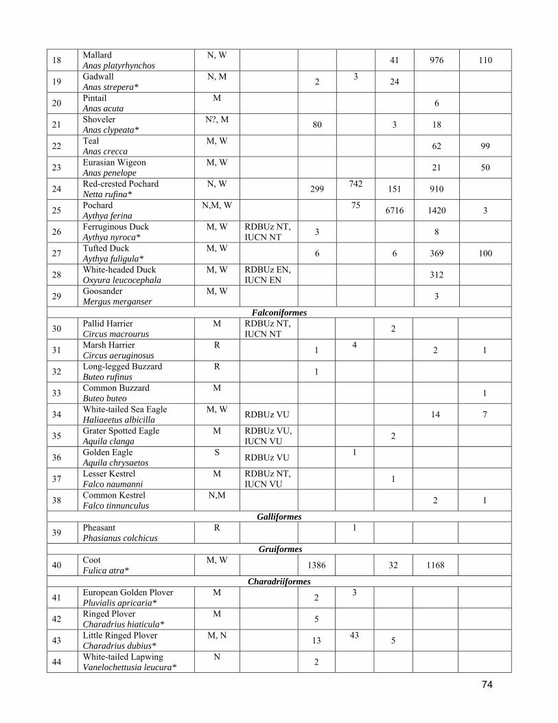
74
18 Mallard Anas platyrhynchos
N, W
41 976 110
19 Gadwall Anas strepera*
N, M 2
3 24
20 Pintail Anas acuta
M
6
21 Shoveler Anas clypeata*
N?, M 80
3 18
22 Teal Anas crecca
M, W
62 99
23 Eurasian Wigeon Anas penelope
M, W
21 50
24 Red-crested Pochard Netta rufina*
N, W 299
742 151 910
25 Pochard Aythya ferina
N,M, W
75 6716 1420 3
26 Ferruginous Duck Aythya nyroca*
M, W RDBUz NT, IUCN NT
3
8
27 Tufted Duck Aythya fuligula*
M, W 6
6 369 100
28 White-headed Duck Oxyura leucocephala
M, W RDBUz EN, IUCN EN
312
29 Goosander Mergus merganser
M, W
3
Falconiformes
30 Pallid Harrier Circus macrourus
M RDBUz NT, IUCN NT
2
31 Marsh Harrier Circus aeruginosus
R 1
4 2 1
32 Long-legged Buzzard Buteo rufinus
R 1
33 Common Buzzard Buteo buteo
M
1
34 White-tailed Sea Eagle Haliaeetus albicilla
M, W RDBUz VU
14 7
35 Grater Spotted Eagle Aquila clanga
M RDBUz VU, IUCN VU
2
36 Golden Eagle Aquila chrysaetos
S RDBUz VU
1
37 Lesser Kestrel Falco naumanni
M RDBUz NT, IUCN VU
1
38 Common Kestrel Falco tinnunculus
N,M
2 1
Galliformes
39 Pheasant Phasianus colchicus
R
1
Gruiformes
40 Coot Fulica atra*
M, W 1386
32 1168
Charadriiformes
41 European Golden Plover Pluvialis apricaria*
M 2
3
42 Ringed Plover Charadrius hiaticula*
M 5
43 Little Ringed Plover Charadrius dubius*
M, N 13
43 5
44 White-tailed Lapwing Vanelochettusia leucura*
N 2
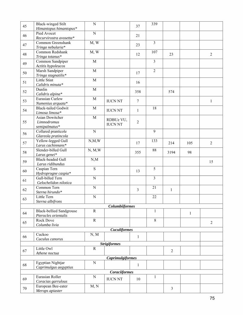
75
45 Black-winged Stilt Himantopus himantopus*
N 37
339
46 Pied Avocet Recurvirostra avosetta*
N 21
47 Common Greenshank Tringa nebularia*
M, W 23
3
48 Common Redshank Tringa totanus*
M, W 12
107 23 2
49 Common Sandpiper Actitis hypoleucos
M
3
50 Marsh Sandpiper Tringa stagnatilis*
M 17
2
51 Little Stint Calidris minuta*
M 16
52 Dunlin Calidris alpina*
M 358
574
53 Eurasian Curlew Numenius arquata*
M IUCN NT 7
1
54 Black-tailed Godwit Limosa limosa*
M IUCN NT 1
18
55 Asian Dowitcher Limnodromus semipalmatus*
M RDBUz VU, IUCN NT
2
56 Collared pranticole Glareola pratincola
N
9
57 Yellow-legged Gull Larus cachinnans*
N,М,W 17
133 214 105 2
58 Slender-billed Gull Larus genei*
N, M,W 355
88 3194 98
59 Black-headed Gull Larus ridibundus
N,M
15
60 Caspian Tern Hydroprogne caspia*
S 13
5
61 Gull-billed Tern Gelochelidon nilotica
N
3
62 Common Tern Sterna hirundo*
N 3
21 1
63 Little Tern Sterna albifrons
N
22
Columbiiformes
64 Black-bellied Sandgrouse Pterocles orientalis
R
1 1
65 Rock Dove Columba livia
R
8 2
Cuculiformes
66 Cuckoo Cuculus canorus
N, M 1
Strigiformes
67 Little Owl Athene noctua
R
2
Caprimulgiformes
68 Egyptian Nightjar Caprimulgus aegyptius
N 1
Coraciiformes
69 Eurasian Roller Coracias garrulous
N IUCN NT 10
1
70 European Bee-eater Merops apiaster
M, N
3

76
71 Blue-cheeked Bee-eater Merops superciliosus
M,N
1
Passeriformes
72 Crested Lark Galerida cristata
R 7
234 17 6 8
73 Barn Swallow Hirundo rustica
N
1700
74 Sand Martin Riparia riparia
S
1206 4880
75 Pied Wagtail Motacilla personata
N 21
76 Citrine Wagtail Motacilla citreola
M 22
77 Yellow Wagtail Motacilla flava
M 248
78 Black-headed Wagtail Motacilla (flava) feldegg
N 4
79 White Wagtail Motacilla alba
M,W
6
80 Isabelline Shrike Lanius isabellinus
N 1
2
81 Great grey Shrike Lanius excubitor
N, R?
1
82 Common Myna Acridotheres tristis
R 2
4 6 2
83 Eurasian Hooded Crow Corvus cornix
M,W
7 3
84 Scrub Warbler Scotocerca inquieta
N,R?
1
85 Southern Booted Warbler Hippolais rama
N,M 2
2 1
86 Pied Wheatear Oenanthe pleschanka
N 6
87 Isabelline Wheatear Oenanthe isabellina
N 2
1
88 Rufous Scrub Robin Cercotrichas galactotes
N 1
89 Indian House Sparrow Passer indicus
N 205
100
90 Tree Sparrow Passer montanus
R
30
91 Spanish Sparrow Passer hispanolensis
N
1
92 Common Chaffinch Fringilla coelebs
M,W
1
93 Eurasian Siskin Spinus spinus
M
1
94 Desert Finch Rhodospiza obsoleta
R 4
14 26
95 Corn Bunting Emberiza calandra
M,W
4
Total birds / waterbirds
3601 / 3062
4437/ 2860
20662/ 14040
7921/ 7826
971/ 946
Total species /waterbirds 53/ 35 45/ 32 39/ 27 44/ 32 29/ 18
Note. Reason of presence: N- nesting, R- resident, M- migrating, W- wintering, S- summering (making summer migrations).
77
Protection status in accordance with the Red Book of the Republic of Uzbekistan (2009) and Red List of IUCN (2012): EN- Endangered; VU- Vulnerable; NT- Near Threatened. * - partial survey is carried out in four points only (from the bridge on either side, at p.57 and in the bay near the road after the bridge)
Type of stay: Among the birds observed at the Dengizkul Lake, 10 species are non-
migratory, 44 species are breeding, 4 species are migrant, 21 species are wintering and 52 are observed during migrations (Table 2).
Species variety is most abundant in May. It is typical for the period, when spring migration of some species is still continuing and simultaneously nesting of others is already beginning. In June the level of species variety is maintained not only by nesting species. Returning sandpipers and swallows, making post-nesting movements, appear here during this time. By autumn and in autumn, the species content of birds at the water body becomes less varied. Actual description of stay of individual bird species at the water body is presented in Table 2. Seasonal aspect of waterbird presence at the lake is in general presented below.
Great-crested Grebe nests and winters at the lake and is observed there during seasonal migrations. Red-necked Grebe Podiceps ruficollis and Black-necked Grebes are observed during migration and wintering.
Great Cormorant and Pygmy Cormorant are common breeding species, observed at the water body all year. Pelicans do not nest at Dengizkul. Dalmatian Pelicans are observed during spring and autumn migrations and also during summer movements. White Pelican is observed only during summer movements.
All 3 species of Herons are breeding. Type of stay of Glossy Ibises is questionable, since nesting of the species is not proved. Spoonbills and Greater Flamingos visit the water body during migration and summer movements.
Among representatives of Anseriformes 6 species are nesting, 8 species are wintering and all registered species are observed during migration.
Order of Charadriiformes is one of the most abundant at the water body in terms of species composition, but the majority of its representatives are observed during migration. Only individual species of sandpipers (Little Ringed Plover, White-tailed Plover, Black-winged Stilt, Avocet), Collared Pratincole, gulls (Caspian Gull, Slender-billed Gull, Black-headed Gull) and terns (Gull-billed Tern, Common Tern, Little Tern) are breeding.
In the past Coot nested at the water body. Now it is observed during migration and wintering. Type of its stay changed due to lack of good reed thickets necessary for nesting.
Among non-waterbirds, of the Falconiformes order only Marsh Harrier nests at the water body. Common Kestrel and Long-legged Buzzard nest in the adjacent territory. Other species are observed during movements, passage and wintering.
Representatives of Galliformes, Columbiiformes, Cuculiformes, Strigiformes, Caprimulgiformes, Coraciiformes and Passeriformes orders nest in the adjacent territory, except for the species, nesting in reeds. Blue Rock Pigeon, Roller and Indian House Sparrow also nest on precipices of hills in the southern part of the lake.
Abundance of the majority of waterbird species, inhabiting Dengizkul Lake, is unstable and depends mostly on the season of year (Table 2).
In early May migrant species, stopping at Dengizkul to feed, predominated among waterbirds. Among them there were migrants that had not yet reached their breeding area, dunlins and species which stayed in good forage areas near their breeding areas at nearby water bodies: Coot, Slender-billed Gull, Red-crested Pochard, and Mute Swan. Among non-waterbird species migrating Yellow Wagtails and Indian House Sparrows that arrived to breeding areas were abundant.
78
Late in June, when for many hydrophilic species nesting period is nearly over, there predominated the Red-crested Pochard, Great Cormorant and Black-winged Stilt, whose breeding period was practically over. We observed many young birds of these species. There was observed a high abundance of the Mute Swan, Caspian Gull, Glossy Ibis, and also Common Redshank and Slender-billed Gull. Redshank is the only of listed species that does not nest at the lake. Observed Redshanks were making return migration southwards.
At the beginning of September early migrants were observed at Dengizkul and other water bodies of the Republic. Pochard, Slender-billed Gull and Great Cormorant were the most numerous among them. Black-necked Grebes, Dunlins, Dalmatian Pelicans were numerous and number of Caspian Gulls, Mute Swans and Red-crested Pochards was a little lower.
This year the last wave of autumn migration was comparatively late, caused by a long warm autumn. In the second half of November there predominated species arriving for wintering. The most abundant in this group of species were Shelduck, Pochard, Coot and Mallard. Abundance of Red-crested Pochard and Great Cormorant is rather high, abundance of White-headed Duck is lower. 2.3 Priority Species
According to BAP five priority groups of species were defined for Khauzak-Shady Block of Dengizkul field in order to focus surveys on the species of the greatest value for world, national and bio-geographical populations. This year we registered at Dengizkul Lake 29 species belonging to five priority groups (Table 3).
Table 3: List of Priority Species of Birds, Registered at Dengizkul Lake During Ornithological Monitoring in 2012
No No
Species
Month
May
Jun
e
Sep
tem
ber
Nov
emb
er
First priority
1 White-headed Duck Oxyura leucocephala 312 2 Ferruginous Duck Aythya nyroca 3 - - 8
Second priority 3 Dalmatian Pelican Pelecanus crispus 11 60 409 - 4 Pallid Harrier Circus macrourus 2 5 Greater Spotted Eagle Aquila clanga 2 6 Lesser Kestrel Falco naumanni 1 7 Eurasian Curlew Numenius arquata 7 1 8 Black-tailed Godwit Limosa limosa 1 18
9 Asian Dowitcher Limnodromus semipalmatus
2
10 Eurasian Roller Coracias garrulus 10 1 Third priority
11 Pygmy Cormorant Phalacrocorax pygmaeus 79 48 33 12 12 White Pelican Pelecanus onocrotalus 20 13 Little Egret Egretta garzetta 4 19 39 14 Glossy Ibis Plegadis falcinellus 1 127 15 Spoonbill Platalea leucorodia 9 14 16 Mute Swan Cygnus olor 151 227 183 208
79
First priority - globally threatened top priority species. In 2012 this group was
represented at the Dengizkul Lake by two species. Two high-priority species (Marbled Teal and Ferruginous Duck) nested at the lake in the past, but we managed to register only Ferruginous Duck.
Ferruginous Duck. Historically the specie was widespread in Uzbekistan, however it was a local breeder. Breeding areas near the Dengizkul Lake were located in basin of the Amu-Darya river near Chardzhou (Kashkarov, 1987). In summer 1997 it was found at the Dengizkul Lake and other water bodies of south-west Uzbekistan (Kreuzberg-Mukhina et al., 2000; Mukhina, Lanovenko, 2001). After 2000 it was observed at Tudakul and Dengizkul in winter (Lanovenko, and others, 2007). There were registered from 8 to 245 birds in winter 2000-2004 (Lanovenko, Turaev, 2008).
On May 4, 2012 early in the morning we observed three feeding birds. No doubt these birds belonged to the species which were indentified with the help of a telescope. The birds were feeding in an open reach at a considerable distance from reeds. It seems that they left the water body unable to find conditions suitable for breeding. In June this species was not registered. Next time we found this species on November 26; there were 8 birds near the place where they were observed in spring, when 1-2 Ferruginous Ducks stayed together in a large flock of Pochards (Picture 12). Slow degradation of reed vegetation round the bay has already prevented this species from breeding at Dengizkul Lake. It still breeds at the lakes along Amu-Bukhara canal. Ferruginous Ducks were observed in June 2012 at Chuchkakhona filtration lake at a distance of 30km from Dengizkul.
It may be assumed that the dry first decade of the 21st century caused a lowering of the lake water level and as a result reed thickets degraded.
17 Greater Flamingo Phoenicopterus roseus 58 48 3 18 White-tailed Sea Eagle Haliaeetus albicilla 14 19 Golden Eagle Aquila chrysaetos 1
Fourth priority 20 Shelduck Tadorna tadorna 13 44 12 1335 21 Great Cormorant Phalacrocorax carbo 78 463 1641 672 22 Mallard Anas platyrhynchos 41 976 23 Red-crested Pochard Netta rufina 299 742 151 910 24 Pochard Aythya ferina 75 6716 1420 25 Coot Fulica atra 1386 32 1168
Fifth priority 26 Egyptian Nightjar Caprimulgus aegyptius 1 27 Scrub Warbler Scotocerca inquieta 1 28 Southern Booted Warbler Hippolaisrama 2 2 1 29 Desert Finch Rhodospiza obsolete 4 14 26
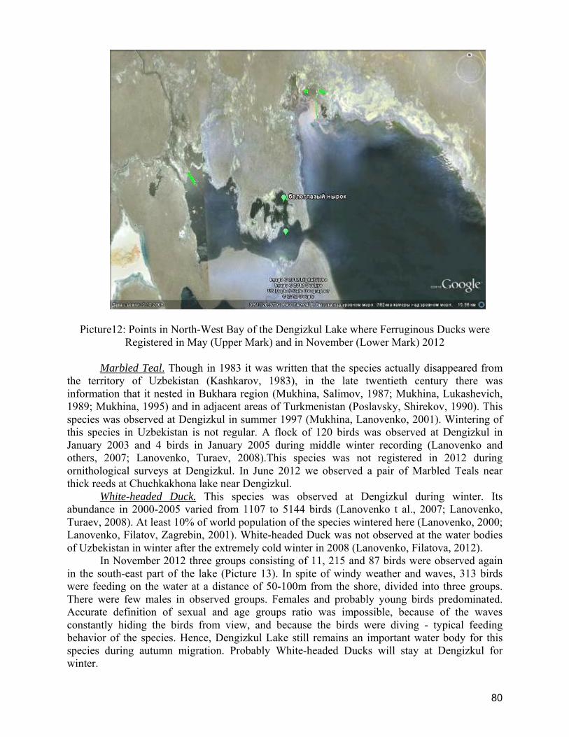
80
Picture12: Points in North-West Bay of the Dengizkul Lake where Ferruginous Ducks were Registered in May (Upper Mark) and in November (Lower Mark) 2012
Marbled Teal. Though in 1983 it was written that the species actually disappeared from
the territory of Uzbekistan (Kashkarov, 1983), in the late twentieth century there was information that it nested in Bukhara region (Mukhina, Salimov, 1987; Mukhina, Lukashevich, 1989; Mukhina, 1995) and in adjacent areas of Turkmenistan (Poslavsky, Shirekov, 1990). This species was observed at Dengizkul in summer 1997 (Mukhina, Lanovenko, 2001). Wintering of this species in Uzbekistan is not regular. A flock of 120 birds was observed at Dengizkul in January 2003 and 4 birds in January 2005 during middle winter recording (Lanovenko and others, 2007; Lanovenko, Turaev, 2008).This species was not registered in 2012 during ornithological surveys at Dengizkul. In June 2012 we observed a pair of Marbled Teals near thick reeds at Chuchkakhona lake near Dengizkul.
White-headed Duck. This species was observed at Dengizkul during winter. Its abundance in 2000-2005 varied from 1107 to 5144 birds (Lanovenko t al., 2007; Lanovenko, Turaev, 2008). At least 10% of world population of the species wintered here (Lanovenko, 2000; Lanovenko, Filatov, Zagrebin, 2001). White-headed Duck was not observed at the water bodies of Uzbekistan in winter after the extremely cold winter in 2008 (Lanovenko, Filatova, 2012).
In November 2012 three groups consisting of 11, 215 and 87 birds were observed again in the south-east part of the lake (Picture 13). In spite of windy weather and waves, 313 birds were feeding on the water at a distance of 50-100m from the shore, divided into three groups. There were few males in observed groups. Females and probably young birds predominated. Accurate definition of sexual and age groups ratio was impossible, because of the waves constantly hiding the birds from view, and because the birds were diving - typical feeding behavior of the species. Hence, Dengizkul Lake still remains an important water body for this species during autumn migration. Probably White-headed Ducks will stay at Dengizkul for winter.
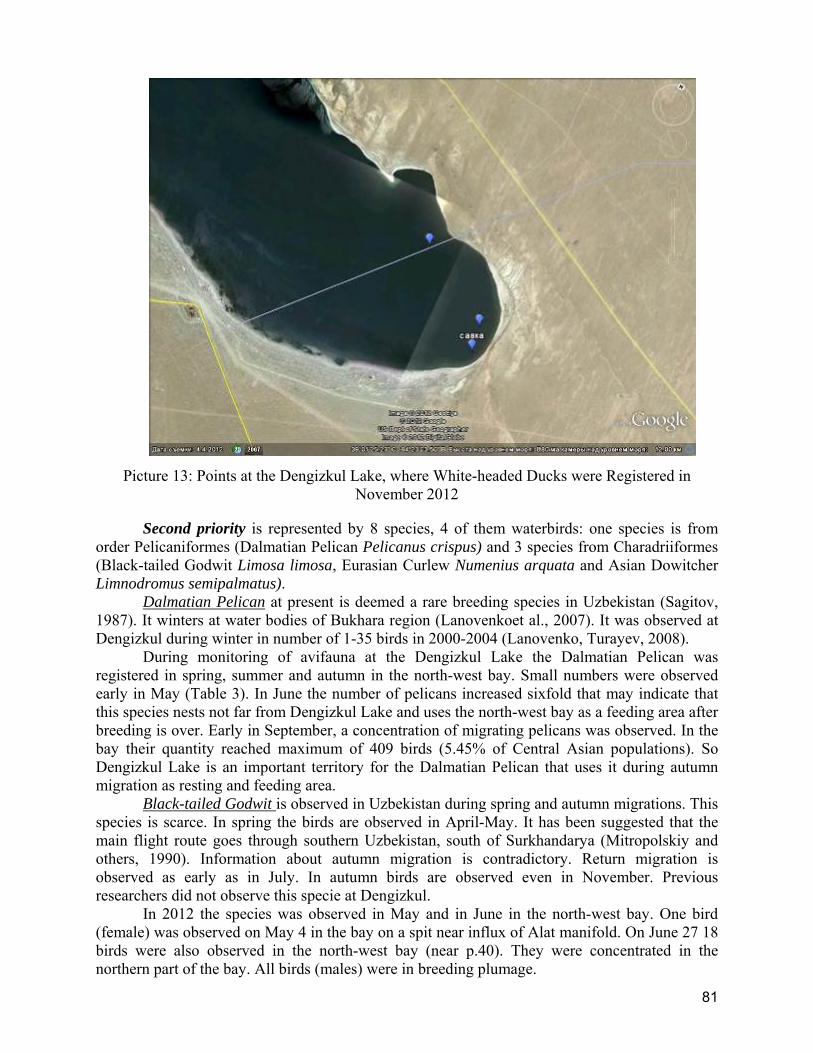
81
Picture 13: Points at the Dengizkul Lake, where White-headed Ducks were Registered in November 2012
Second priority is represented by 8 species, 4 of them waterbirds: one species is from order Pelicaniformes (Dalmatian Pelican Pelicanus crispus) and 3 species from Charadriiformes (Black-tailed Godwit Limosa limosa, Eurasian Curlew Numenius arquata and Asian Dowitcher Limnodromus semipalmatus).
Dalmatian Pelican at present is deemed a rare breeding species in Uzbekistan (Sagitov, 1987). It winters at water bodies of Bukhara region (Lanovenkoet al., 2007). It was observed at Dengizkul during winter in number of 1-35 birds in 2000-2004 (Lanovenko, Turayev, 2008).
During monitoring of avifauna at the Dengizkul Lake the Dalmatian Pelican was registered in spring, summer and autumn in the north-west bay. Small numbers were observed early in May (Table 3). In June the number of pelicans increased sixfold that may indicate that this species nests not far from Dengizkul Lake and uses the north-west bay as a feeding area after breeding is over. Early in September, a concentration of migrating pelicans was observed. In the bay their quantity reached maximum of 409 birds (5.45% of Central Asian populations). So Dengizkul Lake is an important territory for the Dalmatian Pelican that uses it during autumn migration as resting and feeding area.
Black-tailed Godwit is observed in Uzbekistan during spring and autumn migrations. This species is scarce. In spring the birds are observed in April-May. It has been suggested that the main flight route goes through southern Uzbekistan, south of Surkhandarya (Mitropolskiy and others, 1990). Information about autumn migration is contradictory. Return migration is observed as early as in July. In autumn birds are observed even in November. Previous researchers did not observe this specie at Dengizkul.
In 2012 the species was observed in May and in June in the north-west bay. One bird (female) was observed on May 4 in the bay on a spit near influx of Alat manifold. On June 27 18 birds were also observed in the north-west bay (near p.40). They were concentrated in the northern part of the bay. All birds (males) were in breeding plumage.
82
Eurasian Curlew is a typical migrant species in plain areas of Uzbekistan; however, it is rare in Karshi steppe (Mitropolskiy, etc., 1990). There are no evidences of this species at Dengizkul. In May 2012 in north-west bay we observed resting passage flock consisting of 7 birds. In autumn, on November 7, a single bird was observed at the west shore of the Dengizkul Lake by the Lukoil-MIGA team. So the Dengizkul Lake serves as resting area for migrating curlews.
Asian Dowitcher is rare migrating species, based on several observations. It was observed in Uzbekistan in the basin of the Syr-Darya (Mitropolskiy et al., 1990) and in Sudochinsk system of lakes in the southern Aral Sea region (Lanovenko and others, 2005). Previous researchers did not observe this species at Dengizkul. On 27 June 2012 two birds were observed on a shoal. Most likely these were migrating birds resting after flight during return migration.
Non-waterbird species in the second priority group are represented by 3 species of raptor: Pallid Harrier Circus macrourus, Greater Spotted Eagle Aquila clanga, Lesser Kestrel Falco naumanni and one species from Coraciiformes: Eurasian Roller Coracias garrulus. All listed diurnal birds of prey were observed in small numbers (1-2 birds) during migration. Eurasian Roller breeds on the west, south and east shore of Dengizkul, building nests in precipices of hills, and is observed during migration. At Khauzak-Shady field these birds are frequently observed sitting on the lines, especially in May.
Third priority: In 2012 at the Dengizkul Lake this group was represented by 9 species, including seven waterbirds: Pygmy Cormorant Phalacrocorax pygmaeus, White Pelican Pelecanus onocrotalus, Little Egret Egretta garzetta, Glossy Ibis Plegadis falcinellus, Spoonbill Platalea leucorodia, Mute Swan Cygnus olor, and Greater Flamingo Phoenicopterus roseus. All these species are regularly observed at water bodies of Bukhara region. White Pelican and Greater Flamingo are observed during migration and summer. Glossy Ibis and Spoonbill are migrating species sporadically nesting in the region.
Pygmy Cormorant is observed in the region all year. It breeds and sometimes winters at Dengizkul, it is also observed there during migration. In 2012 this specie was observed during all periods of our surveys mostly in the north-west bay. Maximum abundance was observed in May during breeding (Table 3). In June the birds had already abandoned their nests and young birds were observed at the lake. In June, September and November abundance gradually decreases as a result of redistribution of birds to adjacent water bodies and autumn migration.
White Pelican is observed during passage and sometimes winters in Bukhara region. In winter 2004-2005 1-50 birds were observed at Dengizkul Lake (Lanovenko, Turaev, 2008). During monitoring surveys in 2012 we observed 20 adult pelicans resting on an island in the north-west bay.
Little Egret breeds in the Bukhara region. There was information within the last decade that it nested at Tudakul reservoir, Khodicha lake and Chuchkakhona Lake (Turaev, 2008). In the literature there is no information about breeding at Dengizkul. In 2012 we observed this species in May, June and September. In the north-west bay the birds nested on shoals with sawyers, remaining from inundated bushes of tamarisk. The birds had not yet finished breeding in June. In some nests there were big chicks. In September abundance of egrets increased in comparison with June, most probably because of young birds.
Glossy Ibis breeds in the Bukhara region. There is information that during the last decade it sometimes nested at Tudakul reservoir, Khodicha lake and Chuchkakhona lake, in Kagan fish farm (Turaev, 2008). There is no information about its breeding at Dengizkul. In 2012 during monitoring surveys one bird was observed in May. In June the species became common. In the north-west bay we counted 127 Glossy Ibises. They were feeding all around the shore of the bay both in pairs and in small groups. Type stay was unclear, as adult and young birds are practically indistinguishable at a distance even with help of optics.
83
Spoonbill breeds in the Bukhara region. There is information that during the last decade it sometimes nested at Tudakul reservoir, Khodicha lake and Chuchkakhona lake, in Kagan fish farm (Turaev, 2008). There is no information about its breeding at Dengizkul. In 2012 9 and 14 birds were registered at Dengizkul in May and September during spring and autumn migrations. On May 4 five feeding Spoonbills were observed at a shoal near reed thickets in the northern part of the lake and four birds were observed in the bay. On 22 September 14 birds were feeding at a shoal of the north-west bay. Most likely, the absence of dense reeds prevents the Spoonbill from nesting at Dengizkul.
Mute Swan breeds (Turaev, 2008) and winters (Lanovenko et al., 2007) in the Bukhara region, it is also observed during passage. Abundance of swans wintering at Dengizkul in 2000-2004 varied from 17 to 654 birds (Lanovenko, Turaev, 2008). In 2012 mute swans were observed at the lake during all four surveys. Abundance of the species proved quite stable and during different seasons (Table 3) it varied from 151-227 birds. Minimum abundance of the birds was observed in May (151 birds). At this time mute swans already had nests and many birds formed pairs. In June their quantity increased to 227 birds. In the north-west bay, in the northern part of the lake and near the island by Samantepe adult birds with broods were observed near their breeding areas. In September concentration of young and adult birds was already observed in the north-west bay (183 birds). In November there were observed birds only in adult plumage (208 birds), it may indicate that part of population flew away for wintering and new birds came to Dengizkul.
Greater Flamingo is regularly observed at water bodies of Uzbekistan during migration and summer movements (Meklenburtsev, 1987). Referring to other researches R.N.Meklenburtsev mentions that the Flamingo was observed at Tudakul and near to Chirakchi. We did not find any information that the Flamingo was observed at Dengizkul. In 2012 flamingos were observed at Dengizkul Lake in June, September and November. In June a flock of 58 birds was observed feeding near a small island in the north-east part of the lake. In September flock of 48 birds was observed at a shoal of the north-west bay. In November 3 birds were roosting near an island not far from Sapantepe hill in the western part of the lake.
Non-waterbirds in this group are represented by two species: the White-tailed Sea Eagle Haliaeetus albicilla and Golden Eagle Aquila chrysaetos.
White-tailed Sea Eagle winters at Dengizkul Lake. It became widespread at the lake due to concentration of waterfowl. In 2000-2005 from 7 to 76 birds wintered at Dengizkul (Lanovenko, Turaev, 2008). In 2012 this species was observed in November only. Birds were observed both at the lake, and in the north-west bay, mostly near concentrations of diving ducks. It should be noted that 4 white-tailed sea eagles at once were observed near flocks of white-headed ducks. In total we counted 14 white-tailed sea eagles (Table 3). Most likely these birds will winter at Dengizkul.
Golden Eagle was observed only once in June on the hills by the southern extremity of the lake. The bird was flying over slopes of hills in search of prey. Most likely the specie nests near the lake.
Fourth priority is represented by 6 species. Four of them were defined on the basis of available data (the Mallard Anas platyrhynchos, Red-crested Pochard Netta rufina, Pochard Aythya ferina, Coot Fulica atra). The main criterion for this priority group is quantitative estimation of bird abundance at the water body during one-time recording at a certain season. During monitoring we revealed two more species: the Shelduck Tadorna tadorna and Great Cormorant Phalacrocorax carbo, meeting criteria of the priority group, namely their abundance exceeds 1% of the ecogeographic population. Status of populations of these species at Dengizkul Lake in 2012 is discussed below. No information is given in this report about some species,
84
included in the fourth priority, based on the results of previous surveys (the Smew), since this year winter survey was not carried out.
Great Cormorant is observed in the Bukhara region all year round. It breeds at Dengizkul Lake and is observed during passage (Lanovenko, 2001). Sometimes a few birds stay there for winter (Lanovenko et al., 2007).
This species was registered at all seasons of survey in 2012. In May during breeding period abundance of the species was the lowest in comparison with other seasons. In June it increased due to arrival of young birds. Maximum abundance (1641 birds) was observed in September. Probably we observed a migration concentration of this species. At this time abundance exceeded the threshold of 1000 birds for population of P.c.sinensis, breeding in South-East Europe, Western and Central Asia (Wetlands International, 2006), it indicates that Dengizkul Lake is an important territory for this species during autumn migration.
Shelduck breeds in the territory of Uzbekistan, it is observed during seasonal migration and a few birds stay for wintering (Kashkarov, 1987). According to our data this species is observed in Bukhara region all year around, but abundance varies greatly depending on the season and by years. The Shelduck breeds at Dengizkul (Lanovenko, 2001).
In 2012 this species was registered during all four surveys. In May, June and September its abundance was not high. In June it was higher than in May due to presence of young birds. Maximum abundance was registered in November (1335 birds), when it exceeded threshold abundance (1000 birds) for population of Central Asia (Wetlands International, 2006).
Mallard is common and most abundant in winter. However, abundance of the species is not stable. According to the results of mid-winter recordings in winter 2000-2005 it varied within 187-10,670 birds (Lanovenko, Turaev, 2008).
During our surveys in 2012 the abundance of this species was low (Table 3). It did not reach the threshold (8000 birds), required to meet criterion of 1%, set for population of Anas platyrhynchos platyrhynchos breeding in Western Siberia and South-West Asia, that winter in Central Asia (Wetlands International, 2006).
Red-crested Pochard breeds and winters at Dengizkul, it is also observed during migration. According to the published data its winter abundance is subject to considerable fluctuations. According to the data of average-winter recordings in 2000-2005 it was varied from 18 to 4550 birds (Lanovenko, Turayev, 2008).
In 2012 we registered this species during all seasons of survey. Number of birds varied from 151 birds in September to 910 in November (Table 3). During our surveys abundance was below the threshold (2500 birds) for Netta rufina, breeding in Central Asia and wintering in Central and South-West Asia (Wetlands International, 2006).
Pochard winters in Uzbekistan and it is observed during passage, there is no reliable data about nesting of this species in Uzbekistan (Kashkarov, 1987). Abundance of pochards wintering at the Dengizkul Lake is unstable. According to the results of mid-winter recordings in 2000-2005 it varied from 250 to 29,100 birds (Lanovenko, Turaev, 2008).
This year during ornithological monitoring the species was registered in June, September and November. In June 75 birds were observed, but type of their stay at the water body is unclear. In September and November flocks of migrating birds were observed, 6716 and 1420 birds respectively. Threshold abundance of population of Aythya ferina, breeding in Western Siberia and wintering in Central Asia is 3500 birds (Wetlands International, 2006). Therefore, the results of our surveys showed that the Dengizkul Lake is an important site for wintering population of Porchard during migration period as well.
Coot breeds and winters in Bukhara region, it is observed there during passage. Few birds of the specie nested (Lanovenko, 2001) and stayed for winter (Lanovenko and others, 2007) at Dengizkul. Winter abundance of the Coot greatly varies by years. In 2000-2005 it varied from
85
1820 to 208,s036 birds (Lanovenko, Turaev, 2008), at the same time large concentrations of the bird were observed throughout the entire water area of the lake.
This year the Coot was observed at Dengizkul only in the north-west bay in May, September and November. In June this species was not registered. It means that in 2012 the Coot did not breed at Dengizkul. The reason is degradation of reed thickets. There were a lot of birds in the bay even early in May, but later, due to lack of the reeds required for breeding, birds moved to nearby water bodies. Therefore, according to the results of our surveys maximum abundance of the Coot was observed after arrival of the species for breeding in May (1386 birds) and during autumn migration (1168 birds). However, in 2012 abundance did not reach the threshold value for Western and Central Asian populations of Fulica atra atra set at 20000 birds (Wetlands International, 2006).
Fifth priority includes the species, whose area of distribution is limited by biome "Eurasian Deserts and Near-deserts". According to criteria of BirdLife International 19 species, whose area of distribution is limited by this biome (Important Bird Areas in Uzbekistan …, 2008), inhabit Uzbekistan. During ornithological monitoring of Dengizkul Lake in 2012 we registered 4 bird species belonging to this priority group: Egyptian Nightjar Caprimulgus aegyptius, Scrub Warbler Scotocerca inquieta, Southern Booted Warbler Hippolais rama, Desert Finch Rhodospiza obsoleta. The primary habitat of these species in the surveyed territory is the sandy desert which surrounds Dengizkul Lake. In general these species are scarce.
Egyptian Nightjar is a migrating species, nesting on the ground, with low abundance. It is active at twilight and at night. During our surveys we just once observed a single bird in May. The nightjar nests in open areas. In the area of the Dengizkul Lake such habitats are available mostly in the centre of the west, south and east parts of the shore, where hills are located. The gas field is located to the north of the specified sites, so project activity cannot impact the Egyptian Nightjar population.
Scrub Warbler is a non-migratory, sometimes migratory specie. It was observed at Dengizkul in the north-west part of the shore on November, 7, on the border of thick riparian strip of tamarisk and sandy desert. It may be supposed to be migrating bird as it was not observed at other seasons.
Southern Booted Warbler is a migrating breeding species. It is observed during breeding and seasonal migrations. During our survey pairs and single birds were observed. It nests both in riparian bushes of tamarisk and in the desert. The area of breeding biotope reduced as a result of project activity during field development. However, it has not had a decisive impact on the species, as the disturbed territory is inappreciable in comparison with the area of adjacent desert.
Desert Finch is non-migrating species. Flocks of desert finches regularly fly to the lake for watering. It nests in sandy desert on saxaul, both in individual pairs and several pairs together. During monitoring surveys this species was registered in May, June and November in pods of 4 - 26 birds.
Species of 1-4 priority groups are represented mostly by waterbird species. Surveys in 2012 showed that as a whole project activity has no adverse impact on them. There is only potential danger of collision with power transmission lines. Reduction of the area of desert habitats is not essential for species of 5th priority group.
2.4 Results of Ornithological Survey of Linear Facilities
Main linear facilities of Khauzak-Shady Block of Dengizkul gas-condensate field are the pipeline, distribution power transmission line and motor road. They are laid along the western lakeshore. Their length corresponds to the extent of the field and goes far to the south beyond the boundaries of the Dengizkul Lake. Specified facilities are mostly located parallel to each other.
86
On the outer side facing the desert along the power transmission line there remained a temporary field road. Significant part of disturbed area throughout the field extent consists of disturbed ground used for construction of linear facilities. On average the width of this disturbed strip was approximately 30-35m. Its length at Khauzak-Shady block is approximately 20km. Its length to the southern extremity of the lake is almost the same.
Pipeline passes along the western lakeshore throughout the territory of the entire field. It is located in a 10m corridor between the motor road and power transmission line. Pipeline construction at Kauzak-Shady block is completed. In the process of construction sandy soil was excavated and backfilled. At present project activity in this strip is completed and the beginning of vegetation cover restoration is observed: in this strip there appear herbaceous plants and solitary saxaul bushes. These processes do not impact waterbirds in any way. Presence of this facility and rules, prohibiting motor transport and other vehicles from crossing pipeline, contribute to limiting of visits to adjacent territory of the desert and north-west bay of the lake, where breeding areas and areas of hydrophilic bird concentration during all seasons of year are located. Absence of disturbance promotes concentration of birds in this part of the lake.
Motor road is being constructed. The southern part of the road has an asphalt topping. Only 8km section of north part, going from the base to the north, has asphalt topping. Further on the road is a dirt fill covered with a thick layer of sand. That is why traffic raises much dust. There is a 50 km/h speed limit for traffic on the south section with asphalt topping. In the vicinity of the base speed is limited to 20km/h. Traffic speed on the earth road is low. It remains low on the bridge through the bay. Thus the speed limit reduces the danger of bird collision with vehicles.
Compacting and sub-grading works in the northern section are still continuing. Road construction on the bridge is not complete either. Surveys carried out to define possible impact of the road on waterbirds, showed that it is limited to dust pollution in the vicinity of the bay. After road construction is complete, the impact of this factor will lessen substantially.
Results of surveys of possibility of bird mortality, caused by collision with moving transport, showed that waterbird species are not observed on the road. They cross the road at a height of 1-2m only in the vicinity of the bay. Only small passerines were observed at other road sections, they were feeding mostly off the road and collecting necessary for their digestion gastroliths (finely broken stones). We did not register any cases of bird mortality caused by collision with motor transport. Reports on survey of the motor road during four field visits are attached (Appendixes 1-4).
Distribution power transmission line mostly goes at a distance of more than 1km from the lakeshore. Visual ornithological survey of the power transmission line was conducted in order to reveal its probable impact on migrating species of waterbirds in accordance with the Bird Monitoring Program within the framework of Biodiversity Action plan for Khauzak-Shady Field. It is worth mentioning that at operating part of power transmission line, measures to prevent bird electrocution were taken, as all cross arms are equipped with special bird protection devices. Poles of power transmission line along the entire length of the line are equipped with bird protection devices that prevent birds from using the poles as perches (Picture 14).

87
Picture 14: Bird Protection Devices on Operating Distribution Power Transmission Line of Khauzak-Shady Field
Survey results showed that waterbird species cross power transmission line mostly in the area of isthmus between Dengizkul Lake and the bay. They regularly fly between power transmission lines, below and mostly above the lines, making feeding trips. These trips are made mostly at a height of 1-15 m, i.e. up to 3-5 m above the lines. In day-time such trips take place all the time. What is more in the morning and in the evening activity is higher. This part of power transmission line is potentially the most hazardous.
During observations, conducted on May
4 and 5, 2012, we registered at this section of power transmission line 508 birds of 8 species: Ducks (Shelducks), Gulls (Slender-billed Gulls), Terns (Common Tern), Sandpipers (Dunlin, Little Ringed Plover, Common Redshank, Marsh Sandpiper) and one bird of prey of medium size (Marsh Harrier). Slender-billed Gull and Sandpipers were predominant.
Behavior of observed birds showed that they adapted to the power transmission line. So birds make regular feeding trips across it. As observed sandpipers also successfully overcame the obstacle in the form of the power transmission line it may mean that they did it not for the first time. Thus Dengizkul Lake with the bay is an important stopover point along for transit migrants. Sandpipers stop at the water body to feed. Five birds of three species were observed at the transect closest to the bay (points 32-33). One of them, Little Ringed Plover, flew from the bay to the lake under power transmission lines at a height of about 3-4 m. Eurasian Roller is included into the Red List of IUCN so it belongs to the second priority.
All waterbirds, observed at the section of power transmission line, are migrating and breeding, or transit migrants. Latter were represented by sandpipers during our survey. Waterbird species are not registered at other power transmission line sections going through sandy desert. At this section of power transmission line and in its immediate vicinity there were observed 13 birds of 6 species. Predominance of the Eurasian Roller is explained by the period of its active migration. During our survey the Eurasian Roller was observed along the entire west lakeshore, both pairs and single birds. Detailed description of behavior of observed birds is given in Minute No 1 (Appendix 1). Survey of power transmission lines and adjacent territory in May, 2012, did not reveal any facts of bird mortality caused by lines collision.
In June we registered 923 birds of 9 species crossing power transmission line in the vicinity of the bay (Appendix 2, Minute No.3). All species, except for Sand Martin and Rock Dove, are waterbirds. The Little Tern, Black-winged Stilt, Little Ringer Plover, Redshanks, Caspian Tern, and Slender-billed Gull regularly cross the power transmission line in daytime making feeding trips, adroitly flying both over and under wires. Among waterbird species one mute swan flew from the bay to the lake at a very dangerous height of about 3m over wires. Unlike species listed above swans cannot swiftly maneuver when flying. Therefore the power transmission line represents a real danger for such species. Mute swan belongs to the third priority group and is included in the national Red Book. The situation described shows the possibility of collision of birds with wires even during daytime. The Sand Martin was the most abundant specie. A flock of 900 birds was resting on wires over the bridge. In sandy desert in the
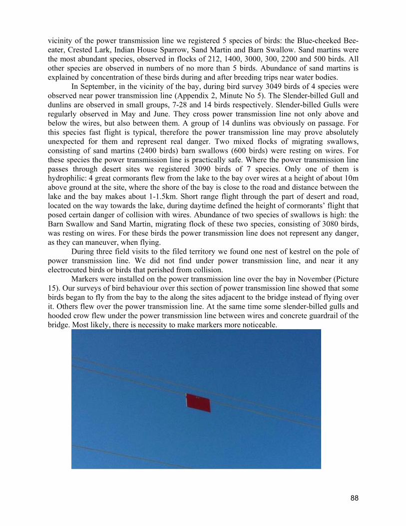
88
vicinity of the power transmission line we registered 5 species of birds: the Blue-cheeked Bee-eater, Crested Lark, Indian House Sparrow, Sand Martin and Barn Swallow. Sand martins were the most abundant species, observed in flocks of 212, 1400, 3000, 300, 2200 and 500 birds. All other species are observed in numbers of no more than 5 birds. Abundance of sand martins is explained by concentration of these birds during and after breeding trips near water bodies.
In September, in the vicinity of the bay, during bird survey 3049 birds of 4 species were observed near power transmission line (Appendix 2, Minute No 5). The Slender-billed Gull and dunlins are observed in small groups, 7-28 and 14 birds respectively. Slender-billed Gulls were regularly observed in May and June. They cross power transmission line not only above and below the wires, but also between them. A group of 14 dunlins was obviously on passage. For this species fast flight is typical, therefore the power transmission line may prove absolutely unexpected for them and represent real danger. Two mixed flocks of migrating swallows, consisting of sand martins (2400 birds) barn swallows (600 birds) were resting on wires. For these species the power transmission line is practically safe. Where the power transmission line passes through desert sites we registered 3090 birds of 7 species. Only one of them is hydrophilic: 4 great cormorants flew from the lake to the bay over wires at a height of about 10m above ground at the site, where the shore of the bay is close to the road and distance between the lake and the bay makes about 1-1.5km. Short range flight through the part of desert and road, located on the way towards the lake, during daytime defined the height of cormorants’ flight that posed certain danger of collision with wires. Abundance of two species of swallows is high: the Barn Swallow and Sand Martin, migrating flock of these two species, consisting of 3080 birds, was resting on wires. For these birds the power transmission line does not represent any danger, as they can maneuver, when flying.
During three field visits to the filed territory we found one nest of kestrel on the pole of power transmission line. We did not find under power transmission line, and near it any electrocuted birds or birds that perished from collision.
Markers were installed on the power transmission line over the bay in November (Picture 15). Our surveys of bird behaviour over this section of power transmission line showed that some birds began to fly from the bay to the along the sites adjacent to the bridge instead of flying over it. Others flew over the power transmission line. At the same time some slender-billed gulls and hooded crow flew under the power transmission line between wires and concrete guardrail of the bridge. Most likely, there is necessity to make markers more noticeable.
89
Picture 15: Markers on the Wires of Power Transmission Line at the Site over the Bridge and
Bay
In November during monitoring of the power transmission lines over the bay we registered 37 birds of 5 species (Appendix 4, Minute No 7). Waterbird species were represented by the Slender-billed Gull, Common Greenshank, Mallard, Pochard and Caspian Gull. All these are autumn migrants. The Mallard and Pochard belong to 4th priority group. The number of birds crossing power transmission lines in groups and flocks varied from 1 to 11: the Slender-billed Gull – 7, 11, 5 birds, the Common Greenshank – 1, the Mallard – 8, the Pochard – 2, the Caspian Gull – 4. They made morning feeding trips. Large flocks of pochards feeding in the bay seemed to arrive at night as the night before they had not been there. At night the power transmission line over the bay is undoubtedly dangerous to passage flocks that cross the bay at low height to alight on water. Non-waterbirds are represented by the Eurasian Hooded Crow (1 bird) that was feeding on the bay shore and flew to the lake under wires. In desert sections we registered 6 species on the power transmission line and near it: Bimaculated Lark, Desert Finch, Corn Bunting, Kestrel, Great Grey Shrike and Common Chiffchaff. The five species are typical in Bukhara region late in autumn and are found there in winter. One can often see them sitting on wires. Large flock of 250 Bimaculated larks swept over wires at a height of about 20m. During feeding migration in open areas without bushes flocks of larks can move not high above the ground. In this case there is danger of their collision with wires. The Common Chiffchaff most likely stayed longer due to long warm autumn. A fresh corpse of this small bird that by accident collided with wires was found early in the morning under the power transmission line near pole No 73 (between 5th and 6th km of motor road from base to bridge).
It is worth mentioning that collisions of small passerines with wires in open areas of Kyzyl Kum desert are not unusual. During survey of power transmission line in Central Kyzyl Kum in September 2007 in addition to large birds of prey (Kashkarov, 2007) warblers and lesser short-toed larks were found that was registered in inspection reports, which we read in State Biological Control of State Committee for Nature Protection of the Republic of Uzbekistan.
90
CONCLUSION In 2012 ornithological monitoring was carried out during the following basic biological
stages in life of waterbirds: spring migration (April – early May), beginning of breeding season (early May), end of breeding season (late June), autumn migration of early migrants (September) and autumn migration of late migrants, which this year took place comparatively late (November).
Waterbirds use the following habitats at the Dengizkul Lake: water area and shoal for feeding and rest, strip along the shore as feeding and rest area, islands and shallows for breeding and rest, reed thickets for breeding and shelter.
Fluctuations in water body level, caused by unstable water inflow and natural evaporation that are not connected with the project activity, results in a growing level of salinity, shallowing and salinification of lakeshores and has great impact on waterbird habitats, represented by shoals and reed thickets. Such a picture was observed in the north and south-west parts of the lake and in the north-west bay.
Project activity in the vicinity of reed thickets and other breeding areas, especially those used by globally threatened species (1-2 priority groups of BAP) and species registered in the national Red Book (3rd priority group of BAP), may disturb and affect success of breeding of these species. In order to avoid negative impact of construction works in the northern part of the lake it is necessary to provide preventive measures.
Only habitats of waterbirds located on the shores of the bay, connecting the lake and north-west bay, underwent considerable changes in the process of project activities at Khauzak-Shady block. As a result of bridge construction activity and laying of the pipeline, heavy machinery completely destroyed topsoil and vegetation there, so later planning of sandy soil surface was performed. However, according to the results of our surveys, this feeding territory has not lost its value for waterbirds (ducks, sandpipers, seagulls and others) which were observed during monitoring at all seasons.
On the west shore of the Dengizkul Lake, within Khauzak-Shady field territory plots of sandy desert, mostly outside water protection area, were allotted for wells and other facilities. One drilling rig was erected, 5 drilling rigs were dismantled and a number of wells and other facilities were completed during ornithological monitoring. Therefore basic impact of field construction and development is reduction of habitats of desert species of birds. It had certain impact on the species, whose area of distribution is limited by biome "Eurasian Deserts and Near-deserts", belonging to fifth priority group: the Desert Finch, Egyptian Nightjar, Desert Warbler, Scrub Warbler, etc. However, reduction of the area of habitats of these species of birds is not critical as they have migrated to extensive adjacent desert.
It is established that in Uzbekistan in the south-east and south-west parts of Kyzyl Kum desert in spring bulk of migrating birds flies north and north-east, and in autumn they fly south-west. When birds fly in the territory of the water body, especially during spring and autumn migration, power transmission lines pose potential threat to hydrophilic species. In the territory of Khauzak-Shady field the distribution power transmission line about 25km long goes parallel to Dengizkul Lakeshore and perpendicular to direction of migratory movement of birds, theoretically it increases risk of bird collision with this power transmission line. In spring and autumn we observed movements of migrating hydrophilic birds between the Djedykul and Dengizkul Lakes, between Dengizkul and north-west bay. Most actively they flew between the lake and bay. Besides, we frequently observed flocks of ducks, flying in close vicinity to power transmission line.
According to survey results we did not find any waterbirds that perished from collision with power transmission line or their remains, though many of them are night migrants. Only in
91
November there was found the Common Chiffchaff, a night migrant, that perished from collision with the power transmission line. We may assume that at night waterbirds make main trips over land above the power transmission line. Near the isthmus, where birds move over water area, markers, installed on the wires over the bridge, play an important role in prevention of bird collision with power transmission lines.
Bird protection devices in a form of special plastic boxes, installed over insulators and wires coming off them, limited possibility of birds of prey to use poles of power transmission line as perches and excluded possibility of their electrocution.
Analysis of the avifauna showed that 94 species of birds were registered during monitoring that makes 52.3% of avifauna of surveyed territory. Among them there are top priority birds: the White-headed Duck 1, Ferruginous Duck 1, Dalmatian Pelican 2, Asian Dowitcher 2, Pallid Harrier 2, Greater Spotted Eagle 2; 17 species registered in the Red Book of the Republic of Uzbekistan; 6 species belonging to fourth priority group (representing substantial part of ecogeographic population): the Mallard, Pochard and Red-crested Pochard, Coot, to them the Great Cormorant and Shelduck were added; and also 3 species, whose area of distribution is limited by biome " Eurasian Deserts and Neardeserts" (the Southern Booted Warbler, Scrub Warbler and Desert Finch).
At the same time 9 new species were added to general list of birds. Among 5 waterbird species there are species of the second (Asian Dowitcher), and third (Greater Flamingo) priority groups. The Lesser Kestrel belonging to second priority group was also registered.
Facts stated above show that in general project activity of Khauzak-Shady gas-condensate field does not have any critical or considerable negative impact on avifauna of Ramsar site of international importance “Dengizkul Lake” and adjacent desert. However ornithological monitoring must be continued and special measures for mitigation of negative impact of project activity on birds must be worked out in order to prevent potential undesirable impacts on birds and their habitats.
92
RECOMMENDATIONS FOR MITIGATION OF PROBABLE IMPACT OF PROJECT ACTIVITIES ON HABITATS AND TOP PRIORITY BIRDS
It is advisable to put markers, indicating a 1km wide protective zone, in order to maintain
optimum regime, preventing disturbance to the birds, inhabiting reed thickets with limited area, as some of the birds are extremely vulnerable to disturbance.
Put markers at a distance of 500m from the water edge at maximum water level, registered within recent years, indicating the water protection zone around the north-west bay, the concentration and breeding area of many bird species.
It is not advisable to perform large-scale construction works at the north extremity of the lake in spring and early summer periods in order to avoid negative impact on bird species breeding here.
In connection with commencement of construction works at “North Shady” block measures must be taken to prevent disturbance to birds in the near-shore strip, for that purpose it is advisable to put markers, indicating protective zone, at a distance of 500m from lakeshore.
In order to prevent possibility of migrating bird collisions with the power transmission line detection of the most dangerous areas must be continued during monitoring and markers must be put at detected dangerous areas. At present such areas are bridge and adjacent sections of the power transmission line: at a distance of 1km before the bridge and 3km after it.
For mitigation of negative impact of motor road and traffic: prevention of bird mortality, caused by collision, established speed limit must be observed and bridge guard rail must be painted in contrast colors to make it visually noticeable.
Ornithological monitoring, meant to study condition of habitats and populations of various species of birds, reveal their concentration areas during various seasons of year and factors influencing them, must be continued.

93
DATA SOURCES
Kashkarov D.Yu. Marbled Duck. Red Book of the Uzbek SSR. Rare and Globally Threatened Species of Animals and Plants. V.1. Verterbrate Animals. Tashkent. “FAN”. 1983. p.64-66.
Kashkarov D.Yu. Ferruginous Duck Aythya niroca Guld. Birds of Uzbekistan. Volume 1. Publishing House “FAN”. Tashkent, 1987. p.108-110.
Lanovenko Е.N. For study of Dengizkul Lake Avifauna. Transactions of Reservations of Uzbekistan. Rev.3. Tashkent, 2001.
Lanovenko Е.N., Filatov А.K., Zagrebin S.V. Importance of Water bodies of Uzbekistan for Preservation of Biological Diversity of Wintering Birds. Actual Problems of Study and Protection of Birds of Eastern Europe and North Africa. Materials of International Conference (XI Ornithological Conference). Kazan, 2001. p.358-359.
Lanovenko Е.N., Kreytsberg Е.А., Zagrebin S.V. Sudoch’e Lake System – Important Territory for Preservation of Rare Species of Birds in the south Sub-Aral Area. Selevinia. 2005. p.97- 104.
Lanovenko Е.N., Filatov А.K., Kashkarov D.Yu., Zagrebin S.V., Shernazarov E., Filatova Е.А. Monitoring of Hydrophilic Birds Wintering in the Water Bodies of Uzbekistan. Biodiversity of Uzbekistan – Monitoring and Usage. Tashkent, 2007. p.98-109.
Lanovenko Е.N., Filatova Е.А. Condition of Stiff-tailed Duck Population (Oxyura leucocephala) in Uzbekistan early in the 21th century. Materials of Conference Dedicated to 100 Anniversary of M.N. Korelov. Almaty. 2011.
Mitropolskiy О.V., Fottler E.R., Tret’yakov G.P. Charadriiformes. Birds of Uzbekistan. V.2. Tashkent. “FAN”. 1990. p.17-118.
Mukhina Е.А., Salimov Kh.V. Rare and Threatened Species of Birds in Bukhara Eco-center of Mammals and Birds of Uzbekistan. Tashkent, FAN. 1987. p.95-97.
Mukhina Е.А., Lukashevich R.V. Hydrophilic Birds of Karshi Steppe (in the vicinity of Bukhara Eco-center, the South-west Uzbekistan) (in 2 parts). Fauna and Ecology of Birds in Uzbekistan. Samarkand. 1989. p.123-147.
Mukhina Е.А., Lanovenko Е.N. Nesting of Marbled Duck and White-eyed Duck in the South-west Uzbekistan. Actual Problems Actual Problems of Study and Protection of Birds of Eastern Europe and North Africa. Materials of International Conference (XI Ornithological Conference). Kazan, 2001..
Poslavskiy А.N., Shirekov R.Sh. Rare and Little-studied Species of Anseriformes of the East Turkmenistan. Rare and Little-studied Birds of the Central Asia. Materials of Conference. Bukhara. 1990. p.40-43.
Important Bird Areas in Uzbekistan. Priority Sites for Conservation Edited by R/Dkashkarov, G.r.Welch and M.Brombacher with assistance from E.Lanovenko. Tashkent, 2008. 188 p .
Kreuzberg-Mukhina E.A., Kashkarov D.Yu., Lanovenko Ye.N., Nazarov A.P., Shernazarov E. Status of Threatened Anatidae in Uzbekistan. TWSG News. The bulletin of the Threateted Waterfowl Specialist Group. No.12, June 2000. P. 70-75.
Lanovenko Ye. White-headed Ducks at Dengizkul Lake, Uzbekistan. TWSG News. The bulletin of the Threateted Waterfowl Specialist Group. No.12, June 2000. P. 18.
Lanovenko Ye.N,, Turaev M.M. Dengizkul Lake. Important Bird Areas in Uzbekistan. Priority Sites for Conservation Edited by R.D. Kashkarov, G.R.Welch and M.Brombacher with assistance from E.Lanovenko. Tashkent, 2008. P.102-104.
Kashkarov O.R. Information bulletin for IBA project in Uzbekistan, 2007. Mukhina E.A. Marbled Teal in Uzbekistan. Threatened Waterfowl Research Group
Newsletter 1995. 7:15-16.

94
Wetlands International, 2006. Waterbird Population Estimates – Fouth Edition. Wetlands International, Wageningen, The Netherlands.
APPENDICES (following pages)
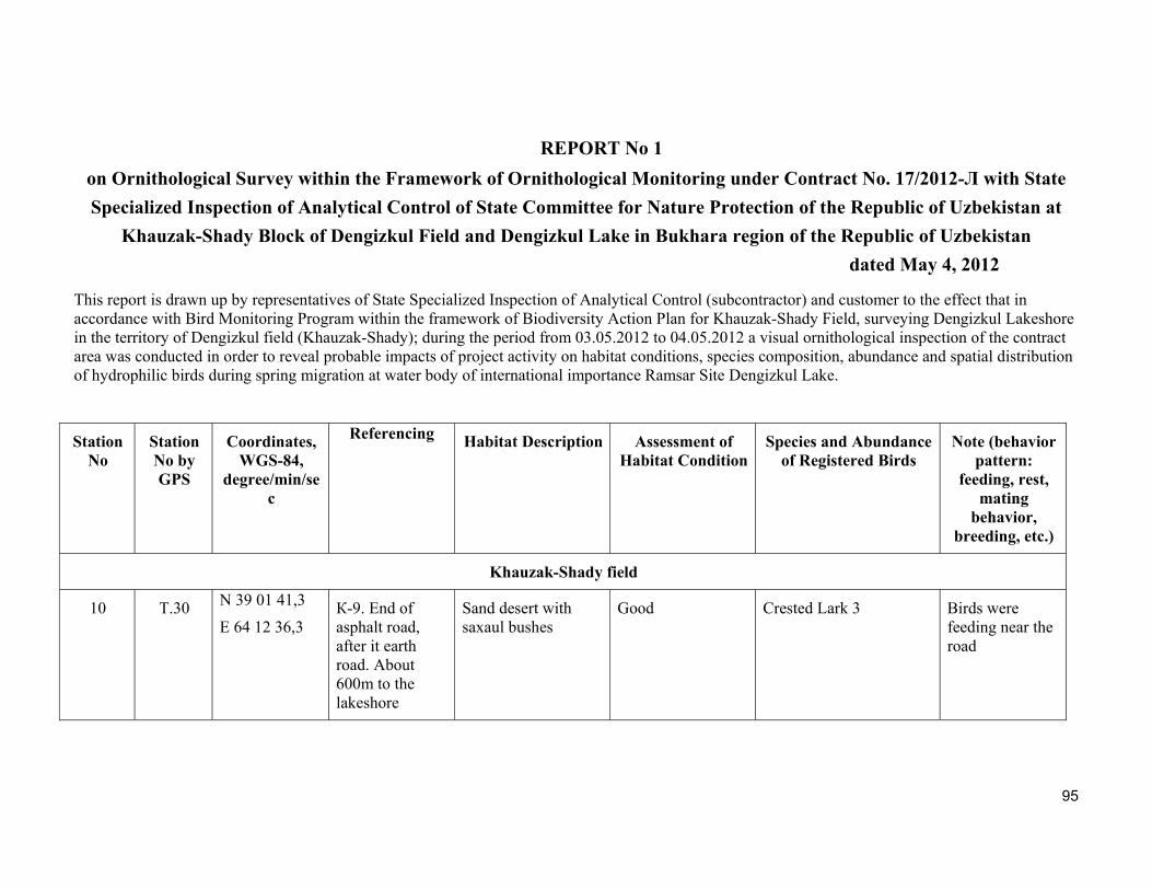
95
REPORT No 1
on Ornithological Survey within the Framework of Ornithological Monitoring under Contract No. 17/2012-Л with State
Specialized Inspection of Analytical Control of State Committee for Nature Protection of the Republic of Uzbekistan at
Khauzak-Shady Block of Dengizkul Field and Dengizkul Lake in Bukhara region of the Republic of Uzbekistan
dated May 4, 2012
This report is drawn up by representatives of State Specialized Inspection of Analytical Control (subcontractor) and customer to the effect that in accordance with Bird Monitoring Program within the framework of Biodiversity Action Plan for Khauzak-Shady Field, surveying Dengizkul Lakeshore in the territory of Dengizkul field (Khauzak-Shady); during the period from 03.05.2012 to 04.05.2012 a visual ornithological inspection of the contract area was conducted in order to reveal probable impacts of project activity on habitat conditions, species composition, abundance and spatial distribution of hydrophilic birds during spring migration at water body of international importance Ramsar Site Dengizkul Lake.
Station No
Station No by GPS
Coordinates, WGS-84,
degree/min/sec
Referencing
Habitat Description Assessment of
Habitat ConditionSpecies and Abundance
of Registered Birds Note (behavior
pattern: feeding, rest,
mating behavior,
breeding, etc.)
Khauzak-Shady field
10 T.30 N 39 01 41,3
E 64 12 36,3 К-9. End of asphalt road, after it earth road. About 600m to the lakeshore
Sand desert with saxaul bushes
Good Crested Lark 3 Birds were feeding near the road
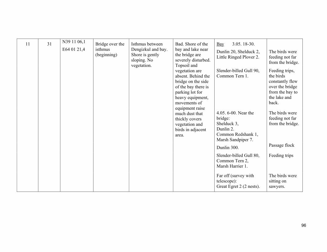
96
11 31 N39 11 06,1
E64 01 21,4 Bridge over the isthmus (beginning)
Isthmus between Dengizkul and bay. Shore is gently sloping. No vegetation.
Bad. Shore of the bay and lake near the bridge are severely disturbed. Topsoil and vegetation are absent. Behind the bridge on the side of the bay there is parking lot for heavy equipment, movements of equipment raise much dust that thickly covers vegetation and birds in adjacent area.
Bay 3.05. 18-30.
Dunlin 20, Shelduck 2, Little Ringed Plover 2.
The birds were feeding not far from the bridge.
Slender-billed Gull 90, Common Tern 1.
Feeding trips, the birds constantly flew over the bridge from the bay to the lake and back.
4.05. 6-00. Near the bridge: Shelduck 3, Dunlin 2. Common Redshank 1, Marsh Sandpiper 7.
The birds were feeding not far from the bridge.
Dunlin 300. Passage flock
Slender-billed Gull 80, Common Tern 2, Marsh Harrier 1.
Feeding trips
Far off (survey with telescope): Great Egret 2 (2 nests).
The birds were sitting on sawyers.
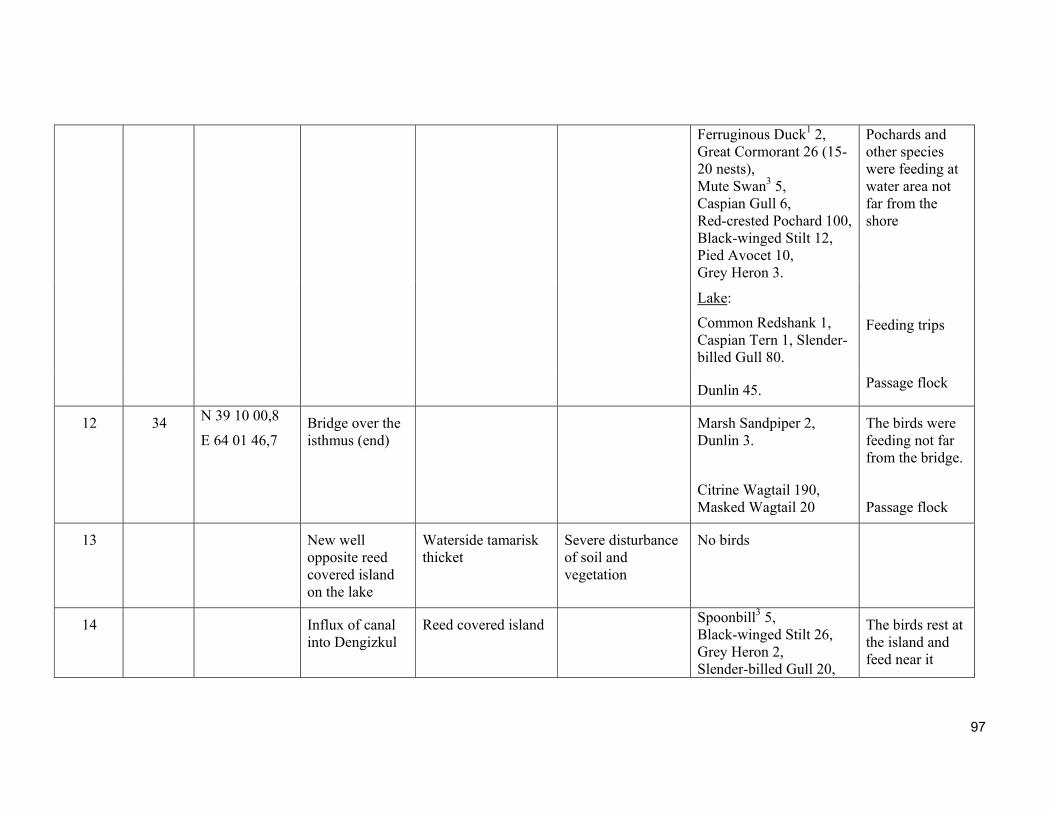
97
Ferruginous Duck1 2, Great Cormorant 26 (15-20 nests), Mute Swan3 5, Caspian Gull 6, Red-crested Pochard 100, Black-winged Stilt 12, Pied Avocet 10, Grey Heron 3.
Pochards and other species were feeding at water area not far from the shore
Lake:
Common Redshank 1, Caspian Tern 1, Slender-billed Gull 80.
Feeding trips
Dunlin 45. Passage flock
12 34 N 39 10 00,8
E 64 01 46,7 Bridge over the isthmus (end)
Marsh Sandpiper 2, Dunlin 3.
Citrine Wagtail 190, Masked Wagtail 20
The birds were feeding not far from the bridge.
Passage flock
13 New well opposite reed covered island on the lake
Waterside tamarisk thicket
Severe disturbance of soil and vegetation
No birds
14 Influx of canal into Dengizkul
Reed covered island Spoonbill3 5, Black-winged Stilt 26, Grey Heron 2, Slender-billed Gull 20,
The birds rest at the island and feed near it
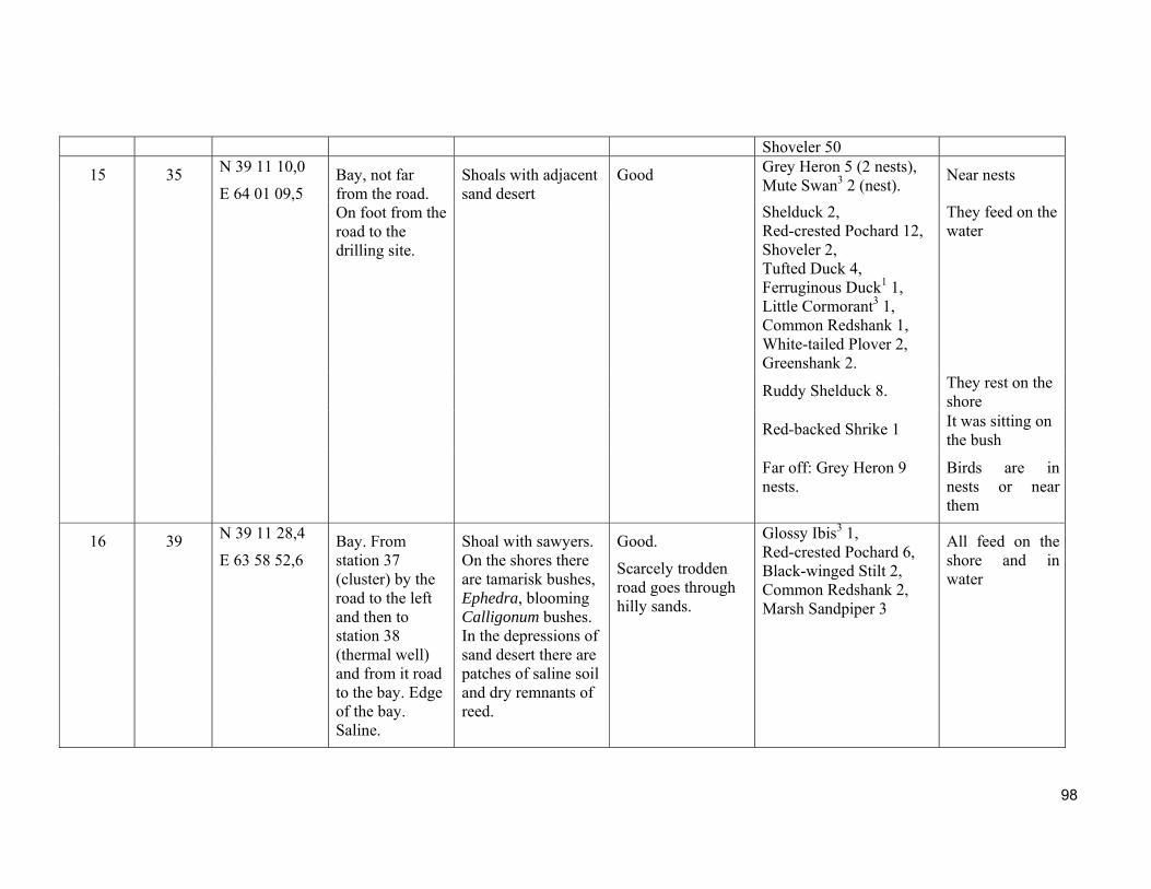
98
Shoveler 50
15 35 N 39 11 10,0
E 64 01 09,5 Bay, not far from the road. On foot from the road to the drilling site.
Shoals with adjacent sand desert
Good Grey Heron 5 (2 nests), Mute Swan3 2 (nest).
Near nests
Shelduck 2, Red-crested Pochard 12, Shoveler 2, Tufted Duck 4, Ferruginous Duck1 1, Little Cormorant3 1, Common Redshank 1, White-tailed Plover 2, Greenshank 2.
They feed on the water
Ruddy Shelduck 8. They rest on the shore
Red-backed Shrike 1 It was sitting on the bush
Far off: Grey Heron 9 nests.
Birds are in nests or near them
16 39 N 39 11 28,4
E 63 58 52,6 Bay. From station 37 (cluster) by the road to the left and then to station 38 (thermal well) and from it road to the bay. Edge of the bay. Saline.
Shoal with sawyers. On the shores there are tamarisk bushes, Ephedra, blooming Calligonum bushes. In the depressions of sand desert there are patches of saline soil and dry remnants of reed.
Good.
Scarcely trodden road goes through hilly sands.
Glossy Ibis3 1, Red-crested Pochard 6, Black-winged Stilt 2, Common Redshank 2, Marsh Sandpiper 3
All feed on the shore and in water

99
17 40 N 39 11 23,7
E 63 58 56,1 Bay. Survey station is 20 m from station 39.
Water area of the bay, far off there is an island and small strip of reeds. Possibly it is the site of the Alat manifold inflow.
Good. On the opposite spit there are some cows.
Black-tailed Godwit 1, Marsh Sandpiper 5, Common Redshank 8, Black-winged Stilt 15, Asian Dowitcher2 2, Pied Avocet 11, Red-crested Pochard 101, Shoveler 24, Gadwall 2, Great Egret 18, Coot4 1386, Shoveler 4, Mute Swan3 142, Tufted Duck 2,
Great Crested Grebe 2, ducks (unidentified) 80, Shelduck 3,
They feed near the shore of the bay and island
Spoonbill3 4, Grey Heron 4,
Little Cormorant3 78, Little Egret3 4, Great Cormorant 52, Dalmatian Pelican2 11, Slender-billed Gull 34, Caspian Tern 12, Caspian Gull 11.
They were sitting on the island
Eurasian Curlew 7, Greenshank 23.
Passage flocks
Scrub Robin 1. Singing on
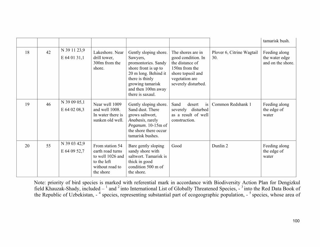
100
tamarisk bush.
18 42 N 39 11 23,9
E 64 01 31,1 Lakeshore. Near drill tower, 300m from the shore.
Gently sloping shore. Sawyers, promontories. Sandy shore front is up to 20 m long. Behind it there is thinly growing tamarisk and then 100m away there is saxaul.
The shores are in good condition. In the distance of 150m from the shore topsoil and vegetation are severely disturbed.
Plover 6, Citrine Wagtail 30.
Feeding along the water edge and on the shore.
19 46 N 39 09 05,1
E 64 02 08,3 Near well 1009 and well 1008. In water there is sunken old well.
Gently sloping shore. Sand dust. There grows saltwort, Anabasis, rarely Peganum. 10-15m of the shore there occur tamarisk bushes.
Sand desert is severely disturbed as a result of well construction.
Common Redshank 1 Feeding along the edge of water
20 55 N 39 03 42,9
E 64 09 52,7 From station 54 earth road turns to well 1026 and to the left without road to the shore
Bare gently sloping sandy shore with saltwort. Tamarisk is thick in good condition 500 m of the shore.
Good Dunlin 2 Feeding along the edge of water
Note: priority of bird species is marked with referential mark in accordance with Biodiversity Action Plan for Dengizkul field Khauzak-Shady, included – 1 and 2 into International List of Globally Threatened Species, - 3 into the Red Data Book of the Republic of Uzbekistan, - 4 species, representing substantial part of ecogeographic population, - 5 species, whose area of

101
distribution is limited by biome " Eurasian Deserts and Neardeserts", registered during survey of Dengizkul Lakeshore and bay.
The present Report is signed
On behalf of the Customer On behalf of the Contractor:
Tukhsanov A.Kh. Lanovenko Е.N., Candidate of Science, Head
Environmental Engineer Shernazarov E., Doctor of Science, expert ornithologist
LUKOIL Uzbekistan Operating Company LLC
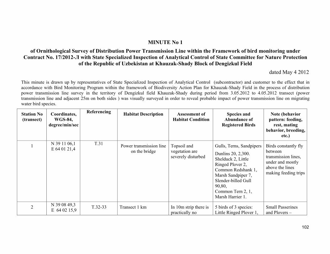
102
MINUTE No 1
of Ornithological Survey of Distribution Power Transmission Line within the Framework of bird monitoring under Contract No. 17/2012-Л with State Specialized Inspection of Analytical Control of State Committee for Nature Protection
of the Republic of Uzbekistan at Khauzak-Shady Block of Dengizkul Field
dated May 4 2012
This minute is drawn up by representatives of State Specialized Inspection of Analytical Control (subcontractor) and customer to the effect that in accordance with Bird Monitoring Program within the framework of Biodiversity Action Plan for Khauzak-Shady Field in the process of distribution power transmission line survey in the territory of Dengizkul field Khauzak-Shady during period from 3.05.2012 to 4.05.2012 transect (power transmission line and adjacent 25m on both sides ) was visually surveyed in order to reveal probable impact of power transmission line on migrating water bird species.
Station No (transect)
Coordinates, WGS-84,
degree/min/sec
Referencing
Habitat Description Assessment of
Habitat Condition Species and
Abundance of Registered Birds
Note (behavior pattern: feeding,
rest, mating behavior, breeding,
etc.)
1 N 39 11 06,1 E 64 01 21,4
Т.31 Power transmission line on the bridge
Topsoil and vegetation are severely disturbed
Gulls, Terns, Sandpipers
Dunlins 20, 2,300. Shelduck 2, Little Ringed Plover 2, Common Redshank 1, Marsh Sandpiper 7, Slender-billed Gull 90,80, Common Tern 2, 1, Marsh Harrier 1.
Birds constantly fly between transmission lines, under and mostly above the lines making feeding trips
2 N 39 08 49,3 E 64 02 15,9
Т.32-33 Transect 1 km In 10m strip there is practically no
5 birds of 3 species: Little Ringed Plover 1,
Small Passerines and Plovers –
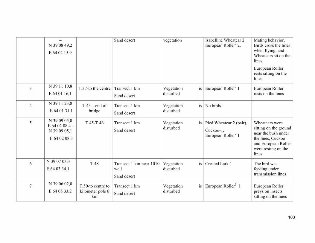
103
– N 39 08 49,2
E 64 02 15,9
Sand desert vegetation Isabelline Wheatear 2, European Roller2 2.
Mating behavior, Birds cross the lines when flying, and Wheatears sit on the lines.
European Roller rests sitting on the lines
3 N 39 11 10,8
E 64 01 16,1 Т.37-to the centre Transect 1 km
Sand desert
Vegetation is disturbed
European Roller2 1 European Roller rests on the lines
4 N 39 11 23,8
E 64 01 31,1 Т.43 – end of
bridge Transect 1 km
Sand desert
Vegetation is disturbed
No birds
5 N 39 09 05,0 E 64 02 08,4 –N 39 09 05,1
E 64 02 08,3
Т.45-Т.46 Transect 1 km
Sand desert
Vegetation is disturbed
Pied Wheatear 2 (pair),
Cuckoo-1, European Roller2 1
Wheatears were sitting on the ground near the bush under the lines, Cuckoo and European Roller were resting on the lines.
6 N 39 07 03,3
E 64 03 34,1 Т.48 Transect 1 km near 1010
well
Sand desert
Vegetation is disturbed
Crested Lark 1 The bird was feeding under transmission lines
7 N 39 06 02,0
E 64 05 33,2 Т.50-to centre to kilometer pole 6
km
Transect 1 km
Sand desert
Vegetation is disturbed
European Roller2 1 European Roller preys on insects sitting on the lines
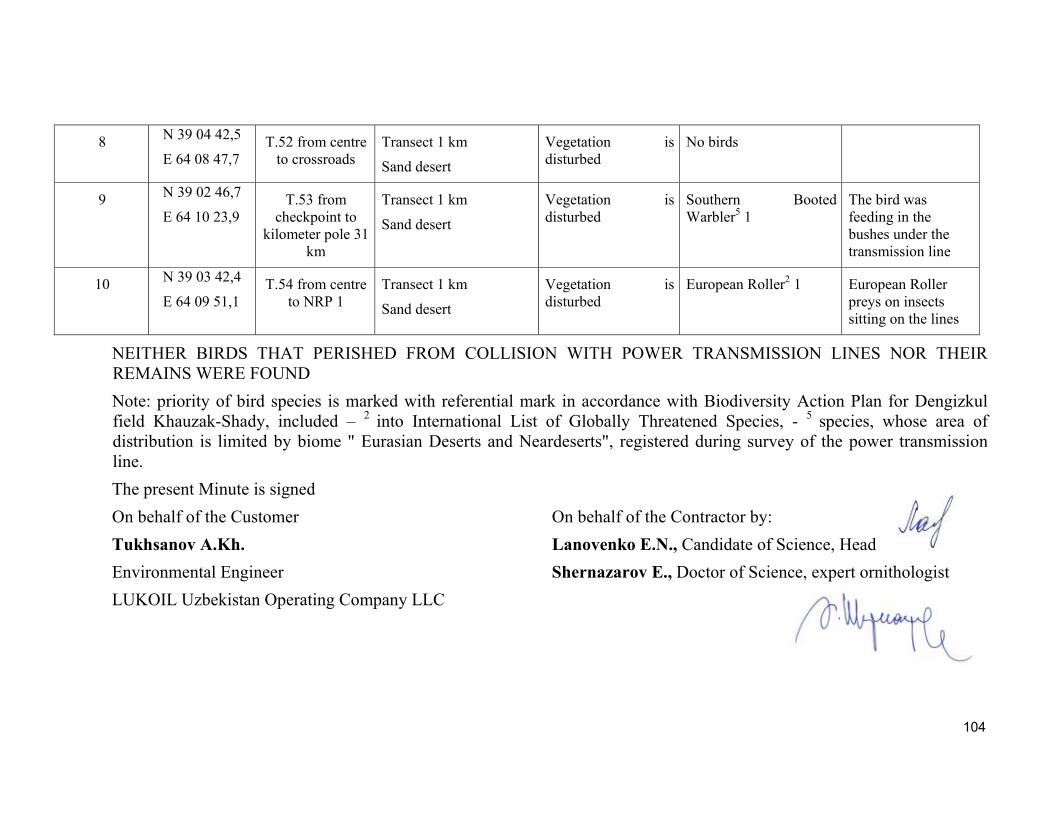
104
8 N 39 04 42,5
E 64 08 47,7 Т.52 from centre
to crossroads Transect 1 km
Sand desert
Vegetation is disturbed
No birds
9 N 39 02 46,7
E 64 10 23,9 Т.53 from
checkpoint to kilometer pole 31
km
Transect 1 km
Sand desert
Vegetation is disturbed
Southern Booted Warbler5 1
The bird was feeding in the bushes under the transmission line
10 N 39 03 42,4
E 64 09 51,1 Т.54 from centre
to NRP 1 Transect 1 km
Sand desert
Vegetation is disturbed
European Roller2 1 European Roller preys on insects sitting on the lines
NEITHER BIRDS THAT PERISHED FROM COLLISION WITH POWER TRANSMISSION LINES NOR THEIR REMAINS WERE FOUND
Note: priority of bird species is marked with referential mark in accordance with Biodiversity Action Plan for Dengizkul field Khauzak-Shady, included – 2 into International List of Globally Threatened Species, - 5 species, whose area of distribution is limited by biome " Eurasian Deserts and Neardeserts", registered during survey of the power transmission line.
The present Minute is signed
On behalf of the Customer On behalf of the Contractor by:
Tukhsanov A.Kh. Lanovenko Е.N., Candidate of Science, Head
Environmental Engineer Shernazarov E., Doctor of Science, expert ornithologist
LUKOIL Uzbekistan Operating Company LLC
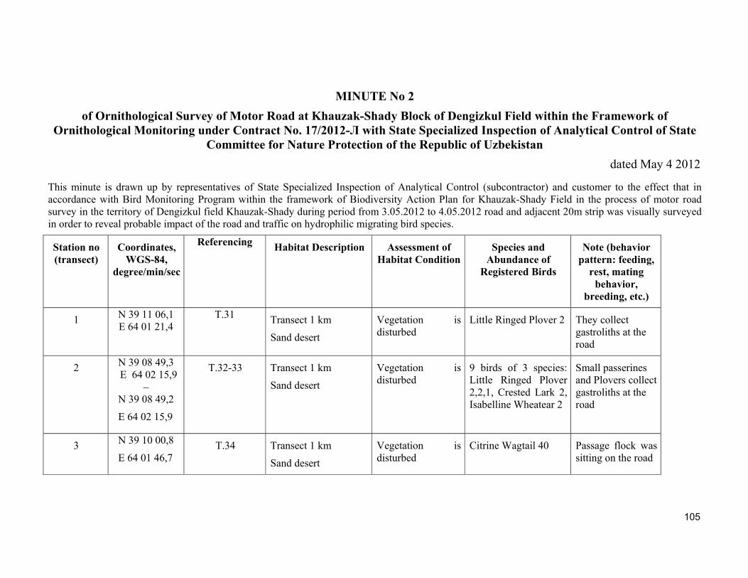
105
MINUTE No 2
of Ornithological Survey of Motor Road at Khauzak-Shady Block of Dengizkul Field within the Framework of Ornithological Monitoring under Contract No. 17/2012-Л with State Specialized Inspection of Analytical Control of State
Committee for Nature Protection of the Republic of Uzbekistan
dated May 4 2012
This minute is drawn up by representatives of State Specialized Inspection of Analytical Control (subcontractor) and customer to the effect that in accordance with Bird Monitoring Program within the framework of Biodiversity Action Plan for Khauzak-Shady Field in the process of motor road survey in the territory of Dengizkul field Khauzak-Shady during period from 3.05.2012 to 4.05.2012 road and adjacent 20m strip was visually surveyed in order to reveal probable impact of the road and traffic on hydrophilic migrating bird species.
Station no (transect)
Coordinates, WGS-84,
degree/min/sec
Referencing
Habitat Description Assessment of
Habitat Condition Species and
Abundance of Registered Birds
Note (behavior pattern: feeding,
rest, mating behavior,
breeding, etc.)
1 N 39 11 06,1 E 64 01 21,4
Т.31 Transect 1 km
Sand desert
Vegetation is disturbed
Little Ringed Plover 2 They collect gastroliths at the road
2 N 39 08 49,3 E 64 02 15,9
– N 39 08 49,2
E 64 02 15,9
Т.32-33 Transect 1 km
Sand desert
Vegetation is disturbed
9 birds of 3 species: Little Ringed Plover 2,2,1, Crested Lark 2, Isabelline Wheatear 2
Small passerines and Plovers collect gastroliths at the road
3 N 39 10 00,8
E 64 01 46,7 Т.34 Transect 1 km
Sand desert
Vegetation is disturbed
Citrine Wagtail 40 Passage flock was sitting on the road
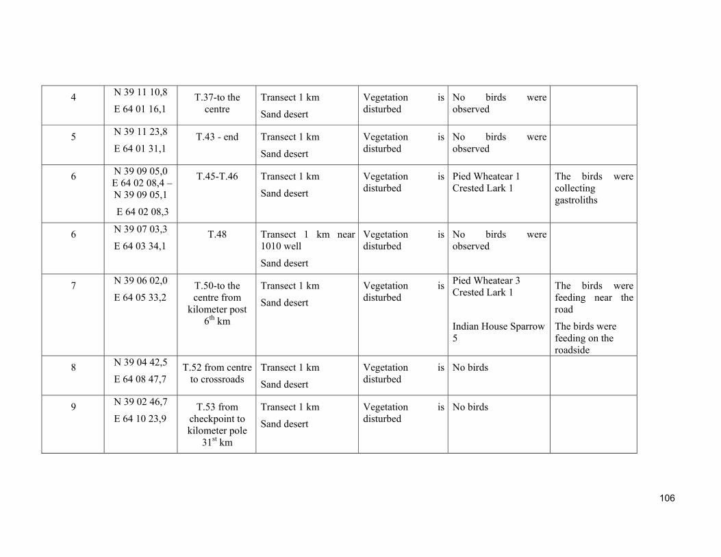
106
4 N 39 11 10,8
E 64 01 16,1 Т.37-to the
centre Transect 1 km
Sand desert
Vegetation is disturbed
No birds were observed
5 N 39 11 23,8
E 64 01 31,1 Т.43 - end Transect 1 km
Sand desert
Vegetation is disturbed
No birds were observed
6 N 39 09 05,0 E 64 02 08,4 –N 39 09 05,1
E 64 02 08,3
Т.45-Т.46 Transect 1 km
Sand desert
Vegetation is disturbed
Pied Wheatear 1 Crested Lark 1
The birds were collecting gastroliths
6 N 39 07 03,3
E 64 03 34,1 Т.48 Transect 1 km near
1010 well
Sand desert
Vegetation is disturbed
No birds were observed
7 N 39 06 02,0
E 64 05 33,2 Т.50-to the centre from
kilometer post 6th km
Transect 1 km
Sand desert
Vegetation is disturbed
Pied Wheatear 3 Crested Lark 1
Indian House Sparrow 5
The birds were feeding near the road
The birds were feeding on the roadside
8 N 39 04 42,5
E 64 08 47,7 Т.52 from centre
to crossroads Transect 1 km
Sand desert
Vegetation is disturbed
No birds
9 N 39 02 46,7
E 64 10 23,9 Т.53 from
checkpoint to kilometer pole
31st km
Transect 1 km
Sand desert
Vegetation is disturbed
No birds
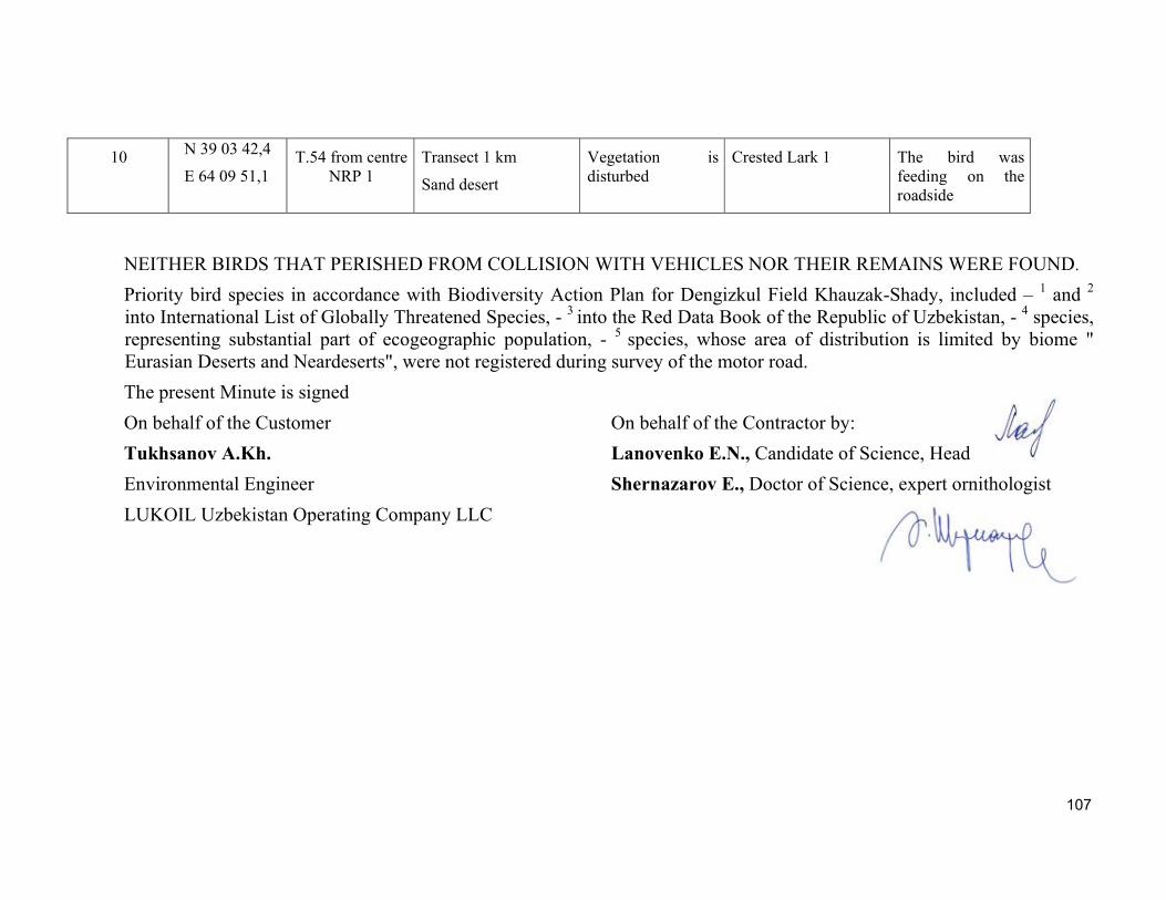
107
10 N 39 03 42,4
E 64 09 51,1 Т.54 from centre
NRP 1 Transect 1 km
Sand desert
Vegetation is disturbed
Crested Lark 1 The bird was feeding on the roadside
NEITHER BIRDS THAT PERISHED FROM COLLISION WITH VEHICLES NOR THEIR REMAINS WERE FOUND.
Priority bird species in accordance with Biodiversity Action Plan for Dengizkul Field Khauzak-Shady, included – 1 and 2
into International List of Globally Threatened Species, - 3 into the Red Data Book of the Republic of Uzbekistan, - 4 species, representing substantial part of ecogeographic population, - 5 species, whose area of distribution is limited by biome " Eurasian Deserts and Neardeserts", were not registered during survey of the motor road.
The present Minute is signed
On behalf of the Customer On behalf of the Contractor by:
Tukhsanov A.Kh. Lanovenko Е.N., Candidate of Science, Head
Environmental Engineer Shernazarov E., Doctor of Science, expert ornithologist
LUKOIL Uzbekistan Operating Company LLC
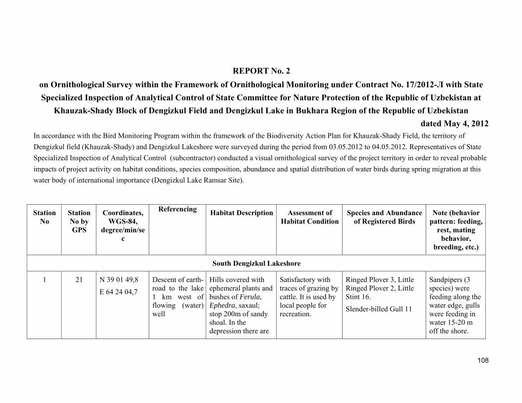
108
REPORT No. 2
on Ornithological Survey within the Framework of Ornithological Monitoring under Contract No. 17/2012-Л with State
Specialized Inspection of Analytical Control of State Committee for Nature Protection of the Republic of Uzbekistan at
Khauzak-Shady Block of Dengizkul Field and Dengizkul Lake in Bukhara Region of the Republic of Uzbekistan
dated May 4, 2012 In accordance with the Bird Monitoring Program within the framework of the Biodiversity Action Plan for Khauzak-Shady Field, the territory of
Dengizkul field (Khauzak-Shady) and Dengizkul Lakeshore were surveyed during the period from 03.05.2012 to 04.05.2012. Representatives of State
Specialized Inspection of Analytical Control (subcontractor) conducted a visual ornithological survey of the project territory in order to reveal probable
impacts of project activity on habitat conditions, species composition, abundance and spatial distribution of water birds during spring migration at this
water body of international importance (Dengizkul Lake Ramsar Site).
Station No
Station No by GPS
Coordinates,WGS-84,
degree/min/sec
Referencing
Habitat Description Assessment of
Habitat ConditionSpecies and Abundance
of Registered Birds Note (behavior
pattern: feeding, rest, mating
behavior, breeding, etc.)
South Dengizkul Lakeshore
1 21 N 39 01 49,8
E 64 24 04,7
Descent of earth-road to the lake 1 km west of flowing (water) well
Hills covered with ephemeral plants and bushes of Ferula, Ephedra, saxaul; stop 200m of sandy shoal. In the depression there are
Satisfactory with traces of grazing by cattle. It is used by local people for recreation.
Ringed Plover 3, Little Ringed Plover 2, Little Stint 16.
Slender-billed Gull 11
Sandpipers (3 species) were feeding along the water edge, gulls were feeding in water 15-20 m off the shore.
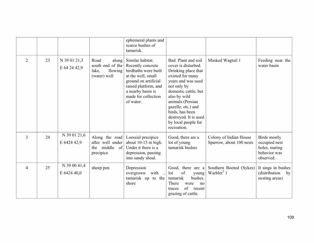
109
ephemeral plants and scarce bushes of tamarisk.
2 23 N 39 01 21,3
E 64 24 42,9
Road along south end of the lake, flowing (water) well
Similar habitat. Recently concrete birdbaths were built at the well, small ground on artificial raised platform, and a nearby basin is made for collection of water.
Bad. Plant and soil cover is disturbed. Drinking place that existed for many years and was used not only by domestic cattle, but also by wild animals (Persian gazelle, etc.) and birds, has been destroyed. It is used by local people for recreation.
Masked Wagtail 1 Feeding near the water basin
3 24 N 39 01 21,6
E 6424 42,9 Along the road after well under the middle of precipice
Loessial precipice about 10-15 m high. Under it there is a depression, passing into sandy shoal.
Good, there are a lot of young tamarisk bushes
Colony of Indian House Sparrow, about 100 nests
Birds mostly occupied nest holes, mating behavior was observed.
4 25 N 39 00 41,4
E 6424 40,0 sheep pen Depression
overgrown with , tamarisk up to the shore
Good, there are a lot of young tamarisk bushes. There were no traces of recent grazing of cattle.
Southern Booted (Sykes) Warbler5 1
It sings in bushes (distribution by nesting areas)
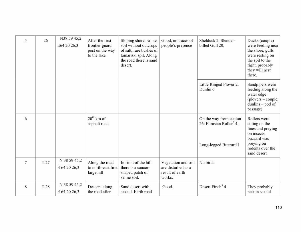
110
5 26 N38 59 45,2
E64 20 26,3
After the first frontier guard post on the way to the lake
Sloping shore, saline soil without outcrops of salt, rare bushes of tamarisk, spit. Along the road there is sand desert.
Good, no traces of people’s presence
Shelduck 2, Slender-billed Gull 20.
Ducks (couple) were feeding near the shore, gulls were resting on the spit to the right, probably they will nest there.
Little Ringed Plover 2. Dunlin 6
Sandpipers were feeding along the water edge (plovers – couple, dunlins – pod of passage)
6 20th km of asphalt road
On the way from station 26: Eurasian Roller2 4.
Long-legged Buzzard 1
Rollers were sitting on the lines and preying on insects, buzzard was preying on rodents over the sand desert
7 Т.27 N 38 59 45,2
E 64 20 26,3 Along the road to north-east first large hill
In front of the hill there is a saucer-shaped patch of saline soil.
Vegetation and soil are disturbed as a result of earth works.
No birds
8 Т.28 N 38 59 45,2
E 64 20 26,3 Descent along the road after
Sand desert with saxaul. Earth road
Good. Desert Finch5 4 They probably nest in saxaul
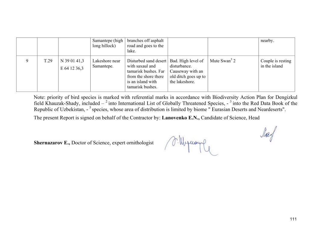
111
Samantepe (high long hillock)
branches off asphalt road and goes to the lake.
nearby.
9 Т.29 N 39 01 41,3
E 64 12 36,3
Lakeshore near Samantepe.
Disturbed sand desert with saxaul and tamarisk bushes. Far from the shore there is an island with tamarisk bushes.
Bad. High level of disturbance. Causeway with an old ditch goes up to the lakeshore.
Mute Swan3 2 Couple is resting in the island
Note: priority of bird species is marked with referential marks in accordance with Biodiversity Action Plan for Dengizkul field Khauzak-Shady, included – 2 into International List of Globally Threatened Species, - 3 into the Red Data Book of the Republic of Uzbekistan, - 5 species, whose area of distribution is limited by biome " Eurasian Deserts and Neardeserts".
The present Report is signed on behalf of the Contractor by: Lanovenko Е.N., Candidate of Science, Head
Shernazarov E., Doctor of Science, expert ornithologist
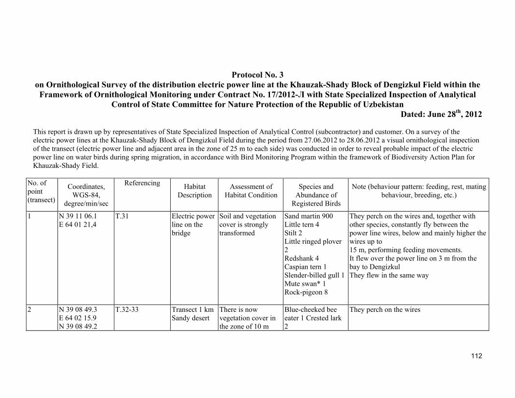
112
Protocol No. 3
on Ornithological Survey of the distribution electric power line at the Khauzak-Shady Block of Dengizkul Field within the Framework of Ornithological Monitoring under Contract No. 17/2012-Л with State Specialized Inspection of Analytical
Control of State Committee for Nature Protection of the Republic of Uzbekistan Dated: June 28th, 2012
This report is drawn up by representatives of State Specialized Inspection of Analytical Control (subcontractor) and customer. On a survey of the electric power lines at the Khauzak-Shady Block of Dengizkul Field during the period from 27.06.2012 to 28.06.2012 a visual ornithological inspection of the transect (electric power line and adjacent area in the zone of 25 m to each side) was conducted in order to reveal probable impact of the electric power line on water birds during spring migration, in accordance with Bird Monitoring Program within the framework of Biodiversity Action Plan for Khauzak-Shady Field.
No. of point (transect)
Coordinates, WGS-84,
degree/min/sec
Referencing
Habitat
Description Assessment of
Habitat Condition Species and
Abundance of Registered Birds
Note (behaviour pattern: feeding, rest, mating behaviour, breeding, etc.)
1 N 39 11 06.1 Е 64 01 21,4
Т.31 Electric power line on the bridge
Soil and vegetation cover is strongly transformed
Sand martin 900 Little tern 4 Stilt 2 Little ringed plover 2 Redshank 4 Caspian tern 1 Slender-billed gull 1 Mute swan* 1 Rock-pigeon 8
They perch on the wires and, together with other species, constantly fly between the power line wires, below and mainly higher the wires up to 15 m, performing feeding movements. It flew over the power line on 3 m from the bay to Dengizkul They flew in the same way
2 N 39 08 49.3 Е 64 02 15.9 N 39 08 49.2
Т.32-33 Transect 1 km Sandy desert
There is now vegetation cover in the zone of 10 m
Blue-cheeked bee eater 1 Crested lark 2
They perch on the wires
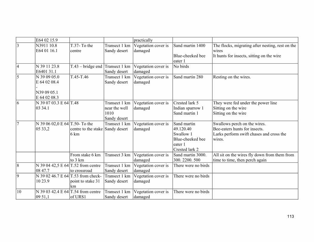
113
Е64 02 15.9 practically 3 N3911 10.8
Е64 01 16.1 Т.37- To the centre
Transect 1 km Sandy desert
Vegetation cover is damaged
Sand martin 1400 Blue-cheeked bee eater 1
The flocks, migrating after nesting, rest on the wires It hunts for insects, sitting on the wire
4 N 39 11 23.8 Е6401 31.1
Т.43 – bridge end Transect 1 km Sandy desert
Vegetation cover is damaged
No birds
5 N 39 09 05.0 Е 64 02 08.4 - N39 09 05.1 Е 64 02 08.3
Т.45-Т.46 Transect 1 km Sandy desert
Vegetation cover is damaged
Sand martin 280 Resting on the wires.
6 N 39 07 03.3 Е 64 03 34.1
Т.48 Transect 1 km near the well 1010 Sandy desert
Vegetation cover is damaged
Crested lark 5 Indian sparrow 1 Sand martin 1
They were fed under the power line Sitting on the wire Sitting on the wire
7 N 39 06 02,0 Е 64 05 33,2
Т.50- To the centre to the stake 6 km
Transect 1 km Sandy desert
Vegetation cover is damaged
Sand martin 49.120.40 Swallow 1 Blue-cheeked bee eater 1 Crested lark 2
Swallows perch on the wires. Bee-eaters hunts for insects. Larks perform swift chases and cross the wires.
From stake 6 km to 3 km
Transect 3 km Vegetation cover is damaged
Sand martin 3000. 300. 2200. 500
All sit on the wires fly down from them from time to time, then perch again
8 N 39 04 42,5 Е 64 08 47.7
Т.52 from centre to crossroad
Transect 1 km Sandy desert
Vegetation cover is damaged
There were no birds
9 N 39 02 46.7 Е 64 10 23.9
Т.53 from check-point to stake 31 km
Transect 1 km Sandy desert
Vegetation cover is damaged
There were no birds
10 N 39 03 42.4 Е 64 09 51,1
Т.54 from centre of URS1
Transect 1 km Sandy desert
Vegetation cover is damaged
There were no birds
114
No birds, killed because of collision with the electric power line were found. It is established that water birds cross the electric power line at migration times within the limits of feeding territory, placed on both side of the bridge. Mute swan is registered among them, which is included in the Red Book of the Republic of Uzbekistan
The priorities of species of birds are marked with apostrophes according to the Biodiversity Action Plan for the Dengizkul field Khauzak-Shady, included - both 1 and 2 in the International list of species, being under global threat of petering, - 3 in the Red book of the Republic of Uzbekistan, - 4 representing considerable part of biogeographical population, 5 species which distribution is limited by the biome "Eurasian deserts and semi-deserts", registered at survey of the electric power line.
This report is signed:
On behalf of the customer by: Tukhsanov A. Kh., Environmental Engineer of the LUKOIL Uzbekistan Operating Company LLC
On behalf of the subcontractor by: Lanovenko E. N., Candidate of Biology, the head
Shernazarov E., Associate Professor of Biology, the expert-ornithologist
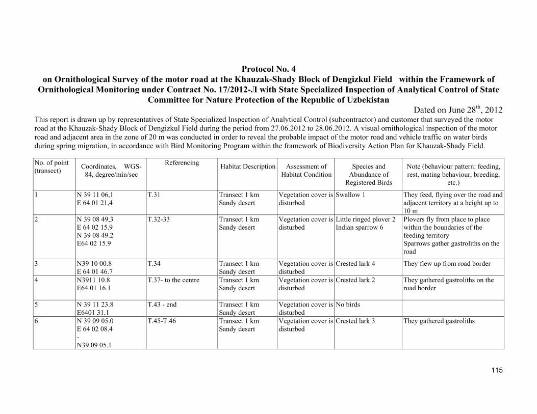
115
Protocol No. 4 on Ornithological Survey of the motor road at the Khauzak-Shady Block of Dengizkul Field within the Framework of
Ornithological Monitoring under Contract No. 17/2012-Л with State Specialized Inspection of Analytical Control of State Committee for Nature Protection of the Republic of Uzbekistan
Dated on June 28th, 2012 This report is drawn up by representatives of State Specialized Inspection of Analytical Control (subcontractor) and customer that surveyed the motor road at the Khauzak-Shady Block of Dengizkul Field during the period from 27.06.2012 to 28.06.2012. A visual ornithological inspection of the motor road and adjacent area in the zone of 20 m was conducted in order to reveal the probable impact of the motor road and vehicle traffic on water birds during spring migration, in accordance with Bird Monitoring Program within the framework of Biodiversity Action Plan for Khauzak-Shady Field. No. of point (transect)
Coordinates, WGS-84, degree/min/sec
Referencing
Habitat Description Assessment of
Habitat Condition Species and
Abundance of Registered Birds
Note (behaviour pattern: feeding, rest, mating behaviour, breeding,
etc.)
1 N 39 11 06,1 E 64 01 21,4
Т.31 Transect 1 km Sandy desert
Vegetation cover is disturbed
Swallow 1 They feed, flying over the road and adjacent territory at a height up to 10 m
2 N 39 08 49,3 Е 64 02 15.9 N 39 08 49.2 Е64 02 15.9
Т.32-33 Transect 1 km Sandy desert
Vegetation cover is disturbed
Little ringed plover 2 Indian sparrow 6
Plovers fly from place to place within the boundaries of the feeding territory Sparrows gather gastroliths on the road
3 N39 10 00.8 Е 64 01 46.7
Т.34 Transect 1 km Sandy desert
Vegetation cover is disturbed
Crested lark 4 They flew up from road border
4 N3911 10.8 Е64 01 16.1
Т.37- to the centre Transect 1 km Sandy desert
Vegetation cover is disturbed
Crested lark 2 They gathered gastroliths on the road border
5 N 39 11 23.8 Е6401 31.1
Т.43 - end Transect 1 km Sandy desert
Vegetation cover is disturbed
No birds
6 N 39 09 05.0 Е 64 02 08.4 - N39 09 05.1
Т.45-Т.46 Transect 1 km Sandy desert
Vegetation cover is disturbed
Crested lark 3 They gathered gastroliths
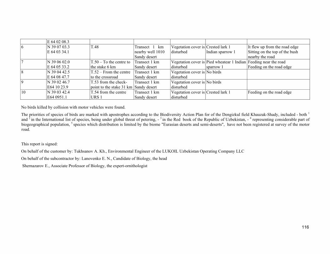
116
Е 64 02 08.3 6 N 39 07 03.3
Е 64 03 34.1 Т.48 Transect 1 km
nearby well 1010 Sandy desert
Vegetation cover is disturbed
Crested lark 1 Indian sparrow 1
It flew up from the road edge Sitting on the top of the bush nearby the road
7 N 39 06 02.0 Е 64 05 33.2
Т.50 – To the centre to the stake 6 km
Transect 1 km Sandy desert
Vegetation cover is disturbed
Pied wheatear 1 Indian sparrow 1
Feeding near the road Feeding on the road edge
8 N 39 04 42.5 Е 64 08 47.7
Т.52 – From the centre to the crossroad
Transect 1 km Sandy desert
Vegetation cover is disturbed
No birds
9 N 39 02 46.7 Е64 10 23.9
Т.53 from the check-point to the stake 31 km
Transect 1 km Sandy desert
Vegetation cover is disturbed
No birds
10 N 39 03 42.4 Е64 0951.1
Т.54 from the centre URS 1
Transect 1 km Sandy desert
Vegetation cover is disturbed
Crested lark 1 Feeding on the road edge
No birds killed by collision with motor vehicles were found.
The priorities of species of birds are marked with apostrophes according to the Biodiversity Action Plan for of the Dengizkul field Khauzak-Shady, included - both 1
and 2 in the International list of species, being under global threat of petering, - 3 in the Red book of the Republic of Uzbekistan, - 4 representing considerable part of biogeographical population, 5 species which distribution is limited by the biome "Eurasian deserts and semi-deserts", have not been registered at survey of the motor road.
This report is signed:
On behalf of the customer by: Tukhsanov A. Kh., Environmental Engineer of the LUKOIL Uzbekistan Operating Company LLC
On behalf of the subcontractor by: Lanovenko E. N., Candidate of Biology, the head
Shernazarov E., Associate Professor of Biology, the expert-ornithologist
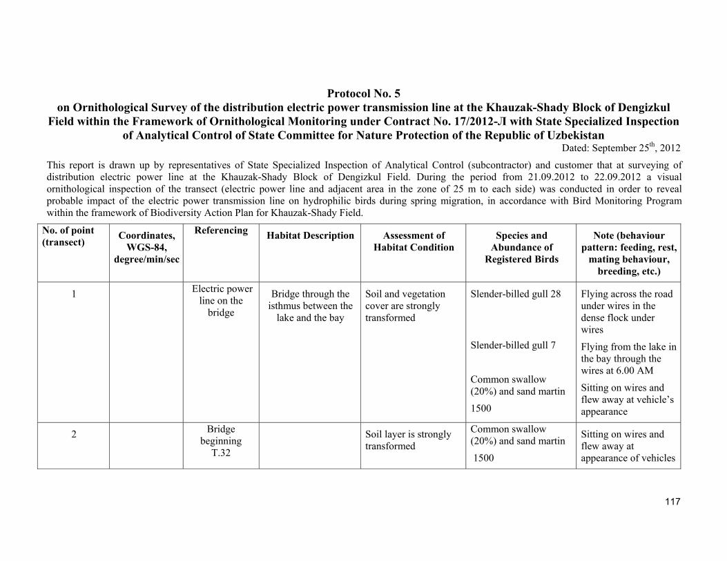
117
Protocol No. 5 on Ornithological Survey of the distribution electric power transmission line at the Khauzak-Shady Block of Dengizkul
Field within the Framework of Ornithological Monitoring under Contract No. 17/2012-Л with State Specialized Inspection of Analytical Control of State Committee for Nature Protection of the Republic of Uzbekistan
Dated: September 25th, 2012
This report is drawn up by representatives of State Specialized Inspection of Analytical Control (subcontractor) and customer that at surveying of distribution electric power line at the Khauzak-Shady Block of Dengizkul Field. During the period from 21.09.2012 to 22.09.2012 a visual ornithological inspection of the transect (electric power line and adjacent area in the zone of 25 m to each side) was conducted in order to reveal probable impact of the electric power transmission line on hydrophilic birds during spring migration, in accordance with Bird Monitoring Program within the framework of Biodiversity Action Plan for Khauzak-Shady Field.
No. of point (transect)
Coordinates, WGS-84,
degree/min/sec
Referencing
Habitat Description Assessment of
Habitat Condition Species and
Abundance of Registered Birds
Note (behaviour pattern: feeding, rest,
mating behaviour, breeding, etc.)
1
Electric power line on the
bridge
Bridge through the isthmus between the
lake and the bay
Soil and vegetation cover are strongly transformed
Slender-billed gull 28
Slender-billed gull 7
Common swallow (20%) and sand martin
1500
Flying across the road under wires in the dense flock under wires
Flying from the lake in the bay through the wires at 6.00 AM
Sitting on wires and flew away at vehicle’s appearance
2 Bridge beginning Т.32
Soil layer is strongly transformed
Common swallow (20%) and sand martin
1500
Sitting on wires and flew away at appearance of vehicles
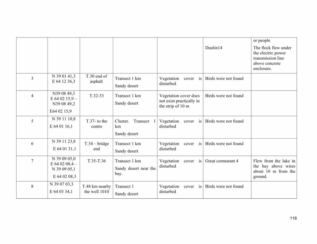
118
Dunlin14
or people
The flock flew under the electric power transmission line above concrete enclosure.
3 N 39 01 41,3 E 64 12 36,3
Т.30 end of asphalt
Transect 1 km
Sandy desert
Vegetation cover is disturbed
Birds were not found
4 N39 08 49,3 E 64 02 15,9 – N39 08 49,2
E64 02 15,9
Т.32-33 Transect 1 km
Sandy desert
Vegetation cover does not exist practically in the strip of 10 m
Birds were not found
5 N 39 11 10,8
E 64 01 16,1 Т.37- to the
centre Cluster. Transect 1 km
Sandy desert
Vegetation cover is disturbed
Birds were not found
6 N 39 11 23,8
E 64 01 31,1 Т.34 – bridge
end Transect 1 km
Sandy desert
Vegetation cover is disturbed
Birds were not found
7 N 39 09 05,0 E 64 02 08,4 –N 39 09 05,1
E 64 02 08,3
Т.35-Т.36 Transect 1 km
Sandy desert near the bay.
Vegetation cover is disturbed
Great cormorant 4 Flew from the lake in the bay above wires about 10 m from the ground.
8 N 39 07 03,3
E 64 03 34,1 Т.48 km nearby the well 1010
Transect 1
Sandy desert
Vegetation cover is disturbed
Birds were not found
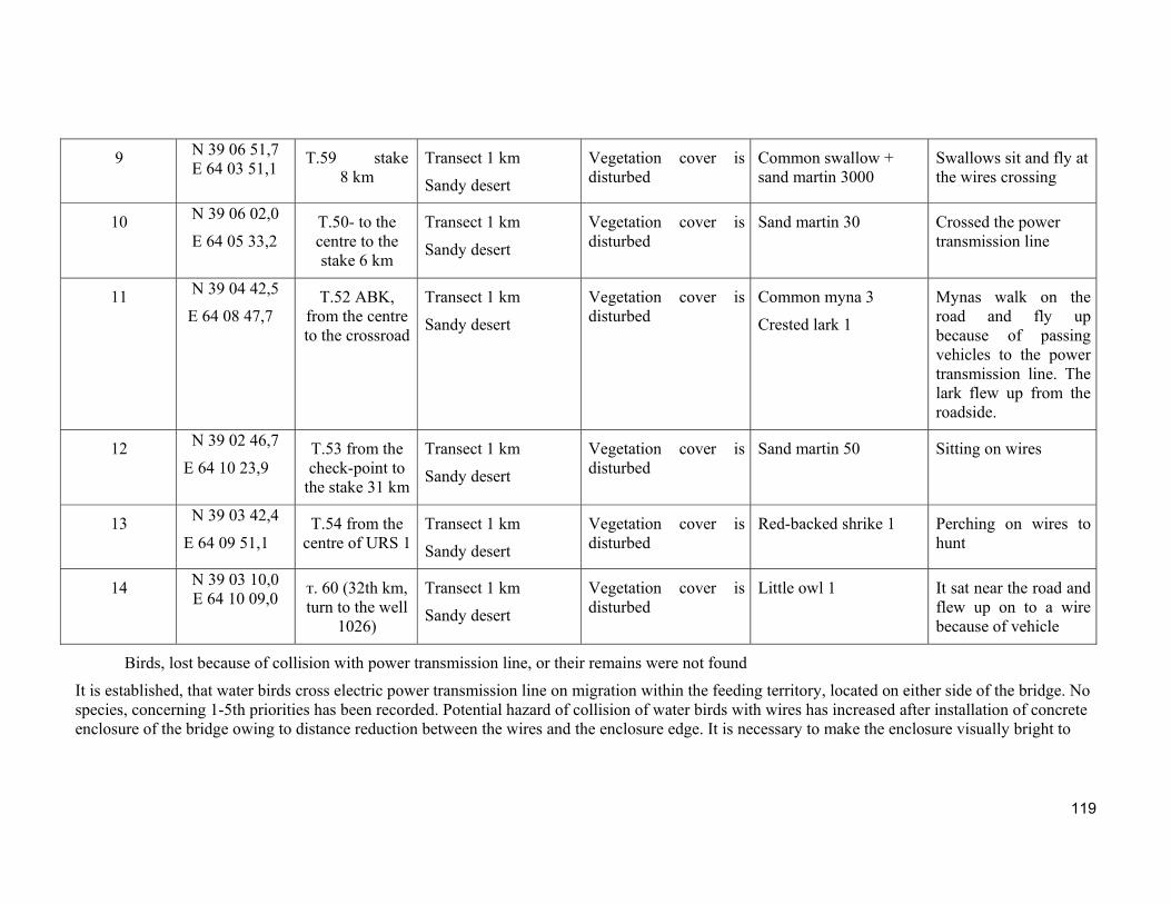
119
9 N 39 06 51,7 E 64 03 51,1
Т.59 stake 8 km
Transect 1 km
Sandy desert
Vegetation cover is disturbed
Common swallow + sand martin 3000
Swallows sit and fly at the wires crossing
10 N 39 06 02,0
E 64 05 33,2 Т.50- to the centre to the stake 6 km
Transect 1 km
Sandy desert
Vegetation cover is disturbed
Sand martin 30
Crossed the power transmission line
11 N 39 04 42,5
E 64 08 47,7 Т.52 ABK,
from the centre to the crossroad
Transect 1 km
Sandy desert
Vegetation cover is disturbed
Common myna 3
Crested lark 1
Mynas walk on the road and fly up because of passing vehicles to the power transmission line. The lark flew up from the roadside.
12 N 39 02 46,7
E 64 10 23,9 Т.53 from the check-point to
the stake 31 km
Transect 1 km
Sandy desert
Vegetation cover is disturbed
Sand martin 50 Sitting on wires
13 N 39 03 42,4
E 64 09 51,1 Т.54 from the
centre of URS 1Transect 1 km
Sandy desert
Vegetation cover is disturbed
Red-backed shrike 1 Perching on wires to hunt
14 N 39 03 10,0 E 64 10 09,0
т. 60 (32th km, turn to the well
1026)
Transect 1 km
Sandy desert
Vegetation cover is disturbed
Little owl 1 It sat near the road and flew up on to a wire because of vehicle
Birds, lost because of collision with power transmission line, or their remains were not found
It is established, that water birds cross electric power transmission line on migration within the feeding territory, located on either side of the bridge. No species, concerning 1-5th priorities has been recorded. Potential hazard of collision of water birds with wires has increased after installation of concrete enclosure of the bridge owing to distance reduction between the wires and the enclosure edge. It is necessary to make the enclosure visually bright to
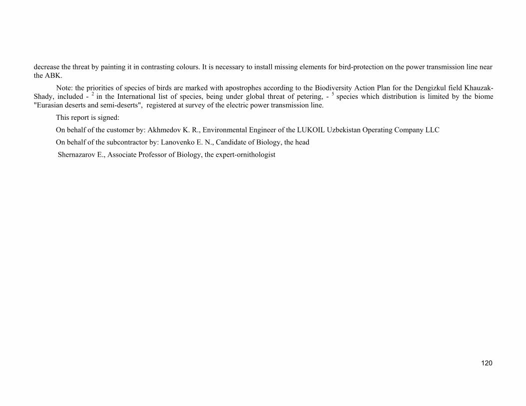
120
decrease the threat by painting it in contrasting colours. It is necessary to install missing elements for bird-protection on the power transmission line near the ABK.
Note: the priorities of species of birds are marked with apostrophes according to the Biodiversity Action Plan for the Dengizkul field Khauzak-Shady, included - 2 in the International list of species, being under global threat of petering, - 5 species which distribution is limited by the biome "Eurasian deserts and semi-deserts", registered at survey of the electric power transmission line.
This report is signed:
On behalf of the customer by: Akhmedov K. R., Environmental Engineer of the LUKOIL Uzbekistan Operating Company LLC
On behalf of the subcontractor by: Lanovenko E. N., Candidate of Biology, the head
Shernazarov E., Associate Professor of Biology, the expert-ornithologist
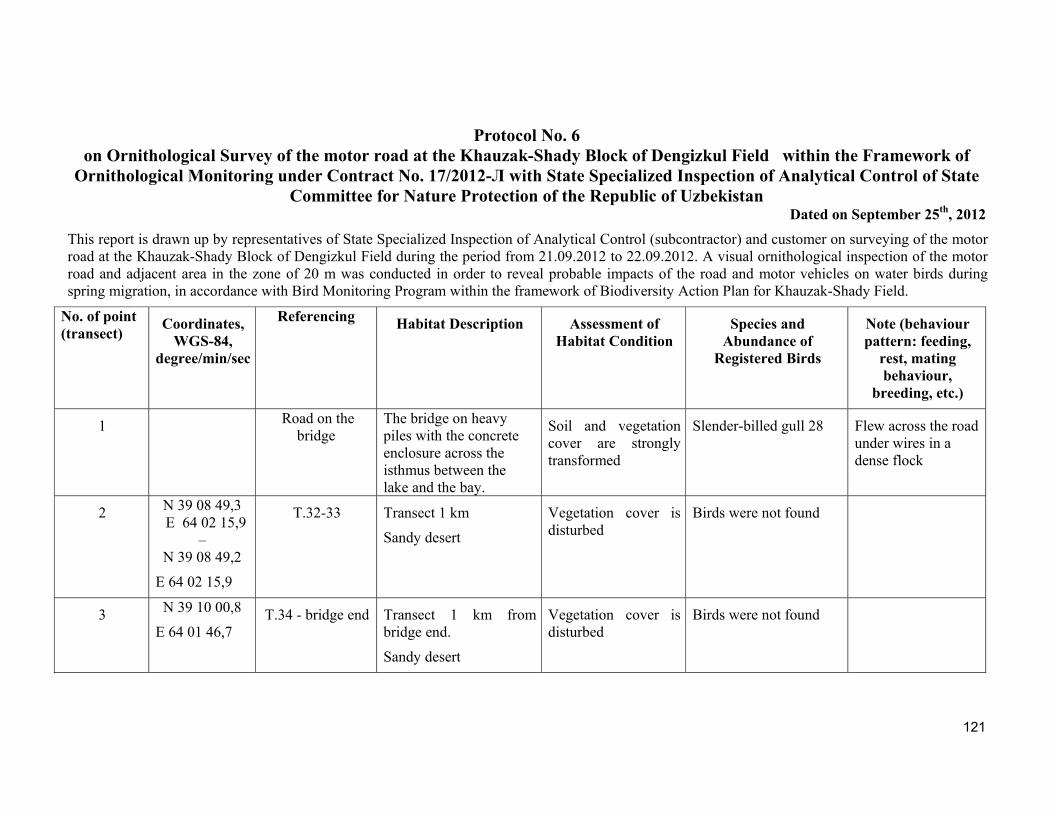
121
Protocol No. 6 on Ornithological Survey of the motor road at the Khauzak-Shady Block of Dengizkul Field within the Framework of
Ornithological Monitoring under Contract No. 17/2012-Л with State Specialized Inspection of Analytical Control of State Committee for Nature Protection of the Republic of Uzbekistan
Dated on September 25th, 2012
This report is drawn up by representatives of State Specialized Inspection of Analytical Control (subcontractor) and customer on surveying of the motor road at the Khauzak-Shady Block of Dengizkul Field during the period from 21.09.2012 to 22.09.2012. A visual ornithological inspection of the motor road and adjacent area in the zone of 20 m was conducted in order to reveal probable impacts of the road and motor vehicles on water birds during spring migration, in accordance with Bird Monitoring Program within the framework of Biodiversity Action Plan for Khauzak-Shady Field.
No. of point (transect)
Coordinates, WGS-84,
degree/min/sec
Referencing
Habitat Description Assessment of
Habitat Condition Species and
Abundance of Registered Birds
Note (behaviour pattern: feeding,
rest, mating behaviour,
breeding, etc.)
1 Road on the bridge
The bridge on heavy piles with the concrete enclosure across the isthmus between the lake and the bay.
Soil and vegetation cover are strongly transformed
Slender-billed gull 28 Flew across the road under wires in a dense flock
2 N 39 08 49,3 E 64 02 15,9
– N 39 08 49,2
E 64 02 15,9
Т.32-33 Transect 1 km
Sandy desert
Vegetation cover is disturbed
Birds were not found
3 N 39 10 00,8
E 64 01 46,7 Т.34 - bridge end Transect 1 km from
bridge end.
Sandy desert
Vegetation cover is disturbed
Birds were not found
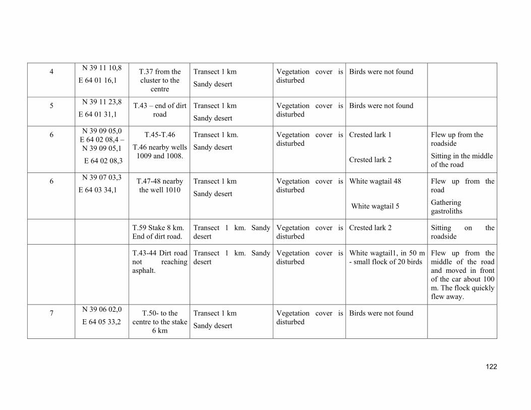
122
4 N 39 11 10,8
E 64 01 16,1 Т.37 from the cluster to the
centre
Transect 1 km
Sandy desert
Vegetation cover is disturbed
Birds were not found
5 N 39 11 23,8
E 64 01 31,1 Т.43 – end of dirt
road Transect 1 km
Sandy desert
Vegetation cover is disturbed
Birds were not found
6 N 39 09 05,0 E 64 02 08,4 –N 39 09 05,1
E 64 02 08,3
Т.45-Т.46
Т.46 nearby wells 1009 and 1008.
Transect 1 km.
Sandy desert
Vegetation cover is disturbed
Crested lark 1
Crested lark 2
Flew up from the roadside
Sitting in the middle of the road
6 N 39 07 03,3
E 64 03 34,1 Т.47-48 nearby the well 1010
Transect 1 km
Sandy desert
Vegetation cover is disturbed
White wagtail 48
White wagtail 5
Flew up from the road
Gathering gastroliths
Т.59 Stake 8 km. End of dirt road.
Transect 1 km. Sandy desert
Vegetation cover is disturbed
Crested lark 2 Sitting on the roadside
Т.43-44 Dirt road not reaching asphalt.
Transect 1 km. Sandy desert
Vegetation cover is disturbed
White wagtail1, in 50 m - small flock of 20 birds
Flew up from the middle of the road and moved in front of the car about 100 m. The flock quickly flew away.
7 N 39 06 02,0
E 64 05 33,2 Т.50- to the
centre to the stake 6 km
Transect 1 km
Sandy desert
Vegetation cover is disturbed
Birds were not found
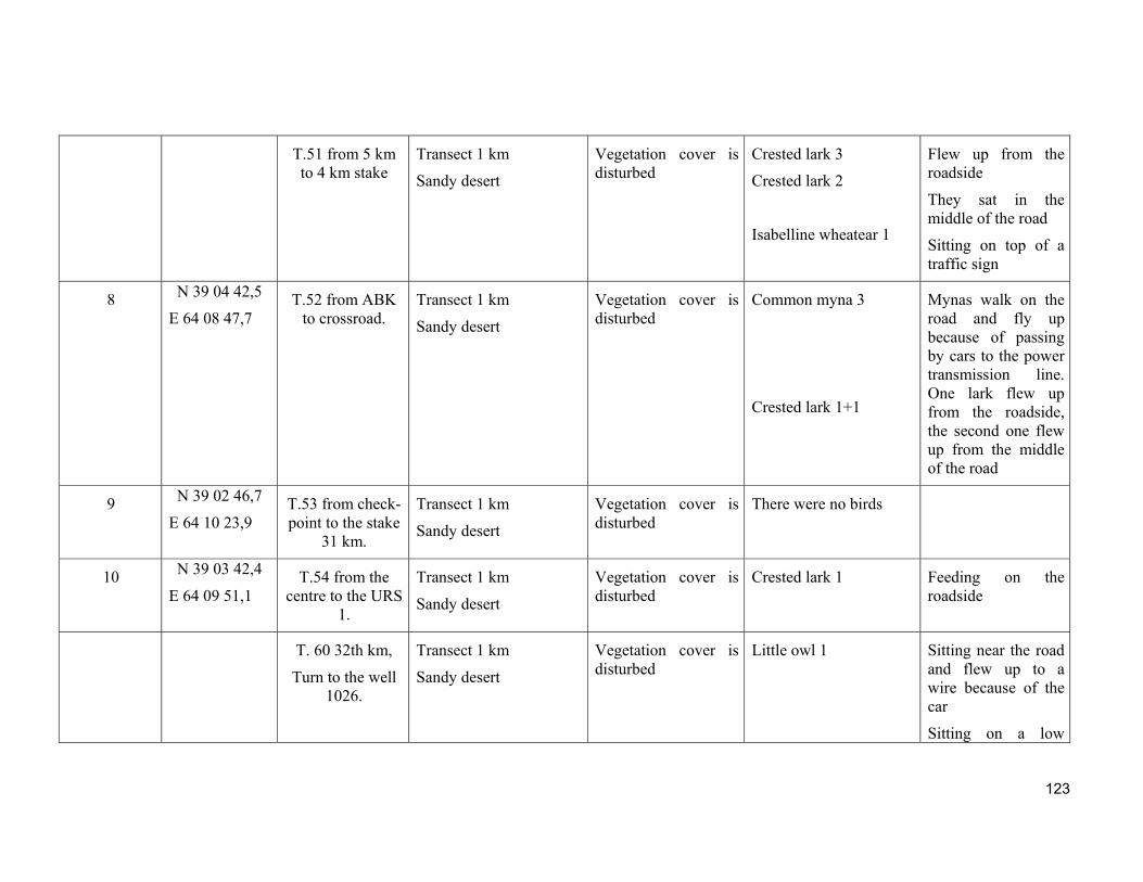
123
Т.51 from 5 km to 4 km stake
Transect 1 km
Sandy desert
Vegetation cover is disturbed
Crested lark 3
Crested lark 2
Isabelline wheatear 1
Flew up from the roadside
They sat in the middle of the road
Sitting on top of a traffic sign
8 N 39 04 42,5
E 64 08 47,7 Т.52 from ABK
to crossroad. Transect 1 km
Sandy desert
Vegetation cover is disturbed
Common myna 3
Crested lark 1+1
Mynas walk on the road and fly up because of passing by cars to the power transmission line. One lark flew up from the roadside, the second one flew up from the middle of the road
9 N 39 02 46,7
E 64 10 23,9 Т.53 from check-point to the stake
31 km.
Transect 1 km
Sandy desert
Vegetation cover is disturbed
There were no birds
10 N 39 03 42,4
E 64 09 51,1 Т.54 from the
centre to the URS 1.
Transect 1 km
Sandy desert
Vegetation cover is disturbed
Crested lark 1 Feeding on the roadside
T. 60 32th km,
Turn to the well 1026.
Transect 1 km
Sandy desert
Vegetation cover is disturbed
Little owl 1
Sitting near the road and flew up to a wire because of the car
Sitting on a low
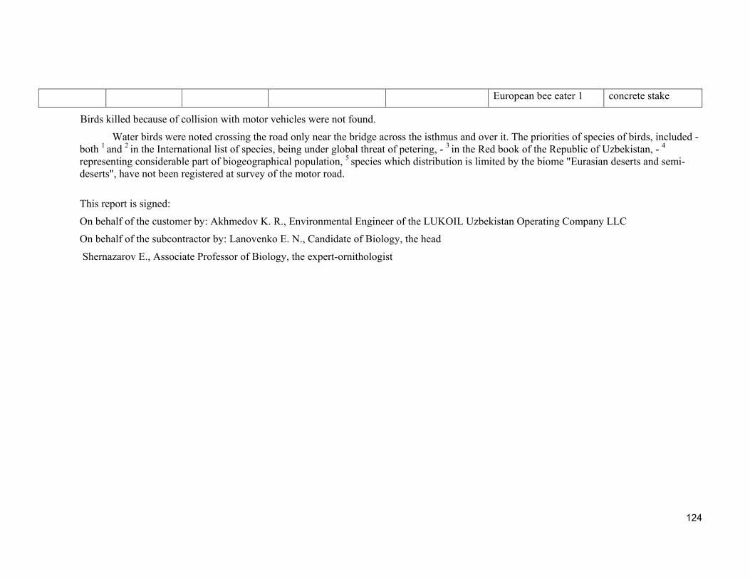
124
European bee eater 1 concrete stake
Birds killed because of collision with motor vehicles were not found.
Water birds were noted crossing the road only near the bridge across the isthmus and over it. The priorities of species of birds, included - both 1 and 2 in the International list of species, being under global threat of petering, - 3 in the Red book of the Republic of Uzbekistan, - 4 representing considerable part of biogeographical population, 5 species which distribution is limited by the biome "Eurasian deserts and semi-deserts", have not been registered at survey of the motor road.
This report is signed:
On behalf of the customer by: Akhmedov K. R., Environmental Engineer of the LUKOIL Uzbekistan Operating Company LLC
On behalf of the subcontractor by: Lanovenko E. N., Candidate of Biology, the head
Shernazarov E., Associate Professor of Biology, the expert-ornithologist
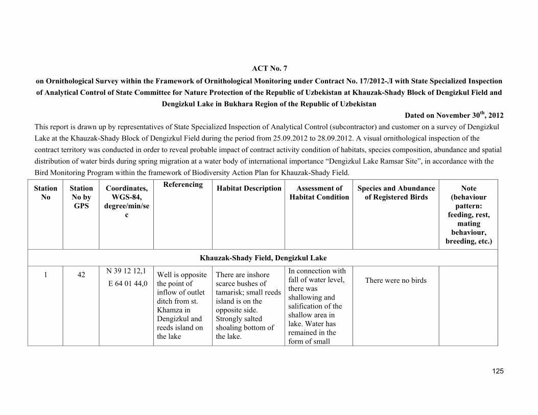
125
ACT No. 7
on Ornithological Survey within the Framework of Ornithological Monitoring under Contract No. 17/2012-Л with State Specialized Inspection
of Analytical Control of State Committee for Nature Protection of the Republic of Uzbekistan at Khauzak-Shady Block of Dengizkul Field and
Dengizkul Lake in Bukhara Region of the Republic of Uzbekistan
Dated on November 30th, 2012
This report is drawn up by representatives of State Specialized Inspection of Analytical Control (subcontractor) and customer on a survey of Dengizkul
Lake at the Khauzak-Shady Block of Dengizkul Field during the period from 25.09.2012 to 28.09.2012. A visual ornithological inspection of the
contract territory was conducted in order to reveal probable impact of contract activity condition of habitats, species composition, abundance and spatial
distribution of water birds during spring migration at a water body of international importance “Dengizkul Lake Ramsar Site”, in accordance with the
Bird Monitoring Program within the framework of Biodiversity Action Plan for Khauzak-Shady Field.
Station No
Station No by GPS
Coordinates,WGS-84,
degree/min/sec
Referencing
Habitat Description Assessment of
Habitat ConditionSpecies and Abundance
of Registered Birds Note
(behaviour pattern:
feeding, rest, mating
behaviour, breeding, etc.)
Khauzak-Shady Field, Dengizkul Lake
1 42
N 39 12 12,1
E 64 01 44,0 Well is opposite the point of inflow of outlet ditch from st. Khamza in Dengizkul and reeds island on the lake
There are inshore scarce bushes of tamarisk; small reeds island is on the opposite side. Strongly salted shoaling bottom of the lake.
In connection with fall of water level, there was shallowing and salification of the shallow area in lake. Water has remained in the form of small
There were no birds
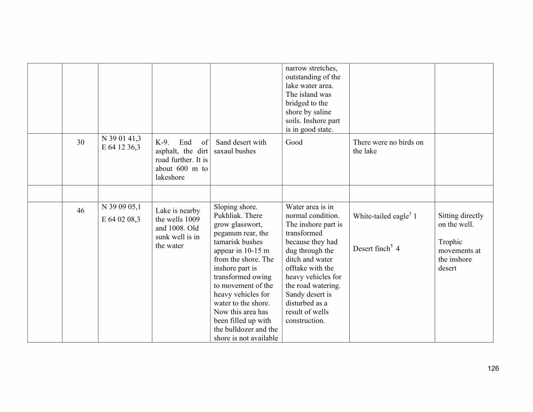
126
narrow stretches, outstanding of the lake water area. The island was bridged to the shore by saline soils. Inshore part is in good state.
30 N 39 01 41,3 E 64 12 36,3
K-9. End of asphalt, the dirt road further. It is about 600 m to lakeshore
Sand desert with saxaul bushes
Good There were no birds on the lake
46 N 39 09 05,1
E 64 02 08,3 Lake is nearby the wells 1009 and 1008. Old sunk well is in the water
Sloping shore. Pukhliak. There grow glasswort, peganum rear, the tamarisk bushes appear in 10-15 m from the shore. The inshore part is transformed owing to movement of the heavy vehicles for water to the shore. Now this area has been filled up with the bulldozer and the shore is not available
Water area is in normal condition. The inshore part is transformed because they had dug through the ditch and water offtake with the heavy vehicles for the road watering. Sandy desert is disturbed as a result of wells construction.
White-tailed eagle3 1
Desert finch5 4
Sitting directly on the well. Trophic movements at the inshore desert
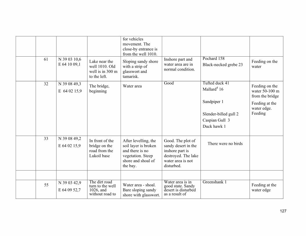
127
for vehicles movement. The close-by entrance is from the well 1010.
61
N 39 03 10,6 E 64 10 09,1
Lake near the well 1010. Old well is in 300 m to the left.
Sloping sandy shore with a strip of glasswort and tamarisk.
Inshore part and water area are in normal condition.
Pochard 158
Black-necked grebe 23 Feeding on the water
32 N 39 08 49,3
E 64 02 15,9 The bridge, beginning
Water area Good Tufted duck 41
Mallard4 16
Sandpiper 1
Slender-billed gull 2
Caspian Gull 3
Duck hawk 1
Feeding on the water 50-100 m from the bridge
Feeding at the water edge. Feeding
33
N 39 08 49,2
E 64 02 15,9 In front of the bridge on the road from the Lukoil base
After levelling, the soil layer is broken and there is no vegetation. Steep shore and shoal of the bay.
Good. The plot of sandy desert in the inshore part is destroyed. The lake water area is not disturbed.
There were no birds
55 N 39 03 42,9
E 64 09 52,7
The dirt road turn to the well 1026, and without road to
Water area - shoal. Bare sloping sandy shore with glasswort.
Water area is in good state. Sandy desert is disturbed as a result of
Greenshank 1
Feeding at the water edge
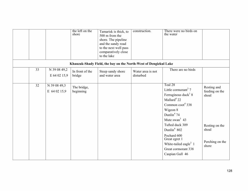
128
the left on the shore
Tamarisk is thick, to 500 m from the shore. The pipeline and the sandy road to the next well pass comparatively close to the lake
construction. There were no birds on the water
Khauzak-Shady Field, the bay on the North-West of Dengizkul Lake
33
N 39 08 49,2
E 64 02 15,9 In front of the bridge
Steep sandy shore and water area
Water area is not disturbed
There are no birds
32 N 39 08 49,3
E 64 02 15,9
The bridge, beginning
Teal 28
Little cormorant3 7
Ferruginous duck1 8
Mallard4 22
Common coot4 338
Wigeon 8
Dunlin4 74
Mute swan3 43
Tufted duck 309
Dunlin4 802
Pochard 600 Great egret 1
White-tailed eagle3 1
Great cormorant 338
Caspian Gull 46
Resting and feeding on the shoal
Resting on the shoal Perching on the shore
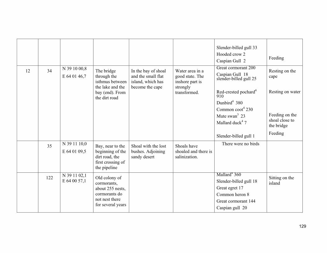
129
Slender-billed gull 33
Hooded crow 2
Caspian Gull 2
Feeding
12 34 N 39 10 00,8
E 64 01 46,7 The bridge through the isthmus between the lake and the bay (end). From the dirt road
In the bay of shoal and the small flat island, which has become the cape
Water area in a good state. The inshore part is strongly transformed.
Great cormorant 200
Caspian Gull 18 slender-billed gull 25
Red-crested pochard4 910
Dunbird4 380
Common coot4 230
Mute swan3 23
Mallard duck4 7
Slender-billed gull 1
Resting on the cape
Resting on water
Feeding on the shoal close to the bridge
Feeding
35 N 39 11 10,0
E 64 01 09,5 Bay, near to the beginning of the dirt road, the first crossing of the pipeline
Shoal with the lost bushes. Adjoining sandy desert
Shoals have shoaled and there is salinization.
There were no birds
122 N 39 11 02,1 E 64 00 57,1
Old colony of cormorants, about 255 nests, cormorants do not nest there for several years
Mallard4 360
Slender-billed gull 18
Great egret 17
Common heron 8
Great cormorant 144
Caspian gull 20
Sitting on the island
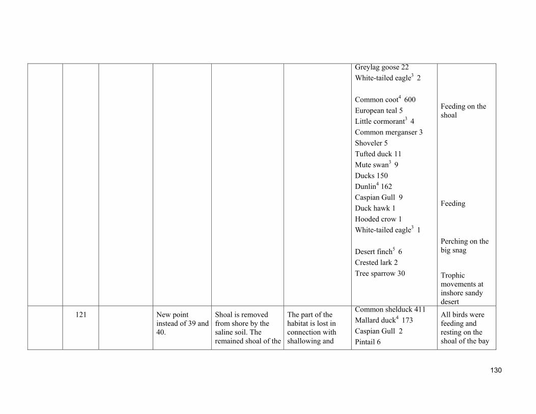
130
Greylag goose 22
White-tailed eagle3 2
Common coot4 600
European teal 5
Little cormorant3 4
Common merganser 3
Shoveler 5
Tufted duck 11
Mute swan3 9
Ducks 150
Dunlin4 162
Caspian Gull 9
Duck hawk 1
Hooded crow 1
White-tailed eagle3 1
Desert finch5 6
Crested lark 2
Tree sparrow 30
Feeding on the shoal
Feeding
Perching on the big snag
Trophic movements at inshore sandy desert
121 New point instead of 39 and 40.
Shoal is removed from shore by the saline soil. The remained shoal of the
The part of the habitat is lost in connection with shallowing and
Common shelduck 411
Mallard duck4 173
Caspian Gull 2
Pintail 6
All birds were feeding and resting on the shoal of the bay
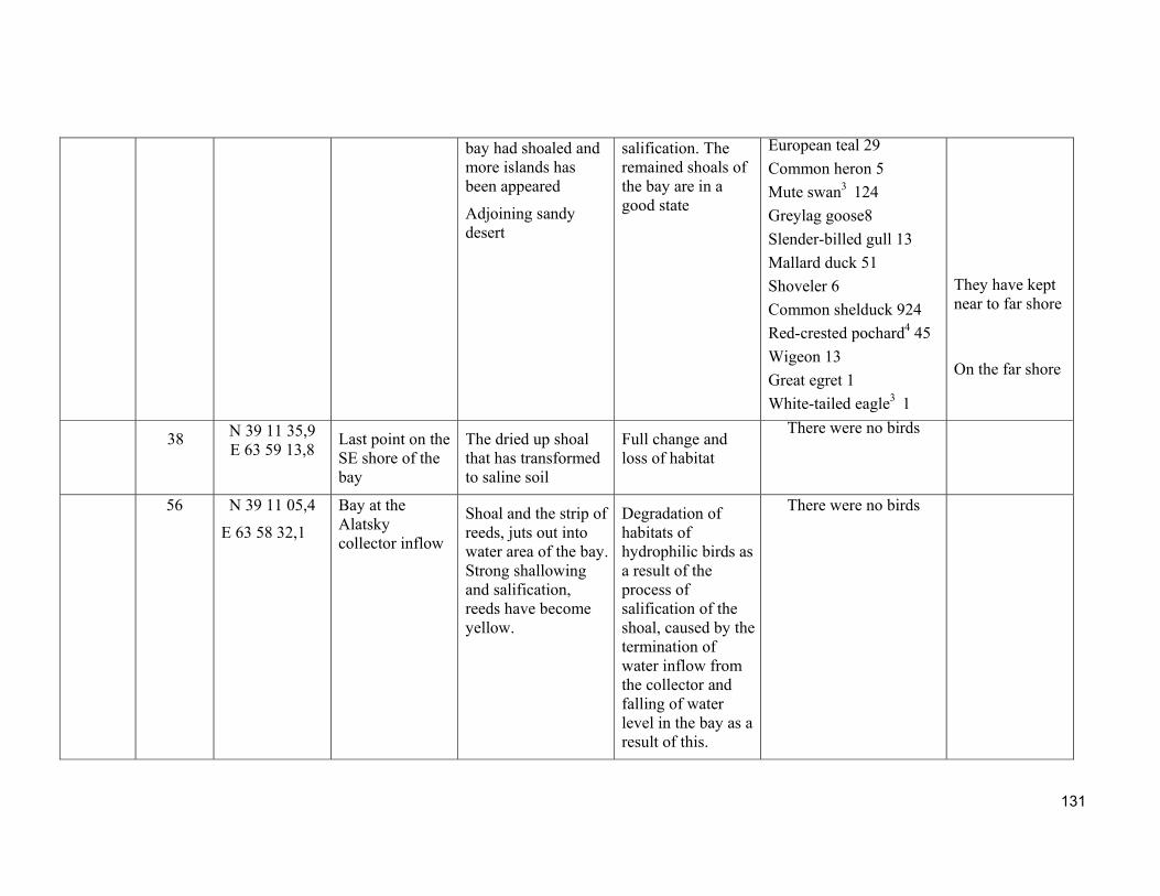
131
bay had shoaled and more islands has been appeared
Adjoining sandy desert
salification. The remained shoals of the bay are in a good state
European teal 29
Common heron 5
Mute swan3 124
Greylag goose8
Slender-billed gull 13
Mallard duck 51
Shoveler 6
Common shelduck 924
Red-crested pochard4 45
Wigeon 13
Great egret 1
White-tailed eagle3 1
They have kept near to far shore
On the far shore
38 N 39 11 35,9 E 63 59 13,8
Last point on the SE shore of the bay
The dried up shoal that has transformed to saline soil
Full change and loss of habitat
There were no birds
56 N 39 11 05,4
E 63 58 32,1
Bay at the Alatsky collector inflow
Shoal and the strip of reeds, juts out into water area of the bay. Strong shallowing and salification, reeds have become yellow.
Degradation of habitats of hydrophilic birds as a result of the process of salification of the shoal, caused by the termination of water inflow from the collector and falling of water level in the bay as a result of this.
There were no birds
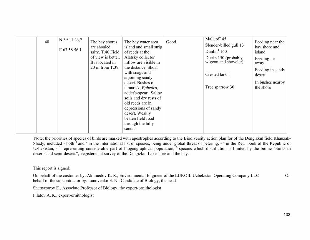
132
40
N 39 11 23,7 E 63 58 56,1
The bay shores are shoaled, salty. Т.40 Field of view is better. It is located in 20 m from T.39.
The bay water area, island and small strip of reeds at the Alatsky collector inflow are visible in the distance. Shoal with snags and adjoining sandy desert. Bushes of tamarisk, Ephedra, adder's-spear. Saline soils and dry rests of old reeds are in depressions of sandy desert. Weakly beaten field road through the hilly sands.
Good.
Mallard4 45
Slender-billed gull 13
Dunlin4 160
Ducks 150 (probably wigeon and shoveler)
Crested lark 1
Tree sparrow 30
Feeding near the bay shore and island
Feeding far away
Feeding in sandy desert
In bushes nearby the shore
Note: the priorities of species of birds are marked with apostrophes according to the Biodiversity action plan for of the Dengizkul field Khauzak-Shady, included - both 1 and 2 in the International list of species, being under global threat of petering, - 3 in the Red book of the Republic of Uzbekistan, - 4 representing considerable part of biogeographical population, 5 species which distribution is limited by the biome "Eurasian deserts and semi-deserts", registered at survey of the Dengizkul Lakeshore and the bay.
This report is signed:
On behalf of the customer by: Akhmedov K. R., Environmental Engineer of the LUKOIL Uzbekistan Operating Company LLC On behalf of the subcontractor by: Lanovenko E. N., Candidate of Biology, the head
Shernazarov E., Associate Professor of Biology, the expert-ornithologist
Filatov A. K., expert-ornithologist

133
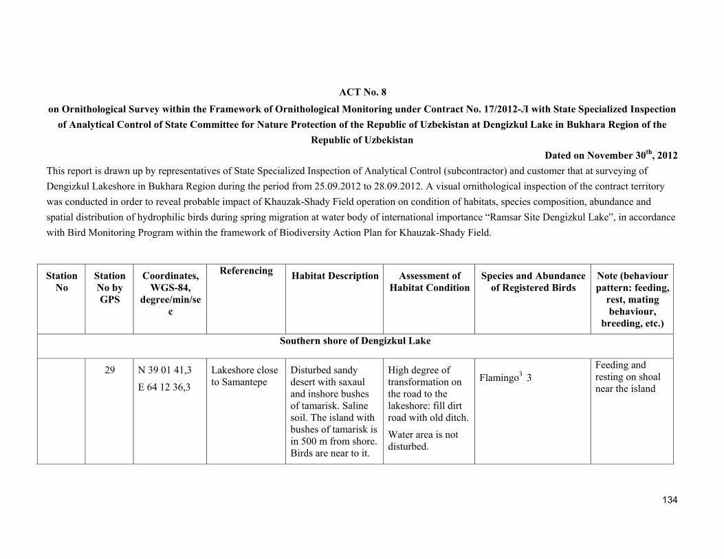
134
ACT No. 8
on Ornithological Survey within the Framework of Ornithological Monitoring under Contract No. 17/2012-Л with State Specialized Inspection
of Analytical Control of State Committee for Nature Protection of the Republic of Uzbekistan at Dengizkul Lake in Bukhara Region of the
Republic of Uzbekistan
Dated on November 30th, 2012
This report is drawn up by representatives of State Specialized Inspection of Analytical Control (subcontractor) and customer that at surveying of
Dengizkul Lakeshore in Bukhara Region during the period from 25.09.2012 to 28.09.2012. A visual ornithological inspection of the contract territory
was conducted in order to reveal probable impact of Khauzak-Shady Field operation on condition of habitats, species composition, abundance and
spatial distribution of hydrophilic birds during spring migration at water body of international importance “Ramsar Site Dengizkul Lake”, in accordance
with Bird Monitoring Program within the framework of Biodiversity Action Plan for Khauzak-Shady Field.
Station No
Station No by GPS
Coordinates,WGS-84,
degree/min/sec
Referencing
Habitat Description Assessment of
Habitat ConditionSpecies and Abundance
of Registered Birds Note (behaviour pattern: feeding,
rest, mating behaviour,
breeding, etc.)
Southern shore of Dengizkul Lake
29 N 39 01 41,3
E 64 12 36,3
Lakeshore close to Samantepe
Disturbed sandy desert with saxaul and inshore bushes of tamarisk. Saline soil. The island with bushes of tamarisk is in 500 m from shore. Birds are near to it.
High degree of transformation on the road to the lakeshore: fill dirt road with old ditch.
Water area is not disturbed.
Flamingo3 3
Feeding and resting on shoal near the island
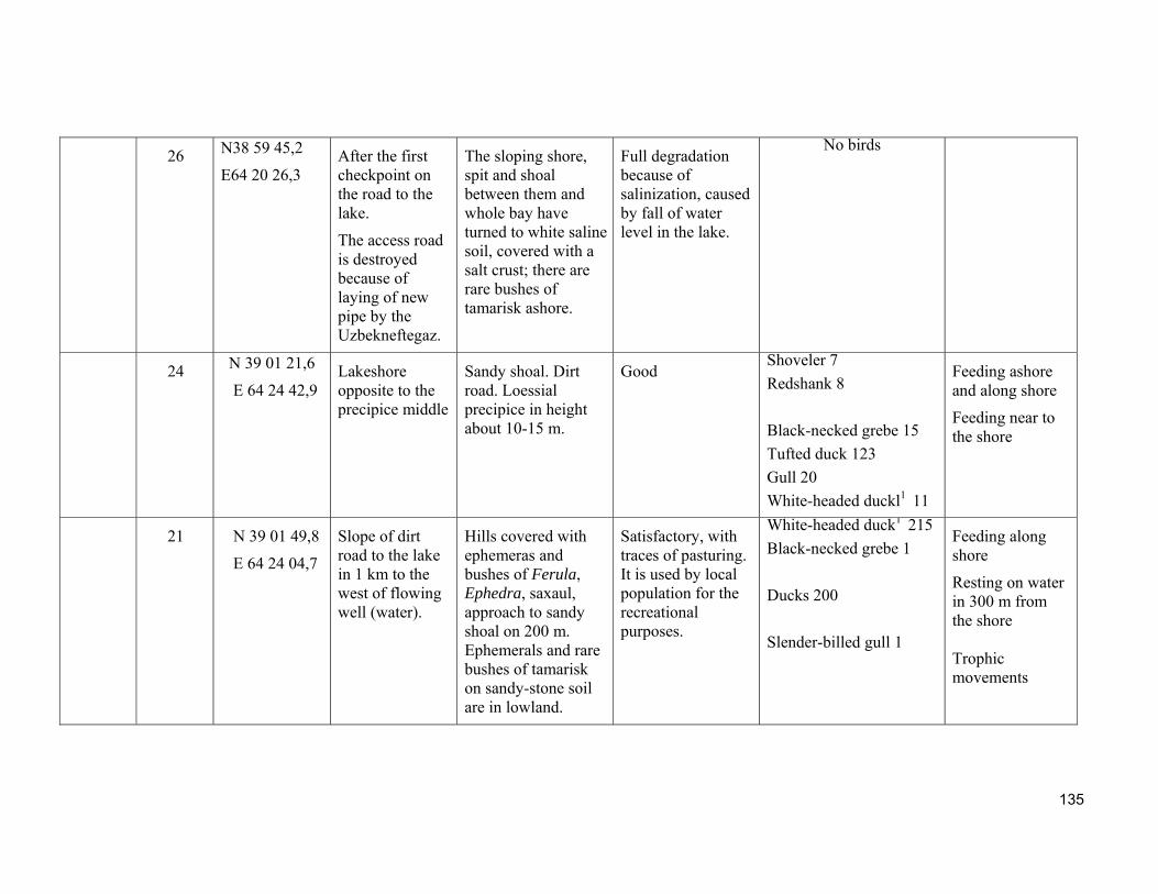
135
26
N38 59 45,2
E64 20 26,3
After the first checkpoint on the road to the lake.
The access road is destroyed because of laying of new pipe by the Uzbekneftegaz.
The sloping shore, spit and shoal between them and whole bay have turned to white saline soil, covered with a salt crust; there are rare bushes of tamarisk ashore.
Full degradation because of salinization, caused by fall of water level in the lake.
No birds
24
N 39 01 21,6
E 64 24 42,9 Lakeshore opposite to the precipice middle
Sandy shoal. Dirt road. Loessial precipice in height about 10-15 m.
Good
Shoveler 7
Redshank 8
Black-necked grebe 15
Tufted duck 123
Gull 20
White-headed duckl1 11
Feeding ashore and along shore
Feeding near to the shore
21 N 39 01 49,8
E 64 24 04,7
Slope of dirt road to the lake in 1 km to the west of flowing well (water).
Hills covered with ephemeras and bushes of Ferula, Ephedra, saxaul, approach to sandy shoal on 200 m. Ephemerals and rare bushes of tamarisk on sandy-stone soil are in lowland.
Satisfactory, with traces of pasturing. It is used by local population for the recreational purposes.
White-headed duck1 215
Black-necked grebe 1
Ducks 200
Slender-billed gull 1
Feeding along shore
Resting on water in 300 m from the shore Trophic movements
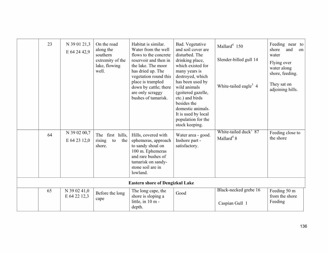
136
23 N 39 01 21,3
E 64 24 42,9
On the road along the southern extremity of the lake, flowing well.
Habitat is similar. Water from the well flows to the concrete reservoir and then in the lake. The moor has dried up. The vegetation round this place is trampled down by cattle; there are only scraggy bushes of tamarisk.
Bad. Vegetative and soil cover are disturbed. The drinking place, which existed for many years is destroyed, which has been used by wild animals (goitered gazelle, etc.) and birds besides the domestic animals. It is used by local population for the stock keeping.
Mallard4 150
Slender-billed gull 14
White-tailed eagle3 4
Feeding near to shore and on water
Flying over water along shore, feeding. They sat on adjoining hills.
64 N 39 02 00,7
E 64 23 12,0 The first hills, rising to the shore.
Hills, covered with ephemeras, approach to sandy shoal on 100 m. Ephemeras and rare bushes of tamarisk on sandy-stone soil are in lowland.
Water area - good. Inshore part - satisfactory.
White-tailed duck1 87
Mallard4 8
Feeding close to the shore
Eastern shore of Dengizkul Lake
65 N 39 02 41,0 E 64 22 12,3
Before the long cape
The long cape, the shore is sloping a little, in 10 m - depth.
Good
Black-necked grebe 16
Caspian Gull 1
Feeding 50 m from the shore Feeding

137
White-tailed eagle3 1
Crested lark 3
Banded plover
It sat at hill foot Trophic movements in adjoining desert It has come for watering
66 N 39 03 15,7 E 64 19 35,9
Under the flares of northern Urtabulak, located on hills. The road goes at the shore on weak track to the well.
Wide bay. Hills rise. Saline soil is in lowland in a strip in width about 200 m. There grow Salicornia and glasswort, and a little tamarisk. The bottom of the lake is deep.
Water area is in good state. There is natural renewal of vegetation round well; however, it is weakly developed still.
Mallard4 6
Black-necked grebe 4
Feeding near to the shore
67 N 39 05 38,9 E 64 16 23,9
The place is in location, not reaching the Samantepe hillock a little that is located on the far shore.
Deep-water area. The small cape, sandy wavy shore, it is separated from sandy desert by narrow strip of poorly developed glasswort. Sandy desert with not high barchans
Water area is in a good state. Condition of vegetative and soil cover is good
Red-crested pochard4 72 Black-necked grebe 5
Feeding on water
68 N 39 06 21,5 E 64 14 23,5
The bay after the Samantepe
Deep-water area. Sandy desert,
Water area is in a good state. The
Survey was not possible (saline soil)
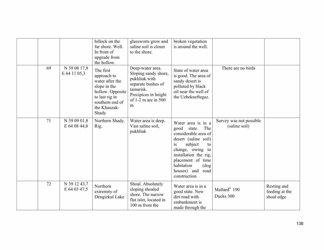
138
hillock on the far shore. Well. In front of upgrade from the hollow.
glassworts grow and saline soil is closer to the shore.
broken vegetation is around the well.
69 N 39 08 17,8 E 64 11 05,3
The first approach to water after the slope in the hollow. Opposite to last rig in southern end of the Khauzak-Shady
Deep-water area. Sloping sandy shore, pukhliak with separate bushes of tamarisk. Precipices in height of 1-2 m are in 500 m
State of water area is good. The area of sandy desert is polluted by black oil near the well of the Uzbekneftegaz.
There are no birds
71 N 39 09 01,8 E 64 08 44,8
Northern Shady. Rig.
Water area is deep. Vast saline soil, pukhliak
Water area is in a good state. The considerable area of desert (saline soil) is subject to change, owing to installation the rig, placement of time habitation (dog houses) and road construction
Survey was not possible (saline soil)
72 N 39 12 43,7 E 64 03 47,5
Northern extremity of Dengizkul Lake
Shoal. Absolutely sloping shoaled shore. The narrow flat islet, located in 100 m from the
Water area is in a good state. New dirt road with embankment is made through the
Mallard4 190
Ducks 300
Resting and feeding at the shoal edge
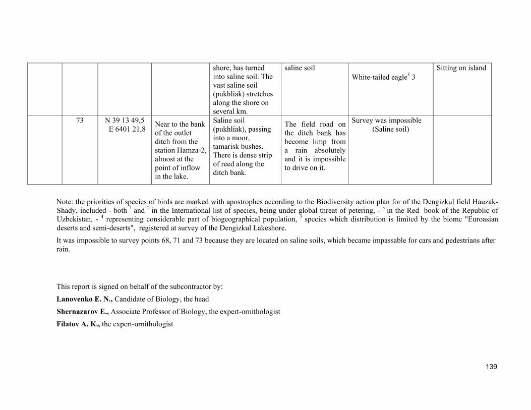
139
shore, has turned into saline soil. The vast saline soil (pukhliak) stretches along the shore on several km.
saline soil White-tailed eagle3 3
Sitting on island
73 N 39 13 49,5 E 6401 21,8
Near to the bank of the outlet ditch from the station Hamza-2, almost at the point of inflow in the lake.
Saline soil (pukhliak), passing into a moor, tamarisk bushes. There is dense strip of reed along the ditch bank.
The field road on the ditch bank has become limp from a rain absolutely and it is impossible to drive on it.
Survey was impossible (Saline soil)
Note: the priorities of species of birds are marked with apostrophes according to the Biodiversity action plan for of the Dengizkul field Hauzak-Shady, included - both 1 and 2 in the International list of species, being under global threat of petering, - 3 in the Red book of the Republic of Uzbekistan, - 4 representing considerable part of biogeographical population, 5 species which distribution is limited by the biome "Euroasian deserts and semi-deserts", registered at survey of the Dengizkul Lakeshore.
It was impossible to survey points 68, 71 and 73 because they are located on saline soils, which became impassable for cars and pedestrians after rain.
This report is signed on behalf of the subcontractor by:
Lanovenko E. N., Candidate of Biology, the head
Shernazarov E., Associate Professor of Biology, the expert-ornithologist
Filatov A. K., the expert-ornithologist


![[Fdtu k15cmu] chien luoc-kinh-doanh-quan-tri-chien-luoc-tieuluanfree](https://img.pdfslide.net/doc/110x75/55907f021a28abbf518b4618/fdtu-k15cmu-chien-luoc-kinh-doanh-quan-tri-chien-luoc-tieuluanfree.jpg)