Embed Size (px)
Citation preview
HarrisGeospatial.com
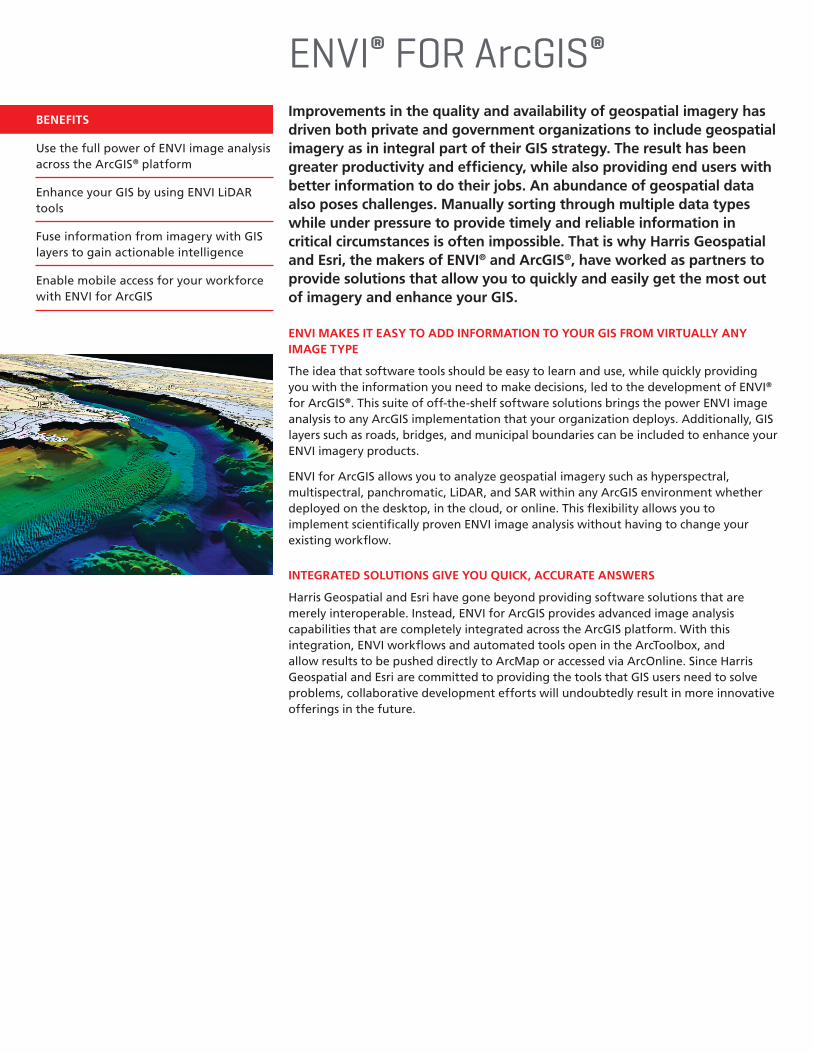
ENVI® for ArcGIS®
TURN GEOSPATIAL IMAGERY INTO USEFUL INFORMATION FOR YOUR GIS ON THE DESKTOP, FOR MOBILE DEVICES, AND IN THE CLOUD
BENEFITS
Use the full power of ENVI image analysis across the ArcGIS® platform
Enhance your GIS by using ENVI LiDAR tools
Fuse information from imagery with GIS layers to gain actionable intelligence
Enable mobile access for your workforce with ENVI for ArcGIS
ENVI® FOR ArcGIS®
Improvements in the quality and availability of geospatial imagery has driven both private and government organizations to include geospatial imagery as in integral part of their GIS strategy. The result has been greater productivity and efficiency, while also providing end users with better information to do their jobs. An abundance of geospatial data also poses challenges. Manually sorting through multiple data types while under pressure to provide timely and reliable information in critical circumstances is often impossible. That is why Harris Geospatial and Esri, the makers of ENVI® and ArcGIS®, have worked as partners to provide solutions that allow you to quickly and easily get the most out of imagery and enhance your GIS.
ENVI MAKES IT EASY TO ADD INFORMATION TO YOUR GIS FROM VIRTUALLY ANY IMAGE TYPE
The idea that software tools should be easy to learn and use, while quickly providing you with the information you need to make decisions, led to the development of ENVI® for ArcGIS®. This suite of off-the-shelf software solutions brings the power ENVI image analysis to any ArcGIS implementation that your organization deploys. Additionally, GIS layers such as roads, bridges, and municipal boundaries can be included to enhance your ENVI imagery products.
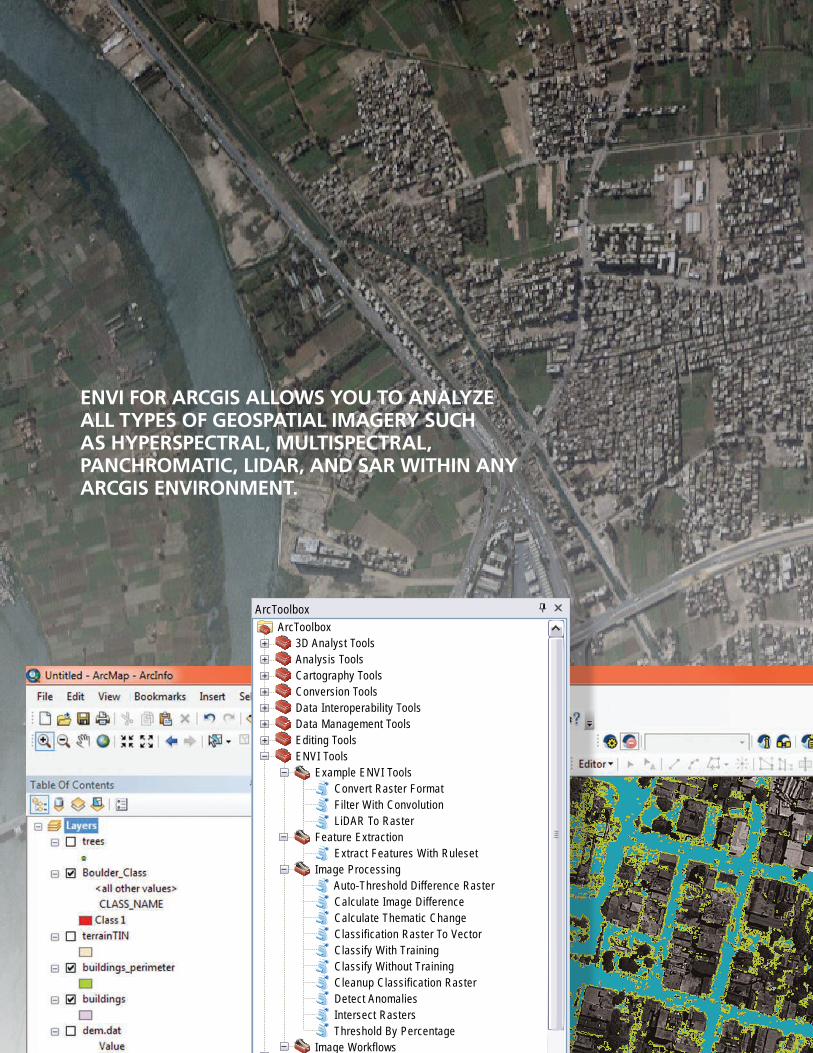
ENVI for ArcGIS allows you to analyze geospatial imagery such as hyperspectral, multispectral, panchromatic, LiDAR, and SAR within any ArcGIS environment whether deployed on the desktop, in the cloud, or online. This flexibility allows you to implement scientifically proven ENVI image analysis without having to change your existing workflow.
INTEGRATED SOLUTIONS GIVE YOU QUICK, ACCURATE ANSWERS
Harris Geospatial and Esri have gone beyond providing software solutions that are merely interoperable. Instead, ENVI for ArcGIS provides advanced image analysis capabilities that are completely integrated across the ArcGIS platform. With this integration, ENVI workflows and automated tools open in the ArcToolbox, and allow results to be pushed directly to ArcMap or accessed via ArcOnline. Since Harris Geospatial and Esri are committed to providing the tools that GIS users need to solve problems, collaborative development efforts will undoubtedly result in more innovative offerings in the future.
Untitled - ArcMap - ArcInfoUntitled - ArcMap - ArcInfo
File Edit View Bookmarks Insert Selection Geoprocessing Customize Windows Help
Layersboulder_sub_quac.dat
Table Of Contents
ArcToolbox
RGBRed: QUAC (Resize (Band 5:10SEP12175936Green: QUAC (Resize (Band 3:10SEP1217593Blue: QUAC (Resize (Band 2:10SEP12175936-
ArcToolbox3D Analyst ToolsAnalysis ToolsCartography ToolsConversion ToolsData Interoperability ToolsData Management ToolsEditing ToolsENVI Tools Example ENVI Tools Convert Raster Format Filter With Convolution LiDAR To Raster Feature Extraction Extract Features With Ruleset Image Processing Auto-Threshold Difference Raster Calculate Image Difference Calculate Thematic Change Classification Raster To Vector Classify With Training Classify Without Training Cleanup Classification Raster Detect Anomalies Intersect Rasters Threshold By Percentage Image Workflows Detect Anomalies With Thresholding Detect Image Difference With Thresholding Detect Thematic Change With Cleanup Supervised Classification With Cleanup Unsupervised Classification With CleanupGeocoding ToolsGeostatistical Analyst Tools
ArcToolbox Results
CatalogSearch
465958.182 4441109.632 Meters
1:6,146
ENVI FOR ARCGIS ALLOWS YOU TO ANALYZE ALL TYPES OF GEOSPATIAL IMAGERY SUCH AS HYPERSPECTRAL, MULTISPECTRAL, PANCHROMATIC, LIDAR, AND SAR WITHIN ANY ARCGIS ENVIRONMENT.
I NEED TO WARN CITIZENS OF MY COUNTY OF THE DANGER OF FIRE FUEL IN CLOSE PROXIMITY TO THEIR HOMES.
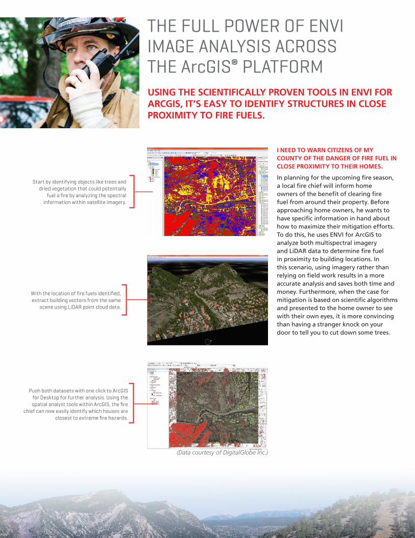
In planning for the upcoming fire season, a local fire chief will inform home owners of the benefit of clearing fire fuel from around their property. Before approaching home owners, he wants to have specific information in hand about how to maximize their mitigation efforts. To do this, he uses ENVI for ArcGIS to analyze both multispectral imagery and LiDAR data to determine fire fuel in proximity to building locations. In this scenario, using imagery rather than relying on field work results in a more accurate analysis and saves both time and money. Furthermore, when the case for mitigation is based on scientific algorithms and presented to the home owner to see with their own eyes, it is more convincing than having a stranger knock on your door to tell you to cut down some trees.
THE FULL POWER OF ENVI IMAGE ANALYSIS ACROSS THE ArcGIS® PLATFORM
Start by identifying objects like trees and dried vegetation that could potentially
fuel a fire by analyzing the spectral information within satellite imagery.
With the location of fire fuels identified, extract building vectors from the same
scene using LiDAR point cloud data.
(Data courtesy of DigitalGlobe Inc.)
Push both datasets with one click to ArcGIS for Desktop for further analysis. Using the spatial analyst tools within ArcGIS, the fire
chief can now easily identify which houses are closest to extreme fire hazards.
USING THE SCIENTIFICALLY PROVEN TOOLS IN ENVI FOR ARCGIS, IT’S EASY TO IDENTIFY STRUCTURES IN CLOSE PROXIMITY TO FIRE FUELS.
USE ADVANCED LIDAR TOOLS IN ENVI TO ENHANCE YOUR GISI NEED TO ASSESS MY EASEMENT FOR VEGETATION ENCROACHMENT ON POWER LINES.
Since vegetation encroachment can pose a significant risk to the operation of power transmission lines, utilities managers spend large sums of money monitoring easements. To reduce the need for teams of workers to drive or walk to visually identify encroachment, utilities managers can use ENVI for ArcGIS to analyze aerial imagery and LiDAR data to identify vegetation risks over broad, inaccessible areas.
ENVI feature extraction routines can extract vector objects from LiDAR data to identify tree locations and power line extents. When integrated with the spatial analysis capabilities of ArcGIS, an accurate assessment of the severity of the encroachment can be made and the appropriate technician/equipment deployed—saving time and money.
ENVI FOR ARCGIS ALLOWS YOU TO QUICKLY AND ACCURATELY ASSESS YOUR EASEMENT WITH LIDAR DATA, SAVING TIME, MONEY, AND RESOURCES.
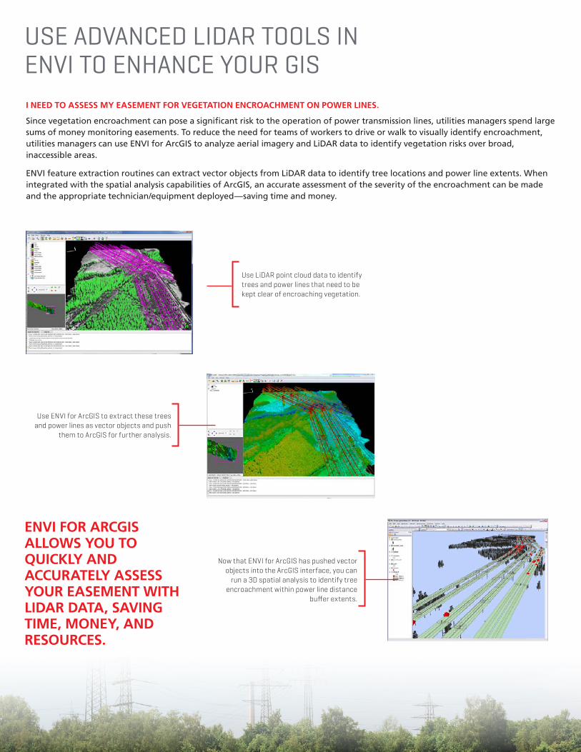
Use LiDAR point cloud data to identify trees and power lines that need to be kept clear of encroaching vegetation.
Use ENVI for ArcGIS to extract these trees and power lines as vector objects and push
them to ArcGIS for further analysis.
Now that ENVI for ArcGIS has pushed vector objects into the ArcGIS interface, you can
run a 3D spatial analysis to identify tree encroachment within power line distance
buffer extents.
I NEED TO ENSURE THE SUCCESS OF MY MISSION BY IDENTIFYING POTENTIAL TARGETS OR THREATS.
Keeping our world safe from threats is an enormous job that entails unique challenges. Defense and intelligence personnel can use ENVI for ArcGIS to analyze a broad geographic area of interest and quickly identify anomalies that could be important to tactical and operational planning.
Anomalies identified through ENVI spectral image processing can identify anything from disturbed soil to camouflaged enemy equipment, or man-made obstacles. These advanced ENVI target and anomaly detection methods yield actionable information from imagery that together with GIS layers can be used to create comprehensive intelligence reports or risk assessments that support mission planning efforts.
USE ENVI FOR ARCGIS TO FUSE INFORMATION FROM IMAGERY WITH GIS LAYERS TO GAIN ACTIONABLE INTELLIGENCE
USE THE SPECTRAL ANALYSIS TOOLS IN ENVI FOR ARCGIS TO IDENTIFY ANOMALIES THAT MAY POSE A THREAT TO MISSION SUCCESS.
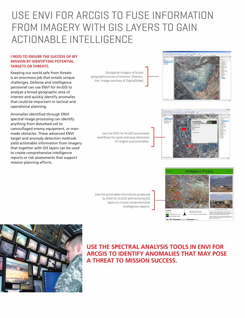
Geospatial imagery of broad geographical area of interest. (Natanz,
Iran. Image courtesy of DigitalGlobe)
Use the actionable information produced by ENVI for ArcGIS with existing GIS
layers to create comprehensive intelligence reports.
Use the ENVI for ArcGIS automated workflows for quick and easy detection
of targets and anomalies.
ENABLE MOBILE ACCESS FOR YOUR WORKFORCE WITH ENVI FOR ARCGISI NEED TO ENSURE THE SAFETY OF MY CARGO VESSEL BY AVOIDING OCEAN DEBRIS.
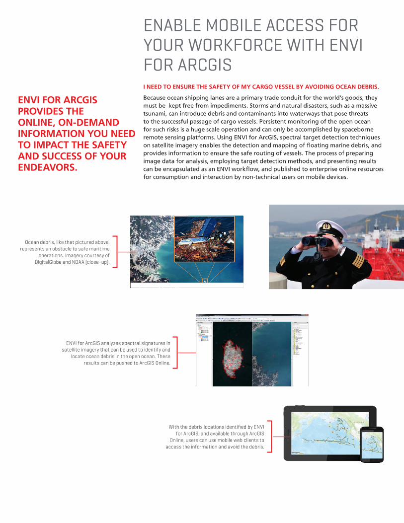
Because ocean shipping lanes are a primary trade conduit for the world’s goods, they must be kept free from impediments. Storms and natural disasters, such as a massive tsunami, can introduce debris and contaminants into waterways that pose threats to the successful passage of cargo vessels. Persistent monitoring of the open ocean for such risks is a huge scale operation and can only be accomplished by spaceborne remote sensing platforms. Using ENVI for ArcGIS, spectral target detection techniques on satellite imagery enables the detection and mapping of floating marine debris, and provides information to ensure the safe routing of vessels. The process of preparing image data for analysis, employing target detection methods, and presenting results can be encapsulated as an ENVI workflow, and published to enterprise online resources for consumption and interaction by non-technical users on mobile devices.
ENVI FOR ARCGIS PROVIDES THE ONLINE, ON-DEMAND INFORMATION YOU NEED TO IMPACT THE SAFETY AND SUCCESS OF YOUR ENDEAVORS.
Ocean debris, like that pictured above, represents an obstacle to safe maritime
operations. Imagery courtesy of DigitalGlobe and NOAA (close-up).
ENVI for ArcGIS analyzes spectral signatures in satellite imagery that can be used to identify and
locate ocean debris in the open ocean. These results can be pushed to ArcGIS Online.
With the debris locations identified by ENVI for ArcGIS, and available through ArcGIS
Online, users can use mobile web clients to access the information and avoid the debris.
Harris is a registered trademark of Harris Corporation. Trademarks and tradenames are the property of their respective companies. © 2017 Harris Corporation 4/16 rev.6-17 VIS-AL
Non-Export-Controlled Information
About Harris CorporationHarris Corporation is a leading technology innovator, solving customers’ toughest mission-critical challenges by providing solutions that connect, inform and protect. Harris supports government and commercial customers around the world. Learn more at harris.com.
FLORIDA | NEW YORK | VIRGINIA | BRAZIL | UNITED KINGDOM | UAE | SINGAPORE
HIGHLIGHTS
Create maps and other geospatial products for more informed decisions
Access prebuilt ENVI image analysis tools within the ArcToolbox™
Easily add analysis capabilities to your GIS models and applications
Deliver information to your workforce – online, and on demand
LEARNING OPPORTUNITIESSTAY CONNECTED
HarrisGeospatial.com/ENVIforArcGIS
TECHNICAL SUPPORT
HarrisGeospatial.com/support
Email: [email protected]
Phone: 303.786.9900
CONTACT US
Classroom Training
Whether you are just learning our products or an experienced pro, we have courses designed to take your abilities to the next level.
Online Training
Attend a live web seminar or watch a recorded web seminar — the perfect way to learn about the latest product developments right from your desk.
HarrisGeospatial.com/training