Embed Size (px)
Citation preview

APACHE ENERGY LTD (ABN 39 009 301 964) 100 ST GEORGES TERRACE / PERTH / WA / 6000 TEL (08) 6218 7100 / FAX (08) 6218 7200
Environment Plan Summary
Varanus Island Hub Operations Environment Plan for Commonwealth Waters
(John Brookes, Greater East Spar and associated Facilities)
EA-66-RI-10003

EA-66-RI-10003
Environment Plan Summary - VI Hub Operations Environment Plan (Cmlth Waters) 2 of 25
CONTENTS
1. INTRODUCTION .................................................................................................................................... 3
1.1 Background ........................................................................................................................................ 3
1.2 Description of the Facilities ................................................................................................................ 5
1.2.1 John Brookes .................................................................................................................................... 5
1.2.2 Greater East Spar (GES) .................................................................................................................... 5
1.3 Location .............................................................................................................................................. 5
1.4 Description of Operational Activities.................................................................................................. 7
2. DESCRIPTION OF THE ENVIRONMENT .................................................................................................. 8
2.1 Physical Environment ......................................................................................................................... 8
2.2 Habitats .............................................................................................................................................. 8
2.2.1 Operational Area Habitats ................................................................................................................ 8
2.2.2 Other EMBA Habitats ....................................................................................................................... 8
2.3 Matters of National Environmental Significance (NES) ....................................................................... 8
2.4 State Marine Reserves........................................................................................................................ 9
2.5 Marine and Coastal Fauna .................................................................................................................10
2.6 Socio-economic Environment ............................................................................................................10
2.6.1 Fisheries and Aquaculture ...............................................................................................................10
2.6.2 Commercial Shipping.......................................................................................................................11
2.6.3 Petroleum Exploration and Production ............................................................................................11
2.6.4 Tourism ...........................................................................................................................................11
2.6.5 Heritage ..........................................................................................................................................11
3. STAKEHOLDER CONSULTATION ...........................................................................................................13
4. ENVIRONMENTAL HAZARDS AND CONTROLS .....................................................................................15
5. MANAGEMENT APPROACH .................................................................................................................24
5.1 Implementation Strategy ..................................................................................................................24
5.2 Oil Spill Response ............................................................................................................................... 7
6. NOMINATED LIAISON PERSON ............................................................................................................25
TABLE OF FIGURES
Figure 1-1: VI Hub facilities including John Brookes and Greater East Spar facilities in Commonwealth waters. 4
LIST OF TABLES
Table 1-1: Surface locations for the John Brookes and Greater East Spar infrastructure ............................ 6
Table 3-1: Summary of key stakeholders consulted ................................................................................ 13
Table 4-1: Environmental hazards and controls for operations activities and oil spill response activities 16

EA-66-RI-10003
Environment Plan Summary - VI Hub Operations Environment Plan (Cmlth Waters) 3 of 25
1. INTRODUCTION
1.1 Background
Apache Northwest Pty Ltd and Apache Oil Australia Pty Ltd operate the John Brookes gas field and Greater East Spar gas fields, respectively, on behalf of the WA-29-L and WA-13-L titleholders, in offshore Commonwealth waters on the North West Shelf (NWS) of Western Australia (WA). These operators are wholly owned subsidiaries of Apache Energy Ltd (Apache). Production fluids from these fields are transported by subsea pipelines to the Varanus Island (VI) oil and gas hub (VI Hub) located in State Waters on the North West Shelf (Figure 1-1). Facilities include subsea wells, other subsea infrastructure (including pipelines) and the John Brookes platform. Approximately 22 km of the pipeline network are located in State waters adjacent to VI and fall under State Petroleum Legislation.
The Varanus Island Hub Operations Environment Plan for Commonwealth Waters (John Brookes, Greater East Spar and associated Facilities)(EA-66-RI-10003), referred to herein as ‘the EP’, was submitted and accepted by the National Offshore Petroleum Safety and Environment Authority (NOPSEMA) for the operation of these facilities. The EP has been prepared in accordance with the Offshore Petroleum and Greenhouse Gas Storage (Environment) Regulations 2009 (OPGGS (E) Regulations) under the Offshore Petroleum and Greenhouse Gas Storage Act 2006 (OPGGS Act) (Cmlth). As required under the OPGGS (E) Regulations, an EP summary (this document) has been prepared for submission to NOPSEMA for public disclosure.

EA-66-RI-10003
Environment Plan Summary - VI Hub Operations Environment Plan (Cmlth Waters) 4 of 25
Figure 1-1: VI Hub facilities including John Brookes and Greater East Spar facilities in Commonwealth waters.

EA-66-RI-10003
Environment Plan Summary - VI Hub Operations Environment Plan (Cmlth Waters) 5 of 25
1.2 Description of the Facilities
All the Commonwealth waters facilities described herein are part of the Varanus Island (VI) Hub, a central gathering and processing hub for Apache’s oil and gas production facilities. Well fluids (gas and condensate) from the John Brookes and Greater East Spar reservoirs are processed in the East Spar Joint Venture (ESJV) Plant on VI. VI also hosts the accommodation, administration and control centre for the production facilities. All facilities that form part of the hub are operated and maintained from VI. Personnel reside at VI and journey to and from the offshore facilities via helicopter or Field Support Vessel (FSV).
1.2.1 John Brookes
The John Brookes Commonwealth waters facilities consists of the following:
John Brookes platform – a normally unmanned wellhead platform (WHP); and
John Brookes pipeline – a subsea gas export line, routed to the VI onshore processing facilities.
1.2.2 Greater East Spar (GES)
The Greater East Spar Commonwealth waters facilities include:
Producing and non-producing subsea wells of the Halyard, Spar and East Spar fields;
Existing and new subsea manifolds;
A navigation communications control (NCC) buoy;
Subsea heat exchangers/cooling skids;
Umbilicals;
Flowlines; and
East Spar pipeline - a subsea gas export line, routed to the VI onshore processing facilities.
1.3 Location
The locations of the facilities and infrastructure covered in the EP are listed in Table 1-1.

EA-66-RI-10003
Environment Plan Summary - VI Hub Operations Environment Plan (Cmlth Waters) 6 of 25
Table 1-1: Surface locations for the John Brookes and Greater East Spar infrastructure
Facility Water depth
(m)
Distance from Varanus Island
Coordinates (Datum/Projection: GDA 94 Zone 50)
Latitude Longitude Easting Northing
John Brookes Infrastructure
JB platform 45.8 54 km northwest
20°26’50”S 115°07’13”E 303,892.90 7,737,890.25
JB pipeline From JB platform to
State Waters boundary
33 km northwest
JB pipeline
intersects State
Waters
boundary
20°36’33.64”S
JB pipeline
intersects State
Waters
boundary
115°23’11.16”E
JB pipeline
intersects
State Waters
boundary
331,854.83
JB pipeline
intersects
State Waters
boundary
7,720,252.86
Greater East Spar Infrastructure
Halyard-1 well head
105 68 km west 20°36’04.06”S 114°55’09.67”E 283,155.40 7,720,610.40
Halyard PLEM 105 ~67 km west
Halyard flowline
Between Halyard-1 wellhead and East Spar manifold.
East Spar PLEM
96 63 km west 20°43’20.25”S 114° 9’03.36”E 290,089.71 7,707,279.49
East Spar manifold
92.1 62 km west 20°43’19.91”S 114°59’04.01”E 290,108.26 7,707,290.32
East Spar NCC buoy
92.1 62 km west 20°43'07.011”S 114°59'02.89”E 290,070.96 7,707,686.72
East Spar pipeline
From ES
manifold to
State Waters
boundary
41 km west
ES pipeline
intersects State
Water Boundary
20°39'45.86”S
ES pipeline
intersects State
Water Boundary
115°22' 08.84”E
ES pipeline
intersects
State Water
Boundary
330,109.67
ES pipeline
intersects
State Water
Boundary
7,714,323.90
Spar-2 wellhead
112.9 69 km west 20°36’31.981”S 114°54’ 2.09”E 281,788.82 7,719,733.4
Spar flowline 112.9 Yet to be installed – will be between Spar-2 wellhead and Halyard PLEM

EA-66-RI-10003
Environment Plan Summary - VI Hub Operations Environment Plan (Cmlth Waters) 7 of 25
1.4 Operational Activities
The EP covers Operational Activities within an Operational Area within Commonwealth waters. The Operational Area is defined as the footprint of the John Brookes and Greater East Spar infrastructure and the area within 500 m of the John Brookes platform (the Exclusion Zone), and 250 m of all other infrastructure. Operational Activities include the following:
Chemical Injection;
Well Intervention;
Well Abandonment / Suspension;
Inline Inspections (pigging);
Infrastructure inspections, maintenance and repair (which may involve ROVS, AUVS and divers) including:
o General visual inspections,
o Integrity and corrosion control surveys,
o Plant and subsea equipment/infrastructure cleaning, repair and modification,
o Marine growth removal,
o Pipeline span rectification;
Support vessel activities including:
o Crew transfers,
o Loading/unloading equipment, materials, chemicals and waste,
o Support for any inspection, maintenance and repair activities; and
Helicopter activities including crew transfers.
Activities involving the use of a Mobile Offshore Drilling Unit (MODU) are not covered in the EP except for emergency response (oil spill response activities).
1.5 Oil Spill Response Activities
The VI Hub Operations Oil Spill Contingency Plan (OSCP) (EA-60-RI-186.2) will be implemented in the event of an oil spill during the activity. The OSCP details Apache’s response preparedness and strategies for combatting an oil spill during Operations Activities. The OSCP includes performance objectives, performance standards and measurement criteria for oil spill response. Oil spill response strategies include:
• Source control (e.g. tank rupture, bunkering spill, pipeline leak, loss of well control);
• Monitor and evaluate: surveillance and spill fate modelling;
• Mechanical dispersion: used to assist with the natural dispersion process of hydrocarbon at sea surface;
• Nearshore and shoreline protection and deflection: considered if spill is predicted to impact sensitive shorelines;
• Shoreline clean-up (if shoreline is impacted) (e.g. physical removal, surf washing, flushing, bioremediation or natural dispersion);
• Oil wildlife response (activation of WA Oiled Wildlife Response Plan);
• Waste management (storage, handling, transportation and disposal); and
• Scientific monitoring: impact and recovery assessment of sensitive marine receptors exposed to oil.
EA-66-RI-10003
Environment Plan Summary - VI Hub Operations Environment Plan (Cmlth Waters) 8 of 25
2. DESCRIPTION OF THE ENVIRONMENT
The existing environment that may be affected (EMBA) by the activity, includes ecological, cultural, social and economic features. The EMBA area has been derived by determining the worst case extent within which impacts could occur from a loss of well control and release of condensate. Controls to prevent and mitigate accidental events such as a loss of well control and other potential oil spills are presented in Section 4.
2.1 Physical Environment
The EMBA lies mainly within the arid tropics experiencing high summer temperatures and periodic tropical cyclones in summer. Rainfall in the region is low, although intense rainfall may occur during the passage of summer tropical cyclones and thunderstorms. Mean air temperatures range from a minimum of 11°C in winter to a maximum of 36°C in summer.
Major drivers of marine ecosystems include ocean currents, tides, waves, temperature and salinity.
Currents in the coastal zone and over the inner to mid-shelf are largely driven by tides and winds, whereas offshore, over the continental shelf, slope and rise are influenced by large scale regional circulation.
Sea surface temperatures vary annually, being warmest in March (32°C) and coolest in August (19°C).
Salinity is relatively uniform at 34–35 ppt throughout the water column and across the North West Shelf. Due to the low rainfall there is little freshwater run-off from the adjacent mainland.
2.2 Habitats
2.2.1 Operational Area Habitats
Within the Operational Area, soft sediments are the dominant habitat, with small areas of hard substrate.
Epibenthic biota over soft sediments is sparse and includes invertebrates such as anemones, urchins, sea pens, sea whips and glass sponges. Light availability at the seabed for most of the Operational Area (depth 20 – 100 + metres) is likely to preclude the growth of photosynthetic organisms.
Raised limestone pavement has been identified around the John Brookes platform and the portion of pipeline in Commonwealth waters. This habitat can support habitat-forming filter feeding organisms such as gorgonians, soft corals, sponges, ascidians, molluscs and hydroids.
2.2.2 Other EMBA Habitats
Outside of the Operational Area benthic subtidal habitats include coral reefs, macroalgae, seagrasses, subtidal soft sediments and benthic fauna and subtidal pavement (which may support sessile filter feeders such as molluscs, sponges, ascidians, gorgonians, soft corals and hydroids), while shoreline/intertidal habitat types include mangroves, sandy beaches, rocky shorelines, intertidal mud/sand flats (which may support seagrass) and intertidal reef platforms (which may support corals, macroalgae, molluscs, sponges and soft corals). Habitats within the EMBA may be protected by marine reserves or other protected areas.
2.3 Matters of National Environmental Significance (NES)
A search of the Environmental Protection and Biodiversity Conservation Act 1999 (EPBC Act) protected matters search tool revealed a number of Matters of NES as well as ‘Other matters protected by the EPBC Act’ within the EMBA. These are:
The Ningaloo Coast World Heritage Property;
The following National Heritage Places:
o Dampier Archipelago (including Burrup Peninsula),
o Barrow Island and Montebello-Barrow Islands Marine Conservation Reserve,
EA-66-RI-10003
Environment Plan Summary - VI Hub Operations Environment Plan (Cmlth Waters) 9 of 25
o HMAS Sydney II and HSK Kormoran Shipwreck Sites;
Listed threatened and migratory fauna including marine mammals, marine reptiles, fish/sharks and birds;
The following Commonwealth Heritage Places:
o Naval Communication Station Harold E Holt (Area A),
o HMAS Sydney II and HSK Kormoran Shipwreck Sites,
o Ningaloo Marine Area – Commonwealth Waters;
The following Commonwealth Marine Reserves:
o Gascoyne Marine Reserve,
o Ningaloo Marine Reserve,
o Montebello Marine Reserve,
o Dampier Marine Reserve,
o Carnarvon Canyon Reserve,
o Argo-Rowley terrace Marine Reserve,
o Abrolhos Commonwealth Marine reserve,
o Shark Bay Commonwealth Marine Reserve;
The Commonwealth Marine Area including the following key ecological features;
o Ancient coastline at 125 m contour,
o Canyons linking the Cuvier Abyssal Plain and the Cape Range Peninsula,
o Commonwealth waters adjacent to Ningaloo,
o Continental slope demersal fish communities,
o Exmouth Plateau,
o Glomar Shoals,
o Wallaby Saddle,
o The Commonwealth marine environment surrounding the Houtman Abrolhos Islands Ancient coastline between 90 and 120 m depth,
o Perth canyon and adjacent shelf break, and other west coast canyons,
o Western demersal slope and associated fish populations,
o Western Rock Lobster.
2.4 State Marine Reserves
State marine reserves within the EMBA comprise the following:
Montebello Islands Marine Park
Barrow Island Marine Park
Barrow Island Marine Management Area
Ningaloo Marine Park
Muiron Islands Marine Management Area

EA-66-RI-10003
Environment Plan Summary - VI Hub Operations Environment Plan (Cmlth Waters) 10 of 25
2.5 Marine and Coastal Fauna
Marine and coastal fauna within the EMBA includes plankton, invertebrates, fish, marine mammals, marine reptiles and shorebirds/seabirds.
2.6 Socio-economic Environment
The Operational Area is located approximately 182 km west of Karratha, 132 km north of the small coastal town of Onslow, and 196 km northeast of Exmouth. Socio-economic activities that may occur within the EMBA include commercial and recreational fishing, oil and gas exploration and production, shipping, and tourism.
2.6.1 Fisheries and Aquaculture
Recreational fisheries and charter boat operators are managed by the Department of Fisheries WA (DoF). The area covered by the EMBA contains the North Coast Bioregion and the Gascoyne Bioregion also extends south into the Northern limits of the West Coast Bioregion
Within the North Coast Bioregion, recreational fishing is experiencing significant growth, with a distinct seasonal peak in winter when the local population increases significantly from tourists visiting the Exmouth/Onslow area and Dampier Archipelago.
State commercial fisheries, managed by DoF, that have boundaries that overlie or are in close proximity to the EMBA are:
North Coast Bioregion
Onslow Prawn Managed Fishery (OPMF);
Nickol Bay Prawn Managed Fishery (NBPMF);
Mackerel Fishery (Area 2 – Pilbara and Area 3 - Gascoyne/West Coast);
Pilbara Demersal Scalefish Fishery (Trap, Trawl and Line);
Pilbara Developing Crab Fishery; and
Pearl Oyster Managed Fishery (Zone 1).
Gascoyne Bioregion
Exmouth Gulf Prawn Managed Fishery;
Abrolhos Islands and Midwest Trawl Fishery;
Gascoyne Demersal Scalefish Fishery;
Shark Bay Prawn Fishery;
Shark Bay Scallop Fishery;
West Coast Demersal Gillnet and Demersal Longline Fishery; and
West Coast Demersal Scalefish Fishery.
West Coast Bioregion
Western Rock Lobster Managed Fishery;
Roe’s Abalone Managed Fishery; and
Southwest Trawl Fishery.
Whole of State Fisheries
Beche-de-mer Fishery;

EA-66-RI-10003
Environment Plan Summary - VI Hub Operations Environment Plan (Cmlth Waters) 11 of 25
Marine Aquarium Fish Fishery;
West Coast Deep Sea Crab (Interim) Managed Fishery (north of Cape Leeuwin and west of NT border);
Specimen Shell Managed Fishery; and
Southwest coast Salmon Fishery.
The North West Slope Trawl Fishery (NWSTF) and the Western Deepwater Trawl Fishery are Commonwealth managed fisheries licensed to operate within the EMBA in offshore waters (>200 m deep).
Other Commonwealth fisheries, such as the Western Tuna and Billfish Fishery (WTBF), Southern Tuna and Billfish Fishery (STBF), Southern Bluefin Tuna Fishery (SBFTF) and the Western Skipjack Tuna Fishery (WSTF) are licenced to fish within the EMBA, but have had no recent fishing effort reported in the EMBA.
In addition to wild fisheries, aquaculture of pearl oysters (Pinctada maxima) occurs within the EMBA.
2.6.2 Commercial Shipping
There are no recognised shipping routes/channels/lanes in or near the Operational Area. The developments are located >50 km southeast of a designated shipping route which is the main merchant shipping route from the Port of Fremantle and northern destinations.
2.6.3 Petroleum Exploration and Production
The Operational Area is located west of Barrow Island, which has been subject to petroleum exploration and production for over 50 years. Exploration and production activities on the island and many surrounding permits are operated by Chevron (Australia). Chevron is also the operator (on behalf of several JV partners) of the Gorgon LNG Project that will tie in offshore gas fields (Gorgon and Janz fields) to Barrow Island (currently under construction). Proposed natural gas pipelines and umbilicals connecting the proposed Barrow Island processing plant to the Gorgon and Janz fields will cross the Halyard Electro Hydraulic Umbilical and the East Spar Pipeline. Chevron (Australia) is also developing the Wheatstone LNG Project, which will tie in offshore gas fields to an LNG processing plant at Ashburton on the WA mainland. The proposed Wheatstone Pipeline will pass ~4 km west of Halyard-1 well and Spar-2 infrastructure.
2.6.4 Tourism
Aquatic recreation off the Pilbara, Ningaloo and Gascoyne coast, based out of the main coastal towns of Exmouth, Dampier, Onslow, Point Samson, Port Hedland, Kalbarri and Geraldton, is mostly restricted to near-shore activities including:
Whale watching;
Recreational boating;
Charter fishing;
Snorkelling/diving;
Surfing; and
Recreational fishing.
In the waters immediately surrounding the John Brookes, Halyard and East Spar developments, tourism activities are limited due to its distance from the mainland shorelines. The EMBA overlaps areas where tourism activities are expected to occur (e.g. Ningaloo Coast, Barrow/ Montebello/ Lowendal Islands).
2.6.5 Heritage
A registered Native Title claim exists over Exmouth Gulf, the Muiron Islands and the Cape Range coast (covering the southern-most portion of the EMBA), but there are no claims over the Operational Area or the majority of the EMBA.

EA-66-RI-10003
Environment Plan Summary - VI Hub Operations Environment Plan (Cmlth Waters) 12 of 25
The Australian National Shipwrecks Database (DSEWPC, 2013) lists seven shipwrecks in the ‘Montebellos Area’ and eight shipwrecks in the ’Onslow Area’. No shipwrecks have previously been recorded in or adjacent to the Operational Area.
The HMAS Sydney II and HSK Komoran Shipwreck sites are ~113 nm west of Steep Point. The WA Museum Shipwreck Database records three shipwrecks at the North West Cape (Fairy Queen, Mildura and Emlyn Castle), the Lady Ann (24 nm north of the North West Cape), one at the northern tip of Barrow Island (Perentie), two within the Montebello Islands (Parks Lugger and Plym HMS) and one north of the Montebello Islands and Trial Rocks (Trial).

EA-66-RI-10003
Environment Plan Summary - VI Hub Operations Environment Plan (Cmlth Waters) 13 of 25
3. STAKEHOLDER CONSULTATION
Apache maintains a comprehensive stakeholder database, overseen by a dedicated Stakeholder Coordinator. Stakeholders for Operational Activities were identified through the following mechanisms:
Review of legislation applicable to petroleum and marine activities;
Identification of marine user groups and interest groups active in the area (e.g., recreational and commercial fisheries, other oil and gas producers, merchant shipping etc.);
Active participation in industry bodies (e.g. APPEA and Australian Marine Oil Spill Centre (AMOSC)); and
Records from previous consultation activities in the area.
The key stakeholders for Operational Activities are summarised in Table 3-1.
Table 3-1: Summary of key stakeholders consulted
Group Stakeholder
Commercial fisheries Australian Fisheries Management Authority (AFMA)
Department of Fisheries (DoF)
Western Australian Fishing Industry Council (WAFIC)
Commonwealth Fisheries Association (CFA)
A Raptis and Sons.
WestMore Seafoods
Shark Bay Seafoods
Austral Fisheries
MG Kailis
Pearl Producers Association
State commercial fishing licence holders
Recreational fisheries Recfishwest
Conservation Department of Parks and Wildlife (DPaW)
Tourism Marine Tourism WA (formerly Charter Boat Owners and Operators Association)
Shipping safety and security
Australian Maritime Safety Authority (AMSA)
Department of Defence
Hydrocarbon spill response
Department of Transport (DoT)
Australian Marine Oil Spill Centre (AMOSC)
State Government Department
Department of Mines and Petroleum (DMP)
Stakeholders are regularly updated on activities at the VI Hub, including Commonwealth waters facilities, through Apache’s ongoing Quarterly Project Updates. These regular, non-project oriented updates detail Apache’s ongoing and proposed activities on the NWS, looking out three to six months. Information provided in this way is intended to afford stakeholders an opportunity to request additional information on specific activities or elements that may be of interest to them, and voice any concerns.
Recent Apache consultation for projects on the NWS has included the Greater East Spar (GES) development, which contains Halyard, Spar-2 and East Spar inside its Operational Area. An information pack relating to GES and the connection of the Spar‐2 well to the Halyard subsea facilities was distributed to Apache stakeholders, as listed above, on August 9, 2013.
EA-66-RI-10003
Environment Plan Summary - VI Hub Operations Environment Plan (Cmlth Waters) 14 of 25
Ongoing feedback that has been provided to Apache through a number of offshore activities undertaken in 2013/2014 confirms previous statements that if no information is received in the 4–6 weeks following email notifications that it is unlikely that the stakeholder had a concern with the activities, and where feedback was received, it indicated that there was no concern with the identified stakeholders regarding the John Brookes and Greater East Spar facilities as part of VI Hub Operations and at the related GES development.

EA-66-RI-10003
Environment Plan Summary - VI Hub Operations Environment Plan (Cmlth Waters) 15 of 25
4. ENVIRONMENTAL HAZARDS AND CONTROLS
Environmental hazards, impacts/risks and control measures associated with operational activities and oil spill response activities were identified by conducting environmental hazard workshops attended by relevant technical, operational and environmental personnel within Apache and key contractor companies. The workshops reviewed all of the activities that may be undertaken during operation and the possible hazards (planned and unplanned events) arising from those activities. For each hazard, impact(s) were determined.
The severity of each impact was assessed according to the environmental consequence level of the impact. Impact attributes such as quantities emitted, concentrations released and time-scale of release, along with the spatial (e.g. proximity to event) and temporal sensitivities (e.g. peak abundance periods) of environmental receptors and values are considered in determining the consequence (severity) level.
A likelihood rating was also allocated to unplanned events. The likelihood that an event will result from any given activity is based on available incident databases, industry experience and professional judgment.
Subsequent internal reviews of the safety and environmental risk assessments by VI Hub operations personnel, safety personnel and the environment team has ensured the impact/risk assessments within the EP are as accurate and complete as possible.
The key environmental hazards and control measures to be applied are provided in Table 4-1. These are consistent with Apache corporate and project specific performance objectives, standards and measurement criteria.

EA-66-RI-10003
Environment Plan Summary - VI Hub Operations Environment Plan (Cmlth Waters) 16 of 25
Table 4-1: Environmental hazards and controls for operational activities and oil spill response activities
# Hazard Cause Impacts Control Measures
1 Light Emissions Safety and operational lighting on support vessels, John Brookes platform and NCC buoy
Potential attraction/ disturbance to marine biota.
Support vessel deck floodlights are to be turned off if not illuminating operational activities
Routine support vessel activities within Operational Area occur during daylight hours only
2 Atmospheric Emissions
Power generation;
Engine exhausts;
Venting of gases.
Reduction in air quality;
Greenhouse gas emissions.
Power generators and other diesel consuming equipment on John Brookes platform are maintained as per the VI Hub CMMS
Support vessel engines are maintained as per the vessel’s planned maintenance system
As per MARPOL Annex VI requirements (Regulations for the Prevention of Air Pollution from Ships) an International Air Pollution Prevention certificate is available for support vessels over 400 gross tonnage.
Sulphur content of support vessel fuel complies with prescribed limits specified in AMSA Marine Order Part 97/ MARPOL Annex VI (currently 3.5% m/m)
3 Planned discharges
Planned discharges include the following:
Deck drainage;
Sewage and grey water;
Deck drainage;
Bilge water;
Cooling water;
Bilge water;
Ballast water;
Food scraps;
Hydraulic fluid (valve operation);
Maintenance discharges.
Reduction in water quality
Potential toxicity to marine biota
Water/glycol based subsea hydraulic control fluids are used for control of subsea valves
Hydraulic control fluid usage is monitored and recorded.
Any subsea hydraulic fluids or water treatment chemicals used in the subsea system are risk assessed
Opening of subsea system will require an impact and risk assessment to be completed prior to commencement of activity.
Production fluids (hydrocarbons) will be flushed through with treated water to Varanus Island prior to opening of the subsea system during maintenance activities.
Residual oil-in-water content of treated water will be reduced to as low as reasonably practicable prior to opening of the subsea system
Support Vessels over 400 gross tonnage have an Oil Record Book and oily water separation equipment compliant with MARPOL Annex I
Oily water and food waste from field support vessel is disposed onshore at Varanus Island
Bilge water (oily water) discharge (location and treatment) will be compliant with Protection of the Sea (Prevention of Pollution from Ships) Act 1983
A Garbage Record Book shall be maintained for every support vessel over 400 gross

EA-66-RI-10003
Environment Plan Summary - VI Hub Operations Environment Plan (Cmlth Waters) 17 of 25
# Hazard Cause Impacts Control Measures
tonnage and every support vessel certified to carry 15 persons or more
If food waste discharge from support vessels, discharge (location and treatment) will be compliant with Protection of the Sea (Prevention of Pollution from Ships) Act 1983
If food waste macerators are compliant with MARPOL Annex V
Support vessels engaged on international voyages that are over 400 gross tonnage or licenced to carry >15 people have an ISPP Certificate
Only biodegradable and phosphate free detergents are used on support vessels
Containerised chemicals/hydrocarbons are stored securely in bunded areas, correctly labelled with current SDS available near storage location.
Bunding/drip-trays are present all portable hydrocarbon containing equipment, if used, and during refuelling, if required
Scupper plugs or equivalent deck drainage control measures available where hydrocarbons are stored and frequently handled.
Bunding/sumps on John Brookes Platform are intact and their integrity and capacity maintained
Sump pump on John Brookes platform is function tested regularly
Spill clean-up equipment located where chemicals are stored and frequently handles. Spill kits are confirmed intact, clearly labelled and contain adequate quantities of absorbent materials.
Contactors using sealed radioactive sources are licensed under the (WA) Radiation Safety Act 1975
4 Noise emissions/ fauna disturbance
Noise/disturbance from John Brookes platform, support vessel and helicopter activities.
Physiological or behavioural effects to fauna.
Collision with fauna
Support vessel and helicopter crew aware of EPBC Regulation (2000) Part 8 relating to cetacean interactions
Helicopters will only fly during daylight hours, unless required in an emergency.
Marine fauna datasheets are completed by Support Vessels and recorded in Marine Fauna Sighting Database. This information submitted to DoTE.
Death or injury to EPBC Act listed marine fauna (including cetaceans or whale sharks) is recorded/reported to NOPSEMA and DoTE in line with regulations
5 Disturbance to marine habitats and seabed
Placement of anchors;
’Wet parking’ equipment;
Subsea maintenance activities;
Physical disturbance to seabed, benthic habitats and associated biota.
Attraction of marine fauna
John Brookes lifting activities conducted as per Apache’s Lifting Equipment Management System
Lifting equipment regularly tested, inspected and certified
Equipment or materials lost overboard will be reported as incidents

EA-66-RI-10003
Environment Plan Summary - VI Hub Operations Environment Plan (Cmlth Waters) 18 of 25
# Hazard Cause Impacts Control Measures
Physical presence of infrastructure;
Dropped objects. If anchoring or placement of equipment is required support vessels will anchor/place
equipment only at Apache pre-approved locations.
Anchoring positions are recorded in the vessel’s anchor handling log book
6 Interference with other users
Interference caused by presence of support vessel and facilities/exclusion zones.
Potential loss of fishing area and/ or disruption to other vessel movements.
Facility location and cautionary zones are marked on navigational charts;
A consultation package outlining VI Hub and Greater East Spar facility operations has been provided to stakeholders and responses recorded
Stakeholder complaints are reported and managed
Navigational lighting on the John Brookes Platform regularly inspected
7 Introduction of marine pests
Biofouling on vessels and equipment;
Ballast water
Colonisation and disturbance to marine fauna and habitats
Pre-mobilisation risk assessment completed for international support vessels
International vessels shall exchange ‘high-risk’ ballast water, as per Australian Ballast Water Management Requirements
International vessel anti-foulant systems are maintained in compliance with International Convention on the Control of Harmful Anti-fouling Systems on Ships
8 Accidental discharge of hazardous/non-hazardous solid materials
Poor storage/ transfer of wastes/ materials
Decrease in water quality
Toxic impacts to fauna
Fauna entanglement/ingestion
All support vessels over 400 gross tonnage or licensed to carry more than 15 people will have a Garbage Management Plan and Garbage Record Book.
Vessel specific garbage receptacles on deck have lids or covers and are clearly labelled.
Waste segregation is in place and no visible litter on deck.
All garbage removed from John Brookes platform.
No solid wastes (hazardous or non-hazardous, excluding sewage and foodscraps as per legislative requirements) to be discharged from support vessels within the Operational Area.
No solid wastes (hazardous or non-hazardous, including food scraps) excluding sewage is discharged from John Brookes Platform.
John Brookes lifting activities conducted as per Apache’s Lifting Equipment Management System.
Lifting equipment regularly tested, inspected and certified.
Equipment or materials lost overboard will be reported as incidents.
9 Accidental discharge of liquid hazardous materials
Poor storage/ transfer of hazardous liquids;
Damage/failure of equipment
Decrease in water quality
Toxic impacts to fauna
John Brookes Platform hydrocarbon containing equipment is regularly inspected.
Bunding/sumps on John Brookes platform are regularly inspected. Sump pump is regularly function tested.
EA-66-RI-10003
Environment Plan Summary - VI Hub Operations Environment Plan (Cmlth Waters) 19 of 25
# Hazard Cause Impacts Control Measures
Support vessel machinery is maintained as per the vessel’s planned maintenance system.
Containerised chemicals/hydrocarbons are stored securely in bunded areas, correctly labelled with current SDS available near storage location.
Bunding/drip-trays are present all portable hydrocarbon containing equipment, if used, and during refuelling, if required.
Scupper plugs or equivalent deck drainage control measures available where hydrocarbons are stored and frequently handled.
Spill clean-up equipment located where chemicals are stored and frequently handles. Spill kits are confirmed intact, clearly labelled and contain adequate quantities of absorbent material.
Support vessels over 400 gross tonnage have a current Oil Record Book.
Chemicals are risk assessed as per Apache’s Operations Chemical Selection Evaluation and Approval Procedure.
Incident notification is completed for any hazardous material (liquid or solid) accidentally discharged overboard.
Support vessels over 400 gross tonnage have a shipboard oil pollution emergency plan (SOPEP) or shipboard marine pollution emergency plan (SMPEP). The plan is to be regularly tested.
Implement the VI Hub Operations Oil Spill Contingency Plan as required.
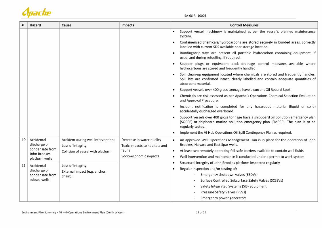
10 Accidental discharge of condensate from John Brookes platform wells
Accident during well intervention;
Loss of integrity;
Collision of vessel with platform.
Decrease in water quality
Toxic impacts to habitats and fauna
Socio-economic impacts
An approved Well Operations Management Plan is in place for the operation of John Brookes, Halyard and East Spar wells.
At least two remotely operating fail-safe barriers available to contain well fluids
Well intervention and maintenance is conducted under a permit to work system
Structural integrity of John Brookes platform inspected regularly
Regular inspection and/or testing of:
- Emergency shutdown valves (ESDVs)
- Surface Controlled Subsurface Safety Valves (SCSSVs)
- Safety Integrated Systems (SIS) equipment
- Pressure Safety Valves (PSVs)
- Emergency power generators
11 Accidental discharge of condensate from subsea wells
Loss of integrity;
External impact (e.g. anchor, chain).

EA-66-RI-10003
Environment Plan Summary - VI Hub Operations Environment Plan (Cmlth Waters) 20 of 25
# Hazard Cause Impacts Control Measures
- John Brookes platform navigational lighting
- John Brookes platform hydrocarbon containing equipment
Modifications to facilities documented as per Change Management Control procedure
Facility location and cautionary zones are marked on navigational charts
Dive support vessels using dynamic positioning are specified as per John Brookes Safety Case and maintain ‘drift-by’ or ‘drift-off’ positioning relative to platform
Incident report is completed for unplanned hydrocarbon release to the environment
Implement the VI Hub Operations Oil Spill Contingency Plan as required.
12 Accidental discharge of condensate from pipelines
Loss of integrity;
External impact (anchor, chain).
Decrease in water quality
Toxic impacts to habitats and fauna
Socio-economic impacts
If anchoring or placement of equipment is required support vessels will anchor/place equipment only at Apache pre-approved locations.
Anchoring positions are recorded in the vessel’s anchor handling log book
Facility location and cautionary zones are marked on navigational charts
John Brookes lifting activities conducted as per Apache’s Lifting Equipment Management System.
Lifting equipment regularly tested, inspected and certified.
Modifications to facilities documented as per Change Management Control procedure
Equipment or materials lost overboard will be reported as incidents.
Regular inspection and/or testing of:
- John Brookes pipeline and riser
- East Spar pipeline
- Emergency shutdown valves (ESDVs)
- Emergency power generators
Helicopter overflights of John Brookes and East Spar pipeline routes
Incident report is completed for unplanned hydrocarbon release to the environment
Implement the VI Hub Operations Oil Spill Contingency Plan as required.
13 Accidental discharge of diesel
Support vessel collision and tank rupture;
Poor storage/ transfer of diesel;
Damage/failure of equipment
Decrease in water quality;
Toxic impacts to habitats and fauna;
Socio-economic impacts
Facility location and cautionary zones are marked on navigational charts
John Brookes lifting activities conducted as per Apache’s Lifting Equipment Management System.
Lifting equipment regularly tested, inspected and certified.
Modifications to facilities documented as per Change Management Control procedure
Support vessel construction, communication and navigation systems meet SOLAS

EA-66-RI-10003
Environment Plan Summary - VI Hub Operations Environment Plan (Cmlth Waters) 21 of 25
# Hazard Cause Impacts Control Measures
and/or Vessel Class requirements
Dive support vessels using dynamic positioning are specified as per John Brookes Safety Case and maintain ‘drift-by’ or ‘drift-off’ positioning relative to platform
Regular inspection and/or testing of:
- John Brookes platform navigational lighting
- John Brookes platform hydrocarbon containing equipment
Bunding/sumps on John Brookes platform are regularly inspected. Sump pump is regularly function tested.
Support vessel machinery is maintained as per the vessel’s planned maintenance system.
Containerised chemicals/hydrocarbons are stored securely in bunded areas, correctly labelled with current SDS available near storage location.
Bunding/drip-trays are present all portable hydrocarbon containing equipment, if used, and during refuelling, if required.
Scupper plugs or equivalent deck drainage control measures available where hydrocarbons are stored and frequently handled.
Spill clean-up equipment located where chemicals are stored and frequently handles. Spill kits are confirmed intact, clearly labelled and contain adequate quantities of absorbent material.
Incident report is completed for unplanned hydrocarbon release to the environment
Support vessels over 400 gross tonnage have a shipboard oil pollution emergency plan (SOPEP) or shipboard marine pollution emergency plan (SMPEP). The plan is to be regularly tested.
Implement the VI Hub Operations Oil Spill Contingency Plan as required.
14 Oil spill response activities – general support vessel/aircraft operations
Accidental oil spills initiate oil spill response
General support vessel/ aircraft operations may lead to impacts as described above for Hazards #1-9 and 13.
Control measures included within those for Hazards #1-9 and 13 as detailed above.
15 Oil spill response activities – MODU relief well drilling
Accidental oil spills initiate oil spill response
Seabed disturbance from MODU anchoring and drilling Seabed disturbance/ contamination and decreased
As detailed within the NOPSEMA accepted Olympus-1 and Bianchi-1 Drilling Environment Plan [EA-00-RI-212/1]
EA-66-RI-10003
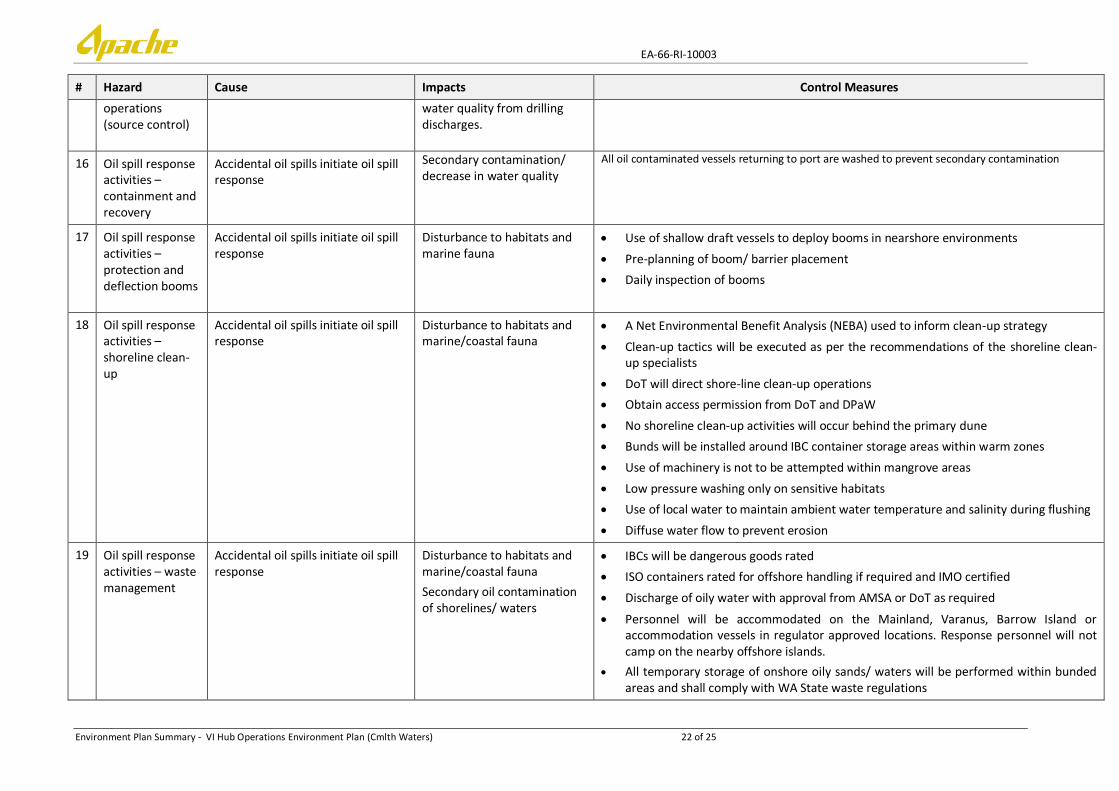
Environment Plan Summary - VI Hub Operations Environment Plan (Cmlth Waters) 22 of 25
# Hazard Cause Impacts Control Measures
operations (source control)
water quality from drilling discharges.
16 Oil spill response activities – containment and recovery
Accidental oil spills initiate oil spill response
Secondary contamination/ decrease in water quality
All oil contaminated vessels returning to port are washed to prevent secondary contamination
17 Oil spill response activities – protection and deflection booms
Accidental oil spills initiate oil spill response
Disturbance to habitats and marine fauna
Use of shallow draft vessels to deploy booms in nearshore environments
Pre-planning of boom/ barrier placement
Daily inspection of booms
18 Oil spill response activities – shoreline clean-up
Accidental oil spills initiate oil spill response
Disturbance to habitats and marine/coastal fauna
A Net Environmental Benefit Analysis (NEBA) used to inform clean-up strategy
Clean-up tactics will be executed as per the recommendations of the shoreline clean-up specialists
DoT will direct shore-line clean-up operations
Obtain access permission from DoT and DPaW
No shoreline clean-up activities will occur behind the primary dune
Bunds will be installed around IBC container storage areas within warm zones
Use of machinery is not to be attempted within mangrove areas
Low pressure washing only on sensitive habitats
Use of local water to maintain ambient water temperature and salinity during flushing
Diffuse water flow to prevent erosion
19 Oil spill response activities – waste management
Accidental oil spills initiate oil spill response
Disturbance to habitats and marine/coastal fauna
Secondary oil contamination of shorelines/ waters
IBCs will be dangerous goods rated
ISO containers rated for offshore handling if required and IMO certified
Discharge of oily water with approval from AMSA or DoT as required
Personnel will be accommodated on the Mainland, Varanus, Barrow Island or accommodation vessels in regulator approved locations. Response personnel will not camp on the nearby offshore islands.
All temporary storage of onshore oily sands/ waters will be performed within bunded areas and shall comply with WA State waste regulations

EA-66-RI-10003
Environment Plan Summary - VI Hub Operations Environment Plan (Cmlth Waters) 23 of 25
# Hazard Cause Impacts Control Measures
20 Oil spill response activities – oiled wildlife response
Disturbance to marine/coastal fauna
Oiled Wildlife response activities conducted as per the DPaW WA Oiled Wildlife Response Plan

EA-66-RI-10003
Environment Plan Summary - VI Hub Operations Environment Plan (Cmlth Waters) 24 of 25
5. MANAGEMENT APPROACH
The objective of the EP is to ensure that potential adverse environmental impacts and risks associated with the activity are reduced to ALARP and are of an acceptable level.
The EP details, for each environmental hazard identified specific performance objectives, performance standards as well as measurement criteria and records to demonstrate compliance with performance objectives and standards.
The EP will be implemented as per below.
5.1 Implementation Strategy
The goals of the environmental implementation strategy as detailed in the EP are to direct, review and manage activities so that performance objectives and standards are met and impacts and risks are continually being reduced to ALARP. The implementation strategy includes the following elements:
1. Systems, practices and procedures; 2. Key roles and responsibilities; 3. Training and competencies; 4. Monitoring, auditing, inspections and management of non-conformance; 5. Incident response; 6. Recording and reporting; and 7. Review, management of change and continual improvement.
The reporting requirements for environmental incidents (recordable and reportable) and EP compliance are detailed in the EP. This includes environmental performance reporting to assess compliance against environmental performance objectives, standards and the implementation strategy described in the EP; an environmental performance report will be submitted at least annually from the date of acceptance of the EP.
Apache will also audit the implementation strategy provided in the EP at least annually from the time of acceptance of this EP. The audit of the implementation strategy will have the overall aim to evaluate if the commitments made in the implementation strategy in the EP are being met. The results of the implementation strategy audit will be detailed in annual compliance reports.

EA-72-RI-006/1
Environment Plan Summary - VI Hub Operations Environment Plan (Cmlth Waters) 25 of 25
6. NOMINATED LIAISON PERSON
Ashlee Crabbe
Stakeholder Consultation Coordinator
Apache Energy Limited
100 St Georges Terrace, Perth, Western Australia, 6000
Phone: 08 6218 7100
Email: [email protected]