Embed Size (px)
Citation preview
CHAPTER 8.
Environmental Conflicts in Coastal Metropolitan
Cities in India: Case Studies of Mumbai and
Chennai Metropolitan Regions
Veena U. JOSHI and Vishwas S. KALE Department of Geography, University of Pune, India

SECOA, Vol. 4. Environmental Conflicts in Coastal Urban Areas
- 320 -
1. Introduction
In a country like India where there is a misappropriation between available land
resources and ever-growing population, overexploitation and the misuse of the resources of
every kind is happening at an alarming rate. Due to the heavy population pressure there is
always demand for land and the issue arises due to people’s failure to recognize and accept
several ecologically sensitive environments as resources. In general, last few decades have
witnessed shrinking of the wetlands, reclamation of ravines, destruction of forests and
mangroves wherever they are present. Especially in the urban cities there has been rapid
economic development in the past few decades, leading to dramatic changes in the land use
and occupational patterns all over the country. An example can be sited from Mumbai
Metropolitan Region (MMR) which has an area of 4,355 km2 with population figure of 20
million; it is the most densely populated metro city in the country. In a situation like this, a
tussle between the nature and human interest is unavoidable.
The main objective of this chapter is to highlight and analyze the nature of the conflicts
through the investigation of three case studies which represent unique cases of struggle of
survival of some ecologically sensitive areas against the human pressure, which is a very
common scenario in the country.
The first case study involves heavy encroachment in a National Park called the Sanjay
Gandhi National Park (SGNP), which is a miraculously preserved green oasis right in the centre
of Mumbai megacity. In the last few decades there has been massive loss of area of this Park to
the illegal constructions and slums. The second case study involves a conflict between local
residents vs. government/forest department concerning the shrinkage of a small natural
wetland called Pallikaranai Marshland (PML) in the Chennai Metropolitan Region. PML has
lost 90% of its area just within the time span of 2-3 decades through garbage dumping and
illegal constructions. The third case study deals with massive destruction of mangrove forests
in Mumbai largely because of reclamation for housing, slums, sewage treatment and garbage
dumps. In all the three cases, the legal measures have not been able to bring about a complete
halt to these destructive activities and conflict is continuing.

V. U. Joshi, et al., Environmental Conflicts in Coastal Metropolitan Cities in India
- 321 -
2. Methodology
The study is based on the collection and analysis of available material that includes the
media reports and research articles as well as writ petitions and the final High Court judgment
reports for all the three case studies. In addition, investigations were also carried out in the
field. Interview of the stakeholders such as the local tribes who are residing within the SGNP
and the officers who are in charge of the Park administration have also been incorporated in the
study. Dr. Sharad Chaphekar, Hon Director, Environmental Conservation, Indian Institute of
Environmental Medicine, Mumbai and Dr. Shanhar Katoley, former Adviser to Maharashtra
Pollution Control Broad, Mumbai provided the first hand accounts of the various legal steps
that had been taken to protect the Park and mangrove forests. For PML, formation was obtained
from reports prepared by and NGO.
The maps of SGNP, PML and mangroves were obtained for different sources. These
included topographical maps, satellite images and various articles and reports. For the AHP
ranking the boundary maps were digitized and layers were created for each parameter scores.
GPS points taken at different spots and the GoogleEarth Image were taken as reference points.
3. Analysis of the conflict cases
3.1 Case Study I -Heavy encroachment in the Sanjay Gandhi National Park - Mumbai
Mumbai is the largest city in India and nearly half of the population lives in slums and
occupies only 8% of the land (UNCHS, 2001). Mumbai has a very low ratio of green spaces per
inhabitant and the Sanjay Gandhi National Park (SNGP) is the only exception. It is a
miraculously preserved green oasis in the centre of Mumbai Megacity (Figure 8.1). The SNGP
enjoys a unique status of the only Park within a metropolitan area perhaps in the whole world.
It is one of the most visited Parks in the world, with 2 million visitors annually. The Park terrain
is undulating with great panoramic views of hills, valleys, lakes and open patches.

SECOA, Vol. 4. Environmental Conflicts in Coastal Urban Areas
- 322 -
Figure 8.1. Location of Sanjay Gandhi National Park (SGNP) in the Mumbai Metropolitan Region.
The relief ranges between ~ 30 to ~ 470 m above mean sea level. Bordered by eastern and
western suburbs of Mumbai, the SGNP is Mumbai’s lung, as it were soaking in the plumes that
its 0.3 million vehicles emit every day. The total area of this Park is 104 km2; out of which only a
small portion is open to public. The remaining area is a protected forest. Under this vast green
cover, nearly 1000 species of flowering plants, 36 species of reptiles and 36 species of mammals,
9 species of amphibians 150 species of butterflies, 269 species of birds, besides a large variety of
fishes, insects and other life forms survive in harmony. The Park has also many endangered
species of plants and animals. This Park sustains a sizable population of big cats like panthers
and leopards. It can also boast of a small population of one of the rarest cats (the rusty-spotted
cat) found in India. Tigers were once resident here but the last one was shot in the late 1920s. A
diversity of flora, ranging from deciduous trees to dense mangroves, proves the area's

V. U. Joshi, et al., Environmental Conflicts in Coastal Metropolitan Cities in India
- 323 -
capability to support a rich ecological diversity. The Park also contains the 2,000-year-old
Kanheri Caves, a complex of 104 Buddhist caves carved out of a hillside (Figure 8.2). Apart
from its aesthetic and environmental value, the Park provides drinking water to the city. Nearly
10% of the water supply is provided by two freshwater lakes situated inside the Park, namely
Tulsi and Vihar. The forests surrounding these lakes acts as a sponge that harnesses the
rainwater and keep the lakes filled with water round the year.
Figure 8.2. The ca 2000 year old Kanheri Caves located within the Sanjay Gandhi National Park.
3.1.1 History of the Park
This forest has a history dating back to the 4th century BCE. The seaports at Sopara
(Nalasopara) and Kalyan near Mumbai were used to trade with Greece and the Middle East.
The trade route connecting the trade centers and these seaports passed through this forest. The
rock-cut caves of Kanheri are ancient Buddhist settlements dating back to the 1st century and
they are on this route and also served as rest houses for travellers.
The word Kanheri is originated from Sanskrit word "Krishnagiri" means, "Black
Mountain". The forest constituted the state property under the Maratha Empire in the 18th
century. After the Forest Department came into existence in 1945, the Park known as
"Krishnagiri National Park" was surveyed and brought under proper management. The Park
area was just 20 km2. By 1975 additional area was transferred to the Forest Department and the

SECOA, Vol. 4. Environmental Conflicts in Coastal Urban Areas
- 324 -
Park of present size materialized. An independent unit of Forest Department called "Borivali
National Park Sub-division" was created and "Krishnagiri National Park" was renamed as
"Borivali National Park". The Park was given the status of “National Park’ in 1982 and renamed
as "Sanjay Gandhi National Park". The final notification as a nature Park and forest reserve came
into effect in January 1996. The wild animals and their habitat within the Parkland are protected
under the Indian Forest Act (1927) and the Wildlife Protection Act (1972) revised in 1991.
3.1.2 Tourism
The SGNP is one of the most visited national Parks in Asia. Around 2 million visitors
visit this Park annually. Collection at the gates in November 2004 touched INR 10 million (~
USD 0.2 million).
The Krishnagiri Upavan (KU) is an area of ~ 5.5 km2 reserved as an easily accessible
public recreation zone inside the Park. The remaining core area has restricted access. KU
consists of a mini-zoo, a crocodile park and a lion-and-tiger safari. A narrow gauge train travels
around the tourist zone showcasing parts of the rich biodiversity. There are boating facilities
and two watchtowers are available for panoramic views of the Park. Many visitors also travel to
the Kanheri Caves (Figure 8.2), especially on an auspicious day in August. Nature trails and
treks are also popular. Rock climbing enthusiasts often come to the Park.
Many rock faces around the SGNP and the Kanheri Caves offer a great opportunity for
rock climbers. There are just a handful of national parks within city limits in the world. The
city's two main sources of drinking water - the Vihar and Tulsi lakes - are within the Park.
Nowhere else in the urban sprawl is the tenuous link between nature and man so crucially
demonstrated as in the dependence of Mumbai's 12 million people on water from these lakes.
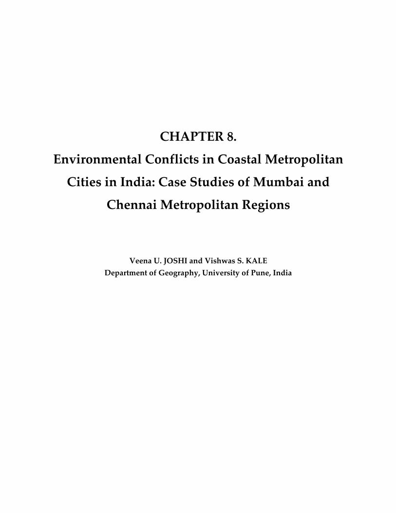
3.2 Case Study II - “Pallikaranai Marshland at the brink of collapse”
It represents another case of conflict between local residents vs. government/forest
department. Pallikaranai Marshland (PML) is one of the few major ecological hotspots in the
Chennai Metropolitan Region (Figure 8.3). Wetlands are a critical element of national and global
ecosystems and economies and are important for their biodiversity and conservation. Despite a
growing understanding of their many values and functions, urban wetlands remain one of the
V. U. Joshi, et al., Environmental Conflicts in Coastal Metropolitan Cities in India
- 325 -
most threatened resources in India. They continue to be regarded as wastelands even now and
therefore their destruction continues without much concern. The state of Tamil Nadu has
three major wetland areas — Point Calimere; Kaliveli and Pallikaranai Marsh and the above
mentioned Pallikaranai Marshland (PML). PML is the largest natural rain water harvesting
system in the CMR. Pallikaranai used to store large quantities of storm water, even while
allowing excesses water to flow into the sea.
It came into existence as a salt marsh created by the backwaters of Bay of Bengal. With
the construction of Buckingham canal in 1876, the inflow of sea water was virtually stopped,
thereafter the copious inflow of rain water turned the swamp into a freshwater body. PML is a
few meters above the sea level and consists of black mud in which many water plants grow.
Figure 8.3. Location of Pallikaranai Marshland in Chennai Metropolitan Region.
SECOA, Vol. 4. Environmental Conflicts in Coastal Urban Areas
- 326 -
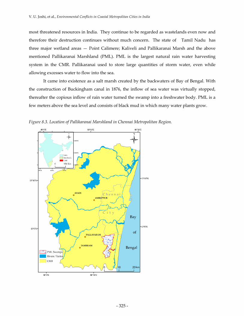
The marshland served two important functions – flood control in the hinterland areas,
and groundwater recharge. The inflow of storm water during the northeast monsoon over
hundreds of years has made the marsh a unique mix of freshwater (in the north) and brackish-
estuarine water in the south. The partly saline and largely freshwater marshland is
characterized by a variety of aquatic grass species and waterlogged areas (Figure 8.4). The
marsh is home to many species of fish, frog, reptiles (including the rare skink Lygsoma
albopunctata a recent addition to Tamil Nadu's reptilian fauna), birds and mammals (Table 8.1).
The most common species include Little Grebe (~700) and Black-winged Stilt (~150). According
to Raj et al. (2010), the PML is also home to nearly threatened bird species such as Spot-billed
Pelican Pelecanus philippensis and Black-headed Ibis Threskiornis melanocephalus.
Figure 8.4. Rich biodiversity of Pallikaranai Marshland.

V. U. Joshi, et al., Environmental Conflicts in Coastal Metropolitan Cities in India
- 327 -
Table 8.1. Species distribution of flora and fauna in Pallikaranai Marsh. Source: Shaktivel et al. (2010).
Sr. No Plant/Animal group Number of species
1 Plants 114
2 Butterflies 7
3 Cruscacenes (crabs and prawns) 5
4 Molluscs (snails and clams) 9
5 Fishes 46
6 Amphibians (Frogs and toads) 10
7 Reptiles 21
8 Birds 115
9 Mammals 10
Total 337
Though the PML has no legal protective status, it is considered biologically significant
by the Tamil Nadu scientific community and it is included in the All India Bird Survey, as a
water fowls habitat, home to a variety of birds, reptiles and amphibians. Besides the
biodiversity richness (Figure 8.4), the PML has immense ecosystem service value. It is the main
outlet of the storm water that drains Madipakkam, Velachery, Taramani and the neighbouring
suburbs. It has been a source of drinking water to people in the immediate neighborhood, and
has sustained agriculture for many centuries before degradation sets in with Chennai’s
increasing profile as a metropolis.
3.3 Case Study III - Massive destruction of mangrove forests in Mumbai
Mumbai’s historical records indicate that there were several islands around Mumbai in
the late 17th century. However, the Britishers, who were controlling the area at that time,
recognized the importance of these islands for commercial purpose. They deforested the
fringing mangroves and reclaimed these islands into one continuous landmass, which later
came to be known as "Greater Bombay" (now Greater Mumbai). The term “mangrove” usually
refers to a tidally influenced wetland complex, consisting of mangrove forests, tidal flats, salt
flats and other associated habitats within the intertidal zone of tropical and subtropical
latitudes. The intertidal wetland is composed of a mosaic of interacting components linked by
flows of water, sediments, nutrients, organic matter and animal populations that move among
its component elements. Traditionally, local communities in mangrove ecosystems collected

SECOA, Vol. 4. Environmental Conflicts in Coastal Urban Areas
- 328 -
fuel wood, harvested fish and other natural resources. For much of history many people have
regarded mangroves as wastelands, but the scale of human impact on mangroves has increased
dramatically in recent years.
Figure 8.5. Map showing the distribution of mangroves in Mumbai Metropolitan Region. Numbers 1 to
6 indicate the sectors depicted in Figure 8.13 (1-6).
Many coastal areas have come under intense pressure from rapid urban and industrial
development, compounded by a lack of governance or power among environmental
institutions. Mangroves have been overexploited or converted to various other forms of land
use, including agriculture, aquaculture, salt ponds, terrestrial forestry, urban and industrial
development and for the construction of roads and embankments. Mumbai is one of the best
examples for the mangrove destruction due to urbanization. All the seven islands of Mumbai
were reclaimed and linked to a continuous land mass after destroying mostly mangrove forests.
Since then the development and subsequently population pressure rapidly increased
and being the coastal area, it took the toll of mangrove land. During the process of deforestation

V. U. Joshi, et al., Environmental Conflicts in Coastal Metropolitan Cities in India
- 329 -
and reclamation, a few mangrove patches are still left in the heart of the city, which proves that
today's megacity had a luxuriant past of mangrove forests (Fig 5). Mumbai has gone through
many cycles of mangrove deforestation and land reclamation and during this time the
mangrove cover of Mumbai has been brought to less than one third of its original amount.
However, large continuous areas of mangrove cover are still seen today in parts of Mumbai,
especially along Thane Creek.
By trapping silt, mangroves maintain the integrity of Mumbai’s shoreline. This is a vital
service to the city of Mumbai as it is very prone to erosion, having been built on reclaimed land
that is surrounded by the sea on all three sides. The Koli fishermen community in Mumbai
worships mangroves because they know that these are breeding and nursery grounds for the
marine organisms on which their nourishment and economic wellbeing depends. Around 20
out of the 35 species of true mangroves found in India have been identified along the
Maharashtra coast and 15 species of these are found in Mumbai. Because of the high salinity of
the soil, something like 60 per cent of Mumbai mangroves comprise of Avicennia marina. This
specie also tolerates pollution including heavy metals such as lead, mercury and chromium, all
found in significant concentrations in the Mithi River, in Greater Mumbai and elsewhere.
4. Overview of users in the case studies
4.1 Case I - Sanjay Gandhi National Park
Over the period of years, there has been encroachment on this lifeline from various
quarters, such as slum shanties, stone quarries, housing colonies and a flourishing timber mafia
etc. Several factors were at play to initiate and accelerate the pressure placed on the Park, the
most prominent being its location between two of the fastest growing cities in the country,
namely, Greater Mumbai and Thane (Figure 8.1). Whereas the population of Greater Mumbai
increased from 5.9 to 11.9 million between 1971 and 2001, the population of Thane increased
from 0.2 to 1.2 million between the same periods. Thane remains one of the fastest growing
neighborhoods, reflecting the mounting importance of the suburbs, which house more than
40% of the Mumbai population in 2001 (Zerah, 2007). With the ongoing changing pattern of
population location, the Park has now become embedded in the middle of dense populated
urban settlements. This has become the prime factor behind the encroachment within the
peripheries of the Park (Figure 8.6).

SECOA, Vol. 4. Environmental Conflicts in Coastal Urban Areas
- 330 -
Table 8.2. Encroachment status in SGNP in January 1995. Source: Jadhav (1995).
Land use/cover category Area in ha % area
Agriculture 35.13 4.68
Settlements and Huts 511.65 68.09
Quarrying 111.49 14.84
Agriculture + Settlement 98.17 13.06
Total area of encroachment 751.44 100.00
Encroachment came from both migrating as well as a residing population that engaged
in environmentally destructive activities such as tree felling. The encroachment initially began
in 1970s and by the mid-1980s the growth became rapid. After 1990 there was steep rise in the
number of hutments and land encroachment had already taken place, mainly by the hutments
(Table 8.2).
Figure 8.6a. Nagars/padas encroaching SGNP (Source: http://www.mumbaikarsforsgnp.com/docs/preli
minary_study_on_the_diet_composition_of_the_leopard.pdf).

V. U. Joshi, et al., Environmental Conflicts in Coastal Metropolitan Cities in India
- 331 -
Figure 8.6b. High-rise buildings, another form of illegal dwelling on the margins of the SGNP.
The problem was neglected for many years and politicians and slum lords did not loose
this opportunity to grab the situation for their benefits. Slum lords tied with local politicians and got hold of poor migrants and “sold” patches of land to them with assurances of
permanency. These politicians saw a huge opportunity for a vote bank for the State election in November 1994 from these people and hence protected and even created new illegal
settlements in the Park. This undoubtedly resulted in massive deforestation, wildlife loss and
the degradation of the quality of the lakes. Commercial enterprises, including equally commercial ‘shrines’ mushroomed; khair treewood was illegally felled to feed the Gutka (a
tobacco product) Industry. By 1995, there were 0.4 million illegal squatters within SGNP. The encroachments, including quarries, covered an area of over 700 ha. By mid-1995, 27 ha of forest
were lost to 800,000 new settlers.
The situation became seriously threatening as the time passed and NGOs concerned with the environmental dimension of sustainability such as the Bombay Natural History Society
and the Bombay Environmental Action Group (BEAG) came forward and filed a Public Interest Litigation (PIL) in 1995 against the Government of Maharashtra and others in order to protect
the Park. To pinpoint the exact number of encroachments, the SGNP authorities had taken the
help of Space Application Centre (SAC) which has mapped forest encroachments through remote sensing images of the whole national Park (Jadhav, 1995). This map was used as
evidence in the High court. Figure 8.6a and b provide glimpses of encroachment in the Park.

SECOA, Vol. 4. Environmental Conflicts in Coastal Urban Areas
- 332 -
The first High Court order came on 15th January 1997 with the verdict for the State Government to stop further encroachment on the Park. Following that Court gave various
interim orders with the specific orders of activities that need to be banned in the Park. The interim order of 17th July 1999 mentioned the removal of the illegal structures and relocation of
the inhabitants with certain compensation amounts. Tribal members claiming to have been living in the park for generations contested the court orders. Tribals and adivasis cannot be
equated with slum-dwellers, unauthorized occupants and trespassers. The final judgment was
given on 15th September 2003 with the Tribal Petition Order that cases could be reconsidered if the government classified some of the families as tribal members.
Mumbai High Court (MHC) defined those who came after 1995 as illegal occupants and there was order of immediate demolition of their houses. There was strong resistance from the
residents and they challenged various court orders on the basis of right to stay and by
presenting property titles. The following months saw large numbers of petition being filed against the court orders. The Court dismissed all the claims stating that a fair deal was made for
resettling the inhabitants. The protest came from 2500 tribes as well who had been living here for generations. The Econet (an NGO) report acknowledges the presence of these tribes but the
Deputy Conservator of the Forest denied their presence. Hence, on this strength court dismissed their case. So, only 30% of the occupants have been relocated till date. The Park is still
facing problems of encroachment despite the MHC asking authorities to clear the Park of all
inhabitants more than a decade ago. The biggest problem in removing the encroachment is the patronage they receive from local politicians. An exclusive study of SGNP was conducted by
Vaquier (2010) and he opined that when evictions are deemed necessary, the proposed options should not only provide ownership and basic services but also immediately provide social
infrastructure (a gap in education or healthcare could potentially have permanent implications
on poverty) as well as commercial tenements. The Forest Department and non-governmental organizations (NGOs) that work for wildlife protection set about implementing the court ruling.
However, their attempts at evicting the encroachers met with resistance from human rights activists.
4.1.1 Man-Animal Conflict
In 2005 with extensive media coverage the Park once again revived the interest of public
with the outbreaks of numerous leopard/panther attacks that took place in the summer of 2004
and the beginning of 2005. Shrinking habitat has forced these cats to stray from the Park and
enter nearby neighborhoods. From 1998 to 2005, the total number of people injured by leopard

V. U. Joshi, et al., Environmental Conflicts in Coastal Metropolitan Cities in India
- 333 -
was 42 and over 100 people were killed during this period. The state administration announced
steps to tackle the leopard/panther problem, first by installing micro-chips and solar fencing to
stop the wild cats from encroaching the city limits. However, as the city's boundaries crept
further in, the leopard's habitat shrank and prey dwindled. At least 37 straying leopards were
caught in 2004. Plans are afoot to release them in the wild with electromagnetic chips so that
they could be tracked and permanently locked up if they attacked people again. Until the Park
is fenced and the adivasis are properly resettled, the fear of more such attacks linger.
4.2 Case II - Pallikaranai Marshland
The PML extended over 5500 ha about 30 years back. A portion of it has been classified
as wasteland since 1970. According to a study by Tamil Nadu Pollution Control Board (TNPCB)
as well as a committee constituted by the Madras High Court, what is left now of this
marshland is a pathetic 10% of the original extent. It is partly because of the administrative
fragmentation of the marsh area into multiple Panchayats and partly because the area was torn
up by urban residential, transport and commercial development. Roads, construction of Mass
Rapid Transit System (MRTS), mushrooming IT industry, dump sites of both Chennai and
Alandur Municipal Corporations have been responsible for reducing the size of the marshland.
Table 8.3. Analysis of change in the area and perimeter of the Pallikaranai Marsh since 2003. Source:
(Chandramohan and Bharati, 2009).
Segment of marsh Year Area (ha) Perimeter Edge Development
Garbage dump 2003 50.25 5.785 2.30
2005 57.54 6.046 2.24
Area impacted by garbage/sewage
2003 58.75 - -
2005 132.25 - -
Northern Segment 2003 227.0 12.11 2.26
2005 150.0 7.6 1.74
Southern Segment 2003 284.0 9.32 1.56
2005 279.0 11.8 1.99
Total 2003 620.0 c.13.0 -
2005 620.0 c.13.0 -
SECOA, Vol. 4. Environmental Conflicts in Coastal Urban Areas
- 334 -
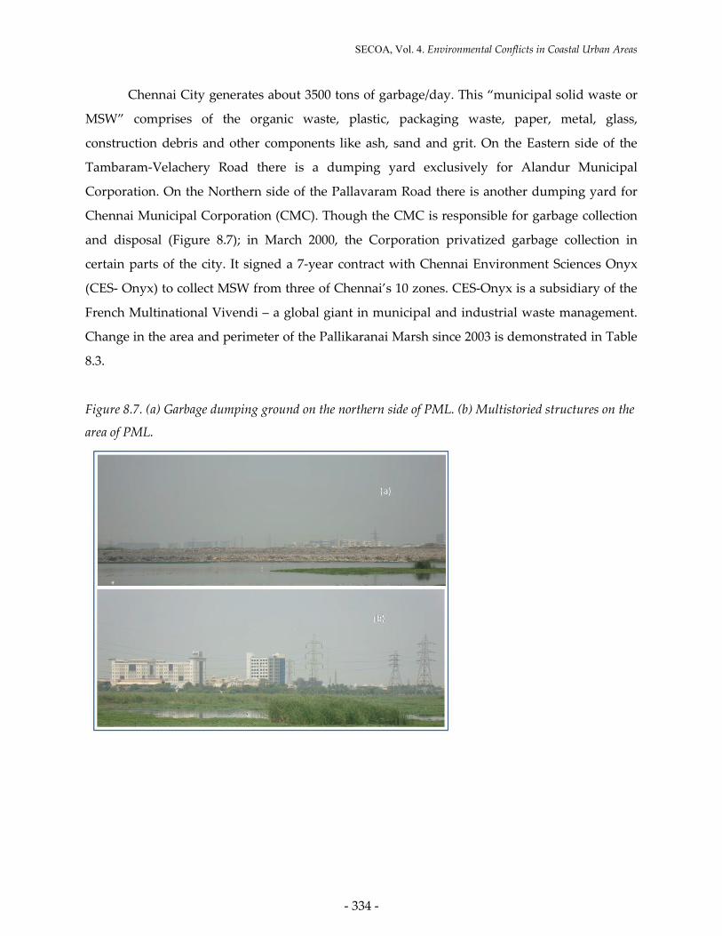
Chennai City generates about 3500 tons of garbage/day. This “municipal solid waste or
MSW” comprises of the organic waste, plastic, packaging waste, paper, metal, glass,
construction debris and other components like ash, sand and grit. On the Eastern side of the
Tambaram-Velachery Road there is a dumping yard exclusively for Alandur Municipal
Corporation. On the Northern side of the Pallavaram Road there is another dumping yard for
Chennai Municipal Corporation (CMC). Though the CMC is responsible for garbage collection
and disposal (Figure 8.7); in March 2000, the Corporation privatized garbage collection in
certain parts of the city. It signed a 7-year contract with Chennai Environment Sciences Onyx
(CES- Onyx) to collect MSW from three of Chennai’s 10 zones. CES-Onyx is a subsidiary of the
French Multinational Vivendi – a global giant in municipal and industrial waste management.
Change in the area and perimeter of the Pallikaranai Marsh since 2003 is demonstrated in Table
8.3.
Figure 8.7. (a) Garbage dumping ground on the northern side of PML. (b) Multistoried structures on the
area of PML.

V. U. Joshi, et al., Environmental Conflicts in Coastal Metropolitan Cities in India
- 335 -
Everyday the CMC and CES- Onyx dump the garbage collected from around the city
and the metro water dumps raw sewage in Perungudi, in the ecologically sensitive PML.
Groundwater in several pockets around the marshlands is now contaminated. The rich organic
content of the MSW degrades over time to release highly acid and toxic leachate. Dark pools of
foul smelling streams are common in the area around the garbage dump. Mass kills of frogs,
fish and sometimes water birds has also been reported. Garbage dumping and burning is
causing air pollution and is a serious health threat to local residents.
4.2.1 Beginning of the conflict
Around the mid-1990s, the Tambaram-Velachery Highway was re-laid and the area has
been blessed with "enviable development". However, in proportion to this "development", the
marsh is losing its value as a well-balanced ecosystem. Constructions, sanctioned and
otherwise, have stripped the swamp of a large extent of land and squeezed the fauna and flora
into 743 ha. Out of this, 213 ha are with the Chennai Corporation. Legally it is allowed to use 30
ha to dump garbage. Instead, it is using 180 ha to throw 3500 tons of garbage everyday. The
Municipality has appropriated 180 ha of the marsh for dumping and incinerating garbage. If
garbage is not bad enough, nearly 40 MLD of domestic sewerage is being drained into the
wetlands everyday. Perungudi Sewerage Treatment Plant (STP) is located in the northeast.
Various central government buildings are constructed in the PML after landfilling. The
construction of Mass Rapid Transit System (MRTS) has taken up a marshland area of ~93 ha.
The National Institute of Ocean Technology (NIOT) and the Central Wind Energy Technology
(C-Wet) is also located in the PML (Table 8.4). The boom of IT industry captured the margins of
the wetland. All these construction activities depleted the total area of PML. Apart from this,
illegal structures are eating into the wetland. Landfill is another upstream source of
contamination. Ideally a landfill should not be located up gradient of any drinking water
source. But PML was once water supplying source that have been destroyed by landfilling. The
slum households for MRTS project were allotted resettlement areas by land filling. This new
settlement known as “Mylai Balaji Nagar” occupies ~ 4 ha. A private hospital has been
constructed over a large area. Almost all houses, commercial establishments in between radial
road and Madipakkam Road are constructed mainly by landfilling.

SECOA, Vol. 4. Environmental Conflicts in Coastal Urban Areas
- 336 -
Table 8.4. The encroachments in the Pallikaranai Marshland Source: Shaktivel et al. (2010).
Sr. No Land Allotment Area in ha
1 Metropolitan Rapid Transport System (MRTS) 92.4
2 Film Employees Federation of South India 34.4
3 Ashram Latha Rajanikanth Trust 5.0
4 Tamil Nadu Agricultural Marketing Board 12.1
5 Dr. Ambedkar Law University 8.1
6 Judicial Academy 6.0
7 MMRD Road 200’ width 13.6
8 IIT, Chennai 17.8
9 National Institute of Ocean Technology (NIOT) 20.3
10 Government Free Pattas 2.0
11 Land Allotted for Ex-Servicemen 61.7
Total 273.6
The wetland was once a habitat of numerous birdwatchers. Over the years, many of
them have turned their back on the deteriorating marsh. Poachers (narikoravas) and local
weekend hunters (shikaris) seem to be working overtime to denude the wetland of its bird life.
The tiny stints and sandpipers are also targeted. These poachers set up clandestine roadside
markets for the day.
Garbage burnt is another serious environmental issue in Pallikaranai Marshland area. At
the Keelkattalai junction of Medavakkam Main Road and Pallavaram Thoraipakkam Radial
Road, garbage is dumped on a water channel below a bridge and burnt throughout the day.
Thick layers of black, obnoxious and toxic fumes continue to envelop the residential areas
located around the dumping yards. As early as September, 2005, air sample from a burning
garbage heap was taken as a part of Community Environmental Monitoring and analysed in
Columbia Analytical Services in Simi Valley. A total of 27 chemicals were found in the sample.
Out of these, 15 chemicals exceed the health-based standards set by UEPAs, 3 chemicals
(Butadiene, Benzene, Chloromethane) are known to cause cancer. Butadiene, Benzene and
Chloromethane were 102 to 103 times higher than the safe levels. Most of the chemicals target
the central nervous system and the respiratory system. This is significant, given the large
residential population in the area.
Conversion of marshland for various developmental activities has drastically reduced
its storage capacity. Recent floods in South Chennai are caused by this. The old storm water

V. U. Joshi, et al., Environmental Conflicts in Coastal Metropolitan Cities in India
- 337 -
canal to the sea was blocked by encroachments and the fencing of the area adjacent to the dump
yard. With the fast expansion of the city towards South some of the sensitive stretches like IT
corridor face untold misery during floods. Residents complaint water logging was a problem
earlier also, but the retention time had increased alarmingly now during monsoon.
4.2.2 Efforts to save the wetland
In recent times, local residents, NGOs and naturalists are taking concerted efforts to save
the Pallikaranai Marshland. Their demands are (a) Withdraw the remaining area from the
Corporation's control, (b) Declare the entire remaining area a sanctuary for wetland birds, (c)
Reclaim alienated areas and carry out afforestation (d) Shift garbage dump to some other
location (e) Include the PML in the National Wetlands Conservation Program and (f) Construct
a sewage treatment plant at Velachery. As a response to a Public Interest Litigation (PIL) by
bodies, legal measures have been taken and the 317 hectares land in Pallikaranai was declared
reserved land in 2007 and the process is now on to declare it as a reserved forest area. The
project also aims at providing alternate employment opportunities to poor people who live near
the marshy land and those who had been affected by the tsunami in 2004.The High Court in
April 2008 directed the Chennai Corporation to establish an integrated waste management
facility, remove all encroachments from the marshland and stop the four municipalities —
Pallavaram, Madipakkam, Kottivakkam and Valasaravakkam — from dumping garbage in the
marshland area. However, in spite of the public protests and court order, the Chennai
Corporation continues to dump garbage daily, and burn it.
4.3 Case III - Mangrove destruction in Mumbai
In the early 1990s, a vast stretch of mangroves existed in Mumbai, largely in the Thane
Creek, Mahim, Versova, Gorai and Ghodbunder, with sporadic patches in places such as
Bandra, Malabar Hill and Colaba. Mumbai has probably lost 40% of all its mangroves in the
past decade or so, largely because of reclamation for housing, slums, sewage treatment and
garbage dumps. Rapid developments like housing, industrialization, pollution and increasing
population of Mumbai has resulted into degradation of mangroves. Between 1997 and 1998
about 3,400 m2 of mangrove in Malad, a north Mumbai suburb, was reduced to 1,400 m2.
Gigantic malls came up on the 2,000 m2 that had been filled in rapidly by dumping debris.
During the earlier years of development, there was no law of a substantive nature, which would
serve as a deterrent to the destruction of mangroves.

SECOA, Vol. 4. Environmental Conflicts in Coastal Urban Areas
- 338 -
Table 8.5. The changes in the area under mangroves in Greater Mumbai. Source: Vijay et al (2005).
Year Mangroves Classes
Total Area (km2) Sparse Mangroves (km2) Dense Mangroves (km2)
1990 75.08
(80.78 %)
17.86
(19.22 %)
92.94
(100%)
1996 43.44
(64.92 %)
23.47
(35.08 %)
66.91
(100%)
2001 30.80
(54.61 %)
25.60
(45.39 %)
56.40
(100%)
In recent decades, multi-storey buildings and thousands of unauthorized slums have
sprung up, which blatantly violate coastal regulations. The biggest culprits are the government
agencies such as the Mumbai Metropolitan and Regional Development Authority (MMRDA),
Maharashtra Housing and Area Development Authority (MHADA) and City Industrial
Development Corporation (CIDCO), which have been reclaiming mangroves for their various
projects. Slum dwellers living near mangrove swamps depend mainly on mangrove firewood
which is free and good. At a number of places, like Versova, Bandra-Kurla Complex, Millat
Nagar, Mumbra, Andheri and Charkop, there have been blatant violations of the Coastal
Regulation Zone (CRZ). Table 8.5 depicts the changes in the area under mangroves in Greater
Mumbai.
4.3.1 Moves from the NGOs
The first campaign to save mangroves was initiated by Debi Goenka at the Rewas Jetty
in the Raigad district in 1983. A large tract of mangroves (about 100 hectares) was then being
destroyed for industrialisation by reclaiming this “wasteland”. ‘Save Mangroves’ campaign was
then taken up by the Bombay Environmental Action Group (BEAG), which filed various
petitions in the Bombay High Court and the Supreme Court of India to protect this important
and vulnerable ecosystem in our country. The Conservation Action Trust (CAT) takes this
legacy ahead and spearheads the mangrove conservation programme in Mumbai and the State
of Maharashtra.

V. U. Joshi, et al., Environmental Conflicts in Coastal Metropolitan Cities in India
- 339 -
4.3.2 Legal Steps
All mangroves are protected under Coastal Regulation Zone (CRZ) 1. They are
protected legally under the following Acts in Mumbai:
• Maharashtra Tree Act of 1975
• Forest Conservation Act 1980
• Environment Protection Act 1986
• Coastal Regulatory Zone Notification of 1991 and 2011.
Further, in the year 1991 the Coastal Regulation Zone (CRZ) Notification was set in
place under the stringent provisions contained in the Environment Protection Act 1986. Under
provisions of this CRZ Notification, the areas, which were occupied by mangroves, were
classified as being in CRZ-I. This classification made the place very restrictive. In such areas,
only those activities, which were related to ports and harbours and those allied with them, were
permitted to be constructed. All other activities were banned. Any violation of these would not
only lead to the undoing of the construction but also that could lead to penal consequences for
imprisonment of up to 5 years, as provided for under section 15 of the Environment Protection
Act, 1986.
In 2005, Bombay High court banned and froze destruction of Mangroves in Maharashtra
and construction within 50 m of CRZ area. Mangroves Society of India (MSI) and Conservation
Action Trust (CAT) are two major organizations who strongly protest against destruction of
mangroves in Mumbai city. The court has also directed to notify mangrove areas as protected
forests. The Bombay High Court issued an important ruling which restricts no-forest activities
in mangrove areas along the state's coast. A division bench ruled that its directive would hold
irrespective of whether the government had notified a mangrove plot as "protected forests" or
not. However, blatant disregard of the law and destruction of mangroves are happening all
around Mumbai.
4.3.3 Mangrove Conservation Centers
The Soonabai Pirojsha Godrej Marine Ecology Centre (SPG) has taken several measures
to protect these mangroves as a part of environmental and social responsibility. One of the
major objectives of the centre is conservation of the marine diversity (mangrove ecosystem)

SECOA, Vol. 4. Environmental Conflicts in Coastal Urban Areas
- 340 -
through research, education/awareness building and regular monitoring. Simultaneously,
centre is engaged in the propagation of various species of Mangroves, developing theme parks
on medicinal plants and rare endemic plant species, palms amongst others.
The Western bank of the Thane Creek is the single largest mangrove belt in Mumbai. A
substantial tract of mangrove land is adjoining the Godrej & Boyce Township, Pirojshanagar, in
Vikhroli a suburb of Mumbai. The mangrove flora of Pirojshanagar is well diversified. There
are 16 species of mangroves and mangrove associates. The faunal composition in the area is also
equally diverse. Vast area under mangroves has been conserved by SPG Marine Ecology
Centre. Well diversified and well protected, these are the last- quality mangroves in the city.
The vast expanse of these mangroves serves as a second lung of the city only after the Sanjay
Gandhi National Park which is under immense environmental pressures.
5. Ranking of the Conflicts
Conflicts between groups emerge for a variety of reasons. A conflict often occurs when
there is a ‘perception’ that one group is gaining (in economic terms, maximising their utility) at
the expense of another. Of the three typology of natural resource conflicts proposed by Warner
(2000), all the three conflicts fall under the third category of micro–macro conflicts, as it involves
conflict between State Forest Department, environmental problems and contradictory resource
needs. In the third context the conflict is between the mangroves and the human. Instead of
realising the ecosystems provided by the mangroves as the resource, the land occupied by them
have been rated as more valuable. The conflict arises out of non-acceptance of the value of this
natural resource. This is only partly due to the lack of knowledge, but largely due to the greed
of short term gain. This typology includes elements that are not directly related to immediate
stakeholders in the resource. Based on the conflict dynamics proposed by Cadoret (2009), all the
three conflicts can be classified under Chronic conflicts. Chandrasekharan (1996) classified
conflicts into six categories, - (a) conflicts over access, (b) conflicts due to change in resource
quality and availability, (c) conflicts regarding authority over resource, (d) conflicts that are
value based, (e) conflicts associated with information processing and availability, (f) conflicts
occurring for legal/policy reasons. Applying his concepts into the present context, it will be the
V. U. Joshi, et al., Environmental Conflicts in Coastal Metropolitan Cities in India
- 341 -
second type of conflict which involves conflicts due to change in resource quality and
availability.
The legal battle which has been fought for over a decade over the issue of encroachment
has almost come to an end with the Supreme Court dismissed all the petitions filed against the
encroachers in SGNP. The only hurdle at the moment is whether it will be possible to relocate
all the encroachers and how long it will take for the Government to completely resolve the
issue. In case of PML, 317 acres of the wetland have been declared as reserved forest in the year
2007. The demands for cessation of the wetland being used as the dump yard and to remove the
sewage treatment plant are still going on. After years of neglect, awareness is arisen amongst
several people now. Five different stages of conflict are described by Rupesinghe (1995) and the
present conflict of Pallikaranai Marshland falls under the ‘Management Stage’, while Sanjay
Gandhi National Park has reached the ‘Transformation Stage’
White et al (2009) uses the term ‘biodiversity conflict’ to refer to those conflicts that
involve natural resources related to specific habitat or species, including wildlife and invasive
or introduced species, but also draw on literature that addresses conflicts over natural resources
and other environmental conflicts in a wider sense. So, natural resource management typically
deals with conflicting interest of various stakeholders since they use the same resources for
different purposes (Reed et al, 2009). It often means that one party can achieve its goals only at
the expense of the other party.
Indiscriminate destruction of mangroves has been legally put to an end after the HC
Order in Mumbai. In addition to it, ‘as per the high court order dated 27.01.1010, no ‘non forest
activity’ is allowed in the mangrove areas. However, illegal clearance of the mangrove forest, as
well as attempts to kill the mangrove plants by blocking the natural inflow of water etc. are still
in practice in many places. In this conflict we can include the natural ecosystems of the
mangroves as stakeholder following the definition by Starik (1995) that “Any naturally occurring
entity that affects or is affected by organizational performance.” “Any naturally occurring entity” gives
us the possibility to include more than just people (Freeman, 1984). Therefore the natural
environment (mangrove ecosystem) itself should be seen as a (primary) stakeholder (Haigh et
al, 2009; Starik, 1995) in this conflict.
The conflict in mangrove areas is also in the ‘Conflict Transformation Stage’. This can be
considered the implementation stage of the conflict resolution. This stage includes new
institutional development. In the case of natural resource conflicts, it is possible at this stage to

SECOA, Vol. 4. Environmental Conflicts in Coastal Urban Areas
- 342 -
implement projects or programmes that assist in better addressing the natural resource conflict
(Rupesinghe, 1995).
5.1 Conflict Management
At this stage it is relevant to identify conflict hotspots which will help to provide the
decision makers with a more rational, objective and unbiased approach to spatial decision
making. Two different methodologies have been adopted for the three case studies. In case of
SGNP and PML, multicriteria decision analysis (MCDA) and geographical information systems
(GIS) were adopted for zonation of the conflicting areas where as due to the patchy nature of
occurrence of the mangroves, the most seriously affected areas have been identified from the
comparison of the satellite images.
The methodology for conflict analysis employed by Tuda et al (2007) has been adopted
here for both SGNP and PML. First, the conflicting stakeholder values causing conflict were
determined. These values are structured hierarchically into objectives and attributes using the
Analytical Hierarchy Process (AHP) (Saaty, 1980; 2008). Second, GIS is applied to demarcate
the conflict areas.
AHP is used to structure the problem and to incorporate the conflicting stakeholder
values into a formal procedure (Saaty, 1980, 2008; Malczewski, 1999). The basic steps of
constructing and examining an AHP model are used: (1) decomposing the problem into a
hierarchical structure, (2) performing judgments to establish priorities for the elements of the
hierarchy, (3) synthesizing the model, and (4) performing a sensitivity analysis (Tuda et al,
2007).
The problem was constructed in a hierarchical structure consisting of goal, objectives
and attributes for SGNP (Figure 8.8) and PML (Figure 8.9). After constructing the AHP
hierarchy, weights of relative importance were assigned to individual objectives and attributes
in each level of the hierarchy. The pairwise comparison technique is applied in assigning the
weights (Saaty, 1980).
The GIS phase involved representing each attribute as a map layer in the GIS database.
Different habitat maps were developed using 5.8-m resolution IRS LISS IV images, while the
stakeholder activity maps were developed from reports of NGOs and Government
organizations and discussions with NGOs and Government Officials.

V. U. Joshi, et al., Environmental Conflicts in Coastal Metropolitan Cities in India
- 343 -
Figure 8.8. Analytical Hierarchy Process (AHP) – the structure of conflict analysis for SNGP showing
goal, objectives and attributes.
Dense Forest0.009
GoalIdentify and demarcateenvironmental conflict
In SGNP
CriteriaCritical habitat
Protection 0.076
Tourism0.179
Caves0.020
Safari0.119
Bird Watching0.039
Film Shooting0.062
Trekking0.047
Urban Landuse0.654
Quarrying0.056
Agriculture0.071
Construction0.110
Slums0.143
Timber0.090
Film City0.100
SubCriteria
AAATransport 0.184
MangrovesA0.03
AAA
Water bodies0.014
Wild life0.009
Sparse Forest0.014
Figure 8.9. Analytical Hierarchy Process (AHP) – the structure of conflict analysis for PML showing
goal, objectives and attributes.
Bird0.004
GoalIdentify and demarcateenvironmental conflict
In PML
Criteria Critical habitatProtection 0.06
Pollution0.28
Air pollution0.17
Surface Water pollution
0.07
Urban Landuse0.66
Construction0.125
Transport0.046
Garbage dump0.442
Sewage plant0.050
SubCriteria
Marshy AreaWithout
Vegetation0.015
Water bodies0.150
Marshy AreaWith healthyVegetation
0.031Ground
Water pollution0.03

SECOA, Vol. 4. Environmental Conflicts in Coastal Urban Areas
- 344 -
A buffer zone of 1-km in width was defined around the Park in case of SGNP. The attribute weights derived in Phase 1 were then added to respective attribute map layers in GIS to determine the coefficient of conflict of each attribute. The coefficient serves as a rating of the effectiveness of each attribute in achieving the goal. The resulting map layers were combined linearly to obtain the overall conflict ratings. Three levels of criticality were defined as low, moderate and high.
5.2 Spatial coverage of conflict
5.2.1 SGNP
The results of conflict analysis (Figure 8.10) show spatial coverage for different levels of conflict. The analysis reveals that 21% of study area is under the high level of conflict. The zones of high conflict are confined to the eastern and western margins of the Park. In a reserved National Park, 21% illegal occupation of land with high level of conflict clearly is a matter of concern.
Figure 8.10. Map showing the conflict zones in and around Sanjay Gandhi National Park.
V. U. Joshi, et al., Environmental Conflicts in Coastal Metropolitan Cities in India
- 345 -
The boundary of the SGNP is shown with black outline in Figure 8.10. The total peripheral length of the park is 91 km, out of that 56 km (61%) is low conflict zone and 19 km (21%) of the boundary is under high conflicting zone.
Low levels of conflict occur in the central part of the SGNP where there is thick coverage of protected forest. This is understandable so because encroachments creep from the peripheral boundaries of the Park and is steadily spreading inward and also they are easily accessible in the form of open land and sparse forest. Along the water bodies and the film city the conflict is medium. The two fresh water lakes such as Vihar and Tulsi are in the midst of thick forest hence no permanent activities are developed around here. However, due to their scenic beauty they attract a large number of tourists. Trekkers and bird watchers swarm these places.
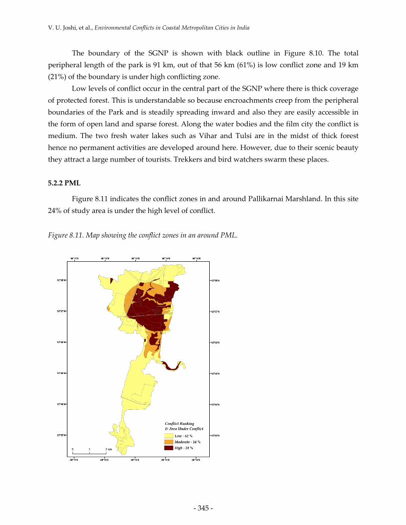
5.2.2 PML
Figure 8.11 indicates the conflict zones in and around Pallikarnai Marshland. In this site 24% of study area is under the high level of conflict.
Figure 8.11. Map showing the conflict zones in an around PML.

SECOA, Vol. 4. Environmental Conflicts in Coastal Urban Areas
- 346 -
The zones of high conflict are confined to the north-central part of the marshland. It
encompasses the areas in and around the dump yard, and Perugundi Sewage Plant. There is an
expansive open water body in this part, which is covered with water hyacinth and shows high
level of pollution. The water is polluted mainly from two sources, such as, the garbage dumps
and the effluents from Sewage Treatment Plants. Air pollution is due to the garbage burning.
There is also lot of encroachment in this part. Hence all the conflicting factors are concentrated
in this part of the marshland. The entire peripheral boundary zones exhibit low conflict areas in
the analysis. This zone occupies 42% of the area.
5.2.3 Mangrove destruction in Mumbai
In case of the third case study, the identification of such conflicting zones is achieved by
carrying out satellite image analysis. For that, for the entire Mumbai, IRS-PAN 5.8 m resolution
image (2 scenes) and LISS III image of 23 m resolution (one scene) were merged to generate
product image, for the year 1997. For the year 2008, 16 scenes of LISS IV of 5.8 m resolution
were used and supervised classifications were conducted employing Maximum Likelihood
Classifier. Spot data for the year 1990 for Greater Mumbai analyzed by Vijay et al (2005) also
has been incorporated. From the classified images, the affected areas have been separately
clipped and their areas were calculated. GoogleEarth image and few GPS points have been
referred during the classification.
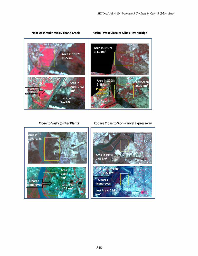
According to Vijay et al (2005) study, the total areas under mangroves were 169 km2 in
1997 for MMR. In 2008, it has been reduced to 157 km2, the total loss being 12 km2 in 11 years
as can be seen in Figure 8.12. In Greater Mumbai, there was 94 km2 of the area under
mangroves in 1990, which has been reduced to 54 km2 in 2008 (Figure 8.12). A good 38 km2 of
mangrove forest has been lost within just a decade. Most of the seriously affected sectors are
along Thane Creek. It is clearly seen in the images depicted in Fig. 13 that MMR have lost large
patches of mangroves to buildings and slums. The seriously affected sectors are Mira
Bhayander and Dahisar mangroves.

V. U. Joshi, et al., Environmental Conflicts in Coastal Metropolitan Cities in India
- 347 -
Figure 8.12. Area under mangroves in 1997 and 2008 in MMR (upper panel), Area under mangroves in
1990 and 2008 in Greater Mumbai (lower panel). Data source: Vijay et al (2005).
Figure 8.13. Satellite images depicting few sites from where mangroves have been cleared. Location of
these sectors are marked in Figure 8.5. (LISS-III+Pan merged 1997 and LISS-IV 2008).
SECOA, Vol. 4. Environmental Conflicts in Coastal Urban Areas
- 348 -

V. U. Joshi, et al., Environmental Conflicts in Coastal Metropolitan Cities in India
- 349 -
6. Conclusion
6.1 Sanjay Gandhi National Park
It is a vivid example of conflict over the resources. The parties involve involuntary stakeholders in the form of SGNP and its flora and fauna and illegal encroachers. If we follow
the definition of Starik (1995) and Freeman (1984) for stakeholders, it is “Any naturally occurring entity that affects or is affected by organizational performance.” This gives us the flexibility to include
more than just people (Freeman, 1984). Some even argue that the natural environment itself should be seen as a (primary) stakeholder (Starik, 1995; Haigh et al, 2009). The stakeholders,
especially in an urban coastal setting, are varied. Besides the economic, ecologic and social
values at stake in these areas, there are the less tangible concepts like the right to a clean environment, the protection that wetlands and dunes offer in case of floods, or doesn’t the
exploitation of this site put a strain on future development or discoveries. So the presence of a human spokesman cannot always be guaranteed in the case of natural resources management.
The local fauna and flora also has a right to be a stakeholder in conflict analysis over resources.
The leopard attacks in SGNP are a clear representation of conflict over resources. In the conflict, the role of NGOs was to act as spokesman for the protection of the inhabitants. There can be
seen clear pictures of the role of politicians to act on their own interest over the issue. After the final court verdict, the question remained “whose voice was heard?” It brought out the dubious
stand of the court while defining who were really considered responsible for the environmental degradation. The view that poor represent a threat to the environment sustainability as it
focussed on squatter settlements rather than number of large bungalows built in the Park
(Zerah, 2007).
6.2 Pallikaranai Marshland
After years of neglect, the floods of 2002 that inundated all the residential areas
adjoining the marsh changed the overall perspective of residents in South Chennai and
protection of the marsh became peoples’ agenda and the forum ‘Save Pallikaranai Marsh Forum’ was formed. Following this, nature lovers, environmentalists and civic groups have
been pressing for protecting the area. In April 2007, 317 ha of the marsh were finally declared a Reserved Forest, which is considered as the first positive response from the Government. This
may reduce the conflict sores from the core areas in the following years.
The present conflict represents a unique case having a strong social relevance, where there is competition for space between people and natural habitats. In India, land is

SECOA, Vol. 4. Environmental Conflicts in Coastal Urban Areas
- 350 -
undoubtedly the most important resource and with the increase in population all over the country especially in the city areas, the demand for land for various uses is also increasing out
of proportion. According to the general view over the decades, a vast stretch of marshland not fit for any economic use is a ‘wasteland’. If it can be made to serve any use whether in the form
of dumping ground or agricultural areas or construction sites by land filling, it was considered a far better option.
6.3 Mangrove Destruction in Mumbai
In addition to land reclamation by industrial houses, developers, builders and non-point
sources of industrial and domestic waste discharges that pollute the mangrove forests in Mumbai, every year, over 1000 tons of mangrove wood is cut for fuel wood and to meet other
timber demands. We need to protect the mangroves since mangroves are buffers between the
land and sea and hence they protect the land from erosion. They are land builders and harbour a variety of life forms like invertebrates, fish, amphibians, reptiles, birds and even mammals
like tigers. Mangroves are the main source of income generation for shoreline communities like fisher folk. In the wake of gradual climate change and rising sea levels, the rapid development,
which is evident from the disappearing of the dense mangrove forest and other trees along the
Vasai and Thane Creek, may spell disaster for the rather under-prepared city in the near future. The main culprit in the destruction of mangroves is Man. To achieve supremacy over nature,
human beings have destroyed this magnificent ecosystem almost irreparably. Floods in Mumbai on July 2005, and the disaster that followed demonstrated the consequence of
tampering with the ecology of fragile ecosystems like mangroves. During flood, the areas with mangrove land could absorb all the rainwater and areas where the mangrove zone had been
reclaimed suffered severe flooding. Protection of the mangrove ecosystem is possible only
through the participation of the local community and by building up pressure groups for ensuring management of this ecosystem and strict implementation of the legal provisions by
the Government. Thereby, integrity of habitats critical for spawning, juveniles and feeding and for biodiversity, apart from ecological sustainability and community-sustainability could be
maintained.
Resource conflicts primarily arise due to the scarcity and multifunctional nature of resources. Resource conflicts are an inevitable part of the rapidly expanding urban
agglomerations such as Mumbai and Chennai. Conflicts over land, water and forests are common. Forest resources (including mangrove forests) are the most contentious issue, given
their varied uses. Encroachments (authorized and unauthorized), dumping of solid waste,

V. U. Joshi, et al., Environmental Conflicts in Coastal Metropolitan Cities in India
- 351 -
poaching of wildlife, etc. have led to severe conflicts among multiple users. Three case studies have been presented in the chapter that focuses on the conflicts in the two coastal cities of India,
such as Mumbai and Chennai. Two case studies have been selected from Mumbai and one from Chennai (Table 8.6).
A social scenario strongly emerges out from these conflicts, such as that all the three cases involve problems of encroachment and tussle between Government/ Forest department
and local residents. In India, majority of the conflicts arise out of land acquisition problems,
which is true for any country with heavy population pressure. Sanjay Gandhi National Park is a wooded area within the heart of the city which is the lungs of the city, presently facing the
threat of encroachment from the building mafias and slum lords. Pallikarnai Marshland is a natural marshland which is shrinking in its size dramatically in the past two decades. Likewise
once a luxurious cover of mangroves have been reduced to only restricted patches now in
Mumbai as we have lost them to the builders and slums. Table 8.6 gives the summary of the findings of the three case studies.
Table 8.6. The three case studies included in this report.
Name Area Status Nature of encroachment
Conflict zone Present Scenario
Sanjay Gandhi National Park (SGNP)
103 km2 Reserved Forest
Buildings
Slums
Quarries
Low (66%)
Moderate (13%)
High (21%)
High Court Order to evacuate all the settlements from the park. 60% have been relocated so far, tribals are resisting the court order.
Pallikarnai Marshland (PML)
5500 ha before 30 years, presently 500 ha
Wetland Garbage dumps, Sewage treatment plant, Government buildings
Low (62%)
Moderate (14%)
High (24%)
317 ha declared as protected area,
Garbage dumping and burning, causing pollution
Mangroves in Mumbai
157 km2
(MMR)
56 km2
(Greater Mumbai)
Protected, in CRZ-1
Slums, buildings. Sewage treatment, Garbage dump
Maximum encroachment, Dahisar, Mira Bhayandar.
Thane Creek
In spite of court order, mangrove reclamation steadily continues
In spite of the similarity in the three cases, we can see clear differences in the approaches
of the intruders. Arguments such as “should we waste acres of unused marshland when we are
struggling for space for survival, etc.” come up during the investigation. However reasoning
like ‘trees, animals, birds and reptiles are the rightful owners of these places and they have the right to live in peace’ does not simply work. To conclude, it can be said that these
environmental conflicts cannot be solved purely by an authoritative approach, as it involves trade offs between differing objectives. There is a need of awareness about importance of these

SECOA, Vol. 4. Environmental Conflicts in Coastal Urban Areas
- 352 -
resources among the people of the country. Resident’s associations should come together to spread this awareness. Legislative measures remain as the famous saying ‘protected on paper,
plundered in practice’ if there is no public support. They must realize that the destruction of SGNP which is the lung of Mumbai or dumping of garbage in the marshland of Pallikaranai or
rapid destruction of mangroves along the coast of Mumbai will have far-reaching effects on the city against the short term benefits. Objectivity and fairness is difficult to attain when stakes are
high and the relationship among the actors unequal (Zarah, 2007). What is necessary is the
participation of the equal footage from all stake holders involved in all the three conflicts. To conclude, an extract from Ostrom (2000) could be sited here, such as, “When the benefits of
organizing are commonly understood by participants to be very high, appropriators lacking many of the attributes conducive to the development of self-governing institutions may be able
to overcome their liabilities and still develop effective agreements. The crucial factor is not
whether all attributes are favorable but the relative size of the expected benefits and costs they generate as perceived by participants. All of these variables affect the expected benefits and
costs of appropriators.
7. References
Cadoret, A. (2009) Conflict dynamics in coastal zones: a perspective using the example of
Languedoc-Rousillon, France. Journal of Coastal Conservation, 13 (2-3), pp. 151-163.
Chandrasekharan, D. (1996) Addressing natural resource conflicts through community forestry:
the Asian perspective. Presented at the Global e-Conference on Addressing Natural
Resource Conflict through Community Forestry. Forests, Trees and People Programme
of the Food and Agriculture Organization of the United Nations, Rome, Italy. Jan–Apr
1996.
Chandramohan, B.P. & Bharati, D. (2009) Role of Public Governance in the Conservation of
Urban Wetland System: A Study of Pallikkaranai Marsh. Proceedings of The Indian
Society for Ecological Economics (INSEE). 5th Biennial Conference, Ahmedabad, India.
January 21-23 2009.
Freeman, R. E. (1984) Strategic management: A stakeholder approach. Boston: Pitman.
Haigh, N. & Griffiths, A. 2009. The natural environment as a primary stakeholder: the case of
climate change. Business Strategy and the Environment, 18 (6), pp.347-359.

V. U. Joshi, et al., Environmental Conflicts in Coastal Metropolitan Cities in India
- 353 -
Jadhav, R.N., (1995) Encroachment in Sanjay Gandhi National Park, Journal of Indian Society of
Remote Sensing, 23, pp. 87-88
Malczewski, J. (1999) GIS and Multicriteria Decision Analysis. John Wiley & Sons, Inc. Toronto.
Ostrom, E. (2000) Reformulating the Commons. Swiss Political Science Review 6(1): 29-52
Raj P. P. N, Ranjini. J, Dhanya. R, Subramanian. J, Azeez P.A & Bhupathy, S. (2010)
Consolidated checklist of birds in the Pallikarnai Wetlands, Chennai, India,
Journal of Threatened Taxa, 2, pp. 1114-1118.
Reed, M.S., Graves, A., Dandy, N., Posthumus, H., Hubacek, K., Morris, J., Prell, C., Quinn,
C.H., & Stringer, L.C. (2009) Who’s in and why? A typology of stakeholder analysis
methods for natural resource management. Journal of Environmental Management 90
(2009) 1933–1949.
Rupesinghe, K. (1995) Multi-Track Diplomacy and the Sustainable Route to Conflict Resolution.
Cultural Survival Quarterly. (Fall 1995), pp. 13-18.
Saaty, T.L. (1980) The Analytical Hierarchy Process (New York, McGraw-Hill).
Saaty, T.L. (2008) Decision making with the analytic hierarchy process. International Journal of
Services Sciences, 1 (1), pp. 83-98.
Sakthivel, M., Senthilkumari, S.K., Priyadharshini, J. & Shobana, L. R. (2010) Managing
Sustainable –Protected Area in Urban Environment: Observations from Pallikarani
Marshlands of Chennai, India. BiodiverCities 2010, Paris, http://biodivercities.
files.wordpress.com/2010/07/sakthivel-mathi-paper-summary-biodivercities-2010.pdf.
Starik, M. (1995) Should trees have managerial standing? Toward stakeholder status for non-
human nature. Journal of Business Ethics, 14 (3), pp. 207-217.
Tuda, A. O., Rodwell, L. D. & Stevens, T. (2007) Conflict management in Mombasa Marine
National Park and Reserve, Kenya: a spatial multicriteria approach, Proceedings of the
Workshop on a Regional Perspective on MPAs in the Western Indian Ocean Rodrigues
Island, Mauritius, 63-72 UNCHS, 2001.
UNCHS, (2001) Cities in a Globalising World. Global Report on Human Settlements. The
United Nations Centre for Human Settlements. Earthscan Publishers Ltd., London, p
171.

SECOA, Vol. 4. Environmental Conflicts in Coastal Urban Areas
- 354 -
Vaquier, D. (2010) The impact of slum resettlement on urban integration in Mumbai: the case of
the Chandivali Project. Publication of the French Research Institutes in India. CSH
Occasional paper No 26 / 2010
Vijay, V., Biradar, R.S., Inamdar, A.B., Deshmukhe, G., Baji, S. & Pikle, M. (2005) Mangrove
mapping and change detection around Mumbai, using remotely sensed data. Indian
Journal of Marine Sciences, 34(3), pp. 310-315.
Warner, M. (2000) Conflict management in community-based natural resource projects:
experiences from Fiji and Papua New Guinea. Working Paper, 135. Overseas
Development Institute, London.
Zerah, M.H. (1997) Conflict between green space preservation and housing needs: The case of
Sanjay Gandhi National Park in Mumbai, Cities, 24, pp. 122-132.

Annex I.
Veena U. JOSHI and Vishwas S. KALE, Department of Geography, University of Pune, India.
email: [email protected]
email: [email protected]
Joshi, U. Veena; Kale, S. Vishwas, "Environmental Conflicts in Coastal Metropolitan Cities in
India: Case Studies of Mumbai and Chennai Metropolitan Regions". In: Ahmed Z. Khan, Le
Xuan Quynh, Frank Canters, Eric Corijn (ed.), Environmental Conflicts in Coastal Urban Areas:
Towards a Strategic Assessment Framework for Sustainable Development. Cap. 8. SECOA FP7
Research Project, Vol. 4. Rome: Sapienza Università Editrice, 2013. ojs.uniroma1.it. DOI:
10.7357/DigiLab-10442. Web. 12 July 2013.
ABSTRACT: The first case study presented in this chapter is Sanjay Gandhi National Park
(SGNP), which is the largest national Park within the urban sprawl of Mumbai. Illegal
quarrying and heavy encroachment are threatening the Park. Mumbai High Court ordered the
removal of all the encroachments but failed to achieve the desired results. The second case
study; Pallikaranai Marshland (PML) is partly saline and largely freshwater marshland in
Chennai. The marshland is facing massive environmental problems, such as, fragmentation and
reclamation of marshland for urban development, garbage dump, disposal of partially treated
sewage and loss of habitat due to reclamation and garbage dump. The Madras (Chennai) High
Court directed the Chennai Corporation to establish an integrated waste management facility,
remove all encroachments for the marshland and stop the municipalities from dumping
garbage in the marshland area but the legal verdicts have not been able to put a complete halt to
the abuse and the degradation continues. The third case study involves mangrove preservation
in Mumbai. Rapid developments like housing, industrialization, pollution and phenomenal
increase in population has resulted into degradation of the mangroves, leaving behind a patchy
picture of mangroves, struggling to survive or mutely facing the mortality due to human greed.
All the three case studies have one thing in common; environmental abuse, legal protection
following intervention from NGOs and finally to be unable to completely put an end to the
situation. These conflicts can be classified under chronic conflicts based on the conflict
dynamics proposed by Cadoret (2009), and are in the transformation stage as per Rupesinghe’s
(1995) classification.

Annex I.
KEYWORDS: global changes, coastal areas, environmental conflicts, Mumbai, Chennai
Submitted: 13th August 2012
Accepted: 17th October 2012
Final Revision: 13th June 2013
Published: 12th July 2013


![Coastal Processes and Conflicts - files.nc.gov · Coastal Processes and Conflicts: E } Z } o ] v [ K µ v l ... Coast: Sea-Level Rise and Estuarine Dynamics, a NC Sea Grant publication](https://img.pdfslide.net/doc/110x75/5f02e60b7e708231d4068f52/coastal-processes-and-conflicts-filesncgov-coastal-processes-and-conflicts.jpg)