Embed Size (px)
Citation preview
World Bank Financed
Ningbo Sustainable Urbanization
Project
Environmental Impact Assessment
December 2015
Ningbo Municipal Research & Design Institute
Of Environmental Protection
SFG1572
Pub
lic D
iscl
osur
e A
utho
rized
Pub
lic D
iscl
osur
e A
utho
rized
Pub
lic D
iscl
osur
e A
utho
rized
Pub
lic D
iscl
osur
e A
utho
rized
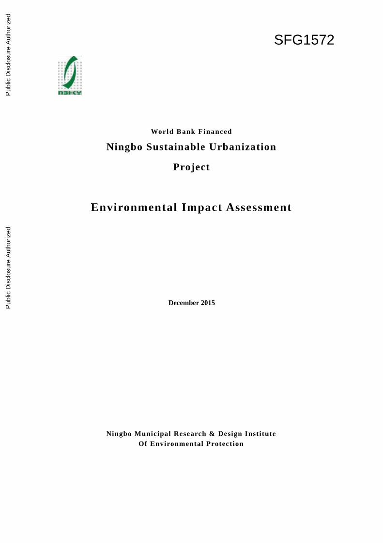
Project Name: World Bank Financed Ningbo Sustainable Urbanization Project
File Type: Environmental Impact Report
Applicable Assessment Range: Traffic and Transportation
Legal representative: ZHANG Bing (Signed and sealed)
Agency in Charge of EA Preparation: Ningbo Municipal Research & Design Institute of
Environmental Protection (NMRDIEP)
Environmental Assessment File: Environmental Impact Report
Client: Ningbo Management Office of World Bank Financed Project
Xiangshan World Bank Financed Project Management Project
Assessment Unit: Ningbo Municipal Research & Design Institute of Environmental
Protection (NMRDIEP)
EA Certificate: GuoHuanPingZheng Jiazi No. 2001 (National EA Certificate 2004)
President: ZHANG Bing
Person in Charge of EA: LIU Zhong
Chief Engineer: SHANG Weichun
Deputy Chief-engineer: TAN Dapeng
Person in Charge of Project: XU Yinchun
Cooperative Unit:
EA Qualification Certificate for Development Projects

World Bank Financed
Ningbo Sustainable Urbanization Project
List of Persons Preparing Environmental Impact Report
Presided by
Name
Vocational
Qualification
Certificate No.
Registration No. Profession Category Signature
Xu Yinchun 0011657 A20040330900 Traffic and
transportation
Key
Pre-
parer
s
No. Name Vocational
Qualification
Certificate No.
Registration
No. Contents Prepared Signature
1 Xu Yinchun 0011657 A20040330900 General review
2 ZHOU Jian 00013517 A20040341000 Sections 1, 2, 3, 6, 9
and 10
3 QIU Jixia 00016130 A20040411000 Sections 2, 3, 4, 5, 6
and 8
4 YU Tao 0011109 A20040291100 Section 7
Quqlity
Reviewer
Name Vocational
Qualification
Certificate No.
Registration
No. Review Category Signature
WANG
Xianhai 0009905 A20040221100 Professional Review
TAN
Dapeng 0001174 A20040090400 Department Review
SHANG
Weichun 0007307 A20040161100 Final review
Chief translator: ZHAO Jinwen ([email protected])
EIAR of Phase I of Ningbo Sustainable Urbanization Demonstration Project
I
Table of Contents
1 Introduction .................................................................................................................1
1.1 Preface .................................................................................................................... 1
1.2 Bases for Report Preparation .................................................................................. 1
1.3 Related Plans and Their Relations to This Project ................................................. 3
1.4 Environmental Function Zoning ........................................................................... 11
1.5 Applicable STANDARD ...................................................................................... 15
1.6 level and scope of assessment............................................................................... 19
1.7 Sensitive Objects Protected .................................................................................. 21
2 Description of Project ...............................................................................................25
2.1 Project background ............................................................................................... 25
2.2 road network improvement subprojects................................................................ 28
2.3 Public Space Retrofit Component ........................................................................ 33
2.4 Public Transportation Component ........................................................................ 34
2.5 Flood Risk Management Component ................................................................... 36
2.6 Investigation of Associated Projects ..................................................................... 42
3 Comparison of Alternatives .....................................................................................45
3.1 Comparison of Huancheng Xilu Route Alternatives ............................................ 45
3.2 Comparison of Terminal at Tashan ....................................................................... 48
3.3 Comparison of with and without Flood Risk Management Component .............. 50
4 Current Environmental and Social Condition .......................................................51
4.1 Summary of Natural Environment........................................................................ 51
4.2 Overview of Social Condition .............................................................................. 54
4.3 Present Environment Quality ................................................................................ 55
5 Analysis of Environmental Impact during Construction Period .........................66
5.1 Analysis of atomespheric impact .......................................................................... 66
5.2 Analysis of wastewater impact ............................................................................. 68
5.3 Analysis of construction noise impact .................................................................. 69
5.4 Analysis of solid waste impact ............................................................................. 71
5.5 Analysis of impact on ecological environment .................................................... 72
5.6 Analysis of social impact ...................................................................................... 73
6 Projection and Assessment on Environmental Impacts during Operation
EIAR of Phase I of Ningbo Sustainable Urbanization Demonstration Project
II
Period ................................................................................................................................74
6.1 Projection and assessment of acoustic environment impact ................................. 74
6.2 Projection and assessment of impacts to atmospheric environment ..................... 76
6.3 Projection and assessment of environment impact to surface water .................... 79
6.4 Projection and assessment on environment impact of solid waste ....................... 80
6.5 Social environment impact analysis ..................................................................... 80
7 Public Consultation ...................................................................................................81
7.1 Purposes and Bases of Public Consultation .......................................................... 81
7.2 Ways, Scope and Participators of Public Participation ......................................... 81
7.3 Information disclosure to Public ........................................................................... 82
7.4 Public consultation................................................................................................ 87
8 Environmental Social Management Plan ...............................................................94
8.1 Arrangements and Responsibilities of Project Environmental Management ....... 94
8.2 Environmental Impact Mitigation Measures ........................................................ 96
8.3 Environmental monitoring plan .......................................................................... 108
8.4 environmental training Programs ....................................................................... 110
8.5 Reporting and complaints mechanism ................................................................ 111
9 Environmental Management Framework ............................................................ 113
9.1 Subprojects selection criteria .............................................................................. 113
9.2 Subprojects siting criteria ................................................................................... 113
9.3 Preparatory Work for Environmental Assessment .............................................. 113
9.4 Public Consultation ............................................................................................. 114
9.5 Review and Approval ......................................................................................... 114
9.6 Implementation ................................................................................................... 114
10 Conclusions .............................................................................................................. 115
EIAR of Phase I of Ningbo Sustainable Urbanization Demonstration Project
III
Abbreviation, Acronyms and Some Chinese Pinyin and Han Characters
Abbreviation Acronyms Chinese Character
and Meaning of
Directions and
Common Place
Names
Bei 北, north, northern
Cun 村, village
Construction
supervision company
CSC
Dadao 大道, avenue
Developmen and
Reform Commission
DRC
Dong 东,east, eastern
Development and
reform bureau
DRB
Environmental
assessment
EA
Environmental impact
assessment
EIA
Environmental impact
assessment report
EIAR
General Guidelines for
Environment, Health
and Safety
EHS Guidelines
-he 河, river, canal
Huadong Engineering
Cooperation Limited,
HECL
Jie 街,street
Lu 路,road
nan 南, south, southern
Ningbo Municipal
Research & Design
Institute of
Environmental
Protection
NMRDIE
Ningbo Project Office
for World Bank
Financed Project
Ningbo Project Office
or Ningbo PMO
NPMO,
shan 山, hill or mountain
Shanghai Municipal
Engineering Design
Institute (Group) Co.,
SMEDI
EIAR of Phase I of Ningbo Sustainable Urbanization Demonstration Project
IV
Ltd.
Traffic Police Brigade TPB
Urban management
bureau
UMB
Xi 西, west, western
Xiang (County)
Environmental
Protection Bureau
Xiang EPB XEPB
Xiang (County)
Housing and Urban &
Rural Development
Bureau
Xiang Construction
Bureau (old abb.)
XHURDB
Xiangshan Planning
Bureau
XPB
Xiangshan Public
Transportation
Company
XPTC
Xiangshan Urban
Management Bureau
XUMB
Xilu 西路, western road
EIAR of Phase I of Ningbo Sustainable Urbanization Demonstration Project
1
Ningbo Municipal Research & Design Institute of Environmental Protection
1 Introduction
1.1 PREFACE
New urbanization is an important goal of China's development in the current stage, and the
enhancement of the new urbanization has been changed from undue emphasis on city size extension
and spatial expansion to promotion of urban culture and improvement of public services, etc. so as to
make our cities and towns become quality livable places.
The core of urbanization is urbanization of people, the key of it is to raise urbanization quality
and the purpose of it is to benefit common people and enrich farmers. In the new urbanization, we
should take a new, intensive, energy-efficient and ecological way, putting forth efforts to enhance the
inherent bearing capacity of city instead of artificial "creating a city"; we should realize the integration
of industrial development and city/town construction to allow migrant workers to be gradually
incorporated into cities and towns. We should create good conditions and provide markets for
agricultural modernization, making the new urbanization and agricultural modernization supplement
each other.
To accelerate the urbanization development in Ningbo, establish and improve a safe, rapid,
efficient, clean, economical and integrated, modernized urban transportation system as well as a flood
risk management system, the city intends to apply to the World Bank for its loan to strengthen the
urban transport management and flood risk management by reference of the Bank's advanced
experience in transportation management and flood risk management, so as to improve urban
infrastructures and public transport services to realize the objectives of urban sustainable development
and livability enhancement.
The project includes four components namely urban regeneration, urban transport, flood risk
management and technical assistance and capacity building, all concentrated in the core urban district
of Xiangshan County.
In accordance with the Environmental Impact Assessment Law, Administrative Regulations on
Environmental Protection for Construction Projects, Operative Policy OP 4.01 and other related
regulations, the project development agency (PMO) entrusted the Ningbo Municipal Research &
Design Institute of Environmental Protection to conduct an environmental impact assessment (EIA) on
the Ningbo Sustainable Urbanization Project to be financed by the World Bank (hereafter referred to
as this or the Project ), so as to have the Project developed in a way coordinated with the environment.
After being entrusted, our institute organized resources immediately to carry out field
investigation and data collection, having prepared this environmental impact report for this Project in
line with the related provisions of the Bank and national technical guidelines and standards for
environmental impact assessment.
1.2 BASES FOR REPORT PREPARATION
1.2.1 Main Laws and Regulations
1) Environmental Protection Law of PRC (Jan.2015);
2) Environmental Noise Pollution Prevention Law of PRC (Mar. 1997);
3) Atmospheric Pollution Prevention Law of PRC (Revised), January 1, 2016;
4) The Environment Impact Assessment Law of PRC (Sep. 2003);
EIAR of Phase I of Ningbo Sustainable Urbanization Demonstration Project
2
Ningbo Municipal Research & Design Institute of Environmental Protection
5) Law of PRC on Prevention of Solid Waste Pollution to Environment (Apr., 2005);
6) Water Pollution Prevention Law of PRC (Jun. 2006);
7) Administrative Regulations on Environmental Protection for Construction Projects (Decree
253 of the State Council, Nov. 1998);
8) Tentative Provisions for Public Participation in Environmental Impact Assessment (HuanFa
2006 [ No. 28];
9) List of Classified Administration on Environmental Impact Assessment for Construction
Projects (Decree 33 of the Ministry of Environmental Protection, Jun. 2015);
10) Provisions on By-level Review and Approval of Environmental Assessment Documents
(Decree 5 of Ministry of Environmental Protection, Mar. 2009);
10) Catalogue of Guiding Industrial Structure Adjustment (2011) (Revised 2013) (Decree 21 of
NDRC, May 2013);
12) Notice on Further Promotion of Environmental Supervision Pilot for Construction Projects
(HuanBan [2012] No. 5, Jan. 2012);
13) Zhejiang Environmental Protection Administrative Provisions for Construction Projects
(Revised 2014) (Decree 321 of the Zhejiang Provincial People's Government, Mar. 2014);
14) Notice of General Affairs Bureau of Ningbo Municipal People's Government on Limits of
Authority of Environmental Protection Bureaus at Municipal and County (city at county level) Level
in Review and Approval of Environmental Impact Assessment Documents for Construction Projects
(YongZhengFa [2015]No. 21, Mar. 2015);
15) Ningbo Administrative Provisions on Civilized Construction under Construction Projects
(Decree 195 of the Ningbo Municipal People's Government, Jan. 2012.
1.2.2 Related Regulations of World Bank
1) Environment Assessment (OP, BP and GP 4.01);
2) Physical and Cultural Resources (OP 4.11);
3) Non-voluntary Resettlement (OP.BP 4.12);
4) Business Information Disclosure (BP 17.50);
5) General Guidelines for Environment, Health and Safety (EHS Guidelines).
1.2.3 Related Technical Guidelines and Standards
1) Technical Guidelines for environmental impact assessment – General Principles (HJ2.1-2011);
2) Technical Guidelines for environmental impact assessment – Atmospheric Environment
(HJ2.2-2008);
3) Technical Guidelines for Environmental Impact Assessment – Surface Water Environment
(HJ/T2.3-93);
4) Technical Guidelines for Environmental Impact Assessment – Acoustic Environment
(HJ/T2.4-2009);
5) Technical Guidelines for Environmental Impact Assessment – Ecological Impact(HJ19-2011);
6) Zhejiang Technical Key Points of environmental impact assessment for Construction projects
(Revised version) (Zhejiang Environmental Protection Bureau, Apr., 2014).
EIAR of Phase I of Ningbo Sustainable Urbanization Demonstration Project
3
Ningbo Municipal Research & Design Institute of Environmental Protection
1.2.4 Plannings Concerned
1) The Master Planning for City (CoreUrban Area) of Xiangshan County (2006-2025);
2) Integrated Transportation Planning For Core Urban District Of Xiangshan County;
3) Specialized Public Passenger Transport for Urban and Rural Areas in Xiangshan;
4) Integrated Planning for Drainage (Rainwater) and Flood Prevention in Urban Area of
Xiangshan.
1.2.5 Environmental Function Zoning
1) Functional Zone Planning of Xiangshan for Ecological Environment (Xiangshan
Environmental Protection Bureau, XiangZhengFa [2008] No. 73, May 2008;
2) Water Functional Zone and Water environment Functional zone division scheme of Zhejiang
(ZheZhengBanFa [2005] No. 9, Dec. 2005);
3) Functional Zone Division Scheme of Ningbo for Ambient Air Quality (YongZhengFa [1997]
No. 67,Apr. 1997.4);
4) Notice on Adjustment of Functional Zoning for offshore Sea area of Zhejiang (Zhejiang
Development and Plan Commission and Zhejiang EPA, ZheHuanFa [2001] No. 242, Oct., 2001).
1.2.6 Technical Documents Related to Project
1)Feasibility Study Report on Integrated Transportation System Subproject in Xiangshan of
Ningbo under the Sustainable Urbanization Project Financed by World Bank (SMEDI);
2)Feasibility Study Report on Flood Risk Management Component under Ningbo Xiangshan
Sustainable Urbanization Project Financed by World Bank (HECL);
3)Other Materials Provided by Project Development Agency (PMO).
1.3 RELATED PLANS AND THEIR RELATIONS TO THIS PROJECT
1.3.1 Master Planning for City (Core urban district) of Xiangshan County (2006-2025)
The plannings under the Master Planning for urban drainage, flood prevention and road system
are briefly introduced as follows:
1)Urban Flood Prevention Planning
(1)Standard for Planning
The Flood control standard for the core urban district of Xiangshan is defined as 50-year return;
The Water-logging prevention standard is defined as 20-year return, 24 hr rainfall to be drained
out in 24 hr.
(2) Engineering Measures for flood control and Logged Water Drainage
(i) Regulating area shall be controlled to be 4.5 km2 within the whole catchment, 2.0 km2 of
which is the total bottom area of watercourses for drainage according to the requirements of river
network layout, the rest 2.5 km2, for retarding basin.
(ii) Because the communication time of the River network in the whole catchment will be
affected to some extent by land development sequence and other factors, the elevation is selected 4.3
m of the ground surface north to outer ring Chengnan Lu (road) and that is ascertained 4.0 m of that
EIAR of Phase I of Ningbo Sustainable Urbanization Demonstration Project
4
Ningbo Municipal Research & Design Institute of Environmental Protection
south to outer ring Chengnan Lu.
(iii) To respectively add a 35 m flood outfall and a 15 m flood outfall on the Menqiantu Seawall
and Xingfu Seawall.
(iv) To widen main watercourses and dredge transverse canals, and excavate flood interception
ditches where appropriate.
2) Urban Drainage Engineering Planning
(1) Drainage system
In the old urban are, a combined system is adopted in the short term, and a separate system will
be employed in the long term. In the new urban area, a separate system will be adopted.
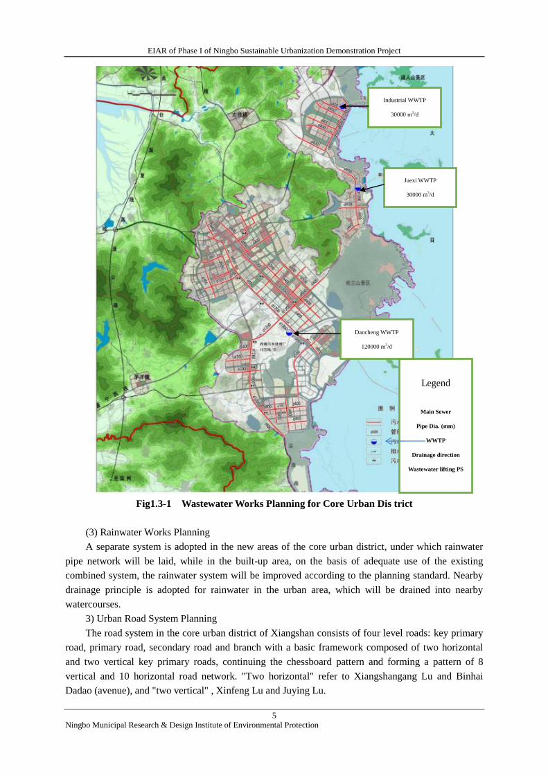
(2)Wastewater Works Planning Three wastewater treatment plants are set in the core urban
district, one for Dandong and Danxi Sub-districts with a capacity of 120 000 m3/d; the other two set in
Juexi, one of which is set in Zone C of the new industrial park for centralized treatment of industrial
wastewater with a capacity of 35000 m3/d and the other is a domestic sewage treatment plant with a
capacity of 30,000 m3/d.
In Qiangtou, Tuci, Maoyang Towns small-sized WWTP need to be built, each with a capacity of
3000-8000 m3/d, sewage from townships and villages will be collected for treatment in nearby
WWTP in the urban area.
Wastewater Works Planning for Core urban district can be seen in Fig. 1.3-1 below.
EIAR of Phase I of Ningbo Sustainable Urbanization Demonstration Project
5
Ningbo Municipal Research & Design Institute of Environmental Protection
Fig1.3-1 Wastewater Works Planning for Core Urban Dis trict
(3) Rainwater Works Planning
A separate system is adopted in the new areas of the core urban district, under which rainwater
pipe network will be laid, while in the built-up area, on the basis of adequate use of the existing
combined system, the rainwater system will be improved according to the planning standard. Nearby
drainage principle is adopted for rainwater in the urban area, which will be drained into nearby
watercourses.
3) Urban Road System Planning
The road system in the core urban district of Xiangshan consists of four level roads: key primary
road, primary road, secondary road and branch with a basic framework composed of two horizontal
and two vertical key primary roads, continuing the chessboard pattern and forming a pattern of 8
vertical and 10 horizontal road network. "Two horizontal" refer to Xiangshangang Lu and Binhai
Dadao (avenue), and "two vertical" , Xinfeng Lu and Juying Lu.
Legend
Main Sewer
Pipe Dia. (mm)
WWTP
Drainage direction
Wastewater lifting PS
Industrial WWTP
30000 m3/d
Juexi WWTP
30000 m3/d
Dancheng WWTP
120000 m3/d
EIAR of Phase I of Ningbo Sustainable Urbanization Demonstration Project
6
Ningbo Municipal Research & Design Institute of Environmental Protection
"Eight vertical" are: HuanchengXilu, Xiguhu Lu, Xinfeng Lu and YanhanNanxian, Laixun Lu
(south to Danyang Lu), Tianan Lu, Donggu Lu, Juying Lu and Xinjiang Lu;
"Ten horizontal" are: HuanchengBeilu, JingnanDajie, Xiangshangang Lu, Danyang Lu,
Xiangshanhe Lu, Danshan Lu, Danfeng Lu, Zhengshi Lu, BinhaiDadao and the planned primary road
south to BinhaiDadao.
1.3.2 Integrated Transportation Planning for Core Urban District of Xiangshan County
The planning horizon of the Planning is 2011 ~ 2020, and the long term horizon is to 2030. Under
the Planning, the objective of the urban road system planning is: with the existing road network and
urban road network under the Urban Master Planning as a basis, and in combination with the layout
form of urban land use and the orientation of future city expansion, to reasonably supplement, improve
and finalize the optimized road network scheme, which allows the urban area and transportation to be
developed harmoniously, and create basic advantageous conditions for the road network to ameliorate
the traffic environment in the core urban district of Xiangshan county.
Road Network Structure Map of Integrated Transportation Planning for Core urban district of
Xiangshan can be seen in Fig. 1.3-2.

EIAR of Phase I of Ningbo Sustainable Urbanization Demonstration Project
7
Ningbo Municipal Research & Design Institute of Environmental Protection
Fig. 1.3-2 Planning Map of Integrated Transportation Planning
For Core Urban District of Xiangshan - Road-Net Structure
1 ) Rapid Road Net Planning
According to the spatial distribution in the core urban district and land use planning, and in
combination with both of the existing road conditions and analysis of motorized vehicle flow through
cross-sections of main passages, a #-shaped rapid road-net scheme is proposed for the planning of
Xiangshan core urban district. As per the planning, such six roads will be upgraded to rapid road as
Xiangxi Line, Xiangshangang Lu, Huancheng Xilu, Juying Lu, Guihua Balu (Planned Road 8).
Among them, the function of HuanchengXilu is to assume through traffic and link Xiangxi Line
northward and Jinkai Lu southward to facilitate communications passing into and out of the city.
2 ) Secondary Road Net Planning
Secondary Roads are main roads between the urban clusters, which link with primary roads to
Huancheng Xilu planned
Baohai Lu planned
Terminal station
planned
Legend
Rapid road
Key primary road
Primary road
Secondary road
Branch road
EIAR of Phase I of Ningbo Sustainable Urbanization Demonstration Project
8
Ningbo Municipal Research & Design Institute of Environmental Protection
form the urban primary road net. From the viewpoint of transport, the main function of the
secondary roads is to gather and distribute traffic flows, meanwhile they also have the function of
facilitating daily life. The width of red boundary line of the road is 24 ~36 m, and the number of
motorized vehicle lane can be basically ensured 4 lanes, two-way.
1.3.3 Specialized Public Passenger Transport for Urban and Rural Areas in Xiangshan
1) Planning Horizon: Short term 2018 and long term 2025.
2) Planning objective: to gradually carry forward the transformation and upgrading of urban
and rural passenger transport, improve the urban public transit system in the core urban district, so as
to allow urban and rural residents to enjoy convenient, comfortable, safe, efficient, rapid,
environmentally-friendly and economical public passenger transport services;To realize the
intercoordination between the public passenger transport route-net,land use and industrial distribution,
And accomplish reasonable resource arrangement of public passenger transport infrastructures.
3) Key Planning Indicators
(i) Maximum trip duration: to take 30 min or less to travel between any two points in the
Xiangshan core urban district, and no more than 50 min to travel from the core urban district to each
center of a town/township.
(ii) Public transport sharing rate: in the short term, the proportion of trip by bus would amount
to 15%, while in the long term, 20%.
(iii) Holding quantity of public bus (HQPB): in the core urban district, HQPB 10 standard buses
per ten thousand people in the short term (2018), while 12 in the long term (2025).
(iv) Density of Public Transport Route Net (DPTRN): in the short term, DPTRN in the core
urban district would reach 3 km/km2 or so, while in the urban fringe, 2.0 km2 or so; in the long term,
3.5 km/km2 or more in the core urban district, while in other areas, 2.5 km/km2 or above.
4) Public transport terminal station planning:
Based on the existing terminal stations in the core urban district, 20 terminal stations named
Tashan, Laocheng etc. will be built under the planning. Among them, Tashan Terminal Station has
been included in the short-term construction plan, which is sited on the side southwest to the
intersection between Tashan Lu and Xingsheng Lu (Please refer to Fig. 1.3-2).
1.3.4 Integrated Planning for Drainage (Rainwater) and Flood Prevention in Main Urban
Area of Xiangshan
The Integrated Drainage and Flood Prevention Planning Report for the Main Urban Area of
Xiangshan has been approved recently, the primary coverage of this planning is cited as follows:
1) Planning Coverage
The scope of this planning covers the main urban area of the county, including major
watercourses within the main urban area of the county. The planning scope starts from Waihuancheng
Beilu (north outer ring road) in the north of the urban area, and ends at the seawall at Menqiantu
Erxian (Line 2); and borders Waihuancheng Xilu in the west, and links the foot of a hill in the east,
with an area of 36 km2 occupied by the planning zone, and a catchment area of 79.55 km2.
2) Planning Horizon
In general, the horizon of the drainage and flood prevention planning should be consistent with
EIAR of Phase I of Ningbo Sustainable Urbanization Demonstration Project
9
Ningbo Municipal Research & Design Institute of Environmental Protection
that of the Master Planning for the Core urban district of Xiangshan (2006-2025). However, because
the year of 2015 will be over soon, the planning horizon is adjusted to be 2018 in the short term, and
2025 in the long term.
3) Standard for Planning
(1) Flood prevention standard: 50-year return decided;
(2) Rainfall runoff control standard
(3) Drainage standard for rainwater pipe and ditch
The design recurrence interval P selected is 2 - 3 years for rainwater in average areas; P 3-5
years, in main areas where governmental, military, educational, medical organizations and other
important institutions and entities are located; P 20 years for underground passages, submerged
squares etc.
(4) Water-logging prevention standard
In the short term: The construction standard for water-logging control facilities is that under the
operation condition of Typhoon Fitow (10~15-year return), no overflow will occur through 24 hr.
rainfall;
In the long term: The construction standard for flood control facilities is that under the
operation condition of flood tide (20-year return), no overflow will occur through 24 hr. rainfall;
4) Scheme for the Planning
The drainage and flood prevention system (systematic scheme) for the main urban area of
Xiangshan is based on the drainage system which comprises "three verticals" (Dongda, Nanda and
Xida Rivers) and "four horizontal" (Magang'an and Menqian Rivers, Xiangshan, Hengjiang and
Hengda Rivers) as backbone drainage watercourses, with Caizuitou Gate, Yuetouzui Gate as terminal
drainage facilities and with Damutu retarding basin as safeguard. Furthermore, drainage and flood
prevention subzones are divided in consideration of the landform, metrological condition, water
resource status of Xiangshan and situation of the built-up drainage and flood control facilities in the
county. The general scheme of the planning is that giving priority to drainage with storage as
supplement; laying emphasis on pre-lowering water level, and controlling runoff".
5) Main Planning Coverage
The main planning coverage is separately described item by item as below:
(1) Urban rainfall runoff control and its utilization as Resource
(2) Planning for Flood Prevention System
According to the results of flood prevention subzones, the flood prevent planning is carried out
respectively for the subzone of the old urban area, that of the economic development park and that of
the new urban area; among them, in the old urban area, such measures will be taken as construction
of closed conduit works, pre-lowering water level of reservoir and tunneling for flood diversion, etc.;
in the economic development park, closed conduit will be constructed or retrofitted,water level of
reservoir pre-lowered and flood intercepting ditch will be constructed; in the new urban area, linking
with the Nanzhuang River net system on the plain and water level of reservoir pre-lowered, after these
measures being implemented, the once per 20-year water logging drainage standard can be met in all
the subzones, also the standard for prevention of 20-year return flood can be satisfied in the county.
(3) Planning for Urban Drainage (Rainwater) Pipeline Net System
Pursuant to the characteristics of the landform and watercourse distribution in Xiangshan and in
combination with the status quo of urban rainwater drainage, the county is divided into three
drainage subzones (old urban area drainage subzone, economic development park subzone and new
EIAR of Phase I of Ningbo Sustainable Urbanization Demonstration Project
10
Ningbo Municipal Research & Design Institute of Environmental Protection
urban area subzone), with a total area of 31.48 km2.
As per the planning, the drainage system in these subzones will adopt completely separate system
(among the subzones, in the old urban area the interception type combined system will be
reconstructed to be completely separate one).
(4) Construction arrangement in the near future
Under this drainage (rainwater) flood prevention planning, the near future construction scope
mainly includes the works related to watercourse realignment as set forth in the Report 2010 on
Planning for the Core urban district (Dancheng subzone) of Xiangshan County as well as correlated
works to be reconstructed or extended under this planning.
1.3.5 Relations with This Project
1) Relations to the Master Planning for City (Urban Core Area) of Xiangshan County
(2006-2025)
Under this project, the road net improvement component will be implemented, the scope of which
includes construction of Huancheng Xilu and Baohai Lu, the former belonging in one of the eight
verticals, a urban primary road; and Baohai Lu, a planned secondary road.
The aim of construction of the flood risk management component is to effectively cope with
disaster of 20-year return stormwater caused inland water logging. The implementation of the
component is in compliance with the standard of urban flood prevention. The drainage pipeline
reconstruction and watercourse dredging under this component are basically consistent with the
engineering measures for flood control and water logging prevention as well as the requirements of the
urban drainage works planning.
It is thus clear that the construction of this project overall conforms to the Urban Master Planning
for the Core urban district of Xiangshan (2006-2025).
2) Relations to the Integrated Transportation Planning for Core urban district of Xiangshan
County
As per the planning, both Huancheng Xilu and Baohai Lu are planned roads, the former being
defined as an urban rapid road and Baohai Lu, an urban secondary road. Under this road net
improvement component, the function of Huancheng Xilu is positioned as an urban primary road,
being a rapid passage on the fringe of the core urban district, while that of Baohai Lu, an urban
secondary road, an important horizontal passage for the built-up new urban area.
It can be seen that the implementation of this project is consistent with the Integrated
Transportation Planning for Core urban district of Xiangshan County.
3) Relations to the Specialized Planning of Xiangshan for Urban and Rural Public Passenger
Transport Development
The implementation of the public transport component accords with the development objective of
the planning, in addition, tashan terminal station belongs in one of terminal stations to be constructed
under the planning. Therefore, the construction of this project is consistent with the Specialized
Planning of Xiangshan for Urban and Rural Public Passenger Transport Development.
4) Relations to the Integrated Planning for Drainage (Rainwater) and Flood Prevention in Main
Urban Area of Xiangshan County
The reconstruction of drainage network and watercourse dredging works are basically consistent
with the contents of construction in the near future.
EIAR of Phase I of Ningbo Sustainable Urbanization Demonstration Project
11
Ningbo Municipal Research & Design Institute of Environmental Protection
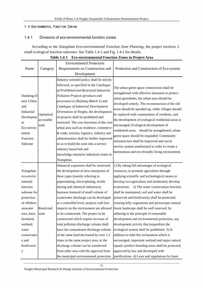
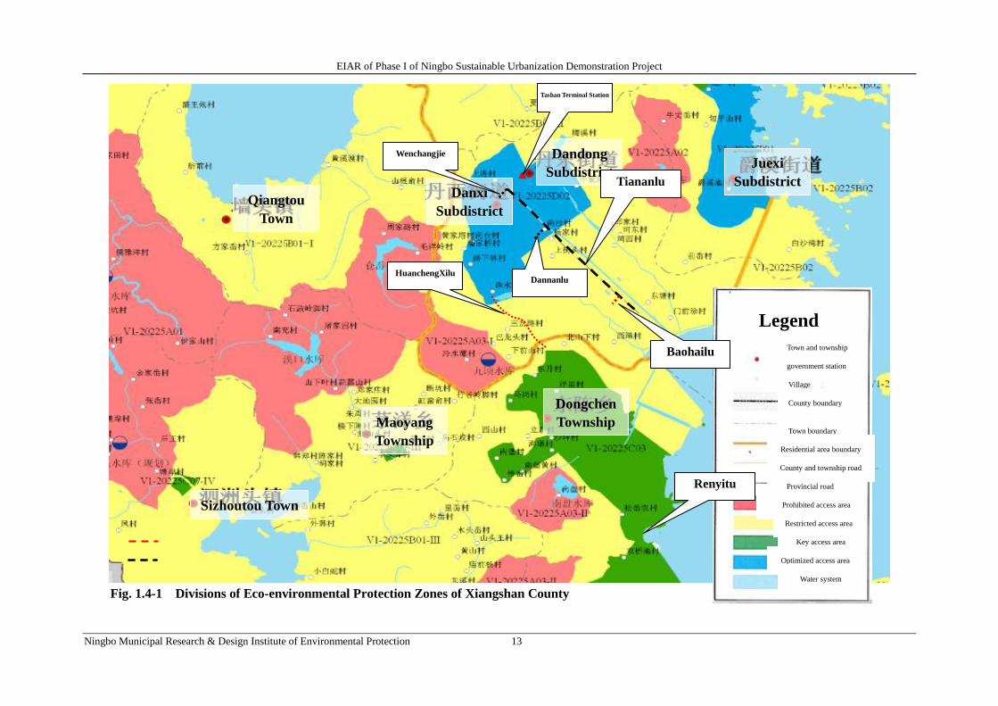
1.4 ENVIRONMENTAL FUNCTION ZONING
1.4.1 Divisions of eco-environmental function zones
According to the Xiangshan Eco-environmental Function Zone Planning, the project involves 2
small ecological function subzones. See Table 1.4-1 and Fig. 1.4-1 for details.
Table 1.4-1 Eco-environmental Function Zones in Project Area
Name Category
Environmental Protection
Requirements on Construction and
Development
Protection and Construction of Eco-system
Dandong-D
anxi Urban
and
Industrial
Developme
nt
Eco-enviro
nment
Function
Subzone
Optimized
accessible
zone
Industry-oriented policy shall be strictly
followed; as specified in the Catalogue
of Prohibited and Restricted Industrial
Pollution Projects (products and
processes) in Zhejiang (Batch 1) and
Catalogue of Industrial Development
Orientation of Ningbo, the development
of projects shall be prohibited and
restricted. The core functions of the core
urban area such as residence, commerce
& trade, tourism, logistics, industry and
administration shall be further improved
so as to build the zone into a service
industry based hub and
knowledge-intensive industrial center in
Xiangshan.
The urban green space construction shall be
strengthened with effective measures to protect
urban greenbelts; the urban area should be
developed orderly. The reconstruction of the old
town should be speeded up, while villages should
be replaced with communities of residents, and
the development of ecological residential areas is
encouraged; Ecological development of
residential areas should be strengthened; urban
green space should be expanded. Community
infrastructure shall be improved and social
service system ameliorated in order to create a
harmonious and eco-friendly living environment.
Xiangshan
eco-enviro
nmental
function
subzone for
protection
of offshore
seawater
area, basic
farmland,
wetland,
water
conservatio
n and
biodiversit
y
Restricted
zone
Industrial expansion shall be restricted;
the development of new enterprises of
three types (mainly referring to
papermaking, electroplating, textile
dyeing and chemical industries);
business featured of small volume of
wastewater discharge can be developed
at a controlled level, projects with less
impacts on the environment are allowed
to be constructed. The project to be
constructed which require increase of
total pollution discharge volume shall
have the contaminant discharge volume
of the same kind decreased by over 1.2
times in the same project area, or the
discharge volume can be transferred
from other area with the approval from
the municipal environmental protection
1) By taking full advantages of ecological
resources, to promote agriculture through
applying scientific and technological means to
develop eco-agriculture and moderately develop
ecotourism. 2) The water conservation function
shall be maintained, soil and water shall be
preserved and biodiversity shall be protected;
existing hilly vegetations and picturesque natural
forest landscape shall be well reserved; by
adhering to the principle of reasonable
development and environmental protection, any
development activity that jeopardizes the
ecological system shall be prohibited. 3) In
addition to tidal flat reclamation which is
encouraged, important wetland and major natural
aquatic product breeding areas shall be protected,
approved by law and developed with
justifications. 4) Laws and regulations for basic
EIAR of Phase I of Ningbo Sustainable Urbanization Demonstration Project
12
Ningbo Municipal Research & Design Institute of Environmental Protection
bureau. farmland protection shall be implemented in a
strict manner with intensified supervision and
administrative means.
EIAR of Phase I of Ningbo Sustainable Urbanization Demonstration Project
Ningbo Municipal Research & Design Institute of Environmental Protection 13
Fig. 1.4-1 Divisions of Eco-environmental Protection Zones of Xiangshan County
Legend
Town and township
government station
Village
County boundary
Town boundary
Residential area boundary
County and township road
Provincial road
Prohibited access area
Restricted access area
Key access area
Optimized access area
Water system
Sizhoutou Town
Maoyang
Township
Dongchen
Township
Qiangtou
Town
Danxi
Subdistrict
Dandong
Subdistrict Juexi
Subdistrict
HuanchengXilu
Tashan Terminal Station
Tiananlu
Baohailu
Renyitu
Wenchangjie
Dannanlu
EIAR of Phase I of Ningbo Sustainable Urbanization Demonstration Project
14
Ningbo Municipal Research & Design Institute of Environmental Protection
The project mainly aims to make Xiangshan an eco-county. The major construction works
involve municipal infrastructures including public transportation station works, road works and
municipal pipe network works and etc. for the purpose of optimizing the urban public traffic condition,
traffic management level, road network condition and flood control capability. However, the
prohibited and restricted works included in the Catalogue of Prohibited and Restricted Industrial
Pollution Projects (products and processes) of Zhejiang Province (Batch 1) and Catalogue of
Industrial Development Orientation of Ningbo and those with heavy pollution such as papermaking,
electroplating, textile dyeing and chemical projects will not be introduced. Moreover, the project
construction shall also be in compliance with environmental protection requirements for construction
activities specified in the Division of Eco-environmental Function Zones in Xiangshan (DEEFZX).
The project will improve infrastructures in the region and better social service system. A
harmonious and ecological living environment will be promoted in accordance with the ecological
protection and construction requirements specified in DEEFZX.
Meanwhile, effective ecological mitigation measures shall be adopted in the process of
engineering design and construction in order to maintain the water conservation and preserve soil,
water and biodiversity. The existing hills, vegetations and picturesque natural forest landscape shall
be well protected and any development activity that jeopardizes the eco-system shall be prohibited.
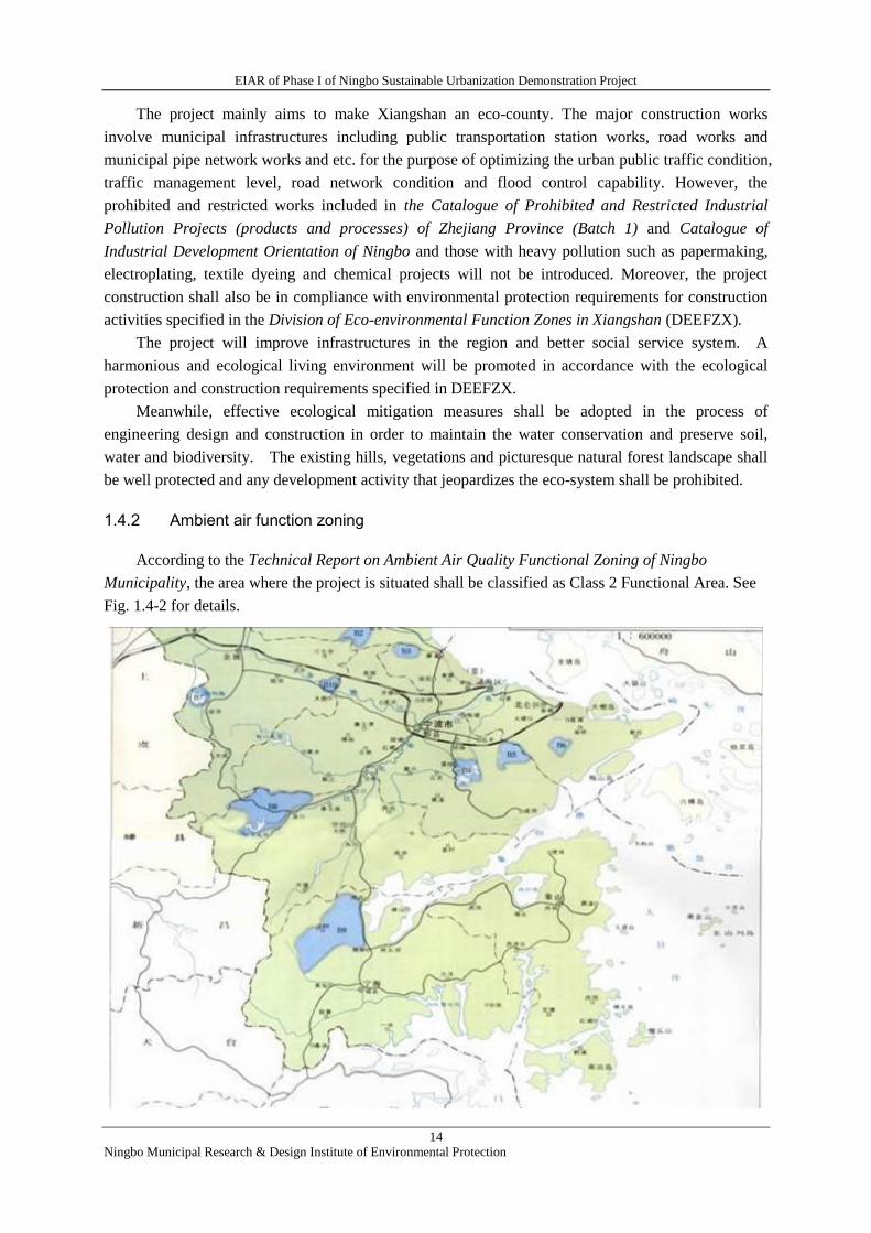
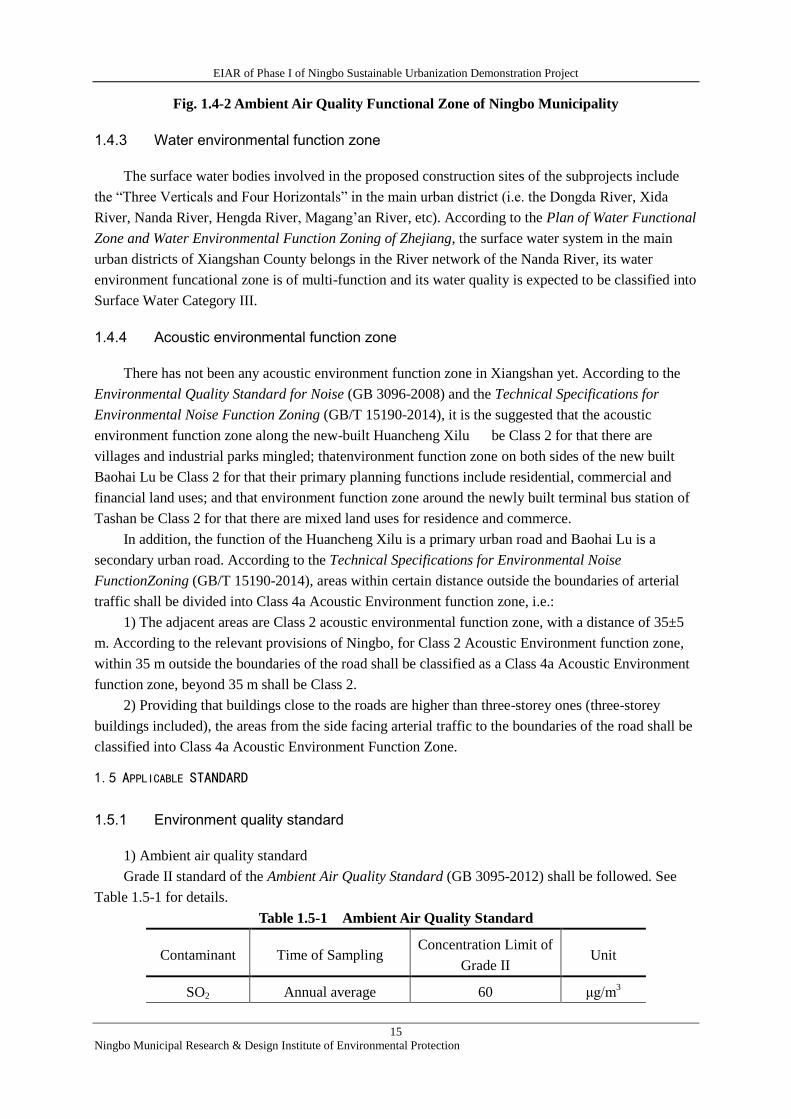
1.4.2 Ambient air function zoning
According to the Technical Report on Ambient Air Quality Functional Zoning of Ningbo
Municipality, the area where the project is situated shall be classified as Class 2 Functional Area. See
Fig. 1.4-2 for details.
EIAR of Phase I of Ningbo Sustainable Urbanization Demonstration Project
15
Ningbo Municipal Research & Design Institute of Environmental Protection
Fig. 1.4-2 Ambient Air Quality Functional Zone of Ningbo Municipality
1.4.3 Water environmental function zone
The surface water bodies involved in the proposed construction sites of the subprojects include
the “Three Verticals and Four Horizontals” in the main urban district (i.e. the Dongda River, Xida
River, Nanda River, Hengda River, Magang’an River, etc). According to the Plan of Water Functional
Zone and Water Environmental Function Zoning of Zhejiang, the surface water system in the main
urban districts of Xiangshan County belongs in the River network of the Nanda River, its water
environment funcational zone is of multi-function and its water quality is expected to be classified into
Surface Water Category III.
1.4.4 Acoustic environmental function zone
There has not been any acoustic environment function zone in Xiangshan yet. According to the
Environmental Quality Standard for Noise (GB 3096-2008) and the Technical Specifications for
Environmental Noise Function Zoning (GB/T 15190-2014), it is the suggested that the acoustic
environment function zone along the new-built Huancheng Xilu be Class 2 for that there are
villages and industrial parks mingled; thatenvironment function zone on both sides of the new built
Baohai Lu be Class 2 for that their primary planning functions include residential, commercial and
financial land uses; and that environment function zone around the newly built terminal bus station of
Tashan be Class 2 for that there are mixed land uses for residence and commerce.
In addition, the function of the Huancheng Xilu is a primary urban road and Baohai Lu is a
secondary urban road. According to the Technical Specifications for Environmental Noise
FunctionZoning (GB/T 15190-2014), areas within certain distance outside the boundaries of arterial
traffic shall be divided into Class 4a Acoustic Environment function zone, i.e.:
1) The adjacent areas are Class 2 acoustic environmental function zone, with a distance of 35±5
m. According to the relevant provisions of Ningbo, for Class 2 Acoustic Environment function zone,
within 35 m outside the boundaries of the road shall be classified as a Class 4a Acoustic Environment
function zone, beyond 35 m shall be Class 2.
2) Providing that buildings close to the roads are higher than three-storey ones (three-storey
buildings included), the areas from the side facing arterial traffic to the boundaries of the road shall be
classified into Class 4a Acoustic Environment Function Zone.
1.5 APPLICABLE STANDARD
1.5.1 Environment quality standard
1) Ambient air quality standard
Grade II standard of the Ambient Air Quality Standard (GB 3095-2012) shall be followed. See
Table 1.5-1 for details.
Table 1.5-1 Ambient Air Quality Standard
Contaminant Time of Sampling Concentration Limit of
Grade II Unit
SO2 Annual average 60 μg/m3
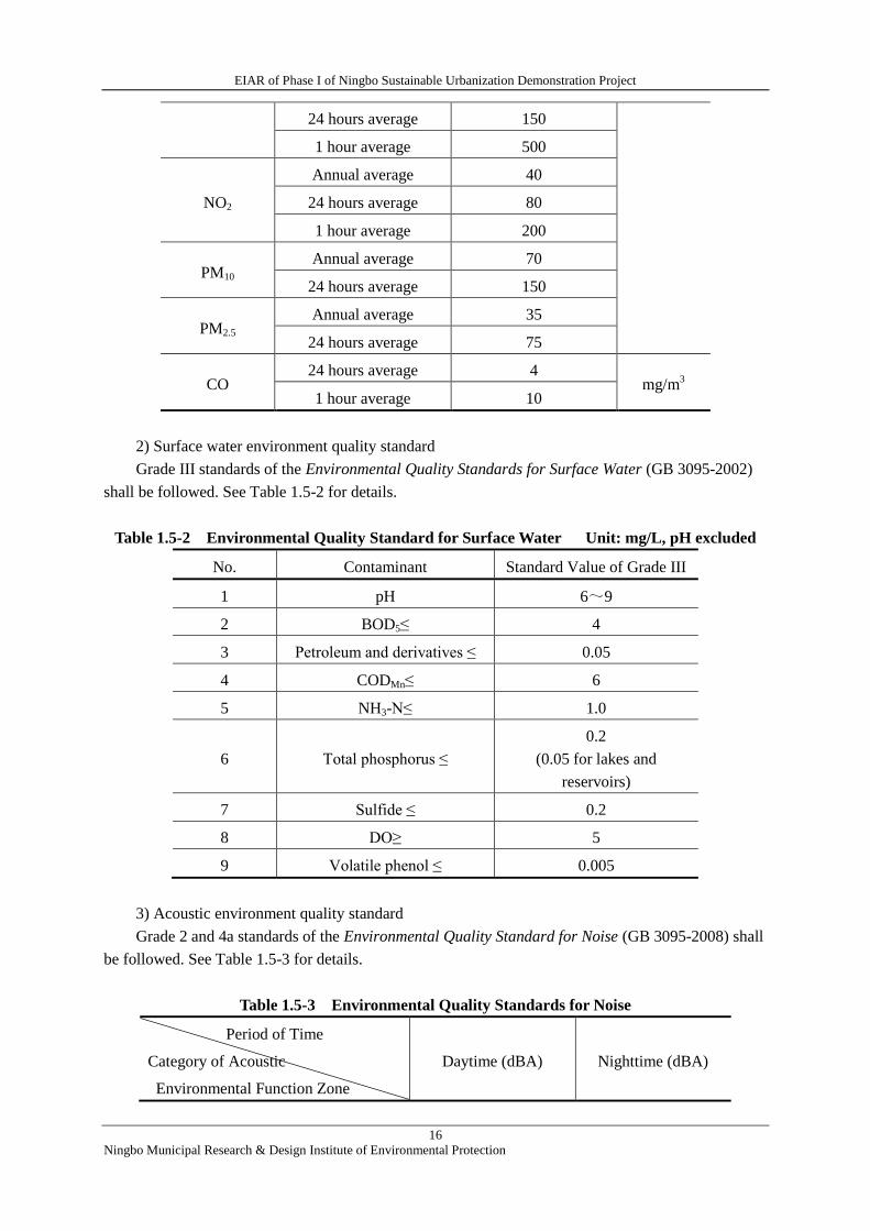
EIAR of Phase I of Ningbo Sustainable Urbanization Demonstration Project
16
Ningbo Municipal Research & Design Institute of Environmental Protection
24 hours average 150
1 hour average 500
NO2
Annual average 40
24 hours average 80
1 hour average 200
PM10 Annual average 70
24 hours average 150
PM2.5 Annual average 35
24 hours average 75
CO 24 hours average 4
mg/m3
1 hour average 10
2) Surface water environment quality standard
Grade III standards of the Environmental Quality Standards for Surface Water (GB 3095-2002)
shall be followed. See Table 1.5-2 for details.
Table 1.5-2 Environmental Quality Standard for Surface Water Unit: mg/L, pH excluded
No. Contaminant Standard Value of Grade III
1 pH 6~9
2 BOD5≤ 4
3 Petroleum and derivatives ≤ 0.05
4 CODMn≤ 6
5 NH3-N≤ 1.0
6 Total phosphorus ≤
0.2
(0.05 for lakes and
reservoirs)
7 Sulfide ≤ 0.2
8 DO≥ 5
9 Volatile phenol ≤ 0.005
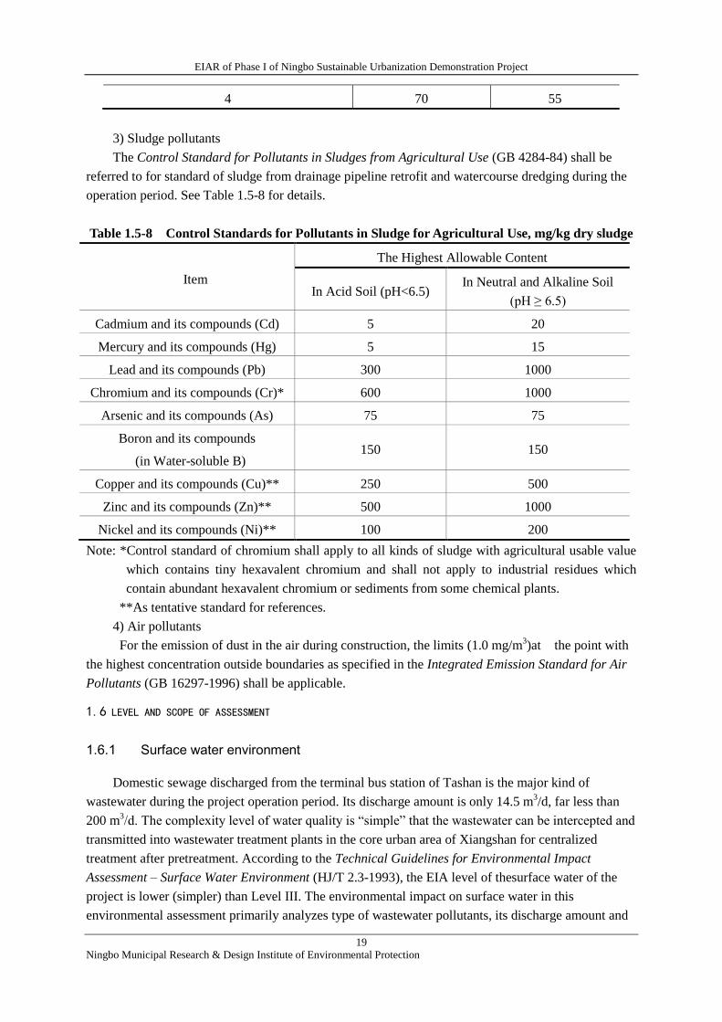
3) Acoustic environment quality standard
Grade 2 and 4a standards of the Environmental Quality Standard for Noise (GB 3095-2008) shall
be followed. See Table 1.5-3 for details.
Table 1.5-3 Environmental Quality Standards for Noise
Period of Time
Category of Acoustic
Environmental Function Zone
Daytime (dBA) Nighttime (dBA)
EIAR of Phase I of Ningbo Sustainable Urbanization Demonstration Project
17
Ningbo Municipal Research & Design Institute of Environmental Protection
Grade 2 60 50
Grade 4a 70 55
4) Soil environment quality standard
Grade II standard of the Environmental Quality Standard for Soils (GB 15618-1995) shall be
followed. See Table 1.5-4 for details.
Table 1.5-4 Soil Environment Quality Standard Unit: mg/kg
No. Item Standard Value of Class 2
pH 6.5~7.5 >7.5
1 Cadmium ≤ 0.30 0.60
2 Chromium in: Paddy land ≤
Dry land ≤
300 350
200 250
3 Arsenic in: Paddy land ≤
Dry land ≤
25 20
30 25
4 Lead ≤ 300 350
5 Copper in:Farmland ≤
Orchard ≤
100 100
200 200
6 Zinc ≤ 250 300
7 Nickel ≤ 50 60
1.5.2 Pollutant Emission Standard
1) Wastewater pollutants
In the construction period: All kinds of wastewater shall not be discharged into Categories I and
II surface water bodies, and natural reserves and swimming areas in Category III surface water bodies
as specified in GB 3838-2002; other discharges into water bodies shall accord to the corresponding
standard values of the Integrated Wastewater Discharge Standard (GB 8978-1996) by their category
of receiving ability. See Table 1.5-5 for details.
Table 1.5-5 Wastewater Discharge Standard during Construction Period
Unit: mg/L except pH value
Item
Integrated Wastewater Discharge Standard (GB 8978-1996)
Grade I (Water Bodies
with Category III
Receiving Water Body)
Grade II (Water Bodies with
Categories IV and V
Receiving Water Body)
Grade III
(Interception
through Sewers)
pH 6~9 6~9 6~9
COD 100 150 500
BOD5 20 30 300
SS 70 150 400

EIAR of Phase I of Ningbo Sustainable Urbanization Demonstration Project
18
Ningbo Municipal Research & Design Institute of Environmental Protection
Phosphate (P) 0.5 1.0 /
Ammonia
Nitrogen 15 25 /
Oil and Grease 10 15 100
Petroleum and
Derivatives 5 10 20
The operation period: Wastewater generated during project operation is primarily domestic
sewage discharged from the terminal bus station of Tashan. The municipal network around it is
complete, so that the wastewater can be intercepted by sewers when Grade III of the Integrated
Wastewater Discharge Standard (GB 8978-1996) shall be followed (some indicators shall perform the
Wastewater Quality Standard for Discharge to Municipal Sewers (CJ 343-2010)). See Table 1.5-6
for details.
Table 1.5-6 Wastewater Discharge Standard during the Operation Period
Unit: mg/L, pH excluded
Item (GB 8978-1996) Grade III CJ 343-2010
pH (Dimensionless) 6~9 /
COD 500 /
BOD5 300 /
SS 400 /
Phosphate (P) / 8
Ammonia Nitrogen / 45
Oil and Grease 100 /
Petroleum and
Derivatives 20 /
2) Noises
The Emission Standard for Environment Noise at Boundary of Construction Site (GB
12523-2011) shall be followed during the construction, i.e. 70 dB(A) in daytime and 55 dB(A) in
nighttime.
During the operation period, Grade 4 standard according to the Emission Standard for Industrial
Enterprises Noise at Boundary (GB 12348-2008) shall be met to control noise at the north boundary
on the side where the terminal station of Tashan adjacent to Tashan Lu, while Grade 2 standard shall
be followed along the other boundaries. See Table 1.5-7 for details.
Table 1.5-7 Standard for Noise at Factory Boundary of Industrial Enterprise
Period of Time
Category of Acoustic Environmental
Function Zone
Daytime (dB(A)) Nighttime (dB(A))
2 60 50
EIAR of Phase I of Ningbo Sustainable Urbanization Demonstration Project
19
Ningbo Municipal Research & Design Institute of Environmental Protection
4 70 55
3) Sludge pollutants
The Control Standard for Pollutants in Sludges from Agricultural Use (GB 4284-84) shall be
referred to for standard of sludge from drainage pipeline retrofit and watercourse dredging during the
operation period. See Table 1.5-8 for details.
Table 1.5-8 Control Standards for Pollutants in Sludge for Agricultural Use, mg/kg dry sludge
Item
The Highest Allowable Content
In Acid Soil (pH<6.5) In Neutral and Alkaline Soil
(pH ≥ 6.5)
Cadmium and its compounds (Cd) 5 20
Mercury and its compounds (Hg) 5 15
Lead and its compounds (Pb) 300 1000
Chromium and its compounds (Cr)* 600 1000
Arsenic and its compounds (As) 75 75
Boron and its compounds
(in Water-soluble B) 150 150
Copper and its compounds (Cu)** 250 500
Zinc and its compounds (Zn)** 500 1000
Nickel and its compounds (Ni)** 100 200
Note: *Control standard of chromium shall apply to all kinds of sludge with agricultural usable value
which contains tiny hexavalent chromium and shall not apply to industrial residues which
contain abundant hexavalent chromium or sediments from some chemical plants.
**As tentative standard for references.
4) Air pollutants
For the emission of dust in the air during construction, the limits (1.0 mg/m3)at the point with
the highest concentration outside boundaries as specified in the Integrated Emission Standard for Air
Pollutants (GB 16297-1996) shall be applicable.
1.6 LEVEL AND SCOPE OF ASSESSMENT
1.6.1 Surface water environment
Domestic sewage discharged from the terminal bus station of Tashan is the major kind of
wastewater during the project operation period. Its discharge amount is only 14.5 m3/d, far less than
200 m3/d. The complexity level of water quality is “simple” that the wastewater can be intercepted and
transmitted into wastewater treatment plants in the core urban area of Xiangshan for centralized
treatment after pretreatment. According to the Technical Guidelines for Environmental Impact
Assessment – Surface Water Environment (HJ/T 2.3-1993), the EIA level of thesurface water of the
project is lower (simpler) than Level III. The environmental impact on surface water in this
environmental assessment primarily analyzes type of wastewater pollutants, its discharge amount and
EIAR of Phase I of Ningbo Sustainable Urbanization Demonstration Project
20
Ningbo Municipal Research & Design Institute of Environmental Protection
whereabouts. A simple analysis of environmental impact is also carried out.
1.6.2 Atmospheric environment
1) Assessment level
Vehicles exhaust after passage on the new built Huancheng Xilu and Baohai Lu is the major
source of waste gas pollutant during the project operation period. Huancheng Xilu is an urban primary
road, and Baohai Lu, an urban secondary road. According to the Guidelines for Environmental Impact
Assessment - Atmospheric Environment (HJ 2.2-2008), for new-built and extension projects pertaining
urban roads such as urban expressway and arterial road, the impacts shall be considered of traffic line
sources on environmental protection objects on their both sides, where assessment level shall not be
lower than Level II. Therefore, assessment level of atmospheric environment of this project is decided
Grade II.
2) Assessment scope
Within 200 m at both sides from the road axes.
1.6.3 Acoustic environment
1) Assessment level
The newly built Huancheng Xilu, Baohai Lu Baohai Lu, terminal bus station of Tashan and
drainage pumping stations of this project are all located in Grade 2 Acoustic Environmental Functional
Area; increments of noise level before and after construction are all less than 5 dB(A) and a small
amount of incremented population affected by the noise. According to the Technical Guidelines for
Noise Impact Assessment (HJ/T 2.4-2009), the assessment level of acoustic environment of this project
is classified as Grade II.
2) Assessment scope
For Huancheng Xilu and Baohai Lu : within 200 m at both sides from road axes of ;
Terminal station of Tashan: a 100 m distance outside its boundaries.
Drainage pumping station: a 100 m distance outside its boundaries.
1.6.4 Ecological environment
1) Assessment level
In this environmental impact assessment, the impacts along the newly built Huancheng Xilu and
Baohai Lu on their neighboring eco-environments shall be of a primary concern. Along Baohai Lu is
mainly farmland eco-environment, while Huancheng Xilu is surrounded by villages, industrial parks,
farmland and hilly forest land. There are no Special Ecological Sensitive Areas and Important
Ecological Sensitive Areas along the new-built roads. The project area of the newly built roads has an
area of less than 5 km2 and a total length of less than 50 km. According to the Technical Guidelines for
Environmental Impact Assessment - Ecological Impact (HJ 19-2011), the assessment level of
eco-environment of newly built road works shall be classified as Grade III.
Table 1.6-1 Division of Ecological Impact Assessment Grade
Ecological Project Area (Water Area)
EIAR of Phase I of Ningbo Sustainable Urbanization Demonstration Project
21
Ningbo Municipal Research & Design Institute of Environmental Protection
Sensitivity of
Affected Zones Area ≥ 20 km
2
or Length ≥ 100 km
Area 2 km2 ~ 20 km
2
or Length 50 km ~ 100 km
Area ≤ 2 km2
or Length ≤ 50 km
Special Ecological
Sensitive Zone Grade I Grade I Grade I
Important
Ecological
Sensitive Zone
Grade I Grade II Grade III
General Areas Grade II Grade III Grade III
2) Assessment scope
On both sides, within 200 m from road axes.
1.7 SENSITIVE OBJECTS PROTECTED
All of the newly built subprojects are located in the main urban districts of Xiangshan. Through
field investigations, it is seen that there are no environmentally sensitive areas including natural
reserves, scenic areas, distribution ranges of rare wild fauna and flora within the assessment scope of
the project. The Sensitive Objects include residential areas, schools, hospitals and other areas within
the assessment scope of all subprojects, which are much concerned by the society, as described as
follows:
1) Terminal bus station of Tashan
See Table 1.7-1 for major environmentally Sensitive Object around the terminal station of Tashan
according to the results of investigations.
Table 1.7-1 Sensitive Objects around Terminal Station of Tashan
Proposed
Works Sensitive Object
Relative
Direction
Minimum Distance from
Site Boundary (m)
Terminal
Bus Station
of Tashan
Xiangshan Middle
School S 115
Tashan Garden
Residential Area E 110
Shangjincun SW 50
2) Huancheng Xilu
According to the investigation findings, the major environmentally Sensitive Objects along
Huancheng Xilu include Zhushuixi Cun and Sanchalu Cun. Zhushuixi Cun is located at north to the
north end of Huancheng Xilu; while Sanchalu Cun is located at southwest to the road in a distance of
about 202 m to its boundary line.
3) Baohai Lu
As shown by the investigation findings, the major environmental Sensitive Objects along
Baohai Lu include Jinxiu Jiayuan Residential Area and Lixin Cun. Jinxiu Jiayuan Residential Area is
located east to the east end of the Baohai Lu. The housing area of Lixin Cun villagers who need to be
demolished under the project is around 2000 m2 (10 households). In addition, according to the Meeting
EIAR of Phase I of Ningbo Sustainable Urbanization Demonstration Project
22
Ningbo Municipal Research & Design Institute of Environmental Protection
Summary of Xiangshan County Government ([2015] No. 71), the remaining residential areas of Lixin
Cun villagers are all listed in the resettlement action plan of Xiangshan County.
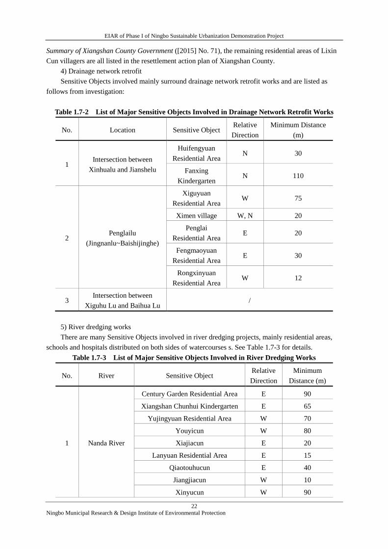
4) Drainage network retrofit
Sensitive Objects involved mainly surround drainage network retrofit works and are listed as
follows from investigation:
Table 1.7-2 List of Major Sensitive Objects Involved in Drainage Network Retrofit Works
No. Location Sensitive Object Relative
Direction
Minimum Distance
(m)
1 Intersection between
Xinhualu and Jianshelu
Huifengyuan
Residential Area N 30
Fanxing
Kindergarten N 110
2 Penglailu
(Jingnanlu~Baishijinghe)
Xiguyuan
Residential Area W 75
Ximen village W, N 20
Penglai
Residential Area E 20
Fengmaoyuan
Residential Area E 30
Rongxinyuan
Residential Area W 12
3 Intersection between
Xiguhu Lu and Baihua Lu /
5) River dredging works
There are many Sensitive Objects involved in river dredging projects, mainly residential areas,
schools and hospitals distributed on both sides of watercourses s. See Table 1.7-3 for details.
Table 1.7-3 List of Major Sensitive Objects Involved in River Dredging Works
No. River Sensitive Object Relative
Direction
Minimum
Distance (m)
1 Nanda River
Century Garden Residential Area E 90
Xiangshan Chunhui Kindergarten E 65
Yujingyuan Residential Area W 70
Youyicun W 80
Xiajiacun E 20
Lanyuan Residential Area E 15
Qiaotouhucun E 40
Jiangjiacun W 10
Xinyucun W 90
EIAR of Phase I of Ningbo Sustainable Urbanization Demonstration Project
23
Ningbo Municipal Research & Design Institute of Environmental Protection
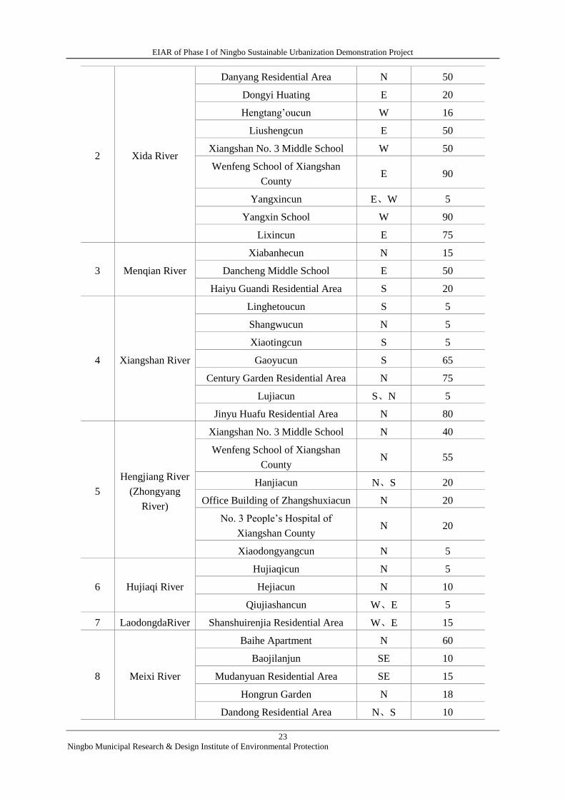
2 Xida River
Danyang Residential Area N 50
Dongyi Huating E 20
Hengtang’oucun W 16
Liushengcun E 50
Xiangshan No. 3 Middle School W 50
Wenfeng School of Xiangshan
County E 90
Yangxincun E、W 5
Yangxin School W 90
Lixincun E 75
3 Menqian River
Xiabanhecun N 15
Dancheng Middle School E 50
Haiyu Guandi Residential Area S 20
4 Xiangshan River
Linghetoucun S 5
Shangwucun N 5
Xiaotingcun S 5
Gaoyucun S 65
Century Garden Residential Area N 75
Lujiacun S、N 5
Jinyu Huafu Residential Area N 80
5
Hengjiang River
(Zhongyang
River)
Xiangshan No. 3 Middle School N 40
Wenfeng School of Xiangshan
County N 55
Hanjiacun N、S 20
Office Building of Zhangshuxiacun N 20
No. 3 People’s Hospital of
Xiangshan County N 20
Xiaodongyangcun N 5
6 Hujiaqi River
Hujiaqicun N 5
Hejiacun N 10
Qiujiashancun W、E 5
7 LaodongdaRiver Shanshuirenjia Residential Area W、E 15
8 Meixi River
Baihe Apartment N 60
Baojilanjun SE 10
Mudanyuan Residential Area SE 15
Hongrun Garden N 18
Dandong Residential Area N、S 10
EIAR of Phase I of Ningbo Sustainable Urbanization Demonstration Project
24
Ningbo Municipal Research & Design Institute of Environmental Protection
9 Oujia River / / /
10 Shangpingfeng
River
No. 1 People’s Hospital of
Xiangshan County SW 25
Shangbanhecun W 35
11 Tianyangli
River
Tianyanglicun N 10
Shanshuirenjia Residential Area W 15
12 WaiyuanRiver
Shangbanhecun N 6
Lijing Residential Area E 60
Zitingshengyuan N 10
13 XinhuaRiver
Xinhua Residential Area E 15
Jinqiu Residential Area W 15
Danjingyuan Residential Area E 20
14 Xinkai River
Penglai Residential Area SW 10
Wufengxincun NE 8
Yingzhou Residential Area SW 8
15 Branch of
Hengjiang River / / /
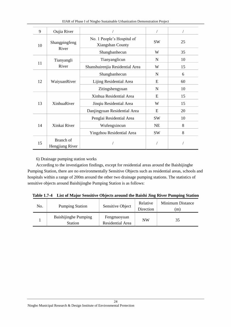
6) Drainage pumping station works
According to the investigation findings, except for residential areas around the Baishijinghe
Pumping Station, there are no environmentally Sensitive Objects such as residential areas, schools and
hospitals within a range of 200m around the other two drainage pumping stations. The statistics of
sensitive objects around Baishijinghe Pumping Station is as follows:
Table 1.7-4 List of Major Sensitive Objects around the Baishi Jing River Pumping Station
No. Pumping Station Sensitive Object Relative
Direction
Minimum Distance
(m)
1 Baishijinghe Pumping
Station
Fengmaoyuan
Residential Area NW 35

EIAR of Phase I of Ningbo Sustainable Urbanization Demonstration Project
25
Ningbo Municipal Research & Design Institute of Environmental Protection
2 Description of Project
2.1 PROJECT BACKGROUND
The total investment of the World Bank financed Ningbo Sustainable Urbanization Project in
Xiangshanis about 729 mil RMB, of which 577.34 mil RMB is for the integrated transportation system
component and151.66 mil RMB is for the flood risk management component. The project
development units (project implementation agencies, PIAs) are the Ningbo and Xiangshan PMOs for
the World Bank fundedproject. It is planned to start the project in August, 2016 and completedthe final
acceptance of the project in 2018. The Project is comprised of two components, i.e. the integrated
transportation system componentand flood risk management component. See Table 2.1-1 for details of
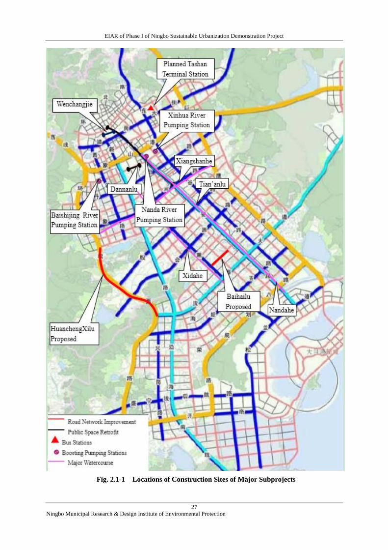
project components and Fig. 2.1-1 for the locations of construction sites of major subprojects.
Table 2.1-1 Project Components and Main Construction Contents
Subproject Main Construction Contents
Integrated Transportation System
Component
of
Old
Town
Upgradi
ng and
of
Accessib
ilityPro
motion
Public
Space
Retrofit
Wenchang Jie
Tiananlu-Xinfenglu segment with an overall length of about 360m.
Major contents include: ① to standardize street function zoning, ②
to improve public facilities such as benches for pedestrians, ③
permeable pavement renewal, ④ architectural facade retrofit.
Tianan Lu
Jianshelu-Xiangshanlu segment with an overall length of about
2.5km. Major contents include: ① to set pocket-shaped parking lots,
② to set parking areas for non-motor vehicles on sidewalks, ③ to
increase benches and other amenities in pedestrian space.
Dannan Lu
Both sides of Xiangshan Experimental Primary School. Major
contents include: ① to set parking areas for non-motor vehicles, ②
to increase amenities such as parent waiting areas and benches, ③
to set safety signs.
Traffic
Corridor
(Tianan
Lu)
Road overhaul Overhaul of and road pavement and subgrade
Optimization of
public
transportation
network and bus
stations
To extend some bus routes and increase departure frequency of
some routes.
Signal
optimization
To add traffic lights in some intersections, to optimize duration of
some traffic lights, etc.
Intersection
optimization
To set pedestrian twice crossings in some intersections and waiting
areas for left-turning vehicles in some intersections.
Traffic
Manageme
nt
Intelligent
transportation
system
To increase intelligent transportation systems in existing roads of
Xiangshan urban areas, mainly include: ① high-definition
electronic police system, ② high spot video monitoring system, ③
dynamic traffic guidance system, ④ dynamic parking guidance
system, ⑤telecommunication network system.
EIAR of Phase I of Ningbo Sustainable Urbanization Demonstration Project
26
Ningbo Municipal Research & Design Institute of Environmental Protection
Road
Network
Improveme
nt
Huancheng Xillu
A new road to be constructed, with an overall length of about
2.9km (north from Danshan Lu and south to Binhaidadao), standard
cross section of 36m and its road grade is urban primary road. See
Subsection 2.2-1 for details.
Baohai Lu Lu
To be built, with an overall length of about 0.7km (west from
Laixun Lu and east to Xinyi Lu), standard cross section of 24m and
its road grade is urban secondary road. See Subsection 2.2-2 for
details.
Public
Transpor
tation
Bus Station Construction To build Tashan Terminal Bus Station. See Subsection 2.4 for
details.
Intelligent Public Transport
System
Electronics including Global Navigation Satellite System (GPS)
and Geographic Information System (GIS) will be configured to
bus stations and vehicles.
Bus Stop Pavilion
Construction
To build 30 new bus stop pavilions and maintenance of some of the
existing stop pavilions
Vehicle purchase To purchase 45 buses by 2018
Flood Risk Management Component
Engineer
ing
Measure
s
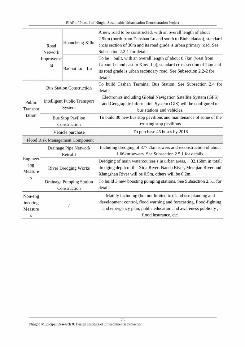
Drainage Pipe Network
Retrofit
Including dredging of 377.2km sewers and reconstruction of about
1.06km sewers. See Subsection 2.5.1 for details.
River Dredging Works
Dredging of main watercourses s in urban areas, 32,168m in total;
dredging depth of the Xida River, Nanda River, Menqian River and
Xiangshan River will be 0.5m, others will be 0.2m.
Drainage Pumping Station
Construction
To build 3 new boosting pumping stations. See Subsection 2.5.1 for
details.
Non-eng
ineering
Measure
s
/
Mainly including (but not limited to): land use planning and
development control, flood warning and forecasting, flood-fighting
and emergency plan, public education and awareness publicity ,
flood insurance, etc.
EIAR of Phase I of Ningbo Sustainable Urbanization Demonstration Project
27
Ningbo Municipal Research & Design Institute of Environmental Protection
Fig. 2.1-1 Locations of Construction Sites of Major Subprojects
EIAR of Phase I of Ningbo Sustainable Urbanization Demonstration Project
28
Ningbo Municipal Research & Design Institute of Environmental Protection
2.2 ROAD NETWORK IMPROVEMENT SUBPROJECTS
2.2.1 Huancheng Xilu Construction
1) Major technical standards
① Road grade: primary road
② Design speed: 60km/h
③ Design working life: 20 years as per the traffic volume projection and analysis; 15 years for
design working life of the pavement
2) Project scope and line route
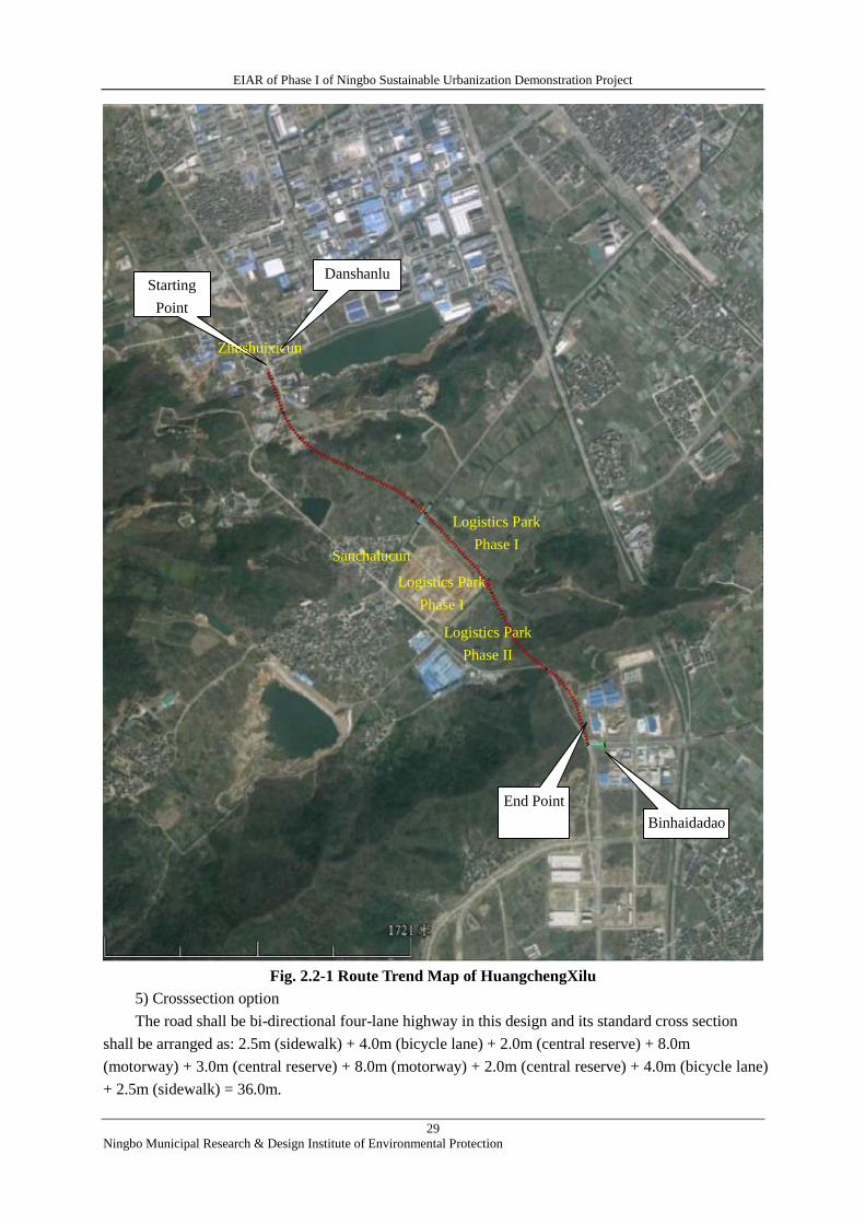
HuanchengXilu, starting frrom Danshan Lu in the north and ending at Binhai Dadao (avenue) in
the south, with as an overall length of 2.9km, a stake number range of K0+000 ~ K2+891.75, will pass
by two hills, Huangtuling and Mulingdong along its route. Two crossing bridges shall be set at the
planned watercourses (stake No. K1+191) and the Jiuqing River (stake No. K1+778).
Starting point of the project shall be converged with ending point of HuanchengXilu road works
(Xiangshanhe Lu ~ Danshanlu), while its ending point shall be converged with the existing Binhai
Dadao.
See Fig. 2.2-1 for details of road the path.
3) Functional orientation
① HuanchengXilu is an urban primary road, a fast passage in the outskirts of the core urban
district;
② A major freight corridor, diverting freight vehicles on Xinfeng Lu;
③ Benefiting Jiuqing Logistics Park, villages and factories along.
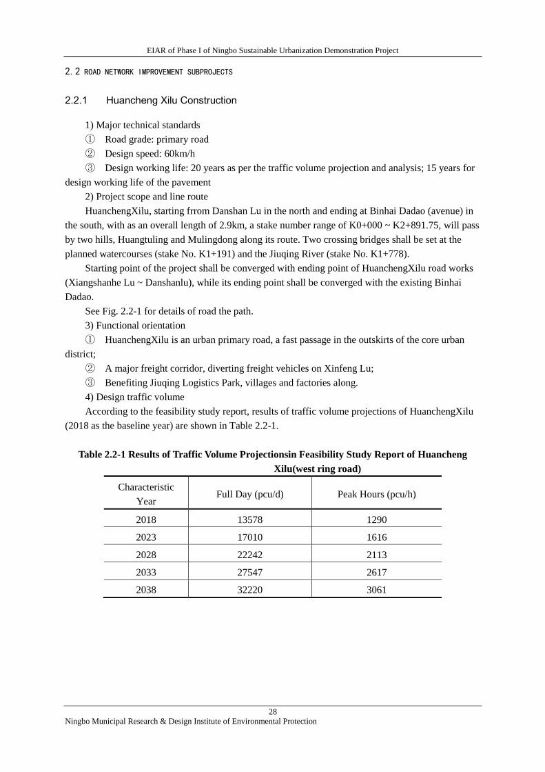
4) Design traffic volume
According to the feasibility study report, results of traffic volume projections of HuanchengXilu
(2018 as the baseline year) are shown in Table 2.2-1.
Table 2.2-1 Results of Traffic Volume Projectionsin Feasibility Study Report of Huancheng
Xilu(west ring road)
Characteristic
Year Full Day (pcu/d) Peak Hours (pcu/h)
2018 13578 1290
2023 17010 1616
2028 22242 2113
2033 27547 2617
2038 32220 3061
EIAR of Phase I of Ningbo Sustainable Urbanization Demonstration Project
29
Ningbo Municipal Research & Design Institute of Environmental Protection
Fig. 2.2-1 Route Trend Map of HuangchengXilu
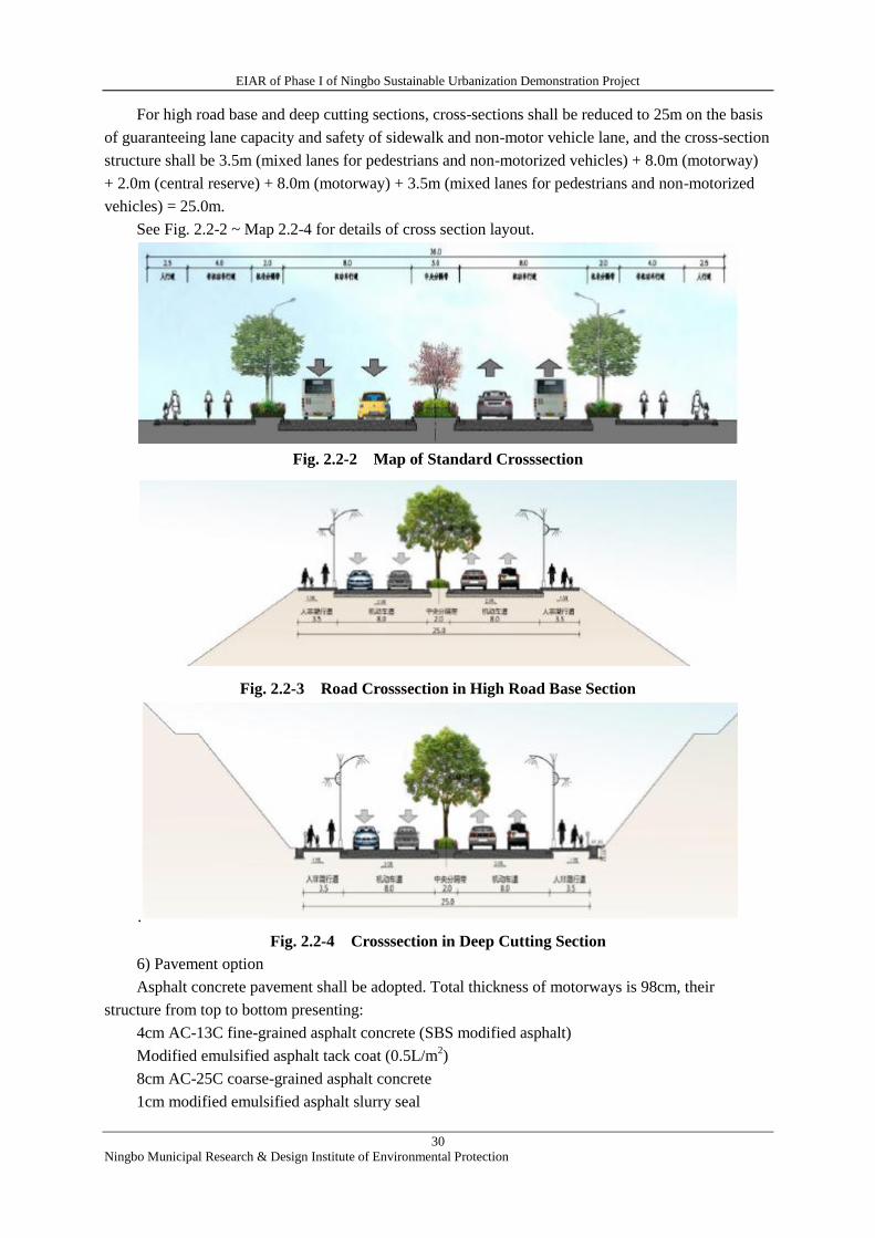
5) Crosssection option
The road shall be bi-directional four-lane highway in this design and its standard cross section
shall be arranged as: 2.5m (sidewalk) + 4.0m (bicycle lane) + 2.0m (central reserve) + 8.0m
(motorway) + 3.0m (central reserve) + 8.0m (motorway) + 2.0m (central reserve) + 4.0m (bicycle lane)
+ 2.5m (sidewalk) = 36.0m.
Starting
Point
End Point
Sanchalucun
Zhushuixicun
Logistics Park
Phase I
Logistics Park
Phase II
Logistics Park
Phase I
Binhaidadao
Danshanlu
EIAR of Phase I of Ningbo Sustainable Urbanization Demonstration Project
30
Ningbo Municipal Research & Design Institute of Environmental Protection
For high road base and deep cutting sections, cross-sections shall be reduced to 25m on the basis
of guaranteeing lane capacity and safety of sidewalk and non-motor vehicle lane, and the cross-section
structure shall be 3.5m (mixed lanes for pedestrians and non-motorized vehicles) + 8.0m (motorway)
+ 2.0m (central reserve) + 8.0m (motorway) + 3.5m (mixed lanes for pedestrians and non-motorized
vehicles) = 25.0m.
See Fig. 2.2-2 ~ Map 2.2-4 for details of cross section layout.
Fig. 2.2-2 Map of Standard Crosssection
Fig. 2.2-3 Road Crosssection in High Road Base Section
.
Fig. 2.2-4 Crosssection in Deep Cutting Section
6) Pavement option
Asphalt concrete pavement shall be adopted. Total thickness of motorways is 98cm, their
structure from top to bottom presenting:
4cm AC-13C fine-grained asphalt concrete (SBS modified asphalt)
Modified emulsified asphalt tack coat (0.5L/m2)
8cm AC-25C coarse-grained asphalt concrete
1cm modified emulsified asphalt slurry seal
EIAR of Phase I of Ningbo Sustainable Urbanization Demonstration Project
31
Ningbo Municipal Research & Design Institute of Environmental Protection
Modified emulsified asphalt prime coat (1.0L/m2)
40cm 5% cement stabilized macadam base
45cm fine spoil bedding (leveling course)7) Pipeline integration
Rainwater, wastewater, water supply, power supply, telecommunication, gas and other
professional pipelines are involved in this project. In the plan, telecommunication pipeline shall be
arranged underneath side walks, gas and wastewater pipelines shall be arranged underneath
non-motorized vehicle lanes northwest to HuanchengXilu; power pipeline shall be arranged
underneath sidewalks, water supply pipeline and their main piping shall be arranged underneath
non-motorized vehicle lanes southeast to HuanchengXilu; rainwater pipeline shall be arranged
underneath its central reserve.
8) Pavement drainage
Rainwater pipes shall be laid underneath the central reserve of the road with their diameter
designed to be D600-D1200; brickwork construction shall be adopted for gutter inlets; mortar laid
stone outlets shall be adopted for rainwater outlets and rainwater shall be discharged into the water
system nearby.
9) Bridge works
Two crossing bridges shall be set over the planned watercourses (stake No. K1+191) and the
Jiuqing River (stake No. K1+778) with no requirements of navigation grade. Pre-stressed concrete of
rigid connection with hollow slabs by prefabrication and pretensioning method shall be adopted for
bridges. φ800 and φ1000 drilled cast-in-place piles shall be adopted as bridge pile foundation.
2.2.2 Baohai Lu Construcdtion
1) Major technical standards
① Road grade: Secondary road
② Design speed: 40km/h
③ Design working life: 20 years as per the traffic volume projection and analysis; 15 years for
design working life of the pavement
2) Project scope and route
Baohai Lu, starting from Laixun Lu in the west and ending at Xinyi Lu in the east, has an overall
length of 0.7km, a stake number range of K0+000 ~ K0+702.10. Starting point of the road has been
already converged with the end point of existing Baohai Lu road works (Tiananlu ~ Xinyilu), while its
end point will be converged with Laixun Lu under construction. See Fig. 2.1-1 for details of road
paths.
3) Functional orientation
① Baohai Lu is an urban secondary road and an important east-west passage for the
built-upnew town in the south;
② Benefiting passage of its surrounding blocks including Jinxiu Jiayuan Residential Area,
planned tourist distributing center and hub station of the new town.
4) Design traffic volume
According to the engineering feasibility study report, results of traffic volume projections of
Baihai Lu (2018 as the baseline year) are shown in Table 2.2-2.
Table 2.2-2 Results of Traffic Volume Projections
In the Feasibility Study Report of Baohai Lu
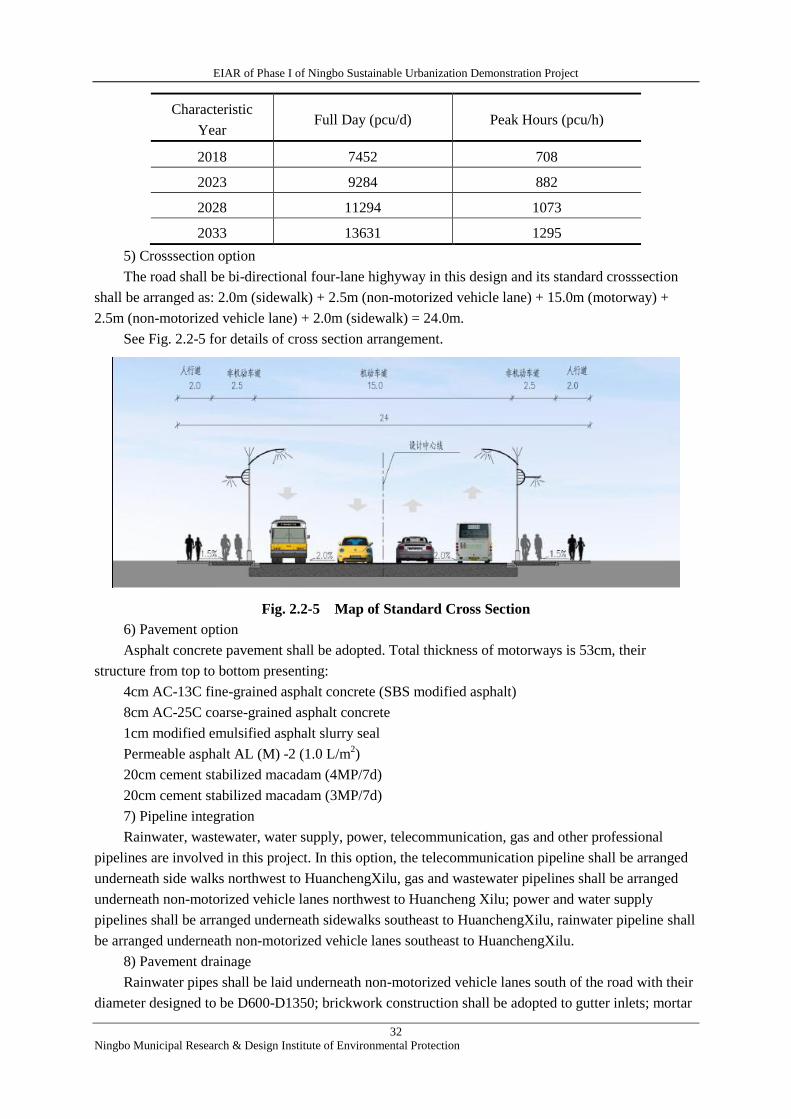
EIAR of Phase I of Ningbo Sustainable Urbanization Demonstration Project
32
Ningbo Municipal Research & Design Institute of Environmental Protection
Characteristic
Year Full Day (pcu/d) Peak Hours (pcu/h)
2018 7452 708
2023 9284 882
2028 11294 1073
2033 13631 1295
5) Crosssection option
The road shall be bi-directional four-lane highyway in this design and its standard crosssection
shall be arranged as: 2.0m (sidewalk) + 2.5m (non-motorized vehicle lane) + 15.0m (motorway) +
2.5m (non-motorized vehicle lane) + 2.0m (sidewalk) = 24.0m.
See Fig. 2.2-5 for details of cross section arrangement.
Fig. 2.2-5 Map of Standard Cross Section
6) Pavement option
Asphalt concrete pavement shall be adopted. Total thickness of motorways is 53cm, their
structure from top to bottom presenting:
4cm AC-13C fine-grained asphalt concrete (SBS modified asphalt)
8cm AC-25C coarse-grained asphalt concrete
1cm modified emulsified asphalt slurry seal
Permeable asphalt AL (M) -2 (1.0 L/m2)
20cm cement stabilized macadam (4MP/7d)
20cm cement stabilized macadam (3MP/7d)
7) Pipeline integration
Rainwater, wastewater, water supply, power, telecommunication, gas and other professional
pipelines are involved in this project. In this option, the telecommunication pipeline shall be arranged
underneath side walks northwest to HuanchengXilu, gas and wastewater pipelines shall be arranged
underneath non-motorized vehicle lanes northwest to Huancheng Xilu; power and water supply
pipelines shall be arranged underneath sidewalks southeast to HuanchengXilu, rainwater pipeline shall
be arranged underneath non-motorized vehicle lanes southeast to HuanchengXilu.
8) Pavement drainage
Rainwater pipes shall be laid underneath non-motorized vehicle lanes south of the road with their
diameter designed to be D600-D1350; brickwork construction shall be adopted to gutter inlets; mortar
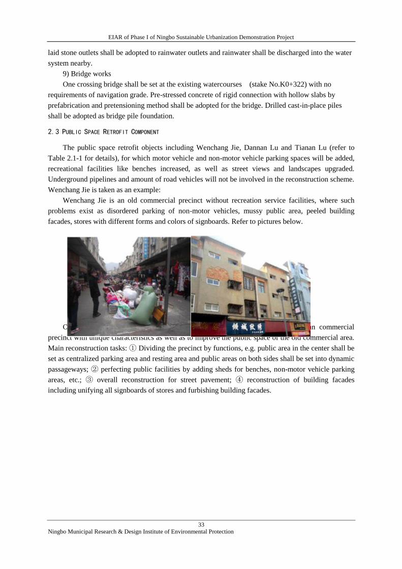
EIAR of Phase I of Ningbo Sustainable Urbanization Demonstration Project
33
Ningbo Municipal Research & Design Institute of Environmental Protection
laid stone outlets shall be adopted to rainwater outlets and rainwater shall be discharged into the water
system nearby.
9) Bridge works
One crossing bridge shall be set at the existing watercourses (stake No.K0+322) with no
requirements of navigation grade. Pre-stressed concrete of rigid connection with hollow slabs by
prefabrication and pretensioning method shall be adopted for the bridge. Drilled cast-in-place piles
shall be adopted as bridge pile foundation.
2.3 PUBLIC SPACE RETROFIT COMPONENT
The public space retrofit objects including Wenchang Jie, Dannan Lu and Tianan Lu (refer to
Table 2.1-1 for details), for which motor vehicle and non-motor vehicle parking spaces will be added,
recreational facilities like benches increased, as well as street views and landscapes upgraded.
Underground pipelines and amount of road vehicles will not be involved in the reconstruction scheme.
Wenchang Jie is taken as an example:
Wenchang Jie is an old commercial precinct without recreation service facilities, where such
problems exist as disordered parking of non-motor vehicles, mussy public area, peeled building
facades, stores with different forms and colors of signboards. Refer to pictures below.
Pictures of Current Situation of Wenchang Jie
Objectives of reconstruction: to build Wenchang Jie into a uniform and clean commercial
precinct with unique characteristics as well as to improve the public space of the old commercial area.
Main reconstruction tasks: ① Dividing the precinct by functions, e.g. public area in the center shall be
set as centralized parking area and resting area and public areas on both sides shall be set into dynamic
passageways; ② perfecting public facilities by adding sheds for benches, non-motor vehicle parking
areas, etc.; ③ overall reconstruction for street pavement; ④ reconstruction of building facades
including unifying all signboards of stores and furbishing building facades.
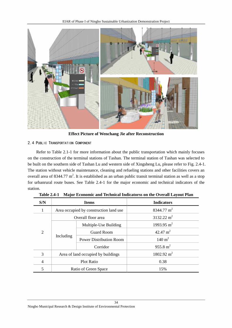
EIAR of Phase I of Ningbo Sustainable Urbanization Demonstration Project
34
Ningbo Municipal Research & Design Institute of Environmental Protection
Effect Picture of Wenchang Jie after Reconstruction
2.4 PUBLIC TRANSPORTATION COMPONENT
Refer to Table 2.1-1 for more information about the public transportation which mainly focuses
on the construction of the terminal stations of Tashan. The terminal station of Tashan was selected to
be built on the southern side of Tashan Lu and western side of Xingsheng Lu, please refer to Fig. 2.4-1.
The station without vehicle maintenance, cleaning and refueling stations and other facilities covers an
overall area of 8344.77 m2. It is established as an urban public transit terminal station as well as a stop
for urbanrural route buses. See Table 2.4-1 for the major economic and technical indicators of the
station.
Table 2.4-1 Major Economic and Technical Indicatorss on the Overall Layout Plan
S/N Items Indicators
1 Area occupied by construction land use 8344.77 m2
2
Overall floor area 3132.22 m2
Including
Multiple-Use Building 1993.95 m2
Guard Room 42.47 m2
Power Distribution Room 140 m2
Corridor 955.8 m2
3 Area of land occupied by buildings 1802.92 m2
4 Plot Ratio 0.38
5 Ratio of Green Space 15%
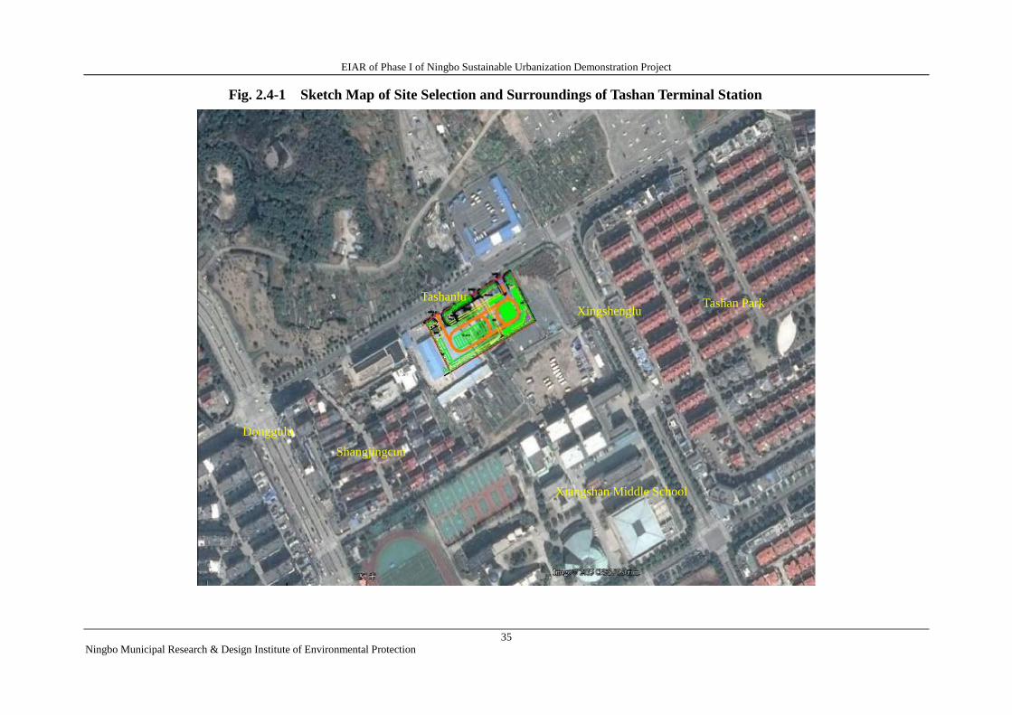
EIAR of Phase I of Ningbo Sustainable Urbanization Demonstration Project
35
Ningbo Municipal Research & Design Institute of Environmental Protection
Xiangshan Middle School
Tashan Park Tashanlu
Xingshenglu
Donggulu
Shangjingcun
Fig. 2.4-1 Sketch Map of Site Selection and Surroundings of Tashan Terminal Station
EIAR of Phase I of Ningbo Sustainable Urbanization Demonstration Project
36
Ningbo Municipal Research & Design Institute of Environmental Protection
2.5 FLOOD RISK MANAGEMENT COMPONENT
According to the data provided at present stage by the design institute of preparing FSR, the
flood risk management component scheme mainly includes engineering measures and
non-engineering measures.
2.5.1 Engineering measures
2.5.1.1 RETROFITOF DRAINAGE PIPE NETWORK
Engineering Composition
Urban drainage pipe network reconstruction works includes drainage pipe network dredging
work and drainage pipe network rebuilding work. Wherein, drainage pipe network dredging work
is mainly to clean all sludge from all built drainage pipelines within Xiangshan urban area. The
drainage pipeline is approximately 303 km long and drainage ditch about 74.2 km long. Drainage
pipe network rebuilding work is mainly to rebuild some drainage pipelines in the old urban area
with a rebuilding length of about 1060 m.
Refer to Table 2.5-1 and Table 2.5-2 for pipeline dredging and rebuilding work amounts and
refer to Fig 2.5-1 for rebuilding location of drainage pipeline.
Table 2.5-1 Drainage Pipeline Dredging Amount
S/N Pipe Diameter (mm) Length (m)
1 Drainage
Pipeline
≤ DN600 282558
2 DN600 <D ≤ DN1000 17453
3 DN1000 < D ≤ DN1500 2981
4
Drainage Ditch
Breadth of Box Culvert Shorter than or
Equal to 100 50599
5 Breadth of Box Culvert Longer than or
Equal to 100 23585
6 Total 377176
Analysis results show that dredging of drainage pipelines can enlarge the flow cross section of
pipeline which plays a certain role in lowering the waterlogging degree.
Table 2.5-2 Drainage Pipeline Rebuilding Amount
S/N Location Rebuilding Content Length
1 Intersection of Xinhua Lu and
Jianshe Lu
It was expanded to 0.8 m ×1.5 m from 0.8 m ×
1.0 m 245 m
2 Penglai Lu (Jingnan Lu~Baishi
Jing River)
To be expanded to 3.5 m ×2.0 m from 1.05m ×
1.45 m 800 m
3 Intersection of Xiguhu Lu and
Baihua Lu
To be expanded to 0.8 m × 0.8 m from 0.3 m ×
0.5 m 15 m
4 Total 1060 m
Refer to Fig. 2.5-1 for the location of drainage pipeline retrofit
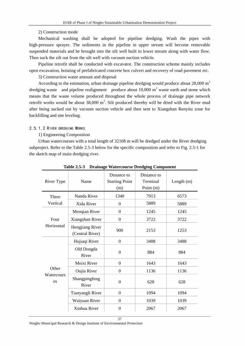
EIAR of Phase I of Ningbo Sustainable Urbanization Demonstration Project
37
Ningbo Municipal Research & Design Institute of Environmental Protection
2) Construction mode
Mechanical washing shall be adopted for pipeline dredging. Wash the pipes with
high-pressure sprayer. The sediments in the pipeline in upper stream will become removable
suspended materials and be brought into the silt well built in lower stream along with water flow.
Then suck the silt out from the silt well with vacuum suction vehicle.
Pipeline retrofit shall be conducted with excavator. The construction scheme mainly includes
open excavation, hoisting of prefabricated concrete box culvert and recovery of road pavement etc.
3) Construction waste amount and disposal
According to the estimation, urban drainage pipeline dredging would produce about 28,000 m3
dredging waste and pipeline realignment produce about 10,000 m3 waste earth and stone which
means that the waste volume produced throughout the whole process of drainage pipe network
retrofit works would be about 38,000 m3. Silt produced thereby will be dried with the River mud
after being sucked out by vacuum suction vehicle and then sent to Xiangshan Renyitu zone for
backfilling and site leveling.
2.5.1.2 RIVER DREDGING WORKS
1) Engineering Composition
Urban watercourses with a total length of 32168 m will be dredged under the River dredging
subproject. Refer to the Table 2.5-3 below for the specific composition and refer to Fig. 2.5-1 for
the sketch map of main dredging river.
Table 2.5-3 Drainage Watercourse Dredging Component
River Type Name
Distance to
Starting Point
(m)
Distance to
Terminal
Point (m)
Length (m)
Three
Vertical
Nanda River 1340 7913 6573
Xida River 0 5889 5889
Four
Horizontal
Menqian River 0 1245 1245
Xiangshan River 0 3722 3722
Hengjiang River
(Central River) 900 2153 1253
Other
Watercours
es
Hujiaqi River 0 3488 3488
Old Dongda
River 0 884 884
Meixi River 0 1643 1643
Oujia River 0 1136 1136
Shangpingfeng
River 0 628 628
Tianyangli River 0 1094 1094
Waiyuan River 0 1039 1039
Xinhua River 0 2067 2067
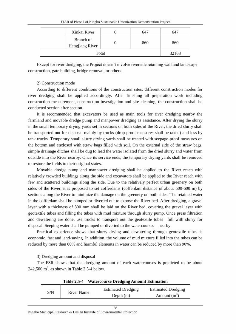
EIAR of Phase I of Ningbo Sustainable Urbanization Demonstration Project
38
Ningbo Municipal Research & Design Institute of Environmental Protection
Except for river dredging, the Project doesn’t involve riverside retaining wall and landscape
construction, gate building, bridge removal, or others.
2) Construction mode
According to different conditions of the construction sites, different construction modes for
river dredging shall be applied accordingly. After finishing all preparation work including
construction measurement, construction investigation and site cleaning, the construction shall be
conducted section after section.
It is recommended that excavators be used as main tools for river dredging nearby the
farmland and movable dredge pump and manpower dredging as assistance. After drying the slurry
in the small temporary drying yards set in sections on both sides of the River, the dried slurry shall
be transported out for disposal mainly by trucks (drop-proof measures shall be taken) and less by
tank trucks. Temporary small slurry drying yards shall be treated with seepage-proof measures on
the bottom and enclosed with straw bags filled with soil. On the external side of the straw bags,
simple drainage ditches shall be dug to lead the water isolated from the dried slurry and water from
outside into the River nearby. Once its service ends, the temporary drying yards shall be removed
to restore the fields to their original states.
Movable dredge pump and manpower dredging shall be applied to the River reach with
relatively crowded buildings along the side and excavators shall be applied to the River reach with
few and scattered buildings along the side. Due to the relatively perfect urban greenery on both
sides of the River, it is proposed to set cofferdams (cofferdam distance of about 500-600 m) by
sections along the River to minimize the damage on the greenery on both sides. The retained water
in the cofferdam shall be pumped or diverted out to expose the River bed. After dredging, a gravel
layer with a thickness of 300 mm shall be laid on the River bed, covering the gravel layer with
geotextile tubes and filling the tubes with mud mixture through slurry pump. Once press filtration
and dewatering are done, use trucks to transport out the geotextile tubes full with slurry for
disposal. Seeping water shall be pumped or diverted to the watercourses nearby.
Practical experience shows that slurry drying and dewatering through geotextile tubes is
economic, fast and land-saving. In addition, the volume of mud mixture filled into the tubes can be
reduced by more than 80% and harmful elements in water can be reduced by more than 90%.
3) Dredging amount and disposal
The FSR shows that the dredging amount of each watercourses is predicted to be about
242,500 m3, as shown in Table 2.5-4 below.
Table 2.5-4 Watercourse Dredging Amount Estimation
S/N River Name Estimated Dredging
Depth (m)
Estimated Dredging
Amount (m3)
Xinkai River 0 647 647
Branch of
Hengjiang River 0 860 860
Total 32168
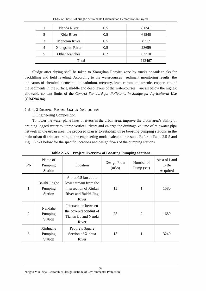
EIAR of Phase I of Ningbo Sustainable Urbanization Demonstration Project
39
Ningbo Municipal Research & Design Institute of Environmental Protection
1 Nanda River 0.5 81341
5 Xida River 0.5 61540
3 Menqian River 0.5 8217
4 Xiangshan River 0.5 28659
5 Other branches 0.2 62710
Total 242467
Sludge after drying shall be taken to Xiangshan Renyitu zone by trucks or tank trucks for
backfilling and field leveling. According to the watercourses sediment monitoring results, the
indicators of chemical elements like cadmium, mercury, lead, chromium, arsenic, copper, etc. of
the sediments in the surface, middle and deep layers of the watercourses are all below the highest
allowable content limits of the Control Standard for Pollutants in Sludge for Agricultural Use
(GB4284-84).
2.5.1.3 DRAINAGE PUMPING STATION CONSTRUCTION
1) Engineering Composition
To lower the water plane lines of rivers in the urban area, improve the urban area’s ability of
draining logged water to “three vertical” rivers and enlarge the drainage volume of rainwater pipe
network in the urban area, the proposed plan is to establish three boosting pumping stations in the
main urban district according to the engineering model calculation results. Refer to Table 2.5-5 and
Fig. 2.5-1 below for the specific locations and design flows of the pumping stations.
Table 2.5-5 Project Overview of Boosting Pumping Stations
S/N
Name of
Pumping
Station
Location Design Flow
(m3/s)
Number of
Pump (set)
Area of Land
to Be
Acquired
1
Baishi Jinghe
Pumping
Station
About 0.5 km at the
lower stream from the
intersection of Xinkai
River and Baishi Jing
River
15 1 1580
2
Nandahe
Pumping
Station
Intersection between
the covered conduit of
Tianan Lu and Nanda
River
25 2 1680
3
Xinhuahe
Pumping
Station
People’s Square
Section of Xinhua
River
15 1 3240
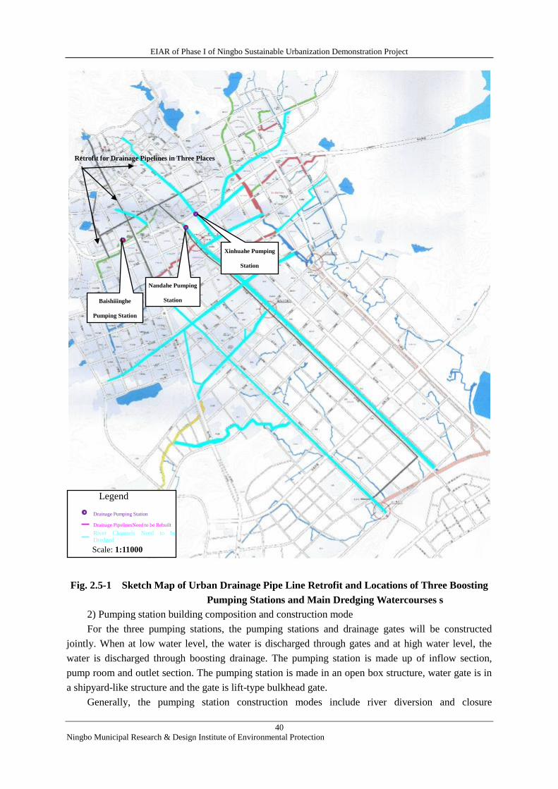
EIAR of Phase I of Ningbo Sustainable Urbanization Demonstration Project
40
Ningbo Municipal Research & Design Institute of Environmental Protection
Fig. 2.5-1 Sketch Map of Urban Drainage Pipe Line Retrofit and Locations of Three Boosting
Pumping Stations and Main Dredging Watercourses s
2) Pumping station building composition and construction mode
For the three pumping stations, the pumping stations and drainage gates will be constructed
jointly. When at low water level, the water is discharged through gates and at high water level, the
water is discharged through boosting drainage. The pumping station is made up of inflow section,
pump room and outlet section. The pumping station is made in an open box structure, water gate is in
a shipyard-like structure and the gate is lift-type bulkhead gate.
Generally, the pumping station construction modes include river diversion and closure
Retrofit for Drainage Pipelines in Three Places
Baishiiinghe
Pumping Station
Nandahe Pumping
Station
Xinhuahe Pumping
Station
Legend
Drainage Pumping Station
Drainage PipelinesNeed to be Rebuilt
Scale: 1:11000
River Channels Need to be
Dredged
EIAR of Phase I of Ningbo Sustainable Urbanization Demonstration Project
41
Ningbo Municipal Research & Design Institute of Environmental Protection
construction, foundation construction, concrete pouring work, grouted rubble or rock-masonry
construction, cushion layer and riprap banket construction, water pump installation, etc.
3) Waste amount and treatment
According to the findings in FSR, the earth balance of each pumping station works is shown in
Table 2.5-6.
Table 2.5-6 Earth Balance of Pumping Station Construction Unit: m3
S/N Name of
Pumping Station
Excavation
Volume Filling Volume
Waste
Amount
1 Baishi Jinghe
Pumping Station 13931 10038 3893
2 Nandahe
Pumping Station 15689 10038 5651
3 Xinhuaher
Pumping Station 18029 11338 6691
Total 47649 31414 16235
Data above show that the waste earth with a volume of about 16235 m3 produced throughout the
pumping station works shall be transported to Xiangshan Renyitu zone for fill disposal.
2.5.2 Non-engineering measures
Non-engineering measures mainly include (but not limited to): land use plan and development
control, flood warning and forecasting, flood-fighting and emergency plan, public education and
awareness publicity, flood insurance, etc.
1) Land use planning and development
A flood risk area planning shall be prepared for land use in stages, which fits the social economic
development level by analysis on the flood characteristics, flood risks as well as the urbanization
development and population migration tendency.
2) Flood warning and forecasting
Flood warning and forecasting measures including flood prediction, flood control scheduling,
flood control scheduling and decision support system, etc., shall be taken to maximize the effects of
flood control subproject and improve the benefits thereof.
3) Fighting Floods
A series of technologies including banking and walling, dry-type flood provention method and
wet-type flood prevention method, etc. shall be applied to minimize the damages to buildings and
properties caused by flood.
4) Emergency plan
The emergency plan is prepared for the main purpose of timely releasing the information when
flood or waterlogging occurs for the areas easy to be flooded. corresponding emergency procedures
and safety measures shall be worked out according to the specific features of potential flood at
different stages. Assessment shall be conducted of the risk degree of flood and waterlogging in
particular areas including culverts, overpass bridges, known blockage points and access points at
floodable areas.
5) Public education and awareness promotion as well as flood insurance
Public awareness of floods can be improved by carrying out public education through media and
EIAR of Phase I of Ningbo Sustainable Urbanization Demonstration Project
42
Ningbo Municipal Research & Design Institute of Environmental Protection
activities. People shall be taught not to conduct behaviors which may aggravate flood and
waterlogging, e.g. the serious consequences of dumping garbage into rivers and knowledge of
minimizing the property loss in flood disaster, e.g. what to do after hearing the flood warning, etc. In
addition, education about other issues related to flood and waterlogging shall also be provided. For
example, people should know how to work with government to fight against the flood, who shall be
contacted during emergencies, the importance of drainage system maintenance, building features for
flood control, the way to access economic aids, etc.
6) Flood insurance
Flood insurance cannot reduce the damage caused by flood disaster but it can change the irregular
flood loss distribution into a uniform annual installment payment system. By making up the losses of
the victims with accumulated funds, the flood insurance can minimize the financial instability caused
by catastrophic floods. Paying flood insurance which is with a certain proportion to the flood risk also
has restrictive effect on uneconomical development in flooded area. This method can make an
optimum utilization of land.
2.6 INVESTIGATION OF ASSOCIATED PROJECTS
Disposal site in Renyitu
The waste soil, stone and sludge underthe Project will be employed to Renyitu for filling. Renyitu
is located in the Dongchen Township of Xiangshan on the seaside, about 10 km to the south of the
county. It is separated from the sea by Renyitu seawall on the eastern side. Wangjialan village is on
the southern side of Renyitu, coastal south road is on the western side and Shuitong’ao hilly area is on
the northern side (refer to Fig. 4.1-1).
In the past, Renyitu was a coastal shoreline. In 2003, the preliminary work of Renyitu
reclamation project was carried out in Xiangshan and a proposal was put forward to build a seawall on
the outer periphery of Renyitu for breeding. The proposal passed the review and approval by the
Development and Plan Commission of Ningbo in September 2003 and environmental assessment of
the project passed the review and approval by the Ningbo Environmental Protection Bureau in
December 2013. (Refer to Table 2.6-1 for details.)
Table 2.6-1 Associated Details about the Approval of Foundation Treatment Project in Renyitu
S/N Project Name Approved by Approval No.
1 Project Proposal for the Xiangshan
Renyitu Reclamation Project
Development
and Plan
Commission
of Ningbo
YongJiNong [2003] No.
447
2 Environmental Impact Report of
Xiangshan Renyitu Reclamation Project
Ningbo
Environmental
Protection
Bureau
YongHuanJian [2003]
No. 104
Renyitu (tu – beach, tidal land) reclamation project was launched in 2005 and completed in
December 2007. After completion, the mud flat inside the seawall was idled for no use. Due to the
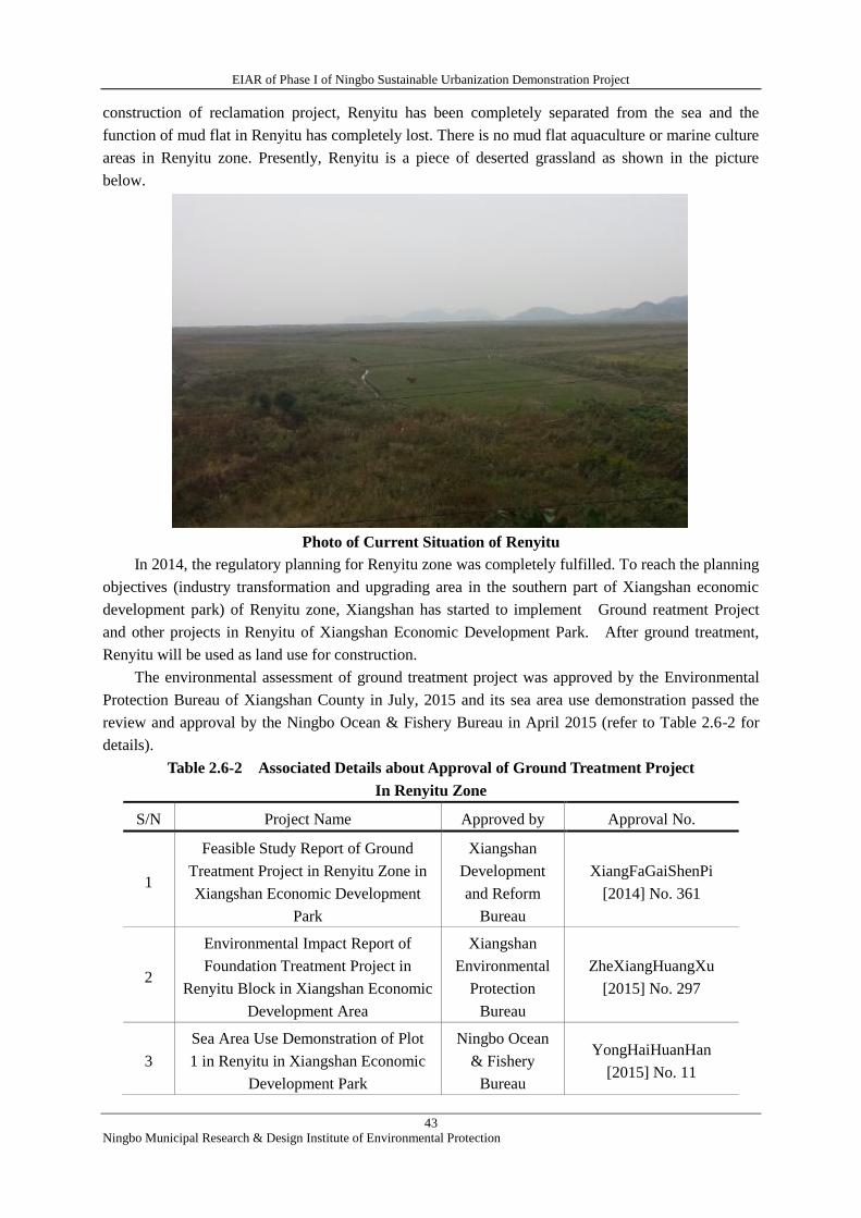
EIAR of Phase I of Ningbo Sustainable Urbanization Demonstration Project
43
Ningbo Municipal Research & Design Institute of Environmental Protection
construction of reclamation project, Renyitu has been completely separated from the sea and the
function of mud flat in Renyitu has completely lost. There is no mud flat aquaculture or marine culture
areas in Renyitu zone. Presently, Renyitu is a piece of deserted grassland as shown in the picture
below.
Photo of Current Situation of Renyitu
In 2014, the regulatory planning for Renyitu zone was completely fulfilled. To reach the planning
objectives (industry transformation and upgrading area in the southern part of Xiangshan economic
development park) of Renyitu zone, Xiangshan has started to implement Ground reatment Project
and other projects in Renyitu of Xiangshan Economic Development Park. After ground treatment,
Renyitu will be used as land use for construction.
The environmental assessment of ground treatment project was approved by the Environmental
Protection Bureau of Xiangshan County in July, 2015 and its sea area use demonstration passed the
review and approval by the Ningbo Ocean & Fishery Bureau in April 2015 (refer to Table 2.6-2 for
details).
Table 2.6-2 Associated Details about Approval of Ground Treatment Project
In Renyitu Zone
S/N Project Name Approved by Approval No.
1
Feasible Study Report of Ground
Treatment Project in Renyitu Zone in
Xiangshan Economic Development
Park
Xiangshan
Development
and Reform
Bureau
XiangFaGaiShenPi
[2014] No. 361
2
Environmental Impact Report of
Foundation Treatment Project in
Renyitu Block in Xiangshan Economic
Development Area
Xiangshan
Environmental
Protection
Bureau
ZheXiangHuangXu
[2015] No. 297
3
Sea Area Use Demonstration of Plot
1 in Renyitu in Xiangshan Economic
Development Park
Ningbo Ocean
& Fishery
Bureau
YongHaiHuanHan
[2015] No. 11
EIAR of Phase I of Ningbo Sustainable Urbanization Demonstration Project
44
Ningbo Municipal Research & Design Institute of Environmental Protection
4
Sea Area Use Demonstration of Plot
2 in Renyitu in Xiangshan Economic
Development Park
Ningbo Ocean
& Fishery
Bureau
YongHaiHuanHan[2015
] No. 12
Abstract of approval opinions of the Ningbo Ocean & Fishery Bureau: sea area of Xiangshan
Renyitu Zone proposed to be transferred is located within the Renyitu reclamation project area. After
filling and field leveling, the field will be turned into a construction land use for uniform development
and construction which almost has no impact on the marine ecosystem nearby. According to the
functions and relevant planning of Renyitu Zone, the project will has no direct impact on the marine
environment as the sea area to be transferred is located in the reclamation area.
The ground treatment project with an earthwork leveling area of 154.34 ha., a total excavation of
2.36 million m3 and a total filling volume of about 3.28 million m
3 mainly involves the works of site
leveling, site ground treatment and road subgrade treatment.
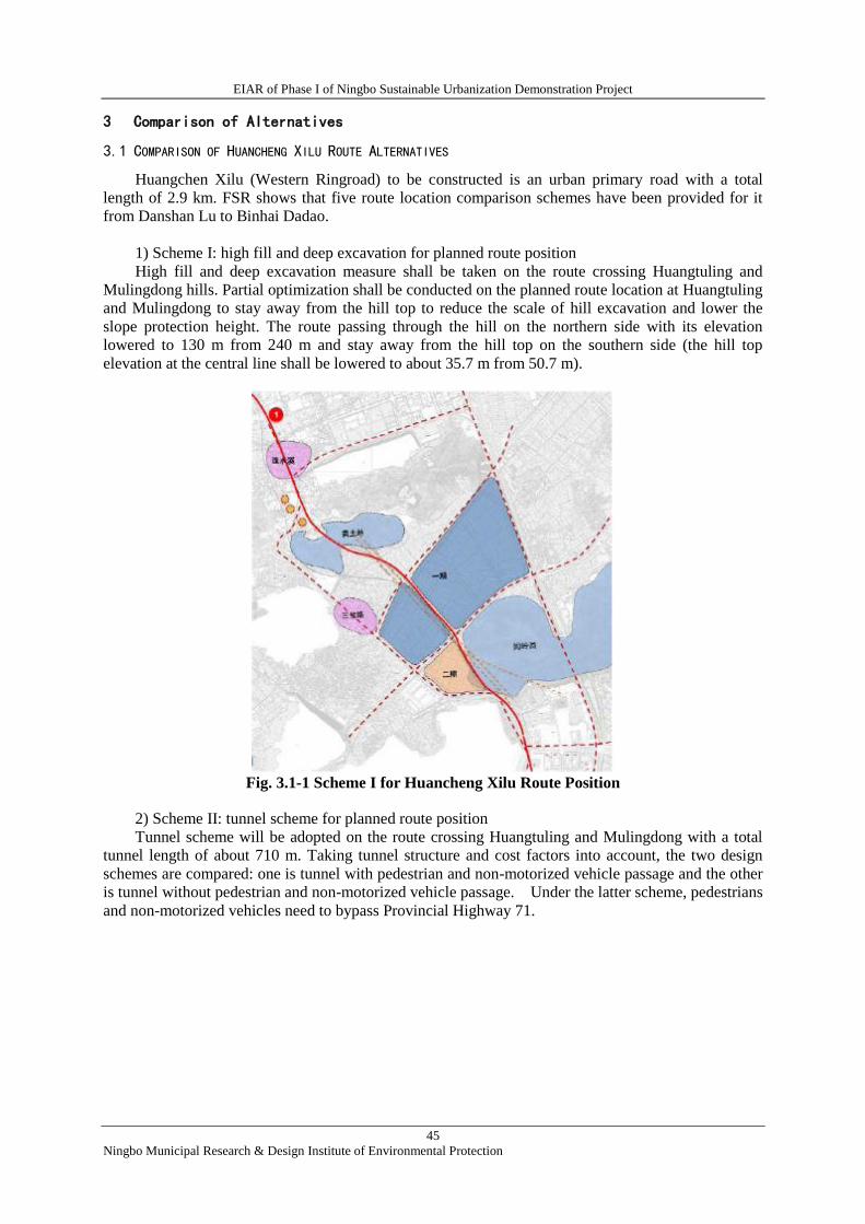
EIAR of Phase I of Ningbo Sustainable Urbanization Demonstration Project
45
Ningbo Municipal Research & Design Institute of Environmental Protection
3 Comparison of Alternatives
3.1 COMPARISON OF HUANCHENG XILU ROUTE ALTERNATIVES
Huangchen Xilu (Western Ringroad) to be constructed is an urban primary road with a total
length of 2.9 km. FSR shows that five route location comparison schemes have been provided for it
from Danshan Lu to Binhai Dadao.
1) Scheme I: high fill and deep excavation for planned route position
High fill and deep excavation measure shall be taken on the route crossing Huangtuling and
Mulingdong hills. Partial optimization shall be conducted on the planned route location at Huangtuling
and Mulingdong to stay away from the hill top to reduce the scale of hill excavation and lower the
slope protection height. The route passing through the hill on the northern side with its elevation
lowered to 130 m from 240 m and stay away from the hill top on the southern side (the hill top
elevation at the central line shall be lowered to about 35.7 m from 50.7 m).
Fig. 3.1-1 Scheme I for Huancheng Xilu Route Position
2) Scheme II: tunnel scheme for planned route position
Tunnel scheme will be adopted on the route crossing Huangtuling and Mulingdong with a total
tunnel length of about 710 m. Taking tunnel structure and cost factors into account, the two design
schemes are compared: one is tunnel with pedestrian and non-motorized vehicle passage and the other
is tunnel without pedestrian and non-motorized vehicle passage. Under the latter scheme, pedestrians
and non-motorized vehicles need to bypass Provincial Highway 71.
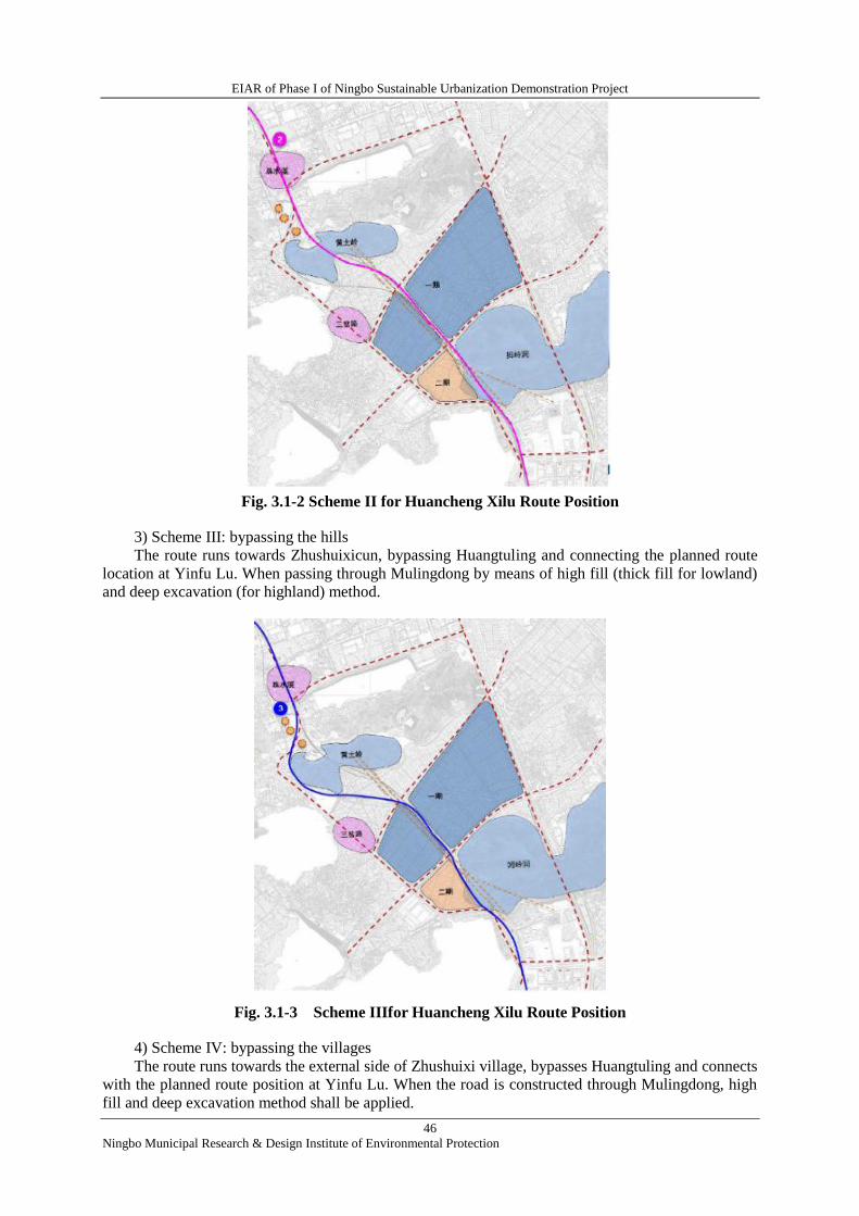
EIAR of Phase I of Ningbo Sustainable Urbanization Demonstration Project
46
Ningbo Municipal Research & Design Institute of Environmental Protection
Fig. 3.1-2 Scheme II for Huancheng Xilu Route Position
3) Scheme III: bypassing the hills
The route runs towards Zhushuixicun, bypassing Huangtuling and connecting the planned route
location at Yinfu Lu. When passing through Mulingdong by means of high fill (thick fill for lowland)
and deep excavation (for highland) method.
Fig. 3.1-3 Scheme IIIfor Huancheng Xilu Route Position
4) Scheme IV: bypassing the villages
The route runs towards the external side of Zhushuixi village, bypasses Huangtuling and connects
with the planned route position at Yinfu Lu. When the road is constructed through Mulingdong, high
fill and deep excavation method shall be applied.
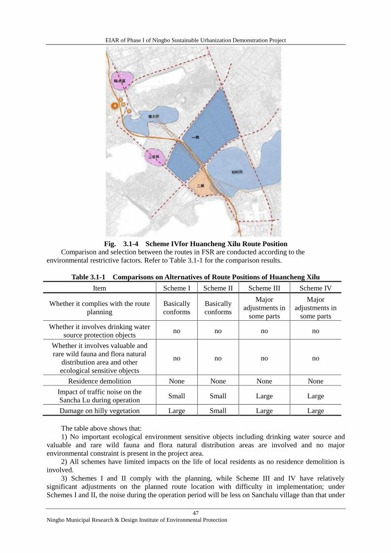
EIAR of Phase I of Ningbo Sustainable Urbanization Demonstration Project
47
Ningbo Municipal Research & Design Institute of Environmental Protection
Fig. 3.1-4 Scheme IVfor Huancheng Xilu Route Position
Comparison and selection between the routes in FSR are conducted according to the
environmental restrictive factors. Refer to Table 3.1-1 for the comparison results.
Table 3.1-1 Comparisons on Alternatives of Route Positions of Huancheng Xilu
Item Scheme I Scheme II Scheme III Scheme IV
Whether it complies with the route
planning
Basically
conforms
Basically
conforms
Major
adjustments in
some parts
Major
adjustments in
some parts
Whether it involves drinking water
source protection objects no no no no
Whether it involves valuable and
rare wild fauna and flora natural
distribution area and other
ecological sensitive objects
no no no no
Residence demolition None None None None
Impact of traffic noise on the
Sancha Lu during operation Small Small Large Large
Damage on hilly vegetation Large Small Large Large
The table above shows that:
1) No important ecological environment sensitive objects including drinking water source and
valuable and rare wild fauna and flora natural distribution areas are involved and no major
environmental constraint is present in the project area.
2) All schemes have limited impacts on the life of local residents as no residence demolition is
involved.
3) Schemes I and II comply with the planning, while Scheme III and IV have relatively
significant adjustments on the planned route location with difficulty in implementation; under
Schemes I and II, the noise during the operation period will be less on Sanchalu village than that under
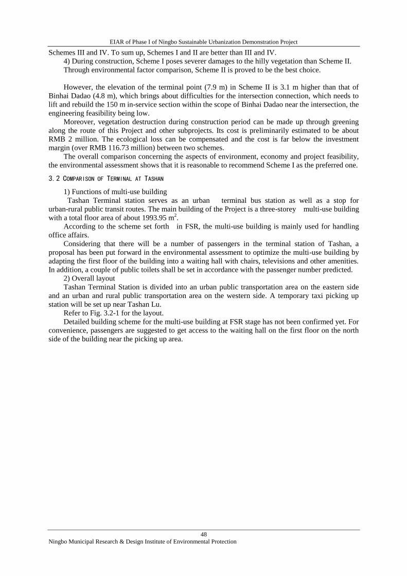
EIAR of Phase I of Ningbo Sustainable Urbanization Demonstration Project
48
Ningbo Municipal Research & Design Institute of Environmental Protection
Schemes III and IV. To sum up, Schemes I and II are better than III and IV.
4) During construction, Scheme I poses severer damages to the hilly vegetation than Scheme II.
Through environmental factor comparison, Scheme II is proved to be the best choice.
However, the elevation of the terminal point (7.9 m) in Scheme II is 3.1 m higher than that of
Binhai Dadao (4.8 m), which brings about difficulties for the intersection connection, which needs to
lift and rebuild the 150 m in-service section within the scope of Binhai Dadao near the intersection, the
engineering feasibility being low.
Moreover, vegetation destruction during construction period can be made up through greening
along the route of this Project and other subprojects. Its cost is preliminarily estimated to be about
RMB 2 million. The ecological loss can be compensated and the cost is far below the investment
margin (over RMB 116.73 million) between two schemes.
The overall comparison concerning the aspects of environment, economy and project feasibility,
the environmental assessment shows that it is reasonable to recommend Scheme I as the preferred one.
3.2 COMPARISON OF TERMINAL AT TASHAN
1) Functions of multi-use building
Tashan Terminal station serves as an urban terminal bus station as well as a stop for
urban-rural public transit routes. The main building of the Project is a three-storey multi-use building
with a total floor area of about 1993.95 m2.
According to the scheme set forth in FSR, the multi-use building is mainly used for handling
office affairs.
Considering that there will be a number of passengers in the terminal station of Tashan, a
proposal has been put forward in the environmental assessment to optimize the multi-use building by
adapting the first floor of the building into a waiting hall with chairs, televisions and other amenities.
In addition, a couple of public toilets shall be set in accordance with the passenger number predicted.
2) Overall layout
Tashan Terminal Station is divided into an urban public transportation area on the eastern side
and an urban and rural public transportation area on the western side. A temporary taxi picking up
station will be set up near Tashan Lu.
Refer to Fig. 3.2-1 for the layout.
Detailed building scheme for the multi-use building at FSR stage has not been confirmed yet. For
convenience, passengers are suggested to get access to the waiting hall on the first floor on the north
side of the building near the picking up area.
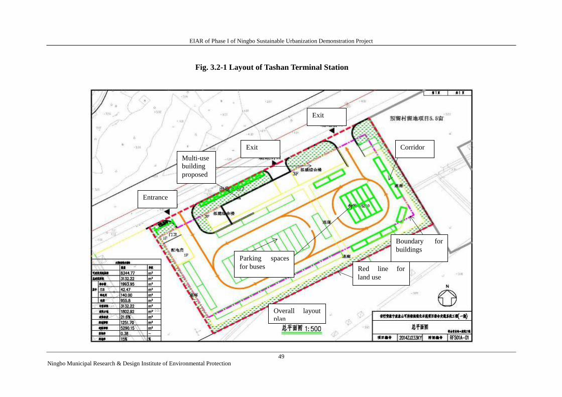
EIAR of Phase I of Ningbo Sustainable Urbanization Demonstration Project
49
Ningbo Municipal Research & Design Institute of Environmental Protection
Fig. 3.2-1 Layout of Tashan Terminal Station
Entrance
Exit
Multi-use
building
proposed
Exit
Corridor
Parking spaces
for buses Red line for
land use
Boundary for
buildings
Overall layout
plan
EIAR of Phase I of Ningbo Sustainable Urbanization Demonstration Project
50
Ningbo Municipal Research & Design Institute of Environmental Protection
3.3 COMPARISON OF ALTERNATIVES WITH AND WITHOUT FLOOD RISK MANAGEMENT COMPONENT
The project data show that in the three areas of the main urban district in Xiangshan, thearea
between Jianshe Lu andJingnan Lu in the old urban area, the partially low lying area of the economic
development park and area south to Danshan Lu in the new urban area, the anti-flood and
waterlogging prevention and control abilities are only to combat flood which happens once every five
years. Furthermore, due to the small capacity of the internal river, the insufficient flood discharge
ability and the poor water quality, if the flood risk management component is not to be included, the
serious waterlogging and sewage overflow in the main urban district of Xiangshan will easily hit the
areas in the flood season, especially typhoon season. Scheme Zero has a remarkable impact on
environment.
On the contrary, if the component is included, a complete and sustainable drainage and
waterlogging prevention system can be established through effective engineering and non-engineering
measures so as to endow Xiangshan strong abilities to fight against 20 year return stormwater as well
as to improve the self-cleaning capacity of rivers and their water quality and benefit the living and
breeding conditions of aquatic species in the Rivers. Although the project will bring certain impacts to
the surroundings, the environmental impacts of the project can be controllable by taking relevant
pollution control measures as proposed in EA and the regional environment quality will not be
affected in the project areas.
In conclusion, the project construction conforms with the national industrial policies and relevant
planning requirements. Compared with Scheme Zero of maintaining the current status unchanged, the
project will have remarkable positive effects on the environment during the operation period. From the
viewpoint of environmental protection, it is desirable to implement this Project.
The project data show that in the three areas of the main urban district in Xiangshan, thearea
between Jianshe Lu and Jingnan Lu in the old urban area, the partially low lying area of the economic
development park and area south to Danshan Lu in the new urban area, the anti-flood and
waterlogging prevention and control abilities are only to combat flood which happens once every five
years. Furthermore, due to the small capacity of the internal river, the insufficient flood discharge
ability and the poor water quality, if the flood risk management component is not to be included, the
serious waterlogging and sewage overflow in the main urban district of Xiangshan will easily hit the
areas in the flood season, especially typhoon season. Scheme Zero has a remarkable impact on
environment.
On the contrary, if the component is included, a complete and sustainable drainage and
waterlogging prevention system can be established through effective engineering and non-engineering
measures so as to endow Xiangshan strong abilities to fight against 20 year return stormwater as well
as to improve the self-cleaning capacity of rivers and their water quality and benefit the living and
breeding conditions of aquatic species in the Rivers. Although the project will bring certain impacts to
the surroundings, the environmental impacts of the project can be controllable by taking relevant
pollution control measures as proposed in EA and the regional environment quality will not be
affected in the project areas.
In conclusion, the project construction conforms with the national industrial policies and relevant
planning requirements. Compared with Scheme Zero of maintaining the current status unchanged, the
project will have remarkable positive effects on the environment during the operation period. From the
viewpoint of environmental protection, it is desirable to implement this Project.
EIAR of Phase I of Ningbo Sustainable Urbanization Demonstration Project
51
Ningbo Municipal Research & Design Institute of Environmental Protection
4 Current Environmental and Social Condition
4.1 SUMMARY OF NATURAL ENVIRONMENT
4.1.1 Geographical Location
Ningbo is located in eastern Zhejiang Province, southeast of the Yangtze River Delta and at the
east end of Ningshao Plain in Zhejiang. Neighboring the East Sea in the East, Ningbo holds the
Zhoushan Islands as its natural cover for defense. Adjacent to Hangzhou Bay in the North, Ningbo
faces to Shanghai across the sea; borders Shaoxing Municipality in the east where the Tiantai
Mountain expands, and connects Sanmen Bay in the south, Ningbo also adjoins Sanmen County and
Tiantai County. Ningbo is 175 km wide from the east to the west and 192 km long from the north to
the south.
The Project lies in the core urban area of Xiangshan County in Ningbo. The county stands
between the north latitude 28°51′18〞and 29°39′42〞 and between the east longitude 121°34′03〞
and 122°17′30. Standing in the middle of the eastern coast of Zhejiang Province and the southeast of
Ningbo, the Project will be developed between Xiangshan Harbor and Sanmen Bay. Close to the
Xiangshan harbor in the north, the county faces to Yinzhou District and Fenghua City across the
harbor. Liuheng Isle of Putuo District in Zhoushan City and Meishan Isle of Beilun District in Ningbo
City stand apart at a distance from the northeast of the county. Bordering the Damuyang sea in the east
and Maotouyang sea in the south, the county stands against Sanmen County of Taizhou City across
Sanmen Bay; the project stretches to Ninghai County to the west and Xiangshan Peninsula enters the
sea to the east from Zixi and Meilin of Ninghai County to Yishi. Xiangshan County consists of
mainland and 656 coastal isles islets, with a land area of 1382 km², a sea area of 6618 km² and a
coastline of 925 km, characterized by “three sides surrounded by the sea and one line penetrating
through the land”.
As a county town in Xiangshan County, Dancheng has two subdistricts named Dandong and
Danxi separated by Tianan Lu. Wherein, Dandong Subdistrict is located at the middle part of the core
urban area of aXiangshan, where the county Party Committee and county government are seated all
long, serving as a hub of economic development, culture, education, sport, medical care for the whole
county. It covers a land area of 38 km², with an agricultural land of 8397 mu (5.60 km²), a forestry
land of 38400 mu (25.60 km²) and a beach area of around 3000 mu (2.00 km²). Danxi Subdistrict is
located in the west of the core urban disrict of Xiangshan, covering a land of 42 km².
See the Fig 4.1-1 for the geographical location of Xiangshan County.
4.1.2 Topography
Xiangshan is an extension from Tiantai Mountain which stretches to the sea and mainly covered
by hills, with a name of “seven tenths of hills, one tenth of waters and two tenths of farmland”.
Situated in the coastal part of hilly areas of the east of Zhejiang, Xiangshan covers a hilly area of 793
km2 which accounts for about seven tenth of its total area. Inside the county, hills below 200 m is seen
mostly with slow slope and rolling ridges. The topography is mainly featured by enormous low hills
with slow slope.
The county declines from the northwest to the southeast. Tiantai Mountain extends eastwards
Ningshan Peninsula from Ninghai County, forming the highest junction part of Ninghai County and
EIAR of Phase I of Ningbo Sustainable Urbanization Demonstration Project
52
Ningbo Municipal Research & Design Institute of Environmental Protection
Xiangshan County inside the northwest of Ninghai County. These hills are magnificent with
undulating ridges and peaks and most main peaks being above 500 meters. Wherein, Dongban
Mountain made of chains of peaks wriggles from the Chashan Mountain in Ninghai County with the
main peak of 810.8 meters high which is the highest in Xiangshan. With an altitude of 756 meters,
Niuliaogang is located in the southeast as the second highest inside the county. There are over 20
peaks with altitudes from 300 m to 700m. Hilly lands are widely spread and normally 200-450m high,
mainly including Juexi hilly area, Huangbi’ao hilly area and Nanxiang hilly area.
Plains of Xiangshan are mostly scattered in the coastal areas, which are evolved from beaches
developed from silt under the effect of the sea bay, and later firstly and reclaimed to be plains. They
belong in marine depositional plains, mainly distributed in Xiangshan Harbor in the North, bays in the
east and Sanmen Bay in the south. They cover massive lands and spreads vastly, dominating the most
part of Xiangshan plains. Nanzhuang Plain and Dingshan Plain rank top 2 in terms of coverage area,
historically boasted as “80,000 mu (more than 5000 ha.) in the upper area and 80,000 mu in the lower
area".
Besides, there are alluvial plains in Xiangshan with the main form of alluvial fan in the front of
hill. Due to low and small hills as well as shallow and narrow hinterland, these plains cover small
areas with typical characteristics in Dancheng, Baishi, Jiuqing and Meixi zones .
Located on the peninsula, Xiangshan has a long coastline with numerous harbors and cape
corners. The county has a coastline of 800 km, including a mainland coastline of 300 km and insular
coastline of 500 km. Main harbors include Xiangshan Harbor, Xihu Harbor, Taiping Harbor, Damu
Bay, Changguo Bay, Shipu Harbor, Sanmen Bay, Yuejingyang bay/harbor, Xieqian Harbor, Nantian
Bay, etc. Among them, Xiangshan Harbor, Sanmen Bay and Shipu Harbor are the provincially and
even nationally famous harbors/bay.
Damutu (tu --- beach or tidal land) is also called Damuwan (wan --- bay) with a width of 14.8 km,
depth of 7.2 km and a total area of 80 km2, which is an open bay, within which there are three small
sea bays. From north to south, there is Menqiantu Bay with an area of 24 km2, Danmen Bay with
coverage of 9 km2 and Jiwu Bay with an area of 21 km
2 inside it. Large beach lands are seen in each
bay with a total area of 30 km2.
4.1.3 Meteorological and climatic characteristics
Xiangshan County enjoys a warm and wet climate influenced by subtropical oceanic monsoon
with four distinctive seasons, abundant sunshine and rainfalls, long winter and summer, short spring
and autumn and much disastrous weather. Perennial mean temperature lies at 17.5 ℃ with
historically highest temperature of 39.6℃ and lowest temperature of -6.9℃; multi-year average
precipitation is 1481.6mm with the maximum annual rainfall of 2177.6mm and minimum annual
rainfall of 770.6mm. With multi-year average humidity is 58.3% with frost-free period of 248 days in
average, the county belongsin humid and semi-humid region which indicates a basic balance between
precipitation and evaporation; Main rainy seasons occur from March to June (i.e. spring rains and
mould rains) and from August to October (i.e. typhoon rain and autumn rain) Typhoon comes to
Xiangshan mainly from July to October with a number of 3 each year. Typhoon will bring about wind
and high waves as well as the highest tidal level over the years, which is a big threat to this region.
The coastal annual average wind speed is 5.6m/s (Scale 4). The days reaches 98.9 in a year with a
wind speed above 18m/s (Scale 8), 67 days at least; as to wind speed above 10.8m/s (Scale 6), it
reaches 254.6 days throughout a year, 288 days at maximum and 216 days at minimum.. Wind
EIAR of Phase I of Ningbo Sustainable Urbanization Demonstration Project
53
Ningbo Municipal Research & Design Institute of Environmental Protection
direction changes distinctly as season changes.Northern winds prevail in winter.Wind direction tends
to change in autumn but southerly wind will be more frequent as time goes by. In summer, southerly
wind will blow mostly.At the beginning of the autumn, wind is changeable in terms of direction but
northerly wind will become the main source after midautumn.
Summer and winter are mostly influenced by the wet and warm airflow from the Indian Ocean
and Pacific Ocean, thus rich rainfalls come; winter and autumn tend to be affected by dry and cold air
from the center of Eurasia and Mongolian Plateau. Rain falls mainly from May to September every
year with 15.5 days of not less than 25mm in terms of multi-year average daily precipitation.
Multi-year annual precipitation…………1481.6mm
Maximum annual precipitation…………2177.6mm
Minimum annual precipitation…………770.6 mm
Maximum daily precipitation………… 103.6 mm
Longest consecutive rainy days…………11d
Largest amount of storm precipitation…..353 mm
4.1.4 Hydrological characteristics
1)Inland river
Streams and rivers in Xiangshan are featured by short sources and rapid flows , which empty
themselves into the sea alone. There are rivers named Datanggang, Nanda, Dangang, Xizhougang,
Xiashengang, Dongtang, Fan’aogang, etc., each with a catchment area of more than 20km2. Among
them, the Datanggang river system is located in Dingshan Plain with a basin area of 134km2.As the
trunk stream, Datanggang was originally an inland harbor of Sanmen bay, which was formed a river
through plugging and storing fresh water, with a length of 18km and average width of 500m. This
Project is located in the middle coastal plain of Xiangshan with multi-year annual precipitation of
1548mm, multi-year annual runoff of 816.2mm and multi-year annual runoff coefficient of 0.53.
2) Offshore area
T Rivers in Xiangshan all discharge into Damuwan (wan --- bay) in the south and into sea at last,
and tides in Damutu seaside belong in non-regular semidiurnal shallow water tide. By gathering tidal
information of the Songlanshan Hydrometric Station, it is concluded that multi-year average tidal level
is 0.28m, measured highest tidal level is 4.54m and lowest tidal level is -2.64m and multi-year average
tidal range is 3.04m.
As for tides of this region, Longdongmen has the eastern sea area as its rotating flow with a
rotating rate of 0.60, the direction of the major axis of current ellipse is approximately in the direction
of southeast-northwest. The averageflow speed of flooding and ebbing tidesis about 0.3m/s, which
gradually turn into reciprocating currents after entering the beach area and meet Wankou (bay mouth)
(line connecting Longdongshan and Danmenshan) vertically. The average speed of flooding and
ebbing tides is 0.2-0.35m/s.
Water temperature of this sea area is 15.7℃ in average in the last ten days of April every year
which gradually falls until the midmonth of October when the temperature reaches 16.2℃.The sea
water salinity is 26.5-30%, rich in nutrient salts.
4.1.5 Seismic intensity
According to the Map of Seismic Ground Motion Peak Acceleration Zoning of China
EIAR of Phase I of Ningbo Sustainable Urbanization Demonstration Project
54
Ningbo Municipal Research & Design Institute of Environmental Protection
(GB18306-2001)published by the China Seismological Bureau, the seismic ground motion peak
acceleration is 0.05g, seismic basic intensity is VI correspondingly and regional crust is confirmed as
stable.
4.2 OVERVIEW OF SOCIAL CONDITION
4.2.1 Overview of Ningbo Municipality
As an important harbor municipality in the southeastern coastal region, Ningbo covers an area of
9365km2 with a total population of 5.604 million and covers an urban area of 2560km
2 with a
population of 2.158 million. Ningbo also forms as an important industrial base and important
production base of special local economic products including grain, cotton, edible oil and aquatic
productsin Zhejiang Province and owns 7 national-level cultural relics protection sites, ranking the
first in Zhejiang Province.
In 2014, the whole municipality realized a local GDP of RMB 760.25 billion, growing by 7.6%
compared to the previous year in terms of comparable prices; per capita GDP based on permanent
residents amounted to RMB 98,972 (USD 16112 converted by annual average exchange rate); As for
the distributions of three industries in GDP, the first industry accomplished RMB 27.517 billion
(accounting for 3.62%), the secondary industry realized RMB 393.557 billion (accounting for 51.77%)
and the tertiary industry achieved RMB 339.176 billion (accounting for 44.61%); financial revenue of
the whole municipality achieved RMB 179.09 billion in which the public budget revenue reached
RMB 86.06 billion with respective growth of 8.5% and 8.6%; average disposable income of urban
residents reached RMB 44,155 with an increase of 9.2% and average net income of rural residents
amounted to RMB 24,283, growing by 11.0%.
4.2.2 Overview of Xiangshan County
Xiangshan County is highly developed in economy which was listed as coastal economic
development zone by the State Council in 1988 and leaped into national top 100 strong counties, thus
becoming an area in the province with rapid economic and social development. Currently, 10 towns, 5
townships and 3 sub-districts are subordinate to Xiangshan County with a total population of 540,000.
The built-up area of the urban core district covers 28 square kilometers with a permanent residential
population of 230,000, ranking 63rd among national top 100 strong counties in terms of national
comprehensive strength.
In 2014, Xiangshan County realized local GDP worth of RMB 38.87 billion and financial
revenue of RMB 5.477 billion with respective growth of 7% and 8.2%; three industries developed
coordinately with the first industry achieving RMB 5.80 billion, accounting for 14.% of GDP, the
secondary, RMB 17.6 billion, accounting for 45.3% of GDP and the tertiary industry, RMB 15.47
billion, accounting for 39.8% of GDP in terms of distributions of three industries in GDP; industrial
economy grew steadily, achieving a total industrial output value above RMB 54 billion by the
industrial enterprises with or above the designated scale, with a growth of 12% and building industry
output value of RMB 111.9 billion, a growth by 12.1%; agriculture maintained a stable economic
growth, realizing a total output value of RMB 10.7 billion;the modern service industry was accelerated
development and value increment in service industry and total retail volume increase of consumables
ranking top in the municipality; general revenue of tourism industry amounted to RMB 14.5 billion,
growing by 20%. Per capita disposable income of resident in the whole town is RMB 33,069,
EIAR of Phase I of Ningbo Sustainable Urbanization Demonstration Project
55
Ningbo Municipal Research & Design Institute of Environmental Protection
increasing by 9.9% year-on-year.
4.3 PRESENT ENVIRONMENT QUALITY
4.3.1 Ambient Air Quality
Referring to the monitoring data of 2014 about the ambient air quality of core urban district of
Xiangshan collected by provincial-level monitoring station in the Wenfeng School set up by
Xiangshan Environment Monitoring Station, detailed monitoring results involving main pollution
factors including SO2, NO2, PM10, PM2.5 and CO are obtained as follows:
Table 4.3-1 Statistical Table of Concentration of Various Pollutants in Core urban district of
Xiangshan in 2014 Unit: mg/m3
Monitoring Month Item SO2 PM10 NO2 PM2.5 CO
January
Sample number 31 29 31 28 31
Minimum value 0.005 0.030 0.020 0.026 0.2
Maximum value 0.073 0.227 0.084 0.152 1.4
Average value 0.019 0.080 0.041 0.060 0.7
February
Sample number 26 18 26 26 26
Minimum value 0.003 0.007 0.007 0.018 0.4
Maximum value 0.036 0.115 0.043 0.090 1.1
Average value 0.013 0.049 0.025 0.041 0.8
March
Sample number 28 28 28 28 28
Minimum value 0.009 0.023 0.017 0.016 0.4
Maximum value 0.031 0.125 0.042 0.088 1.3
Average value 0.018 0.060 0.027 0.040 1.0
The First Quarter Average value 0.017 0.063 0.031 0.047 0.83
April
Sample number 30 28 30 30 30
Minimum value 0.010 0.019 0.015 0.010 0.3
Maximum value 0.030 0.100 0.044 0.082 1.0
Average value 0.015 0.048 0.023 0.034 0.6
May
Sample number 31 31 28 31 31
Minimum value 0.004 0.024 0.010 0.013 0.5
Maximum value 0.023 0.159 0.030 0.094 1.2
Average value 0.010 0.069 0.020 0.044 0.8
June
Sample number 30 30 27 30 30
Minimum value 0.003 0.011 0.003 0.012 0.4
Maximum value 0.015 0.081 0.021 0.075 0.9
Average value 0.006 0.039 0.009 0.038 0.6
The Second Quarter Average value 0.010 0.052 0.017 0.039 0.67
EIAR of Phase I of Ningbo Sustainable Urbanization Demonstration Project
56
Ningbo Municipal Research & Design Institute of Environmental Protection
Monitoring Month Item SO2 PM10 NO2 PM2.5 CO
July
Sample number 31 31 31 27 31
Minimum value 0.004 0.016 0.002 0.011 0.5
Maximum value 0.009 0.073 0.018 0.099 0.9
Average value 0.006 0.038 0.007 0.039 0.6
August
Sample number 31 31 31 31 31
Minimum value 0.004 0.012 0.004 0.012 0.5
Maximum value 0.016 0.077 0.018 0.058 1.0
Average value 0.007 0.034 0.012 0.031 0.7
September
Sample number 30 30 27 30 30
Minimum value 0.003 0.011 0.002 0.004 0.5
Maximum value 0.011 0.079 0.034 0.058 1.1
Average value 0.007 0.038 0.017 0.026 0.7
The Third Quarter Average value 0.007 0.037 0.012 0.032 0.67
October
Sample number 31 31 31 31 29
Minimum value 0.005 0.028 0.012 0.007 0.4
Maximum value 0.023 0.123 0.040 0.086 0.9
Average value 0.010 0.056 0.021 0.030 0.6
November
Sample number 30 30 30 30 30
Minimum value 0.006 0.021 0.014 0.017 0.5
Maximum value 0.034 0.164 0.048 0.136 1.2
Average value 0.013 0.062 0.030 0.044 0.7
December
Sample number 31 31 31 31 31
Minimum value 0.007 0.047 0.022 0.029 0.6
Maximum value 0.022 0.164 0.055 0.112 1.3
Average value 0.013 0.095 0.043 0.066 0.9
The Fourth Quarter Average value 0.012 0.071 0.031 0.047 0.73
Annual
Sample number 360 348 351 353 358
Minimum value 0.003 0.007 0.002 0.004 0.2
Maximum value 0.073 0.227 0.084 0.152 1.4
Average value 0.012 0.056 0.023 0.041 0.7
By combining monitoring data shown above and adopting and comparing Level-II standard
comprehensive pollution index of Ambient Air Quality Standard (GB 3095-2012), conclusions are
drawn infollowing Table 4.3-2.
Table 4.3-2 Comprehensive Pollution Index of Various Pollutants
Year Pollution sub-Index Comprehensive
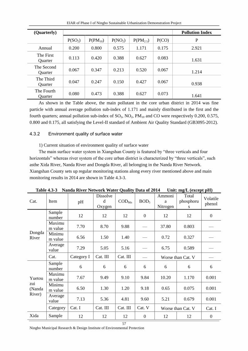
EIAR of Phase I of Ningbo Sustainable Urbanization Demonstration Project
57
Ningbo Municipal Research & Design Institute of Environmental Protection
(Quarterly) Pollution Index
P(SO2) P(PM10) P(NO2) P(PM2.5) P(CO) P
Annual 0.200 0.800 0.575 1.171 0.175 2.921
The First
Quarter 0.113 0.420 0.388 0.627 0.083 1.631
The Second
Quarter 0.067 0.347 0.213 0.520 0.067 1.214
The Third
Quarter 0.047 0.247 0.150 0.427 0.067 0.938
The Fourth
Quarter 0.080 0.473 0.388 0.627 0.073 1.641
As shown in the Table above, the main pollutant in the core urban district in 2014 was fine
particle with annual average pollution sub-index of 1.171 and mainly distributed in the first and the
fourth quarters; annual pollution sub-index of SO2, NO2, PM10 and CO were respectively 0.200, 0.575,
0.800 and 0.175, all satisfying the Level-II standard of Ambient Air Quality Standard (GB3095-2012).
4.3.2 Environment quality of surface water
1) Current situation of environment quality of surface water
The main surface water system in Xiangshan County is featured by “three verticals and four
horizontals” whereas river system of the core urban district is characterized by “three verticals”, such
asthe Xida River, Nanda River and Dongda River, all belonging in the Nanda River Network.
Xiangshan County sets up regular monitoring stations along every river mentioned above and main
monitoring results in 2014 are shown in Table 4.3-3.
Table 4.3-3 Nanda River Network Water Quality Data of 2014 Unit: mg/L (except pH)
Cat. Item pH
Dissolve
d
Oxygen
CODMn BOD5
Ammoni
a
Nitrogen
Total
phosphoru
s
Volatile
phenol
Dongda
River
Sample
number 12 12 12 0 12 12 0
Maximu
m value 7.70 8.70 9.88 — 37.80 0.803 —
Minimu
m value 6.56 1.50 1.40 — 0.72 0.327 —
Average
value 7.29 5.05 5.16 — 6.75 0.589 —
Cat. Category I Cat. III Cat. III — Worse than Cat. V —
Yuetou
zui
(Nanda
River)
Sample
number 6 6 6 6 6 6 6
Maximu
m value 7.67 9.49 9.10 9.84 10.20 1.170 0.001
Minimu
m value 6.50 1.30 1.20 9.18 0.65 0.075 0.001
Average
value 7.13 5.36 4.81 9.60 5.21 0.679 0.001
Category Cat. I Cat. III Cat. III Cat. V Worse than Cat. V Cat. I
Xida Sample 12 12 12 0 12 12 0

EIAR of Phase I of Ningbo Sustainable Urbanization Demonstration Project
58
Ningbo Municipal Research & Design Institute of Environmental Protection
River number
Maximu
m value 7.80 10.30 7.18 — 45.10 0.930 —
Minimu
m value 6.72 2.80 1.44 — 0.90 0.090 —
Average
value 7.24 5.45 5.07 — 5.63 0.441 —
Category Cat. I Cat. III Cat. III — Worse than Cat. V
—
As shown in the Table above, only three pollutant indicators of the Dongda River and Xida River
do not exceedthe standard limited values of Category III of the Environmental Quality Standard for
Surface Water (GB3838-2002), such as pH, DO and CODMn, whereas ammonia nitrogen and total
phosphorus exceed standard limited values of Category V; pH, DO, volatile phenol, CODMn of Nanda
River meet the requirements of Category III standard while ammonia nitrogen, BOD5abd total
phosphorus all exceed the standard limits; waters mentioned above are assessed as that worse than
Category V, failing to meet the requirement for protecting Category III waters.
2) Overview of sewage treatment plant in the core urban district of Xiangshan County
Wastewater produced by the Project will be discharged into municipal sewer net after
pretreatment and then transmitted to the wastewater treatment plant in the core urban district of
Xiangshan for final treatment.
The WWTP in the core urban district of Xiangshan is located inside Xiangshan County Urban
Drainage Company in the south of Binghai Dadao and the west of Laixun Lu. This plant is engaged in
providing service in the old urban district in the north of Dandong Jie and Danxi Jie as well as villages
subordinate to Dongcheng Township (in the north of Jinkai Lu and on the both sides of the coastal
south line).
The first-stage and second-stage projects have been completed in the plant with a design capacity
of 2,5000m3/d at the first stage; and that of the second-stage 2,5000m
3/d, totally50,000m
3/d. A2/O
process is adopted for treating wastewater. First-stage effluent discharge adopts Level-I BStandard
of Discharge Standard for Pollutantsfrom Municipal WWTP and second-stage effluent discharge
standard is elevated to Level-I AStandard, and the tail water is discharged into the Xida River after
being treated to meet the standard; the design capacity for reclaimed water treatment is 2,5000m3/d,
the process adopted for which is sand filtration plus disinfection . Sludge will be converted to
aerobic compost by adopting mechanical thickening and centrifugal dewatering. The first-stage
worksconstruction was started in September, 2005, including construction of pipe network, mid-way
1-5# lift pump stations, wastewater treatment plant, and reclaimed water reuse facilities, which were
put into trial operation in September, 2006; the second-stage works started construction in August,
2009, including construction of sewer network, wastewater (reclaimed water) treatment, sludge
disposal and reclaimed water pipe network without mid-way lift pump stations added, which were put
into trial operation as of October 1, 2010.
In order to satisfy continuously increasing demands of treating urban sewage, Xiangshan County
Urban Drainage Company invested to construct the third-stage works in 2014 toenhance the capacity
to 70,000m3/d from 50,000m
3/d and adopting A2/O technology. Tertiary treatment applies hybrid
reaction and activated carbon sand filtration, new-added deep treatment adopts micro-flocculation and
denitrification filtration technology and the effluent discharge still implements GB18918-2002 Level
1A Standard. Currently, the third-stage works is under construction.
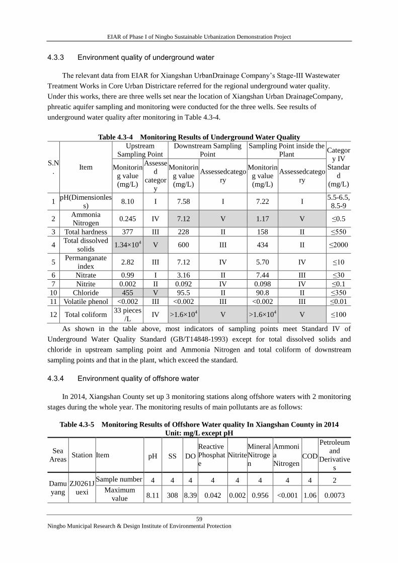
EIAR of Phase I of Ningbo Sustainable Urbanization Demonstration Project
59
Ningbo Municipal Research & Design Institute of Environmental Protection
4.3.3 Environment quality of underground water
The relevant data from EIAR for Xiangshan UrbanDrainage Company’s Stage-III Wastewater
Treatment Works in Core Urban Districtare referred for the regional underground water quality.
Under this works, there are three wells set near the location of Xiangshan Urban DrainageCompany,
phreatic aquifer sampling and monitoring were conducted for the three wells. See results of
underground water quality after monitoring in Table 4.3-4.
Table 4.3-4 Monitoring Results of Underground Water Quality
S.N
. Item
Upstream
Sampling Point
Downstream Sampling
Point
Sampling Point inside the
Plant Categor
y IV
Standar
d
(mg/L)
Monitorin
g value
(mg/L)
Assesse
d
categor
y
Monitorin
g value
(mg/L)
Assessedcatego
ry
Monitorin
g value
(mg/L)
Assessedcatego
ry
1 pH(Dimensionles
s) 8.10 I 7.58 I 7.22 I
5.5-6.5,
8.5-9
2 Ammonia
Nitrogen 0.245 IV 7.12 V 1.17 V ≤0.5
3 Total hardness 377 III 228 II 158 II ≤550
4 Total dissolved
solids 1.34×10
4 V 600 III 434 II ≤2000
5 Permanganate
index 2.82 III 7.12 IV 5.70 IV ≤10
6 Nitrate 0.99 I 3.16 II 7.44 III ≤30
7 Nitrite 0.002 II 0.092 IV 0.098 IV ≤0.1
10 Chloride 455 V 95.5 II 90.8 II ≤350
11 Volatile phenol <0.002 III <0.002 III <0.002 III ≤0.01
12 Total coliform 33 pieces
/L IV >1.6×10
4 V >1.6×10
4 V ≤100
As shown in the table above, most indicators of sampling points meet Standard IV of
Underground Water Quality Standard (GB/T14848-1993) except for total dissolved solids and
chloride in upstream sampling point and Ammonia Nitrogen and total coliform of downstream
sampling points and that in the plant, which exceed the standard.
4.3.4 Environment quality of offshore water
In 2014, Xiangshan County set up 3 monitoring stations along offshore waters with 2 monitoring
stages during the whole year. The monitoring results of main pollutants are as follows:
Table 4.3-5 Monitoring Results of Offshore Water quality In Xiangshan County in 2014
Unit: mg/L except pH
Sea
Areas Station Item pH SS DO
Reactive
Phosphat
e
Nitrite
Mineral
Nitroge
n
Ammoni
a
Nitrogen COD
Petroleum
and
Derivative
s
Damu
yang
ZJ0261J
uexi
Sample number 4 4 4 4 4 4 4 4 2
Maximum
value 8.11 308 8.39 0.042 0.002 0.956 <0.001 1.06 0.0073
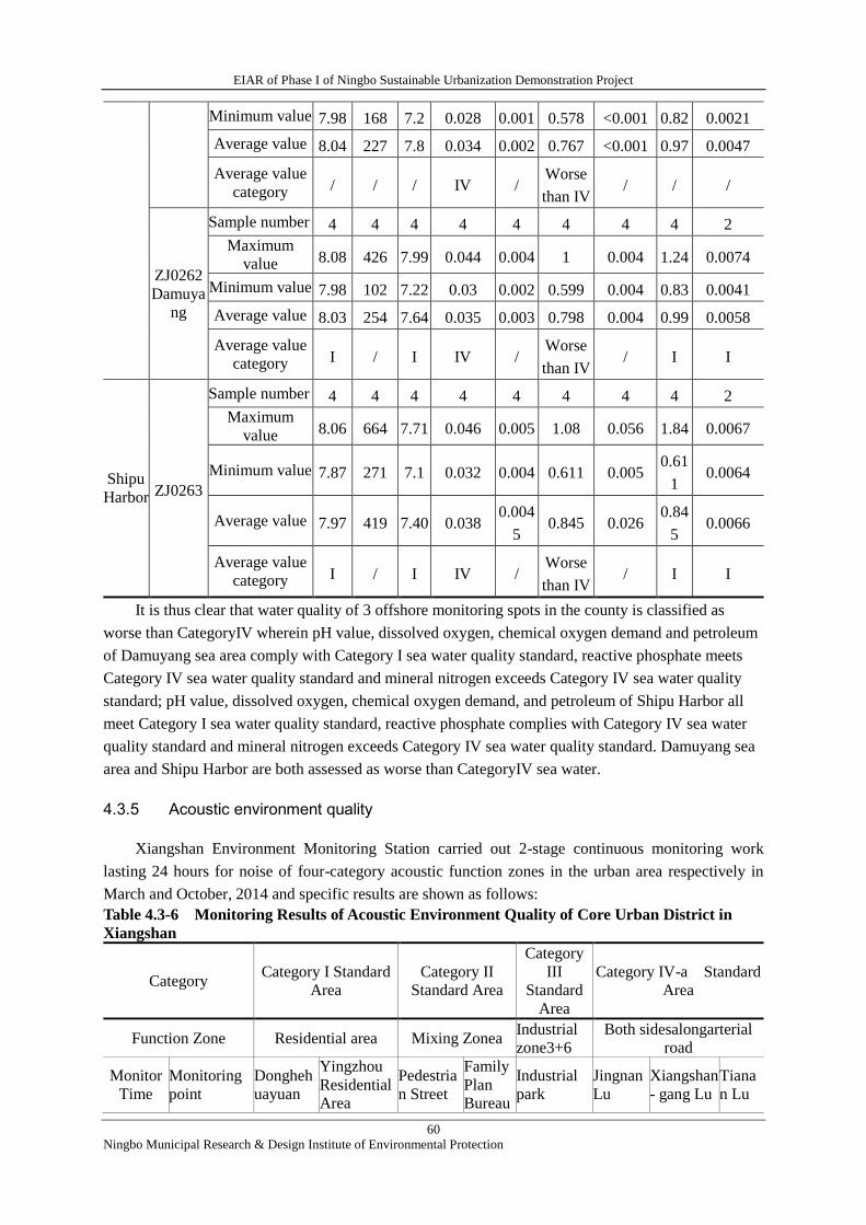
EIAR of Phase I of Ningbo Sustainable Urbanization Demonstration Project
60
Ningbo Municipal Research & Design Institute of Environmental Protection
Minimum value 7.98 168 7.2 0.028 0.001 0.578 <0.001 0.82 0.0021
Average value 8.04 227 7.8 0.034 0.002 0.767 <0.001 0.97 0.0047
Average value
category / / / IV / Worse
than IV / / /
ZJ0262
Damuya
ng
Sample number 4 4 4 4 4 4 4 4 2
Maximum
value 8.08 426 7.99 0.044 0.004 1 0.004 1.24 0.0074
Minimum value 7.98 102 7.22 0.03 0.002 0.599 0.004 0.83 0.0041
Average value 8.03 254 7.64 0.035 0.003 0.798 0.004 0.99 0.0058
Average value
category I / I IV / Worse
than IV / I I
Shipu
Harbor ZJ0263
Sample number 4 4 4 4 4 4 4 4 2
Maximum
value 8.06 664 7.71 0.046 0.005 1.08 0.056 1.84 0.0067
Minimum value 7.87 271 7.1 0.032 0.004 0.611 0.005 0.61
1 0.0064
Average value 7.97 419 7.40 0.038 0.004
5 0.845 0.026
0.84
5 0.0066
Average value
category I / I IV / Worse
than IV / I I
It is thus clear that water quality of 3 offshore monitoring spots in the county is classified as
worse than CategoryIV wherein pH value, dissolved oxygen, chemical oxygen demand and petroleum
of Damuyang sea area comply with Category I sea water quality standard, reactive phosphate meets
Category IV sea water quality standard and mineral nitrogen exceeds Category IV sea water quality
standard; pH value, dissolved oxygen, chemical oxygen demand, and petroleum of Shipu Harbor all
meet Category I sea water quality standard, reactive phosphate complies with Category IV sea water
quality standard and mineral nitrogen exceeds Category IV sea water quality standard. Damuyang sea
area and Shipu Harbor are both assessed as worse than CategoryIV sea water.
4.3.5 Acoustic environment quality
Xiangshan Environment Monitoring Station carried out 2-stage continuous monitoring work
lasting 24 hours for noise of four-category acoustic function zones in the urban area respectively in
March and October, 2014 and specific results are shown as follows:
Table 4.3-6 Monitoring Results of Acoustic Environment Quality of Core Urban District in
Xiangshan
Category Category I Standard
Area
Category II
Standard Area
Category
III
Standard
Area
Category IV-a Standard
Area
Function Zone Residential area Mixing Zonea Industrial
zone3+6
Both sidesalongarterial
road
Monitor
Time
Monitoring
point
Dongheh
uayuan
Yingzhou
Residential
Area
Pedestria
n Street
Family
Plan
Bureau
Industrial
park
Jingnan
Lu
Xiangshan
- gang Lu
Tiana
n Lu
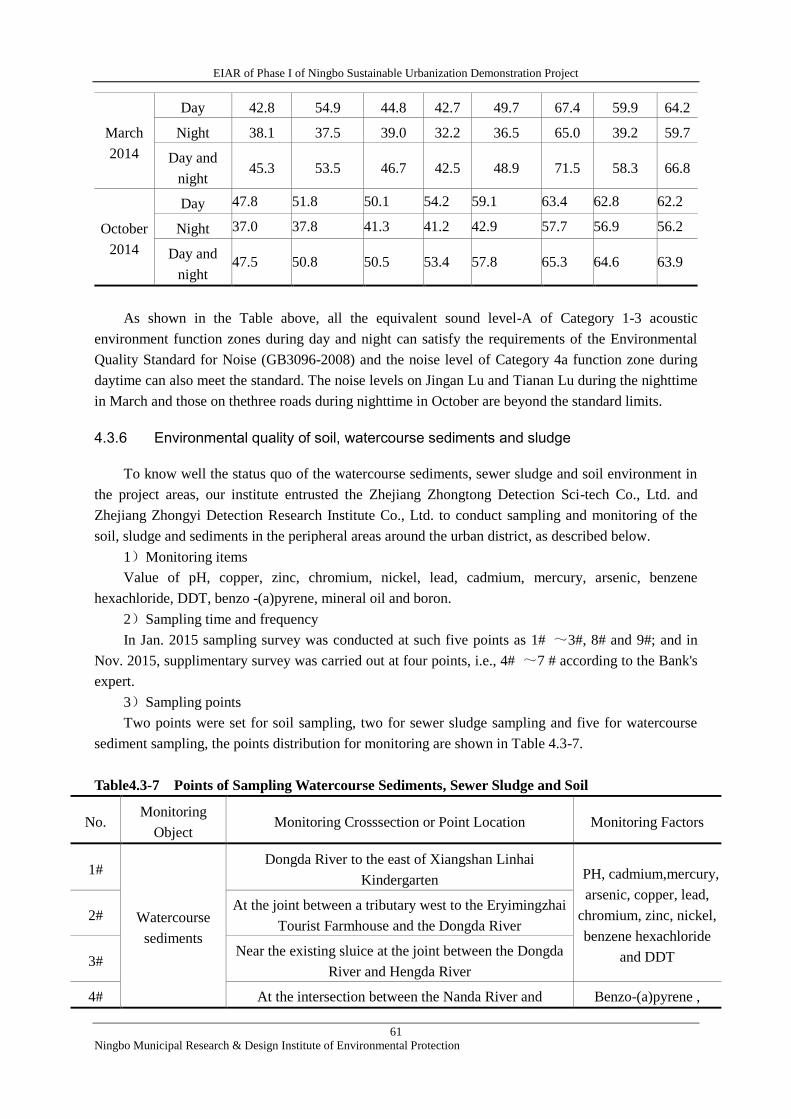
EIAR of Phase I of Ningbo Sustainable Urbanization Demonstration Project
61
Ningbo Municipal Research & Design Institute of Environmental Protection
March
2014
Day 42.8 54.9 44.8 42.7 49.7 67.4 59.9 64.2
Night 38.1 37.5 39.0 32.2 36.5 65.0 39.2 59.7
Day and
night 45.3 53.5 46.7 42.5 48.9 71.5 58.3 66.8
October
2014
Day 47.8 51.8 50.1 54.2 59.1 63.4 62.8 62.2
Night 37.0 37.8 41.3 41.2 42.9 57.7 56.9 56.2
Day and
night 47.5 50.8 50.5 53.4 57.8 65.3 64.6 63.9
As shown in the Table above, all the equivalent sound level-A of Category 1-3 acoustic
environment function zones during day and night can satisfy the requirements of the Environmental
Quality Standard for Noise (GB3096-2008) and the noise level of Category 4a function zone during
daytime can also meet the standard. The noise levels on Jingan Lu and Tianan Lu during the nighttime
in March and those on thethree roads during nighttime in October are beyond the standard limits.
4.3.6 Environmental quality of soil, watercourse sediments and sludge
To know well the status quo of the watercourse sediments, sewer sludge and soil environment in
the project areas, our institute entrusted the Zhejiang Zhongtong Detection Sci-tech Co., Ltd. and
Zhejiang Zhongyi Detection Research Institute Co., Ltd. to conduct sampling and monitoring of the
soil, sludge and sediments in the peripheral areas around the urban district, as described below.
1)Monitoring items
Value of pH, copper, zinc, chromium, nickel, lead, cadmium, mercury, arsenic, benzene
hexachloride, DDT, benzo -(a)pyrene, mineral oil and boron.
2)Sampling time and frequency
In Jan. 2015 sampling survey was conducted at such five points as 1# ~3#, 8# and 9#; and in
Nov. 2015, supplimentary survey was carried out at four points, i.e., 4# ~7 # according to the Bank's
expert.
3)Sampling points
Two points were set for soil sampling, two for sewer sludge sampling and five for watercourse
sediment sampling, the points distribution for monitoring are shown in Table 4.3-7.
Table4.3-7 Points of Sampling Watercourse Sediments, Sewer Sludge and Soil
No. Monitoring
Object Monitoring Crosssection or Point Location Monitoring Factors
1#
Watercourse
sediments
Dongda River to the east of Xiangshan Linhai
Kindergarten PH, cadmium,mercury,
arsenic, copper, lead,
chromium, zinc, nickel,
benzene hexachloride
and DDT
2# At the joint between a tributary west to the Eryimingzhai
Tourist Farmhouse and the Dongda River
3# Near the existing sluice at the joint between the Dongda
River and Hengda River
4# At the intersection between the Nanda River and Benzo-(a)pyrene ,
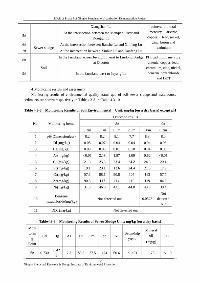
EIAR of Phase I of Ningbo Sustainable Urbanization Demonstration Project
62
Ningbo Municipal Research & Design Institute of Environmental Protection
Xiangshan Lu mineral oil, total
mercury, arsenic,
copper, lead, nickel,
zinc, boron and
cadmium
5# At the intersection between the Menqian River and
Donggu Lu
6# Sewer sludge
At the intersection between Jianshe Lu and Xinfeng Lu
7# At the intersection between Xinhua Lu and Danfeng Lu
8#
Soil
In the farmland across Juying Lu, east to Lindong Bridge
at Qiaotou
PH, cadmium, mercury,
arsenic, copper, lead,
chromium, zinc, nickel,
benzene hexachloride
and DDT
9# In the farmland west to Juyang Lu
4)Monitoring results and assessment
Monitoring results of environmental quality status quo of soil sewer sludge and watercourse
sediments are shown respectively in Table 4.3-8 ~Table 4.3-10.
Table 4.3-8 Monitoring Results of Soil Environmental Unit: mg/kg (on a dry basis) except pH
No. Monitoring items
Detection results
8# 9#
0.2m 0.5m 1.0m 2.0m 3.0m 0.2m
1 pH(Dimensionless) 8.2 8.2 8.1 7.7 8.3 8.0
2 Cd (mg/kg) 0.08 0.07 0.04 0.04 0.04 0.06
3 Hg(mg/kg) 0.09 0.05 0.01 0.10 0.04 0.03
4 As(mg/kg) <0.01 2.18 1.87 1.09 0.62 <0.01
5 Cu(mg/kg) 21.5 25.3 23.4 24.2 24.3 20.1
6 Pb(mg/kg) 19.1 23.1 12.6 24.4 21.3 17.9
7 Cr(mg/kg) 57.3 88.1 90.8 105 113 57.7
8 Zn(mg/kg) 90.5 117 114 119 119 84.5
9 Ni(mg/kg) 31.5 46.9 43.1 44.0 43.0 30.4
10 Benzene
hexachloride(mg/kg) Not detected out 0.0528
Not
detected
out
11 DDT(mg/kg) Not detected out
Table4.3-9 Monitoring Results of Sewer Sludge Unit: mg/kg (on a dry basis)
Moni
torin
g
Point
Cd Hg As Cu Pb Zn Ni Benzo(a)p
yrene
Mineral
oil
(mg/g)
B
6# 0.730 0.42
3 7.7 89.5 77.5 474 60.6 ﹤0.01 1.73 ﹤1.0
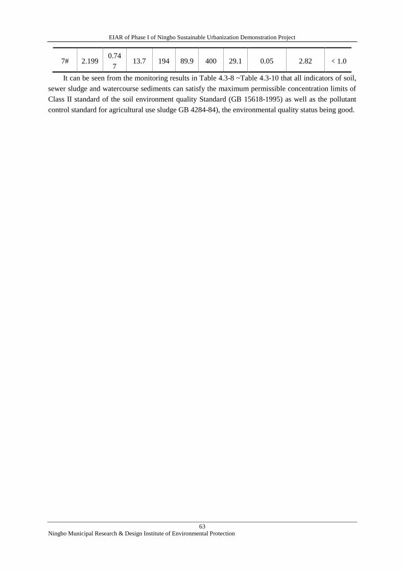
EIAR of Phase I of Ningbo Sustainable Urbanization Demonstration Project
63
Ningbo Municipal Research & Design Institute of Environmental Protection
7# 2.199 0.74
7 13.7 194 89.9 400 29.1 0.05 2.82 ﹤1.0
It can be seen from the monitoring results in Table 4.3-8 ~Table 4.3-10 that all indicators of soil,
sewer sludge and watercourse sediments can satisfy the maximum permissible concentration limits of
Class II standard of the soil environment quality Standard (GB 15618-1995) as well as the pollutant
control standard for agricultural use sludge GB 4284-84), the environmental quality status being good.
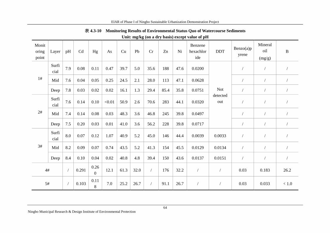
EIAR of Phase I of Ningbo Sustainable Urbanization Demonstration Project
64
Ningbo Municipal Research & Design Institute of Environmental Protection
表 4.3-10 Monitoring Results of Environmental Status Quo of Watercourse Sediments
Unit: mg/kg (on a dry basis) except value of pH
Monit
oring
point
Layer pH Cd Hg As Cu Pb Cr Zn Ni
Benzene
hexachlor
ide
DDT Benzo(a)p
yrene
Mineral
oil
(mg/g)
B
1#
Surfi
cial 7.9 0.08 0.11 0.47 39.7 5.0 35.6 188 47.6 0.0200
Not
detected
out
/ / /
Mid 7.6 0.04 0.05 0.25 24.5 2.1 28.0 113 47.1 0.0628 / / /
Deep 7.8 0.03 0.02 0.02 16.1 1.3 29.4 85.4 35.8 0.0751 / / /
2#
Surfi
cial 7.6 0.14 0.10 <0.01 50.9 2.6 70.6 283 44.1 0.0320 / / /
Mid 7.4 0.14 0.08 0.03 48.3 3.6 46.8 245 39.8 0.0497 / / /
Deep 7.5 0.20 0.03 0.01 41.0 3.6 56.2 228 39.8 0.0717 / / /
3#
Surfi
cial 8.0 0.07 0.12 1.07 40.9 5.2 45.0 146 44.4 0.0039 0.0033 / / /
Mid 8.2 0.09 0.07 0.74 43.5 5.2 41.3 154 45.5 0.0129 0.0134 / / /
Deep 8.4 0.10 0.04 0.02 40.8 4.8 39.4 150 43.6 0.0137 0.0151 / / /
4# / 0.291 0.26
0 12.1 61.3 32.0 / 176 32.2 / / 0.03 0.183 26.2
5# / 0.103 0.11
8 7.0 25.2 26.7 / 91.1 26.7 / / 0.03 0.033 ﹤1.0
EIAR of Phase I of Ningbo Sustainable Urbanization Demonstration Project
65
Ningbo Municipal Research & Design Institute of Environmental Protection
4.3.7 Ecological environment
1) Terrestrial ecology
The vegetation in Xiangshan is mainly of a hilly type which belongs in the north sub-zone of
mid-subtropical evergreen broad-leaved forests. It has evolved into a secondary vegetation type owing
to the extinction of a large area of primitive evergreen broad-leaved forests. Its actual vegetation can
be divided into 15 vegetation types and 23 formations. Arboreal forests include coniferous forests
consisting of masson pine, cypress and China fir, evergreen broad-leaved forests consisting of nanmu,
Castanopsis sclerophylla and Schima superba, mixed forests consisting of secondary broad-leaved
forests and coniferous forests mingled with deciduous broad-leaved forests as well as natural bamboo
forests featuring with maobamboo. Shrubberies consist of white oak, white azalea and Eurya japonica.
Thick growth of grasses consists of cogon, Themeda triandra and Arundinella anomala. Economic
forests include citrus, red bayberry, loquat, tee, peach, plum, Chinese plum and pear tree.
2) Marine ecology
There are multiple eco-types in the surrounding waters of Xiangshan County according to the
recent investigations and statistics from local authorities for fishery. More than 210 nektons have
appeared including 124 fishes, 30 shrimps and 49 crabs. Major harvesting species are hair-tail, baby
croaker, Acetes chinensis, mantis shrimp, Exopalaemon carinicauda and Muraenesox cinereous. Major
economic fishes are large and small yellow croakers, hair-tail, silvery pomfret, mackerel and eel.
Organisms in intertidal belts are also abundant with a common number of over 200 species, of which
mollusks and crustaceans are in the majority. Littorina brevicula and hermit crabs are common in
mudstone reef intertidal belts. Ruditapes philippinarum and coquina clams are common in intertidal
sandflats. Mud snails and Ilyoplax tansuiensis are common in intertidal mud flats. About 70 species of
benthos are common, mainly polychaetes, molluscs and crustaceans including Lumbriconeris
heteropoda, scallop and stick insects.
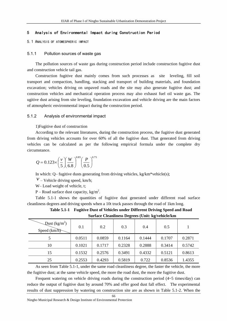
EIAR of Phase I of Ningbo Sustainable Urbanization Demonstration Project
66
Ningbo Municipal Research & Design Institute of Environmental Protection
5 Analysis of Environmental Impact during Construction Period
5.1 ANALYSIS OF ATOMESPHERIC IMPACT
5.1.1 Pollution sources of waste gas
The pollution sources of waste gas during construction period include construction fugitive dust
and construction vehicle tail gas.
Construction fugitive dust mainly comes from such processes as site leveling, fill soil
transport and compaction, handling, stacking and transport of building materials, and foundation
excavation; vehicles driving on unpaved roads and the site may also generate fugitive dust; and
construction vehicles and mechanical operation process may also exhaust fuel oil waste gas. The
ugitive dust arising from site leveling, foundation excavation and vehicle driving are the main factors
of atmospheric environmental impact during the construction period.
5.1.2 Analysis of environmental impact
1)Fugitive dust of construction
According to the relevant literatures, during the construction process, the fugitive dust generated
from driving vehicles accounts for over 60% of all the fugitive dust. That generated from driving
vehicles can be calculated as per the following empirical formula under the complete dry
circumstance.
75.085.0
5.08.65123.0
PWvQ
In which: Q– fugitive dusts generating from driving vehicles, kg/km*vehicle(s);
v – Vehicle driving speed, km/h;
W– Load weight of vehicle, t;
P – Road surface dust capacity, kg/m2.
Table 5.1-1 shows the quantities of fugitive dust generated under different road surface
cleanliness degrees and driving speeds when a 10t truck passes through the road of 1km long.
Table 5.1-1 Fugitive Dust of Vehicles under Different Driving Speed and Road
Surface Cleanliness Degrees (Unit: kg/vehicle/km
Dust (kg/m2)
Speed (km/h) 0.1 0.2 0.3 0.4 0.5 1
5 0.0511 0.0859 0.1164 0.1444 0.1707 0.2871
10 0.1021 0.1717 0.2328 0.2888 0.3414 0.5742
15 0.1532 0.2576 0.3491 0.4332 0.5121 0.8613
25 0.2553 0.4293 0.5819 0.722 0.8536 1.4355
As seen from Table 5.1-1, under the same road cleanliness degree, the faster the vehicle, the more
the fugitive dust; at the same vehicle speed, the more the road dust, the more the fugitive dust.
Frequent watering on vehicle driving roads during the construction period (4~5 times/day) can
reduce the output of fugitive dust by around 70% and offer good dust fall effect. The experimental
results of dust suppression by watering on construction site are as shown in Table 5.1-2. When the
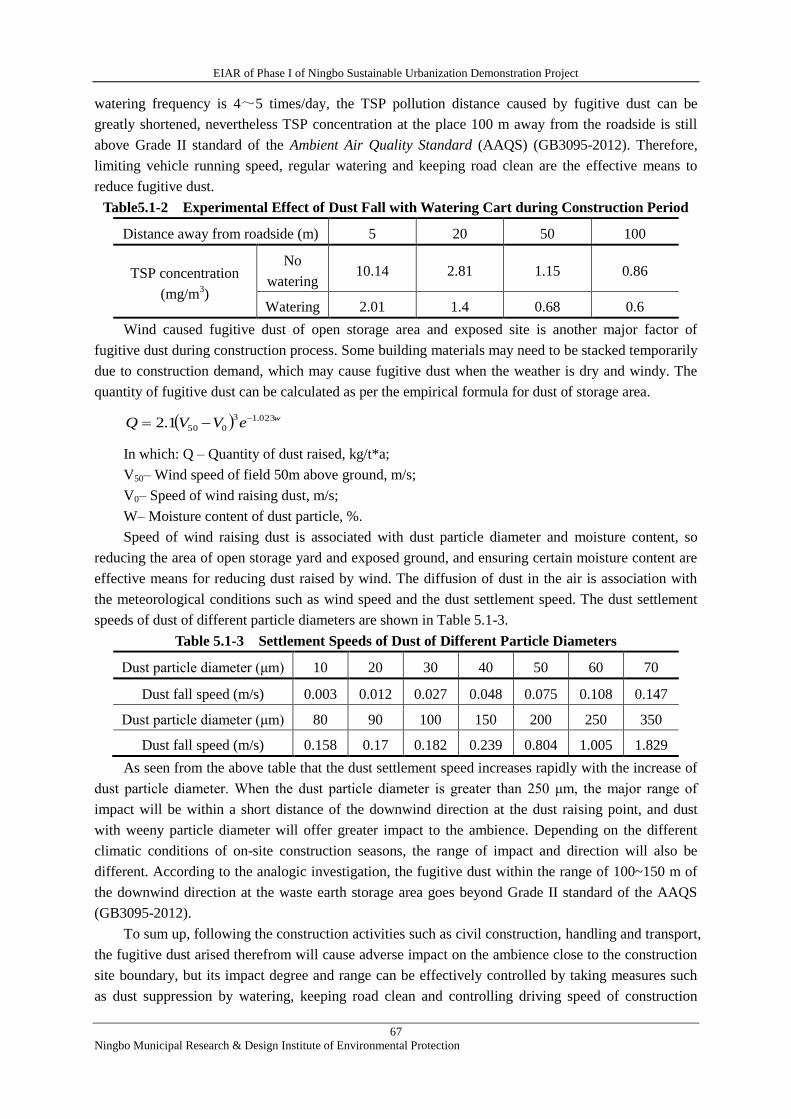
EIAR of Phase I of Ningbo Sustainable Urbanization Demonstration Project
67
Ningbo Municipal Research & Design Institute of Environmental Protection
watering frequency is 4~5 times/day, the TSP pollution distance caused by fugitive dust can be
greatly shortened, nevertheless TSP concentration at the place 100 m away from the roadside is still
above Grade II standard of the Ambient Air Quality Standard (AAQS) (GB3095-2012). Therefore,
limiting vehicle running speed, regular watering and keeping road clean are the effective means to
reduce fugitive dust.
Table5.1-2 Experimental Effect of Dust Fall with Watering Cart during Construction Period
Distance away from roadside (m) 5 20 50 100
TSP concentration
(mg/m3)
No
watering 10.14 2.81 1.15 0.86
Watering 2.01 1.4 0.68 0.6
Wind caused fugitive dust of open storage area and exposed site is another major factor of
fugitive dust during construction process. Some building materials may need to be stacked temporarily
due to construction demand, which may cause fugitive dust when the weather is dry and windy. The
quantity of fugitive dust can be calculated as per the empirical formula for dust of storage area.
weVVQ 023.13
0501.2
In which: Q – Quantity of dust raised, kg/t*a;
V50– Wind speed of field 50m above ground, m/s;
V0– Speed of wind raising dust, m/s;
W– Moisture content of dust particle, %.
Speed of wind raising dust is associated with dust particle diameter and moisture content, so
reducing the area of open storage yard and exposed ground, and ensuring certain moisture content are
effective means for reducing dust raised by wind. The diffusion of dust in the air is association with
the meteorological conditions such as wind speed and the dust settlement speed. The dust settlement
speeds of dust of different particle diameters are shown in Table 5.1-3.
Table 5.1-3 Settlement Speeds of Dust of Different Particle Diameters
Dust particle diameter (μm) 10 20 30 40 50 60 70
Dust fall speed (m/s) 0.003 0.012 0.027 0.048 0.075 0.108 0.147
Dust particle diameter (μm) 80 90 100 150 200 250 350
Dust fall speed (m/s) 0.158 0.17 0.182 0.239 0.804 1.005 1.829
As seen from the above table that the dust settlement speed increases rapidly with the increase of
dust particle diameter. When the dust particle diameter is greater than 250 μm, the major range of
impact will be within a short distance of the downwind direction at the dust raising point, and dust
with weeny particle diameter will offer greater impact to the ambience. Depending on the different
climatic conditions of on-site construction seasons, the range of impact and direction will also be
different. According to the analogic investigation, the fugitive dust within the range of 100~150 m of
the downwind direction at the waste earth storage area goes beyond Grade II standard of the AAQS
(GB3095-2012).
To sum up, following the construction activities such as civil construction, handling and transport,
the fugitive dust arised therefrom will cause adverse impact on the ambience close to the construction
site boundary, but its impact degree and range can be effectively controlled by taking measures such
as dust suppression by watering, keeping road clean and controlling driving speed of construction
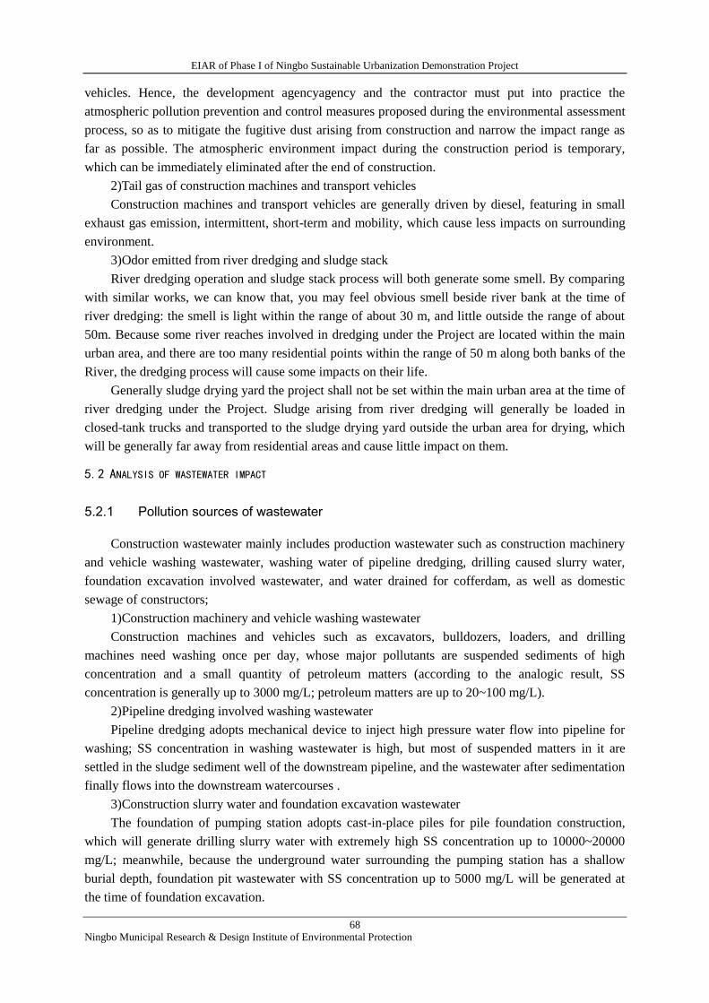
EIAR of Phase I of Ningbo Sustainable Urbanization Demonstration Project
68
Ningbo Municipal Research & Design Institute of Environmental Protection
vehicles. Hence, the development agencyagency and the contractor must put into practice the
atmospheric pollution prevention and control measures proposed during the environmental assessment
process, so as to mitigate the fugitive dust arising from construction and narrow the impact range as
far as possible. The atmospheric environment impact during the construction period is temporary,
which can be immediately eliminated after the end of construction.
2)Tail gas of construction machines and transport vehicles
Construction machines and transport vehicles are generally driven by diesel, featuring in small
exhaust gas emission, intermittent, short-term and mobility, which cause less impacts on surrounding
environment.
3)Odor emitted from river dredging and sludge stack
River dredging operation and sludge stack process will both generate some smell. By comparing
with similar works, we can know that, you may feel obvious smell beside river bank at the time of
river dredging: the smell is light within the range of about 30 m, and little outside the range of about
50m. Because some river reaches involved in dredging under the Project are located within the main
urban area, and there are too many residential points within the range of 50 m along both banks of the
River, the dredging process will cause some impacts on their life.
Generally sludge drying yard the project shall not be set within the main urban area at the time of
river dredging under the Project. Sludge arising from river dredging will generally be loaded in
closed-tank trucks and transported to the sludge drying yard outside the urban area for drying, which
will be generally far away from residential areas and cause little impact on them.
5.2 ANALYSIS OF WASTEWATER IMPACT
5.2.1 Pollution sources of wastewater
Construction wastewater mainly includes production wastewater such as construction machinery
and vehicle washing wastewater, washing water of pipeline dredging, drilling caused slurry water,
foundation excavation involved wastewater, and water drained for cofferdam, as well as domestic
sewage of constructors;
1)Construction machinery and vehicle washing wastewater
Construction machines and vehicles such as excavators, bulldozers, loaders, and drilling
machines need washing once per day, whose major pollutants are suspended sediments of high
concentration and a small quantity of petroleum matters (according to the analogic result, SS
concentration is generally up to 3000 mg/L; petroleum matters are up to 20~100 mg/L).
2)Pipeline dredging involved washing wastewater
Pipeline dredging adopts mechanical device to inject high pressure water flow into pipeline for
washing; SS concentration in washing wastewater is high, but most of suspended matters in it are
settled in the sludge sediment well of the downstream pipeline, and the wastewater after sedimentation
finally flows into the downstream watercourses .
3)Construction slurry water and foundation excavation wastewater
The foundation of pumping station adopts cast-in-place piles for pile foundation construction,
which will generate drilling slurry water with extremely high SS concentration up to 10000~20000
mg/L; meanwhile, because the underground water surrounding the pumping station has a shallow
burial depth, foundation pit wastewater with SS concentration up to 5000 mg/L will be generated at
the time of foundation excavation.
EIAR of Phase I of Ningbo Sustainable Urbanization Demonstration Project
69
Ningbo Municipal Research & Design Institute of Environmental Protection
4)Cofferdam water drainage
Cofferdams by segments are required to be set for some of the River dredging. Ponding in it is
required to be pumped out or diverted to expose the Riverbed. The initial SS concentration for
drainage of this part is relatively low, and rises during the later stage. In general, the SS concentration
of drainage from cofferdam of watercourse dredging work is about 400~10000 mg/L.
5)Domestic sewage of constructors
According to the data provided by the design institute for the project feasibility study), the
duration for the drainage network improvement and reconstruction is about 10 months with about 10
constructors needed per day; the duration for the drainage network dredging work is about 10 months
with about 30 constructors per day; the durations for the drainage network dredging and pumping
station construction works are about 12 and 18 months respectively with about 30 constructor per day;
the above works are basically implemented simultaneously, with the water consumption of
constructors as calculated as 100L/d per capita . Hence, as seen from the calculation, the water
consumption for the constructors of the above works during the construction period will be about 10
m3/d; given that domestic sewage discharge coefficient is about 0.9, then the domestic sewage
discharge amount will be about 9 m3/d, and the domestic sewage discharge volume for the whole
duration will be about 3510 m3.
The domestic sewage quality is generally CODCr 300~400 mg/L, BOD5 200~300 mg/L, 30~40
mg/L of ammonia nitrogen, and 50~100 mg/L of animal or vegetable oil.
5.2.2 Analysis of wastewater impact
Construction wastewater generally includes high concentration of SS and a little petroleum
matters. If it is directly discharged into municipal pipes or watercourses s without treatment, it will
cause pollution to surrounding surface water and shallow groundwater, and may affect normal
operation of wastewater treatment plant and service life of equipment.
T River dredging and pumping station construction may both disturb sediments on river bottom,
cause increase of suspended matter concentration in water of watercourses , and pollute the water
quality of rivers in the construction operation areas and surrounding areas, but because the dredging
and construction operations in watercourses s of the pumping station are temporary, the suspended
matter pollution caused therefrom is not continuous; meanwhile, because of the water flow influence,
the suspended matters will not settle within a narrow range, the quality of river water caused
therefrom will not be severely impacted, and will be eliminated at the end of the construction.
5.3 ANALYSIS OF CONSTRUCTION NOISE IMPACT
The varieties of mechanical equipment used during construction period such as drilling machines,
excavators, bulldozers, concrete mixers and transport vehicles are all the noise generating sources. In
consideration of the complexity of construction noise and different affected areas and stages of
construction noise impact, in the EA the noise impact ranges calculated of different varieties of
construction equipment for different construction stages, so as to enable the contactor to adopt
appropriate noise prevention and control measures during construction.
The noise sources of construction equipment shall be calculated on a point acoustic source basis,
with the noise projecttion model as:
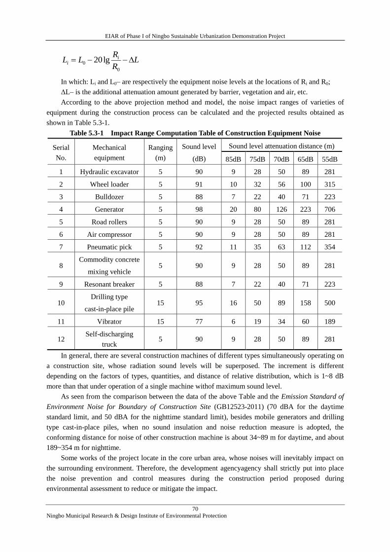
EIAR of Phase I of Ningbo Sustainable Urbanization Demonstration Project
70
Ningbo Municipal Research & Design Institute of Environmental Protection
In which: Li and L0– are respectively the equipment noise levels at the locations of Ri and R0;
ΔL– is the additional attenuation amount generated by barrier, vegetation and air, etc.
According to the above projection method and model, the noise impact ranges of varieties of
equipment during the construction process can be calculated and the projected results obtained as
shown in Table 5.3-1.
Table 5.3-1 Impact Range Computation Table of Construction Equipment Noise
Serial
No.
Mechanical
equipment
Ranging
(m)
Sound level
(dB)
Sound level attenuation distance (m)
85dB 75dB 70dB 65dB 55dB
1 Hydraulic excavator 5 90 9 28 50 89 281
2 Wheel loader 5 91 10 32 56 100 315
3 Bulldozer 5 88 7 22 40 71 223
4 Generator 5 98 20 80 126 223 706
5 Road rollers 5 90 9 28 50 89 281
6 Air compressor 5 90 9 28 50 89 281
7 Pneumatic pick 5 92 11 35 63 112 354
8 Commodity concrete
mixing vehicle 5 90 9 28 50 89 281
9 Resonant breaker 5 88 7 22 40 71 223
10 Drilling type
cast-in-place pile 15 95 16 50 89 158 500
11 Vibrator 15 77 6 19 34 60 189
12 Self-discharging
truck 5 90 9 28 50 89 281
In general, there are several construction machines of different types simultaneously operating on
a construction site, whose radiation sound levels will be superposed. The increment is different
depending on the factors of types, quantities, and distance of relative distribution, which is 1~8 dB
more than that under operation of a single machine withof maximum sound level.
As seen from the comparison between the data of the above Table and the Emission Standard of
Environment Noise for Boundary of Construction Site (GB12523-2011) (70 dBA for the daytime
standard limit, and 50 dBA for the nighttime standard limit), besides mobile generators and drilling
type cast-in-place piles, when no sound insulation and noise reduction measure is adopted, the
conforming distance for noise of other construction machine is about 34~89 m for daytime, and about
189~354 m for nighttime.
Some works of the project locate in the core urban area, whose noises will inevitably impact on
the surrounding environment. Therefore, the development agencyagency shall strictly put into place
the noise prevention and control measures during the construction period proposed during
environmental assessment to reduce or mitigate the impact.
LR
RLL i
i 0
0 lg20
EIAR of Phase I of Ningbo Sustainable Urbanization Demonstration Project
71
Ningbo Municipal Research & Design Institute of Environmental Protection
5.4 ANALYSIS OF SOLID WASTE IMPACT
5.4.1 Pollution sources of construction solid waste
The solid waste generated during the construction period includes construction waste and waste
earthwork generated from various subprojects, sludge arising from pipeline and watercourse dredging,
and domestic waste of constructors, etc.
1)Construction waste
The construction waste arising from engineering construction includes waste building stone, steel,
reinforced concrete, timber, prefabricated parts, and woven bags, etc., whose quantity is associated
with the management level, construction quality and personal qualities of workers during the
construction process, and is hard to be quantitatively estimated.
2)Waste soil and stone
According to the estimation of the feasibility study, the waste earth generated from Huancheng
Xilu and Baohai Lu works will be about 274 thousand m3; the waste earth generated by pipeline
improvement and reconstruction will be about 10 thousand m3; and the waste earth generated by
pumping station work will be about 16.2 thousand m3.
3)Sludge
The sludge will mainly come from dredging of drainage pipeline and watercourses in the urban
areas, of which, the former will generate 28 thousand m3 of sludge, and the latter , 242.5m
3.
4)Domestic waste of constructors
During the construction period, the constructors will generate a certain amount of domestic
waste.
If construction wasteand waste earth are stacked at will, they may not only disturb the visual
effect of landscape, but also infiltrate into soil or surrounding surface water, reducing the soil
productivity and polluting the surface water environment; if is not suitably collected and disposed, the
domestic waste of constructors may bring about impacts on the landscape and cause sanitation
problems in the construction areas, and even cause epidemic diseases to constructors.
5.4.2 Impact analysis
1)Construction waste
According to the relevant provisions such as the Construction wasteManagement Measures of
Ningbo, before the commencement of works, the construction unit shall prepare construction
wastedisposal program and submit it to the local urban management bureau for filing; meanwhile,
comprehensive disposal and recycling approaches shall be preferentially adopted to dispose of the
solid waste generated during the construction process; as for the construction wastesuch as redundant
building materials and wastes, considerations should be taken to utilize them in a comprehensive
disposal and recycling manner for the greening basecourse earthing, foundation backfill, and
abandoned hilly pond filling, etc. for the works under construction; as for those non-utilizable, the
construction muck clearing qualification management shall be strictly implemented and the unit with
construction wasteoperation and service enterprise qualification shall be entrusted for outward
transport and disposal.
2)Waste earth and sludge
The waste earth and sludge of the project shall be uniformly transported to the “Foundation
EIAR of Phase I of Ningbo Sustainable Urbanization Demonstration Project
72
Ningbo Municipal Research & Design Institute of Environmental Protection
Treatment Works of Renyitu Zone in the Xiangshan Economic Development Park” for backfill and
site leveling. The development agency of the works has agreed to use the waste earth of the project for
site backfill. The waste earth disposal of the project conforms to the recycling utilization policy for
solid waste disposal.
3)Domestic waste
As for the domestic waste generated by constructors, the environmental sanitation agency shall be
entrusted for timely clearing; meanwhile, the environmental protection awareness education for
constructors shall be enhanced to avoid littering of domestic waste and impacting on city appearance
and landscapes.
4)Brief summary
Varieties of solid waste of the project can be properly disposed by classes. The solid waste
generated during the construction period will cause less impact on the surrounding environment.
5.5 ANALYSIS OF IMPACT ON ECOLOGICAL ENVIRONMENT
5.5.1 Impact of waste earth disposal on marine ecological environment
The waste earth of the project is planned to be uniformly transported to Renyitu for site backfill
to form a construction land use. As seen from the aforesaid analysis that the “Foundation Treatment
Works of Renyitu Section” has been approved by the Ningbo Ocean & Fishery Bureau and Xiangshan
Environmental Protection Bureau, etc. in respect of relevant environmental protection approval
procedures. Because the construction of reclamation dike has cut off the water exchange between
Renyitu and the open sea, Renyitu has lost its mudflat function. There are no mudflat aquaculture and
seawater aquaculture areas in the section. The current landform of Renyitu is mainly wild grass
ground.
The “Foundation Treatment Works of Renyitu Section” locates in Renyitu reclaimed area. The
works construction involves no marine environment outside the dike. As seen from expert review
opinions related to the marine environment impact and the replied conclusions of the Ningbo Ocean &
Fishery Bureau that “the sea area proposed to be transferred in Xiangshan Renyitu section locates in
Renyitu reclaimed project area, which basically has no impact on the marine ecosystem in the
surrounding area. In consideration of the fact that the sea area proposed to be transferred locates in the
reclamation area, it will cause no direct impact on the marine environment.”
To sum up, the waste earthof the project will not cause new losses to marine ecological resources
at the time of Renyitu backfill and utilization, nor impact on the surrounding marine environment of
Renyitu (tu means beach or mud flat).
5.5.2 Impacts on vegetation and forest
The land occupation for construction may damage the original landform and aboveground
vegetation. According to the survey results, there is no rare wild plant and animal or old tree and
famous wood species in the project area. Except that Huancheng Xilu construction involves hilly
forest land, other subprojects mainly involve artificial vegetation.
The original landform on the temporary construction camp shall be timely recovered after the
completion of the works; the vegetation and forest losses caused by permanent land occupation shall
be compensated with re-vegetation measures. Hence, the vegetation and forest losses caused during
the construction period will be recovered or compensated, the impact to the environment being less.
EIAR of Phase I of Ningbo Sustainable Urbanization Demonstration Project
73
Ningbo Municipal Research & Design Institute of Environmental Protection
5.5.3 Impacts on animals and their habitats
Except the subproject of Huancheng Xilu, all the other subprojects locate in the core urban area
and will not cause any impact to wild animals and their habitats.
Two hills (Huangtuling and Mulingdong) are beside Huancheng Xilu, which are small hills and
locate in the core urban area. The west sides of the two hills have been separated with the other hills
by the built Provincial Highway 71. According to the survey results, the wild animals in the hills
include swallow, sparrow, hare, field mouse, frog, toad, and snake, etc., but no passageways of rare
and endangered wild animals or large wide animals. To sum up, the project construction will cause
less impact on the animals and their habitats.
5.6 ANALYSIS OF SOCIAL IMPACT
The social environment impacts during construction period are mainly negative ones, which are
reflected in respect of land requisition, residents resettlement as well as their trips.
Impacts of land requisition and resettlement: the permanent land requisition area of the project is
about 210.21 mu or 14 ha.; the area of non-residence to be demolished is about 2764 m2; the area of
rural housing to be demolished is about 2000 m2 (10 houses, all in Lixin Village on Baohai Lu). The
economic incomes and livelihood modes of these affected households will all be impacted to different
extents.
The project development agencys shall strictly put into place the land requisition work proposed
by the social environment assessment and livelihood recovery of the affected population; all
compensation amounts shall be reimbursed to the affected ones fully and timely, without impacting on
their long-term livelihood and residential conditions.
2) Tianan Lu is a primary north-south road of Xiangshan, and the key commercial corridor and
residents’ activity place of Xiangshan, which has large traffic flows and pedestrian flows. The
overhaul of Tianan Lu and renovation of public space will cause some impacts on the traffic flows of
vehicles and pedestrians. Before the construction period, the development agency and construction
unit shall contact traffic police department, conduct traffic reconciliation scheme for the construction
period. The traffic reconciliation scheme for the construction period shall be contained in the
construction management plan.
3) The stores along Wenchang Jie and Tianan Lu are mainly owned by various merchants. The
public space renovation may impact on the traffic conditions of pedestrians and vehicles, and further
impact on the interests of merchants. The development agency shall adopt reasonable construction
schemes, and reserve necessary sidewalks and merchant access ways to ensure that the merchants can
operate normally.
4) Pollutions such as fugitive dusts, noise and construction wastegenerated during the
construction period may impact on the daily life, traffic and teaching activities of residents and schools
surrounding the construction areas. The development agency shall strictly put into place the
environmental protection measures proposed by the environmental assessment, conduct publicity and
education in terms of construction safety, relieve negative impacts and avoid disturbing residents as
far as possible.
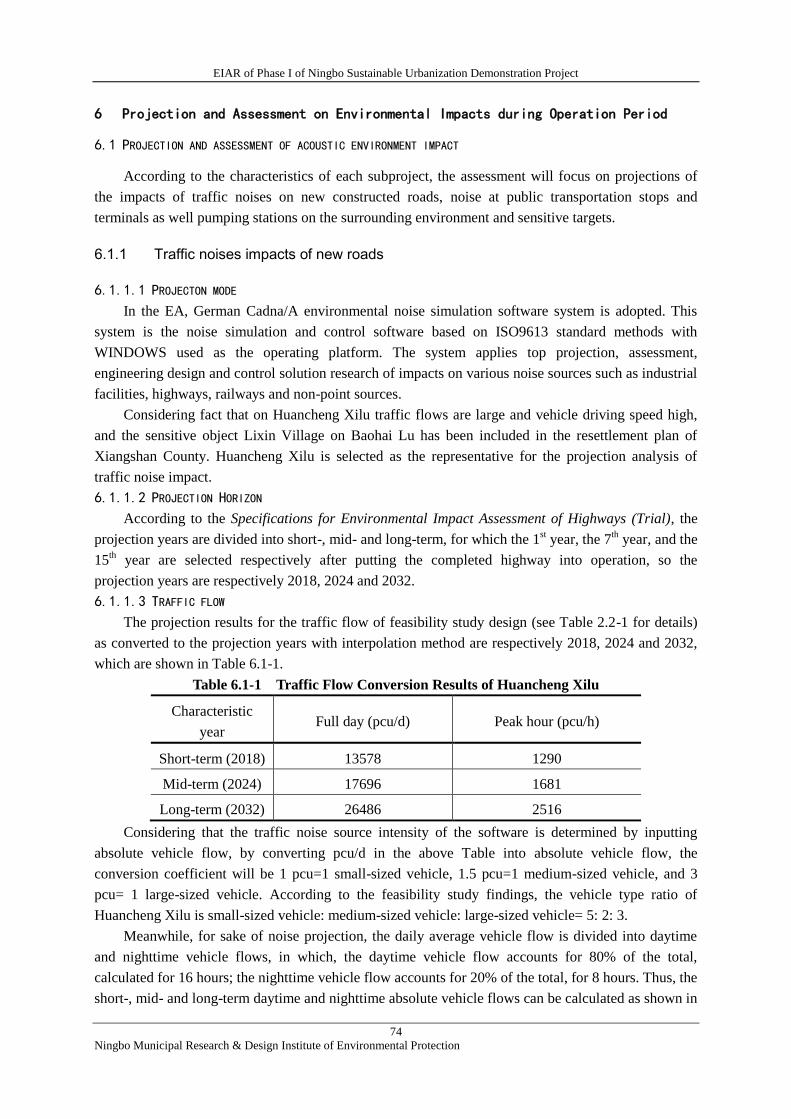
EIAR of Phase I of Ningbo Sustainable Urbanization Demonstration Project
74
Ningbo Municipal Research & Design Institute of Environmental Protection
6 Projection and Assessment on Environmental Impacts during Operation Period
6.1 PROJECTION AND ASSESSMENT OF ACOUSTIC ENVIRONMENT IMPACT
According to the characteristics of each subproject, the assessment will focus on projections of
the impacts of traffic noises on new constructed roads, noise at public transportation stops and
terminals as well pumping stations on the surrounding environment and sensitive targets.
6.1.1 Traffic noises impacts of new roads
6.1.1.1 PROJECTON MODE
In the EA, German Cadna/A environmental noise simulation software system is adopted. This
system is the noise simulation and control software based on ISO9613 standard methods with
WINDOWS used as the operating platform. The system applies top projection, assessment,
engineering design and control solution research of impacts on various noise sources such as industrial
facilities, highways, railways and non-point sources.
Considering fact that on Huancheng Xilu traffic flows are large and vehicle driving speed high,
and the sensitive object Lixin Village on Baohai Lu has been included in the resettlement plan of
Xiangshan County. Huancheng Xilu is selected as the representative for the projection analysis of
traffic noise impact.
6.1.1.2 PROJECTION HORIZON
According to the Specifications for Environmental Impact Assessment of Highways (Trial), the
projection years are divided into short-, mid- and long-term, for which the 1st year, the 7
th year, and the
15th year are selected respectively after putting the completed highway into operation, so the
projection years are respectively 2018, 2024 and 2032.
6.1.1.3 TRAFFIC FLOW
The projection results for the traffic flow of feasibility study design (see Table 2.2-1 for details)
as converted to the projection years with interpolation method are respectively 2018, 2024 and 2032,
which are shown in Table 6.1-1.
Table 6.1-1 Traffic Flow Conversion Results of Huancheng Xilu
Characteristic
year Full day (pcu/d) Peak hour (pcu/h)
Short-term (2018) 13578 1290
Mid-term (2024) 17696 1681
Long-term (2032) 26486 2516
Considering that the traffic noise source intensity of the software is determined by inputting
absolute vehicle flow, by converting pcu/d in the above Table into absolute vehicle flow, the
conversion coefficient will be 1 pcu=1 small-sized vehicle, 1.5 pcu=1 medium-sized vehicle, and 3
pcu= 1 large-sized vehicle. According to the feasibility study findings, the vehicle type ratio of
Huancheng Xilu is small-sized vehicle: medium-sized vehicle: large-sized vehicle= 5: 2: 3.
Meanwhile, for sake of noise projection, the daily average vehicle flow is divided into daytime
and nighttime vehicle flows, in which, the daytime vehicle flow accounts for 80% of the total,
calculated for 16 hours; the nighttime vehicle flow accounts for 20% of the total, for 8 hours. Thus, the
short-, mid- and long-term daytime and nighttime absolute vehicle flows can be calculated as shown in
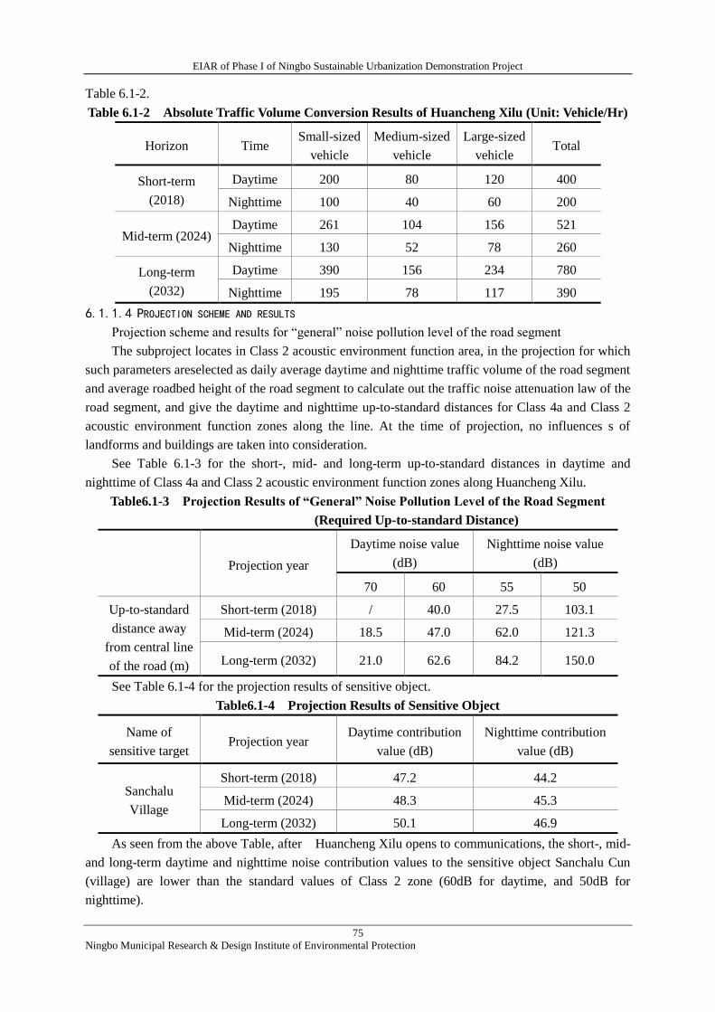
EIAR of Phase I of Ningbo Sustainable Urbanization Demonstration Project
75
Ningbo Municipal Research & Design Institute of Environmental Protection
Table 6.1-2.
Table 6.1-2 Absolute Traffic Volume Conversion Results of Huancheng Xilu (Unit: Vehicle/Hr)
Horizon Time Small-sized
vehicle
Medium-sized
vehicle
Large-sized
vehicle Total
Short-term
(2018)
Daytime 200 80 120 400
Nighttime 100 40 60 200
Mid-term (2024) Daytime 261 104 156 521
Nighttime 130 52 78 260
Long-term
(2032)
Daytime 390 156 234 780
Nighttime 195 78 117 390
6.1.1.4 PROJECTION SCHEME AND RESULTS
Projection scheme and results for “general” noise pollution level of the road segment
The subproject locates in Class 2 acoustic environment function area, in the projection for which
such parameters areselected as daily average daytime and nighttime traffic volume of the road segment
and average roadbed height of the road segment to calculate out the traffic noise attenuation law of the
road segment, and give the daytime and nighttime up-to-standard distances for Class 4a and Class 2
acoustic environment function zones along the line. At the time of projection, no influences s of
landforms and buildings are taken into consideration.
See Table 6.1-3 for the short-, mid- and long-term up-to-standard distances in daytime and
nighttime of Class 4a and Class 2 acoustic environment function zones along Huancheng Xilu.
Table6.1-3 Projection Results of “General” Noise Pollution Level of the Road Segment
(Required Up-to-standard Distance)
Projection year
Daytime noise value
(dB)
Nighttime noise value
(dB)
70 60 55 50
Up-to-standard
distance away
from central line
of the road (m)
Short-term (2018) / 40.0 27.5 103.1
Mid-term (2024) 18.5 47.0 62.0 121.3
Long-term (2032) 21.0 62.6 84.2 150.0
See Table 6.1-4 for the projection results of sensitive object.
Table6.1-4 Projection Results of Sensitive Object
Name of
sensitive target Projection year
Daytime contribution
value (dB)
Nighttime contribution
value (dB)
Sanchalu
Village
Short-term (2018) 47.2 44.2
Mid-term (2024) 48.3 45.3
Long-term (2032) 50.1 46.9
As seen from the above Table, after Huancheng Xilu opens to communications, the short-, mid-
and long-term daytime and nighttime noise contribution values to the sensitive object Sanchalu Cun
(village) are lower than the standard values of Class 2 zone (60dB for daytime, and 50dB for
nighttime).
EIAR of Phase I of Ningbo Sustainable Urbanization Demonstration Project
76
Ningbo Municipal Research & Design Institute of Environmental Protection
6.1.2 Noise impact of Tashan Terminal Station
No facility in respect of vehicle repair and washing, etc. is set in the newly constructed Tashan
Terminal Station under the Project, whose noise sources during operation period are mainly the public
traffic vehicle access noise in the stations under the project. Because the vehicle speed in the station is
low and so is the vehicle running noise, the major noise source is vehicle launching noise. According
to the measured analogic data, the noise generated by public traffic vehicle under steady driving is
70~75 dBA, and the launching and braking noises are 78~86 dBA.
Because the vehicle speed of public traffic vehicle at the time of launching and braking is low, in
the EAthe noise source is simplified as a point source of noise of a semi-free acoustic field. The
distance attenuation projection mode of non-directional point acoustic source in a semi-free space is as
followed (only distance attenuation will be considered).
L2=L1-20lgr2/r1。
In which: r1 and r2 are the distances away from the acoustic source (m);
L1 and L2 are the noise acoustic levels of the acoustic source within the distances of r1 and r2
(dBA).
The distance of access to the village, a sensitive object, closest to the project is about 50 m; as
per the calculation, the noise contribution value is about 52.0 dB, which is lower than the standard
value for daytime of Class 2 zone (60 dB).
According to the survey, the operation time of buses in Xiangshan County is no later than 22:00.
That is to say, Tashan Terminal Station does not operate during nighttime. According to the projection
result, the degree of impact of noise of Tashan Terminal Station on the sensitive object conforms to
the standard requirements.
6.1.3 Noise impact of pumping stations
The boosting pumping stations operate in an intermittent manner. The pumping stations realize
drainage function via automatic control of liquid level during the flood and rainy seasons. When the
water level of watercourses is higher than the designed high water level, the water pumping units
will start to run, and close when lower than the normal water level. According to the FSR, submersible
axial-flow pumps will be adopted for all the three pumping stations under the project with buried
design. According to the analogic survey data, the water pumps of such design generate less noise
impact. On the basis of adopting EA-recommended vibration and noise reduction measures, it can be
ensured that the station boundary noise satisfies Class 2 emission standard in the Emission Standard
for Industrial Enterprise Noise at Its Boundary (GB12348-2008). Because the closest sensitive object
around the pumping station is 35 m away, the pumping station operating noise will not cause any
impact to the object after vibration and noise reduction and distance attenuation.
6.2 PROJECTION AND ASSESSMENT OF IMPACTS TO ATMOSPHERIC ENVIRONMENT
The atmospheric environmental impact source during the project operation period is mainly the
impact of vehicle exhaust gas on the surrounding environment. The vehicle exhaust gas pollution
source can be simulated as a continuously emitting linear pollution source. With Huancheng Xilu as
example, the projection and analysis can be conducted as follows.
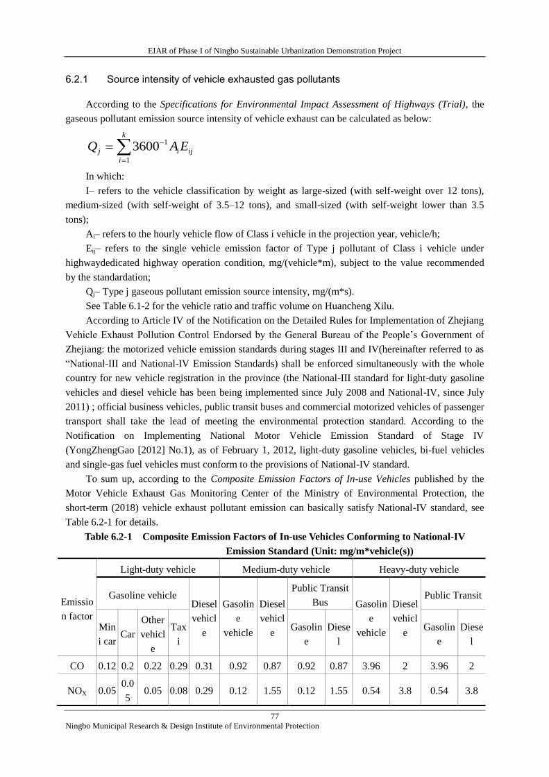
EIAR of Phase I of Ningbo Sustainable Urbanization Demonstration Project
77
Ningbo Municipal Research & Design Institute of Environmental Protection
6.2.1 Source intensity of vehicle exhausted gas pollutants
According to the Specifications for Environmental Impact Assessment of Highways (Trial), the
gaseous pollutant emission source intensity of vehicle exhaust can be calculated as below:
k
i
ijij EAQ1
13600
In which:
I– refers to the vehicle classification by weight as large-sized (with self-weight over 12 tons),
medium-sized (with self-weight of 3.5–12 tons), and small-sized (with self-weight lower than 3.5
tons);
Ai– refers to the hourly vehicle flow of Class i vehicle in the projection year, vehicle/h;
Eij– refers to the single vehicle emission factor of Type j pollutant of Class i vehicle under
highwaydedicated highway operation condition, mg/(vehicle*m), subject to the value recommended
by the standardation;
Qj– Type j gaseous pollutant emission source intensity, mg/(m*s).
See Table 6.1-2 for the vehicle ratio and traffic volume on Huancheng Xilu.
According to Article IV of the Notification on the Detailed Rules for Implementation of Zhejiang
Vehicle Exhaust Pollution Control Endorsed by the General Bureau of the People’s Government of
Zhejiang: the motorized vehicle emission standards during stages III and IV(hereinafter referred to as
“National-III and National-IV Emission Standards) shall be enforced simultaneously with the whole
country for new vehicle registration in the province (the National-III standard for light-duty gasoline
vehicles and diesel vehicle has been being implemented since July 2008 and National-IV, since July
2011) ; official business vehicles, public transit buses and commercial motorized vehicles of passenger
transport shall take the lead of meeting the environmental protection standard. According to the
Notification on Implementing National Motor Vehicle Emission Standard of Stage IV
(YongZhengGao [2012] No.1), as of February 1, 2012, light-duty gasoline vehicles, bi-fuel vehicles
and single-gas fuel vehicles must conform to the provisions of National-IV standard.
To sum up, according to the Composite Emission Factors of In-use Vehicles published by the
Motor Vehicle Exhaust Gas Monitoring Center of the Ministry of Environmental Protection, the
short-term (2018) vehicle exhaust pollutant emission can basically satisfy National-IV standard, see
Table 6.2-1 for details.
Table 6.2-1 Composite Emission Factors of In-use Vehicles Conforming to National-IV
Emission Standard (Unit: mg/m*vehicle(s))
Emissio
n factor
Light-duty vehicle Medium-duty vehicle Heavy-duty vehicle
Gasoline vehicle Diesel
vehicl
e
Gasolin
e
vehicle
Diesel
vehicl
e
Public Transit
Bus Gasolin
e
vehicle
Diesel
vehicl
e
Public Transit
Min
i car Car
Other
vehicl
e
Tax
i
Gasolin
e
Diese
l
Gasolin
e
Diese
l
CO 0.12 0.2 0.22 0.29 0.31 0.92 0.87 0.92 0.87 3.96 2 3.96 2
NOX 0.05 0.0
5 0.05 0.08 0.29 0.12 1.55 0.12 1.55 0.54 3.8 0.54 3.8
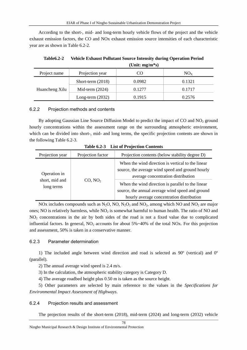
EIAR of Phase I of Ningbo Sustainable Urbanization Demonstration Project
78
Ningbo Municipal Research & Design Institute of Environmental Protection
According to the short-, mid- and long-term hourly vehicle flows of the project and the vehicle
exhaust emission factors, the CO and NOx exhaust emission source intensities of each characteristic
year are as shown in Table 6.2-2.
Table6.2-2 Vehicle Exhaust Pollutant Source Intensity during Operation Period
(Unit: mg/m*s)
Project name Projection year CO NOX
Huancheng Xilu
Short-term (2018) 0.0982 0.1321
Mid-term (2024) 0.1277 0.1717
Long-term (2032) 0.1915 0.2576
6.2.2 Projection methods and contents
By adopting Gaussian Line Source Diffusion Model to predict the impact of CO and NO2 ground
hourly concentrations within the assessment range on the surrounding atmospheric environment,
which can be divided into short-, mid- and long terms, the specific projection contents are shown in
the following Table 6.2-3.
Table 6.2-3 List of Projection Contents
Projection year Projection factor Projection contents (below stability degree D)
Operation in
short, mid and
long terms
CO, NO2
When the wind direction is vertical to the linear
source, the average wind speed and ground hourly
average concentration distribution
When the wind direction is parallel to the linear
source, the annual average wind speed and ground
hourly average concentration distribution
NOx includes compounds such as N2O, NO, N2O3 and NO2, among which NO and NO2 are major
ones; NO is relatively harmless, while NO2 is somewhat harmful to human health. The ratio of NO and
NO2 concentrations in the air by both sides of the road is not a fixed value due to complicated
influential factors. In general, NO2 accounts for about 5%~40% of the total NOx. For this projection
and assessment, 50% is taken in a conservative manner.
6.2.3 Parameter determination
1) The included angle between wind direction and road is selected as 90º (vertical) and 0º
(parallel).
2) The annual average wind speed is 2.4 m/s.
3) In the calculation, the atmospheric stability category is Category D.
4) The average roadbed height plus 0.50 m is taken as the source height.
5) Other parameters are selected by main reference to the values in the Specifications for
Environmental Impact Assessment of Highways.
6.2.4 Projection results and assessment
The projection results of the short-term (2018), mid-term (2024) and long-term (2032) vehicle
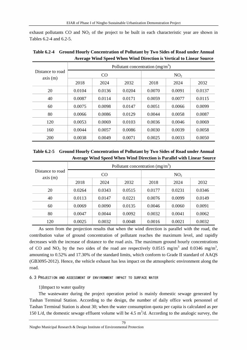
EIAR of Phase I of Ningbo Sustainable Urbanization Demonstration Project
79
Ningbo Municipal Research & Design Institute of Environmental Protection
exhaust pollutants CO and NO2 of the project to be built in each characteristic year are shown in
Tables 6.2-4 and 6.2-5.
Table 6.2-4 Ground Hourly Concentration of Pollutant by Two Sides of Road under Annual
Average Wind Speed When Wind Direction is Vertical to Linear Source
Distance to road
axis (m)
Pollutant concentration (mg/m3)
CO NO2
2018 2024 2032 2018 2024 2032
20 0.0104 0.0136 0.0204 0.0070 0.0091 0.0137
40 0.0087 0.0114 0.0171 0.0059 0.0077 0.0115
60 0.0075 0.0098 0.0147 0.0051 0.0066 0.0099
80 0.0066 0.0086 0.0129 0.0044 0.0058 0.0087
120 0.0053 0.0069 0.0103 0.0036 0.0046 0.0069
160 0.0044 0.0057 0.0086 0.0030 0.0039 0.0058
200 0.0038 0.0049 0.0071 0.0025 0.0033 0.0050
Table 6.2-5 Ground Hourly Concentration of Pollutant by Two Sides of Road under Annual
Average Wind Speed When Wind Direction is Parallel with Linear Source
Distance to road
axis (m)
Pollutant concentration (mg/m3)
CO NO2
2018 2024 2032 2018 2024 2032
20 0.0264 0.0343 0.0515 0.0177 0.0231 0.0346
40 0.0113 0.0147 0.0221 0.0076 0.0099 0.0149
60 0.0069 0.0090 0.0135 0.0046 0.0060 0.0091
80 0.0047 0.0044 0.0092 0.0032 0.0041 0.0062
120 0.0025 0.0032 0.0048 0.0016 0.0021 0.0032
As seen from the projection results that when the wind direction is parallel with the road, the
contribution value of ground concentration of pollutant reaches the maximum level, and rapidly
decreases with the increase of distance to the road axis. The maximum ground hourly concentrations
of CO and NO2 by the two sides of the road are respectively 0.0515 mg/m3 and 0.0346 mg/m
3,
amounting to 0.52% and 17.30% of the standard limits, which conform to Grade II standard of AAQS
(GB3095-2012). Hence, the vehicle exhaust has less impact on the atmospheric environment along the
road.
6.3 PROJECTION AND ASSESSMENT OF ENVIRONMENT IMPACT TO SURFACE WATER
1)Impact to water quality
The wastewater during the project operation period is mainly domestic sewage generated by
Tashan Terminal Station. According to the design, the number of daily office work personnel of
Tashan Terminal Station is about 30; when the water consumption quota per capita is calculated as per
150 L/d, the domestic sewage effluent volume will be 4.5 m3/d. According to the analogic survey, the
EIAR of Phase I of Ningbo Sustainable Urbanization Demonstration Project
80
Ningbo Municipal Research & Design Institute of Environmental Protection
domestic sewage volume of entrance passengers is estimated to be about 10.0 m3/d, then the total
effluent volume of domestic sewage of Tashan Terminal Station during the operation period will be
about 14.5 m3/d; according to the empirical value, the concentration of domestic sewage is generally
350 mg/l for COD and 35 mg/l for ammonia nitrogen.
Tashan Terminal Station has good surrounding sewage discharge conditions. After being treated
in septic tank, domestic sewage can be treated in WWTP in the core urban area of Xiangshan County
via the municipal sewage pipe network, with less impact on environment.
After the implementation of urban drainage pipeline reconstruction and watercourses dredging
subprojects, the eutrophication compositions such as nitrogen and phosphorus settled in urban river
bed caused by residents’ life and breeding industry can be greatly reduced, which increases the water
storage and conservation and water environment capacity, enhances the self-cleaning capacity of
river water, and can obviously improve the water quality in urban river, which plays an important part
for realizing Class III water quality protection target of surface water in urban river network, and is
beneficial to the existence and multiplication of aquatic organism of watercourses .
2)Hydrological regime impact
According to the calculation by means of the model adopted in the feasibility study, after the
implementation of the River dredging works, when 5% frequency rainstorm occurs, the water level of
river in the core urban area of Xiangshan will descend by about 20 cm; on the basis of this, after
further implementation of pipeline network dredging works, the water level will descend by up to
23~30 cm; after the implementation of pumping station works, the maximum water level of upstream
areas of Baishijing River, Nandahe Conduit and Xinhua River Pumping Station will continue to
descend by 18~30 cm, and upraise the water level of initial segments of Dongda River and Xida River
of the downstream by 4~6 cm, making the old urban area basically reach the drainage standard of 5%
frequency.
Therefore, the implementation of the flood risk management component can effectively descend
the water level of urban rivers during flood season, and increase its capacity of flood prevention and
logged water drainage.
6.4 PROJECTION AND ASSESSMENT ON ENVIRONMENT IMPACT OF SOLID WASTE
The solid waste generated during operation period is mainly domestic waste generated by Tashan
Terminal Station, for which the environmental sanitation authority is entrusted for regular collection,
transport and disposal, having less environmental impact.
6.5 SOCIAL ENVIRONMENT IMPACT ANALYSIS
The social environment impact is mainly citied from Social Impact assessment report of the
project, which has the major conclusions as followed.
6.5.1 Positive effects
1) Good for relieving transport pressure, and promoting safety and accessibility of road;
2) Good for improving the urban road network, and the urban public transport facility layout and
transport efficiency;
3) Good for improving the urban commercial environment and public utilities;
4) Good for enhancing economic benefits of the project area;
5) Good for promoting the employment of residents in the project area particularly vulnerable
EIAR of Phase I of Ningbo Sustainable Urbanization Demonstration Project
81
Ningbo Municipal Research & Design Institute of Environmental Protection
groups, and improving residents’ living quality.
6.5.2 Negative impacts
The negative impacts are mainly embodied in the project construction period. See Sub-section 5.6
for details.
7 Public Consultation
7.1 PURPOSES AND BASES OF PUBLIC CONSULTATION
The construction of the Project may bring about advantageous or disadvantageous influences to
the surrounding ecological and social environments, which may directly or indirectly affect the social
development and life of residents in the adjacent areas. Out of consideration of their self-interests or
public interests, the masses may hold different viewpoints or opinions concerning the Project. The
purpose of public participation survey is to learn about and get feed-back comments, demands and
opinions of the public in the project area, and allow the public to participate in EIA, in order to have
EIA more objective and comprehensive, and enable decision-makers to also consider the public's
interests and demands when determing the construction of the Project and avoid one-sideness and
blindness, so as to make the planning, design and formulated environmental measures for the Project
meet the requirements of the economic development being coordinated with the ecological
environment protection.
The public participation shall be carried out in accordance with the Tentative Provisions for
Public Participation in Environmental Impact Assessment (HuanFa 2006 [No. 28], Zhejiang
Environmental Protection Administrative Provisions for Construction Projects (Decree 288 of the
Provincial Government), Enforcement Regulations (For Trial) for Public Participation and
Government Information Disclosure in EIA (ZheHuanFa [2014] No. 28) and provisions and
requirements in the Bank's EA Operative Policy (OP 4.01).
7.2 WAYS, SCOPE AND PARTICIPATORS OF PUBLIC PARTICIPATION
1)Ways of Public Participation
On the basis of the national and World Bank's requirements, such ways are adopted for the public
involvement as information disclosure, common people symposium and questionnaire survey.
2)Scope and Participators of Public Participation
The implementation range of this PP maily covers the areas where the subprojects are situated, as
well as affected peripheral areas and participators include citizens, and representatives of legal persons,
social organizations and other ones.
Individual information of two- round questionnaire surveys can be seen in Table 7.2-1.
Table 7.2-1 Individual Information of Two- Round Questionnaire Surveys
Age
18~35 36~60 >60
Nr.
(persons) %
Nr.
(persons) % Nr. (persons) %
16 15.1 83 78.3 7 6.6
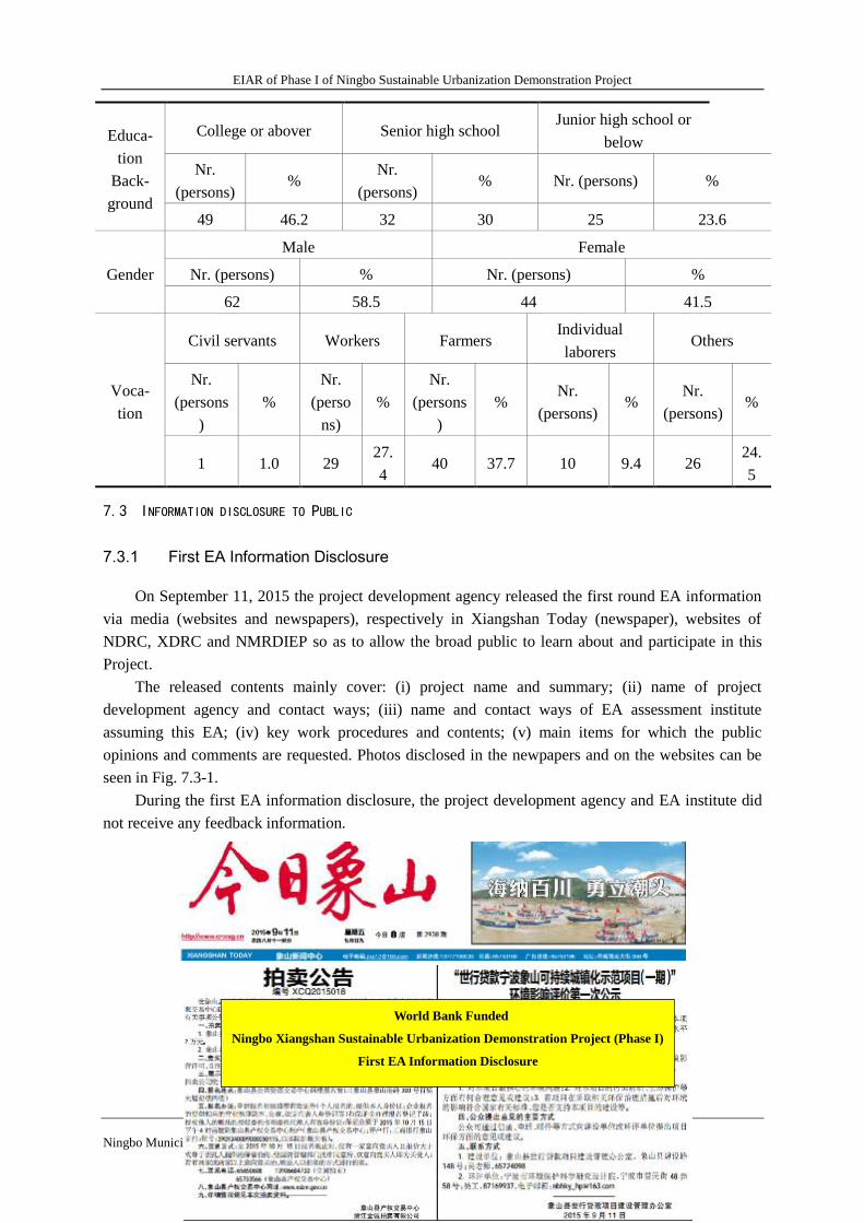
EIAR of Phase I of Ningbo Sustainable Urbanization Demonstration Project
82
Ningbo Municipal Research & Design Institute of Environmental Protection
Educa-
tion
Back-
ground
College or abover Senior high school Junior high school or
below
Nr.
(persons) %
Nr.
(persons) % Nr. (persons) %
49 46.2 32 30 25 23.6
Gender
Male Female
Nr. (persons) % Nr. (persons) %
62 58.5 44 41.5
Voca-
tion
Civil servants Workers Farmers Individual
laborers Others
Nr.
(persons
)
%
Nr.
(perso
ns)
%
Nr.
(persons
)
% Nr.
(persons) %
Nr.
(persons) %
1 1.0 29 27.
4 40 37.7 10 9.4 26
24.
5
7.3 INFORMATION DISCLOSURE TO PUBLIC
7.3.1 First EA Information Disclosure
On September 11, 2015 the project development agency released the first round EA information
via media (websites and newspapers), respectively in Xiangshan Today (newspaper), websites of
NDRC, XDRC and NMRDIEP so as to allow the broad public to learn about and participate in this
Project.
The released contents mainly cover: (i) project name and summary; (ii) name of project
development agency and contact ways; (iii) name and contact ways of EA assessment institute
assuming this EA; (iv) key work procedures and contents; (v) main items for which the public
opinions and comments are requested. Photos disclosed in the newpapers and on the websites can be
seen in Fig. 7.3-1.
During the first EA information disclosure, the project development agency and EA institute did
not receive any feedback information.
World Bank Funded
Ningbo Xiangshan Sustainable Urbanization Demonstration Project (Phase I)
First EA Information Disclosure
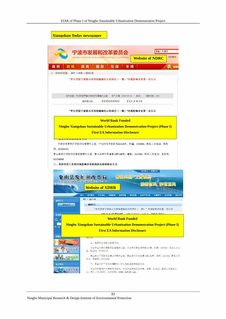
EIAR of Phase I of Ningbo Sustainable Urbanization Demonstration Project
83
Ningbo Municipal Research & Design Institute of Environmental Protection
Xiangshan Today newspaper
Website of NDRC
Website of XDRB
World Bank Funded
Ningbo Xiangshan Sustainable Urbanization Demonstration Project (Phase I)
First EA Information Disclosure
World Bank Funded
Ningbo Xiangshan Sustainable Urbanization Demonstration Project (Phase I)
First EA Information Disclosure
EIAR of Phase I of Ningbo Sustainable Urbanization Demonstration Project
84
Ningbo Municipal Research & Design Institute of Environmental Protection
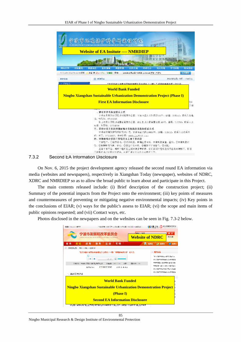
EIAR of Phase I of Ningbo Sustainable Urbanization Demonstration Project
85
Ningbo Municipal Research & Design Institute of Environmental Protection
Fig.7.3-1 Photos for First Information Disclosure
7.3.2 Second EA Information Disclosure
On Nov. 6, 2015 the project development agency released the second round EA information via
media (websites and newspapers), respectively in Xiangshan Today (newspaper), websites of NDRC,
XDRC and NMRDIEP so as to allow the broad public to learn about and participate in this Project.
The main contents released include: (i) Brief description of the construction project; (ii)
Summary of the potential impacts from the Project onto the environment; (iii) key points of measures
and countermeasures of preventing or mitigating negative environmental impacts; (iv) Key points in
the conclusions of EIAR; (v) ways for the public's assess to EIAR; (vi) the scope and main items of
public opinions requested; and (vii) Contact ways, etc.
Photos disclosed in the newpapers and on the websites can be seen in Fig. 7.3-2 below.
Website of EA Insitute ---- NMRDIEP
Website of NDRC
宁波市发改委网站
World Bank Funded
Ningbo Xiangshan Sustainable Urbanization Demonstration Project (Phase I)
First EA Information Disclosure
World Bank Funded
Ningbo Xiangshan Sustainable Urbanization Demonstration Project
(Phase I)
Second EA Information Disclosure
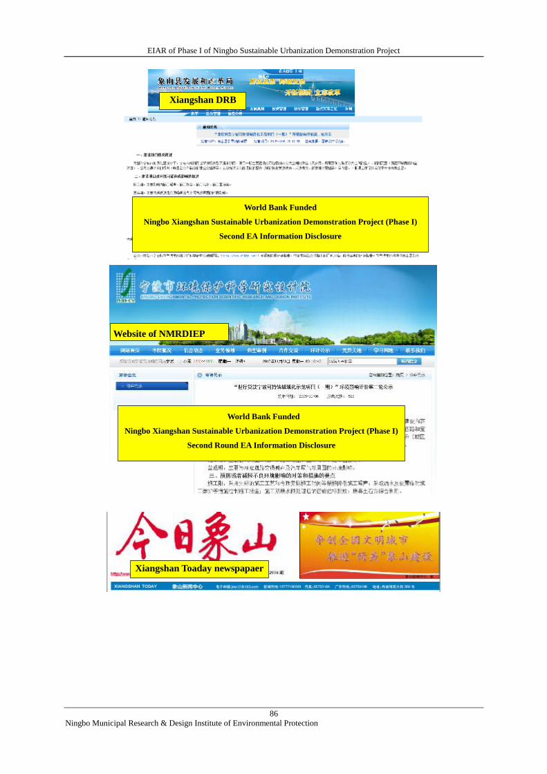
EIAR of Phase I of Ningbo Sustainable Urbanization Demonstration Project
86
Ningbo Municipal Research & Design Institute of Environmental Protection
Xiangshan DRB
Xiangshan Toaday newspapaer
Website of NMRDIEP
World Bank Funded
Ningbo Xiangshan Sustainable Urbanization Demonstration Project (Phase I)
Second EA Information Disclosure
World Bank Funded
Ningbo Xiangshan Sustainable Urbanization Demonstration Project (Phase I)
Second Round EA Information Disclosure
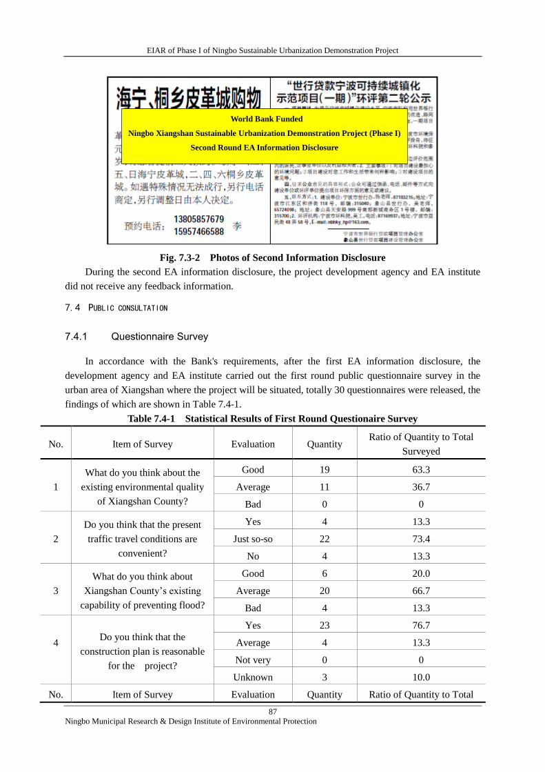
EIAR of Phase I of Ningbo Sustainable Urbanization Demonstration Project
87
Ningbo Municipal Research & Design Institute of Environmental Protection
Fig. 7.3-2 Photos of Second Information Disclosure
During the second EA information disclosure, the project development agency and EA institute
did not receive any feedback information.
7.4 PUBLIC CONSULTATION
7.4.1 Questionnaire Survey
In accordance with the Bank's requirements, after the first EA information disclosure, the
development agency and EA institute carried out the first round public questionnaire survey in the
urban area of Xiangshan where the project will be situated, totally 30 questionnaires were released, the
findings of which are shown in Table 7.4-1.
Table 7.4-1 Statistical Results of First Round Questionaire Survey
No. Item of Survey Evaluation Quantity Ratio of Quantity to Total
Surveyed
1
What do you think about the
existing environmental quality
of Xiangshan County?
Good 19 63.3
Average 11 36.7
Bad 0 0
2
Do you think that the present
traffic travel conditions are
convenient?
Yes 4 13.3
Just so-so 22 73.4
No 4 13.3
3
What do you think about
Xiangshan County’s existing
capability of preventing flood?
Good 6 20.0
Average 20 66.7
Bad 4 13.3
4
Do you think that the
construction plan is reasonable
for the project?
Yes 23 76.7
Average 4 13.3
Not very 0 0
Unknown 3 10.0
No. Item of Survey Evaluation Quantity Ratio of Quantity to Total
World Bank Funded
Ningbo Xiangshan Sustainable Urbanization Demonstration Project (Phase I)
Second Round EA Information Disclosure
EIAR of Phase I of Ningbo Sustainable Urbanization Demonstration Project
88
Ningbo Municipal Research & Design Institute of Environmental Protection
Surveyed
5
What do you think the project
will bring about influences after
the project implemenation?
Advantageous 22 73.3
Basically no
influence 8 26.7
Disadvantageous 0 0
8
If the environmental impacts are
controlled within the range
permissible by the state, what is
your overall opinion and
attitude?
Supportive 28 93.3
Oppositive 0 0
Doesn’t matter 2 6.7
Based on the table above, the main findings can be summarized below:
1) the overwhelming majority of the public think that the existing traffic and trip conditions are
average or inconvenient in the county, the percentage amounting to 86.7%;
2) the overwhelming majority of the public think that the current flood control and drainage
capabilities are just so so or weak, the percentage 80.0%;
3) the vast majority of the public think that the construction plan selected is reasonable for the
project, 76.7%; and
4) the overwhelming majority support the project construction, 93.3%, while 6.7% do not care,
and zero oppositive.
7.4.2 Second round questionnaire survey and symposium
In accordance with the requirements of the state and the Bank, the project development agency
and EA institute carried out the second round questionnaire survey after the second information
disclosure. Considering that the construction scopes of the subprojects had been basically identified
during the survey, the questionnaires were distributed specially to the targeted residents/villagers in
this round survey, such as those in Ruli Xincun, Sanchalu village, Jinxiujiayuan as well as business
households in Wenchang Jie (street), Xiangshan Experiment School Elementary School and other
social organizations, totally 86 questionnaires released to individuals and 29 to organizations. The
findings can be seen in Tables 7.4-2 and 7.4-3.
Table 7.4-2 Statistical Findings of Second Round Individual Survey Questionaire
No. Item of Survey Evaluation Number of
Persons
Ratio of Number to
Total Surveyed
1 To what extent do you
know the Project?
Known 35 40.7
Heard of 43 50
Unknown 8 9.3
2
What do you think about
the existing
environmental quality of
Xiangshan County
Good 43 50
Average 41 47.7
Bad 2 2.3
3 What are the problems Wastewater 40 46.5
EIAR of Phase I of Ningbo Sustainable Urbanization Demonstration Project
89
Ningbo Municipal Research & Design Institute of Environmental Protection
that you mostly worry
about?(multiply
selectable)
pollution
Air pollution 33 38.4
Noise 32 37.2
Ecological
destruction 9 10.5
Solid waste 16 18.6
Others 0 0
4
Do you think that the
present traffic and travel
conditions are
convenient?
Yes 30 34.9
Average 47 54.7
No 9 10.4
5
What do you think about
Xiangshan County’s
existing capability of
preventing flood?
Good 21 24.4
Average 44 51.2
Bad 21 24.4
Unclear 0 0
6
Do you think that after the
project being
implemented the
residents’ travel
conditions and regional
flood prevention capacity
will be improved and
raised?
Advantageous 71 82.5
Basically no 12 14
Disadvantageous 0 0
Unclear 3 3.5
7
What influence do you
think may be brought to
your life and work after
the project
implementation?
Advantageous 65 75.6
Basically no 19 22.1
Disadvantageous 0 0
Unclear 2 2.3
No. Item of Survey Evaluation Number of
Persons
Ratio of Number
to Total Surveyed
8
If the environmental
impacts are controlled
within the range
permissible by the state,
what is your overall
opinion and attitude?
Supportive 78 90.7
Oppositive 0 0
Doesn’t mater 8 9.3
Based on Table 7.4-2, the main findings of the second round Individual questionnaire are
summarized below:
1) The overwhelming majority of individuals had known or heard of the Project, the percentage
representing 90.7%;
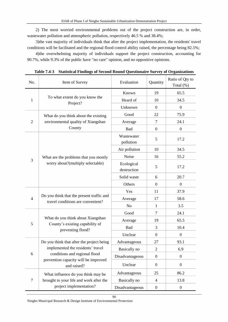
EIAR of Phase I of Ningbo Sustainable Urbanization Demonstration Project
90
Ningbo Municipal Research & Design Institute of Environmental Protection
2) The most worried environmental problems out of the project construction are, in order,
wastewater pollution and atmospheric pollution, respectively 46.5 % and 38.4%;
3)the vast majority of individuals think that after the project implementation, the residents' travel
conditions will be facilitated and the regional flood control ability raised, the percentage being 82.5%;
4)the overwhelming majority of individuals support the project construction, accounting for
90.7%, while 9.3% of the public have "no care" opinion, and no oppositive opinions.
Table 7.4-3 Statistical Findings of Second Round Questionaire Survey of Organizations
No. Item of Survey Evaluation Quantity Ratio of Qty to
Total (%)
1 To what extent do you know the
Project?
Known 19 65.5
Heard of 10 34.5
Unknown 0 0
2
What do you think about the existing
environmental quality of Xiangshan
County
Good 22 75.9
Average 7 24.1
Bad 0 0
3 What are the problems that you mostly
worry about?(multiply selectable)
Wastewater
pollution 5 17.2
Air pollution 10 34.5
Noise 16 55.2
Ecological
destruction 5 17.2
Solid waste 6 20.7
Others 0 0
4 Do you think that the present traffic and
travel conditions are convenient?
Yes 11 37.9
Average 17 58.6
No 1 3.5
5
What do you think about Xiangshan
County’s existing capability of
preventing flood?
Good 7 24.1
Average 19 65.5
Bad 3 10.4
Unclear 0 0
6
Do you think that after the project being
implemented the residents’ travel
conditions and regional flood
prevention capacity will be improved
and raised?
Advantageous 27 93.1
Basically no 2 6.9
Disadvantageous 0 0
Unclear 0 0
7
What influence do you think may be
brought to your life and work after the
project implementation?
Advantageous 25 86.2
Basically no 4 13.8
Disadvantageous 0 0
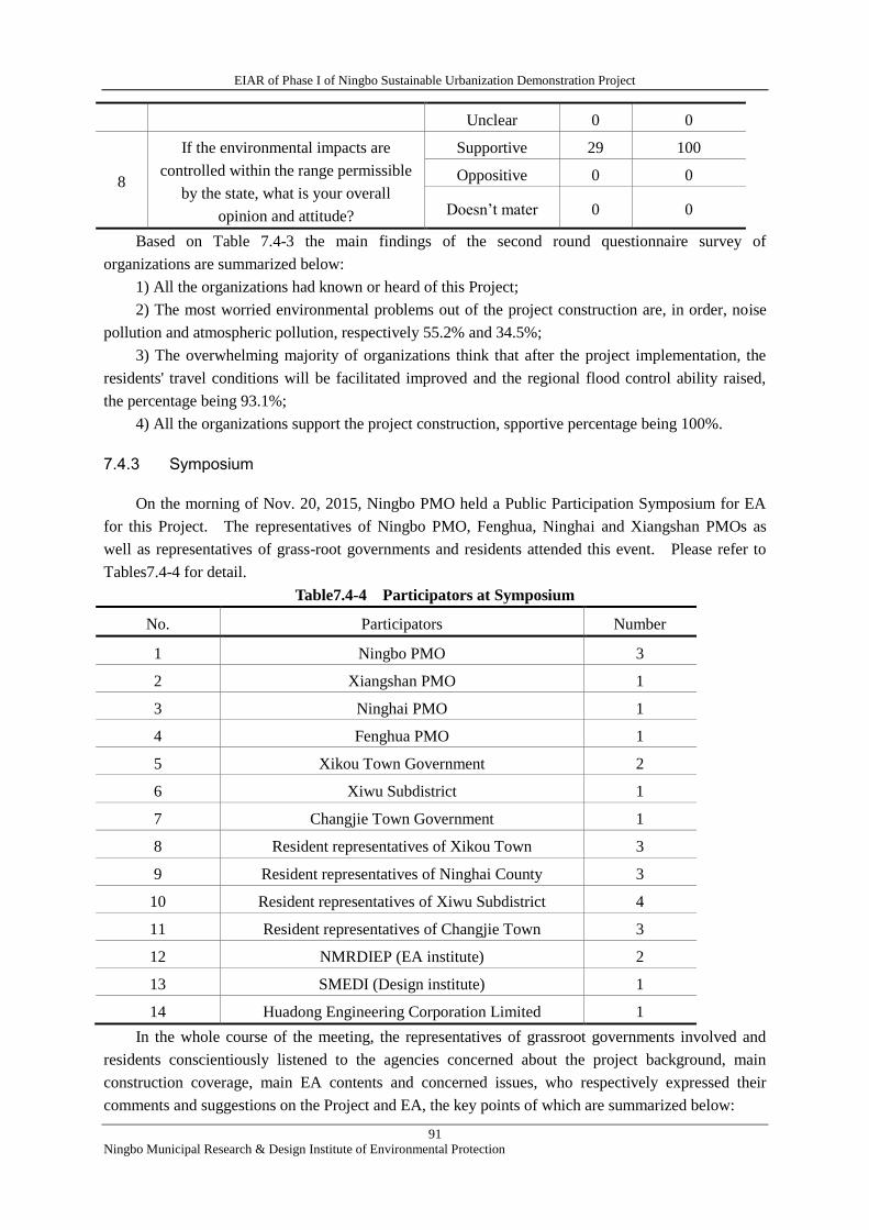
EIAR of Phase I of Ningbo Sustainable Urbanization Demonstration Project
91
Ningbo Municipal Research & Design Institute of Environmental Protection
Unclear 0 0
8
If the environmental impacts are
controlled within the range permissible
by the state, what is your overall
opinion and attitude?
Supportive 29 100
Oppositive 0 0
Doesn’t mater 0 0
Based on Table 7.4-3 the main findings of the second round questionnaire survey of
organizations are summarized below:
1) All the organizations had known or heard of this Project;
2) The most worried environmental problems out of the project construction are, in order, noise
pollution and atmospheric pollution, respectively 55.2% and 34.5%;
3) The overwhelming majority of organizations think that after the project implementation, the
residents' travel conditions will be facilitated improved and the regional flood control ability raised,
the percentage being 93.1%;
4) All the organizations support the project construction, spportive percentage being 100%.
7.4.3 Symposium
On the morning of Nov. 20, 2015, Ningbo PMO held a Public Participation Symposium for EA
for this Project. The representatives of Ningbo PMO, Fenghua, Ninghai and Xiangshan PMOs as
well as representatives of grass-root governments and residents attended this event. Please refer to
Tables7.4-4 for detail.
Table7.4-4 Participators at Symposium
No. Participators Number
1 Ningbo PMO 3
2 Xiangshan PMO 1
3 Ninghai PMO 1
4 Fenghua PMO 1
5 Xikou Town Government 2
6 Xiwu Subdistrict 1
7 Changjie Town Government 1
8 Resident representatives of Xikou Town 3
9 Resident representatives of Ninghai County 3
10 Resident representatives of Xiwu Subdistrict 4
11 Resident representatives of Changjie Town 3
12 NMRDIEP (EA institute) 2
13 SMEDI (Design institute) 1
14 Huadong Engineering Corporation Limited 1
In the whole course of the meeting, the representatives of grassroot governments involved and
residents conscientiously listened to the agencies concerned about the project background, main
construction coverage, main EA contents and concerned issues, who respectively expressed their
comments and suggestions on the Project and EA, the key points of which are summarized below:
EIAR of Phase I of Ningbo Sustainable Urbanization Demonstration Project
92
Ningbo Municipal Research & Design Institute of Environmental Protection
1) Representatives of Xikou Town and residents: (i) in the old town area, buildings are crowded,
the width of road in some part is only one meter or so; furthermore, the town is a well-known tourist
scenic spot, where it is very difficult for vehicles to run and park at ordinary times, the traffic will
even suffer more serious paralysis in case of tourist seasons; (ii) because of unsound drainage facilities,
water is serviously logged at Xilou Agroproduct Market, Paimen Lu and Wuling Middle School, etc.;
(iii) urgently hope to improve regional traffic and drainage issues by reference of the Bank's advanced
experience; (iv) due to the fact that there are a lot of cultural conservation units, close attention should
be paid to the protection of them. In addition, the traffic flows are greatly different between tourist and
non-tourist seasons, it is hoped that design of traffic management can be conducted in consideration of
the regional characteristics.
2) Resident representatives of Ninghai County: Rest facilities are insufficient along main roads in
the urban district, so they hope that these facilities can be improved through the Bank-funded project,
especially the project of public spatial retrofit subproject can be implemented.
3) The representatives of Xiwu Sub-district and residents: (i) The Xiwu residents strongly support
the urbanized reconstruction in the area, meanwhile hoping that in the reconstruction, the orginal
historical style and features can be preserved; (ii) since there are a number of houses along streets in
Xiwu, attention shall be paid to the safety of the old houses in the project implementation.
4) Representatives of Changjie Town Government and residents: (i) The town is surrounded by
hills in three directions with serious problem of torrential flood, moreover, all the floodwater needs to
pass through the town area to flow into sea, the town area is submerged twice or thrice every year; (ii)
The roads are crowded in Changjie with a through-way across the town area, which brings about
hidden danger to the safety of students and pedestrians, the representatives hope that a new
through-way can be constructed outside the town area; (iii) urgently hope that the World Bank funded
urbanization project can be implemented, under which the regional communications and drainage can
be improved by reference of the Bank's advanced experience; (iv) the facilities of collecting and
transferring domestic solid waste are simple and crude, as a result, environmental contamination is
serious in the course of collection and transfer, the government hopes that one modernized waste
transfer station can be included in the the World Bank financed project; (v) the town belongs in a soft
ground area, so attention shall be paid in EA to the rationality of construction management plan to
prevent the building structures from being damaged.
5) Subconslusion: all the representatives of the grassroot governments and residents reflect that
the capacities of urban traffic infrastructures and flood prevention are weak, hoping that they can
participate into the implementation scope of the World Bank financed project to improve regional
traffic and flood control infrastructures with the help of the advanced idea and experience of the Bank
so as to raise the regional urbanization level and liveability.
Through twice EA information disclosure, most of the public have known the situation of the
Project; the public participation symposium indicates that all the grassroot governments of the areas
where the subprojects will be located hope that their areas can be involved into the implementation
scope of the Bank funded project, all of them support the project construction; in addition, the
findings of the two rounds questionaire surveys show that the overwhelming majority of the public
support the project construction, no oppositive opinions.

EIAR of Phase I of Ningbo Sustainable Urbanization Demonstration Project
93
Ningbo Municipal Research & Design Institute of Environmental Protection
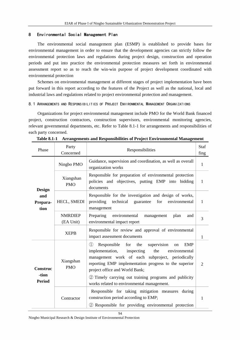
EIAR of Phase I of Ningbo Sustainable Urbanization Demonstration Project
94
Ningbo Municipal Research & Design Institute of Environmental Protection
8 Environmental Social Management Plan
The environmental social management plan (ESMP) is established to provide bases for
environmental management in order to ensure that the development agencies can strictly follow the
environmental protection laws and regulations during project design, construction and operation
periods and put into practice the environmental protection measures set forth in environmental
assessment report so as to reach the win-win purpose of project development coordinated with
environmental protection
Schemes on environmental management at different stages of project implementation have been
put forward in this report according to the features of the Project as well as the national, local and
industrial laws and regulations related to project environmental protection and management.
8.1 ARRANGEMENTS AND RESPONSIBILITIES OF PROJECT ENVIRONMENTAL MANAGEMENT ORGANIZATIONS
Organizations for project environmental management include PMO for the World Bank financed
project, construction contractors, construction supervisors, environmental monitoring agencies,
relevant governmental departments, etc. Refer to Table 8.1-1 for arrangements and responsibilities of
each party concerned.
Table 8.1-1 Arrangements and Responsibilities of Project Environmental Management
Phase Party
Concerned Responsibilities
Staf
fing
Design
and
Prepara-
tion
Ningbo PMO Guidance, supervision and coordination, as well as overall
organization works 1
Xiangshan
PMO
Responsible for preparation of environmental protection
policies and objectives, putting EMP into bidding
documents
1
HECL, SMEDI
Responsible for the investigation and design of works,
providing technical guarantee for environmental
management
1
NMRDIEP
(EA Unit)
Preparing environmental management plan and
environmental impact report 3
XEPB Responsible for review and approval of environmental
impact assessment documents
1
Construc
-tion
Period
Xiangshan
PMO
① Responsible for the supervision on EMP
implementation, inspecting the environmental
management work of each subproject, periodically
reporting EMP implementation progress to the superior
project office and World Bank;
② Timely carrying out training programs and publicity
works related to environmental management.
2
Contractor
Responsible for taking mitigation measures during
construction period according to EMP;
② Responsible for providing environmental protection
1
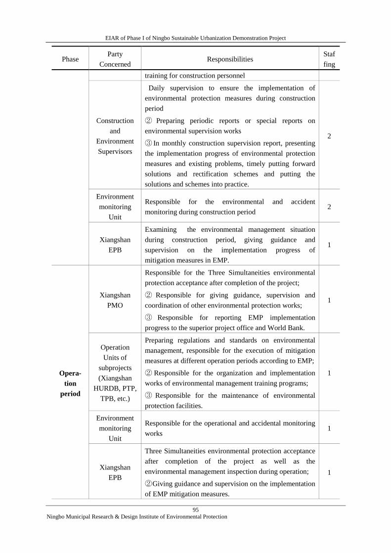
EIAR of Phase I of Ningbo Sustainable Urbanization Demonstration Project
95
Ningbo Municipal Research & Design Institute of Environmental Protection
Phase Party
Concerned Responsibilities
Staf
fing
training for construction personnel
Construction
and
Environment
Supervisors
Daily supervision to ensure the implementation of
environmental protection measures during construction
period
② Preparing periodic reports or special reports on
environmental supervision works
③ In monthly construction supervision report, presenting
the implementation progress of environmental protection
measures and existing problems, timely putting forward
solutions and rectification schemes and putting the
solutions and schemes into practice.
2
Environment
monitoring
Unit
Responsible for the environmental and accident
monitoring during construction period 2
Xiangshan
EPB
Examining the environmental management situation
during construction period, giving guidance and
supervision on the implementation progress of
mitigation measures in EMP.
1
Opera-
tion
period
Xiangshan
PMO
Responsible for the Three Simultaneities environmental
protection acceptance after completion of the project;
② Responsible for giving guidance, supervision and
coordination of other environmental protection works;
③ Responsible for reporting EMP implementation
progress to the superior project office and World Bank.
1
Operation
Units of
subprojects
(Xiangshan
HURDB, PTP,
TPB, etc.)
Preparing regulations and standards on environmental
management, responsible for the execution of mitigation
measures at different operation periods according to EMP;
② Responsible for the organization and implementation
works of environmental management training programs;
③ Responsible for the maintenance of environmental
protection facilities.
1
Environment
monitoring
Unit
Responsible for the operational and accidental monitoring
works 1
Xiangshan
EPB
Three Simultaneities environmental protection acceptance
after completion of the project as well as the
environmental management inspection during operation;
② Giving guidance and supervision on the implementation
of EMP mitigation measures.
1
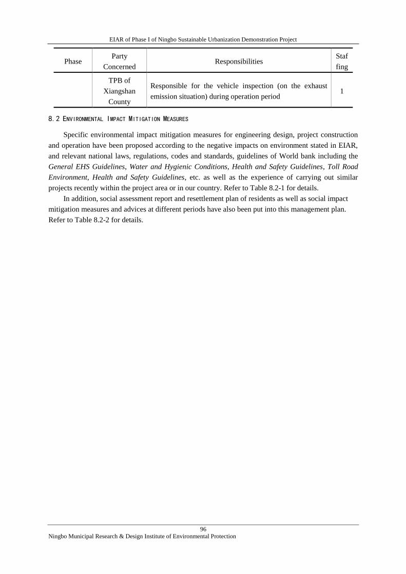
EIAR of Phase I of Ningbo Sustainable Urbanization Demonstration Project
96
Ningbo Municipal Research & Design Institute of Environmental Protection
Phase Party
Concerned Responsibilities
Staf
fing
TPB of
Xiangshan
County
Responsible for the vehicle inspection (on the exhaust
emission situation) during operation period 1
8.2 ENVIRONMENTAL IMPACT MITIGATION MEASURES
Specific environmental impact mitigation measures for engineering design, project construction
and operation have been proposed according to the negative impacts on environment stated in EIAR,
and relevant national laws, regulations, codes and standards, guidelines of World bank including the
General EHS Guidelines, Water and Hygienic Conditions, Health and Safety Guidelines, Toll Road
Environment, Health and Safety Guidelines, etc. as well as the experience of carrying out similar
projects recently within the project area or in our country. Refer to Table 8.2-1 for details.
In addition, social assessment report and resettlement plan of residents as well as social impact
mitigation measures and advices at different periods have also been put into this management plan.
Refer to Table 8.2-2 for details.
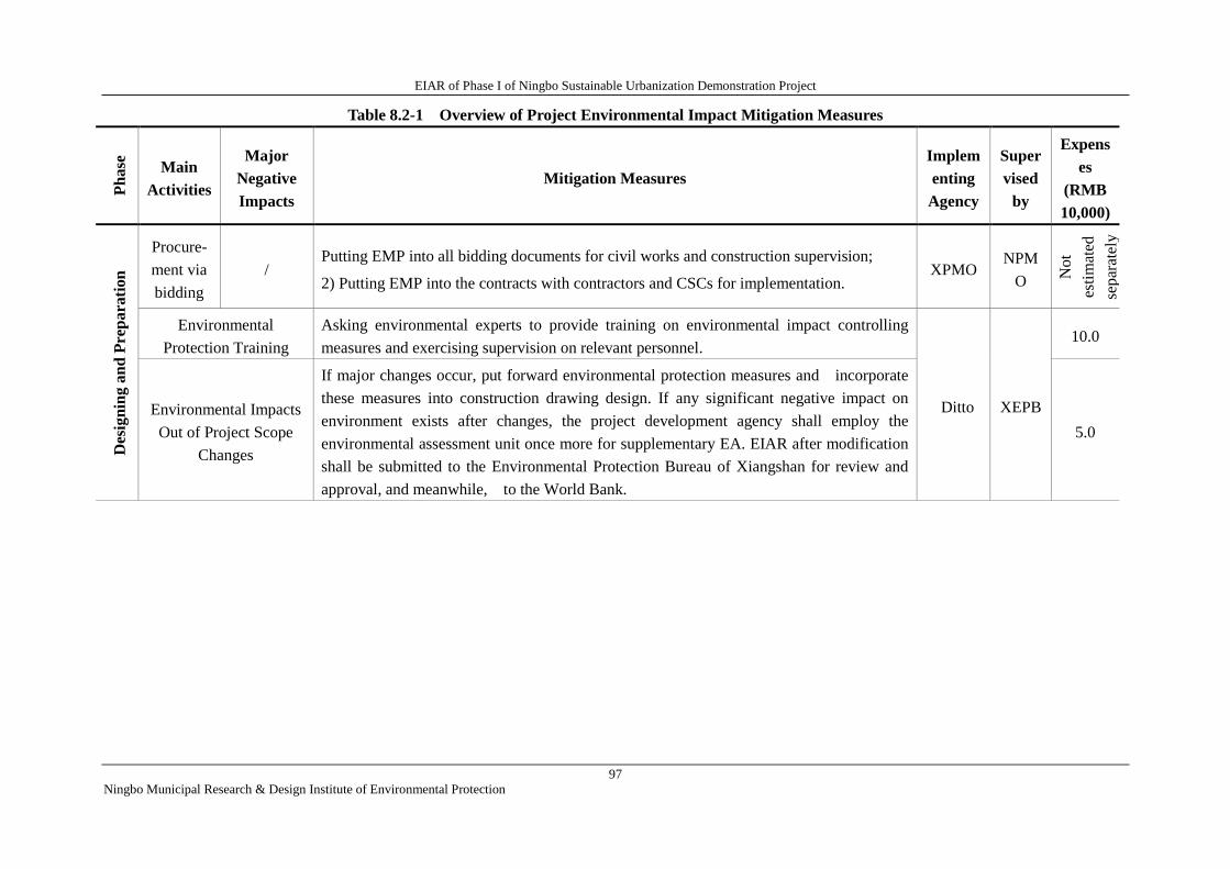
EIAR of Phase I of Ningbo Sustainable Urbanization Demonstration Project
97
Ningbo Municipal Research & Design Institute of Environmental Protection
Table 8.2-1 Overview of Project Environmental Impact Mitigation Measures P
hase
Main
Activities
Major
Negative
Impacts
Mitigation Measures
Implem
enting
Agency
Super
vised
by
Expens
es
(RMB
10,000)
Des
ign
ing a
nd
Pre
para
tion
Procure-
ment via
bidding
/ Putting EMP into all bidding documents for civil works and construction supervision;
2) Putting EMP into the contracts with contractors and CSCs for implementation. XPMO
NPM
O Not
esti
mat
ed
separ
atel
y
Environmental
Protection Training
Asking environmental experts to provide training on environmental impact controlling
measures and exercising supervision on relevant personnel.
Ditto XEPB
10.0
Environmental Impacts
Out of Project Scope
Changes
If major changes occur, put forward environmental protection measures and incorporate
these measures into construction drawing design. If any significant negative impact on
environment exists after changes, the project development agency shall employ the
environmental assessment unit once more for supplementary EA. EIAR after modification
shall be submitted to the Environmental Protection Bureau of Xiangshan for review and
approval, and meanwhile, to the World Bank.
5.0
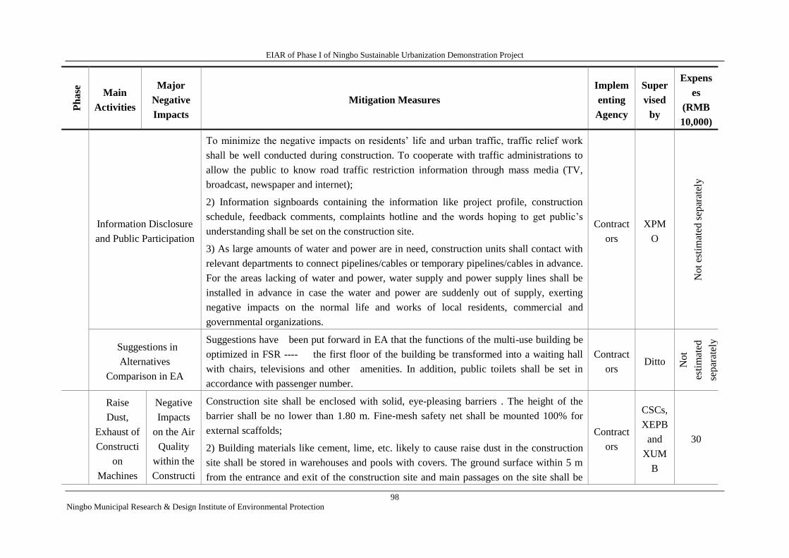
EIAR of Phase I of Ningbo Sustainable Urbanization Demonstration Project
98
Ningbo Municipal Research & Design Institute of Environmental Protection
Ph
ase
Main
Activities
Major
Negative
Impacts
Mitigation Measures
Implem
enting
Agency
Super
vised
by
Expens
es
(RMB
10,000)
Information Disclosure
and Public Participation
To minimize the negative impacts on residents’ life and urban traffic, traffic relief work
shall be well conducted during construction. To cooperate with traffic administrations to
allow the public to know road traffic restriction information through mass media (TV,
broadcast, newspaper and internet);
2) Information signboards containing the information like project profile, construction
schedule, feedback comments, complaints hotline and the words hoping to get public’s
understanding shall be set on the construction site.
3) As large amounts of water and power are in need, construction units shall contact with
relevant departments to connect pipelines/cables or temporary pipelines/cables in advance.
For the areas lacking of water and power, water supply and power supply lines shall be
installed in advance in case the water and power are suddenly out of supply, exerting
negative impacts on the normal life and works of local residents, commercial and
governmental organizations.
Contract
ors
XPM
O
Not
esti
mat
ed s
epar
atel
y
Suggestions in
Alternatives
Comparison in EA
Suggestions have been put forward in EA that the functions of the multi-use building be
optimized in FSR ---- the first floor of the building be transformed into a waiting hall
with chairs, televisions and other amenities. In addition, public toilets shall be set in
accordance with passenger number.
Contract
ors Ditto N
ot
esti
mat
ed
sep
arat
ely
Con
stru
ctio
n
Per
iod
Con
stru
ctio
n
Per
iod
Raise
Dust,
Exhaust of
Constructi
on
Machines
Negative
Impacts
on the Air
Quality
within the
Constructi
Construction site shall be enclosed with solid, eye-pleasing barriers . The height of the
barrier shall be no lower than 1.80 m. Fine-mesh safety net shall be mounted 100% for
external scaffolds;
2) Building materials like cement, lime, etc. likely to cause raise dust in the construction
site shall be stored in warehouses and pools with covers. The ground surface within 5 m
from the entrance and exit of the construction site and main passages on the site shall be
Contract
ors
CSCs,
XEPB
and
XUM
B
30
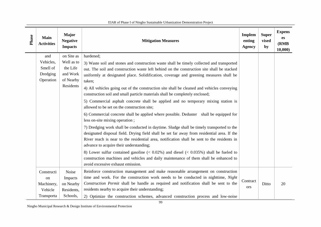
EIAR of Phase I of Ningbo Sustainable Urbanization Demonstration Project
99
Ningbo Municipal Research & Design Institute of Environmental Protection
Ph
ase
Main
Activities
Major
Negative
Impacts
Mitigation Measures
Implem
enting
Agency
Super
vised
by
Expens
es
(RMB
10,000)
and
Vehicles,
Smell of
Dredging
Operation
on Site as
Well as to
the Life
and Work
of Nearby
Residents
hardened;
3) Waste soil and stones and construction waste shall be timely collected and transported
out. The soil and construction waste left behind on the construction site shall be stacked
uniformly at designated place. Solidification, coverage and greening measures shall be
taken;
4) All vehicles going out of the construction site shall be cleaned and vehicles conveying
construction soil and small particle materials shall be completely enclosed;
5) Commercial asphalt concrete shall be applied and no temporary mixing station is
allowed to be set on the construction site;
6) Commercial concrete shall be applied where possible. Deduster shall be equipped for
less on-site mixing operation ;
7) Dredging work shall be conducted in daytime. Sludge shall be timely transported to the
designated disposal field. Drying field shall be set far away from residential area. If the
River reach is near to the residential area, notification shall be sent to the residents in
advance to acquire their understanding;
8) Lower sulfur contained gasoline (< 0.02%) and diesel (< 0.035%) shall be fueled to
construction machines and vehicles and daily maintenance of them shall be enhanced to
avoid excessive exhaust emission.
Constructi
on
Machinery,
Vehicle
Transporta
Noise
Impacts
on Nearby
Residents,
Schools,
Reinforce construction management and make reasonable arrangement on construction
time and work. For the construction work needs to be conducted in nighttime, Night
Construction Permit shall be handle as required and notification shall be sent to the
residents nearby to acquire their understanding;
2) Optimize the construction schemes, advanced construction process and low-noise
Contract
ors Ditto 20
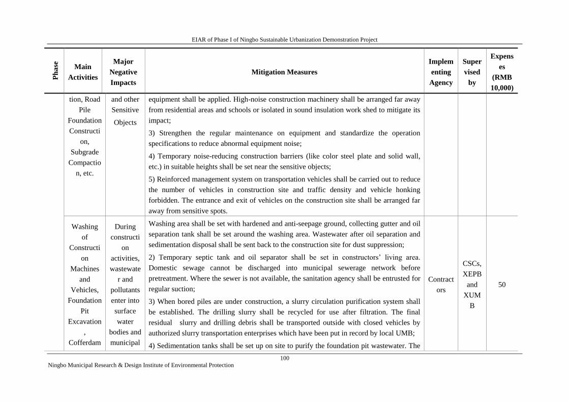
EIAR of Phase I of Ningbo Sustainable Urbanization Demonstration Project
100
Ningbo Municipal Research & Design Institute of Environmental Protection
Ph
ase
Main
Activities
Major
Negative
Impacts
Mitigation Measures
Implem
enting
Agency
Super
vised
by
Expens
es
(RMB
10,000)
tion, Road
Pile
Foundation
Constructi
on,
Subgrade
Compactio
n, etc.
and other
Sensitive
Objects
equipment shall be applied. High-noise construction machinery shall be arranged far away
from residential areas and schools or isolated in sound insulation work shed to mitigate its
impact;
3) Strengthen the regular maintenance on equipment and standardize the operation
specifications to reduce abnormal equipment noise;
4) Temporary noise-reducing construction barriers (like color steel plate and solid wall,
etc.) in suitable heights shall be set near the sensitive objects;
5) Reinforced management system on transportation vehicles shall be carried out to reduce
the number of vehicles in construction site and traffic density and vehicle honking
forbidden. The entrance and exit of vehicles on the construction site shall be arranged far
away from sensitive spots.
Washing
of
Constructi
on
Machines
and
Vehicles,
Foundation
Pit
Excavation
,
Cofferdam
During
constructi
on
activities,
wastewate
r and
pollutants
enter into
surface
water
bodies and
municipal
Washing area shall be set with hardened and anti-seepage ground, collecting gutter and oil
separation tank shall be set around the washing area. Wastewater after oil separation and
sedimentation disposal shall be sent back to the construction site for dust suppression;
2) Temporary septic tank and oil separator shall be set in constructors’ living area.
Domestic sewage cannot be discharged into municipal sewerage network before
pretreatment. Where the sewer is not available, the sanitation agency shall be entrusted for
regular suction;
3) When bored piles are under construction, a slurry circulation purification system shall
be established. The drilling slurry shall be recycled for use after filtration. The final
residual slurry and drilling debris shall be transported outside with closed vehicles by
authorized slurry transportation enterprises which have been put in record by local UMB;
4) Sedimentation tanks shall be set up on site to purify the foundation pit wastewater. The
Contract
ors
CSCs,
XEPB
and
XUM
B
50
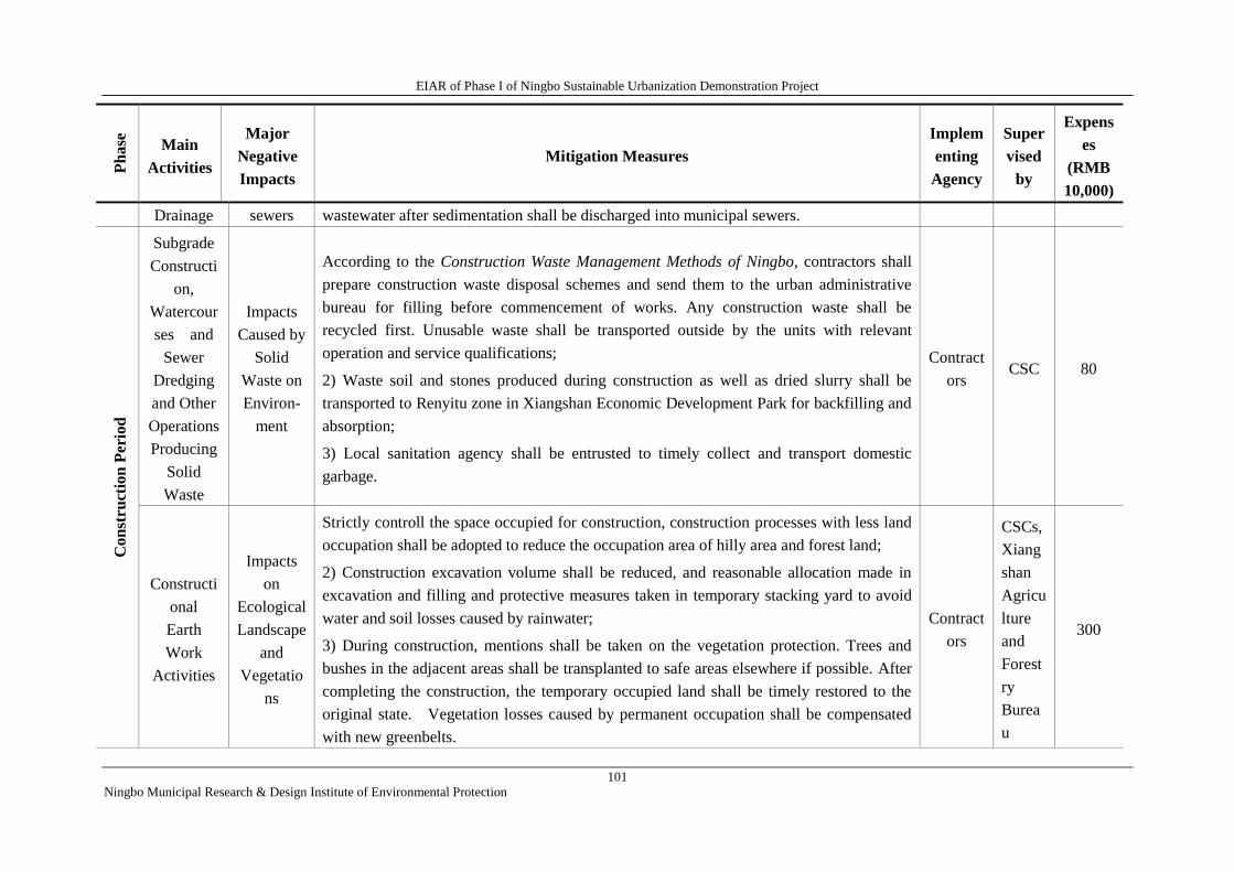
EIAR of Phase I of Ningbo Sustainable Urbanization Demonstration Project
101
Ningbo Municipal Research & Design Institute of Environmental Protection
Ph
ase
Main
Activities
Major
Negative
Impacts
Mitigation Measures
Implem
enting
Agency
Super
vised
by
Expens
es
(RMB
10,000)
Drainage sewers wastewater after sedimentation shall be discharged into municipal sewers.
Co
nst
ruct
ion
Per
iod
Subgrade
Constructi
on,
Watercour
ses and
Sewer
Dredging
and Other
Operations
Producing
Solid
Waste
Impacts
Caused by
Solid
Waste on
Environ-
ment
According to the Construction Waste Management Methods of Ningbo, contractors shall
prepare construction waste disposal schemes and send them to the urban administrative
bureau for filling before commencement of works. Any construction waste shall be
recycled first. Unusable waste shall be transported outside by the units with relevant
operation and service qualifications;
2) Waste soil and stones produced during construction as well as dried slurry shall be
transported to Renyitu zone in Xiangshan Economic Development Park for backfilling and
absorption;
3) Local sanitation agency shall be entrusted to timely collect and transport domestic
garbage.
Contract
ors CSC 80
Constructi
onal
Earth
Work
Activities
Impacts
on
Ecological
Landscape
and
Vegetatio
ns
Strictly controll the space occupied for construction, construction processes with less land
occupation shall be adopted to reduce the occupation area of hilly area and forest land;
2) Construction excavation volume shall be reduced, and reasonable allocation made in
excavation and filling and protective measures taken in temporary stacking yard to avoid
water and soil losses caused by rainwater;
3) During construction, mentions shall be taken on the vegetation protection. Trees and
bushes in the adjacent areas shall be transplanted to safe areas elsewhere if possible. After
completing the construction, the temporary occupied land shall be timely restored to the
original state. Vegetation losses caused by permanent occupation shall be compensated
with new greenbelts.
Contract
ors
CSCs,
Xiang
shan
Agricu
lture
and
Forest
ry
Burea
u
300
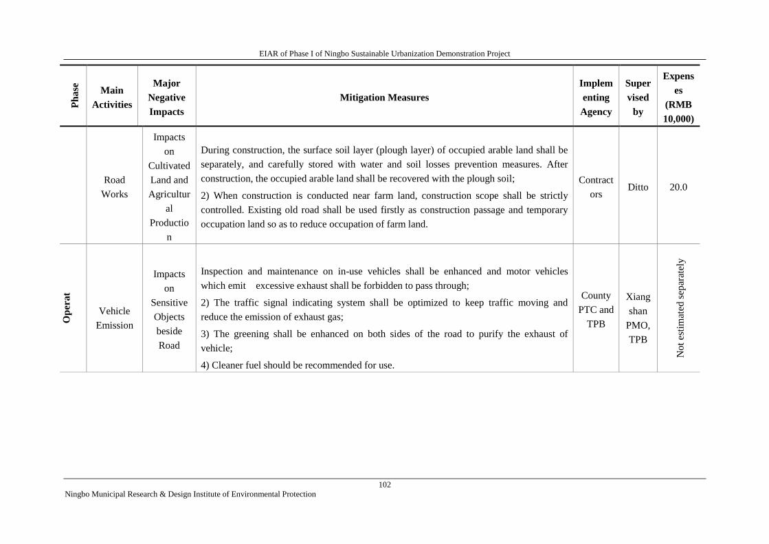
EIAR of Phase I of Ningbo Sustainable Urbanization Demonstration Project
102
Ningbo Municipal Research & Design Institute of Environmental Protection
Ph
ase
Main
Activities
Major
Negative
Impacts
Mitigation Measures
Implem
enting
Agency
Super
vised
by
Expens
es
(RMB
10,000)
Road
Works
Impacts
on
Cultivated
Land and
Agricultur
al
Productio
n
During construction, the surface soil layer (plough layer) of occupied arable land shall be
separately, and carefully stored with water and soil losses prevention measures. After
construction, the occupied arable land shall be recovered with the plough soil;
2) When construction is conducted near farm land, construction scope shall be strictly
controlled. Existing old road shall be used firstly as construction passage and temporary
occupation land so as to reduce occupation of farm land.
Contract
ors Ditto 20.0
Op
erat
ion
per
i
od
Vehicle
Emission
Impacts
on
Sensitive
Objects
beside
Road
Inspection and maintenance on in-use vehicles shall be enhanced and motor vehicles
which emit excessive exhaust shall be forbidden to pass through;
2) The traffic signal indicating system shall be optimized to keep traffic moving and
reduce the emission of exhaust gas;
3) The greening shall be enhanced on both sides of the road to purify the exhaust of
vehicle;
4) Cleaner fuel should be recommended for use.
County
PTC and
TPB
Xiang
shan
PMO,
TPB
No
t es
tim
ated
sep
arat
ely
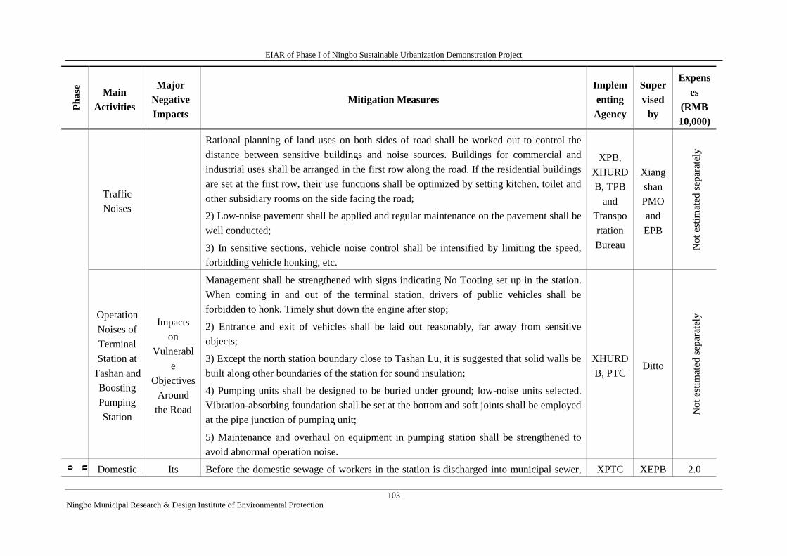
EIAR of Phase I of Ningbo Sustainable Urbanization Demonstration Project
103
Ningbo Municipal Research & Design Institute of Environmental Protection
Ph
ase
Main
Activities
Major
Negative
Impacts
Mitigation Measures
Implem
enting
Agency
Super
vised
by
Expens
es
(RMB
10,000)
Traffic
Noises
Rational planning of land uses on both sides of road shall be worked out to control the
distance between sensitive buildings and noise sources. Buildings for commercial and
industrial uses shall be arranged in the first row along the road. If the residential buildings
are set at the first row, their use functions shall be optimized by setting kitchen, toilet and
other subsidiary rooms on the side facing the road;
2) Low-noise pavement shall be applied and regular maintenance on the pavement shall be
well conducted;
3) In sensitive sections, vehicle noise control shall be intensified by limiting the speed,
forbidding vehicle honking, etc.
XPB,
XHURD
B, TPB
and
Transpo
rtation
Bureau
Xiang
shan
PMO
and
EPB
Not
esti
mat
ed s
epar
atel
y
Operation
Noises of
Terminal
Station at
Tashan and
Boosting
Pumping
Station
Impacts
on
Vulnerabl
e
Objectives
Around
the Road
Management shall be strengthened with signs indicating No Tooting set up in the station.
When coming in and out of the terminal station, drivers of public vehicles shall be
forbidden to honk. Timely shut down the engine after stop;
2) Entrance and exit of vehicles shall be laid out reasonably, far away from sensitive
objects;
3) Except the north station boundary close to Tashan Lu, it is suggested that solid walls be
built along other boundaries of the station for sound insulation;
4) Pumping units shall be designed to be buried under ground; low-noise units selected.
Vibration-absorbing foundation shall be set at the bottom and soft joints shall be employed
at the pipe junction of pumping unit;
5) Maintenance and overhaul on equipment in pumping station shall be strengthened to
avoid abnormal operation noise.
XHURD
B, PTC Ditto
No
t es
tim
ated
sep
arat
ely
O p e r a ti o n
p e r i o d
Domestic Its Before the domestic sewage of workers in the station is discharged into municipal sewer, XPTC XEPB 2.0
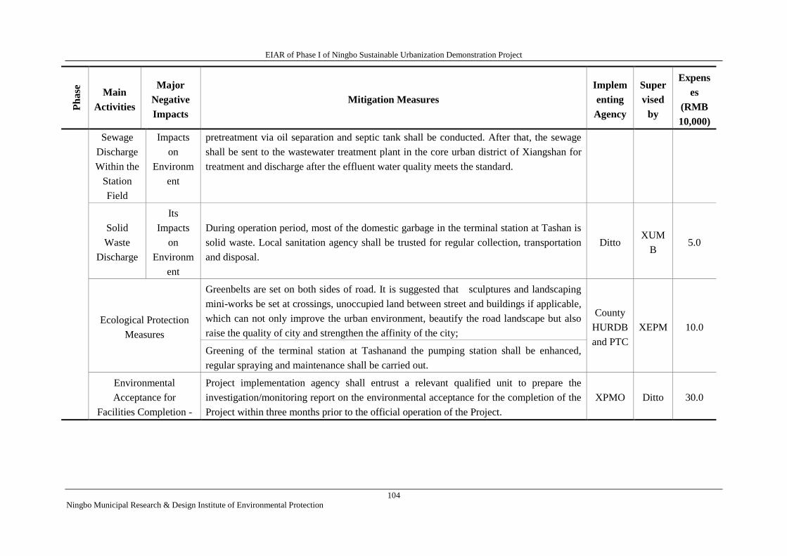
EIAR of Phase I of Ningbo Sustainable Urbanization Demonstration Project
104
Ningbo Municipal Research & Design Institute of Environmental Protection
Ph
ase
Main
Activities
Major
Negative
Impacts
Mitigation Measures
Implem
enting
Agency
Super
vised
by
Expens
es
(RMB
10,000)
Sewage
Discharge
Within the
Station
Field
Impacts
on
Environm
ent
pretreatment via oil separation and septic tank shall be conducted. After that, the sewage
shall be sent to the wastewater treatment plant in the core urban district of Xiangshan for
treatment and discharge after the effluent water quality meets the standard.
Solid
Waste
Discharge
Its
Impacts
on
Environm
ent
During operation period, most of the domestic garbage in the terminal station at Tashan is
solid waste. Local sanitation agency shall be trusted for regular collection, transportation
and disposal.
Ditto XUM
B 5.0
Ecological Protection
Measures
Greenbelts are set on both sides of road. It is suggested that sculptures and landscaping
mini-works be set at crossings, unoccupied land between street and buildings if applicable,
which can not only improve the urban environment, beautify the road landscape but also
raise the quality of city and strengthen the affinity of the city;
County
HURDB
and PTC
XEPM 10.0
Greening of the terminal station at Tashanand the pumping station shall be enhanced,
regular spraying and maintenance shall be carried out.
Environmental
Acceptance for
Facilities Completion -
Project implementation agency shall entrust a relevant qualified unit to prepare the
investigation/monitoring report on the environmental acceptance for the completion of the
Project within three months prior to the official operation of the Project.
XPMO Ditto 30.0
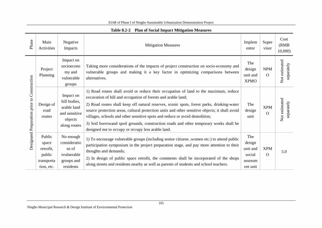
EIAR of Phase I of Ningbo Sustainable Urbanization Demonstration Project
105
Ningbo Municipal Research & Design Institute of Environmental Protection
Table 8.2-2 Plan of Social Impact Mitigation Measures P
has
e
Main
Activities
Negative
Impacts Mitigation Measures
Implem
entor
Super
visor
Cost
(RMB
10,000)
Des
ignan
d P
repar
atio
n p
rior
to C
onst
ruct
ion
Project
Planning
Impact on
socioecono
my and
vulnerable
groups
Taking more considerations of the impacts of project construction on socio-economy and
vulnerable groups and making it a key factor in optimizing comparisons between
alternatives.
The
design
unit and
XPMO
NPM
O
Not
esti
mat
ed
separ
atel
y
Design of
road
routes
Impact on
hill bodies,
arable land
and sensitive
objects
along routes
1) Road routes shall avoid or reduce their occupation of land to the maximum, reduce
excavation of hill and occupation of forests and arable land;
2) Road routes shall keep off natural reserves, scenic spots, forest parks, drinking-water
source protection areas, cultural protection units and other sensitive objects; it shall avoid
villages, schools and other sensitive spots and reduce or avoid demolition;
3) Soil borrowand spoil grounds, construction roads and other temporary works shall be
designed not to occupy or occupy less arable land.
The
design
unit
XPM
O
Not
esti
mat
ed
separ
atel
y
Public
space
retrofit,
public
transporta
tion, etc.
No enough
consideratio
ns of
ivulnerable
groups and
residents
1) To encourage vulnerable groups (including senior citizens ,women etc.) to attend public
participation symposium in the project preparation stage, and pay more attention to their
thoughts and demands;
2) In design of public space retrofit, the comments shall be incorporated of the shops
along streets and residents nearby as well as parents of students and school teachers.
The
design
unit and
social
assessm
ent unit
XPM
O 5.0
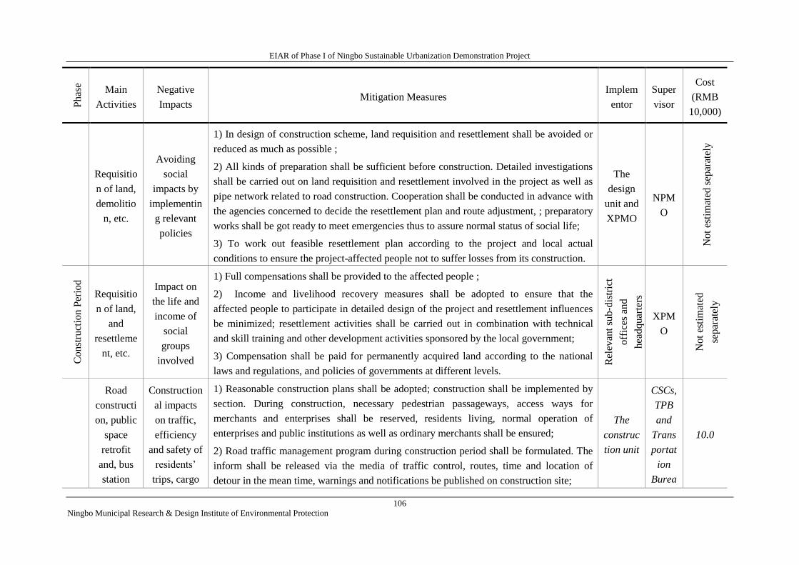
EIAR of Phase I of Ningbo Sustainable Urbanization Demonstration Project
106
Ningbo Municipal Research & Design Institute of Environmental Protection
Phas
e
Main
Activities
Negative
Impacts Mitigation Measures
Implem
entor
Super
visor
Cost
(RMB
10,000)
Requisitio
n of land,
demolitio
n, etc.
Avoiding
social
impacts by
implementin
g relevant
policies
1) In design of construction scheme, land requisition and resettlement shall be avoided or
reduced as much as possible ;
2) All kinds of preparation shall be sufficient before construction. Detailed investigations
shall be carried out on land requisition and resettlement involved in the project as well as
pipe network related to road construction. Cooperation shall be conducted in advance with
the agencies concerned to decide the resettlement plan and route adjustment, ; preparatory
works shall be got ready to meet emergencies thus to assure normal status of social life;
3) To work out feasible resettlement plan according to the project and local actual
conditions to ensure the project-affected people not to suffer losses from its construction.
The
design
unit and
XPMO
NPM
O
Not
esti
mat
ed s
epar
atel
y
Co
nst
ruct
ion P
erio
d
Requisitio
n of land,
and
resettleme
nt, etc.
Impact on
the life and
income of
social
groups
involved
1) Full compensations shall be provided to the affected people ;
2) Income and livelihood recovery measures shall be adopted to ensure that the
affected people to participate in detailed design of the project and resettlement influences
be minimized; resettlement activities shall be carried out in combination with technical
and skill training and other development activities sponsored by the local government;
3) Compensation shall be paid for permanently acquired land according to the national
laws and regulations, and policies of governments at different levels.
Rel
evan
t su
b-d
istr
ict
off
ices
and
hea
dq
uar
ters
XPM
O
No
t es
tim
ated
sep
arat
ely
Road
constructi
on, public
space
retrofit
and, bus
station
Construction
al impacts
on traffic,
efficiency
and safety of
residents’
trips, cargo
1) Reasonable construction plans shall be adopted; construction shall be implemented by
section. During construction, necessary pedestrian passageways, access ways for
merchants and enterprises shall be reserved, residents living, normal operation of
enterprises and public institutions as well as ordinary merchants shall be ensured;
2) Road traffic management program during construction period shall be formulated. The
inform shall be released via the media of traffic control, routes, time and location of
detour in the mean time, warnings and notifications be published on construction site;
The
construc
tion unit
CSCs,
TPB
and
Trans
portat
ion
Burea
10.0
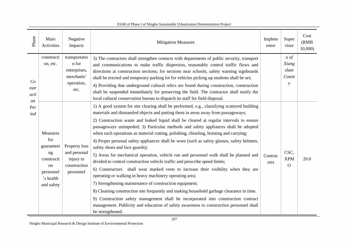
EIAR of Phase I of Ningbo Sustainable Urbanization Demonstration Project
107
Ningbo Municipal Research & Design Institute of Environmental Protection
Phas
e
Main
Activities
Negative
Impacts Mitigation Measures
Implem
entor
Super
visor
Cost
(RMB
10,000)
Co
nstr
ucti
on
Per
iod
constructi
on, etc.
transportatio
n for
enterprises,
merchants’
operation,
etc.
3) The contractors shall strengthen contacts with departments of public security, transport
and communications to make traffic dispersion, reasonably control traffic flows and
directions at construction sections; for sections near schools, safety warning signboards
shall be erected and temporary parking lot for vehicles picking up students shall be set;
4) Providing that underground cultural relics are found during construction, construction
shall be suspended immediately for preserving the field. The contractor shall notify the
local cultural conservation bureau to dispatch its staff for field disposal.
u of
Xiang
shan
Count
y
Measures
for
guaranteei
ng
constructi
on
personnel
’s health
and safety
Property loss
and personal
injury to
construction
personnel
1) A good system for site clearing shall be performed, e.g., classifying scattered building
materials and dismantled objects and putting them in areas away from passageways;
2) Construction waste and leaked liquid shall be cleared at regular intervals to ensure
passageways unimpeded; 3) Particular methods and safety appliances shall be adopted
when such operations as material cutting, polishing, chiseling, hoisting and carrying;
4) Proper personal safety appliances shall be worn (such as safety glasses, safety helmets,
safety shoes and face guards);
5) Areas for mechanical operation, vehicle run and personnel walk shall be planned and
divided to control construction vehicle traffic and prescribe speed limits;
6) Constructors shall wear marked vests to increase their visibility when they are
operating or walking in heavy machinery operating area;
7) Strengthening maintenance of construction equipment;
8) Cleaning construction site frequently and making household garbage clearance in time.
9) Construction safety management shall be incorporated into construction contract
management. Publicity and education of safety awareness to construction personnel shall
be strengthened.
Contrac
otrs
CSC,
XPM
O
20.0
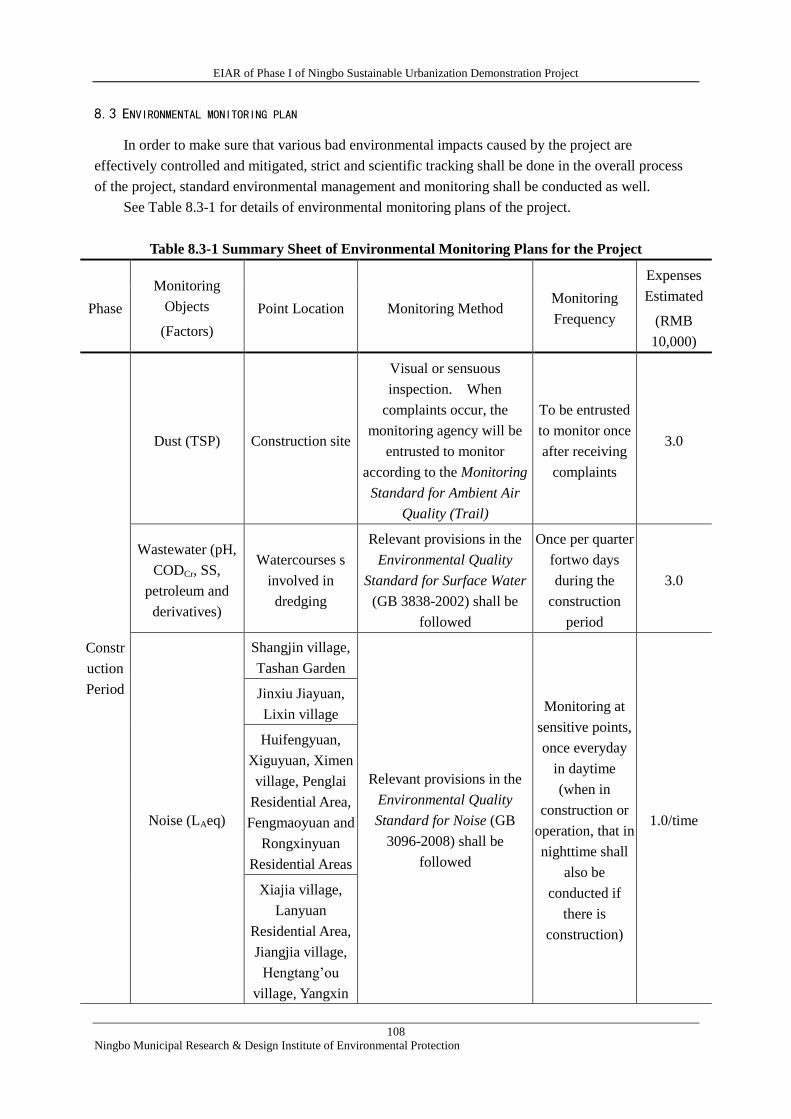
EIAR of Phase I of Ningbo Sustainable Urbanization Demonstration Project
108
Ningbo Municipal Research & Design Institute of Environmental Protection
8.3 ENVIRONMENTAL MONITORING PLAN
In order to make sure that various bad environmental impacts caused by the project are
effectively controlled and mitigated, strict and scientific tracking shall be done in the overall process
of the project, standard environmental management and monitoring shall be conducted as well.
See Table 8.3-1 for details of environmental monitoring plans of the project.
Table 8.3-1 Summary Sheet of Environmental Monitoring Plans for the Project
Phase
Monitoring
Objects
(Factors)
Point Location Monitoring Method Monitoring
Frequency
Expenses
Estimated
(RMB
10,000)
Constr
uction
Period
Dust (TSP) Construction site
Visual or sensuous
inspection. When
complaints occur, the
monitoring agency will be
entrusted to monitor
according to the Monitoring
Standard for Ambient Air
Quality (Trail)
To be entrusted
to monitor once
after receiving
complaints
3.0
Wastewater (pH,
CODCr, SS,
petroleum and
derivatives)
Watercourses s
involved in
dredging
Relevant provisions in the
Environmental Quality
Standard for Surface Water
(GB 3838-2002) shall be
followed
Once per quarter
fortwo days
during the
construction
period
3.0
Noise (LAeq)
Shangjin village,
Tashan Garden
Relevant provisions in the
Environmental Quality
Standard for Noise (GB
3096-2008) shall be
followed
Monitoring at
sensitive points,
once everyday
in daytime
(when in
construction or
operation, that in
nighttime shall
also be
conducted if
there is
construction)
1.0/time
Jinxiu Jiayuan,
Lixin village
Huifengyuan,
Xiguyuan, Ximen
village, Penglai
Residential Area,
Fengmaoyuan and
Rongxinyuan
Residential Areas
Xiajia village,
Lanyuan
Residential Area,
Jiangjia village,
Hengtang’ou
village, Yangxin

EIAR of Phase I of Ningbo Sustainable Urbanization Demonstration Project
109
Ningbo Municipal Research & Design Institute of Environmental Protection
Phase
Monitoring
Objects
(Factors)
Point Location Monitoring Method Monitoring
Frequency
Expenses
Estimated
(RMB
10,000)
village, Xiabanhe
village, Haiyu
Guandi
Residential Area,
Linghetou village,
Shangwu village,
Xiaoting village,
Lujia village,
Xiaodongyang
village, Hujiaqi
village,
Qiujiashan
village, etc.
Operati
on
period
Vehicle exhaust
(CO, NOx, PM10)
Zhushuixicun,
Jinxiu Jiayuan,
Lixincun The Monitoring Standard for
Ambient Air Quality (Trail)
shall be followed
Once for two
days after road
operation
reaches its peak
flow,
4.0
Shangjincun,
Tashan Garden,
Xiangshan Middle
School
Once every year
for two days
after the
operation of the
terminal station
4.0
Noise (LAeq)
Pumping stations,
boundary of
terminal station of
Tashan
Relevant provisions in the
Emission Standard for Noise
at Boundaries of Industrial
Enterprises (GB
12348-2008) shall be
followed
Once during
operation of
pumping
stations, and
after operation
of the terminal
station. In
addition, once
monitoring after
receiving
complaints
2.0
Zhushuixicun,
Jinxiu Jiayuan,
Lixincun
Relevant provisions in the
Environmental Quality
Standard for Noise (GB
3096-2008) shall be
followed
Once after road
operation
reaches its peak
flow, one time
in both daytime
1.0
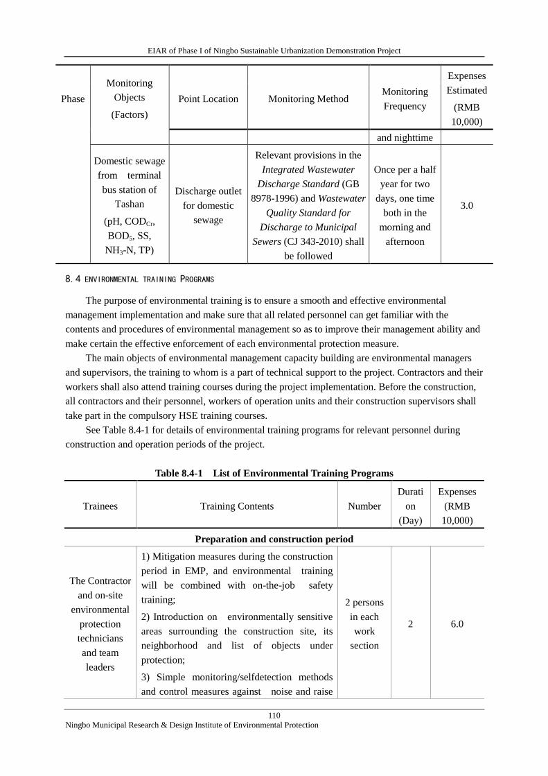
EIAR of Phase I of Ningbo Sustainable Urbanization Demonstration Project
110
Ningbo Municipal Research & Design Institute of Environmental Protection
Phase
Monitoring
Objects
(Factors)
Point Location Monitoring Method Monitoring
Frequency
Expenses
Estimated
(RMB
10,000)
and nighttime
Domestic sewage
from terminal
bus station of
Tashan
(pH, CODCr,
BOD5, SS,
NH3-N, TP)
Discharge outlet
for domestic
sewage
Relevant provisions in the
Integrated Wastewater
Discharge Standard (GB
8978-1996) and Wastewater
Quality Standard for
Discharge to Municipal
Sewers (CJ 343-2010) shall
be followed
Once per a half
year for two
days, one time
both in the
morning and
afternoon
3.0
8.4 ENVIRONMENTAL TRAINING PROGRAMS
The purpose of environmental training is to ensure a smooth and effective environmental
management implementation and make sure that all related personnel can get familiar with the
contents and procedures of environmental management so as to improve their management ability and
make certain the effective enforcement of each environmental protection measure.
The main objects of environmental management capacity building are environmental managers
and supervisors, the training to whom is a part of technical support to the project. Contractors and their
workers shall also attend training courses during the project implementation. Before the construction,
all contractors and their personnel, workers of operation units and their construction supervisors shall
take part in the compulsory HSE training courses.
See Table 8.4-1 for details of environmental training programs for relevant personnel during
construction and operation periods of the project.
Table 8.4-1 List of Environmental Training Programs
Trainees Training Contents Number
Durati
on
(Day)
Expenses
(RMB
10,000)
Preparation and construction period
The Contractor
and on-site
environmental
protection
technicians
and team
leaders
1) Mitigation measures during the construction
period in EMP, and environmental training
will be combined with on-the-job safety
training;
2) Introduction on environmentally sensitive
areas surrounding the construction site, its
neighborhood and list of objects under
protection;
3) Simple monitoring/selfdetection methods
and control measures against noise and raise
2 persons
in each
work
section
2 6.0
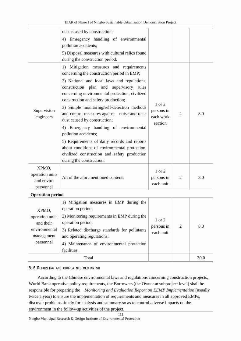
EIAR of Phase I of Ningbo Sustainable Urbanization Demonstration Project
111
Ningbo Municipal Research & Design Institute of Environmental Protection
dust caused by construction;
4) Emergency handling of environmental
pollution accidents;
5) Disposal measures with cultural relics found
during the construction period.
Supervision
engineers
1) Mitigation measures and requirements
concerning the construction period in EMP;
2) National and local laws and regulations,
construction plan and supervisory rules
concerning environmental protection, civilized
construction and safety production;
3) Simple monitoring/self-detection methods
and control measures against noise and raise
dust caused by construction;
4) Emergency handling of environmental
pollution accidents;
5) Requirements of daily records and reports
about conditions of environmental protection,
civilized construction and safety production
during the construction.
1 or 2
persons in
each work
section
2 8.0
XPMO,
operation units
and enviro
personnel
All of the aforementioned contents
1 or 2
persons in
each unit
2 8.0
Operation period
XPMO,
operation units
and their
environmental
management
personnel
1) Mitigation measures in EMP during the
operation period;
2) Monitoring requirements in EMP during the
operation period;
3) Related discharge standards for pollutants
and operating regulations;
4) Maintenance of environmental protection
facilities.
1 or 2
persons in
each unit
2 8.0
Total 30.0
8.5 REPORTING AND COMPLAINTS MECHANISM
According to the Chinese environmental laws and regulations concerning construction projects,
World Bank operative policy requirements, the Borrowers (the Owner at subproject level) shall be
responsible for preparing the Monitoring and Evaluation Report on EEMP Implementation (usually
twice a year) to ensure the implementation of requirements and measures in all approved EMPs,
discover problems timely for analysis and summary so as to control adverse impacts on the
environment in the follow-up activities of the project.
EIAR of Phase I of Ningbo Sustainable Urbanization Demonstration Project
112
Ningbo Municipal Research & Design Institute of Environmental Protection
Arrangements for environmental monitoring and reporting are as follows:
1) Supervision engineers of the project shall keep detailed records of implementation conditions
of EMPs into supervisor’s logs and monthly reports, and submit them to the PMO for the World Bank
Financed Project;
2) Xiangshan PMO shall make regular and irregular site supervision on the implementation of
EMPs and have the records to be incorporated into semi-annual reports;
3) The external environmental monitoring unit shall supervise implementation of mitigation
measures as soon as accepting entrusted tasks, regularly monitor quantitative indicators, prepare
external monitoring reports according to the requirements of this section and the Contract and submit
them to the Xiangshan PMO;
4) If any environmental complaint occurs, external environmental monitoring unit and Xiangshan
PMO shall notify local EPBs and submit it to the superiors if necessary.
5) Xiangshan PMO shall work out schedules for EMP on the basis of materials and reports
stipulated in the four items above and with the help of external environmental monitoring unit or
experts, which shall be incorporated into semi-annual reports of project implementation progress and
submitted to the World Bank in time.
Main contents shall be included in implementation of EMP:
1) Implementation of EMP: main contents of this construction stage, what training on
environmental management has been conducted during this stage, problems in existence,
implementation of mitigation measures, problems and causes as well as next rectification measures;
2) Environmental monitoring results: brief explanation to data, its existing problems and
phenomena not up to standard, their causes analysis and rectification measures suggested; residents’
complaints and solutions shall be included if necessary;
3) Overall evaluation and conclusions to EMP implementation of this stage, and suggestions and
plans for next half year work.
EIAR of Phase I of Ningbo Sustainable Urbanization Demonstration Project
113
Ningbo Municipal Research & Design Institute of Environmental Protection
9 Environmental Management Framework
For the subprojects to be identified and environmentally assessed in the course of implementing
this Project, an Environmental management Frame is hereby worked out to guide PMO to identify and
manage environmental impacts of the subprojects and to provide an action plan for environmental
management and control of the follow-up subprojects.
9.1 SUBPROJECTS SELECTION CRITERIA
1)The projects shall be within the scope of municipal infrastructure category, flood risk
management and integrated transportation system category, such as road construction, river
realignment, municipal pipe network construction etc. Furthermore, no projects with large
environmental impacts, to which the public is sensitive (for example, domestic solid waste landfill and
incineration projects and solid waste centralized disposal projects etc.), will be implemented.
2)The Environmental and social impacts of the subprojects shall not exceed the scope and
category of the safeguard policies of the World Bank.
9.2 SUBPROJECTS SITING CRITERIA
1) No subprojects shall be located within such special protected areas and other environmentally
sensitive areas according to the national stipulations and planning, or approval by the people's
government at county level or above as drinking-water source protection area, natural reserve, scenic
spot, ecological function protection zone, basic farmland protection zone, main area of preventing
water loss and soil erosion, forest park, geologic park, world heritage place etc.;
2) The project siting shall be in conformity with the related Regional Master Planning, Industrial
Development Planning, Function Zone Planning for ecological environment, and other planning;
3)After the public participation and consultation being conducted according to the requirements
concerned, the peripheral affected residents can accept the implementation of the Project.
9.3 PREPARATORY WORK FOR ENVIRONMENTAL ASSESSMENT
1)National Preparatory Work for Environmental Assessment
After the subprojects being identified, the first is to process the national environmental
requirements and procedures. Namely, we need to ask the national environmental protection agency
for advice about the administrative requirements on EA. If EIA report (EIAR) is necessary, the project
development agency needs to entrust a qualified EIA institute to prepare the national EIA and other
materials concerned, and ascertain, according to the List of Classified Administration Construction
Projects, which is needed among EIAR, Report Table and Registration Table.
2)World Bank EA Requirements
On the basis of the national Environmental Assessment and with the Bank's EA for Phase I as
model, EIAR/EMP will be prepared and submitted to the Bank so as to meet the provisions of the
Bank at the same time. EIAR/EMP submitted to the national authorities and the Bank shall be
consistent in such key contents as subprojects' construction scope, environmental impact analysis,
mitigation measures, monitoring requirements etc.
3)Preparation of EMP
For environmental assessment of subprojects, EMP shall be prepared for each in accordance with
the Bank's requirements. EMP shall mainly cover the requirements of related environmental impact
EIAR of Phase I of Ningbo Sustainable Urbanization Demonstration Project
114
Ningbo Municipal Research & Design Institute of Environmental Protection
mitigation measures for construction and operation periods and those on the responsible units and
other necessary contents; furthermore, relevant monitoring plans and staff training programs, etc. need
to be provided.
The final EIARs/EMPs of both Chinese and English versions shall be delivered to the Bank.
9.4 PUBLIC CONSULTATION
The task of public involvement needs to be completed in line with the requirements of the
national authorities and the Bank. It is required by the national authorities that during EA period the
information be disclosed twice and the public consultation be conducted once; while by the Bank that
the more the better.
1) Information disclosure requirement
As required by the Bank, the information disclosure should cover the whole EA process, and the
information be disclosed for at least two weeks and then the public consultation conducted so as to
ensure that the affected people may have sufficient time to learn about the Project and to feed back
their opinions, and avoid just going through the motions. The information disclosed mainly includes
main information, concise version and complete version of EA. The ways of disclosure include public
disclosure in local main media (newspaper, broadcast, TV, and website on internet), and the public
should be informed of disclosure time, location, and ways for access to the concise and complete EA
documents (generally the reports will be avalible in public places where the public are easy to look up)
and how they can provide their feedback.
2)Public consultation
Multiple methods should be adopted to conduct public consultation, i.e., symposium, individual
interview and questionnaire survey. Most of recipients should be affected people other than local
officials, and the more the number of recipients the better. Their concerns should be reflected in
revisions of EIAR and EMP. EIAR should detail records of the dates, locations, discussion topics,
ways and number of participators, their professions and main concerns, as well as how EA and project
design address these issues and suggestions raised by the public.
9.5 REVIEW AND APPROVAL
1)After EAs are completed for the subprojects, EIAR will be submitted to the local EPB for
evaluation. At the same time, it will be delivered to the Bank for pre-appraisal of EA and EMP.
2)The local EPB with the authority of review and approval will organize experts to evaluate
EIAR and provide evalution comments. Also, the Bank will give written comments on EA.
3) The EA institute will modify and improve EIAR incorporating the national EA evaluation
comments and the Bank's pre-appraisal comments and submit the final version to the EPB for review
and approval, and at the same time, to the Bank.
9.6 IMPLEMENTATION
1)Each Subproject PMO shall contain the funds nessary for EMP implementation in the estimated
costs for project implementation in order to ensure that EMP can be implemented practically.
2)Project implementation agencies, project development agencies and operation units shall,
according to EIAR and EMP, put into effect the environmental impact mitigation measures, personnel
training programs and environmental monitoring plans.
EIAR of Phase I of Ningbo Sustainable Urbanization Demonstration Project
115
Ningbo Municipal Research & Design Institute of Environmental Protection
10 Conclusions
The World Bank financed Ningbo Sustainable Urbanization Project will be located in Xiangshan
County, Ningbo municipality, the construction of which meets the requirements of the Xiangshan
Urban Master Planning, Integrated Transportation Planning, Integrated Drainage and Flood Prevention
Planning, and also conforms to the national and local industrial policies. The main construction
contents are municipal services and infrastructures. The construction of the Project will play an
important role of raising the capacity of drainage and flood prevention, enhancing the comprehensive
urban transport capability and improving the overall image of the county seat. Although certain
impacts may be brought to the environment during the construciton and operation periods, the
pollution/pollutants generated in the course of construction and operation can be effectively treated
and controlled and the regional environmental impacts will be in the extent acceptable, the project will
bring about good economic and social benefits and overwhelming majority of the public support the
construction of the Project, as the specialized environmental impact assessments indicate, if only the
project development agency put into effect the environment protective measures proposed in EIR.
Therefore, from the environmental angle, the implementation of this Project is feasible.