Embed Size (px)
Citation preview
International Journal For Technological Research In Engineering
Volume 3, Issue 9, May-2016 ISSN (Online): 2347 - 4718
www.ijtre.com Copyright 2016.All rights reserved. 1890
ENVIRONMENTAL IMPACT ASSESMENT OF THE PROPOSED
OUTER RING ROAD PROJECT FOR NEW CAPITAL OF ANDHRA
PRADESH, INDIA
K. Sundara Kumar1, Koduru.Kavya
2, Venigalla.Akhil
3, Marupilla.SS.Deepthi
4,
Velaga. Sai Krishna5, Kambhampati. Datta Sairam
6
1Associate Professor and Head, Department of Civil Engineering,
2,3,4,5,6Final B.Tech., Department of Civil Engineering
Usha Rama College of Engineering & Technology, Telaprolu, Krishna District, Andhra Pradesh, India.
ABSTRACT: Assessment of environmental impacts is
necessary for any kind of major projects to safeguard the
environmental sustainability. The National Highway
Authority of India (NHAI) has proposed an “Outer Ring
Road (ORR)” around the new capital city of Andhra
Pradesh which is taken up by the Capital Region
Development Authority (CRDA). This is a major project
which involves acquisition of land for road construction
which affects agriculture land forests, water bodies, etc.
The main focus of this project is to identify the
environmental impacts of the proposed ORR for the new
capital of Andhra Pradesh and to present the results in
such a way that decision making can be done easily. For
this purpose the outline of the proposed ORR was obtained
from CRDA. The road line was digitized in Arc GIS and
road width is extended using buffer tool. The same road
map with road width is placed on Google earth map and the
affected area has been identified. All the possible effects
identified are fed to the Rapid Impact Assessment Matrix
for Assessment (RIAM). The RIAM calculates the impacts
under four categories: Physicochemical, Biological
Ecological, Social Cultural, and Economical Operational.
The output of the RIAM shows that the ORR project has
severe negative impacts in all the categories. Alternatively
another route has been proposed by us in such a way that
the impacts are minimized. These two options are compared
and the results were presented in the form of bar charts.
The results are very useful for better decision making. Keywords: Environmental Impact Assessment, Outer Ring
Road, CRDA, RIAM, GIS
I. INTRODUCTION
The roads are lifeline of any country. They are also important
for the building the nation and are mirror of country’s
development. However, most of these roads on account of
their location, route alignment and associated activities are
invariably accompanied by significant environmental and
social impacts during different phases (viz., Pre-construction,
Construction and Operational phase) of the project. The
nature of these impacts could be either positive or negative
depending upon their potential to favourably or adversely affect the surrounding environment and also the resident
community.[1,2] The aim of the present work is to explore
the environmental impacts of the proposed Outer Ring Road
around the new capital city of Andhra Pradesh state.[3,4]
Environmental Impact Assessment
Environmental Impact Assessment (EIA) is an important
management tool for ensuring optimal use of natural
resources for sustainable development. To facilitate collection of environmental data and preparation of
management plans, guidelines have been evolved and
circulated to the concerned Central and State Government
Departments. EIA has now been made mandatory under the
Environmental (Protection Act, 1986 for 29 categories of
developmental activities involving investments of Rs. 50
crores and above).
Environmental Impact Assessment (EIA) is the process by
which the anticipated effects on the environment of a
proposed development or project are measured. If the likely
effects are unacceptable, design measures or other relevant
mitigation measures can be taken to reduce or avoid those effects. The document from this process is called an
Environmental Impact Statement (EIS). It aims to predict
environmental impacts at an early stage in project planning
and design, find ways and means to reduce adverse impacts.
By using EIA both environmental and economic benefits can
be achieved, such as reduced cost and time of project
implementation and design, avoided treatment /clean-up
costs and impacts of laws and regulations.[5,6]
Outer Ring Road Project
The ORR or Vijayawada bypass was mooted in 2009, to decongest heavy vehicular traffic in the city. As per the buzz,
Government has planned to construct three ring roads around
the new capital. Inner Ring roads having length of 45 to 50
KMs and 75 to 80 KMs and length of Outer ring road is
about 185 to 190 KMs. All these have to exist between
Vijayawada and Guntur cities. 70 to 80% of the new capital
will be in Guntur district and 20 to 30% in Krishna District.
But new capital would become nearer to Vijayawada City.
There is a proposal to extend the existing road to 6 lanes
between Vijayawada and Hyderabad. Seethanagaram near
Prakasam Barriage to Amaravathi 6 lanes of road and
Amaravathi to Guntur another 6 lanes of road will be built. Extending the roads from Hyderabad to Vijayawada via
Daachepalli, Sattenapalli and Piduguralla is one option. Al
least two bridges would construct on Krishna River. The
International Journal For Technological Research In Engineering
Volume 3, Issue 9, May-2016 ISSN (Online): 2347 - 4718
www.ijtre.com Copyright 2016.All rights reserved. 1891
NHAI has directed the contractor, Gammon India, to begin
works immediately. The Vijayawada ORR or bypass will
take off from Mangalagiri on NH 5 and connect with NH 9 at
Gollapudi on the other end of river Krishna. The road will then go through Nunna, Mustabad and again meet NH 5 at
Peda Avutapally (Gannavaram). It will end at Gundugolanu
in West Godavari district.
The proposed ORR will have a total length of 185 kilometres
for this 4177 acres of land must be procured which costs
around 4000 crores. This 8 lane road construction would cost
10 crores per kilometre.
Environmental Impact Assessment need for Outer Ring Road
Project
The environmental impact of roads (both positive and
negative) include the local effects of highways (public roads)
such as on noise, water pollution, habitat destruction/disturbance and local air quality, and the wider
effects which may include climate change from vehicle
emissions. The design, construction and management
of roads, parking and other related facilities as well as the
design and regulation of vehicles can change the impacts to
varying degrees. There is a growing awareness that road
development has major environmental impacts Some of the
major environmental impacts of road projects include
damage to sensitive ecosystems, loss of productive
agricultural lands, resettlement of large numbers of people,
permanent disruption of local economic activities, demographic change, accelerated urbanization, and
introduction of disease.[9,10]
Since environmental impacts from road development are
quite common, such projects usually call for comprehensive
environmental assessment studies, carried out by EIA
professionals (both specialists and generalists) who support
the main engineering team. Substantial time and effort is
often required to identify potential impacts and options for
minimizing them. In addition, contract clauses covering work
procedures and staff training needs to be prepared, and work
processes in relation to roadside communities, flora, and fauna given considerable attention. In order to conduct EIAs
successfully, road agency staff need to understand the
assessment process and must coordinate it with road
planning, design, and construction activities, allowing
sufficient lead time and funds for the necessary additional
steps. New skills may have to be developed to meet the
demands of the EIA process. This is especially true in the
area of consultation with affected residents, interested
members of the public, government departments, and other
organizations (known collectively as the stakeholders).
Projects limited to road rehabilitation, maintenance, minor
construction, as well as to traffic management and regulation, generally involve lesser environmental concerns. These
situations do not call for full-scale EAs but do require impact
identification, mitigation, and a certain amount of compliance
monitoring and documentation.[7,8]
About Rapid Impact Assessment Matrix software
Normal EIA would take lot of time and in most cases the
weightages to be given for certain parameters may be
difficult. The intangible effects cannot be properly taken in to
account unless there is a numerical associated with it.
Towards a solution for this problem, Rapid Impact
Assessment Matrix (RIAM) has been developed which take
in to account all the tangible and intangible parameters and provide a score for all of them.[11,12] The Rapid Impact
Assessment Matrix (RIAM) is a method seeks to overcome
the problems of recording subjective judgments by defining
the criteria and scales against which these judgments are to
be made; and by placing the results in a simple matrix that
allows for a permanent record of the arguments in the
judgment process. This paper describes system of scoring
within a matrix that has been designed to allow subjective
judgments to be quantitatively recorded, thus providing both
an impact evaluation and a record that can be re-assessed in
the future. The system is ideally suited to EIA where a multi-
disciplinary team approach is used, as it allows for data from different components to be analyzed against common
important criteria within a common matrix, thus providing a
rapid, clear assessment of the major impacts. [13,14] The
Rapid Impact Assessment Matrix (RIAM) method is based
on a standard definition of the important assessment criteria
as well as the means by which semi-quantitative values for
each of these criteria can be collated to provide an accurate
and independent score for each condition. The impacts of
project activities are evaluated against the environmental
components and for each component a score (using the
defined criteria) are determined, which provides a measure of the impact expected from the component. [15]
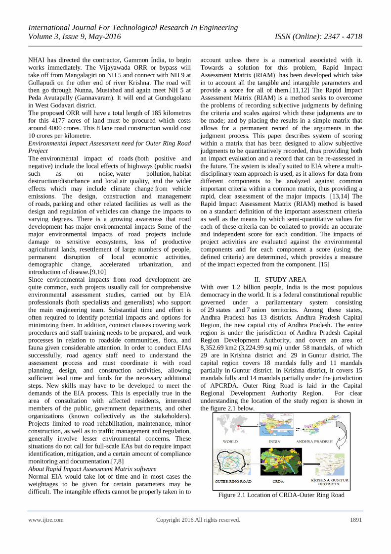
II. STUDY AREA
With over 1.2 billion people, India is the most populous
democracy in the world. It is a federal constitutional republic
governed under a parliamentary system consisting
of 29 states and 7 union territories. Among these states,
Andhra Pradesh has 13 districts. Andhra Pradesh Capital
Region, the new capital city of Andhra Pradesh. The entire
region is under the jurisdiction of Andhra Pradesh Capital
Region Development Authority, and covers an area of 8,352.69 km2 (3,224.99 sq mi) under 58 mandals, of which
29 are in Krishna district and 29 in Guntur district. The
capital region covers 18 mandals fully and 11 mandals
partially in Guntur district. In Krishna district, it covers 15
mandals fully and 14 mandals partially under the jurisdiction
of APCRDA. Outer Ring Road is laid in the Capital
Regional Development Authority Region. For clear
understanding the location of the study region is shown in
the figure 2.1 below.
Figure 2.1 Location of CRDA-Outer Ring Road
International Journal For Technological Research In Engineering
Volume 3, Issue 9, May-2016 ISSN (Online): 2347 - 4718
www.ijtre.com Copyright 2016.All rights reserved. 1892
Capital Regional Development Authority
The Andhra Pradesh Capital Region Development
Authority was notified on 30 December 2014 by the
Government. As per Andhra Pradesh Capital Region Development Authority Act, 2014, it replaced
the Vijayawada Guntur Tenali Mangalagiri Urban
Development Authority. It has a jurisdictional area of
8,352.69 km2 (3, 224.99 sq mi) spread in Guntur
and Krishna districts. It also includes 214 km2 (83 sq mi) of
the new capital city of Andhra Pradesh, Amravati. Under
Andhra Pradesh Capital Region 58 mandals, of which 29 are
in Krishna district and 29 in Guntur district. The capital
region covers 18 mandals fully and 11 mandals partially
in Guntur district. In Krishna, it covers 15 mandals fully and
14 mandals partially under the jurisdiction of APCRDA. The
Map of Capital Regional Development Authority extent is shown in the following Figure 2.2.
Figure 2.2 Map of Capital Regional Development Authority
extent
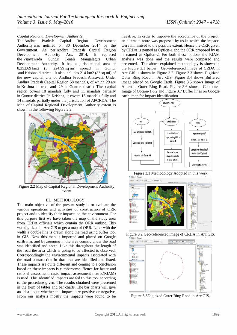
III. METHODOLOGY
The main objective of the present study is to evaluate the
various operations and activities of construction of ORR
project and to identify their impacts on the environment. For
this purpose first we have taken the map of the study area
from CRDA officials which contain the ORR outline. This
was digitized in Arc GIS to get a map of ORR. Later with the
width a double line is drawn along the road using buffer tool
in GIS. Now this map is imported and placed on Google
earth map and by zooming in the area coming under the road was identified and noted. Like this throughout the length of
the road the area which is going to be affected is observed.
Correspondingly the environmental impacts associated with
the road construction in that area are identified and listed.
These impacts are quite different and coming to a conclusion
based on these impacts is cumbersome. Hence for faster and
rational assessment, rapid impact assessment matrix(RIAM)
is used. The identified impacts are fed to this tool according
to the procedure given. The results obtained were presented
in the form of tables and bar charts. The bar charts will give
an idea about whether the impacts are positive or negative. From our analysis mostly the impacts were found to be
negative. In order to improve the acceptance of the project,
an alternate route was proposed by us in which the impacts
were minimised to the possible extent. Hence the ORR given
by CRDA is named as Option-1 and the ORR proposed by us is named as Option-2. For both these options the RIAM
analysis was done and the results were compared and
presented. The above explained methodology is shown in
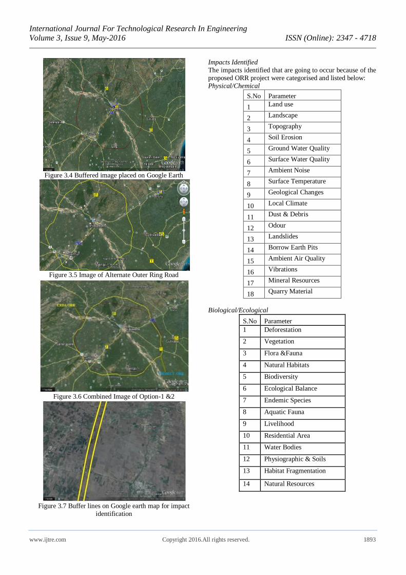
the Figure 3.1 below. Geo-referenced image of CRDA in
Arc GIS is shown in Figure 3.2. Figure 3.3 shows Digitized
Outer Ring Road in Arc GIS. Figure 3.4 shows Buffered
image placed on Google Earth. Figure 3.5 shows Image of
Alternate Outer Ring Road. Figure 3.6 shows Combined
Image of Option-1 &2 and Figure 3.7 Buffer lines on Google
earth map for impact identification.
Figure 3.1 Methodology Adopted in this work
Figure 3.2 Geo-referenced image of CRDA in Arc GIS.
Figure 3.3Digitized Outer Ring Road in Arc GIS.
International Journal For Technological Research In Engineering
Volume 3, Issue 9, May-2016 ISSN (Online): 2347 - 4718
www.ijtre.com Copyright 2016.All rights reserved. 1893
Figure 3.4 Buffered image placed on Google Earth
Figure 3.5 Image of Alternate Outer Ring Road
Figure 3.6 Combined Image of Option-1 &2
Figure 3.7 Buffer lines on Google earth map for impact
identification
Impacts Identified
The impacts identified that are going to occur because of the
proposed ORR project were categorised and listed below:
Physical/Chemical
S.No Parameter
1 Land use
2 Landscape
3 Topography
4 Soil Erosion
5 Ground Water Quality
6 Surface Water Quality
7 Ambient Noise
8 Surface Temperature
9 Geological Changes
10 Local Climate
11 Dust & Debris
12 Odour
13 Landslides
14 Borrow Earth Pits
15 Ambient Air Quality
16 Vibrations
17 Mineral Resources
18 Quarry Material
Biological/Ecological
S.No Parameter
1 Deforestation
2 Vegetation
3 Flora &Fauna
4 Natural Habitats
5 Biodiversity
6 Ecological Balance
7 Endemic Species
8 Aquatic Fauna
9 Livelihood
10 Residential Area
11 Water Bodies
12 Physiographic & Soils
13 Habitat Fragmentation
14 Natural Resources
International Journal For Technological Research In Engineering
Volume 3, Issue 9, May-2016 ISSN (Online): 2347 - 4718
www.ijtre.com Copyright 2016.All rights reserved. 1894
Sociological/Cultural
S.No Parameter
1 Rehabitation
2 Resettlement
3 Housing
4 Infrastructure
5 Health Aspects
6 Hygiene
7 Cultural Heritage
8 Education Centers
9 Religious Places
10 Recreation Facilities
11 Market Centers
12 Employment
13 Clinic Centers
14 Uplift of Standard Life
15 Basic Amenities
16 Labor Work
17 Traffic Problems
18 Urban Development
Economical/Operational
S.No Parameter
1 Agricultural land
2 Commercial Establishments
3 Business Opportunities.
4 Finance
5 Land Cost
6 Land Value
7 Transportation Cost
8 Construction cost
9 Earth moving Equipment Cost
10 Large Scale Industries
11 Small Scale Industries
12 Local Area Development
13 Electricity Facilities
Assessment criteria of Rapid Impact Assessment Matrix
The criteria should be defined for both groups, and should be
based on fundamental conditions that may be affected by
change rather than be related to individual projects. It is
theoretically possible to define a number of criteria, but two
principles should always be satisfied:
1. The universality of the criterion, to allow it to be used in
different EIAs.
2. The value of the criterion, which determines whether it
should be treated as a Group (A) or Group (B) condition.
At this point only five criteria have been developed for use
in the RIAM. Nevertheless, these five criteria represent the most important fundamental assessment conditions for all
EIAs, and satisfy the principles set out above.
These criteria, together with their appropriate judgment
scores are defined as:
Group (A) criteria
Importance of condition (A1)
A measure of the importance of the condition, which is
assessed against the spatial boundaries or human interest sit
will affect. The scales are defined:
4-important to national/international interests
3-important to regional/national interests
2-important to areas immediately outside the local condition 1-important only to the local condition
0-no importance.
Magnitude of change/effect (A2)
Magnitude is defined as a measure of the scale of benefit /
disbenefit of an impact or a condition:
+3-major positive benefit
+2-significant improvement in status quo
+1-improvement in status quo
0-no change/status quo
-1-negative change to status quo
-2-significant negative disbenefit or change -3-major disbenefit or change.
Group (B) criteria
Permanence (B1)
This defines whether a condition is temporary or permanent,
and should be seen only as a measure of the temporal status
of the condition.(e.g.: an embankment is a permanent
condition even if it may one day be breached or abandoned;
whilst a coffer dam is a temporary condition, as it will be
removed).
1-no change/not applicable 2-temporary
3-permanent.
Reversibility (B2)
This defines whether the condition can be changed and is a
measure of the control over the effect of the condition. It
should not be confused or equated with permanence. (e.g.: an
accidental toxic spillage into a river is a temporary condition
(B1) but its effect (death of fish) is irreversible (B2); a
town’s sewage treatment works is a permanent
Condition (B1), the effect of its effluent can be changed
(reversible condition) (B2)).
1-no change/not applicable 2-reversible
3-irreversible.
Cumulative (B3)
This is a measure of whether the effect will have a single
direct impact or whether there will be a cumulative effect
over time, or a synergistic effect with other conditions. The
cumulative criterion is a means of judging the sustainability
of a condition, and is not to be confused with a
International Journal For Technological Research In Engineering
Volume 3, Issue 9, May-2016 ISSN (Online): 2347 - 4718
www.ijtre.com Copyright 2016.All rights reserved. 1895
permanent/irreversible situation. For instance, the death of an
old animal is both permanent and irreversible, but non-
cumulative as the animal can be considered to have already
passed its breeding capabilities. The loss of post-larval shrimp in the wild is also permanent and irreversible, but in
this case cumulative, as all subsequent generations that the
larvae (as adults) may have initiated will also have been lost.
1-no change/not applicable
2-non-cumulative/single
3-cumulative/synergistic
It is possible to change the cumulative component to one of
synergism, if the condition warrens consideration of additive
affects.
IV. RESULTS AND DISCUSSION
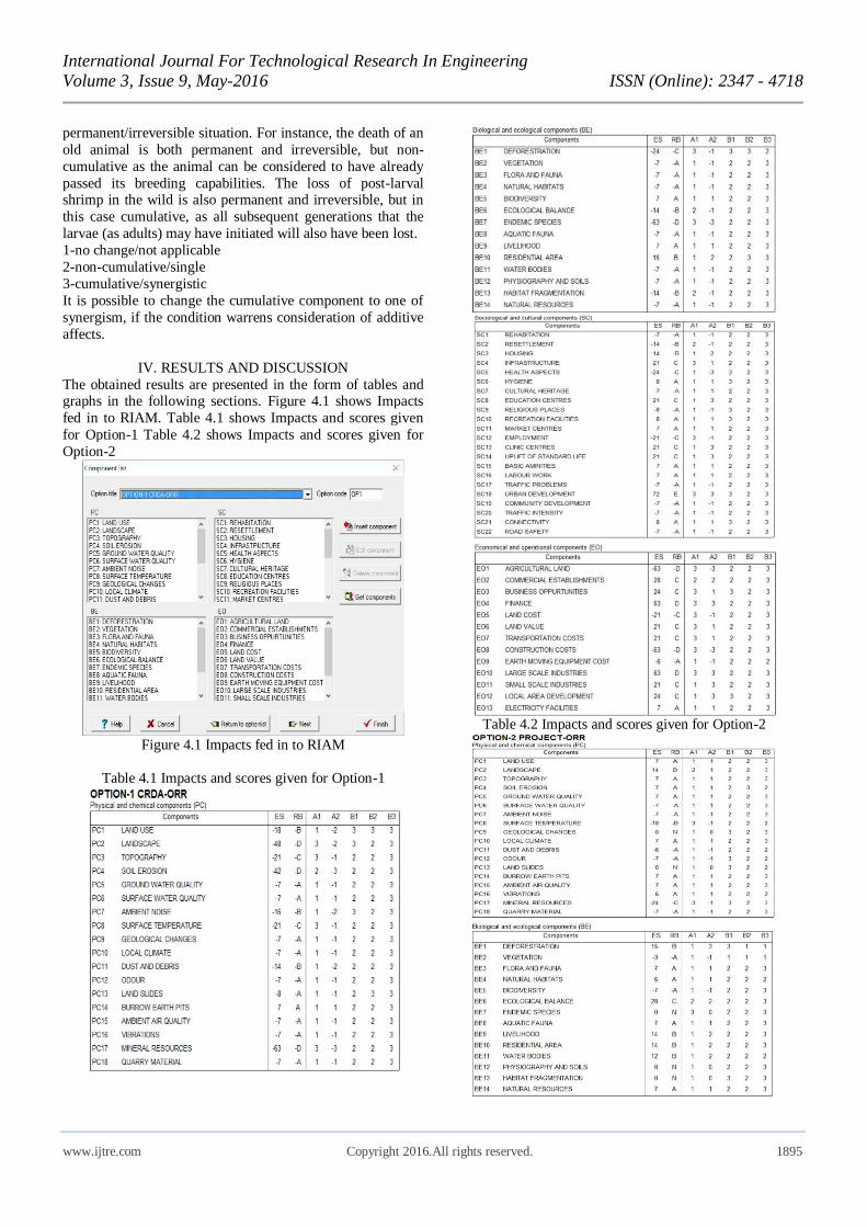
The obtained results are presented in the form of tables and graphs in the following sections. Figure 4.1 shows Impacts
fed in to RIAM. Table 4.1 shows Impacts and scores given
for Option-1 Table 4.2 shows Impacts and scores given for
Option-2
Figure 4.1 Impacts fed in to RIAM
Table 4.1 Impacts and scores given for Option-1
Table 4.2 Impacts and scores given for Option-2
International Journal For Technological Research In Engineering
Volume 3, Issue 9, May-2016 ISSN (Online): 2347 - 4718
www.ijtre.com Copyright 2016.All rights reserved. 1896
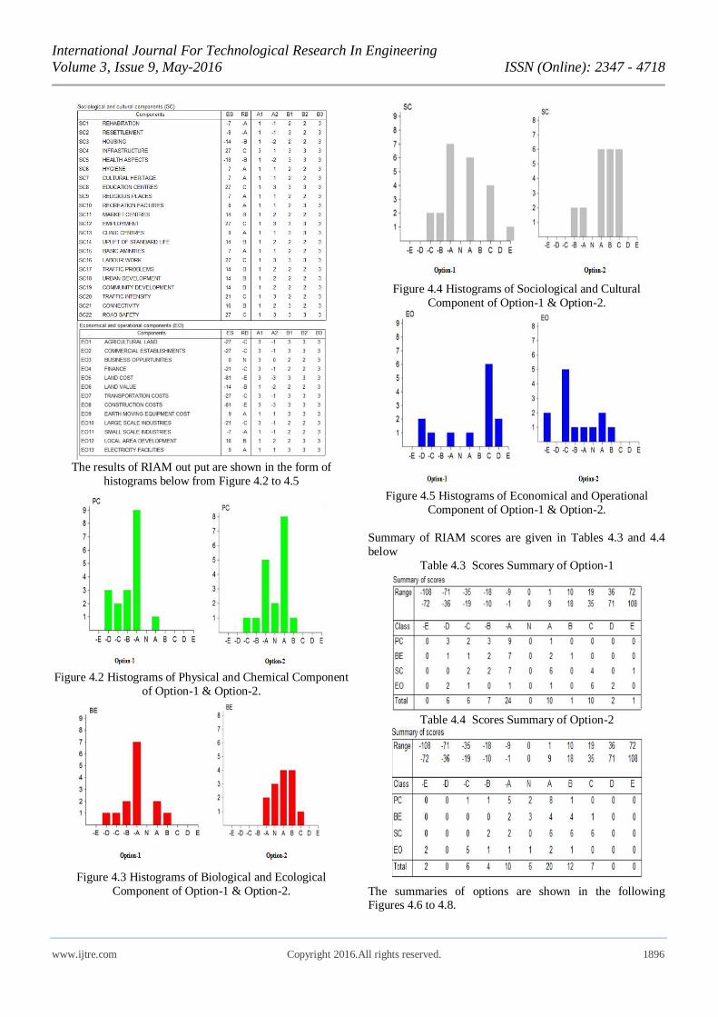
The results of RIAM out put are shown in the form of
histograms below from Figure 4.2 to 4.5
Figure 4.2 Histograms of Physical and Chemical Component
of Option-1 & Option-2.
Figure 4.3 Histograms of Biological and Ecological
Component of Option-1 & Option-2.
Figure 4.4 Histograms of Sociological and Cultural
Component of Option-1 & Option-2.
Figure 4.5 Histograms of Economical and Operational
Component of Option-1 & Option-2.
Summary of RIAM scores are given in Tables 4.3 and 4.4
below
Table 4.3 Scores Summary of Option-1
Table 4.4 Scores Summary of Option-2
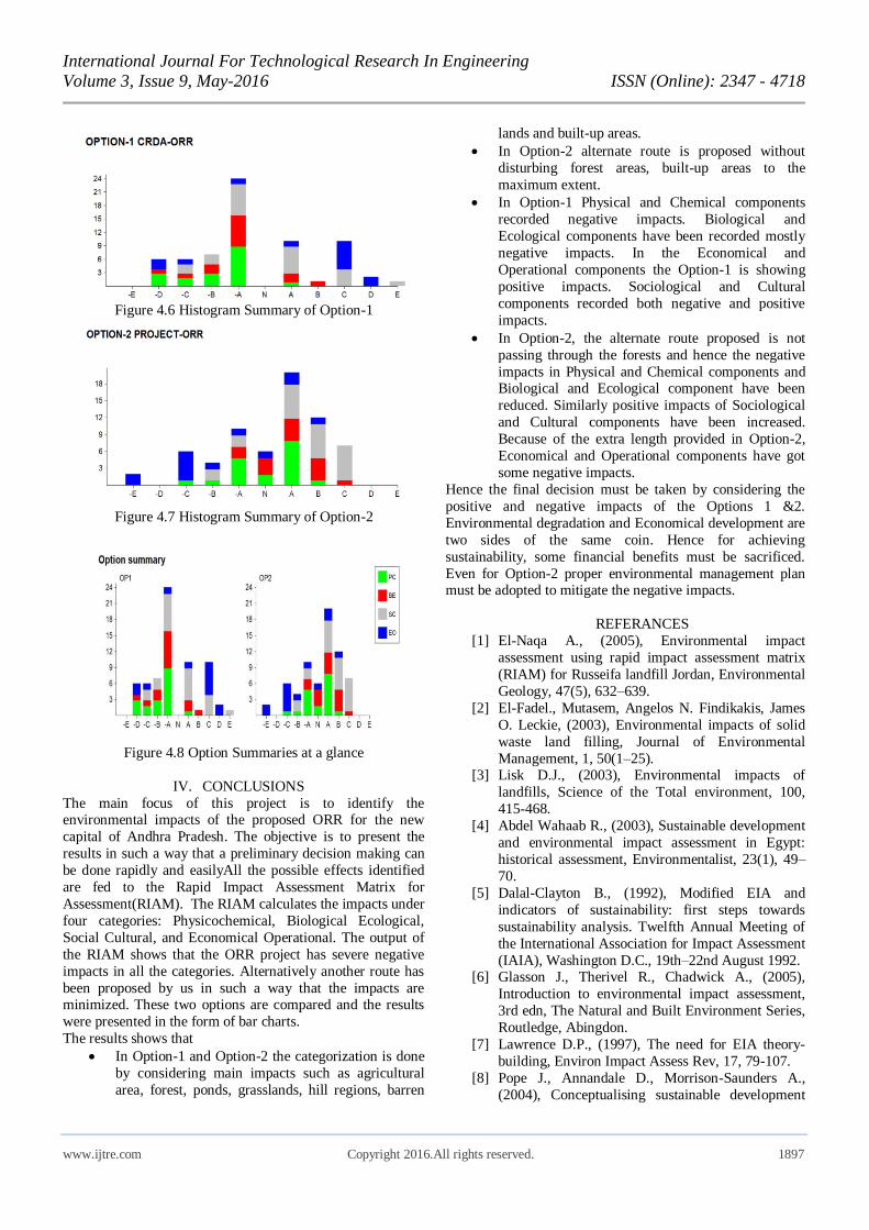
The summaries of options are shown in the following Figures 4.6 to 4.8.
International Journal For Technological Research In Engineering
Volume 3, Issue 9, May-2016 ISSN (Online): 2347 - 4718
www.ijtre.com Copyright 2016.All rights reserved. 1897
Figure 4.6 Histogram Summary of Option-1
Figure 4.7 Histogram Summary of Option-2
Figure 4.8 Option Summaries at a glance
IV. CONCLUSIONS
The main focus of this project is to identify the environmental impacts of the proposed ORR for the new
capital of Andhra Pradesh. The objective is to present the
results in such a way that a preliminary decision making can
be done rapidly and easilyAll the possible effects identified
are fed to the Rapid Impact Assessment Matrix for
Assessment(RIAM). The RIAM calculates the impacts under
four categories: Physicochemical, Biological Ecological,
Social Cultural, and Economical Operational. The output of
the RIAM shows that the ORR project has severe negative
impacts in all the categories. Alternatively another route has
been proposed by us in such a way that the impacts are minimized. These two options are compared and the results
were presented in the form of bar charts.
The results shows that
In Option-1 and Option-2 the categorization is done
by considering main impacts such as agricultural
area, forest, ponds, grasslands, hill regions, barren
lands and built-up areas.
In Option-2 alternate route is proposed without
disturbing forest areas, built-up areas to the
maximum extent.
In Option-1 Physical and Chemical components
recorded negative impacts. Biological and
Ecological components have been recorded mostly
negative impacts. In the Economical and
Operational components the Option-1 is showing
positive impacts. Sociological and Cultural
components recorded both negative and positive
impacts.
In Option-2, the alternate route proposed is not
passing through the forests and hence the negative
impacts in Physical and Chemical components and Biological and Ecological component have been
reduced. Similarly positive impacts of Sociological
and Cultural components have been increased.
Because of the extra length provided in Option-2,
Economical and Operational components have got
some negative impacts.
Hence the final decision must be taken by considering the
positive and negative impacts of the Options 1 &2.
Environmental degradation and Economical development are
two sides of the same coin. Hence for achieving
sustainability, some financial benefits must be sacrificed.
Even for Option-2 proper environmental management plan must be adopted to mitigate the negative impacts.
REFERANCES
[1] El-Naqa A., (2005), Environmental impact
assessment using rapid impact assessment matrix
(RIAM) for Russeifa landfill Jordan, Environmental
Geology, 47(5), 632–639.
[2] El-Fadel., Mutasem, Angelos N. Findikakis, James
O. Leckie, (2003), Environmental impacts of solid
waste land filling, Journal of Environmental
Management, 1, 50(1–25). [3] Lisk D.J., (2003), Environmental impacts of
landfills, Science of the Total environment, 100,
415-468.
[4] Abdel Wahaab R., (2003), Sustainable development
and environmental impact assessment in Egypt:
historical assessment, Environmentalist, 23(1), 49–
70.
[5] Dalal-Clayton B., (1992), Modified EIA and
indicators of sustainability: first steps towards
sustainability analysis. Twelfth Annual Meeting of
the International Association for Impact Assessment
(IAIA), Washington D.C., 19th–22nd August 1992. [6] Glasson J., Therivel R., Chadwick A., (2005),
Introduction to environmental impact assessment,
3rd edn, The Natural and Built Environment Series,
Routledge, Abingdon.
[7] Lawrence D.P., (1997), The need for EIA theory-
building, Environ Impact Assess Rev, 17, 79-107.
[8] Pope J., Annandale D., Morrison-Saunders A.,
(2004), Conceptualising sustainable development
International Journal For Technological Research In Engineering
Volume 3, Issue 9, May-2016 ISSN (Online): 2347 - 4718
www.ijtre.com Copyright 2016.All rights reserved. 1898
assessment, Environ Impact Assess Rev, 24(6), 595-
616.
[9] Phillips J., (2011), The conceptual development of a
geocybernetic relationship between sustainable development and environmental impact assessment,
Appl. Geogr., 31, 969-979.
[10] Phillips J., (2012), The level and nature of
sustainability for clusters of abandoned limestone
quarries in the southern Palestinian West Bank,
Appl. Geogr., 32, 376-392
[11] Dan Gavrilescu, Adrian Catalin Puitel, Gheorghe
Dutuc, Grigore Craciun, (2012), Environmental
Impact of Pulp and Paper Mills, Environmental
Engineering and Management Journal, 11(1), 81-85
[12] Suditu G.D., Robu B.M., (2012), Digitization of the
Environmental Impact Quantification Process, Environmental Engineering and Management
Journal, 11(4), 841-848.
[13] Canter L.W., (1996), Environmental impact
assessment, Second edition. McGraw-Hill, New
York.
[14] Pastakia C.M.R., Jensen A, (1998), The rapid
impact assessment matrix (RIAM) for EIA, Environ
Impact Assess Rev, 18, 461-482.
[15] Paulo S.F., De Araújo, Eduardo F.S.C., Moura
Naim Haie, (2005), Application of RIAM to the
environmental impact assessment of hydroelectric installations, The Fourth Inter-Celtic colloquium on
Hydrology and Management of Water resources,
Portugal.
[16] Sundara Kumar K., (2010), Environmental impact
assessment of a proposed Bauxite mining using
rapid impact assessment matrix method, Int. J. Appl.
Environ. Sci., 5(1), 29-38.