Embed Size (px)
Citation preview

FINAL Nuclear-1 EIA Agricultural Report August 2010
ENVIRONMENTAL IMPACT ASSESSMENT FOR THE PROPOSED NUCLEAR POWER STATION (‘NUCLEAR 1’) AND ASSOCIATED
INFRASTRUCTURE
Agricultural Impact Assessment
August 2010
Prepared by: Golder Associates/ Imani Development (SA) (Pty) Ltd
Prepared for: Arcus GIBB Pty Ltd On behalf of: Eskom Holdings Ltd


FINAL Nuclear-1 EIA Agricultural Report August 2010
EXECUTIVE SUMMARY
1. A survey undertaken within a 16km radius of all three sites showed that agriculture around Thyspunt is based substantially on milk production; fynbos prevails in the Bantamsklip area although there is some dairy as well as beef, sheep and game farming; while the Duynefontein area is based on mixed farming.
2. Given the information gathered in the agricultural study, it was estimated that the
current annual value of farm production in 2008 was R150 million in the Thyspunt area, R29 million for Bantamsklip and R75 million for Duynefontein.
3. The major impacts of a nuclear power station on agriculture would be the generation
of dust during the construction phase, labour shortages and wage increases, and market effects. The estimated impact on produce markets showed that the gross value of production in the Bantamsklip area could potentially increase by up to 5% and in the Thyspunt area by 10 to 15%, while no change is anticipated in the Duynefontein area.
4. From an agricultural production perspective Duynefontein is a mature site because
grape and wheat production in the area has progressed alongside the construction and operational phases of the existing Koeberg Nuclear Power Station. Dust during construction of the new plant will have little effect on farm lands because the prevailing winds during the dry summer months are in line with the coastal strip. In summary, the impacts on agriculture at the three sites are as follows: Duynefontein – no significant impact on agriculture during construction and normal operations. No increase in agricultural production during operation. Thyspunt – short term negative impact on agriculture in terms of dust during the construction phase. However, there is potential for a positive impact on production by increasing the size of the local market for fresh produce as a result of the influx of population (Nuclear-1 employees and their families as well as construction workers) to the area. Bantamsklip – short term negative impact on agricultural production with regard to dust during the construction phase. There is an estimated potential of less than 5% to increase the market for local agricultural produce because of water limitations that restrict expansion. In terms of the impact on agriculture, there are no fatal flaws in respect of any of the three sites, and all of them would be suitable to accommodate Nuclear-1.

FINAL Nuclear-1 EIA Agricultural Report August 2010
ENVIRONMENTAL IMPACT ASSESSMENT FOR THE PROPOSED NUCLEAR POWER STATION (‘NUCLEAR-1’) AND ASSOCIATED
INFRASTRUCTURE
CONTENTS
Chapter Description Page
EXECUTIVE SUMMARY 2
1 INTRODUCTION 1
1.1 Background 1
1.2 Methodology 2
2 DESCRIPTION OF AFFECTED ENVIRONMENT 3
2.1 Description of Land Use (20km radius) 3 2.1.1 Thyspunt 3 2.1.2 Bantamsklip 8 2.1.3 Duynefontein 10
2.2 Agricultural Survey 13 2.2.1 Soils 13 2.2.2 Agricultural Survey of Farm Units within a 16km radius 20 2.2.3 Thyspunt 20 2.2.4 Bantamsklip 26 2.2.5 Duynefontein 30 2.2.6 Summary of Farming Practices 34
2.3 Economic Analysis of Agriculture 34
3 POTENTIAL IMPACTS ON AGRICULTURAL PRODUCTION 36
3.1 Introduction 36
3.2 Literature Review and Related Case Studies 36
3.3 Livestock 37 3.3.1 Effect of Radionuclides on Livestock 38 3.3.2 Potential Impacts on Livestock 39
(1) Construction Phase 40 (2) Operational Phase 40 (4) Possibility of a Nuclear Incident 41
3.4 Crop Production 42 3.4.1 The Effect of Radionuclides on Crop Production 42 3.4.2 Potential Impacts on Crop Production 43
FINAL Nuclear-1 EIA Agricultural Report August 2010
(1) Construction 43 (2) Operational Phase 44 (4) Possibility of a Nuclear Incident 44
3.5 Potential for Water Contamination 45
3.6 Potential Economic and Marketing Impacts 45
3.7 Potential Impact of Climate Change 47
3.8 Impact of Desalination Plant 49
4 MITIGATION MEASURES 50
4.1 Construction Phase 50
4.2 Operational Phase 50 4.2.1 Phase 1 − Data Gathering and Laboratories 50 4.2.2 Phase 2 − Protective Measures 51
4.3 Decommissioning Phase 52
5 IMPACT ASSESSMENT 53
5.1 Impact Criteria 53
5.2 Assessment 53 (a) Thyspunt 54 (b) Bantamsklip 54 (c) Duynefontein 55
6 CONCLUSIONS AND RECOMMENDATIONS 56
7 REFERENCES 57

FINAL Nuclear-1 EIA Agricultural Report August 2010
TABLES Table 2-1: Means and Extremes of Temperature for Cape St. Francis − 2004 (June) to 2007. 20 Table 2-2: Average, Maximum and Minimum Monthly Rainfall (mm) for Cape St. Francis − 2004 (June) to 2007 ................................................................................................................. 21 Table 2-3: Means and Extremes of Dry-bulb Temperatures for Hermanus − 2001 to 2007. 26 Table 2-4: Means and Extremes of Temperature for Struisbaai − 2001 to 2007................ 26 Table 2-5: Average, Maximum and Minimum Monthly Precipitation (mm) for Hermanus and Struisbaai − 2001 to 2007 (South African Weather Service). ................................................. 27 Table 2-6: Means and Extremes of Dry-Bulb Temperature at the Duynefontein Site (measured 10 m above ground level) − (1980 To 2007)......................................................... 30 Table 2-7: Monthly Measurements off Precipitation at the Duynefontein Site −1980 to 2007 31 Table 2-8: Farming Practices (number of farms)..................................................................... 34 Table 3-1: Maximum Inhalation and External Effective Dose Predicted In the 40 km by 40 km Study Area for 4 000 MWe nuclear power station............................................................. 36 Table 3-2 : Estimated Economic Impact on the Markets of Agricultural Produce................... 46 Table 3-3 : Indicative Summary of Projected Changes in Mean Annual Rainfall at Tableview (Duynefontein) .......................................................................................................................... 47 Table 3-4 : Indicative Summary of Projected Changes in Mean Annual Rainfall for Pearly Beach (Bantamsklip) ................................................................................................................ 47 Table 3-5 : Indicative Summary of Projected Changes in Mean Annual Rainfall for Oyster Bay (Thyspunt) ......................................................................................................................... 47 Table 3-6 : Indicative Summary of Projected Changes in Temperature for Tableview (Duynefontein) .......................................................................................................................... 48 Table 3-7 : Summary of Projected Changes in Temperature for Pearly Beach (Bantamsklip).................................................................................................................................................. 48 Table 3-8 : A Summary of Projected Changes in Temperature for Oyster Bay (Thyspunt) ... 49 Table 4-1: Guideline Levels for Radionuclides in Foods for Use in International Trade following Accidental Nuclear Contamination ........................................................................... 51 Table 5-1: Agricultural Impacts for sites .................................................................................. 54
FIGURES
Figure 2-1: Borrow Pit Area ....................................................................................................... 6
Figure 2-2: Woodlands Dairy ..................................................................................................... 6
Figure 2-3: Land Use Map, Thyspunt ........................................................................................ 7
Figure 2-4: Fynbos flower picking – The Springs Farm ............................................................ 8
Figure 2-5: Typical farm land .................................................................................................. 8
Figure 2-6: Land Use Map - Bantamsklip .................................................................................. 9
Figure 2-7: Land Use Map - Duynefontein .............................................................................. 12
Figure 2-8: Broad Soil Pattern: Thyspunt ................................................................................ 14
Figure 2-9: Broad Soil Pattern: Bantamsklip ........................................................................... 15
Figure 2-10: Broad Soil Pattern : Duynefontein....................................................................... 16
Figure 2-11: Land Type - Bantamsklip .................................................................................... 17
Figure 2-12: Land Type - Thyspunt ......................................................................................... 18
Figure 2-13: Land Type - Duynefontein................................................................................... 19
Figure 2-14: Dairy cows on farm.............................................................................................. 22
Figure 2-15: Extensive silage production on most farms ........................................................ 22
Figure 2-16: Silage bales ......................................................................................................... 23
Figure 2-17: Agricultural survey: Thyspunt .............................................................................. 24
Figure 2-18: Types of farming - Thyspunt ............................................................................... 25

FINAL Nuclear-1 EIA Agricultural Report August 2010
Figure 2-19: Agricultural Survey - Bantamsklip ....................................................................... 28
Figure 2-20: Agricultural Survey - Duynefontein ..................................................................... 32
Figure 2-21: Types of Farming - Duynefontein........................................................................ 33
APPENDICES
Appendix 1: Detailed information on each farm unit Appendix 2: Soil Sample Results

FINAL Nuclear-1 EIA Agricultural Report August 2010
ABBREVIATIONS
AERMIC AMS/EPA Regulatory Model Improvement Committee AERMOD AERMIC dispersion model AERMAP AERMOD terrain pre-processor AERMET AERMOD meteorological pre-processor AGIS Agricultural Georeferenced Information System APCS Air Pollution Control System AQGs Air Quality Guidelines BMP best management practices Bq becquerel(s) BWR boiling water reactor C Celsius CEDE committed effective dose equivalent CFR Code of Federal Regulations cm centimetre(s) CNPP Chernobyl Nuclear Power Plant CO Carbon monoxide CO2 Carbon dioxide d day DBA design-basis accident DEA Department of Environmental Affairs (previously Department of
Environmental Affairs and Tourism DME Department of Minerals and Energy DWEA Department of Water and Environmental Affairs EC European Community EIA Environmental Impact Assessment EMS Environmental Management System EPA U.S. Environmental Protection Agency ESE east-southeast FAO Food and Agriculture Organisation g gram GDP Gross Domestic Product ha hectare(s) HC Hydrocarbon HLW high-level waste HP High Pressure HWR Heavy Water Reactors hr hour(s) IAEA International Atomic Energy Agency ICRP International Commission on Radiological Protection ISCST Industrial Sources Complex Short-Term Model IT Interim Targets kg kilogram(s) km kilometre(s) kV kilovolt(s) kWh kilowatt hour(s) L litre(s) m metre(s) m/s metre(s) per second MSL mean sea level mSv millisievert(s) µSv microsievert(s) MW megawatt(s)

FINAL Nuclear-1 EIA Agricultural Report August 2010
MWt megawatt(s)-thermal MWh megawatt hour(s) NA not applicable NCDC National Climatic Data Centre NCRP National Council on Radiation Protection and Measurements NEMA National Environmental Management Act, 1998 (Act No. 107 of 1998) NNE north-northeast NOAA National Oceanographic and Atmospheric Administration NO Nitrous oxide NO2 Nitrogen dioxide NOx Oxides of nitrogen OA Options Analysis PAH Polycyclic aromatic hydrocarbons PAZ Proactive Action Zone PPC plant parameter corridor ppm parts per million PM2.5 Particulate matter with diameter of 2.5 µm PM10 Particulate matter with diameter of 10 µm PWR pressurised water reactor RCIC reactor core isolation cooling REMP radiological environmental monitoring programme s Second SA South African SABS South African Bureau of Standards SANS South African National Standards SAWS South African Weather Services SO2 Sulphur dioxide SOx Sulphur oxide(s) SSR Site Safety Report SSE south-southeast Sv sievert(s) t metric ton(s) (or tonne[s]) TSP Total Suspended Particulates UK United Kingdom UPZ Urgent Protective Zone USA United States of America US EPA United States Environmental Protection Agency WB World Bank WHO World Health Organisation yr year(s) µ Micro
FINAL Nuclear-1 EIA Agricultural Report August 2010
1
1 INTRODUCTION
1.1 Background
Eskom Holdings Limited (Eskom) is responsible for the provision of reliable and affordable power to South Africa. The South African economy is currently experiencing greater than expected economic growth, resulting in a rapidly declining surplus of power. Demand for power in South Africa is expected to grow at around the same pace as that of gross domestic product (GDP), with long-term forecasts putting electricity demand on a growth path of 4.2 %. It is estimated that this will amount to a requirement of more than 40 000 megawatts (MW) of new electricity generating capacity over the next 20 years. This additional generating capacity could come from a variety of energy sources, for example, coal, liquid fuels, gas turbines, natural gas, uranium (nuclear), hydro and pumped storage schemes, wind and solar energy. Eskom’s current plant mix includes gas-fired stations (including open cycle), hydropower, pumped storage schemes, nuclear and coal-fired based-load stations, the latter making up the largest portion of the current power mix. South Africa’s existing nuclear power station at Koeberg has been safely supplying electricity for more than 20 years. Eskom has undertaken a number of studies aimed at identifying possible sites for additional nuclear power stations. This EIA covers the construction and operation of a conventional nuclear power station and its associated infrastructure in the Eastern and Western Cape areas. The sites that are being investigated in this EIA have been identified on the basis of site investigations undertaken in the 1980s. Eskom proposes to construct a nuclear power station of the pressurised water reactor type which in many ways resembles the structure of that of a conventional thermal power plant. The difference between such plants is in the manner in which heat is produced. In a fossil plant, oil, gas or coal is fired in the boiler, which means that the chemical energy of the fuel is converted into heat, whereas in a nuclear power plant the energy from the fission chain reaction is utilised. The water required for cooling purposes within the nuclear power station can be obtained directly from the sea. Although a detailed design still needs to be completed, it is estimated that the entire development will require in the region of 250 - 280 ha as a primary nuclear plant zone, including all auxiliary infrastructure. The proposed Nuclear-1 will include a nuclear reactor, turbine complex, spent fuel, nuclear fuel storage facilities, waste-handling facilities, intake and outfall basin and various elements of auxiliary service infrastructure. The proposed Nuclear-1 will include two or three nuclea r reactors, depending on the technology used, associated turbine complexes, spen t fuel, nuclear fuel storage facilities, waste-handling facilities, inta ke and outfall pipelines and various elements of auxiliary service infrastructur e. The primary objective of this study will be to measure the nature and magnitude of the impacts on agriculture emanating from the increased production activities in the Eastern Cape and Western Cape due to the construction of a nuclear power station.

FINAL Nuclear-1 EIA Agricultural Report August 2010
2
1.2 Methodology
This study considers the agricultural sector at each proposed site for the Nuclear-1 programme and the potential impact thereon of the construction, operation and decommissioning of a nuclear power station. The proposed sites are: • Thyspunt; • Bantamsklip; and • Duynefontein This report has three objectives: • Describe the status quo in terms of the agricultural production in a 16km radius of
the proposed sites; • Determine the potential impacts on agricultural production that would occur as a
result of the construction and operation of a nuclear power station; • Identify and recommend mitigation measures to reduce or offset perceived
negative impacts. Although the proposed sites (EIA corridors) are discussed, the study focuses on the impact of agriculture in the surrounding region as the impact of the actual site where the plant is to be constructed will be negligible in relation to the total agricultural production in the region. As per the terms of reference the study analyses the general land use within a 20km radius, undertakes an agricultural survey, and identifies all farming units within a 16 km radius and significant agricultural support infrastructure within a 30 km radius of the proposed sites for the nuclear power station. The study examines the general land use around each site, followed by a detailed survey of all agricultural production of the proposed study areas. It should be noted that during the study a number of stakeholders, including the farm owners or manag ers and other related agribusiness representatives such as the dairy fact ories, were consulted in this process and information obtained from them. From this information the value of agricultural production is estimated for each region. This is followed by identifying the potential impacts that a nuclear power station would have on agricultural production. Lastly, mitigation options are considered and the potential sites are compared according to the potential net impacts. It should be noted that this study does not include the impact on agriculture of the proposed transmission lines related to the nuclear power station as this is being undertaken under a separate study.

FINAL Nuclear-1 EIA Agricultural Report August 2010
3
2 DESCRIPTION OF AFFECTED ENVIRONMENT
2.1 Description of Land Use (20km radius)
Using aerial photography, satellite imagery and on-site verification, a general land use map was compiled on a 20km radius for each site. As stated in Section 1.2, the actual proposed site for Nuclear-1 will not have a significant impact on agriculture. However, the EIA corridor for each site was inspected to ascertain any potential loss to agriculture.
2.1.1 Thyspunt
There is currently no agricultural production on the proposed site (EIA corridor ) but given the land use on surrounding farms, there is the potential for agricultural development. This would mainly be the allocations of planted pastures for dairy production. Soil samples from within the EIA corridor were taken, and the results of the analysis are given in Appendix 2. No abnormal s ignificant soil characteristics are observed given the site area (i .e. coastal etc) There is no agricultural production within the 800m ”Proactive Action Zone” (PAZ). The 3km “Urgent Protective Zone” (UPZ) borders onto a dairy farm on the northern side of the proposed site but will have no impact on agricultural activities.
With regard to the new proposed access roads to the site, the proposed northern access road will pass through cultivated pasture land used for dairy production. The exact extent of the amount of pasture land taken out of production as a result of the road will depend on the final route of the road. This area is considered to be a prime dairy production area, and the estimated value of pasture land is in the region of R 20,000-25,000 per hectare. It should also be noted that dust from the northern access road will have a negative short term (as it is planned that the access road be tarred at the beginning of the construction phas e) impact on surrounding pastures, i.e., dust settling on the leaves and reducing photosynthesis of the pasture. The proposed western and eastern access roads will have no significant impact on agricultural production.
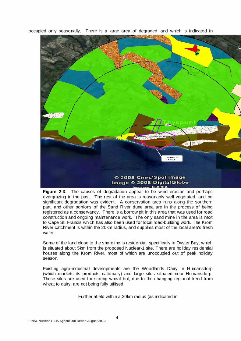
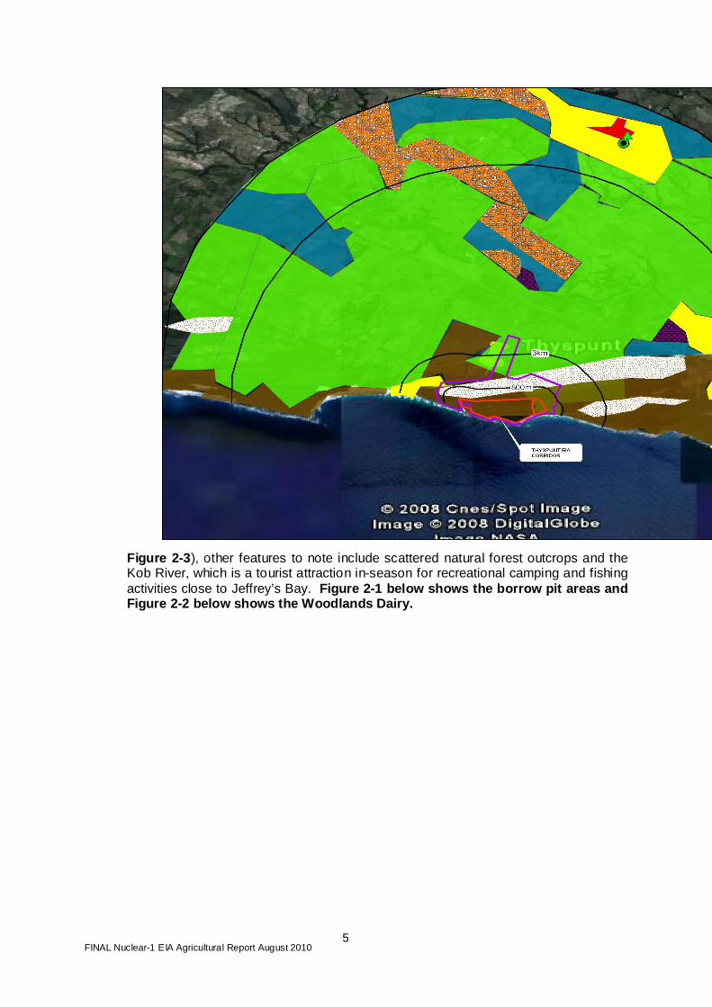
The land use within a 20km radius of the Nuclear-1 site is dominated by commercial dairy farming as indicated in Figure 2.3. About 65% of the entire body of land within the radius is used for commercial agriculture. Strandveld (thicket) is found along the coastline together with a larger portion of bare sand in the form of dunes (the Sand River). The residential areas are Humansdorp, St. Francis, Cape St. Francis and Oyster Bay. Humansdorp is the most populated residential area as the other areas consist predominantly of holiday homes,
FINAL Nuclear-1 EIA Agricultural Report August 2010
4
occupied only seasonally. There is a large area of degraded land which is indicated in
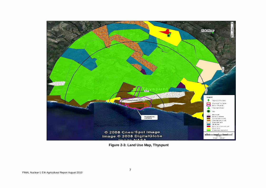
Figure 2-3 . The causes of degradation appear to be wind erosion and perhaps overgrazing in the past. The rest of the area is reasonably well vegetated, and no significant degradation was evident. A conservation area runs along the southern part, and other portions of the Sand River dune area are in the process of being registered as a conservancy. There is a borrow pit in this area that was used for road construction and ongoing maintenance work. The only sand mine in the area is next to Cape St. Francis which has also been used for local road-building work. The Krom River catchment is within the 20km radius, and supplies most of the local area’s fresh water. Some of the land close to the shoreline is residential, specifically in Oyster Bay, which is situated about 5km from the proposed Nuclear-1 site. There are holiday residential houses along the Krom River, most of which are unoccupied out of peak holiday season. Existing agro-industrial developments are the Woodlands Dairy in Humansdorp (which markets its products nationally) and large silos situated near Humansdorp. These silos are used for storing wheat but, due to the changing regional trend from wheat to dairy, are not being fully utilised.
Further afield within a 30km radius (as indicated in
FINAL Nuclear-1 EIA Agricultural Report August 2010
5
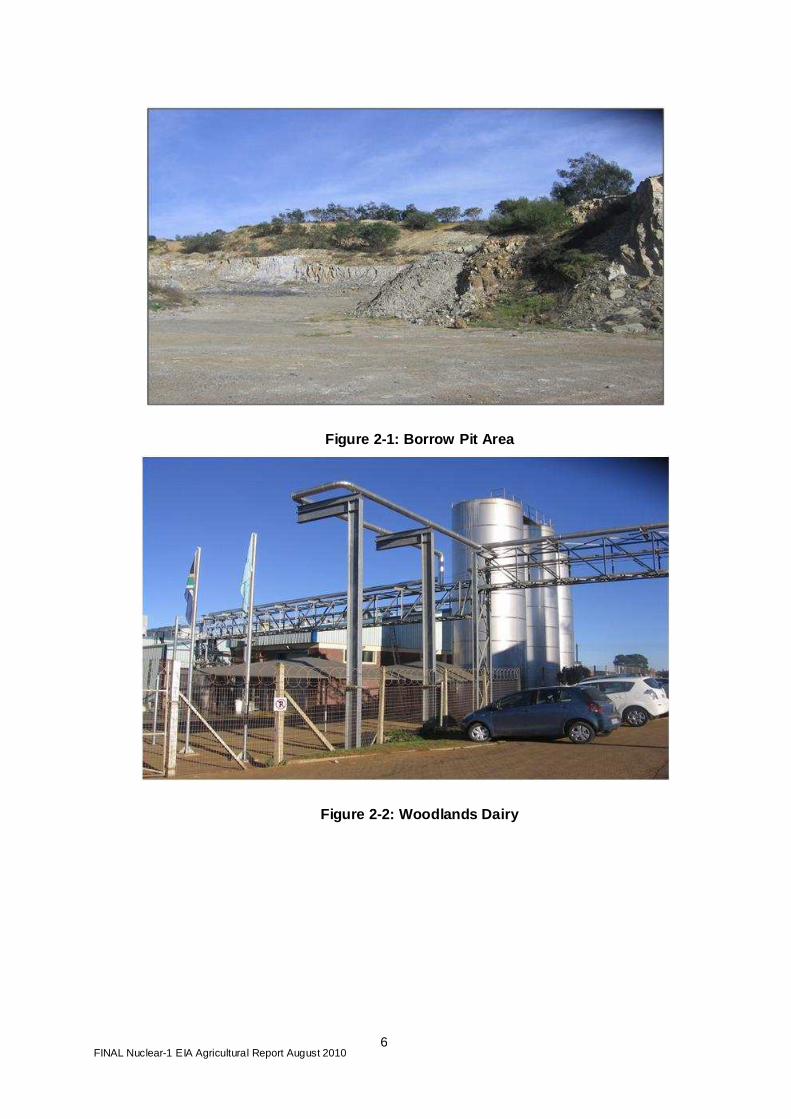
Figure 2-3 ), other features to note include scattered natural forest outcrops and the Kob River, which is a tourist attraction in-season for recreational camping and fishing activities close to Jeffrey’s Bay. Figure 2-1 below shows the borrow pit areas and Figure 2-2 below shows the Woodlands Dairy.
FINAL Nuclear-1 EIA Agricultural Report August 2010
6
Figure 2-1: Borrow Pit Area
Figure 2-2: Woodlands Dairy
FINAL Nuclear-1 EIA Agricultural Report August 2010
7
Figure 2-3: Land Use Map, Thyspunt

FINAL Nuclear-1 EIA Agricultural Report August 2010
8
2.1.2 Bantamsklip There is no agricultural production within the proposed site (EIA corridor) and, in fact, the potential for agricultural production is very limited. This is mainly because of the lack of available irrigation water from surface and ground water sources. As in the case of Thyspunt, soil samples were taken within the EIA corridor and are given in Appendix 2. No abnormal significant soil character istics are observed given the site area (i.e. coastal etc). A large majority of the area surrounding the proposed site is land that is currently being used for fynbos harvesting with some commercial agricultural production taking place on a few farms. The main activity in this area is fynbos harvesting. Only farms that have planted pastures with irrigation that can supplement the natural grazing have livestock on their farms. Therefore, for agriculture production to increase in this area, more irrigation and cultivated pastures would need to be established. The permanent residential areas in this area are relatively small in population size. Pearly Beach, for example, is a holiday location, occupied seasonally during peak tourist times; it has only a small permanent population.
Figure 2-4: Fynbos flower picking – The Springs Farm
Figure 2-5: Typical farm land

FINAL Nuclear-1 EIA Agricultural Report August 2010
9
Figure 2-6: Land Use Map - Bantamsklip

FINAL Nuclear-1 EIA Agricultural Report August 2010
10
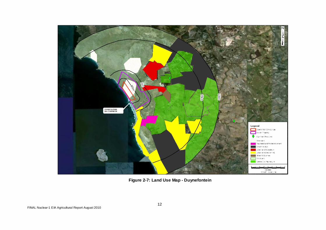
2.1.3 Duynefontein There is no agricultural production within the proposed site (EIA corridor). The potential for agricultural production on the proposed site is very limited, mainly as a result of the soil (sand dunes). As the EIA corridor only consists of sand dunes no soil samples were taken for this site. There is no commercial cultivation within the proposed 800 m PAZ but some mixed farming is being undertaken on the border of the proposed 3 km UPZ . There are broad bands of land use around the proposed site, the first being open vegetation close to the coast, the second the farming areas, and then the residential areas in and around Melkbosstrand and Atlantis.
As shown in
Figure 2-7, the majority (approximately 80%) of the northern area is dominated by shrubland. There is a large urban area in Atlantis with industrial activity around the residential areas. There is an area that has been prepared for residential development, marked on the map as land degraded in preparation for development. There are two distinct areas that that are dominated by smallholdings where mainly subsistence farming is practiced . A wide range of enterprises produce agricultural goods but this is mainly for home consumption with very little commercial production taking place.

FINAL Nuclear-1 EIA Agricultural Report August 2010
11
On one farm (Vaaitjie) there is a sand mine and adjacent brick-making business with excavations for brick-making material. Apollo Brickmakers produce an average of 3,500,000 bricks per day.
FINAL Nuclear-1 EIA Agricultural Report August 2010
12
Figure 2-7: Land Use Map - Duynefontein

FINAL Nuclear-1 EIA Agricultural Report August 2010
13
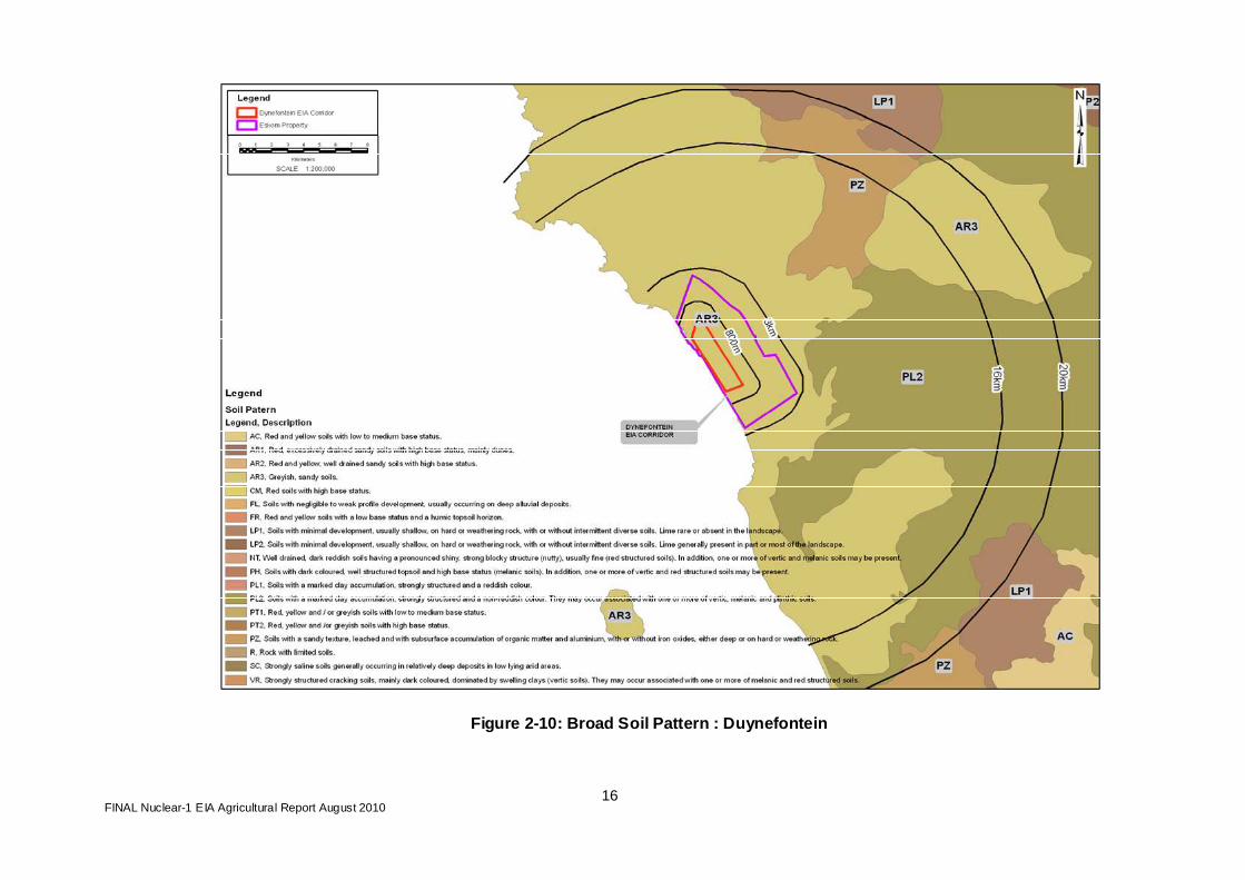
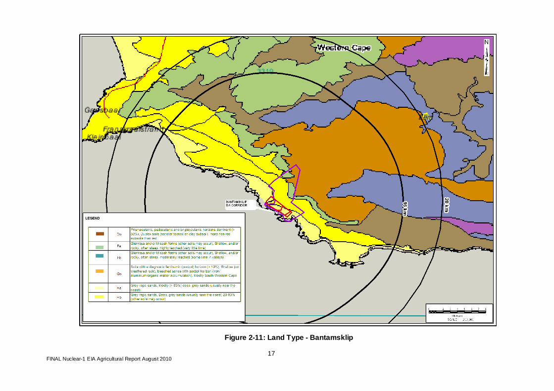
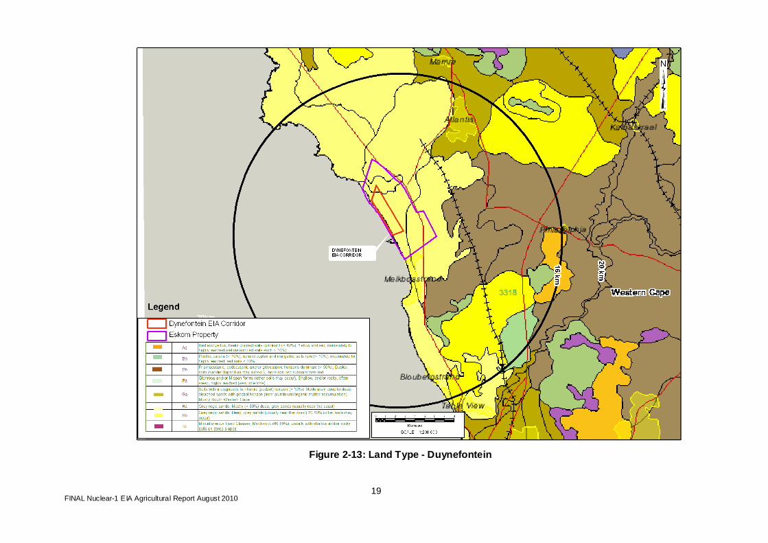
2.2 Agricultural Survey
2.2.1 Soils
In evaluating the potential agricultural production of an area, one of the first elements that is considered is the type of soils that can be found in the region. The type of soil can give a good indication of the agricultural potential of an area. Figures 2.8, 2.9 and 2.10 show broad soil patterns for the proposed sites, obtained from the National Department of Agriculture and the Agricultural Research Council’s Agricultural Geo-Referenced Information System (AGIS). Figures 2.11, 2.12 and 2.13 show the land type for the proposed sites. All three proposed sites for Nuclear-1 lie within a coastal plain landform flanked inland by mountains. The soils at the three sites have relatively low agricultural potential. Further inland the soils have medium to low agricultural potential. High-potential soils with high clay contents and good depth lie away from the proposed sites, occurring within the flood-plains of the rivers rising in the mountains and flowing towards the Indian and Atlantic Oceans. For example, map unit Ca (an important soil inland of all three sites), indicates land that qualifies as a plinthic catena (sequence of soils) which has, in upland positions, margalitic (dark coloured topsoils with a high-base status dominated by Ca and Mg cations) and/or duplex soils (with a relatively permeable topsoil abruptly overlying a very slowly permeable horizon which is not a hardpan) and covering more than 10% of the area. Plinthite, whether as a soft or hard layer, forms from the localisation and accumulation of iron and manganese oxides under conditions of fluctuating water table, and may have reddish brown, yellowish brown and/or black mottles. Soils with key codes Ea and Eb are generally shallow and are suitable for grazing only: All three sites under consideration for the proposed new Nuclear-1 have soil code Ed, which indicates generally greyish, sandy, excessively drained soils. These soils have low potential for crop production due to poor ability to retain moisture and nutrients required for crop growth and development. It should be noted that all these proposed sites are in areas that have been developed over a long period of time, and therefore the current agricultural development in the region reflects the areas of relatively high agricultural potential.

FINAL Nuclear-1 EIA Agricultural Report August 2010
14
Figure 2-8: Broad Soil Pattern: Thyspunt

FINAL Nuclear-1 EIA Agricultural Report August 2010
15
Figure 2-9: Broad Soil Pattern: Bantamsklip
FINAL Nuclear-1 EIA Agricultural Report August 2010
16
Figure 2-10: Broad Soil Pattern : Duynefontein
FINAL Nuclear-1 EIA Agricultural Report August 2010
17
Figure 2-11: Land Type - Bantamsklip

FINAL Nuclear-1 EIA Agricultural Report August 2010
18
Figure 2-12: Land Type - Thyspunt
FINAL Nuclear-1 EIA Agricultural Report August 2010
19
Figure 2-13: Land Type - Duynefontein
FINAL Nuclear-1 EIA Agricultural Report August 2010
20
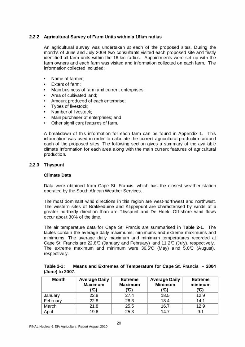
2.2.2 Agricultural Survey of Farm Units within a 16 km radius
An agricultural survey was undertaken at each of the proposed sites. During the months of June and July 2008 two consultants visited each proposed site and firstly identified all farm units within the 16 km radius. Appointments were set up with the farm owners and each farm was visited and information collected on each farm. The information collected included: • Name of farmer; • Extent of farm; • Main business of farm and current enterprises; • Area of cultivated land; • Amount produced of each enterprise; • Types of livestock; • Number of livestock; • Main purchaser of enterprises; and • Other significant features of farm.
A breakdown of this information for each farm can be found in Appendix 1. This information was used in order to calculate the current agricultural production around each of the proposed sites. The following section gives a summary of the available climate information for each area along with the main current features of agricultural production.
2.2.3 Thyspunt Climate Data Data were obtained from Cape St. Francis, which has the closest weather station operated by the South African Weather Services. The most dominant wind directions in this region are west-northwest and northwest. The western sites of Brakkeduine and Klippepunt are characterised by winds of a greater northerly direction than are Thyspunt and De Hoek. Off-shore wind flows occur about 30% of the time. The air temperature data for Cape St. Francis are summarised in Table 2-1 . The tables contain the average daily maximums, minimums and extreme maximums and minimums. The average daily maximum and minimum temperatures recorded at Cape St. Francis are 22.8°C (January and February) and 11.2°C (July), respectively. The extreme maximum and minimum were 36.5°C (May) a nd 5.0°C (August), respectively.
Table 2-1: Means and Extremes of Temperature for Ca pe St. Francis − 2004 (June) to 2007.
Month Average Daily Maximum
(°C)
Extreme Maximum
(°C)
Average Daily Minimum
(°C)
Extreme minimum
(°C) January 22.8 27.4 18.5 12.9 February 22.8 28.3 18.4 14.1 March 21.8 25.5 16.7 12.9 April 19.6 25.3 14.7 9.1

FINAL Nuclear-1 EIA Agricultural Report August 2010
21
Month Average Daily Maximum
(°C)
Extreme Maximum
(°C)
Average Daily Minimum
(°C)
Extreme minimum
(°C) May 19.4 36.5 13.3 7.1 June 18.8 29.0 11.7 6.8 July 18.1 28.0 11.2 6.6 August 17.9 30.5 11.6 5.0 September 18.1 24.4 12.9 7.0 October 19.2 25.5 14.2 8.5 November 20.9 31.1 15.9 11.2 December 22.0 25.0 17.4 12.6 Annual 20.1 36.5 14.7 5.0
The rainfall observations made at the SAWS station in Cape St. Francis recorded an annual average of 610.9 mm for the period 2004 (June) to 2007 (Table 2-2 ).
Table 2-2: Average, Maximum and Minimum Monthly Rai nfall (mm) for Cape St. Francis − 2004 (June) to 2007
Month Average Monthly Maximum Monthly Minimum Monthly January 32.2 46.4 18.6 February 18.4 33.8 8.6 March 80.6 173.4 12 April 61.2 71.8 41.6 May 61.6 106.8 18.4 June 33.9 51 19.2 July 40.4 80.4 6.6 August 101.1 211.4 26.8 September 32.8 69 17 October 43.0 64 17.4 November 44.6 94.2 12.4 December 61.3 138 15.4 Annual average 610.9
Current Agricultural Production
The Thyspunt area is dominated by dairy farming. Within the 16km radius there is only one other farm type, on a relatively large property (over 2,000 ha in extent) carrying a flock of 6 500 sheep. The dairy farms supply milk to dairies such as Woodlands, Parmalat, Nestle and Clover Dairies. Woodlands Dairy and Clover Dairies together produce an average of 700 000 litres of milk per day, and make dairy products such as cheese, butter and yoghurt. The dairy farms consist mainly of cultivated pastures and maize production (mostly for silage) for dairy cows. Much of the natural vegetation in the area is shrub land with the occasional outcrop of alien bushveld. Many of the farms produce their own silage for their own use or to sell to other local farmers. Some land is used for wheat production. A summary of the information collected from each farm is given in the Appendix 1.
FINAL Nuclear-1 EIA Agricultural Report August 2010
22
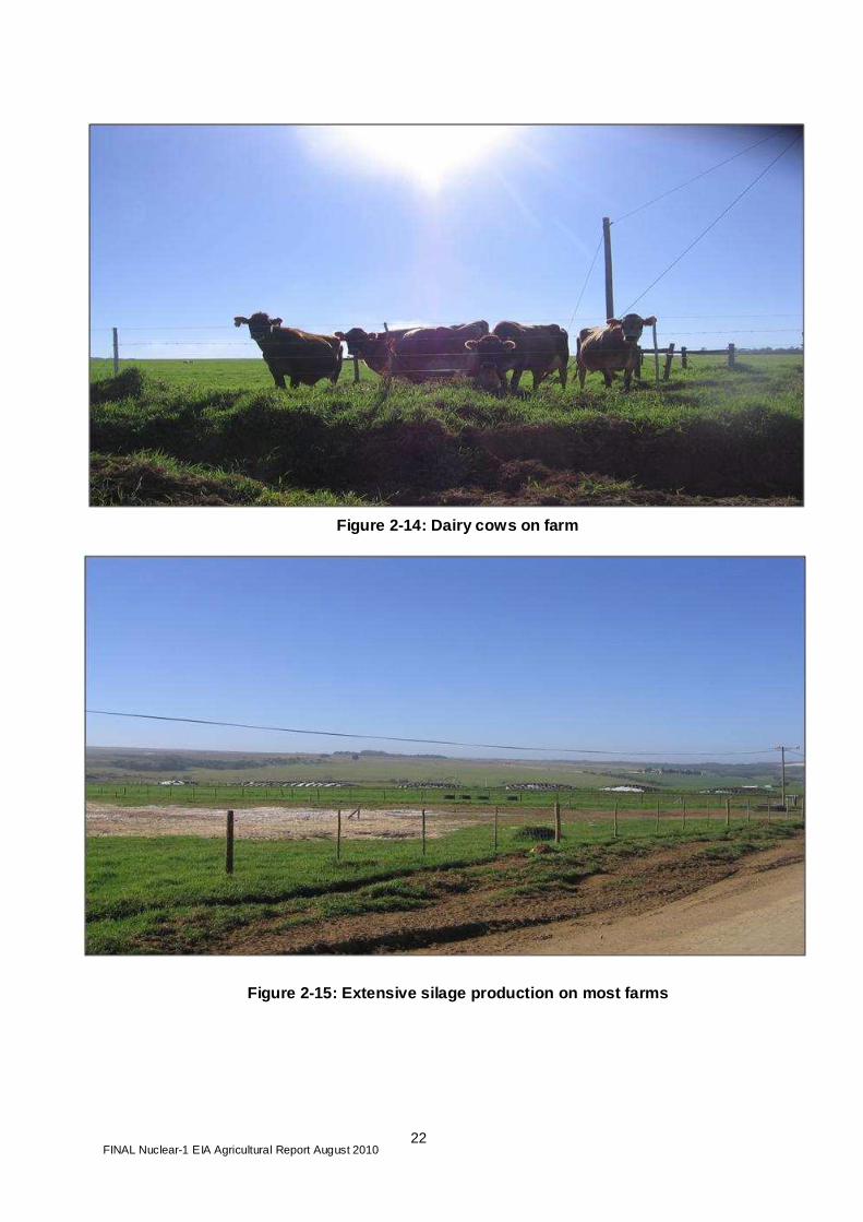
Figure 2-14: Dairy cows on farm
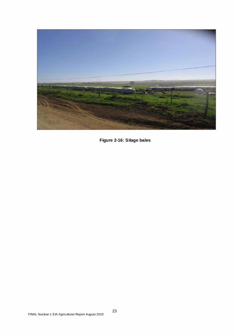
Figure 2-15: Extensive silage production on most fa rms
FINAL Nuclear-1 EIA Agricultural Report August 2010
23
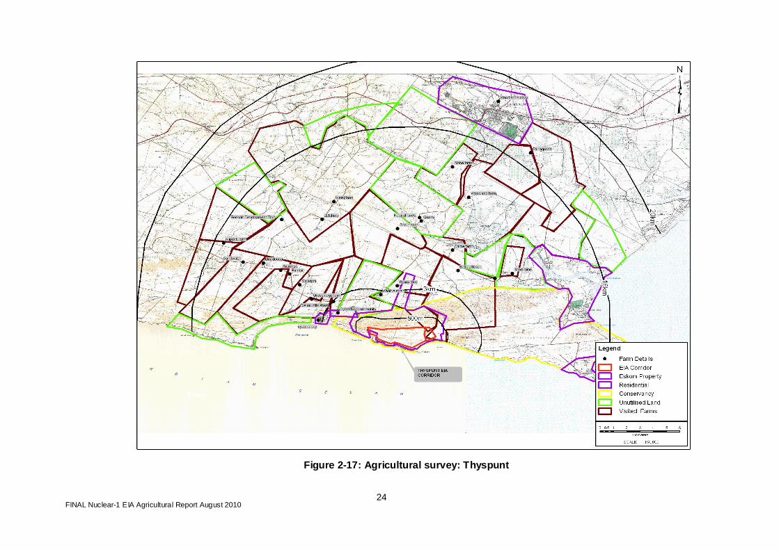
Figure 2-16: Silage bales
FINAL Nuclear-1 EIA Agricultural Report August 2010
24
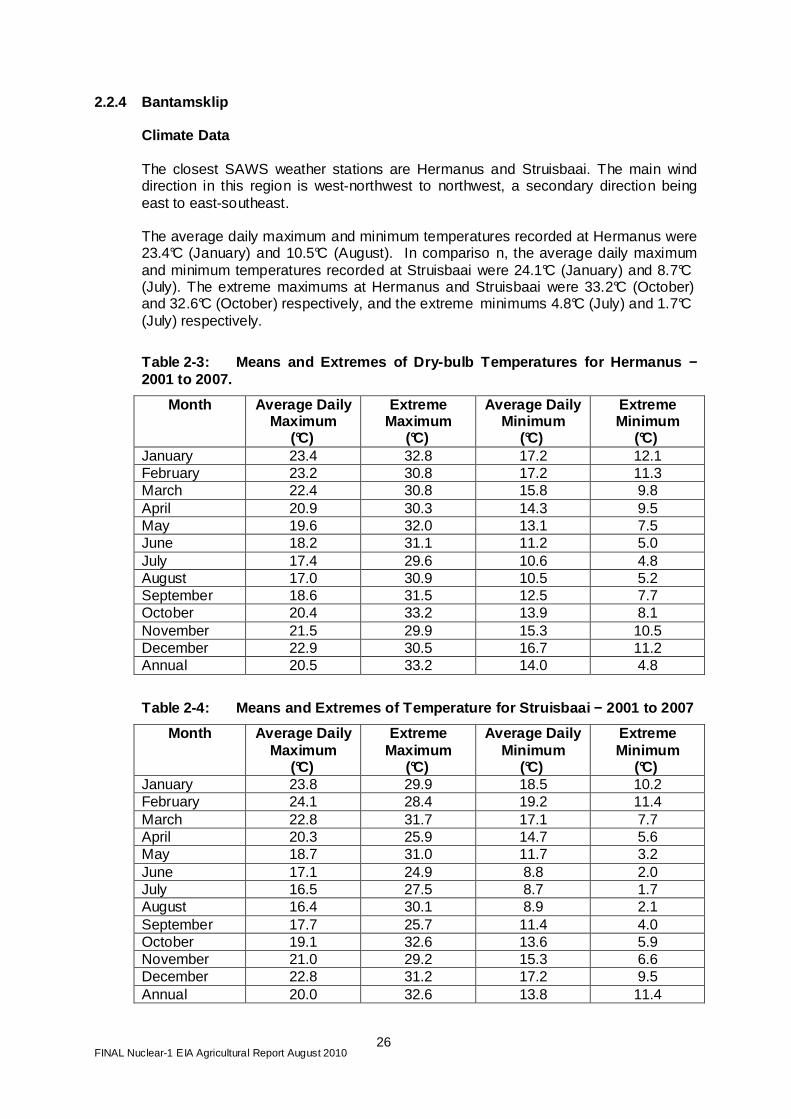
Figure 2-17: Agricultural survey: Thyspunt

FINAL Nuclear-1 EIA Agricultural Report August 2010
25
Figure 2-18: Types of farming - Thyspunt
FINAL Nuclear-1 EIA Agricultural Report August 2010
26
2.2.4 Bantamsklip Climate Data
The closest SAWS weather stations are Hermanus and Struisbaai. The main wind direction in this region is west-northwest to northwest, a secondary direction being east to east-southeast. The average daily maximum and minimum temperatures recorded at Hermanus were 23.4°C (January) and 10.5°C (August). In compariso n, the average daily maximum and minimum temperatures recorded at Struisbaai were 24.1°C (January) and 8.7°C (July). The extreme maximums at Hermanus and Struisbaai were 33.2°C (October) and 32.6°C (October) respectively, and the extreme minimums 4.8°C (July) and 1.7°C (July) respectively.
Table 2-3: Means and Extremes of Dry-bulb Temperatu res for Hermanus − 2001 to 2007.
Month Average Daily Maximum
(°C)
Extreme Maximum
(°C)
Average Daily Minimum
(°C)
Extreme Minimum
(°C) January 23.4 32.8 17.2 12.1 February 23.2 30.8 17.2 11.3 March 22.4 30.8 15.8 9.8 April 20.9 30.3 14.3 9.5 May 19.6 32.0 13.1 7.5 June 18.2 31.1 11.2 5.0 July 17.4 29.6 10.6 4.8 August 17.0 30.9 10.5 5.2 September 18.6 31.5 12.5 7.7 October 20.4 33.2 13.9 8.1 November 21.5 29.9 15.3 10.5 December 22.9 30.5 16.7 11.2 Annual 20.5 33.2 14.0 4.8
Table 2-4: Means and Extremes of Temperature for St ruisbaai − 2001 to 2007
Month Average Daily Maximum
(°C)
Extreme Maximum
(°C)
Average Daily Minimum
(°C)
Extreme Minimum
(°C) January 23.8 29.9 18.5 10.2 February 24.1 28.4 19.2 11.4 March 22.8 31.7 17.1 7.7 April 20.3 25.9 14.7 5.6 May 18.7 31.0 11.7 3.2 June 17.1 24.9 8.8 2.0 July 16.5 27.5 8.7 1.7 August 16.4 30.1 8.9 2.1 September 17.7 25.7 11.4 4.0 October 19.1 32.6 13.6 5.9 November 21.0 29.2 15.3 6.6 December 22.8 31.2 17.2 9.5 Annual 20.0 32.6 13.8 11.4

FINAL Nuclear-1 EIA Agricultural Report August 2010
27
As shown in Table 2-3 , the rainfall regime for the Bantamsklip area is typical of a winter rainfall season area. Rainfall observations are made at the SAWS stations in Hermanus and Struisbaai. These are summarised in Table 2-5 . The annual average recording for this period is 533.2 mm at Hermanus and 385.9 mm at Struisbaai.
Table 2-5: Average, Maximum and Minimum Monthly Pre cipitation (mm) for Hermanus and Struisbaai − 2001 to 2007 (South Afric an Weather Service).
Hermanus Struisbaai Month Average
Monthly Maximum Monthly
Minimum Monthly
Average Monthly
Maximum Monthly
Minimum Monthly
Jan 33.2 121.0 7.2 30.5 78.4 5.6 Feb 23.4 37.4 11.2 13.2 33.6 4.8 Mar 20.5 60.6 5.8 20.8 85.4 0.2 Apr 68.7 232.6 21.2 53.4 175.8 19.6 May 50.9 87.4 9.0 36.1 47.2 8.0 Jun 59.1 132.8 11.6 39.7 75.2 15.4 Jul 68.0 111.0 10.4 49.3 94.6 13.4 Aug 73.3 130.6 33.6 47.2 84.4 25.8 Sep 27.9 52.0 0.0 25.3 45.0 9.8 Oct 52.1 131.4 16.4 34.8 98.6 12.8 Nov 33.9 120.2 9.8 20.8 60.6 3.8 Dec 22.2 51.0 6.6 14.8 33.2 3.0 Annual average 533.2 385.9
Current Agricultural Production
The majority of the land within the 16km radius is natural fynbos vegetation. The farms further inland are mainly devoted to cattle or sheep. Recently wine farms within the broader region have been developed into the Agulhas wine region. It is envisaged that this trend toward wine estates and eco-tourism will continue in the medium term. The coastal belt, which stretches approximately 6km inland, is predominantly natural vegetation, with some uncultivated and cultivated fynbos. This land is used for flower harvesting, with the occasional small-scale subsistence fishing activity or holiday property within it. The areas further inland produce dairy, cattle and sheep. Here there is a small village called Baardskeerdersbos with some small scale-farmers and a residential area. The farms that produce dairy, cattle and sheep are spread over 10km from the proposed site. The dairy farms sell predominantly to the Parmalat Dairy. The bigger farms, other than those that do game farming, are all in dairying or fynbos harvesting. There are a few farms that produce sweet potatoes, cucumber and oats, and there is a small amount of trout farming. A butchery on one of the farms (Kleinplaas Farm) buys and sells much of the local produce. There are a number of small-scale farms in the area, most of them being operated at a subsistence level. With regard to fynbos, the flowers are boxed and sold to local distributors for export. The primary buyers are from the UK. The fynbos production is a major source of income in the area, as many of the local people rely on such farms for seasonal employment. A summary of the information collected from each farm is given in Appendix 1.

FINAL Nuclear-1 EIA Agricultural Report August 2010
28
Figure 2-19: Agricultural Survey - Bantamsklip

FINAL Nuclear-1 EIA Agricultural Report August 2010
29
Figure 2-20: Types of Farming - Bantamsklip

FINAL Nuclear-1 EIA Agricultural Report August 2010
30
2.2.5 Duynefontein Climate Data
In terms of wind south-south-easterly winds dominate, with approximately 13% occurrences during a year. During winter months (July to August), an increase in frequency of east-north-easterly winds occurs, and in the summer months there is an increase in the frequency of southerly winds As indicated in Table 2-6 , temperatures measured at Duynefontein site are largely influenced by the close proximity of the cold Benguela ocean current which has a moderating effect on the temperatures. The lowest temperature recorded at the Duynefontein site was above freezing (2.2°C on 2 Au gust 1981) and the maximum was 38.2°C (13 September 2005).
Table 2-6: Means and Extremes of Dry-Bulb Temperatu re at the Duynefontein Site (measured 10 m above ground level) − (1980 To 2007)
Month Average Daily
Maximum (°C) Extreme
Maximum (°C) Average Daily Minimum (°C)
Extreme Minimum (°C)
January 25.4 38.1 15.9 10.5 February 25.5 38 16.1 9 March 24.3 36.6 15.3 9 April 21 35.5 13.3 5.5 May 19.1 33.6 11 5.7 June 19.4 31.4 9.6 4.1 July 19.5 29 9.2 2.8 August 17.2 32 8.2 2.2 September 19.7 38.2 10.4 2.3 October 20.4 37.2 11.6 5.4 November 22.6 36.3 13.6 6.3 December 22.9 37.4 14.5 9.3 Annual average
21.4 38.2 12.4 2.2
Air temperatures at Cape Town International Airport (1956-1973) show an extreme maximum of 40.7°C and an extreme minimum of -1.3°C. The rainfall season for the Duynefontein site is classified as a winter area (Figure 2 20).
FINAL Nuclear-1 EIA Agricultural Report August 2010
31
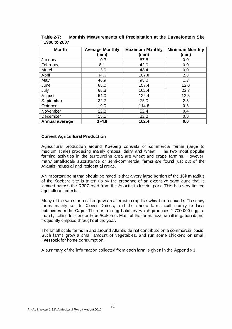
Table 2-7: Monthly Measurements off Precipitation a t the Duynefontein Site −1980 to 2007
Month Average Monthly (mm)
Maximum Monthly (mm)
Minimum Monthly (mm)
January 10.3 67.6 0.0 February 8.1 42.0 0.0 March 13.0 48.4 0.0 April 34.6 107.8 2.8 May 46.9 98.2 1.3 June 65.0 157.4 12.0 July 65.3 162.4 22.8 August 54.0 134.4 12.8 September 32.7 75.0 2.5 October 19.0 114.8 0.6 November 12.3 52.4 0.4 December 13.5 32.8 0.3 Annual average 374.8 162.4 0.0
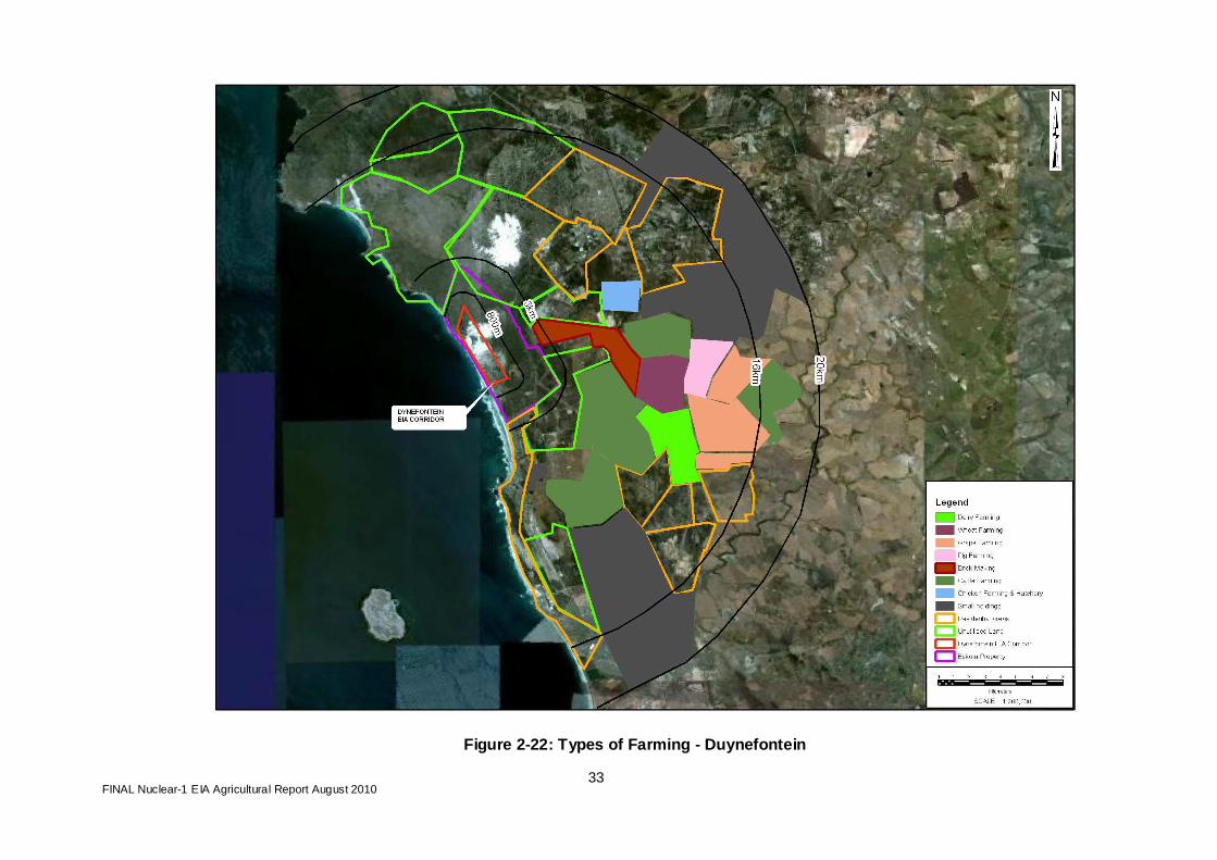
Current Agricultural Production Agricultural production around Koeberg consists of commercial farms (large to medium scale) producing mainly grapes, dairy and wheat. The two most popular farming activities in the surrounding area are wheat and grape farming. However, many small-scale subsistence or semi-commercial farms are found just out of the Atlantis industrial and residential areas. An important point that should be noted is that a very large portion of the 16k m radius of the Koeberg site is taken up by the presence of an extensive sand dune that is located across the R307 road from the Atlantis industrial park. This has very limited agricultural potential. Many of the wine farms also grow an alternate crop like wheat or run cattle. The dairy farms mainly sell to Clover Dairies, and the sheep farms sell mainly to local butcheries in the Cape. There is an egg hatchery which produces 1 700 000 eggs a month, selling to Pioneer Food/Bokomo. Most of the farms have small irrigation dams, frequently emptied throughout the year. The small-scale farms in and around Atlantis do not contribute on a commercial basis. Such farms grow a small amount of vegetables, and run some chickens or small livestock for home consumption. A summary of the information collected from each farm is given in the Appendix 1.

FINAL Nuclear-1 EIA Agricultural Report August 2010
32
Figure 2-21: Agricultural Survey - Duynefontein
FINAL Nuclear-1 EIA Agricultural Report August 2010
33
Figure 2-22: Types of Farming - Duynefontein
FINAL Nuclear-1 EIA Agricultural Report August 2010
34
2.2.6 Summary of Farming Practices
The farming practices for each of the proposed sites are summarised in Table 2-8 below.
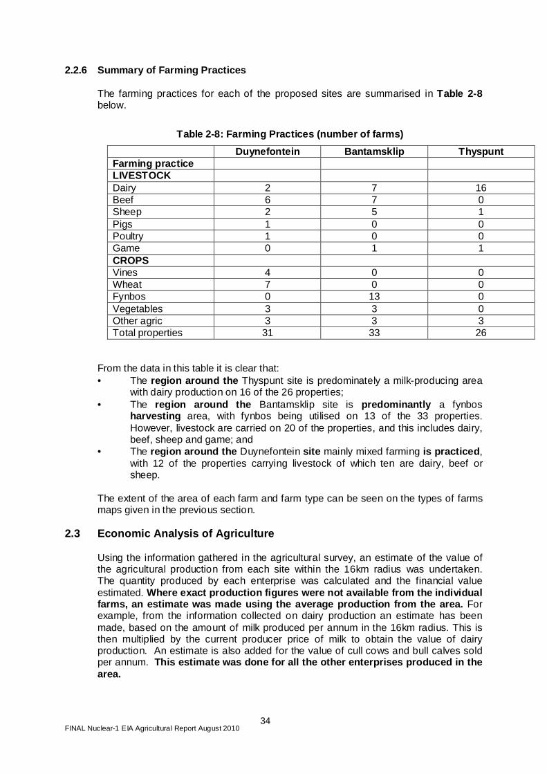
Table 2-8: Farming Practices (number of farms)
Duynefontein Bantamsklip Thyspunt Farming practice LIVESTOCK Dairy 2 7 16 Beef 6 7 0 Sheep 2 5 1 Pigs 1 0 0 Poultry 1 0 0 Game 0 1 1 CROPS Vines 4 0 0 Wheat 7 0 0 Fynbos 0 13 0 Vegetables 3 3 0 Other agric 3 3 3 Total properties 31 33 26
From the data in this table it is clear that: • The region around the Thyspunt site is predominately a milk-producing area
with dairy production on 16 of the 26 properties; • The region around the Bantamsklip site is predominantly a fynbos
harvesting area, with fynbos being utilised on 13 of the 33 properties. However, livestock are carried on 20 of the properties, and this includes dairy, beef, sheep and game; and
• The region around the Duynefontein site mainly mixed farming is practiced , with 12 of the properties carrying livestock of which ten are dairy, beef or sheep.
The extent of the area of each farm and farm type can be seen on the types of farms maps given in the previous section.
2.3 Economic Analysis of Agriculture
Using the information gathered in the agricultural survey, an estimate of the value of the agricultural production from each site within the 16km radius was undertaken. The quantity produced by each enterprise was calculated and the financial value estimated. Where exact production figures were not available f rom the individual farms, an estimate was made using the average produ ction from the area. For example, from the information collected on dairy production an estimate has been made, based on the amount of milk produced per annum in the 16km radius. This is then multiplied by the current producer price of milk to obtain the value of dairy production. An estimate is also added for the value of cull cows and bull calves sold per annum. This estimate was done for all the other enterprise s produced in the area.
FINAL Nuclear-1 EIA Agricultural Report August 2010
35
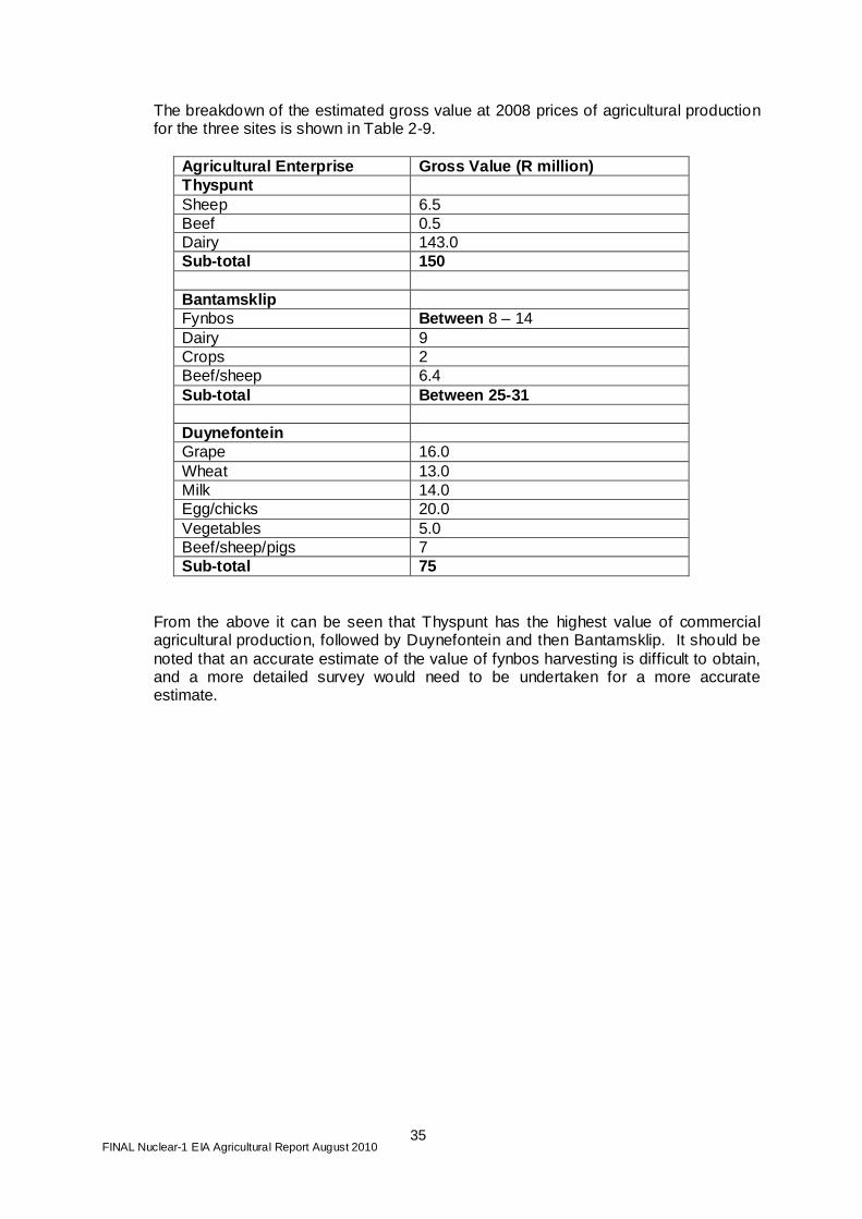
The breakdown of the estimated gross value at 2008 prices of agricultural production for the three sites is shown in Table 2-9.
Agricultural Enterprise Gross Value (R million) Thyspunt Sheep 6.5 Beef 0.5 Dairy 143.0 Sub-total 150 Bantamsklip Fynbos Between 8 – 14 Dairy 9 Crops 2 Beef/sheep 6.4 Sub-total Between 25-31 Duynefontein Grape 16.0 Wheat 13.0 Milk 14.0 Egg/chicks 20.0 Vegetables 5.0 Beef/sheep/pigs 7 Sub-total 75
From the above it can be seen that Thyspunt has the highest value of commercial agricultural production, followed by Duynefontein and then Bantamsklip. It should be noted that an accurate estimate of the value of fynbos harvesting is difficult to obtain, and a more detailed survey would need to be undertaken for a more accurate estimate.

FINAL Nuclear-1 EIA Agricultural Report August 2010
36
3 POTENTIAL IMPACTS ON AGRICULTURAL PRODUCTION
3.1 Introduction
Using data from the Air Quality Impact and Climatology Assessment Study for Environmental Impact Assessment for Nuclear-1 (Nov 2009), the maximum predicted doses of µSv/annum under normal operating conditions for the three sites and two different engineering designs for a nuclear power station are given in Table 3-1.
Table 3-1: Maximum Inhalation and External Effectiv e Dose Predicted In the 40 km by 40 km Study Area for 4 000 MWe nuclear power station
Effective Dose (µSv/annum) Site EPR AP1000 Duynefontein 4.07 2.56 Bantamsklip 4.60 2.19 Thyspunt 11.31 4.56 The report further goes on to state that the NNR Regulation R388 specifies that the annual effective dose limit for members of the public from all authorised actions is 1 000 µSv with an additional provision of an annual dose constraint of 250 µSv. The highest predicted inhalation and external effective dose of 11.3 µSv is therefore about 4.5% of the dose constraint and about 1% of the annual effective dose limit. With the possible addition of more units to eventually generate 10 000 MWe1, the maximum external effective dose would be less than 30 µSv. Therefore, it can be taken that, under normal operating conditions, the µSv/annum are well below the recommended limits and that no impacts would occur during normal operation of Nuclear-1 . As a result, any discussion on the impact of radionuclides on agriculture relates to the unintentional or accidental release of radionuclides.
3.2 Literature Review and Related Case Studies
In terms of agriculture the best researched nuclear power plant disaster is Chernobyl in 1986. Much of the information that we have on the effect of radiation on agriculture comes from research carried out after the incident. It should be stressed that any reference to Chernobyl refers to the agricultural research that took place, and in no way should any comparison be made concerning this disaster and what could happen at one of the proposed sites. The Soviet authorities declared an emergency exclusion zone within 19 miles (30.5 km) of the Chernobyl No. 4 reactor after the accident. The contamination - particularly from Cesium-137 (137Cs) as well as Strontium-90 and Plutonium - was not confined to the 19-mile exclusion zone. Around these areas were areas with lower levels, creating a patchwork of go and no-go zones. In these areas farming never
1 The current EIA process is only applying for 4 000 MW. Possible later capacity expansions would be subject to separate EIA applications.

FINAL Nuclear-1 EIA Agricultural Report August 2010
37
stopped entirely, though the economy collapsed. Instead, the state farms adopted measures to minimise contamination of crops, including the use of certain fertilisers. Some crops absorb less radiation; those that absorb more are grown only for fodder. In October 2006 of the 1 000 square miles of contaminated land, only 54 square miles had been returned to active agricultural use. The survey completed in 2004 found that still more land could be reclaimed. The main effect on plants of unintentional radiation fallout from accidents at nuclear power stations accelerated mutation rates. For example, wheat plants exposed to radiation in the Ukraine show unusually high mutation rates. The plants' mutation rates were six times higher than normal, the result of some unknown effects of low-level chronic exposure to radiation. One possible explanation - and it is speculative - is that over a ten-month period (one season) the damage to the plant might be so small that the DNA repair system simply failed to recognise it. The genetic consequences of radioactive contamination by the fallout to agricultural crops have been studied by Geraskin et al (2002). In the first acute period of this accident, when the absorbed dose was primarily due to external Beta-and Gamma-irradiation, the radiation injury of agricultural crops, according to the basic cytogenetic tests, resembled the effect produced by acute Gamma-irradiation at comparable doses. The yield of cytogenetic damage in leaf meristem of plants grown in the 10-km zone during 1987–1989 (the period of chronic, lower-level radiation exposure) was shown to be enhanced and dependent on the level of radioactive contamination. The rate of decline with time in cytogenetic damage induced by chronic exposure lagged considerably behind that of the radiation exposure. Analysis of genetic variability in three sequential generations of rye and wheat revealed increased cytogenetic damage in plants exposed to chronic irradiation during the second and third years. In many of the reports great concern is shown about the impact of radionuclides affecting humans through entering the human food chain. Initially the unintentional radiation fallout comes into contact with crops or animal feeds. In the case of animal feeds the radionuclides pass into the livestock and are then passed onto humans through the animal products consumed by humans. It is worth noting that in a report by the FAO (1994) it is stated that “the amount of radioactive contamination required to destroy or injure the productivity of plants and animals is much greater than that which would render the resultant foodstuffs unsafe for human consumption”. Against this background, and because of public sensitivity to possible or imaginary radiation harm to man, a consensus has emerged that “it is the impact on humans” that would be important “rather than the effects on other components of the biosphere”. Nevertheless, there is an impact on animals and their products.
3.3 Livestock
This section evaluates the impact of the development of nuclear reactors on livestock and their products in the Duynefontein, Thyspunt and Bantamsklip sites. The section describes the effect of radionuclides if there is a n accidental or an emergency condition where abnormal radiation is released. Und er normal operating conditions there is no effect on livestock or other agricultural produce.
FINAL Nuclear-1 EIA Agricultural Report August 2010
38
3.3.1 Effect of Radionuclides on Livestock Radionuclides enter an animal mainly through feed and in smaller quantities through inhalation or through the skin. The level of contamination of the feed is the main determinant of the overall volume of radionuclides in the animal’s body. After entry to the animal’s stomach the radionuclides are included in the process of metabolism, and all the animal’s systems respond to the impact of radiation. The radionuclides participate in processes of digestion, being transferable by blood to different organs and tissues, and then being either deposited there or removed from the body. The balance between all these processes is given by the radionuclide content of the different organs and tissues of animals. Intake and Digestion of Radionuclides The process of radionuclide intake and subsequent transfer through the cell membrane may be based either on passive diffusion or on mechanisms of active transport. The speed of radionuclide digestion and transport depends upon the physical and chemical characteristics of the compounds in which these nuclides are included. The first step in radionuclide metabolism is their transformation by digestion with the help of physical fragmentation, enzyme treatment and the acid reaction with the gastric juices. The digestion of radionuclides transformed into ionising forms depends upon the chemical nature of the elements and upon the animal species. For example, for iodine-131, 100 % is digested by dairy, beef cattle and sheep, 75 % -80 % by poultry and 33 %- 76% by pigs, while 100 % of caesium-137 is digested by pigs, 67 % by poultry and only 50 - 75 % by cattle and sheep. The digestion of strontium-90 is usually much lower than other radionuclides and is 6 %-16 % for cattle and sheep and 13 % for pigs, although it is 50 % - 80 % for poultry. The coefficient of digestion depends upon the animal’s age. In newborn calves the digestion of strontium-90 increases to 93 %, in lambs to 100 % and in piglets to 97 %, but for poultry chicks it remains at 50 %. The digestion of caesium-137 by young animals varies from 93 % to 100 %. Metabolism of Radionuclides After digestion, the radionuclides enter the blood and become attached to elements of the blood to form components of the serum. The iodine-131 forms compounds with blood proteins, and about 65 % of this radionuclide in blood is linked with erythrocytes. By contrast, caesium-137 does not form any links with proteins in sheep blood, and about 93 % to 99 % of their ions are excreted from the kidneys. For strontium-90, from 30 % to 40 % of its ions concentrate on the serum proteins. The radionuclides delivered by blood to the organs and tissues may be selectively deposited inside them. The selectivity in the dispersion of radionuclides inside the animal body is better expressed in young individuals. For example, the concentration of strontium-90 in the skeleton of calves comprises 1.9 % of the total amount taken in orally. For lambs this proportion is 69 % and for piglets it is 14 %. The adult animals have proportions of 0.1 %, 5 % and 1 % respectively. The deposition of strontium-90 in the muscle, heart, liver, kidneys and lungs of calves was 0.01 % to 0.04 %, and in the organs of adult animals 0.002 % to 0.005 %. In the organs of calves caesium-137 is deposited in the following proportions: in the skeleton 0.2 %, in muscle 0.35 %, in the heart 3.6 %, in lungs 1.7 %, in the liver 1.65 %, and in kidneys 4.8 %. After long-term feeding on contaminated feedstuffs, the strontium-90 concentrates in the skeleton of animals and the caesium-137 in the soft organs and tissues. During long-term intake of radionuclides, at first their content in organs and tissues increases but

FINAL Nuclear-1 EIA Agricultural Report August 2010
39
after a while a balance is established between radionuclide intake and removal, and their content in the animal tissue remains at the same level. The equilibrium state for strontium-90 is achieved after 5-7 days for soft tissues of cattle and sheep and after 30-90 days for pigs and poultry. The caesium-137 content achieves a state of equilibrium later than strontium-90. In sheep this is after 105 days and in cattle after 150 days. After long-term intake of radionuclides, strontium-90 concentrates in the skeleton while caesium-137 is from 20 % to 55 % in soft tissue of calves and from 4 % to 9 % in the tissues of adult animals. Excretion of Radionuclides The radionuclides are excreted from the animal organs and tissues via the gastrointestinal system, lungs, kidneys, skin and milk producing glands. The radionuclides deposited in soft tissues are removed more easily than those in the skeleton. For example, for caesium-137 after three days 45 % of deposited radionuclides are removed and after 46 days 55 % have gone, but more than 3 000 days are required for the removal of half the strontium-90 from the skeleton of cows. The radionuclides caesium-137 and iodine-131 are excreted mainly by the kidneys and in smaller quantities (about 3 %) through the milk-producing glands of cows. The radionuclides deposited in meat, eggs and milk may be transferred to humans by ingestion. The transfer of radionuclides in meat products from animal feed rations depends on the physical and chemical characteristics of the radionuclides, and on the age and the species of animal. After long-term intake of strontium-90, the skeletons of cattle contained 7.4 % of the daily ration and the muscles only 8 %. For pigs these figures were 1.3 % and 1.15 % respectively. At equilibrium, the caesium-137 content in the skeleton of cows was 22 % and in muscle 8.1 % of the daily ration. The skeletons of pigs contained 3.5 % of the daily content in the ration of strontium-90 and the muscles 22 %. The young animals accumulate more radionuclides in their organs and tissues than older animals. After intake of radionuclides by cows, their intensive excretion in the milk is observed for two days. Initially, one litre of milk contained 0.09 % of strontium-90 and 0.42 % of caesium-137 ingested. During the following eight days 2.8 % of strontium-90 and 18 % of caesium-137 were removed from the animal’s body in the milk. The intensity of radionuclide extraction in milk varies and depends upon species, stock and individual characteristics. The average coefficient of transfer into milk is 1.0 for caesium-137 and 0.15 for strontium-90. In poultry the transfer of strontium-90 from feed to eggs comprises between 40 % and 60 % of daily intake. About 96 % of this radionuclide concentrates in eggshell, 3.5 % in the yolk and 0.2 % in the white. The maximum amount of radionuclides is observed on the first day after intake. The maximum concentration for strontium-90 was observed in the eggshell, for caesium-137 in egg-white and for iodine-131 in the yolk.
3.3.2 Potential Impacts on Livestock
In terms of agriculture there are three phases/scenarios where the potential impacts can be evaluated: 1. The construction of the reactors; 2. The operation of the reactors; 3. The decommissioning phase; and 4. The possibility of a nuclear incident/disaster at these reactors.

FINAL Nuclear-1 EIA Agricultural Report August 2010
40
(1) Construction Phase There is considerable agricultural activity within the 16km radius surrounding the three sites. Construction of a nuclear power station could potentially have an impact on farming in these areas. Road Congestion: Construction of the reactors may result is some congestion on local roads due to the large amount of building materials that will be brought into the site. This increased traffic is likely to have some impact on the local farmers because they transport produce to market on a daily basis. The impact is likely to be greater where the produce is milk, vegetables and flowers, in which case the farmers around the Thyspunt and Bantamsklip sites are more likely to be affected than the more extensive farming operations around the Duynefontein site. A specific concern in this regard would be dairy ca ttle crossing the roads to get to other pastures or for milking. This will need t o be well controlled with traffic flags stopping the traffic. Dust Generated: It is expected that, as a result of the large amount of transport involved in construction, there will also be a certain amount of dust generated over an extended period. The amount of dust will depend on the surface of the roads. If they are mainly dirt roads a considerable amount of dust will be generated which is not desirable in any farming operation. This is especially so where fresh produce like milk and vegetables, are produced around the Thyspunt and Bantamsklip sites but also around the Koeberg site where grapes are an important fresh product. Job Market: Industrial intrusion into any agricultural area has an impact on farms. First, industrial jobs traditionally pay more than agricultural jobs. This creates unhappiness amongst the agricultural workers, which results in demands for higher wages. Secondly, there is a move away from farming to industry, resulting in a shortage of agricultural labour. Thus, one would expect there to be some competition for labour, particularly casual, between the Nuclear-1 project and the agricultural sector. However, according to the Social Impact Specialist (personal communication), the personalities and lifestyle of farm workers are so different to those of construction workers that such competition is unlikely to occur on any significant scale. Stock Theft and General Crime As a result of the increased influx of people durin g the construction period there may be an increase in stock theft and related crime. This issue is dealt with in the Social Impact Report. (2) Operational Phase The operation of the reactors should not affect livestock producers or their livestock or livestock produce in any substantial way.

FINAL Nuclear-1 EIA Agricultural Report August 2010
41
(3) Decommissioning Phase
Eskom provided the decommissioning plan developed for the Koeberg Nuclear Power Station as the basis for the decommissioning phase of the proposed Nuclear-1 . Eskom developed a strategy for decommissioning based on the United States Nuclear Regulatory Commission (US NRC) “Decon” alternative. Given the above, the exposure to radiation would therefore be kept to a minimum and below the required dose stipulated by the National Nuclear Regulator (NNR) through continued radiation measurement. Since these dose limits are based on safe exposure levels, it is expected that the radiation exposure during decommissioning would be low. Therefore decommissioning operation of the reactors should not affect livestock producers or their livestock or livestock produce in any substantial way. (4) Possibility of a Nuclear Incident The actual risk of an accidental release of radionuclides over and above normal operations will need to be verified in the overall risk assessment report. Given that the probability of an incident happening is very low, the discussion below must be seen in this context. The accidental release of radionuclides from a nuclear reactor and their effect on crop and livestock has been researched and summarised in the preceding sections of the study. It should be noted that caution should be exercised in regard to the accuracy of these measurements due to the complex nature of the biological systems involved in the uptake, storage and release of the radionuclides in animals. Nevertheless, there is naturally great concern that these nuclear products will enter the food chain through domestic farm animals, and there is sufficient evidence to show the nature of the transfer of radionuclides from the air to the soil and plants and thereafter into animals and the human food chain. With livestock, the major concern regards the contamination of meat and milk. As milk is more likely to contain higher levels of radionuclides than meat and is immediately moved into the human food chain, the main concern with livestock products is directed at milk. The meat from longer-living animals, e.g. beef cattle which live up to 2-10 years as opposed to shorter-living animals (pigs and poultry) is less likely to be contaminated because of the reduction in beef of those radionuclides with a short half-life. However, pigs and poultry are usually kept inside sheds where they are fed with feed from outside the area and are therefore less likely to be contaminated in the first place. Therefore, in the event of a nuclear disaster with consequent nuclear fallout, the main concern is that milk will immediately be contaminated and within 24 hours enter the human food chain. Beef cattle, sheep and game that feed on contaminated grazing will also be immediately contaminated, but the meat will enter the human food chain only after a period of time when radionuclides have diminished to an extent in the meat. Poultry and pigs are unlikely to suffer contamination except through the ingestion of radioactive material. A number of proposals for reducing the effect of radionuclides in livestock have been made and also implemented, but few have any great significance. (i) Dairy Producers

FINAL Nuclear-1 EIA Agricultural Report August 2010
42
In the event of a disaster all dairy cattle will have to be removed from the area immediately. If they are to continue to be milked they will then need to be fed with uncontaminated fodder for the length of their lives. Their original farms will need to be evacuated for a period exceeding their own productive lives. (ii) Beef Farmers: The majority of feed for beef cattle will come from grazing natural or artificial pastures, and these feed sources will be contaminated immediately, in which case the cattle will need to be removed immediately from the farms and put on ‘clean’ grazing. (iii) Poultry and Pig Producers: Poultry and pigs in enclosed housing and fed “out of the bag” are the least likely of the farm animal species to be affected by radionuclides. It would appear that, in the case of a nuclear disaster, they could continue to be produced in this manner, but the farm workers would not be allowed to continue working in the area because of the likelihood of them being exposed to radiation. In this case the stock would need to be slaughtered or moved outside the danger area.
3.4 Crop Production
The survey of agricultural activities at the three sites revealed that Thyspunt is predominantly a dairy farming area, Bantamsklip has fynbos and dairy farms, and Koeberg has irrigated grapes and wheat under dryland production. The information gathered in the agricultural survey has been used in identifying potential impacts on agricultural production of the proposed nuclear power station. These were analysed and mitigation options prepared. The impacts on crop production and mitigation measures have been separated into three phases, - construction, normal operation and nuclear accident. The impacts on agriculture have been confined to the 16km radius around the proposed sites, although experience such as at Chernobyl shows that farming is vulnerable to the effects of a nuclear accident hundreds, even thousands, of kilometres away from the site.
3.4.1 The Effect of Radionuclides on Crop Productio n
Radionuclides that mainly enter the food chain by direct contamination (e.g. radiocaesium, 137Cs) are especially important in the context of the study, in particular in the contamination of cereals such as wheat and pasture grasses. The radionuclide contaminants of most significance in agriculture are those which are relatively highly taken up by crops, have high rates of transfer to animal products such as milk and meat, and have relatively long radiological half-lives. However, the ecological pathways leading to crop contamination and the radio-ecological behaviour of the radionuclides are complex and are affected not only by the physical and chemical properties of the radionuclides but also by factors which include soil type, cropping system (including tillage), climate, season and, where relevant, biological half-life within animals. The major radionuclides of concern in agriculture following a large reactor accident are 131I, 137Cs, 134Cs and 90Sr.

FINAL Nuclear-1 EIA Agricultural Report August 2010
43
While the caesium isotopes and 90Sr are relatively immobile in soil, uptake of roots is of less importance compared with plant deposition. Plant deposition takes place when radionuclides are brought to earth in the rain or through dry deposition. Soil type (particularly with regard to clay mineral composition and organic matter content), tillage practice and climate all affect the propensity for radionuclides to move to groundwater. The same factors affect availability to plants insofar as they control concentrations in soil solution. In addition, because caesium and strontium are taken up by plants by the same mechanism as potassium and calcium respectively, the extent of their uptake depends on the availability of these elements. Thus, high levels of potassium fertilisation can reduce caesium uptake and liming can reduce strontium uptake. The dynamics of radioactive contamination of aquatic ecosystems (1986–1990) is considered on the basis of observational data in the near and distant zones of the Chernobyl fallout (the Chernobyl Nuclear Power Plant (CNPP) cooling pond, the Pripyat River, the Dnieper reservoirs, and the Kopor inlet of the Gulf of Finland). Radionuclide accumulation in aquatic biota was analysed. The results obtained by Kryshev (1995) indicate that the radioecological conditions in the water bodies under investigation were in a state of non-equilibrium over a long period of time. Reduction in the 137Cs concentration proceeded slowly in most of the aquatic ecosystems. The effect of trophic levels, which consisted of increased accumulation of radiocaesium by predatory fish, was observed in various parts of the contaminated area. From the above discussion, and in particular the non-equilibrium state over time (radiation clearing slowly), the restrictions in place on food grown around a disaster might have to remain in force for half a century. Radioactive materials, especially cesium-137, with a half-life of 30 years, will decay over time, but life in the contaminated parts will take time to return to normal.
3.4.2 Potential Impacts on Crop Production As in livestock there are four phases/scenarios where the potential impacts can be evaluated: 1. The construction of the reactors; 2. The operation of the reactors; 3 The decommissioning phase; and 4. The possibility of a nuclear in accident/disaster at these reactors.
(1) Construction
During the construction phase of the proposed new nuclear power station , the main risk to crop production will be dust and increased cost of unskilled labour. (a) Dust:
Dust in the air or deposited on plant foliage will reduce photosynthesis in the plants. Reduced photosynthesis will mean less energy for growth and lower crop yields. The impact of dust on the plants will reduce when rain or irrigation washes the dust off the foliage. Prevailing wind direction over the study areas varies during the year. The risk of dust during construction will be highest at Bantamsklip, where farming mainly involves harvesting of flowers from fynbos grown under dryland conditions. Dust on leaves of

FINAL Nuclear-1 EIA Agricultural Report August 2010
44
perennial fynbos plants will result in some loss of photosynthetic activity and reduced flower yields. At Thyspunt the pastures of most farms used for dairy production are too far downwind of the proposed nuclear power station, and are therefore not likely to be impacted by dust. The farms Waalgelegan, Penny Bee and BuffelsBosh may encounter some loss of fodder production due to dust. In summer the prevailing wind at Thyspunt (Cape St. Francis) is mainly off-shore. The coastline at Koeberg lies north-west to south-east, and therefore dust from construction during summer will mainly affect beaches. The south-westerly winds are associated with rain, which will settle the dust and therefore reduce dust depositions on farms inland of the coast. (b) Labour Market: Labour-intensive farming activities such as grape harvesting and flower harvesting from fynbos may be negatively impacted during the construction phase when local labour costs, mainly for unskilled persons, will increase because of demand for labour. The situation could normalise after construction, when semi-skilled and skilled staff is recruited to operate the power station. However, as mentioned in Section 3.3.2 above, it appears from the Social Impact Specialist study (personal communication) that competition between these sectors will not be of any significance. (2) Operational Phase The normal operation of the reactors should not affect crop production in any substantial way. (3) The Decommissioning Phase The decommissioning phase of the reactors should not affect crop production in any substantial way. (4) Possibility of a Nuclear Incident Countermeasures applied during the first few weeks after deposition are concerned particularly with reducing exposure from short-lived radionuclides such as iodine-131. Thus, crops may be harvested and stored, or harvesting may be delayed, to allow for radioactive decay before consumption. Once radioactive contamination is distributed through the biosphere, a wider range of countermeasures needs to come into play, to take into consideration the transfer of the relevant radionuclides from soils into the food chain. For example, since mineral uptake by plants is related to the total available and relative abundance of their different ions, the application of high levels of potassium fertilizer can reduce radiocaesium uptake, while liming, by increasing calcium levels, can reduce radiostrontium uptake. It may be possible to use alternative crops or varieties that accumulate lower levels of radionuclides than those normally grown in a region - for example, cereals in place of leafy vegetables and pasture. Another possibility is to grow crops such as sugar-beet or canola where the edible product is processed and contamination reduced. In order to maintain some form of agriculture wherever possible, the production of non-food

FINAL Nuclear-1 EIA Agricultural Report August 2010
45
crops such as flax for fibre, oilseed for lubricants or biofuel, and ornamental plants must be considered. Finally, burying the contaminated surface of the land by deep ploughing can be an effective procedure for large farms provided the proper ploughs and powerful tractors are available.
3.5 Potential for Water Contamination
All the sites are located on the coast in close proximity to the sea. Therefore in the event that there is a contaminated spillage and a subsequent seepage into the ground water, this will not affect the ground water used by farmers as they are inland of the sites. In terms of surface water, this will only be contaminated by a general fallout, which has been described in the previous section.
3.6 Potential Economic and Marketing Impacts
As a result of the development of a nuclear power station, there is potential to increase the market demand of local agricultural production in the area of the proposed sites. This potential impact could be negated to some extent by the perceived consumer concern of produce grown in the proximity of a nuclear plant. This perception has no scientific basis during normal operation of the nuclear plant (given the dosage emission in Section 3.1), but could be a short-term impact until the consumer becomes more knowledgeable about the environmental impacts of a nuclear plant on agricultural production. The normalisation of the market for agricultural produce grown in close proximity to a nuclear plant can to some extent be shown by the agricultural production arou nd the Koeberg nuclear power station. As can be seen from the farm survey around Duynefontein, there is extensive agricultural production around K oeberg, none of which is significantly different to the regional production in the area further away from the nuclear plant. This can also be seen on some n uclear plants in other countries (e.g. France) where there is agricultural production in close proximity to the nuclear plant. Related to this market conce rn is the fact that there is currently an increase in the move towards organic f arming in South Africa. A number of organic certification organisations were contacted and they confirmed that production in close proximity to a n uclear plant would not preclude a farm from obtaining certification and th at normal criteria would apply for certification. Notwithstanding the above, an estimate is made on the potential market increase for each site given the potential to increase agricultural production in each area. This potential increase in demand for agricultural produ ce is a result of the influx of people during the construction phase and to a lesse r extent during the operational phase. This potential economic benefit is based on the potential of a region to increase its agricultural production as a result of the potential increased demand within the region.

FINAL Nuclear-1 EIA Agricultural Report August 2010
46
In regard to Duynefontein it is estimated that ther e will not be a significant increase in demand in the region, as the region is a peri urban region in close proximity to a large expanding city (i.e. a large m arket for agricultural produce). Therefore, the influx of people for the proposed Nu clear-1 development will not have a significant effect on the local demand for a gricultural produce. In regard to Bantamsklip the majority of the curren t and potential production is from fynbos harvesting, which will not be significa ntly impacted by the influx of people. There are some dairy and mixed farming act ivities, which potentially can take advantage of the increase in demand for ag ricultural production. A major constraint in this area is the availability o f water for irrigation purposes. Therefore, any potential increase in current produc tion is very limited. If the region is not able to increase production then the increased production to meet the demand will come from another region. For these reasons it is estimated that the potential market increase will be less tha n 5%. The region around Thyspunt has relatively high agri cultural production, which is illustrated by the estimate of total agricultura l revenue from the region. The dominant farming activity is currently dairy farmin g, with farmers supplying large dairy factories, which then distribute the mi lk locally and nationally. An increase in the demand for pasteurised milk and mil k products locally will increase the demand for raw milk in the region. Dai ry farmers have a number of options available to increase production other than expansion. These include an improvement in management and an improvement in the nutrient value of planted pastures, which would result in an increase in milk produced per milking cow. Other market opportunities potentiall y could open, including the selling of raw milk or maas directly to consumers. Alternatively, farmers may also switch production a s has been done in the past (the region has moved from a predominantly wheat gr owing area to a dairy region mainly as a result of market forces). Therefore, f or example, some farmers may switch to vegetable production if they believe this will be more profitable. Given the above it is estimated that the potential increase in the market for agricultural produce could be 10-15%. Table 3-2 summarises the estimated potential increase in agricultural production as a result of the possible increase in demand for agricultural production in the regions of the three alternative sites.
Table 3-2 : Estimated Economic Impact on the Market s of Agricultural Produce
Site Gross Value R (million) Estimated impact Bantamsklip 29 Increase by 0-5% Duynefontein 75 No change Thyspunt 150 Increase by 10-15%
One of the most significant economic impacts on agricultural production would be the potential shortage of unskilled labour and the resultant increase in cost of labour. This has been discussed in the technical considerations above. As indicated, a number of the enterprises are labour intensive and therefore would experience increased production costs. It is envisaged that this would be a short-to medium-term impact as it would mainly be during the construction phase of the development, and labour from other areas will move into the proposed sites.
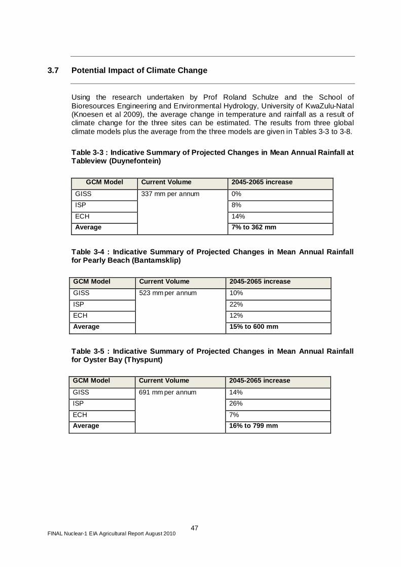
FINAL Nuclear-1 EIA Agricultural Report August 2010
47
3.7 Potential Impact of Climate Change
Using the research undertaken by Prof Roland Schulze and the School of Bioresources Engineering and Environmental Hydrology, University of KwaZulu-Natal (Knoesen et al 2009), the average change in temperature and rainfall as a result of climate change for the three sites can be estimated. The results from three global climate models plus the average from the three models are given in Tables 3-3 to 3-8.
Table 3-3 : Indicative Summary of Projected Changes in Mean Annual Rainfall at Tableview (Duynefontein)
GCM Model Current Volume 2045-2065 increase
GISS 0%
ISP 8%
ECH 14%
Average
337 mm per annum
7% to 362 mm
Table 3-4 : Indicative Summary of Projected Changes in Mean Annual Rainfall for Pearly Beach (Bantamsklip)
GCM Model Current Volume 2045-2065 increase
GISS 10%
ISP 22%
ECH 12%
Average
523 mm per annum
15% to 600 mm
Table 3-5 : Indicative Summary of Projected Changes in Mean Annual Rainfall for Oyster Bay (Thyspunt)
GCM Model Current Volume 2045-2065 increase
GISS 14%
ISP 26%
ECH 7%
Average
691 mm per annum
16% to 799 mm
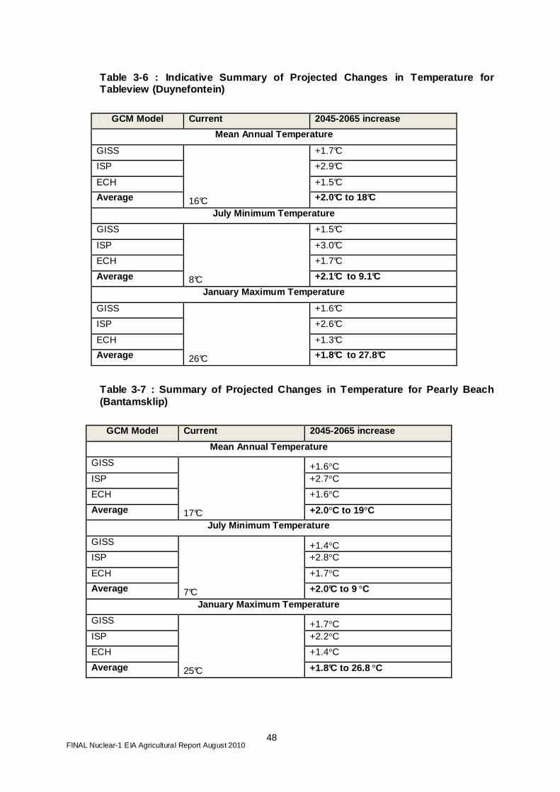
FINAL Nuclear-1 EIA Agricultural Report August 2010
48
Table 3-6 : Indicative Summary of Projected Changes in Temperature for Tableview (Duynefontein)
GCM Model Current 2045-2065 increase
Mean Annual Temperature
GISS +1.7°C
ISP +2.9°C
ECH +1.5°C
Average 16°C +2.0°C to 18°C
July Minimum Temperature
GISS +1.5°C
ISP +3.0°C
ECH +1.7°C
Average 8°C +2.1°C to 9.1°C
January Maximum Temperature
GISS +1.6°C
ISP +2.6°C
ECH +1.3°C
Average 26°C +1.8°C to 27.8°C
Table 3-7 : Summary of Projected Changes in Tempera ture for Pearly Beach (Bantamsklip)
GCM Model Current 2045-2065 increase
Mean Annual Temperature
GISS +1.6°C ISP +2.7°C
ECH +1.6°C
Average 17°C +2.0°C to 19°C
July Minimum Temperature
GISS +1.4°C ISP +2.8°C
ECH +1.7°C
Average 7°C +2.0°C to 9 °C
January Maximum Temperature
GISS +1.7°C ISP +2.2°C
ECH +1.4°C
Average 25°C +1.8°C to 26.8 °C

FINAL Nuclear-1 EIA Agricultural Report August 2010
49
Table 3-8 : A Summary of Projected Changes in Tempe rature for Oyster Bay (Thyspunt)
GCM Model Current 2045-2065 increase
Mean Annual Temperature
GISS +1.5°C ISP +2.2°C
ECH +1.4°C
Average 17°C +1.7°C to 18.7°C
July Minimum Temperature
GISS +1.3°C ISP +2.2°C
ECH +2.0°C
Average 8°C +1.8°C to 9.8 °C
January Maximum Temperature
GISS +1.7°C ISP +1.5°C
ECH +1.3°C
Average 24°C +1.5°C to 15.5 °C
Source: Knoesen et al 2009 From the above tables it can be seen that it is expected that there will be an increase both in temperature (1-2oC) and rainfall. It is expected that the increase in rainfall will mainly be from extreme events at specific times in the season as opposed to a general increase over the year. From this it is expected that there will be a positive impact on agricultural production with an increase in heat units. However, this impact is not expected to be significant. With regard to the impact with or without a Nuclear Power Station, the only impact would be wind and the effect of dust. Unfortunately there is no information on wind in relation to climate change. However, wind is expected to increase as a result of an increase in extreme climatic events.
3.8 Impact of Desalination Plant
For all three sites it is assumed that the waste from the desalinisation plant (brine) will be pumped back into the ocean in a controlled way. If this is the case there will be no impact on agricultural production as a result of the desalinisation plant.
FINAL Nuclear-1 EIA Agricultural Report August 2010
50
4 MITIGATION MEASURES
4.1 Construction Phase
Farming will be disrupted to a certain extent at all three site areas by the construction process. Those farmers with produce that is transported to market on a daily basis will be most affected by this disruption. This disruption will therefore particularly affect milk and vegetable producers. Thyspunt farmers will be the most affected, followed by Bantamsklip farmers, while Koeberg (Duynefontein) farmers should be least affected, In order to minimise dust from construction the following measures should be implemented: • Build the roads serving the nuclear power station as a first priority, and have
these tarred or lined with concrete; • Regular spraying of water on bare soil at site to reduce generation of dust.
In terms of negative market perspective of agricultural produce grown near a nuclear plant, an awareness programme showing the impacts of a nuclear plant on agricultural production needs to be implemented. With regard to labour, although it appears that competition will not be a significant factor, an awareness campaign needs to be undertaken among existing farm labour highlighting the benefits of permanent work on farms as against the essentially short-term nature of construction work on a nuclear plant.
4.2 Operational Phase
In the planning and preparation of responses to a nuclear accident, possible protective actions should be assessed in a general way in relation to a range of credible accident scenarios. From this, the criteria for action to be used immediately and for a short time after an accident can be developed. The response plan could follow two phases.
4.2.1 Phase 1 − Data Gathering and Laboratories Response plans require a database which includes information about the transfer of the radioisotopes caesium and strontium between local soil, water, plants, animals and fish. These are the isotopes most likely to cause more than transient problems to agriculture. In addition, data on soils, weather patterns, local dietary preferences, and some feasible countermeasures with estimates of their costs should be included. A network of laboratories for radionuclide analysis must also be identified. With regard to acceptable levels of radionuclides in food, radioactivity in foodstuffs and soil are expressed as activity per unit mass (g or kg). The FAO/WHO Codex Alimentarius Commission has developed international standards for radionuclide contamination to be applied to food moving in international trade. These are shown in Table 4-1 .
FINAL Nuclear-1 EIA Agricultural Report August 2010
51
Table 4-1: Guideline Levels for Radionuclides in Fo ods for Use in International Trade following Accidental Nuclear Contamination
Dose per unit intake factor Representative radionuclides Level
(Bq/kg) Foods destined for general consumption 10-6 Americium-241, Plutonium-239 10 10-7 Strontium-90 100 10-8 Iodine-131, Caesium-134, Caesium-137 1000 Milk and infant foods 10-5 Americium-241, Plutonium-239 1 10-7 Iodine-131, Strontium-90 100 10-8 Caesium-134, Caesium-137 1000 Source: http://www.iaea.org/Publications/Magazines/Bulletin/Bull383/38305493843.pdf Note 1: The standard SI unit for radioactivity is the Becquerel (Bq). A becquerel is equal to one unit of disintegration per second. Note 2: These levels are designed to be applied only to radionuclides contaminating food moving in international trade following an accident and not to naturally occurring radionuclides which have always been present in the diet. The Codex Alimentarius Guideline Levels remain applicable for one year following a nuclear accident. By an accident is meant a situation where the uncontrolled release of radionuclides to the environment results in the contamination of food offered in international trade.
The levels are based on a number of conservative assumptions in order to be confident that there will be essentially no effect over a lifetime of exposure. Hence, if alternative food is not available, higher values would be acceptable in the short term. On the other hand, lower levels may be appropriate, for example, if external radiation makes a high contribution to the total dose. However, in many cases the choice of countermeasures will be constrained by social factors and infrastructure of the region, so it is important that the database for decision-making includes this information too.
4.2.2 Phase 2 − Protective Measures
The second phase begins some time after an accident has happened when specific information on its nature and likely consequences is available. Specific protective measures can then be considered. Agricultural countermeasures address long-term health effects in the human population; the more immediate impact of radiation exposure on plant and animal life is not directly considered. Test plantings of crops which were grown in the past, such as wheat, grapes and pastures, should be done over time until acceptably low radiation levels are measured in the harvested products. Thereafter, the area can be used for large-scale crop production. An alternative strategy would be to use the contaminated lands for industrial biofuel crops such as sugar-beet for ethanol and canola for biodiesel.
FINAL Nuclear-1 EIA Agricultural Report August 2010
52
4.3 Decommissioning Phase
There have been no significant impacts identified for agricultural production during the decommissioning phase.
FINAL Nuclear-1 EIA Agricultural Report August 2010
53
5 IMPACT ASSESSMENT
5.1 Impact Criteria
The following criteria impacts are analysed for the construction phase: • Dust; • Availability/cost of labour; and • Market effects. The potential impacts are summarised in Table 5-1 (a) to (c) for the three Nuclear-1 sites.
5.2 Assessment
From the above it can be clearly seen that the potential impacts during the construction phase are least significant at the Duynefontein site. The main reason for this is that the area already has the infrastructure for a nuclear plant and the surrounding areas of agricultural production have adapted to the existing plant. In the operational phase, the biggest impact in unlikely event of a nuclear incident would be at the Thyspunt site, as the area is the most intensively used for agriculture. The largest potential increase in agricultural prod uction would be at Thyspunt, due to the favourable agricultural conditions, whic h would allow farmers to capitalise on the inflow of employees into the area . There would be a smaller potential increase at Bantamsklip, and no positive impact at Duynefontein.

FINAL Nuclear-1 EIA Agricultural Report August 2010
54
Table 5-1: Agricultural Impacts for sites
(a) Thyspunt
Impact Intensity Extent Duration
Impact on irreplaceable resources Consequence Probability SIGNIFICANCE
Dust pollution Medium Low Low Low Medium High Medium
Dust pollution (mitigated) Low Low Low Low Low Low Low
Availability/Cost of labour Medium Low Medium Low Medium Medium Medium
Availability/Cost of labour Mitigated) Medium Low Medium Low Medium Medium Medium Change in market condition (Positive) Medium Low Medium Low Medium Medium Medium Change in market condition (Optimised) Medium Low Medium Low Medium Medium Medium
(b) Bantamsklip
Impact Intensity Extent Duration
Impact on irreplaceable resources Consequence Probability SIGNIFICANCE
Dust pollution Medium Low Low Low Medium High Medium
Dust pollution (mitigated) Low Low Low Low Low Low Low
Availability/Cost of labour Medium Low Medium Low Medium Medium Medium Availability/Cost of labour Mitigated) Medium Low Medium Low Medium Medium Medium Change in market condition (Positive) Low Low Medium Low Low Medium Low Change in market condition (Optimised) Low Low Medium Low Low Medium Low

FINAL Nuclear-1 EIA Agricultural Report August 2010
55
(c) Duynefontein
Impact Intensity Extent Duration
Impact on irreplaceable resources Consequence Probability SIGNIFICANCE
Dust pollution Low Low Low Low Low High Low - medium Dust pollution (mitigated) Low Low Low Low Low Low Low Availability/Cost of labour Low Low Medium Low Low Medium Low Availability/Cost of labour Mitigated) Low Low Medium Low Low Medium Low Change in market condition (Positive) Low Low Medium Low Low Medium Low Change in market condition (Optimised) Low Low Medium Low Low Medium Low
FINAL Nuclear-1 EIA Agricultural Report August 2010
56
6 CONCLUSIONS AND RECOMMENDATIONS
This report has examined the impact of the proposed Nuclear-1 power station on agriculture at the three alternative proposed sites. The report has focused on the regional impact as opposed to the specific site, as the power station itself will have no impact on agricultural production. In order to obtain a regional perspective a land use survey and an agricultural survey was undertaken on a 20km and 16km radius respectively. Each farm unit was identified and information was collected on each farm. In this way the amount of agricultural production taking place within the 16km radius was estimated for each alternative site. From this information it was found that the Thyspunt site had the highest agricultural production and also the biggest potential to increase production compared to the other two sites. With regard to potential impacts, it was found that the Duynefontein site would have the least negative impact on agriculture as agricultural production has already taken place in the surrounding region alongside the construction and operation of the Koeberg Nuclear Power Station . From an agricultural production perspective, Thyspunt is the preferred site because its agricultural production could potentially expand the most of all the three sites. For all three sites there are no “no-go” areas and no preferred siting of the facility from an agricultural point of view. In summary, the impacts on agriculture at the three sites are as follows: Duynefontein – no significant impact on agriculture during construction and normal operations. No increase in agricultural production during the operational phase. Thyspunt – negative impact on agriculture in terms of dust (short term) during the construction phase. However, there is potential for a positive impact of 10 to 15 % on production by increasing the size of the local market for fresh produce as a result of the influx of population (Nuclear-1 operational employees and their families as well as construction workers) to the area. Bantamsklip – negative impact on agricultural production with regard to dust during the construction phase. There is an estimated potential of less than 5% to increase the market for local agricultural produce because of water limitations that restrict expansion. In terms of the impact on agriculture, there are no fatal flaws in respect of any of the three sites, and all of them would be suitable to accommodate Nuclear-1.

FINAL Nuclear-1 EIA Agricultural Report August 2010
57
7 REFERENCES
Alexakhin, R. (2008). Database on Sr-90 and Cs-137 transfer factors in the soil-fodder-animal products chain. Russian Institute of Agricultural Radiology and Agroecology. [online]. Available: http://www.fgi.icc.gov.ua/eng/1Publications/radioecology/SP-23b-Alexakhin.doc [15 August 2008]. ANON (1959). Radioactive Materials in Food and Agriculture. Rome: FAO. ANON (2000). Radionuclides (including Radon, Radium and Uranium. Technology Transfer Network. [online]. Available: http://www.epa.gov/ttnatw01/hlthef/radionuc.html (13 August 2008). ANON (2006). French dairy cattle given water contaminated by leaking nuclear dumpsite. Greenpeace Report. [online]. Available: www.greenpeace.org [ 12 August 2008]. Anon (2007). Eskom Fact Sheet - Nuclear Waste. Generation Communication. [online]. Available: http://www.eskom.co.za/content/NU%200002NucWastRev2.doc [August 2008]. ANON (Unknown-a). Facts on nuclear waste from Koeberg. [online]. Available: http://www.eepublishers.co.za/view.php?sid=1204 [15 August 2008]. ANON (unknown-b). What you should know about nuclear incidents. [Online]. Available: www.agriculture.state.pa.us [13 August 2008] Beresford, N.A., Gashchak, S., Lasarev, N., Arkhipov, A., Baglay, Y.G., Loginova, L. and Burov, N. (2000). Transfer of Cs137 and Sr90 to dairy cattle fed fresh herbage 3.5 kilometres from the Chernobyl Power Plant. Journal of Environmental Radioactivity, 47(2):157-170. Beresford, N.A., Mayes, R.W., Colgrove, P.M., Barnett, C.L., Bryce, L., Dodd, B.A. and Lamb, C.S. (2000). A comparative assessment of the potential use of alginates and dietary calcium manipulation as countermeasures to reduce the transfer of radiostrontium to them milk of dairy animals. Abs. Journal of Environmental Radioactivity, 51(3): 321-334. Cook, J. (1986). Red Alert. Kent: New English Library. Fig D. (1994). Nuclear Issues in Contemporary South Africa. Johannesburg: GEM monitor. Geraskin, S. A., Dikarev, V.G., Zyablitskaya, Y.Y., Oudalova, A.A., Spirin, Y.V. and Alexakhin, R.M. (2002). Genetic consequences of radioactive contamination by the Chernobyl fallout to agricultural crops. Journal of Environmental Radioactivity. 66:(1-2)155-169. Green, N, Wilkins, B.T, Davidson, M.F, and Hammond, D.J. (1995). The transfer of plutonium, americium and technetium along the soil-pasture -cow pathway in an area of land reclaimed from the sea, Abs. Journal of Environmental Radioactivity, 27: 35-47 [online]. Available:
FINAL Nuclear-1 EIA Agricultural Report August 2010
58
http://www.sciencedirect.com/science?_ob=ArticleURL&_udi=B6VB2-3YF4P15-J&_user=10&_rdoc=1&_fmt=&_orig=search&_sort=d&view=c&_version=1&_urlVersion=0&_userid=10&md5=c870aa02a551d6ac8a1da7f52ece2196 (17 August 2008). Harrison, J, and Phipps, A. (2002). Comparing man-made and natural sources of radionuclide exposure. Consultative Exercise on Radiation Risks of Internal Emitters. [online]. Available: http://www.cerrie.org/committee_papers/INFO_6-E.doc (11 August 2008). IAEA Bulletin (1996). Guideline levels for Radionuclides in Foods following accidental nuclear contamination for Use in International Trade. [online]. Available: http://www.iaea.org/Publications/Magazines/Bulletin/Bull383/38305493843.pdf. [16 August 2008] Jones, B.E. (1993). Management methods of reducing radionuclide contamination of animal food products. Science of the Total Environment, 137:227-233. Knoeson D, R Schulze, C Pringle, M Summerton, C Dickens and R Kunz (2009). Water for the Future: Impacts of Climate Change on Water Services in the Orange-Senqu River Basin. Report to NeWater, a project funded under the Sixth Research Framework of the European Union. Institute for Natural Resources, Pietermaritzburg, South Africa, Kryshev, I. I. (1995). Radioactive contamination of aquatic ecosystems following the Chernobyl accident. Journal of Environmental Radioactivity, 27(3): 207-219. Mayes, R.W. (1989). The quantification of dietary intake, digestion and metabolism in farm livestock and its relevance to the study of radionuclide uptake. Science of the Total Environment, 85: 29-51. [online]. Available: http://www.sciencedirect.com/science?_ob=ArticleListURL&_method=list&_ArticleListID=779844250&_sort=d&view=c&_acct=C000050221&_version=1&_urlVersion=0&_userid=10&md5=27d287ae385795d1adfb6bda14d284c6 (Accessed August 2008). Medvedev, Z. (1990). The Legacy of Chernobyl. New York: WW Norton. Mitchell, P. I., Vintro, L.L., Dahlgaard, H., Gasco, C. and Sanchezcabeza, J.A. (1997). Perturbation in the Plutonium 240/239 global fallout ratio in local sediments following the nuclear accidents at Thule in Greenland and Palomares in Spain. Abs. [online]. Available: http://www.ncbi.nlm.nih.gov/pubmed/9241884 (13 August 2008). Pasqualetti, M. (1990). Nuclear Decomissioning and Society. New York: Rutledge, Chapman & Hall. Richards, J. and Hance, R (Unknown). Agricultural countermeasures. . International Atomic Energy Agency, Austria. Savchenko VK (1995). The Ecology of the Chernobyl Catastrophe. Paris: ONFSCO. Smith, F, and Clark, M (1989). The Transport and Deposition of the Airborne Debris from the Chernobyl Power Plant with Special Emphasis on the Consequences to the United Kingdom. London: HMSO Publication Centre. Ward, G. (1989). Recent research involving the transfer of radionuclides to milk. Journal of Dairy Science 72:284-287.

FINAL Nuclear-1 EIA Agricultural Report August 2010
59
Wikipedia (unknown). The Three Mile Island nuclear accident [online]. Available: http://en.wikipedia.org/wiki/Three_Mile_Island_accident (14 August 2008). Winteringham, F.P.W. (1989). Radioactive fallout in soils, crops and food. FAO Soils Bulletin, 61. [online]. Available: http://www.fao.org/docrep/T0228E/T0228E00.htm (15 August 2008). Woodman, R.F.M, and Nisbet A.F. (1999). Derivation of working levels for radionuclides in animal feedstuffs for use following a nuclear accident. Abs. Health Physics, 77: 383-391. [online]. Available: http://www.health-physics.com/pt/re/healthphys/abstract.00004032-199910000-00005.htm;jsessionid=LsDNcqhgH9Ncy83lNrGHG2Qv2Zpw5KmhTJ0CRvtnpY71Cvznww2v!2087890851!181195629!8091!-1 (10 August 2008). World Nuclear Organisation (2008). Chernobyl accident. [online]. Available: http://www.world-nuclear.org/info/chernobyl (13 August 2008).
FINAL Nuclear-1 EIA Agricultural Report August 2010
60
APPENDIX 1
DETAILED INFORMATION ON EACH FARM UNIT

FINAL Nuclear-1 EIA Agricultural Report August 2010 61
Detailed Information: Thyspunt

FINAL Nuclear-1 EIA Agricultural Report August 2010 62
Detailed Information: Bantamsklip

FINAL Nuclear-1 EIA Agricultural Report August 2010 63
Detailed Information: Duynefontein
FINAL Nuclear-1 EIA Agricultural Report August 2010
64
APPENDIX 2
SOIL SAMPLE RESULTS

FINAL Nuclear-1 EIA Agricultural Report August 2010
65
KwaZulu-Natal Department of Agriculture and Environ mental Affairs
Soil Salinity Laboratory, Soil Fertility and Analytical Services
Private Bag X9059, Pietermaritzburg,3200 Tel. 033 3559465
Name: Jon Howcroft Advisor: Block C Bellevue Canpus 5 Bellevue Rd Kloof
Tel: 031 717 2790 TEL:
Fax 031 717 2791
Date 27/09/2010 PARTICLE SIZE ANALYSIS According to:- Soil Classification, A Taxonomic Sys tem For South Africa 1991
Coarse Silt
& Laboratory Sample Clay % Fine Silt % Sand %
Number ID (<0.002
mm) (0.02 - 0.002
mm) (0.02 - 2
mm) Texture Class
26507 Bamtamsklip
1A 17 9 75 Sandy Loam
26508 Bantamsklip
1B 18 10 72 Sandy Loam
26509 Bantamsklip
2A 9 2 88 Loamy Sand
26510 Bantamsklip
2B 10 2 89 Loamy Sand
26511 Thyspunt
3A 6 1 93 Sand
26512 Thyspunt
3B 5 1 94 Sand
26513 Thyspunt
4A 5 0 95 Sand
26514 Thyspunt
4B 4 1 95 Sand
Results are not to be used for litigation purposes. Your's faithfully

FINAL Nuclear-1 EIA Agricultural Report August 2010
66
KwaZulu-Natal Department of Agriculture and Environ mental Affairs Soil Salinity Laboratory, Soil Fertility and Analytical Services Private Bag X9059, Pietermaritzburg,3200
Tel: 033 3559465
Report For: John Howcroft Adviser:
Block C Bellevue Campus
5 Bellevue Rd Kloof
Fax: Fax: Tel : Tel:
SOIL SALINITY ANALYSIS REPORT Date: 01/10/ 2010 Results are not to be used for litigation purposes Soil pH % EC Assessment
Sample ID Lab Number (H 2O) Sat. (mS/m) Na
(me/L) Ca
(me/L) Mg
(me/L) K
(me/L) SAR Code* Bantamsklip
1A 26507 7.92 99.80 3.36 5.57 1.49 0.62 1.79 1,4 Bantamsklip
1B 26508 7.98 88.80 2.85 5.55 1.13 0.41 1.56 1,4 Bantamsklip
2A 26509 8.08 68.10 0.83 5.05 0.62 0.32 0.49 1,4 Bantamsklip
2B 26510 8.08 80.60 1.59 5.37 0.62 0.38 0.92 1,4 Thyspunt
3A 26511 8.00 Thyspunt
3B 26512 8.15 82.20 1.99 5.54 0.69 0.11 1.13 1,4 Thyspunt
4A 26513 8.20 187.50 6.66 7.67 2.56 0.68 2.94 2,4 Thyspunt
4B 26514 8.09 68.00 2.22 5.09 0.82 0.28 1.29 1,4
Recommendations/Comments:
*Assessment Code: First number: 1-Non-Saline, 2-Potentially Saline, 3- Saline Second number: 4- Non-Sodic, 5- Potentially Sodic, 6- Sodic

FINAL Nuclear-1 EIA Agricultural Report August 2010
67
Code 1,4:- Soils suitable for irrigation Code 2,5:- Poorly drained soils; not suitable for irrigation Code 3,6:- Soils not suitable for irrigation
Your's
faithfully,


![Bile metabolites of polycyclic aromatic hydrocarbons (PAHs) in … · 2016-11-04 · metabolism of PAH in most vertebrates [-13]. As a con sequence, PAH metabolites in fish are recommended](https://img.pdfslide.net/doc/110x75/5e334532ecd345350f232c6f/bile-metabolites-of-polycyclic-aromatic-hydrocarbons-pahs-in-2016-11-04-metabolism.jpg)


![Polycyclic aromatic hydrocarbons (PAH) guidance · Polycyclic aromatic hydrocarbons (Benzo[a]pyrene) General Information Key Points Identity The term polycyclic aromatic hydrocarbons](https://img.pdfslide.net/doc/110x75/5af498db7f8b9a8d1c8c6b2b/polycyclic-aromatic-hydrocarbons-pah-guidance-aromatic-hydrocarbons-benzoapyrene.jpg)