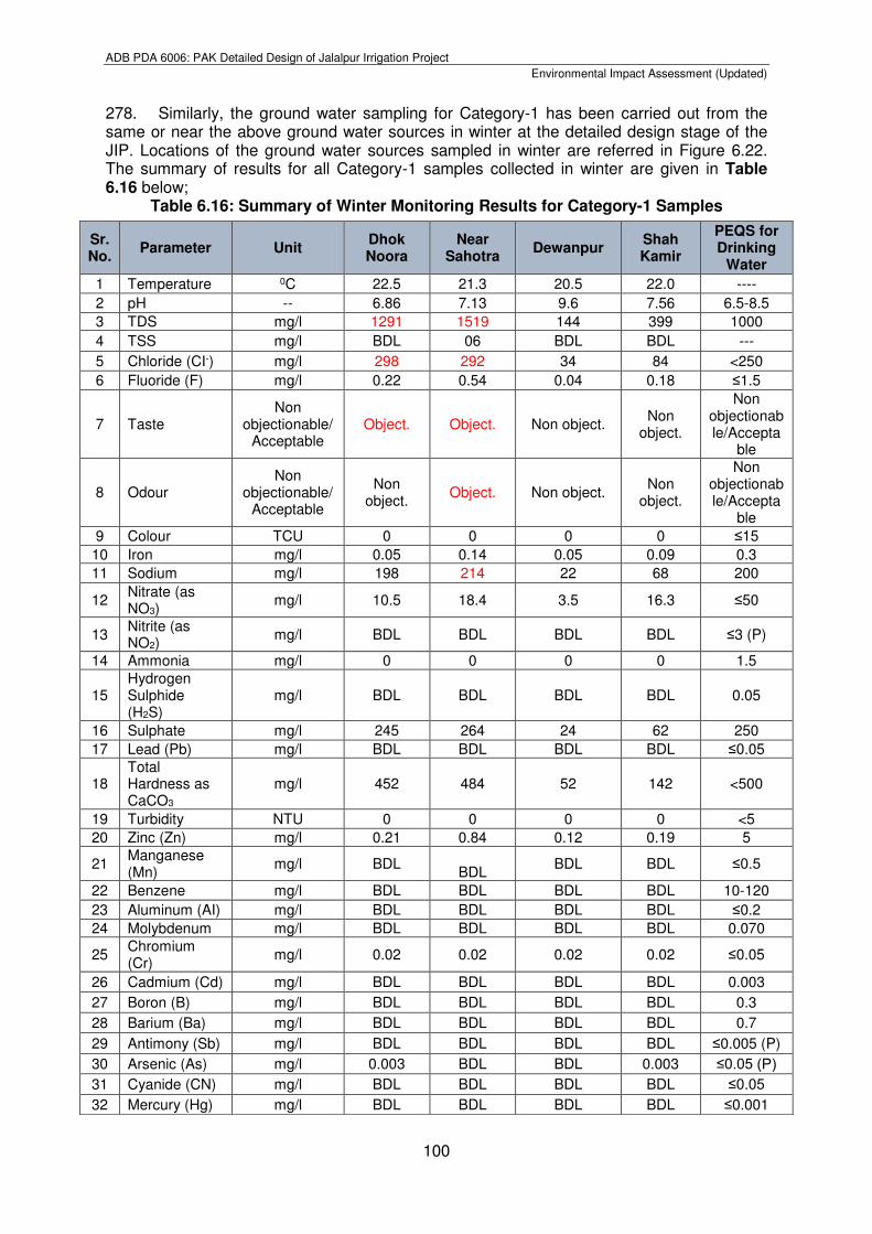
Embed Size (px)
Citation preview
Environmental Impact Assessment
July 2017
PAK: Jalalpur Irrigation Project Project No. 46528-002 Part 6 of 9 of the Main Report
Prepared by Irrigation Department, Government of Punjab for the Asian Development Bank
(ADB).
This environmental impact assessment is a document of the borrower. The views expressed herein do not necessarily represent those of ADB’s Board of Directors, Management, or staff, and may be preliminary in nature.
In preparing any country program or strategy, financing any project, or by making any designation of or reference to a particular territory or geographic area in this document, the Asian Development Bank does not intend to make any judgments as to the legal or other status of any territory or area.
ADB PDA 6006: PAK Detailed Design of Jalalpur Irrigation Project
Environmental Impact Assessment (Updated)
93
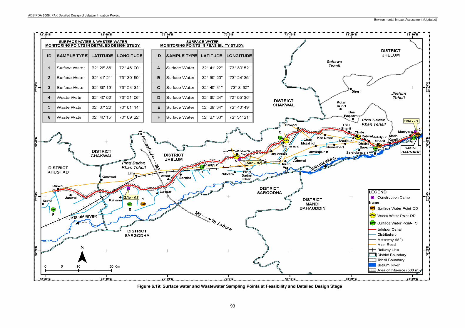
Figure 6.19: Surface water and Wastewater Sampling Points at Feasibility and Detailed Design Stage
ADB PDA 6006: PAK Detailed Design of Jalalpur Irrigation Project
Environmental Impact Assessment (Updated)
94
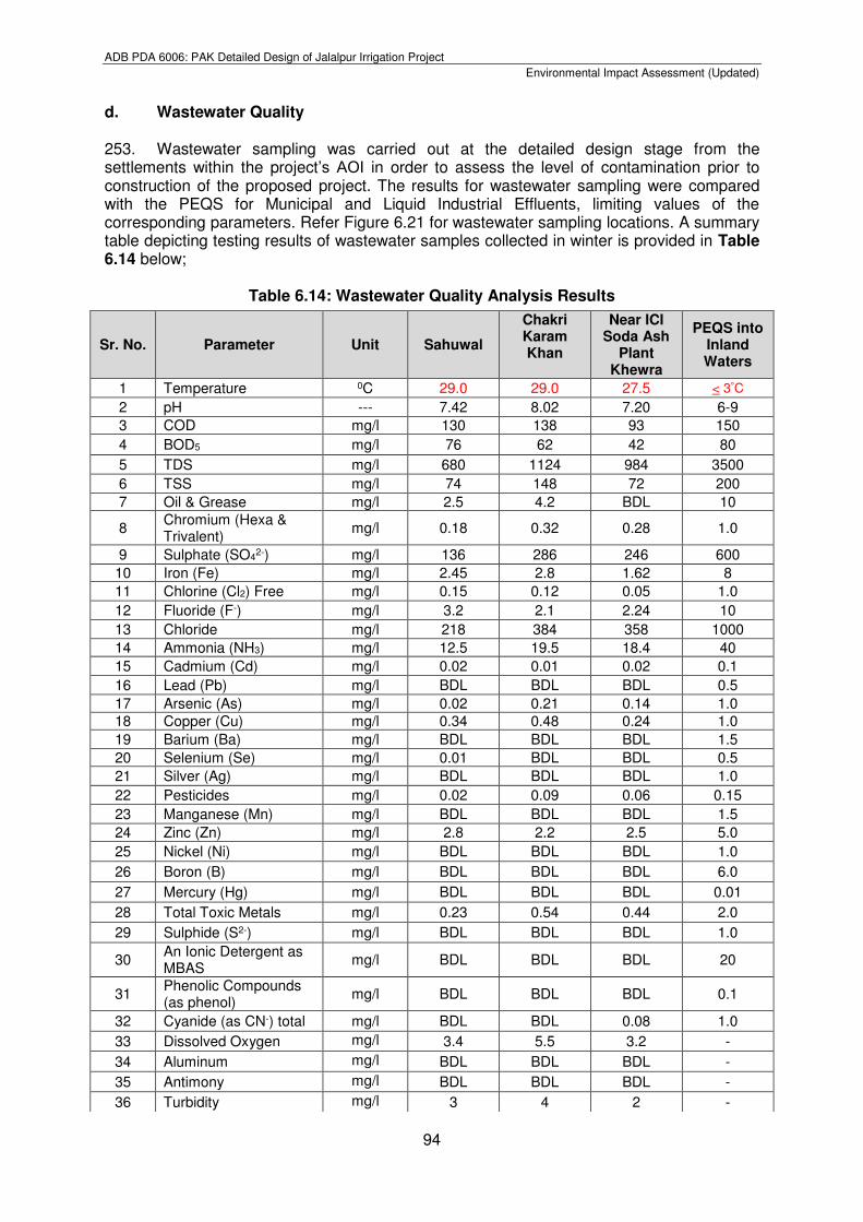
d. Wastewater Quality 253. Wastewater sampling was carried out at the detailed design stage from the settlements within the project’s AOI in order to assess the level of contamination prior to construction of the proposed project. The results for wastewater sampling were compared with the PEQS for Municipal and Liquid Industrial Effluents, limiting values of the corresponding parameters. Refer Figure 6.21 for wastewater sampling locations. A summary table depicting testing results of wastewater samples collected in winter is provided in Table 6.14 below;
Table 6.14: Wastewater Quality Analysis Results
Sr. No. Parameter Unit Sahuwal
Chakri Karam Khan
Near ICI Soda Ash
Plant Khewra
PEQS into Inland Waters
1 Temperature 0C 29.0 29.0 27.5 < 3°C
2 pH --- 7.42 8.02 7.20 6-9
3 COD mg/l 130 138 93 150
4 BOD5 mg/l 76 62 42 80
5 TDS mg/l 680 1124 984 3500
6 TSS mg/l 74 148 72 200
7 Oil & Grease mg/l 2.5 4.2 BDL 10
8 Chromium (Hexa & Trivalent)
mg/l 0.18 0.32 0.28 1.0
9 Sulphate (SO42-) mg/l 136 286 246 600
10 Iron (Fe) mg/l 2.45 2.8 1.62 8
11 Chlorine (Cl2) Free mg/l 0.15 0.12 0.05 1.0
12 Fluoride (F-) mg/l 3.2 2.1 2.24 10
13 Chloride mg/l 218 384 358 1000
14 Ammonia (NH3) mg/l 12.5 19.5 18.4 40
15 Cadmium (Cd) mg/l 0.02 0.01 0.02 0.1
16 Lead (Pb) mg/l BDL BDL BDL 0.5
17 Arsenic (As) mg/l 0.02 0.21 0.14 1.0
18 Copper (Cu) mg/l 0.34 0.48 0.24 1.0
19 Barium (Ba) mg/l BDL BDL BDL 1.5
20 Selenium (Se) mg/l 0.01 BDL BDL 0.5
21 Silver (Ag) mg/l BDL BDL BDL 1.0
22 Pesticides mg/l 0.02 0.09 0.06 0.15
23 Manganese (Mn) mg/l BDL BDL BDL 1.5
24 Zinc (Zn) mg/l 2.8 2.2 2.5 5.0
25 Nickel (Ni) mg/l BDL BDL BDL 1.0
26 Boron (B) mg/l BDL BDL BDL 6.0
27 Mercury (Hg) mg/l BDL BDL BDL 0.01
28 Total Toxic Metals mg/l 0.23 0.54 0.44 2.0
29 Sulphide (S2-) mg/l BDL BDL BDL 1.0
30 An Ionic Detergent as MBAS
mg/l BDL BDL BDL 20
31 Phenolic Compounds (as phenol)
mg/l BDL BDL BDL 0.1
32 Cyanide (as CN-) total mg/l BDL BDL 0.08 1.0
33 Dissolved Oxygen mg/l 3.4 5.5 3.2 -
34 Aluminum mg/l BDL BDL BDL -
35 Antimony mg/l BDL BDL BDL -
36 Turbidity mg/l 3 4 2 -
ADB PDA 6006: PAK Detailed Design of Jalalpur Irrigation Project
Environmental Impact Assessment (Updated)
95
BDL= Below Detection Limit
254. All the above parameters for wastewater testing are in the range of PEQS permissible limit values. e. Groundwater Quality
255. Groundwater is relatively brackish in nature and contains more salts than the surface water. In such situations, a salinity problem of considerable magnitude can arise when irrigation is done with ground waters of poor quality. Review of Previous Water Quality Studies3: 256. In order to assess the groundwater quality of project area, water quality surveys were carried out by different agencies and Consultants in different periods as mentioned below:
Water Quality Surveys by WAPDA – 1977;
Hydrogeological Investigation in Eastern Drainage Basin, Potwar Plateau, Punjab by WAPDA, GWI Report Nov. 1981; and
Water Quality Survey by NDC, 1992. Shallow Water Quality Survey by WAPDA, 1977: 257. A water quality survey was conducted by WAPDA during 1977 and collected water samples from seven (7) open wells and one (1) tube well. Water samples were also collected within a depth of 10 feet (3 meters), where possible at the soil sampling sites. 258. Detailed chemical analysis of the water samples was done in respect of suitability criteria of WAPDA for Total Dissolved Salts (TDS), Sodium Adsorption Ratio (SAR) and Residual Sodium Carbonate (RSC). The data indicate that only 10.8 percent area (8231 ha) was useable, 3.4 percent area (2,590 ha) was marginal and remaining 85.8 percent area (65,393 ha) having hazardous water. Water Quality Survey by Hydrogeological Directorate of WAPDA 1981: 259. Hydrogeological Directorate of WAPDA carried out water quality surveys in Eastern Drainage Basin, Potwar Plateau, Punjab in 1981. Water samples were collected from 10 open wells for quality assessment.
260. According to the survey, the area of use-able and marginal quality water encompass jointly 27 percent while the rest of 54 percent of the project area is classified as hazardous water quality, which is unfit for irrigation purposes. The remaining 19 percent of the Jalalpur canal project area is not surveyed by Hydrogeological Directorate, WAPDA.
3 Source: Soil & Water Quality Studies Report, Jalalpur Irrigation project, NESPAK-ICS JV, November 2014
37 Nutrient as (K) mg/l 0 0.02 0.009 -
38 Nutrient as (N) mg/l 0.01 0.009 0.02 -
39 Nutrient as (P) mg/l 0.04 0.02 0.04 -
40 Total Coliform MPN/100
ml 152 192 142 -
41 Fecal Coliform MPN/100
ml 84 128 62 -
ADB PDA 6006: PAK Detailed Design of Jalalpur Irrigation Project
Environmental Impact Assessment (Updated)
96
Water Quality Survey by NDC – 1992: 261. In order to study the change in ground water quality due to recharge of groundwater, rains and floods, a survey was conducted in November 1992, taking the WAPDA data on base map. Water samples were collected from open dug wells, hand pumps and tube wells operating at the time of survey in different quality zone of project area. 262. Majority of area (77.5 percent) is underlain with brackish (hazardous) water and is unfit for irrigational uses. Useable water (14.3 percent) can be used extensively in the project area without any danger of development of salinity/sodicity problems. The marginal quality area (8.2 percent) would, however, require careful management before it is put to agricultural activities. Water Quality Studies by NESPAK - ICS Joint Venture Consultants November 20144: 263. In order to update the groundwater quality of the project area, some 200 water samples were collected from different sources. These samples were tested for (EC) by the portable EC meter in the field. 264. Out of these 200 samples, 19 water samples were selected and sampled for detailed chemical analysis from the laboratory for the following determinations:
pH and EC mS/cm at 25°C;
Total Dissolved Solids (TDS) in ppm;
Cations and Anions in milliequivalent/liter (me/l);
Sodium Adsorption Ratio (SAR);
Residual Sodium Carbonates (RSC) in me/l; and
Boron in ppm and Chloride in me/l. 265. The ground water quality was assessed for irrigation purpose by evaluating the parameters of salinity, sodicity, toxicity and heavy metals by using the WAPDA Water Quality Standards.
Salinity: 266. The water quality data indicate that 12 % (9,137 ha) of the project area have useable category water. The useable quality data is represented by 42 tube wells and 23 hand pumps tested in the field during water quality survey. Out of these, only 8 tube wells were analysed in detail in the laboratory. Their Electric Conductivity (EC) values range from 375 to 1,350 dS/cm at 25°C and corresponding TDS value varies from 273 to 945 ppm. The useable quality water can be used extensively without any danger of development of salinity/sodicity problem in the project area.
267. As per water quality survey, seven % (5,289 ha) of the project area have marginal quality water. About 17 tube wells and 13 hand pumps fall in the marginal quality water areas which were tested in field. Out of 17 tube wells, 5 tube wells were selected for detail analysis from the laboratory. The EC and TDS values of these tube wells water are ranging from 1,820 to 2,840 µS/cm at 25°C and 1,274 to 1,988 ppm, respectively. The marginal quality water would, however, require careful management before it is put to agricultural use. The mixing of marginal quality ground water with good quality surface water in such proportion that the quality of the resultant water falls within the permissible limits of usability.
4 Source: Soil & Water Quality Studies Report, Jalalpur Irrigation project, NESPAK-ICS JV, November 2014
ADB PDA 6006: PAK Detailed Design of Jalalpur Irrigation Project
Environmental Impact Assessment (Updated)
97
268. The remaining 81 % (61,787 ha) of the project area is underlain with hazardous groundwater quality which is unfit for irrigation purposes. According to water quality survey, 10 tube wells, 37 hand pumps and 3 open wells fall in the hazardous quality water areas which were checked in the field for EC by the EC meter. Of these, 2 tube wells and 4 hand pumps water were selected for detailed analysis from the laboratory. The EC and TDS values range between 3,300 to 1,1360 µS/cm at 25°C and 2,310 to 7,952 ppm, respectively. Sodicity: 269. The sodicity or alkali hazard of groundwater quality is indicted by SAR. It refers to the relative proportion of Na+ to Ca+2 and Mg+2 in the groundwater. As per the test results most of the water samples are well below 10. Thus, as per WAPDA standards, most of the samples are safe for irrigation use except four water samples whose SAR values range from 13.7 to 26.2 and is classed as marginal to hazardous quality water.
270. The RSC is also an index of sodicity and measure of excess quantity of carbonate and bicarbonate ions compared to calcium and magnesium. In most of the water samples RSC value is negative or less than 0.7 me/l. Thus, in most of the cases water quality from sodicity viewpoint is good.
Toxicity: 271. Certain salts are essential for plant growth if in minute quantities, but can cause toxicity when the quantity exceeds safe limits. The degree of damage depends on uptake and crop sensitivity. 272. It is evident that out of 19 groundwater samples tested for toxic elements, most of the samples have boron from 0.16 to 0.59 ppm, while remaining 6 samples have from 0.86 to 0.97 ppm. According to the WAPDA standards for irrigation water, the former are of good quality, while the latter are of marginal quality.
273. The chloride content of 9 water samples have 0.1 to 2.0 me/l, which is safe as per criteria. Chloride content of 4 water samples varies from 7.1 to 9.00 me/l and is classed as marginal quality. The chloride content of remaining 6 water samples ranges from 10.6 to 65.00 me/l and is classed as unsuitable quality. 274. During the EIA study at the project preparatory/feasibility stage, the study team has conducted sampling and testing of ground water in late summer from different locations. (Refer Appendix-III). All the samples were collected as grab samples and after being labeled and preserved they were transported to the laboratory in Lahore for testing. These samples were tested against the twenty one parameters and compared with NEQS and FAO standards in relevant section.
275. Ground water sampling was executed in three categories at the project preparatory/feasibility stage in late summer. However at the detailed design stage two more categories were added for water sampling in winter which were devised on the basis of water usage. Explanation of categories is as follows:
Category-1: This category was formed to check water quality of hand pumps installed near river bank for drinking purpose;
Category-2: This covers those tube wells whose water is being used only for agriculture purpose; and
Category-3: This category was devised to check the ground water quality used for household purposes or either drinking near streams carrying wastewater or located near industrial activities.
ADB PDA 6006: PAK Detailed Design of Jalalpur Irrigation Project
Environmental Impact Assessment (Updated)
98
Category-4: This category was devised to check the ground water quality at the proposed construction camp locations potentially to be used by labourers for drinking and other purposes during construction; and
Category-5: This category was devised to check the ground water quality of natural springs in the project’s AOI used for drinking and other purposes.
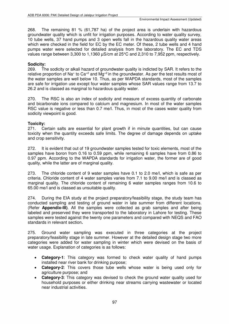
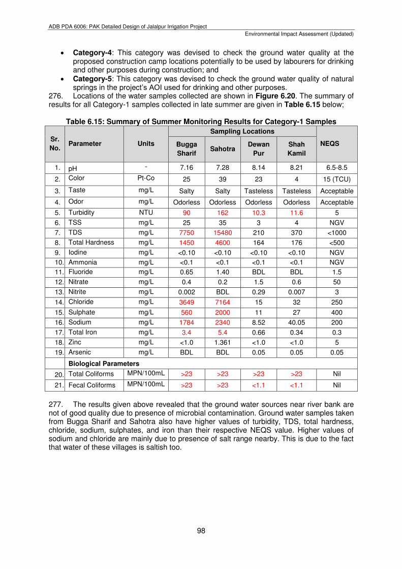
276. Locations of the water samples collected are shown in Figure 6.20. The summary of results for all Category-1 samples collected in late summer are given in Table 6.15 below;
Table 6.15: Summary of Summer Monitoring Results for Category-1 Samples
Sr.
No. Parameter Units
Sampling Locations
NEQS Bugga
Sharif Sahotra
Dewan
Pur
Shah
Kamil
1. pH - 7.16 7.28 8.14 8.21 6.5-8.5
2. Color Pt-Co 25 39 23 4 15 (TCU)
3. Taste mg/L Salty Salty Tasteless Tasteless Acceptable
4. Odor mg/L Odorless Odorless Odorless Odorless Acceptable
5. Turbidity NTU 90 162 10.3 11.6 5
6. TSS mg/L 25 35 3 4 NGV
7. TDS mg/L 7750 15480 210 370 <1000
8. Total Hardness mg/L 1450 4600 164 176 <500
9. Iodine mg/L <0.10 <0.10 <0.10 <0.10 NGV
10. Ammonia mg/L <0.1 <0.1 <0.1 <0.1 NGV
11. Fluoride mg/L 0.65 1.40 BDL BDL 1.5
12. Nitrate mg/L 0.4 0.2 1.5 0.6 50
13. Nitrite mg/L 0.002 BDL 0.29 0.007 3
14. Chloride mg/L 3649 7164 15 32 250
15. Sulphate mg/L 560 2000 11 27 400
16. Sodium mg/L 1784 2340 8.52 40.05 200
17. Total Iron mg/L 3.4 5.4 0.66 0.34 0.3
18. Zinc mg/L <1.0 1.361 <1.0 <1.0 5
19. Arsenic mg/L BDL BDL 0.05 0.05 0.05
Biological Parameters
20. Total Coliforms MPN/100mL >23 >23 >23 >23 Nil
21. Fecal Coliforms MPN/100mL >23 >23 <1.1 <1.1 Nil
277. The results given above revealed that the ground water sources near river bank are not of good quality due to presence of microbial contamination. Ground water samples taken from Bugga Sharif and Sahotra also have higher values of turbidity, TDS, total hardness, chloride, sodium, sulphates, and iron than their respective NEQS value. Higher values of sodium and chloride are mainly due to presence of salt range nearby. This is due to the fact that water of these villages is saltish too.
ADB PDA 6006: PAK Detailed Design of Jalalpur Irrigation Project
Environmental Impact Assessment (Updated)
99
Figure 6.20: Ground water Sampling Points for all Categories at Feasibility and Detailed Design Stage
ADB PDA 6006: PAK Detailed Design of Jalalpur Irrigation Project
Environmental Impact Assessment (Updated)
100
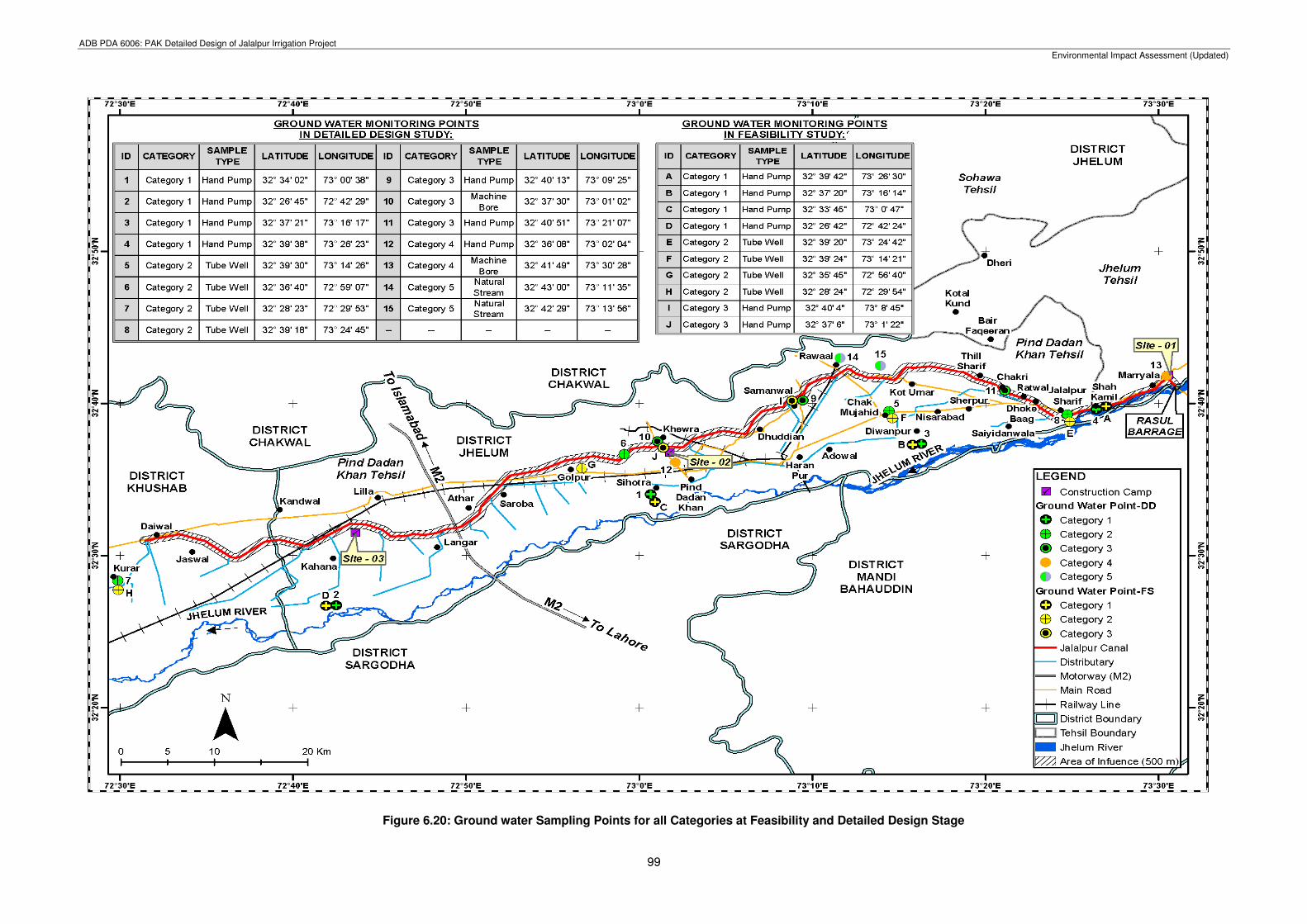
278. Similarly, the ground water sampling for Category-1 has been carried out from the same or near the above ground water sources in winter at the detailed design stage of the JIP. Locations of the ground water sources sampled in winter are referred in Figure 6.22. The summary of results for all Category-1 samples collected in winter are given in Table 6.16 below;
Table 6.16: Summary of Winter Monitoring Results for Category-1 Samples
Sr. No.
Parameter Unit Dhok Noora
Near Sahotra
Dewanpur Shah Kamir
PEQS for Drinking
Water
1 Temperature 0C 22.5 21.3 20.5 22.0 ----
2 pH -- 6.86 7.13 9.6 7.56 6.5-8.5
3 TDS mg/l 1291 1519 144 399 1000
4 TSS mg/l BDL 06 BDL BDL ---
5 Chloride (CI-) mg/l 298 292 34 84 <250
6 Fluoride (F) mg/l 0.22 0.54 0.04 0.18 ≤1.5
7 Taste Non
objectionable/ Acceptable
Object. Object. Non object. Non
object.
Non objectionable/Accepta
ble
8 Odour Non
objectionable/ Acceptable
Non object.
Object. Non object. Non
object.
Non objectionable/Accepta
ble
9 Colour TCU 0 0 0 0 ≤15
10 Iron mg/l 0.05 0.14 0.05 0.09 0.3
11 Sodium mg/l 198 214 22 68 200
12 Nitrate (as NO3)
mg/l 10.5 18.4 3.5 16.3 ≤50
13 Nitrite (as NO2)
mg/l BDL BDL BDL BDL ≤3 (P)
14 Ammonia mg/l 0 0 0 0 1.5
15 Hydrogen Sulphide (H2S)
mg/l BDL BDL BDL BDL 0.05
16 Sulphate mg/l 245 264 24 62 250
17 Lead (Pb) mg/l BDL BDL BDL BDL ≤0.05
18 Total Hardness as CaCO3
mg/l 452 484 52 142 <500
19 Turbidity NTU 0 0 0 0 <5
20 Zinc (Zn) mg/l 0.21 0.84 0.12 0.19 5
21 Manganese (Mn)
mg/l BDL
BDL BDL BDL ≤0.5
22 Benzene mg/l BDL BDL BDL BDL 10-120
23 Aluminum (AI) mg/l BDL BDL BDL BDL ≤0.2
24 Molybdenum mg/l BDL BDL BDL BDL 0.070
25 Chromium (Cr)
mg/l 0.02 0.02 0.02 0.02 ≤0.05
26 Cadmium (Cd) mg/l BDL BDL BDL BDL 0.003
27 Boron (B) mg/l BDL BDL BDL BDL 0.3
28 Barium (Ba) mg/l BDL BDL BDL BDL 0.7
29 Antimony (Sb) mg/l BDL BDL BDL BDL ≤0.005 (P)
30 Arsenic (As) mg/l 0.003 BDL BDL 0.003 ≤0.05 (P) 31 Cyanide (CN) mg/l BDL BDL BDL BDL ≤0.05
32 Mercury (Hg) mg/l BDL BDL BDL BDL ≤0.001
ADB PDA 6006: PAK Detailed Design of Jalalpur Irrigation Project
Environmental Impact Assessment (Updated)
101
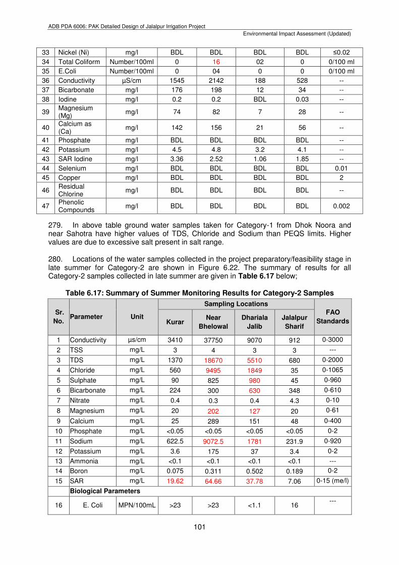
279. In above table ground water samples taken for Category-1 from Dhok Noora and near Sahotra have higher values of TDS, Chloride and Sodium than PEQS limits. Higher values are due to excessive salt present in salt range. 280. Locations of the water samples collected in the project preparatory/feasibility stage in late summer for Category-2 are shown in Figure 6.22. The summary of results for all Category-2 samples collected in late summer are given in Table 6.17 below;
Table 6.17: Summary of Summer Monitoring Results for Category-2 Samples
Sr.
No. Parameter Unit
Sampling Locations
FAO
Standards Kurar Near
Bhelowal
Dhariala
Jalib
Jalalpur
Sharif
1 Conductivity µs/cm 3410 37750 9070 912 0-3000
2 TSS mg/L 3 4 3 3 ---
3 TDS mg/L 1370 18670 5510 680 0-2000
4 Chloride mg/L 560 9495 1849 35 0-1065
5 Sulphate mg/L 90 825 980 45 0-960
6 Bicarbonate mg/L 224 300 630 348 0-610
7 Nitrate mg/L 0.4 0.3 0.4 4.3 0-10
8 Magnesium mg/L 20 202 127 20 0-61
9 Calcium mg/L 25 289 151 48 0-400
10 Phosphate mg/L <0.05 <0.05 <0.05 <0.05 0-2
11 Sodium mg/L 622.5 9072.5 1781 231.9 0-920
12 Potassium mg/L 3.6 175 37 3.4 0-2
13 Ammonia mg/L <0.1 <0.1 <0.1 <0.1 ---
14 Boron mg/L 0.075 0.311 0.502 0.189 0-2
15 SAR mg/L 19.62 64.66 37.78 7.06 0-15 (me/l)
Biological Parameters
16 E. Coli MPN/100mL >23 >23 <1.1 16 ---
33 Nickel (Ni) mg/l BDL BDL BDL BDL ≤0.02
34 Total Coliform Number/100ml 0 16 02 0 0/100 ml
35 E.Coli Number/100ml 0 04 0 0 0/100 ml
36 Conductivity µS/cm 1545 2142 188 528 --
37 Bicarbonate mg/l 176 198 12 34 --
38 Iodine mg/l 0.2 0.2 BDL 0.03 --
39 Magnesium (Mg)
mg/l 74 82 7 28 --
40 Calcium as (Ca)
mg/l 142 156 21 56 --
41 Phosphate mg/l BDL BDL BDL BDL --
42 Potassium mg/l 4.5 4.8 3.2 4.1 --
43 SAR Iodine mg/l 3.36 2.52 1.06 1.85 --
44 Selenium mg/l BDL BDL BDL BDL 0.01
45 Copper mg/l BDL BDL BDL BDL 2
46 Residual Chlorine
mg/l BDL BDL BDL BDL --
47 Phenolic Compounds
mg/l BDL BDL BDL BDL 0.002
ADB PDA 6006: PAK Detailed Design of Jalalpur Irrigation Project
Environmental Impact Assessment (Updated)
102
281. It is evident from the results provided in above table that ground water of Kurar and Jalalpur Sharif villages is fit for irrigation, but samples taken from Dhariala Jalib and Bhelowal shows that irrigation water has higher values of TDS, Magnesium and Sodium. The concentration of Sulphate and bicarbonates is also high in Bhelowal village. Electrical conductivity of the water samples is also high due to presence of salts. The results revealed that irrigation water is saline in nature, which effects the plant growth and causes salinity issues. 282. Similarly, the ground water sampling for Category-2 has been carried out from the same or near the above ground water sources in winter at the detailed design stage of the JIP. Locations of the ground water sources sampled in winter are shown in Figure 6.22. The summary of results for all Category-2 samples collected in winter are given in Table 6.18 below;
Table 6.18: Summary of Winter Monitoring Results for Category-2 Samples
Sr. No.
Parameter Unit Talokar Kurar
Dhok Wenis
Chak Mujhaid
Jalalpur Sharif
PEQS for Drinking
Water
1 Temperature 0C 22.0 21.3 20.5 23.0 ----
2 pH -- 7.34 7.24 6.8 7.51 6.5-8.5
3 TDS mg/l 1417 1523 699 333 1000
4 TSS mg/l 03 BDL BDL 06 ---
5 Chloride (CI-) mg/l 264 310 118 78 <250
6 Fluoride (F) mg/l 0.31 0.18 0.22 0.21 ≤1.5
7 Taste Non
objectionable/ Acceptable
Object. Object. Non object. Non object. Non
objectionable/Acceptable
8 Odour Non
objectionable/ Acceptable
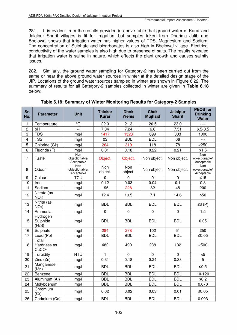
Non object.
Non object.
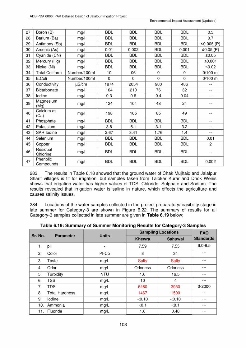
Non object. Non object. Non
objectionable/Acceptable
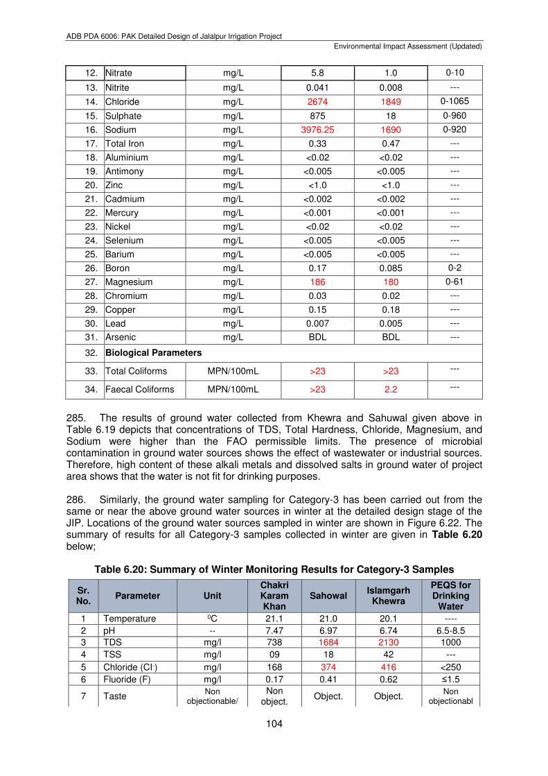
9 Colour TCU 0 0 0 0 ≤15 10 Iron mg/l 0.12 0.03 0.04 0.1 0.3
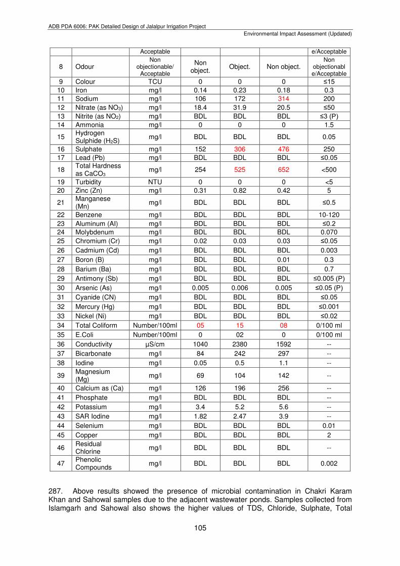
11 Sodium mg/l 195 228 82 48 200
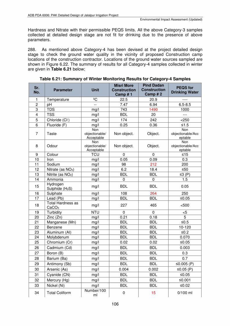
12 Nitrate (as NO3)
mg/l 12.4 10.5 7.1 14.6 ≤50
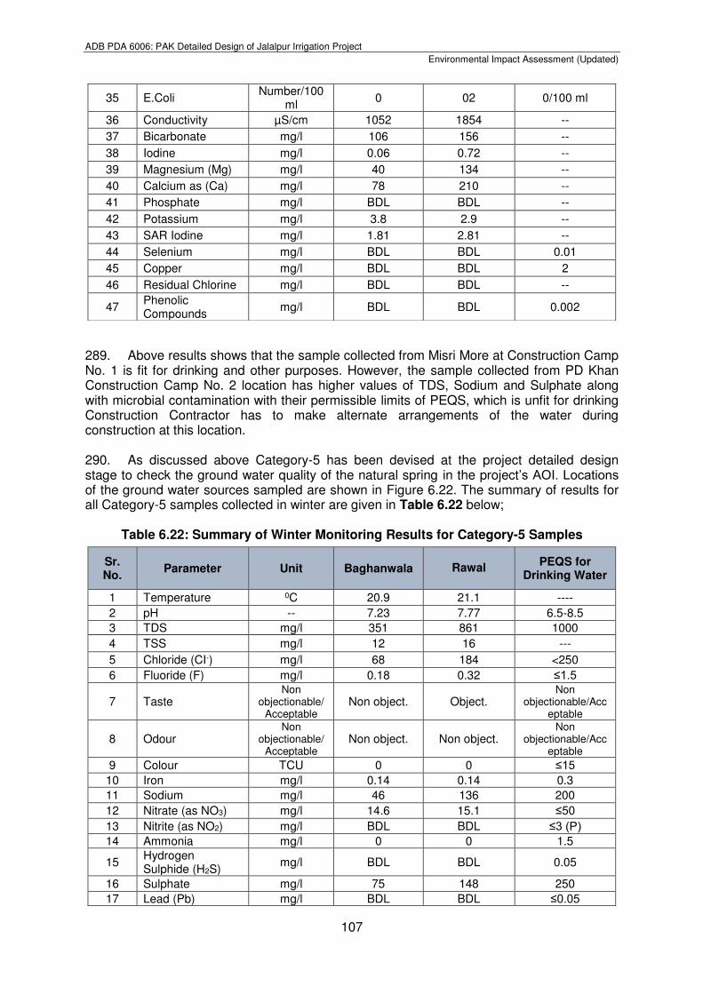
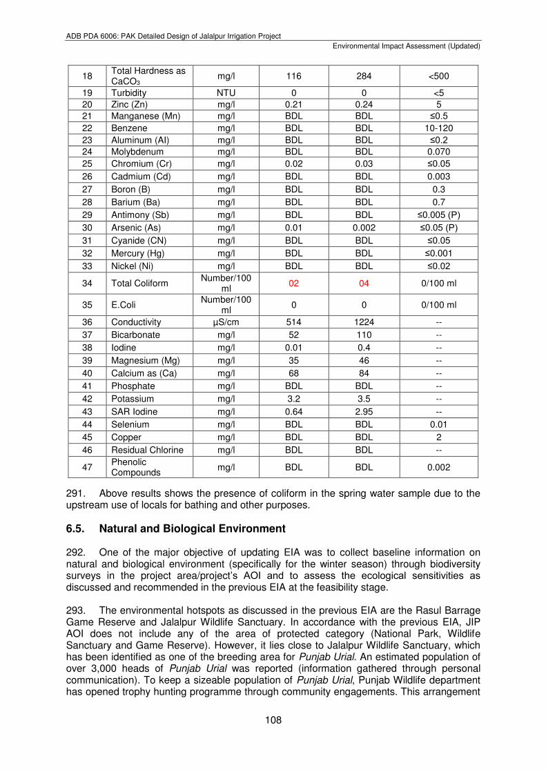
13 Nitrite (as NO2)
mg/l BDL BDL BDL BDL ≤3 (P)
14 Ammonia mg/l 0 0 0 0 1.5
15 Hydrogen Sulphide (H2S)
mg/l BDL BDL BDL BDL 0.05
16 Sulphate mg/l 284 278 102 51 250
17 Lead (Pb) mg/l BDL BDL BDL BDL ≤0.05
18 Total Hardness as CaCO3
mg/l 482 490 238 132 <500
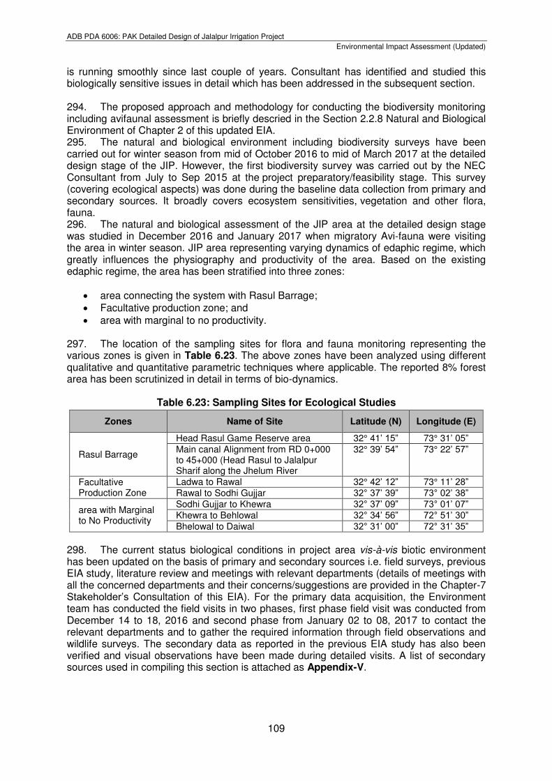
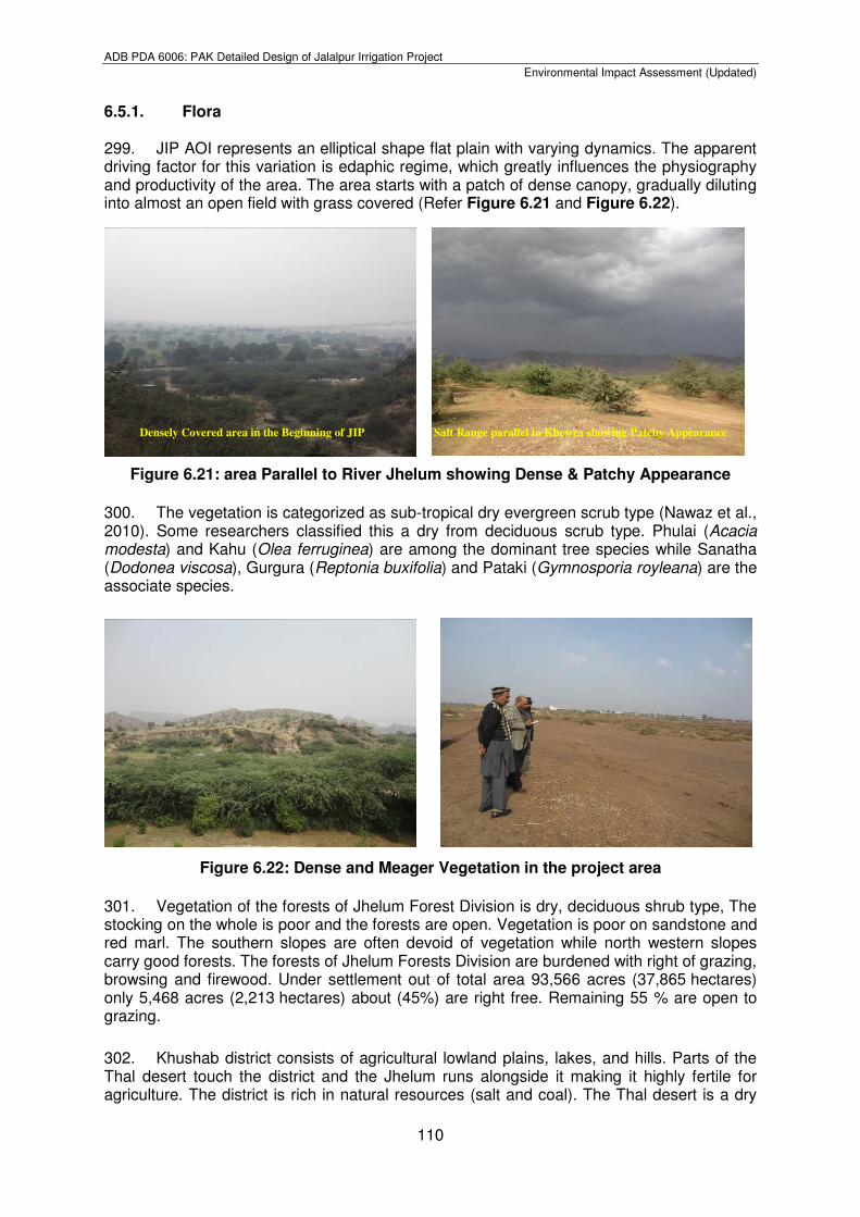
19 Turbidity NTU 1 0 0 0 <5
20 Zinc (Zn) mg/l 0.31 0.18 0.24 0.38 5
21 Manganese (Mn)
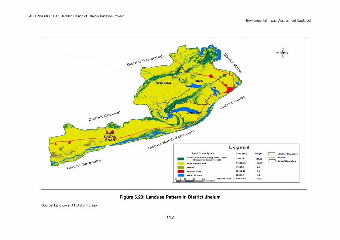
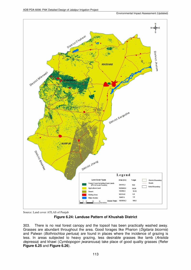
mg/l BDL BDL BDL BDL ≤0.5
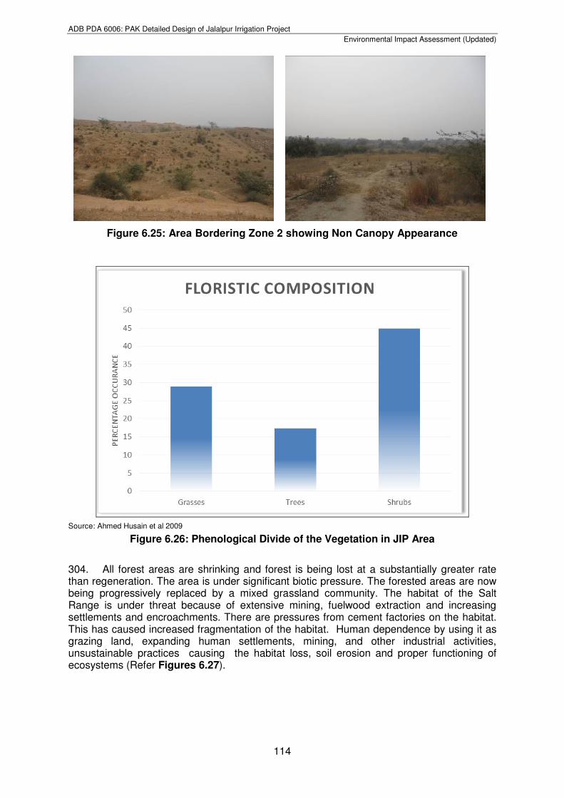
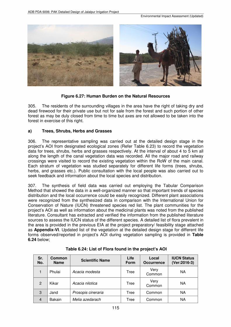
22 Benzene mg/l BDL BDL BDL BDL 10-120
23 Aluminum (AI) mg/l BDL BDL BDL BDL ≤0.2
24 Molybdenum mg/l BDL BDL BDL BDL 0.070
25 Chromium (Cr)
mg/l 0.02 0.02 0.03 0.01 ≤0.05
26 Cadmium (Cd) mg/l BDL BDL BDL BDL 0.003
ADB PDA 6006: PAK Detailed Design of Jalalpur Irrigation Project
Environmental Impact Assessment (Updated)
103
283. The results in Table 6.18 showed that the ground water of Chak Mujhaid and Jalalpur Sharif villages is fit for irrigation, but samples taken from Talokar Kurar and Dhok Wenis shows that irrigation water has higher values of TDS, Chloride, Sulphate and Sodium. The results revealed that irrigation water is saline in nature, which effects the agriculture and causes salinity issues. 284. Locations of the water samples collected in the project preparatory/feasibility stage in late summer for Category-3 are shown in Figure 6.22. The summary of results for all Category-3 samples collected in late summer are given in Table 6.19 below;
Table 6.19: Summary of Summer Monitoring Results for Category-3 Samples
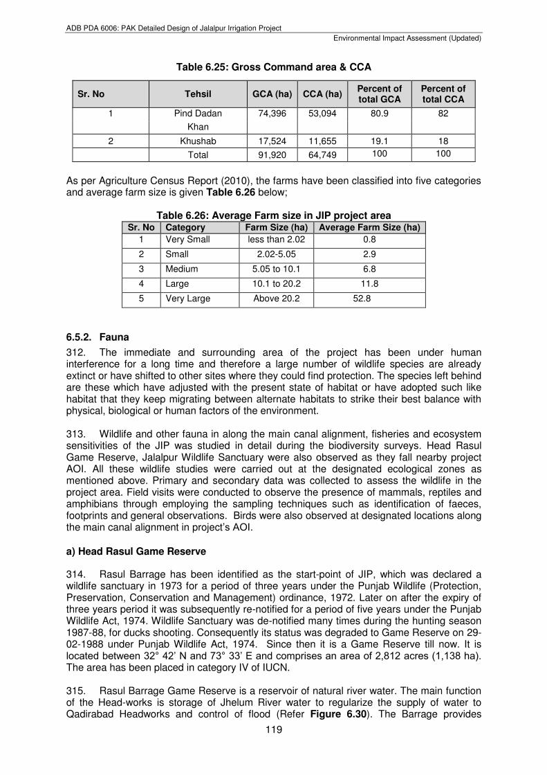
Sr. No. Parameter Units Sampling Locations FAO
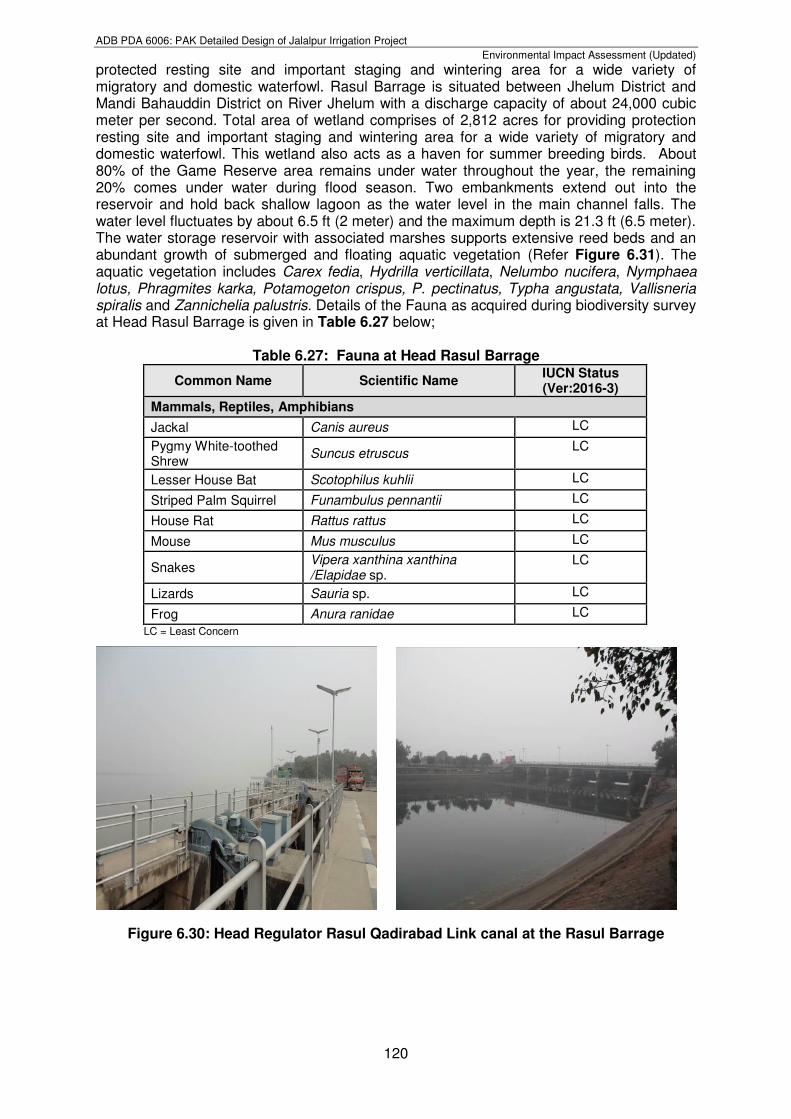
Standards Khewra Sahuwal
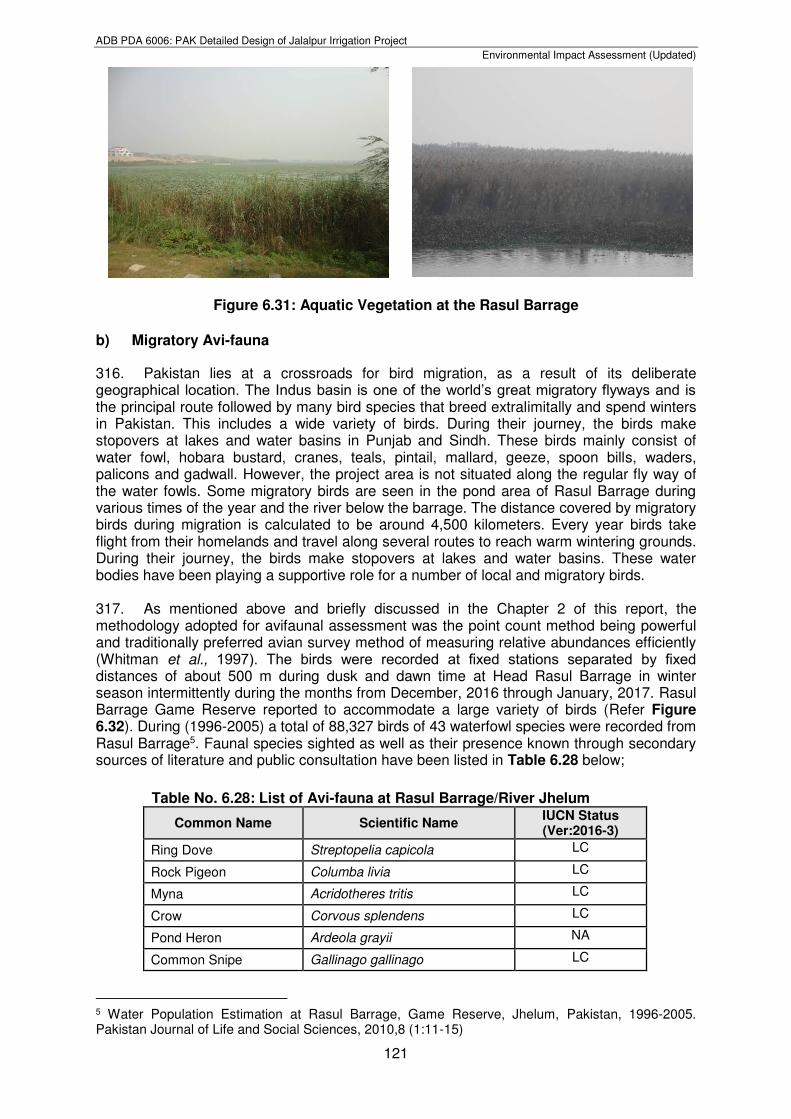
1. pH - 7.59 7.55 6.0-8.5
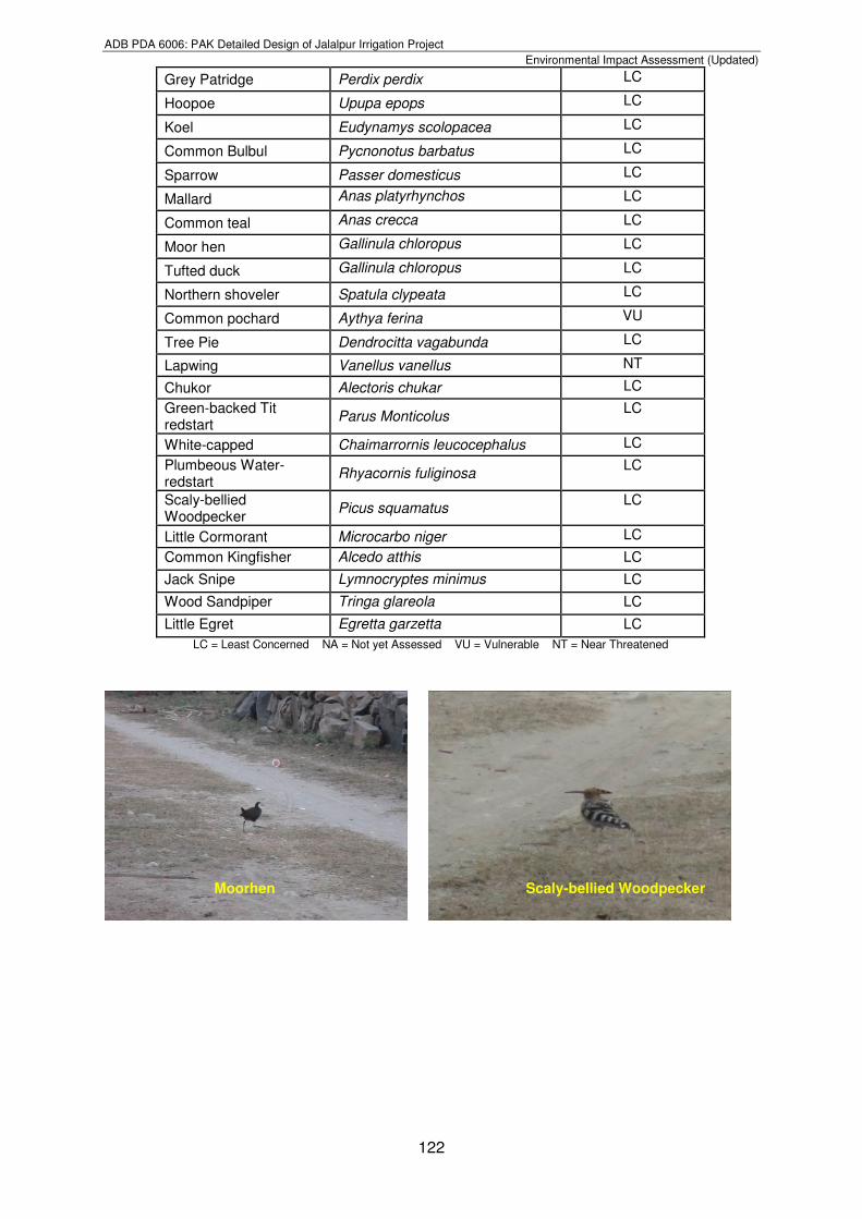
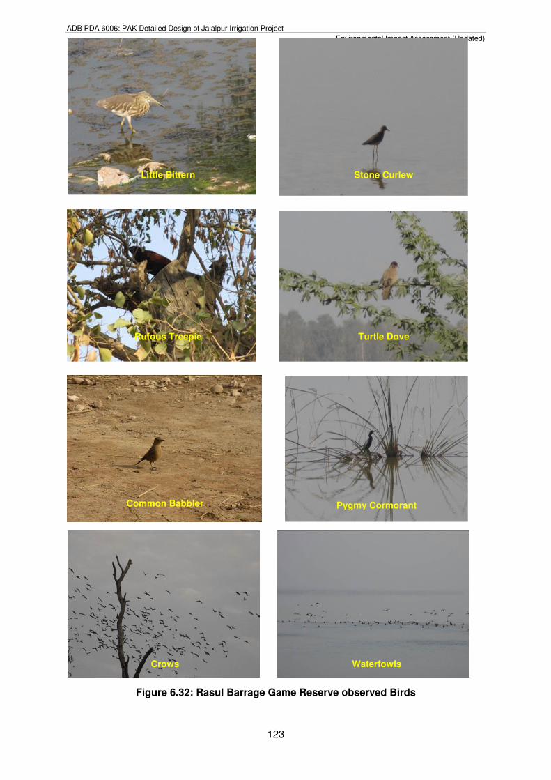
2. Color Pt-Co 8 34 ---
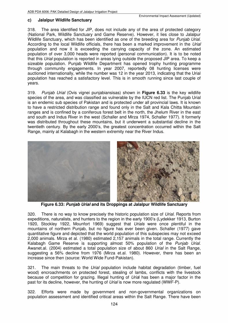
3. Taste mg/L Salty Salty ---
4. Odor mg/L Odorless Odorless ---
5. Turbidity NTU 1.6 16.5 ---
6. TSS mg/L 10 4 ---
7. TDS mg/L 6480 3950 0-2000
8. Total Hardness mg/L 1467 1500 ---
9. Iodine mg/L <0.10 <0.10 ---
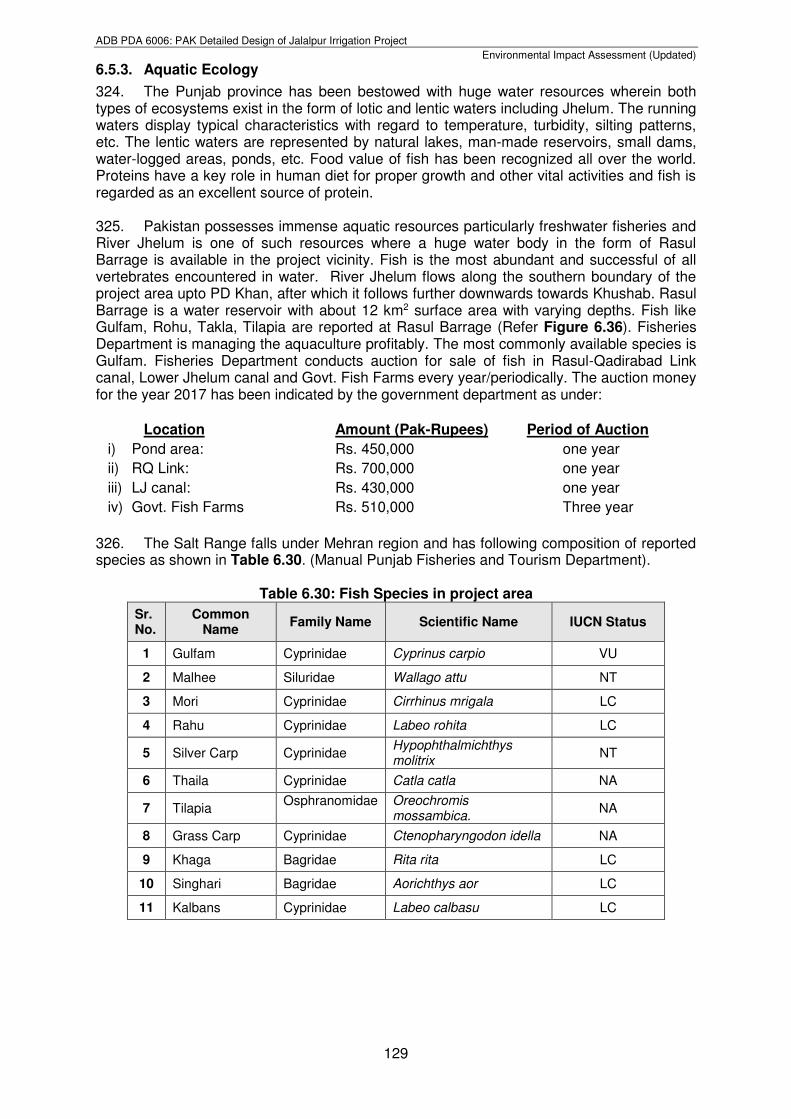
10. Ammonia mg/L <0.1 <0.1 ---
11. Fluoride mg/L 1.6 0.48 ---
27 Boron (B) mg/l BDL BDL BDL BDL 0.3
28 Barium (Ba) mg/l BDL BDL BDL BDL 0.7
29 Antimony (Sb) mg/l BDL BDL BDL BDL ≤0.005 (P) 30 Arsenic (As) mg/l 0.01 0.002 BDL 0.001 ≤0.05 (P) 31 Cyanide (CN) mg/l BDL BDL BDL BDL ≤0.05
32 Mercury (Hg) mg/l BDL BDL BDL BDL ≤0.001
33 Nickel (Ni) mg/l BDL BDL BDL BDL ≤0.02
34 Total Coliform Number/100ml 10 06 0 0 0/100 ml
35 E.Coli Number/100ml 0 0 0 0 0/100 ml
36 Conductivity µS/cm 1874 2054 980 486 --
37 Bicarbonate mg/l 164 210 76 32 --
38 Iodine mg/l 0.3 0.6 0.4 0.04 --
39 Magnesium (Mg)
mg/l 124 104 48 24 --
40 Calcium as (Ca)
mg/l 198 165 85 49 --
41 Phosphate mg/l BDL BDL BDL BDL --
42 Potassium mg/l 3.8 5.1 3.1 3.2 --
43 SAR Iodine mg/l 2.67 3.41 1.76 1.4 --
44 Selenium mg/l BDL BDL BDL BDL 0.01
45 Copper mg/l BDL BDL BDL BDL 2
46 Residual Chlorine
mg/l BDL BDL BDL BDL --
47 Phenolic Compounds
mg/l BDL BDL BDL BDL 0.002
ADB PDA 6006: PAK Detailed Design of Jalalpur Irrigation Project
Environmental Impact Assessment (Updated)
104
12. Nitrate mg/L 5.8 1.0 0-10
13. Nitrite mg/L 0.041 0.008 ---
14. Chloride mg/L 2674 1849 0-1065
15. Sulphate mg/L 875 18 0-960
16. Sodium mg/L 3976.25 1690 0-920
17. Total Iron mg/L 0.33 0.47 ---
18. Aluminium mg/L <0.02 <0.02 ---
19. Antimony mg/L <0.005 <0.005 ---
20. Zinc mg/L <1.0 <1.0 ---
21. Cadmium mg/L <0.002 <0.002 ---
22. Mercury mg/L <0.001 <0.001 ---
23. Nickel mg/L <0.02 <0.02 ---
24. Selenium mg/L <0.005 <0.005 ---
25. Barium mg/L <0.005 <0.005 ---
26. Boron mg/L 0.17 0.085 0-2
27. Magnesium mg/L 186 180 0-61
28. Chromium mg/L 0.03 0.02 ---
29. Copper mg/L 0.15 0.18 ---
30. Lead mg/L 0.007 0.005 ---
31. Arsenic mg/L BDL BDL ---
32. Biological Parameters
33. Total Coliforms MPN/100mL >23 >23 ---
34. Faecal Coliforms MPN/100mL >23 2.2 ---
285. The results of ground water collected from Khewra and Sahuwal given above in Table 6.19 depicts that concentrations of TDS, Total Hardness, Chloride, Magnesium, and Sodium were higher than the FAO permissible limits. The presence of microbial contamination in ground water sources shows the effect of wastewater or industrial sources. Therefore, high content of these alkali metals and dissolved salts in ground water of project area shows that the water is not fit for drinking purposes. 286. Similarly, the ground water sampling for Category-3 has been carried out from the same or near the above ground water sources in winter at the detailed design stage of the JIP. Locations of the ground water sources sampled in winter are shown in Figure 6.22. The summary of results for all Category-3 samples collected in winter are given in Table 6.20 below;
Table 6.20: Summary of Winter Monitoring Results for Category-3 Samples
Sr. No.
Parameter Unit Chakri Karam Khan
Sahowal Islamgarh Khewra
PEQS for Drinking
Water
1 Temperature 0C 21.1 21.0 20.1 ----
2 pH -- 7.47 6.97 6.74 6.5-8.5
3 TDS mg/l 738 1684 2130 1000
4 TSS mg/l 09 18 42 ---
5 Chloride (CI-) mg/l 168 374 416 <250
6 Fluoride (F) mg/l 0.17 0.41 0.62 ≤1.5
7 Taste Non
objectionable/ Non
object. Object. Object.
Non objectionabl
ADB PDA 6006: PAK Detailed Design of Jalalpur Irrigation Project
Environmental Impact Assessment (Updated)
105
287. Above results showed the presence of microbial contamination in Chakri Karam Khan and Sahowal samples due to the adjacent wastewater ponds. Samples collected from Islamgarh and Sahowal also shows the higher values of TDS, Chloride, Sulphate, Total
Acceptable e/Acceptable
8 Odour Non
objectionable/ Acceptable
Non object.
Object. Non object. Non
objectionable/Acceptable
9 Colour TCU 0 0 0 ≤15 10 Iron mg/l 0.14 0.23 0.18 0.3
11 Sodium mg/l 106 172 314 200
12 Nitrate (as NO3) mg/l 18.4 31.9 20.5 ≤50
13 Nitrite (as NO2) mg/l BDL BDL BDL ≤3 (P) 14 Ammonia mg/l 0 0 0 1.5
15 Hydrogen Sulphide (H2S)
mg/l BDL BDL BDL 0.05
16 Sulphate mg/l 152 306 476 250
17 Lead (Pb) mg/l BDL BDL BDL ≤0.05
18 Total Hardness as CaCO3
mg/l 254 525 652 <500
19 Turbidity NTU 0 0 0 <5
20 Zinc (Zn) mg/l 0.31 0.82 0.42 5
21 Manganese (Mn)
mg/l BDL BDL BDL ≤0.5
22 Benzene mg/l BDL BDL BDL 10-120
23 Aluminum (AI) mg/l BDL BDL BDL ≤0.2
24 Molybdenum mg/l BDL BDL BDL 0.070
25 Chromium (Cr) mg/l 0.02 0.03 0.03 ≤0.05
26 Cadmium (Cd) mg/l BDL BDL BDL 0.003
27 Boron (B) mg/l BDL BDL 0.01 0.3
28 Barium (Ba) mg/l BDL BDL BDL 0.7
29 Antimony (Sb) mg/l BDL BDL BDL ≤0.005 (P) 30 Arsenic (As) mg/l 0.005 0.006 0.005 ≤0.05 (P) 31 Cyanide (CN) mg/l BDL BDL BDL ≤0.05
32 Mercury (Hg) mg/l BDL BDL BDL ≤0.001
33 Nickel (Ni) mg/l BDL BDL BDL ≤0.02
34 Total Coliform Number/100ml 05 15 08 0/100 ml
35 E.Coli Number/100ml 0 02 0 0/100 ml
36 Conductivity µS/cm 1040 2380 1592 --
37 Bicarbonate mg/l 84 242 297 --
38 Iodine mg/l 0.05 0.5 1.1 --
39 Magnesium (Mg)
mg/l 69 104 142 --
40 Calcium as (Ca) mg/l 126 196 256 --
41 Phosphate mg/l BDL BDL BDL --
42 Potassium mg/l 3.4 5.2 5.6 --
43 SAR Iodine mg/l 1.82 2.47 3.9 --
44 Selenium mg/l BDL BDL BDL 0.01
45 Copper mg/l BDL BDL BDL 2
46 Residual Chlorine
mg/l BDL BDL BDL --
47 Phenolic Compounds
mg/l BDL BDL BDL 0.002
ADB PDA 6006: PAK Detailed Design of Jalalpur Irrigation Project
Environmental Impact Assessment (Updated)
106
Hardness and Nitrate with their permissible PEQS limits. All the above Category-3 samples collected at detailed design stage are not fit for drinking due to the presence of above parameters. 288. As mentioned above Category-4 has been devised at the project detailed design stage to check the ground water quality in the vicinity of proposed Construction camp locations of the construction contractor. Locations of the ground water sources sampled are shown in Figure 6.22. The summary of results for all Category-4 samples collected in winter are given in Table 6.21 below;
Table 6.21: Summary of Winter Monitoring Results for Category-4 Samples
Sr. No.
Parameter Unit Misri More
Construction Camp # 1
Pind Dadan Construction
Camp # 2
PEQS for Drinking Water
1 Temperature 0C 22.5 20.9 ----
2 pH -- 7.47 6.94 6.5-8.5
3 TDS mg/l 743 1490 1000
4 TSS mg/l BDL 20 ---
5 Chloride (CI-) mg/l 174 242 <250
6 Fluoride (F) mg/l 0.25 0.36 ≤1.5
7 Taste Non
objectionable/ Acceptable
Non object. Object. Non
objectionable/Acceptable
8 Odour Non
objectionable/ Acceptable
Non object. Object. Non
objectionable/Acceptable
9 Colour TCU 0 0 ≤15 10 Iron mg/l 0.05 0.09 0.3
11 Sodium mg/l 98 212 200
12 Nitrate (as NO3) mg/l 6.2 18.4 ≤50
13 Nitrite (as NO2) mg/l BDL BDL ≤3 (P) 14 Ammonia mg/l 0 0 1.5
15 Hydrogen Sulphide (H2S)
mg/l BDL BDL 0.05
16 Sulphate mg/l 108 264 250
17 Lead (Pb) mg/l BDL BDL ≤0.05
18 Total Hardness as CaCO3
mg/l 227 465 <500
19 Turbidity NTU 0 0 <5
20 Zinc (Zn) mg/l 0.21 0.18 5
21 Manganese (Mn) mg/l BDL BDL ≤0.5
22 Benzene mg/l BDL BDL 10-120
23 Aluminum (AI) mg/l BDL BDL ≤0.2
24 Molybdenum mg/l BDL BDL 0.070
25 Chromium (Cr) mg/l 0.02 0.02 ≤0.05
26 Cadmium (Cd) mg/l BDL BDL 0.003
27 Boron (B) mg/l BDL BDL 0.3
28 Barium (Ba) mg/l BDL BDL 0.7
29 Antimony (Sb) mg/l BDL BDL ≤0.005 (P)
30 Arsenic (As) mg/l 0.004 0.002 ≤0.05 (P) 31 Cyanide (CN) mg/l BDL BDL ≤0.05
32 Mercury (Hg) mg/l BDL BDL ≤0.001
33 Nickel (Ni) mg/l BDL BDL ≤0.02
34 Total Coliform Number/100
ml 0 15 0/100 ml
ADB PDA 6006: PAK Detailed Design of Jalalpur Irrigation Project
Environmental Impact Assessment (Updated)
107
289. Above results shows that the sample collected from Misri More at Construction Camp No. 1 is fit for drinking and other purposes. However, the sample collected from PD Khan Construction Camp No. 2 location has higher values of TDS, Sodium and Sulphate along with microbial contamination with their permissible limits of PEQS, which is unfit for drinking Construction Contractor has to make alternate arrangements of the water during construction at this location. 290. As discussed above Category-5 has been devised at the project detailed design stage to check the ground water quality of the natural spring in the project’s AOI. Locations of the ground water sources sampled are shown in Figure 6.22. The summary of results for all Category-5 samples collected in winter are given in Table 6.22 below;
Table 6.22: Summary of Winter Monitoring Results for Category-5 Samples
35 E.Coli Number/100
ml 0 02 0/100 ml
36 Conductivity µS/cm 1052 1854 --
37 Bicarbonate mg/l 106 156 --
38 Iodine mg/l 0.06 0.72 --
39 Magnesium (Mg) mg/l 40 134 --
40 Calcium as (Ca) mg/l 78 210 --
41 Phosphate mg/l BDL BDL --
42 Potassium mg/l 3.8 2.9 --
43 SAR Iodine mg/l 1.81 2.81 --
44 Selenium mg/l BDL BDL 0.01
45 Copper mg/l BDL BDL 2
46 Residual Chlorine mg/l BDL BDL --
47 Phenolic Compounds
mg/l BDL BDL 0.002
Sr. No.
Parameter Unit Baghanwala
Rawal
PEQS for Drinking Water
1 Temperature 0C 20.9 21.1 ----
2 pH -- 7.23 7.77 6.5-8.5
3 TDS mg/l 351 861 1000
4 TSS mg/l 12 16 ---
5 Chloride (CI-) mg/l 68 184 <250
6 Fluoride (F) mg/l 0.18 0.32 ≤1.5
7 Taste Non
objectionable/ Acceptable
Non object. Object. Non
objectionable/Acceptable
8 Odour Non
objectionable/ Acceptable
Non object. Non object. Non
objectionable/Acceptable
9 Colour TCU 0 0 ≤15 10 Iron mg/l 0.14 0.14 0.3
11 Sodium mg/l 46 136 200
12 Nitrate (as NO3) mg/l 14.6 15.1 ≤50
13 Nitrite (as NO2) mg/l BDL BDL ≤3 (P) 14 Ammonia mg/l 0 0 1.5
15 Hydrogen Sulphide (H2S)
mg/l BDL BDL 0.05
16 Sulphate mg/l 75 148 250
17 Lead (Pb) mg/l BDL BDL ≤0.05
ADB PDA 6006: PAK Detailed Design of Jalalpur Irrigation Project
Environmental Impact Assessment (Updated)
108
291. Above results shows the presence of coliform in the spring water sample due to the upstream use of locals for bathing and other purposes.
6.5. Natural and Biological Environment 292. One of the major objective of updating EIA was to collect baseline information on natural and biological environment (specifically for the winter season) through biodiversity surveys in the project area/project’s AOI and to assess the ecological sensitivities as discussed and recommended in the previous EIA at the feasibility stage. 293. The environmental hotspots as discussed in the previous EIA are the Rasul Barrage Game Reserve and Jalalpur Wildlife Sanctuary. In accordance with the previous EIA, JIP AOI does not include any of the area of protected category (National Park, Wildlife Sanctuary and Game Reserve). However, it lies close to Jalalpur Wildlife Sanctuary, which has been identified as one of the breeding area for Punjab Urial. An estimated population of over 3,000 heads of Punjab Urial was reported (information gathered through personal communication). To keep a sizeable population of Punjab Urial, Punjab Wildlife department has opened trophy hunting programme through community engagements. This arrangement
18 Total Hardness as CaCO3
mg/l 116 284 <500
19 Turbidity NTU 0 0 <5
20 Zinc (Zn) mg/l 0.21 0.24 5
21 Manganese (Mn) mg/l BDL BDL ≤0.5
22 Benzene mg/l BDL BDL 10-120
23 Aluminum (AI) mg/l BDL BDL ≤0.2
24 Molybdenum mg/l BDL BDL 0.070
25 Chromium (Cr) mg/l 0.02 0.03 ≤0.05
26 Cadmium (Cd) mg/l BDL BDL 0.003
27 Boron (B) mg/l BDL BDL 0.3
28 Barium (Ba) mg/l BDL BDL 0.7
29 Antimony (Sb) mg/l BDL BDL ≤0.005 (P) 30 Arsenic (As) mg/l 0.01 0.002 ≤0.05 (P) 31 Cyanide (CN) mg/l BDL BDL ≤0.05
32 Mercury (Hg) mg/l BDL BDL ≤0.001
33 Nickel (Ni) mg/l BDL BDL ≤0.02
34 Total Coliform Number/100
ml 02 04 0/100 ml
35 E.Coli Number/100
ml 0 0 0/100 ml
36 Conductivity µS/cm 514 1224 --
37 Bicarbonate mg/l 52 110 --
38 Iodine mg/l 0.01 0.4 --
39 Magnesium (Mg) mg/l 35 46 --
40 Calcium as (Ca) mg/l 68 84 --
41 Phosphate mg/l BDL BDL --
42 Potassium mg/l 3.2 3.5 --
43 SAR Iodine mg/l 0.64 2.95 --
44 Selenium mg/l BDL BDL 0.01
45 Copper mg/l BDL BDL 2
46 Residual Chlorine mg/l BDL BDL --
47 Phenolic Compounds
mg/l BDL BDL 0.002
ADB PDA 6006: PAK Detailed Design of Jalalpur Irrigation Project
Environmental Impact Assessment (Updated)
109
is running smoothly since last couple of years. Consultant has identified and studied this biologically sensitive issues in detail which has been addressed in the subsequent section. 294. The proposed approach and methodology for conducting the biodiversity monitoring including avifaunal assessment is briefly descried in the Section 2.2.8 Natural and Biological Environment of Chapter 2 of this updated EIA. 295. The natural and biological environment including biodiversity surveys have been carried out for winter season from mid of October 2016 to mid of March 2017 at the detailed design stage of the JIP. However, the first biodiversity survey was carried out by the NEC Consultant from July to Sep 2015 at the project preparatory/feasibility stage. This survey (covering ecological aspects) was done during the baseline data collection from primary and secondary sources. It broadly covers ecosystem sensitivities, vegetation and other flora, fauna. 296. The natural and biological assessment of the JIP area at the detailed design stage was studied in December 2016 and January 2017 when migratory Avi-fauna were visiting the area in winter season. JIP area representing varying dynamics of edaphic regime, which greatly influences the physiography and productivity of the area. Based on the existing edaphic regime, the area has been stratified into three zones:
area connecting the system with Rasul Barrage;
Facultative production zone; and
area with marginal to no productivity.
297. The location of the sampling sites for flora and fauna monitoring representing the various zones is given in Table 6.23. The above zones have been analyzed using different qualitative and quantitative parametric techniques where applicable. The reported 8% forest area has been scrutinized in detail in terms of bio-dynamics.
Table 6.23: Sampling Sites for Ecological Studies
Zones Name of Site Latitude (N) Longitude (E)
Rasul Barrage
Head Rasul Game Reserve area 32° 41’ 15” 73° 31’ 05” Main canal Alignment from RD 0+000 to 45+000 (Head Rasul to Jalalpur Sharif along the Jhelum River
32° 39’ 54” 73° 22’ 57”
Facultative Production Zone
Ladwa to Rawal 32° 42’ 12” 73° 11’ 28” Rawal to Sodhi Gujjar 32° 37’ 39” 73° 02’ 38”
area with Marginal to No Productivity
Sodhi Gujjar to Khewra 32° 37’ 09” 73° 01’ 07” Khewra to Behlowal 32° 34’ 56” 72° 51’ 30” Bhelowal to Daiwal 32° 31’ 00” 72° 31’ 35”
298. The current status biological conditions in project area vis-à-vis biotic environment has been updated on the basis of primary and secondary sources i.e. field surveys, previous EIA study, literature review and meetings with relevant departments (details of meetings with all the concerned departments and their concerns/suggestions are provided in the Chapter-7 Stakeholder’s Consultation of this EIA). For the primary data acquisition, the Environment team has conducted the field visits in two phases, first phase field visit was conducted from December 14 to 18, 2016 and second phase from January 02 to 08, 2017 to contact the relevant departments and to gather the required information through field observations and wildlife surveys. The secondary data as reported in the previous EIA study has also been verified and visual observations have been made during detailed visits. A list of secondary sources used in compiling this section is attached as Appendix-V.
ADB PDA 6006: PAK Detailed Design of Jalalpur Irrigation Project
Environmental Impact Assessment (Updated)
110
6.5.1. Flora 299. JIP AOI represents an elliptical shape flat plain with varying dynamics. The apparent driving factor for this variation is edaphic regime, which greatly influences the physiography and productivity of the area. The area starts with a patch of dense canopy, gradually diluting into almost an open field with grass covered (Refer Figure 6.21 and Figure 6.22).
Figure 6.21: area Parallel to River Jhelum showing Dense & Patchy Appearance
300. The vegetation is categorized as sub-tropical dry evergreen scrub type (Nawaz et al., 2010). Some researchers classified this a dry from deciduous scrub type. Phulai (Acacia modesta) and Kahu (Olea ferruginea) are among the dominant tree species while Sanatha (Dodonea viscosa), Gurgura (Reptonia buxifolia) and Pataki (Gymnosporia royleana) are the associate species.
Figure 6.22: Dense and Meager Vegetation in the project area
301. Vegetation of the forests of Jhelum Forest Division is dry, deciduous shrub type, The stocking on the whole is poor and the forests are open. Vegetation is poor on sandstone and red marl. The southern slopes are often devoid of vegetation while north western slopes carry good forests. The forests of Jhelum Forests Division are burdened with right of grazing, browsing and firewood. Under settlement out of total area 93,566 acres (37,865 hectares) only 5,468 acres (2,213 hectares) about (45%) are right free. Remaining 55 % are open to grazing.
302. Khushab district consists of agricultural lowland plains, lakes, and hills. Parts of the Thal desert touch the district and the Jhelum runs alongside it making it highly fertile for agriculture. The district is rich in natural resources (salt and coal). The Thal desert is a dry
Densely Covered area in the Beginning of JIP Salt Range parallel to Khewra showing Patchy Appearance

ADB PDA 6006: PAK Detailed Design of Jalalpur Irrigation Project
Environmental Impact Assessment (Updated)
111
desert with scarce vegetation, mostly thorny bushes, over a breadth of 70 miles (110 km) and is situated between the Indus river and the Jhelum river. In Thal, the whole land is arid and depends upon the weather condition, but now with the project of greater Thal canal the most part of the desert will be irrigated. The landuse distribution in District Khushab and Jhelum is shown in Figure 6.23 and Figure 6.24.
ADB PDA 6006: PAK Detailed Design of Jalalpur Irrigation Project
Environmental Impact Assessment (Updated)
112
Figure 6.23: Landuse Pattern in District Jhelum
Source: Land cover ATLAS of Punjab
ADB PDA 6006: PAK Detailed Design of Jalalpur Irrigation Project
Environmental Impact Assessment (Updated)
113
Source: Land cover ATLAS of Punjab
Figure 6.24: Landuse Pattern of Khushab District
303. There is no real forest canopy and the topsoil has been practically washed away. Grasses are abundant throughout the area. Good forages like Pharion (Digitaria bicornis) and Palwan (Bothriochloa pertusa) are found in places where the incidence of grazing is less. In areas subjected to heavy grazing, less desirable grasses like lamb (Aristida depressa) and khawi (Cymbopogon jwarancusa) take place of good quality grasses (Refer Figure 6.25 and Figure 6.26).
ADB PDA 6006: PAK Detailed Design of Jalalpur Irrigation Project
Environmental Impact Assessment (Updated)
114
Figure 6.25: Area Bordering Zone 2 showing Non Canopy Appearance
Source: Ahmed Husain et al 2009
Figure 6.26: Phenological Divide of the Vegetation in JIP Area
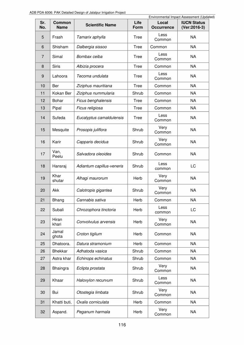
304. All forest areas are shrinking and forest is being lost at a substantially greater rate than regeneration. The area is under significant biotic pressure. The forested areas are now being progressively replaced by a mixed grassland community. The habitat of the Salt Range is under threat because of extensive mining, fuelwood extraction and increasing settlements and encroachments. There are pressures from cement factories on the habitat. This has caused increased fragmentation of the habitat. Human dependence by using it as grazing land, expanding human settlements, mining, and other industrial activities, unsustainable practices causing the habitat loss, soil erosion and proper functioning of ecosystems (Refer Figures 6.27).
ADB PDA 6006: PAK Detailed Design of Jalalpur Irrigation Project
Environmental Impact Assessment (Updated)
115
Figure 6.27: Human Burden on the Natural Resources
305. The residents of the surrounding villages in the area have the right of taking dry and dead firewood for their private use but not for sale from the forest and such portion of other forest as may be duly closed from time to time but axes are not allowed to be taken into the forest in exercise of this right.
a) Trees, Shrubs, Herbs and Grasses
306. The representative sampling was carried out at the detailed design stage in the project’s AOI from designated ecological zones (Refer Table 6.23) to record the vegetation data for trees, shrubs, herbs and grasses respectively. At the interval of about 4 to 5 km all along the length of the canal vegetation data was recorded. All the major road and railway crossings were visited to record the existing vegetation within the RoW of the main canal. Each stratum of vegetation was studied separately for different life forms (trees, shrubs, herbs, and grasses etc.). Public consultation with the local people was also carried out to seek feedback and information about the local species and distribution. 307. The synthesis of field data was carried out employing the Tabular Comparison Method that showed the data in a well-organized manner so that important trends of species distribution and the local occurrence could be easily recognized. Different plant associations were recognized from the synthesized data in comparison with the International Union for Conservation of Nature (IUCN) threatened species red list. The plant communities for the project’s AOI as well as information about the medicinal plants was noted from the published literature. Consultant has extracted and verified the information from the published literature sources to assess the IUCN status of the different species. A detailed list of flora prevalent in the area is provided in the previous EIA at the project preparatory/ feasibility stage attached as Appendix-VI. Updated list of the vegetation at the detailed design stage for different life forms observed/reported in project’s AOI during vegetation sampling is provided in Table 6.24 below;
Table 6.24: List of Flora found in the project’s AOI
Sr. No.
Common Name
Scientific Name Life
Form Local
Occurrence IUCN Status (Ver:2016-3)
1 Phulai Acacia modesta Tree Very
Common NA
2 Kikar Acacia nilotica Tree Very
Common NA
3 Jand Prosopis cineraria Tree Common NA
4 Bakain Melia azedarach Tree Common NA
ADB PDA 6006: PAK Detailed Design of Jalalpur Irrigation Project
Environmental Impact Assessment (Updated)
116
Sr. No.
Common Name
Scientific Name Life
Form Local
Occurrence IUCN Status (Ver:2016-3)
5 Frash Tamarix aphylla Tree Less
Common NA
6 Shisham Dalbergia sissoo Tree Common NA
7 Simal Bombax ceiba Tree Less
Common NA
8 Siris Albizia procera Tree Common NA
9 Lahoora Tecoma undulata Tree Less
Common NA
10 Ber Ziziphus mauritiana Tree Common NA
11 Kokan Ber Ziziphus nummularia Shrub Common NA
12 Bohar Ficus benghalensis Tree Common NA
13 Pipal Ficus religiosa Tree Common NA
14 Sufeda Eucalyptus camaldulensis Tree Less
Common NA
15 Mesquite Prosopis juliflora Shrub Very
Common NA
16 Karir Capparis decidua Shrub Very
Common NA
17 Van, Peelu
Salvadora oleoides Shrub Common NA
18 Hansraj Adiantum capillus-veneris Shrub Less
common LC
19 Khar shutar
Alhagi maurorum Herb Very
Common NA
20 Akk Calotropis gigantea Shrub Very
Common NA
21 Bhang Cannabis sativa Herb Common NA
22 Subali Chrozophora tinctoria Herb Less
common LC
23 Hiran khari
Convolvulus arvensis Herb Very
Common NA
24 Jamal ghota
Croton tiglium Herb Common NA
25 Dhatoora. Datura stramonium Herb Common NA
26 Bhekkar Adhatoda vasica Shrub Common NA
27 Astra khar Echinops echinatus Shrub Common NA
28 Bhaingra Eclipta prostata Shrub Very
Common NA
29 Khaar Haloxylon recurvum Shrub Less
Common NA
30 Bui Otostegia limbata Shrub Very
Common NA
31 Khatti buti, Oxalis corniculata Herb Common NA
32 Aspand. Peganum harmala Herb Very
Common NA
ADB PDA 6006: PAK Detailed Design of Jalalpur Irrigation Project
Environmental Impact Assessment (Updated)
117
Sr. No.
Common Name
Scientific Name Life
Form Local
Occurrence IUCN Status (Ver:2016-3)
33 Rani phal Polygonum plebejum Herb Common NA
34 Khurfa Portulaca oleracea Herb Very
Common NA
35 Arund Ricinus communis Shrub Common NA
36 Pataki Gymnosporia royleana Shrub Common NA
37 Mako Solanum miniatum Herb Very
Common NA
38 Katai khurd
Solanum surattense Herb Very
Common NA
39 Laani Suaeda fruticosa Herb Very
Common NA
40 Bas khapra.
Trianthema govindia Herb Common NA
41 Chota gokhru
Tribulus terrestris Herb Common NA
42 Asgand Withania somnifera Herb Very
Common NA
43 Khabbal Cynodon dactylon Grass Common NA
44 Khawi Cymbopogon jwarancusa Grass Common NA
45 Sarkanda Saccharum munja Grass Common NA
46 Dhaman Cenchrus ciliaris Grass Common NA
47 Suriala Heteropogon contortus Grass Common NA
48 Sawank Panicum antidotale Grass Common NA
49 Lamb Aristida depressa Grass Common NA
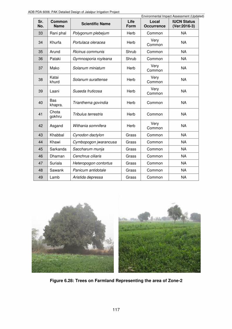
Figure 6.28: Trees on Farmland Representing the area of Zone-2
ADB PDA 6006: PAK Detailed Design of Jalalpur Irrigation Project
Environmental Impact Assessment (Updated)
118
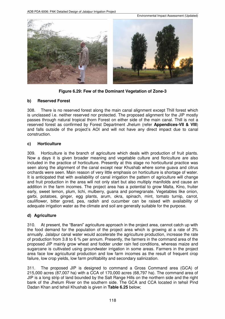
Figure 6.29: Few of the Dominant Vegetation of Zone-3
b) Reserved Forest
308. There is no reserved forest along the main canal alignment except Thill forest which is unclassed i.e. neither reserved nor protected. The proposed alignment for the JIP mostly passes through natural tropical thorn Forest on either side of the main canal. Thill is not a reserved forest as confirmed by Forest Department Jhelum (refer Appendices-VII & VIII) and falls outside of the project’s AOI and will not have any direct impact due to canal construction. c) Horticulture
309. Horticulture is the branch of agriculture which deals with production of fruit plants. Now a days it is given broader meaning and vegetable culture and floriculture are also included in the practice of horticulture. Presently at this stage no horticultural practice was seen along the alignment of the canal except near Khushab where some guava and citrus orchards were seen. Main reason of very little emphasis on horticulture is shortage of water. It is anticipated that with availability of canal irrigation the pattern of agriculture will change and fruit production in the area will not only start but also multiply manifolds and cause an addition in the farm incomes. The project area has a potential to grow Malta, Kino, fruiter early, sweet lemon, plum, lichi, mulberry, guana and pomegranate. Vegetables like onion, garbi, potatoes, ginger, egg plants, arum, okra, spinach, mint, tomato turnip, carrot, cauliflower, bitter gored, pea, radish and cucumber can be raised with availability of adequate irrigation water as the climate and soil are generally suitable for the purpose. d) Agriculture
310. At present, the “Barani” agriculture approach in the project area, cannot catch up with the food demand for the population of the project area which is growing at a rate of 3% annually. Jalalpur canal water would accelerate the agriculture production, increase the rate of production from 3.8 to 6 % per annum. Presently, the farmers in the command area of the proposed JIP mainly grow wheat and fodder under rain fed conditions, whereas maize and sugarcane is cultivated using groundwater irrigation in some areas. Farmers in the project area face low agricultural production and low farm incomes as the result of frequent crop failure, low crop yields, low farm profitability and secondary salinization. 311. The proposed JIP is designed to command a Gross Command area (GCA) of 215,000 acres (87,007 ha) with a CCA of 170,000 acres (68,797 ha). The command area of JIP is a long strip of land bounded by the Salt Range Hills on the northern side and the right bank of the Jhelum River on the southern side. The GCA and CCA located in tehsil Pind Dadan Khan and tehsil Khushab is given in Table 6.25 below;
ADB PDA 6006: PAK Detailed Design of Jalalpur Irrigation Project
Environmental Impact Assessment (Updated)
119
Table 6.25: Gross Command area & CCA
Sr. No Tehsil GCA (ha) CCA (ha) Percent of total GCA
Percent of total CCA
1 Pind Dadan 74,396 53,094 80.9 82
Khan
2 Khushab 17,524 11,655 19.1 18
Total 91,920 64,749 100 100
As per Agriculture Census Report (2010), the farms have been classified into five categories and average farm size is given Table 6.26 below;
Table 6.26: Average Farm size in JIP project area Sr. No Category Farm Size (ha) Average Farm Size (ha)
1 Very Small less than 2.02 0.8
2 Small 2.02-5.05 2.9
3 Medium 5.05 to 10.1 6.8
4 Large 10.1 to 20.2 11.8
5 Very Large Above 20.2 52.8
6.5.2. Fauna
312. The immediate and surrounding area of the project has been under human interference for a long time and therefore a large number of wildlife species are already extinct or have shifted to other sites where they could find protection. The species left behind are these which have adjusted with the present state of habitat or have adopted such like habitat that they keep migrating between alternate habitats to strike their best balance with physical, biological or human factors of the environment. 313. Wildlife and other fauna in along the main canal alignment, fisheries and ecosystem sensitivities of the JIP was studied in detail during the biodiversity surveys. Head Rasul Game Reserve, Jalalpur Wildlife Sanctuary were also observed as they fall nearby project AOI. All these wildlife studies were carried out at the designated ecological zones as mentioned above. Primary and secondary data was collected to assess the wildlife in the project area. Field visits were conducted to observe the presence of mammals, reptiles and amphibians through employing the sampling techniques such as identification of faeces, footprints and general observations. Birds were also observed at designated locations along the main canal alignment in project’s AOI. a) Head Rasul Game Reserve
314. Rasul Barrage has been identified as the start-point of JIP, which was declared a wildlife sanctuary in 1973 for a period of three years under the Punjab Wildlife (Protection, Preservation, Conservation and Management) ordinance, 1972. Later on after the expiry of three years period it was subsequently re-notified for a period of five years under the Punjab Wildlife Act, 1974. Wildlife Sanctuary was de-notified many times during the hunting season 1987-88, for ducks shooting. Consequently its status was degraded to Game Reserve on 29-02-1988 under Punjab Wildlife Act, 1974. Since then it is a Game Reserve till now. It is located between 32° 42’ N and 73° 33’ E and comprises an area of 2,812 acres (1,138 ha). The area has been placed in category IV of IUCN. 315. Rasul Barrage Game Reserve is a reservoir of natural river water. The main function of the Head-works is storage of Jhelum River water to regularize the supply of water to Qadirabad Headworks and control of flood (Refer Figure 6.30). The Barrage provides
ADB PDA 6006: PAK Detailed Design of Jalalpur Irrigation Project
Environmental Impact Assessment (Updated)
120
protected resting site and important staging and wintering area for a wide variety of migratory and domestic waterfowl. Rasul Barrage is situated between Jhelum District and Mandi Bahauddin District on River Jhelum with a discharge capacity of about 24,000 cubic meter per second. Total area of wetland comprises of 2,812 acres for providing protection resting site and important staging and wintering area for a wide variety of migratory and domestic waterfowl. This wetland also acts as a haven for summer breeding birds. About 80% of the Game Reserve area remains under water throughout the year, the remaining 20% comes under water during flood season. Two embankments extend out into the reservoir and hold back shallow lagoon as the water level in the main channel falls. The water level fluctuates by about 6.5 ft (2 meter) and the maximum depth is 21.3 ft (6.5 meter). The water storage reservoir with associated marshes supports extensive reed beds and an abundant growth of submerged and floating aquatic vegetation (Refer Figure 6.31). The aquatic vegetation includes Carex fedia, Hydrilla verticillata, Nelumbo nucifera, Nymphaea lotus, Phragmites karka, Potamogeton crispus, P. pectinatus, Typha angustata, Vallisneria spiralis and Zannichelia palustris. Details of the Fauna as acquired during biodiversity survey at Head Rasul Barrage is given in Table 6.27 below;
Table 6.27: Fauna at Head Rasul Barrage
Common Name Scientific Name IUCN Status (Ver:2016-3)
Mammals, Reptiles, Amphibians
Jackal Canis aureus LC
Pygmy White-toothed Shrew
Suncus etruscus LC
Lesser House Bat Scotophilus kuhlii LC
Striped Palm Squirrel Funambulus pennantii LC
House Rat Rattus rattus LC
Mouse Mus musculus LC
Snakes Vipera xanthina xanthina /Elapidae sp.
LC
Lizards Sauria sp. LC
Frog Anura ranidae LC
LC = Least Concern
Figure 6.30: Head Regulator Rasul Qadirabad Link canal at the Rasul Barrage
ADB PDA 6006: PAK Detailed Design of Jalalpur Irrigation Project
Environmental Impact Assessment (Updated)
121
Figure 6.31: Aquatic Vegetation at the Rasul Barrage
b) Migratory Avi-fauna
316. Pakistan lies at a crossroads for bird migration, as a result of its deliberate geographical location. The Indus basin is one of the world’s great migratory flyways and is the principal route followed by many bird species that breed extralimitally and spend winters in Pakistan. This includes a wide variety of birds. During their journey, the birds make stopovers at lakes and water basins in Punjab and Sindh. These birds mainly consist of water fowl, hobara bustard, cranes, teals, pintail, mallard, geeze, spoon bills, waders, palicons and gadwall. However, the project area is not situated along the regular fly way of the water fowls. Some migratory birds are seen in the pond area of Rasul Barrage during various times of the year and the river below the barrage. The distance covered by migratory birds during migration is calculated to be around 4,500 kilometers. Every year birds take flight from their homelands and travel along several routes to reach warm wintering grounds. During their journey, the birds make stopovers at lakes and water basins. These water bodies have been playing a supportive role for a number of local and migratory birds. 317. As mentioned above and briefly discussed in the Chapter 2 of this report, the methodology adopted for avifaunal assessment was the point count method being powerful and traditionally preferred avian survey method of measuring relative abundances efficiently (Whitman et al., 1997). The birds were recorded at fixed stations separated by fixed distances of about 500 m during dusk and dawn time at Head Rasul Barrage in winter season intermittently during the months from December, 2016 through January, 2017. Rasul Barrage Game Reserve reported to accommodate a large variety of birds (Refer Figure 6.32). During (1996-2005) a total of 88,327 birds of 43 waterfowl species were recorded from Rasul Barrage5. Faunal species sighted as well as their presence known through secondary sources of literature and public consultation have been listed in Table 6.28 below;
Table No. 6.28: List of Avi-fauna at Rasul Barrage/River Jhelum
Common Name Scientific Name IUCN Status (Ver:2016-3)
Ring Dove Streptopelia capicola LC
Rock Pigeon Columba livia LC
Myna Acridotheres tritis LC
Crow Corvous splendens LC
Pond Heron Ardeola grayii NA
Common Snipe Gallinago gallinago LC
5 Water Population Estimation at Rasul Barrage, Game Reserve, Jhelum, Pakistan, 1996-2005. Pakistan Journal of Life and Social Sciences, 2010,8 (1:11-15)
ADB PDA 6006: PAK Detailed Design of Jalalpur Irrigation Project
Environmental Impact Assessment (Updated)
122
Grey Patridge Perdix perdix LC
Hoopoe Upupa epops LC
Koel Eudynamys scolopacea LC
Common Bulbul Pycnonotus barbatus LC
Sparrow Passer domesticus LC
Mallard Anas platyrhynchos LC
Common teal Anas crecca LC
Moor hen Gallinula chloropus LC
Tufted duck Gallinula chloropus LC
Northern shoveler Spatula clypeata LC
Common pochard Aythya ferina VU
Tree Pie Dendrocitta vagabunda LC
Lapwing Vanellus vanellus NT
Chukor Alectoris chukar LC
Green-backed Tit redstart
Parus Monticolus LC
White-capped Chaimarrornis leucocephalus LC
Plumbeous Water-redstart
Rhyacornis fuliginosa LC
Scaly-bellied Woodpecker
Picus squamatus LC
Little Cormorant Microcarbo niger LC
Common Kingfisher Alcedo atthis LC
Jack Snipe Lymnocryptes minimus LC
Wood Sandpiper Tringa glareola LC
Little Egret Egretta garzetta LC
LC = Least Concerned NA = Not yet Assessed VU = Vulnerable NT = Near Threatened
Scaly-bellied Woodpecker Moorhen
ADB PDA 6006: PAK Detailed Design of Jalalpur Irrigation Project
Environmental Impact Assessment (Updated)
123
Figure 6.32: Rasul Barrage Game Reserve observed Birds
Turtle Dove Rufous Treepie
Pygmy Cormorant
Crows Waterfowls
Common Babbler
Little Bittern Stone Curlew
ADB PDA 6006: PAK Detailed Design of Jalalpur Irrigation Project
Environmental Impact Assessment (Updated)
124
c) Jalalpur Wildlife Sanctuary
318. The area identified for JIP, does not include any of the area of protected category (National Park, Wildlife Sanctuary and Game Reserve). However, it lies close to Jalalpur Wildlife Sanctuary, which has been identified as one of the breeding area for Punjab Urial. According to the local Wildlife officials, there has been a marked improvement in the Urial population and now it is exceeding the carrying capacity of the zone. An estimated population of over 3,000 heads were reported (personal communication). It is to be noted that this Urial population is reported in areas lying outside the proposed JIP area. To keep a sizeable population. Punjab Wildlife Department has opened trophy hunting programme through community engagements. In year 2007, reportedly 08 hunting licenses were auctioned internationally, while the number was 12 in the year 2013, indicating that the Urial population has reached a satisfactory level. This is in smooth running since last couple of years. 319. Punjab Urial (Ovis vignei punjabiansisas) shown in Figure 6.33 is the key wildlife species of the area, and was classified as vulnerable by the IUCN red list. The Punjab Urial is an endemic sub species of Pakistan and is protected under all provincial laws. It is known to have a restricted distribution range and found only in the Salt and Kala Chitta Mountain ranges and is confined by a coniferous forest belt in the north, the Jhelum River in the east and south and Indus River in the west (Schaller and Mirza 1974, Schaller 1977). It formerly was distributed throughout these mountains, but it underwent a substantial decline in the twentieth century. By the early 2000’s, the greatest concentration occurred within the Salt Range, mainly at Kalabagh in the western extremity near the River Indus.
Figure 6.33: Punjab Urial and its Droppings at Jalalpur Wildlife Sanctuary 320. There is no way to know precisely the historic population size of Urial. Reports from expeditions, naturalists, and hunters to the region in the early 1900’s (Lydekker 1913, Burton 1920, Stockley 1922, Mounfort 1969) suggest that Urials were once plentiful in the mountains of northern Punjab, but no figure has ever been given. Schaller (1977) gave quantitative figure and depicted that the world population of this subspecies may not exceed 2,000 animals. Mirza et al. (1980) estimated 2,157 animals in the total range. Currently the Kalabagh Game Reserve is supporting almost 50% population of the Punjab Urial. Awanet.al. (2004) estimated a total population size of about 860 Urial in the Salt Range, suggesting a 56% decline from 1976 (Mirza et.al. 1980). However, there has been an increase since then (source: World Wide Fund-Pakistan). 321. The main threats to the Urial population include habitat degradation (timber, fuel wood) encroachments on protected forest, stealing of lambs, conflicts with the livestock because of competition for grazing. Illegal hunting of Urial has been a major factor in the past for its decline, however, the hunting of Urial is now more regulated (WWF-P). 322. Efforts were made by government and non-governmental organizations on population assessment and identified critical areas within the Salt Range. There have been

ADB PDA 6006: PAK Detailed Design of Jalalpur Irrigation Project
Environmental Impact Assessment (Updated)
125
various initiatives for the protection of habitat and restoration of degraded area with the help of various partners that included watershed initiatives, alternate energy such as biogas plants to reduce the dependency on fuel wood. They also helped communities within the Urial habitat by providing alternate livelihoods and has established information center to promote awareness, and also promoted ecotourism for the same purpose. Ecotourism provides alternate livelihood to communities and reduces their reliance on natural resources which helps in the conservation of species, (WWF-P). As the proposed JIP area does not fall inside the Urial habitat, these initiatives do not have any footprints in the proposed project area. d) Other Fauna in Project’s AOI
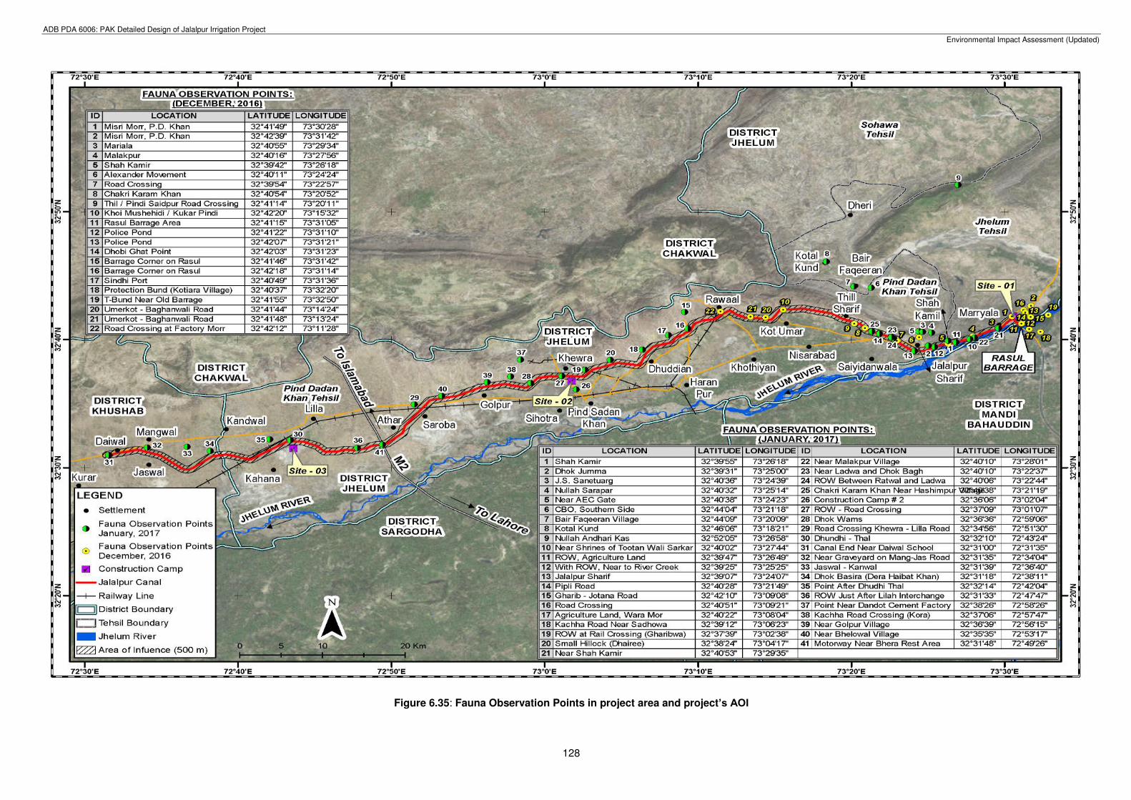
323. Primary data was collected from the designated ecological zones to observe the fauna along the main canal alignment in project’s AOI. Primary data was collected through field visits in non-breeding i.e. winter season only to observe the mammals, reptiles and amphibians through employing the sampling techniques such as identification of faeces, footprints and general observations. Fauna monitoring was carried out all along the length of the main canal alignment at an approximate interval of about 4 to 5 km for 20 to 25 minutes at each point (Refer Figure 6.35). Fauna observation points including birds along the main canal alignment at each points with location and coordinates for the period of December, 2016 and January 2017 is shown in Figure 6.35. The detailed list of species observed at each point with location and coordinates along the main canal alignment in project’s AOI is given in Table 6.29. A detailed list of fauna prevalent in the area identified at the project preparatory/feasibility stage is also attached as Appendix-VI.
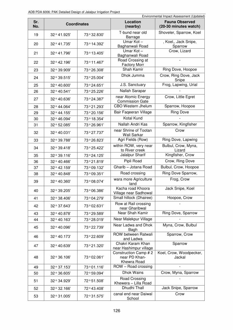
Table 6.29: Observed Fauna in winter with Coordinates/Location in project’s AOI Sr. No.
Coordinates Location (nearby)
Fauna Observed (20-30 minutes watch)
Northing Easting
1 32 o 41.813’ 73 o 30.469’ Misri More Ring Dove, Crow
2 32 o 42.650’ 73 o 31.707’ Misri More (RD Khan) Myna, Crow
3 32 o 40.919’ 73 o 29.571’ Muriala Crow, Hoopoe, Lizard
4 32 o 40.269’ 73 o 27.930’ Malikpur -
5 32 o 39.695’ 73 o 26.294’ Shah Kamir Crow, Jack Snipe,
6 32 o 40.183’ 73 o 24.401’ Alexander Monument Crow, Little Egret
7 32 o 39.900’ 73 o 22.946’ Road Crossing -
8 32 o 40.898’ 73 o 20.870’ Chakri Karam Khan Myna, Sparrow, Crow
9 32 o 41.238’ 73 o 20.175’ Road Crossing: Pindi Saidpur-Thil Road
Crow, Jack Snipe, Tree Pie, Kingfisher, Hoopoe
10 32 o 42.329’ 73 o 15.536’ Khoi Mushahidi/Kukar Pindi)
Crow, Sparrow, Little Egret, Bulbul
11 32 o 41.252’ 73 o 31.078’
Rasul Barrage area Moor hen, shoveler, Water-redstart, Little Cormorant, Sparrow,
Tufted duck,
12 32 o 41.366’ 73 o 31.159’ Police Pond Ring Dove, Water-redstart,
13 32 o 42.117’ 73 o 31.342’ Police Pond Little Egret Moor hen
14 32 o 42.058’ 73 o 31.382’ Dhobi Ghat Point Frog, Crow, Little Egret, Hoopoe
15 32 o 41.769’ 73 o 31.693’ Dhobi Ghat Point Moor hen, Water-redstart
16 32 o 42.305’ 73 o 31.230’ Barrage Corner on Rasul Jhelum Road
Ring Dove, Sparrow, Kingfisher, Little Egret
17 32 o 40.823’ 73 o 31.596’ Sindhi Pond Moor hen, Ring Dove
18 32 o 40.611’ 73 o 32.331’ Protection Bund near Kotiara Village
Ring Dove, Tree Pie, Crow, Hoopoe
ADB PDA 6006: PAK Detailed Design of Jalalpur Irrigation Project
Environmental Impact Assessment (Updated)
126
Sr. No.
Coordinates Location (nearby)
Fauna Observed (20-30 minutes watch)
19 32 o 41.925’ 73 o 32.830’ T-bund near old Barrage
Shoveler, Sparrow, Koel
20 32 o 41.735’ 73 o 14.392’ Umar Kot – Baghanwali Road
, Koel,, Jack Snipe, Sparrow
21 32 o 41.796’ 73 o 13.405’ Umar Kot – Baghanwali Road
Crow, Lizard
22 32 o 42.196’ 73 o 11.467’ Road Crossing at Factory Morr
-
23 32 o 39.909’ 73 o 26.308’ Shah Kamir Ring Dove, Hoopoe
24 32 o 39.515’ 73 o 25.004’ Dhok Jumma Crow, Ring Dove, Jack Snipe
25 32 o 40.600’ 73 o 24.651’ J.S. Sanctuary Frog, Lapwing, Urial
26 32 o 40.541’ 73 o 25.226’ Nallah Sarapar -
27 32 o 40.636’ 73 o 24.387’ near Atomic Energy Commission Gate
Crow, Little Egret
28 32 o 44.064’ 73 o 21.293’ CBO Western Jhelum Sparrow, Hoopoe
29 32 o 44.155’ 73 o 20.156’ Bair Faqeeran Village Ring Dove
30 32 o 46.094’ 73 o 18.354’ Kotal Kund -
31 32 o 52.085’ 73 o 26.961’ Nallah Andri Kas Sparrow, Kingfisher
32 32 o 40.031’ 73 o 27.737’ near Shrine of Tootan Wali Sarkar
Crow
33 32 o 39.788’ 73 o 26.823’ Agri Fields (Row) Ring Dove, Lapwing
34 32 o 39.418’ 73 o 25.422’ within ROW, very near to River creek
Bulbul, Crow, Myna, Lizard
35 32 o 39.116’ 73 o 24.125’ Jalalpur Sharif Kingfisher, Crow
36 32 o 40.466’ 73 o 21.819’ Pipli Road Crow, Ring Dove
37 32 o 42.159’ 73 o 09.132’ Gharib – Jotana Road Bulbul, Crow, Hoopoe
38 32 o 40.848’ 73 o 09.351’ Road crossing Ring Dove Sparrow,
39 32 o 40.360’ 73 o 08.074’ wara more Agriculture land
Frog, Crow
40 32 o 39.205’ 73 o 06.386’ Kacha road Khoora Village near Sadhowal
Jack Snipe, Koel
41 32 o 38.406’ 73 o 04.279’ Small hillock (Dhairee) Hoopoe, Crow
42 32 o 37.643’ 73 o 02.631’ Row at Rail crossing near Gharibwal
-
43 32 o 40.878’ 73 o 29.589’ Near Shah Kamir Ring Dove, Sparrow
44 32 o 40.163’ 73 o 28.019’ Near Malekpur Village -
45 32 o 40.096’ 73 o 22.739’ Near Ladwa and Dhok Bagh
Myna, Crow, Bulbul
46 32 o 40.173’ 73 o 22.609’ ROW between Ratwali and Ladwa
Sparrow, Crow
47 32 o 40.639’ 73 o 21.320’ Chakri Karam Khan near Hashimpur village
Sparrow
48 32 o 36.106’ 73 o 02.061’ Construction Camp # 2
near PD Khan- Khewra Road
Koel, Crow, Woodpecker, Jackal
49 32 o 37.153’ 73 o 01.116’ ROW – Road crossing -
50 32 o 36.605’ 72 o 59.094’ Dhok Wains Crow, Myna, Sparrow
51 32 o 34.929’ 72 o 51.508’ Road Crossing Khewera – Lilla Road
-
52 32 o 32.166’ 72 o 43.408’ Dhudhi Thall Jack Snipe, Sparrow
53 32 o 31.005’ 72 o 31.575’ canal end near Daiwal School
Crow
ADB PDA 6006: PAK Detailed Design of Jalalpur Irrigation Project
Environmental Impact Assessment (Updated)
127
Sr. No.
Coordinates Location (nearby)
Fauna Observed (20-30 minutes watch)
54 32 o 31.580’ 72 o 34.064’ Near Graveyard on
Mangwal-Jaswal Road Little Cormorant,
Sparrow
55 32 o 31.646’ 72 o 36.670’ Jaswal-Kandwal Road Woodpecker, Sparrow, Crow
56 32 o 31.307’ 72 o 38.190’ Dhok Basira, near dera Haibat Khan
Crow, Bulbul, Lizard
57 32 o 32.229’ 72 o 42.072’ Point after Dhudi Thal Grey Partridges, Jackal
58 32 o 31.548’ 72 o 47.781’ Row just after Lillah Interchange
Jack Snipe, Myna
59 32 o 38.439’ 72 o 58.430’ Point near Dandot Cement Factory
Little Cormorant, Pond Heron, Myna, Frog
60 32 o 37.101’ 72 o 57.790’ Kacha road crossing near Korra village
-
61 32 o 36.657’ 72 o 56.250’ Near Golpur village Sparrow, Lapwing, Crow
62 32 o 35.589’ 72 o 53.291’ Near Bhelowal village Myna, Crow
63 32 o 31.804’ 72 o 49.428’ On motorway near Bhera Rest area
-
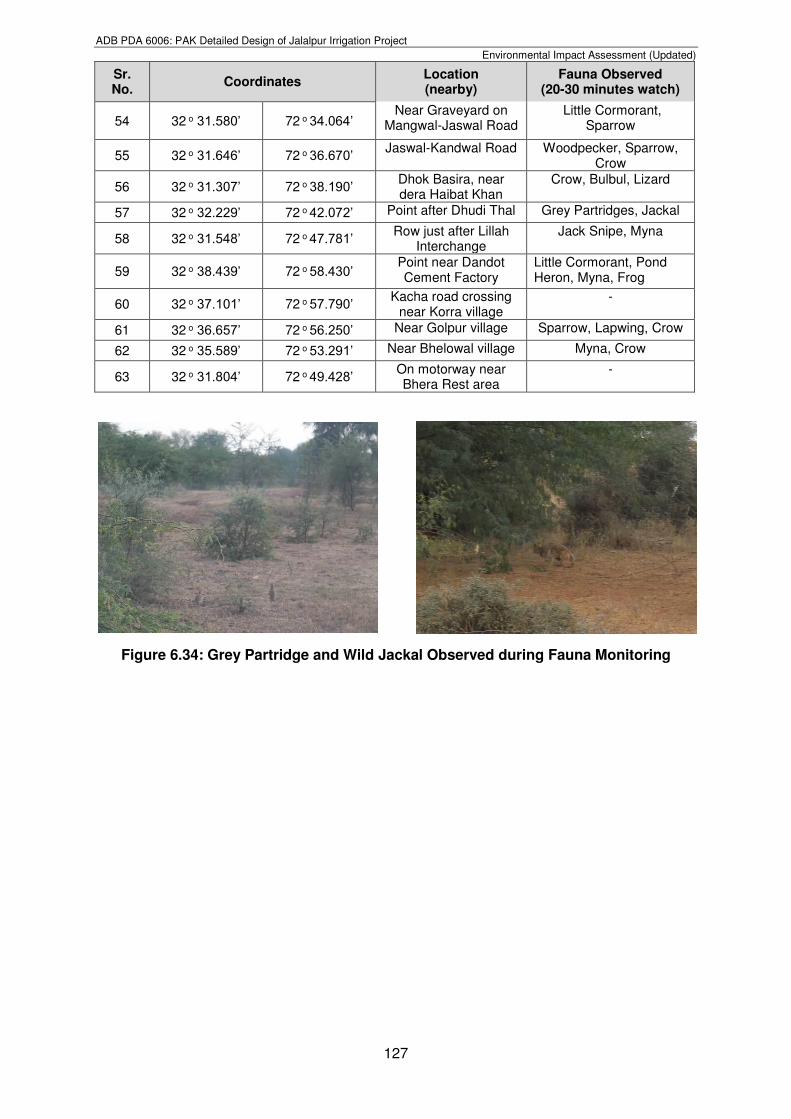
Figure 6.34: Grey Partridge and Wild Jackal Observed during Fauna Monitoring
ADB PDA 6006: PAK Detailed Design of Jalalpur Irrigation Project
Environmental Impact Assessment (Updated)
128
Figure 6.35: Fauna Observation Points in project area and project’s AOI
ADB PDA 6006: PAK Detailed Design of Jalalpur Irrigation Project
Environmental Impact Assessment (Updated)
129
6.5.3. Aquatic Ecology
324. The Punjab province has been bestowed with huge water resources wherein both types of ecosystems exist in the form of lotic and lentic waters including Jhelum. The running waters display typical characteristics with regard to temperature, turbidity, silting patterns, etc. The lentic waters are represented by natural lakes, man-made reservoirs, small dams, water-logged areas, ponds, etc. Food value of fish has been recognized all over the world. Proteins have a key role in human diet for proper growth and other vital activities and fish is regarded as an excellent source of protein. 325. Pakistan possesses immense aquatic resources particularly freshwater fisheries and River Jhelum is one of such resources where a huge water body in the form of Rasul Barrage is available in the project vicinity. Fish is the most abundant and successful of all vertebrates encountered in water. River Jhelum flows along the southern boundary of the project area upto PD Khan, after which it follows further downwards towards Khushab. Rasul Barrage is a water reservoir with about 12 km2 surface area with varying depths. Fish like Gulfam, Rohu, Takla, Tilapia are reported at Rasul Barrage (Refer Figure 6.36). Fisheries Department is managing the aquaculture profitably. The most commonly available species is Gulfam. Fisheries Department conducts auction for sale of fish in Rasul-Qadirabad Link canal, Lower Jhelum canal and Govt. Fish Farms every year/periodically. The auction money for the year 2017 has been indicated by the government department as under:
Location Amount (Pak-Rupees) Period of Auction
i) Pond area: Rs. 450,000 one year
ii) RQ Link: Rs. 700,000 one year
iii) LJ canal: Rs. 430,000 one year
iv) Govt. Fish Farms Rs. 510,000 Three year
326. The Salt Range falls under Mehran region and has following composition of reported species as shown in Table 6.30. (Manual Punjab Fisheries and Tourism Department).
Table 6.30: Fish Species in project area
Sr. No.
Common Name
Family Name Scientific Name IUCN Status
1 Gulfam Cyprinidae Cyprinus carpio VU
2 Malhee Siluridae Wallago attu NT
3 Mori Cyprinidae Cirrhinus mrigala LC
4 Rahu Cyprinidae Labeo rohita LC
5 Silver Carp Cyprinidae Hypophthalmichthys molitrix
NT
6 Thaila Cyprinidae Catla catla NA
7 Tilapia Osphranomidae
Oreochromis mossambica.
NA
8 Grass Carp Cyprinidae Ctenopharyngodon idella NA
9 Khaga Bagridae Rita rita LC
10 Singhari Bagridae Aorichthys aor LC
11 Kalbans Cyprinidae Labeo calbasu LC
ADB PDA 6006: PAK Detailed Design of Jalalpur Irrigation Project
Environmental Impact Assessment (Updated)
130
Figure 6.36: Fish catching at Head Rasul and Gulfam Fish on Right Side
6.5.4. Habitat and Biodiversity Conservation
327. Biodiversity Conservation status of project’s AOI is discussed according to the zones/sampling sites mentioned in Table 6.23 above. 328. Zone-1(Head Rasul Game Reserve area and along Main canal Alignment upto RD 0+000 to RD 45+000); this wetland area located at the fringe of water and land is supporting comparatively rich and diversified ecosystem. Rasul Barrage being man-made water body is a site, where migratory waterfowls are winter visitors along with local avi-faunal species. On account of prevailing nature of the area, the Zone is categorized as Modified Habitat because of the conversion of natural habitat from river flow to formation of water body for storage purposes. 329. Zone-2 (Facultative Production Zone); area of this zone spreading from Ladwal to Rawal and Sodhi Gujjar, is also considered as an altered form of natural habitat due to introduction of agricultural practices in most of the area replacing the scrub and sub-tropical thorn vegetation with alien cash crops. The area has significantly changed to Modified Habitat and, thus, would require mitigation measures like tree plantation as mentioned in Tree Plantation Plan given in EMP, in accordance with Biodiversity Conservation characteristics. 330. Zone-3 (Marginal to No Productivity area); This zone spreads over from Sodhi Gujjar to Khewra, Behlowal, and to Daiwal. The land is rugged with scanty, stunted and bushy or no growth of vegetation. The natural habitat has been degraded in the past on account of anthropogenic activities including persistent over-grazing and fuel wood cutting. The mitigation measures for the impacts would, therefore, essentially base on biological improvement approach such as Range Management and Forestry activities as mentioned in Impact and Mitigation section. 6.5.5. Ecosystem Sensitivities
331. At the detailed design stage, Consultant has assessed the status of the biological aspects including wildlife protected/sensitive areas along the updated alignment within the project’s AOI. The sensitive areas identified in the previous EIA and updated at the detailed design stage in the vicinity of the project’s AOI is as follows;
Head Rasul Game Reserve
Jalalpur Wildlife Sanctuary
Rakh Kandal Wildlife Sanctuary
CBO Western Jhelum
Thill Unclassed Forest
332. Consultants, through PID, requested Director General Punjab Wildlife and Parks Department for the identification of the Wildlife Sensitive/Reserved/ Protected/Community
ADB PDA 6006: PAK Detailed Design of Jalalpur Irrigation Project
Environmental Impact Assessment (Updated)
131
Based Organizations Protected areas in the vicinity of the proposed alignment of the canal vide their letter No. PMU/LBDCIP/IPD/7777 dated 28-10-2016. Consultant Environment team pursued the Department to get required details of the protected areas in the vicinity of the proposed alignment of the canal (Rasul Barrage Game Reserve, Jalalpur Wildlife Sanctuary and Community Based Organizations managed Urial habitats). Client’s letter to the DG Punjab Wildlife and Parks Department is attached as Appendix-VII. The purpose of this exercise was to evaluate the ecological sensitivities of Jalalpur Irrigation project JIP, which occupies most of Pind Dadan Khan Tehsil of Jhelum district and which terminates in tehsil Khushab of Khushab district. These two tehsils Jhelum and Khushab districts have their recognition as an integral part of Salt Range. To have a better understanding an overview of the collective picture have been considered worth discussing. 333. The EIA team undertook detailed visits of the project area and its surroundings to ascertain whether the project area overlaps with any of the above mentioned wildlife parks or reserves. After a thorough review and revalidation by the concerned Government Departments, it has been found that the JIP project area does not interfere or overlap with any of the declared ecologically sensitive areas, neither does its boundary touch such an area. For the purpose of this EIA, the JIP area has been fragmented into designated zones for a more realistic analysis. Only zone 1, area connecting the system with Rasul Barrage (stretching from Barrage to Jalalpur Sharif) is found to be situated relatively closer to, but outside the boundary of ecologically sensitive locations, whereas, other zones fall far apart from any significant ecological sensitivity. 334. The concerned department confirmed that the proposed alignment of the main canal for JIP does not cross through any ecological sensitive area vide their letter No. 5076/DDW-SR/2016 dated 23-11-2016. Punjab Wildlife and Parks Department’s letter is attached as Appendix-VIII. Revalidation reveals that the closest point of ecological sensitive area Jalalpur Wildlife Sanctuary is at a distance of about 1.3 km away from the project’s AOI, whereas, other sensitive areas fall far apart from JIP alignment. It is also clear from the Figure 6.37 that the AOI for the proposed project is clearly outside the eco-sensitive Salt Range, though it lies near to Rasul Barrage and Jalalpur Wildlife Sanctuary. 335. Pind Dadan Khan tehsil of Jhelum District, mainly constitute the most of JIP bounded on the south-east by the Jhelum River, and is traversed in its northern portion by the Salt Range. The hills consist of two roughly parallel ranges about 6 mile (10 km apart), with a strip of richly cultivated and fairly level uplands between. The southern slopes of the hills are steep and barren. The rest of the tehsil consists of a belt of alluvial plain, a portion of which is much affected by saline deposits. The apparent economic look of the area shows a pastoral tilt, not heavily depending on direct agriculture.