Embed Size (px)
Citation preview

Environmental impact of geometric earthworkconstruction in pre-Columbian AmazoniaJohn Francis Carsona,b,1, Bronwen S. Whitneyb, Francis E. Maylea, José Iriartec, Heiko Prümersd, J. Daniel Sotoe,and Jennifer Watlingc
aDepartment of Geography and Environmental Science, University of Reading, Whiteknights, Reading RG6 6AB, United Kingdom; bSchool of GeoSciences,University of Edinburgh, Edinburgh EH8 9XP, United Kingdom; cDepartment of Archaeology, University of Exeter, Exeter EX4 4QE, United Kingdom;dKommission für Archäologie Aussereuropäischer Kulturen, Deutsches Archäologisches Institut, 53173 Bonn, Germany; and eHerbario del Oriente Boliviano,Museo de Historia Natural ‘Noel Kempff Mercado,’ Universidad Autónoma Gabriel René Moreno, Casilla 2489, Santa Cruz, Bolivia
Edited by Charles Stanish, University of California, Los Angeles, CA, and approved May 30, 2014 (received for review November 22, 2013)
There is considerable controversy over whether pre-Columbian(pre-A.D. 1492) Amazonia was largely “pristine” and sparsely popu-lated by slash-and-burn agriculturists, or instead a densely populated,domesticated landscape, heavily altered by extensive deforestationand anthropogenic burning. The discovery of hundreds of largegeometric earthworks beneath intact rainforest across southernAmazonia challenges its status as a pristine landscape, and has beenassumed to indicate extensive pre-Columbian deforestation by largepopulations. We tested these assumptions using coupled local- andregional-scale paleoecological records to reconstruct land use onan earthwork site in northeast Bolivia within the context of regional,climate-driven biome changes. This approach revealed evidence foran alternative scenario of Amazonian land use, which did not neces-sitate labor-intensive rainforest clearance for earthwork construc-tion. Instead, we show that the inhabitants exploited a naturallyopen savanna landscape that they maintained around their settle-ment despite the climatically driven rainforest expansion that be-gan ∼2,000 y ago across the region. Earthwork construction andagriculture on terra firme landscapes currently occupied by theseasonal rainforests of southern Amazonia may therefore not havenecessitated large-scale deforestation using stone tools. This findingimplies far less labor—and potentially lower population density—than previously supposed. Our findings demonstrate that currentdebates over themagnitude and nature of pre-Columbian Amazonianland use, and its impact on global biogeochemical cycling, arepotentially flawed because they do not consider this land use inthe context of climate-driven forest–savanna biome shifts throughthe mid-to-late Holocene.
paleoecology | Amazonian archaeology | human–environmentinteractions | Anthropocene | Amazon rainforest
Evidence for the existence of large and socially complex soci-eties in Amazonia before the arrival of Europeans (pre-A.D.
1492) is emerging from a growing number of archaeological sitesacross the Amazon Basin (1–9). The scale of these societies’environmental impact and its potential legacy in modern Ama-zonian forest ecosystems are hotly debated. Whereas some arguefor a relatively limited and localized human influence (10–13),others have described pre-Columbian Amazonia as a “culturalparkland,” which was widely impacted by human disturbance(14–16). It has been proposed that deforestation and biomassburning before the collapse of native Amazonian populationsfollowing European contact in A.D. 1492 occurred on a scalelarge enough to contribute to an early anthropogenic influenceon the global carbon cycle (17), and was a significant forcing ofHolocene climate perturbations (18). It has also been suggestedthat this pervasive historical human influence on Amazonianforest ecosystems should change our views on their resilience tohuman impacts and influence our approach to their conservation(19). However, in many regions, a lack of appropriately scaledpaleoecological data means that we have no paleoenvironmental
context in which to place these societies and assess their environ-mental impacts.Paleoecological studies (20–23) conducted in aseasonal west-
ern and central Amazonia suggest stability of the rainforestbiome throughout the Holocene and appear to show little evi-dence for significant deforestation or biomass burning by theirpre-Columbian inhabitants. However, the presence of regionallyextensive pre-Columbian geometric earthworks underlying theseasonal southern Amazonian rainforests (SSAR) (Fig. 1A) (2,4, 15, 24, 25) is suggestive of large-scale historical deforestationby substantial populations. These earthworks, uncovered bymodern deforestation, are thought to represent only a fractionof the total, which lie undiscovered beneath the intact SSAR(3), a subregion of ∼1,000,000 km2 (SI Text, Site Descriptions),which constitutes one-fifth of the Amazon basin. This practiceof geometric earthwork building appears to have developed anddiverged across southern Amazonia over a long time periodfrom prehistory to European contact (2) (SI Text, GeometricEarthworks).Here we investigated the environmental impact of geometric
earthwork building by using paleoecological techniques to re-construct vegetation change and human land use on both a local
Significance
The discovery of extensive geometric earthworks beneath ap-parently pristine rainforest across southern Amazonia hasfueled debate over the scale of environmental impact causedby ancient human societies. Whereas some claim that thesesites are evidence of vast deforestation by populous pre-Columbian (pre-A.D. 1492) societies, others propose a model ofsmall-scale, localized clearance. We tested these contrastinghypotheses by reconstructing environmental change in a re-gion of geometric earthworks in northeast Bolivia over the last6,000 y. Our unexpected findings reveal a surprising third sce-nario, in which earthwork builders took advantage of a naturallyopen savanna landscape, which existed under drier-than-presentclimatic conditions before ∼2,000 y ago. This finding suggestslower environmental impact, less labor, and possibly a smallerpopulation than previously assumed.
Author contributions: J.F.C. and F.E.M. designed research; J.F.C., B.S.W., H.P., and J.D.S.performed research; H.P. contributed archaeological data; J.D.S. contributed botanicaldata; J.F.C., B.S.W., F.E.M., J.I., and J.W. analyzed data; and J.F.C., B.S.W., F.E.M., J.I.,H.P., J.D.S., and J.W. wrote the paper.
The authors declare no conflict of interest.
This article is a PNAS Direct Submission.
Data deposition: The data have been deposited in the publicly-available Neotoma data-base (www.neotomadb.org/) and Global Charcoal Database (www.gpwg.org/gpwgdb.html).1To whom correspondence should be addressed. Email: [email protected].
This article contains supporting information online at www.pnas.org/lookup/suppl/doi:10.1073/pnas.1321770111/-/DCSupplemental.
www.pnas.org/cgi/doi/10.1073/pnas.1321770111 PNAS | July 22, 2014 | vol. 111 | no. 29 | 10497–10502
ANTH
ROPO
LOGY
ECOLO
GY
Dow
nloa
ded
by g
uest
on
Apr
il 27
, 202
0

and a regional scale around a pre-Columbian earthwork site innortheast Bolivia.
Study AreaOur study was conducted in Iténez province in northeast Boliviaat the geologically defined boundary between the terra firme(nonflooded) humid evergreen rainforest on the uplands of thepre-Cambrian Shield (PCS) and the seasonally flooded savannas
of the adjacent Beni sedimentary basin (31). Although the for-est–savanna boundary of our study area is locally controlled bygeological, edaphic, and hydrological conditions, it is situatedwell within the SSAR, the southern ecotone of which is con-trolled by precipitation at a broad regional scale (Fig. 1A). Ar-chaeologically, the Iténez region is characterized by extensivenetworks of artificial earthworks covering an estimated area of12,000 km2 (24). On the terra firme land of the PCS, these in-clude dense clusters of ring ditches, ranging from circular forms,up to several hundred meters in diameter, to kilometer-longcurvilinear ditches up to 3-m deep and 4-m wide. The function ofthese ring ditches is unknown. One possibility is that they actedas defensive features around settlements and were perhaps en-hanced by the construction of palisade walls built from treetrunks (24). However, no archaeological evidence of post holesor wood remains has yet been found to confirm this hypothesis(32). Other suggested functions for geometric earthworks in-clude: drainage (5), ceremonial/religious (3), or formal organi-zation of space according to social hierarchy (1, 15).To gain a temporal understanding of the nature and scale of
human impact on vegetation in the ring-ditch region of northeastBolivia, we analyzed fossil pollen and macroscopic charcoal fromradiocarbon-dated lake sediment cores to reconstruct paleo-vegetation and fire history over the past ∼6,000 y (Methods). Thepollen source area represented by fossil pollen in lake sedimentsis determined by lake surface area (33). We therefore selecteda pair of lakes of contrasting size to capture vegetation on twodistinct spatial scales (Fig. 1B). The smaller of the two lakes,Laguna Granja (LG), reflects local-scale vegetation at an adja-cent ring-ditch site (Fig. 1C) and is nested within the regional-scale pollen catchment of the much larger lake, Laguna Orícore(LO), which reveals broader, biome-scale vegetation changes onthe PCS (SI Text, Pollen catchment area).During the rainy season, both lakes receive flood waters (and
hence pollen input) from the surrounding seasonally floodedsavannas of the Beni basin, as well as from the adjacent SanMartín river, which drains rainforest, dry forest, and savannaregions south of Iténez. However, despite this floodwater input,we found that the surface-sediment pollen assemblages of bothlakes were dominated by taxa indicative of the terra firme humidevergreen rainforest that covers the PCS. Our interpretation isbased upon extensive modern pollen rain studies conducted inthe Bolivian Amazon, which enabled us to distinguish betweenthe characteristic pollen signatures of savanna, seasonally drytropical forest, and humid evergreen rainforest (34–37). Most ofthe pollen entering the two lakes must therefore originate viawind dispersal from the vegetation of the PCS, with onlya background input from the Beni basin and riverine floodwaters. Analysis of the fossil pollen and macroscopic charcoalfrom the deeper lake sediments confirms that the paleoecolog-ical records from our study lakes are representative of changes inthe ring-ditch region in northern Iténez and not the region to thesouth drained by the San Martín river (SI Text, Pollen andcharcoal source).
Results and InterpretationL. Orícore. In zone LO-1 (5700–2000 calibrated years beforepresent, or cal yr B.P.) (Fig. 2), LO shows low arboreal pollenlevels (≤30%) and high Poaceae (grass) abundance (up to 50%),which—together with peak abundance of drought-tolerant taxa,such as Anadenanthera, and maximum charcoal concentrations—indicate a drier and regionally more open environment com-pared with the present (34–37). At the zone LO-1/LO-2 bound-ary (∼2000 cal yr B.P.), total arboreal pollen percentages beginto increase, with especially marked increases in abundance ofevergreen taxa, such as Brosimum and Alchornea, whereasPoaceae, Anadenanthera, and charcoal levels decline, signalingan expansion of closed-canopy humid evergreen rainforest
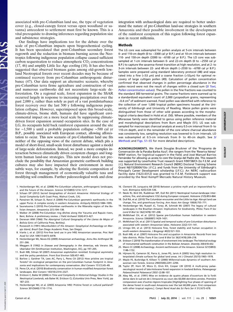
Fig. 1. Map of site locations. (A) Present-day precipitation across Amazonbasin during the three driest months of the year (26); solid black line delimitsmodern extent of Amazonian forest; approximate extent of SSAR/geometricearthwork region is within the <125-mm isohyet. Over 400 geometricearthworks have been discovered in eastern Acre, Brazil (location no. 3 in A),and many more across Iténez (location no. 1 in A, detail in B) and Riberalta(location no. 2 in A), northeast Bolivia, and the Upper Xingu (location no. 4in A), Brazil. Previously published lake-sediment pollen records showingevidence for late Holocene biome shifts are represented by white circles: (a)Bella Vista, (b) Chaplin (27), (c) Yaguarú (28), (d) Carajas (29). Previouslypublished lake-sediment pollen records in central and western Amazonia,which show stability of the forest biome and limited or no human impactover mid-to-late Holocene, are represented by gray circles: (e) Siberia (30), (f)Chalalán and Santa Rosa (22), (g) Gentry, Parker, Vargas, Werth (23). Blackcrosses represent soil-pit sampling locations/transects discussed in the maintext, which show little evidence of pre-Columbian forest disturbance (20, 21).(B) Study area showing locations of LO and LG (detail in C), main rivers, andbiome distribution. (C) Laguna Granja and Granja del Padre ring ditch.
10498 | www.pnas.org/cgi/doi/10.1073/pnas.1321770111 Carson et al.
Dow
nloa
ded
by g
uest
on
Apr
il 27
, 202
0

(34–36). By ∼1700 cal yr B.P., total arboreal pollen percentageshad reached modern values, indicating that the regional terrafirme PCS landscape had reached a level of forest cover com-parable to the modern closed-canopy rainforest. This record ofa savanna landscape changing to evergreen rainforest ∼2000 calyr B.P. is consistent with paleoecological studies from other partsof southern Amazonia, which were dominated by savanna andseasonally dry tropical forest until ∼3000–2000 B.P., when humidevergreen rainforest began to expand southward (27–29). Theserecords of expanding evergreen rainforest coincide with in-creasing lake levels at Lake Titicaca (38, 39) (an Andean site thatreceives most of its precipitation from lowland Amazonia), sug-gesting that rainforest expansion occurred as a result of in-creasing precipitation across southern Amazonia. The latter reflectsa strengthening of the South American summer monsoon, drivenby increased insolation linked to precessional orbital forcing(27). Further independent, multiproxy evidence of mid-to-lateHolocene climate change in the study area is presented in SI Text,Mid-Late Holocene Climate Change.
L. Granja. LG provides a record of local-scale human impact ata ring ditch site on the PCS, on the outskirts of the modern daytown of Bella Vista (SI Text, Site Descriptions). Ground mappingand airborne light detection and ranging (LiDAR) surveysconducted by H.P. over an area of 200 km2 around LG havedocumented numerous earthworks enclosing areas up to 200ha. Two ring ditches, one located 100 m east of the lake and thesecond located 1 km away, have been radiocarbon dated to be-tween ∼800 and 500 cal yr B.P. (40). The ring ditch nearest to thelake (Fig. 3) is 150 m in diameter and 2 m deep, and is connectedto the second ring ditch by a linear ditch that bisects an area of150 ha. Excavations of this nearest ring ditch uncovered 15separate burials and associated ceramics.In zone LG-1 the high ratio of Poaceae to arboreal pollen
(Fig. 4) (6100–2500 cal yr B.P.) shows that, before occupation,the environment around LG was an open savanna, in contrast
to the dense evergreen rainforest that exists there today (not-withstanding scattered clearings made for cattle pasture andslash-and-burn agriculture), an interpretation reinforced by modernpollen-vegetation studies (34–37). The LG-1/LG-2 zone bound-ary marks the onset of agriculture and anthropogenic burning atLG at 2500 cal yr B.P., as indicated by a sharp charcoal increaseand the presence of maize pollen (Zea mays L.). Although thecharcoal record shows variations, with two distinct periods ofmore intensive anthropogenic burning at ∼2500–1600 cal yr B.P.and ∼700–500 cal yr B.P., the almost continual presence of maizepollen shows that the site was occupied throughout zones LG-2and LG-3. The second charcoal peak (700–500 cal yr B.P.)coincides with peak Poaceae pollen percentages and ring ditchconstruction/occupation (∼800–500 cal yr B.P.) (40), whichindicates, either a more intense period of burning associated withthe ring ditch construction, or burning closer to the lake itself (SIText, L. Granja charcoal). The decrease in arboreal types at thishorizon is driven mostly by the disappearance of taxa such as
Fig. 2. LO pollen and charcoal records. Pollen data presented as percent abundance (of the total terrestrial pollen sum) and total concentrations per cubiccentimeter. Charcoal presented as particles per cubic centimeter. “Total Arboreal” is the sum of all tree taxa. Dominant tree taxa (> 2% abundance) areshown. Plotted against calibrated radiocarbon years B.P. and individual radiocarbon dates shown on right (Fig. S1 and Table S1).
Fig. 3. Aerial photo of ring ditch next to LG (taken 2008 by H.P.). Open groundaround the ditch reflects modern, small-scale clearance for cattle pasture.
Carson et al. PNAS | July 22, 2014 | vol. 111 | no. 29 | 10499
ANTH
ROPO
LOGY
ECOLO
GY
Dow
nloa
ded
by g
uest
on
Apr
il 27
, 202
0

Alchornea, Celtis, and Cecropia, indicating clearance of the gal-lery forest immediately around the lake (34–36). Open savanna/grassland vegetation persists throughout zone LG-2 and expan-sion of dense-canopy rainforest into the terra firme around LGdoes not occur until ∼500 cal yr B.P. (zone LG-2/3 boundary)following a decline in human activity at the site, possibly linkedto the introduction of Old World diseases associated with thearrival of Europeans in the Americas in A.D. 1492 (41).The timing of this local forest expansion at LG (∼500 cal yr
B.P.) contrasts with the much earlier regional-scale pattern offorest expansion seen at LO (∼2000 cal yr B.P.). The mostparsimonious explanation for the persistence of this open land-scape at LG is that early settlers maintained open ground ona local scale by suppressing forest expansion around the settle-ment. The maintenance of this opening is not seen in the LOrecord because the much larger pollen catchment area of LOmeans that it is insensitive to detecting openings on the scale ofthe ring-ditch site (33). The LG pollen record therefore dem-onstrates that construction of the earthworks and agriculturalactivity around LG occurred in an open environment, main-tained since the first occupation of the site. Rather than havingto rely upon stone axes and burning to clear dense-canopyrainforest, a feat that would have been hugely labor intensive andhighly impractical before the introduction of steel tools (42), ourdata show that the inhabitants took advantage of an existingopen savanna landscape. Although the movement of earth toconstruct the ring ditches would have required a considerablelabor force, the maintenance of an open landscape locallyaround LG, by the suppression of tree growth associated with theclimate-driven rainforest expansion, would have required far lesshuman effort (and potentially a lower population density) thanthat needed for the removal of dense-canopy rainforest.
Implications. It is intriguing that most geometric earthworksfound beneath terra firme tropical forest have been concentrated
in seasonal southern Amazonia [i.e., northeast Bolivia (4, 24),eastern Acre state (3, 25), and the upper Xingu region of Brazil(15)], rather than wetter, less seasonal parts of the basin (Fig.1A). Late Holocene climate-driven rainforest expansion hasbeen documented in other parts of southern Amazonia (27–29),coinciding with rising lake levels in the tropical Andes (38, 39),which demonstrates that the forest expansion at LO reflectsa broad-scale vegetation response to increasing precipitationacross the southern Amazon. However, the geographic scale ofthis biome shift in the context of large geometric earthworkconstruction has hitherto not been considered. Our discoveryraises the strong possibility that other geometric earthworksacross southern Amazonia were also built in a savanna/openwoodland that subsequently became covered by closed-canopyforest. Although dating of two of the numerous ring ditches atthe Bella Vista site has shown them to be relatively late features(built and occupied between ∼800 and 500 B.P.), geometricearthworks in Pando (northeast Bolivia) and eastern Acre(northwest Brazil) have been dated to as early as 2000 B.P.(4, 43). The recent discovery of ancient shell middens in thecentral Beni basin have demonstrated a human presence in theBolivian Amazon since the early Holocene (∼10,000 y B.P.) (44).Gaining a sound understanding of the historical role of hu-
mans in shaping Amazonian landscapes, and the extent to whichAmazonian forests were resilient to historical disturbance, iscritical to informing policy makers on sustainable Amazonianfutures (8, 12, 16, 19, 45). However, the debate so far has con-sidered only the extent of past human impact and land use inwhat is assumed to have been a forested landscape, based uponthe modern distribution of forest. Our study demonstrates thatcurrent debates over the magnitude and nature of pre-Colum-bian Amazonian land use are potentially flawed because they donot consider this land use in the context of climate-driven eco-system dynamics through the mid-to-late Holocene (27, 29). Ourfindings show that, to determine the scale of environmental impact
Fig. 4. LG pollen and charcoal records. Pollen data presented as percent abundance (of the total terrestrial pollen sum) and total pollen concentrations.Charcoal presented as particles per cubic centimeter. Zea mays plotted as no. of grains per ∼0.4 cm3. “Total Arboreal” is the sum of all tree taxa. Dominanttree pollen types (>2% abundance) are shown. Dashed line indicates timing of regional forest expansion shown in LO. Plotted against calibrated years beforepresent, with individual radiocarbon dates shown on the right (Fig. S2 and Table S1).
10500 | www.pnas.org/cgi/doi/10.1073/pnas.1321770111 Carson et al.
Dow
nloa
ded
by g
uest
on
Apr
il 27
, 202
0
associated with pre-Columbian land use, the type of vegetationcover (e.g., closed-canopy forest versus open woodland or sa-vanna) antecedent to settlement must first be known. This is avital prerequisite to drawing inferences regarding population sizeand subsistence strategies.Our findings have implications too for the debate over the
scale of pre-Columbian impacts upon biogeochemical cycling.It has been speculated that post-Columbian secondary forestregrowth and the reduction in biomass burning across the Neo-tropics following indigenous population collapse caused sufficientcarbon sequestration to reduce atmospheric CO2 concentrations(17, 46) and amplify Little Ice Age cooling (18). It has also beensuggested that observed biomass gains among old-growth low-land Neotropical forests over recent decades may be because ofcontinued recovery from pre-Columbian anthropogenic distur-bance (47). Our data support an alternative scenario, wherebypre-Columbian terra firme agriculture and construction of vastand numerous earthworks did not necessitate large-scale de-forestation. On a regional scale, forest expansion in the SSARoccurred largely in response to increasing precipitation over thepast 2,000 y, rather than solely as part of a vast postdisturbanceforest recovery over the last 500 y following indigenous popu-lation collapse. However, superimposed upon this broad-scale,climate-driven, biome shift, humans did have significant envi-ronmental impact on a more local scale by suppressing climate-driven forest expansion around occupation sites. In the case ofLG, its occupants held back rainforest expansion around the sitefor ∼1,500 y until a probable population collapse ∼500 cal yrB.P., possibly associated with European contact, allowing affores-tation to occur. This new scenario of pre-Columbian land use fitsneither of the opposing views of the current debate, which pits amodel of short-lived, small-scale forest disturbance against a modelof large-scale deforestation. Instead, we posit a more complex in-teraction between climatically driven ecosystem changes and long-term human land-use strategies. This new model does not pre-clude the possibility that Amazonian geometric earthwork buildingcultures may also have impacted their environment in moresubtle ways, for example, by altering the floristic composition offorest through management of economically valuable taxa andmodifying soil conditions. Further paleoecological work and close
integration with archaeological data are required to better under-stand the nature of pre-Columbian land-use strategies in southernAmazonia and their possible involvement in the developmentof the rainforest ecosystem of this region following forest expan-sion in recent millennia.
MethodsThe LG core was subsampled for pollen analysis at 5-cm intervals between0- and 110-cm depth (0 to ∼3300 cal yr B.P.) and at 10-cm intervals between110- and 150-cm depth (3300 to ∼6100 cal yr B.P.). The LO core was sub-sampled at 1-cm intervals between 0- and 22-cm depth (0 to ∼2550 cal yrB.P.) to capture the savanna–forest transition at high resolution, and at 2- to3-cm intervals between 22- and 40-cm depth (∼2550 to ∼6700 cal yr B.P.).Samples were prepared using standard laboratory protocol (48) and sepa-rated into a fine (<53 μm) and a coarse fraction (>53μm) for optimal re-covery of large cultigen pollen (49). Calculation of pollen concentrationconfirmed that observed changes in pollen percentage abundance in thepaleo record were not the result of changes within a closed sum (SI Text,Pollen concentration values). The pollen in the fine fractions was counted tothe standard 300 terrestrial grains. The coarse fractions were scanned up toa standardized equivalent count of 2,000 Lycopodium grains, representing∼0.4 cm3 of sediment scanned. Fossil pollen was identified with reference tothe collection of over 1,000 tropical pollen specimens housed at the Uni-versity of Edinburgh and University of Reading. Maize pollen grains weredistinguished from those of other wild grasses according to the morpho-logical criteria described in Holst et al. (50). Where possible, members of theMoraceae family were identified to genus using pollen reference materialand morphological descriptions from Burn and Mayle (51). LG was sub-sampled for macroscopic charcoal analysis at every 0.5-cm interval from 0- to110-cm depth, and in the remainder of the core where charcoal abundancewas consistently low, sampling resolution was lowered to 5-cm intervals. LOwas subsampled at 0.5-cm intervals from 0- to 40-cm depth. See SIMethods and Figs. S1–S5 for more detailed descriptions.
ACKNOWLEDGMENTS. We thank Douglas Bruckner of the ‘Programa deConservación de la Paraba Barba Azul’; the rangers from the ‘Reserva Iténez’WWF station, for logistical support in the field; and José Manuel BarriosFernández for allowing us access to core the Granja del Padre site. This researchwas supported by Leverhulme Trust research Grant F/00158/Ch (to F.E.M. andJ.I.); Natural Environment Research Council (NERC) Doctoral Training SchemeGrant NE/152830X/1(to J.F.C.); and funds from the University of Edinburgh’sPrincipal’s Career Development scholarship (J.F.C.). An NERC radiocarbonfacility date (1623.0312) was granted to F.E.M. Fieldwork support wasprovided by the Noel Kempff Mercado Natural History Museum.
1. Heckenberger MJ, et al. (2008) Pre-Columbian urbanism, anthropogenic landscapes,and the future of the Amazon. Science 321(5893):1214–1217.
2. Schaan DP (2012) Sacred Geographies of Ancient Amazonia: Historical Ecology ofSocial Complexity (Left Coast Press, Walnut Creek, CA).
3. Parssinen M, Schaan D, Ranzi A (2009) Pre-Columbian geometric earthworks in theupper Purús: A complex society in western Amazonia. Antiquity 83(322):1084–1095.
4. Saunaluoma S (2010) Pre-Columbian earthworks in the Riberalta region of the Bo-livian Amazon. Amazonica 2(1):104–138.
5. Walker JH (2008) Pre-Columbian ring ditches along the Yacunta and Rapulo rivers,Beni, Bolivia: A preliminary review. J Field Archaeol 33(4):413–427.
6. Denevan WM (1966) The Aboriginal Cultural Geography of the Llanos de Mojos ofBolivia (Univ of California Press, Berkley).
7. Roosevelt A (1991) Mounbuilders of the Amazon: Geophysical Archaeology on Mar-ajo Island, Brazil (San Diego Academic Press, San Diego).
8. Iriarte J, et al. (2012) Fire-free land use in pre-1492 Amazonian savannas. Proc NatlAcad Sci USA 109(17):6473–6478.
9. Heckenberger MJ, Neves EG (2009) Amazonian archaeology. Annu Rev Anthropol 38:251–266.
10. Meggers B (1992) in Disease and Demography in the Americas, eds Verano JW,Uberlaker DH (Smithsonian Institution, Washington, DC), pp 197–205.
11. Bush MB, Silman M (2007) Amazonian exploitation revisited: Ecological asymmetryand the policy pendulum. Front Ecol Environ 5(9):457–465.
12. Barlow J, Gardner TA, Lees AC, Parry L, Peres CA (2012) How pristine are tropicalforests? An ecological perspective on the pre-Columbian human footprint in Ama-zonia and implications for contemporary conservation. Biol Conserv 151(1):45–49.
13. Peres CA, et al. (2010) Biodiversity conservation in human-modified Amazonian forestlandscapes. Biol Conserv 143(10):2314–2327.
14. Erickson C, Balée W (2006) in Time and Complexity in Historical Eology: Studies in theNeotropical Lowlands, eds Balee W, Erickson CL (Columbia Univ Press, New York), pp187–233.
15. Heckenberger MJ, et al. (2003) Amazonia 1492: Pristine forest or cultural parkland?Science 301(5640):1710–1714.
16. Clement CR, Junqueira AB (2010) Between a pristine myth and an impoverished fu-ture. Biotropica 42(5):534–536.
17. Nevle RJ, Bird DK, Ruddiman WF, Dull RA (2011) Neotropical human-landscape inter-actions, fire, and atmospheric CO2 during European conquest. Holocene 21(5):853–864.
18. Dull RA, et al. (2010) The Columbian encounter and the Little Ice Age: Abrupt land usechange, fire, and greenhouse forcing. Ann Assoc Am Geogr 100(4):755–771.
19. Heckenberger MJ, Russell JC, Toney JR, Schmidt MJ (2007) The legacy of culturallandscapes in the Brazilian Amazon: Implications for biodiversity. Philos Trans R SocLond B Biol Sci 362(1478):197–208.
20. McMichael CH, et al. (2012) Sparse pre-Columbian human habitation in westernAmazonia. Science 336(6087):1429–1431.
21. McMichael CH, et al. (2011) Spatial and temporal scales of pre-Columbian disturbanceassociated with western Amazonian lakes. Holocene 22(2):131–141.
22. Urrego DH, et al. (2013) Holocene fires, forest stability and human occupation insouth-western Amazonia. J Biogeogr 40(3):521–533.
23. Bush MB, et al. (2007) Holocene fire and occupation in Amazonia: Records from twolake districts. Philos Trans R Soc Lond B Biol Sci 362(1478):209–218.
24. Erickson C (2010) The transformation of environment into landscape: The historical ecologyof monumental earthwork construction in the Bolivian Amazon. Diversity 2(4):618–652.
25. Mann CC (2008) Archaeology. Ancient earthmovers of the Amazon. Science 321(5893):1148–1152.
26. Hijmans RJ, Cameron SE, Parra JL, Jones PG, Jarvis A (2005) Very high resolution in-terpolated climate surfaces for global land areas. Int J Climatol 25(15):1965–1978.
27. Mayle FE, Burbridge R, Killeen TJ (2000) Millennial-scale dynamics of southern Am-azonian rain forests. Science 290(5500):2291–2294.
28. Taylor ZP, Horn SP, Mora CI, Orvis KH, Cooper LW (2010) A multi-proxy palae-oecological record of late-Holocene forest expansion in lowland Bolivia. PalaeogeogrPalaeoclimatol Palaeoecol 293(1-2):98–107.
29. Absy ML, et al. (1991) Mise en évidence de quatre phases d’ouverture de la forêtdense dans le sud-est de L’Amazonie au cours des 60,000 dernières années. Premièrecomparaison avec d’autres régions tropicales [Highlighting four phases of opening ofthe dense forest in south-east Amazonia over the last 60,000 years. First comparisonwith other tropical regions.]. Compt Rend Acad des Sci Paris Ser II 312:673–678.
Carson et al. PNAS | July 22, 2014 | vol. 111 | no. 29 | 10501
ANTH
ROPO
LOGY
ECOLO
GY
Dow
nloa
ded
by g
uest
on
Apr
il 27
, 202
0

30. Mourguiart P, Ledru M-P (2003) Last Glacial Maximum in an Andean cloud forestenvironment (Eastern Cordillera, Bolivia). Geology 31(3):195–198.
31. Navarro G, Maldonado M (2005) Geografia Ecologia de Bolivia: Vegetacion y Am-bientes Acuaticos [Ecological Geography of Bolivia: Vegetation and Aquatic Envi-ronments] (Centro de ecologia difusion de simion I, Patino, Santa Cruz, Bolivia).Spanish.
32. Prümers H (2013) Die arbeiten des Bolivianisch-Deutschen Projektes in Mojos in denjahren 2011 / 2012 [The work of the Bolivian-German Project in the Mojos in the years2011–2012]. Zeitschrift fur Archaeol Aussereuopaischer 5:315–324.
33. Sugita S (1994) Pollen representation of vegetation in Quaternary sediments: Theoryand method in patchy vegetation. J Ecol 82(4):881–897.
34. Burn M, Mayle FE, Killeen T (2010) Pollen-based differentiation of Amazonian rain-forest communities and implications for lowland palaeoecology in tropical SouthAmerica. Palaeogeogr Palaeoclimatol Palaeoecol 295(1-2):1–18.
35. Gosling W, Mayle FE, Tate N, Killeen T (2005) Modern pollen-rain characteristics of tallterra firme moist evergreen forest, southern Amazonia. Quat Res 64(3):284–297.
36. Gosling W, Mayle FE, Tate N, Killeen T (2009) Differentiation between Neotropicalrainforest, dry forest, and savannah ecosystems by their modern pollen spectra andimplications for the fossil pollen record. Rev Palaeobot Palynol 153(1-2):70–85.
37. Jones H, Mayle FE, Pennington RT, Killeen T (2011) Characterisation of Bolivian sa-vanna ecosystems by their modern pollen rain and implications for fossil pollen re-cords. Rev Palaeobot Palynol 164(3-4):223–237.
38. Baker PA, et al. (2001) The history of South American tropical precipitation for thepast 25,000 years. Science 291(5504):640–643.
39. Cross S, Baker P, Seltzer GO, Fritz SC, Dunbar RB (2000) A new estimate of theHolocene lowstand level of Lake Titicaca, central Andes, and implications for tropicalpalaeohydrology. Holocene 10(1):21–32.
40. Dickau R, et al. (2012) Diversity of cultivars and other plant resources used at habi-tation sites in the Llanos de Mojos, Beni, Bolivia: Evidence from macrobotanical re-mains, starch grains, and phytoliths. J Archaeol Sci 39(2):357–370.
41. Denevan WM (1992) The Pristine Myth: The landscape of the Americas in 1492. AnnAssoc Am Geogr 82(3):369–385.
42. Denevan WM (2001) Cultivated Landscapes of Native Amazonia and the Andes(Oxford Univ Press, Oxford).
43. Schaan D, et al. (2012) New radiometric dates for pre-Columbian (2000–700 B.P.)earthworks in western Amazonia, Brazil. J Field Archaeol 37(2):132–142.
44. Lombardo U, et al. (2013) Early and middle Holocene hunter-gatherer occupations inwestern Amazonia: The hidden shell middens. PLoS ONE 8(8):e72746.
45. Renard D, et al. (2012) Ecological engineers ahead of their time: The functioning ofpre-Columbian raised-field agriculture and its potential contributions to sustain-ability today. Ecol Eng 45:30–44.
46. Kaplan JO, et al. (2010) Holocene carbon emissions as a result of anthropogenic landcover change. Holocene 21(5):775–791.
47. Chave J, et al. (2008) Assessing evidence for a pervasive alteration in tropical treecommunities. PLoS Biol 6(3):e45.
48. Faegri K, Iversen K (1989) Textbook of Pollen Analysis (Blackburn Press, New Jersey).49. Whitney BS, Rushton EA, Carson JF, Iriarte J, Mayle FE (2012) An improved method-
ology for the recovery of Zea mays and other large crop pollen, with implications forenvironmental archaeology in the Neotropics. Holocene 22(10):1087–1096.
50. Holst I, Moreno JE, Piperno DR (2007) Identification of teosinte, maize, and Tripsacumin Mesoamerica by using pollen, starch grains, and phytoliths. Proc Natl Acad Sci USA104(45):17608–17613.
51. Burn M, Mayle FE (2008) Palynological differentiation between genera of the Mor-aceae family and implications for Amazonian palaeoecology. Rev Palaeobot Palynol149(3-4):187–201.
10502 | www.pnas.org/cgi/doi/10.1073/pnas.1321770111 Carson et al.
Dow
nloa
ded
by g
uest
on
Apr
il 27
, 202
0

![[PPT]PowerPoint Presentation - University of Delaware 486/Earthwork Notes.ppt · Web viewConstruction Methods & Management CIEG 486-010 Earthwork Earthwork Earthwork Earthwork Earthwork](https://img.pdfslide.net/doc/110x75/5ab3861f7f8b9ad9788e28f7/pptpowerpoint-presentation-university-of-486earthwork-notespptweb-viewconstruction.jpg)