Embed Size (px)
Citation preview

ENVIRONMENTAL INFRASTRUCTURE
DESIGN GUIDELINES
BLACK COUNTRY

CONTENTS
3
4
8
12
20
24
29
34
40
44
49
53
58
0 / Introduction
1 / Green Roofs
2 / Biomass and Phytoremediation
3 / Urban Wetlands and Street Rain Gardens
4/ Space for Food
5/ Ecological Networks
6 / Open Space and Health
7 / Canals
8/ Cycle and Pedestrian Routes
9 / Quality Places: Public Realm Improvements
10 / Economic Gateways
11 / Adaptation for Schools
Useful Links
Image on cover: Black Country Historic Landscape Characterisation
2
INTRODUCTION
0
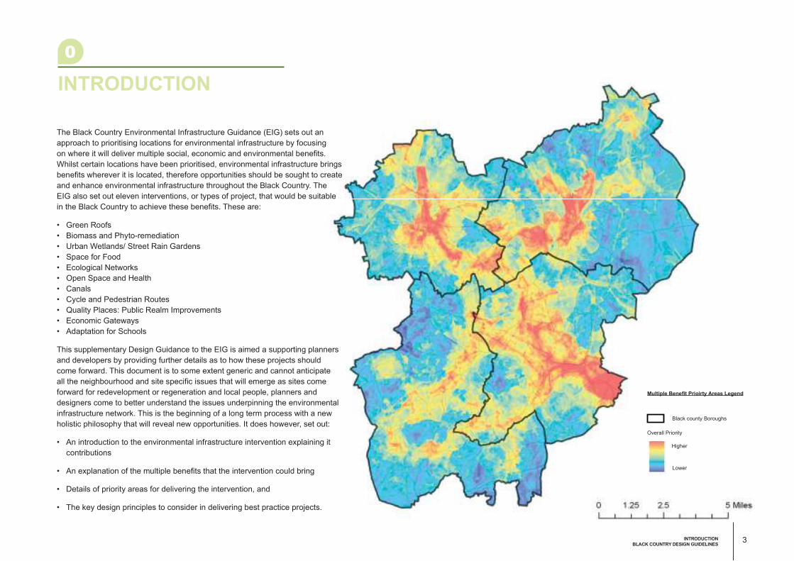
The Black Country Environmental Infrastructure Guidance (EIG) sets out an
approach to prioritising locations for environmental infrastructure by focusing
on where it will deliver multiple social, economic and environmental benefits.
Whilst certain locations have been prioritised, environmental infrastructure brings
benefits wherever it is located, therefore opportunities should be sought to create
and enhance environmental infrastructure throughout the Black Country. The
EIG also set out eleven interventions, or types of project, that would be suitable
in the Black Country to achieve these benefits. These are:
• Green Roofs
• Biomass and Phyto-remediation
• Urban Wetlands/ Street Rain Gardens
• Space for Food
• Ecological Networks
• Open Space and Health
• Canals
• Cycle and Pedestrian Routes
• Quality Places: Public Realm Improvements
• Economic Gateways
• Adaptation for Schools
This supplementary Design Guidance to the EIG is aimed a supporting planners
and developers by providing further details as to how these projects should
come forward. This document is to some extent generic and cannot anticipate
all the neighbourhood and site specific issues that will emerge as sites come
forward for redevelopment or regeneration and local people, planners and
designers come to better understand the issues underpinning the environmental
infrastructure network. This is the beginning of a long term process with a new
holistic philosophy that will reveal new opportunities. It does however, set out:
• An introduction to the environmental infrastructure intervention explaining it
contributions
• An explanation of the multiple benefits that the intervention could bring
• Details of priority areas for delivering the intervention, and
• The key design principles to consider in delivering best practice projects.
Multiple Benefi t Prioirty Areas Legend
Black county Boroughs
Overall Priority
Higher
Lower
3INTRODUCTION
BLACK COUNTRY DESIGN GUIDELINES

GREEN ROOFS
BLACK COUNTRY ENVIRONMENTAL INFRASTRUCTURE DESIGN GUIDELINES
Green Roof: Livingroofs.org

Introduction to the Intervention Green roofs (sometimes known as living
roofs) are deliberately vegetated roofs.
Intensive green roofs are roof gardens, found
on residential and substantial commercial
buildings which are usually irrigated. Extensive
green roofs are relatively lightweight and low
maintenance with self-sustaining vegetation.
One type of extensive green roof is the brown
roof (or biodiverse roof) designed to mitigate
for the loss of habitat on a brownfield site with
open mosaic habitats. Further information
on the different categories of green roof is
available at the livingroofs.org website.1
Green roofs are truly multi-functional. Typical
extensive green roofs absorb 50% of the
rainfall that falls on them, helping to reduce
the pressure on drainage systems and the
risk of flooding. Green roofs are recognised
by the Environment Agency and CIRIA as a
valuable component of sustainable drainage
systems (SUDS). Water that evaporates
from green roofs cools down buildings and
neighbourhoods, helping people to cope
with heat waves and the urban heat island.
Green roofs save energy and reduce carbon
dioxide emissions by increasing insulation
and reducing air conditioning loads. Green
roofs can bring valuable wildlife habitat into
areas where the conservation of biodiversity is
often neglected. Roof gardens provide private
amenity and places to relax and grow food in
even the most urban locations, improving the
quality of housing and raising standards.
Multiple Benefits• Supporting Investment:
Installing green roofs helps to
support the growth of green
industry in the Black Country
• Fostering High Quality
Neighbourhoods:
Roof gardens and extensive
green roofs will help to green
districts that might otherwise
be perceived as harsh
environments
• Creating Sustainable Links:
Green roofs can act as stepping
stones in ecological networks
• Protecting and Enhancing
Biodiversity:
Extensive green roofs can be
designed to benefit birds and
rare invertebrates, including
spiders, beetles and bees. Bees
pollinate about 25% of our food
crops.
• Celebrating a Sense of Place:
Green roofs can bring a new
attractive look to otherwise
generic ‘anyplace’ buildings.
• Supporting Healthy Living:
Green roofs can bring
psychological benefits for those
who overlook or use them. Roof
gardens can be used to produce
local food
• Managing Resources
Efficiently: Green roofs
conserve energy and prolong
the life of the waterproofing on a
roof. They also help to maintain
water and air quality.
• Building Resilience to Climate
Change:
Green roofs help to reduce the
urban heat island effect and are
part of sustainable drainage
systems.
Peter Merian Haus - Basel: Gary Grant
GREEN ROOFS
1
5GREEN ROOFS
BLACK COUNTRY DESIGN GUIDELINES

Priority AreasIt is recommended that green roofs (either on
new build or retrofitted) are installed wherever
the opportunity arises throughout the Black
Country, but there will be extra benefits in
areas where climate change is predicted to
make living and working conditions intolerable.
The average thresholds for defining heat
waves in England are 30oC during the day
and 15oC overnight. When temperatures
climb above 25oC there is increased mortality
in vulnerable people including those with
severe and chronic illness, the very young
and old. The thermal image (fig 1.1) of the
Black Country shows how temperatures are
higher in town centres and industrial areas
where sealed surfaces and dense materials
dominate and soil and vegetation is reduced
or absent. These are also places where the
preponderance of sealed surfaces creates
a heightened risk of surface water flooding.
Green roofs can help to reduce temperatures
in the hottest areas and form part of
sustainable drainage systems in the same
locations.
0 5 102.5 KmFig 1.1 Urban Heat Island
coolhot
Major Roads
Urban Heat Legend
Relative
Surface Temp.
Black county
Boroughs
Industrial and distribution buildings in Switzerland designed for
summer cooling, rainwater attenuation, nesting birds, wildflowers and
invertebrates: Livingroofs.org
Where urban areas prevent the establishing
ecological networks at ground level, green
roofs can also help by providing ‘stepping
stone’ habitats.
6

Key Design Principles Construction - Figure 1.2 shows a cross
section an extensive green roof. It highlights
the need for appropriate structural support,
roof protection, drainage and the growing
medium. Note that extra light weight green
roofs will not absorb as much rainwater which
will limit their performance in terms of drainage
and cooling. Their ecological value is also
lower. As such green roof substrate should be
no less than 80mm.
New Build - It is important to consider the
functions of the green roof before design
and specification. Is the roof required as an
accessible garden, to provide summer cooling,
reduce run-off or improve biodiversity? The
structure should be designed to support the
green roof that is most appropriate for the
situation.
Retrofitting - When an existing roof needs to
be replaced there will be an expectation that a
green roof is considered. A structural engineer
will advise on whether or not an existing roof is
capable of supporting extra weight.
Many types of building are suitable for green
roofs including residential blocks, offices,
shops, institutional buildings and schools.
Chimney Pot Park2 in Salford is an example
of roof gardens included in terrace houses.
The commercial warehouse below has been
retrofitted with a green roof. The cross-
braces were all that were needed to give the
roof sufficient structural support to hold the
additional load.
Fig 1.2 Typical Section of Green Roof
Green roof supporting structure: Gary Grant
7GREEN ROOFS
BLACK COUNTRY DESIGN GUIDELINES

BIOMASS AND
PHYTOREMEDIATION
BLACK COUNTRY ENVIRONMENTAL INFRASTRUCTURE DESIGN GUIDELINES
Aircraft Repair & Supply Center, Elizabeth City: Ryan Somma

Introduction to the Intervention The Black Country has a number of
vacant brownfield sites, most of which will
eventually be regenerated, for employment,
housing or as part of the environmental
infrastructure network. Some of these sites
are contaminated and will need to be cleaned
up before re-use. One way of cleaning
up certain categories of contamination is
to use vegetation, a process known as
phytoremediation. Phytoremediation is a
broad term used fro a variety of processes
whereby vegetation and soil microbes
break down organic pollutants or uptake or
stabilise metals, making it easier to remove
them. Examples of plants that have been
used to isolate metals are certain strains of
fescue (a grass) and poplars (a fast growing
tree). Man made wetlands can also be
used to clean up contaminated leachates.
Phytoremediation is still a relatively new
approach to clean up of contaminated sites,
but costs are a fraction of those associated
with conventional excavation, washing and
reburial.3 Phytoremediation can be used
in combination with conventional methods.
Further information on phytoremediation,
including case studies, is available from the
US EPA.4
Many sites are likely to remain vacant for
many years. There is a growing demand
for sources of low or zero carbon energy.
One possible source of this alternative
energy will be biomass as fuel for heating
or to fuel combined heat and power plants.
A popular source of biomass for energy
production is woodchips derived from
woodland management and short-rotation
coppice (SRC). SRC involves the growing
of willow and poplar trees and cutting the
woody re-growth of shoots at the base of the
plant. Sites need to be at least 3 hectares in
size to attract government grants. The latest
advice on siting and funding is available from
Natural England.5 Yields for some of the more
productive varieties can reach 15 dry tonnes
per hectare per annum. Approximately 100
hectares of SRC is required to for 1 MW
of continuous power output. The cuttings
are chipped and fed into wood-burning
furnaces that make steam to heat homes and
businesses and to drive electricity generating
turbines. SRC is popular in Scandinavia,
where it is often irrigated with waste water
from sewage treatment plans. The Black
Country has vacant sites larger than 3
hectares suitable for planting with SRC and
has many industrial areas where woodchip
fuel could be processed and stored. Other
sources of woodchip would be cuttings from
street trees and parks and waste wood from
industry and municipal waste sites.
SRC can therefore provide both a relatively
inexpensive way of cleaning up contaminated
sites, that can be more acceptable
to the public than more conventional
decontamination processes, as well as
Tree roots take in water and
pollution from the ground
polluted soil
clean soil
water table
polluted groundwaterclean groundwater
water enters tree where pollution is
cleaned up
Fig 2.1 Phytoremediation
BIOMASS AND PHYTOREMEDIATION
2
9BIOMASS AND PHOTREMEDIATION
BLACK COUNTRY DESIGN GUIDELINES

providing a low carbon energy source.
Where a contaminated site will be maintained
as open space over the long term,
conventional woodland planting should be
considered. This can provide phytoremediation
whilst providing biomass (through thinnings)
reducing surface run-off and creating valuable
wildlife and amenity. Grants are available
for woodland creation through the England
Woodland Grant Scheme.6
• Supporting Investment:
Woodland, SRC and CHP would
create jobs and help to develop
green industry in the Black
Country.
• Fostering High Quality
Neighbourhoods:
Woodland and SRC provides a
green and attractive outlook.
• Creating Sustainable Links:
Woodland and SRC sites can
be part of the wider ecological
network.
• Protecting and Enhancing
Biodiversity:
Woodland, SRC and phyto-
remediation sites are valuable
wildlife habitat, left to grow
during the summer to provide
nesting sites for birds and cover
for other wildlife. Willows and
poplars support insects which
attract aerial feeders like bats,
swallows and swift.
• Celebrating a Sense of Place:
Woodland and SRC will become
a welcome addition to the
cityscape. CHP plants could be
celebrated as part of the local
industrial tradition.
• Supporting Healthy Living:
Access can be provided along
tracks that cross woodland and
SRC sites for recreation and
exercise.
• Managing Resources
Efficiently:
Woodland and SRC will make a
contribution towards creating a
low carbon future.
• Building Resilience to Climate
Change:
Woodland and SRC will be
part of the wider environmental
infrastructure network reducing
urban heat islands and
attenuating surface water run-
off.
Priority AreasBiomass is likely to play an important role
in meeting carbon reduction targets. There
are limited opportunities to grow biomass
on agricultural land in the Black Country.
However, if all the brownfield and vacant sites
in the Black Country was used to grow SRC
for biomass, it has been estimated that it
could produce enough energy to heat 10,000
homes each year. Planning departments
should identify sites with potential for this as a
temporary use.
It is recommended that SRC is targeted at
brownfield sites that are level (a requirement
for operating SRC machinery), have adequate
access for farm vehicles, are likely to remain
vacant for some years and are larger than 3
hectares.
Phytoremediation techniques need to be
carefully matched to the actual contamination
found on a particular sites and this will require
further investigation.
Where contaminated sites remain, permanent
woodland creation should be considered as an
option.Derelict land in the Black Country
Multiple Benefits
10
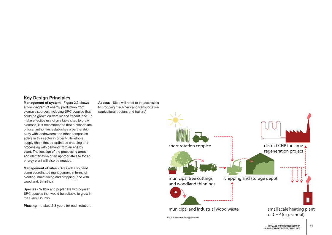
Access - Sites will need to be accessible
to cropping machinery and transportation
(agricultural tractors and trailers)
Fig 2.3 Biomass Energy Process
Key Design PrinciplesManagement of system - Figure 2.3 shows
a flow diagram of energy production from
biomass sources, including SRC coppice that
could be grown on derelict and vacant land. To
make effective use of available sites to grow
biomass, it is recommended that a consortium
of local authorities establishes a partnership
body with landowners and other companies
active in this sector in order to develop a
supply chain that co-ordinates cropping and
processing with demand from an energy
plant. The location of the processing areas
and identification of an appropriate site for an
energy plant will also be needed.
Management of sites - Sites will also need
some coordinated management in terms of
planting, maintaining and cropping (and with
woodland, thinning).
Species - Willow and poplar are two popular
SRC species that would be suitable to grow in
the Black Country
Phasing - It takes 2-3 years for each rotation.
11BIOMASS AND PHOTREMEDIATION
BLACK COUNTRY DESIGN GUIDELINES

URBAN W
ETLANDS
AND STREET RAIN
GARDENS
BLACK COUNTRY ENVIRONMENTAL INFRASTRUCTURE DESIGN GUIDELINES
Natural water treatment, Melbourne Dock by AECOM: AECOM

Introduction to the InterventionThere are serious surface water flood
risks in the Black Country. There are also
serious water pollution issues in the canals
and watercourses. The Flood & Water
Management Act of 2010 has established
a new lead role for local authorities, which
are preparing Surface Water Management
Plans7 to bring about the capture, storage and
treatment of runoff to protect property and
waterways from both flooding and pollution.
Urban wetlands are a type of Sustainable
Urban Drainage System (SUDS) that act to
store and treat water while also providing
valuable habitat and amenity. Urban
wetlands are constructed, and can be
sized and designed to suit their contextual
surroundings8. The wetlands can be lined
and have a hard edge to suit commercial or
industrial surroundings, though the soil and
vegetation layers are specifically designed to
improve water quality.
The Black Country has many commercial and
industrial areas where water management
features with soft edges may be inappropriate.
Urban wetlands can be accommodated in
‘lost spaces’ in these areas, and can be hard-
edged, linear or irregular in shape, capturing
runoff from several surrounding properties
(from roofs and paved surfaces).
Rain gardens are a type of Sustainable
Urban Drainage System (SUDS) that capture
rainwater runoff, allowing water to trickle
through specifically designed soil layers that
help remove pollutants, and then capturing
water below the garden for either storage
or discharge. Rain gardens can look like
a normal landscaped area to the observer
and are an ideal type of SUDS for use in
residential areas of the Black Country, as they
add valued landscaping yet take up a small
amount of space. They can be well integrated
with streets, either acting as a verge, a central
median, a traffic island or a street tree pit.
Rain gardens can be provided on any street
and connect to an existing drainage system.
Street rain gardens have seen widespread
success and community support in Portland,
Oregon.9 Portland’s features and delivery
URBAN WETLANDS AND STREET RAIN GARDENS
3
Water treatment in Waitangi Park, New Zealand: AECOM
13URBAN WETLANDS
BLACK COUNTRY DESIGN GUIDELINES

methods could be used as a blueprint for the
Black Country.
Local authorities will act as approval bodies
for SUDS, which will be required on all new
development sites under the Flood and Water
Management Act 2010, but there is a very
apparent need to also retrofit SUDS into
existing areas, particularly areas with a high
proportion of paved surfaces where runoff
volumes are considerable and water quality
poor.
Bioretention swales by AECOM: AECOM
San Francisco rain garden: AECOM Flow-through planter: City of Portland
14

• Supporting Investment:
Urban wetlands and rain
gardens will be a special
feature of the Black Country,
fostering a forward-thinking
image for the area.
• Fostering High Quality
Neighbourhoods:
Urban wetlands and rain
gardens will be natural and
aesthetically pleasing features
that soften the grounds of
public buildings as well as
residential, industrial and
commercial landscapes.
• Building Resilience to
Climate Change:
Urban wetlands and rain
gardens and modified street
tree pits will help to manage
the increased risk of flooding
but will also help reduce the
urban heat island effect.
• Managing Resources
Efficiently:
Urban wetlands and rain
gardens help to manage
surface water runoff,
preventing flooding, but also
storing and treating water
locally to allow reuse.
• Celebrating a Sense of
Place:
The Black Country has a
strong industrial and canal
heritage. A number of historic
canals have now silted over,
but the reintroduction of
functional water features can
be designed to celebrate
these features and to support
heritage projects.
• Protecting and Enhancing
Biodiversity:
Urban wetlands will
provide valuable habitat in
industrialised areas, and
also can be designed near
canals and waterways to link
similar habitat types. Street
rain gardens and associated
street trees can increase
urban biodiversity and improve
ecological connectivity.
• Creating Sustainable Links:
Rain gardens and street trees
will help make routes more
pleasant for walking, and can
also be integrated with traffic
calming measures.
Multiple Benefits
Bioretention, Meolbourne: AECOM
Bioretention swale for treatment and harvesting, Adelaide: AECOM
15URBAN WETLANDS
BLACK COUNTRY DESIGN GUIDELINES
0 5 102.5 Km
Fig3.1 Permeability Mapping
Major Roads
Permeability Legend
Black county Boroughs
Inland Water/Cloud/Shadow
Artificial
Mainly Artificial
Mixed Artificial/Bare
Mixed Bare/ Sparsely Vegetated
Vegetated
Densely Vegetated
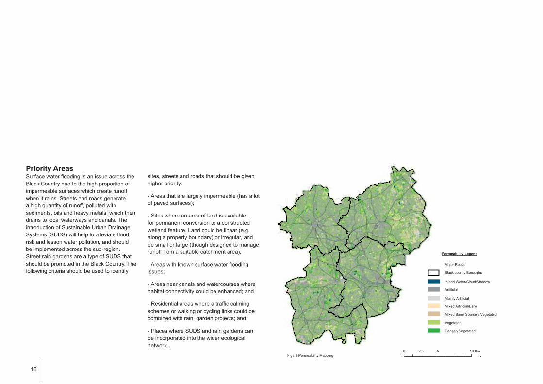
Priority Areas Surface water flooding is an issue across the
Black Country due to the high proportion of
impermeable surfaces which create runoff
when it rains. Streets and roads generate
a high quantity of runoff, polluted with
sediments, oils and heavy metals, which then
drains to local waterways and canals. The
introduction of Sustainable Urban Drainage
Systems (SUDS) will help to alleviate flood
risk and lesson water pollution, and should
be implemented across the sub-region.
Street rain gardens are a type of SUDS that
should be promoted in the Black Country. The
following criteria should be used to identify
sites, streets and roads that should be given
higher priority:
- Areas that are largely impermeable (has a lot
of paved surfaces);
- Sites where an area of land is available
for permanent conversion to a constructed
wetland feature. Land could be linear (e.g.
along a property boundary) or irregular, and
be small or large (though designed to manage
runoff from a suitable catchment area);
- Areas with known surface water flooding
issues;
- Areas near canals and watercourses where
habitat connectivity could be enhanced; and
- Residential areas where a traffic calming
schemes or walking or cycling links could be
combined with rain garden projects; and
- Places where SUDS and rain gardens can
be incorporated into the wider ecological
network.
16

Streetscape Integration – Rain gardens
should be integrated into appropriate spaces
within a streetscape. Verges can be used on
either side of a street, or for more efficient
construction, one central garden can be used
Key Design PrinciplesDesign and Sizing – Urban wetlands
(including rain gardens) should be sized to
provide adequate storage of water after a
rainfall event, but also to allow for a high level
of natural water treatment to take place. As a
rule of thumb, depending on the depth of the
feature and rate of infiltration, urban wetlands
should be between 2-10% of the impermeable
area drained (the area of roofs and paved
space it will receive run-off water from). In the
case where a limited area is available, its size
can be used to determine which buildings/
what scale of area it could capture runoff from
for treatment. Even if an area is smaller than
ideal, it can still reduce flows into conventional
drains and improve water quality, so will be
worth the effort. Urban wetlands should be
designed by a multi-disciplinary design team,
including a drainage engineer, a landscape
architect and an ecologist to ensure the
features have multiple benefits. Where the
feature is located in an important public realm
or amenity area, it should be integrated with
wider landscape design, and could include
public art or geological features.Storm water harvesting Melbourne Docklands Park: AECOM
in a central reservation. Traffic islands and
roundabouts can also be converted to rain
gardens to create an attractive yet functional
landscape. Rain gardens should be carefully
sited in relation to other underground utilities.

Fig 3.3 Urban Wetland Principle
Inclusion of Street Trees – Street trees can
be incorporated into a rain garden and runoff
can therefore be used to passively irrigate the
tree. A tree pit can also be designed as a small
rain garden, gathering runoff and passing it
through vertical filter layers.
Water Treatment – The wetland should be
vegetated with plants that can cope with
both wet and dry conditions, which assist
in water treatment, which are native, and
which contribute to amenity. The soil layers
beneath the rain garden should be specifically
designed to allow rapid draining (with a highly
permeable layer on top), but also to aid
treatment (with sand filtration layers). A gravel
storage area with a perforated pipe should be
included as the bottom layer to capture water
and direct it to another rain garden or the
wider surface drainage network.
Parking lot swale: City of Portland
18
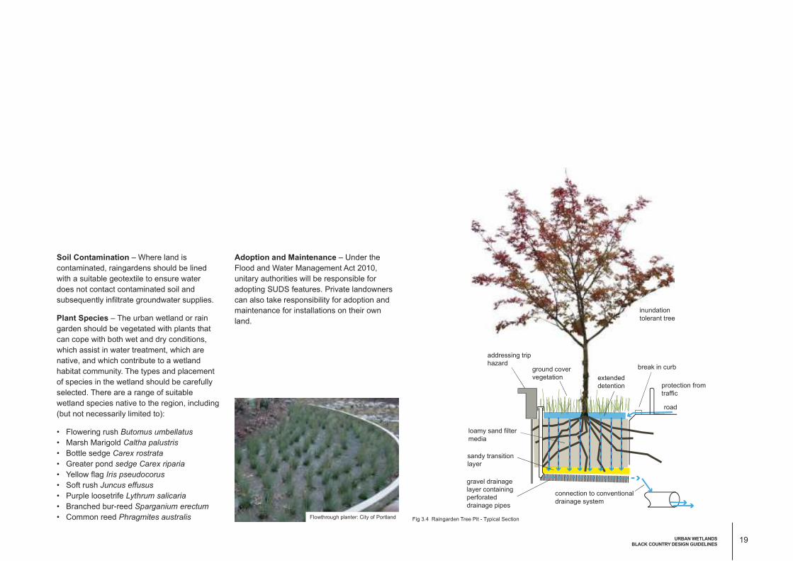
Soil Contamination – Where land is
contaminated, raingardens should be lined
with a suitable geotextile to ensure water
does not contact contaminated soil and
subsequently infiltrate groundwater supplies.
Plant Species – The urban wetland or rain
garden should be vegetated with plants that
can cope with both wet and dry conditions,
which assist in water treatment, which are
native, and which contribute to a wetland
habitat community. The types and placement
of species in the wetland should be carefully
selected. There are a range of suitable
wetland species native to the region, including
(but not necessarily limited to):
• Flowering rush Butomus umbellatus
• Marsh Marigold Caltha palustris
• Bottle sedge Carex rostrata
• Greater pond sedge Carex riparia
• Yellow flag Iris pseudocorus
• Soft rush Juncus effusus
• Purple loosetrife Lythrum salicaria
• Branched bur-reed Sparganium erectum
• Common reed Phragmites australis
Adoption and Maintenance – Under the
Flood and Water Management Act 2010,
unitary authorities will be responsible for
adopting SUDS features. Private landowners
can also take responsibility for adoption and
maintenance for installations on their own
land.
loamy sand filter
media
sandy transition
layer
addressing trip
hazardground cover
vegetation extended
detention
break in curb
protection from
traffic
road
inundation
tolerant tree
gravel drainage
layer containing
perforated
drainage pipes
connection to conventional
drainage system
Fig 3.4 Raingarden Tree Pit - Typical SectionFlowthrough planter: City of Portland
19URBAN WETLANDS
BLACK COUNTRY DESIGN GUIDELINES

SPACE FOR FOOD
BLACK COUNTRY ENVIRONMENTAL INFRASTRUCTURE DESIGN GUIDELINES
Allotments: AECOM

Introduction to the InterventionLocally grown food can reduce carbon
dioxide emissions by reducing transportation,
encourage people to exercise more, cook
more and enjoy a healthier and more
varied diet. There is a growing demand
for conventional local authority allotments,
however there are interesting examples
of local food cultivation in schools and on
housing estates and on derelict land. Space
for food growing can be a temporary use of
a vacant site where development is likely to
occur after a number of years.
The Capital Growth campaign, supported
by the Greater London Authority and the Big
Lottery’s Local Food Fund, is an example
of where recognition of the potential to
use under-utilised land for food production
in London has generated numerous food
growing initiatives. The Campaign, which
aims to have 2,012 new food growing spaces
by the time of the 2012 Olympics, supports
communities in finding space, providing
expert advice and using economies of scale
to discount seeds, tools and insurance. In
addition to the potential health benefits and
making better use or resources, there is
significant evidence to suggest schemes have
improved community cohesion.
An excellent example of urban food growing
in the Black Country is the Salop Drive Market
Garden in Sandwell,10 a unique 1.2 hectare
working market garden, which developed from
a derelict allotment site over a period of five
years through the hard work and vision of local
people.
• Celebrating a Sense of Place:
community allotments can
promote community cohesion
and become the centre of
community activity
• Supporting Healthy Living:
encouraging the growth of
vegetables and fruit can help
engender healthy eating
• Managing Resources
Efficiently: allotments are a
good way of making under-
utilised land more productive
and can promote active
temporary use of vacant sites.
• Building Resilience to Climate
Change:
Locally grown produce reduces
the need to transport good and
for packaging.
4
SPACE FOR FOOD
Multiple Benefits
Local cultivation: SMBC
21SPACE FOR FOOD
BLACK COUNTRY DESIGN GUIDELINES

Priority Areas It is recommended that:
• More allotments are provided close to
residential areas, close to where people live
• Consultation is undertaken with residents
on existing estates to explore the possibility
of converting existing incidental open
spaces into secure plots that can be used
as vegetable gardens.
• Where new residential development is
planned, some space should be put aside
for allotments.
• Suitable derelict and under-utilised sites
close to residential areas are taken into
use. Temporary use of sites allocated for
development may be possible.
• www.landshare.net links those in search of
space to grow food with available land. It
was set up by Hugh Fearnley-Whittingstall’s
River Cottage, after helping to some Bristol
families grow vegetables on derelict land.
Now Landshare is a national movement
of more than 50,000 people including
0 5 102.5
Major Roads
Green Derelict Land Legend
Black county Boroughs
Vegetated Vacant and Derelict Land
Vacant and Derelict Land
Fig 4.1 Derelict land presents opportunity areas
significant areas in the Black Country that
could offer potential.
Incredible Edible: CABE

Key Design PrinciplesRaised beds – Previously developed sites
often do not have sufficient quality top soil for
growing food, or could be contaminated. One
option to provide raised beds filled with top
soil. These should be at least 40cm deep. If
the land is contaminated, the bed would need
to be lined to prevent contaminants from being
drawn up into the plants.
Growing sacks – In some instances, such as
on contaminated land or where growing beds
might need to be moved at a later date, use
large growing sacks.
Water Supply – sites should have a
connection to a clean water supply.
Secure - Sites should be safe and secure.
Where possible they should be over looked,
have good access and be easy to move
around. If tools and equipment are to be
left on site these need to be locked in a
secure shed. Allotments should also be well
maintained and kept tidy, with waste recycled
or removed.
Link to food waste – Opportunities to
‘close the loop’ by linking food growing with
waste food should be sought. The ‘Food
Loop’ project at the Maiden Lane Estate,
Camden links their successful allotments
with a community composting scheme. Food
waste is collected from the estate and rapidly
composted using an accelerated in-vessel
composter before being used in the allotments
to support further food growth.
Raised Beds: AECOM Raised Beds: Ryan Mitchelll
23SPACE FOR FOOD
BLACK COUNTRY DESIGN GUIDELINES

ECOLOGICAL
NETWORKS
BLACK COUNTRY ENVIRONMENTAL INFRASTRUCTURE DESIGN GUIDELINES
Pond at Sandwell Valley Country Park: ‘Black Country Historic Landscape’ ‘Characterisation

Introduction to the InterventionEcological networks begin with designated
sites, which become the core areas of
the network. Core areas should then be
surrounded by buffer zones where it is feasible
to create or restore habitat. In urban areas
these buffer zones could be existing green
space or vacant sites. Green connections,
often in the form of linear sites associated
with road, rail or canals network or perimeter
strips around sites can then be improved
and linked in order to complete the network.
GIS mapping is used to identify core areas,
buffers and interconnections. Where large
scale regeneration is proposed, planners
should examine the options for buffering core
sites, restoring biodiversity to open space and
making the connections in the wider network,
by creating multi-functional environmental
infrastructure corridors that include cycle
paths, footpaths and SUDS as well as
ecological connections (fig 5.1). The network
can also be an opportunity to showcase and
increase awareness of sites of interest for
geodiversity.
Ecological networks make the landscape
more permeable to both wildlife and people.
The ecosystem services that are associated
with environmental infrastructure are provided
in a more efficient way when habitats and
open space are interconnected. Ecological
networks are primarily about the conservation
of biodiversity but they also moderate climate,
reduce flood risk and bring respite from
poor air quality. For a full discussion of the
importance of restoring an ecological network
see the Lawton Review (2010).11 In developing
the network, consideration should be given to
the Black Country Geodiversity Action Plan.12
Fig 5.1 Building an Ecological Network
5
ECOLOGICAL NETWORKS
MIT Campus: AECOM
25ECOLOGICAL NETWORKS
BLACK COUNTRY DESIGN GUIDELINES

Multiple Benefits• Creating Sustainable Links:
The ecological network is
part of a wider network of
routes for boaters, cyclists and
pedestrians
• Protecting and Enhancing
Biodiversity:
The ecological network
is comprised of retained,
enhanced and created wildlife
habitat managed for wildlife.
This should be guided by the
local biodiversity action plan.
• Celebrating a Sense of Place:
Habitats in the ecological
network are the most
appropriate landscapes for each
locality.
• Supporting Healthy Living:
Access could be provided in
and around water bodies for
recreation.
• Managing Resources
Efficiently:
Cuttings and thinning from the
expanded network will be used
to provide energy in biomass
furnaces.
• Building Resilience to Climate
Change:
Vegetation will help reduce
flooding and help control micro-
climate.
• Supporting Investment:
Green cities attract more
investment. People are more
likely to want to live a work in
a green environment and are
more likely to settle down.
• Fostering High Quality
Neighbourhoods:
By permeating every part of the
Black Country and expanded
ecological network provides a
green and attractive outlook for
more people.
Bio-swale at Mission Bay Sports Complex, San Francisco: AECOM
26

Key Design Principles Strategic guidance - The EIG provides
an overarching strategy for key creation
and enhancement opportunities within the
identified priority areas. An example of this is
shown in figure 5.3. Consideration should be
given to working over interventions (eg urban
wetlands) into the network. Reference should
be made to the Biodiversity Enhancement
Zones and Geodiversity Consideration Zones
in the EIG Phase 1.
Local conditions - The habitats created
should be determined following a thorough
analysis of local conditions, including
topography, geology and adjacent habitats.
Suitable habitats and species - The Local
Biodiversity Action Plan should also be
referred to in order to select the appropriate
habitats and target species. Native species of
local provenance should be used.
Geodiversity – Interventions should protect,
enhance and create new geological or
geodiversity features, which will contribute to
sense of place.
Priority AreasThe greatest changes in the Black Country
will occur within the regeneration corridors so
special attention should be paid to creating
new links within the wider ecological network
within these areas (see primary opportunity
areas in fig. 5.2). The masterplan for each
project should include connection corridors
(or if this is not feasible habitat patches) to
contribute to the creation of a wider Black
Country ecological network. Priority should
be given to providing ‘missing links’ within the
network (Fig 5.2). These are indicative and
subject to revision as opportunities emerge.
Planning to extend the wider ecological
network within the regeneration corridors
should take account of the locations of
existing core areas as well as buffer areas
where restoration and enhancement can
be supported and the creation of new
connections.
The network will be comprised of a mosaic of
semi-natural habitats including open water,
wetlands, woodlands, grasslands and pioneer
communities.
0 5 102.5 Km
Major Roads
Ecological Network Legend
Black county Boroughs
Wildlife corridors
Regeneration corridors
Primary Opportunity Areas
(size denotes scale of
potential intervention)
Fig 5.2 Priority Areas for strengthening Ecological Networks
27ECOLOGICAL NETWORKS
BLACK COUNTRY DESIGN GUIDELINES

Barriers - Opportunities should be sought to
cross barriers to ecological networks, such as
major roads and infrastructure.
New development - Provides an excellent
opportunity to reinforce ecological networks.
Sometimes unexpected links can be created.
Canals and linear linkages - Will help further
extend the ecological network.
RC4.d: Identified Wildlife Corridor(Birmingham Canal)
RC4.a: Identified Wildlife Corridor(Railway line)
RC4.b: Habitat Creation
(Vacant land along canal and railway)
RC4.c: Habitat Enhancement
Fig 5.3 Proposed Networks with Regeneration areas. Example: Wolverhampton - Bilston
Area in
Regeneration
Corridor
Habitats / Land
Use
Remarks
RC4.a Broadleaved
woodland (WB3),
Scrub woodland
(WB2), Improved
grassland (GI0)
A diversity of habitats is present along
the railway line and viaduct opposite
Manders Industrial Estate including areas
of woodland, scrub and grassland. These
habitats are likely to act as a wildlife
corridor as well as providing a link to the
Wyrley & Essignton Canal.
RC4.b Industrial /
Commercial (UR0B)
Habitat creation is recommended within
brownfield sites and vacant industrial land
present along the Birmingham Canal –
Wolverhampton Level in order to improve
the ecological value and the continuity of
this wildlife corridor.
RC4.c Broadleaved
woodland (WB3),
Improved grassland
(GI0)
Habitat enhancement is recommended
for an area of improved grassland and
scattered / dense trees located between
Birmingham Canal and the railway line in
order to improve the ecological network
and wildlife corridor formed by the canal.
RC4.d Standing open water
(AS0), Calcareous
grassland (GC0),
Scrub woodland
(WB2), Broadleaved
woodland (WB3),
Improved grassland
(GI0)
A variety of habitats e.g. calcareous
grassland, scrub and woodland, and
designated sites along the Birmingham
Canal, including Birmingham Canal
SLINC and Ladymoor Pool SINC, have
been identified as a wildlife corridor.
28