Embed Size (px)
Citation preview
ENVIRONMENTAL MANAGEMENTFRAMEWORK (EMF)
FOR
REGIONAL DISASTER VULNERABILITYREDUCTION PROJECT (RDVRP)
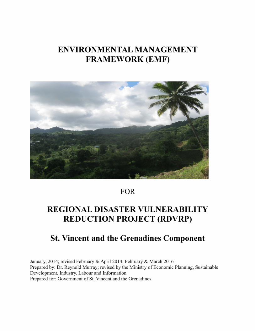
St. Vincent and the Grenadines Component
January, 2014; revised February & April 2014; February & March 2016Prepared by: Dr. Reynold Murray; revised by the Ministry of Economic Planning, Sustainable Development, Industry, Labour and InformationPrepared for: Government of St. Vincent and the Grenadines
ACRONYMS
AF Additional FinancingAPL Adaptable Program LendingBMP Best Management PracticeCWSA Central Water and Sewerage AuthorityDVRP Disaster Vulnerability Reduction ProjectEA Environmental AssessmentEIA Environmental Impact Assessment EIS Environmental Impact StatementEMF Environmental Management FrameworkEMP Environmental Management PlanENSO El Niño Southern OscillationILO International Labor OrganizationLBS Land Based Sources (of marine pollution)MEAs Multilateral Environmental AgreementsOECS Organization of East Caribbean StatesOP Operational PolicyPPU Physical Planning UnitPPDB Physical Planning and Development BoardPSIPMU Public Sector Investment Project Management UnitRDVRP Regional Disaster Vulnerability Reduction ProjectSGD St. Georges Declaration (of Principles for sustainable development in the OECS)SVG St. Vincent and the GrenadinesSWMA Solid Waste Management AuthorityUNCBD United Nations Convention on Biological DiversityUNCCD United Nations Convention to Combat DesertificationUNFCCC United Nations Framework Convention on Climate ChangeVINLEC Vincentian Electricity ServicesWB World Bank
Page 2 of 118
EXECUTIVE SUMMARY
The Government of Saint Vincent and the Grenadines (GoSVG) is collaborating with the WorldBank (WB) to implement a Regional Disaster Vulnerability Reduction Project (RDVRP) whichaims to measurably reduce vulnerability to natural hazards and the adverse impacts of climatechange in Saint Vincent and the Grenadines (SVG).
The XCD 165.4 million SVG RDVRP was declared effective by the WB on September 9, 2011,and is being implemented over a seven (7) year period that ends on December 31, 2018. It is100% financed by credits of USD 46.52 million from the International Development Agency,Strategic Climate Fund Pilot Program for Climate Resilience grants of USD 12 million, and aStrategic Climate Fund Loan of USD 3 million.
Additional Financing (AF) is being sought for the RDVRP project. This EnvironmentalManagement Framework (EMF) updates and expands on the previously prepared EMF, whichprovides screening methods and procedures for the application of Bank safeguards, includingguidance on the scope of studies necessary to complete for each subproject, criteria for triggeringadditional studies in the case of complex or significant activities, and a generic EnvironmentalManagement Plan (EMP) for use in simple situations where activities need no additionalassessment. It is likely that the majority of works will be relatively minor in nature and involvesimple civil works where the environmental impacts are limited to the construction phase,requiring only the application of a standardized generic EMP. However, any exceptions will beidentified during screening in the EMF, and subject to additional assessment work.
Project works will be undertaken on mainland SVG - Bequia, and Union Island. Workscontemplated relate to the repair and rehabilitation of existing infrastructure, retrofitting of keygovernment buildings and new facility construction (particularly satellite warehouses),geotechnical studies and engineering supervision for slope stabilization along critical roadsegments, river defense works and coastal erosion protection studies, the rehabilitation of feederroads and the repair of a jetty. The possible project locations have been field-checked by WorldBank staff have been inventoried and assessed in preliminary form through this EMF safeguardsinstrument which also includes a top-level Environmental Assessment (EA) to describe theenvironmental impacts of the project on a program-wide level. In addition this EMF includes anEMP with environmental safeguards to guide the implementation of relatively simple civil worksfor which no additional assessment would be required.
This EMF describes the environmental impacts of the project on a program wide level. The EMFis the appropriate environmental management tool to be used for future subprojects as detailedinformation on particular specific sub-projects under the RDVRP have yet to be fully defined.General guidelines have been provided to assist in identifying potential impacts, mitigatepotential negative impacts, statutory administration, and responsibilities as best as possible. AnEMP with standard mitigation management measures has also been prepared and should beincorporated into the civil works contract as clauses to guide the contractor and to also form abasis for monitoring during implementation. Any additional detailed mitigation measuresdeveloped by specific studies (EIAs) for complex or sensitive subproject activities, or anyadditional environmental requirements imposed by St. Vincentian law and regulations, would
Page 3 of 118

also be translated into performance requirements for the contractors through civil workscontracting clauses and verified by monitoring during implementation.
Page 4 of 118
TABLE OF CONTENTS
EXECUTIVE SUMMARY...........................................................................................................3
1.0 INTRODUCTION...................................................................................................................9
1.1 Project Description................................................................................................................9
1.2 Background............................................................................................................................9
1.3 List and Description of Subprojects....................................................................................10
2.0 LEGAL AND REGULATORY FRAMEWORK................................................................16
2.1 Regulatory Framework........................................................................................................16
2.2 World Bank Safeguard Policies...........................................................................................18
2.3 National Regulatory Framework.........................................................................................21
2.4 Environmental Management Capacities..............................................................................22
3.0 DESCRIPTION OF EXISTING ENVIRONMENT...........................................................23
3.1 St. Vincent and the Grenadines General Context................................................................23
3.2 Geology................................................................................................................................24
3.3 Topography and Drainage....................................................................................................25
3.4 Current Climate...................................................................................................................26
3.5 Socio-economy and Human Settlement...............................................................................29
3.6 Biological Resources...........................................................................................................32
3.7 Geo-hazards.........................................................................................................................34
3.8 Physical Cultural Resources................................................................................................37
4.0 PROJECTED IMPACTS......................................................................................................39
4.1 Analysis of Projected Impacts.............................................................................................39
4.1.1 Positive Impacts............................................................................................................45
4.1.2 Negative Impacts..........................................................................................................45
5.0 MITIGATION MEASURES.................................................................................................49
5.1 Mitigation Measures............................................................................................................49
6.0 SCREENING PROCEDURES.............................................................................................54
6.1 Screening Processes.............................................................................................................54
6.2 Local Permitting..................................................................................................................55
6.3 Screening Criteria and Checklists........................................................................................56
6.3.1 Relatively Complex Sub-projects.................................................................................56
6.3.2 Relatively Simple Sub-projects....................................................................................58
6.4 Emergency Procedures........................................................................................................58
7.0 ENVIRONMENTAL MANAGEMENT PLAN..................................................................60
Page 5 of 118
7.1 Mitigation Measures............................................................................................................60
7.2 Environmental Performance Clauses for Works Contracts.................................................64
7.3 Supervision, Monitoring, and Reporting.............................................................................65
8.0 DISCLOSURE WORKSHOP / PUBLIC CONSULTATION............................................67
9.0 TECHNICAL REFERENCES..............................................................................................69
APPENDICES..............................................................................................................................71
Appendix 1 – Project Environmental Screening Checklist Form - Part 1.................................72
Appendix 2 – Project Environmental Screening Checklist Form - Part 2.................................75
Appendix 3 – Guidelines for Using the Project Environmental Screening Checklist...............77
Appendix 4 – Guidelines for Preparing an EIS.........................................................................80
Appendix 5 – Best Management Practices for Erosion Control................................................86
Appendix 6 – Best Management Practices for Slope Stabilization...........................................88
Appendix 7 – Other Best Management Practices......................................................................92
Appendix 8 – Typical Environmental Contract Clauses............................................................93
Appendix 9 – Disclosure Workshop / Public Consultation.....................................................103
Appendix 10 – Redisclosure....................................................................................................105
Page 6 of 118

Figures Title Page
1
2
34
Location Map of Saint Vincent and the Grenadines
Geological Map of St. VincentTopographic Map of St. VincentMajor Watersheds Used for Water Supply in St. VincentMajor Watersheds in Use in St. Vincent
22
24
2526
5 Mean Annual Monthly Rainfall for St. Vincent 1987-2008 266 Hurricane Track in the Caribbean and the Gulf of Mexico 277 Population Distribution 288 Land Use Map of St. Vincent 309 a, b Important Bird Area and Protected Area in St. Vincent 3310 Volcanic Hazard Zone 3511 Storm Surge and Coastal Erosion 36
Tables
1 Summary of Pertinent Agencies, Supporting Legislation andScope
15
2 World Bank Project Categories 183a Impact Matrix: List of RDVRP Projects Approved 38
3b Impact Matrix: Proposed Projects41
4 Impact Areas and Mitigation Measures 50
5 Identification of Complex/Sensitive Sub-projects orActivities
58
6 Standard Minimum Elements of the EnvironmentalManagement Plan (EMP)
61
Page 7 of 118
LIST OF APPENDICES
1. Project Environmental Screening Checklist Form – Part 1
2. Project Environmental Screening Checklist Form – Part 2
3. Guidelines for Using the Project Environmental Screening Checklist.
4. Guidelines for Preparing an EIS
5. Best Management Practices for Erosion Control
6. Best Management Practices for Slope Stabilization
7. Other Best Management Practices
8. Typical Environmental Contract Clauses
9. Disclosure Workshop / Public Consultation
10. Redisclosure Notice
Page 8 of 118
1.0 INTRODUCTION
1.1 Project Description
The GoSVG with the assistance of the WB is implementing the RDVRP as part of the Regional Disaster Vulnerability Reduction Program Adaptable Program Lending (APL) for the East Caribbean Region.
The Program aims at measurably reducing vulnerability to natural hazards and climate change impacts in the Eastern Caribbean Sub-region. The achievement of the Program Development Objectives would be measured using the following key indicators: (a) Reduced risk of OECS population to failure of public buildings and infrastructure due to natural hazards or climate change impacts; and (b) Increased capacity of OECS Governments to identify and monitor climate risk and impacts.
The objective of the RDVRP in SVG is to measurably reduce vulnerability to natural hazards andclimate change impacts and to create some level of resilience at a national level, as well as to include various activities related to institutional strengthening and training.
According to the Bank’s Environmental Assessment (EA) Policy (Operational Policy OP 4.01), the RDVRP is classified as Category B, meaning that environmental impacts for the type of workanticipated under the project are expected to be moderate in nature and can be managed through the application of appropriate engineering and management measures.
This program-level EMF updated the existing EA and included guidance during project execution for screening possible subprojects and identify complex projects which would require additional studies to comply with safeguards policies. All future subprojects which are as yet not identified in detail are included in a single EMF document. The EMF will serve as a screening procedure for work activities and subprojects designed to identify potential environmental impacts, provide standardized mitigation measures in the form of an EMP, and identify works requiring additional assessment during project execution. The EMF and its procedures have been prepared in a form to be incorporated into the Project Operations Manual and will serve as a guide for environmental management of future subprojects or activities once they are defined in sufficient detail for execution. The EMF as a public document, serves to inform stakeholders and guide environmental management of activities to be implemented.
1.2 Background
An important issue confronting SVG’s development is the vulnerability of its population and economy to natural disasters, which can seriously impact the productive sectors of the economy, such as agriculture and tourism, with particularly severe effects on communities and households.
Page 9 of 118
Natural disasters impose large costs on the country’s fragile economy and exacerbate poverty levels.
The island's natural resource base is crucial to the future of the country’s economy and must be considered in any national resilience building program or plan. Development pressures and systemic deficiencies have resulted in substantial damage to critical infrastructure, housing, and livelihoods during disasters. Poor land use planning and associated squatter developments, deforestation and developments in disaster prone areas have exacerbated vulnerabilities to climate change impacts and in particular climate related disasters. Most of the island’s major human settlements, and associated infrastructure (telecommunications, roads, airports and seaports), are located along the narrow coastal belt and are at direct risk from extreme weather activity, sea level rise and storm surges, rain-induced landslides on steep slopes, and flooding andinundation, posing threats to lives, livelihoods and socio-economic activity.
Areas of bare soil exposed by landslides are highly susceptible to erosion; and with even moderate rain can directly affect already damaged water intakes and result in heavy siltation which can cause widespread flooding, and downstream effects on the marine environment. The scale and complexity of the landslides and debris flows have posed enormous challenges to SaintVincent and the Grenadines as the rehabilitation efforts outstripp local capacity in terms of technical expertise and finance.
Individual project activities with potentially significant environmental impacts will likely focus on small- to mid-sized civil works to be executed under the proposed project. Works activities include retrofitting of structures to improve disaster resilience, road works and bridge construction/rehabilitation including the possibility of road realignment, sea defenses, and building improvements and new construction. Several specific individual subprojects have already been identified and prioritized. A number of other possible subprojects have not yet beenspecifically identified, but the types of activities and civil works are known in general terms, with detailed design pending.
1.3 List and Description of Subprojects
(a) Satellite Warehouses in Rose Hall, Sandy Bay, Bequia, Mesopotamia, Georgetown, Union Island.
These buildings will be less than 1000 square feet in plan and will be constructed from reinforced concrete and concrete block. The activities will include
Excavation for foundations approximately 3 feet deep 2 feet wide around the perimeter of the building.
Installation of reinforcement and casting of concrete in trench for a strip footing 2 feet wide by 1 foot thick.
Backfilling of trench with excavated material. Installation of block-work around building perimeter to 1 foot above grade.
Page 10 of 118
Spreading and compacting gravel material within perimeter block-work to receive 6 inch reinforced (BRC) concrete floor.
Backfilling of trench with excavated material. Erection of concrete block external walls to 12 feet height with upper level ventilation
blocks and inline reinforced concrete columns. Casting of reinforced concrete roof. Levelling of external yard to receive compacted gravel base course and 6 inch
reinforced (BRC) concrete pavement. Erection of perimeter chain-link fencing and gate. Provision of external drains. Provision of electrical and plumbing utilities to building with external septic tank and
soakpit.
(b) Retrofitting of Emergency Shelters at Kingstown and Dorsetshire Government Schools, and the Union Island Learning Resource Center (LRC).
The retrofitting and rehabilitation works on the schools and the LRC have been designed.
The Dorsetshire Hill school requires the demolition, rehabilitation and extension of the existing building and associated external works. In this case the construction activities will basically follow that of the Emergency shelters.
The Kingstown school building will require a complete roof demolition and rebuild of the old block, the installation of windows and shutters, and the construction of a new bathroom block.
The LRC will require the demolition and remodelling of the ground floor bathroom, the installation of shutters for existing windows, remedial works to existing water tank, replacing theexternal security lighting on the building.
In these works provision must be made to identify the presence of asbestos components in the roof structures. Asbestos disposal methodologies would then be used. These methodologies are well established and bear no repeat here. Standard mitigation measures for disposal of asbestos-containing materials are provided in Annex 10 of this EMF.
(c) Bridges and Fords on Fenton to Green Hill Road.
Analysis of these four bridges (spans less than 30 feet) and three fords have been conducted by a consultant. The final designs are being executed by a consultant. It is expected that the works will include the full demolition and rebuild of the bridges. Associated reconstruction activities for the bridges will include:
Upgrading of access roads to the bridges, placing and compacting base course material onexisting road.
Demolition of reinforced concrete bridges using a combination of jackhammer and tracked excavator equipment. This equipment would have to track up the existing road, as
Page 11 of 118
opposed to being transported with a trailer. Demolished material will be hauled away to a designated disposal site.
New bridges road width will be approximately 22 feet wide. Concrete production will likely be done on site due to access challenges. This will
involve the haulage of sand, aggregate and cement to the various locations. Bridge reconstruction will involve excavation at least 4 feet below river bed to cast
reinforced concrete abutments. Bridge deck construction will involve the installation of formwork, reinforcement and the
casting of concrete. Activities will also include the construction of 100 meters of concrete road before and
after each bridge location (a total of 800m). This will involve some road widening, embankment excavation , construction of box drains (18 inches wide by 12 inches high), placement and compaction of gravel base course and casting of 6 inch reinforced concrete pavement.
Construction activities for the fords will include the demolition of the existing minor concrete swale structures.
Excavation for three feet diameter minimum concrete culverts, with upstream and downstream concrete headwalls and downstream gabion slope protection to prevent waterscour.
Vegetation in the riverbeds and adjoining riparian areas, as well as in forest areas in the hilltops above the roadway areas, appears to be relatively well preserved based on a preliminary view. Accordingly, the potential environmental aspects of the civil works will be closely examined andthe appropriate mitigation measures designed, as described later in this EMF.
(d) Middle Bridge over South River Kingstown, Bay Street Bridge over North River Kingstown
Work on these sub-projects will include: Demolition of the existing bridge decks and abutments. Reconstruction of new reinforced concrete single span bridges will require temporary
diversions which are available at both locations over adjacent bridges No piling is anticipated at the abutments Some upstream and downstream embankment and channel improvement work (concrete)
is required at both locations as part of bridge contract. More extensive channel improvement work will be contracted separately to extend between 500m to 1000m upstream of the bridges.
(e) Slope Stabilisation
Design studies for slope stabilization works at Dark View, Petit Bordel, Rose Bank, Maroon Hill,German Gutter, English Gutter, Ginger Village, Mt Greenan and Spring have commenced. A design study for slope stabilisation and road realignment at Coull’s Hill and Belle Isle is also underway. The anticipated interventions will include the following activities.
Page 12 of 118
For Rose Bank, Dark View, Petit Bordel and Mt Greenan, the anticipated interventions are reductions in the slope gradient using a combination of both re-sloping and benching. This will involve the excavation and removal of earthwork with large amounts at Mt Greenan (60,000 cubic yards) with excavators and the haulage via trucks to a designated disposal site. Replanting of the slope is also anticipated.
For Ginger Village, the anticipated intervention will include a combination of reinforced concrete retaining walls, benching, planting of vegetation and control of rainfall runoff. Activities associated with the construction of retaining walls at this location will probablyrequire the construction of a temporary access road to the wall locations. The location of the walls may be at the top adjacent to the road as well as the toe and a few intermediate locations. The retaining walls themselves will require excavation for the footing, erection of formwork and reinforcement and the casting of concrete. The control of rainfall run-off may require the construction of a concrete box drain.
At German Gutter and English Gutter, the anticipated interventions are reinforced concrete retaining walls and gabion basket slope protection to mitigate scour from drainage run-off.
At Maroon Hill, reinforced concrete retaining walls will be required. At Spring, the slope protection here will probably be a reinforced concrete sea wall at the
toe of the cliff. The construction will require an excavator to track down the coastal embankment to the beach to carry out the excavation works. This could cause some permanent damage to the slope, therefore the appropriate restoration and revegetation will be designed and included in the contract scope of work.
At Coull’s Hill, the upgrade and improved resilience of approximately 500m of road withwidening, drainage and slope protection works (gabion baskets, reinforced concrete retaining walls, benching of slopes, surface water control and tree planting).
At Belle Isle, the upgrade and improved resilience of approximately 100m of road with widening, drainage and slope protection works (gabion baskets, reinforced concrete retaining walls, benching of slopes, surface water control, and tree planting).
At Paget Farm road in Bequia, consulting services to carry out feasibility and pre-engineering studies and preparation of preliminary designs and reliable cost estimates.
In cases where only feasibility designs or studies will be undertaken, those feasibility studies will include information relevant to the EIAs which would be required for the actions eventually being considered as viable alternatives, either as the preparation of the EIA itself, or as a scopingand identification of the EIA requirements and associated cost estimates to develop the EIA.
(f) Georgetown Coastal Defence
A Final Design Study for the protection of the Georgetown coasts is expected to commence soon.Concept designs are substantially complete. North of the playing field the designs comprise of a rock armour revetment with some land reclamation. This land reclamation aspect is currently being finalised. The plan is to reclaim sufficient space to construct a seaside road, vending strip and small recreational space e.g. beach volleyball court. These facilities are expected to add commercial value to the project as opposed to providing a pure sea defense structure. South of the playing field, the intervention is a combination of groynes and bio engineering. The
Page 13 of 118
construction activity associated with this structure will include boulders being brought in by barge and dumped overboard in the relevant locations. Final placement will be done using an on board crane with a clamshell bucket directed by underwater divers.
At this time the origin of the boulders is not clear. The final design study will consider the potential of various quarries identified around the island. Loading a barge with these size boulders could present significant logistical problems regarding transport and loading facilities.
Civil works in the near-shore and marine environments will require specific mitigation measures to prevent significant potential environmental impacts, and will be detailed and developed through a site-specific EIA once designs are sufficiently advanced, as described further in this EMF. This condition will apply to all coastal defence projects.
(g) Dark View Coastal Defence
The consultant has provided the following final design option at this location viz.
i A 620m long boulder revetment on the Eastern side of the site. The boulders will havea D50 size of 1m placed in two layers at the base of the cliff between mean sea level (msl) and + 6.5m above msl. The boulders are supported on a gravel filter bed on geotextile fabric. The boulder slope configuration is 1V to 2H.
ii A 100m long offshore breakwater situated approximately 25m from the water line. The D50 size is 1.3m placed in a 1V to 1.5H configuration with a 3m crest width. The crest of the breakwater will be at elevation +1m. The boulders are supported on geotextile fabric on the sea bed and will have an approximate crest height of 5m above the sea bed.
The construction activity associated with the offshore breakwater will include boulders being brought in (a) by barge and dumped overboard in the relevant locations or (b) via a temporary access road constructed out from the seashore to the breakwater location. Final placement will bedone using crane with a clamshell bucket directed by underwater divers. At this time the origin of the boulders is not clear. Loading a barge with these size boulders could present significant logistical problems regarding transport and loading facilities.
For the construction of the boulder revetment, access along the cliff base will require the development of a temporary access road to allow the trucks to haul in the boulders. This access road will need to be built to the far end of the revetment and just above sea level with work proceeding from the far end back to the start. The road material will be removed and used as partof the filter layer between the main boulders and cliff face. It will also help to form the 1V:2H slope.
As indicated for the Georgetown project, at this time the origin of the boulders is not clear. The final design study will consider the potential of various quarries identified around the island. Loading a barge with these size boulders could present significant logistical problems regarding transport and loading facilities even though the project location is on the protected Leeward coastline.
Page 14 of 118
(h) Sans Souci Coastal Defence
In anticipation of the reduction of slope angle at Mt. Greenan that would produce 60,000 – 100,000 cubic yards of material, the coastal defense intervention would provide ideal synergy through landfill to mitigate against coastal erosion. The works shall include rock armour revetment protection on geotextile fabric on the seaward side of the landfill. Civil works in the near-shore and marine environments will require specific mitigation measures to prevent significant potential environmental impacts, and will be detailed and developed through a site-specific EIA once designs are sufficiently advanced.
(i) River Defense at North River, South River, Warrowwarrow River.
The designs for these works are currently being finalised by a consultant based on the conceptualdesigns by a previous consultancy. The final designs indicate that the nature of the construction activity here will be essentially a combination of gabion basket work, concrete underpinning of existing walls, new reinforced concrete retaining walls and a large box drain lining of the river channel (Warrowwarrow) .
The gabion work activity will be standard. viz. excavation three feet below riverbed, followed bythe laying of geotextile fabric and baskets in-filled with cobble sized stones. The baskets will be tied together with tie wire. Some excavation and /or backfilling will be required on the embankment slopes to form a suitable hydraulic alignment.
In these areas, the civil works in riverbed areas will require specific mitigation measures to prevent significant potential environmental impacts, and will be detailed and developed once designs are sufficiently advanced, as described further in this EMF.
(j) Rehabilitation of Longline Road, Ferguson Mountain Road, Gaskill Road,Fireburn Road, Dandrade Road, Palmiste Road, and Congo Valley Road
A preliminary assessment was made of these roads based on areconnaissance in February 2015. The Longline and Congo roads bothtraverse areas with well preserved natural habitat and will require EIAs todevelop appropriate management plans. Similar studies for the Fenton –Green Hill Road (DVRP) were well prepared and can be used as a guide ortemplate, as they covered such aspects as parrot habitat, temporary storageand laydown areas and access, and erosion control, among others. Chance-find procedures should be rigorously implemented near Palmiste asarcheological sites are known in the area (the Layou Petroglyphs). Finally theenvironmental effects from quarry sites used for the project should also beincluded in the environmental assessment and mitigation measures.
(k) Chateaubelair Jetty
Page 15 of 118
The existing jetty at Chateaubelair was badly damaged by flooding and mustbe rehabilitated to provide emergency access to populations on thenorthwest coast. The Chateaubelair Islet Wildlife Reserve is a sensitiveprotected area not too distant from the jetty site, and local fishermen use thearea as well. This has already been done for the other coastal works projectsunder the DVRP (Georgetown, Dark View). Coastal works such as these willrequire careful planning and detailed mitigation measures, for which an EIA isneeded. Earnest community consultation is also recommended for allcoastal works because of the high potential for socioeconomic andenvironmental impact.
Page 16 of 118
2.0 LEGAL AND REGULATORY FRAMEWORK
2.1 Regulatory Framework
In Saint Vincent and the Grenadines a number of Government and statutory agencies have responsibility for environmental management in one form or another under various pieces of legislation. Some agencies find themselves operating in grey areas or executing responsibilities that could better be managed under one agency with the relevant legal mandate. The following matrix provides a general overview of the agencies, laws and regulations pertaining to environmental management and disaster mitigation. They cover such areas as the environment, land use, water management (including domestic, commercial, and hazardous waste management), historical and cultural patrimony, public health, and disaster response. The varied environmental management efforts have generally been fragmented and stymied in many cases by a lack of coordinated efforts, absence of empowering legislation or regulations, and financial and technical resources.
Table 1. Summary of pertinent agencies, the supporting legislations and scope of influence.
Agency Legislation ScopeCentral Water andSewerage Authority
[Ministry of Health Wellness and the Environment]
Central Water and Sewerage Act (No.6, 1978), amended in 1992
Central Water and Sewerage Authority Act (No.17, 1991)
Make better provision for the conservation, control, apportionment, and use of water resources of SVG.
Ministry of Health Wellness and the Environment
Environmental Health Services Act (No.14, 1991)
Environmental Impact Assessment Regulations (Draft, 2009)
Environmental Management Act (Draft, 2009)
Make provision for the conservation and maintenance of the environment in the interest of health generally and in particularly in relation to places frequented by the public
Page 17 of 118
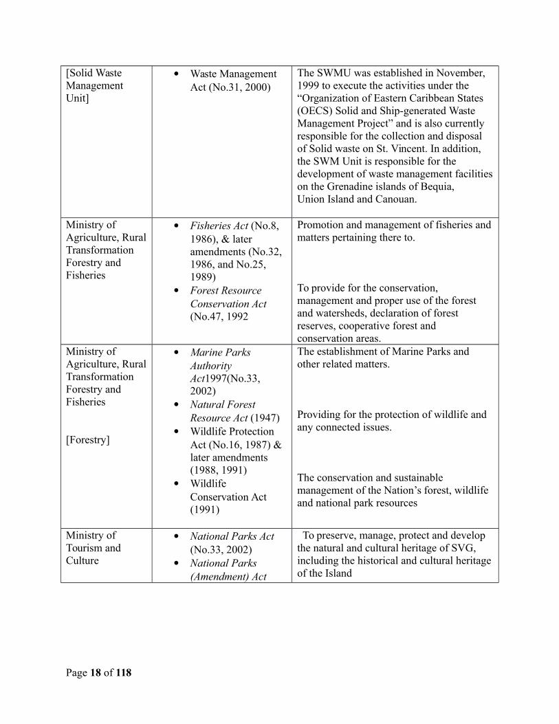
[Solid Waste Management Unit]
Waste Management Act (No.31, 2000)
The SWMU was established in November, 1999 to execute the activities under the “Organization of Eastern Caribbean States (OECS) Solid and Ship-generated Waste Management Project” and is also currently responsible for the collection and disposal of Solid waste on St. Vincent. In addition, the SWM Unit is responsible for the development of waste management facilitieson the Grenadine islands of Bequia, Union Island and Canouan.
Ministry of Agriculture, RuralTransformation Forestry and Fisheries
Fisheries Act (No.8, 1986), & later amendments (No.32, 1986, and No.25, 1989)
Forest Resource Conservation Act (No.47, 1992
Promotion and management of fisheries andmatters pertaining there to.
To provide for the conservation, management and proper use of the forest and watersheds, declaration of forest reserves, cooperative forest and conservation areas.
Ministry of Agriculture, RuralTransformation Forestry and Fisheries
[Forestry]
Marine Parks Authority Act1997(No.33, 2002)
Natural Forest Resource Act (1947)
Wildlife Protection Act (No.16, 1987) & later amendments (1988, 1991)
Wildlife Conservation Act (1991)
The establishment of Marine Parks and other related matters.
Providing for the protection of wildlife and any connected issues.
The conservation and sustainable management of the Nation’s forest, wildlife and national park resources
Ministry of Tourism and Culture
National Parks Act (No.33, 2002)
National Parks (Amendment) Act
To preserve, manage, protect and develop the natural and cultural heritage of SVG, including the historical and cultural heritageof the Island
Page 18 of 118
(No.13, 2010)Ministry of Housing, InformalHuman Settlement, Physical Planning, Lands and Surveys[PPU]
Town and Country Planning Act (No.45, 1992)
The Town and Country Planning Act (No.45, 1992) guides planning in St. Vincent & the Grenadines. Under this act, the PPU has the legal authority for environmental management in general, including the evaluation of the need for and level of EIA requirements.
The Ministry of Health Wellness and the Environment houses the focal point for these conventions.
United Nations Conventions UNCBD
UNCCD
UNFCCC
Cartagena Convention – LBS protocol
Convention for the protection of biological diversity.Convention to combat desertification.
Convention to reduce greenhouse gas emissions.
Convent against land based sources of marine pollution.
The Ministry of Health Wellness and the Environment.
[The SGD has reporting requirements for all Ministries of Government]
St. Georges Declaration of Principles for Sustainable Development (SGD) in the Organization ofthe Eastern CaribbeanStates (OECS) of 2001.
This sub-regional agreement is designed to support sustainable development and coversa wide range of environmental issues including … the Multilateral Environmental Agreements (MEAs)
As a signatory to the MEAs and SGD, St. Vincent & the Grenadines has obligations to reduce its greenhouse gas emissions, protect and sustainably manage its biological diversity, prevent land degradation and ensure that livelihood issues are not threatened or compromised. The National Environmental Management Strategy and the National Economic and Social Development Plan 2013-2025 speaks to environmental sustainability; as a consequence, all activities under the RDVRP must respect and respond to these declarations and pronouncements.
2.2 World Bank Safeguard Policies
The World Bank projects and activities are governed by Operational Policies (OP), which aredesigned to ensure that the projects are economically, financially, socially and environmentally
Page 19 of 118
sound.1 The Bank has specific safeguard policies, which include Environmental Assessments andpolicies designed to prevent unintended adverse effects on third parties and the environment.These specific safeguard policies address natural habitats, pest management, cultural property,involuntary resettlement, indigenous peoples, safety of dams, projects on internationalwaterways and projects in disputed areas2.
The World Bank's environmental assessment policy and recommended processing are used toidentify, avoid, and mitigate the potential negative environmental impacts associated with Banklending operations and are described in the Bank’s Operational Policy (OP)/Bank Procedure(BP) 4.01: Environmental Assessment. This policy is considered to be the umbrella policy forthe Bank's environmental 'safeguard policies' which among others include: Natural Habitats (OP4.04), Forests (OP 4.36), Pest Management (OP 4.09), Physical Cultural Resources (OP 4.11),and Safety of Dams (OP 4.37).
Under OP4.01 the Bank will undertake environmental screening of each proposed project todetermine the appropriate extent and type of environmental assessment required. Proposedprojects are classified into one of four categories, depending on the type, location, sensitivity,and scale of the project and the nature and magnitude of its potential environmental impacts.The categories of potential environmental impacts are classified as A, B, C and FI, as describedin Table 2 below:
Table 2: World Bank project categories
Category DescriptionCategory A Category A project is likely to have significant adverse
environmental impacts that are sensitive, diverse, or unprecedented.These impacts may affect an area broader than the sites or facilitiessubject to physical works. The EA for Category A project examinesthe project's potential negative and positive environmental impacts,compares them with those of feasible alternatives (including the"without project" scenario), and recommends any measures neededto prevent, minimise, mitigate, or compensate for adverse impactsand improve environmental performance. For Category A project, aborrower is responsible for preparing an Environmental ImpactAssessment (or a suitably comprehensive regional or sectorial EA).
Category B Category B project has potential adverse environmental impacts on
1Source: http://www.worldbank.org/opmanual
2Source: http://web.worldbank.org/WBSITE/EXTERNAL/PROJECTS/EXTPOLICIES/EXTSAFEPOL/0,,contentMDK:20507440~pagePK:64168427~piPK:64168435~theSitePK:584435,00.html
Page 20 of 118
human populations or environmentally important areas, includingwetlands, forests, grasslands, and other natural habitats - which areless adverse than those of Category A projects. These impacts aresite specific; few if any of them are irreversible; and in most casesmitigation measures can be designed more readily than for CategoryA projects.
Category C Category C project is likely to have minimal or no adverseenvironmental impacts. Beyond screening, no further EA action isrequired.
Category FI Category F or FI project involves investment of Bank funds througha financial intermediary, in subprojects that may result in adverseenvironmental impacts.
After review of the project and its components, the overall DVRP project has not been deemed tohave any major negative environmental impacts but because of the presence of the civil workswith minor to moderate impacts, the project has been classified as a Category B project. Theimplementation of appropriate mitigation and management measures will assist in reducing anypotential negative impacts from the various project components.
The World Bank Safeguard Policy OP 4.01 for Environmental Assessment (EA) is triggered, andrequires that an Environmental Management Framework (EMF) be prepared along with anEnvironmental Management Plan (EMP) to guide recommended measures.
The other World Bank Safeguard Policies dealing with natural habitats, physical culturalresources, pest management, and forests may possibly apply to projects in the future of theRDVRP program, so they are described briefly below3:
Operational Policy 4.04 on Natural Habitats seeks to ensure that World Bank-supported infrastructure and other development projects take into account the conservation of biodiversity, as well as the numerous environmental services and products which natural habitats provide to human society. The policy strictly limits the circumstances under which any Bank-supported project can damage natural habitats (land and water areas where most of the native plant and animal species are still present). This policy was triggered as a precaution to ensure that any affected natural habitats are adequately protected.
The objective of OP/BP 4.11 on Physical Cultural Resources is to avoid, or mitigate, adverse impacts on cultural resources from development projects that the World Bank finances. Cultural resources are important as sources of valuable historical and scientific information, as assets for economic and social development, and as integral parts of a
3Source: http://web.worldbank.org/WBSITE/EXTERNAL/PROJECTS/EXTPOLICIES/EXTSAFEPOL/0,,content M DK:20543943~menuPK:1286597~pagePK:64168445~piPK:64168309~theSitePK:584435,00.html
Page 21 of 118
people's cultural identity and practices. The loss of such resources is irreversible, but fortunately, it is often avoidable. Physical cultural resources are defined as movable or immovable objects, sites, structures, groups of structures, and natural features and landscapes that have archaeological, paleontological, historical, architectural, religious, aesthetic, or other cultural significance. Physical cultural resources may be located in urban or rural settings, and may be above or below ground, or under water. Their cultural interest may be at the local, provincial or national level, or within the international community. This policy was triggered as a precaution to ensure that any “chance finds” or other physical cultural resources are adequately protected.
The above two policies have been triggered as precautions, so that the appropriate measures to protect natural habitats and physical cultural resources are certain to be included in this EMF.
Operational Policy 4.09 on Pest Management seeks to ensure that rural development and health sector projects avoid using harmful pesticides. A preferred solution is to use Integrated Pest Management (IPM) techniques and encourage their use in the whole of the sectors concerned. The Bank requires that any pesticide it finances be manufactured, packaged, labelled, handled, stored, disposed of, and applied according to standards acceptable to the Bank. The Bank does not finance formulated products that fall in WHOclasses IA and IB, or formulations of products in Class II, if (a) the country lacks restrictions on their distribution and use; or (b) they are likely to be used by, or be accessible to, lay personnel, farmers, or others without training, equipment, and facilities to handle, store, and apply these products properly. This policy has been triggered because subproject activities may require the purchase or use of small amounts of pesticide through licensed registered professional contractors (e.g. termite treatment for building foundations). Use or purchase of significant amounts of pesticides is excluded in the EMF by screening as well as through standard contract clauses, therefore no separate Pest Management Plan is required; instead, the EMF includes appropriate procedures in the generic standardized EMP for incorporation into contract clauses. Any subprojects involving use or purchase of significant amounts of pesticides (other than incidental use e.g. for termite control through licensed registered professional contractors) are screened out and not eligible under the RDVRP.
The Bank's Forests Policy (Operational Policy/Bank Procedure 4.36) aims to reduce deforestation, enhance the environmental contribution of forested areas, promote afforestation, reduce poverty, and encourage economic development. The objective of this policy is to assist borrowers to harness the potential of forests to reduce poverty in a sustainable manner, integrate forests effectively into sustainable economic development, and protect the vital local and global environmental services and values of forests. Whereforest restoration and plantation development are necessary to meet these objectives, the Bank assists borrowers with forest restoration activities that maintain or enhance biodiversity and ecosystem functionality. The Bank also assists borrowers with the establishment and sustainable management of environmentally appropriate, socially beneficial, and economically viable forest plantations to help meet growing demands for
Page 22 of 118
forest goods and services. This policy applies to the projects that have or may have impacts on the health and quality of forests, projects that affect the rights and welfare of people and their level of dependence upon or interaction with forests, and projects that aim to bring about changes in the management, protection, or utilization of natural forests. This policy was not triggered, as planned watershed management activities and slope stabilization works will not impact the management, protection and/or utilization offorests nor are any projects involving harvesting or converting forest resources considered under the project. Therefore there is an exclusion included in this EMF to ensure that no projects are eligible for which the forestry policy would apply.
Careful examination is warranted to ensure that adequate steps are taken for protection of naturalhabitat and for the conservation of physical cultural resources. Screening of proposed projectswill reveal whether the appropriate inquiries must be included in the analysis of environmentalimpacts and the design of mitigation measures (if they could affect natural habitat or physicalcultural resources) or the exclusion of certain types of projects (if they should involve significantpurchase or use of pesticides or change in forest management). This EMF report provides detailson those types of possible impacts in the context of this program, as well as guidelines forscreening and subsequent actions.
2.3 National Regulatory Framework
St. Vincent & the Grenadines has legislation in place to address environmental and social development issues within respective jurisdictions. The Town and Country Planning Act (No.45,1992) was initiated to guide planning in St. Vincent & the Grenadines and falls under the jurisdiction of Ministry of Housing, Informal Human Settlement, Physical Planning , Lands and Surveys. Under the Act, Article 29, an EIA for environmentally sensitive projects or activities is required.
The Physical Planning Unit (PPU) has the legal authority for environmental management in general under this Act, including the evaluation of, the need for and level of EIA required. In St. Vincent & the Grenadines there is no grading system for projects requiring EIA but the scope of the EIA is determined through discussion with the PPU.
Within this piece of legislation lies the authority of the Planning Department to “… makeprovision for the orderly development of land, the assessment of the environmental impacts ofdevelopment, the grant of permission to develop land and for other powers to regulate the use ofland, and for related matters.”
The PPU functions as the technical/advisory arm of the Physical Planning and Development Board (PPDP), the body that oversees national development. The Act gives the Minister the ultimate and final decision on any planning matter. The Chair, Deputy Chair and Committee member of the PPDB are civil society member with the Town Planner as Secretary. Other members of the PPDB include representatives from the Police, National Properties, Transport and Works (Chief Engineer), Housing and Land Development Corporation, CWSA, VINLEC,
Page 23 of 118
Lands and Surveys, Kingstown Town board, the Ministry of Health Wellness and the Environment, Ministry of Agriculture and the Permanent Secretary in the Ministry of Housing.
The Physical Planning and Development Board (PPDB) has the legal authority for carrying out the purpose and provisions of the Town and Country Planning Act.
The PPU is responsible for ensuring Project development occurs within the environmental and social requirements of St. Vincent & the Grenadines. As part of its regular responsibilities, the PPU will review the EIA and development applications as well as oversee all other development control related matters, from inspection, to monitoring and enforcement.
2.4 Environmental Management Capacities
The various management agencies operate under legislation that attempts to guide them but theissues of overlapping and sometimes unclear responsibilities continue to plague effectiveoperations and responses to a number of environmental management issues. Coastaldevelopment is a case in point. The Fisheries Authority, the Forestry Department and thePhysical Planning Department all have some jurisdiction over coastal resources. These forms ofoverlap along with lack of adequately trained staff, technical and financial resources coupledwith absence of concerted, coordinated, cooperative efforts by the various agencies havecontributed to limitations in environmental management.
Such limitations coupled with agencies heavy workloads and deadlines make it difficult if notimpossible for them to single-handedly contribute to monitoring and ensuring environmentalsafeguards as prescribed. In such a circumstance it appears that utilizing a joint and focusedapproach in the form of a small multidisciplinary team may be the better approach to managingand monitoring projects to ensure basic environmental safeguards are incorporated andmaintained. Here it is worth noting that there is a dormant cabinet appointed multidisciplinaryteam called the Environmental Advisory Board that has a mandate to ensure environmentalsafeguards for SVG.
Page 24 of 118
3.0 DESCRIPTION OF EXISTING ENVIRONMENT
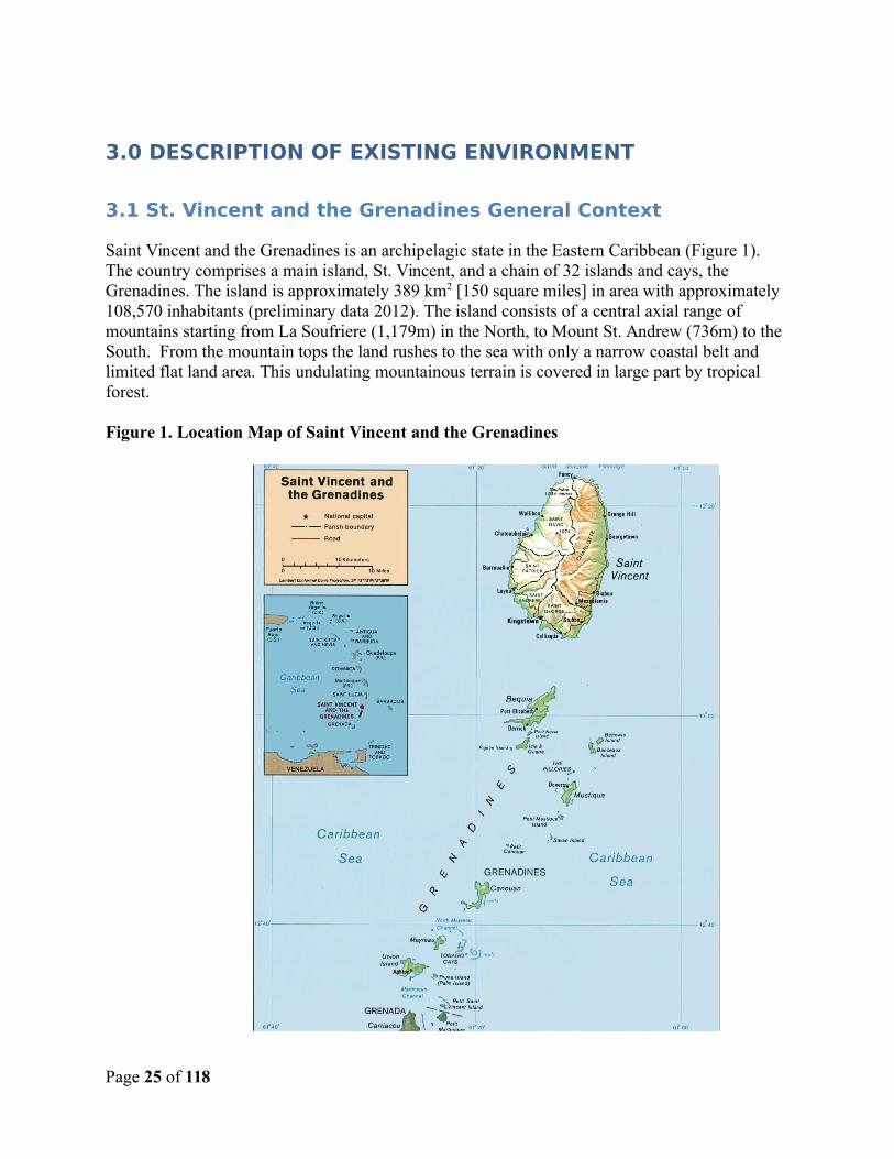
3.1 St. Vincent and the Grenadines General Context
Saint Vincent and the Grenadines is an archipelagic state in the Eastern Caribbean (Figure 1). The country comprises a main island, St. Vincent, and a chain of 32 islands and cays, the Grenadines. The island is approximately 389 km2 [150 square miles] in area with approximately 108,570 inhabitants (preliminary data 2012). The island consists of a central axial range of mountains starting from La Soufriere (1,179m) in the North, to Mount St. Andrew (736m) to the South. From the mountain tops the land rushes to the sea with only a narrow coastal belt and limited flat land area. This undulating mountainous terrain is covered in large part by tropical forest.
Figure 1. Location Map of Saint Vincent and the Grenadines
Page 25 of 118
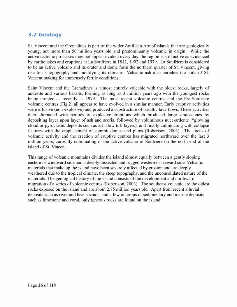
3.2 Geology
St. Vincent and the Grenadines is part of the wider Antillean Arc of islands that are geologicallyyoung, not more than 50 million years old and predominantly volcanic in origin. While theactive tectonic processes may not appear evident every day, the region is still active as evidencedby earthquakes and eruptions at La Soufriere in 1812, 1902 and 1979. La Soufriere is consideredto be an active volcano and its crater and dome form the northern quarter of St. Vincent, givingrise to its topography and modifying its climate. Volcanic ash also enriches the soils of St.Vincent making for immensely fertile conditions.
Saint Vincent and the Grenadines is almost entirely volcanic with the oldest rocks, largely ofandesite and various basalts, forming as long as 3 million years ago with the youngest rocksbeing erupted as recently as 1979. The most recent volcanic centres and the Pre-Soufrierevolcanic centres (Fig.2) all appear to have evolved in a similar manner. Early eruptive activitieswere effusive (non-explosive) and produced a substructure of basaltic lava flows. These activitiesthen alternated with periods of explosive eruptions which produced large strato-cones bydepositing layer upon layer of ash and scoria, followed by voluminous nuee-ardente (“glowingcloud or pyroclastic deposits such as ash-flow tuff layers), and finally culminating with collapsefeatures with the emplacement of summit domes and plugs (Robertson, 2003). The focus ofvolcanic activity and the creation of eruptive centres has migrated northward over the last 3million years, currently culminating in the active volcano of Soufriere on the north end of theisland of St. Vincent.
This range of volcanic mountains divides the island almost equally between a gently sloping eastern or windward side and a deeply dissected and rugged western or leeward side. Volcanic materials that make up the island have been severely affected by erosion and are deeply weathered due to the tropical climate, the steep topography, and the unconsolidated nature of the materials. The geological history of the island consists of the development and northward migration of a series of volcanic centres (Robertson, 2003). The southeast volcanic are the oldestrocks exposed on the island and are about 2.75 million years old. Apart from recent alluvial deposits such as river and beach sands, and a few outcrops of sedimentary and marine deposits such as limestone and coral, only igneous rocks are found on the island.
Page 26 of 118
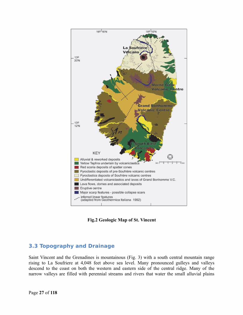
Fig.2 Geologic Map of St. Vincent
3.3 Topography and Drainage
Saint Vincent and the Grenadines is mountainous (Fig. 3) with a south central mountain rangerising to La Soufriere at 4,048 feet above sea level. Many pronounced gulleys and valleysdescend to the coast on both the western and eastern side of the central ridge. Many of thenarrow valleys are filled with perennial streams and rivers that water the small alluvial plains
Page 27 of 118
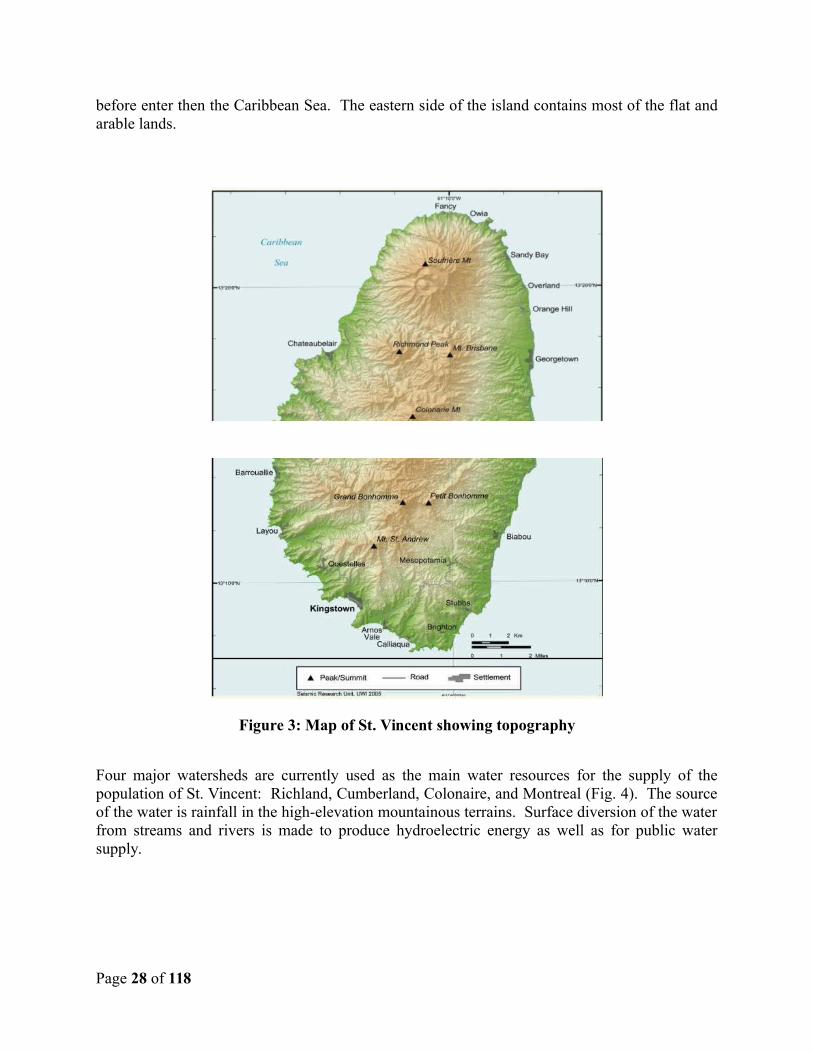
before enter then the Caribbean Sea. The eastern side of the island contains most of the flat andarable lands.
Figure 3: Map of St. Vincent showing topography
Four major watersheds are currently used as the main water resources for the supply of thepopulation of St. Vincent: Richland, Cumberland, Colonaire, and Montreal (Fig. 4). The sourceof the water is rainfall in the high-elevation mountainous terrains. Surface diversion of the waterfrom streams and rivers is made to produce hydroelectric energy as well as for public watersupply.
Page 28 of 118
3.4 Current Climate
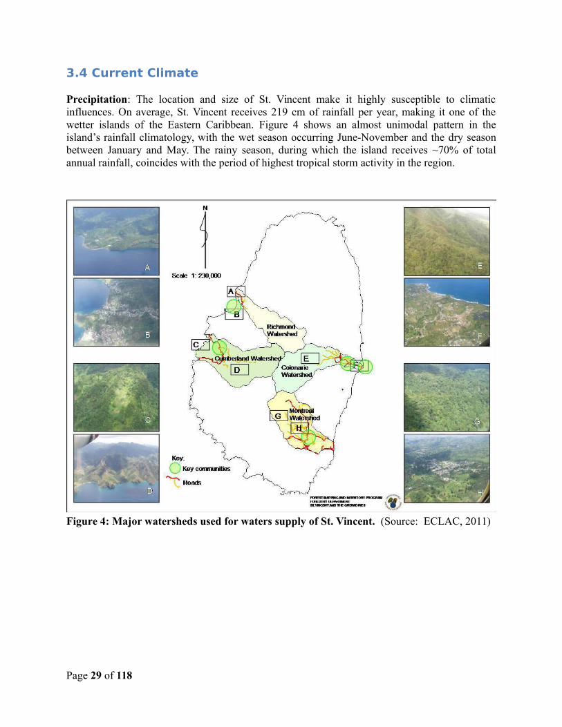
Precipitation: The location and size of St. Vincent make it highly susceptible to climaticinfluences. On average, St. Vincent receives 219 cm of rainfall per year, making it one of thewetter islands of the Eastern Caribbean. Figure 4 shows an almost unimodal pattern in theisland’s rainfall climatology, with the wet season occurring June-November and the dry seasonbetween January and May. The rainy season, during which the island receives ~70% of totalannual rainfall, coincides with the period of highest tropical storm activity in the region.
Figure 4: Major watersheds used for waters supply of St. Vincent. (Source: ECLAC, 2011)
Page 29 of 118
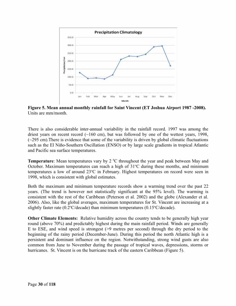
Figure 5. Mean annual monthly rainfall for Saint Vincent (ET Joshua Airport 1987 -2008). Units are mm/month.
There is also considerable inter-annual variability in the rainfall record. 1997 was among thedriest years on recent record (~160 cm), but was followed by one of the wettest years, 1998,(~295 cm).There is evidence that some of the variability is driven by global climatic fluctuationssuch as the El Niño-Southern Oscillation (ENSO) or by large scale gradients in tropical Atlanticand Pacific sea surface temperatures.
Temperature: Mean temperatures vary by 2 0C throughout the year and peak between May andOctober. Maximum temperatures can reach a high of 31oC during these months, and minimumtemperatures a low of around 23oC in February. Highest temperatures on record were seen in1998, which is consistent with global estimates.
Both the maximum and minimum temperature records show a warming trend over the past 22years. (The trend is however not statistically significant at the 95% level). The warming isconsistent with the rest of the Caribbean (Peterson et al. 2002) and the globe (Alexander et al.2006). Also, like the global averages, maximum temperatures for St. Vincent are increasing at aslightly faster rate (0.2oC/decade) than minimum temperatures (0.15oC/decade).
Other Climate Elements: Relative humidity across the country tends to be generally high yearround (above 70%) and predictably highest during the main rainfall period. Winds are generallyE to ESE, and wind speed is strongest (>9 metres per second) through the dry period to thebeginning of the rainy period (December-June). During this period the north Atlantic high is apersistent and dominant influence on the region. Notwithstanding, strong wind gusts are alsocommon from June to November during the passage of tropical waves, depressions, storms orhurricanes. St. Vincent is on the hurricane track of the eastern Caribbean (Figure 5).
Page 30 of 118
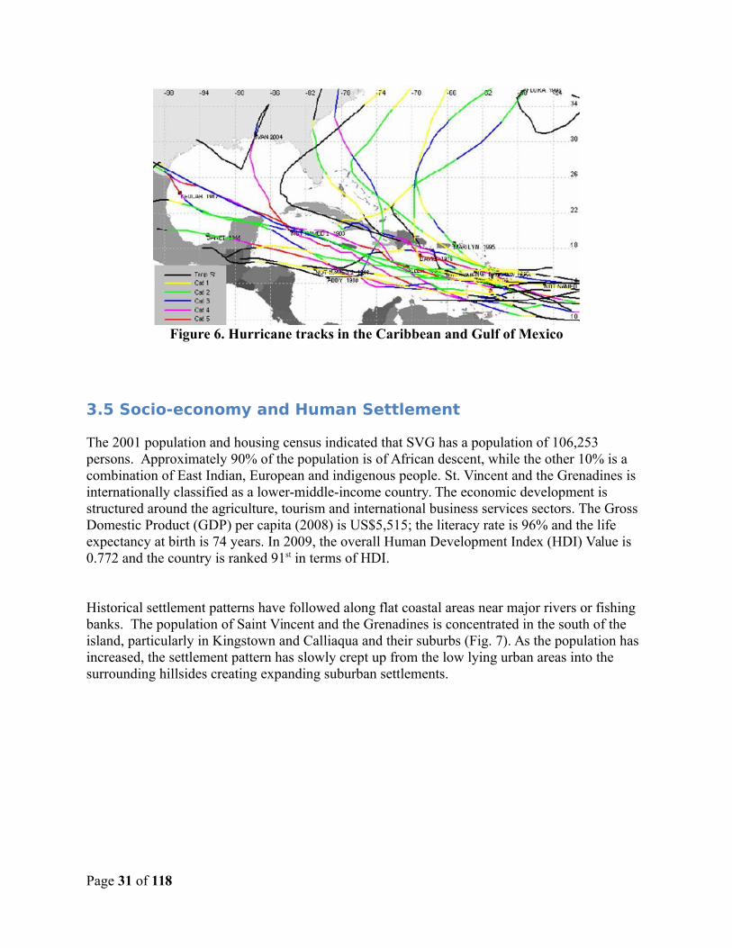
Figure 6. Hurricane tracks in the Caribbean and Gulf of Mexico
3.5 Socio-economy and Human Settlement
The 2001 population and housing census indicated that SVG has a population of 106,253 persons. Approximately 90% of the population is of African descent, while the other 10% is a combination of East Indian, European and indigenous people. St. Vincent and the Grenadines is internationally classified as a lower-middle-income country. The economic development is structured around the agriculture, tourism and international business services sectors. The Gross Domestic Product (GDP) per capita (2008) is US$5,515; the literacy rate is 96% and the life expectancy at birth is 74 years. In 2009, the overall Human Development Index (HDI) Value is 0.772 and the country is ranked 91st in terms of HDI.
Historical settlement patterns have followed along flat coastal areas near major rivers or fishing banks. The population of Saint Vincent and the Grenadines is concentrated in the south of the island, particularly in Kingstown and Calliaqua and their suburbs (Fig. 7). As the population has increased, the settlement pattern has slowly crept up from the low lying urban areas into the surrounding hillsides creating expanding suburban settlements.
Page 31 of 118
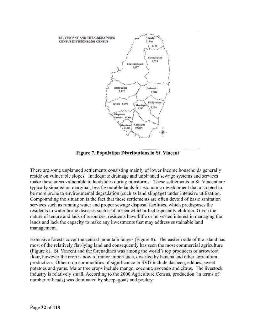
Figure 7. Population Distributions in St. Vincent
There are some unplanned settlements consisting mainly of lower income households generally reside on vulnerable slopes. Inadequate drainage and unplanned sewage systems and services make these areas vulnerable to landslides during rainstorms. These settlements in St. Vincent aretypically situated on marginal, less favourable lands for economic development that also tend to be more prone to environmental degradation (such as land slippage) under intensive utilization. Compounding the situation is the fact that these settlements are often devoid of basic sanitation services such as running water and proper sewage disposal facilities, which predisposes the residents to water borne diseases such as diarrhea which affect especially children. Given the nature of tenure and lack of resources, residents have little or no vested interest in managing the lands and lack the capacity to make any investments that may address sustainable land management.
Extensive forests cover the central mountain ranges (Figure 8). The eastern side of the island hasmost of the relatively flat-lying land and consequently has seen the most commercial agriculture (Figure 8). St. Vincent and the Grenadines was among the world’s top producers of arrowroot flour, however the crop is now of minor importance, dwarfed by banana and other agricultural production. Other crop commodities of significance in SVG include dasheen, eddoes, sweet potatoes and yams. Major tree crops include mango, coconut, avocado and citrus. The livestock industry is relatively small. According to the 2000 Agriculture Census, production (in terms of number of heads) was dominated by sheep, goats and poultry.
Page 32 of 118
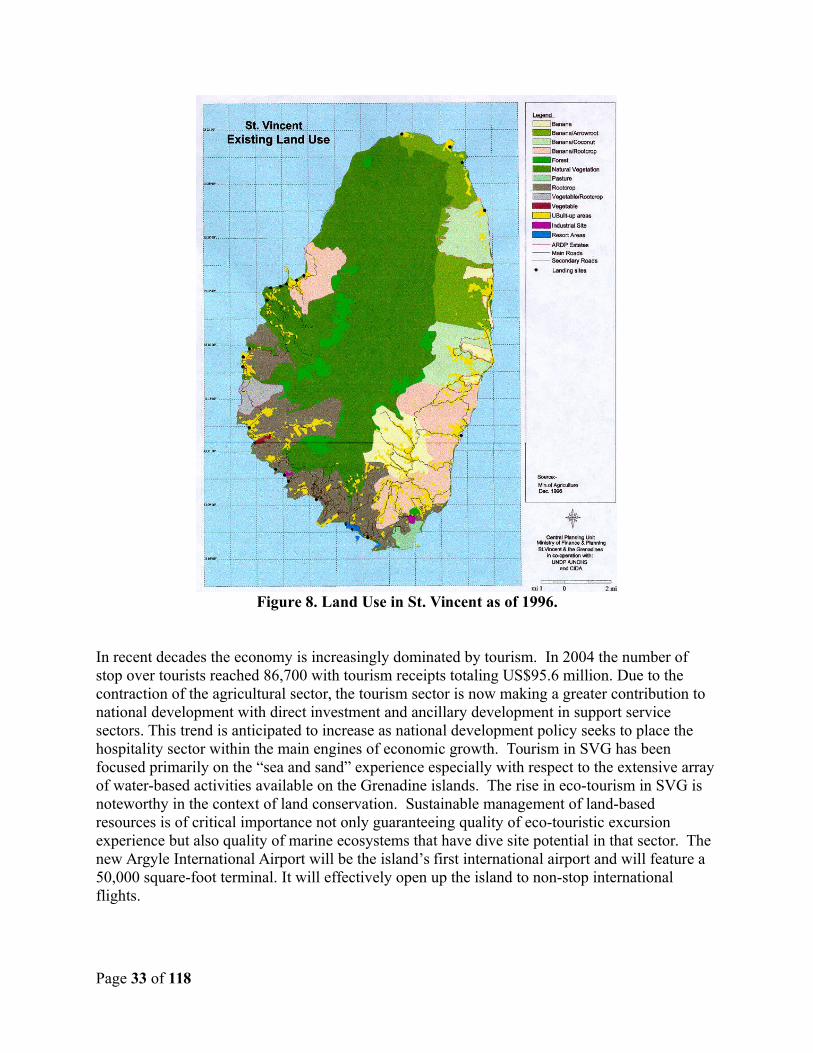
Figure 8. Land Use in St. Vincent as of 1996.
In recent decades the economy is increasingly dominated by tourism. In 2004 the number of stop over tourists reached 86,700 with tourism receipts totaling US$95.6 million. Due to the contraction of the agricultural sector, the tourism sector is now making a greater contribution to national development with direct investment and ancillary development in support service sectors. This trend is anticipated to increase as national development policy seeks to place the hospitality sector within the main engines of economic growth. Tourism in SVG has been focused primarily on the “sea and sand” experience especially with respect to the extensive arrayof water-based activities available on the Grenadine islands. The rise in eco-tourism in SVG is noteworthy in the context of land conservation. Sustainable management of land-based resources is of critical importance not only guaranteeing quality of eco-touristic excursion experience but also quality of marine ecosystems that have dive site potential in that sector. The new Argyle International Airport will be the island’s first international airport and will feature a 50,000 square-foot terminal. It will effectively open up the island to non-stop international flights.
Page 33 of 118
The industrial sector in SVG employs around 8% of the workforce and in 2008 contributed about29.2% to GDP. Industrial activity is focused primarily on agricultural processing of foodstuffs such as flour, rice, animal feeds, beans and other dried grain.
3.6 Biological Resources
The natural vegetation of SVG exists in several stages of development and/or disturbance causedby human and natural (volcanic) interventions. It is therefore defined by a climax vegetation formation based on environmental gradients. The concentric variations of rainfall with elevation give rise to concentric variations in vegetation. The slopes of the La Soufriere volcano have beensubject to the frequent disturbance of vegetation by volcanic eruptions, however it shows both the success of re-vegetation along with the variation of vegetation with elevation. This concentricvariation in vegetation is modified by factors of topography and geology in the Grenadines, which have lower relief, and a more semi-arid climate than the mainland. The soils of the Grenadines are shallow with a uniform vegetation distribution of scrub and cacti vegetation. The physical and environmental conditions of rainfall, soils, elevation, terrain, and exposure to the trade winds, results in a remarkable diversity of eco-systems and forest types, including:
Elfin Woodland: Found on exposed summits above 500 metres on both sides of the central mountains. They consist of pure stands of dwarfed trees about three metres in height covered with epiphytes. This vegetation type is commonly associated with the Palm Brake vegetation type.
Rain Forest: Confined to areas in the upper Colonaire, Cumberland and Buccament Valleys between 300 and 488 metres.
Palm Brake: This refers to a sub-climax type typically at elevations over 500 metres arising after disturbances such as landslides or tree-falls (opening up the forest canopy). The land is covered initially by mosses, then by small tree ferns and heliconias followed by the characteristic Mountain Cabbage Palms.
Secondary Rain Forest: This type describes the resultant forests arising from disturbancesfrom volcanic eruptions, hurricanes and human activity. The largest areas lie around the Soufriere Mountains. The vegetation ranges from almost bare soil on the upper slopes of the Soufriere volcano to significant stands of new forest at lower elevations.
Deciduous Seasonal Forests/Cactus Scrub: On the dry southern and southwestern coasts of St. Vincent and the Grenadines where the soils are extremely thin, deciduous to semi-deciduous and xerophytic species predominate.
Littoral Woodland: This type of vegetation is characterized by manchineel, button mangrove, sea grape and similar species. They exist as small narrow strips along the eastern coastline on St. Vincent and on a number of the islets and cays of the Grenadines. This type of vegetation is fast disappearing as development takes place along the coast.
Swamp: Only small areas of swamp occur in St. Vincent and the Grenadines. These existin the southern section of the main land on the coast and on a few of the Grenadine islets. The typical species found in these areas are Red Mangrove, Black Mangrove, White Mangrove and Button Mangrove.
Page 34 of 118
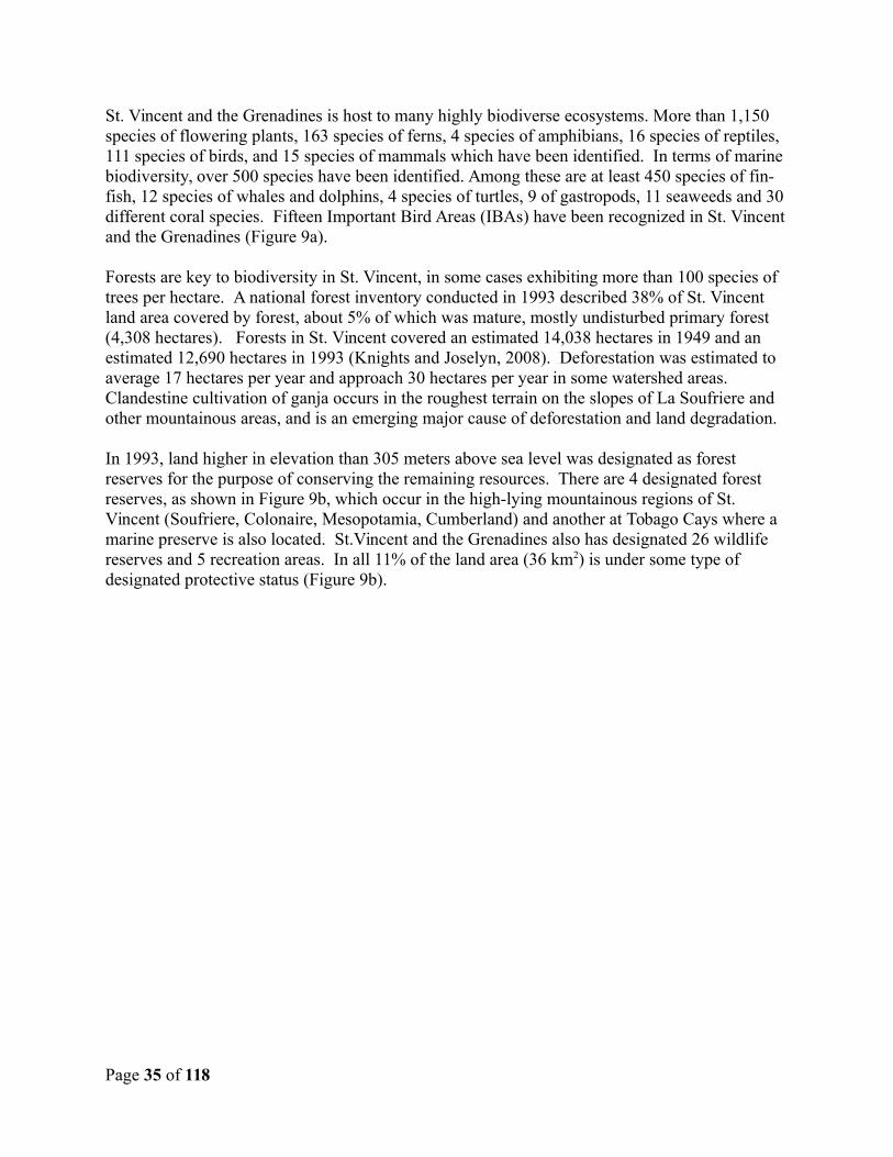
St. Vincent and the Grenadines is host to many highly biodiverse ecosystems. More than 1,150 species of flowering plants, 163 species of ferns, 4 species of amphibians, 16 species of reptiles, 111 species of birds, and 15 species of mammals which have been identified. In terms of marine biodiversity, over 500 species have been identified. Among these are at least 450 species of fin-fish, 12 species of whales and dolphins, 4 species of turtles, 9 of gastropods, 11 seaweeds and 30 different coral species. Fifteen Important Bird Areas (IBAs) have been recognized in St. Vincentand the Grenadines (Figure 9a).
Forests are key to biodiversity in St. Vincent, in some cases exhibiting more than 100 species of trees per hectare. A national forest inventory conducted in 1993 described 38% of St. Vincent land area covered by forest, about 5% of which was mature, mostly undisturbed primary forest (4,308 hectares). Forests in St. Vincent covered an estimated 14,038 hectares in 1949 and an estimated 12,690 hectares in 1993 (Knights and Joselyn, 2008). Deforestation was estimated to average 17 hectares per year and approach 30 hectares per year in some watershed areas. Clandestine cultivation of ganja occurs in the roughest terrain on the slopes of La Soufriere and other mountainous areas, and is an emerging major cause of deforestation and land degradation.
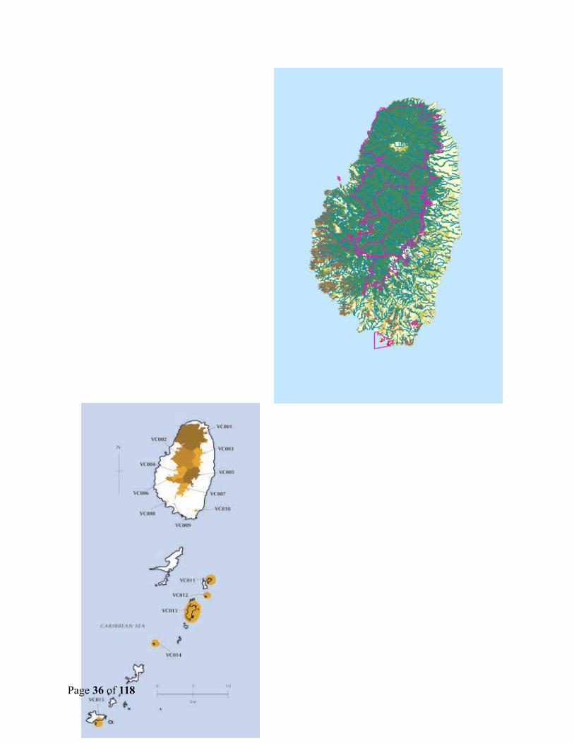
In 1993, land higher in elevation than 305 meters above sea level was designated as forest reserves for the purpose of conserving the remaining resources. There are 4 designated forest reserves, as shown in Figure 9b, which occur in the high-lying mountainous regions of St. Vincent (Soufriere, Colonaire, Mesopotamia, Cumberland) and another at Tobago Cays where a marine preserve is also located. St.Vincent and the Grenadines also has designated 26 wildlife reserves and 5 recreation areas. In all 11% of the land area (36 km2) is under some type of designated protective status (Figure 9b).
Page 35 of 118
Page 36 of 118
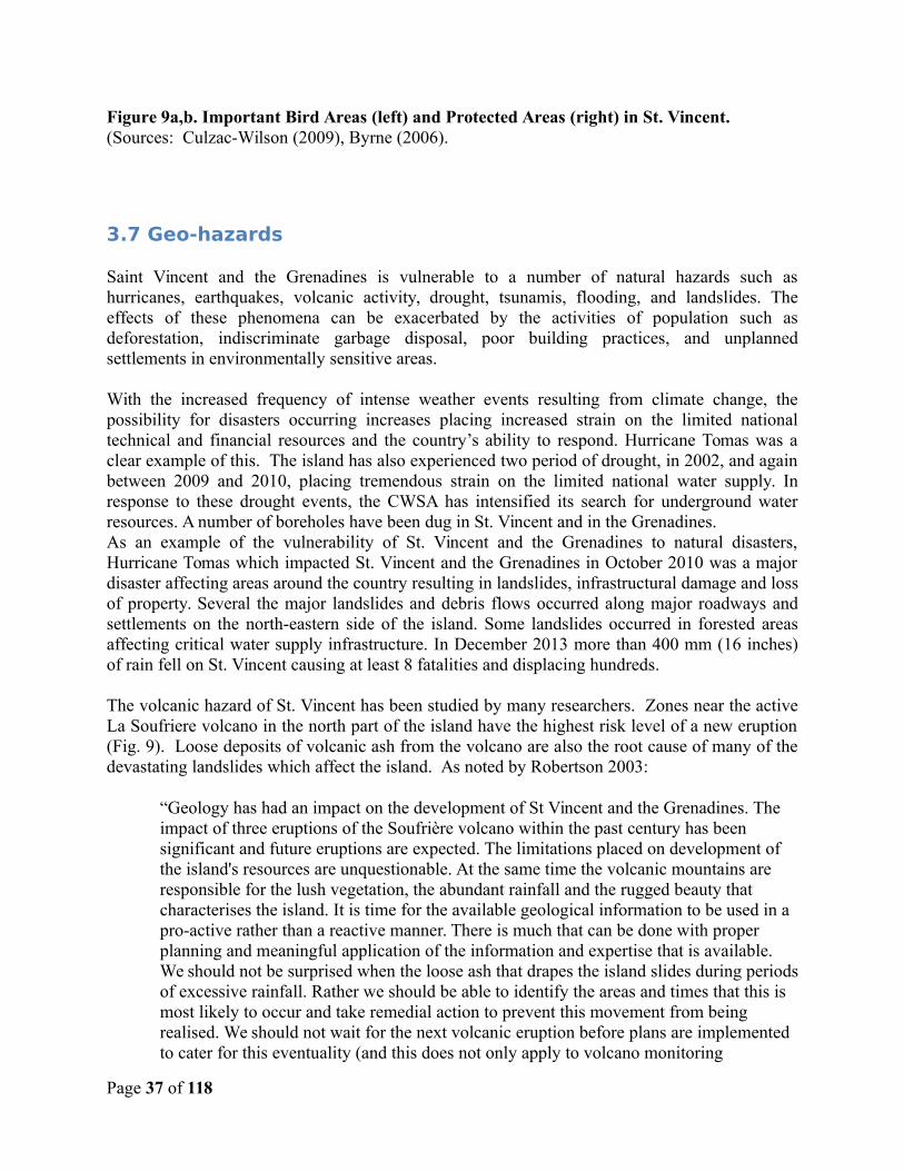
Figure 9a,b. Important Bird Areas (left) and Protected Areas (right) in St. Vincent. (Sources: Culzac-Wilson (2009), Byrne (2006).
3.7 Geo-hazards
Saint Vincent and the Grenadines is vulnerable to a number of natural hazards such ashurricanes, earthquakes, volcanic activity, drought, tsunamis, flooding, and landslides. Theeffects of these phenomena can be exacerbated by the activities of population such asdeforestation, indiscriminate garbage disposal, poor building practices, and unplannedsettlements in environmentally sensitive areas.
With the increased frequency of intense weather events resulting from climate change, thepossibility for disasters occurring increases placing increased strain on the limited nationaltechnical and financial resources and the country’s ability to respond. Hurricane Tomas was aclear example of this. The island has also experienced two period of drought, in 2002, and againbetween 2009 and 2010, placing tremendous strain on the limited national water supply. Inresponse to these drought events, the CWSA has intensified its search for underground waterresources. A number of boreholes have been dug in St. Vincent and in the Grenadines. As an example of the vulnerability of St. Vincent and the Grenadines to natural disasters,Hurricane Tomas which impacted St. Vincent and the Grenadines in October 2010 was a majordisaster affecting areas around the country resulting in landslides, infrastructural damage and lossof property. Several the major landslides and debris flows occurred along major roadways andsettlements on the north-eastern side of the island. Some landslides occurred in forested areasaffecting critical water supply infrastructure. In December 2013 more than 400 mm (16 inches)of rain fell on St. Vincent causing at least 8 fatalities and displacing hundreds.
The volcanic hazard of St. Vincent has been studied by many researchers. Zones near the activeLa Soufriere volcano in the north part of the island have the highest risk level of a new eruption(Fig. 9). Loose deposits of volcanic ash from the volcano are also the root cause of many of thedevastating landslides which affect the island. As noted by Robertson 2003:
“Geology has had an impact on the development of St Vincent and the Grenadines. The impact of three eruptions of the Soufrière volcano within the past century has been significant and future eruptions are expected. The limitations placed on development of the island's resources are unquestionable. At the same time the volcanic mountains are responsible for the lush vegetation, the abundant rainfall and the rugged beauty that characterises the island. It is time for the available geological information to be used in a pro-active rather than a reactive manner. There is much that can be done with proper planning and meaningful application of the information and expertise that is available. We should not be surprised when the loose ash that drapes the island slides during periodsof excessive rainfall. Rather we should be able to identify the areas and times that this is most likely to occur and take remedial action to prevent this movement from being realised. We should not wait for the next volcanic eruption before plans are implemented to cater for this eventuality (and this does not only apply to volcano monitoring
Page 37 of 118
installations). We should not place investment in schemes that are unlikely to last due to limitations placed on them by geologic processes such as mass movement and volcanic hazards. We can use the information we have to build environmentally friendly structures and sustainable systems that will not be destroyed by the processes that have formed the island and that will continue to impact on its evolution.”
Figure 10. Volcanic hazard zones in St. Vincent. (Source: Robertson, 2005)
The University of West Indies (UWI, 2011) has produced updated maps showing seismic hazard (earth shaking) that can be used for planning purposes in the Eastern Caribbean. These seismic hazards result from tectonic activity (the subduction of the Atlantic Plate beneath the Caribbean Plate). In St. Vincent the peak ground acceleration (expressed as a percentage (%) of g, the acceleration of gravity), is up to 15%g every 100 years, 25%g every 500 years, and 40%g every 1,000 years.
Costal zones are also vulnerable to storm surge during hurricanes, and erosion from wave energy.Storm surge from hurricanes is pronounced on the southwest coast, where up to 5 meters of sealevel rise during hurricanes could occur (Fig. 10). Elsewhere, up to 2 meters would be expectedduring hurricanes. The eastern side of St. Vincent is exposed to long-fetch waves across
Page 38 of 118
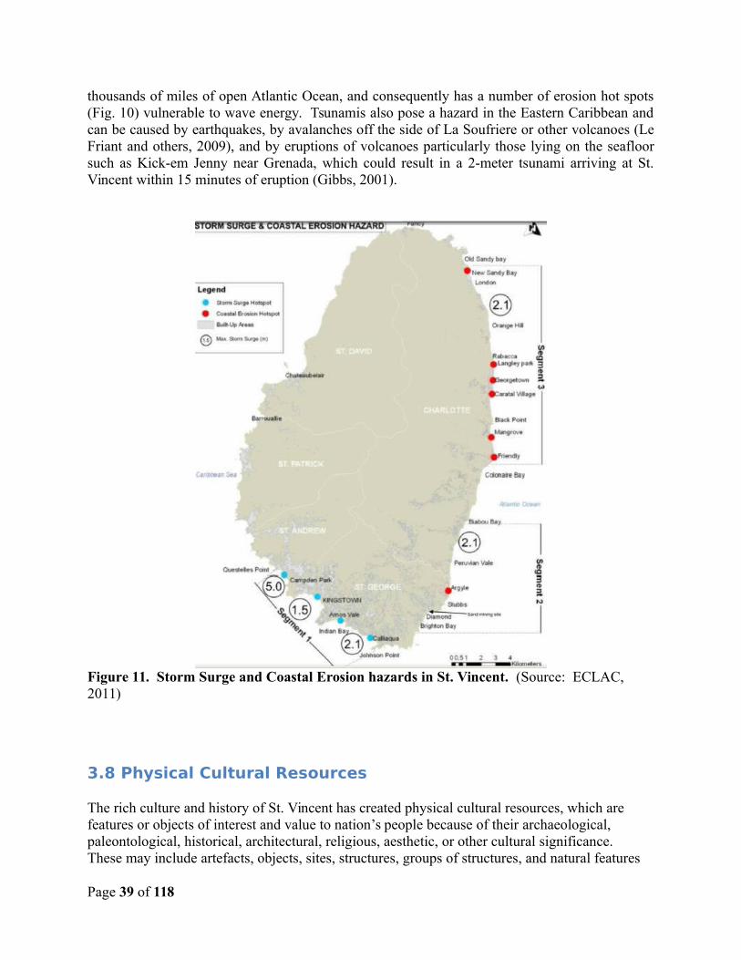
thousands of miles of open Atlantic Ocean, and consequently has a number of erosion hot spots(Fig. 10) vulnerable to wave energy. Tsunamis also pose a hazard in the Eastern Caribbean andcan be caused by earthquakes, by avalanches off the side of La Soufriere or other volcanoes (LeFriant and others, 2009), and by eruptions of volcanoes particularly those lying on the seafloorsuch as Kick-em Jenny near Grenada, which could result in a 2-meter tsunami arriving at St.Vincent within 15 minutes of eruption (Gibbs, 2001).
Figure 11. Storm Surge and Coastal Erosion hazards in St. Vincent. (Source: ECLAC, 2011)
3.8 Physical Cultural Resources
The rich culture and history of St. Vincent has created physical cultural resources, which are features or objects of interest and value to nation’s people because of their archaeological, paleontological, historical, architectural, religious, aesthetic, or other cultural significance. These may include artefacts, objects, sites, structures, groups of structures, and natural features
Page 39 of 118
and landscapes, and may be located in urban or rural settings, above or below ground, or under water. Cultural resources are important as sources of valuable historical and scientific information, as assets for economic and social development, and as integral parts of a people's cultural identity and practices.
Recognition of physical cultural resources may be at the local, national level, or within the international community. Examples may include St. Vincent’s natural treasures such the Botanic Gardens, the petroglyphs in Mesopotamia, Layou, and Barrouallie, the Catholic Church in Kingatown and the old cemetery at Dorsetshire Hill; as marine preserves like the Tobago Cays orforest trails, excellent masonry works, historical buildings, or other features of community importance or international renown.
Page 40 of 118
4.0 PROJECTED IMPACTS
4.1 Analysis of Projected Impacts
The following impacts relate to the civil works proposed on the respective sites underconsideration. The proposed civil works activities with any potential impacts are generally smallto midsized civil works. While none of the projects are being implemented in historic or culturalsites, or within designated forest reserves, care must be taken to screen each possible projectlocation and ensure that these resources are carefully protected. Five subproject activitiesinvolve river crossing (Bridges & River crossing at South River, Dauphine, Fenton, Green Hilland river defence for the Warrowwarrow river in the Arnos Vale area), where care must thereforebe taken during the reconstruction activities to avoid sedimentation and or pollution of the riversand ultimately the coastal seas. Areas for work in coastal zones may involve possible effects tomarine and coastal habitat. Clearing of vegetation and removal of forest cover is generallyrequired for new road segments or at the approach to bridges and fords, so therefore carefulanalysis must be made to ensure that sensitive habitat, well-preserved forest, or other resourcesare not affected. Pertinent environmental management measures in accordance with thescreening measures and mitigation plans described later in this EMF must be implemented.
There are both positive and negative impacts attendant to the project and its components. Aninitial list of projects was provided by the PSIPMU for which an impact matrix was prepared asbelow. The capacity building or institutional strengthening projects could be consideredenvironmentally benign with no adverse impacts. The Table below provides a list and summaryof impacts. Although the implementing agency is listed as Ministries of Works and PhysicalPlanning, it is expected that some works would be undertaken by private companies but that theMinistries will remain involved at all times giving oversight and performing Monitoring andEvaluation.
Table 3a. Impact Matrix: List of RDVRP Projects Currently Approved
Proposed Activities
Agency Possibility of Environmental Impact?
Environmental Impact Aspect, positive(+) or negative(-)
Level of EnvironmentalImpacts
Satellite Warehouses at Sandy Bay, Rose Hall, Bequia, Mesopotamia, Union Island, Georgetown
Ministry of Works;Physical Planning.
Yes 1. Potential poor construction and management practices leading to poor end
Minimal disruption to the environment if standard EMP and planning guidelines are followed
Page 41 of 118
products (-)
2. Air pollution from dust and vehicular / machinery fumes
3. Poor Solid waste management from works (-).
4. Potential resident and worker safety issues (-).
Retrofitting of Emergency Shelters at Dorsetshire andKingstown Government Schools and Union Island Learning Resource Center
Ministry of Works;Physical Planning
Yes 1. Improved safety of occupants(+)
Level of impactwill be minimalneeding only proper disposal of waste and safety measuresfor humans.
Bridges & River crossing at South River, North River, Dauphine, Fenton, Green Hill
Ministry of Works;Physical Planning
Yes 1. Potential waste management issues (-).
2. Increased siltation of waterways from works (-).
3. Potential safety issues for
Moderate but has potential to be significant ifnot properly scoped and works not properly implemented and managed; may require additional
Page 42 of 118
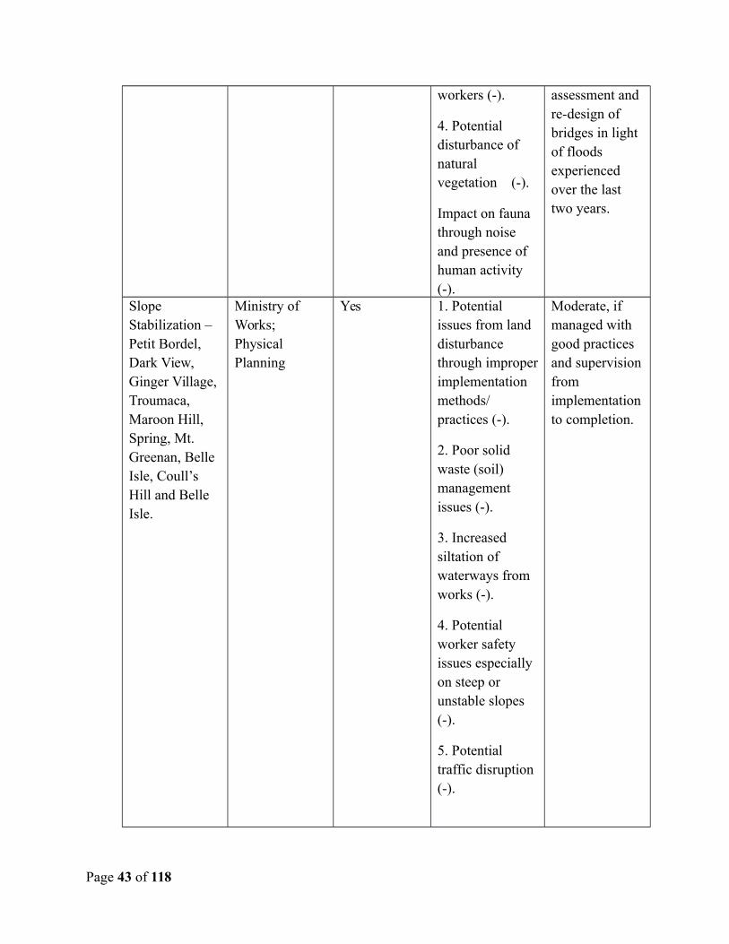
workers (-).
4. Potential disturbance of natural vegetation (-).
Impact on fauna through noise and presence of human activity (-).
assessment and re-design of bridges in light of floods experienced over the last two years.
Slope Stabilization – Petit Bordel, Dark View, Ginger Village, Troumaca, Maroon Hill, Spring, Mt. Greenan, Belle Isle, Coull’s Hill and Belle Isle.
Ministry of Works;Physical Planning
Yes 1. Potential issues from land disturbance through improperimplementation methods/ practices (-).
2. Poor solid waste (soil) management issues (-).
3. Increased siltation of waterways from works (-).
4. Potential worker safety issues especially on steep or unstable slopes (-).
5. Potential traffic disruption (-).
Moderate, if managed with good practices and supervisionfrom implementationto completion.
Page 43 of 118
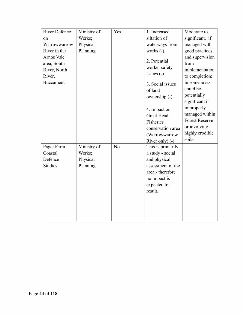
River Defence on WarrowwarrowRiver in the Arnos Vale area, South River, North River, Buccament
Ministry of Works;Physical Planning
Yes 1. Increased siltation of waterways from works (-).
2. Potential worker safety issues (-).
3. Social issues of land ownership (-).
4. Impact on Great Head Fisheries conservation area(Warrowwarrow River only) (-)
Moderate to significant. if managed with good practices and supervisionfrom implementationto completion; in some areas could be potentially significant if improperly managed withinForest Reserve or involving highly erodible soils.
Paget Farm Coastal Defence Studies
Ministry of Works;Physical Planning
No This is primarily a study - social and physical assessment of thearea - therefore no impact is expected to result.
Page 44 of 118
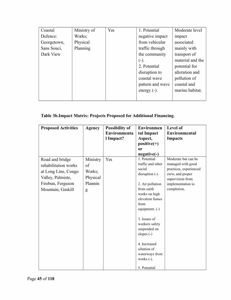
Coastal Defence: Georgetown, Sans Souci, Dark View
Ministry of Works;Physical Planning
Yes 1. Potential negative impact from vehicular traffic through the community (-).2. Potential disruption to coastal wave pattern and waveenergy (-).
Moderate level impact associated mainly with transport of material and thepotential for alteration and pollution of coastal and marine habitat.
Table 3b.Impact Matrix: Projects Proposed for Additional Financing.
Proposed Activities Agency Possibility of Environmental Impact?
Environmental Impact Aspect, positive(+) or negative(-)
Level of Environmental Impacts
Road and bridge rehabilitation works at Long Line, Congo Valley, Palmiste, Firebun, Ferguson Mountain, Gaskill
Ministryof Works;PhysicalPlanning
Yes 1. Potential traffic and othersocial disruption (-)
2. Air pollution from earth works on high elevation fumesfrom equipment. (-)
3. Issues of workers safety suspended on slopes (-)
4. Increased siltation of waterways fromworks (-).
5. Potential
Moderate but can be managed with good practices, experienced crew, and proper supervision from implementation to completion.
Page 45 of 118
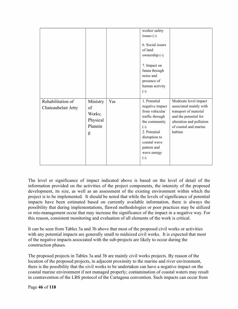
worker safety issues (-).
6. Social issues of land ownership (-).
7. Impact on fauna through noise and presence of human activity (-).
Rehabilitation of Chateaubelair Jetty
Ministryof Works;PhysicalPlanning
Yes 1. Potential negative impactfrom vehicular traffic through the community (-).2. Potential disruption to coastal wave pattern and wave energy (-).
Moderate level impact associated mainly with transport of material and the potential for alteration and pollution of coastal and marine habitat.
The level or significance of impact indicated above is based on the level of detail of theinformation provided on the activities of the project components, the intensity of the proposeddevelopment, its size, as well as an assessment of the existing environment within which theproject is to be implemented. It should be noted that while the levels of significance of potentialimpacts have been estimated based on currently available information, there is always thepossibility that during implementations, flawed methodologies or poor practices may be utilizedor mis-management occur that may increase the significance of the impact in a negative way. Forthis reason, consistent monitoring and evaluation of all elements of the work is critical.
It can be seen from Tables 3a and 3b above that most of the proposed civil works or activities with any potential impacts are generally small to midsized civil works. It is expected that most of the negative impacts associated with the sub-projects are likely to occur during the construction phases.
The proposed projects in Tables 3a and 3b are mainly civil works projects. By reason of the location of the proposed projects, in adjacent proximity to the marine and river environment, there is the possibility that the civil works to be undertaken can have a negative impact on the coastal marine environment if not managed properly; contamination of coastal waters may result in contravention of the LBS protocol of the Cartagena convention. Such impacts can occur from
Page 46 of 118
spillage of construction materials or chemicals such as cement or oils, from suspended sedimentsin the water, or from altering the shoreline or coastline configuration such that tidal or water currents are changed to create new areas of erosion or new areas where sediments may be deposited.
In the case of the River Defense Works, hydraulic studies have been conducted to ensure that theproposed works supports flood mitigation efforts. Final site clean-up after completion of projectmust be undertaken. This is very important to reducing the environmental impact of the civilworks and should be included in the EMP and contract language as a standard mitigationmeasure.
4.1.1 Positive Impacts
There are several potential positive impacts of the project and associated works. These will onlybe highlighted here, as the focus is on negative impacts, and mitigation measures. The mostobvious positive impact is the reduction of the nation’s vulnerability to disasters ensuring safetyof property and life. Other positive benefits include the creation of employment and incomegeneration during the construction phase and finally in the operational phase, although for a lessnumber of persons. With each sub-project there may be specific positive impacts that can besummarized as follows:
Improving the access to population center, social amenities and farm lands by theupgrading and provision of access roads.
The creation of temporary employment opportunities and long-term income generationevolving from construction projects, rehabilitation of the community centers and theconstruction of road and river stabilization works.
The provision of improved emergency shelters and warehouses. Improved learning environments and access to education as in the case of the new
schools
Efforts to maximize the positive benefits of the works should be sought during design and implementation.
4.1.2 Negative Impacts
There is the possibility of the occurrence of the following negative impacts associated with theprojects.
Increased traffic and potential for traffic conflict Increased Vibration and Noise levels Poor Solid and Liquid Waste Management Deforestation and Removal of Natural Habitat
Page 47 of 118
Air pollution Marine pollution and impacts on marine habitats Terrestrial pollution Soil erosion and land slippage Occupational Health and safety issues Loss of or Damage to Physical Cultural Resources
Each of the impacts is described in more detail below. Measures to avoid, minimize, and mitigate the negative effects, are described later in this report.
4.1.2.1 Increased Traffic and Potential for Traffic Conflict
There is always the possibility of increased construction-related traffic for civil works of certainsizes especially when the works are occurring adjacent to a main highway. The potential forvehicular/vehicular and pedestrian/vehicular conflict increases as the scale of constructionincreases if proper traffic management procedures are not implemented. This can lead to verytempered negative response from the nearby residents or the community affected. The matter ofsafety also becomes a great concern in relation to the speed of the vehicles as well as thealertness of the drivers as they traverse the highways and through communities especially if thereare children within the vicinity who may be accustomed to playing on the roads or sidewalkareas. The breakdown of a large project vehicle causing the blockage of a well travelled routecan escalate tensions within a community especially if it contributes to loss of travel time towork, school, or returning home.
4.1.2.2 Increased Noise levels
Increased noise and vibration levels resulting from construction activities such as the movementof heavy supply trucks into and out of the site, the use of various forms of heavy equipment suchas demolition equipment, can have negative impacts on both the terrestrial and marineenvironments especially along the coast as well as in the forested areas. In secluded or forestedareas, fauna habitats can be disturbed causing such creatures to flee their homes and nestingareas. Similarly, increased noise levels from activities adjacent to or within communities andresidential areas, can be deemed as an unnecessary and unwanted nuisance affecting localbusiness and day to day activities. Care must be taken in the judicious usage of any form ofheavy noise and vibration equipment. Associated vibrations from the use of heavy equipmentsuch as rollers can negatively impact surrounding communities, causing nuisances by shakinghousehold items and possibly affecting the stability of nearby structures.
4.1.2.3 Poor Solid and Liquid Waste Management
The improper management and disposal of both solid and liquid wastes can be detrimental toboth the terrestrial and to the nearby marine environment. The mishandling of constructionwastes such as chemicals, detergents, greases, oils, building materials, can lead to the poisoning
Page 48 of 118
of the terrestrial environment. The entry into the marine environment of any waste or chemical,either through runoff, in drains, or are blown by the wind can also poison the marineenvironment or damage the fragile marine ecosystem. The management of human wastes on siteis very critical to ensuring a healthy working environment and reduce the risk of faecalcontamination. The management of food wastes is also critical to reducing the incidence ofvector entry into an area causing infestation.
Managing excavated soil is also important especially when this soil is being transported toanother site for use or storage. Care must be taken to ensure the appropriateness of the transportand the protocols for transporting and storing the soil.
4.1.2.4 Deforestation and Removal of Natural Habitat
The practice of land clearing and especially mass and sometimes indiscriminate land clearing,excavation practices, as well as poor site drainage can lead to land slippage and eventuallysiltation leading to the loss of life, coastal marine pollution and destruction. This is especially soon steep slopes. In forested areas, such deforestation to accommodate the creation of new roadsegments can lead to loss of habitat for forest and endemic flora and fauna as well as a loss ofbiodiversity. Particular care must be exercised in these cases.
4.1.2.5 Air Pollution
Air pollution can come from a number of sources. The vehicles and machinery being utilized canboth produces noxious fumes such as carbon monoxide, diesel fumes, as well as burnt oil fumes.There is the increased potential for air pollution to come from older or improperly servicevehicles and machinery as well. Dust also arises from cleared land that has been exposed to thesun, is dried, and the wind carries this material to nearby residences or communities. Similarly,uncovered fines such as sands or even cement can be light enough to be blown by the wind. Thisis a nuisance to nearby facilities or communities. The mishandling of particularly noxiouschemicals such as solvents or chemical washes, greases, as well as the burning of solid wastes onthe construction site, especially chemical containers, can lead to air pollution resulting innegative health impacts.
4.1.2.6 Terrestrial and Marine Pollution
The potential for terrestrial and marine pollution can occur with indiscriminate disposal of both solid and liquid wastes. The mishandling of chemicals and especially waste oils during construction activities can poison the landscape. During rainfall events chemicals can mix with or be carried by runoff and create liquid wastes that impact both terrestrial and marine environments. Improper disposal of human wastes can lead to similar effects. This also applies to pesticides used in termite treatment of construction sites. With the occurrence of civil works projects along or adjacent, or within the coastal waters such as the River Defence on Warrowwarrow River in the Arnos Vale area, the river defense at Buccament and the coastal defence at Sans Souci, there is the possibility of impact on the marine ecosystem which must be evaluated as project details become more clear.
Page 49 of 118
4.1.2.7 Soil Erosion and Land Slippage
The practice of land clearing and especially mass and sometimes indiscriminate land clearing,excavation practices, as well as poor site drainage can lead to exposed soil. This, the nature ofthe exposed soil, in combination with the precipitation and/or poor drainage, can lead to landslippage especially on steep slopes. This can result in loss of life and property. Eventually thismaterial can wash down into rivers and then to the sea causing siltation and sedimentation. Theresulting effect within the coastal marine environment can be pollution leading to ecosystemdeath and loss of livelihoods.
In St. Vincent there is a special vulnerability with regards to landslides, and other mass earthmovements, due to the loose unconsolidated geologic materials which form the island, the heavyrains to which they are exposed, and the steep slopes upon which they lay. Opening ofroadways, trenching for installation of water lines, grading or clearing for agriculture or housingdevelopments, may all destabilize the soil surface and eventually be the cause for landslides at alater time. Accordingly, careful planning is required to ensure that soil erosion is minimized andthat landslide potential is not exacerbated. Appendix 6 of this EMF provides a discussion of BestManagement Practices (BMPs) for slope stabilization which may serve as a valuable reference todevelop mitigation measures.
4.1.2.8 Occupational Health and Safety Issues
The International Labour Organization (ILO) defines decent wok as safe and having appropriatecompensation. Worker safety is critical to any operation, therefore, mishandling of equipment,the improper storage and usage of various chemicals and construction materials on site, poor andunsafe working conditions, high levels of continuous noise and fumes, as well as inadequatesafety equipment can cause serious injury and down time to the workers and project and shouldtherefore be avoided. Best management practices should always be implemented as labour lawshold the employer responsible for the workers safety. Proper facilities will need to be providedfor workers in the interest of the workers and the environment.
4.1.2.9 Loss of or Damage to Physical Cultural Resources
During construction activities, there is the possibility of coming across or “chance finding” whatmay appear to be an historical or cultural artifact which may need to be studied and preserved bythe relevant authorities. One example is the sunken ship that became partially exposed on theGeorgetown beach a few years ago. In cases like this, the artifact could be lost due to carelessconstruction activities prior to the relevant authorities determining whether or not it is worthy ofpreservation. It is therefore recommended to consult with local stakeholders as to the finaldesign of facility, and the disposition of any potential physical and cultural resources, becausethe valuation of such items is ultimately subjective and they are of most value to localstakeholders.
Page 50 of 118

Page 51 of 118
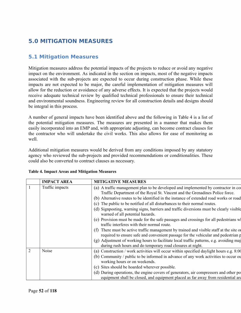
5.0 MITIGATION MEASURES
5.1 Mitigation Measures
Mitigation measures address the potential impacts of the projects to reduce or avoid any negativeimpact on the environment. As indicated in the section on impacts, most of the negative impactsassociated with the sub-projects are expected to occur during construction phase. While theseimpacts are not expected to be major, the careful implementation of mitigation measures willallow for the reduction or avoidance of any adverse effects. It is expected that the projects wouldreceive adequate technical review by qualified technical professionals to ensure their technicaland environmental soundness. Engineering review for all construction details and designs shouldbe integral in this process.
A number of general impacts have been identified above and the following in Table 4 is a list ofthe potential mitigation measures. The measures are presented in a manner that makes themeasily incorporated into an EMP and, with appropriate adjusting, can become contract clauses forthe contractor who will undertake the civil works. This also allows for ease of monitoring aswell.
Additional mitigation measures would be derived from any conditions imposed by any statutoryagency who reviewed the sub-projects and provided recommendations or conditionalities. Thesecould also be converted to contract clauses as necessary.
Table 4. Impact Areas and Mitigation Measures
IMPACT AREA MITIGATIVE MEASURES1 Traffic impacts (a) A traffic management plan to be developed and implemented by contractor in consultation with the
Traffic Department of the Royal St. Vincent and the Grenadines Police force.(b) Alternative routes to be identified in the instance of extended road works or road blockages. (c) The public to be notified of all disturbances to their normal routes. (d) Signposting, warning signs, barriers and traffic diversions must be clearly visible and the public
warned of all potential hazards.(e) Provision must be made for the safe passages and crossings for all pedestrians where construction
traffic interferes with their normal route.(f) There must be active traffic management by trained and visible staff at the site or along roadways as
required to ensure safe and convenient passage for the vehicular and pedestrian public.(g) Adjustment of working hours to facilitate local traffic patterns, e.g. avoiding major work activities
during rush hours and do temporary road closures at night.2 Noise (a) Construction / work activities will occur within specified daylight hours e.g. 8:00 am to 4:00pm.
(b) Community / public to be informed in advance of any work activities to occur outside of normal working hours or on weekends.
(c) Sites should be hoarded wherever possible.(d) During operations, the engine covers of generators, air compressors and other powered mechanical
equipment shall be closed, and equipment placed as far away from residential areas as possible.
Page 52 of 118
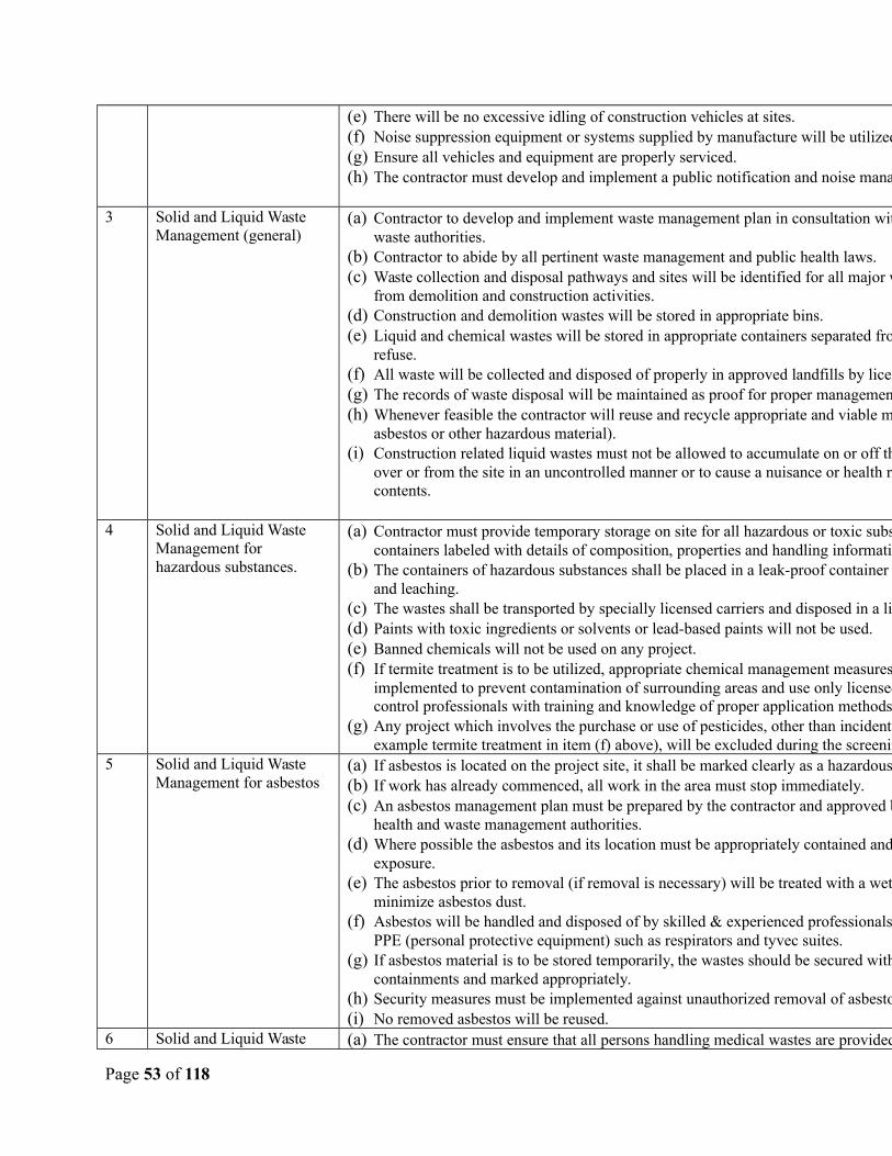
(e) There will be no excessive idling of construction vehicles at sites.(f) Noise suppression equipment or systems supplied by manufacture will be utilized.(g) Ensure all vehicles and equipment are properly serviced.(h) The contractor must develop and implement a public notification and noise management plan.
3 Solid and Liquid Waste Management (general)
(a) Contractor to develop and implement waste management plan in consultation with the local solid waste authorities.
(b) Contractor to abide by all pertinent waste management and public health laws. (c) Waste collection and disposal pathways and sites will be identified for all major waste types expected
from demolition and construction activities.(d) Construction and demolition wastes will be stored in appropriate bins.(e) Liquid and chemical wastes will be stored in appropriate containers separated from the general
refuse.(f) All waste will be collected and disposed of properly in approved landfills by licensed collectors.(g) The records of waste disposal will be maintained as proof for proper management as designed.(h) Whenever feasible the contractor will reuse and recycle appropriate and viable materials (except
asbestos or other hazardous material).(i) Construction related liquid wastes must not be allowed to accumulate on or off the site, or to flow
over or from the site in an uncontrolled manner or to cause a nuisance or health risk due to its contents.
4 Solid and Liquid Waste Management for hazardous substances.
(a) Contractor must provide temporary storage on site for all hazardous or toxic substances in safe containers labeled with details of composition, properties and handling information.
(b) The containers of hazardous substances shall be placed in a leak-proof container to prevent spillage and leaching.
(c) The wastes shall be transported by specially licensed carriers and disposed in a licensed facility.(d) Paints with toxic ingredients or solvents or lead-based paints will not be used.(e) Banned chemicals will not be used on any project.(f) If termite treatment is to be utilized, appropriate chemical management measures will be
implemented to prevent contamination of surrounding areas and use only licensed and registered pest control professionals with training and knowledge of proper application methods and techniques.
(g) Any project which involves the purchase or use of pesticides, other than incidental amounts (for example termite treatment in item (f) above), will be excluded during the screening project.
5 Solid and Liquid Waste Management for asbestos
(a) If asbestos is located on the project site, it shall be marked clearly as a hazardous material.(b) If work has already commenced, all work in the area must stop immediately. (c) An asbestos management plan must be prepared by the contractor and approved by the relevant local
health and waste management authorities.(d) Where possible the asbestos and its location must be appropriately contained and sealed to minimize
exposure.(e) The asbestos prior to removal (if removal is necessary) will be treated with a wetting agent to
minimize asbestos dust.(f) Asbestos will be handled and disposed of by skilled & experienced professionals using appropriate
PPE (personal protective equipment) such as respirators and tyvec suites.(g) If asbestos material is to be stored temporarily, the wastes should be secured within closed
containments and marked appropriately. (h) Security measures must be implemented against unauthorized removal of asbestos from the site.(i) No removed asbestos will be reused.
6 Solid and Liquid Waste (a) The contractor must ensure that all persons handling medical wastes are provided with proper
Page 53 of 118
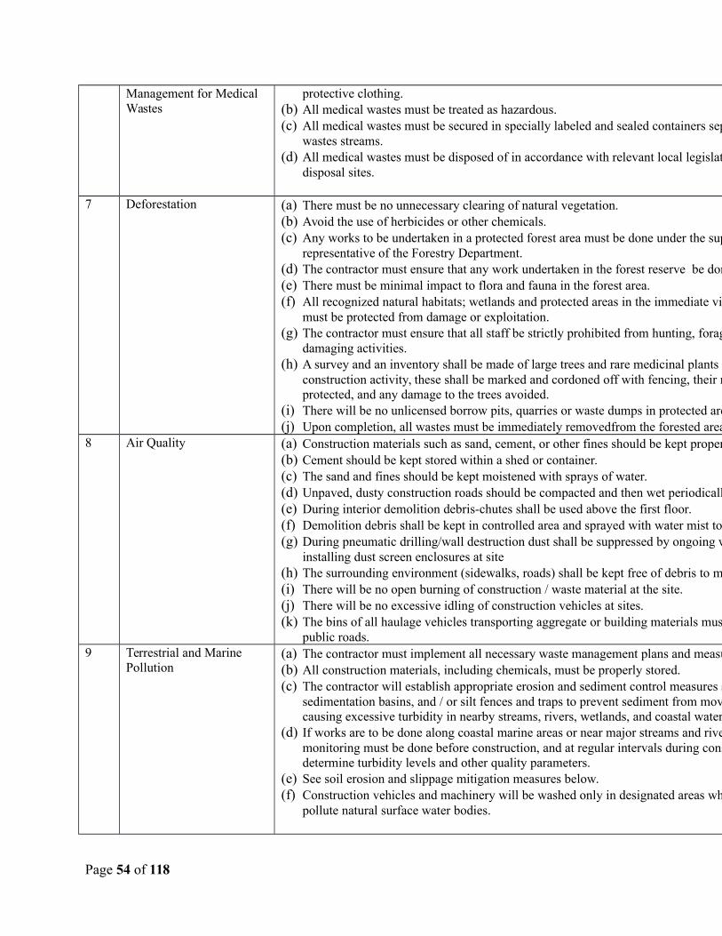
Management for Medical Wastes
protective clothing.(b) All medical wastes must be treated as hazardous.(c) All medical wastes must be secured in specially labeled and sealed containers separate from other
wastes streams. (d) All medical wastes must be disposed of in accordance with relevant local legislation at specified
disposal sites.
7 Deforestation (a) There must be no unnecessary clearing of natural vegetation.(b) Avoid the use of herbicides or other chemicals.(c) Any works to be undertaken in a protected forest area must be done under the supervision of a
representative of the Forestry Department. (d) The contractor must ensure that any work undertaken in the forest reserve be done by manual means.(e) There must be minimal impact to flora and fauna in the forest area.(f) All recognized natural habitats; wetlands and protected areas in the immediate vicinity of the activity
must be protected from damage or exploitation.(g) The contractor must ensure that all staff be strictly prohibited from hunting, foraging, logging or other
damaging activities.(h) A survey and an inventory shall be made of large trees and rare medicinal plants in the vicinity of the
construction activity, these shall be marked and cordoned off with fencing, their root system protected, and any damage to the trees avoided.
(i) There will be no unlicensed borrow pits, quarries or waste dumps in protected areas.(j) Upon completion, all wastes must be immediately removedfrom the forested area.
8 Air Quality (a) Construction materials such as sand, cement, or other fines should be kept properly covered. (b) Cement should be kept stored within a shed or container. (c) The sand and fines should be kept moistened with sprays of water.(d) Unpaved, dusty construction roads should be compacted and then wet periodically.(e) During interior demolition debris-chutes shall be used above the first floor.(f) Demolition debris shall be kept in controlled area and sprayed with water mist to reduce debris dust.(g) During pneumatic drilling/wall destruction dust shall be suppressed by ongoing water spraying and/or
installing dust screen enclosures at site(h) The surrounding environment (sidewalks, roads) shall be kept free of debris to minimize dust.(i) There will be no open burning of construction / waste material at the site.(j) There will be no excessive idling of construction vehicles at sites.(k) The bins of all haulage vehicles transporting aggregate or building materials must be covered on all
public roads.9 Terrestrial and Marine
Pollution(a) The contractor must implement all necessary waste management plans and measures.(b) All construction materials, including chemicals, must be properly stored.(c) The contractor will establish appropriate erosion and sediment control measures such as hay bales,
sedimentation basins, and / or silt fences and traps to prevent sediment from moving off site and causing excessive turbidity in nearby streams, rivers, wetlands, and coastal waters.
(d) If works are to be done along coastal marine areas or near major streams and rivers, water quality monitoring must be done before construction, and at regular intervals during construction to determine turbidity levels and other quality parameters.
(e) See soil erosion and slippage mitigation measures below.(f) Construction vehicles and machinery will be washed only in designated areas where runoff will not
pollute natural surface water bodies.
Page 54 of 118
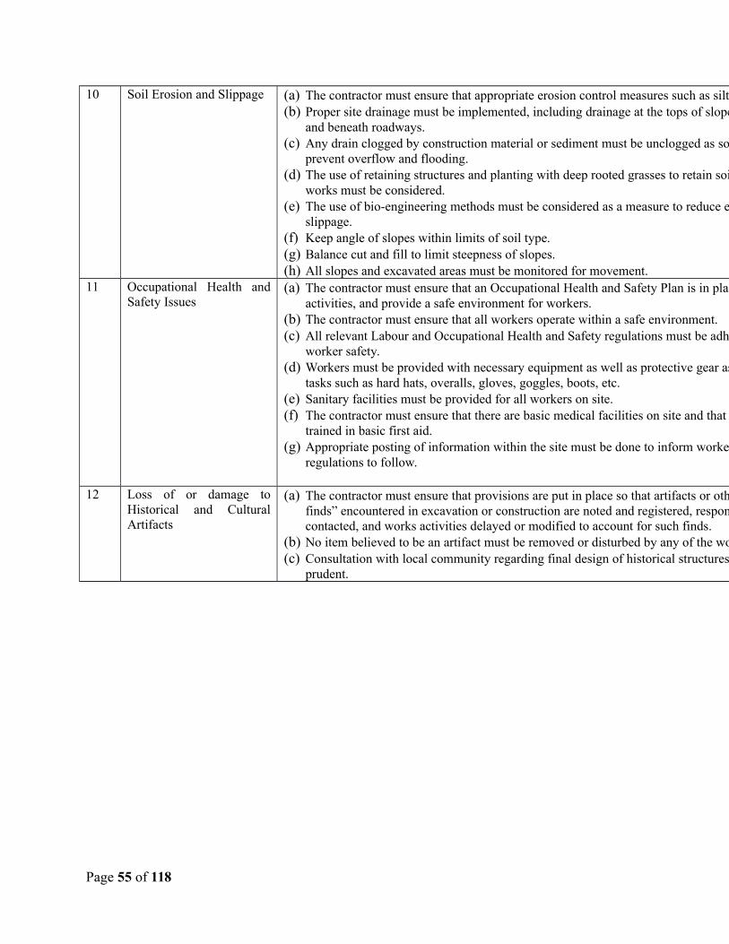
10 Soil Erosion and Slippage (a) The contractor must ensure that appropriate erosion control measures such as silt fences are installed. (b) Proper site drainage must be implemented, including drainage at the tops of slopes, around slopes,
and beneath roadways.(c) Any drain clogged by construction material or sediment must be unclogged as soon as possible to
prevent overflow and flooding.(d) The use of retaining structures and planting with deep rooted grasses to retain soil during and after
works must be considered.(e) The use of bio-engineering methods must be considered as a measure to reduce erosion and land
slippage.(f) Keep angle of slopes within limits of soil type.(g) Balance cut and fill to limit steepness of slopes.(h) All slopes and excavated areas must be monitored for movement.
11 Occupational Health andSafety Issues
(a) The contractor must ensure that an Occupational Health and Safety Plan is in place to guide work activities, and provide a safe environment for workers.
(b) The contractor must ensure that all workers operate within a safe environment.(c) All relevant Labour and Occupational Health and Safety regulations must be adhered to ensure
worker safety. (d) Workers must be provided with necessary equipment as well as protective gear as per their specific
tasks such as hard hats, overalls, gloves, goggles, boots, etc.(e) Sanitary facilities must be provided for all workers on site.(f) The contractor must ensure that there are basic medical facilities on site and that there are staff
trained in basic first aid. (g) Appropriate posting of information within the site must be done to inform workers of key rules and
regulations to follow.
12 Loss of or damage toHistorical and CulturalArtifacts
(a) The contractor must ensure that provisions are put in place so that artifacts or other possible “chance finds” encountered in excavation or construction are noted and registered, responsible Authorities contacted, and works activities delayed or modified to account for such finds.
(b) No item believed to be an artifact must be removed or disturbed by any of the workers.(c) Consultation with local community regarding final design of historical structures will be done as
prudent.
Page 55 of 118
6.0 SCREENING PROCEDURES
This section of the report provides an important element of the EMF document, namely the screening procedure for future work activities and subprojects. At present the proposed works are known at a general level of detail and their potential impacts are also known only in a generalsense. The preliminary project descriptions, impact evaluations, and generalized mitigation measures given previously in this report therefore provide a good starting point, but as is often the case details and particulars may change over time. In the future as detailed actions emerge and physical works ready to begin, the scope, scale, and design of particular activities become fully known. At that time it will be necessary to ascertain their potential environmental impacts through a screening process, identify potential environmental impacts, and provide standardized mitigation measures in the form of an EMP and develop associated contract clauses to ensure they are indeed executed appropriately. Perhaps more importantly it will be necessary to identifyworks which could have more significant impacts and which would require additional evaluation, assessment, and careful planning to best manage impacts during project execution. Accordingly, this part of the report contains the guidelines, procedures and protocols that will be used to serve as a guide for environmental management of future subprojects or activities once they are defined in sufficient detail for execution.
6.1 Screening Processes
Each sub-project may have site specific issues that contribute to potential environmental impacts.A screening mechanism and a scoping exercise are key tools to assist assessing officers in redflagging potential environmental risks or issues as part of the assessment process at an earlystage in the project identification cycle. This process would allow for the highlighting ofpotential impacts, mitigation measures to address the potential impacts, and allowing for theincorporation of these mitigation measures as contract clauses for the proposed small works.
The Physical Planning Unit, the agency charged with regulating development in St. Vincent andthe Grenadines, is in the process of developing an internal screening mechanism, elements ofwhich are presented in Appendix 1, 2 and 3. It is proposed that this screening checklist be usedduring the scoping exercise so that an officer may be able to determine that a project has certainenvironmental ramifications that were not previously identified.
As part of the general assessment process, The Bank, as the main project sponsor with its owninternal procedures, has determined in general that the collective suite of potential sub-projectsthat together create the RDVRP program have resulted in a classification of “Category B”meaning that while there will be some negative impacts, they can be identified and managedthrough fairly standard means. These would include, for simple projects, a generic standardizedEMP that could highlight the general impact areas associated with the proposed constructionactivities, which would then feed into the generalized standard environmental contract clausesfor the contractor to follow. In most of the sub-projects identified in this RDVRP, this will be thecase. In other sub-projects, however, it will be found as details emerge that the possible
Page 56 of 118
environmental effects could be significant, that issues surrounding the proper management aremore complex than previously assumed, or that sensitive areas or natural habitats require specialattention to avoid doing harm. In those cases, additional study is merited in the form of aseparate EIA (Environmental Impact Assessment) appropriate to the scale of the potential effects,which would have as its end product a specific tailor-made EMP to best manage the project inquestion.
To facilitate the process it is necessary for the assessing individual or agency to use a screening or scoping tool, typically a checklist (Appendix 1, 2 and 3), to determine the potential red flags or issues, and to trigger specific responses as appropriate. Checklists are simple tools that are easily used by the assessing officer or agency. The checklist helps to identify and assess potentialimpacts and contribute to the wider decision making process involving the proposed project and project activities. The checklists and its response should be feed into the EMP and proposed mitigation measures to address potential issues that have been identified and as necessary, triggeradditional measures such as impact analysis.
6.2 Local Permitting
The Physical Planning Unit (PPU) is the main authority with legislated responsibility for granting development permits or approvals in St. Vincent and the Grenadines. In doing so, this authority relies on reviews and approvals from the Physical Planning and Development Board, a body comprising both public and private sector personnel including the Central Water and Sewerage Authority (CWSA), the power company (VINLEC), the Police, the Kingstown Town Board, National Properties, Ministries of Environment, Transport and Works, Housing and Surveys, and Agriculture. All development projects including commercial buildings, apartments, hotels, industrial building, residential or commercial subdivisions with civil works such as roads,drains, retaining walls, must submit their plans to the PPU/PPDB for approval before works can commence. This is to ensure integrity in the designs as well as orderliness of the development in keeping with the national vision. The PPU/PPDB utilizes their internal checklist to appraise such developments and to red flag any potential issues as part of the screening process.
As an evolving step, St. Vincent and the Grenadines has a Draft Environmental Management Act (2009) and Draft Environmental Impact Assessment Regulations. Among other things, the draft regulations set criteria and procedure to determine whether an activity is likely to significantly affect the environment and is therefore subject to an environmental impact assessment. It requires all project proposals submitted to the government be sent to the Environment Department (an agency within the Ministry of Health Wellness and the Environment) for environment screening and the Department’s comments shall be submitted to Cabinet. Further, that all persons, agencies, institutions (whether public or private), unless exempted pursuant to the Regulations, shall, before embarking on a proposed project or activity, apply to the Environment Department for a determination whether such project or activity would require an environmental impact assessment.
Page 57 of 118
During the scoping phase of the project assessment, the PPU officer uses his/her training and experience to make a determination bases on the degree of impact likely to be caused by the project due to its size, proximity to a coastal area, marine or terrestrial reserve and the existing topography that may be disturbed, using Appendix 1, 2 and 3. For all projects in the RDVRP, the requirements of the PPU must be followed, as well as all laws and regulations pertaining to environmental protection in Saint Vincent and the Grenadines. In addition, for World Bank projects, there are additional criteria that are required specific to environmental aspects of the RDVRP.
6.3 Screening Criteria and Checklists
In addition to the internal screening of Appendix 1, 2, and 3, the screening criteria for the DVRPprojects addresses the environmental aspects and allows for flagging of the pertinent World Bankpolicy response if or as necessary. To begin, it is necessary to determine whether a proposedproject falls into one of two groups: those which involve more complex environmentalconditions and/or potentially significant environmental effects (if unmitigated) and whichtherefore require more cautious planning efforts; or, those comprising relatively simple oruncomplicated works where the impacts are minimal (e.g., effects during construction of repairsand retrofitting) and which can be addressed through standardized or generic mitigationmeasures.
6.3.1 Relatively Complex Sub-projects
There are several criteria to determine if a sub-project or activity is environmentally complex ormay have potentially significant impacts if unmitigated. These would include the following:
Potential impact to natural habitats (OP/BP 4.04): whether or not a specific activity orsubproject would potentially affect land or water areas where the biological communitiesare formed largely by native plant and animal species where human activity has notessentially or heavily modified the area's primary ecological functions.
Potential impact to physical cultural resources (OP/BP 4.11): whether or not a specificsubproject or activity would potentially affect objects, sites, structures, natural features orlandscapes that have archaeological, paleontological, historical, architectural, religious,aesthetic, or other cultural significance.
Potential for Hazardous Waste: whether or not special or hazardous wastes would need tobe handled, for example waste solvents, asbestos, medical waste, infectious or biohazardmaterials, or radioactive materials.
The following checklist in Table 5 is intended to be used as a first tier screen or adapted withmodifications to fit the specific suite of sub-projects being considered by the RDVRP, to assistthe PSIPMU, PPU and proposing agencies in determining if a project is likely to have significant
Page 58 of 118
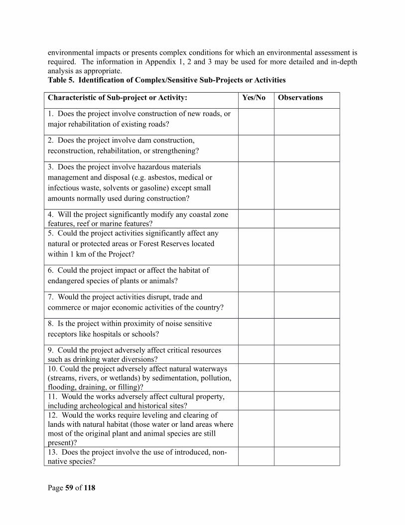
environmental impacts or presents complex conditions for which an environmental assessment isrequired. The information in Appendix 1, 2 and 3 may be used for more detailed and in-depthanalysis as appropriate.Table 5. Identification of Complex/Sensitive Sub-Projects or Activities
Characteristic of Sub-project or Activity: Yes/No Observations
1. Does the project involve construction of new roads, or major rehabilitation of existing roads?
2. Does the project involve dam construction, reconstruction, rehabilitation, or strengthening?
3. Does the project involve hazardous materials management and disposal (e.g. asbestos, medical or infectious waste, solvents or gasoline) except small amounts normally used during construction?
4. Will the project significantly modify any coastal zone features, reef or marine features?5. Could the project activities significantly affect any natural or protected areas or Forest Reserves located within 1 km of the Project?
6. Could the project impact or affect the habitat of endangered species of plants or animals?
7. Would the project activities disrupt, trade and commerce or major economic activities of the country?
8. Is the project within proximity of noise sensitive receptors like hospitals or schools?
9. Could the project adversely affect critical resources such as drinking water diversions?10. Could the project adversely affect natural waterways (streams, rivers, or wetlands) by sedimentation, pollution, flooding, draining, or filling)?11. Would the works adversely affect cultural property, including archeological and historical sites?12. Would the works require leveling and clearing of lands with natural habitat (those water or land areas wheremost of the original plant and animal species are still present)?13. Does the project involve the use of introduced, non-native species?
Page 59 of 118

14. Does the project involve the use of pesticides, herbicides, or other agents to destroy pests?15. Does the project pose a high risk of causing landslides, slips, slumps, rock-falls, debris-flows, or excessive erosion?
16. Will the project result in the violation of Saint Vincentand the Grenadines law, international treaty, or Bank policy?
In cases where it is suspected that a specific sub-project or activity could meet these criteria, thescreening procedure would result in a positive determination. Projects where the significant useor purchase of pesticides is envisioned are not eligible under the RDVRP and would therefore beexcluded and “screened out”. In addition, projects that would trigger the Forest policy are also tobe excluded during the screening process (i.e., projects which have or may have impacts on thehealth and quality of forests, projects that affect the rights and welfare of people and their levelof dependence upon or interaction with forests, and projects that aim to bring about changes inthe management, protection, or utilization of natural forests). Other projects that could affectnatural habitats, physical cultural resources, or that have other complex environmental or socialconditions as identified in the checklist above and such subproject would require a separatestand-alone EIA to be done specifically for that sub-project. For sub-projects requiring a stand-alone EIA, the EIA will be completed prior to initiation of the works and will establishenvironmental requirements for the design and construction phase of the activity in the form anEMP specific to that sub-project. Guidance on preparing an EIA is included in Appendix 4.World Bank staff may assist in preparing the TORs and reviewing the EIAs.
Based on the discussion and analysis of the RDVRP sub-projects presented in Section 4 of thisreport, most are fairly simple and do not involve significant impacts. There are only a few whichmeet the criteria presented in Table 5 above and therefore merit additional analysis. Once thedetails of the activities encompassed in those sub-projects are known with greater precision, thescreening tools should be applied and an informed decision made with respect to the need foradditional assessment and planning.
6.3.2 Relatively Simple Sub-projects
If none of the criteria in Table 5 apply to a particular sub-project or activity, then it is consideredto have only a limited and minor environmental impact. Based on the discussion and analysis inSection 4 of this report, most of the sub-projects with minor civil works will involve only limitedor minor impact, and can be easily mitigated by using standardized generic environmentalcontrols that represent best practice for construction of civil works. For the relativelyuncomplicated environmental actions required of these activities, standardized genericconstruction contract clauses are sufficient, and can be applied as needed to works constructioncontracts. Best management practices are provided as guidance in Appendix 5, 6 and 7 forvarious construction practices, and typical draft language for inclusion in contracts can be foundin Appendix 8 of this report. Further discussion of the generic EMP is provided in section 7 ofthis report.
Page 60 of 118
6.4 Emergency Procedures
Component 3 of the RDVRP is intended to provide financing for emergency sub-projects. Because most of the elements financed under Component 3 are likely to be related to emergency provision of critical goods, it is expected that those subprojects will fall into Category C and therefore would require no environmental screening or assessment work. However, some Component 3 activities could include demolition, removal, repair or reconstruction of damaged public infrastructure, clearing of debris, or other activities which could have potential negative impacts if not mitigated, and would therefore fall into Category B. It is even possible that there may be exceptional cases where a proposed sub-project would involve work in highly ecologically sensitive areas, potentially affect physical cultural resources, or require acquisition of substantial areas of land either temporarily or permanently for reconstruction work or relocation of a vulnerable population. In order to ensure that Component 3 emergency subproject activities are consistent with the World Bank Safeguard Policies as outlined in this EA& EMF document, the activities identified for financing under Component 3 will be subject to anexpedited review by safeguards specialists to determine if they are eligible under the safeguard policies and compliance procedures used by the PSIPMU for all activities financed under the RDVRP. This will allow the possibility to exclude certain activities if the environmental or social impacts are too great, or to include appropriate mitigation measures for a proposed activityif feasible. Having the existing safeguards screening process in place will also allow a certain degree of flexibility and efficiency in processing potential subprojects or activities.
Page 61 of 118
7.0 ENVIRONMENTAL MANAGEMENT PLAN
This section of the report describes the link between the predicted environmental impacts, the needed mitigation measures identified during the screening and assessment process, provisions for budgeting the costs of such measures, and the roles of those responsible for ensuring that the mitigation measures are carried out.
7.1 Mitigation Measures
The mitigation measures for relatively simple environmental management issues are based onbest management practice and industry standards. These are the mitigation measures which areexpected of all professional contractors who are performing civil works, and represent theminimum standard of execution for environmental protection during the execution of suchworks.
As discussed in Section 4 of this report, most of the civil works in the DVRP will be fairlystraightforward and relatively simple from the point of view of environmental management, andonly the standard generic mitigation measures need be considered. Following in Table 6 is alisting of those measures, which have been described more fully in Table 4 under MitigationMeasures and need not be repeated here. Best Management Practices are provided in Appendix5, 6 and 7, and typical generic environmental clauses in Appendix 8 of this report will feed intothe specific contract clauses for these types of works which are deemed to have minimal orlimited impacts.
The following Table 6 provides the elements of the standardized EMP for civil works that haveminimal or limited impacts. Monitoring responsibilities and time frames are also included.
Table 6. Standard Minimum Elements of the Environmental Management Plan (EMP)
Category ofProject
Impact Area MitigationMeasures
MitigationResponsibility
Monitoring Frequency
Rehabilitationor demolitionof existingbuildings.
Air Quality As per mitigation measures (a) to (k)
Contractor Siteinspection
Weekly
Traffic Impacts As permitigationmeasures (a)to (g)
Contractor Policetrafficreports
Weekly
Page 62 of 118
Noise As permitigationmeasures (a)to (h)
Contractor Civil society complaints,interviews
Weekly
Solid and LiquidWaste Management(general)
As permitigationmeasures (a)to (i)
Contractor Disposalrecords,siteinspection
Weekly
Solid and LiquidWaste Management(hazardous)
As permitigationmeasures (a)to (f)
Contractor Disposal records, site inspection
Weekly
Occupational Healthand Safety Issues
As permitigationmeasures (a)to (g)
Contractor Workersreport,medicalrecords
Weekly
Solid and Liquid Waste Management (Medical Wastes)
As permitigationmeasures (a)to (d)
Contractor Disposalrecords,siteinspection
Weekly
New Buildingand generalconstruction
Air Quality As permitigationmeasures (a)to (k)
Contractor Siteinspection
Weekly
Traffic Impacts As permitigationmeasures (a)to (g)
contractor Policetrafficreports
Weekly
Noise As permitigationmeasures (a)to (h)
Contractor Civil society complaints,interviews
Weekly
Solid and LiquidWaste Management(general)
As permitigationmeasures (a)to (i)
Contractor Disposalrecords,siteinspection
Weekly
Solid and LiquidWaste Management(hazardous)
As permitigationmeasures (a)to (f)
Contractor Disposalrecords,siteinspection
Weekly
Occupational Healthand Safety Issues
As permitigationmeasures (a)to (g)
Contractor Workersreport,medicalrecords
Weekly
Terrestrial andMarine Pollution
As permitigationmeasures (a)to (f)
Contractor Siteinspection,marinereports
Weekly
Page 63 of 118
Soil Erosion andSlippage
As permitigationmeasures (a)to (h)
Contractor Siteinspection
Weekly
Loss of or damage toHistorical andCultural Artifacts
As permitigationmeasures (a)to (b)
Contractor Site visits Weekly
Deforestation As permitigationmeasures (a)to (j)
Contractor Site visitsandforestryreports
Weekly
Road and drainconstructionandrehabilitation
Air Quality As permitigationmeasures (a)to (k)
Contractor Site visits,communityreports
Weekly
Terrestrial andMarine Pollution
As permitigationmeasures (a)to (f)
Contractor Siteinspections, marinereports
Weekly
Soil Erosion andSlippage
As permitigationmeasures (a)to (h)
Contractor Site visit/inspection
Weekly
Occupational Healthand Safety Issues
As permitigationmeasures (a)to (g)
Contractor Medicalreports,workersinterview
Weekly
Terrestrial andMarine Pollution
As permitigationmeasures (a)to (f)
Contractor Weekly
Solid and LiquidWaste Management(general)
As permitigationmeasures (a)to (i)
contractor Disposalrecords,site visits
Weekly
Solid and LiquidWaste Management(hazardous
As permitigationmeasures (a)to (f)
contractor Disposalrecords,site visits
Weekly
Traffic Impacts As permitigationmeasures (a)to (g)
Contractor Trafficpolicereport
Weekly
River, floodmitigation, andBridge Works
Air Quality As permitigationmeasures (a)to (k)
Contractor Site visit,waterquality test
Weekly
Page 64 of 118
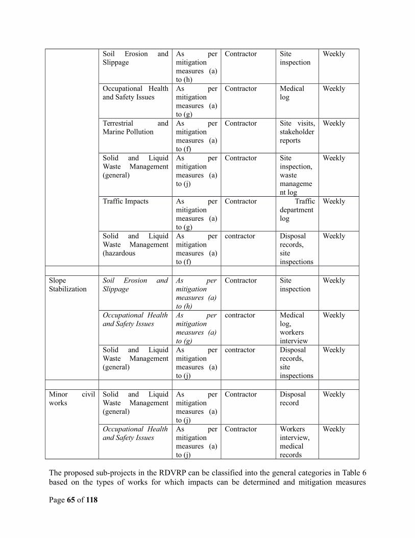
Soil Erosion andSlippage
As permitigationmeasures (a)to (h)
Contractor Siteinspection
Weekly
Occupational Healthand Safety Issues
As permitigationmeasures (a)to (g)
Contractor Medicallog
Weekly
Terrestrial andMarine Pollution
As permitigationmeasures (a)to (f)
Contractor Site visits,stakeholderreports
Weekly
Solid and LiquidWaste Management(general)
As permitigationmeasures (a)to (j)
Contractor Siteinspection,wastemanagement log
Weekly
Traffic Impacts As permitigationmeasures (a)to (g)
Contractor Trafficdepartmentlog
Weekly
Solid and LiquidWaste Management(hazardous
As permitigationmeasures (a)to (f)
contractor Disposalrecords,siteinspections
Weekly
SlopeStabilization
Soil Erosion andSlippage
As permitigationmeasures (a)to (h)
Contractor Site inspection
Weekly
Occupational Healthand Safety Issues
As permitigationmeasures (a)to (g)
contractor Medical log, workers interview
Weekly
Solid and LiquidWaste Management(general)
As permitigationmeasures (a)to (j)
contractor Disposal records, site inspections
Weekly
Minor civilworks
Solid and LiquidWaste Management(general)
As permitigationmeasures (a)to (j)
Contractor Disposal record
Weekly
Occupational Healthand Safety Issues
As permitigationmeasures (a)to (j)
Contractor Workers interview, medical records
Weekly
The proposed sub-projects in the RDVRP can be classified into the general categories in Table 6based on the types of works for which impacts can be determined and mitigation measures
Page 65 of 118
already identified in Table 4 (Impact Areas and Mitigation Measures). For example, the works tobe done on the community centres and schools can be classified as rehabilitation or demolition ofexisting buildings. New construction would include new structures such as storage facilities, orwarehouses. Road and drain construction and rehabilitation, River and Bridge Works and slopestabilization works are also provided with separate categories in Table 6 above. These categoriesprovide guidelines for the selection of the appropriate mitigation measures to be included, as aminimum, in contract documents for each type of project.
If PPU approval has been sought and granted for the relevant sub-project, then the genericminimum mitigation measures and monitoring conditions in Table 6 above should be amended toinclude the conditions and recommendations of the PPU. If an EIA has been conducted for aparticular sub-project due to its environmentally sensitive or complex nature, then the specificrecommendations for mitigation measures in that EIA should also be included in the specificEMP for that sub-project as well, in addition to the standard minimum EMP in Table 6 above.
7.2 Environmental Performance Clauses for Works Contracts
Standard environmental related clauses were developed and are to be appended to orincorporated into the contracts as necessary depending on the type of works to be conducted orthe findings of the checklist by the appraising project officer. These form part of theenvironmental management plan and the mitigation measure presented there. These clauses aregeneral and may be modified to conform to applicable laws and contract procedures of St.Vincent and the Grenadines for such works and shall remain in force throughout the contractperiod.
Generic contract clauses are provided in Appendix 8 for the following general conditions forsmall civil works, roads, buildings, and other works expected to have minor impacts:
Permits and Approvals Site Security Discovery of Antiquities Worker Occupational Health and Safety Noise Control Use and Management of Hazardous Materials, fuels, solvents and petroleum products Use and Management of Pesticides Use of Preservatives and Paint Substances Use of Explosives Site Stabilization and Erosion Control Traffic Management Management of Standing Water Management of Solid Wastes -trash and construction debris Management of Liquid Wastes
Page 66 of 118
Additional clauses for the following special conditions are also within Appendix 8:
Management of Medical Wastes Management of Asbestos Water Pipeline Installation Works in designated Forest Reserves
It is expected that these generic clauses will be incorporated into all contracts, as applicable. Inaddition, specific project-related recommendations may also be forthcoming from statutorybodies that are part of the permitting agencies such as the CWSA or VINLEC and that these canbe reformatted in to contract clauses as well. Finally, if an EIA has been conducted for aparticular sub-project due to its environmentally sensitive or complex nature (see section 6), thenthe specific recommendations for mitigation measures in that EIA should also be included ascontract clauses.
For purposes of cost estimation and budgeting, the contractors should be aware of the existenceof the environmental mitigation measures and associated EMP requirements, and include costitems for such purposes in their proposals.
7.3 Supervision, Monitoring, and Reporting
A unified and integrated approach must be adopted in reviewing the EMP, monitoring theprojects from pre to post positions, and responding to any issue that may arise. The purpose ofthe EMP and its conditions reflected in the construction and operational contract are to ensureaccepted good practices are employed and maintained in order to mitigate any adverseenvironmental impacts.
The person or entity responsible for on-ground implementation and abiding by the contractclauses, recommendations, and mitigation measures will be the contractor. The frequency ofmonitoring will be determined by the requesting agencies, but will be frequent enough to allowthem to determine site changes, the environmental conditions, the adequacy of the mitigationmeasures, and the overall ability of the contractor to execute the works in the specified andsustainable manner.
The overall agency with the responsibility to supervise and monitor the sub-projects is thePSIPMU. The PSIPMU would have the ability to co-opt other technical departments andministries to assist in executing this duty especially where it came to monitoring and report onthe technical aspects of the civil works. However, the PSIPMU simply does not have the staff tofacilitate assessment of each sub-project or to carry out any form of extensive monitoring, so itexpected that the agencies who requesting the work, or hired consultants, will need to exercisethe simple checklist and provide their findings as part of the project document to the PPU forreview and approval. Any findings and approval conditions will have to be incorporated into theproject documents and contract clauses. The agencies will also have to be part of the monitoringand reporting effort to support the PSIMPU’s efforts.
Page 67 of 118
Understanding that environmental management is a cross-sectorial task especially within a smallisland developing states like St. Vincent and the Grenadines with limited financial and technicalresources, the agencies must collaborate to monitor projects and to ensure sustainabledevelopment. The Project Coordination Unit (PSIPMU) will serve as overall project coordinatorfor the RDVRP project undertaking the tasks of evaluation, supervision and implementation. TheEnvironmental Coordinating Unit in the Ministry of Health Wellness and the Environment as thecountry’s environmental lead agency will serve as the Project’s technical advisory unit and co-opt other technical Ministries and departments as necessary to assist in those functions to ensurefruitful project implementation and sustainability.
It is expected that the PSIPMU, in ensuring the sustainability of the various projects, wouldassist in ensuring that they are subject to review by the PPU and that approval is granted prior toimplementation. The PPU is expected to provide timely reviews of the projects, reverting to thePSIPMU within a predetermined timeframe that considers the PSIPMU’s requirement for aspeedy turnaround time to facilitate project implementation in such cases.
Supervision for environmental compliance will be managed jointly by the EnvironmentalCoordinating Unit and the PSIPMU with periodic technical assistance from the Bank. ThePSIPMU will designate a field representative who shall conduct periodic inspections to assureenvironmental compliance. In addition to Bank requirements, the PSIPMU will also beresponsible for ensuring the proper application of any national environmental requirements. ThePSIPMU should staff an additional environmental specialist or engineer to supportenvironmental supervision, especially as regards inspection in the field.
Page 68 of 118
8.0 DISCLOSURE WORKSHOP / PUBLIC CONSULTATION
The desired state of the environment in St. Vincent was investigated through a recent (2010)consultation effort in the UN’s National Environmental Summary. The results of interviews,national consultation, and information review revealed the six major environmental issues in St.Vincent are the following (UNEP, 2010):
“The Effects of Climate Change: The effects of global climate change are being felt in SVG in which the climate patterns are noticeably changing into extreme weather events. A period of drought in 2009 has an effect on the agricultural sector and in addition, has fuelled further land degradation and loss of critical coverage in the forest sector due to the increased incidence of fires9. In addition, the intensity in rainfall is increasing which are also contributing to increased erosion and land slippages in many areas. The drought has also triggered a rethinking of SVGs policy of freshwater management.
Deforestation: By law, any land above the 1000 ft contour is classified as state land and as such majority of forested lands are under government control10. Illegal marijuana cultivation is done on squatted forest lands often in the higher elevations (in watershed areas) and in areas that are unstable (e.g. on slopes on the La Soufriere area)11. This has lead to a significant level of deforestation and concomitant problems include uncontrollederosion, loss of biodiversity, degradation of critical habitats and watershed area and contamination of the drinking water sources. As in the case of water, it is noted that is notunusual for water to arrive in homes heavily laden with sediments despite having passed through the treatment process (sedimentation, filtration and chlorination)12. Although a significant amount of programme intervention was done by the Government to curb deforestation, the problems are short of being abated. Of the 29% of forest area in St Vincent, 27% of this total is classified as planted forests13, thus demonstrating the magnitude of the problem but also the response effort.
Land Degradation: Constrained by the small size of the island, topography and increasing population, St. Vincent has limited land available (36,423 ha) for commercial development, housing, recreation, agriculture and other uses. Currently, there is no National Physical Development Plan to direct growth and development and to facilitate more comprehensive planning which embraces land zoning. This has resulted in incompatible land use in many areas which has resulted in soil erosion, land slippage and pollution of waterways.
Lost of Agricultural Lands to Development: Previously the agricultural sector in StVincent was characterised by a vibrant banana production. However, the loss ofpreferential access to the European Union has significantly reduced the agriculturaloutput and many farms were abandoned. The agricultural lands (especially thoseprivately owned, which is in the majority, if not all) are being converted to housing andother forms of development. Given the private leasehold issue, little control is beingexerted by the Government in addition, the weak land use planning mechanism currentlyin place, brings little or no solution to the issue. Within the context of sustainable land
Page 69 of 118
management, the loss of agricultural lands to these somewhat irreversible land uses havelong term implications for food security in SVG.
Pollution of Coastal Water and River system: Land-based sources of pollution are mainly from sediments, agrochemical leaching, direct agrochemical influx, industrial andcommercial discharge, liquid waste, and storm water runoff from city streets and construction sites. The issue of pollution is affecting the river and coastal water quality, but is also impacting on the habitats. Ship generated waste is major issue in SVG, as it is known that some small ships and pleasure crafts traversing the waters of SVG dump theirwaste into the sea within the EEZ of the country14 and the poor surveillance system serves little as a deterrent.
Solid Waste: SVG has a good waste collection system but indiscriminate and improperdumping of waste is an issue. In particular, plastics bottles and containers (the changingconsumption patterns from local to more imported foods are driving this increase) andderelict vehicles are the forms of waste which are not adequately captured by the currentwaste management collection. In particular, enforcing the waste management laws seemto be the challenges specifically with regard to illegal dumping and enforcement arelargely based of voluntary.”
A workshop was conducted to obtain agency and public feedback on the draft EMF, and toidentify any revisions necessary to better reflect the goals and activities of the RDVRP.Appendix 9 contains summaries, attendance lists from the review workshop.
This EMF document was revised in April 2014, February 2016 and March 2016 and redisclosed,as detailed in Appendix 10.
Page 70 of 118
9.0 TECHNICAL REFERENCES
Byrne, J. St. Vincent & the Grenadines Protected Areas System Gap Assessment. Convention on Biological Diversity Secretariat and The Nature Convervancy, First Workshop, March 9th & 10th, 2006.
Culzac-Wilson, L. Important Bird Areas – AMERICAS, St. Vincent and the Grenadines. Avian Eyes, 2009.
De Graff, Jerome. Land Slide Hazards of St. Vincent, West Indies. U S Department of Agriculture, Forest Service, Fresno California. January 1988.
ECLAC (Economic Commission for Latin America and the Caribbean). An Assessment of the Economic Impact of Climate Change on the Water Sector in Saint Vincent and the Grenadines. United Nations, October 2011.
Eur-OPA. Major Hazards Agreement. Hazards. http://www.besafenet.org/main/default.aspx?it=1&tabid=49&itemid=1227.
Knights, R.D. and Joslyn, Otis R.F. Climate Change and Biodiversity in St. Vincent and the Grenadines. Convention on Biological Diversity, Meeting February 25-29 2008, Panama City, Panama. February 2008.
Gibbs, T. Natural Hazards in the Caribbean. U.S. Geological Survey, 2001.
Government of St. Vincent and the Grenadines. Draft Environmental Management Act, 2009.
Government of St. Vincent and the Grenadines. Draft Environmental Impact Assessment Regulations, 2009.
Government of St. Vincent and the Grenadines. National Economic and Social Development Plan 2013-2025.
Government of Saint Vincent and the Grenadines. Physical Development Act no 21 of 2001.
Highland, L.M., and Bobrowsky, Peter. The landslide handbook—A guide to understanding landslides: Reston, Virginia, U.S. Geological Survey Circular 1325, 2008. http://pubs.usgs.gov/circ/1325/pdf/C1325_508.pdf
Le Friant, A., Goudon, G., Arnulf, A., and Robertson, R. Debris avalanche deposits offshore St. Vincent (West Indies): Impact of flank-collapse events on the morphological evolution of the island. Journal of Volcanology and Geothermal Research 179, p. 1-10. 2009.
Page 71 of 118
Ministry of Health, Wellness and the Environment. National Report, Third International Conference on Small Island Developing States. July 2013.
Ministry of Transport and Works. Flash Flood 2011: Damage Assessment Report, Final. 2011.
National Environmental Advisory Board and Ministry of Health and the Environment. Initial National Communication on Climate Change, St. Vincent and the Grenadines. Prepared under the United Nations Framework for Climate Change, CPACC (Caribbean Planning for Adaptation to Climate Change). November 2000.
Public Sector Investment Programme Management Unit, Ministry of Finance, Government of St.Vincent and the Grenadines. Hydrology / Hydraulic Analysis & Geotechnical Studies for (i) South River Bridge; (ii) Bridges and Fords on Fenton to Green Hill Road (iii) Arnos Vale Watershed Area. December, 2013.
Robertson, R. Final Report on Sustainable Land Management St. Vincent and the Grenadines. UNDP-GEF project, 2012.
Robertson, R. Volcanic hazard atlas of the Lesser Antilles – St. Vincent and The Grenadines.University of the West Indies, Trinidad and Tobago, W.I., Seismic Research Unit, 241-273. 2005.
Robertson, R. The Volcanic Geology of the Pre-Soufriere Rocks of St. Vincent, West Indies, 2002.
Singh, A., and Wilson J. National Environmental Summary (NES), St. Vincent and the Grenadines, 2010. UNEP (United Nations Environment Programme), 2010.
SVG National Physical Development Plan: Preliminary Methodological Framework Report. Stephen Kemp BA, DipTP, MRTPI, FRSA 16th October 2013.
The Caribbean Conservation Association. St. Vincent Country Environmental Profile. St. Michael, Barbados. 1991.
UWI. Probabilistic Seismic Hazard Assessment for the Eastern Caribbean Islands. The University of the West Indies, Seismic Research Centre, 2011.
Wade, A. Barry. COASTAL ZONE MANAGEMENT, The Need for a CZM Programme, St. Vincent and the Grenadines. Environmental Solutions Ltd. Kingston 6, Jamaica. October 10, 2013.
Page 72 of 118

Page 73 of 118

APPENDICES
Page 74 of 118
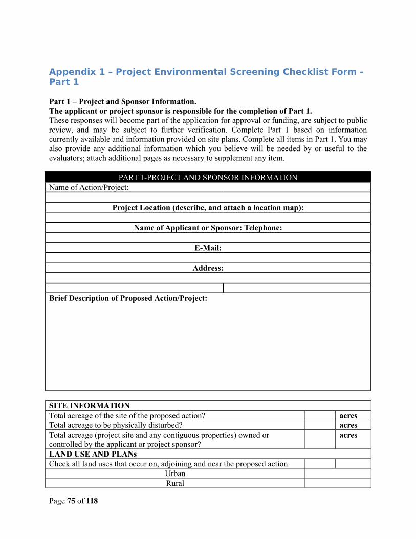
Appendix 1 – Project Environmental Screening Checklist Form - Part 1
Part 1 – Project and Sponsor Information. The applicant or project sponsor is responsible for the completion of Part 1. These responses will become part of the application for approval or funding, are subject to publicreview, and may be subject to further verification. Complete Part 1 based on informationcurrently available and information provided on site plans. Complete all items in Part 1. You mayalso provide any additional information which you believe will be needed by or useful to theevaluators; attach additional pages as necessary to supplement any item.
PART 1-PROJECT AND SPONSOR INFORMATIONName of Action/Project:
Project Location (describe, and attach a location map):
Name of Applicant or Sponsor: Telephone:
E-Mail:
Address:
Brief Description of Proposed Action/Project:
SITE INFORMATIONTotal acreage of the site of the proposed action? acresTotal acreage to be physically disturbed? acresTotal acreage (project site and any contiguous properties) owned or controlled by the applicant or project sponsor?
acres
LAND USE AND PLANsCheck all land uses that occur on, adjoining and near the proposed action.
UrbanRural
Page 75 of 118
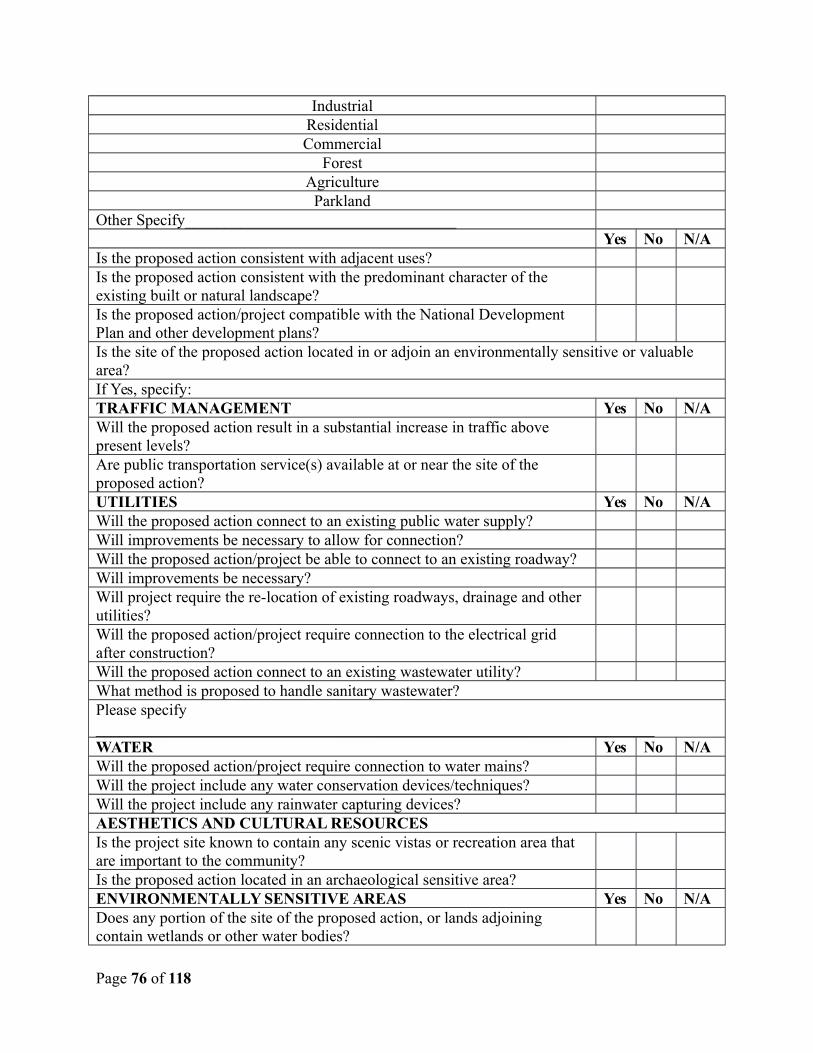
IndustrialResidentialCommercial
ForestAgriculture
ParklandOther Specify__________________________________
Yes No N/AIs the proposed action consistent with adjacent uses?Is the proposed action consistent with the predominant character of the existing built or natural landscape?Is the proposed action/project compatible with the National Development Plan and other development plans?Is the site of the proposed action located in or adjoin an environmentally sensitive or valuable area?If Yes, specify:TRAFFIC MANAGEMENT Yes No N/AWill the proposed action result in a substantial increase in traffic above present levels? Are public transportation service(s) available at or near the site of the proposed action? UTILITIES Yes No N/AWill the proposed action connect to an existing public water supply?Will improvements be necessary to allow for connection?Will the proposed action/project be able to connect to an existing roadway?Will improvements be necessary?Will project require the re-location of existing roadways, drainage and other utilities?Will the proposed action/project require connection to the electrical grid after construction?Will the proposed action connect to an existing wastewater utility?What method is proposed to handle sanitary wastewater?Please specify ______________________________________________________________________WATER Yes No N/AWill the proposed action/project require connection to water mains?Will the project include any water conservation devices/techniques?Will the project include any rainwater capturing devices?AESTHETICS AND CULTURAL RESOURCESIs the project site known to contain any scenic vistas or recreation area that are important to the community?Is the proposed action located in an archaeological sensitive area?ENVIRONMENTALLY SENSITIVE AREAS Yes No N/ADoes any portion of the site of the proposed action, or lands adjoining contain wetlands or other water bodies?
Page 76 of 118
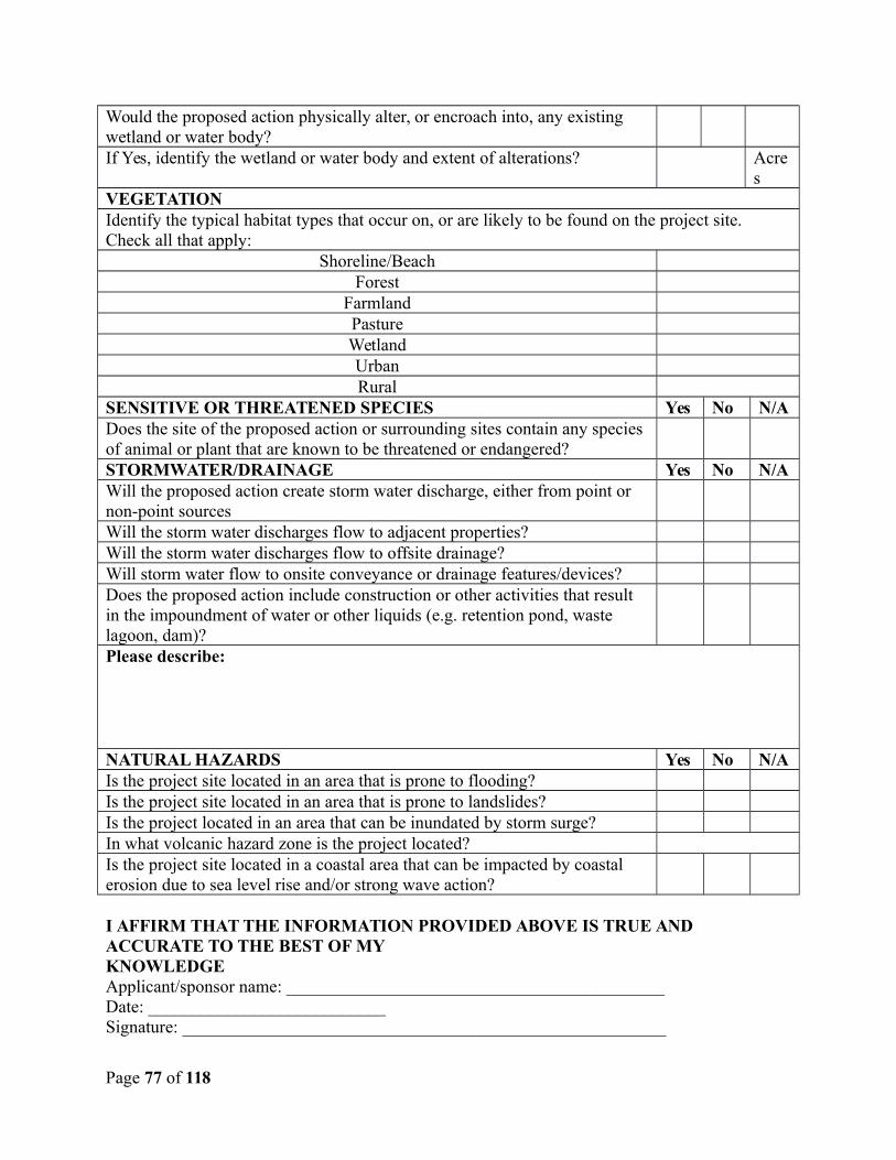
Would the proposed action physically alter, or encroach into, any existing wetland or water body?If Yes, identify the wetland or water body and extent of alterations? Acre
sVEGETATIONIdentify the typical habitat types that occur on, or are likely to be found on the project site. Check all that apply:
Shoreline/BeachForest
FarmlandPastureWetlandUrbanRural
SENSITIVE OR THREATENED SPECIES Yes No N/ADoes the site of the proposed action or surrounding sites contain any species of animal or plant that are known to be threatened or endangered?STORMWATER/DRAINAGE Yes No N/AWill the proposed action create storm water discharge, either from point or non-point sourcesWill the storm water discharges flow to adjacent properties?Will the storm water discharges flow to offsite drainage?Will storm water flow to onsite conveyance or drainage features/devices?Does the proposed action include construction or other activities that result in the impoundment of water or other liquids (e.g. retention pond, waste lagoon, dam)?Please describe:
NATURAL HAZARDS Yes No N/AIs the project site located in an area that is prone to flooding?Is the project site located in an area that is prone to landslides?Is the project located in an area that can be inundated by storm surge?In what volcanic hazard zone is the project located?Is the project site located in a coastal area that can be impacted by coastal erosion due to sea level rise and/or strong wave action?
I AFFIRM THAT THE INFORMATION PROVIDED ABOVE IS TRUE AND ACCURATE TO THE BEST OF MYKNOWLEDGEApplicant/sponsor name: ___________________________________________ Date: ___________________________Signature: _______________________________________________________
Page 77 of 118

Page 78 of 118
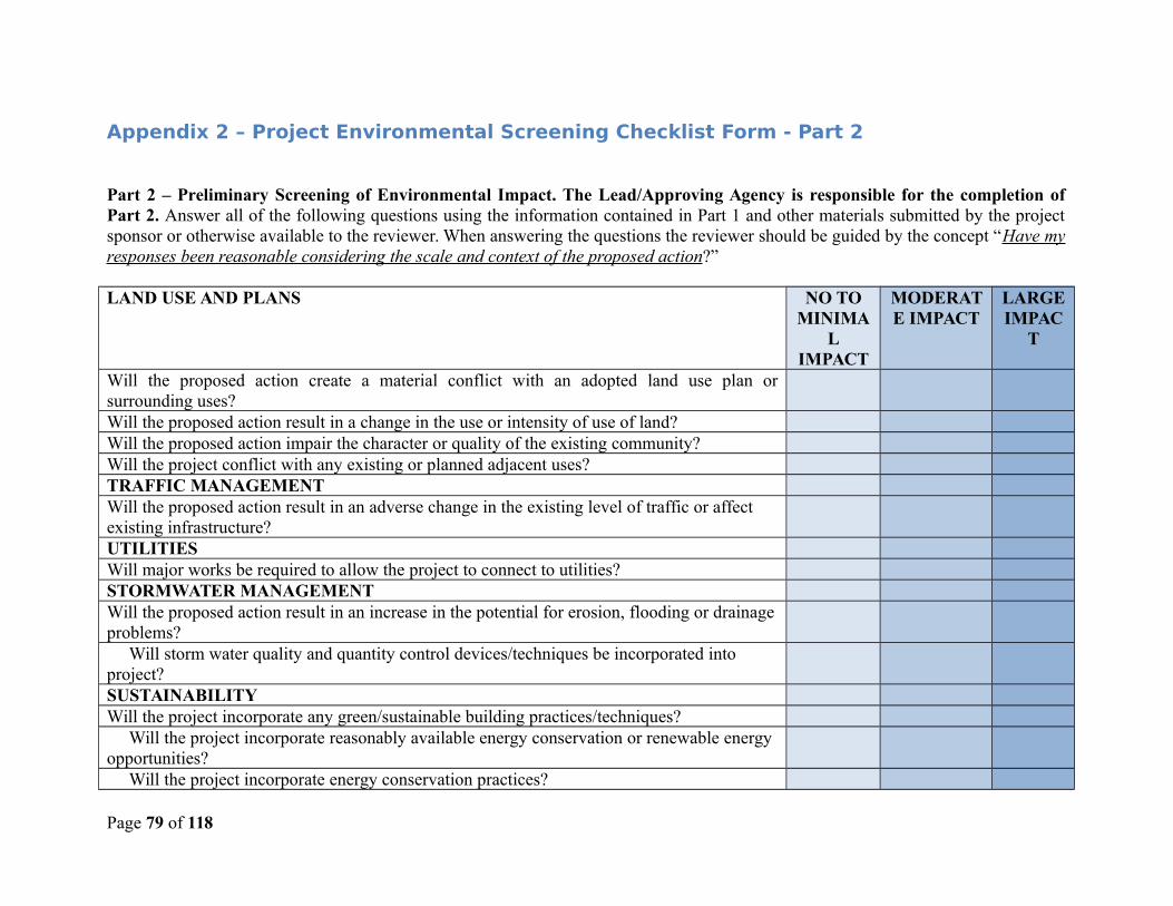
Appendix 2 – Project Environmental Screening Checklist Form - Part 2
Part 2 – Preliminary Screening of Environmental Impact. The Lead/Approving Agency is responsible for the completion ofPart 2. Answer all of the following questions using the information contained in Part 1 and other materials submitted by the projectsponsor or otherwise available to the reviewer. When answering the questions the reviewer should be guided by the concept “Have myresponses been reasonable considering the scale and context of the proposed action?”
LAND USE AND PLANS NO TOMINIMA
LIMPACT
MODERATE IMPACT
LARGEIMPAC
T
Will the proposed action create a material conflict with an adopted land use plan orsurrounding uses?Will the proposed action result in a change in the use or intensity of use of land?Will the proposed action impair the character or quality of the existing community?Will the project conflict with any existing or planned adjacent uses?TRAFFIC MANAGEMENTWill the proposed action result in an adverse change in the existing level of traffic or affect existing infrastructure?UTILITIESWill major works be required to allow the project to connect to utilities?STORMWATER MANAGEMENTWill the proposed action result in an increase in the potential for erosion, flooding or drainageproblems? Will storm water quality and quantity control devices/techniques be incorporated into project?SUSTAINABILITYWill the project incorporate any green/sustainable building practices/techniques? Will the project incorporate reasonably available energy conservation or renewable energy opportunities? Will the project incorporate energy conservation practices?
Page 79 of 118
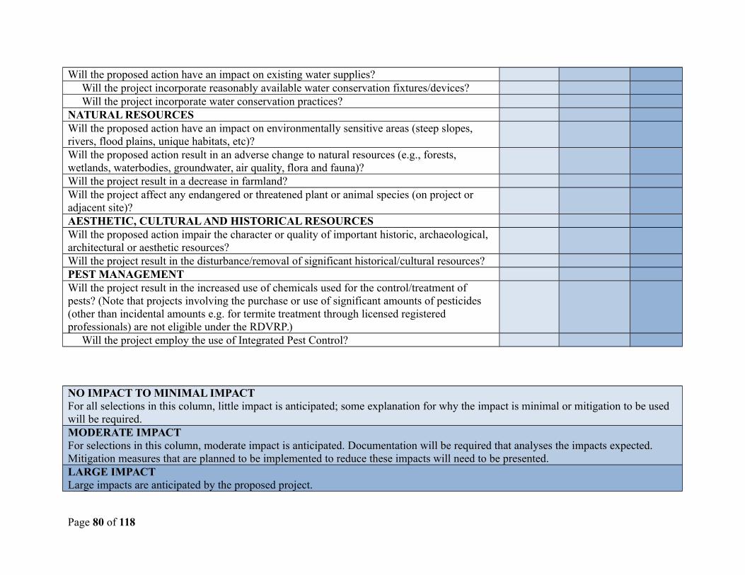
Will the proposed action have an impact on existing water supplies? Will the project incorporate reasonably available water conservation fixtures/devices? Will the project incorporate water conservation practices?NATURAL RESOURCESWill the proposed action have an impact on environmentally sensitive areas (steep slopes, rivers, flood plains, unique habitats, etc)?Will the proposed action result in an adverse change to natural resources (e.g., forests, wetlands, waterbodies, groundwater, air quality, flora and fauna)?Will the project result in a decrease in farmland?Will the project affect any endangered or threatened plant or animal species (on project or adjacent site)?AESTHETIC, CULTURAL AND HISTORICAL RESOURCESWill the proposed action impair the character or quality of important historic, archaeological, architectural or aesthetic resources?Will the project result in the disturbance/removal of significant historical/cultural resources?PEST MANAGEMENTWill the project result in the increased use of chemicals used for the control/treatment of pests? (Note that projects involving the purchase or use of significant amounts of pesticides (other than incidental amounts e.g. for termite treatment through licensed registered professionals) are not eligible under the RDVRP.) Will the project employ the use of Integrated Pest Control?
NO IMPACT TO MINIMAL IMPACTFor all selections in this column, little impact is anticipated; some explanation for why the impact is minimal or mitigation to be used will be required. MODERATE IMPACTFor selections in this column, moderate impact is anticipated. Documentation will be required that analyses the impacts expected. Mitigation measures that are planned to be implemented to reduce these impacts will need to be presented. LARGE IMPACTLarge impacts are anticipated by the proposed project.
Page 80 of 118
If >75% of answers are checked in the ‘No to Minimal Impact’ column, no further assessment is needed but documentation and someexplanation may be required to verify that the anticipated impacts are minimal and that any mitigation measures that are to be implemented in the areas addressed in the Part 1 and Part 2 are adequate. If 75% of answers fall within the ‘Moderate Impact’ or the ‘Large Impact’ column, please provide an EIS that fully examines theproposed project using the format provided in the Environmental Management Framework (EMF), Appendix 3 and 4. An EIS should,in sufficient detail, identify the impacts, including any mitigation measures that have been included by the project sponsor to avoid orreduce impacts. It should also explain how the lead/approval agency determined that the impact may or will not be significant. Eachpotential impact should be assessed considering its setting, probability of occurring, duration, irreversibility, geographic scope andmagnitude. Also consider the potential for short-term, long-term and cumulative impacts. This document should be completed by thelead/approving agency or on their behalf.
Appendix 3 – Guidelines for Using the Project Environmental Screening Checklist
Purpose
This Appendix gives the Guidelines for completing the Environmental Screening Checklist Forms (Parts 1 & 2), and provides guidance on how to proceed with an Environmental Impact Assessment (EIA) should one be required.
Overview
Natural resources are limited and every effort should be made to protect them. There is no doubt that development often results in thedestruction of valuable resources, but as proposed projects often have social and economic benefits, there is a need for a process thatevaluates the negative and positive impacts on natural resources, social and economic effects. The environmental review processprovides for the detailed analysis of a proposed project. It identifies the public need and other social, economic and environmentalbenefits of the project and potential adverse impacts. The process allows stakeholders to weigh the benefits and adverse impacts of aproject. Given the complexity of most projects – delivery timeframe, the variety of environmental settings and the dynamics of naturalenvironmental management/monitoring technology - a single standalone EMP is often inadequate. This framework and themanagement processes it describes are continuous institutional functions and not functions that are triggered only by individualdevelopment proposals. The framework establishes ambient or acceptable limits and triggers. The triggers are signals in advance of thelimits that allows for evaluation, adjustment and invocation on an on-going basis. If the trigger or limit is exceeded there will be amanagement response.
Page 81 of 118
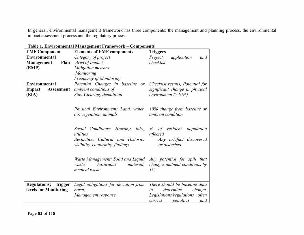
In general, environmental management framework has three components: the management and planning process, the environmentalimpact assessment process and the regulatory process.
Table 1. Environmental Management Framework – ComponentsEMF Component Elements of EMF components TriggersEnvironmentalManagement Plan(EMP)
Category of project Area of ImpactMitigation measure Monitoring Frequency of Monitoring
Project application andchecklist
EnvironmentalImpact Assessment(EIA)
Potential Changes in baseline orambient conditions ofSite: Clearing, demolition
Physical Environment: Land, water,air, vegetation, animals
Social Conditions: Housing, jobs,utilitiesAesthetics, Cultural and Historic:visibility, conformity, findings.
Waste Management: Solid and Liquidwaste, hazardous material,medical waste
Checklist results, Potential forsignificant change in physicalenvironment (>10%)
10% change from baseline orambient condition
% of resident populationaffected
Any artefact discoveredor disturbed
Any potential for spill thatchanges ambient conditions by1%.
Regulations; triggerlevels for Monitoring
Legal obligations for deviation fromnorm; Management response,
There should be baseline datato determine change.Legislations/regulations oftencarries penalties and
Page 82 of 118
corrective measures
The information in the remainder of this framework document provides guidelines on how to do, manage and monitor various types ofsubprojects presented in the RDVRP.
Environmental Documentation
Environmental documents present the anticipated impacts, negative and positive, and allows for an objective analysis of costs andbenefits related to a proposed project. An Environmental Impact Statement (EIS) will be the primary source of environmentalinformation to help stakeholders and decision makers make informed decisions regarding the proposed action. The EIS accomplishesthose goals by examining the nature and extent of identified potential environmental impacts of an action. Importantly, steps that couldbe taken to avoid or minimize adverse impacts must also be presented. An EIS is not appropriate for all projects. In some instances ageneric and standard Environmental Management Plan (EMP) that addresses specific issues will suffice. Deciding between anassessment or an impact is somewhat subjective, but examining the project and using forms and checklists can help determine whattype of documentation is needed. Appendix 5 presents the environmental checklist assessment forms that are to be used as screeningtools for projects. Part 2-Impact Assessment should be completed for those projects that are likely to have adverse impacts based onthe Part 1 Environmental Assessment Form. The Part 2 Impact Assessment triggers additional documentation as follows:
If > 75% of answers are checked in the ‘No to Minimal Impact’ column, please provide a document that explains why theimpacts are anticipated to be minimal and any mitigation measures that are to be implemented in the areas addressed in thePart 1 and Part 2.
If 75% of answers fall within the ‘Moderate Impact’ or the ‘Large Impact’ column, please provide an EIS that fullyexamines the proposed project using the format provided in Appendix 4 of this Environmental Management Framework(EMF).
Table 2 below gives some suggested triggers for selected environment resources that may be affected by civil works during theimplementation of the RDVRP. These triggers are very generic since the baseline conditions are assumed conditions and nationalstandards or tolerant levels do not exist in most cases.
Table 2. Baseline conditions and suggested triggers.
Resource Impacted Baseline conditions Triggers
Page 83 of 118
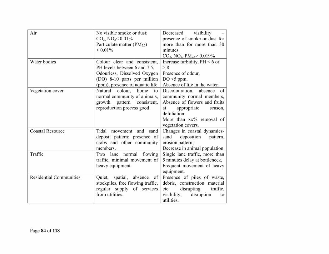
Air No visible smoke or dust; CO2, NO2< 0.01%Particulate matter (PM2.5)< 0.01%
Decreased visibility –presence of smoke or dust formore than for more than 30minutes.CO2, NO2, PM2.5> 0.019%
Water bodies Colour clear and consistent,PH levels between 6 and 7.5,Odourless, Dissolved Oxygen(DO) 8-10 parts per million(ppm), presence of aquatic life
Increase turbidity, PH < 6 or> 8Presence of odour, DO <5 ppm.Absence of life in the water.
Vegetation cover Natural colour, home tonormal community of animals,growth pattern consistent,reproduction process good.
Discolouration, absence ofcommunity normal members,Absence of flowers and fruitsat appropriate season,defoliation.More than xx% removal ofvegetation covers.
Coastal Resource Tidal movement and sanddeposit pattern; presence ofcrabs and other communitymembers,
Changes in coastal dynamics-sand deposition pattern,erosion pattern;Decrease in animal population
Traffic Two lane normal flowingtraffic, minimal movement ofheavy equipment.
Single lane traffic, more than5 minutes delay at bottleneck,Frequent movement of heavyequipment.
Residential Communities Quiet, spatial, absence ofstockpiles, free flowing traffic,regular supply of servicesfrom utilities.
Presence of piles of waste,debris, construction materialetc. disrupting traffic,visibility; disruption toutilities.
Page 84 of 118
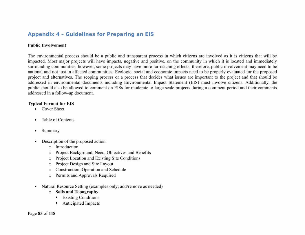
Appendix 4 – Guidelines for Preparing an EIS
Public Involvement
The environmental process should be a public and transparent process in which citizens are involved as it is citizens that will beimpacted. Most major projects will have impacts, negative and positive, on the community in which it is located and immediatelysurrounding communities; however, some projects may have more far-reaching effects; therefore, public involvement may need to benational and not just in affected communities. Ecologic, social and economic impacts need to be properly evaluated for the proposedproject and alternatives. The scoping process or a process that decides what issues are important to the project and that should beaddressed in environmental documents including Environmental Impact Statement (EIS) must involve citizens. Additionally, thepublic should also be allowed to comment on EISs for moderate to large scale projects during a comment period and their commentsaddressed in a follow-up document.
Typical Format for EIS Cover Sheet
Table of Contents
Summary
Description of the proposed actiono Introductiono Project Background, Need, Objectives and Benefitso Project Location and Existing Site Conditions o Project Design and Site Layout o Construction, Operation and Scheduleo Permits and Approvals Required
Natural Resource Setting (examples only; add/remove as needed)o Soils and Topography
Existing Conditions Anticipated Impacts
Page 85 of 118
Proposed Mitigationo Water Resources
Existing Conditions Anticipated Impacts Proposed Mitigation
o Ecological Resources Existing Conditions Anticipated Impacts Proposed Mitigation
Social Setting (examples only; add/remove as needed)o Transportation
Existing Conditions Anticipated Impacts Proposed Mitigation
o Land Use, Land Use Plans and Zoning Existing Conditions Anticipated Impacts Proposed Mitigation
o Community Facilities and Services Existing Conditions Anticipated Impacts Proposed Mitigation
o Aesthetic Resources and Community Character Existing Conditions Anticipated Impacts Proposed Mitigation
o Cultural Resources Existing Conditions Anticipated Impacts Proposed Mitigation
Page 86 of 118
Construction-Related Impacts Cumulative Impacts
o Economic Adverse Impacts That Cannot Be Avoided Irreversible and Irretrievable Commitment of Resources Growth-Inducing Aspects Alternative 1: Apply mitigation Alternative 2: Downscale the Project Alternative 3: Redesign or relocate Alternative 4: Abandon project
A brief background of the project must be provided early on in any documentation. The project must be clearly defined and allissues/impacts presented and evaluated in an unbiased manner. Maps, graphics, photographs, site plans, renderings and other datashould be included in any documentation. Impacts on natural resources like soils, water, vegetation, terrestrial and marine speciesclearly defined. Social impacts should also be presented. Impacts on transportation, infrastructure, energy, drainage, sewage,education, health, safety, noise, security, land use, planned projects, community facilities, utilities, cultural and historical resources andcommunity character must be presented and analysed. All economic impacts must also be presented with supporting data/studies, etc.Importantly, alternatives to the proposed project must be presented and evaluated.
The description of the proposed action should include:
1. The purpose or objective of the action, including any public need for, or public benefits from the action, including social and economic considerations;
2. The location and physical dimensions of the action;
3. The background and history of the action, or site;
4. Timing and schedule for implementing the action, including construction and operations phases, to the extent the information is available, or can reasonably be estimated;
Page 87 of 118
5. Relationship of the action to land use plans, zoning restrictions, and other adopted plans and programs at the local or regional level; and
6. Identification of authorizations permits and approvals required.
Best Practice in EIA Preparation
Environmental Impact Assessment should be:Purposive – the process should inform decision-making and result in appropriate levels of environmental protection and community well-being.
Rigorous – the process should apply 'best practicable' science, employing methodologies and techniques appropriate to address the problems being investigated.
Practical – the process should result in information and outputs which assist with problem solving and are acceptable to and able to beimplemented by proponents.
Cost-effective – the process should achieve the objectives of EIA within the limits of available information, time, resources and methodology.
Efficient – the process should impose the minimum cost burdens in terms of time and finance on proponents and participants consistent with meeting accepted requirements and objectives of EIA.
Focused – the process should concentrate on significant environmental effects and key issues; i.e., the matters that need to be taken into account in making decisions.
Adaptive – the process should be adjusted to the realities, issues and circumstances of the proposals under review without compromising the integrity of the process, and be iterative, incorporating lessons learned throughout the proposal’s life cycle.
Participative – the process should provide appropriate opportunities to inform and involve the interested and affected publics, and their inputs and concerns should be addressed explicitly in the documentation and decision-making.
Page 88 of 118
Interdisciplinary – the process should ensure that the appropriate techniques and experts in the relevant biophysical and socioeconomic disciplines are employed, including use of traditional knowledge as relevant.
Credible – the process should be carried out with professionalism, rigor, fairness, objectivity, impartiality and balance, and be subject to independent checks and verification. Integrated – the process should address the interrelationships of social, economic and biophysical aspects. Transparent – the process should have clear, easily understood requirements for EIA content; ensure public access to information; identify the factors that are to be taken into account in decision making; and acknowledge limitations and difficulties.
Systematic – the process should result in full consideration of all relevant information on the affected environment, of proposed alternatives and their impacts, and of the measures necessary to monitor and investigate residual effects.
Natural Resource Setting
All natural resources that will be or have the potential to be adversely affected by the proposed project need to be examined andanalysed in environmental documentation. Given the geologic history, soils and topography of St. Vincent and the Grenadines, anyand all development needs to be properly planned and potential adverse environmental impacts examined. Additionally, given thepropensity for landslides in St. Vincent and flooding and the fact that the country is prone to numerous natural hazards, much thoughtneeds to be given to projects that involve impacts on natural resources.
The type of soil in an area needs to be considered, as well as, and in conjunction with slope and vegetation. Given the propensity forlandslide in St. Vincent, in particular, care needs to be taken with development that requires excavations and which disturbs vegetationand soil. Therefore, all proposed projects that involve the removal of vegetation and disturbance of soil and slopes needs to be apriority in environmental documentation. Additionally, hydrology and drainage areas, waterways/streams/rivers and associated floodplains need to be considered and presented in an EIS and other documentation.
The project site and surrounding areas need to be evaluated for the presence of important/significant or endangered species. If suchspecies are present the project team should weigh the need and benefits of the project against the ecological benefits of the specie(s) inquestions and/or consider alternatives to the proposed project.
Social Setting
Page 89 of 118
The social setting of a proposed project examines the services available and characteristics of a community. It covers such topics astransportation, land use, educational facilities, aesthetic and cultural resources and other elements important to a community. If aproposed project is likely to have a significant impact, negative or positive, on a community, constituency or the nation it needs to bepresented as part of the environmental documentation associated with a project. If for instance, a project will require the re-routing oftraffic or the relocation of a main roadway, it needs to be discussed in an EIS or other document.
All social impacts must be presented in an unbiased manner to allow for the proper evaluation of benefits and costs of the proposedproject.
Coastal and Marine Resources
Sea level rise is a great threat to the beaches, low-lying areas and coastal infrastructure in St. Vincent and the Grenadines. Due to thelimited amount of low-lying areas and the fact that critical facilities are located in proximity to the coastline, sea level rise and theresultant coastal erosion and loss of land will have an impact on the island and its economy. Add more intense and frequent hurricanesand tropical storms to the steep and rugged topography of St. Vincent the result is the potential for serious floods and landslides. Inaddition to sea level rise caused by melting snow caps and glaciers, a warming world means warmer oceans. Water expands as itwarms, so not only will sea levels rise because of melting ice caps and glaciers but it will expand thermally. Globally and regionally,this means death to coral reefs and increase storm surges.Any damage to the reef may result in stronger wave action near shore which could exacerbate coastal erosion problems. Additionally,warming ocean temperatures will have a negative effect on reefs and the species that depend on it. This will in turn affect fisheries,diving, snorkelling and other water-based activities around the islands, thereby threatening tourism and the economy.
Climate Change
Climate change is a global issue that should and must be a priority for St. Vincent and the Grenadines. Although the Caribbean regioncontributes much less greenhouse gases to the atmosphere than industrialized nations, this will not lessen the impacts experienced bythe region nor will it reduce the economic hardship that the islands will face. Along with the warming of temperatures, changes beingobserved across the globe include weather and precipitation pattern modifications, increase in storm intensities, more frequentdroughts and torrential downpours, changes in growing seasons, expansion of ranges of plants, insects, animals and diseases,warming of oceans and seas, melting of snow caps and glaciers, rising ocean levels and many more changes. While global
Page 90 of 118
temperatures are cyclical in nature, it is accepted by many that human activities are contributing to the changes currently beingobserved.
Given that climate change is such an important issue, especially for small island states, every effort should be made to makedevelopment as sustainable as possible to further reduce contributions of greenhouse gases to the atmosphere. Each and every projectplanned, constructed, implemented at any point going forward should make climate change and sustainability a top priority.Sustainable building techniques should be practiced; renewable energy utilized as much as possible and energy and water conservationdevices/fixtures and practices implemented. A decision must be made early on to develop a sustainable project as it is more costeffective to include the required elements in the development stage rather than during a retrofit/renovation.
Site Stabilization and Erosion Control
Given the topography, volcanic nature, soils and climate of St. Vincent and the Grenadines, special attention is needed in the area ofsite stabilization and erosion control. These elements should be addressed during the project design and planning stages and plansincluded with other site plans.
In an effort to protect natural resources, life, property and infrastructure and given the topography and soils present in St. Vincent, sitestabilization and erosion control measures may be necessary during project implementation. Clearing and site disturbance should belimited only that which is necessary and soils should not be left open to rainfall. Specific attention should be paid to installing erosioncontrol measures on the downslope side of the project site or disturbance area and in proximity to natural drainage features andwaterways. An erosion control plan should be included with a proposed landscape plan and other site plans. Best managementpractices for site slope stabilization and erosion control are presented in Appendix 5 and 6, below.
Other Issues to be considered in the EIS:
Site Security Discovery of antiquities Asbestos Worker Sanitation Noise Control Use and management of hazardous materials
Page 91 of 118
Use of preservatives and paint substances Schools Agency Responsibility
Appendix 5 – Best Management Practices for Erosion Control
Mitigation Measures
Limit the area of disturbance/clearing, the development footprint and preserve natural drainage patterns and vegetation as much as isfeasible. Ensure that exposed areas are protected in an effort to limit exposure of bare soil to rain and wind during construction.Immediately after earth moving activities are completed, all exposed areas should be covered with a combination of grass, trees andshrubs to form a permanent protection against erosion. Grass could be established either with sodding or seeding using grass speciesthat are native to the area. Mulching should be used as needed around tree roots to improve the supply of moisture and oxygen to the
Page 92 of 118
roots. Wood mulch can be used to spread over the disturbed area as a temporary measure until permanent vegetation can beestablished.
On very steep slopes erosion occurs more easily and any mulching and seeding laid down may be washed away before the new grassor vegetation are properly established. In these situations, a special matting material to provide a cover for the exposed soil isrecommended. The matting, available in rolls, can be laid down over the exposed area and secured into the ground with pegs. Thematting allows grass to grow through while preventing the soil from moving as the runoff travels across the land surface.
Install perimeter protection along natural flow areas to prevent sediment from travelling off-site during construction. These include siltfencing, haybales or other erosion control methods. See illustrations below.
During construction trucks and equipment entering and leaving the project site tend to track debris and dirt onto roadways. Effortsshould be made to limit the material that is carried onto roadways. Install rumple strip so that debris/dirt can be shaken off beforeexiting the site.
For site design and planning do not channel storm water runoff offsite to adjacent properties, drainage features, roadways,waterways or similar. Retain as much of the runoff generated by impervious surfaces onsite as possible and direct to onsite rainwatercollection system or drainage features such as swales, drainage ponds, dry wells, rain gardens, etc. Eliminate or limit the use ofchemicals including pesticides, fertilizers, as they will likely contaminate surface water flows originating on-site. A depiction of a drywell is included below.
The National Institute of Building Sciences recommends the following: Keep land disturbance to a minimum and retain prime vegetation features to the extent possible. Reduce building and paving footprints. Limit site disturbance to a minimal area around the building perimeter, including locating building adjacent to existing
infrastructure.
Plan construction staging areas with the environment in mind
Page 93 of 118

Figure 2 Cross Section of Retention Cell/Rain Garden
Figure 3 Cross-section of a Typical Infiltration TrenchSource:
Using alternative paving materials like grass and permeable pavers will reduce runoff generation and increase infiltration.
Several rainwater collection/storage/treatment features are illustrated below.
Page 94 of 118
Figure 1 A Grassed Swalehttp://www.pbcgov.com/coextension/horticulture/neighborhoods/tips/_images/swale.jpg
Appendix 6 – Best Management Practices for Slope Stabilization
In an effort to protect natural resources, life, property and infrastructure Slope Stabilization measures may be necessary for areas proneto slope failure which includes land, rock and debris slides. Several factors can contribute to land movement. These include rainfall,slope gradient, earthquakes, erosion and, of course, gravity. In some cases, rock and landslide can be triggered by clearing anddisturbing areas for roads, structures and other development.In determining the best methods for Slope Stabilization, being able to assess existing conditions, slope gradient, hydrology anddrainage characteristics, soil, surface or sediment deposits and underlying rock formations will be important.
Rock-fall-Prevention Methods
Rock-falls can be triggered by rainfall, natural and manmade undercutting, earthquakes and vibrations. Most slope failures in St.Vincent are as a consequence of heavy rainfall. It should be noted that human activities like clearing of land for roads and structures,undercutting of slopes and improper excavating can contribute to slope failures. It is also important to note that leaking water mains,pipes and septic systems can also play a role in slope failures.The USGS (2008, 53) notes that rock-falls can be mitigated through the use of “catch ditches, benches, scaling and trimming, cableand mesh, shotcrete, anchors, bolts, dowels, and controlled blasting.”
Catch Ditches
The USGS (2008, 100) notes that “[w]ide catch ditches are effective in containing rock-fall, but the ditches must be designed with thecliff geometry taken into account, and it is best to consult a professional about specifications. The bottom of the catchment ditchshould be covered with loose earth to prevent falling rock from bouncing or shattering into pieces or shards. If there is not enoughspace to construct as wide a ditch as is specified, then a combination of smaller ditches with a gabion or rock wall along their downhilledges can be used.”
Page 95 of 118
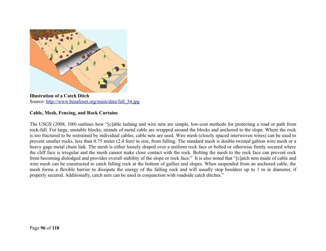
Illustration of a Catch DitchSource: http://www.besafenet.org/main/data/fall_34.jpg
Cable, Mesh, Fencing, and Rock Curtains
The USGS (2008, 100) outlines how “[c]able lashing and wire nets are simple, low-cost methods for protecting a road or path fromrock-fall. For large, unstable blocks, strands of metal cable are wrapped around the blocks and anchored to the slope. Where the rockis too fractured to be restrained by individual cables, cable nets are used. Wire mesh (closely spaced interwoven wires) can be used toprevent smaller rocks, less than 0.75 meter (2.4 feet) in size, from falling. The standard mesh is double-twisted gabion wire mesh or aheavy gage metal chain link. The mesh is either loosely draped over a uniform rock face or bolted or otherwise firmly secured wherethe cliff face is irregular and the mesh cannot make close contact with the rock. Bolting the mesh to the rock face can prevent rockfrom becoming dislodged and provides overall stability of the slope or rock face.” It is also noted that “[c]atch nets made of cable andwire mesh can be constructed to catch falling rock at the bottom of gullies and slopes. When suspended from an anchored cable, themesh forms a flexible barrier to dissipate the energy of the falling rock and will usually stop boulders up to 1 m in diameter, ifproperly secured. Additionally, catch nets can be used in conjunction with roadside catch ditches.”
Page 96 of 118
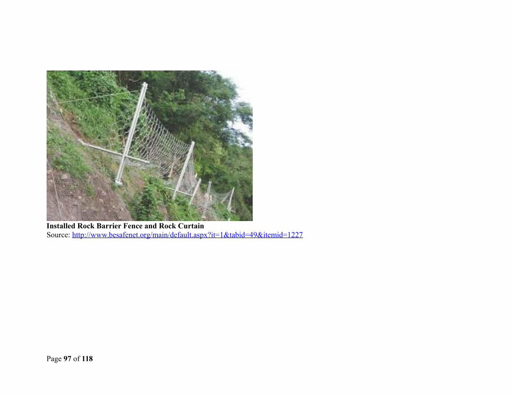
Installed Rock Barrier Fence and Rock CurtainSource: http://www.besafenet.org/main/default.aspx?it=1&tabid=49&itemid=1227
Page 97 of 118
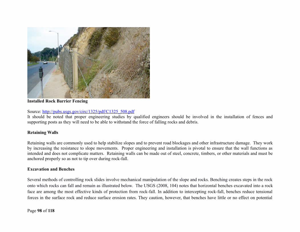
Installed Rock Barrier Fencing
Source: http://pubs.usgs.gov/circ/1325/pdf/C1325_508.pdfIt should be noted that proper engineering studies by qualified engineers should be involved in the installation of fences andsupporting posts as they will need to be able to withstand the force of falling rocks and debris.
Retaining Walls
Retaining walls are commonly used to help stabilize slopes and to prevent road blockages and other infrastructure damage. They workby increasing the resistance to slope movements. Proper engineering and installation is pivotal to ensure that the wall functions asintended and does not complicate matters. Retaining walls can be made out of steel, concrete, timbers, or other materials and must beanchored properly so as not to tip over during rock-fall.
Excavation and Benches
Several methods of controlling rock slides involve mechanical manipulation of the slope and rocks. Benching creates steps in the rockonto which rocks can fall and remain as illustrated below. The USGS (2008, 104) notes that horizontal benches excavated into a rockface are among the most effective kinds of protection from rock-fall. In addition to intercepting rock-fall, benches reduce tensionalforces in the surface rock and reduce surface erosion rates. They caution, however, that benches have little or no effect on potential
Page 98 of 118
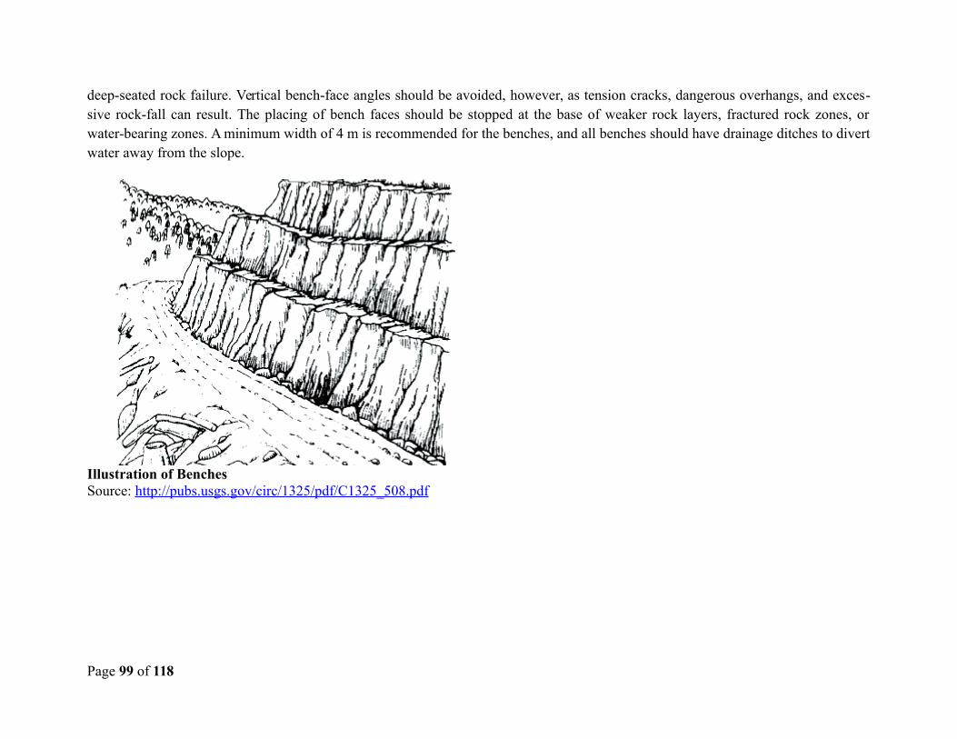
deep-seated rock failure. Vertical bench-face angles should be avoided, however, as tension cracks, dangerous overhangs, and exces-sive rock-fall can result. The placing of bench faces should be stopped at the base of weaker rock layers, fractured rock zones, orwater-bearing zones. A minimum width of 4 m is recommended for the benches, and all benches should have drainage ditches to divertwater away from the slope.
Illustration of BenchesSource: http://pubs.usgs.gov/circ/1325/pdf/C1325_508.pdf
Page 99 of 118
Appendix 7 – Other Best Management Practices
Management of construction waste
Every effort should be made to prevent sediment, fill, debris, and pollutants from traveling off site during construction by utilizingsediment barriers and sound construction practices. It is recommended that silt fencing be installed along the downslope side of thelimits of clearing to minimize/prevent sediment from washing offsite to streams, drains, adjacent streets and properties. Cover exposedarea with mulch or hay to prevent erosion during rain events or seed areas that will be exposed for long periods with temporary grass.Silt fencing and/or anchored tarps are recommended to prevent the travel of materials from the designed stockpile areas.
Page 100 of 118
The site contractor should be responsible for ensuring that storage and stockpiling of construction materials and supplies will be indesignated areas and erosion control measures are implemented to prevent/reduce wind-blown dust and erosion from rainwater. Storedmaterials may include machinery for construction activities; fill material, stockpiled soil, and building materials as necessary. Acovered dumpster is recommended for waste materials. It should be the responsibility of the site contractor to ensure the equipmentand materials stored onsite are protected as necessary to prevent accidental spills of hazardous materials/substances.
Pest Management
Pest management in the tropical is an important issue. Chemicals used to control pests indoors and outdoors can be potentiallydangerous to applicators, the general public and waterways, etc.. Integrated Pest Management (IPM) is a concept of pest managementthat seeks to reduce the use of harmful chemicals, target specific pests, increase the use of safer alternatives and techniques and limitexposure of applicators, humans and other organisms to harmful substances. It is a proactive approach with the premise that if the foodand habitat are not provided for the pests, they will go elsewhere. Chemicals are applied as a last resort and the least hazardouschemical is applied in the lowest possible concentration by trained professional. Note that projects involving the purchase or use ofpesticides (other than incidental amounts) are not eligible under the DVRP.
The following IPM principles and practices should be implemented/practiced:
Design, construct, and maintain buildings to be as pest resistant as possible. Ensure that roof parapets and caps are sealed, any other devices on roofs, such as traps or bait stations, are placed at
documented locations and regularly checked, and nets for bird/pigeon activity are checked on a regular basis. Eliminate cracks and holes to keep pests out. Lightly dust gaps between walls and other voids with boric acid before
closing them up. Inspect the grounds around buildings and fill burrows with gravel. Keep vegetation at least 12 inches from building
perimeter. Ensure that devices such as bait stations placed in outside areas are locked, secured, clean, and in good working order.
Rodents do not like dusty and unclean bait stations. Use physical barriers to block pest entry and movement (such as door sweeps, screens at air intakes, doors, and
windows).
Page 101 of 118

Page 102 of 118
Appendix 8 – Typical Environmental Contract Clauses
The following are standard environmental related clauses that may be appended to or incorporated into the contracts for the small civilworks which have been determined to be of minimal environmental impact. These mitigation measures are the core of a generic,standardized EMP (Environmental Management Plan) for these types of small works and the typical associated minor impacts whichcan be routinely addressed with best industry practice. These clauses are general and may be modified to conform to applicable SaintVincent and the Grenadines laws and contract procedures for such works and shall remain in force throughout the contract period.These mitigation measures are intended for relatively simple environmental management issues and are based on best managementpractice and industry standards. These are the mitigation measures which are expected of all professional contractors who areperforming civil works, and represent the minimum standard of execution for environmental protection during the execution of suchworks. (Specific project related recommendations may also be forthcoming from statutory permitting agencies such as the PPDB orthe Ministry of Health, and these can be reformatted in to contract clauses as well. Finally, if an EIA has been conducted for aparticular sub-project due to its environmentally sensitive or complex nature, then the specific recommendations for mitigationmeasures in that EIA should also be included as contract clauses.)
1. Permits and Approvals
The contractor shall be responsible for ensuring that he or she has all relevant legal approvals and permits required to commenceworks.
2. Site Security
The contractor shall be responsible for maintaining security over the construction site including the protection of stored materials andequipment. In the event of severe weather, the contractor shall secure the construction site and associated equipment in such a manneras to protect the site and adjacent areas from consequential damages. This includes the management of onsite, construction materials,construction and sanitary wastes, additional strengthening of erosion control and soil stabilization systems and other conditionsresulting from contractor activities which may increase the potential for damages.
Page 103 of 118
3. Discovery of Antiquities
If, during the execution of the activities contained in this contract, any material is discovered onsite which may be considered ofhistorical or cultural interest, such as evidence of prior settlements, native or historical activities, evidence of any existence on a sitewhich may be of cultural significance, all work shall stop and the supervising contracting officer shall be notified immediately. Thearea in which the material was discovered shall be secured, cordoned off, marked, and the evidence preserved for examination by thelocal archaeological or cultural authority. No item believed to be an artifact must be removed or disturbed by any of the workers.Work may resume, without penalty of prejudice to the contractor upon permission from the contracting officer with any restrictionsoffered to protect the site.4. Worker Occupational Health and Safety
The contractor shall ensure that all workers operate within a safe environment. Sanitation facilities shall be provided for all siteworkers. All sanitary wastes generated as a result of project activities shall be managed in a manner approved by the contractingofficer and the local authority responsible for public health. The contractor shall ensure that there are basic medical facilities on siteand that there are staff trained in basic first aid. Workers must be provided with the necessary protective gear as per their specific taskssuch as hard hats, overalls, gloves, goggles, boots, etc. The contractor shall provide the contracting officer with an occupational healthand safety plan for approval by the local health authority prior to the commencement of site activities.
The contractor must ensure that all workers operate within a safe environment. All relevant Labour and Occupational Health and Safety regulations must be adhered to ensure worker safety. Sanitary facilities must be provided for all workers on site. Appropriate posting of information within the site must be done to inform workers of key rules and regulations to follow.
5. Noise Control
The contractor shall control noise emissions generated as a result of contracting activities to the extent possible. In the case of sitelocations where noise disturbance will be a concern, the contractor shall ensure that the equipment is in good working order withmanufacturer supplied noise suppression (mufflers etc.) systems functioning and in good repair. Where noise management is aconcern, the contractor shall make reasonable efforts to schedule activities during normal working hours (between 8 am and 5 pm).Where noise is likely to pose a risk to the surrounding community either by normal works or working outside of normal working hoursor on weekends, the contractor shall inform the contracting officer and shall develop a public notification and noise management planfor approval by the contracting officer.
Page 104 of 118
Specific elements of the noise control activities by the contractor shall include: construction/ work activities will occur withinspecified daylight hours e.g. 8:00 am to 4:00pm; community / public to be informed in advance of any work activities to occur outsideof normal working hours or on weekends; sites should be hoarded wherever possible; during operations, the engine covers ofgenerators, air compressors and other powered mechanical equipment shall be closed, and equipment placed as far away fromresidential areas as possible; there will be no excessive idling of construction vehicles at sites; noise suppression equipment or systemssupplied by manufacture will be utilized; ensure all vehicles and equipment are properly serviced; the contractor must develop andimplement a public notification and noise management plan.
6. Use and Management of Hazardous Materials, fuels, solvents and petroleum products
The use of any hazardous materials including pesticides, oils, fuels and petroleum products shall conform to the proper userecommendations of the product. Waste hazardous materials and their containers shall be disposed of in a manner approved by thecontracting officer. A site management plan will be developed by the contractor if the operation involves the use of these materials toinclude estimated quantities to be consumed in the process, storage plans, spill control plans, and waste disposal practices to befollowed. This plan and the manner of management are subject to the approval of local authority responsible for safety, and wastemanagement, and the contracting officer.
Elements of the hazardous materials management shall include: contractor must provide temporary storage on site of all hazardous ortoxic substances in safe containers labeled with details of composition, properties and handling information; the containers ofhazardous substances shall be placed in an leak-proof container to prevent spillage and leaching; the wastes shall be transported byspecially licensed carriers and disposed in a licensed facility; paints with toxic ingredients or solvents or lead-based paints will not beused; banned chemicals will not be used on any project.
7. Use and Management of Pesticides
The project will not fund activities that involve the purchase or use of significant quantities of pesticides. For incidental, minor use ofpesticides, the use of pesticides shall be approved by the contracting officer and shall conform to the manufacturers’ recommendationsfor use and application. Any person using pesticides shall demonstrate that they have read and understood these requirements and arecapable of complying with the usage recommendations to the satisfaction of the contracting officer. All pesticides to be used shallconform to the list of acceptable pesticides that are not banned by the relevant local authority.
Page 105 of 118
If termite treatment is to be utilized, ensure appropriate chemical management measures are implemented to prevent contamination of surrounding areas, and use only licensed and registered pest control professionals with training and knowledge of proper application methods and techniques.
8. Use of Preservatives and Paint Substances
All paints and preservatives shall only be used with the approval of the contracting officer. Information shall be provided to thecontracting officer who describes the essential components of the materials to be used so that an informed determination can be madeas to the potential for environmental effects and suitability can be made. Storage, use, and disposal of excess paints and preservativesshall be managed in conformance with the manufacturers’ recommendations and as approved by the contracting officer. The contractorshall provide the contracting officer with a list of materials and estimated quantities to be used, storage, spill control and wastedisposal plans to be observed during the execution of the contract. This plan is subject to the approval of the contracting officer.
9. Use of Explosives
Use of explosives shall be at the approval of the relevant local authority and shall be supervised and undertaken by a qualifiedexplosives technician. Blasting will be limited to between the hours of 9:00am and 4:00 pm unless specifically approved by the localauthority and the contracting officer. Any use of explosives shall be permitted only after an explosives management and blasting planhas been approved by the relevant local authority and the contracting officer.
This plan shall include:
A. Description of the explosive agent, charge description, intended use.
B. Site safety plan including:1. Storage of initiators, booster charges and principal blasting agents2. Handling precautions to be observed3. Transport to and from site4. Security of stored materials5. Disposal of excess or damaged explosive materials.
C. Analysis of risk to surrounding area and mitigation measures to be employed including:
Page 106 of 118
1. Over-pressure event2. Noise3. Flying debris4. Seismic transmission5. Accidental detonation
D. Name and qualifications for all persons responsible for handling explosive agents
10. Site Stabilization and Erosion Control
The Contractor shall implement measures at the site of operations to manage soil erosion through minimization of excavated area andtime of exposure of excavated areas, preservation of existing ground cover to the extent possible, provision of approved ground cover.Where excavations are made, contractor shall implement appropriate stabilizing techniques to prevent cave-in or landslide. Measuresshall be approved by the contracting officer.
The contractor must ensure that appropriate erosion control measures such as silt fences are installed. Proper site drainage must be implemented. Any drain clogged by construction material or sediment must be unclogged as soon as possible to prevent overflow and flooding. The use of retaining structures and planting with deep rooted grasses to retain soil during and after works must be considered. The use of bio-engineering methods must be considered as a measure to reduce erosion and land slippage. Keep angle of slopes within limits of soil type. Balance cut and fill to limit steepness of slopes. All slopes and excavated areas must be monitored for movement.
All construction materials, including chemicals, must be properly stored. The contractor will establish appropriate erosion andsediment control measures such as hay bales, sedimentation basins, and / or silt fences and traps to prevent sediment from moving offsite and causing excessive turbidity in nearby streams, rivers, wetlands, and coastal waters. An erosion management plan will be required where the potential exists for significant sediment quantities to accumulate in wetlands,lakes, rivers and nearshore marine systems. This plan shall include a description of the potential threat, mitigation measures to beapplied, and consideration for the effects of severe weather and an emergency response plan.
If works are along coastal marine areas or near major steams and river, water quality monitoring must be done before construction,and at regular intervals to determine turbidity levels and other quality parameters. Construction vehicles and machinery will bewashed only in designated areas where runoff will not pollute natural surface water bodies.
Page 107 of 118
11. Air Quality
The following conditions apply to work sites for the control of air quality including dust control:
Construction materials such as sand, cement, or other fines should be kept properly covered. Cement should be kept stored within a shed or container. The sand and fines can be moistened with sprays of water. Unpaved, dusty construction roads should compacted and then wet periodically. During interior demolition debris-chutes shall be used above the first floor. Demolition debris shall be kept in controlled area and sprayed with water mist to reduce debris dust. During pneumatic drilling/wall destruction dust shall be suppressed by ongoing water spraying and/or installing dust screen
enclosures at site The surrounding environment (sidewalks, roads) shall be kept free of debris to minimize dust. There will be no open burning of construction / waste material at the site. There will be no excessive idling of construction vehicles at sites. The bins of all haulage vehicles transporting aggregate or building materials must be covered on all public roads.
12. Traffic Management
In the event that construction activities should result in the disruption of area transportation services, including temporary loss ofroadways, blockages due to deliveries and site related activities, the contractor shall provide the contracting officer with a trafficmanagement plan including a description of the anticipated service disruptions, community information plan, and traffic controlstrategy to be implemented so as to minimize the impact to the surrounding community. This plan shall consider time of day forplanned disruptions, and shall include consideration for alternative access routes, access to essential services such as medical, disasterevacuation, and other critical services. The plan shall be approved by relevant local authority and the contracting officer.
Elements of the traffic management plan to be developed and implemented by contractor shall include: alternative routes to beidentified in the instance of extended road works or road blockages; the public to be notified of all disturbance to their normal routes;signposting, warning signs, barriers and traffic diversions must be clearly visible and the public warned of all potential hazards;provision must be made for the safe passages and crossings for all pedestrians where construction traffic interferes with their normalroute; there must be active traffic management by trained and visible staff at the site or along roadways as required to ensure safe and
Page 108 of 118
convenient passage for the vehicular and pedestrian public; Adjustment of working hours to local traffic patterns, e.g. avoiding majortransport activities during rush hours or times of livestock movement .
13. Management of Standing Water
Under no circumstances shall the contractor permit the collection of standing water as a consequence of contractor activities withoutthe approval of the contracting officer and consultation with the relevant local environmental health authority. Recommendations fromthat local authority on how to manage and treat the standing water must be implemented. The condition of the standing water must bemonitored by the contractor to ensure that it does not present itself as a breeding ground for any pests such as mosquitoes.
14. Management of Solid Wastes -trash and construction debris
The contractor shall provide the contracting officer with a solid waste management plan as part of a site waste management plan thatconforms to the solid waste management policies and regulations of the relevant Saint Vincent and the Grenadines authority. Under nocircumstances shall the contractor allow construction wastes to accumulate so as to cause a nuisance or health risk due to thepropagation of pests and disease vectors. The site waste management plan shall include a description of how wastes will be stored,collected and disposed of in accordance with current law. Additionally the contractor shall provide for the regular removal anddisposal of all site wastes and provide the contracting officer with a schedule for such removal.
15. Management of Liquid Wastes
The contractor shall provide the contracting officer with a liquid waste management plan as part of a site waste management plan thatconforms to the waste management policies and regulations of the relevant Saint Vincent and the Grenadines authority. Under nocircumstances shall the contractor allow construction related liquid wastes to accumulate on or off the site, or to flow over or from thesite in an uncontrolled manner or to cause a nuisance or health risk due to its content. The site waste management plan shall include adescription of how these wastes will be stored, collected and disposed of in accordance with current law. Additionally the contractorshall provide for the regular removal and disposal of all site wastes and provide the contracting officer with a schedule for suchremoval.
Specific elements of the contractor’s liquid waste management plan shall include: contractor to abide by all pertinent wastemanagement and public health laws; waste collection and disposal pathways and sites will be identified for all major waste typesexpected from demolition and construction activities; construction and demolition wastes will be stored in appropriate bins; liquid andchemical wastes will be stored in appropriate containers separated from the general refuse; all waste will be collected and disposed of
Page 109 of 118
properly in approved landfills by licensed collectors; the records of waste disposal will be maintained as proof for proper managementas designed; whenever feasible the contractor will reuse and recycle appropriate and viable materials (except asbestos); constructionrelated liquid wastes must not be allowed to accumulate on or off the site, or to flow over or from the site in an uncontrolled manner orto cause a nuisance or health risk due to its contents.
16. Special Condition - Management of Medical Wastes
In the event that the contractor discovers medical wastes, the contractor shall provide the contracting officer with a medical wastemanagement plan as part of a site waste management plan that conforms to the waste management policies and regulations of therelevant Saint Vincent and the Grenadines health and waste management authorities. The plan shall include a description of how thesewastes will be stored, collected and disposed of in accordance with current law. The contractor must ensure that all persons handlingmedical wastes are provided with proper protective clothing. All medical wastes must be secured in specially labelled and sealedcontainers, and disposed of according to relevant local legislation at specified disposal sites. Medical wastes must be kept separatefrom the other waste streams on site.
The waste management plan provided by the contractor must ensure that all persons handling medical wastes are provided with properprotective clothing. All medical wastes must be treated as hazardous. All medical wastes must be secured in specially labeled and sealed containers separate from other wastes streams. All medical wastes must be disposed of according to relevant local legislation at specified disposal sites.
17. Special Condition - Management of Asbestos
In the event that during the course of work activities the contractor discovers asbestos as part of the existing site that requiresstabilization and removal, the contractor shall contact the relevant local authorities and the contracting officer immediately. If workhas already commenced, all work in the area must stop immediately. An asbestos management plan must be prepared by the contractorand approved by the relevant local health and waste management authorities and the contracting officer describing how this materialwill be stored, collected and disposed of in accordance with current law, and identifying the approved experienced professional whowill undertake this work. The plan must include:
Description of the issue and extent of contamination Site safety measures Stabilization techniques to be employed Storage and transport plan
Page 110 of 118
Approved disposal procedure Worker awareness and training
In preparing the plan, the contractor should liaise with the relevant local health and waste management agencies to ensure that theadequacy of the measurements being proposed.
Site management shall consist of enclosing relevant sections of the site with appropriate material by the contractor. Where possible the asbestos and its location must be appropriately contained and sealed to minimize exposure, and any asbestos shall be marked clearly as a hazardous material. Stabilizing friable asbestos will be done prior to removal (if removal is necessary) and it will be treated with a wetting agent to minimize asbestos dust. Asbestos will be handled and disposed by skilled & experienced professionals using appropriate PPE (personal protective equipment) such as respirators and tyvec suites which will be provisioned to workers to protect them and prevent contamination with asbestos fibres. Respiratory protection together with measures to prevent the contamination of clothing and inadvertent transport of asbestos fiber off-site shall be provided to all exposed workers. If asbestos material is to be stored temporarily, the wastes should be securely enclosed inside closed containments and marked appropriately. Security measures must be implemented against unauthorized removal of asbestos from the site. No removed asbestos will be reused.
18. Special conditions - Water Pipeline Installation
The Contractor shall utilize the following measures to mitigate potential environmental, health and safety impacts during theconstruction and installation of the water pipeline:
Trenching. Soil stockpiling will be done in designated areas alongside the trench using piles no higher than 2 meters, convexin shape, and located so as to minimize disturbance and hazard to passers-by or traffic. The contractor shall ensure thatstockpiles do not cause damming of water or runoff, or that such stockpiles are themselves not washed away.
Dewatering. Removal of water from trenches shall be done in such a manner to prevent the discharge of mud or sediment intoany water body, or the creation of standing water bodies on lands outside the work area.
Dust Control. During dry periods when dust is a nuisance it shall be mitigated by spraying of water onto work surfaces alongthe pipeline work area. Dust shall not be allowed to travel outside of the work zone.
Traffic Control. For all works alongside roadways, appropriate safety signage and barriers shall be used to ensure the safety ofany foot traffic or vehicular traffic. If the trench is exposed to foot or vehicle traffic appropriate restrictive barriers, taping, andwarning signage shall be used. Traffic shall be controlled and stopped as necessary on public thoroughfares in accordance with
Page 111 of 118
good safety practice and national requirements. Trenches or equipment exposed to public access must be clearly demarcatedand restricted to public access. Mud and sand brought onto paved public access roads shall be washed and cleared daily.
Safety Plan. The Contactor will prepare a Health and Safety Plan which shall include emergency response and first aidprocedures, awareness training suitable to the tasks being conducted, vehicle and equipment safety provisions, and personalprotective equipment information. The contractor will provide hard hats, work boots, protective eyewear and gloves toworkers and will ensure that they are used by workers on the job.
Vegetation and Topsoil Clearing. If any vegetation or brush is cleared, or topsoil removed, it shall be done in such a way as toavoid disturbance or effects outside the established work area. Herbicides or burning may not be used to dispose of anycleared vegetation, rather such vegetation must be chipped, shredded, and dispersed in approved areas or hauled to anapproved landfill. Should fauna be encountered work will cease until such fauna have been safely relocated. If anyagricultural land is crossed, topsoil shall be stored separately and replaced by spreading on the land surface upon completion ofwork.
Access Roads. No new access roads will be opened, only existing roadways will be used for all the entry and exit of materialsand equipment to and from the work zone.
Work Areas. Contractor will delineate approved work areas for all activities including excavation, stockpiling, access,equipment placement during excavation, and materials storage. Such work areas are subject to approval by the contractmanager and/or supervising engineer, and Contractor may use only those lands for which approval and access has beenprovided by the contracting officer and/or supervising engineer. Any rental, use or acquisition of lands from private parties isnot permitted without previous notification to and express written approval by the PSIMPU through application of relevantWorld Bank Policy.
Vehicle and Equipment Fuelling and Maintenance. All gasoline and diesel filling, oil changing, and maintenance of vehiclesand equipment will be done outside of the project area at established facilities. If fuel trucks are used they will have adequatesafety equipment and fire extinguishers, be free of leaks and be fitted with appropriate dispensers, and have spill kits andabsorbent materials ready to retrieve any leaked or spilled fuels. No fuel, new oil or waste oil will be stored on the work site,and vehicles will not be washed on the work site or in adjacent areas.
19. Special conditions – works in Forest Reserves
For any work in a designated Forest Reserve, the following will apply:
Page 112 of 118
There must be no unnecessary clearing of natural vegetation. Avoid the use of herbicides or other chemicals. Any works to be undertaken in a protected forest area must be done under the supervision of a representative of the Forestry
Department. The contractor must ensure that any work undertaken in the forest reserve must be done by manual means. There must be minimal impact to flora and fauna in the forest area. All recognized natural habitats, wetlands and protected areas in the immediate vicinity of the activity must not be damaged or
exploited. The contractor must ensure that all staff will be strictly prohibited from hunting, foraging, logging or other damaging activities. A survey and an inventory shall be made of large trees in the vicinity of the construction activity, large trees shall be marked
and cordoned off with fencing, their root system protected, and any damage to the trees avoided. There will be no unlicensed borrow pits, quarries or waste dumps in protected areas. Upon completion, all wastes must be immediately removed out of the forested area.
Page 113 of 118

Page 114 of 118
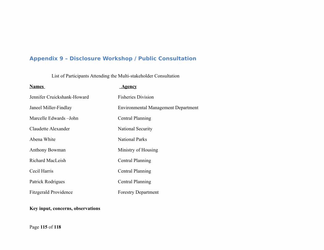
Appendix 9 – Disclosure Workshop / Public Consultation
List of Participants Attending the Multi-stakeholder Consultation
Names Agency
Jennifer Cruickshank-Howard Fisheries Division
Janeel Miller-Findlay Environmental Management Department
Marcelle Edwards –John Central Planning
Claudette Alexander National Security
Abena White National Parks
Anthony Bowman Ministry of Housing
Richard MacLeish Central Planning
Cecil Harris Central Planning
Patrick Rodrigues Central Planning
Fitzgerald Providence Forestry Department
Key input, concerns, observations
Page 115 of 118
The participants felt that the draft EMF was a good start to a document that can become a national tool. There were some concerns about the amount of narrative. Persons would like to see more checklist and tables with guidelines and beat practices. There were some concerns regarding guidelines for and assistance to consultants/contractors in terms of environmental expectations, regulations and national goals.
Participants felt that there should be some way of helping consultants/contractors address cultural and traditional issues and attitudes. It was felt that the EMF should address economic issues as a mitigation measure.
There was a request for information on flooding given the events of the last three years.
In responding to these concerns some best practices for EIA are included in Appendix 4 with the expectation that the information will be appended to the contract clause.
Major conclusions, resultsThere is a call for a modified (more condensed, instructive) EMF for regular use by planners, regulating agencies and developers. TheEMF was finalized based on inputs from the national workshop and comments on the draft by the World Bank. The inputs from the colleagues at the Bank were very instructive in giving shape to this final product. Unfortunately, the contract arrangement and time frame did not allow for the consultant to address all of the suggestions and recommendations from the Bank. The suggestions not addressed relates to inclusion of additional information addressing the December floods.
Page 116 of 118
Appendix 10 – Redisclosure
The European Union through its 11th European Development Fund B-Envelope is supporting the efforts of St Vincent and theGrenadines in the wake of the severe infrastructure damage suffered from a storm event on December 24 th and 25th 2013. TheEuropean Union is integrating its support into the existing Regional Disaster Vulnerability Reduction Project through a trust fund with
Page 117 of 118
the World Bank. This aid assistance has allowed for the expansion of the scope of work to be included in the sub project portfoliocovered by this EMF. This increased scope is listed as follows:
Ginger Village Road Rehabilitation and Slope Stabilisation Congo Valley Road and bridge rehabilitation Longline bridge and road rehabilitation Palmiste Road rehabilitation Fireburn Road rehabilitation Ferguson Mountain Road rehabilitation Gaskill Road rehabilitation Chateaubelair Jetty rehabilitation
Project descriptions have been added to the EMF and projected impacts included in table 3b in Section 4.1. Finally, projects involvingsignificant purchase or use of pesticides are to be excluded through the screening process. The revised EMF will be circulated toworkshop participants listed in Appendix 9 and hosted on the project’s home page on the government’s website, gov.vc. Notice of therevised sub projects are to be advertised in the local newspapers.
Page 118 of 118


![Implementing an MDA Approach for Managing Variability in ...Eclipse Modeling Framework (EMF) [15] and the Graphical Editing Framework (GEF) [16]. EMF is a modeling framework for building](https://img.pdfslide.net/doc/110x75/5ff8e9ac187d202be861beb9/implementing-an-mda-approach-for-managing-variability-in-eclipse-modeling-framework.jpg)