Embed Size (px)
Citation preview
Issue Date: 13 February 2013 PEPL Relocation Project
EP Act Proposal Referral - Attachment
Document No: W-02-1000-SEO-G-003
Page 1 of 19 Revision 0: Issued for Use
Environmental Protection Act 1986 Proposal Referral
Pilbara Pipeline System
PEPL Relocation Project
Supporting Documentation
Epic Energy Document No.: W-02-1000-SEO-G-003
Rev #
Issue Date
Created By Reviewed By Approved By Summary of Amendments
A 02/02/13 R.Roberts J. Gratton M. Burns Issued for review
0 13/02/13 J. Gratton M. Burns Issued for Use
1
2
3
Issue Date: 13 February 2013 PEPL Relocation Project
EP Act Proposal Referral - Attachment
Document No: W-02-1000-SEO-G-003
Page 2 of 19 Revision 0: Issued for Use
Table of Contents 1. Introduction .......................................................................................................... 3
2. Scope .................................................................................................................... 4
3. Project Activities .................................................................................................. 5
4. Project Area .......................................................................................................... 6
5. Existing Environment .......................................................................................... 9
5.1 Biophysical Environment ........................................................................................ 9
5.2 Climate ........................................................................................................... 9
5.2.1 Rainfall, Flooding and Tropical Cyclones ............................................................ 10
5.3 Flora and Vegetation ......................................................................................... 11
5.3.1 Floristic Community Analysis ............................................................................... 12
5.3.2 Nationally Listed Threatened Flora ...................................................................... 12
5.3.3 Threatened and Priority Ecological Communities ................................................ 13
5.3.4 Environmentally Sensitive Areas ......................................................................... 13
5.3.5 Conservation Significant Flora ............................................................................. 13
5.3.6 Weeds ......................................................................................... 13
5.3.7 Vegetation Clearing ......................................................................................... 13
5.4 Water ......................................................................................................... 15
5.4.1 Surface Waterways ......................................................................................... 15
5.4.2 Groundwater ......................................................................................... 15
5.5 Air Quality ......................................................................................................... 16
5.6 Indigenous Heritage .......................................................................................... 18
5.7 Native Title ......................................................................................................... 18
5.8 Land Use and Third Party ................................................................................. 18
6. Stakeholder Consultation ................................................................................. 18
7. References .......................................................................................................... 19
List of Figures Figure 1: Proposed Roy Hill Rail Corridor ....................................................................... 4 Figure 2: Proposed Epic Gas Pipeline Relocation Project Area ..................................... 7 Figure 3: Proposed Epic Gas Pipeline Relocation Project Disturbance Footprint .......... 8 Figure 4: Temperature Variances at Port Hedland Airport............................................ 10 Figure 5: Project Area Environmental Aspects ............................................................. 17
List of Figures Table 1: Description of Activities ..................................................................................... 5 Table 2: Mean Monthly Rainfall at Port Hedland Airport ............................................... 11 Table 3: Floristic Community Types (FCTs) occurring within the Project area ............. 12 Table 4: Stakeholder Consultation ................................................................................ 19
Issue Date: 13 February 2013 PEPL Relocation Project
EP Act Proposal Referral - Attachment
Document No: W-02-1000-SEO-G-003
Page 3 of 19 Revision 0: Issued for Use
1. Introduction
The Roy Hill Iron Ore (RHIO) Project includes a new iron ore mine at the Roy Hill deposit, a mine process plant, new port facilities at Boodarie Industrial Estate and a heavy haul railway system from mine to port, southwest of Port Hedland, Western Australia.
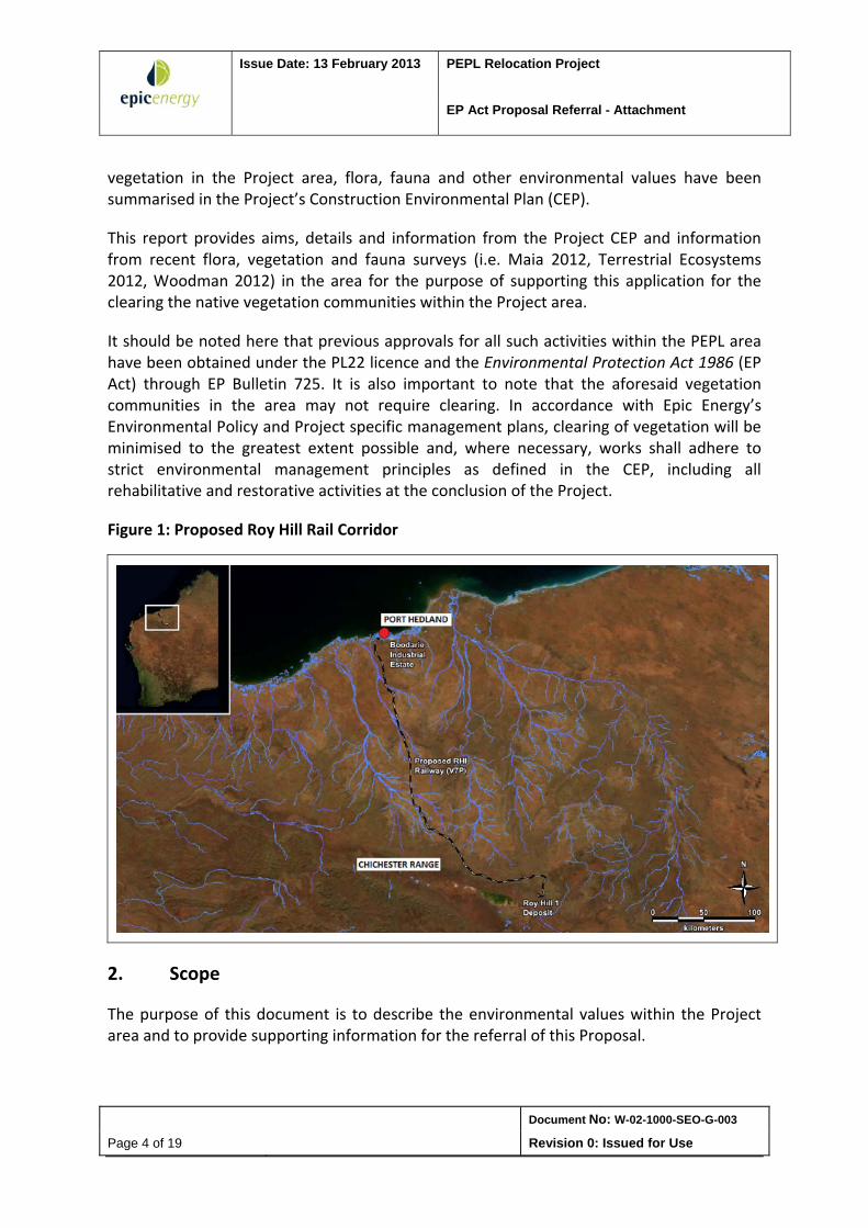
The proposed single‐track, heavy haul railway is approximately 340km in length from the Roy Hill mine site to the unloading facility at Boodarie Industrial Estate, as depicted in Figure 1.
A portion of the proposed railway line will cross over the existing Pipeline Licence PL22 Pilbara Energy Pipeline (PEPL). This has made it necessary for the relocation of approximately 670m of pipeline, which is currently buried at a depth of approximately 900mm. It is necessary to relocate the pipeline at a depth of approximately 9m to enable the rail construction and operation in accordance with Australian Standards.
Epic Energy (Epic) will be facilitating the installation of approximately 670m of pipeline for the relocation of the Pilbara Energy Pipeline (PEPL) so that RHIO can construct a new railway infrastructure as part of the Roy Hill Infrastructure (RHI) Railway Project. This is known as the ‘PEPL Relocation Project’.
With effect from 12 December 2012 Epic Energy became a wholly‐owned subsidiary of the APA Group. Epic Energy as Licensee and operator will be managing the construction work on this Project.
The PEPL Relocation Project is located approximately 11km south west of Port Hedland and 5km west of South Hedland, specifically within the Boodarie Pastoral Lease Station, which is located on Crown Land. To the east of the project site is Turner River. Access to the project site will be gained through a 7.25km access track connecting the project site to the North West Coastal Highway.
The PEPL is contained within a 30m easement, with the PL22 licence area. The PL22 licence area extends 125m laterally on either side of the PEPL centerline. The construction will be contained within the PL22 licence area and a section 91 licence under the Land Administration Act of 1997 is currently being sought for the area outside the registered easement but within the PL22 licence area.
It is necessary that the PEPL Relocation Project is completed prior to the construction of the Roy Hill railway. Based on this, plans are to carry out construction between May 2013 and February 2014.
Project works will require the clearing of two native vegetation communities in this area, specifically FCT6a and 6d, which covers a total ground area of 22.341ha. Details on the
Issue Date: 13 February 2013 PEPL Relocation Project
EP Act Proposal Referral - Attachment
Document No: W-02-1000-SEO-G-003
Page 4 of 19 Revision 0: Issued for Use
vegetation in the Project area, flora, fauna and other environmental values have been summarised in the Project’s Construction Environmental Plan (CEP).
This report provides aims, details and information from the Project CEP and information from recent flora, vegetation and fauna surveys (i.e. Maia 2012, Terrestrial Ecosystems 2012, Woodman 2012) in the area for the purpose of supporting this application for the clearing the native vegetation communities within the Project area.
It should be noted here that previous approvals for all such activities within the PEPL area have been obtained under the PL22 licence and the Environmental Protection Act 1986 (EP Act) through EP Bulletin 725. It is also important to note that the aforesaid vegetation communities in the area may not require clearing. In accordance with Epic Energy’s Environmental Policy and Project specific management plans, clearing of vegetation will be minimised to the greatest extent possible and, where necessary, works shall adhere to strict environmental management principles as defined in the CEP, including all rehabilitative and restorative activities at the conclusion of the Project.
Figure 1: Proposed Roy Hill Rail Corridor
2. Scope
The purpose of this document is to describe the environmental values within the Project area and to provide supporting information for the referral of this Proposal.
Issue Date: 13 February 2013 PEPL Relocation Project
EP Act Proposal Referral - Attachment
Document No: W-02-1000-SEO-G-003
Page 5 of 19 Revision 0: Issued for Use
3. Project Activities
RHIO plan to construct a new railway line and yard as part of their plans for the expansion of future production. The proposed new railway will be excavated into the existing ground levels forming a large cutting. Therefore, the pipeline will have to be relocated vertically from the current depth of approximately 900mm to require a considerable drop of approximately 9m within the existing pipeline easement. The horizontal alignment will be parallel to the existing PEPL where consideration has been made with regards to potential risks and constructability.
Key Project construction activities that will be carried out under this Project are detailed in Table 1.
Table 1: Description of Activities
Site survey and potholing on the existing live pipeline
Site survey and set out to determine the location of the existing pipeline, new crossing alignment, easement, Licence Area and the construction footprint
Potholing on the existing live pipeline and in the transition locations and including interconnecting piping and hot tap locations
Civil works
Upgrade of the access track, clearing of the work site and the pipe stockpile area and installation of temporary fencing
Excavation of the existing pipeline and excavation of the pipe trench on the new alignment
Establishment of site facilities, including cyclone rated site offices, crib huts, ablutions and security
Set up of a laydown area for the contractor’s equipment
Excavation and pipe stringing
Trench excavation below ground level and benching for stability
Ramping of excavation at both ends to facilitate removal of spoil, access of pipeline construction equipment, welding of the pipe string and fauna egress
Single lengths of pipe transported to the ROW and welding of the pipe string
Non‐destructive testing and “Tie in spools” and hot tap bypass pipe work fabricated after pipe string is completed, tested and joint coated
Testing, trenching and backfilling
Pipeline section holiday tested and any repairs carried out
Pipe section wrapped in “rockmesh” to protect the external FBE pipe coating from potential damage caused by earth materials falling into the trench and onto the pipeline
Lowering in, using sidebooms and excavators and backfilling and compaction of the pipeline trench up to the ROW/excavation floor level
DCVG survey completed to determine any coating defects in the buried pipeline section
Area adjacent to any defects excavated, repaired and holiday tested
Hydrostatic testing, bulk backfilling and grading and compaction of excavation
Hydrostatic test undertaken on the complete new section, including filling, gauging, stabilisation, strength and leak test, depressurizing and dewatering
Trench filled in with excavation spoil and bulldozer and grader spread and level the loose material prior to conditioning and compaction of the material in 300 mm layers
Issue Date: 13 February 2013 PEPL Relocation Project
EP Act Proposal Referral - Attachment
Document No: W-02-1000-SEO-G-003
Page 6 of 19 Revision 0: Issued for Use
Hot tapping and stoppling works
PEPL pipeline excavated and exposed and Hot tap and stopple fittings welded onto the existing PEPL pipeline and new pipe section
Testing/Inspection of the fittings welds using Non destructive testing (NDT) and temporary crossover pipe work measured, fabricated and tied in spools
Hot tapping of the new pipe section and live PEPL pipeline completed and completion of purge and gas into the new pipe section
Line stops installed, section to be removed isolated, depressurisation and purging prior to removal of redundant section of pipeline carried out
Interconnecting piggable and pre tested pipe spools tied in to complete the new bypass section
NDT inspection of welds, commissioning of interconnecting spools, completion of purging and tie‐in sections pressurised by introduced gas
Temporary valves closed, temporary cross over pipework removed and completion flanges installed
Site reinstatement and demobilisation
Backfilling and compaction of open trenches and a DCVG section over the pipeline carried out
Site cleaned up, reinstated and pipeline warning signs installed
Equipment including temporary offices, toilets, storage containers and fuel tank demobilised from site
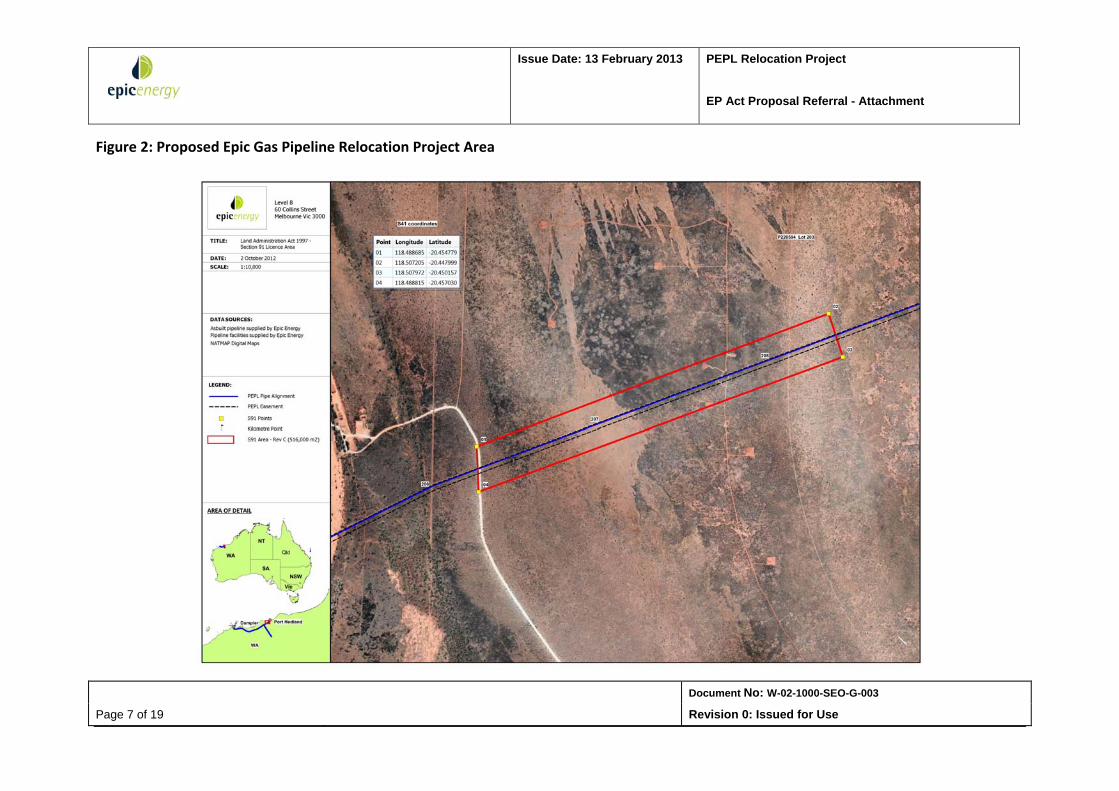
4. Project Area
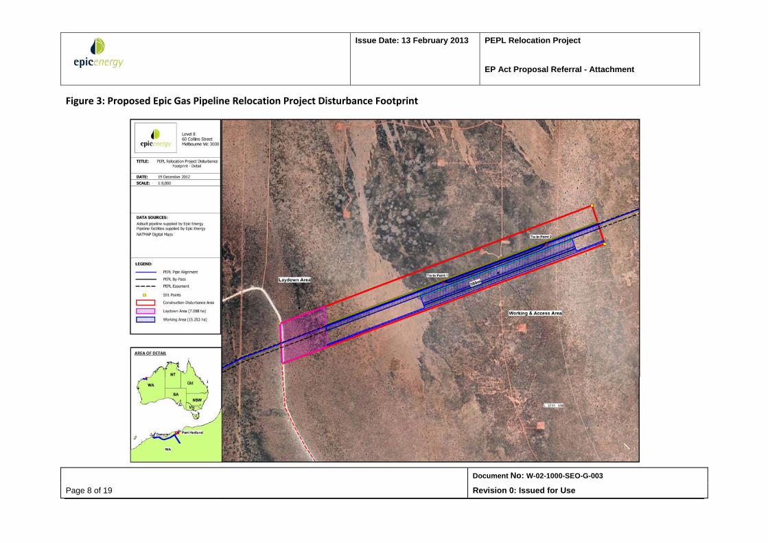
The Project area incorporates the area within the PL22 licence area, existing registered easement and pending s91 licence area, as depicted in Figure 2. Figure 3 depicts the expected Project footprint area within the PL22 licence area.
Issue Date: 13 February 2013 PEPL Relocation Project
EP Act Proposal Referral - Attachment
Document No: W-02-1000-SEO-G-003
Page 7 of 19 Revision 0: Issued for Use
Figure 2: Proposed Epic Gas Pipeline Relocation Project Area
Issue Date: 13 February 2013 PEPL Relocation Project
EP Act Proposal Referral - Attachment
Document No: W-02-1000-SEO-G-003
Page 8 of 19 Revision 0: Issued for Use
Figure 3: Proposed Epic Gas Pipeline Relocation Project Disturbance Footprint
Issue Date: 13 February 2013 PEPL Relocation Project
EP Act proposal Referral - Attachment
Document No: W-02-1000-SEO-G-003
Page 9 of 19 Revision 0: Issued for Use
5. Existing Environment
This section provides a brief overview of the key environmental features relevant to the Project area and is taken from the associated PEPL CEP. Information summarised below has been extracted from several existing documents that have carried out extensive research and investigation with regards to the broader Pilbara Pipeline System and proposed Roy Hill Railway Project. These are given below.
Pilbara Pipeline System Environmental Management Plan: Operations (Epic Energy 2011);
RH1 Railway Project Flora and Vegetation Survey (Woodman Environmental 2011); RHI Rail Corridor: Targeted Flora Survey Multiple Areas ‐ Chainage 2 to Chainage 148
(Maia 2011); Turner River and Rail Terminal Yard Flood Study (WorleyParsons 2012) Conservation Significant Vertebrate Fauna Species Habitat Assessment: Roy Hill
Infrastructure Rail Corridor (Terrestrial Ecosystems 2011).
5.1 Biophysical Environment
The 0‐93 km length of the Roy Hill Rail corridor is located within the Pilbara Interim Biogeographic Region (IBRA) of Western Australia. Within this, the Roy Hill Rail Corridor intersects the Roebourne sub‐region, whose classification code is PIL4 in the north and the Chichester sub‐region, whose classification is PIL1 in the south. The project site covered in this CEP is located in the Roebourne sub‐region.
Woodman Environmental (2011) describes the vegetation characteristics of the Roebourne sub‐region as comprising of quaternary alluvial and older colluvial coastal and sub‐coastal plains, with a grass savannah of mixed bunch and hummock grasses, and dwarf shrub steppe of Acacia stellaticeps or A. pyrifolia and A. inaequilatera.
Linear ranges of basalt uplands with minor exposures of granite occur on the plains, and are dominated by Triodia hummock grasslands. Ephemeral drainage lines support Eucalyptus victrix or Corymbia hamersleyana woodlands, with Samphire, Sporobolus and mangal occurring on marine flats.
Woodman Environmental (2011) has also noted that this sub‐region is extensively used for pastoral activities.
5.2 Climate
The Project is located within the Pilbara region in the Arid Zone of Western Australia. This area is classified as desert because of low and erratic rainfall in the region. The Pilbara coast has hot, humid summers from December to March and warm, dry winters from May to November. Summer temperatures are usually extreme and there is a high evaporation rate.
Issue Date: 13 February 2013 PEPL Relocation Project
EP Act proposal Referral - Attachment
Document No: W-02-1000-SEO-G-003
Page 10 of 19 Revision 0: Issued for Use
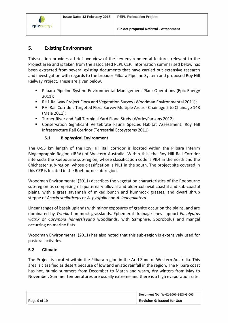
Figure 4 shows the highest recorded monthly maximum and minimum temperatures (data from 1948 – 2012), recorded for Port Hedland Airport, the nearest meteorological station to the project area (Bureau of Meteorology 2011). As can be seen in the Figure, temperatures can peak up to 50ᵒC around November – January, and drop as low as 2ᵒC in July. On average, the highest mean annual temperature is 33.2ᵒC and lowest is 19.4ᵒC.
High temperatures, of close to 50ᵒ C expected in summer over January to November is another consideration that has to be taken into account in relation to construction activities at the project site, where potential caution has to be taken with regards to heat stress and fatigue in carrying out construction activities.
Figure 4: Temperature Variances at Port Hedland Airport
Source: Australian Bureau of Meteorology (2012)
5.2.1 Rainfall, Flooding and Tropical Cyclones
As shown in Table 2, the mean rainfall peaks in summer, particularly over the period January‐March, with rainfall strongly influenced by tropical cyclones. The prevalence of such cyclonic events results in the Pilbara receiving slightly higher average annual rainfall (250‐300mm) than the remainder of the Arid Zone. The mean annual rainfall in the region is 317mm and it rains for an average of 20.4 days annually.
Hydrological modeling has been carried out for areas located within the delta of Turner River in a recent study carried out by WorleyParsons (2012). Results of the 20 year and 50 year design flood events indicated that an existing natural ridge constrained flood waters to within the floodplain, therefore protecting any areas within the Roy Hill Rail Corridor from runoff and flooding from the Turner River.
Issue Date: 13 February 2013 PEPL Relocation Project
EP Act proposal Referral - Attachment
Document No: W-02-1000-SEO-G-003
Page 11 of 19 Revision 0: Issued for Use
Results of the 100 year modeling have shown, however, that flood waters spill over the Turner River catchment boundary in two locations, entering the proposed Roy Hill Corridor area. However, these locations are sited within the northern areas of the Turner River catchment and are not expected to affect the construction area pertaining to the PEPL Relocation Project.
Table 2: Mean Monthly Rainfall at Port Hedland Airport
Month Mean rainfall (mm)
January 28.4
February 68.2
March 41.1
April 21.1
May 29.6
June 35.8
July 14.6
August 6.1
September 1.4
October 0.5
November 0.4
December 13.5
Source: DEC, 2006
Tropical cyclones occur in the Pilbara region between November and April, with April storms, historically being the most severe.
5.3 Flora and Vegetation
Information on vegetation, flora, floristic communities and weeds within the project area referred to in the CEP are derived from two recent surveys carried out on the Roy Hill Project. Details on these surveys are given below.
Woodman Environmental (2011): This study reported the findings of a survey of conservation significant and introduced flora within the 0‐93 km section of the entire length of the Roy Hill Project corridor. As part of this study, a Floristic Community Type Analysis of vegetation in the 0‐40.5 km section of the proposed corridor was also carried out.
Maia Environmental (2011): This study comprised of the identification of targeted flora at various points along chainage 2 to chainage 148 within the RHI Railway corridor.
Issue Date: 13 February 2013 PEPL Relocation Project
EP Act proposal Referral - Attachment
Document No: W-02-1000-SEO-G-003
Page 12 of 19 Revision 0: Issued for Use
5.3.1 Floristic Community Analysis
Woodman Environmental (2011) classified flora and vegetation identified in their survey of the 0‐40.5 km Roy Hill Rail corridor into super‐groups.
Of these communities, FCT 6a and 6d were found to occur within the Project area. These are summarized in Table 3.
Conservation Significant Flora occurring within FCT6a communities include: Abutilon pritzelianum ms (P1), Tephrosia rosea var. venulosa (P1) and Eragrostis crateriformis (P3). Even though the Project area is considered to contain portions of FCT6a and 6d communities, there are no known occurrences of Conservation Significant Flora in the area.
Table 3: Floristic Community Types (FCTs) occurring within the Project area
FCT Extent in Survey area (ha) (%) RHI Rail Corridor
Local Conservation Significance
Ranking of FCT
Local Conservation Significance Regional Conservation Significance
6a 2,996.74 ha (32.77%) of the survey area
1 FCT 6a was found to comprise of >10 % of the area surveyed along the 0‐40.5 km Roy Hill Rail Corridor.
The FCT 6a community is known to occur along plains, which are a locally common and widespread type of landform in the area.
Conservation Significant flora known to occur in FCT 6a are Abutilon pritzelianum ms (P1), Tephrosia rosea var. venulosa (P1) and Eragrostis crateriformis (P3).
Known to occur outside survey area
Likely to be relatively regionally common and widespread based on usual landform type
6d 25.67 ha (0.28%) of the survey area
4 FCT comprises <1 % of survey area.
Landforms on which FCT occurs (flats) locally common and widespread
Known to occur outside survey area
Likely to be relatively regionally common and widespread based on usual landform type
5.3.2 Nationally Listed Threatened Flora
No nationally‐listed threatened flora species, as listed under the Environmental Protection and Biodiversity Conservation Act of 1999 were recorded in the study undertaken by Woodman Environmental (2011), which includes the Project area.
Issue Date: 13 February 2013 PEPL Relocation Project
EP Act proposal Referral - Attachment
Document No: W-02-1000-SEO-G-003
Page 13 of 19 Revision 0: Issued for Use
5.3.3 Threatened and Priority Ecological Communities
The closest known Threatened Ecological Communities in the area were located over 100 km to the south of the Roy Hill Rail Corridor. These are namely TEC 46, which are the Themeda Grasslands and TEC 78, which is known as the Ethel Gorge Aquifer Stygobiont Community.
There are no identified Threatened or Priority Ecological Communities within 500 m of the Project area.
5.3.4 Environmentally Sensitive Areas
There have been no Environmentally Sensitive Areas identified within 500m of the Project area.
5.3.5 Conservation Significant Flora
Conservation Significant Flora were found to occur in the area, as per the results of the survey carried out by Woodman Environmental (2011), within the 0‐40.5 km length of the Roy Hill Rail Corridor. Maia Environmental (2011) also identified two Conservation Significant Flora species during their survey, which is consistent with those by Woodman Environmental (2011).
None of the Conservation Significant Flora species were identified within the Project area.
5.3.6 Weeds
No weed species identified by the surveys are listed as Declared Plants by the Department of Agriculture and Food (Woodman Environmental 2011).
5.3.7 Vegetation Clearing
Under the PL22 licence, the land within the Project area was originally cleared to construct the PEPL pipeline, under which relevant permits to clear were obtained at the time. Since then, the land has been used for pastoral grazing, with parts of the area covered by grasses such as Spinifex.
The Project has applied for a Native Vegetation Clearing (Purpose Permit) through the Department of Mines and Petroleum. The total amount of vegetation clearing may be 22.341ha.
Graders and bulldozers would be used to clear vegetation and remove topsoil. Vegetation would be broken and raked into a stockpile minimising movement of topsoil. Topsoil will be
Issue Date: 13 February 2013 PEPL Relocation Project
EP Act proposal Referral - Attachment
Document No: W-02-1000-SEO-G-003
Page 14 of 19 Revision 0: Issued for Use
graded to a depth of 100mm for a blade‐width over the trench line and other disturbed areas.
The proposed area of clearing of native vegetation along the pipeline corridor will undergo rehabilitation once the project has been completed. Ongoing maintenance access and vegetation trimming/clearing as required under AS2885.1 will be implemented through the lifetime of the operating asset.
The pipeline trench will be backfilled and recontoured to match the surrounding topography. Once backfilling has occurred, the stockpiled topsoil would be spread evenly across the area to assist in vegetation re‐establishment from seed. In areas along pipeline corridor, where the route is currently vegetated with native species, stockpiled vegetation would be re‐spread over the area to assist in vegetation re‐establishment from branch‐retained seed. No specific re‐seeding will be implemented as a result of the already cleared land within which the pipeline will be located.
Monitoring of the area will be ongoing after the completion of revegetation to assess the progress of rehabilitation and also to identify any erosion or surface drainage issues.
Ten clearing principles have been identified under Schedule 5 of the Environmental Protection Act 1986 for the purposes of determining the impact of clearing. The Project is not considered to be at variance with any of the ten clearing principles listed in Schedule 5 of the Environmental Protection Act 1986.
5.4 Fauna
A fauna survey has recently been carried out for the broader Roy Hill Rail Infrastructure Project area by Terrestrial Ecosystems (2011). This found that there are three species, the Crest‐tailed Mulgara (Dasycercus cristicauda), the Brush‐tailed Mulgara (Dasycercus blythi) and the Bilby (Macrotis lagotis), which are listed as Vulnerable under the EPBC Act and Schedule 1 under the WA Wildlife Conservation Act 1950 and Priority 4 with the DEC.
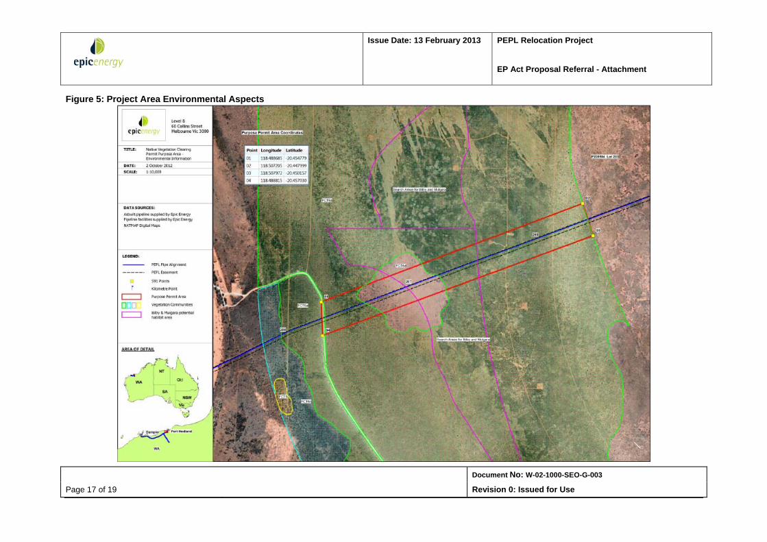
As can be seen in Figure 5 given below, a significant portion of the s91 licence area is covered by potential Bilby and Mulgara potential habitats, which are protected as conservation significant flora. Key vegetation communities, namely FCT6a and FCT6d are also located within the area.
Four sets of old burrows were recorded in the assessment of the broader RHI rail corridor but none were active. Similar habitat to where this Bilby was recorded is found across the RHI rail corridor. Bilbies shift their burrows and foraging area when food resources in an area are depleted, so even if they were not present in an area during this habitat assessment, they could have moved into an area that is to be cleared before vegetation clearing commences.
Issue Date: 13 February 2013 PEPL Relocation Project
EP Act proposal Referral - Attachment
Document No: W-02-1000-SEO-G-003
Page 15 of 19 Revision 0: Issued for Use
To mitigate any potential harm to these species, this area is to be searched for active burrows within 6 weeks of vegetation clearing. Areas within the vegetation clearing corridor that contain active burrows should be subject to a trapping and translocation program to minimise the number of Bilbies or Mulgara that could be killed and injured during the vegetation clearing and rail construction activities.
It is also noted that four introduced species, as found in the Pilbara region, may be present in the licence area. These are namely, the house mouse, black rat, cat and fox (DEC 2006).
5.5 Water
5.5.1 Surface Waterways
The Roebourne sub‐region has limited surface freshwater. Freshwater flows are variable and typically associated with storm‐surge or tropical cyclone activity. These periods of high flows are followed by dry periods, when the stream flows stop and even the deeper waterholes in the gorges can dry up completely.
The closest surface waterway to the Project site is the Turner River, located to the east of the site. Heavy rainfall is required to produce flowing conditions. Cyclones can cause major flows between November and April. The rivers are generally dry between August and October, with only occasionally short‐lived flows.
The Project will not impact the Turner River.
There are no Ramsar wetland sites or wetlands of national significant anywhere in the vicinity of the Pilbara Pipeline System.
5.5.2 Groundwater
The regional aquifer consists of the Pilbara fractured rock aquifer, consisting of Precambrian granite greenstone terrain overlain by superficial sediments in the river valleys. The water table is generally within 15m of the surface in the granitic areas, but may be deeper below the greenstone hills.
Project construction activities involve excavation up to 9m in depth. Therefore, the groundwater table is not expected to be encountered. Excavation activities will be carried out during the dry season, where there is very low rainfall, which will help ensure that there will be no impact on the groundwater table.
Dewatering is not anticipated to be required unless the excavation is carried out after rainfall. If groundwater is encountered in the excavation, then dewatering of both the excavation and the surrounding ground is required to prevent a reduction in slope stability. Within the Red Beds, it likely that the permeability will be inconsistent, with seepage occurring along soil defects and in zones of lower fines content. The lower 1m of the
Issue Date: 13 February 2013 PEPL Relocation Project
EP Act proposal Referral - Attachment
Document No: W-02-1000-SEO-G-003
Page 16 of 19 Revision 0: Issued for Use
excavation is likely to be more permeable than the remainder of the Red Beds due to the lower fines content encountered at this depth.
Water for the Project will be obtained from an existing RHIO bore located south of the Project site or alternatively from potable sources in South Hedland.
5.6 Air Quality
Dust is likely to be a minor issue during construction of the Project. The generation of dust will be minimized by clearing during periods of low wind speed events and using water carts to dampen the ground where surface soil moisture is low.
There is no odour expected from the construction activities.
The Proposal is being designed to ensure compliance with National Greenhouse and Energy Reporting Act 2007 and associated regulations and industry standards.
Issue Date: 13 February 2013 PEPL Relocation Project
EP Act Proposal Referral - Attachment
Document No: W-02-1000-SEO-G-003
Page 17 of 19 Revision 0: Issued for Use
Figure 5: Project Area Environmental Aspects
Issue Date: 13 February 2013 PEPL Relocation Project
EP Act Proposal Referral - Attachment
Document No: W-02-1000-SEO-G-003
Page 18 of 19 Revision 0: Issued for Use
5.7 Indigenous Heritage
Aboriginal heritage surveys were carried out prior to construction of the existing PEPL. The PEPL alignment was selected to avoid known sites of cultural significance protected under the Aboriginal Heritage Act 1972.
A heritage survey was conducted in late 2012 and no heritage sites were identified within or adjacent to the Project Area.
5.8 Native Title
Native Title agreements have been obtained for all Pilbara Pipeline System (PPS) pipeline licences in Western Australia by processes consistent with the Native Title Act 1993. As such, the PEPL is not subject to native title claims under the Native Title Act 1993.
The PEPL Relocation project is being completed in association with Roy Hill Infrastructure Pty Ltd pursuant to the Railway (Roy Hill Infrastructure Pty Ltd) Agreement Act 2010. The pending s91 licence area is within the area that RHIO has a current Native Title Agreement with the Kariyarra People, which will be applied to this Project.
5.9 Land Use and Third Party
The PEPL Relocation Project entails the relocation of the existing pipeline so that RHI can construct a new railway as part of the RHI Railway Project.
The location of the Project is on Pastoral Lease land used for extensive cattle grazing. Access to this land has been obtained under the PEPL pipeline licence PL22, existing registered easement, existing access agreement with Boodarie Station and the pending s91 licence.
6. Stakeholder Consultation
Regular contact will be maintained with relevant stakeholder to ensure that there will be minimal inconvenience and impact on their activities. This consultation will be the responsibility of the Project Manager and HSE Manager. All liaison activities will be undertaken in accordance with existing Epic stakeholder construction procedures.
Prior to construction commencing, all relevant stakeholders will be advised of the commencement of work, an approximate schedule of operations for their area and providing Epic contact details.
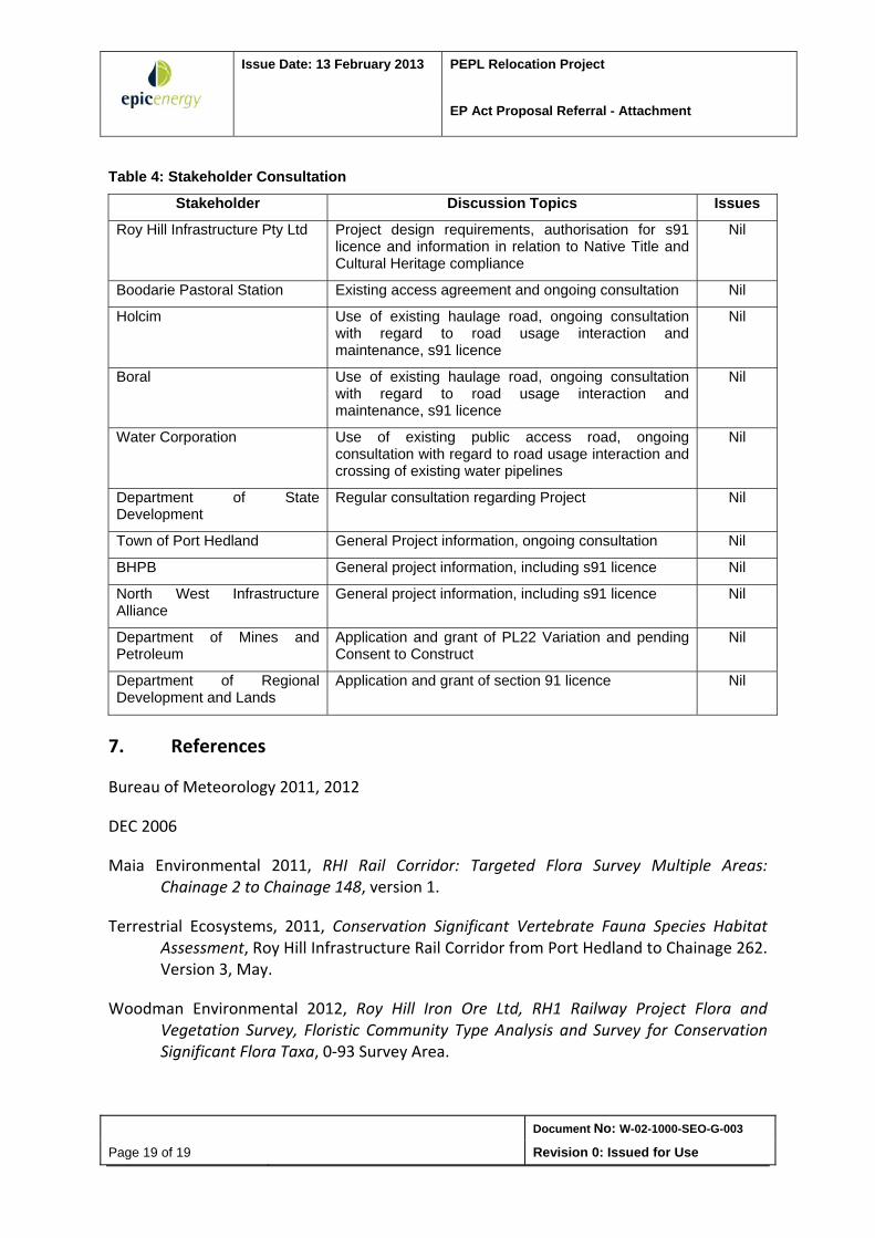
Table 4 below provides a summary of the entities with whom consultation regarding Project activities have been carried out. It is noted here that no issues with regard to potential Project impacts have been raised, to date.
Issue Date: 13 February 2013 PEPL Relocation Project
EP Act Proposal Referral - Attachment
Document No: W-02-1000-SEO-G-003
Page 19 of 19 Revision 0: Issued for Use
Table 4: Stakeholder Consultation
Stakeholder Discussion Topics Issues
Roy Hill Infrastructure Pty Ltd Project design requirements, authorisation for s91 licence and information in relation to Native Title and Cultural Heritage compliance
Nil
Boodarie Pastoral Station Existing access agreement and ongoing consultation Nil
Holcim Use of existing haulage road, ongoing consultation with regard to road usage interaction and maintenance, s91 licence
Nil
Boral Use of existing haulage road, ongoing consultation with regard to road usage interaction and maintenance, s91 licence
Nil
Water Corporation Use of existing public access road, ongoing consultation with regard to road usage interaction and crossing of existing water pipelines
Nil
Department of State Development
Regular consultation regarding Project Nil
Town of Port Hedland General Project information, ongoing consultation Nil
BHPB General project information, including s91 licence Nil
North West Infrastructure Alliance
General project information, including s91 licence Nil
Department of Mines and Petroleum
Application and grant of PL22 Variation and pending Consent to Construct
Nil
Department of Regional Development and Lands
Application and grant of section 91 licence Nil
7. References
Bureau of Meteorology 2011, 2012
DEC 2006
Maia Environmental 2011, RHI Rail Corridor: Targeted Flora Survey Multiple Areas: Chainage 2 to Chainage 148, version 1.
Terrestrial Ecosystems, 2011, Conservation Significant Vertebrate Fauna Species Habitat Assessment, Roy Hill Infrastructure Rail Corridor from Port Hedland to Chainage 262. Version 3, May.
Woodman Environmental 2012, Roy Hill Iron Ore Ltd, RH1 Railway Project Flora and Vegetation Survey, Floristic Community Type Analysis and Survey for Conservation Significant Flora Taxa, 0‐93 Survey Area.