Embed Size (px)
Citation preview

Corlacky Hill Wind Farm
Environmental Statement
Volume 2: Main Report
Chapter 10: Geology and Water Environment
Chapter 10 – Page 1
10. Geology and Water Environment
Introduction
Terms of Reference
10.1 This chapter considers the likely significant effects on the receiving hydrological, geological
and hydrogeological environments, associated with the construction, operation and
decommissioning of the Proposed Corlacky Hill Wind Farm, hereafter referred to as ‘the
Proposed Wind Farm Development’.
10.2 Assessment techniques used are aimed at identifying hydrological, hydrogeological and
geological constraints within the Preliminary Boundary, hereafter referred to as ‘the Site’,
including areas in which development should be avoided and areas in which additional
mitigation measures are required.
10.3 This chapter is supported by:
• Technical Appendix 10.1: Water Framework Directive Assessment;
• Technical Appendix 10.2: Geology & Water Environment Consultation Records;
• Technical Appendix 10.3: Abstraction Records;
• Technical Appendix 10.4: Peat Slide Risk Assessment;
• Technical Appendix 10.5: Peat Management Plan; and
• Figures 10.1 – 10.5 which are referenced within the text where relevant.
Statement of Authority
10.4 The assessment has been carried out by McCloy Consulting Ltd.; an independent
environmental consultancy specialising in the water environment, with specialist knowledge
of hydrological and hydrogeological assessments, sustainable drainage systems (SuDS),
drainage, river modelling and flood risk assessment.
10.5 McCloy Consulting has ongoing involvement in numerous geology and water environment
studies and SuDS projects across the UK and has developed a particular expertise in surface
water management for wind farms. The company has successfully designed a number of
SuDS/silt management solutions for wind farms in accordance with current best practice
guidance. The primary personnel responsible for undertaking this hydrology assessment are:
• Nicola Bradley BEng (Hons) MSc - Environmental Engineer with experience in the
preparation of geology and water environment assessments and environmental
monitoring for a number of onshore wind farms and for onshore wind energy projects in
the UK and particularly Northern Ireland;
• Kyle Somerville BEng (Hons) CEng MIEI - Chartered Engineer specialising in the fields of
engineering hydrology, surface water management, groundwater screening assessments
and geology assessments. He has provided technical input to planning applications for
over 20 onshore wind farms in Northern Ireland and has been responsible for planning
and construction-phase surface water management design and monitoring for a number
of the largest onshore wind farm developments in the UK, including particular
experience of upland sites in environmentally sensitive watersheds.
Complementary Assessments
10.6 The majority of potential effects arising due to wind farms are caused by construction
activities; therefore reference should be made to Chapter 2: Proposed Development for
information regarding detailed construction proposals.
10.7 Changes to the hydrological / hydrogeological regime may create resultant effects on
ecology with hydrological dependant ecosystems such as fisheries and peat. Therefore this
chapter is further supported by:
• Chapter 6: Vegetation & Peatland;
• Chapter 7: Terrestrial Fauna;
• Chapter 9: Fisheries;
Legislation and Planning Policy
10.8 Environmental planning policy and industry best-practice guidance relevant to an
assessment of hydrology and the water environment are summarised in Table 10.1 and the
following sections.
Relevant European and National Planning Policy
Table 10.1: Relevant European and National Planning Policy
Legislation
EU EU Water Framework Directive (2000/60/EC)
Groundwater Daughter Directive to the Water Framework Directive (2006/118/EC)
Priority Substance Daughter Directive to the Water Framework Directive (2008/105/EC)
Freshwater Fish Directive (2006/44/EC)
Environmental Liability Directive (2004/35/EC)
Dangerous Substances Directive (2006/11/EC)
UK UK Environmental Standards and Conditions Phase 1 and Phase 2 (UK TAG 2008)
NI Control of Pollution (Oil Storage) (Amendment) Regulations (NI) 2011
Drainage (Environmental Impact Assessment) Regulations (NI) 2006
Environmental Liability (Prevention and Remediation) (Amendment) Regulations (NI) 2009
Groundwater Regulations (NI) 2009 / Groundwater (Amendment) Regulations (NI) 2014
Nature Conservation and Amenity Lands (NI) Order 1985
Private Water Supply Regulations (NI) 2009 / Private Water Supply (Amendment) Regulations (NI) 2010

Corlacky Hill Wind Farm
Environmental Statement
Chapter 10 – Page 2
Volume 2: Main Report
Chapter 10: Geology and Water Environment
Legislation
Surface Waters (Dangerous Substances) (Classifications) Regulations (NI) 1998
The Drainage (NI) Order 1973 / The Drainage (Amendment) (NI) Order 2005
The Environment (NI) Order 2002
The Fisheries (NI) Act 1966
Water Act (Northern Ireland) 1972 / The Water (NI) Order 1999
Water Supply (Water Quality) Regulations (NI) 2007 / (Amendment) Regulations (NI) 2010
Water Environment (Water Framework Directive) Regulations (NI) 2003
Water Framework Directive (Priority Substances and Classification) (Amendment) Regulations (NI) 2012
Sustainable Development Strategy, “Everyone's Involved" (2010)
Regional and Local Planning Policy
10.9 The Site has been reviewed in relation to local planning policy specific to geology and the
water environment. A detailed planning policy and legislation review is included within
Chapter 1: Introduction and Planning Policy.
Magherafelt Area Plan 2015
10.10 The Site lies within Mid Ulster District Council area; the current area plan is Magherafelt
Area Plan 20151. The plan contains limited information regarding planning policy related to
the geology or water environments; or specifically to wind farms.
10.11 The Countryside Assessment technical supplement2 provided details of the sensitivity of
designated sites within the council area and outlines the scale of importance as summarised
in Table 10.2.
Table 10.2: Designations Summary
Scale of Importance Designation Type Designated By
INTERNATIONAL Nature Conservation Importance
RAMSAR Sites Convention on Wetlands of International Importance1975
Special Protection Areas
Special Areas of Conservation
European Commission Directive on the Conservation of Wild Birds (79/409/EEC)
The Conservation (Natural Habitats, etc.) Regulations ( NI ) 1995
NATIONAL Nature Conservation Importance
Nature Reserves, National Nature Reserves, Marine Nature Reserves
Areas of Special Scientific Interest
Nature Conservation and Amenity Lands (NI ) Order 1985
LOCAL Nature Conservation Importance
Sites of Local Nature Conservation Importance and Earth Science Interests / Assets
Northern Ireland Council Area Plans
1 Planning Service (2011) Magherafelt Area Plan. Available: http://www.planningni.gov.uk/index/policy/development_plans/devplans_az/magherafelt_web2.pdf [Accessed 08/02/2016]
2 Planning Service (2011) Magherafelt Area Plan: Countryside Assessment. Available: http://www.planningni.gov.uk/index/policy/development_plans/devplans_az/magherafelt_2015/magherafelt2015-techsupp-countryside.pdf [Accessed
08/02/2016]
PPS15 – Revised Planning and Flood Risk
10.12 Revised PPS15 sets out planning policies to "minimise flood risk to people, property and the
environment", emphasising sustainable development and the conservation of biodiversity.
The policy refers to the use of SuDS to minimise effects on the receiving water environment.
10.13 The policy notes that development proposals facilitating sustainable drainage would be
considered favourably by the planning authority; as such a sustainable drainage approach
would be adopted by the Proposed Wind Farm Development.
Guidance on Conservation of Geological Features - Earth Science Conservation Review
10.14 The Earth Science Conservation Review (ESCR) is the means whereby areas of geological
interest in Northern Ireland are assessed to determine their importance to science and
hence to earth science conservation.
10.15 The objective of the ESCR is to define systematically all earth science localities (geological
and/or geomorphologic) in Northern Ireland. The overall aim of the process is to encourage
conservation of such areas to protect them from potential threats such as landfill, changes
to natural systems and coastal defence work.
Industry Guidelines
10.16 The Pollution Prevention Guidelines (PPGs), published by the Northern Ireland Environment
Agency (NIEA) in conjunction with the Environment Agency for England and Wales, and the
Scottish Environment Protection Agency (SEPA) include the documents referred to below.
Guidance notes relevant to the Proposed Wind Farm Development include:
• PPG01 Understanding Your Environmental Responsibilities: Good Environmental Practice;
• PPG02 Above Ground Oil Storage Tanks;
• PPG03 Use and Design Of Oil Separators in Surface Water Drainage Systems;
• PPG04 Treatment and Disposal of Sewage where no Foul Sewer is Available;
• PPG05 Works and Maintenance in or near Water;
• PPG06 Working at Construction and Demolition-sites;
• PPG07 The Safe Operation of Refuelling Facilities;
• PPG18 Managing Fire, Water and Major Spillages;
• PPG20 Dewatering Underground Ducts and Chambers;
• PPG21 Pollution Incident Response Planning;
• PPG26 Drums and Intermediate Bulk Containers.
10.17 Other relevant industry guidance includes:
• BS6031 - Code of Practice for Earthworks (2009);
• CIRIA C523 - Sustainable Urban Drainage Systems; Best Practice Manual (2001);
• CIRIA C532 - Control of Water Pollution from Construction Sites (2001);
• CIRIA C692 - Environmental Good Practice on-Site (2010);
• CIRIA C609 - Sustainable Drainage Systems: hydraulic/structural/water quality (2004);

Corlacky Hill Wind Farm
Environmental Statement
Volume 2: Main Report
Chapter 10: Geology and Water Environment
Chapter 10 – Page 3
• CIRIA C697- The SuDS Manual (2007);
• CIRIA C689- Culvert Design and Operation Guide (2010);
• Environment Agency Policy: Technical Guidance on Culverting Proposals (1999);
• DEFRA Good Practice Guide for Handling Soils (2000);
• DEFRA Code of Practice for Sustainable Use of Soils on Construction Sites (2009);
• PPS 18 Renewable Energy and supplementary Planning Guidance;
• DOE / NIEA - Water Feature Surveys: A Guide to EIA and Planning Considerations (2015);
• DOE / NIEA - Water Feature Surveys: Wind Farms and Groundwater Impacts (2015).
Scope of Assessment
10.18 This report assesses the effects of the Proposed Wind Farm Development on hydrology and
surface water quality, hydrogeology and groundwater quality and geological features. The
assessment covers construction, operation, maintenance and decommissioning phases.
10.19 The report identifies and assesses the potential effects on the following:
• Existing natural and artificial drainage patterns
• Runoff rates and volumes
• Flooding and impediments to flows
• Surface water dependant ecosystems including hydrological units of peat bog
• Hydrogeological patterns
• Water quality of surface water and groundwater
• Usage of surface water and groundwater including abstractions
• Aquifer systems and their vulnerability
• Existing solid geology and superficial geology
• Structural geology of the area and its environs.
10.20 In order to quantifiably assess the preceding, this report:
• Outlines relevant policy relating to the water and geological environment;
• Summarises and responds to consultations provided in response to scoping requests to
inform particular requirements of the assessment;
• Provides baseline information and identifies sensitive receptors;
• Identifies potential likely effects, including potential likely cumulative effects;
• Assesses the significance of any adverse effects and resulting impacts based on the
magnitude of the impact and the sensitivity of the receptors;
• Discusses management of design evolution and detailed mitigation measures;
• Provides a residual impact assessment;
• Discusses cumulative effects of the Proposed Wind Farm Development in conjunction
with other proposed and existing developments in the vicinity.
Consultation
10.21 Formal consultation to form opinion and requirements with regards to the hydrological and
geological environments was sought from local and regional organisations as summarised
within. Consultation took the form of a proposed scope of this assessment and a request for
any amendment or additional requirements sought by the consultee.
10.22 A summary of the specific requests made by the various consultees is included in the
following table and input provided that was specific to the Proposed Wind Farm
Development is included in the subsequent baseline assessment.
Table 10.3: Consultee Summary
Consultee Summary of Response Addressed in Assessment
Local Council Causeway Coast and Glens
Provided addresses of 16 properties with a registered private water supply within 5 km of the Site.
10.96-10.106
Mid-Ulster Provided addresses of 25 properties fed by 11 private water supplies within 5 km of the Site. Advised that information is not held as to the source of the supply.
10.96-10.106
Department of Agriculture and Regional Development (DARD)
Sea, Fisheries and Environment
Confirmed that they had no issues or concerns from an aquaculture aspect.
Advised that it is an offence under Article 47 of the Fisheries Act (NI) 1966 to cause pollution which is subsequently shown to have a deleterious effect on fish stocks.
10.108-10.109
Rivers Agency Confirmed the area highlighted contains no designated watercourses but is affected by a number of undesignated watercourses as per the Drainage (N. Ireland) Order 1973.
Advised if during the course of development a watercourse is uncovered which was not previously evident they should be advised and; any proposals (temporary or permanent) in connection with the development which involve interference with any watercourse require written consent of Rivers Agency.
Noted Rivers Agency do not hold a database of records in relation to undesignated watercourses and therefore advised consultation with Ordnance survey or site inspections. For undesignated watercourses responsibility for maintenance rests with the landowners / riparian.
Confirmed Rivers Agency do not hold any floodplain survey information for the area highlighted.
10.60
10.83-10.85
Department of Culture Arts and Leisure (DCAL)
Inland Waterways and Fisheries
Advised that the Clady River is an index river informing DCAL policy in relation to the Department’s Salmon Management Strategy and the recent salmon conservation measures; and consistently exceeds its conservation level for salmon since monitoring of adult salmon returns began in 2011.
10.108-10.109
Department of Enterprise Trade and Investment (DETI)
Geological Survey of Northern Ireland
(GSNI)
An initial inspection of 1:10,000 geological maps in respect to the Proposed Wind Farm Development confirmed a large proportion of the Site is underlain by peat on top of glacial till and below the superficial deposits the bedrock is composed of Baroney Glen sandstone and Dungiven sandstone formations.
Noted that records indicate no mine workings nearby and recommend the ES includes a Peat Slide Risk Assessment.
10.47-10.52

Corlacky Hill Wind Farm
Environmental Statement
Chapter 10 – Page 4
Volume 2: Main Report
Chapter 10: Geology and Water Environment
Consultee Summary of Response Addressed in Assessment
Northern Ireland Environment Agency (NIEA)
Natural Heritage
NIEA response recommended that a description of the following should be included within the water and hydrology assessment:
Topography, geology, soils and water environment of the Site and surrounding area;
Water environment of the area - running and static surface waters, groundwater, estuaries, coastal waters / sea, run-off and drainage;
Hydrology, water quality and use of any water resources that may be affected by the development (e.g. water supply, fisheries, angling, bathing, amenity, navigation, effluent disposal);
Consequences of changes to the hydro-geological system of the area on peatland, rivers, streams, flushes and wetland habitats.
Clear identification of areas of active peat and intact peat in the EIA.
For sites hydrologically connected to a designated site, NIEA advised buffers of at least 50 m are provided to watercourses in which there should be no infill, disturbance, construction activity or material storage.
Throughout
Water Management Unit
Provided information on surface freshwater quality, groundwater / hydrogeology, Water Framework Directive data and abstraction licences downstream of the Site.
10.75-10.77
10.96-10.106
Drinking Water Inspectorate
Indicated six private drinking water supplies and 16 dairy farms using private water supplies within 10 km of Site.
10.96-10.106
Land and Groundwater
Recommended using the online GSNI Geoindex to source information on established groundwater regime, aquifer classification and groundwater vulnerability along with wetland / groundwater dependant ecology and surface / bedrock geology.
Confirmed that there are no licensed landfills within 5 km of the Site centroid and that there are no un-licensed landfills within 5 km of the Site centroid.
10.59
10.86-10.95
Assessment Methodology
Baseline Characterisation
10.23 This water environment and geology assessment has been undertaken using a qualitative
assessment based on experienced professional judgement and assessment of compliance
with statutory and industry guidance, including site visits for verification.
Study Area
10.24 Potential effects were considered within the study area defined as: the area within the
Preliminary Boundary (within which the planning application boundary lies) hereafter
referred to as the Site; and the wider geological and hydrogeological setting of the area.
10.25 The hydrological study area includes the downstream river reaches affected by the Site and
the surface water catchments draining the Site as defined by the relevant River Basin
Management Plans, Local Management Areas and Catchment Stakeholder Groups outlined
within Section 10.60 and as shown on Figure 10.1: Site Hydrology.
10.26 The hydrogeological and geological study area extends to the underlying aquifer catchments
and the extents of geological units.
Additional Areas Considered
10.27 Consideration has been given to potential likely significant effects in respect of the
proposed turbine delivery route and access route. Details of the work comprising junction
widening, passing bays and general road widening, and potential effects on the geology and
water environment are summarised within Chapter 11: Transport and Traffic.
10.28 A potential grid connection route is described within Technical Appendix 2.1: Assessment
of Potential Grid Connection. Although the grid route is not part of the Proposed Wind
Farm Development consideration has been given to potential likely significant effects.
Desk Study
10.29 The desktop study involved collation and assessment of the relevant information from the
following sources:
• Consultation responses (summarised in Table 10.3)
• Ordnance Survey raster and vector mapping in addition to aerial photography to assess
land use and environs and to identify water features and watercourse catchments
• The Geology of Northern Ireland – Our Natural Foundation, GSNI, Mitchell (2004)
• GSNI Geoindex (aquifers and aquifer vulnerability)
• GSNI 1:50,000 Bedrock Geology Map (Sheet 19 Maghera)
• NIEA Groundwater quality data and abstractions / discharges database
• NIEA Drinking Water Inspectorate and Water Management Unit data
• NIEA river quality data and natural heritage data
• CEH Flood Estimation Handbook (Version 3) for details of river catchment data
• Rivers Agency Flood Maps NI
• DCAL Inland Fisheries information.
Field Survey
10.30 A walkover survey was undertaken (18th March and 26th March 2015) with the purpose of
identifying / verifying existing natural and artificial site drainage characteristics and
hydrological features, and identifying the nature of superficial geology where visible.
10.31 The walkover survey incorporated the Site, with particular emphasis on areas affected by
preliminary turbine locations and known / mapped watercourses in order to fully assess
potential issues with regards to:
Corlacky Hill Wind Farm
Environmental Statement
Volume 2: Main Report
Chapter 10: Geology and Water Environment
Chapter 10 – Page 5
• New or upgraded watercourse crossings (bridges and culverts) required to facilitate the
proposed infrastructure;
• Disruption to watercourses through construction of roads/hard standing etc;
• Likelihood of adverse effects on surface water quality due to construction and operation
of wind farms;
• Potential for impact on natural geological conditions and groundwater movement /
quality.
Determination of Sensitivity, Magnitude, Likelihood and Significance
10.32 This assessment determines the nature, scale and significance of the effects of the Proposed
Wind Farm Development on the baseline (current) scenario in accordance with a
methodology stated within The Institute of Environmental Management and Assessment
guidance3.
10.33 The potential impact significance is defined by the combination of the sensitivity of the
receptor (Table 10.4) and the magnitude of the effect (Table 10.5). Following this an overall
impact significance is determined by considering the potential impact significance (Table
10.6) and the likelihood of the effect occurring (Table 10.7).
Sensitivity Criteria
10.34 The scale and sensitivity of the receiving environment (receptor) has been categorised on a
scale of “Very High” to “Low”. The sensitivity criteria used for this assessment are
presented in Table 10.4 and are based on:
• Vulnerability of a receptor to a particular pressure (degree of environmental response to
any particular effect); and
• The importance or ‘value’ of the receptor e.g. an area of international importance
should be considered more sensitive to effect than a local area of little or no
conservation value.
Table 10.4: Evaluation of Receptor Sensitivity Criteria
Scale / Sensitivity of the Environment (Receptor)
Definition of Criteria
International and / or Very High
Attribute has a very high quality / rarity at an international scale.
Geology / Soils
Important on a European or global level, e.g. World Heritage Site, Geopark, Ramsar Sites, Special Areas of Conservation (SAC), Special Protected Areas (SPA), Habitats Directive Sites or protected sites under EC legislation with respect to the geological environment.
Water Environment
Important on a European or global level, e.g. Ramsar Sites, SAC, SPA and Habitats Directive Sites with dependence on the water environment.
National and / or High
Attribute has a high quality and rarity at a national scale.
Geology / Soils
Important in Northern Ireland, e.g. Area of Special Scientific Interest (ASSI), with respect to the geological environment or protected site under UK or NI legislation.
Water Important in Northern Ireland, e.g. ASSI or National
3 Institute of Environmental Management and Assessment (2004) Guidelines for Environmental Impact Assessment.
Scale / Sensitivity of the Environment (Receptor)
Definition of Criteria
Environment Nature Reserve (NNR) with respect to the hydrological environment.
WFD classification of 'High' with the watercourse providing a nationally important resource or supporting river ecosystem.
Public water supplies and highly productive aquifers or local water supplies, including private water supplies where there is no alternative to private supplies.
Principal aquifer providing a nationally important resource.
Source Protection Zone 2 (Outer Source Protection Zone).
Regional and / or Medium
Attribute has a medium quality and rarity at a regional scale.
Geology / Soils
Site of regional geological importance.
Sites of Nature Conservation Importance in relation to earth science interest.
Water Environment
Important in the context of the region, e.g. catchment scale issues, main river within the catchment, local Nature Reserves or Sites of Local Importance for Nature Conservation (SLNCI).
WFD classification of 'Good' with the watercourse providing an important resource or supporting river ecosystem or upstream of a designated fishery.
Active floodplain area.
Designated fishery, catchment regionally important for fisheries.
Domestic private water supplies, located within vicinity of mains water supply or private water supplies used only for agricultural purposes and not drinking water.
Groundwater dependent terrestrial ecosystems in hydraulic continuity with the Site.
Principal aquifer providing a regionally important resource e.g. industrial use with limited connection to surface water.
Source Protection Zone 3 (catchment of groundwater source).
Local and / or Low
Attribute has a low quality and rarity at a local scale.
Geology / Soils
Areas with properties abundant on a local or regional scale or with little or no agricultural value.
Water Environment
WFD classification of 'Moderate' or less with the watercourse providing a locally important resource or supporting river ecosystem.
Domestic private water supplies, located within vicinity of mains water supply or private water supplies used only for agricultural purposes and not drinking water.
Groundwater dependent terrestrial ecosystems in hydraulic continuity with the Site.
Aquifer providing a locally important resource e.g. For agricultural or small-domestic supplies.

Corlacky Hill Wind Farm
Environmental Statement
Chapter 10 – Page 6
Volume 2: Main Report
Chapter 10: Geology and Water Environment
Magnitude of Effect
10.35 The magnitude of change / effect is influenced by the timing, scale, size and duration of
the hazardous effect; magnitude has been categorised on a scale of “High” to “Low” as
defined in Table 10.5.
Table 10.5: Evaluation of Magnitude of Effect Criteria
Magnitude of Effect / Description Definition of Criteria
High Fundamental change resulting in loss of an attribute and /or the quality and integrity of conditions.
River morphology / fluvial geomorphology
Significant and permanent change over large scale i.e. Large changes in erosion and deposition regimes.
Water Quality Potential high risk of pollution to surface water changing water quality status.
Water Supply Loss of local water supply or change in quality with respect to drinking water standards (DWS).
Flood Risk / Erosion Potential
Significant increase in risk due to a significant change in the proportion of hard standing and altered surface water flows.
Surface Water Dependant Ecosystem
Loss of or extensive change to a surface water dependant ecosystem or fishery.
Groundwater Significant change in groundwater levels, flow regime, groundwater quality or extensive change to an aquifer.
Geology / Soils Loss of the resource and / or quality and integrity of resource; severe damage to key characteristics, features or elements.
Medium Detectable change to conditions resulting in non-fundamental temporary or permanent consequential changes.
River morphology / fluvial geomorphology
Detectable change to river morphology / fluvial geomorphology over a small scale i.e. some changes in erosion and deposition regimes.
Water Quality Potential medium risk of pollution to surface water, changing water quality status.
Water Supply Temporary loss of local water supply or minor change in quality of supply with respect to drinking water standards.
Flood Risk / Erosion Potential
Detectable increase in flood risk and erosion potential due to a medium change in the proportion of hardstanding and altered surface water flows.
Surface Water Dependant Ecosystem
Partial loss or change to a surface water dependant ecosystem or fishery.
Groundwater Measurable change in groundwater levels, groundwater flow regime, groundwater quality or identifiable change to an aquifer.
Geology / Soils The site’s integrity would not be adversely affected, but the scheme may lead to a loss of or damage to key characteristics, features or attributes.
Low Results in minor effect on attribute of insufficient magnitude
River morphology / fluvial geomorphology
Unquantifiable or unqualifiable change to river morphology / fluvial geomorphology.
Magnitude of Effect / Description Definition of Criteria
to affect the use or integrity.
Water Quality Minor deterioration in water quality unlikely to affect the most sensitive receptor or insignificant change in water quality conditions not exceeding those expected due to naturally occurring fluctuations.
Water Supply No change in pressure or flow to local water supply or minor change in quality of supply with respect to drinking water standards.
Flood Risk / Erosion Potential
Minor changes in the proportion of hardstanding and altered surface water flows result in no detectable increase in flood risk and erosion potential.
Surface Water Dependant Ecosystem
Any measurable change in groundwater levels does not affect groundwater flow regime, groundwater quality with regards to DWS or result in any change to an aquifer.
Groundwater Minor alteration to one or more characteristics, features or elements or no observable effect
Geology / Soils No significant loss of or damage to key characteristics, features or attributes.
Impact Significance Criteria
10.36 The magnitude of effect and receptor sensitivity are combined to evaluate and qualify if an
impact is of high, moderate, low or negligible significance as outlined in Table 10.6.
Table 10.6: Evaluation of Potential Impact Significance
Scale / Sensitivity of the Environment
Effect Magnitude
Low Medium High
International / Very High Moderate High High
National / High Moderate Moderate High
Regional / Medium Low Moderate Moderate
Local / Low Negligible Low Low
Likelihood of Occurrence Criteria
10.37 The likelihood of the potential effects occurring is assessed based on historical data,
quantitative analysis and professional judgement based on relevant experience as shown in
10.38 Table 10.7.
Table 10.7: Evaluation of Likelihood of Occurrence
Likelihood of occurrence
Criteria
Certain Likely consequential effect in medium term and inevitable in long term (within the life of the development).
Likely Possible consequential effect in the medium term and likely but not inevitable in the long term.
Unlikely Unlikely that any consequential effect would arise within the lifetime of the development.
Rare It is unlikely that any consequence would ever arise.

Corlacky Hill Wind Farm
Environmental Statement
Volume 2: Main Report
Chapter 10: Geology and Water Environment
Chapter 10 – Page 7
Determination of Overall Impact Significance
10.39 Potential Impact Significance (Table 10.6) and Likelihood of Occurrence (
10.40 Table 10.7) are combined to determine an Overall Impact Significance as shown in the
matrix in Table 10.8.
Table 10.8: Evaluation of Overall Significance
Potential Significance Likelihood of Occurrence
Rarely Unlikely Likely Certain
High Minor Moderate Major Major
Moderate Minor Minor Moderate Major
Low Not Significant Minor Minor Moderate
Negligible Not Significant Not Significant Minor Moderate
Baseline Conditions
Site Description
10.41 The Proposed Wind Farm Development is located approximately 3 km to the west of
Swatragh, County L’derry and lies on the eastern slopes of Moneyoran Hill which has a peak
of approximately 414 mAOD and Carntogher which has a peak of approximately 464 mAOD.
The Application Boundary considered within this assessment occupies an area of
approximately 94 Ha.
Topography
10.42 Topography on the Site is dictated by the peaks of Moneyoran and Carntogher hills. Levels
fall from approximately 420 mAOD to 200 mAOD. The highest point of the Site is in the
south-west corner with land falling towards the Knockoneill River valley to the north-east;
topography dictates surface water catchments on the Site as summarised within Section
10.60 - 10.70. Slope gradients vary from 0o to 15o.
Land Cover
10.43 The principal habitat types found on the Site are upland blanket bog (the majority of which
is classified as degraded), wet heath (also degraded) and extensive areas of marshy, acid
and semi-improved grassland mosaics. The main land use on the Site is agricultural grazing.
Meteorological Data Summary
10.44 The Standard Percentage Runoff (SPR) is a parameter used in runoff and flood estimation,
which represents the percentage of total rainfall likely to contribute to direct runoff and
storm flows. For context, SPR values in the UK range from 2% (sand or chalk with slow
response / low runoff) to a maximum of 60% (peat bog with rapid response / high runoff).
10.45 A review of the Site in relation to Hydrology of Soil Types (HOST) class mapping indicates a
SPR of approximately 50 – 60 %, i.e. the general permeability of Site is low and catchments
are therefore likely to have a rapid response to rainfall events falling on open ground.
10.46 Rainfall data for the catchment extracted from Centre for Ecology and Hydrology Flood
Estimation Handbook at location centroid E321558 N327671 shows the Annual Average
Rainfall (1961 – 1990) is 1245 mm and Annual Average Rainfall (1941 – 1970) is 1376 mm.
Based on the Meteorological Office banding of annual average rainfall, the above statistics
indicate that rainfall in the area is within the 4th highest band of rainfall (1250-1500 mm) of
the nine bands; and the rainfall climate in the vicinity of the Site is similar to the UK
average and is typical for regions in the north-east of Northern Ireland.
Geology
10.47 The Site has been reviewed in relation to GSNI 1:50,000 series mapping (Maghera Sheet 19 -
Bedrock and Superficial Deposits), GSNI borehole data, Geoindex mapping, and additional
published information in order to determine potential geohazards that may restrict
development and identify existing geological features that may be adversely affected by the
Proposed Wind Farm Development.
Solid Geology
10.48 1:50,000 mapping indicates the composition of the upper bedrock varies across the Site;
• The upper bedrock within the south eastern portion of the Site (along the eastern and
southern boundaries) and land to the east of the Site is olivine basalt lava flows of the
Lower Basalt Formation.
• This is underlain by interbedded sandstone, siltstone and mudstone of the Barony Glen
Formation, the basalt does not extend across the centre of the Site and therefore the
Baroney Glen Formation Bedrock is the upper layer within the middle of the Site.
• Along the western boundary of the Site the upper bedrock comprises a variety of
metamorphic rocks. The upper bedrock within the central portion is psammite and
semipelite of the Dungiven Formation. This is underlain by metalimestone of the Bonds
Glen Limestone (exposed as the upper bedrock immediately north and south of the
psammite and semipelite) and underlain by psammite and semipelite of the Dart
Formation (exposed as the upper bedrock in the far north east and south east corners).
10.49 Faults at rockhead and intrusions of Donald’s Hill Ignimbrite and Dolerite are noted along
the geological boundaries between formations. A syncline (fold) has formed within the
metalimestone bedrock within the north-west corner of the Site.
Soils and Drift Geology
10.50 1:50,000 mapping indicates lower lying areas to the north-east and east are overlain by till
(diamicton, clay to sand matrix, varied pebble to boulder content) with drumlins. There are
Corlacky Hill Wind Farm
Environmental Statement
Chapter 10 – Page 8
Volume 2: Main Report
Chapter 10: Geology and Water Environment
comparatively minor (in the context of the Site area) isolated areas of glaciofluvial deposits
of poorly sorted sand and gravel in the south-east corner of the Site.
10.51 Drift geology mapping indicates no significant areas of sand on the Site that could be
considered a geohazard and deposits are of widespread local abundance.
Peat
10.52 The south-western, higher area is overlain by peat and there is one area of peat flow shown
on the superficial geology mapping initiating in the extreme south-west corner and flowing
in a north-east direction. This area is part of the Carntogher SLNCI; designated due to the
presence of blanket bog. The Maghera Sheet 19 superficial deposits mapping indicates an
area of peat flow (mass movement of peat resulting from a bog burst) within the southwest
corner of the Preliminary Boundary but outside the Application Boundary; details of the
historic Bog Flow are outlined within Technical Appendix 10.4: Peat Slide Risk Assessment
(PSRA). Findings from the PSRA are summarised as follows:
• Peat depth across the site ranged from 0.5 m to 1.5 m with depths increasing to >2 m in
the south west of the Site.
• The Qualitative Risk Assessment identified areas of ‘Medium’ and ‘High’ risk locations
across the Site and the resulting Quantitative Risk Assessment indicated that the risk of
instability at these locations is acceptably low providing suitable construction
methodologies are established.
• The assessment concluded that the overall risk is ‘Very Low ‘to ‘Low’. Further
recommendations on construction methodologies and mitigation measures along with a
Preliminary Geotechnical Risk Register are provided within the Technical Appendix.
Agricultural Land Classification
10.53 DARD published a classification index for Agricultural Land Classification (ALC) in 1997 based
on a document “Agricultural Land Classification of England and Wales” published by the
Ministry of Agriculture and Fisheries and Food (now Department for Environment, Food and
Rural Affairs) in 1988. The index classifies agricultural land into five grades based on
climate, topography, soil, slope and altitude characteristics; with Grade 1 excellent quality
and Grade 5 very poor quality.
10.54 Using an ALC classification summary table4 along with available site information including
site walkover observations and gradients; the lower gradient regions on the Site would be
anticipated to be classified as Grade 3b (moderate quality) agriculture land with higher
regions classified as 5 (very poor). As such loss of the land would not be considered of
significant consequence in the context of the region.
4 DRD (2013) Appendix C7 Agricultural Land Classification in Northern Ireland. Available:
http://www.drdni.gov.uk/appendix_c7_agricultural_land_classification.pdf [Accessed 17/09/2015]
Radon
10.55 UK Radon interactive mapping indicates that a north western portion of the Application
Boundary is located within an area where 5-10% of homes are at or above the action level
(200 Bq/m3) and an area to the south is located within an area where 1-3% of homes are at
or above the action level. The Application Boundary is therefore within a “radon affected
area” and the occurrence of radon is potentially a constraint to permanent buildings as part
of the development (i.e. substation building).
Waste and Minerals
10.56 The GSNI Geoindex showed no mine shafts / adits or active quarries on or immediately
adjacent to the Site that could pose a constraint to development. It also showed that
although the Site is situated within a historic mining licence area it is not within a current
licensed area and new mining activity is unlikely.
10.57 The GBASE 1994-96 Survey indicated gold within the stream sediments of tributaries of the
Knockoneill River. However the Tellus Survey 2005 - 2006 recorded no gold within stream
sediments of the downstream rivers and no other mineral occurrences were recorded on or
immediately adjacent to the Site; therefore proposed mining activity is unlikely within the
vicinity of the Knockoneill River.
10.58 The Carntogher SLNCI and adjacent Carn – Glenshane Pass (ASSI / SAC) are classified as
Areas of Constraint on Mineral Developments; therefore proposed mining activities or
quarries within these designated areas is unlikely.
10.59 NIEA has confirmed that their records show no licensed or unlicensed landfills within 5 km of
the Site centroid. As such potential geohazards arising from this source are negligible.
Geology Summary
Table 10.9: Evaluation of Geohazards
Geohazard Type Applicable to Proposed Corlacky Wind Farm & Rational
Extractions N/A No mining / quarry activity on the Site and new mining activity unlikely within the vicinity of the Site.
Land Slip N/A Excluding Peat Slide (considered separately) no historic landslips have been mapped on the Site. Limited depths of superficial deposits indicate low risk.
Running Sand N/A No significant sand deposits recorded on the Site
Compressible Ground N/A
Bedrock is considered to have sufficient bearing capacity for development. Isolated areas of compressible ground may be present within till deposits.
Peat slide risk is considered separately.
Landfill N/A No licensed landfills on the Site, no illegal landfill activity on the site.
Radon Yes Areas within the Application Boundary are within a classified Radon Action Area.
Corlacky Hill Wind Farm
Environmental Statement
Volume 2: Main Report
Chapter 10: Geology and Water Environment
Chapter 10 – Page 9
Catchment Hydrology
Surface Water Bodies
10.60 The Rivers Agency Map of Designations approved by Drainage Council (NI) indicated that
there are no designated watercourses on the Site; as such all watercourses on the Site are
subject to riparian ownership and maintenance only. No other surface water bodies (ponds /
loughs) were identified on the Site.
10.61 Walkover observations indicated that the natural hydrology of the Site and undesignated
water features consist of source streams of the Knockoneill River and areas of artificially
modified peat drains.
10.62 NIEA River Basin Management Plan boundaries indicate all water features on the Site
discharge to the Knockoneill River; consequently the Site and its downstream catchment are
situated within the Lower Bann Local Management Area (LMA) which is within the Lower
Neagh Bann Catchment Stakeholder Group and falls under the control of the Neagh Bann
River Basin District.
10.63 The designated reach of the Knockoneill River draining the Site begins approximately 2 km
downstream of the Site at Knockoneill Bridge and is a tributary of the designated Clady
River. The Clady River flows in an eastern direction; discharging to the River Bann, which
flows north and discharges to Portstewart Bay approximately 30 km north of the Site.
Watersheds
10.64 The following is based on a combination of desktop study and walkover survey observations.
Main stream reach lengths identified are as per OSNI 1:2,500 scale mapping, validated or
otherwise by means of visual survey during the walkover.
10.65 Site drainage can be divided into five surface water catchments as detailed in sections
10.66-10.70. Surface water catchment extents are shown on Figure 10.1: Site Hydrology.
Knockoneill River
10.66 The majority of the Site containing proposed turbines T3 – T10 would drain to the main
channel of the Knockoneill River which issues at the south-west corner of the Site and flows
in a north-east direction. Within this catchment:
• Proposed turbines T4 – T5 and surrounding infrastructure drain directly to the main
Knockoneill River channel;
• Proposed turbine T3 would drain to a tributary of the Knockoneill River (Northern
Tributary); source streams of which issue along the western boundary of the Site;
• Proposed turbines T6 – T10 and the area surrounding the sub-station and construction
compound would drain to a tributary of the Knockoneill River (Central Tributary); source
streams of which issue along the southern boundary of the Site.
10.67 The Knockoneill River leaving the Site flows east becoming the Beagh River at Swatragh and
discharging to Clady River at Dunglady Bridge approximately 10 km downstream of the Site.
Eastern Knockoneill Tributary
10.68 T11 and the eastern portion of the Site would drain to a tributary of the Knockoneill River
(Eastern Tributary). Source streams of which issue along the southern boundary of the Site
and flow in a north north-east direction before discharging to the Knockoneill River
approximately 1 km downstream of the Site.
Southern Knockoneill Tributary
10.69 An area in the south-east corner of the Site which would contain the proposed site entrance
would drain to a tributary of the Knockoneill River (Southern Tributary). Source streams of
which issue on the Site in the south-east corner and flow in an eastern direction discharging
to the Knockoneill River approximately 1.7 km downstream of the Site.
Green Water
10.70 The north-west corner of the Site containing T1 and T2 would drain to the Green Water.
Head waters of the Green Water issue west of the Site and flow eastward discharging to the
Knockoneill River at Knockoneill Bridge approximately 2 km downstream of the Site.
Site Influence on Catchments
10.71 Table 10.10 demonstrates the proportionate influence by area on the main catchments
identified as being downstream of the development in order to qualify the significance of
potential effects on the receiving catchment.
Table 10.10: Watercourse Catchment Influence by Area
Catchment Extent Upstream Catchment Size (km2)
Catchment Area within
the Site (km2)
% of Upstream Catchment
within the Site Watercourse Downstream Location
Knockoneill River Knockoneill Bridge 2 km downstream of Site
E 283939 N 408462
14.58 4.46 30.6%
Central Tributary Upstream of Discharge to Knockoneill
E 281255 N 408086
1.59 1.42 89.6%
Knockoneill River Immediately downstream of Site
E 281870
N 408479 4.10 2.99 73.1%
Northern Tributary
Upstream of Discharge to Knockoneill
E 281319
N 408254 0.59 0.31 52.6%
Eastern Tributary Upstream of Discharge to Knockoneill
E 283221
N 408472 1.51 0.79 52.4%
Southern Tributary
Upstream of Discharge to Knockoneill
E 283751
N 408176 2.21 0.35 15.8%
Green Water Upstream of Discharge to Knockoneill
E 281889
N 408507 3.27 0.33 10.0%

Corlacky Hill Wind Farm
Environmental Statement
Chapter 10 – Page 10
Volume 2: Main Report
Chapter 10: Geology and Water Environment
10.72 The Site is fully within the Knockoneill River Catchment when taken from the Knockoneill
Bridge; the Site influences 30.6% of this catchment. When sub- catchments are considered
individually the influence the Site potentially has on a catchment can be further qualified.
10.73 The Site has a minor influence on the Southern Tributary and Green Water (15.8% and 10.0%
respectively of the catchments influenced by the Site) and a moderate influence on the
Northern Tributary and Eastern Tributary (52.6% and 52.4% respectively). These catchments
also contain a smaller proportion of the proposed infrastructure with two turbines,
substation and construction compound proposed for these areas; indicating a lower
significance of potential effects on these receptors.
10.74 The Site has a larger influence on the Central Tributary as the catchment is almost fully
within the Site (89.6 %) and the main Knockoneill River Catchment (if taken from
immediately downstream of the Site and including all tributaries) would have 73.1% of its
area influenced by the Site. These catchments contain the majority of the proposed
turbines and infrastructure; indicating higher significance of effect on receptors.
Surface Water Quality
10.75 The following section is intended to provide a qualitative appraisal of existing surface water
quality in those waterbodies whose catchment the Proposed Wind Farm Development lies
within.
10.76 Following publication of the Water Framework Directive (Priority Substance and
Classification) Regulations (NI) 2011 (WFD) waterbodies are given a classification based on
annual average / percentile results from several individual monitoring stations. WFD
classification is a combination of chemical, biological and hydromorphological elements,
whereby the overall status is the lowest of the combined constituents. The quality
elements considered for WFD classification are: biological quality elements; general
chemical quality elements; specific pollutants; and hydromorphology.
10.77 For purposes of classification, under the WFD, watercourses draining the Site lie within the
Lower Bann Local Management Area and local NIEA water quality monitoring locations in the
vicinity of the Site are shown on Figure 10.3: Water Quality. WFD results are summarised
below with overall WFD classification for the waterbody draining the Site outlined within
Table 10.11 and classifications for individual monitoring stations contributing to the overall
WFD classification summarised within Table 10.11.
Table 10.11: Surface Water Body Classification
Waterbody Name
Waterbody WFD Classification WFD Objectives
2021 / 2027 2009 2010 2011 2012 2013 2014
Knockoneill River
Moderate Moderate Moderate Moderate Moderate Good Good
Table 10.12: Contributing Surface Water Stations Classifications
Station Name and Number
Grid Ref.
Station WFD Classification
2006 - 2008
2007 - 2009
2008 - 2010
2009 - 2011
2010 - 2012
2011 - 2013
F10915 Knockoneill River at Dunglady
E 289600 N 403700
Good High Moderate Moderate Moderate Moderate
F10405 Knockoneill River at Beagh
E 285500 N 406300
Moderate Moderate Moderate Moderate Moderate Moderate
Project Specific Water Quality Assessment
10.78 In addition to a review of water quality data held by statutory agencies, independent water
quality monitoring has been undertaken as part of this assessment to provide baseline water
quality standards within the immediate environs prior to any proposed development. The
baseline assessment collected and assessed representative samples of water from
watercourses draining the Site.
10.79 Monitoring locations comprised sample points along the Knockoneill River and the Green
Water and included control sample locations; ten water quality monitoring locations were
sampled during the baseline survey as shown on Figure 10.3: Water Quality.
10.80 Water quality results were measured for compliance against key parameter limits outlined in
the WFD and the UK Technical Advisory Group on the Water Framework Directive (UK
Environmental Standards and Conditions) 2008. In terms of key indicators of water quality
and / or pre-existing pollutants, chemical results obtained showed:
• Classifications of “High” or “Good” based on WFD standards for several chemical
parameters (pH, dissolved oxygen, ammoniacal nitrogen, orthophosphate and biological
oxygen demand) indicating good water quality;
• Levels within typically expected ranges for freshwater for the majority of other
chemical parameters (alkalinity, electrical conductivity, chemical oxygen demand,
nitrates, aluminium and iron) indicating good water quality.
10.81 Biological results had relatively high Biological Monitoring Working Party (BMWP) biotic
scores (calculated from the presence of key family groups) and high Average Score per
Taxon (ASPT) with samples containing taxa from family groups 1 – 3 (considered to be
pollutant intolerant species and a sign of good water quality). Overall quality ratio
calculated from the BMWP and ASPT scores resulted in a classification of ‘Excellent’ or
‘Good’ at all water quality sampling locations.
10.82 Water quality for watercourses draining the Site is generally consistent with the WFD status
of Good/Moderate for the downstream waterbody outlined in Section 10.775. Therefore
preservation of the baseline water quality results within the upper reaches would be
important at a local level to preserve the downstream NIEA classifications.
5 Note: Independent water quality parameter assessments were carried out at face value over one round of monitoring rather than annual average / percentile
as required under the WFD. The data is presented in order to give context to the water quality observed on site.

Corlacky Hill Wind Farm
Environmental Statement
Volume 2: Main Report
Chapter 10: Geology and Water Environment
Chapter 10 – Page 11
Flood Data
10.83 The Proposed Wind Farm Development was considered in relation to Flood Maps (NI) which
provide an indication of predicted flood extents for a 1% Annual Equivalent Probability (AEP)
fluvial flood and 0.5% AEP Surface Water Flood.
10.84 Areas of fluvial flooding are predicted on the Site along the banks of the significant
watercourse channels. Areas of pluvial (surface water) flooding are predicted on the Site
along the banks of significant and minor watercourse channels. Isolated areas of surface
water flooding were noted in lands between the Central Tributary and Eastern Tributary and
along the southern boundary of the Site corresponding to isolated low points and issues /
headwaters of water features.
10.85 PPS15 states development will not be permitted within the 1% AEP fluvial floodplain
therefore flood extents would pose a constraint to development. Flood extents are shown
on Figure 10.1: Site Hydrology. Mitigation of flood risk is described in subsequent sections.
Hydrogeology
Groundwater Body
10.86 The Site is situated within the Coleraine-Kilrea Groundwater Body area (UKGBNI4NB001).
This groundwater body is defined by surface water catchments and the coastline to the
north. It is an area of central lowland comprising of predominantly agricultural land with
some larger population centres. Depth to water is variable but generally shallow;
approximately <10 m.
Bedrock Aquifers
10.87 The bedrock aquifer underlying the south east corner of the Site is classified as Bm(f)
indicating the aquifer has moderate productivity potential, intergranular porosity is
negligible and fracture flow is dominant and the aquifers have mostly short flow (tens to
hundreds of meters) with some regional flow. Bm(f) is consistent with palaeogene basalt.
10.88 The bedrock aquifer underlying the north west of the Site is classified as Bl(f) indicating the
aquifers have limited productivity potential and negligible intergranular porosity and flow
can occur within the upper weathered zone and some limited fracture flow can occur within
the upper 30 m. Bl(f)is common within dalradian rocks.
Superficial Aquifers / Aquifer Risk Ratings
10.89 Geoindex mapping indicates no superficial aquifers on the Site or within the downstream
catchment of the Knockoneill River. Minor isolated areas of glaciofluvial deposits of poorly
sorted sand and gravel (indicated on superficial geology mapping) likely to contain confined
lenses of groundwater are noted in the south-east corner and centre of the site.
10.90 Areas to the south-west of the Site (corresponding to areas of peat) and higher areas within
the catchment have a higher vulnerability. Central areas of the Site have a vulnerability of
4a where there is non-aquifer sand and gravel cover. The Site and most of the Knockoneill
Catchment have a vulnerability classification of “2” indicating low vulnerability.
Springs / Seepages
10.91 Historical NIEA Mapping6 shows springs at the head waters of the central tributary and
southern tributary on the 1829-1835 series and 1901-1957 series. The review of historic
springs indicates no other significant watercourses or features other than those mapped
within this chapter.
Boreholes / Wells
10.92 GSNI Geoindex indicates no recorded boreholes on the Site.
Groundwater Quality
10.93 For purposes of classification, under the implementation of the WFD the groundwater body
underlying the Site is the Coleraine-Kilrea Groundwater Body which falls within the Neagh
Bann River Basin District; initial characterisation of which was undertaken in 2012.
10.94 NIEA Water Management Unit (WMU) consultation indicated that no groundwater monitoring
points exist within 5 km of the Site. In the absence of groundwater monitoring results in the
immediate vicinity of the Site, the NIEA River Basin Monitoring Plan provided groundwater
quality information as summarised within Table 10.13;
Table 10.13: Groundwater Body Classification
Waterbody Name and Number WFD Classification WFD Objectives
2014 2021 2027
UKGBNI4NB001 – Coleraine-Kilrea Poor Poor Poor
Contaminated Groundwater
10.95 NIEA Guidance7 recommends identifying potential areas of saline or contaminated
groundwater based on historic land use. The baseline assessment aims to identify the
potential for any existing contaminated or low quality groundwater at the Site as its
presence could dictate construction methods required. NIEA Historical Land Use mapping
noted the following historic activities in the vicinity of the Site:
• Quarry and lime kilns (ceramics, cement and asphalt manufacturing work) near the
ponds to the north of the Site.
• Lime kilns (ceramics, cement and asphalt manufacturing work) during the 1980s and
1930s near at Corlacky Road / Corlacky Hill junction along the boundary of the Site.
6 NIEA (2015) Map Viewer Historic Six Inch Series. Available: http://maps.ehsni.gov.uk/SixInchSeries/Default.aspx [Accessed 08/02/2016]
7 NIEA (2015) Water Feature Surveys: A Guide to EIA and Planning Considerations. Available:
http://www.planningni.gov.uk/index/advice/northern_ireland_environment_agency_guidance/water_features_surveys.pdf
[Accessed 08/02/2016]

Corlacky Hill Wind Farm
Environmental Statement
Chapter 10 – Page 12
Volume 2: Main Report
Chapter 10: Geology and Water Environment
Abstractions
10.96 Consideration has been given to the potential for the Proposed Wind Farm Development to
affect downstream water use (abstractions). Abstraction data has been obtained from a
number of sources, as follows:
• NIEA: WMU provided information on current licensed abstractions including public water
supplies within 5 km of the Site;
• NIEA: Drinking Water Inspectorate (DWI) has provided information on private water
supplies registered with the Inspectorate under The Private Water Supplies Regulations
(NI) 2009, including private drinking supplies and agricultural (dairy farm) supplies
within 5 km of the Site;
• Mid-Ulster Council and Causeway Coast and Glens Council provided addresses of
properties within 5 km of the Site which have a private water supply (PWS).
10.97 Guidance relating to abstraction constraints has been sought from the following UK sources:
• WMU recommendations of a 250 m buffer to development around any spring, well or
borehole used for public or private drinking water.
• SEPA Guidance Note 4 which indicates that roads, tracks and cable trenches associated
with wind farm development must be situated greater than 100 m from any abstraction
points and foundations must be situated greater than 250 m from any abstraction points.
10.98 Abstractions have therefore been screened for further investigation where they are within
500 m of the Site i.e. twice the recommended buffer to offer a conservative appraisal.
Surface Water Abstractions
10.99 A review of all information obtained from WMU and DWI indicates that no recorded surface
water abstractions are located within the identified screened area.
10.100 All other registered abstractions identified by the consultees lie sufficiently down gradient
of the Site so as not to fall within the conservative screening assessment and / or are
outwith the hydrological catchments affected by the Proposed Wind Farm Development.
Groundwater Abstractions
10.101 For purposes of determining the area affected by any potential effect on groundwater, it is
assumed that groundwater flow direction reflects local topography. A review of all
information obtained indicates that no groundwater abstractions exist within the screened
area.
10.102 All other groundwater abstractions identified by the consultees lie sufficiently down
gradient of the Site so as not to fall within the conservative screening assessment and / or
are outwith the hydrological catchments affected by the Proposed Wind Farm Development.
Other Abstractions
10.103 Mid-Ulster District Council and Causeway Coast and Glens District Council provided
addresses of 41 properties which are served by a PWS within 5 km of the Site. Two of the
properties registered as having a PWS are situated within the 500 m screening area. The
location of the point of abstraction of the PWS and the type/source was not provided by the
council; the points of abstraction were assumed to be at / immediately adjacent to the
property location.
Property Assessment
10.104 The various consultees indicated that they do not hold a definitive database of individual
properties served by a private water supply. Therefore in order to ensure a robust
assessment this assessment has screened properties not served by a Northern Ireland Water
(NIW) mains supply (based on review of NIW asset information) in order to further identify
properties potentially served by a local unrecorded abstraction.
10.105 A review of property data (comprising 78 properties as recorded by the Applicant in its
internal screening surveys) using NI Water Mains data and topography data identified ten
properties within the vicinity of the Site and down gradient of construction, which were
potentially not connected to mains:
• Two properties were mains connected and three properties were derelict /
uninhabitable; and therefore eliminated as a potential constraint.
• The remaining five properties were confirmed as being served by a PWS. This included
two boreholes located within the south east corner of the preliminary boundary which
were identified as serving adjacent properties as part of this assessment. Locations of
the properties and wells serving them are shown on Figure 10.2: Abstractions; all are
within the Knockoneill Catchment and within 500 m of the Site.
10.106 Mitigation is discussed in full within Section 10.161; however generally as a precautionary
measure potential private water supplies are identified as a constraint to construction: a
buffer of 250 m between the abstraction point and The proposed turbines and infrastructure
was incorporated into the design evolution of the Proposed Wind Farm Development, as
described in Chapter 3: Design Evolution & Alternatives. All abstractions considered and
proposed buffers are shown on Figure 10.2: Abstractions; and abstraction data received
from consultees is contained within Appendix 10.3: Abstraction Records.
Eco-Hydrology and Water Dependant Habitats / Wetlands
10.107 In scoping the water environment assessment in consultation with NIEA, priority habitats
recommended for investigation include active blanket bog and spring / flush areas.
Consideration has been given to local surface water and groundwater dependant ecosystems
and habitats dependant on or prone to change due to variation in surface water and
groundwater patterns on the Site within Chapter 06: Vegetation & Peatland. No further
consideration is given to those aspects within this chapter.

Corlacky Hill Wind Farm
Environmental Statement
Volume 2: Main Report
Chapter 10: Geology and Water Environment
Chapter 10 – Page 13
Fisheries
10.108 A full fisheries assessment is included within Chapter 9: Fisheries and is intended to qualify
the significance of water quality on and downstream of the Site to habitats and fish
populations. The Fisheries Assessment concluded that the Knockoneill River, Knockoneill
Tributary and the Green Water within the Preliminary Boundary had high sensitivity in
relation to fisheries potential / presence of key species with remaining on-site tributaries
determined to have medium or low sensitivity.
Water Framework Directive – Fisheries Classification
10.109 Following the repeal of Directive 2006/44/EC ‘on the quality of freshwaters needing
protection or improvement in order to support fish life’, commonly known as the Freshwater
Fish Directive; watercourses in Northern Ireland are classified by the WFD as outlined within
Section 10.75. NIEA Water Management Unit data showed that the Knockoneill River is
designated as a protected area under the WFD due to the presence of economically
significant species; this is considered when informing the sensitivity of watercourses.
Designated Sites
10.110 Environmental receptors such as Special Protected Areas (SPA), Special Areas of
Conservation (SAC), Areas of Special Scientific Interest (ASSI), Sites of Local Nature
Conservation Importance (SLNCI), Nature Reserves (NR) and Earth Science Conservation
Review sites (ESCR) have been investigated as part of this assessment. Assessed designated
sites are detailed below and shown on Figure 10.4: Designated Sites.
10.111 Designated sites were identified based on datasets available from NIEA at the time of the
assessment and the datasets were screened to identify:
• Hydrological sites with sensitivities to the water environment that are connected to the
Site, i.e. Sites which lie in the upstream catchment of or are on downstream
streamlines of the watercourses draining the Site;
• Terrestrial sites of geological importance on or immediately adjacent to the Site.
10.112 Terrestrial sites with ground or surface water dependant habitats are not included within
this assessment; sites are considered in Chapter 06: Vegetation & Peatland if required.
There are no areas of Earth Science Interest identified within or immediately adjacent to
the Preliminary Boundary.
Carn and Glenshane Pass SAC and ASSI
10.113 The Carn and Glenshane designated site is immediately adjacent to the Site. Surface water
catchments indicate that the Site drains eastwards and therefore the designated site is not
within the downstream catchment and not at risk from potential significant effects which
might occur as a result of the Proposed Wind Farm Development. Refer to Chapter 6:
Vegetation & Peatland for further information.
Baseline Summary and Receptor Sensitivity
10.114 The baseline assessment identified the receptors which have the potential to demonstrate
sensitivity to the Proposed Wind Farm Development; the receptors and their sensitivity /
value are summarised within Table 10.14. Sensitivity is based on the baseline assessment
and determined in accordance with the rationale previously described in Table 10.4.
Table 10.14: Receptor Sensitivity
Type Receptor Sensitivity Rational
Geological Soils / Drift Deposits Local / Low Site with little geological value or of widespread local abundance. Loss of the land on the Site would not be considered significant in the context of the region.
Hydrological On-Site and Downstream Knockoneill River
Regional / Medium
On-site watercourse has high fisheries sensitivity.
Upstream of the Clady River; a designated Salmonid watercourse under the FFD with populations of Salmonids, brown trout, European eel and Atlantic salmon.
WFD Classification of ‘Moderate’.
Approximately 73.1% of catchment influenced by Site.
On-Site Central Tributary
Regional / Medium
On-site watercourse has low fisheries sensitivity.
Upstream of the Knockoneill River which has a WFD Classification of ‘Moderate’.
Approximately 89.6% of catchment influenced by Site.
Northern and Eastern Tributaries
Local / Low On-site watercourse has low fisheries sensitivity.
Upstream of the Knockoneill River which has a WFD Classification of ‘Moderate’.
Approximately 52.4% and 52.6% of the northern and eastern catchments respectively influenced by Site.
Southern Tributary Local / Low On-site watercourse has low fisheries sensitivity.
Upstream of the Knockoneill River which has a WFD Classification of ‘Moderate’.
Approximately 15.8% of catchment influenced by Site.
On-Site Green Water Local / Low On-site watercourse has high fisheries sensitivity.
Upstream of the Knockoneill River which has a WFD Classification of ‘Moderate’.
Approximately 10.0% of catchment influenced by Site.
Hydro-Geological
Groundwater / Aquifers
Local / Low Minor isolated areas of glaciofluvial sand/gravel deposits.
Aquifer with limited productivity.
Groundwater WFD Classification and 2027 objective of “Poor”.
Used on a local scale for private water supplies in the vicinity of the Site.
Terrestrial Tracks, turbines and associated buildings.
Local / Low Proposed infrastructure prone to damage including potential for water damage of electrical infrastructure in a flood event; potential for structural damage of access infrastructure in the event of hydraulic incapacity.

Corlacky Hill Wind Farm
Environmental Statement
Chapter 10 – Page 14
Volume 2: Main Report
Chapter 10: Geology and Water Environment
Predicted Environmental Effects
Preamble
10.115 This section describes the potential likely effects on hydrological patterns and water quality
on the Site, and in the downstream environment, that have the potential to arise in the
absence of mitigation, during the following development phases of the Proposed Wind Farm
Development:
• Wind farm construction;
• Wind farm operation and maintenance;
• Wind farm decommissioning.
10.116 During each of these phases a number of activities will be undertaken, some of which will
have the potential to modify hydrological regimes and affect water quality on the Site and
in the downstream environment. Due to the nature of the Site and work undertaken,
hazards and associated effects will be similar for each phase, with an increased likelihood
during the construction phase due to the nature of the work undertaken.
10.117 Measures to prevent or reduce impacts are identified in the following sections, after which
residual effects post-application of mitigation are assessed.
Components Contributing to Predicted Environmental Effects
Activities Associated with Construction, Operation and Decommissioning
10.118 During construction, the Proposed Wind Farm Development comprises construction of
infrastructure which would be likely to cause change to local hydrology and water quality,
comprising earthworks, plant movements with associated use of lubricants and fuel oils,
spoil handling and placement of aggregates and cementitious materials, and dewatering
associated with construction of temporary compounds, turbine foundations, building
foundations, access tracks, and cable trenches.
10.119 The operational phase of the Proposed Wind Farm Development over the designed operating
life (estimated to be 25 years) would cause runoff from access tracks, turbine bases and
hard standings via drainage features; and would cause presence of onsite welfare facilities
with waste arising and potentially storage and use of oils, fuels and lubricants on-site.
10.120 Activities associated with the decommissioning phase at the end of the operating design life
are generally as per those for the construction phase, whereby activities associated with
decommissioning comprise earthworks, plant movements with associated use of lubricants
and fuel oils, spoil handling and placement of aggregates and cementitious materials, and
dewatering associated with removal of turbines, buildings, hard standing areas and buried
structures followed by reinstatement and restoration of ground cover.
Likely Significant Effects
10.121 The likely effects of the Proposed Wind Farm Development on the surface and ground water
environment prior to any avoidance or mitigation are summarised in the following sections.
Changes in Runoff and Flow Patterns
10.122 New temporary and permanent impermeable surfaces, as well as temporary compaction of
soils due to construction phase plant and site traffic movements, may cause increased rate
and volume of surface water runoff due to the reduced permeable area on the Site through
which rainfall can infiltrate. Impermeable surfaces will cause an increased “flashy” response
to rainfall events, with increased water velocities in new and existing drainage features. As
a consequence, the effect would be likely to cause temporary or permanent increases in
surface water runoff rates and volumes, leading to increased flood risk and increased
effects of erosion and scour in down gradient watercourses, affecting downstream
watercourses. Similarly loss of permeable areas is likely to cause reduced potential for
groundwater recharge affecting aquifers.
10.123 Significant excavations, in particular linear works such as access tracks, drainage ditches
and cable trenches are likely to act as barriers to runoff resulting in ponding, or
development of preferential flow routes, diverting surface water away from its current
route. As a consequence, temporarily or permanently redirected surface water flows may
to starve areas where water currently flows, or cause flooding of areas where water
currently does not flow.
10.124 Works to existing surface watercourses (such as installation of culverts or bridges) are likely
to cause an obstruction to flows and significantly alter conveyance capacities, with the
consequence of potentially causing temporary or permanent restrictions in watercourse
channels, affecting upstream water levels and increasing flood risk.
10.125 Ditch blocking as part of the habitat management plan has the potential to directly affect
stream morphology on the Site and in the upstream catchments during the operational
phase.
10.126 Significance of the identified potential effects is dependent on the particular catchment and
is considered in Table 10.21.
Silt / Suspended Solid Pollution
10.127 Temporary activities required to construct wind farm infrastructure would require
excavations, ground disturbance (due to excavations and trafficking), stripping and
excavation of peat and soils, and temporary spoil deposition. Exposed soils have potential
to release fine sediments in surface water runoff or where excavations come in contact with
surface watercourses.

Corlacky Hill Wind Farm
Environmental Statement
Volume 2: Main Report
Chapter 10: Geology and Water Environment
Chapter 10 – Page 15
10.128 Construction of access tracks and other hard standing areas would require importing,
handling and placement of aggregate, which would have the potential to release fine
sediments into surface water runoff or where tracks are built over surface watercourses.
10.129 Temporary surface water or shallow groundwater gathering in significant excavations has
the potential to be significantly polluted due to contact with excavated surfaces and
aggregates. Discharging of untreated water by pump or gravity would potentially cause
release of potentially heavily polluted effluent to watercourses.
10.130 As a consequence suspended sediments and debris entering watercourses would have the
potential to adversely modify stream morphologies, smother habitats and harm aquatic flora
and fauna.
10.131 Ditch blocking and peat placement as part of the habitat management plan has the
potential to cause release of silt / suspended solids effecting water quality (turbidity /
colour) during the construction phase.
10.132 Significance of the identified potential effects is dependent on the particular catchment and
is considered in Table 10.21.
Chemical Pollution of Surface Water and Groundwater
10.133 Temporary storage and use on the Site of chemicals, fuels and oils associated with
construction activity, and use of wet concrete and other cementitious material results in the
potential for these substances to enter the surface water environment through accidental
spillages, improper transport and refuelling or inappropriate storage and disposal
procedures, by gradual leakage or single failure of storage tanks or refuelling mechanisms.
Temporary presence of alum-based flocculants, (used to remove suspended solids from
surface water) if unregulated, has potential to enter surface waters.
10.134 Permanent presence of oils and lubricants associated with maintenance of turbines for the
life of the wind farm has a similar potential to enter the surface water environment.
10.135 Temporary and permanent wastewater effluent from temporary construction phase welfare
facilities and permanent substation building welfare facilities has the potential to enter
surface water or shallow groundwater.
10.136 As a consequence, chemical pollutants from construction activities, storage of materials, or
from coliforms from wastewater entering watercourses have the potential to adversely
affect water quality, with associated effects to potable supplies, fish and aquatic ecology.
10.137 Significance of the identified potential effects is dependent on the particular catchment and
is considered in Table 10.21.
Design Evolution: Avoidance Measures / Buffer Zones
10.138 The magnitude and significance of those effects determined as being likely to be a
consequence of the Proposed Wind Farm Development can be substantially reduced or
eliminated through sympathetic design to avoid those baseline receptors established
previously, with particular emphasis and concern in relation to fishery habitats.
10.139 This section identifies the avoidance measures imposed and subsequently identifies the
resulting magnitude and significance of residual effects. Additional mitigation is then
specified to further reduce or eliminate remaining effects.
10.140 Detail of the design evolution showing considerations made with regards to hydrology and
water quality management is presented in Chapter 3: Design Evolution & Alternatives.
10.141 The Proposed Wind Farm Development layout has evolved so that the design avoids conflict
with the water and geology environment, as demonstrated in the following sections.
Water Features
10.142 As a precautionary measure and in accordance with the guidance previously advocated by
NIEA Natural Heritage buffer (exclusion) zones to water features are adopted as constraints
to built development, and for incorporation as a construction buffer in relation to
permissible land uses in proximity to watercourses.
10.143 Impact avoidance and the design of mitigation have been developed in accordance with best
practice, using legislation and guidance as outlined in previous sections. Of particular
importance are the implications of the WFD and FFD. Mitigation for all water features aims
to preserve existing water quality ratings as a minimum.
10.144 Establishment of intact vegetated buffer zones between infrastructure and water features
allows:
• Protection of water quality by filtering runoff within riparian vegetation before it enters
the watercourse;
• Space for natural fluvial processes such as channel shape and planform adjustment
which help restore and maintain the natural dynamic balance of river systems and
associated habitats;
• Establishment of vegetation to stabilise banks and reduce soil erosion;
• Access for the maintenance and inspection of watercourses and for dealing with any
residual risk of pollution incidents; and
• Habitat for plants and animals to form part of a habitat network.
10.145 The sensitivity of the water feature, and the associated degree of protection it is afforded,
is primarily dependent upon:
• Environmental designations on the water feature or downstream environment;

Corlacky Hill Wind Farm
Environmental Statement
Chapter 10 – Page 16
Volume 2: Main Report
Chapter 10: Geology and Water Environment
• Fisheries or ecological potential in the water feature or in the downstream
environment;
• Water feature morphology (natural substrate or artificial channel, soil/ground type);
• Water feature size, capacity to convey water and hydrological potential (flows);
• Nature and topography of the surrounding land, i.e. wet, poorly drained soils and steep
slopes (>10°) would require greater protection;
• Sensitivity of the water feature, i.e. silts / nutrient enrichment / chemical pollution.
10.146 The rationale adopted in relation to water feature buffers is informed by NIEA Natural
Heritage guidance, which normally requests no infill, disturbance, construction activity or
storage of materials within 50 m of all natural watercourses. NIEA has indicated that
justification for buffer zones applied is the responsibility on the Applicant, while any
rationale for reducing the scale of the buffer zone must be demonstrated requiring the
submission of detailed information using a number of additional factors e.g. soil typology,
topography, size of watercourse and climatic conditions.
10.147 Additionally, NIEA in its Practice Guide to EIA and Planning Considerations8 outlines buffer
zones for water features (including surface watercourses) as per Table 10.15.
Table 10.15: NIEA Buffer Zones for Water Features
Water Feature Buffer Zone
Surface Watercourse 10 m (minimum detailed in PPG 5)
Water Feature (surface watercourse, spring, well, borehole)
used for Drinking Water (public or private) 250 m
Water Feature (surface watercourse, spring, well, borehole)
not used for Water supply (but could provide a preferential flow pathway) 50 m
Designated Wetland 250 m
10.148 Additional reference has been sought and taken into account from planning and policy
guidance adopted or promoted elsewhere in the UK. SEPA and Scottish Natural Heritage
(SNH) endorse guidance provided in Scottish Planning Advice as per Table 10.16. Additional
qualification notes that wet, poorly drained soils and steep slopes (>10°) will require a
larger buffer strip.
Table 10.16: SEPA / SNH Buffer Guidance
Width of Watercourse Width of Buffer Strip
Ditches 3 m
Less than 1 m 6 m
1-5 m 6-12 m
5-15 m 12-20 m
15 m+ 20 m+
8 NIEA (2015) Wind farms and Groundwater Impacts: A guide to EIA and Planning considerations. Available: http://www.planningni.gov.uk/index/advice/northern_ireland_environment_agency_guidance/wind_farms_and_groundwater_impacts-3.pdf [Accessed
08/02/2016]
10.149 Additional industry guidance relevant and similar in nature to the construction and
operational activities for the Proposed Wind Farm Development has been reviewed and
taken into account, in particular:
• Pollution Prevention Guidance (PPGs) in particular PPG5 ‘Works in or close to water’ –
recommends buffer strips of vegetation 5 – 10 m wide along site boundaries and river
banks to act as sediment filter.
• Best practice9 in relation to forestry works (in particular on upland and peat sites)
recommends riparian buffer reflecting stream size, with buffers from 5 – 20 m.
• Best practice10 in management of sediments and runoff from exposed ground in relation
to agriculture recommends buffers of up to 10 m in order to protect surface waters from
pollution by suspended solids, and nutrient enrichment by organic/inorganic fertilisers.
10.150 All water features (rivers, streams, drains and waterbodies) considered significant for the
purposes of this assessment and requiring application of a buffer to the Proposed Wind Farm
Development are shown on Figure 10.1: Site Hydrology and drainage management drawings
within Technical Appendix 10.1: Water Framework Directive Assessment.
Significant watercourses
10.151 Significant watercourses identified and requiring application of a buffer to the proposed
turbines and infrastructure are largely as per OS close scale vector mapping and were
subject to ground truthing on site. NIEA in its consultation response has stated its
preference that for upland sites 50 m buffers be provided to watercourses.
10.152 A 50 m buffer has been applied to the significant watercourses identified in the baseline
assessment, i.e. undesignated reaches of the Green Water and Knockoneill River and
undesignated Central and Eastern tributaries of the Knockoneill on the Site.
10.153 The drain along the western boundary of the Site has significant habitat within its
downstream catchment as it feeds the Green Water and drains the adjacent ASSI; however
the artificially excavated and diverted nature of the drain (cut laterally into the slope)
means that lands within the Site are downslope and cannot feasibly runoff into the drain. A
buffer of 20 m is applied the reaches of this drain, that buffer being defined by the distance
downslope of the drain at which ground levels relative to drain invert levels would cause it
to be impossible for there to be runoff to the drain.
9 Forestry Commission (2015) Managing Riparian Buffer Areas. Available: http://www.forestry.gov.uk/fr/INFD-6MVK4U [Accessed 08/02/2016]
10 DEFRA (2009) Protecting our Water, Soil and Air - A Code of Good Agricultural Practice. Available:
https://www.gov.uk/government/uploads/system/uploads/attachment_data/file/69344%2Fpb13558-cogap-090202.pdf [Accessed 08/02/2016]
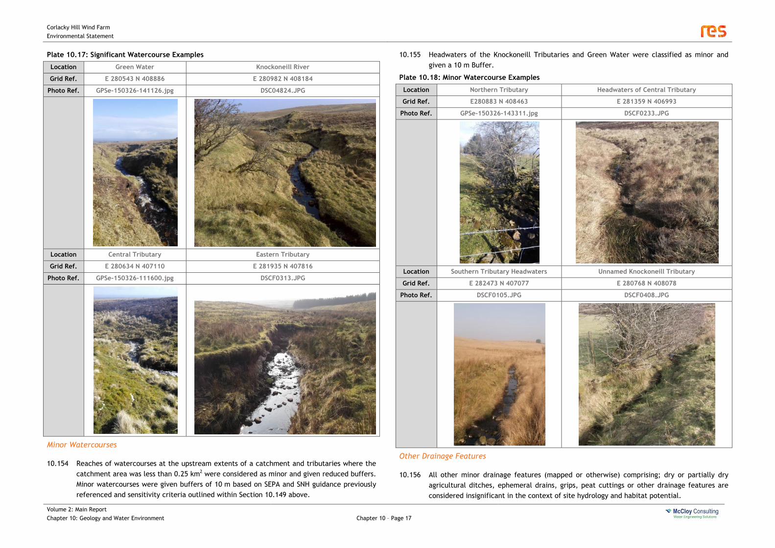
Corlacky Hill Wind Farm
Environmental Statement
Volume 2: Main Report
Chapter 10: Geology and Water Environment
Chapter 10 – Page 17
Plate 10.17: Significant Watercourse Examples
Location Green Water Knockoneill River
Grid Ref. E 280543 N 408886 E 280982 N 408184
Photo Ref. GPSe-150326-141126.jpg DSC04824.JPG
Location Central Tributary Eastern Tributary
Grid Ref. E 280634 N 407110 E 281935 N 407816
Photo Ref. GPSe-150326-111600.jpg DSCF0313.JPG
Minor Watercourses
10.154 Reaches of watercourses at the upstream extents of a catchment and tributaries where the
catchment area was less than 0.25 km2 were considered as minor and given reduced buffers.
Minor watercourses were given buffers of 10 m based on SEPA and SNH guidance previously
referenced and sensitivity criteria outlined within Section 10.149 above.
10.155 Headwaters of the Knockoneill Tributaries and Green Water were classified as minor and
given a 10 m Buffer.
Plate 10.18: Minor Watercourse Examples
Location Northern Tributary Headwaters of Central Tributary
Grid Ref. E280883 N 408463 E 281359 N 406993
Photo Ref. GPSe-150326-143311.jpg DSCF0233.JPG
Location Southern Tributary Headwaters Unnamed Knockoneill Tributary
Grid Ref. E 282473 N 407077 E 280768 N 408078
Photo Ref. DSCF0105.JPG DSCF0408.JPG
Other Drainage Features
10.156 All other minor drainage features (mapped or otherwise) comprising; dry or partially dry
agricultural ditches, ephemeral drains, grips, peat cuttings or other drainage features are
considered insignificant in the context of site hydrology and habitat potential.
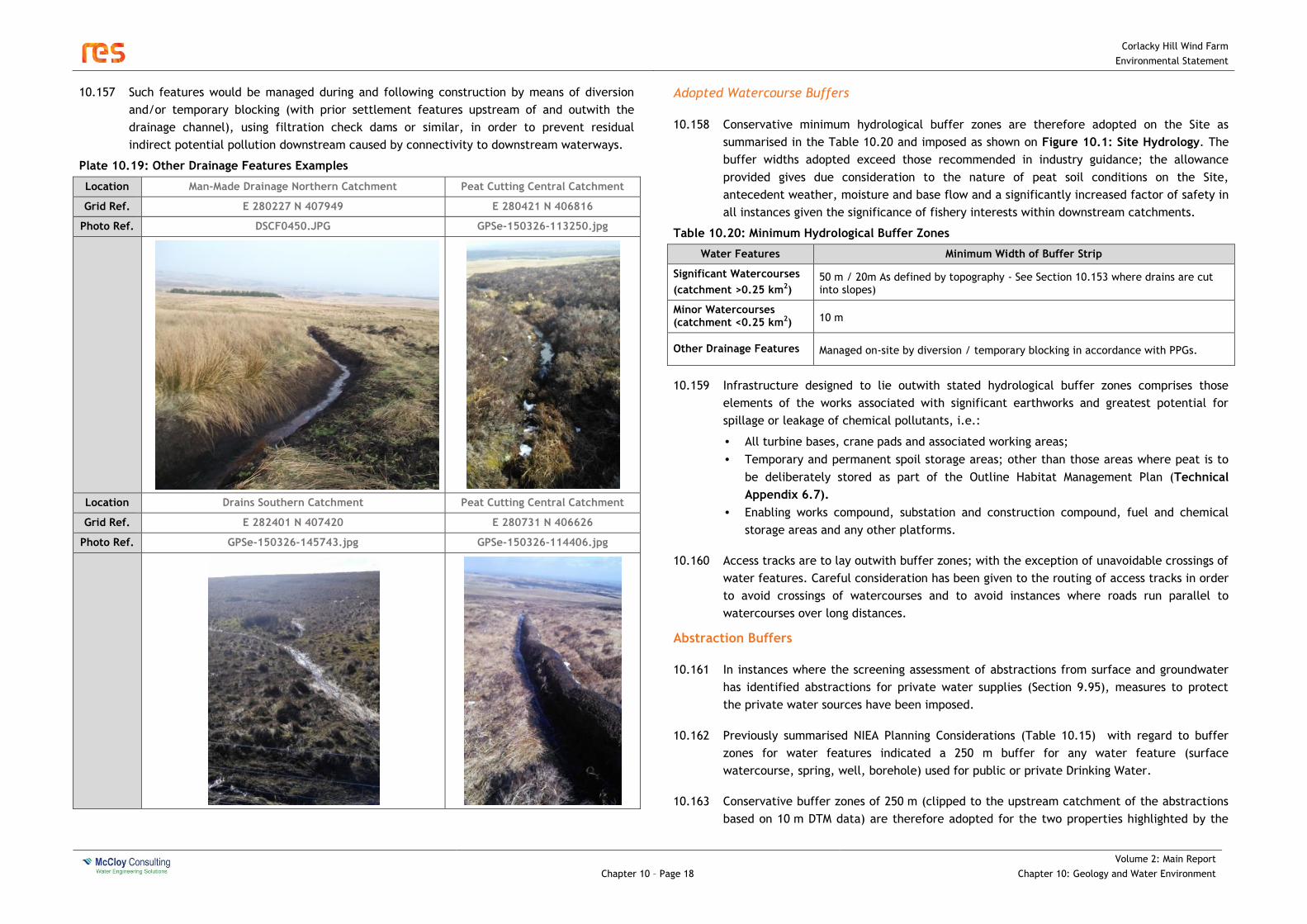
Corlacky Hill Wind Farm
Environmental Statement
Chapter 10 – Page 18
Volume 2: Main Report
Chapter 10: Geology and Water Environment
10.157 Such features would be managed during and following construction by means of diversion
and/or temporary blocking (with prior settlement features upstream of and outwith the
drainage channel), using filtration check dams or similar, in order to prevent residual
indirect potential pollution downstream caused by connectivity to downstream waterways.
Plate 10.19: Other Drainage Features Examples
Location Man-Made Drainage Northern Catchment Peat Cutting Central Catchment
Grid Ref. E 280227 N 407949 E 280421 N 406816
Photo Ref. DSCF0450.JPG GPSe-150326-113250.jpg
Location Drains Southern Catchment Peat Cutting Central Catchment
Grid Ref. E 282401 N 407420 E 280731 N 406626
Photo Ref. GPSe-150326-145743.jpg GPSe-150326-114406.jpg
Adopted Watercourse Buffers
10.158 Conservative minimum hydrological buffer zones are therefore adopted on the Site as
summarised in the Table 10.20 and imposed as shown on Figure 10.1: Site Hydrology. The
buffer widths adopted exceed those recommended in industry guidance; the allowance
provided gives due consideration to the nature of peat soil conditions on the Site,
antecedent weather, moisture and base flow and a significantly increased factor of safety in
all instances given the significance of fishery interests within downstream catchments.
Table 10.20: Minimum Hydrological Buffer Zones
Water Features Minimum Width of Buffer Strip
Significant Watercourses
(catchment >0.25 km2) 50 m / 20m As defined by topography - See Section 10.153 where drains are cut into slopes)
Minor Watercourses (catchment <0.25 km2) 10 m
Other Drainage Features Managed on-site by diversion / temporary blocking in accordance with PPGs.
10.159 Infrastructure designed to lie outwith stated hydrological buffer zones comprises those
elements of the works associated with significant earthworks and greatest potential for
spillage or leakage of chemical pollutants, i.e.:
• All turbine bases, crane pads and associated working areas;
• Temporary and permanent spoil storage areas; other than those areas where peat is to
be deliberately stored as part of the Outline Habitat Management Plan (Technical
Appendix 6.7).
• Enabling works compound, substation and construction compound, fuel and chemical
storage areas and any other platforms.
10.160 Access tracks are to lay outwith buffer zones; with the exception of unavoidable crossings of
water features. Careful consideration has been given to the routing of access tracks in order
to avoid crossings of watercourses and to avoid instances where roads run parallel to
watercourses over long distances.
Abstraction Buffers
10.161 In instances where the screening assessment of abstractions from surface and groundwater
has identified abstractions for private water supplies (Section 9.95), measures to protect
the private water sources have been imposed.
10.162 Previously summarised NIEA Planning Considerations (Table 10.15) with regard to buffer
zones for water features indicated a 250 m buffer for any water feature (surface
watercourse, spring, well, borehole) used for public or private Drinking Water.
10.163 Conservative buffer zones of 250 m (clipped to the upstream catchment of the abstractions
based on 10 m DTM data) are therefore adopted for the two properties highlighted by the

Corlacky Hill Wind Farm
Environmental Statement
Volume 2: Main Report
Chapter 10: Geology and Water Environment
Chapter 10 – Page 19
local council (Section 10.103) and five PWS identified in the property assessment (Section
10.105) as shown on Figure 10.2: Abstractions.
Floodplains
10.164 All permanent structures have been located outside areas denoted as lying within the
1% AEP fluvial floodplain based on Flood Maps (NI) strategic level mapping.
10.165 Pluvial and fluvial flood extends noted along watercourses on-site (outlined within Section
10.83 and shown on Figure 10.1: Site Hydrology) do not extend beyond the extent of the
buffers established in Section 10.158 and therefore do not further constrain development.
10.166 Infrastructure is designed to ensure that conveyance of surface water flooding is not
impeded by means of providing drainage culverts / under track crossings where necessary.
Electrical infrastructure that would be susceptible to damage by floodwater is designed such
that it does not have potential to be affected by surface water flooding.
10.167 Areas of isolated surface water flooding generally coincide with source areas of on-site
water features or isolated low-points. Site drainage and culverts shall allow passage of local
surface flooding as considered within Technical Appendix 10.1: Water Framework
Directive Assessment and accompanying drainage management drawings.
Radon
10.168 The permanent sub-station building is sited within an area classified as having the lowest
band of radon potential (less than 1% of homes above the action level. However due to the
identified likelihood of elevated radon levels within other areas of the preliminary
boundary, design of permanent (for the design life of the development) buildings including
substation buildings will be informed by a site specific radon survey post-consent; the
building will incorporate measures appropriate to radon levels observed in accordance with
Building Research Establishment guidance11 and any supplementary requirement of local
Building Control.
Effect of the Development
10.169 Magnitude and likelihood of the environmental effects identified previously in the
qualitative analysis presented in Section 10.115 have been determined based on criteria
outlined within Sections 10.32 - 10.39 and taking into account the effect of avoidance
measures proposed.
10.170 The associated impact significance of these effects on the receptors affected (following the
implementation of avoidance and design measures proposed) has been determined in
accordance with the rationale previously described and the results are presented in
summary Table 10.21 overleaf.
11 BR413 Radon: Guidance on protective measures for new dwellings in Northern Ireland (BRE 2004)

Corlacky Hill Wind Farm
Environmental Statement
Chapter 10 – Page 20
Volume 2: Main Report
Chapter 10: Geology and Water Environment
Table 10.21: Potential Magnitude and Significance of Impacts to Receptors – Including effect of Avoidance
Receptor and Sensitivity
Effect and Magnitude Potential
Effect Significance
Likelihood Overall Effect
Significance Rationale
Soils / Drift Deposits
(Local / Low)
Ground Movement / Instability
Medium Low Unlikely Minor Land slip potential is negligible due to shallow depth of stiff-natured drift deposits. Considered separately within the Peat Slide Risk Assessment; a quantitative analysis determined that the overall risk is ‘Very Low’ to ‘Low’ on the site.
On-Site /Downstream Knockoneill River
Central Tributary
(Regional / Medium)
Changes in runoff and flow patterns
Low Low Certain Moderate Increased runoff from impermeable infrastructure would cause a minor effect, however the effect is considered to be of low magnitude due to the proportional area of the receiving catchments affected being insignificant, and would therefore not affect the water use (in terms of normal water flows and frequency and magnitude of flooding).
Introducing crossings at seven locations within channels on-site within the Knockoneill / Central Catchment would be likely to change or restrict channel capacity, with potential to cause a detectable but minor and localised increase in flood risk / flood levels upstream of the structure (i.e. on the Site itself).
Temporary and permanent infrastructure comprising linear works installed (drainage channels, cable routes etc) would be likely to cause minor and local change to runoff patterns on Site.
Qualitative appraisal of environmental effects arising is as described in Sections 10.122 - 10.126.
Silt / suspended solid pollution of surface waters
Medium Moderate Likely Moderate Temporary short-term construction activities within watercourses would be likely to cause a significant but temporary fundamental change in water quality in the immediate downstream environment.
Avoidance of watercourses by infrastructure would result in there being no direct discharge of silt laden runoff from infrastructure to watercourses other than at watercourse crossings. Filtration of runoff across intact riparian buffers is likely to sufficiently reduce concentrations of pollutants sufficiently that there would be no significant effect.
Remaining point discharges of runoff to watercourses at unavoidable crossings would be likely to cause a significant but temporary fundamental change in water quality in the immediate downstream environment during construction phase, and a detectable but minor change in water quality during the operational phase.
Qualitative appraisal of environmental effects arising is as described in Sections 10.127 - 10.132.
Chemical pollution of surface waters
Medium Moderate Likely Moderate Spillage of oils, chemicals, or cementitious material associated with temporary construction and arising due to improper site management would be likely to cause a fundamental but temporary change in water quality in the downstream environment.
Qualitative appraisal of environmental effects arising is as described in Sections 10.133 - 10.137.
On-Site Northern Tributary
(Local / Low)
Changes in runoff and flow patterns
Low Negligible Certain Moderate No turbines or watercourse crossings are proposed within this catchment.
Increased runoff from impermeable infrastructure would cause a minor effect, however the effect is considered to be of low magnitude due to the proportional area of the receiving catchments affected being insignificant, and would therefore not affect the water use (in terms of normal water flows and frequency and magnitude of flooding).
Temporary and permanent infrastructure comprising linear works installed (drainage channels, cable routes etc) would be likely to cause minor and local change to runoff patterns on the Site.
Qualitative appraisal of environmental effects arising is as described in Sections 10.122 - 10.126.
Silt / suspended solid pollution of surface waters
Medium Low Likely Moderate Temporary short-term construction activities within watercourses would be likely to cause a significant but temporary fundamental change in water quality in the immediate downstream environment.
Avoidance of watercourses by infrastructure would result in there being no direct discharge of silt laden runoff from infrastructure to watercourses other than at watercourse crossings. Filtration of runoff across intact riparian buffers is likely to sufficiently reduce concentrations of pollutants sufficiently that there would be no significant effect.
Qualitative appraisal of environmental effects arising is as described in Sections 10.127 - 10.132.
Chemical pollution of surface waters
Medium Low Rarely Moderate No permanent storage of oils, chemicals, or cementitious material associated with operational activities proposed within this catchment.
On-Site Eastern Tributary
(Local / Low)
Changes in runoff and flow patterns
Low Negligible Certain Moderate Increased runoff from impermeable infrastructure would cause a minor effect, however the effect is considered to be of low magnitude due to the proportional area of the receiving catchments affected being insignificant, and would therefore not affect the water use (in terms of normal water flows and frequency and magnitude of flooding).
Introducing structures (culverts) at one location within channels on-site within the Eastern Tributary Catchment would be likely to change or restrict channel capacity, with the potential to cause a detectable but minor and localised increase in flood risk / flood levels upstream of the structure (i.e. on the Site itself).
Temporary and permanent infrastructure comprising linear works installed (drainage channels, cable routes etc) would be likely to cause minor and local change to runoff patterns on the Site.
Qualitative appraisal of environmental effects arising is as described in Sections 10.122 - 10.126.
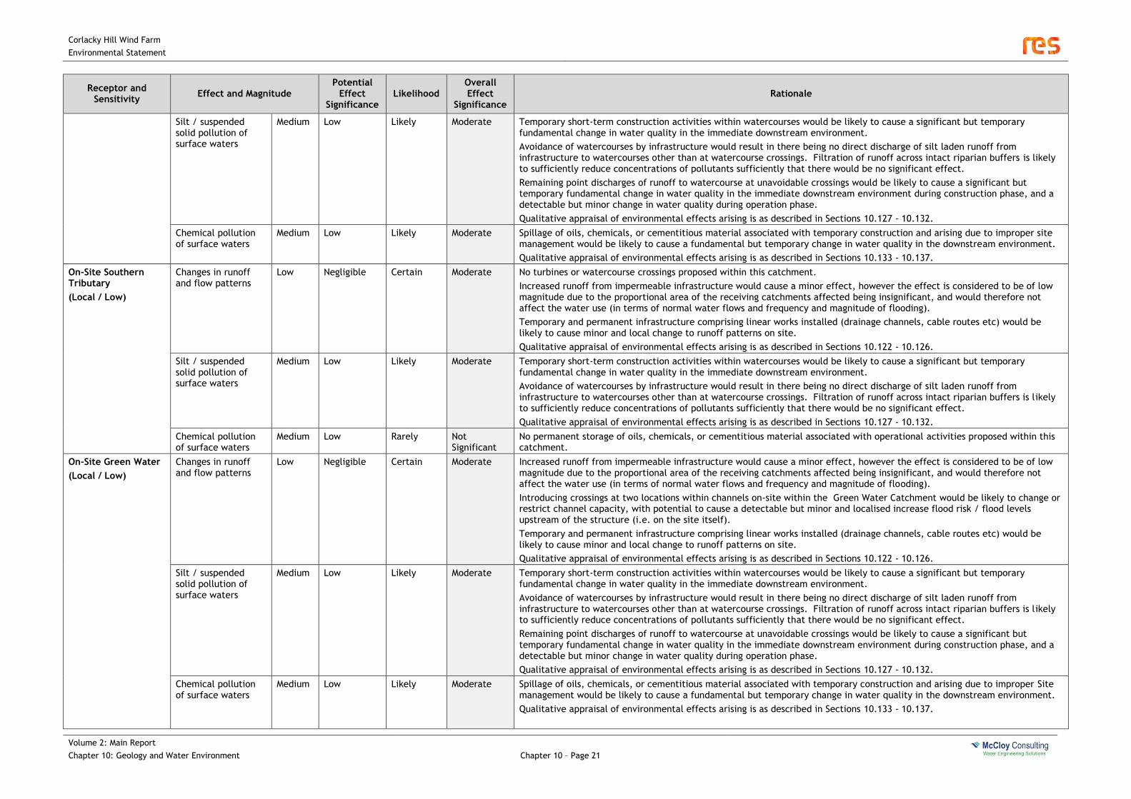
Corlacky Hill Wind Farm
Environmental Statement
Volume 2: Main Report
Chapter 10: Geology and Water Environment
Chapter 10 – Page 21
Receptor and Sensitivity
Effect and Magnitude Potential
Effect Significance
Likelihood Overall Effect
Significance Rationale
Silt / suspended solid pollution of surface waters
Medium Low Likely Moderate Temporary short-term construction activities within watercourses would be likely to cause a significant but temporary fundamental change in water quality in the immediate downstream environment.
Avoidance of watercourses by infrastructure would result in there being no direct discharge of silt laden runoff from infrastructure to watercourses other than at watercourse crossings. Filtration of runoff across intact riparian buffers is likely to sufficiently reduce concentrations of pollutants sufficiently that there would be no significant effect.
Remaining point discharges of runoff to watercourse at unavoidable crossings would be likely to cause a significant but temporary fundamental change in water quality in the immediate downstream environment during construction phase, and a detectable but minor change in water quality during operation phase.
Qualitative appraisal of environmental effects arising is as described in Sections 10.127 - 10.132.
Chemical pollution of surface waters
Medium Low Likely Moderate Spillage of oils, chemicals, or cementitious material associated with temporary construction and arising due to improper site management would be likely to cause a fundamental but temporary change in water quality in the downstream environment.
Qualitative appraisal of environmental effects arising is as described in Sections 10.133 - 10.137.
On-Site Southern Tributary
(Local / Low)
Changes in runoff and flow patterns
Low Negligible Certain Moderate No turbines or watercourse crossings proposed within this catchment.
Increased runoff from impermeable infrastructure would cause a minor effect, however the effect is considered to be of low magnitude due to the proportional area of the receiving catchments affected being insignificant, and would therefore not affect the water use (in terms of normal water flows and frequency and magnitude of flooding).
Temporary and permanent infrastructure comprising linear works installed (drainage channels, cable routes etc) would be likely to cause minor and local change to runoff patterns on site.
Qualitative appraisal of environmental effects arising is as described in Sections 10.122 - 10.126.
Silt / suspended solid pollution of surface waters
Medium Low Likely Moderate Temporary short-term construction activities within watercourses would be likely to cause a significant but temporary fundamental change in water quality in the immediate downstream environment.
Avoidance of watercourses by infrastructure would result in there being no direct discharge of silt laden runoff from infrastructure to watercourses other than at watercourse crossings. Filtration of runoff across intact riparian buffers is likely to sufficiently reduce concentrations of pollutants sufficiently that there would be no significant effect.
Qualitative appraisal of environmental effects arising is as described in Sections 10.127 - 10.132.
Chemical pollution of surface waters
Medium Low Rarely Not Significant
No permanent storage of oils, chemicals, or cementitious material associated with operational activities proposed within this catchment.
On-Site Green Water
(Local / Low)
Changes in runoff and flow patterns
Low Negligible Certain Moderate Increased runoff from impermeable infrastructure would cause a minor effect, however the effect is considered to be of low magnitude due to the proportional area of the receiving catchments affected being insignificant, and would therefore not affect the water use (in terms of normal water flows and frequency and magnitude of flooding).
Introducing crossings at two locations within channels on-site within the Green Water Catchment would be likely to change or restrict channel capacity, with potential to cause a detectable but minor and localised increase flood risk / flood levels upstream of the structure (i.e. on the site itself).
Temporary and permanent infrastructure comprising linear works installed (drainage channels, cable routes etc) would be likely to cause minor and local change to runoff patterns on site.
Qualitative appraisal of environmental effects arising is as described in Sections 10.122 - 10.126.
Silt / suspended solid pollution of surface waters
Medium Low Likely Moderate Temporary short-term construction activities within watercourses would be likely to cause a significant but temporary fundamental change in water quality in the immediate downstream environment.
Avoidance of watercourses by infrastructure would result in there being no direct discharge of silt laden runoff from infrastructure to watercourses other than at watercourse crossings. Filtration of runoff across intact riparian buffers is likely to sufficiently reduce concentrations of pollutants sufficiently that there would be no significant effect.
Remaining point discharges of runoff to watercourse at unavoidable crossings would be likely to cause a significant but temporary fundamental change in water quality in the immediate downstream environment during construction phase, and a detectable but minor change in water quality during operation phase.
Qualitative appraisal of environmental effects arising is as described in Sections 10.127 - 10.132.
Chemical pollution of surface waters
Medium Low Likely Moderate Spillage of oils, chemicals, or cementitious material associated with temporary construction and arising due to improper Site management would be likely to cause a fundamental but temporary change in water quality in the downstream environment.
Qualitative appraisal of environmental effects arising is as described in Sections 10.133 - 10.137.

Corlacky Hill Wind Farm
Environmental Statement
Chapter 10 – Page 22
Volume 2: Main Report
Chapter 10: Geology and Water Environment
Receptor and Sensitivity
Effect and Magnitude Potential
Effect Significance
Likelihood Overall Effect
Significance Rationale
Groundwater / Aquifers
(Local / Low)
Alteration of Groundwater
Medium Low Unlikely Minor The nature of the Proposed Wind Farm Development has no potential to affect bedrock aquifers; no works are proposed that would require excavation to a significant depth within the bedrock. Significant dewatering with the potential for affecting groundwater levels is not anticipated.
Superficial aquifers are unlikely to be present, minor areas of glaciofluvial sand/gravel deposits were noted. Any dewatering would cause temporary insignificant change in the shallow water table of insignificant consequence due to the low / local value of the aquifer.
Chemical pollution of groundwater
Medium Low Likely Minor The majority of soils and sub soils (alluvium and till) are of low permeability and will generally mitigate through slow downward migration of pollution into deep groundwater. However a significant pollution event arising due to improper site management would be likely to cause detectable but temporary pollution to the aquifer. Significance is minor due to the low / local value of the aquifer.
Tracks, turbines and associated buildings.
(Local / Low)
Risk to occupants and infrastructure due to identified potential risk of flooding.
Low
Negligible Unlikely Not
Significant The Proposed Wind Farm Development has been designed to avoid areas of fluvial flooding and infrastructure is designed to be resilient to surface water flooding.
Risk to occupants due to identified risk of radon
Low Negligible Unlikely Not Significant
The proposed permanent substation has been located in an area of low radon potential and will be subject to a site specific radon survey to inform appropriate building mitigation.
Corlacky Hill Wind Farm
Environmental Statement
Volume 2: Main Report
Chapter 10: Geology and Water Environment
Chapter 10 – Page 23
Additional Mitigation Measures
All Phases
10.171 Additional mitigating measures over and above the avoidance and buffer zones previously
detailed are intended to reduce or prevent the residual significant hazards not fully
mitigated by the design evolution and avoidance, identified in the preceding Table: 10.22.
Site Drainage Management and SuDS Design
10.172 The Site will adopt a surface water management plan / site drainage design using the
principles of Sustainable Drainage, promoting the principles of on-site retention of flows and
use of buffers and other silt removal techniques. All drainage-related mitigation measures
proposed will be encompassed by a robust and proven Sustainable Drainage System (SuDS)
design which will be used to control drainage and silt management on the Site.
10.173 In summary, drainage will minimise modification and disruption of the existing hydrology by:
• Maintaining existing overland flow routes and channels. All existing natural flow paths
lateral to access roads will be maintained through the use of piped crossings under road
alignments at natural depressions and at regular intermediate intervals. The spacing of
cross drains will be specified at detailed design stage;
• Avoiding transporting rainfall runoff in long linear drainage swales by providing regular
channel “breakouts”, whereby water is encouraged to flow overland throughout the
Site, thus maintaining existing natural hydrological patterns;
• Reducing surface water flow rates and volumes by attenuating runoff from tracks and
hard standings “at source” by providing check-dams in swales, whereby the flow
velocity and rate of discharge is artificially reduced to mimic natural properties;
• Providing settlement ponds at turbine hard standing areas and other main surface water
discharge locations, where runoff from significant new impermeable areas is treated
and attenuated before being released overland;
• All swales, crossings and other hydraulic features will be engineered to ensure that
dimensions etc. are suitable to convey predicted flows and so prevent build-up of
surface water and / or flooding.
10.174 Drainage design will reduce chemical, silt and other suspended pollutant transport by
providing a “treatment train” of two to three stages of pollutant removal to all surface
water runoff, nominally by:
• Ensuring that drainage swales are designed to convey flows at a low velocity by using a
wide, flat bottomed drain;
• Providing settlement and filtration features in all linear drainage swales (check dams,
filtration dams) to reduce flow velocity and encourage settlement;
• Encouraging appropriate vegetation growth in the base of all linear drainage to provide
additional filtration to flows;
• Providing settlement ponds at turbine hard standing areas and other key discharge
locations in order to provide treatment to contaminated runoff prior to discharge;
• Discharging surface water runoff over undisturbed vegetated ground, hence allowing any
remaining silts and other pollutants to drop out of flows before entering the
watercourse (having the effect of polishing the runoff);
• Preventing the discharge of surface water runoff flows directly to existing watercourses
or drainage. All discharges are to be via SuDS and buffer zones which will act as a filter
strip, allowing deposition of suspended solids and other pollutants.
• Providing settlement features in water channels downstream of areas of peat infilling
and ditch blocking proposed as part of habitat management and enhancement planning.
10.175 Considerations specific to the proposed infrastructure elements are documented in the
detailed site specific drainage management / SuDS design - Technical Appendix 10.1:
Water Framework Directive Assessment and accompanying Drainage Management
Drawings.
Design and Construction of Watercourse Crossings
10.176 As noted previously, the number of watercourse and drainage crossings has been minimised
through the principle of avoidance at the layout design stage. Proposals submitted in
conjunction with this assessment indicate:
• Four crossings of hydrologically significant watercourses (two of which are considered
sensitive with respect to fisheries potential);
• Six crossings of minor watercourses.
10.177 Culverts will be designed to accommodate track crossings and minimise length of affected
channel in order to comply with Revised PPS15 policy FLD4.
10.178 Hydraulic design of crossings will be undertaken as per the guidance and requirements
provided in CIRIA C689 “Culvert Design and Operation Guide” (or other standard as may be
required by Rivers Agency in post-consent consultation), with primary parameters likely to
include:
• Width of the culvert will be greater than the width of the active drainage channel;
• Alignment of the culvert will suit the alignment of the drainage channel, i.e. preserve
the existing direction of flow;
• The slope of the culvert will not exceed the slope of the bed of the existing drainage
channel.
10.179 Detailed design of crossings will assume a hydraulic capacity requirement of 1% Annual
Equivalent Probability flow as a conservative measure. Detailed hydraulic design of culverts
and similar structures post permission is normal and accepted practice for wind farms in
Northern Ireland.

Corlacky Hill Wind Farm
Environmental Statement
Chapter 10 – Page 24
Volume 2: Main Report
Chapter 10: Geology and Water Environment
10.180 Fisheries shall be protected by adopting the guidance stated in Guidelines for Fisheries
Protection during Development Works as published by Loughs Agency (adopted in the
absence of specific guidance published by DCAL as the statutory agency with remit for
fisheries protection for the region affected).
10.181 Culvert form will be informed by the site specific fisheries assessment (Chapter 9:
Fisheries). In the two instances where fish passage is a requirement (crossing of Knockoneill
River and Central Tributary), culverts will be designed to ensure that the channel bed and
banks remain intact in order to preserve fisheries habitats and allow continued fish passage;
i.e. the structure will be a bottomless culvert. Elsewhere culverts shall be of a closed
conduit type. Typical design drawings for a bottomless culvert and closed culvert have been
provided as part of the planning application and are included as part of the Drainage
Management Drawings within Technical Appendix 10.1: Water Framework Directive
Assessment.
10.182 Consultation and approval will be sought from all relevant parties as required by the
Department of the Environment Surface Waters Alteration Handbook (December 2013),
including Rivers Agency in particular, at the pre-construction detailed design stage for all
works in and affecting watercourses and drains, as per the requirements of Schedule 6 of
the Drainage (Northern Ireland) Order 1973 and subsequent amendments.
Water Quality Monitoring
10.183 A water quality monitoring program will be implemented to monitor effects on the
hydrological and groundwater regime and water quality during the infrastructure
construction, operation and decommissioning phases of the wind farm in order to:
• Demonstrate that the mitigation measures and surface water management is performing
as designed;
• Provide validation that the in-place mitigation measures are not having an adverse
effect upon the environment;
• Indicate the need for additional mitigation measures to prevent, reduce or remove any
effects on the water environment, such as additional temporary settlement or filtration
structures or short term flocculant dosing to suit observed Site conditions.
10.184 The monitoring would be informed by existing baseline data gathered at the pre-planning
stage as presented in the baseline Section 10.78 of this assessment.
10.185 It is intended that the water monitoring extent, duration and frequency will be agreed with
the DOE Planning or the relevant regulating body (nominally NIEA WMU) post consent and
will nominally consist of physicochemical and biological monitoring. The extent, duration
and frequency of the monitoring will be proportionate to the level of activity and perceived
risks.
Construction and Decommissioning Phases
10.186 During all phases the site manager will ensure that mitigation measures as identified within
this assessment are fully implemented and that activities are carried out in such a manner
as to prevent or reduce effects. The following construction / decommissioning phase-
specific measures will be implemented. The following sections should be read in
conjunction with the construction management information provided within Chapter 2:
Proposed Development.
Pollution Prevention Guidance
10.187 To ensure best practice on site and to help avoid pollution release to watercourses and
groundwater, the following NIEA Pollution Prevention Guidance (PPGs) will be adhered to:
• PPG01 Understanding Your Environmental Responsibilities - Good Environmental
Practices
• PPG02 Above Ground Oil Storage Tanks
• PPG03 Use and Design of Oil Separators in Surface Water Drainage Systems
• PPG04 Treatment and Disposal of Sewage where no Foul Sewer is available
• PPG05 Works and Maintenance in or near Water
• PPG06 Working at Construction and Demolition Sites
• PPG07 Refuelling Facilities
• PPG18 Managing Fire Water and Major Spillages
• PPG20 Dewatering Underground Ducts and Chambers
• PPG21 Pollution Incident Response Planning
• PPG26 Drums and Intermediate Bulk Containers.
10.188 Key requirements for control of chemical pollution risk are identified in the above guidance
and will include the following:
• Storage – all equipment, materials and chemicals on the Site will be stored away from
any watercourse (i.e. outwith previously stated buffer zones). Chemical, fuel and oil
stores will be sited on impervious bases in accordance with PPG2 and within a secured
bund of 110% of the storage capacity, within the lay down area.
• Vehicles and refuelling – standing machinery will have drip trays placed underneath to
prevent oil and fuel leaks causing pollution. Refuelling of vehicles and machinery will be
carried out on an impermeable surface in designated areas, well away from any
watercourse or drainage ditches (i.e. outwith previously stated buffer zones) and will
adhere to best practice as detailed in PPG7.
• Maintenance – on site maintenance to construction plant will be avoided in all
practicable instances, unless vehicles have broken down necessitating maintenance at
the point of breakdown. Suitable measures in accordance with a pollution prevention
plan will be put in place prior to commencement of maintenance in this instance.
• Cement and concrete batching – Preference shall be given to construction techniques
that do not require use of cementitious materials where suitable practicable

Corlacky Hill Wind Farm
Environmental Statement
Volume 2: Main Report
Chapter 10: Geology and Water Environment
Chapter 10 – Page 25
alternatives exist. When concrete / cement are used, concrete batching will not be
permitted on Site. Wet concrete operations will not be carried out within watercourses
or adjacent to watercourses. Measures to prevent discharge of alkaline wastewaters or
contaminated storm water to watercourses will be outlined in a detailed Pollution
Prevention Plan for the Site to be approved by NIEA before commencement of works.
Wastewater spillage will be minimised by using settling tanks and recycling water.
• Mess and welfare facilities will be required during construction and decommissioning
and will be located at the construction compound. Foul effluent disposal shall be via
chemical facilities with periodic tankered removal by a licensed waste haulier for
licensed offsite disposal (i.e. there shall be no emission on Site).
Pollution Prevention Plan
10.189 A detailed Pollution Prevention Plan (PPP) will be implemented and monitored by the site
manager as part of a full Construction & Decommissioning Method Statement (CDMS) for the
project, to be agreed with DOE Planning at the pre-construction stage. Although this will be
of particular importance during construction, it will apply to potentially polluting activities
during all phases of the Proposed Wind Farm Development.
10.190 The detailed PPP will be produced following consultation and agreement with NIEA, and all
appropriate personnel working on the Site will be trained in its use. As a minimum, the PPP
will comply with Pollution Prevention Guidelines (in particular PPG21: Pollution Incident
Response Planning) and best practice as advocated by CIRIA. The PPP will identify site-
specific measures and incorporate a Pollution Incident Plan, which will include emergency
contact details, details of spill kits on the Site and instructions on actions in case of spillage
/ emergency.
Construction in the vicinity of Watercourses
10.191 The following procedures apply to the general construction activities either within the
watercourses or in defined watercourse buffer zones:
• Due consideration will be given to the prevailing ground and weather conditions when
programming the execution of the works in order to ensure that in-channel works are
undertaken during periods of predicted low flow and low rainfall in order to minimise
contact with water.
• Ensure that roadside drains do not discharge directly into watercourses, but rather
through a riparian buffer area of intact vegetation as denoted on design drawings.
Construction of Watercourse Crossings
10.192 Measures for in-stream works including watercourse crossings will be as per the guidance
stated in Guidelines for Fisheries Protection during Development Works as published by
Loughs Agency (adopted in the absence of specific guidance published by DCAL as the
statutory agency with remit for fisheries protection for the region affected).
10.193 Construction of watercourse crossings will be programmed to coincide with periods of
predicted low flow in the affected channel (determined by rainfall and would generally
coincide with summer months) and adhere to working period restrictions imposed.
Construction will be strictly as per the design for each identified watercourse crossing and
will fully implement all SuDS and additional mitigating measures proposed at the detailed
design stage. For purposes of outline design, the proposed mitigation will include:
• Installation of silt fences parallel to the watercourse channel in the vicinity of the
proposed crossing;
• Installation of small cut-off drains to prevent natural surface runoff entering area of
construction activity;
• Installation of filtration or other silt entraining features within the watercourse channel
immediately downstream of the works location;
• Use of over pumping where deemed appropriate.
Electrical Cable
10.194 Due consideration will be given to the prevailing ground conditions and season when
programming the execution of cable trench excavations in order to ensure works are
undertaken during periods with predicted low rainfall and elevated shallow groundwater
levels in order to reduce the likelihood of runoff entering the excavations.
10.195 Excavation of cable trenches will be carried out over short distances, with frequent
backfilling of trenches to minimise opportunity for the ingress of water into open trenches,
temporary silt traps will be provided in longer trench runs and on steeper slopes and spoil
will be stored in line with a spoil management plan, which will be produced as part of the
CDMS at the pre-construction stage.
10.196 Cable crossings of watercourses shall use a raised cable tray to bridge the river channel,
with supports and footings constructed outwith the river channel. No plant shall be
permitted within watercourse channels when undertaking such works.
Excavations and Spoil Management
10.197 Soil and subsoil excavation and movement will be undertaken in accordance with best
practice guidelines such as Good Practice Guide for Handling Soils (MAFF, 2000) in order to
minimise potential for silt laden runoff from spoil and excavations. Areas of stockpiled spoil
including stored peat:
• will not be permitted within previously identified watercourse buffer zones; and
• will not be permitted to obstruct the flow of overland surface water with specific
drainage to spoil mounds to be provided.
10.198 Material produced from excavations on the Site will be reused where reasonably practicable
in the reinstatement of the Site. Excavated materials will be separated into rock material,
subsoil, reusable peat and vegetated sod material and will be stored in the designated
temporary stockpile zones, under the supervision of a geotechnical expert. These materials

Corlacky Hill Wind Farm
Environmental Statement
Chapter 10 – Page 26
Volume 2: Main Report
Chapter 10: Geology and Water Environment
will be reused where possible to re-grade slopes, and to re-vegetate and stabilise the sides
of access tracks and hard standing areas.
10.199 Spoil drainage will be designed on a bespoke basis for spoil storage areas to allow controlled
dewatering and prevent washout of suspended solids to the receiving water environment.
As part of the detailed CDMS a spoil management strategy will be developed by the
appointed competent contractor for the development. Outline designs for drainage
arrangements for temporary spoil areas are shown on the Drainage Management Drawings
within Technical Appendix 10.1: Water Framework Directive Assessment.
Ditch Blocking and Peat Placement for Habitat Enhancement
10.200 In the Outline Habitat Management Plan (Technical Appendix 6.7) areas for ditch blocking
and areas of re-profiling using excavated peat have been proposed in areas where the effect
could have no offsite hydrological effect (by raising water levels or impeding drainage such
that water would divert or back-up onto 3rd party lands). The effect of impeded drainage
would be limited to lands under control of the applicant. Drainage channels affected have
been determined not to be of significant aquatic habitat value.
10.201 It is anticipated that ditch blocking methods would depend upon local conditions at any
given location. A number of techniques for maintaining the water levels in the drains
associated with the flushes may be used and would typically comprise the installation of a
barrier (e.g. (piled) plastic corrugated sheets or drop board sluice or installation of pipe
dams, in conjunction with backfilling with site-won peat). Methods will comply with best
practice guidance12.
10.202 Downstream water quality that may otherwise be affected by release of peat in runoff
would be protected by adopting spoil handling methods as set out in Sections 10.197 to
10.199. In particular, the channel(s) downstream of the blocked areas would have
temporary filtration features (i.e. silt fences or clean drainage stone dams) installed in the
channel in order to filter or settle solids, until such time as the level of washout had
receded.
Dewatering of Excavations
10.203 Turbine base foundations will be on bedrock or other hard strata above bedrock (to be
confirmed by detailed site investigation prior to detailed design); therefore deep
excavations within bedrock and the associated bedrock aquifer are not anticipated and
dewatering below the bedrock aquifer groundwater table is therefore not anticipated.
10.204 Shallow groundwater (e.g. in areas of glaciofluvial sand/gravel deposits) or rainfall runoff
collected in excavations will be discharged via settlement ponds or filter strips prior to
entry to the receiving water environment. Any settlement lagoons or filter strips associated
with dewatering will be regularly inspected, particularly after periods of heavy rainfall and
12 Armstrong A1, Holden J, Kay P, Foulger M, Gledhill S, McDonald AT, Walker A.. (2009). Drain-blocking techniques on blanket peat: A framework for best practice. Journal for Environmental Managers. Vol. 90
prior to periods of forecast heavy rainfall. Maintenance (to clear blockages or remove silt)
will be carried out in periods of dry weather where practicable. Maintenance requirements
are further considered in Technical Appendix 10.1: Water Framework Directive
Assessment.
Dust Management
10.205 Loose track material generated during the use of access tracks and the construction
compound will be prevented from reaching watercourses by maintenance to surface water
drainage systems installed at aggregate based hard standing areas. In dry weather dust
suppression methods such as by dust suppression bowser will be employed.
Borrow Pits
10.206 For the avoidance of doubt, no borrow pits are proposed at the Site, therefore associated
pollution risks associated with rock extraction activities are not a consideration.
Maintenance of Pollution Prevention Measures
10.207 All SuDS and additional pollution prevention measures installed will be subject to a regular
maintenance regime for the life of the construction phase in order to maintain functionality
of all features. This will comprise:
• Unblocking of drains;
• Maintenance of access road and other hard standing surfaces;
• Replacement of filtration features;
• Removal of silt build-up from settlement and filtration features.
Mitigating Measures - Operational Phase
10.208 Mitigation of the effects of the wind farm development will comprise the following:
• Ensure best practice is adhered to on the Site and avoid pollution release to
watercourses by incorporating NIEA Pollution Prevention Guidance notes into
management policy.
• In the event that permanent welfare facilities are installed as part of control building /
substation facilities, foul effluent will be disposed of through the use of sealed cesspools
or chemical facilities with periodic tankered removal by a licensed waste haulier for
licensed offsite disposal (i.e. there shall be no emission on the Site).
• Cyclical maintenance of permanent SuDS drainage features installed during the
construction phase, including unblocking of drains, maintenance of access road and
other hard standing surfaces, and removal of silt build-up from settlement features. An
outline maintenance programme is included in Technical Appendix 10.1: Water
Framework Directive Assessment.

Corlacky Hill Wind Farm
Environmental Statement
Volume 2: Main Report
Chapter 10: Geology and Water Environment
Chapter 10 – Page 27
Commentary on Proposed Development
Off-Site Route Improvement Works
10.209 Information made available in relation to route improvement works outlined the
requirement for widening at two junctions, eight passing bays and general running width
widening along Corlacky Road to permit abnormal deliveries.
10.210 Details of the assessment of potential impact of access works on the geology and water
environment are included within Chapter 12: Traffic and Transport. The desktop
assessment concluded that given the short duration of construction and limited localised
areas of disturbance proposed during the route improvement works it is considered that
there would be no significant effect to geology or the water and environment.
On-Site Works
10.211 Table 10.22 summarises the potential impact of infrastructure to be installed as part of the
Proposed Wind Farm Development following adoption of the preceding mitigation for the
design phase. All turbines and infrastructure are outside the recommended buffers (aside
from watercourse crossings) as described in Chapter 3: Design Evolution & Alternatives.
Table 10.22: Commentary on Infrastructure Elements
Infrastructure Element
Commentary / Specific Mitigation Implemented Mitigated Impact
Magnitude
Access Track Track is orientated in accordance with the guidance provided by the peat slide risk assessment for the Site, minimising risks to the soil and water environment.
Track is orientated to cause least possible disruption by crossing watercourses perpendicular to the watercourse channel.
Track is aligned to minimise constructed length within watercourse buffer zones.
Runoff from track hardstanding to be attenuated and treated in trackside swales / check dams.
All existing watercourse paths to be maintained; culverts to be designed to ensure no restriction or diversion to flows.
Minor / Negligible
Permanent Control room & Substation Compound
Contaminated runoff from excavations, hardstanding and roof areas will be treated to remove silts / suspended solids as part of the drainage management plan for the Site using SuDS techniques prior to discharge.
Runoff from new hardstanding and roof areas will be managed using SuDS techniques to attenuate, control and treat flows.
Located >65 m from nearest watercourse.
Permanent chemical welfare facilities to be provided to negate requirement for any foul effluent discharge from the Site.
Minor / Negligible
Temporary Enabling Works Compound
Contaminated runoff from excavations, hardstanding and roof areas will be treated to remove silts / suspended solids as part of the drainage management plan for the Site using SuDS techniques prior to discharge.
Runoff from new hardstanding and roof areas will be managed using SuDS techniques to attenuate, control and treat flows.
Located >60m from nearest watercourse.
Minor / Negligible
Infrastructure Element
Commentary / Specific Mitigation Implemented Mitigated Impact
Magnitude
Temporary Construction Compound
Contaminated runoff from excavations, hardstanding and roof areas will be treated to remove silts / suspended solids as part of the drainage management plan for the Site using SuDS techniques prior to discharge.
Runoff from new hardstanding and roof areas will be managed using SuDS techniques to attenuate, control and treat flows.
Located >65 m from nearest watercourse.
Oil containment facility to be provided.
Temporary chemical welfare facilities to be provided to negate requirement for any foul effluent discharge from the Site.
Minor / Negligible
All Turbines Contaminated runoff from excavations and earthworks will be treated to remove silts / suspended solids as part of the drainage management plan for the Site using SuDS techniques prior to discharge.
Runoff from new hardstanding areas will be managed using SuDS techniques to attenuate, control and treat flows.
Turbine foundation formation level is bedrock; no requirement for piled foundations or excavation in bedrock, with associated increased risk to aquifer, Is anticipated.
Minor / Negligible
T1 Turbine base and associated crane pad located >60 m from nearest watercourse.
Minor / Negligible
T2 Turbine base located > 60 m from nearest watercourse and associated crane pad located > 30 m from nearest minor watercourse.
Minor / Negligible
T3 Turbine base and associated crane pad located > 50 m from nearest watercourse.
Minor / Negligible
T4 Turbine base and associated crane pad located > 45 m from nearest watercourse.
Minor / Negligible
T5 Turbine base and associated crane pad located > 60 m from nearest watercourse.
Minor / Negligible
T6 Turbine base and associated crane pad located > 50 m from nearest watercourse.
Minor / Negligible
T7 Turbine base and associated crane pad located > 100 m from nearest watercourse.
Minor / Negligible
T8 Turbine base and associated crane pad located > 60 m from nearest watercourse.
Minor / Negligible
T9 Turbine base and associated crane pad located > 150 m from nearest watercourse.
Minor / Negligible
T10 Turbine base and associated crane pad located > 30 m from nearest minor watercourse.
Minor / Negligible
T11 Turbine base and associated crane pad located > 130 m from nearest watercourse.
Minor / Negligible

Corlacky Hill Wind Farm
Environmental Statement
Chapter 10 – Page 28
Volume 2: Main Report
Chapter 10: Geology and Water Environment
11.9.6 Mitigating Measures and Residual Effects
10.212 The following table details the assessed impact magnitude, likelihood and associated
significance as a function of the matrix stated previously of all receptors identified as
previously having an unmitigated impact significance greater than ‘nil’ or ‘not significant’.
10.213 Note that assessment of peat slide and blanket bog impacts are excluded from this
assessment and are assessed separately in Technical Appendix 10.4: Peat Slide Risk
Assessment and Chapter 6: Vegetation & Peatland.

Corlacky Hill Wind Farm
Environmental Statement
Volume 2: Main Report
Chapter 10: Geology and Water Environment
Chapter 10 – Page 29
Table 10.23: Potential Magnitude and Significance of Impacts to Receptors (Post-Mitigation)
Receptor and Sensitivity Effect and Mitigated Magnitude Potential Effect
Significance Likelihood
Overall Mitigated Effect Significance
Rationale
Soils / Drift Deposits
(Local / Low)
Ground Instability Low Negligible Rarely Not Significant Infrastructure designed to incorporate Peat Stability; Land slip potential is considered Negligible.
On-Site / Downstream Knockoneill River
Central Tributary
(Regional / Medium)
Changes in runoff and flow patterns
Low Low Rarely Not Significant Surface water runoff from the Site will not cause a change in downstream hydrological conditions following mitigation to attenuate site runoff.
Sympathetic design of infrastructure layout in relation to disruption / diversion of existing surface water and overland runoff routes results in no quantifiable change in runoff patterns on the Site.
Silt / suspended solid pollution of surface waters
Low Low Rarely Not Significant Surface water management to control silt in proximity to watercourses at all phases is likely to result in no permanent change and no significant temporary change in conditions exceeding natural or pre-existing conditions.
Chemical pollution of surface waters
Low Low Rarely Not Significant Pollution prevention measures proposed to control chemical pollution at all phases is likely to result in no permanent or temporary change in conditions exceeding natural or pre-existing conditions.
On-Site Northern, Eastern and Southern Tributaries
(Local / Low)
Changes in runoff and flow patterns
Low Negligible Rarely Not Significant Surface water runoff from the Site will not cause a change in downstream hydrological conditions following mitigation to attenuate site runoff.
Sympathetic design of infrastructure layout in relation to disruption / diversion of existing surface water and overland runoff routes results in no quantifiable change in runoff patterns on the Site.
Silt / suspended solid pollution of surface waters
Low Negligible Rarely Not Significant Surface water management to control silt in proximity to watercourses at all phases is likely to result in no permanent change and no significant temporary change in conditions exceeding natural or pre-existing conditions.
Chemical pollution of surface waters
Low Negligible Rarely Not Significant Pollution prevention measures proposed to control chemical pollution at all phases is likely to result in no permanent or temporary change in conditions exceeding natural or pre-existing conditions.
On-Site Green Water
(Local / Low)
Changes in runoff and flow patterns
Low Negligible Rarely Not Significant Surface water runoff from the Site will not cause a change in downstream hydrological conditions following mitigation to attenuate site runoff.
Sympathetic design of infrastructure layout in relation to disruption / diversion of existing surface water and overland runoff routes results in no quantifiable change in runoff patterns on the Site.
Silt / suspended solid pollution of surface waters
Low Negligible Rarely Not Significant Surface water management to control silt in proximity to watercourses at all phases is likely to result in no permanent change and no significant temporary change in conditions exceeding natural or pre-existing conditions.
Chemical pollution of surface waters
Low Negligible Rarely Not Significant Pollution prevention measures proposed to control chemical pollution at all phases is likely to result in no permanent or temporary change in conditions exceeding natural or pre-existing conditions.
Groundwater / Aquifers
(Local / Low)
Alteration of Groundwater Medium Low Rarely Not Significant Deep excavations within bedrock and the associated bedrock aquifer are not anticipated and dewatering below the bedrock aquifer groundwater table is not anticipated.
Chemical pollution of groundwater
Low Negligible Rarely Not Significant Pollution prevention measures at all phases is likely to result in no permanent or temporary change in conditions exceeding natural or pre-existing conditions.
Corlacky Hill Wind Farm
Environmental Statement
Chapter 10 – Page 30
Volume 2: Main Report
Chapter 10: Geology and Water Environment
Cumulative Effects
10.214 An assessment has been undertaken of the cumulative effect on geology and the water
environment of the Proposed Corlacky Hill Wind Farm in conjunction with other known wind
farms and other significant developments in planning, construction or operation at the time
of the application.
10.215 The assessment aims to determine potential for cumulative impact within the hydrological
and hydrogeological setting of the Site caused by an accumulation of similar developments.
The hydrological and hydrogeological setting of the Site for the purposes of the assessment
is the downstream Knockoneill River, Beagh River and Clady River catchments as identified
on the NIEA Water Framework Directive interactive catchment mapping website and shown
on Figure 10.5: Cumulative Assessment.
10.216 Coordinates of wind farms within 40 km of the Proposed Corlacky Hill Wind Farm
Development were provided; two developments outlined within Table 10.24 were identified
within a similar hydrological catchment to the Proposed Corlacky Hill Wind Farm. Single
turbine wind developments are excluded as not having potential to significantly adversely
affect the water or geological environment individually or cumulatively.
Table 10.24: Cumulative Assessment
Wind Farm Centroid No. Of
Turbines Status
Distance between nearest Turbines
Brockaghboy E281035 , N410865 15 Consented 0.9 km
Brockaghboy Extension E281614 , N409345 4 Consented 1.4 km
10.217 Areas of the Brockaghboy and Brockaghboy Extension sites drain towards the Knockoneill
River via the Green Water and an unnamed tributary; discharging to the Knockoneill River at
two locations along the Knockoneill Road approximately 350 m and 1.5 km downstream of
the Site as shown on Figure 10.5: Cumulative Assessment.
10.218 As no likely significant residual water environment or geological effects are predicted
arising from the development of the Proposed Corlacky Hill Wind Farm, there is no potential
significant cumulative effect to water or the geological environment in conjunction with any
other pre-existing or proposed development.
Summary and Conclusions
10.219 This assessment identifies the potential geological, hydrological, and hydrogeological
impacts, including surface and groundwater quality of the Proposed Wind Farm
Development. It summarises the relevant legislation and guidance and provides appropriate
baseline information, enabling the potential effects to be identified.
10.220 Aspects of the design, construction and operation of the Proposed Wind Farm Development
that may potentially impact on the receiving geological and water environment have been
identified and the pathways for impacts assessed. It has been determined that without
mitigation the Proposed Wind Farm Development would be likely to cause adverse impacts
of moderate significance primarily driven by the sensitivity of fisheries interests on and
shortly downstream of the Site. As such, informed by the baseline assessment and pathways
identified, mitigation integrated as part of outline design and proposed during construction
phase includes:
• Avoidance of water features based on baseline constraints mapping;
• Design of site elements to minimise impact on the geological and water environment;
• Implementation of a comprehensive surface water management plan comprising the use
of SuDS (drainage) and silt management in order to prevent pathways for pollution;
• Construction phase pollution prevention procedures in accordance with NIEA
requirements and guidance.
10.221 Monitoring of the effect of the Proposed Wind Farm Development on the water environment
and fisheries habitat will be provided through physicochemical and biological water quality
monitoring. Implementation of the mitigation proposed eliminates or reduces the potential
significance to all receptors to “not significant”.
10.222 There is no likelihood of significant cumulative impacts over and above any pre-existing
effect caused by existing or consented wind development.
Corlacky Hill Wind Farm
Environmental Statement
Volume 2: Main Report
Chapter 10: Geology and Water Environment
Chapter 10 – Page 31
List of References, Figures and Appendices
References
British Geological Society (1996) Hydrogeology of Northern Ireland.
British Geological Society (2005) EU Water Framework Directive: groundwater-dependent terrestrial ecosystems in Northern Ireland. Available: http://nora.nerc.ac.uk/11263/1/CR05069N.pdf [Accessed 08/02/2016]
Centre for Hydrology and Ecology Wallingford (2009), Flood Estimation Handbook and Associated Software Version 3.
CIRIA (1997) Culvert Design Guide Report No. C168; Construction Industry Research and Information Association, London.
CIRIA (2006) Control of Water Pollution from Linear Construction Projects, Report No C648, Construction Industry Research and Information Association.
CIRIA (2006) Control of Water Pollution from Linear Construction Projects - Site guide. Report No C649, Construction Industry Research and Information Association.
CIRIA (2007) The SUDS Manual, Report No C697, Construction Industry Research and Information Association.
CIRIA (2010) Culvert Design and Operation Guide Report No. C689; Construction Industry Research and Information Association.
CIRIA, Wilson, S., Bray, R. And Cooper, P. (2004), Sustainable Drainage Systems – Hydraulic, Structural and Water Quality Advice Report No. C609.
Cruickshank (1997) Soil and Environment: Northern Ireland.
Department of Agriculture and Rural Development and Rivers Agency (2014), Flood Maps (NI). Available : http://riversagency.maps.arcgis.com/apps/webappviewer/index.html?id=fd6c0a01b07840269a50a2f596b3daf6 [Accessed 08/02/2016]
Department of Enterprise Trade and Investment (2016) Mining and Exploration Activity. Available: https://www.detini.gov.uk/sites/default/files/publications/deti/1601-Minerals-License-Map_4.pdf [Accessed 08/02/2016]
Department of the Environment for Northern Ireland (1993), River and Estuary Quality in Northern Ireland: Report of the 1991 Survey.
Environment and Heritage Service and National Museums and Galleries of Northern Ireland (Unknown), Geological Sites in Northern Ireland - Earth Science Conservation Review. Available: http://www.habitas.org.uk/escr/ [Accessed 08/02/2016]
Geological Survey of Northern Ireland (1997) 1:250,000 Solid Geology map of Northern Ireland 2nd Edition.
Geological Survey of Northern Ireland (2001) 1:50,000 Bedrock Geology Map (Sheet 19: Maghera).
Geological Survey of Northern Ireland (2001) 1:50,000 Superficial Geology Map (Sheet 19: Maghera).
Geological Survey of Northern Ireland (2010) GeoIndex. Available: http://mapapps2.bgs.ac.uk/GSNI_Geoindex/home.html [Accessed 08/02/2016]
Geological Survey of Northern Ireland (2014) Minerals Promotion Pack. Available: https://www.bgs.ac.uk/gsni/minerals/downloads/GSNIFlyers.pdf [Accessed 08/02/2016]
Highways Agency (2006) Design Manual for Roads and Bridges Volume 4, Section 2: Drainage.
Holden, J., Kirkby, M.J., Lane, S.N., Milledge, D.G., Brookes, C.J., Holden, V. And McDonald, A.T. (2008), Water Resources Research, Volume 44 (6) - Overland flow velocity and roughness properties in peatlands.
Met Office (2014) UK Mapped Climate Averages. Available: http://www.metoffice.gov.uk/climate/uk/averages/ukmapavge.html [Accessed 08/02/2016]
Ministry of Agriculture, Fisheries and Food (1988) Land Classification in England and Wales. Available:
http://webarchive.nationalarchives.gov.uk/20130402151656/http://archive.defra.gov.uk/foodfarm/landmanage/land-use/documents/alc-guidelines-1988.pdf [Accessed 08/02/2016]
Natural Environment Research Council (1974) Flood Studies Report.
Northern Ireland Environment Agency (2009) GQA Biological Classification System. Available: http://www.ni-environment.gov.uk/water-home/quality/rivers/river_results/gqabiolexpln.htm [Accessed 26/06/2015]
Northern Ireland Environment Agency (2009) GQA Chemical Classification System. Available: http://www.ni-environment.gov.uk/water/quality/rivers/river_results/gqachemexpln.htm [Accessed 26/06/2015]
Northern Ireland Environment Agency (2009) River Monitoring Results. Available: http://www.ni-environment.gov.uk/water-home/quality/rivers [Accessed 26/06/2015]
Northern Ireland Environment Agency (2010) River Basin Plan Interactive Map. Available: http://maps.ehsni.gov.uk/wmuviewer/ [Accessed 08/02/2016]
Northern Ireland Environment Agency (2015) Wind Farms and Groundwater Impacts: A Guide to EIA and Planning Considerations. Available: http://www.planningni.gov.uk/index/advice/northern_ireland_environment_agency_guidance/wind_farms_and_groundwater_impacts-3.pdf [Accessed 08/02/2016]
Office of Public Sector Information (1973) Drainage (Northern Ireland) Order.
Public Health England (2015) UK Radon Action Level Map. Available: http://www.ukradon.org/information/ukmaps [Accessed 08/02/2016]
Rivers Agency (Unknown) Estimation of Flood Peaks in Northern Ireland Rivers from Catchment Characteristics - Rivers Agency Design Note.
Rivers Agency (2014) Map of Designations Approved by Drainage Council (NI). Available: http://riversagency.maps.arcgis.com/apps/webappviewer/index.html?id=28b901c557054dd488953180d2309903 [Accessed 08/02/2016]
Scottish Executive (2000) River Crossing and Migratory Fish: Design Guidance.
Wallingford (1994) Flood Estimation for Small Catchments - Institute of Hydrology Report No IH124.
Additional references identified in specific footnotes.
Figures
• Figure 10.1: Site Hydrology
• Figure 10.2: Abstraction Locations
• Figure 10.3: Water Quality Monitoring
• Figure 10.4: Designated Sites
• Figure 10.5: Cumulative Assessment
Appendices
• Appendix 10.1: Water Framework Directive Assessment and Drainage Management
Drawings
• Appendix 10.2: Consultation Responses
• Appendix 10.3: Abstraction Records
• Appendix 10.4: Peat Slide Risk Assessment
• Appendix 10.5: Draft Peat Management Plan

Corlacky Hill Wind Farm
Environmental Statement
Chapter 10 – Page 32
Volume 2: Main Report
Chapter 10: Geology and Water Environment