Embed Size (px)
Citation preview
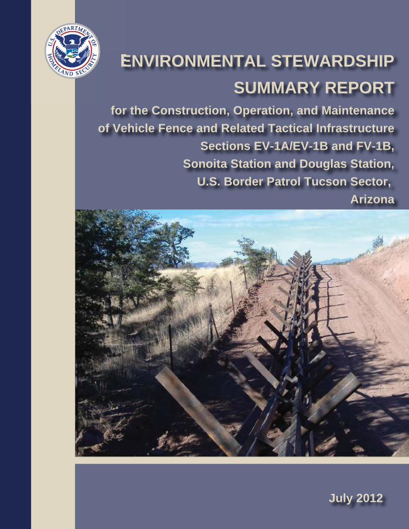
ENVIRONMENTAL STEWARDSHIPSUMMARY REPORT
for the Construction, Operation, and Maintenanceof Vehicle Fence and Related Tactical Infrastructure
Sections EV-1A/EV-1B and FV-1B,Sonoita Station and Douglas Station,
U.S. Border Patrol Tucson Sector, Arizona
July 2012
ENVIRONMENTAL STEWARDSHIP SUMMARY REPORT
FOR THE CONSTRUCTION, OPERATION, AND MAINTENANCE
OF VEHICLE FENCE AND RELATED TACTICAL INFRASTRUCTURE
SECTIONS EV-1A/EV-1B AND FV-1B,
SONOITA STATION AND DOUGLAS STATION,
U.S. BORDER PATROL TUCSON SECTOR,
ARIZONA
July 2012
Lead Agency: Department of Homeland Security
U.S. Customs & Border Protection
Office of Finance, Asset Management
1300 Pennsylvania Ave NW
Washington, DC 20229
Point of Contact: Loren Flossman
Director
Border Patrol Facilities and Tactical Infrastructure
Program Management Office
Facilities Management & Engineering
1301 Constitution Ave NW
EPA West, Suite B-155
Washington, DC 20229

TCA_VF300_ESSR_FINAL Final
EXECUTIVE SUMMARY The U.S. Customs and Border Protection (CBP) Secure Border Initiative (SBI) built tactical infrastructure (TI) for the U.S. Border Patrol (USBP), Tucson Sector. The term TI is used to describe the physical structures that facilitate enforcement activities; these items typically include roads, vehicle and pedestrian fences, lights, gates, and boat ramps. TI built under SBI’s Vehicle Fence 300 (VF300) Program within the Tucson Sector consisted of vehicle fence with adjacent construction/maintenance roads, access roads, and staging areas in two separate sections, Section EV-1A/EV-1B and Section FV-1B. A total of 30.36 miles of vehicle fence was planned to be built, and 30.22 miles were actually built. Section EV-1A/EV-1B, designated as Sonoita Station, is along the U.S./Mexico international border in the San Rafael Valley in Santa Cruz and Cochise counties, Arizona. Section FV-1B, designated as Douglas Station, is along the U.S./Mexico international border near the City of Douglas and is wholly contained within Cochise County. This Environmental Stewardship Summary Report (ESSR) was prepared to document the impact areas, compared with the original ESPs and the changes identified in the CR forms, for the following reasons:
1. To compare anticipated to actual impacts, so that a final new baseline is established for future maintenance and repair and any potential future actions.
2. To document success of BMPs and any changes or improvements for the future. 3. To document any changes to the planned location or type of the TI.
Planned installation of TI was documented in two Environmental Stewardship Plans (ESPs) for the construction, operation, and maintenance of vehicle fence and related TI in the Tucson Sector published in December 2008. Section EV-1A/EV1-B was built between December 2008 and a 2009. Section FV-1B was built between October and December 2008. Overall, CBP determined that the projects within the Tucson Sector covered by this ESSR resulted in approximately 87 fewer acres of habitat and other environmental impacts than were predicted in the project-level ESPs. This represents a 35 percent reduction in impact area over what was predicted in the project-level ESPs for Tucson Sector. Table ES-1 summarizes the comparison of predicted and actual environmental impacts as determined through onsite monitoring during the construction effort. Section EV-1A was excluded from environmental monitoring because construction was limited to retrofitting or replacing existing fence in already disturbed areas. Disturbed areas were restored following retrofit or replacement. Restoration consisted of soil preparation by tilling and hydroseeding with native seed mix.
Table ES-1. Comparison of Predicted and Actual Impacts
Section Predicted Impacts (total acres)
Actual Impacts (total acres)
Difference in Impacts (total acres)
EV-1A/EV-1B 43.60 24.49 - 19.11 FV-1B 207.90 140.06 - 67.84
Totals 251.50 164.55 - 86.95

ES-2
TCA_VF300_ESSR_FINAL Final
CBP is committed to building TI in an environmentally responsible manner, and conducted
environmental resource surveys and prepared management plans to ensure that potential
environmental harm would be avoided or minimized where practical. CBP coordinated with the
U.S. Fish and Wildlife Service (USFWS); Bureau of Land Management (BLM); Arizona State
Historic Preservation Office (SHPO); other Federal, state, and local agencies; and the Tohono
O’odham Tribal Nation, and requested input on potential environmental concerns regarding the
projects.
Affected property owners and members of the general public were also included in outreach
activities. Project descriptions were provided to the public using both a dedicated Internet site
and through public meetings. The current website is http://cbp.gov/xp/cgov/border_security
/ti/ti_docs/sector/tucson/. In its continuing commitment to environmental stewardship, CBP
implemented a comprehensive environmental monitoring program during construction.
Environmental monitors documented daily construction activity and ensured that contractors
adhered to BMPs. Environmental monitors also provided guidance to construction contractors
and the U.S. Army Corps of Engineers (USACE) on natural and cultural resources issues as they
arose, served as a conduit for coordination with resource agencies if needed, and moved animals
and plants from the construction corridor when needed. For example, in Section EV-1B, large
trees that compose one of the Mexican spotted owl’s primary constituent elements—physical and
biological features of a landscape that a species needs to survive and reproduce—were removed;
when this occurred, they were replanted within the restored area to create another Mexican
spotted owl primary constituent element, the presence of large woody debris, in accordance with
a BMP from the December 2008 Tucson Sector Biological Resources Plan (BRP). After
construction was complete, the daily environmental monitor logs and weekly environmental
monitor reports were compiled and analyzed to determine the actual final construction impacts of
the projects within the Tucson Sector covered by this ESSR.
Most BMPs were strictly observed during TI construction in the Tucson Sector. The most
common deviations included insufficient perimeter flagging and resulting out-of-bounds activity,
improperly managed trash and construction waste, concrete-related issues, open trenches without
proper escape ramps for trapped animals, and lack of drip pans underneath stored equipment
causing minor spills. At the close of construction, the vast majority of deviations had been fully
resolved. However, one deviation remained unaddressed in Section EV-1B at the close of
construction. Approximately 1,180 square meters of vegetation were cleared in error before it
was discovered that the original survey of the project corridor was incorrect. The deviation was
noted, and the area was hydroseeded with native seed mix in early summer 2009.
Archaeological resource sites were monitored during the construction process. The
environmental monitor report for Section EV-1B indicates that one unanticipated find was
recorded during the construction and monitoring efforts. A prehistoric artifact scatter was
discovered during construction of a staging area on the east end of EV-1B. The find was
assessed as eligible for inclusion in the National Register of Historic Places (NRHP) under
Criterion D of 36 CFR 60.6. An avoidance zone was established around the site, and the
resource was preserved. The environmental monitor report for Section FV-1B indicates that no
unanticipated finds were recorded during the construction and monitoring efforts. Onsite
mitigation was achieved in Section FV-1B by preserving the “Mormon House” cultural site by
ES-3
TCA_VF300_ESSR_FINAL Final
placing compacted fill on the excavated foundation instead of excavating the structure and
removing artifacts.
At the conclusion of the construction efforts, there were no measureable changes in impacts on
other resource categories beyond those predicted in the original Tucson Sector ESPs. Potential
effects, including physical disturbance and construction of solid barriers on wetlands, riparian
areas, streambeds, and floodplains, were avoided or mitigated, as appropriate. BMPs to protect
natural and cultural resources included a Stormwater Pollution Prevention Plan (SWPPP),
Construction Mitigation and Restoration (CM&R) Plan, Spill Prevention Control and
Countermeasures Plan (SPCCP), Dust Control Plan, Fire Prevention and Suppression Plan, and
Unanticipated Discovery Plan.
After completion of the ESP, changes were made to the alignment, design, or construction
methods to facilitate construction, reduce costs or potential impacts, respond to stakeholder
requests, or enhance the efficacy of fences for enforcement. These changes were reviewed and
approved through CBP Headquarters and documented in Change Request (CR) forms. This
report also summarizes any significant modifications during construction that increased or
reduced environmental impacts.
CBP consultants surveyed the Sections EV-1A/EV-1B and FV-1B sites to inspect the final
project corridor and infrastructure footprints. The survey documented any significant differences
between the planned and completed actions. When changes were noted, the CR forms were
consulted to see if the changes were recorded and approved. A total of 15 CRs were approved
for the two sections; only four of these had the potential to result in environmental impacts.
The post-construction surveys indicated that the affected area in Section EV-1B was 19.11 acres
less than the ESP anticipated. This is primarily due to successful use of less area than was
allotted for the project corridor.
In Section FV-1B the affected area was 67.84 acres less than the ESP anticipated. This is also
primarily due to successful use of less area than was allotted for the project corridor. Other
important contributions to limiting the total impact area were the use of preexisting access roads
for construction access and limiting the number and size of staging areas to the minimum
required for construction. These actions were approved by CRs.
Construction of other TI and maintenance and repair of existing access or other required roads
might be required in the future as mission and operational requirements are continually
reassessed. To the extent that other current and future actions are known, they are discussed in
the project-level ESPs, as are additional project-level details.
TCA_VF300_ESSR_FINAL Final
TABLE OF CONTENTS
EXECUTIVE SUMMARY ................................................................................................... ES-1
1.0 INTRODUCTION, OUTREACH, AND METHODS ................................................... 1-1
1.1 PUBLIC AND AGENCY OUTREACH .................................................................. 1-1 1.2 METHODS ............................................................................................................... 1-1
1.2.1 Environmental Monitoring Process ............................................................ 1-4 1.2.2 Change Request Process ............................................................................. 1-4 1.2.3 Post-Construction Survey Methods ............................................................ 1-5
2.0 DESCRIPTION OF THE PLANNED ACTION ........................................................... 2-1
2.1 SECTION EV-1A/EV-1B ........................................................................................ 2-3 2.2 SECTION FV-1B ..................................................................................................... 2-3 2.3 MONITORING ........................................................................................................ 2-3 2.4 ENVIRONMENTAL MONITOR OVERVIEW ..................................................... 2-7 2.5 CHANGE REQUEST FORMS .............................................................................. 2-11 2.6 IMPACT QUANTITIES ANTICIPATED IN THE ENVIRONMENTAL
STEWARDSHIP PLAN ........................................................................................ 2-11
3.0 POST-CONSTRUCTION FINDINGS............................................................................ 3-1
3.1 RESULTS OF ROAD MEASUREMENTS............................................................. 3-1 3.1.1 Access Roads .............................................................................................. 3-1
3.1.1.1 Section EV-1B ............................................................................. 3-4 3.1.1.2 Section FV-1B ............................................................................. 3-4
3.2 FENCE AND ADJACENT CONSTRUCTION/ MAINTENANCE ROAD .......... 3-4 3.2.1 Section EV-1B ............................................................................................ 3-5 3.2.2 Section FV-1B............................................................................................. 3-5
3.3 STAGING AREAS .................................................................................................. 3-6 3.3.1 Section EV-1B ............................................................................................ 3-6 3.3.2 Section FV-1B............................................................................................. 3-7
3.4 MEASURED IMPACT QUANTITIES ................................................................... 3-7 3.4.1 Section EV-1B ............................................................................................ 3-7
3.4.1.1 Vegetation and Soils .................................................................... 3-7 3.4.1.2 Cultural Resources ....................................................................... 3-9 3.4.1.3 Wetlands and Waters of the United States ................................... 3-9
3.4.2 Section FV-1B............................................................................................. 3-9 3.4.2.1 Vegetation and Soils .................................................................... 3-9 3.4.2.2 Cultural Resources ....................................................................... 3-9 3.4.2.3 Wetlands and Waters of the United States ................................. 3-10
4.0 DISCUSSION .................................................................................................................... 4-1
4.1 INCREASED PROJECT FOOTPRINT ................................................................... 4-1 4.2 DECREASED PROJECT FOOTPRINT .................................................................. 4-1 4.3 ADDITIONAL ISSUES ........................................................................................... 4-1

ii
TCA_VF300_ESSR_FINAL Final
LIST OF FIGURES
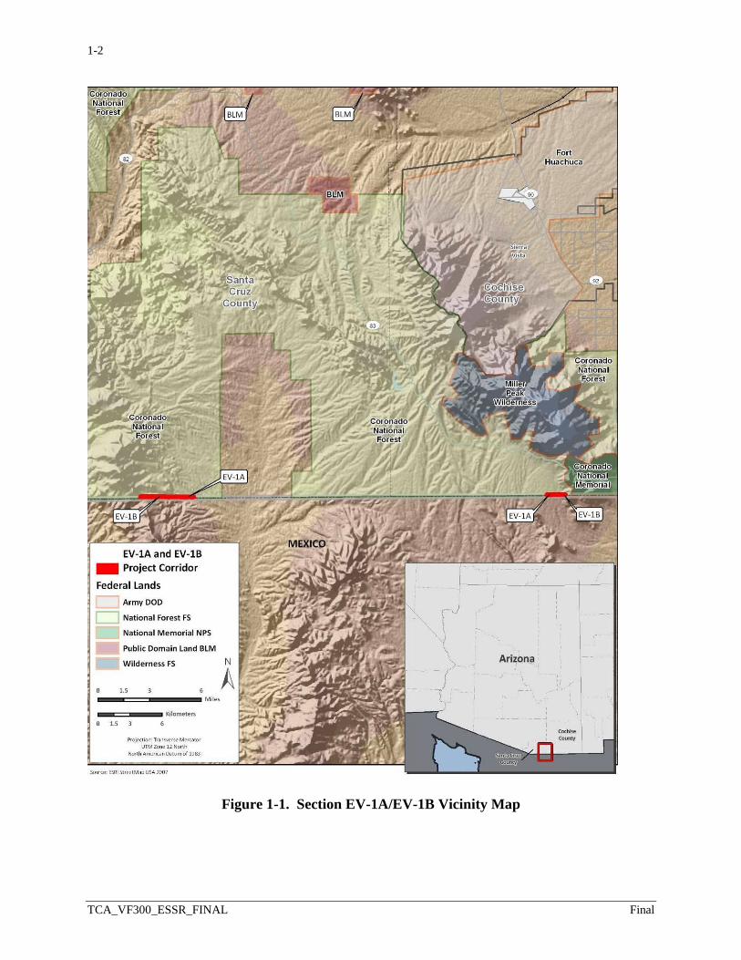
Figure 1-1. Section EV-1A/EV-1B Vicinity Map ..................................................................... 1-2
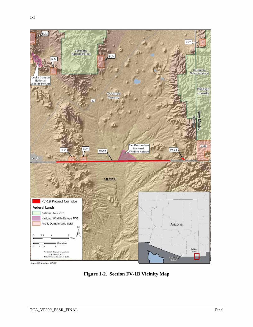
Figure 1-2. Section FV-1B Vicinity Map .................................................................................. 1-3
Figure 2-1. Photograph of Normandy-style Fence .................................................................... 2-2
Figure 2-2. Photograph of Post-on-Rail Fence .......................................................................... 2-2
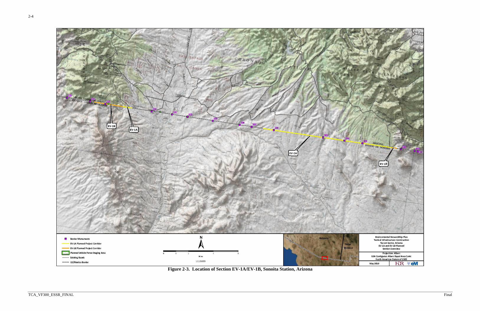
Figure 2-3. Location of Section EV-1A/EV-1B, Sonoita Station, Arizona ............................... 2-4
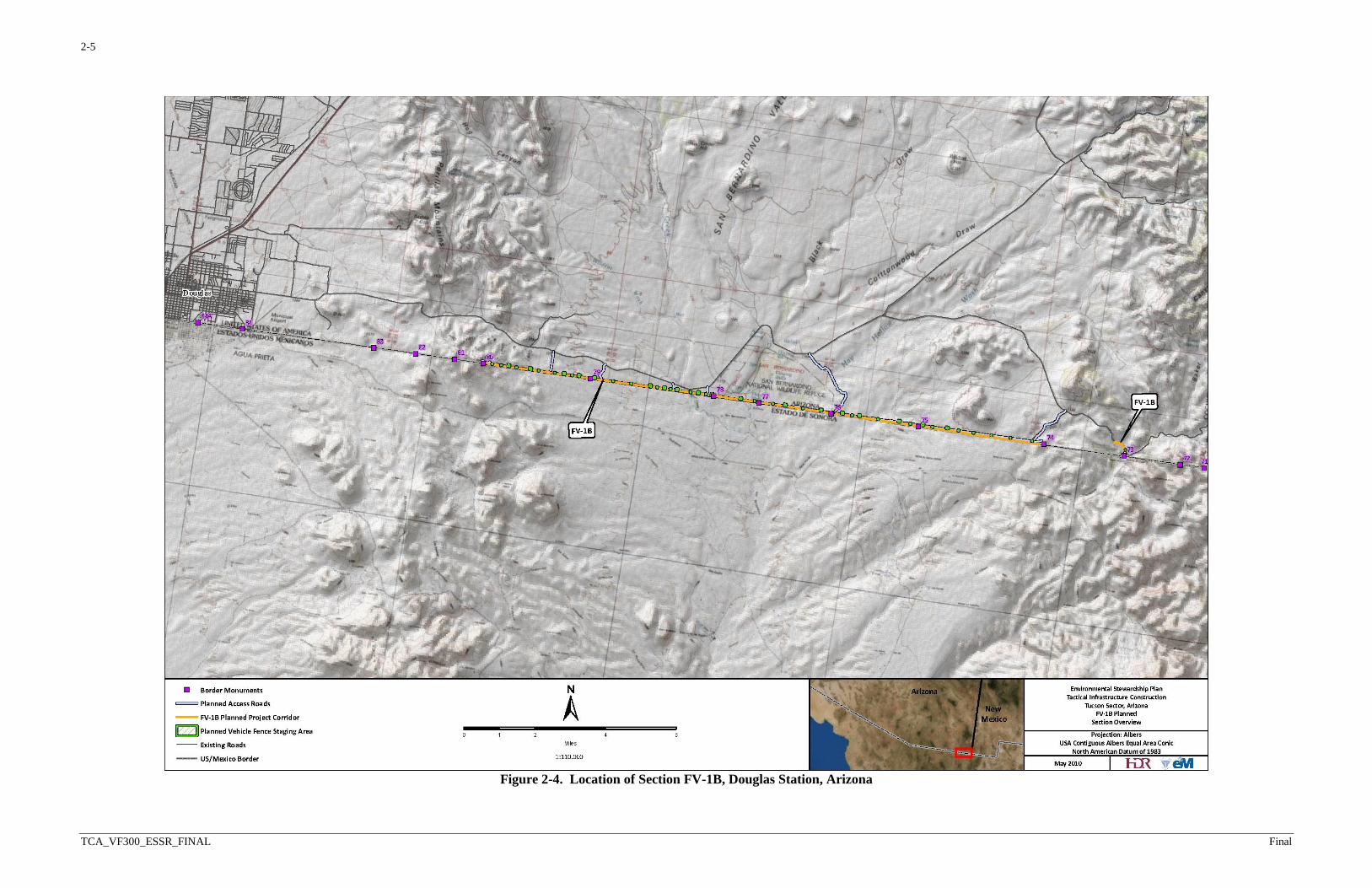
Figure 2-4. Location of Section FV-1B, Douglas Station, Arizona .......................................... 2-5
Figure 2-5. Photograph of Unauthorized Work in Black Draw in Section FV-1B ................... 2-9
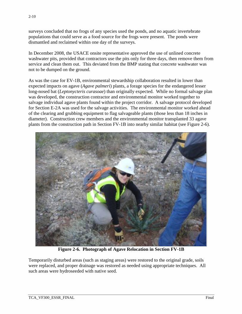
Figure 2-6. Photograph of Agave Relocation in Section FV-1B ............................................. 2-10
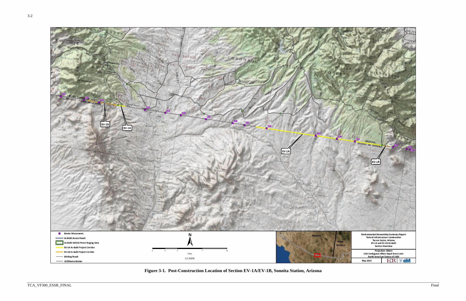
Figure 3-1. Post-Construction Location of Section EV-1A/EV-1B, Sonoita Station, Arizona . 3-2
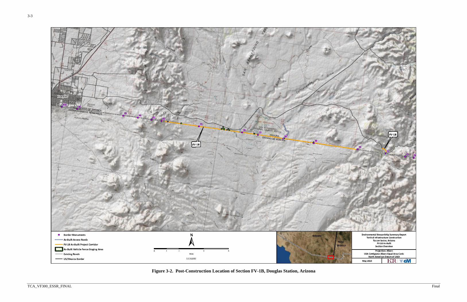
Figure 3-2. Post-Construction Location of Section FV-1B, Douglas Station, Arizona ............ 3-3
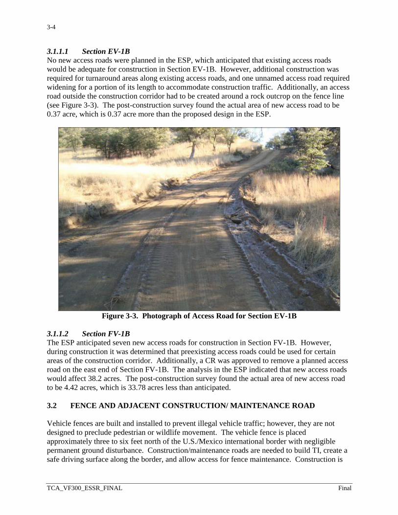
Figure 3-3. Photograph of Access Road for Section EV-1B ..................................................... 3-4
Figure 3-4. Photograph of Section EV-1B Fence Construction on Steep Terrain ..................... 3-5
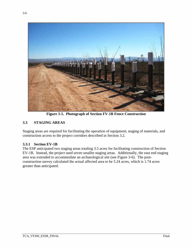
Figure 3-5. Photograph of Section FV-1B Fence Construction ................................................ 3-6
Figure 3-6. Photograph of Staging Area for Section EV-1B ..................................................... 3-7
Figure 3-7. Photograph of Vegetation in Section EV-1B .......................................................... 3-8
Figure 3-8. Photograph of Mormon House Site in Section FV-1B ......................................... 3-10
LIST OF TABLES
Table ES-1. Comparison of Predicted and Actual Impacts ......................................................ES-1
Table 2-1. Summary of BMP Infractions ................................................................................. 2-6
Table 2-2. Summary of Approved CRs .................................................................................. 2-11
Table 2-3. Resources Anticipated to Be Impacted ................................................................. 2-12
Table 3-1. Construction Impacts for Vehicle Fence Sections in Tucson Sector (Acres) ......... 3-1
Table 3-2. Summary of Anticipated Versus Actual Impacts Associated with the Vegetative
Community Types in the Tucson Sector ................................................................. 3-8
LIST OF APPENDICES
Appendix A. Public Outreach and Coordination

SECTION 1.0INTRODUCTION, OUTREACH, AND METHODS
1-1
TCA_VF300_ESSR_FINAL Final
1.0 INTRODUCTION, OUTREACH, AND METHODS
In support of a continuing commitment to environmental stewardship for the construction,
operation, and maintenance of tactical infrastructure (TI) along the U.S./Mexico international
border in the U.S. Border Patrol (USBP) Tucson Sector, U.S. Customs and Border Protection
(CBP) prepared project-level Environmental Stewardship Plans (ESPs) under the Vehicle Fence
300 (VF300) program that documented the projected environmental effects of planned projects.
TI within the Tucson Sector consisted of vehicle fence with adjacent construction/maintenance
roads, access roads, and staging areas in two separate sections. The ESPs planned for a total of
30.36 miles of vehicle fence to be built, and 30.22 miles were actually built. The ESPs discussed
CBP plans to mitigate potential environmental impacts and detailed the best management
practices (BMPs) for the TI that CBP would implement during and after construction.
After construction was completed, CBP prepared this Environmental Stewardship Summary
Report (ESSR), which consolidates and summarizes the Sonoita Station (Section EV-1A/EV-1B)
and Douglas Station (Section FV-1B) VF300 project-level ESPs into a single document.
Information in this ESSR was compiled from environmental summary reports and approved
modifications made during construction, and through a post-construction survey of the project
corridor. This ESSR compares anticipated impacts described and assessed in the original ESPs
to actual impacts after construction. Project vicinity maps are presented in Figures 1-1 and 1-2.
Construction of other TI and maintenance and repair of existing access or other required roads
might be required in the future as mission and operational requirements are continually
reassessed. To the extent that other current and future actions are known, they are discussed in
the project-level ESPs, as are additional project-level details.
1.1 PUBLIC AND AGENCY OUTREACH
CBP is fully committed to public and agency outreach in building, operating, and maintaining
TI. CBP conducted environmental resource surveys and prepared management plans to ensure
avoiding or minimizing potential environmental harm where practical. CBP coordinated with
the U.S. Fish and Wildlife Service (USFWS); Arizona State Historic Preservation Office
(SHPO); other Federal, state, and local agencies; and the Tohono O’odham Tribal Nation, and
requested input on potential environmental concerns regarding the projects.
CBP also included affected property owners and members of the general public in outreach
activities. It provided project descriptions to the public using both a dedicated internet site
resource and public meetings. The current internet site is http://cbp.gov/xp/cgov/border_security
/ti/ti_docs/sector/tucson/. A detailed summary of CBP’s public outreach and agency
coordination throughout ESP development is contained in Appendix A.
1.2 METHODS
During construction, CBP followed specially developed criteria to reduce environmental damage
and implemented mitigation measures to further reduce or offset environmental damage to the
extent practical. Mitigation measures to reduce environmental harm included avoiding physical
1-2
TCA_VF300_ESSR_FINAL Final
Figure 1-1. Section EV-1A/EV-1B Vicinity Map
1-3
TCA_VF300_ESSR_FINAL Final
Figure 1-2. Section FV-1B Vicinity Map
1-4
TCA_VF300_ESSR_FINAL Final
disturbance and building barriers in wetlands, riparian areas, and streambeds, where practicable.
Consultation with Federal and state agencies and other stakeholders augmented efforts to avoid
or minimize environmental damage. CBP used appropriate BMPs to protect natural and cultural
resources. BMPs to protect natural and cultural resources included a Stormwater Pollution
Prevention Plan (SWPPP), Construction Mitigation and Restoration (CM&R) Plan, Spill
Prevention Control and Countermeasures Plan (SPCCP), Dust Control Plan, Fire Prevention and
Suppression Plan, and Unanticipated Discovery Plan. Some of these same criteria and BMPs
will be used during operation and maintenance to reduce or offset environmental harm and
protect natural and cultural resources.
1.2.1 Environmental Monitoring Process
CBP implemented a comprehensive monitoring program during construction in which
environmental monitors documented daily construction activity and ensured that the construction
contractor adhered to BMPs. Environmental monitors also provided guidance to construction
contractors and the U.S. Army Corps of Engineers (USACE) on natural and cultural resources
issues as they arose, served as a conduit for coordination with resource agencies if needed, and
moved animals from the construction corridor when needed. After construction was complete,
the daily monitor logs and weekly monitor reports were compiled and analyzed to determine the
actual final construction impacts of the projects within USBP Tucson Sector covered by this
ESSR.
CBP implemented an environmental monitoring reporting program for construction of the
projects discussed in this ESSR. Environmental Monitor Reports documented conformance to
BMPs; issues related to environmental resources, such as threatened and endangered species
habitat; and cultural resources encountered during construction.
The reports also documented BMP infractions, including the impact of the BMP infractions on
biological, cultural, or other resources, and corrective actions taken. They also summarize
completed and planned construction activity.
1.2.2 Change Request Process
CBP developed a Change Management Process (CMP) to identify, analyze, and approve
unforeseen modifications during design and construction of TI, and set up an environmental
monitoring program to document compliance with environmental requirements and adherence to
the BMPs during construction. The CMP employed a formal system of design and construction
change requests (CRs). Each CR was evaluated for potential environmental impacts as part of
the approval process.
CRs document unforeseen modifications, additions, or deletions during construction. These
changes occur as a result of various factors, including changes in terrain, construction material
changes, variations in planned routes and staging areas, stakeholder requests, and other causes.
Each CR contains its own unique identifier. In addition, each request describes the requested
change, states a justification for why the change was necessary, discusses additional costs, if
applicable, and describes how the change might affect the construction schedule. If necessary,
the CR includes attachments such as maps or photographs to further explain the change. Each
CR was reviewed and submitted to CBP Headquarters for approval.
1-5
TCA_VF300_ESSR_FINAL Final
1.2.3 Post-Construction Survey Methods
The objective of the post-construction survey was to locate, identify, photograph, and record the
installation of the TI infrastructure, including types of fence and the width of access roads and
the project corridor. In addition, the surveys recorded biological communities, wetlands, and
other environmental conditions in and adjacent to the project corridor. They also recorded any
other unusual conditions observed (such as fence failure, significant erosion, hazardous waste, or
construction debris).
Before the field survey, CBP produced maps of the project corridor as described in the ESP. The
ESP was reviewed for the description of locations and type of fence to be installed, location and
width of access and maintenance area, and location and size of staging areas. Approved CR
forms were also produced and used in the field to document approved changes. Surveyors
examined the entire USBP Tucson Sector project corridor and recorded the centerline, length,
and width of construction and access road alignments using a Trimble Global Positioning System
(GPS). The surveyors also took periodic GPS coordinates of the temporary and permanent
construction footprint, particularly when the corridor appeared to be expanded or reduced. They
also recorded perimeters of staging areas using GPS, and the start and stop coordinates for
various fence types.

SECTION 2.0DESCRIPTION OF THE PLANNED ACTION
2-1
TCA_VF300_ESSR_FINAL Final
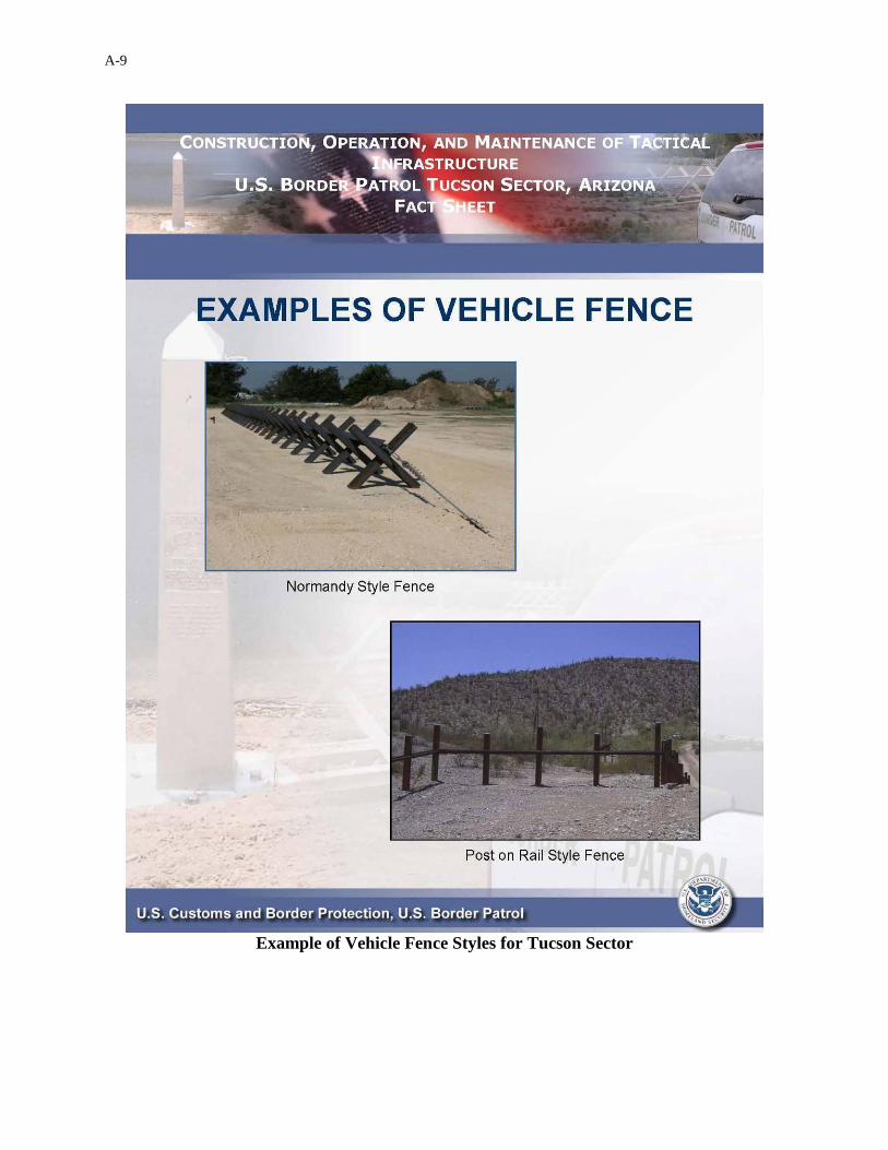
2.0 DESCRIPTION OF THE PLANNED ACTION CBP built and now intends to operate and maintain approximately 38 miles of TI, including approximately 30 miles of vehicle fence and eight miles of access roads along the U.S./Mexico international border in Sonoita and Douglas stations, Tucson Sector, Arizona. The locations of TI were based on a Tucson Sector assessment of local operational requirements that identified where such infrastructure will assist USBP agents in reducing illegal cross-border activities. Where possible, CBP also determined the location and design of TI through consultations with local stakeholders. The vehicle fence for Section EV-1A/EV-1B consists of 11.1 miles of Normandy-style fence (see Figure 2-1) and 2.8 miles of post-on-rail fence (see Figure 2-2). Vehicle fence in Section FV-1B consists of 16.5 miles of post-on-rail fence. Generally, vehicle fencing was installed approximately three to six feet north of the United States/Mexico international border within the Roosevelt Reservation.1 The fencing affected an approximately 60-foot-wide corridor along each fence section, although some construction contractors were successful in using a narrower corridor, as noted in some environmental monitor reports. TI was built around U.S. Section, International Boundary and Water Commission (USIBWC) monuments. Wherever possible, contractors used existing roads and previously disturbed areas for construction access and staging. Any necessary aggregate or fill material was clean material they obtained from available sources that did not pose damage to biological or cultural resources. New fence was fabricated from nonreflective steel and required no painting. Maintenance will include removing any debris accumulated on the fence after rain to avoid potential future flooding. It is anticipated that the Normandy-style fence placed within the washes will sufficiently allow water and debris through during storms. Following storms the washes will be patrolled for large debris, and the debris will be removed. Normandy-style fence was securely anchored to the bottom and sides of washes. Sand that builds up against the fence and brush near the fence will also be removed, as needed. Brush removal could include mowing, removal of small trees, and application of U.S. Environmental Protection Agency (USEPA) and U.S. Department of Agriculture (USDA) approved herbicide, if needed. Any destruction or breaches of the fence will be repaired, as needed. Additionally, access roads will be maintained or potentially upgraded to ensure year-round access for fence maintenance. Access road maintenance activities could include the periodic grading or repairing of eroded areas.
1 In 1907, President Roosevelt reserved from entry and set apart as a public reservation all public lands within 60
feet of the international boundary between the United States and Mexico within the State of California and the Territories of Arizona and New Mexico. Known as the “Roosevelt Reservation,” this land withdrawal was found “necessary for the public welfare ... as a protection against the smuggling of goods.” The proclamation excepted from the reservation all lands, which, as of its date, were (1) embraced in any legal entry; (2) covered by any lawful filing, selection, or rights of way duly recorded in the proper U.S. Land Office; (3) validly settled pursuant to law; or (4) within any withdrawal or reservation for any use or purpose inconsistent with its purposes (CRS 2006).

2-2
TCA_VF300_ESSR_FINAL Final
Figure 2-1. Photograph of Normandy-style Fence
Figure 2-2. Photograph of Post-on-Rail Fence

2-3
TCA_VF300_ESSR_FINAL Final
2.1 SECTION EV-1A/EV-1B
Within the Sonoita Station Area of Responsibility (AOR), the TI designated as Section EV-
1A/EV-1B is 13.9 miles long, including 11.1 miles of Normandy-style vehicle fence and 2.8
miles of post-on-rail vehicle fence. Section EV-1A/EV-1B lies along the U.S./Mexico
international border in the San Rafael Valley in Santa Cruz and Cochise counties (see Figure 2-
3). The vehicle fence is placed approximately three to six feet north of the border, within the
Roosevelt Reservation.
2.2 SECTION FV-1B
Within the Douglas Station AOR, the TI designated as Section FV-1B totals 16.5 miles of post-
on-rail vehicle fence and 8.0 miles of access road. Section FV-1B lies along the U.S./Mexico
international border in the San Rafael Valley near the City of Douglas and is wholly contained
within Cochise County (see Figure 2-4). The vehicle fence section is placed approximately three
to six feet north of the border, within the Roosevelt Reservation.
2.3 MONITORING
Monitoring reports for VF300 TI construction were prepared weekly by a third-party contractor
and contained daily logs. Post-construction environmental monitor reports documented the final
overall impacts from all projects within the Tucson Sector covered by this ESSR, and compared
the actual post-construction impacts with those predicted in the individual project-level ESPs.
Table 2-1 summarizes BMP infractions listed in the environmental monitor reports that posed
damage to biological, cultural, or other resources. Through the course of construction, changes
to construction plans, discrepancies in environmental documents, and unexpected field
conditions led USACE and the environmental monitors to work together with USFWS
representatives to resolve various issues.
The environmental monitors, sector coordinators, and other members of the monitoring team
provided environmental support in these situations by analyzing BMPs and field surveys to
document changes and minimize any potential harm. Issues were minimal within the Tucson
Sector project sections relative to the size of the project. Most issues identified by the monitors
were immediately brought to the attention of the project engineer and resolved promptly. TI
construction in the Tucson Sector strictly adhered to most BMPs. Additionally, the weekly
monitoring reports advised the USFWS of infractions. Section EV-1A was excluded from
environmental monitoring because construction was limited to retrofitting or replacing existing
fence in already disturbed areas. Disturbed areas were restored following retrofit or replacement.
Restoration consisted of soil preparation by tilling and hydroseeding with native seed mix.
2-4
TCA_VF300_ESSR_FINAL Final
Figure 2-3. Location of Section EV-1A/EV-1B, Sonoita Station, Arizona
2-5
TCA_VF300_ESSR_FINAL Final
Figure 2-4. Location of Section FV-1B, Douglas Station, Arizona

2-6
TCA_VF300_ESSR_FINAL Final
Table 2-1. Summary of BMP Infractions
BMP Deviation Resolution
Average Number of Days Left
Unresolved
Section Number of Deviations Per Section
1
Perimeter flagging in the alignment corridor was insufficient, sometimes resulting in out-of-bounds activity.
Perimeter flagging was improved or the deviation was indirectly resolved by completing construction and removing equipment from the project corridor.
91
EV-1B 2
FV-1B 1
7 and 10
The widening of existing or created roadbed beyond the design parameters due to improper maintenance and use was not avoided or minimized.
Section FV-1B was hydroseeded with native seed mix during construction. Section EV-1B was hydroseeded with native seed mix post-construction.
56 days in Section FV-
1b
EV-1B 7
FV-1B 1
20 and 27
A copy of the SWPPP was not present, or the SWPPP was not adequately implemented.
SWPPP documentation was finalized and provided to the environmental monitor.
33 FV-1B 2
21 and 28
Drip pans were not always placed under parked or stored equipment; petroleum-based spills were not adequately cleaned immediately after occurring; refueling occurred without an adequate containment zone.
Drip pans were placed under equipment and containment zones were used for refueling, or deviations were indirectly resolved due to completion of construction and removal of equipment from the project corridor. A spill plan was never provided for Section FV-1B.
47
EV-1B 2
FV-1B 10
23 and 30
Food-related trash items were found as litter along the project corridor, or trash containers with food-related trash items were not removed daily from the project site.
Trash items were disposed of properly or deviation was indirectly resolved due to completion of construction and removal of trash containers from the project corridor.
54
EV-1B 1
FV-1B 1
24 and 31
Nonhazardous waste materials and other discarded materials such as construction waste were found as litter along the project corridor or were otherwise insufficiently contained.
All nonhazardous waste materials were removed from the project area, and construction material spills were sufficiently cleaned.
45
EV-1B 8
FV-1B 4
2-7
TCA_VF300_ESSR_FINAL Final
BMP Deviation Resolution
Average Number of Days Left
Unresolved
Section Number of Deviations Per Section
25 and 32 Concrete washwater was disposed of improperly.
Sites of improper concrete washwater discharge were sufficiently cleaned; two areas of improper concrete washwater discharge remained visible and unresolved as of the environmental monitor’s final visit to Section FV-1B.
55 days
EV-1B 4
FV-1B 8
39 and 47
Open trenches were not properly equipped with wildlife escape ramps or holes were left uncovered overnight.
Ramps were installed into the trenches or panels were placed into all open holes or trenches and cemented into place.
2 FV-1B 15
42 and 50 Off-road vehicle activity was documented outside the project corridor.
The areas affected by off-road vehicle activity in Section FV-1B were hydroseeded.
23 days FV-1B 4
2.4 ENVIRONMENTAL MONITOR OVERVIEW Section EV-1B The most common deviations from the established BMPs in Section EV-1B included insufficient perimeter flagging and resulting out-of-bounds activity, improperly managed trash and construction waste, concrete-related issues, open trenches without proper escape ramps for trapped animals, and lack of drip pans underneath stored equipment that allowed minor spills. At the close of construction, the vast majority of the deviations had been fully resolved. One deviation remained unaddressed: approximately 1,180 square meters of vegetation were cleared in error before it was discovered that the original survey of the project corridor was incorrect. No restoration activities had occurred there as of the final walk-through. However, the area was hydroseeded with native seed mix in early summer 2009, which resolved the deviation. The USACE onsite representative approved the construction of a reroute of the planned construction road to avoid difficult terrain. The proposed reroute was within critical habitat for the Mexican spotted owl. On January 7, 2009 the environmental monitor completed a biological survey of the proposed impact area and found no federally or state-listed species in the reroute area. Vegetation on the route was cleared before January 15, 2009. In March 2009, the USACE onsite representative allowed cement trucks to wash out onto the riprap in low water crossings that were to be cemented in the future, rather than washing out into designated lined pits. No long-term harm to listed species resulted from the practice, as no aquatic habitat that was at risk of contamination was present in this section. On January 5, 2009, large pieces of equipment traveling into the site remained on the road but broke several large branches off nearby trees. Although this incident was not considered a BMP
Table 2-1, continued
2-8
TCA_VF300_ESSR_FINAL Final
deviation, the contractor agreed to pile the broken branches according to the species-specific
BMPs and trimmed the broken areas of the damaged trees. Treatment paint was applied to the
exposed broken areas of the trees on January 15, 2009.
Environmental stewardship collaboration resulted in lower than expected impacts on agave
(Agave palmeri) plants, a forage species for the endangered lesser long-nosed bat (Leptonycteris
curasoae). While no formal salvage plan was developed, the construction contractor and
environmental monitor worked together to salvage individual agave plants found within the
project corridor. A salvage protocol developed for Section E-2A, Naco Station, in Cochise
County was used for the salvage activities. The environmental monitor worked ahead of the
clearing and grubbing equipment to flag salvageable plants (those less than 18 inches in
diameter). Construction crew members transplanted approximately 300 agave plants from the
EV-1B construction path into nearby similar habitat.
When construction activity removed large trees that compose one of the Mexican spotted owl’s
primary constituent elements (physical and biological features of a landscape that a species needs
to survive and reproduce), they were replanted within the restored area to create another Mexican
spotted owl primary constituent element, the presence of large woody debris, in accordance with
a BMP from the Tucson Sector BRP.
Three archaeological resources sites were monitored during construction for Section EV-1B.
The environmental monitor report indicated that one of these sites was an unanticipated find
recorded during construction and monitoring. A prehistoric artifact scatter was discovered
during grading of a staging area. The site was assessed as eligible for National Register of
Historic Places (NRHP) inclusion, and an avoidance area was established to preserve the
resource.
Section FV-1B
The most common deviations from the established BMPs in Section FV-1B included insufficient
perimeter flagging and resulting out-of-bounds activity, improperly managed trash and
construction waste, concrete-related issues, and lack of drip pans underneath stored equipment,
allowing minor spills. At the close of construction activities, all deviations had been fully
resolved.
Two incidents occurred during construction. In the first, on October 20, 2008, a bulldozer
operator worked past the end point of the area surveyed by the environmental monitor and
authorized for vegetation removal (see Figure 2-5). The operator bulldozed a path through the
bottom of Black Draw. The environmental monitor was observing vegetation removal activities
elsewhere on the section and did not witness the event. Shortly after the incident, the monitor
arrived at Black Draw and observed small fish both upstream and downstream from the
bulldozed area, but was unable to get close enough to identify the species. The monitor was also
unable to verify whether any federally listed species were harmed by the incident.

2-9
TCA_VF300_ESSR_FINAL Final
Figure 2-5. Photograph of Unauthorized Work
in Black Draw in Section FV-1B
The BRP indicated that three federally listed fish species occur in Black Draw, but these species
were not identified. USFWS information indicated that there were known occurrences of the
beautiful shiner, Yaqui catfish, Yaqui chub, and Yaqui topminnow in Black Draw, a tributary of
the Rio Yaqui Basin. Three of these species, the beautiful shiner, Yaqui catfish, and Yaqui chub,
were listed with designated critical habitat, and the clearing activities affected this critical
habitat.
The contractor reestablished the stream channel soon after the event using heavy equipment that
worked through the bottom of the stream channel to remove soil deposited by the bulldozer. Silt
fencing was installed to reduce sedimentation into the stream. A temporary culvert was installed
through the stream channel to facilitate better flow, and erosion-control measures such as fiber
rolls and riprap were placed along the remaining disturbed areas to further control sedimentation
issues. CBP worked closely with the land manager and USFWS ecological services to
permanently protect this stream. The culvert was removed, the area was restored to its original
contour, and stabilization measures were assured.
The second incident occurred on November 2, 2008, when two unauthorized water retention
ponds were excavated and built onsite. The ponds posed a potential threat for Chiricahua
leopard frogs in the area by potentially providing the illusion of suitable habitat for the frogs or
other aquatic species that harbor the fungal disease chytridiomycosis. The construction
contractor agreed to install silt fencing around the ponds to exclude any small vertebrate animals
from entering. Wildlife biologists that hold USFWS approval for the Chiricahua leopard frog
surveys assessed the ponds for frog presence using an established protocol for that frog. The
2-10
TCA_VF300_ESSR_FINAL Final
surveys concluded that no frogs of any species used the ponds, and no aquatic invertebrate
populations that could serve as a food source for the frogs were present. The ponds were
dismantled and reclaimed within one day of the surveys.
In December 2008, the USACE onsite representative approved the use of unlined concrete
washwater pits, provided that contractors use the pits only for three days, then remove them from
service and clean them out. This deviated from the BMP stating that concrete washwater was
not to be dumped on the ground.
As was the case for EV-1B, environmental stewardship collaboration resulted in lower than
expected impacts on agave (Agave palmeri) plants, a forage species for the endangered lesser
long-nosed bat (Leptonycteris curasoae) than originally expected. While no formal salvage plan
was developed, the construction contractor and environmental monitor worked together to
salvage individual agave plants found within the project corridor. A salvage protocol developed
for Section E-2A was used for the salvage activities. The environmental monitor worked ahead
of the clearing and grubbing equipment to flag salvageable plants (those less than 18 inches in
diameter). Construction crew members and the environmental monitor transplanted 33 agave
plants from the construction path in Section FV-1B into nearby similar habitat (see Figure 2-6).
Figure 2-6. Photograph of Agave Relocation in Section FV-1B
Temporarily disturbed areas (such as staging areas) were restored to the original grade, soils
were replaced, and proper drainage was restored as needed using appropriate techniques. All
such areas were hydroseeded with native seed.

2-11
TCA_VF300_ESSR_FINAL Final
Eighteen archaeological resources sites were monitored during construction for FV-1B. The
environmental monitor report for this section indicates that no unanticipated finds were recorded
during construction and monitoring.
2.5 CHANGE REQUEST FORMS
This project used the previously described CR process. Most CRs for VF300 TI in the Tucson
Sector did not add to the environmental impacts expected in the original project-level ESPs, and
in some cases they reduced environmental impacts. Where a design or construction change
resulted in a change from the baseline established in the project-level ESPs, the change typically
reduced the impacts. For example, the “Mormon House” cultural site in FV-1B was preserved
by placing compacted fill on the structure instead of excavating the structure and removing
artifacts. Other examples include reducing the number of staging areas and eliminating
unnecessary access roads.
Fifteen CR forms were approved during construction of the Tucson Sector corridor. However,
only four modifications had the potential to affect the construction footprint and, thus, change the
environmental impacts. Table 2-2 summarizes the project modifications determined to have the
potential to change the environmental effects discussed in the ESPs.
Table 2-2. Summary of Approved CRs
CR
No. Section Brief Description of Change Impact Date of Approval
7 FV-1B
Remove access roads on east end,
since no vehicle fence will be
built.
Minor beneficial impact on
soils and surface water due to
reduced construction activity.
June 3, 2008
41 FV-1B
Remove staging area 45, as it is
unnecessary and on an
archaeological site on Arizona
state land.
Minor beneficial impact on
cultural resources. Minor
beneficial impact by 2.07 acres
to soils and surface water due
to reduced construction
activity.
September 19, 2008
71 FV-1B
Preserve the “Mormon House”
cultural site by placing
compacted fill on the excavated
foundation instead of excavating
the structure and removing
artifacts.
Major beneficial impact on
cultural resources. December 9, 2008
79 EV-1B
Improve the existing access road
and delete the planned access
road on U.S. Forest Service
(USFS) property.
Minor beneficial impact on
soils and surface water due to
reduced construction activity.
December 24, 2008
2.6 IMPACT QUANTITIES ANTICIPATED IN THE ENVIRONMENTAL
STEWARDSHIP PLAN
Table 2-3 identifies the pertinent resources that the ESPs expected construction to affect. This is
not all-inclusive, as post-construction quantities for some resource impacts (such as air, noise,
2-12
TCA_VF300_ESSR_FINAL Final
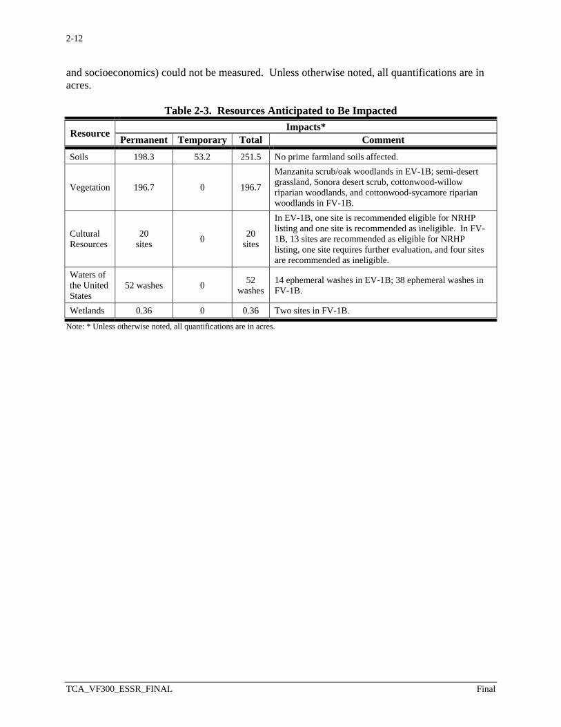
and socioeconomics) could not be measured. Unless otherwise noted, all quantifications are in acres.
Table 2-3. Resources Anticipated to Be Impacted
Resource Impacts* Permanent Temporary Total Comment
Soils 198.3 53.2 251.5 No prime farmland soils affected.
Vegetation 196.7 0 196.7
Manzanita scrub/oak woodlands in EV-1B; semi-desert grassland, Sonora desert scrub, cottonwood-willow riparian woodlands, and cottonwood-sycamore riparian woodlands in FV-1B.
Cultural Resources
20 sites 0 20
sites
In EV-1B, one site is recommended eligible for NRHP listing and one site is recommended as ineligible. In FV-1B, 13 sites are recommended as eligible for NRHP listing, one site requires further evaluation, and four sites are recommended as ineligible.
Waters of the United States
52 washes 0 52 washes
14 ephemeral washes in EV-1B; 38 ephemeral washes in FV-1B.
Wetlands 0.36 0 0.36 Two sites in FV-1B.
Note: * Unless otherwise noted, all quantifications are in acres.

SECTION 3.0POST-CONSTRUCTION FINDINGS
3-1
TCA_VF300_ESSR_FINAL Final
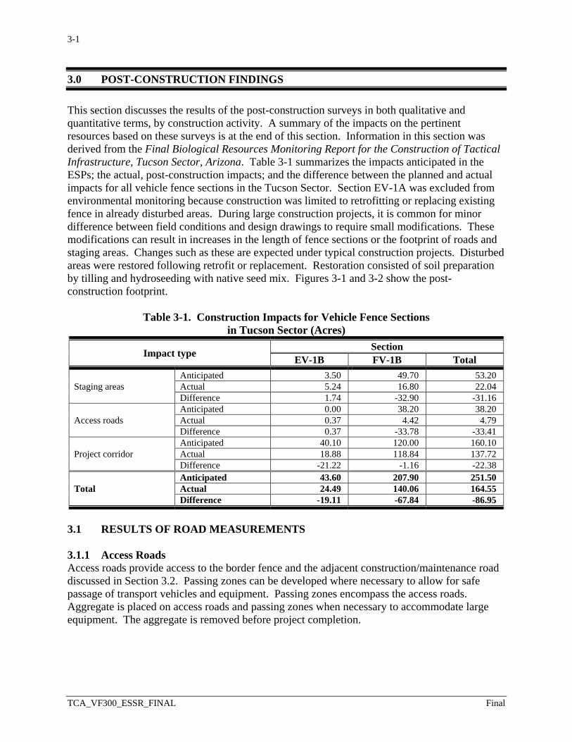
3.0 POST-CONSTRUCTION FINDINGS This section discusses the results of the post-construction surveys in both qualitative and quantitative terms, by construction activity. A summary of the impacts on the pertinent resources based on these surveys is at the end of this section. Information in this section was derived from the Final Biological Resources Monitoring Report for the Construction of Tactical Infrastructure, Tucson Sector, Arizona. Table 3-1 summarizes the impacts anticipated in the ESPs; the actual, post-construction impacts; and the difference between the planned and actual impacts for all vehicle fence sections in the Tucson Sector. Section EV-1A was excluded from environmental monitoring because construction was limited to retrofitting or replacing existing fence in already disturbed areas. During large construction projects, it is common for minor difference between field conditions and design drawings to require small modifications. These modifications can result in increases in the length of fence sections or the footprint of roads and staging areas. Changes such as these are expected under typical construction projects. Disturbed areas were restored following retrofit or replacement. Restoration consisted of soil preparation by tilling and hydroseeding with native seed mix. Figures 3-1 and 3-2 show the post-construction footprint.
Table 3-1. Construction Impacts for Vehicle Fence Sections in Tucson Sector (Acres)
Impact type Section EV-1B FV-1B Total
Staging areas Anticipated 3.50 49.70 53.20 Actual 5.24 16.80 22.04 Difference 1.74 -32.90 -31.16
Access roads Anticipated 0.00 38.20 38.20 Actual 0.37 4.42 4.79 Difference 0.37 -33.78 -33.41
Project corridor Anticipated 40.10 120.00 160.10 Actual 18.88 118.84 137.72 Difference -21.22 -1.16 -22.38
Total Anticipated 43.60 207.90 251.50 Actual 24.49 140.06 164.55 Difference -19.11 -67.84 -86.95
3.1 RESULTS OF ROAD MEASUREMENTS 3.1.1 Access Roads Access roads provide access to the border fence and the adjacent construction/maintenance road discussed in Section 3.2. Passing zones can be developed where necessary to allow for safe passage of transport vehicles and equipment. Passing zones encompass the access roads. Aggregate is placed on access roads and passing zones when necessary to accommodate large equipment. The aggregate is removed before project completion.
3-2
TCA_VF300_ESSR_FINAL Final
Figure 3-1. Post-Construction Location of Section EV-1A/EV-1B, Sonoita Station, Arizona
3-3
TCA_VF300_ESSR_FINAL Final
Figure 3-2. Post-Construction Location of Section FV-1B, Douglas Station, Arizona
3-4
TCA_VF300_ESSR_FINAL Final
3.1.1.1 Section EV-1B
No new access roads were planned in the ESP, which anticipated that existing access roads
would be adequate for construction in Section EV-1B. However, additional construction was
required for turnaround areas along existing access roads, and one unnamed access road required
widening for a portion of its length to accommodate construction traffic. Additionally, an access
road outside the construction corridor had to be created around a rock outcrop on the fence line
(see Figure 3-3). The post-construction survey found the actual area of new access road to be
0.37 acre, which is 0.37 acre more than the proposed design in the ESP.
Figure 3-3. Photograph of Access Road for Section EV-1B
3.1.1.2 Section FV-1B
The ESP anticipated seven new access roads for construction in Section FV-1B. However,
during construction it was determined that preexisting access roads could be used for certain
areas of the construction corridor. Additionally, a CR was approved to remove a planned access
road on the east end of Section FV-1B. The analysis in the ESP indicated that new access roads
would affect 38.2 acres. The post-construction survey found the actual area of new access road
to be 4.42 acres, which is 33.78 acres less than anticipated.
3.2 FENCE AND ADJACENT CONSTRUCTION/ MAINTENANCE ROAD
Vehicle fences are built and installed to prevent illegal vehicle traffic; however, they are not
designed to preclude pedestrian or wildlife movement. The vehicle fence is placed
approximately three to six feet north of the U.S./Mexico international border with negligible
permanent ground disturbance. Construction/maintenance roads are needed to build TI, create a
safe driving surface along the border, and allow access for fence maintenance. Construction is

3-5
TCA_VF300_ESSR_FINAL Final
typically contained within the 60-foot-wide Roosevelt Reservation corridor unless there are
extenuating circumstances such as rugged terrain.
3.2.1 Section EV-1B
The analysis in the ESP indicated that the construction corridor for Section EV-1B could require
ground disturbance up to 120 feet north of the U.S./Mexico international border due to the
rugged terrain (see Figure 3-4). According to the post-construction survey, the contractor used
an area significantly narrower than the allowed construction design. The ESP indicated that the
designed construction corridor for EV-1B contained 40.1 acres. The post-construction survey
calculated the actual affected area to be 18.88 acres, which is 21.22 acres less than anticipated.
Figure 3-4. Photograph of Section EV-1B Fence Construction
on Steep Terrain
3.2.2 Section FV-1B
The ESP indicated that the 60-foot-wide construction corridor for Section FV-1B contained 120
acres (see Figure 3-5). According to the post-construction survey, the contractor used an area
narrower than the design allowed. The post-construction survey calculated the actual affected
area to be 118.84 (see Figure 3-1), which is 1.16 acres less than anticipated.
3-6
TCA_VF300_ESSR_FINAL Final
Figure 3-5. Photograph of Section FV-1B Fence Construction
3.3 STAGING AREAS
Staging areas are required for facilitating the operation of equipment, staging of materials, and
construction access to the project corridors described in Section 3.2.
3.3.1 Section EV-1B
The ESP anticipated two staging areas totaling 3.5 acres for facilitating construction of Section
EV-1B. Instead, the project used seven smaller staging areas. Additionally, the east end staging
area was extended to accommodate an archaeological site (see Figure 3-6). The post-
construction survey calculated the actual affected area to be 5.24 acres, which is 1.74 acres
greater than anticipated.

3-7
TCA_VF300_ESSR_FINAL Final
Figure 3-6. Photograph of Staging Area for Section EV-1B
3.3.2 Section FV-1B
The ESP expected 44 staging areas totaling 49.7 acres for facilitating construction of Section
FV-1B. However, the post-construction survey indicated that the contractor had limited the
number and size of areas for storing and staging construction equipment and materials.
Additionally, a CR was approved to remove staging area number 45 as unnecessary and because
it was on an archaeological site on Arizona state land. This reduced the affected area by
2.07 acres. The post-construction survey calculated the actual affected area to be 16.8 acres,
which is 32.9 acres less than anticipated.
3.4 MEASURED IMPACT QUANTITIES
The post-construction surveys allow one to compare the impacts anticipated by the original
ESPs, as summarized in Table 2-3 of this ESSR, to the actual impacts after construction.
3.4.1 Section EV-1B
3.4.1.1 Vegetation and Soils
The December 2008 Tucson Sector BRP identified and assessed the composition, structure, and
general health of vegetation communities within the project corridor (see Figure 3-7). The
analysis in the BRP indicated that the project would permanently affect approximately 40 acres
of vegetation. The project as a whole, however, affected less acreage of native vegetation than
anticipated in the construction plans, thereby minimizing the need for mitigation due to loss of
habitat. TI construction and installation permanently altered approximately 24.5 acres of
existing land uses, soils, vegetation, wildlife habitat, and potential habitat for protected species.
The contractor disturbed approximately 15.5 less acres than anticipated for the access roads,
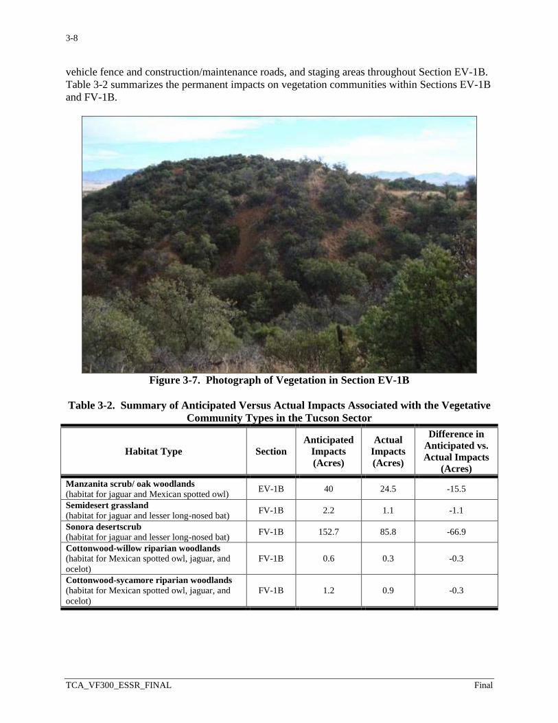
3-8
TCA_VF300_ESSR_FINAL Final
vehicle fence and construction/maintenance roads, and staging areas throughout Section EV-1B.
Table 3-2 summarizes the permanent impacts on vegetation communities within Sections EV-1B
and FV-1B.
Figure 3-7. Photograph of Vegetation in Section EV-1B
Table 3-2. Summary of Anticipated Versus Actual Impacts Associated with the Vegetative
Community Types in the Tucson Sector
Habitat Type Section
Anticipated
Impacts
(Acres)
Actual
Impacts
(Acres)
Difference in
Anticipated vs.
Actual Impacts
(Acres)
Manzanita scrub/ oak woodlands
(habitat for jaguar and Mexican spotted owl) EV-1B 40 24.5 -15.5
Semidesert grassland (habitat for jaguar and lesser long-nosed bat)
FV-1B 2.2 1.1 -1.1
Sonora desertscrub (habitat for jaguar and lesser long-nosed bat)
FV-1B 152.7 85.8 -66.9
Cottonwood-willow riparian woodlands (habitat for Mexican spotted owl, jaguar, and
ocelot)
FV-1B 0.6 0.3 -0.3
Cottonwood-sycamore riparian woodlands (habitat for Mexican spotted owl, jaguar, and
ocelot)
FV-1B 1.2 0.9 -0.3

3-9
TCA_VF300_ESSR_FINAL Final
3.4.1.2 Cultural Resources
CBP monitored three archaeological sites during construction. One was a border monument
erected between 1882 and 1896. The monument, recommended eligible for NRHP inclusion
under Criterion A of 36 Code of Federal Regulations (CFR) 60.4, was avoided during fence
construction. Archaeological monitors were present to ensure avoidance. The second
archaeological site was considered ineligible for NRHP listing. An unanticipated third site was
discovered during construction of a staging area on the east end of EV-1B. The prehistoric
artifact scatter was assessed as eligible for NRHP inclusion under Criterion D of 36 CFR 60.6.
Contractors established an avoidance zone around the site and preserved the resource.
According to the post-construction survey, no significant issues were associated with these
archaeological sites, nor did destruction of site areas occur outside the 60-foot-wide construction
corridor.
3.4.1.3 Wetlands and Waters of the United States
CBP monitored 14 ephemeral washes meeting the definition of jurisdictional waters of the
United States during construction. Contractors traversed the waters of the United States with
various types of drainage structures in accordance with the design, including concrete low-water
crossings, reinforced concrete pipes, and box culverts. The project did not change existing
drainage patterns of transboundary runoff. In addition, riprap, rock, and other energy-dissipating
materials were placed downstream of the drainage structures to reduce flow velocity, long-term
erosion, and downstream sedimentation. TI construction did not increase the footprint within
these jurisdictional areas. No other additional waters of the United States were identified.
3.4.2 Section FV-1B
3.4.2.1 Vegetation and Soils
The December 2008 Tucson Sector BRP identified and assessed the composition, structure, and
general health of vegetation communities within the project corridor. The analysis in the BRP
indicated that the project would permanently affect approximately 156.7 acres of vegetation.
The project as a whole, however, affected less acreage of native vegetation than expected,
thereby minimizing the need for mitigation due to loss of habitat. TI construction and
installation permanently altered approximately 88.1 acres of existing land uses, soils, vegetation,
wildlife habitat, and potential habitat for protected species. The contractor disturbed
approximately 68.6 acres less than anticipated for the access roads, vehicle fence,
construction/maintenance roads, and staging areas throughout Section FV-1B. Table 3-2
summarizes the permanent impacts on vegetation communities within Sections EV-1B and FV-
1B.
3.4.2.2 Cultural Resources
CBP monitored 18 archaeological sites during construction. Seven were border monuments
erected between 1852 and 1896. Two were historical sites associated with Slaughter Ranch, and
the rest were prehistoric artifact scatters. All of the border monuments were recommended
eligible for NRHP listing under Criterion A of 36 CFR 60.4 and were avoided during fence
construction. Archaeological monitors were present to ensure avoidance. Among the other sites
recommended eligible, six could not be avoided during fence construction. Archaeological data
recovery was carried out on these sites before any ground-disturbing activities. According to the
post-construction survey, there were no significant issues associated with these archaeological

3-10
TCA_VF300_ESSR_FINAL Final
sites, unexpected subsurface cultural finds, or destruction of site areas outside the 60-foot-wide
construction corridor. A CR was approved to preserve the “Mormon House” cultural site by
placing compacted fill on the excavated foundation instead of excavating the structure and
removing artifacts (see Figure 3-8).
Figure 3-8. Photograph of Mormon House Site in Section FV-1B
3.4.2.3 Wetlands and Waters of the United States
CBP monitored two wetlands and 38 ephemeral washes meeting the definition of jurisdictional
waters of the United States during construction. Contractors traversed the waters of the United
States with various types of drainage structures, including concrete low water crossings,
reinforced concrete pipes, and box culverts. The project did not change existing drainage
patterns of transboundary runoff. In addition, riprap, rock, and other energy-dissipating
materials were placed downstream of the drainage structures to reduce flow velocity, long-term
erosion, and downstream sedimentation. TI construction did not increase the footprint within
these jurisdictional areas. No other additional waters of the United States were identified.
4-1
TCA_VF300_ESSR_FINAL Final
4.0 DISCUSSION The permanent impacts on soils and vegetation decreased from the original estimate of approximately 251.5 acres in the ESPs to 164.55 acres as determined by the post-construction survey, a difference of 86.95 acres. This decrease was largely due to using less area than allotted for the project corridor, using preexisting access roads, and limiting the number and size of staging areas to the minimum required for construction. Limiting the amount of disturbed area to only what was necessary for construction reduced impacts on natural resources, including soil, water, vegetation, and threatened and endangered species habitat. Table 3-1 summarizes the impacts anticipated in the ESPs; the actual, post-construction impacts; and the difference between the planned and actual impacts for both VF sections in the Tucson Sector. Section EV-1A was excluded from environmental monitoring because construction was limited to retrofitting or replacing existing fence in already disturbed areas. Disturbed areas were restored following retrofit or replacement. Restoration consisted of soil preparation by tilling and hydroseeding with native seed mix. 4.1 INCREASED PROJECT FOOTPRINT An unanticipated access road in Section EV-1B disturbed approximately 0.37 acre of soil and vegetation. The two staging areas in Section EV-1B were 1.74 acres greater than designed. 4.2 DECREASED PROJECT FOOTPRINT Using preexisting access roads in lieu of planned access roads allowed approximately 33.78 acres of soil and vegetation within access road corridors in Section FV-1B to be left undisturbed. Approximately 21.22 acres of soil and vegetation in Section EV-1B and approximately 1.16 acres of soil and vegetation in Section FV-1B were not disturbed within the fence construction corridor as a result of the contractor using a narrower corridor than designed, and elimination of an access road on the east end of Section FV-1B as authorized by a CR. Reducing the number and size of staging areas in Section FV-1B allowed approximately 32.9 acres of soil and vegetation to remain undisturbed. Contributing to this reduction was a CR authorizing elimination of a 2.07-acre staging area. 4.3 ADDITIONAL ISSUES At the time this ESSR was completed, construction of a bridge over the Black Draw stream channel in Section FV-1B was planned. The bridge was later completed. CBP is implementing a Comprehensive Tactical Infrastructure Maintenance and Repair (CTIMR) program to ensure the TI and related areas are maintained and repaired as needed.

APPENDIX APUBLIC OUTREACH AND AGENCY COORDINATION
APPENDIX A
Public Outreach and Agency Coordination

A-1
APPENDIX A PUBLIC OUTREACH AND AGENCY COORDINATION
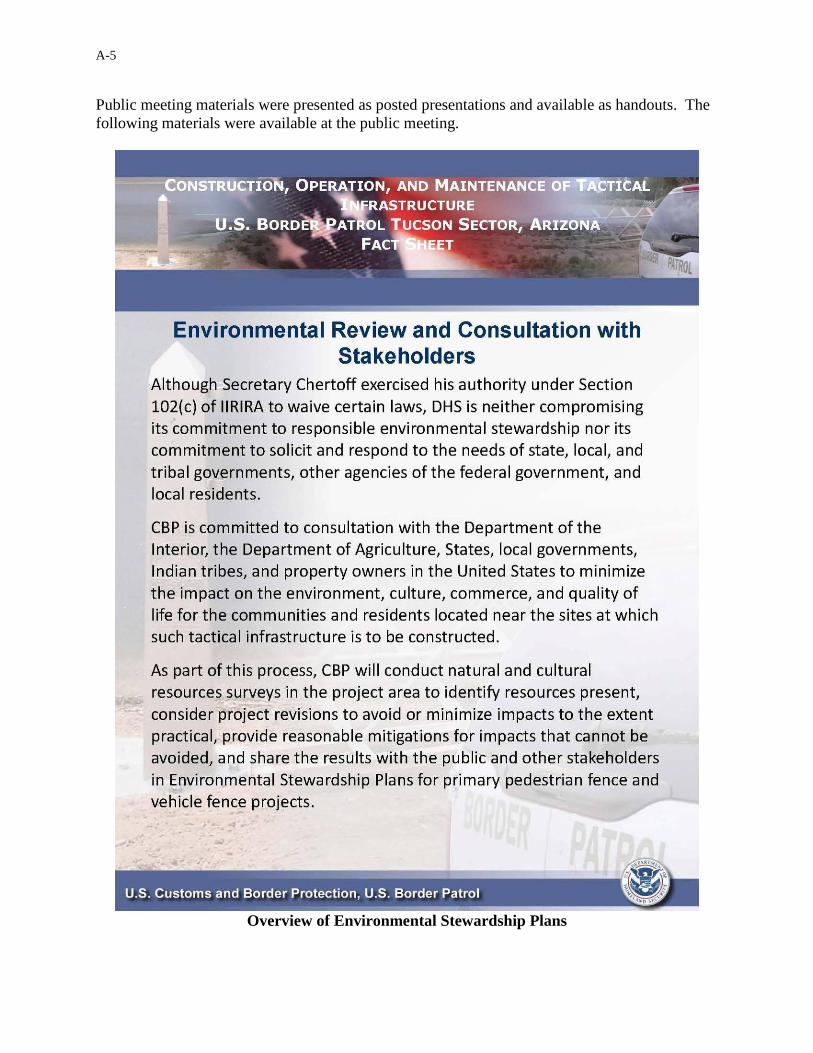
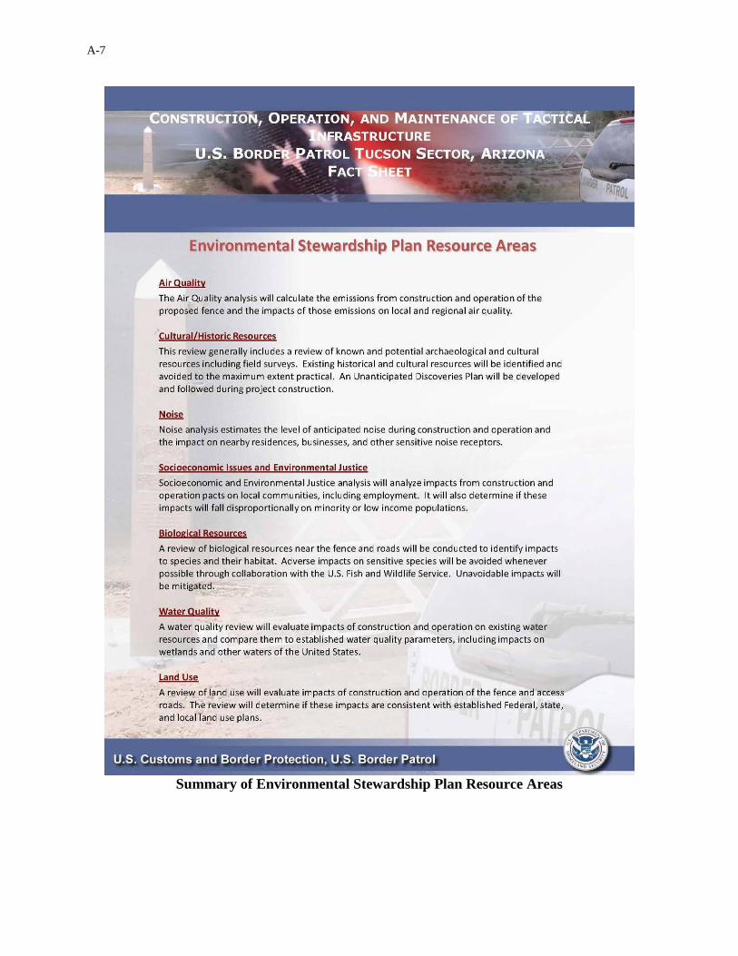
A.1 INTRODUCTION The Department of Homeland Security (DHS), U.S. Customs and Border Protection (CBP) committed to constructing, operating, and maintaining tactical infrastructure (TI) along the U.S./Mexico international border in an environmentally responsible manner. Public outreach and agency coordination were an important component of this effort. This appendix provides additional detailed information on all the activities associated with the various public outreach and agency coordination efforts related to vehicle fence Sections EV-1A/EV-1B and FV-1B within the U.S. Border Patrol (USBP) Tucson Sector. CBP notified relevant Federal, Tribal, state, and local agencies concerning the project and requested their input on potential environmental concerns. Because CBP is committed to building TI in an environmentally responsible manner, it also conducted environmental resource surveys and prepared management plans to ensure that it minimized potential environmental damage. CBP coordinated with the U.S. Fish and Wildlife Service (USFWS); Bureau of Land Management (BLM); State Historic Preservation Office (SHPO); other Federal, state, and local agencies; and the Tohono O’odham Tribal Nation. Coordination and outreach activities also included affected property owners and members of the general public. CBP actively solicited public input for developing the Environmental Stewardship Plans (ESPs) through both a dedicated Internet site resource and public meetings. The following subsections of this appendix provide specific information on these public outreach and agency coordination efforts. This appendix is organized around the particular public audience or resource agencies involved. A.2 PUBLIC COMMENT SOLICITATION A.2.1 Public Meetings and Project Website Information A public open house meeting to inform the public about the project was announced in local newspapers and held at the Windemere Hotel and Conference Center in Sierra Vista, Arizona, as described in Table A-1.
Table A-1. Public Meeting Information VF300 Sector Public Meeting Location Date Estimated
Attendees Registered Attendees
Tucson Sector
The Windemere Hotel and Conference Center
2047 S. State Highway 92 Sierra Vista, AZ 85635
May 13, 2008 40 25
A-2
A.2.1.1 Public Meeting Materials Shown below are various exhibits of materials associated with the public meeting, including the newspaper announcement, the presentation for the meeting, and the materials available to the public at the public meeting, including the general project description. The public meeting announcement was published in the Arizona Daily Star and Sierra Vista Herald on May 10, 2008.
Public Open House Announcement
Construction of Tactical Infrastructure along the U.S./Mexico international border
U.S. Border Patrol (USBP) Tucson Sector, Arizona U.S. Department of Homeland Security, Customs and Border Protection (CBP) plans to construct, operate, and maintain tactical infrastructure along the U.S./Mexico international border in the USBP Tucson Sector, Arizona. The infrastructure will consist of vehicle fence, pedestrian fence, access roads, and patrol roads. The tactical infrastructure will be built in areas of the border that are not currently fenced. Through our consultation and environmental stewardship efforts, CBP seeks to identify, avoid, minimize, and mitigate impacts on air quality, noise, land use, recreation, visual resources, geology and soils, water use and quality, cultural resources, socioeconomic resources and environmental justice, utilities and infrastructure, and biological resources including vegetation, wildlife, aquatic species, and special status species. CBP will prepare an Environmental Stewardship Plan (ESP) to ensure that adverse environmental impacts are minimized whenever possible during the construction of tactical infrastructure along the U.S./Mexico international border in the USBP Tucson Sector, Arizona. CBP is committed to building tactical infrastructure in an environmentally responsible manner that protects valuable natural and cultural resources.
Additional information regarding the ESP can be found at www.dhs.gov/xnews/releases/pr_1207080713748.shtm, or by e-mailing: [email protected]. For further information please contact Loren Flossman, Program Manager, SBI Tactical Infrastructure, 1300 Pennsylvania Ave, NW, Washington, DC 20229, Tel: (877) 752-0420, Fax: (703) 752-7754.
A public open house to discuss the planned infrastructure will be held on May 13, 2008, from 4:30 p.m. to 8:00 p.m. at The Windmere Hotel and Conference Center, 2047 S. State Highway 92, Sierra Vista, Arizona 85635.
Public Open House Announcement
A-3
Public Registration Card and Privacy Act
A-4
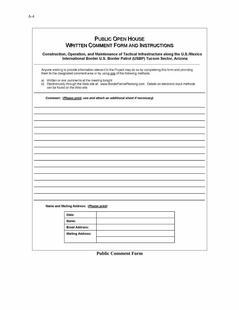
Public Comment Form
A-5
Public meeting materials were presented as posted presentations and available as handouts. The
following materials were available at the public meeting.
Overview of Environmental Stewardship Plans

A-6
Summary of Tactical Infrastructure for Tucson Sector
A-7
Summary of Environmental Stewardship Plan Resource Areas

A-8
General Location of Tactical Infrastructure for Tucson Sector
A-9
Example of Vehicle Fence Styles for Tucson Sector
A-10
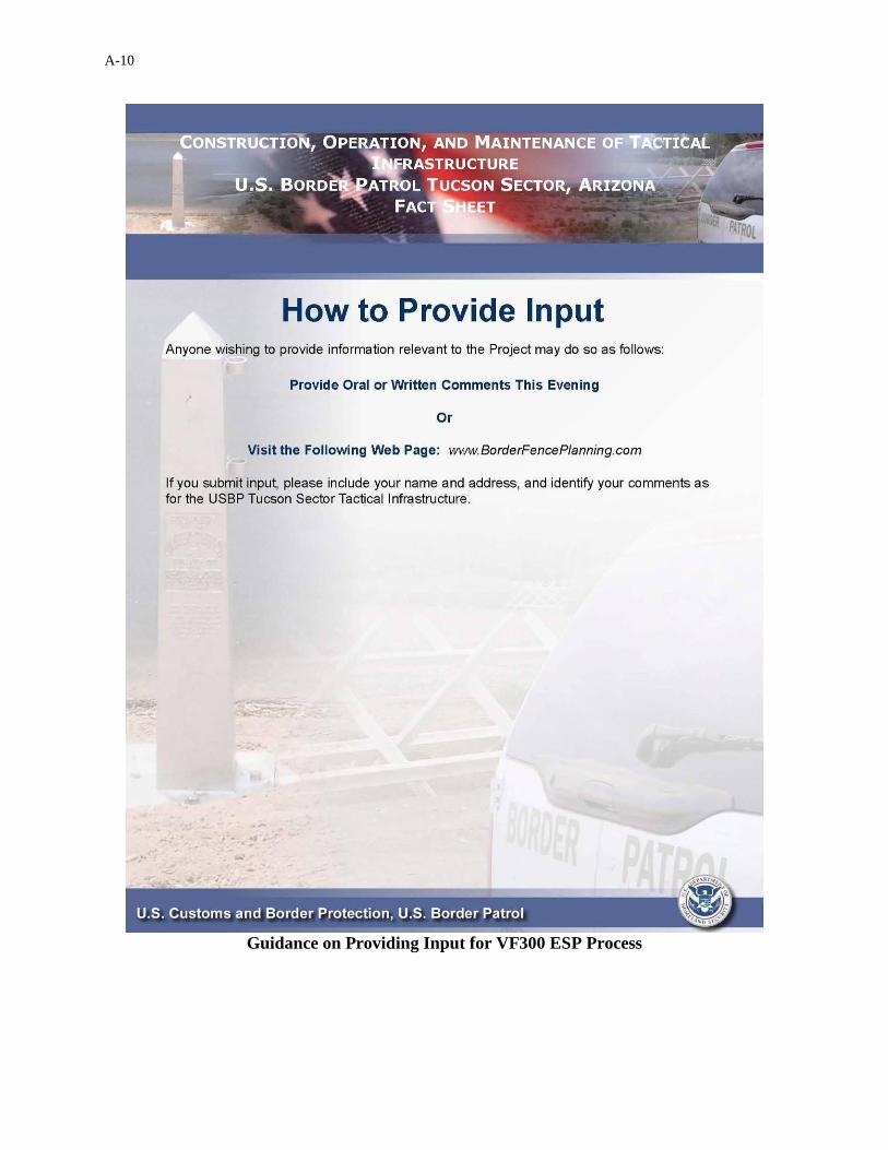
Guidance on Providing Input for VF300 ESP Process
A-11
A.2.1.2 Project Website Materials
In addition to the information provided in the public meetings, a website addressing the project
was established at www.BorderFencePlanning.com, currently http://cbp.gov/xp/cgov/border_
security/ti/ti_docs/sector/tucson/. This website provided information about the project and also
gave individuals an alternative opportunity to submit comments. A 15-day period was available
to review the project descriptions and related material, from June 1, 2008, through June 15, 2008.
This ESSR will also be maintained on the public access website. In addition, below are
examples of materials for the public meeting that were also available on the website.

A-12
Summary of Tactical Infrastructure for Tucson Sector

A-13
Example of Vehicle Fence Styles for Tucson Sector

A-14
General Location of Tactical Infrastructure for Tucson Sector
A-15
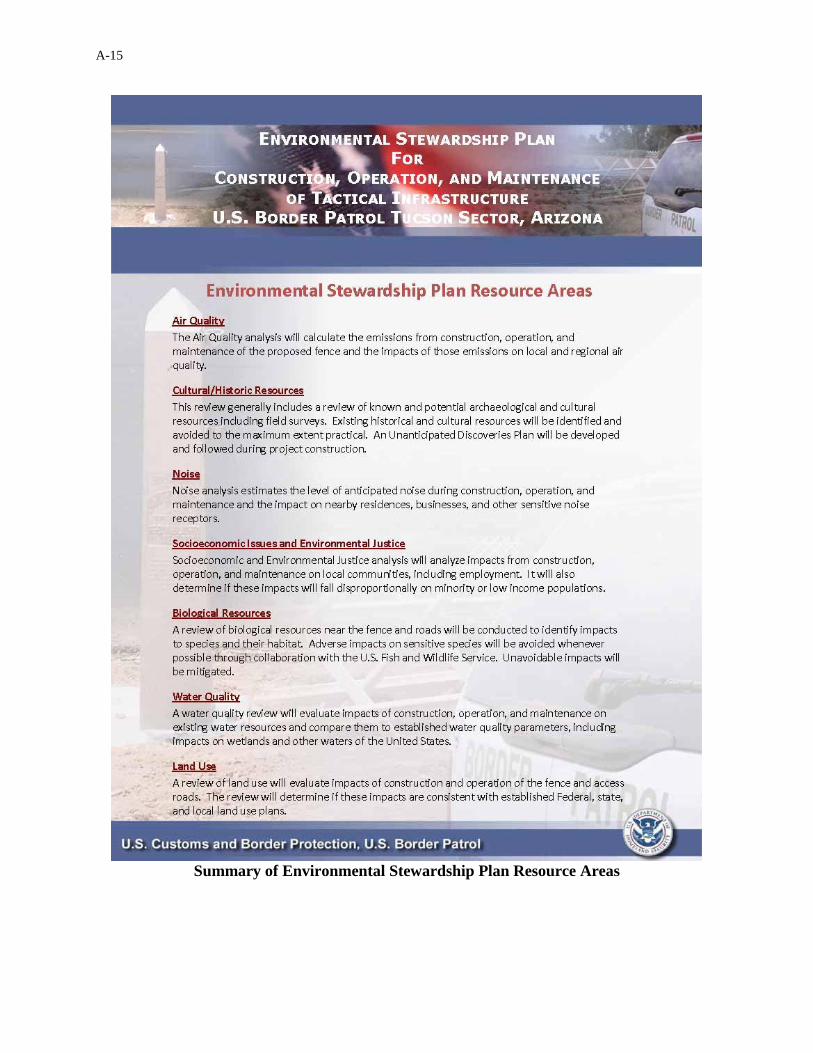
Summary of Environmental Stewardship Plan Resource Areas

A-16
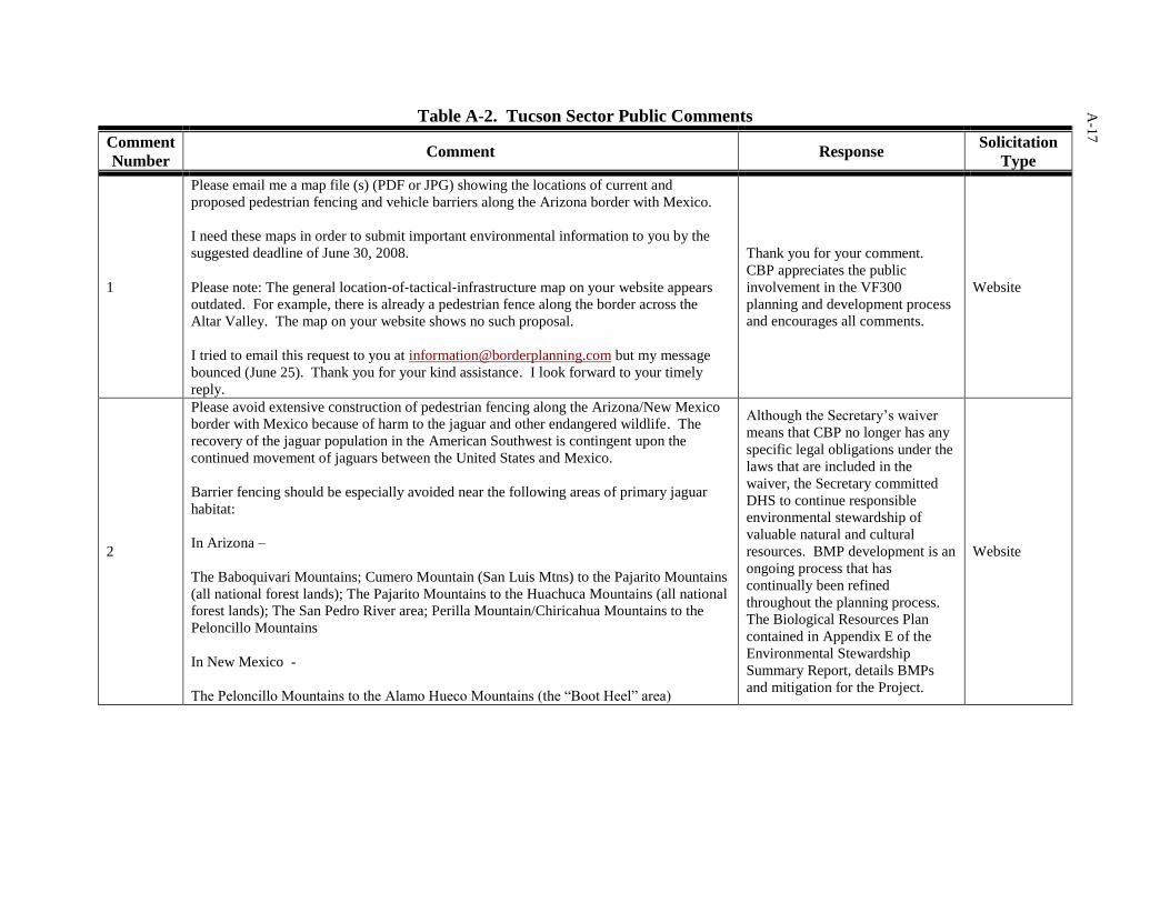
A.2.1.3 Public Meetings and Project Website Comments Comments received during the Tucson Sector public meeting and from the 15-day public review on the www.borderfenceplanning.com website (currently http://cbp.gov/xp/cgov/border_security /ti/ti_docs/sector/tucson/) appear in Table A-2. Eight written comments and nine oral comments were received at the public meeting. Five comments also were received from the public via the project website comment page during the 15-day review and comment period.
A-1
7
Table A-2. Tucson Sector Public Comments
Comment
Number Comment Response
Solicitation
Type
1
Please email me a map file (s) (PDF or JPG) showing the locations of current and
proposed pedestrian fencing and vehicle barriers along the Arizona border with Mexico.
I need these maps in order to submit important environmental information to you by the
suggested deadline of June 30, 2008.
Please note: The general location‐of‐tactical‐infrastructure map on your website appears
outdated. For example, there is already a pedestrian fence along the border across the
Altar Valley. The map on your website shows no such proposal.
I tried to email this request to you at [email protected] but my message
bounced (June 25). Thank you for your kind assistance. I look forward to your timely
reply.
Thank you for your comment.
CBP appreciates the public
involvement in the VF300
planning and development process
and encourages all comments.
Website
2
Please avoid extensive construction of pedestrian fencing along the Arizona/New Mexico
border with Mexico because of harm to the jaguar and other endangered wildlife. The
recovery of the jaguar population in the American Southwest is contingent upon the
continued movement of jaguars between the United States and Mexico.
Barrier fencing should be especially avoided near the following areas of primary jaguar
habitat:
In Arizona –
The Baboquivari Mountains; Cumero Mountain (San Luis Mtns) to the Pajarito Mountains
(all national forest lands); The Pajarito Mountains to the Huachuca Mountains (all national
forest lands); The San Pedro River area; Perilla Mountain/Chiricahua Mountains to the
Peloncillo Mountains
In New Mexico -
The Peloncillo Mountains to the Alamo Hueco Mountains (the “Boot Heel” area)
Although the Secretary’s waiver
means that CBP no longer has any
specific legal obligations under the
laws that are included in the
waiver, the Secretary committed
DHS to continue responsible
environmental stewardship of
valuable natural and cultural
resources. BMP development is an
ongoing process that has
continually been refined
throughout the planning process.
The Biological Resources Plan
contained in Appendix E of the
Environmental Stewardship
Summary Report, details BMPs
and mitigation for the Project.
Website

A-18
Comment Number Comment Response Solicitation
Type
2 (cont'd.)
Our concern about extensive pedestrian fencing in other areas, such as that already built in Altar Valley and between Naco and Douglas, Arizona, will force illegal border crossings and related border patrol activity into more rugged and remote country that includes primary habitat for jaguar. We urge that vehicle barriers, electronic surveillance, and other measures and policies be applied in lieu of barriers such as pedestrian fences that block the movement of wildlife along our southern border. We would appreciate your kind response to this request, particularly in terms of the extent to which you will limit pedestrian fencing and other absolute barriers along the border in deference to the jaguar and other wildlife.
3 Please send any information that you have regarding the border wall in Arizona. I am extremely disappointed to see that the website that purported to be in compliance with NEPA has been taken down, and that the public may no longer access that information.
Thank you for your comment. CBP appreciates the public involvement in the VF300 planning and development process and encourages all comments.
Website
4 I am conducting some research regarding the proposed border fence in the Sonoran Desert and would greatly appreciate if you could provide me links you have to any Environmental Impact Statements or Environmental Assessments that you have for this area.
Thank you for your comment. CBP appreciates the public involvement in the VF300 planning and development process and encourages all comments.
Website
5 I would feel safer bicycling near the border west of the San Pedro River if there were a pedestrian border fence. Please start as soon as possible.
Thank you for your comment. CBP appreciates the public involvement in the VF300 planning and development process and encourages all comments.
Website
6 I would like information regarding the Environmental Stewardship Plan for the construction of tactical infrastructure along the U.S./Mexico international border. A public open house is scheduled for May 13 in Sierra Vista, AZ. Please contact me.
Thank you for your comment. CBP appreciates the public involvement in the VF300 planning and development process and encourages all comments.
Public Meeting -- Written Comment

A-1
9
Comment
Number Comment Response
Solicitation
Type
7
First, in the history of the world, a wall has never worked. The Great Wall of China did
not keep out the Huns. Hadriens Wall did not keep out the Picts. The Berlin Wall did not
keep in the East Germans or keep out the West. Given that this fence/defense is not going
to work as planned, my primary concerns are unintended consequences and environmental
impacts. The money would be better spent on the Border Patrol. Construction will
compact soil, disrupt water patterns, scarify steep slopes and interfere with large mammal
and in some cases, small animal movements. Rehabilitation efforts will depend on further
funding - which may not be forthcoming. In the desert southwest cars on the land last for
hundreds of years. Suggestion: put three times as much money for rehabilitation in the
budget as you think you will need and sequester it until after each section is complete.
Accept this isn’t going to work the way it’s being claimed and admit it ahead of time so
you don’t look so foolish.
Thank you for your comment.
CBP appreciates the public
involvement in the VF300
planning and development process
and encourages all comments.
Public Meeting
-- Written
Comment
8
Build the Fence!
Environmental damage is a smoke screen. Far more damage results from illegal traffic
and the greatest damage is being caused by uncontrolled development and depletion of the
San Pedro River’s aquifer.
Thank you for your comment.
CBP appreciates the public
involvement in the VF300
planning and development process
and encourages all comments.
Public Meeting
- Written
Comment
9
Use of the pedestrian-style fence should be minimized. It is absolutely devastating to
wildlife movement and people just scale it or cut it. Vehicle style fences would be better
and have less impact. Has a wall ever really stopped people or protected a country
(Hadrian’s wall, Great wall of China)?
Our money would be better spent fixing the legal worker visa program. It would also be
better to eliminate NAFTA, which has been good for corporations, but has caused harm to
citizens of Mexico and the U.S. I know plenty of Mexicans and they really just want to
stay in their own country with their families. We need to do our best to fix the economics
that has basically forced so many to come here.
Thank you for your comment.
CBP appreciates the public
involvement in the VF300
planning and development process
and encourages all comments.
Public Meeting
- Written
Comment
10
Please tell me:
Was there a meeting like this for information to property owners on the east side of the
river?
When?
Where?
Where property owners informed by letter or phone call?
Thank you for your comment.
CBP appreciates the public
involvement in the VF300
planning and development process
and encourages all comments.
Public Meeting
- Written
Comment

A-2
0
Comment
Number Comment Response
Solicitation
Type
11
The announcement of this open house offered an internet link to learn more about the ESP.
Unfortunately, that link sent me to an announcement of Sec Chertoff waiving all laws to
proceed with fence construction. Not helpful.
Thank you for your comment.
CBP appreciates the public
involvement in the VF300
planning and development process
and encourages all comments.
Public Meeting
- Written
Comment
12 Please look at the effects of rivulets, not just on major rivers/washes when it comes to
looking at water resources.
Although the Secretary’s waiver
means that CBP no longer has any
specific legal obligations under the
laws that are included in the
waiver, the Secretary committed
DHS to continue responsible
environmental stewardship of
valuable natural and cultural
resources. BMP development is an
ongoing process that has
continually been refined
throughout the planning process.
The Biological Resources Plan
contained in Appendix E of the
Environmental Stewardship
Summary Report, details BMPs
and mitigation for the Project.
Public Meeting
- Written
Comment
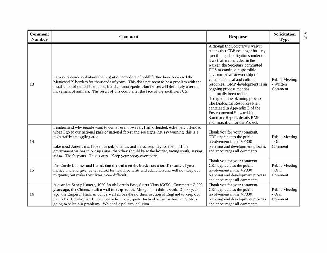
A-2
1
Comment
Number Comment Response
Solicitation
Type
13
I am very concerned about the migration corridors of wildlife that have traversed the
Mexican/US borders for thousands of years. This does not seem to be a problem with the
installation of the vehicle fence, but the human/pedestrian fences will definitely alter the
movement of animals. The result of this could alter the face of the southwest US.
Although the Secretary’s waiver
means that CBP no longer has any
specific legal obligations under the
laws that are included in the
waiver, the Secretary committed
DHS to continue responsible
environmental stewardship of
valuable natural and cultural
resources. BMP development is an
ongoing process that has
continually been refined
throughout the planning process.
The Biological Resources Plan
contained in Appendix E of the
Environmental Stewardship
Summary Report, details BMPs
and mitigation for the Project.
Public Meeting
- Written
Comment
14
I understand why people want to come here; however, I am offended, extremely offended,
when I go to our national park or national forest and see signs that say warning, this is a
high traffic smuggling area.
Like most Americans, I love our public lands, and I also help pay for them. If the
government wishes to put up signs, then they should be at the border, facing south, saying
aviso. That’s yours. This is ours. Keep your booty over there.
Thank you for your comment.
CBP appreciates the public
involvement in the VF300
planning and development process
and encourages all comments.
Public Meeting
- Oral
Comment
15
I’m Cecile Loomer and I think that the walls on the border are a terrific waste of your
money and energies, better suited for health benefits and education and will not keep out
migrants, but make their lives more difficult.
Thank you for your comment.
CBP appreciates the public
involvement in the VF300
planning and development process
and encourages all comments.
Public Meeting
- Oral
Comment
16
Alexander Sandy Kunzer, 4969 South Laredo Pass, Sierra Vista 85650. Comments: 3,000
years ago, the Chinese built a wall to keep out the Mongols. It didn’t work. 2,000 years
ago, the Emperor Hadrian built a wall across the northern section of England to keep out
the Celts. It didn’t work. I do not believe any, quote, tactical infrastructure, unquote, is
going to solve our problems. We need a political solution.
Thank you for your comment.
CBP appreciates the public
involvement in the VF300
planning and development process
and encourages all comments.
Public Meeting
- Oral
Comment
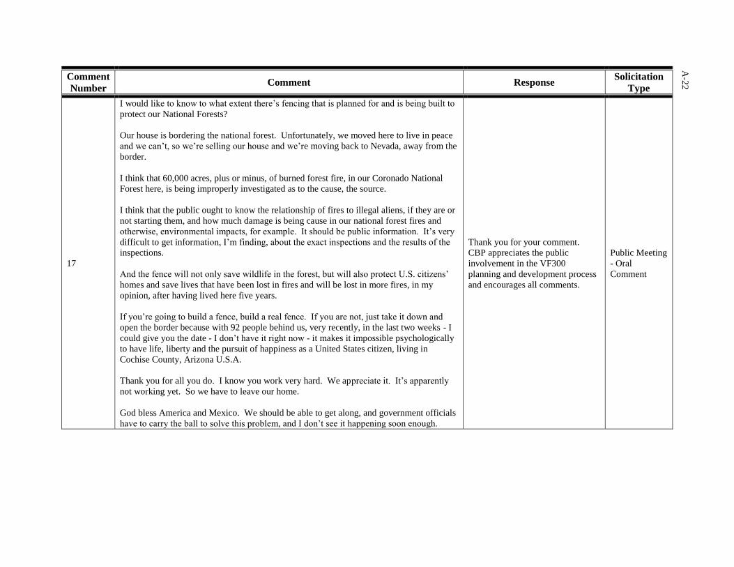
A-2
2
Comment
Number Comment Response
Solicitation
Type
17
I would like to know to what extent there’s fencing that is planned for and is being built to
protect our National Forests?
Our house is bordering the national forest. Unfortunately, we moved here to live in peace
and we can’t, so we’re selling our house and we’re moving back to Nevada, away from the
border.
I think that 60,000 acres, plus or minus, of burned forest fire, in our Coronado National
Forest here, is being improperly investigated as to the cause, the source.
I think that the public ought to know the relationship of fires to illegal aliens, if they are or
not starting them, and how much damage is being cause in our national forest fires and
otherwise, environmental impacts, for example. It should be public information. It’s very
difficult to get information, I’m finding, about the exact inspections and the results of the
inspections.
And the fence will not only save wildlife in the forest, but will also protect U.S. citizens’
homes and save lives that have been lost in fires and will be lost in more fires, in my
opinion, after having lived here five years.
If you’re going to build a fence, build a real fence. If you are not, just take it down and
open the border because with 92 people behind us, very recently, in the last two weeks - I
could give you the date - I don’t have it right now - it makes it impossible psychologically
to have life, liberty and the pursuit of happiness as a United States citizen, living in
Cochise County, Arizona U.S.A.
Thank you for all you do. I know you work very hard. We appreciate it. It’s apparently
not working yet. So we have to leave our home.
God bless America and Mexico. We should be able to get along, and government officials
have to carry the ball to solve this problem, and I don’t see it happening soon enough.
Thank you for your comment.
CBP appreciates the public
involvement in the VF300
planning and development process
and encourages all comments.
Public Meeting
- Oral
Comment

A-2
3
Comment
Number Comment Response
Solicitation
Type
18
On Easter Sunday, I was out picking up bags, several backpacks and blankets and tons of
water bottles, on a lone mountain road, that were full of I don’t know what. I’ve kept
them. I’m going to categorize them for history to find out what was inside of them.
I don’t think it’s right that citizens should have to police areas around their homes like
that. I think we need a lot of money appropriated to clean up all the trails that are filled
with litter through our National Forest.
Thank you for your comment.
CBP appreciates the public
involvement in the VF300
planning and development process
and encourages all comments.
Public Meeting
- Oral
Comment
19
My name is Bill Odle, and we live on the border. Our property is adjacent to the San
Pedro National Wildlife Recreation Area. That’s our west fence, and the border is our
south fence. So we are just east of the San Pedro River.
And we’ve seen the construction. The fence has been completed in that area, as folks
probably know. Disappointed that weren’t asked anything about it, and I understand the
reasons why that was political issues. But I feel that it is way too overbuilt, and I’ll be
glad to explain that.
It’s not stopping people from crossing over. I’ve got some ladders in our yard that have
been used by folks crossing the fence, a rope ladder, other evidence that people have used
crossing over the fence.
I check the stock fence that goes east of us to Naco, about 10 miles, because our neighbors
are ranchers. And, I check that barbed wire fence, and there’s continuing evidence of folks
crossing the fence. In other words, the fence is bent up, or the fence ties are taken off, or
that type of thing; and you see evidence of people crawling or climbing the fence.
My feeling is that there are probably - of course, this is one of those figures that you have
no way of having actual counts - but I feel there are as many folks crossing on foot now as
were previous to the fence.
This fence has stopped vehicular traffic. They can’t drive through it. And it’s also
stopped livestock from crossing over intermittently, either the Mexican cattle or the cattle
that the ranchers have on this side of the fence. So it’s stopped that problem, but to repeat,
it sure hasn’t stopped people.
Thank you for your comment.
CBP appreciates the public
involvement in the VF300
planning and development process
and encourages all comments.
Public Meeting
- Oral
Comment
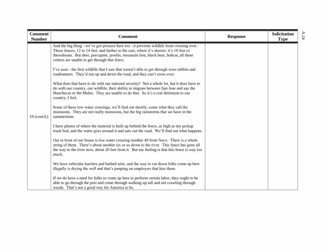
A-2
4
Comment
Number Comment Response
Solicitation
Type
19 (cont'd.)
And the big thing - we’ve got pictures here too - it prevents wildlife from crossing over.
Those fences, 12 to 14 feet, and farther to the east, where it’s shorter; it’s 10 feet or
thereabouts. But deer, porcupine, javelin, mountain lion, black bear, bobcat, all these
critters are unable to get through that fence.
I’ve seen - the first wildlife that I saw that weren’t able to get through were rabbits and
roadrunners. They’d run up and down the road, and they can’t cross over.
What does that have to do with our national security? Not a whole lot, but it does have to
do with our country, our wildlife, their ability to migrate between San Jose and say the
Huachucas or the Mules. They are unable to do that. So it’s a real detriment to our
country, I feel.
Some of these low water crossings, we’ll find out shortly, come what they call the
monsoons. They are not really monsoons, but the big rainstorms that we have in the
summertime.
I have photos of where the material is built up behind the fence, as high as my pickup
truck bed, and the water goes around it and eats out the road. We’ll find out what happens.
Out in front of our house is low water crossing number 49 from Naco. There is a whole
string of them. There’s about another six or so down to the river. This fence has gone all
the way to the river now, about 20 feet from it. But my feeling is that this fence is way too
much.
We have vehicular barriers and barbed wire, and the way to cut down folks come up here
illegally is drying the well and that’s jumping on employers that hire them.
If we do have a need for folks to come up here to perform certain labor, they ought to be
able to go through the port and come through walking up tall and not crawling through
weeds. That’s not a good way for America to be.
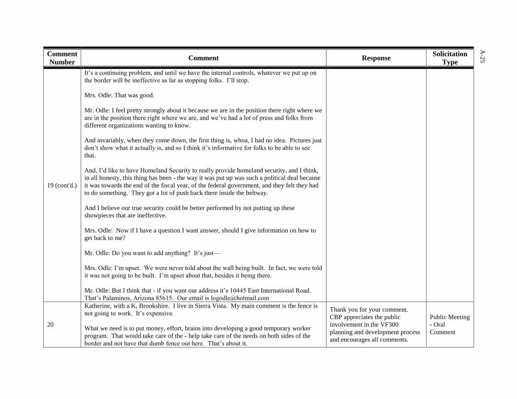
A-2
5
Comment
Number Comment Response
Solicitation
Type
19 (cont'd.)
It’s a continuing problem, and until we have the internal controls, whatever we put up on
the border will be ineffective as far as stopping folks. I’ll stop.
Mrs. Odle: That was good.
Mr. Odle: I feel pretty strongly about it because we are in the position there right where we
are in the position there right where we are, and we’ve had a lot of press and folks from
different organizations wanting to know.
And invariably, when they come down, the first thing is, whoa, I had no idea. Pictures just
don’t show what it actually is, and so I think it’s informative for folks to be able to see
that.
And, I’d like to have Homeland Security to really provide homeland security, and I think,
in all honesty, this thing has been - the way it was put up was such a political deal because
it was towards the end of the fiscal year, of the federal government, and they felt they had
to do something. They got a lot of push back there inside the beltway.
And I believe our true security could be better performed by not putting up these
showpieces that are ineffective.
Mrs. Odle: Now if I have a question I want answer, should I give information on how to
get back to me?
Mr. Odle: Do you want to add anything? It’s just—
Mrs. Odle: I’m upset. We were never told about the wall being built. In fact, we were told
it was not going to be built. I’m upset about that, besides it being there.
Mr. Odle: But I think that - if you want our address it’s 10445 East International Road.
That’s Palaminos, Arizona 85615. Our email is [email protected]
20
Katherine, with a K, Brookshire. I live in Sierra Vista. My main comment is the fence is
not going to work. It’s expensive.
What we need is to put money, effort, brains into developing a good temporary worker
program. That would take care of the - help take care of the needs on both sides of the
border and not have that dumb fence out here. That’s about it.
Thank you for your comment.
CBP appreciates the public
involvement in the VF300
planning and development process
and encourages all comments.
Public Meeting
- Oral
Comment
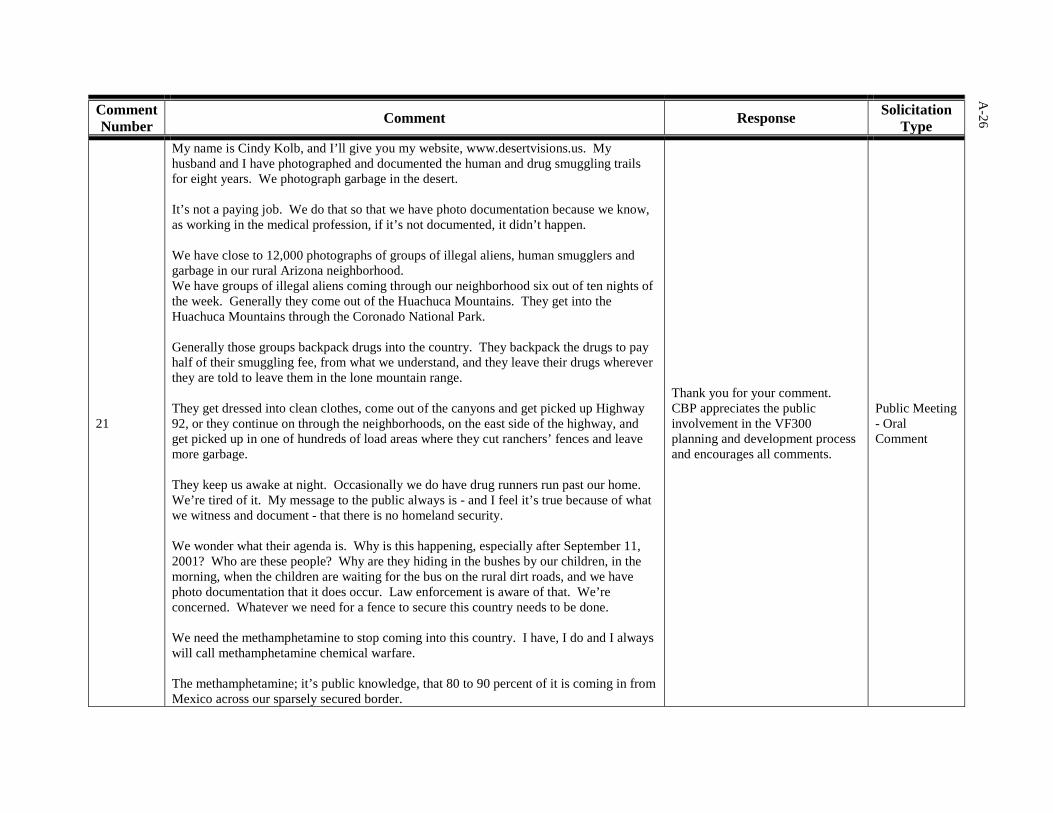
A-26
Comment Number Comment Response Solicitation
Type
21
My name is Cindy Kolb, and I’ll give you my website, www.desertvisions.us. My husband and I have photographed and documented the human and drug smuggling trails for eight years. We photograph garbage in the desert. It’s not a paying job. We do that so that we have photo documentation because we know, as working in the medical profession, if it’s not documented, it didn’t happen. We have close to 12,000 photographs of groups of illegal aliens, human smugglers and garbage in our rural Arizona neighborhood. We have groups of illegal aliens coming through our neighborhood six out of ten nights of the week. Generally they come out of the Huachuca Mountains. They get into the Huachuca Mountains through the Coronado National Park. Generally those groups backpack drugs into the country. They backpack the drugs to pay half of their smuggling fee, from what we understand, and they leave their drugs wherever they are told to leave them in the lone mountain range. They get dressed into clean clothes, come out of the canyons and get picked up Highway 92, or they continue on through the neighborhoods, on the east side of the highway, and get picked up in one of hundreds of load areas where they cut ranchers’ fences and leave more garbage. They keep us awake at night. Occasionally we do have drug runners run past our home. We’re tired of it. My message to the public always is - and I feel it’s true because of what we witness and document - that there is no homeland security. We wonder what their agenda is. Why is this happening, especially after September 11, 2001? Who are these people? Why are they hiding in the bushes by our children, in the morning, when the children are waiting for the bus on the rural dirt roads, and we have photo documentation that it does occur. Law enforcement is aware of that. We’re concerned. Whatever we need for a fence to secure this country needs to be done. We need the methamphetamine to stop coming into this country. I have, I do and I always will call methamphetamine chemical warfare. The methamphetamine; it’s public knowledge, that 80 to 90 percent of it is coming in from Mexico across our sparsely secured border.
Thank you for your comment. CBP appreciates the public involvement in the VF300 planning and development process and encourages all comments.
Public Meeting - Oral Comment
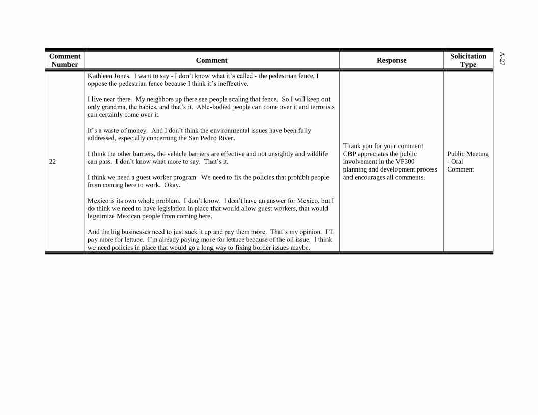
A-2
7
Comment
Number Comment Response
Solicitation
Type
22
Kathleen Jones. I want to say - I don’t know what it’s called - the pedestrian fence, I
oppose the pedestrian fence because I think it’s ineffective.
I live near there. My neighbors up there see people scaling that fence. So I will keep out
only grandma, the babies, and that’s it. Able-bodied people can come over it and terrorists
can certainly come over it.
It’s a waste of money. And I don’t think the environmental issues have been fully
addressed, especially concerning the San Pedro River.
I think the other barriers, the vehicle barriers are effective and not unsightly and wildlife
can pass. I don’t know what more to say. That’s it.
I think we need a guest worker program. We need to fix the policies that prohibit people
from coming here to work. Okay.
Mexico is its own whole problem. I don’t know. I don’t have an answer for Mexico, but I
do think we need to have legislation in place that would allow guest workers, that would
legitimize Mexican people from coming here.
And the big businesses need to just suck it up and pay them more. That’s my opinion. I’ll
pay more for lettuce. I’m already paying more for lettuce because of the oil issue. I think
we need policies in place that would go a long way to fixing border issues maybe.
Thank you for your comment.
CBP appreciates the public
involvement in the VF300
planning and development process
and encourages all comments.
Public Meeting
- Oral
Comment

A-28
A.3 COORDINATION WITH RESOURCE AGENCIES/STAKEHOLDERS
A.3.1 Coordination with Resource Agencies/Stakeholders
On several occasions during the preparation of the ESPs, CBP mailed correspondence to
identified potentially interested points of contact at resource agencies and potentially interested
stakeholders. The purpose was to inform them of the status of the ongoing environmental
analyses, solicit input during the scoping of the analyses to be included in the ESPs, and notify
them of the availability of completed ESPs on the project website. CBP consequently received
written correspondence with feedback about the project. CBP considered agency stakeholder
comments on the VF300 projects and incorporated them into the ESP analysis of potential
environmental impacts, as applicable.
A.3.2 Coordination with Natural Resources-Related Agencies on VF300 Biological
Resources Plans
As a part of environmental stewardship for the project, CBP conducted natural resource surveys
of the project corridor areas. The purpose of these surveys was to collect information on plant
and animal species present in the project corridor, including threatened and endangered species,
and related habitat. CBP then used this information to prepare Biological Resources Plans
(BRPs) that helped in preparing the analyses for the ESPs and were intended to be a future
reference for CBP and contractor personnel during TI construction, operation, and maintenance.
CBP distributed draft BRPs for review by selected resource agencies (BLM, USFWS, and U.S.
Forest Service) based on the resources within the particular project corridor.
A.3.3 Coordination for Cultural Resources
As a part of environmental stewardship for the project, CBP conducted cultural resources
surveys of the project corridor areas. The purpose of these surveys was to collect information on
cultural resources in the project corridor, including previously unknown resources. CBP began
coordinating with the SHPO and appropriate Native American tribal points of contact before the
surveys to add knowledge that might assist the survey team in its efforts.
CBP then used the results of the surveys to prepare Cultural Resources Survey Reports that
subsequently helped in preparing the ESP analyses. CBP also sent the reports to the SHPO and
appropriate Native American tribal points of contact for review and comment.
A.4 ADDITIONAL OUTREACH TO RESOURCE AGENCIES, ELECTED
OFFICIALS, AND OTHER STAKEHOLDERS
A.4.1 Extended Outreach to Resource Agencies, Elected Officials, and Other Stakeholders
CBP conducted coordination meetings with Federal and state resource agencies, as well as other
interested stakeholders, in May and July 2008. The purpose was to present and discuss
environmental aspects of the VF300 projects and to obtain feedback and more information on
any potentially sensitive resources in the project areas.
In May 2008, CBP held a sector-level project kickoff meeting at the USBP Tucson Sector
Station in Tucson, Arizona. The purpose was to discuss the plans and timeline for VF300 ESPs
covering projects in the Sonoita Station and Douglas Station areas of operations. Participating in
the meeting were approximately 30 representatives from the USFWS, BLM, Arizona Game and
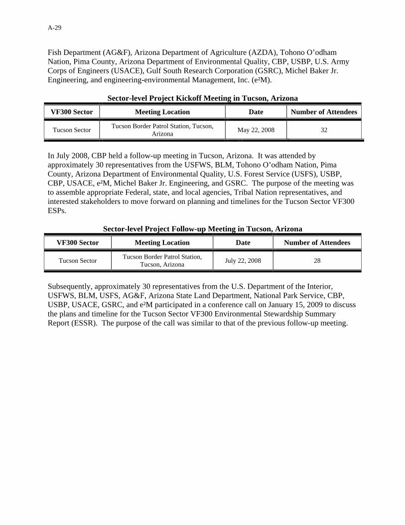
A-29
Fish Department (AG&F), Arizona Department of Agriculture (AZDA), Tohono O’odham Nation, Pima County, Arizona Department of Environmental Quality, CBP, USBP, U.S. Army Corps of Engineers (USACE), Gulf South Research Corporation (GSRC), Michel Baker Jr. Engineering, and engineering-environmental Management, Inc. (e²M).
Sector-level Project Kickoff Meeting in Tucson, Arizona
VF300 Sector Meeting Location Date Number of Attendees
Tucson Sector Tucson Border Patrol Station, Tucson, Arizona May 22, 2008 32
In July 2008, CBP held a follow-up meeting in Tucson, Arizona. It was attended by approximately 30 representatives from the USFWS, BLM, Tohono O’odham Nation, Pima County, Arizona Department of Environmental Quality, U.S. Forest Service (USFS), USBP, CBP, USACE, e²M, Michel Baker Jr. Engineering, and GSRC. The purpose of the meeting was to assemble appropriate Federal, state, and local agencies, Tribal Nation representatives, and interested stakeholders to move forward on planning and timelines for the Tucson Sector VF300 ESPs.
Sector-level Project Follow-up Meeting in Tucson, Arizona
VF300 Sector Meeting Location Date Number of Attendees
Tucson Sector Tucson Border Patrol Station, Tucson, Arizona July 22, 2008 28
Subsequently, approximately 30 representatives from the U.S. Department of the Interior, USFWS, BLM, USFS, AG&F, Arizona State Land Department, National Park Service, CBP, USBP, USACE, GSRC, and e²M participated in a conference call on January 15, 2009 to discuss the plans and timeline for the Tucson Sector VF300 Environmental Stewardship Summary Report (ESSR). The purpose of the call was similar to that of the previous follow-up meeting.