Embed Size (px)
Citation preview

ENVIRONMENTAL STUDY OF DEGRADATION IN THE SOOL PLATEAU AND GEBI VALLEY:
SANAAG REGION OF NORTHERN SOMALIA
Simon Mumuli Oduori Musse Shaie Alim
Dr. Nathalie Gomes, Team Leader
FINAL REPORT
February 2006
With the Support of
1

TABLE OF CONTENTS
Testimonial 5 Acknowledgements 6 Acronyms and Abbreviations 7 Introduction to Horn Relief 8 Executive Summary 9 Introduction 12 1. 2004 Humanitarian Crisis 12
1.1 Major Identified Causes of Environmental Degradation 12 1.2. Local Awareness of Environmental Degradation 13 2. Gaps and Research Questions 14 3. Objectives of the Study 14 4. Description of the Study Area 15
The Gebi Valley 15 The Two Parts of the Sool Plateau 16 The Sool Plateau Proper 16 Xadeed 16
5. Methodology of the Study 18 5.1 General Bibliographical Review 18 5.2 Interpretation of Satellite Imagery and Identification of Hot Spots 18
Defining Hot Spots and Bright Spots 18 Pre-Fieldwork Analysis 18
5.3 Methodologies for the Field Survey 20 5.4 Procedure for Field Survey Work 23
Notes on the Ecological Survey 24 Notes on the Soil Survey 24
Chapter 1: Identifying and Tracking Hot Spots from Remote Sensing (1988-2003) 25 1. Methodology for Field-data Analysis 25
1.1 Land-Cover Classification 25 1.2 Estimates for Herbaceous Biomass 25 1.3 ERDAS Imagine Land Cover Classification 25 2. Results 25 2.1 Galool Forest 25 2.2 Shrubs Open 25 2.3 Sparse Herbs/Shrubs 26 2.4 Grassland 26 2.5 Bare Lands (soils and rock) 26
Chapter 2: Drought 30
1. Conceptual Framework 30 1.1 Typology of Droughts 30 1.2 Drought Characteristics and Severity 31 1.3 Drought Preparedness 31 2. Rainfall Patterns in the Gebi Valley and Sool Plateau 32 2.1 Rainfall Analysis 32 2.2 Local Oral Memory since the 1950s 34 3. Drought and Vegetation Decline 34 3.1 Normalised Difference Vegetation Index (NDVI) 34 3.2 Indigenous Knowledge and Field Observations 35
2

TABLE OF CONTENTS (continued) 4. Quantity and Quality of Water from the Aquifer 36 4.1 Physiography 36 4.2 Water Quality 37 4.3 Factors Affecting Recharge 38 5. Drought’s Impact on Pastoralist Livelihoods 40 5.1 Loss of Livestock 40 5.2 Famine and Malnutrition 41 5.3 Scarcity and High Cost of Water 42 6. Coping Strategies and their Limitations 43 6.1 Inward and Outward Migration 43 6.2 Displacement of the Destitute to Settlements and Urban Centers 44 6.3 External support 44 6.4 Alternative Livelihoods 44
Conclusions 44 Chapter 3: Soil Erosion 46
1. Conceptual Framework 46 2. Soils of the Gebi Valley and Sool Plateau 46 2.1 History of Soil Erosion in the Gebi Valley and Sool Plateau 46 2.2 Field Observations on Soil Degradation 47 2.3 Physical and Chemical Properties of Soil Samples Taken from the Gebi Valley and Sool Plateau 50
Physical Properties 50 Chemical Properties 50
3. Major Causes of Environmental Degradation and their Impact 51 3.1 De-vegetation of Prime Grasslands in the Gebi Valley 51 3.2. Decreased Soil-Water Retention 51 3.3 Rate of Formation and Expansion of Gullies 53 3.4 Wind Erosion 53
Conclusions 54 Chapter 4: The Breakdown of Governance 55 1. Conceptual Framework 55
1.1 The Tragedy of the Commons 55 1.2 Customary Pastoral Land Use and Tenure 56 1.3 Disruptive Factors 56 2. The Collapse of Range-management Systems 57 2.1 Water Development and Settlements 57 2.2 Overgrazing and Waste pollution 61
3. The Spread of Range Enclosures 62 4. Anthropogenic Deforestation and De-vegetation 63 4.1 Deforestation 63 4.2 Grass Harvesting 68 5. Damage caused by the Proliferation of Road Networks 68 Conclusions 69 Chapter 5: Conservation and Rehabilitation Initiatives 70 1. Community Initiatives 70 Community Policing of Deforestation 70 Policing and Regulating Charcoal Burning 70 Controlling Grass Harvesting 72 1.1 Small-scale Homestead Tree Planting 73 1.2 Soil Conservation 75
3

TABLE OF CONTENTS (continued) 2. Horn Relief’s Commitment to Environmental Health 75 2.1 Emergency Relief and Drought Vulnerability
Reduction Programme 75 Summary of Micro-Projects 75
Conclusions 78 Overall Conclusions 79 Major Environmental Issues 79 Environmental Awareness and Community Initiatives 80 Government and NGO Initiatives 80 Recommendations 81 Reducing Drought Vulnerability 81 Drought Preparedness 81 Further Studies to be Undertaken 82 Annexes 83 Annex 1: Questionnaire 83 Annex 2: Drought Trends in Local Memory 88 Annex 3: Vegetation Decline Estimates 90 Annex 4: Estimates of Livestock Losses 94 Annex 5: Berked Information 95 Annex 6: Soil Analysis 98 Annex 7: Charcoal Production Estimates 103 Bibliography 104
4

Testimonial
“In the area of Badhan/Xubeera, fifty years ago, I endured mosquitoes, swampland and grass so tall that the families sometimes lost their baby camels from the herd. I remember being tied to the family hut to prevent me from wandering away and being lost in the foliage. In Xubeera, the remnants of the Sultan’s palace can still be found in a vast wasteland that once produced the best grassland and the best horses in Somalia”(Fatima Jibrell, Horn Relief).1 “Before, in the area of Hadaaftimo, the cattle could get lost in the Doomaar. This grass was very tall. Now, it can’t even hide a kid (goat) because of soil erosion” (Hadaaftimo).
“‘In front of us, the area was a very thick woodland with high grasses. A camel of five years could disappear in it. The area was degraded over the years with the reduction of the rain, cutting of trees and livestock coming for water, which increased overgrazing” (Ceel-Buh).
1 Somalia Natural Resources Management Network, workshop 3, September 20th-October 3rd 1997, p 6
5
Acknowledgments Horn Relief would like to thank Novib/Oxfam Netherlands for recognising the importance of such a study and providing the funding needed to undertake this study. The environmental experts wish to express their profound gratitude to: Fatima Jibrell, Degan Ali, Liesl Inglis, Lesley Bourns, Reginauld Cherogony, Crispin Kinga, Abduba Mollu Ido, Pauline Bwire and Fred Monari of Horn Relief for their collective support; Zoltan Balint, Laura Monaci and John Cody of SWALIM for their encouragement; Thomas Gabrielle of FSAU, Patrick Berner, Harold Weepener and Joab Nyakwana of FAO Somalia, Craig von Hagen and Gabriel Sanya of FAO-AFRICOVER, K. Nair and Richard Ngetich of UNDP Somalia, Sidow Ibrahim and Gideon Galu of FEWS NET, Christian Omuto of The World Agroforestry Centre (ICRAF) and Patrick Gicheru of KSS, KARI for their assistance, information exchange and hospitality. The experts are most grateful to FAO AFRICOVER for providing Landsat Satellite Imageries (MSS, TM, and ETM) that were used in this desk study. We wish to acknowledge with gratitude the help and provision of valuable document copies and information of: Eng. Ali Abdi Odawaa, Director General of the Ministry of Mining and Water Resources of Somaliland, Mohamed Jaamac, Director General, and Abdulkadir Abdi Aware, of the Ministry of Pastoral Development and Environment of Somaliland, Dr. Ahmed Abdullahi Elmi, Programme Officer of Danish Refugee Council in Hargeisa, Mrs Sadia Mohamed Ahmed, Director of PENHA, Dr. Harun Ahmed Yusuf, Head of ACTIONAID, Hargeisa, Mr. Ahmed Ibrahim Ali, Programme Manager of Candlelight, Mr. Abdullahi Yusuf, and Mr. Ali Ismail of Oxfam, Mr. Mohamed Said Gees, Chairman, Ali Eghe Duale and Ali Jibril Hirsi, of the Academy for Peace and Development (APD), Dr. Hassan Mohamed Ali of VETAID. We would like also to thank our assistants in Nairobi and in the field: Fred Monari, Eng. Omar Mohamud Irbad, Ali Hussein Mohamed, Abdishakur Mohamed Ali, Fatah Mohamed Abdullahi, Kadro Adbdullahi Dhakthar, Abdirisak Mohamed Isse and Mohamed Farah Ahmed. We would also like to thank the local communities that welcomed and guided us during the fieldwork. Particular thanks go to Fred Monari for participating in the preparation of the training manual. Also, we would like to thank Olufemi Terry for editing the report. We are very grateful to the members of the technical review committee of this study, namely Zoltan Balint (SWALIM), Friedrich Mahler (EC-Somalia), Edmund Barrow and Chihenyo Mvoyi (IUCN), Chris Print (UNICEF) and Nicolas Haan (FSAU), and to the members of the SACB who attended our presentation on 15 December, 2005, for their constructive comments.
6

Acronyms and Abbreviations AGNPS Agricultural Non Point Source Pollution Model ASAL Arid and Semi Arid Lands BRI Buraan Rural Institute CIGR International Commission of Agricultural Engineering EC European Commission ERDVR Emergency Relief and Drought Vulnerability Reduction ETM Enhanced Thematic Mapper FAO Food and Agriculture Organisation of the United Nations FEWSNET Famine Early Warning System Network FSAU Food Security Analysis Unit of the FAO FEZ Food Economy Zone GoK Government of Kenya GTZ Deutsche Gesellschaft für Technische Zusammenarbeit ICRAF International Centre for Research on Agroforestry IIASA International Institute for Applied Systems Analysis IRIN Integrated Regional Information Network ITCZ Inter Tropical Convergence Zone ITF Inter Tropical Front IUCN World Conservation Union KARI Kenya Agricultural Research Institute KENSOTER Kenya Soils and Terrain KSS Kenya Soil Survey LADA Land Degradation Assessment Programme MSS Multi-Spectral Scanner NDVI Normalised Difference Vegetation Index NGO Non-Governmental Organisation NOVIB OXFAM Netherlands PINEP Pastoral Information Network Programme PYL Pastoralist Youth Leadership RMSN Resource Management Somali Network SWALIM Soil, Water and Land Information Management SEPADO Somali Environmental Protection and Anti-Desertification Organisation SACB Somalia Aid Coordination Body TM Thematic Mapper TNG Transitional National Government UNDP United Nations Development Programme UNEP United Nations Environment Programme UNICEF United Nations Children’s Fund UNOCHA United Nations Office for the Co-ordination of Humanitarian Affairs USAID United States Agency for International Development WB World Bank WFP World Food Programme
7

Introduction to Horn Relief
Horn Relief is an African-led international organisation with a mission to support pastoral livelihoods in pursuit of a peaceful, self-reliant and greener future. Since its inception in 1991 in response to Somalia’s devastating humanitarian crisis and civil war, Horn Relief has grown from a small grassroots organisation to one able to advocate for and leverage much-needed resources for its partner communities internationally and regionally. Horn Relief is based in Nairobi, operational throughout northern Somalia and is currently expanding its operations to include southern Somalia and Kenya. In recognition of the central role that the natural environment plays in the lives and livelihoods of pastoralist communities, and in Somalia’s future in general, environmental protection and rehabilitation is at the core of all of Horn Relief’s work. To that end, the organisation has closely monitored the status of gullies, water sources, and rangelands for over a decade. Also, Horn Relief has been a leader in the campaign to develop alternative energy sources such as energy improved stoves and solar lighting and cookers, which led to the first large-scale distribution of highly efficient solar cookers to poor households in Somalia in 2005-2006. The organisation has also engaged in extensive lobbying and advocacy efforts against the charcoal trade, resulting in the ban of charcoal exportation from Puntland in 1998. Horn Relief’s results-oriented actions with rural communities, their livestock, and their environment have won awards, including the largest global environmental prize, the Goldman Environmental Prize in 2002, and gained recognition from the international community as a whole.
8

Executive Summary
Horn Relief began alerting the international community, in particular the Somalia Aid Coordination Body (SACB) of the looming humanitarian crisis, caused in part by environmental factors, in northern Somalia since 2001. In 2003, the international community began to acknowledge the crisis and its environmental component, particularly as a result of reports from the Food Security Analysis Unit (FSAU). This dire situation was linked to a persistent drought affecting the primary source of livelihood for the population: transhumant pastoralism. Numerous studies undertaken have associated environmental degradation processes in the Sool Plateau livelihood zone with both natural and anthropogenic factors, mainly natural disasters and change in land use. A multidisciplinary team comprising an ecologist, a soil specialist and a social anthropologist was tasked to assess and ultimately increase understanding of the complexity of the environmental problem. The broad objective of this study was to assess the status (nature and severity) of environmental degradation, particularly land degradation and the socio-economic impacts thereof on the pastoralists of the Gebi Valley and Sool Plateau. The study consisted of two phases: Phase one began with a two-week desk study in Nairobi involving literature review, rainfall data analysis and preliminary interpretation of satellite imagery of Gebi Valley and Sool Plateau (Sanaag Region); In Phase two, the team undertook a 21-day field study in collaboration with Horn Relief field staff. Field work was carried out in 21 sites selected from the desk study, hot-spot analysis and from consultation with Horn Relief staff. Field survey methodologies included: (1) Interviews based on a qualitative questionnaire; (2) FAO/Africover land cover classification forms; ( 3) Line transect and quadrant techniques for vegetation sampling; (4) SWALIM water source survey forms; (5) Reference to a Kenyan soil-survey manual for land and soil description; and (6) Soil sampling and analysis to assess physical and chemical properties. Land-cover changes over a 15-year period (1988-2003) were assessed using Computer Aided Land Cover Classification by ERDAS Imagine software; FAO’s Africover Land-Cover Classification System; and ground observations for species composition, land cover and herbaceous biomass.
The main findings on land-cover changes over the period in question are: • 52% of forest has been lost on the Sool Plateau • A 32% decrease in shrubs open (20 to 65% of total cover), especially in the Gebi Valley and Xadeed • A 40% decrease in grassland, especially in the Gebi Valley and Xadeed • A 4% decrease in sparse vegetation (1 to 5% of total cover) in the Sool Plateau, Gebi Valley and Xadeed • A 370% increase in bare land in the Sool Plateau, Gebi Valley and Xadeed • Dry herbaceous biomass in 2005 by vegetation type stood at 120 kilograms per hectare
(kg/ha) of sparse vegetation; 460kg/ha.of grassland; 200kg/ha.of trees open and 1400kg/ha.of shrubs open
The last prolonged drought (2000-2004) in the area in question, as reflected in the NDVI data, dried up all the palatable vegetation used as forage by the different categories of livestock (cattle, camels and shoats). Livestock died of starvation and, according to the local community, there was deterioration in water quality, which the study has not conclusively linked to the drought. Global Acute Malnutrition reached alarming rates. Due to scarcity, water prices increased as did the need for water trucking to settlements and grazing areas. Animals were too weak to walk to water sources and there were heavy losses of pack camels, which are used to carry water and goods.
9
Recourse to coping strategies for the drought was limited: migration became difficult due to the geographic and temporal extent of the drought. Many destitute and poor pastoralists relied on charcoal production and grass harvesting as alternative livelihoods. The study area is currently undergoing considerable land degradation as a result of soil erosion, negative land-cover change, increasing bare lands, overgrazing, heavy runoff during rainy seasons, strong winds in dry seasons and the clearing of vegetation. The major causes of soil erosion include water (flash floods in the 1971-1972 cyclone; El Nino in 1997-1998; and heavy downpours in 2004), wind, trampling by livestock, vehicles tracks on innumerable unpaved roads, and the clearing of vegetation. The localities most affected by all types of soil erosion are: Ceel-Doofaar, Cawsane, Mindigaale, Raad-Laako, Badhan, Hadaaftimo and Yuube, in the Gebi Valley; and Carmaale, Ceel-Buh, Buraan, Dhahar, Sherbi and Waaciye, in Sool Plateau. The rugged and steep topography surrounding the floodplains facilitates runoff water forming flash floods, accelerating various forms of water erosion including splash, sheet, rill and gully. Rills and gullies have damaged or destroyed almost 50% of floodplains, which were the primary grazing lands for livestock during dry seasons. Strong winds erode about 190-300 mt/ha. of soil annually from an already denuded bare surface, per the team’s calculations. The impact of wind erosion can be observed in the Xubeera area of Gebi Valley: drifting sands accumulate around shrubs and dry wood lying on the ground whenever a path is blocked, forming sand mounds. Sinkholes are also characteristic of the study area and contribute considerably to water and sediment loss by diminishing the water- retention capacity of the soils. Sinkholes have been observed in soils with an underlying shallow limestone formation in Mindigaale and Xingalool areas (Gebi Valley and Xadeed). The major consequences of soil erosion are numerous. There is direct loss of thousands of tonnes of productive topsoil in every flash flood, which in turn causes hundreds of hectares of land surface to be dissected by gullies or newly formed streams on the flood plains. Grass and trees are swept away from the primary grazing lands (for example, in Cawsane). Large quantities of rain water are lost as runoff through streams and gullies to the ocean or through percolation into sinkholes. Soil fertility and soil water retention are diminished, thereby hampering the productive capacity of the floodplains that formerly were the primary grazing lands in the areas. Lastly, soil deposition occurs in riverbeds and berkeds whereas settlements and roads are threatened by gullies. The collapse of the Somali government led to the neglect or abandonment of range management systems or Seere (reserve grazing land for dry periods) in Gebi Valley and modern rotational grazing on the Sool Plateau. At the same time, since 1991 efforts at water development by drilling boreholes and digging permanent wells as well as constructing underground and house berkeds (water reservoirs) especially on the Sool Plateau coincided with an increase in permanent settlements. The consequences of these factors are intensified overgrazing and land denudation around settlements and water points, water pollution affecting livestock and degraded water quality of surface water sources and storage facilities. Many new illegal enclosures have been established on communal rangelands outside of the areas designated for enclosure in rangeland established by the British (47 farms) and the government of Somalia in 1975 as part of rangeland concessioning and the formulation of a post-drought recovery strategy. These post-1991 illegal enclosures are used for grass harvesting (Raad-Laako) and for small-scale farming (Ceel-Doofar, Mindigaale, Hadaaftimo, Yuube, Damala-Xagarre, Dhahar). During the drought, charcoal burning intensified as an alternative source of livelihood for destitute pastoralists and in response to internal market demand. The study estimates that approximately
10

80,000 trees are cut every month in the Sool Plateau. While this figure is much lower than elders’ estimate of 400,000, it is still a considerable amount. The communities of Gebi Valley and Sool Plateau have attempted to conduct several conservation and rehabilitation initiatives including control and policing of charcoal burning and grass harvesting. Elders convinced local residents to stop burning and to destroy kilns with the help of local patrols sponsored by the community. However communities require considerable external support to have more impact. Over the last 14 years, Horn Relief has participated in environmental campaigns against charcoal burning, and successfully convinced the Puntland Authority and other local organisations to ban charcoal exports in 1988. Horn Relief has also worked hard to raise environmental awareness among local communities, to promote resolution of resource-based conflicts (typically over charcoal and water), and to support small-scale soil and water conservation projects. Many advancing and destructive gullies in the most damaged areas of Gebi Valley villages (Cawsane, Mindigaale/Dawli, Badhan, Hadaaftimo and Carmaale) and Sool Plateau villages (Ceel-Buh, Xingalool, Wardheer, Baraagaha-qol, and Dhahar) were contained or managed through Horn Relief micro-projects to construct: rock dams, check dams, stone-protected soil bunds, regular soil bunds, drop structures, excavated drainage channels, semi-circular soil bunds and to rehabilitate roads and diversion works. Most of the interventions were successful in diverting water, reducing gully head advancement, promoting soil deposition and enclosing sinkholes in the different sites. It was noted that an increase in water detention and soil water retention for about 50 square kilometres in the rehabilitated areas ensured sufficient moisture for pasture growth and the increase of biomass production. Only 20% of the sited structures were destroyed by heavy rainfall and floods (Cawsane, Mindigaale, Raad-Laako and Hadaaftimo in the Gebi Valley; Ceel-Buh on the Sool Plateau). The recent prolonged drought, predictably, affected the vegetation and the livelihood of the local communities. Water became scarce and perennial palatable vegetation dried out. More than 80% of livestock was lost through starvation or water-scarcity related stress. Primary grazing land was lost (almost 50% in the floodplains) due to gully expansion or the removal of productive topsoil by floods and increased loss of rain water running off into streams and then to the Indian Ocean. Additionally, there is an ongoing increase in new settlement centers, with construction of berkeds occurring in primary grazing lands, and undiminished charcoal burning for income generation by the destitute population, collectively contributing to land-cover destruction and the shrinking of seasonal grazing areas. The study’s recommendations • Restock destitute pastoralists with animals and pack camels to allow them to recover
economically and to allow migration to areas with good pasture and adequate water
• Restore the practice of reserved grazing lands and/or apply modern rotational grazing systems to allow regeneration of vegetation
• Support initiatives to increase water retention and soil conservation
• Combat commercial deforestation and illegal de-vegetation and promote reforestation.
• Monitor water availability and quality for human and livestock use
• Monitor and evaluate the durability of soil conservation structures
• Strengthen mechanisms for forecasting drought and floods
• Promote consensus on interregional migration
11

Introduction
FSAU and Horn Relief understood early the environmental dimension of the humanitarian crisis in the north, especially in the Sool plateau (FSAU Flash, 2004:1/Horn Relief Drought Assessment Report, 2003). This dire situation was linked to a persistent drought affecting the primary source of livelihood for the population: transhumant pastoralism. 1. The 2004 Humanitarian Crisis
The Food Security Analysis Unit (FSAU) has developed a methodology to analyse food security in Somalia. The organisation divided Somalia into livelihood zones, also called Food Economy Zones (FEZ) and established indicators that could be monitored to assess levels of food security. In early 2004, a part of the Sool Plateau livelihood zone was declared a humanitarian emergency area requiring urgent humanitarian assistance. Global acute malnutrition climbed as high as 20%. Heavy livestock losses (80% of camels, 40-50% shoats), displacement of pastoralists to urban centres and increasing outbreaks of human disease were reported. The situation was attributed to a persistent drought affecting the prime source of livelihood of the population: transhumant pastoralism. In fact, FEWS-NET indicated that the Normalised Difference Vegetation Index (NDVI) or vegetation profile in the FEZ had been sub-normal for seven seasons.
1.1 Major identified Causes of Environmental Degradation
Several assessments have concluded that environmental degradation in the Sool Plateau livelihood zone is attributable to natural and anthropogenic factors, mainly natural disasters and changes in land use. Among these:
The occurrence of drought In 1974, Somalia is reported to have experienced its worst ever extended drought. The drought, known to Somalis, as “Daba Dheer” (long-tailed) due to its severity and long duration affected many thousands of families in central and northern Somalia. Many lost all their livestock and were relocated by the Somali Government to the fertile southern areas and adapted to new livelihoods as farmers and fishermen. The most recent drought, which persisted for four years (2000-2004) in northern
12

Somalia, also devastated livestock (FSAU, 2005). The large number of livestock deaths from this drought pushed tens of thousands of people into destitution and dependence on social support with minimal prospects of returning to pastoralism. Soil erosion When flooding from the Golis Mountains occurs during rainy seasons, soils in the Gebi Valley and Sool Plateau experience severe sheet, rill and gully erosion. The soils of the Gebi Valley are of alluvial origin and hence are highly susceptible to soil erosion during the rainy seasons. However, these soils become encrusted and compacted in dry seasons. Alkalinity and salinity are also common soil problems in the region (Hassan-Sufi, March 2005). The cyclones of 1971-1972 (Duufaan), flooding related to El Nino (1997-1998) and heavy rainfall in 2004 exacerbated extensive erosion in prime rangelands. Sand-dune formation is evident wherever strong winds prevail in areas of degraded and bare, sandy soil surfaces (UNDP, 2001).
Establishment of settlements in wet grazing lands The establishment of settlements in wet grazing lands has devastated vegetation that would otherwise serve as a windbreak (IUCN, 1997). This trend has been heightened by an increase in the number of permanent water sources. Around settlements and water points range degradation is notably more severe (EC, 2005). Deforestation of critical tree species The most-severe environmental degradation process, prevalent in almost every part of Somalia, is the depletion of acacia tree species. A UNDP study claimed deforestation throughout Somalia reduced forest cover to as low as 10% over the last decade (UNDP, 2001). Deforestation is attributed to: fuel wood and charcoal production; cutting of timber for construction, clearing of land for new settlements and dry-land agriculture; excessive browsing and grazing by livestock; and vegetation clearing for building materials in new settlement areas (UNDP, 2001). Deforestation leads to loss of biodiversity (i.e. loss of important wildlife habitat) and soil degradation (i.e. erosion, reduction in water-retention capacity, soil encrustation and compaction). Vegetation degradation leads to an increase in soil and ambient thermal conditions. The occurrence of these conditions exacerbates the problem of drought vulnerability and increases the burden on residual open range, which is being exhausted.
1.2. Local Awareness of Environmental Degradation
A household survey conducted on environmental concerns in Somalia (UNDP/WB, 2003) revealed that most households are aware of local environmental problems. Survey correspondents ranked specific environmental concerns as follows:
1) Drought (28.5%), 2) Deforestation (13.8%), including charcoal production (7.8%) 3) Soil erosion (8.2%), 4) Uncollected garbage (4.8%), especially nylon bags in the supply of Khat in the study
areas, which has affected the livestock as well as the vegetation. However, conservation and rehabilitation initiatives are few: overall, little is currently being done by agencies or local authorities to stop the continuous land degradation in Somalia. Because of the lack of central government (and non-recognition of the Somaliland and Puntland States), none of the UN Conventions such as the Convention to Combat Desertification (CCD) and the Bio-diversity Convention (BDC) have been ratified. In addition, there is no national environmental action plan. Although Somaliland has introduced a strategic range-management plan, it has yet to be implemented due to lack of resources (UNICEF, 2002)
13
2. Gaps and Research Questions Horn Relief has undertaken environmental initiatives in the Sool Plateau and Gebi Valley areas of Sanaag Region of Northern Somalia for over ten years and recognises that the growing environmental crisis in the area threatens the very survival of local communities. Although there is a wealth of information available on the livelihoods, climate, food security and to a degree, the environment in the region, there are several existing gaps in background intelligence and information, particularly quantitative data to gauge the level of the environmental crisis. These are due in part to four key issues of concern: 1. Existing data is inadequately centralised, consolidated and documented 2. Detailed information regarding key environmental issues of concern and their scale remains
unavailable (particularly at the level needed for project planning in a given area) 3. Pastoralist communities’ indigenous knowledge of historical trends in environmental
change and how they have affected livelihoods in the region is undocumented. Existing information systems are inadequate to track environmental change, an essential element to effectively recognise and avert environmental crises
4. Awareness creation and training in natural-resource management is clearly lacking from project planning aimed at improving food security and addressing issues of drought vulnerability, mainly due to the gaps mentioned in points 1, 2 and 3
The environment is the natural, social, cultural and economic surroundings of a certain area of interest (Trust, 1979). In this study, environmental degradation encompasses land degradation as well as human pollution and invasion of vegetation predators. The UN CCD defines land degradation as a natural process or a human activity that results in land no longer being able to sustain properly its economic functions or the original ecological functions (ISO 1996, FAO 1988).
3. Objectives of the Study The broad objective of the study was to assess the status (nature, extent and severity) of environmental degradation, especially land degradation and its socio-economic impacts on the pastoralists of the Gebi Valley and Sool Plateau.
The specific objectives of the study are fivefold:
1. Determine the environmental issues in the area 2. Determine the main causes of the environmental problems 3. Determine the effects of the outlined environmental problems on the livelihood of the
communities 4. Outline the strategies for coping with drought in the study area 5. Outline the main environmental threats to the livelihood of the local communities in the area
This exhaustive study was intended to provide a better understanding of the mechanisms available and measures taken to counter environmental degradation and the effects of drought and desertification on communities in the two study areas. The outcome of this study should, going forward, constitute a baseline against which the results of future annual environmental surveillance can be measured.
14

4. Description of the Study Area The study area is located between latitudes 10o 43’ 40.4” and 9o 14’ 1.4” north and longitudes 41o 51’ 43.8” and 43o 45’ 51.6” east. It covers an area of about 307,000 ha. It is bounded in the north by the escarpment of the Golis Mountains, in the east by the Daroor Valley, to the south by the Karkar Mountains and in the west by a strip of Sool Plateau and the upper edge of the Nugaal Valley. This is the ecological definition of the Gebi Valley and Sool Plateau, which differs from FSAU’s Food Economy Zoning (FEZ) definition. The Gebi Valley The Gebi Valley landform comprises barren whitish and pinkish weathering hills, eroded into round-topped hills occurring singularly or in rows surrounded by gently sloping pediments separated by outcropped ravines, plains and recently formed alluvial plain between them. The hills are of Karkar formation with some layers of anhydrites near the top of the range. The anhydrites weather into naturally rolling mostly flat downland and small flat-topped hills formed of thin limestone.
The plains consist of quaternary deposits, mainly formed in a continental environment with some marine influence. The composition is mainly silty clay with secondary fine sands. Many streams (toggas) cross the plains flowing toward the coastline of Indian Ocean, and rounded stones, gravel and sandy deposits typify their course. Coarse deposits are predominant in the areas out of the toggas and close to the hills, while clay and silts are dominant in flood plains. The recent alluvial plains constitute parcels or narrow strips of relatively smooth land created from flood deposits formed adjacent to many river channels in the area distributed between the hills.
The altitude in the Gebi Valley area ranges from 1,300m above sea level (a.s.l) from Yuube in the North to 1000m (a.s.l) at Ceel-Doofar in east; and from 1,300m (a.s.l) from the north foot slope of Al Madow at Raad-Laako to 900m (a.s.l) at Ceel-Buh to the south at Togga Saar. The overall shape of the terrain is characterised by generally sloping topography, varying from gently undulating (2-5% slope gradient) to very gently undulating (0-2% slope) mostly on the alluvial plains.
Soils are developed commonly on the flat to very gently undulating terrain with depths ranging from shallow to very deep. They are low to moderately drained with variable levels of fertility, but lack of sufficient rain and occasional floods hinder potential production of good pasture.
Although human activity has removed most of the original trees and tall shrubs in many parts of the territory and the surface of the hills is totally bare, the plains and floodplains present variable degrees of vegetation cover. The vegetation of the plains is predominantly herbaceous varying from fairly dense to sparse cover; while in the flood plains there is a range of sparse to dense trees along the rivers and scattered in small depression sites, their composition mainly of Acacia species. Large tracts of the flat and depressed areas (45% of total surface) in the floodplains have fairly dense grasses and herbs, this area encompasses part of the target area of Horn Relief’s rehabilitation efforts to halt gully erosion and sinkholes; other portions have sparse herbaceous plants or are totally bare. The area is used as communal grazing land, excepting a small proportion of illegal enclosures used for grass harvesting by people living close to the settlement of Raad-Laako. There is newly introduced farming in small plots in areas close to water-source points in a few settlements like Mindigaale and Ceel-Doofar, but this is negligible. In the areas surrounding Hadaaftimo and Yuube villages much of the grasslands are privately owned or have been appropriated since 1990 following collapse of the government. These are used for grass harvesting or grazed by family stocks.
15

The Two Parts of the Sool Plateau The Sool plateau forms a large part of eastern Sanaag that can be divided into two main parts, namely Xadeed, which is plains land bisecting two tracts of forest plateau, one to the north (Sool Plateau North) and one to the south (Sool Plateau South). Both have the same landscape evolution and distinctions between the two are based on lithological and ecological differences. Topography ranges from a large, nearly flat plateau to a gentle slope nearer the direction of the Indian Ocean. The altitude of this area ranges between 1,100m (a.s.l) and 900m (a.s.l). The Sool Plateau Proper The Sool Plateau is mainly covered by the Karkar Formation constituting sedimentary rocks of limestone and gypsum, not dissected by valleys. Its eastern side is delineated by the Buraan scarp, while the south-eastern side joins with the north-eastern edge of the Sool Hawd Plateau. It is characterised by flat and gently undulating topography covered by quaternary alluvial deposit fill depressions. Overall slope is usually from 2-5%. Soil development in the alluvial plain is of variable depth, from shallow to moderate, and often not dissected by valleys and it is underlain by shallow marine deposits that extend into the eastern highlands of Karkar.
Land in the Sool Plateau has consistent vegetation, locally called Ood, comprising Acacia woodlands and tall grasses, which becomes progressively thinner before disappearing altogether at the point of confluence with Xadeed. In this zone the only accepted land use is communal grazing, but there is intensive tree cutting and charcoal burning for sale to the major urban settlements in North-eastern Somalia (Puntland). Xadeed Xadeed is a tract of land that covers the middle of a large area of the Sool Plateau, beginning south of Carmaale village and extending as far as the depression zone south of Xingalool village. It has a rock formation of Gypsum and anhydrite of the Taleex formation underlain by Nubian sandstone and Auradu limestone, which outcrops along the northern margin of the Sool Xadeed Plateau. Most of this area is covered by gypsum and gypsiferous soils with minor areas of limestone. The areas covered by gypsum are completely bare, with some pebble layers covering a few places. Drainage is nearly absent in areas covered by gypsum; karstic depressions and sinkholes are widely spread in these zones. Runoff water from toggas draining the area between Jiidali and Yuube at the western Hadaaftimo floods in transitional flat depressions before it spreads to the large Xadeed Plain area southwest of Carmaale, Shimbiraale, Damala-Xagarre and Xingalool to Baragaha-qol. Among settlements in Sool Xadeed are Xingalool, Sibaayo and Damala-Xagarre.
This flood-prone area is covered by gypsiferous soils and thin reddish sand-covered limestone. It is characterised by dense herbaceous vegetation cover, but areas featuring gypsum outcrops are entirely bare. Many sinkholes are found scattered around in the area, but are more concentrated in areas surrounding Xingalool and often coincide with patches of Acacia trees.
The land is used for communal grazing of livestock and for wildlife; local communities practice wildlife conservation in the region.
16

17

5. Methodology of the Study
This study was undertaken by a multidisciplinary team in two main phases: a preliminary desk study followed by a field survey.
5.1 General Bibliographical Review Two teams of environmental experts spent six weeks compiling and collating information from various local and international organisations, research and academic libraries with specific information on Somalia.
Among the organisations consulted were: Horn Relief; UNDP Somalia; FAO Somalia; Food Security Analysis Unit Somalia(FSAU); Somalia Water and Lands Information Management (SWALIM) of FAO Somalia; AFRICOVER of FAO; Famine and Early Warning Systems Network (FEWS-NET); IUCN; European Commission (EC); FAO’s Land Degradation Assessment (LADA) Programme; National Land Degradation Assessment and Mapping in Kenya (a collaborative effort between UNEP and the Government of Kenya); Kenya Soil Survey (KSS) of the Kenya Agricultural Research Institute (KARI); Somalia Aid Coordination Body (SACB); The World Agro-forestry Centre (ICRAF); and the Pastoral Information Network Programme at the University of Nairobi (publishers of Africa Pastoral Forum).
During this desk study, the environmental experts held consultations and discussions with Horn Relief’s management, scientists, consultants, technicians attached to the organisations mentioned above, and a visiting Somali, Mr. Abdullahi Mohammed Hassan (Sufi) from FSAU’s Field Monitoring Unit based in the focus areas of Gebi Valley and Sool Plateau.
5.2 Interpretation of Satellite Imagery and Identification of Hot Spots Defining Hot Spots and Bright Spots According to FAO’s LADA (Land Degradation Assessment in Drylands) Manual, a hot spot, for environmental purposes, is an area where land degradation is particularly severe, with actual or anticipated effects of high impact on-site or off-site; or where the land is particularly vulnerable and threatened by degradation. A bright spot is an area without significant land degradation that is stable, naturally or under the present conditions of sustainable management, or alternatively a formerly degraded or vulnerable area where land protection or land rehabilitation have been successful or are underway (LADA 2005). Pre-Fieldwork Analysis In September 2005, a preliminary Landsat TM image interpretation was undertaken aimed at identifying hot spots in preparation for fieldwork in Gebi Valley and Sool Plateau. The interpretation was done on three images, acquired from Africover, at different periods (March 1988, January 1995 and November 2001). See the maps below.
computer-aided classification was performed using the ERDAS Imagine 8.3 software. In this rocess, the classification was controlled. This entailed providing information on training sites to the
A psystem (by expert knowledge) from which the spectral signature of each class was calculated. The classification was done using the Maximum Likelihood Algorithm. The computer-aided classification was precise, rapid and easily repeated.
18
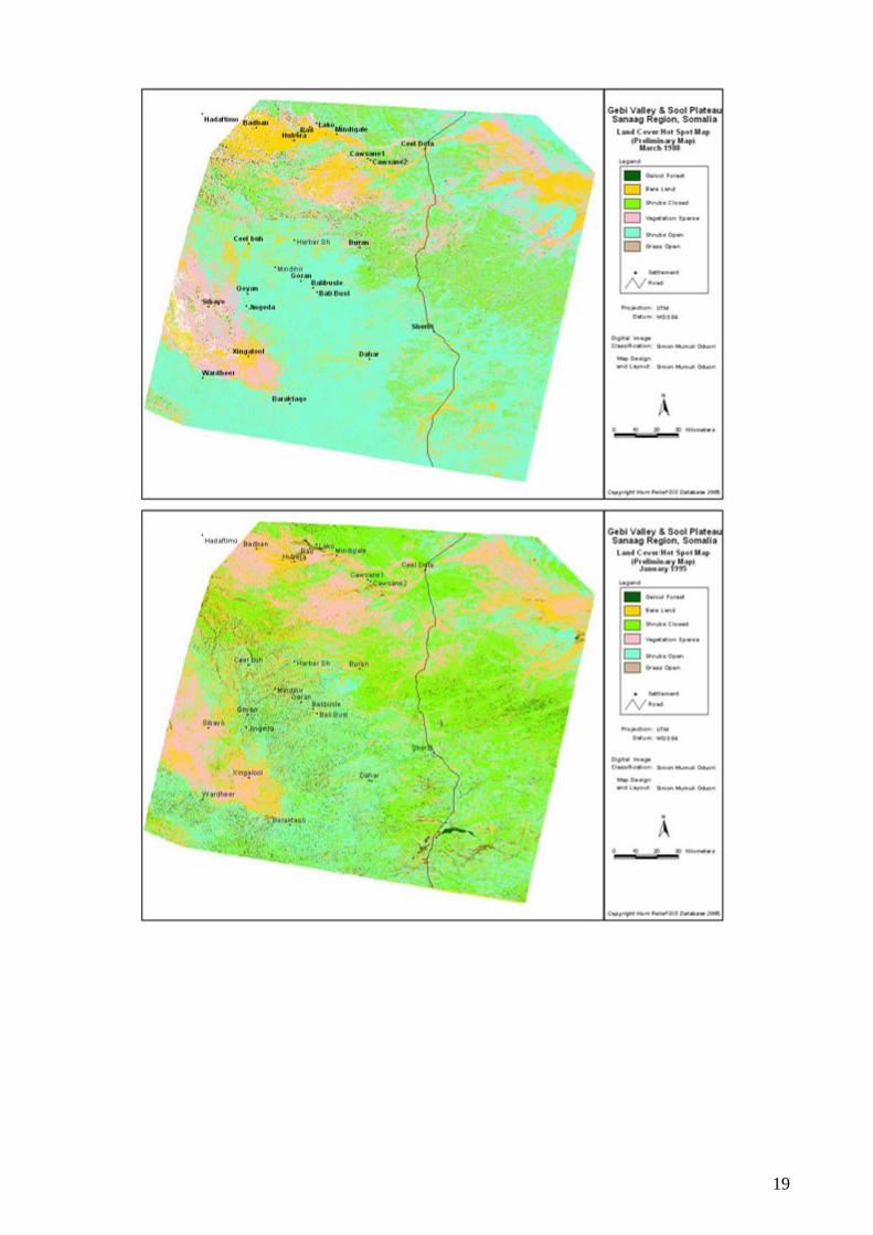
19

The results of the exercise revealed that hot spots are located in important settlement areas (with a population of above 15000 persons). In Badhan, Raad-Laako and Xingalool, for example, the surrounding areas have been severely degraded, with bare land being conspicuous since at least 1988. Xingalool was created in 1958 and Badhan in 1971. The maps also show an increase in the extent of these hot spots over the years. This trend is evident, for example, in the areas around Xingalool between 1988 and 1995. It is noteworthy that the three hot spots are located within Evaporate of Taleex (ET) formations, which re recent a alluvial deposits located in depression sites (lowlands) where human-settlement density is
ased settlement areas is so pronounced that even the wincid
germin over the region. Howev hot spots in these images remain visible throughout, even during the rainy season, with
ost of them featuring exposed soil. The area stretching between Badhan and Xingalool has xperienced increased degradation over the years, as the results of the analysis of the images show.
elief team in Somalia confirms the results of the computer-
The teconcep ction. During the training, the team selected sites for the field survey based on the Preliminary Satellite Image interpretation and in consultation with Somali-based staff of Horn Relief.
high due to water accessibility. In the Gebi Valley, these coincide with the three flood plains: Cawsane, Raad-Laako and Xubeera. B on preliminary analysis, degradation within these in et season plant growth is limited, as evidenced in the images from November 2001 which co es with the Deyr or short rains. However, following the onset of the rains, herbaceous material
tes and the January 1995 image reveals herbaceous vegetation present all aer,
me
round observation data by the Horn RGaided satellite imagery classification. The area between Badhan and Cawsane including Raad-Laako and Mindigaale is characterised by the presence of pronounced gullies. Gullies are also found between Badhan and Ceel-Buh and south of Dhahar. Some gullies are large, visible and in some instances appear in the interpreted maps as pockets of degraded, bare land. 5.3 Methodologies for the Field Survey
am of experts spent three days training Horn Relief staff members on environmental ts and data colle
20

n September 21, 2005 and October 11, 2005, which coincides with the end of the short dry (Xagaa) and the beginnin
Betweeseason g of the short rainy season (Deyr), the team assessed a total of
• eera, Hadaaftimo and Yuube)
•
asta
20 settlements and their surrounding environments. These comprised: Seven settlements in Gebi valley (Ceel-Doofaar, Cawsane, Mindigaale, Raad-Laako, Badhan/Xub
• One settlement in the Karkar mountains (Buraan) • Nine settlements in Sool plateau (Ceel-Buh, Mindhicir, Bali-Busle, Carmaale, Dhahar and
Sherbi in Sool Plateau North; and Wardheer, Sarmaanyo and Baraagaha-qol in Sool Plateau South) Three settlements in Xadeed (Xingalool, Sibaayo and Damala-Xagarre)
Due to time constraints, the team was unable to visit the Golis Mountains (Al Madow) and the co l areas (Guban), which form part of the local pastoral ecosystem.
21

All the localities visited are in Sanaag region except Sarmaanyo, which falls within Sool region, and Sherbi and Ceel-Doofar which form part of Bari region. Yuube, Carmaale and Damala-Xagarre are located in Cerigaabo district. Hadaaftimo, Badhan/Xubeera, Mindigaale, Raad-Laako, Ceel-Buh, Mindhicir and Wardheer are part of Badhan district. Cawsane, Buraan, Bali-Busle, Baraagaha-qol, Xingalool and Dhahar are situated in Dhahar district. The majority of the settlements are home to the Warsangeli, except Sarmaanyo which is inhabited by Dhulbahante, and half of Damala-Xagarre, in which Dhulbahante also predominate. The village of Sherbi belongs to a group called Dishiishe.
22

The estim ersons. However, these figures may not be entirely accurate for the following reasons:
•• ements on the Sool Plateau located in Sool Region and
Puntland (along the tarmac road and east of this road) were not assessed
.4 Procedure for Field Survey Work
ttlement centres or villages. Gatherings occurred in elected positions like in the shade of trees, halls, spacious rooms or school classrooms. The field urvey exercises in each settlement were conducted as follows:
1. Discussions were held with the most respected local community elders, women and youth behalf of
2 peeches from the three experts (namely Nathalie, Simon and Musse). During these introductions, a detailed account was made of the aim of the field visits.
3 ted the full cooperation of the elders during the field visits with respect to the research in general and to responding to the questionnaire
4
5
ght, cyclones, land-resource-use-related problems and desertification, traditional environmental
ervation techniques used and modern approaches to soil conservation. 6 e end of the session elders were asked to identify from among their number three
ded assessment of the most serious damage in terms of: soil erosion; tree cutting and charcoal burning; grass harvesting for sale; and local water sources points.
7 embers (Nathalie, Simon, and Musse) of the original team then separated from and formed three new teams each with two assistant enumerators and the
8 Kenya Soil Survey data form was used to collect data on soils while a modified FAO-
ta form was used to collect data on land cover and land use. Specially rms were used to collect data on charcoal burning and vegetation.
9.
ated population of the study area as of 2005 is 21,509 households, or 150,000 p
They do not necessarily include all pastoralists A number of permanent settl
5 The study applied a routine procedure throughout the process of fieldwork for Gebi Valley and Sool plateau. The first part of the morning session was used to mobilise the respected resident elders, women and youth groups of the various sess
who were able to converse clearly about relevant local environmental problems onthe community.
. The gatherings were preceded by introductory s
. Following the introduction, the team reques
specifically. During this session the team moderated debate, undertook interpretation and took notes.
. The qualitative portion of the general questionnaire was administered. (See annex 1)
. Elders were asked to share their local knowledge of their environment, and to respond to specific questions pertaining to settlement history, population estimates, local land degradation, droughts, impacts of drought, local coping strategies for drou
cons. At th
individuals familiar with local environmental problems. Each of the three would then serve as a guide to a member of the team during the field exercises in the vicinity. Areas of focus inclu
. The three meach other guide picked from among the elders. This was to allow each expert to undertake a practical and specialised observation and investigation. Nathalie’s (social anthropology) team visited water-source sites in the area used both for domestic needs and to water animals. Musse’s (soil) team investigated areas with problems of soil erosion. Simon’s team (ecology) visited sites where tree cutting, charcoal burning and grass harvesting were carried out. The ecology team also collected data on land and vegetation cover and frequency, and herbaceous biomass.
. The SWALIM-designed questionnaire was used to collected data on water sources. The
Africover dadesigned foData collection was supervised by the three experts with the help of the assistant enumerators.
23

Notes on the Ecological Survey The results of the preliminary interpretation made in Nairobi formed the basis of the ecological fieldwor . Samples sites for field verification were selected based on the different land cover hot spots identified in th interpretation of the preliminary satellite image.
ke
he output of the initial satellite-image interpretation was a preliminary land cover map showing hot pots in the study area. Subsequently, stratified random sample points were selected in each land-
y coordinates of these points were entered in the handheld Garmin lobal Positioning Systems, GPS, as waypoints. These waypoints were used for navigation to the
ss, data on the constituent lassifiers was collected. FAO’s Land Cover Classification software was then used to classify the nd-cover classes. All the land-cover types were visited and ground truth data collected on the
ibutes. Selection of the sample points was based on accessibility.
tation ttributes determined: species name, frequency, crown cover and height class. At 20-metre tervals, basal clipping of the herbaceous plants was done.
otes on the Soil Survey
r suitable interventions aimed at soil conservation. The survey, which began n September 16, 2005 was not aimed at making a detailed survey of the land degradation of the tudy areas, but to acquire corroboration on the ground in selected areas identified on the desk-
s in line with tandard methods used for soil survey and utilised in the Manual for Soil Survey and Land
Evaluation of Kenya, 1987.
The field survey foc n the fo
• Geology • Landform • Slope • Vegetation cover • d use • Physica rties (depth, colour, te tructure , ompaction, sealing/crusting) • Chemical analysis (pH, salinity and sodicity, content o s
Tscover stratum. The x and Gsample points for field-data collection. Data was collected on land cover, land use and vegetation frequency, cover, height and species composition, and clippings of herbaceous material for dry herbaceous biomass estimation. Classification of the various land-cover classes was based on the Africover-FAO Land Cover Classification System, LCCS. For each claclaabove listed attr The line transect method (Heady 1983, Crocket 1963, Johnston 1957) was used to estimate both woody and herbaceous vegetation parameters. The line transects measured 100m in length. The woody layer was sampled along the same transect. The woody crown interceptions (McIntrye 1953, Heady 1983 and Westman 1984) were recorded and the following woody vegeain NThe soil survey was undertaken to explore and map the severity of soil erosion, particularly in the gullies of Gebi Valley and Sool Plateau. Findings could then be used to form conclusions and recommendations foosstudy satellite images as hot spots. The methodology used for the fieldwork was
u osed llowing:
Lan Soil l Prope xture, s c f carbonate )
24

25
Chapter 1: Identifying and Tracking Hot Spots from Remote Sensing
fication
The gathered plant samples were classified using the Africover-FAO Land Cover Classification software, (LCCS), for easier establishment of classes from field data. Several classes were merged to produce manageable classes. Merging of the classes was done because of the small scale at which the mapping was carried out. 1.2 Estimates for Herbaceous Biomass Clipped vegetation matter was later oven dried at 80oC for 48 hours and then weighed to determine the dry herbaceous biomass (Muchoki 1988). Appendices 2 and 3 show the data forms used to collect data on the herbaceous vegetation layer. 1.3 ERDAS Imagine Land Cover Classification As mentioned previously, a computer-aided classification was performed using the ERDAS Imagine 8.3 software. In this process, the classification was controlled. The process involved giving the system knowledge in form of training sites, from the field samples, out of which the spectral signature of each class was calculated. The classification was done using the Maximum Likelihood Algorithm. The computer-aided classification was more precise and rapid, and is one that can be repeated easily. After several trials, final land cover/hot spot maps were generated for 1998 and 2003. 2. Results The computer-aided classification process produced maps (see below) with the following classes of vegetation: 2.1 Galool Forest Galool Forest comprised 5.2% of the focus area in 1988 but only 2.9% in 2003. The forest is called Galool forest because Acacia bussei (Galool in Somali) is dominant. Other woody species in this forest included Acacia tortilis (Qurac), Boscia miniimifolia (Meygaag), Salvadora spp. (Cadey), Acacia nilotica (Maraa), Cadaba herterotricha (Higlo), Ziziphus Mauritania (Gob) and Cadaba somalensis (Qaalanqal). Galool Forest covered an area of about 162,467.5 ha. in 1988 (Figures 4 and 5). However, by 2003, Galool Forest covered an area of about 78,211.89 ha. A total of 84,255.61 ha. of Galool forest were lost in the 15 years, equal to a loss of 52%. 2.2 Shrubs Open Shrubs Open comprised 45.1% or 1,397,528.28 ha. of the focus area in 1988 and 34.8% (94, 9957.83 ha.) 15 years later, a 30% decrease. The dominant woody species here include Acacia bussei, Acacia tortilis and Solana spp. Other woody species in this forest included, Boscia miniimifolia (Meygaag), Salvadora spp. (Cadey), Acacia nilotica (Maraa), Cadaba herterotricha
(1988-2003) This chapter discusses the results of the final interpretation of satellite images. These results are based solely on the field observations. 1. Methodology for Field-data Analysis 1.1 Land-Cover Classi

(Higlo), Ziziphus Mauritania (Gob) and Cadaba somalensis (Qaalanqal). Herbaceous species include Anthropogon spp. (Duur), Chrysopogon aucheri (Dureemo), Sporobolus variegatus (Duxi), Dactyloctenium spp. (Saddexo), Sporobolus spp. (Sifaar), Eragrostis haraensis (Gubungub), Cynodon Dactylon (Doomaar Madow), Paspalidium desertorum (Gargaro), Digitaria scalarum (Xul or Domar Cad), Olea chrysophylla (Weyrax), and Chloris spp. (Xarfo). 2.3 Sparse Herbs/Shrubs Sparse Herbs/Shrubs constituted 33.5% (1,038,259.89 ha.) and 36.3% (993,558.69 ha.) of the study area in 1988 and 2003 respectively, a decrease of 44,701.2 ha. (4%). The woody plant species included Euphorbia spp. (Xagar), Boswellia spp. (Moxor), Balanites spp. (Kidi), and Acacia spp. Herbaceous species included Sifaar, Gubungub, Rako, and Yamaarug. 2.4 Grassland In the focus areas, grassland constituted 402,896.52 ha. or 13% in 1998 and 236,149.74 ha. (8.6%) in 2003. This represents a decrease of 166,746.78 ha. (roughly 40%) in grassland cover between 1988 and 2003. The dominant species included Sifaar, Chrysopogon aucheri (Dureemo), Spropolus variegates (Duxi), Anthropogon kelleri (Duur), Gubungub, Rako, and Yamaarug. 2.5 Bare Lands (soils and rock) Bare soils and bare rock constituted 3.3% or 100,715.49 ha. in 1988, and 17.4% (475,901.73 ha.) in 2003, of the target areas. In other words, bare land increased by 375186.24 ha. or 370% during the period in question. Table showing Size and Proportion of land cover in study area and Herbaceous Biomass 1988 attributes
Bare Soil Forest
Shrubs Open Grassland
Sparse Herbs/Shrubs TOTAL
Ha 100715.49 162467.46 1397528.28 402896.52 1038259.89 3101867.64 % 3.3 5.2 45.1 13 33.5 100.1 2001 attributes
Bare Soil Forest
Shrubs Open Grassland
Sparse Herbs/Shrubs TOTAL
Ha 623342.97 66960.45 107245.96 485887.14 824070.15 2107506.67 % 29.5 3.2 5.1 23.1 39.1 100 2003 attributes
Bare Soil Forest
Shrubs Open Grassland
Sparse Herbs/Shrubs TOTAL
Ha 475901.73 78211.89 949957.83 236149.74 993558.69 2733779.88 % 17.4 2.9 34.8 8.6 36.3 100 2005 Herbaceous Biomass (Kg/Ha) NA 200 1400 460 120
26

he table and results above show distinct trends in land-cover dynamics in the study area. However, no
Tconclusions can be drawn about the causes of these changes. For example, bare lands increased between 1988 and 2003 whereas Galool Forest decreased over the same period. Possible causes for these changes in land cover, based on qualitative data gathered, will be addressed in the following chapters.
The table also shows the herbaceous biomass, in each land cover type, for the year 2005. Sparse Vegetation had the lowest herbaceous biomass estimate (120 Kg/ha) while Shrubs Open had the highest, at 1400Kg/ha. Other herbaceous biomass estimates were 200Kg/ha.and 460Kg/ha.for Galool Forest and Grassland, respectively.
27

28

29

Chapter 2: rought
rought has been identified as one of the major environmental problems in the Gebi Valley and international agencies. This chapter will present a
analysing drought hazards and trends in the study areas using information from rainfall analysis and indigenous knowledge compiled during fieldwork. Lastly, this section will also capture the effects of the recent drought on the vegetation and on local livelihoods as revealed by NDVI analysis and interpretations of satellite imagery, supported by field observations and interviews with pastoralists.
1. Conceptual Framework
Camilla Toulmin (IIED, 1993) drew clear distinctions between drought and desiccation. Drought iswhich rainfall is below average, and in which water
hortages reduce growth and the final yield of staple crops or pasture. Humans and livestock are
ri, 2003):
sub-normal rainfall is reflected in reduced biomass, low levels of surface runoff in rivers and streams, scarcity of pasture and the drying up of small streams.
• Hydrological drought is a condition in which aggregate runoff is less than average runoff. It refers to a period during which stream flows are inadequate to supply established uses under a given water management system. This type of drought has a direct impact on the operation of multipurpose dams, irrigation schemes, water-generated energy sources and water-driven industries such as water mills.
• Socio-economic drought refers to the effects of droughts on the supply and demand of goods. Drought, according to the socio-economic definition, occurs when supply falls below an established level of requirement demand due to rainfall shortages. The supply of agricultural, animal products, silvocultural products falls short of normal demand. The impact of drought in this case is frequently exaggerated, as there is a tendency to blame drought wrongly for all types of shortages that may be actually associated with other factors, such as hoarding.
• Agricultural drought refers to conditions in which the water needs of plants and animals are not met. This category is further divided into: incipient drought, permanent drought and seasonal drought. Incipient drought is considered drought only in instances in which the objective is to achieve the maximum possible yield from a given crop variety. It is important only at the experimental level and with respect to modern, large and specialised farms. Permanent drought occurs in arid areas where rain fed agriculture is impossible. In these areas, cultivation is only possible through irrigation. Seasonal droughts are droughts that
D
DSool Plateau both by local communities andconceptual framework of drought, before
defined as a period of one to two years in saffected by drought in two ways. They endure food and water shortages. Desiccation, by contrast, is defined as a process of aridification resulting from a dry period lasting decades. The risk of drought is a product of both exposure to the hazard (climatology) and the vulnerability of livestock and people to drought conditions (Wilhite, 2000). Exposure to drought is assessed through monthly and annual climatic variations. 1.1 Typology of Droughts
divided into four categories (Mathuva and OduoDrought can be
• Meteorological drought is a condition in which precipitation is below the expected average. This presupposes that ecosystems and human activities are adapted to the average precipitation of an area, and less will induce moisture stress on the ecosystem. Such a situation may lead to a steady impoverishment of the quality and diversity of flora and fauna especially if frequent and persistent. The impact of
30

occur every season. Seasonal droughts aris sons are disturbed and irregularity sets in.
.2 Drought Characteristics and Severity
Droughts differ from one another in three special characteristics: intensity, duration and spatial coverage (Mathuva, 2003). • Intensity: This refers to the degree of precipitation shortfall and/or the severity of impact
associated with the shortfall. This is generally measured by the deviation of some climatic
nitude of drought impact is closely lated to the timing of the onset of the precipitation shortage, and its intensity and duration.
differ in terms of their spatial characteristics. Areas
rought should be able to account for the
• o reduce human suffering by providing water during the drought emergency minimise household vulnerability to future droughts
to mitigate and withstand future droughts
k economy. An early warning ystem is an important component of drought monitoring programmes. Drought occurs when a
in time and space. Drought is best defined nced in the difference between time supply
e when the normal dry and wet sea
1
index from normal and is closely linked to the duration in the determination of the impact. The simplest index in use is the percent of normal precipitation, which compares actual precipitation to normal or average precipitation for time periods ranging from one to twelve or more months. Actual precipitation departures are normally compared to expected or average amounts on a monthly, seasonal or yearly basis.
• Duration: This refers to the length of the time interval in which the drought occurs.
Droughts usually require a minimum of one to three years to become established but then can continue for several consecutive years. The magre
• Spatial coverage: Droughts also
affected by severe drought evolve gradually and regions of maximum intensity shift from season to season.
The effects of drought vary according to the time of occurrence, frequency (probability), severity (persistence), and duration. Recurrence of droughts can be established in circumstances where long-term weather data is available. The severity of these droughts depends on the number of dry spells within a rainy season. Temporal fluctuations in seasonal and mean annual rainfall are indicative of the persistence of drought. A good definition of dvariable susceptibility of tree crops and vegetation during different development stages.
1.3 Drought Preparedness
According to Mathuva and Oduori (2003), in the event of drought the objectives of intervention include the following:
T• o preserve asset stock in order to • To build communities’ capacity
T
• To facilitate a coordinated approach among relevant agencies in effectively targeting and providing relief assistance to affected population groups
rought results in deterioration of natural resources and the livestocDssignificant water deficit takes place that is spread both
y using properties of water deficit conceived or experiebof water and water demand. Therefore, a large water deficit of significant duration for a given water user or interest is defined as drought. The process of planning for drought consists of three elements:
31

• Drought Monitoring, which involves identification of indicators of drought that can be tracked in the process. A drought forecast is part of drought monitoring and comprises four elements, amely: duration, severity, distribution, and occurrence. Thus in a drought forecast, it is portant to study the duration and severity of critical droughts using annual and seasonal
rainfall time series data. In Northern Somali it is possible to forecast droughts using spatially aggreg d historic NDVI data. NDVI data can be used to predict drought severity and duratio rends in the Gebi Valley and Sool Plateau livelihood zones. A time series of this
isk as essment, which entails acquiring an understanding of the impact of drought severity, duration and spatial extent and community vulnerability to drought.
ance of drought to reduce its long-term risk.
e rainfall does not always provide sufficient moisture for green
nd
November, providing a second season of
s requires 30 years of continuous rainfall time-series data Historical data on rainfall patterns for Sanaag and Sool is
on-continuous rainfall sed in this study are
Seasonal Rainfall Patterns in Sanaag Region (1996-2005)
nim
a,aten t
NDVI analysis can be generated to provide long-term trends. It is however important to note that due to climatic change, it is no longer possible to forecast with certainty drought trends on the basis of time-series data.
• R s
• Drought mitigation, which is to take action in advThis requires policies, activities, plans, and programmes aimed at reducing drought vulnerability.
2. Rainfall Patterns in the Gebi Valley and Sool Plateau
The Gebi Valley and Sool Plateau areas are characterised by low, highly variable rainfall and a landscape that undergoes a marked and abrupt change between wet and dry seasons within a year. The amount and duration of rainfall in the rainy season decreases southwards away from the hilly and mountainous areas. Average annual rainfall varies from 300 mm in the Golis Mountains to 100 mm south of the Sool Plateau. Averagpastures for livestock and successful rain-fed crop production. There are two rainy seasons (Gu and Deyr) bracketed by two dry seasons (Jilaal and Xagaa):
• Gu is a transition period between the monsoons in April and May that is relatively warm a
humid, and which marks the main rainy season of the year • Xagaa is the southwest monsoon from June to September, cloudy and windy with relatively
ool and dry weather c• Deyr is another transition period from October to
ain r• Jilaal is the Northeast monsoon from December to March, which is the longer dry and hot
season
2.1 Rainfall Analysis Accurate and reliable rainfall analysi
cquired via the same methodology.alimited. Data available from before the outbreak of civil war consists of nime-series data recorded at local meteorological stationst 2. The records u
stacked time-series analysis (1996-2005) using unmarked Meteosat images (interpolated and smoothed) provided by FEWS-NET. For unknown reasons, three different sets of data for the ame period were made available and the third set is presented per season in the two tables s
below.
2 Daily, monthly and annual rainfall for the Northeast Regions of Bari, Nugaal, Sanaag and Sool, Ministry of Agriculture, Flood early Warning System Department, Mogadishu (FEWS, January 1989) provided by SWALIM. In this data set, there are no data available for between 1961 and 1984 and from 1987 to 1995. The rainfall data on the agro-climatology of Somalia ends in 1988.
32

020406080
100120140160
1996 1997 1998 1999 2000 2001 2002 2003 2004 2005
Jilaal (Jan-March)Gu (April-May)Hagaax (June-SeDhey (Oct-Nov)Jilaal (Dec)
Seasonal Rainfall Patterns in Sool Region
Source: FEWS-Net Meteosat, 2005
020406080
100120140160180
1996 1997 1998 1999 2000 2001 2002 2003 2004 2005
Jilaal (Jan-March)Gu (April-May)Hagaax (June-Sept)Deyr (0ct-Noc)Jilaal (Dec)
Source: FEWS-Net Meteosat, 2005 (1996-2005)
than Sool region, which lies in a lower altitude. In general the rainfall of both regions is t of the year, and by
to year and season to season. Normally, both regions receive the highest rainfall amounts in Gu season (April-May). However, the charts clearly
dicate a decrease in rainfall in both regions between Deyr 2000 and Gu 2004 (below 50mm in also experienced an exceptional Deyr. The
bles also show exceptional rainfall in Gu 1996 and Gu 2000.
. Since 1996, the longest dry spells nd correspondingly the largest deficit volume occurred during the last drought. The figures also how more deficits (dry spells) than surpluses (wet spells) in Sanaag region.
Rainfall in Sanaag region is strongly influenced by the hilly terrain of the Golis Mountains (Al Madow). Due to the mountainous and hilly masses, Sanaag region receives slightly higher rainfall
characterised by small total amounts having a bimodal distribution during mostemporal and spatial distribution variations from year
inaverage). After the plentiful Gu of 2004, both regionsta From the above rainfall data, two graphs were formulated for this present study to illustrate the recent drought events in the study area. The two graphs indicate an increase in dry spells both in magnitude and duration (1999 and 2001-2003 dry spell) for Sanaag regionas
33

Annual Drought Events in Sanaag Region
0
50
100
150
200
1996 99
719
9819
9920
0020
01 002
2003
250
1 2 2004
300
Annual rainfall
Mean Annual Rainfall1996-2004Mean Annual Rainfall1982-2004
Source: FEWS-Net, 2005
Annual Drought Events in Sool Region
0
50
100
150
200
250
300
1996
1997
1998
1999
2000
2001
2002
2003
2004
350
Annual Rainfall
Mean AnnualRainfall 1996-2004Mean AnnualRainfall 1982-2004
from 1982 to 2004) for three consecutive years (2001-2003).
50s
ral memory can be a very rich source of information about drought trends (see annex 2). From itative questions in the general questionnaire, it appears that several droughts
ave been widely experienced in the study area since the 1950s. For example Siiga-Casse (1950-
n Ceel-Doofar, it began in 1997.
NDVI is a useful indicator of changes in vegetation cover. Using remotely sensed satellite imagery data sets of the Normalised Difference Vegetation Index (NDVI) going back to July 1981, FEWS-NET and FSAU conducted a historic average vegetation profile analysis for just the Sool Plateau
Source: FEWS-Net, 2005
Drought events can be categorised as mild, moderate and severe using a standardised index (Gibbs, 1975; Rossi, et al., 1992; Sharma, 1997). According to Sharma (1997), a mild droughtcorresponds to 90 to 100% of the mean annual rainfall and may extend from 2 to 6 years over a time span of 10 to 200 years. A moderate drought corresponds to 80 to 90% of the mean annual rainfall and may persist for 2 to 4 years over the same time span. A severe drought corresponds with 60 to 80% of the mean annual rainfall and may persist for 1 to 3 years over the aforementioned time span. For Sanaag region, the more recent drought can be classified as a severe drought since the area received only 60% to 80% of mean annual rainfall (as measured
2.2 Local Oral Memory Since the 19
Othe analysis of qualh1952), Cadhooley (1963-1964), Daba-Dheer (1973-1974 also called Gargaaraley), Gubungubley (1984-1986), Arbaca (1990-1992) and of course the last drought (2000-2004) which has different names, the most common being Talawaa and Tuur ku qaad (meaning confusion and bear the burden on the back) because of the high death toll of pack camels. Droughts are locally described as cyclical events, which strike on average once a decade.
However, the last drought has been described as the worst ever experienced in living memory, as well as the longest and most extensive (see annex 2). This is reflected in its name in some localities, such as Lama Arag (never seen before) in Hadaaftimo. In most of the settlements visited during this study, especially in the Sool Plateau, it began in 2000 and lasted until early 2004. However, in several other locations, especially in the Gebi Valley and Xadeed, it began even earlier, in 1999; in Cawsane, Badhan and Hadaaftimo, it began in 1998; in Mindigaale, Sherbi, Mindhicir and Baraagaha-qol, and eve
3. Drought and Vegetation Decline A decrease in vegetation cover has been noted from NDVI analysis and satellite-imagery analysis supported by field observation and interviews with pastoralists. The main issues concern low levels of regeneration of palatable vegetation despite the last good rainy seasons (Deyr 2004, Gu 2005), and the appearance and proliferation of new non-palatable species. 3.1 Normalised Difference Vegetation Index (NDVI)
34

Food Economy Zone (FEZ). Low values of NDVI represent surfaces with less vegetation. NDVI values throughout the FEZ were spatially averaged for each 10-day period starting in 1981 to
erive a single value, and this was then compared with the long-term average for the FEZ to ddetermine the percentage deviation from normal.
In the graph above, four periods of sub-average NDVI are notable: 1981-1983, 1986, 1991-1992 and 2001–2004, which represent drought events characterised by low vegetation cover. The years 1997-1998 coincided with the El Nino rains, which were characterised by abnormally high rainfall. The result of this was manifested in high vegetative photosynthetic activity and hence high NDVI alues.
d Field Observations
es also dried.
ajor concern and many species do not seem to have fully recovered from the cent drought despite good Gu and Deyr rains in 2004-2005. Non-regeneration of Duur grass
(Anthropogo ful wind and water break, , 1951).
“ f trees did not re like Damal, Dhuur, Higlo, Meygaag; Qurac, Qalaanqal. Only 30% of Daran, Duur, Saddexo and Gubungub came back” (Ceel-Doofar).
“Duur and Gubungub gr recove herbi).
“Higlo, Meygaag, Qalaa ay, H Qansax nd Qu ac trees ot rege well. Duur and Duxi grasses did not fully recover” (Baraagaha-qol).
“Only 60% of Duur, Dureemo, Sifaar, Duxi, and Gubungub regenerated. Geed Wacal (Commiphora) trees did not come back” (Dhahar).
v
3.2 Indigenous Knowledge an
Pastoralists are well aware of the impact of drought on vegetation, especially on palatable vegetation, which is used as forage by the different categories of livestock (camels, cattle, shoats, donkeys and horses).
From the analysis of responses to the general questionnaire, it appears that drought has been one of the main causes of vegetation loss. Many trees and shrubs dried. The oldest pastoralists interviewed stated that Acacia bussei (Galool) declined by an average of 80% since the 1940s and 1950s. In 60% of settlements visited, many elders mentioned drought as one of the two major causes of decline of this species, the second cause being charcoal burning (see annex 3). Much of the perennial grass
Regeneration is a mre
n spp.) is particularly alarming due to its special properties: It is a usestopping lin way (Huntes of grass seed from being blown or floating right a
A lot o generate
asses did not r” (S
nqal, Jiic, Duk iil, a r did n nerate
35

“80% of Dhuur are dead “ t com i and Si ere al lost” ardhee “Higlo, Meygaag, Qalaanq t come back as well as Dureemo, Duur, Sifaar and Duxi. Only 30% of the grasses returned” (Sarmaa “Dureemo and Duur grass e back” ayo).
” (Mindhicir).
Duur plants did no e back. Dux faar w so (W r).
al, did nonyo, Sool Plateau South).
es did not com (Siba
Strip of Duur/Galool near Sarmaanyo, with dead palatable Duur (Anthropogon spp.), Sool Plateau North
Nomadic settlement in the degraded perennial grassland of Xadeed between Xingalool and Sibaayo
On the other hand, many intruder species appeared. In Yuube, Halamash grass appeared after the 1950 locust invasion from Ethiopia. In Raad and Mindigaale, pastoralists mentioned the intrusion of another non-palatable grass species called Aftoxolle (Zygophyllum Hildebrandtii) after the 2000-2004 drought.
ndtii) intruder in
4. Quantity and Quality Regional and local grou he target areas were investigated by Faillace & Faillace (1986). The authors obtai of their information from German and Chinese borehole-completion reports (Von Hoyer & Eckart, 1981; (CWDT, 1986). Sool Plateau groundwater is linked to ph 4.1 Physiography The study area can be divided into two physiographic provinces: (a) the plateaus and (b) the Valleys of the Gebi Valley (and part of Daroor Valley), on the one hand, and the Sool Plateau on the other. The geological formation of the plateaux belongs to the Eocene period and is widely exposed in these areas. On a regional scale, the movement of groundwater is better defined
Aftoxolle (Zygophyllum Hildebra Raad (Gebi Valley)
of Water from the Aquifer
nd water conditions in tned most
ysiographic, geology, and recharge processes.
36

according to the two major physiographic provinces. The hydrology of Taleex Plateau and Sool Plateau is as follows: The Taleex Plateau rises gently towards the edge of the escarpment, which
the uppermost part of the Togga Nugaal catchment zone. Water infiltrates rapidly into fractures, fissures, sinkholes and karstic depressions in both the Auradu limestone, which
ahar, Qardho and Adinsoone among others.
Sool plateau in the floodable area of Xingalool occurs at depths of approximately 60 metres. The middle and the upper sections of the Karkar Formation consist of
spite of the low rainfall in the Sool plateau and the great depths of water-bearing strata, the
The results of boreholes drilled in the Sool plateaus show that groundwater resources are
Water that falls as rain in the study area is very pure. As it runs off from and along the hills, plains
ck layers dissolves various materials. (Water containing more than 50 parts per million (ppm) of calcium and magnesium salts is considered hard and more than 100 ppm causes it to be
and lowfactor f
r k lalong smdry per
ccordf the aquifer. Drilled in 1987 by the Italian Development Agency, the borehole of Baraagaha-qol
constitutes the uppermost part of the Togga Nugaal catchment areas. Most of the area is covered by gypsum and gypsiferous soils and to a lesser extent by limestone. The areas covered by gypsum are completely bare, with some pebble layers covering a few places.
Drainage is nearly absent in areas covered by gypsum; karstic depressions and sinkholes are widely spread in these zones. Sinkholes in the area of Cerigaabo and south of the town often coincide with Berda trees. Groundwater recharge by direct infiltration in these regions occurs mainly in
constitutes the edges of the escarpment, and also in the overlying Taleex formation. According to the knowledge obtained from nine water wells drilled by the Chinese government in 1985 in Sool Plateau for rural water supplies, depth ranged from 113.5m in Xingalool to 230m in Guud Cad, which lies within the Karkar Formation. Most of the Chinese wells were drilled in the vicinity of previous deep wells. The new wells were drilled in Ceel-Buh, Dh
The water table in the
limestone with intercalations of marls, and are generally dry since aquifers are below 100 metres. The section is constituted mainly of marls and shales, with occasional intercalations of water-bearing limestone layers. These few, thin layers yield very little water.
Insemi-confined water-bearing layers intercalated with marls and clay layers supply water with low mineralisation. The Chinese boreholes have a TDS ranging from 1250 mg/l in Awrculus to 1730mg/l in Ceel-Buh. The borehole in Xingalool has a TDS value of 3300mg/l and taps water from the gypsiferous alluvial sediments, which accounts for the high TDS value, and from the Karkar Formation.
somewhat scarce and limited to small water-bearing layers of limestone intercalated with marls and clay of the of Karkar Formation. 4.2 Water Quality
and floodplains, it erodes soil and picks up a significant load of sediment. Water that seeps through soil and ro
classified as hard water because much soap is required for cleaning purposes).
Streams pick up more and more discharge water and dissolved salts as they flow into flatter areas elevations. The salt content increases more rapidly in arid regions because the dilution
or water is smaller. Salt concentration increases as less water and more salt go to the water table or to the streams. The highest concentration of salts occur in the dry periods because the oc yers and sediments of these arid soils contains more leached salt, and in the lower parts of
all rivers the length permits several leaching cycles to occur and the low water volume in iods provides minimal dilution. ing to local communities, the last prolonged drought also decreased the quality of the water A
o
37
was abandoned in 2002 just after its rehabilitation by Horn Relief3. A sudden and massive death of
ya in October 2003 shows high electro-onductivity (5.3mS) and high PH levels (8.2), high Calcium carbonate content (1550 mg/l),
ing water. Chloride concentrations of above 250 mg/l give water a salty taste. ulphate content in excess of 250-500 mg/l gives the water a bitter taste. Above 300 mg/l of alcium carbonate, water is said to be very hard. However, from the Faillace report, one of the old
igher figures (for example EC=6.7mS). Therefore, it is not clear hether high salinity; bitterness or hardness were direct cause of livestock deaths.
e permanent echanised shallow well providing hard water that is located inside the settlement for domestic
In Badhan, the manager of a spring reported that water levels had decreased by 10 meters.
gas). The groundwater level coincides with the water table and its shape correlates closely to the surface topography of the region, reaching its highest elevations
ubsides and gradually approaches the level of the valleys. Also, in times of extended drought, the water table may drop enough to dry up shallow
Water that passes straight into an aquifer is known as direct recharge, whereas water that
els may nevertheless be variable and seasonally controlled. This recharge mechanism (sub-surface flow) occurs along the
ult/fracture zones and the toggas. Sub-surface flow eventually reaches the vast plains, where it indirectly replenishes the various types of aquifers underlying them. Indirect recharge also occurs where hydraulic continuity exists between the alluvial topsoil and the deeply seated weathered or fractured basement aquifers; there will also be recharge from infiltrating surface water (streams and flood areas).
livestock occurred and was attributed by the local community to a deterioration of the water quality. The chemical analysis ordered by Horn Relief in KencChloride (1150mg/l) and Sulphate (1800 mg/l). All these recordings exceed international standards for human drinkSCboreholes of Xingalool had hw The quality of water from the 228-meter deep borehole of Yuube drilled in 1978 by the Italian Development Agency and rehabilitated by Horn Relief in 2004 is said to have deteriorated, albeit to a lesser extent, since the drought. The local population increasingly uses thmwater use. No analysis is available.
4.3 Factors Affecting Recharge Lack of rainfall diminishes the recharge rate of springs, boreholes and permanent wells.
However, this is also due to high levels of water removal for trucking to settlements for filling berkeds or directly to grazing sites.
In the study area, primary recharge water only comes from rain, while secondary recharge may occur via seasonal rivers (tog
beneath the hills and descending towards valleys in response to gravity. The slope and the material through which the water drains determine its velocity and direction of movement. When rainfall decreases, the water table in the hills s
wells. So the variations in rainfall permeability of rocks and sediments from place to place are contributory factors to the unevenness of the water table.
percolates laterally from higher elevations into aquifers at lower elevations, or that leaks from rivers is known as indirect recharge.
Direct recharge from rainwater is unconfined recharge to phreatic or water table aquifers and the indirect recharge is rainwater infiltrating directly into the surface on relatively high ground flows under gravity towards the lower plains. The rate of flow is determined by both gradient and geological material. Due to the limited storage volume, water lev
fa
3 Horn Relief’s rehabilitation of the various borholes involved only provision of new gensets and infrastructure sorrounding the exterior (e.g. water troughs, engine house, etc.) where appropriate and did not involve any work on the interior of the borehole.
38

Data on water quality from underground water sources in the study area4: N.B: 1mmho/cm ≈ 750 ppm ≈ 0.075% ≈ 10 meq /litre ≈ 0.01 N
Zone Location Depth PH EC Taste Recharge
rate Ceel-Doofar borehole 70 Hard NK Badhan spring 10 8 2.64 ms Hard NK Ceelaayo 18 Hard Poor Mindigaale wells 5 Hard Good Body Cadet well 14 Hard Poor Yuube borehole 228 Turned Hard 15 minutes
Gebi Valley
Qoraley well 27 Hard Poor Buraan borehole 36 7 2.5 ms Sweet 15 minutes Karkar Buraan spring 5 Sweet NK Carmaale 160 Sweet immediate Ceel-Buh old 194 7.4 2.7 ms Sweet 1 hour borehole Ceel-Buh new borehole
250 7.3 1.3 ms Sweet 4 hours
Baraagaha-qol le
160 8.2 5.3 ms Turned very hard in 2002
immediate abandoned boreho
Sool Plateau North
NK Sweet NK Dhahar borehole Xingalool old borehole 120 Hard immediate Xingalool new borehole
110 Hard immediate Xadeed
Sibaayo well 16.5 Very Hard NK
4 All measurements were taken during fieldwork, except for Baraagaha-qol borehole. For this borehole, chemical water analysis was done in Kenya by the Government Chemists Department in October 2003 at the request of Horn Relief.
39

5. Drought’s Impact on Pastoralist Livelihoods
The last prolonged drought, particularly during the last two years, (2003-2004) had severe impacts on pastoralism, which is the main economic activity in the study area. Drought dried up all the palatable vegetation used as forage by the different categories of livestock (cattle, camels and shoats), which died from starvation and a decrease in water, as reported by pastoralists and Horn Relief. The main causes of camel death are malnutrition and related diseases. Large camel deaths are a result of the lack of quality pastures for three consecutive years. (Horn Relief, op cit, June-July 2003). In Buraan, elders reported that camels ate the denuded branches of trees and died from gum infection.
Migration, which is the usual coping strategy, was not practica
area; the dearth of pack camels and donkeys and k to grazing tes; and also restriction of movement d to its own territory. The main coping strategy of
, many of which essentially faced destitution, has been to turn to alternative sources of velihood using local natural resources: charcoal burning and grass harvesting.
%, and even higher mortality rates among pack camels (over 80%), which increased vulnerability of pastoralist households by reducing their
oats died. Even more alarming was the drop in livestock uture viability and recovery (FSAU, 2003).
The average size of camel herds before the drought was 79; afterward it fell to 4. Settlements with higher mean camel herd sizes were: Baraagaha-qol (300); and Dhahar, Mindhicir and Ceel-Doofar (all 100)
• Settlements most affected by camel losses were Baraagaha-qol (99.3%), Wardheer (98.7%), Cawsane and Dhahar (98%), Ceel-Buh (97.7%), Sarmaanyo (97.5%) and Carmaale (97.1%). All these settlements are located in Sool Plateau North and South, except Cawsane, which is in the Gebi Valley
• The settlements least affected by camel losses were Badhan (83.3%) and Sherbi (85.5%)
Loss of pack or burden came by a nickname of the last drought in Sarmaanyo (Tuur rarato, meaning: carry everything on your back)
l due to a coincidence of several factors: the extent of the drought in the affectedthe high cost of hiring truck to transport livestocfollowing the civil war, when each clan returnepastoralists
si
li
5.1 Loss of Livestock
A multi-agency team (FSAU/FAO, UNICEF, WFP, UNOCHA, FEWS NET, Horn Relief and VSF) conducted an emergency humanitarian assessment in Sool Plateau October 9-13, 2004. The objective was to ascertain the severity and extent of the humanitarian problem and make recommendations concerning appropriate responses. The principle findings showed that cumulative livestock losses (mortalities and distress sales) over the past four drought years decimated herds and altered herd composition. Most critically, camels were particularly affected, with losses of 60-70
mobility. Nearly half (40-50%) of shreproduction, on which hopes rest for f
From the study, the uniqueness of the last drought is that it eradicated the majority of the livestock and not only killed drought- vulnerable categories of livestock such as cattle, but also camels. The drought was nicknamed Xoola Dhamays meaning “eradication of all animals” in Sibaayo; Mariso or “it emptied everything,” in Badhan, and Geel Baabi’iso in Mindhicir, meaning “Camel Killer.” These losses induced considerable trauma; many wealthy camel owners who have lost their beloved animals suffer from psychological harm, for example, drawing camels on rocks (Xingalool).
In the study area, pastoralists provided us with the following information on livestock losses (see annex 4):
• Pastoralists lost on average 97% of cattle, 95% of camels, including pack camels, 82% of
shoats and 71% of donkeys •
ls is a major issue, as reflected
40

“The pack camels died because they carried water back and forth. They could not find enough forage with the drought, not enough forage” (Ceel-Buh).
To date, the only category of livestock that has recovered is shoats (estimated at 50% of pre-
2005.
ites surveillance, malnutrition levels within the Sool plateau were gradually decreasing with the exception of Xingalool and Awrboogays; 5.4% of the women were malnourished, significant decline from April- 2004 levels. (FSAU Nutrition update, January 2005).
The u r-five mortality and crude mortality rates were 0.9/10000/day and 0.2/10000/day
es were indicative of a situation approaching the lassification alert. (IIA, 2003).
tree of a type known as Carmo. In Mindhicir, pastoralists resorted to
consuming hyenas. In Ceel-Buh, before the provision of food aid, women were forced to feed
f malnutrition provided several explanations.
e other hand, these two locations benefited from small rains in Deyr 2003 and Gu 2004. Some
coal burning was used as a source of livelihood in Bali-Busle on the Sool Plateau North from 1991 until February 2004.
drought levels).
5.2 Famine and Malnutrition Loss of livestock affected the diet of pastoralists. A 60-70% drop in income from livestock sales drastically reduced the purchasing power of producers (FSAU, 2003). The lack of livestock products, which are the main source of food and income, especially milk, considerably increased malnutrition rates, which remained high in some surveillance sites as of early
Approximately 15,500 households in the Sool Plateau of Sool, Sanaag and Bari Regions, Gebi Valley and Lower Nugaal livelihood zones have experienced food insecurity (FSAU). In November 2004, all sites in the Sool plateau reported global malnutrition rates below 16.5%. Compared to the last rounds of sentinel s
a
nderespectively, lower than those observed in previous surveys (FSAU, Nutrition Update, January 2005). In May/June 2003, there were respectively 1.9 deaths per 100,000 children under five and 0.88 deaths per person per day. Both mortality ratc
In Cawsane, women cooked a
young children a diet of black tea, exclusively.
However, it is interesting to observe that Global Acute Malnutrition trends vary greatly among the FSAU-monitored sites as shown in the table below. Staff who have been involved in FSAU’s monitoring o
Firstly, the drought did not affect all the settlements at the same time and with the same severity. Xingalool, Awrboogays and Sarmaanyo began to feel the effects of lack of rain in Jiilaal 2004 while other localities, such as Bali-Busle and Shimbiraale were already affected in Jiilaal 2003. On th
settlements received food aid and had more opportunities to turn immediately to an alternative source of livelihood. For example, char
41
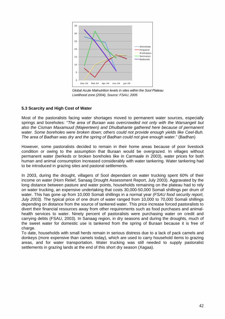
0
5
10
15
20
25
30
Dec-03 Feb-04 Apr-04 nov-04 jan-05
35
ShimbilaleHingaloolArwbogaysSarmanyoBalibulsle
Global Acute Malnutrition levels in sites within the Sool Plateau Livelihood zone (2004), Source: FSAU, 2005
5.3 Scarcity and High Cost of Water
Most of the pastoralists facing water shortages moved to permanent water sources, especially springs and boreholes: “The area of Buraan was overcrowded not only with the Warsangeli but also the Cisman Maxamuud (Majeerteen) and Dhulbahante gathered here because of permanent water. Some boreholes were broken down; others could not provide enough yields like Ceel-Buh. The area of Badhan was dry and the spring of Badhan could not give enough water.” (Badhan) However, some pastoralists decided to remain in their home areas because of poor livestock condition or owing to the assumption that Buraan would be overgrazed. In villages without permanent water (berkeds or broken boreholes like in Carmaale in 2003), water prices for both human and animal consumption increased considerably with water tankering. Water tankering had to be introduced in grazing sites and pastoral settlements. In 2003, during the drought, villagers of Sool dependant on water trucking spent 60% of their income on water (Horn Relief, Sanaag Drought Assessment Report, July 2003). Aggravated by the long distance between pasture and water points, households remaining on the plateau had to rely on water trucking, an expensive undertaking that costs 30,000-50,000 Somali shillings per drum of water. This has gone up from 10,000 Somali shillings in a normal year (FSAU food security report, July 2003). The typical price of one drum of water ranged from 10,000 to 70,000 Somali shillings depending on distance from the source of tankered water. This price increase forced pastoralists to divert their financial resources away from other requirements such as food purchases and animal- health services to water. Ninety percent of pastoralists were purchasing water on credit and carrying debts (FSAU, 2003). In Sanaag region, in dry seasons and during the droughts, much of the sweet water for domestic use is tankered from the spring of Buraan because it is free of charge. To date, households with small herds remain in serious distress due to a lack of pack camels and donkeys (more expensive than camels today), which are used to carry household items to grazing areas, and for water transportation. Water trucking was still needed to supply pastoralist settlements in grazing lands at the end of this short dry season (Xagaa).
42

Drums in front of a nomadic settlement near
Water being trucked from Buraan spring to Mindhicir berked
During
sistavern
urtun
years o rced to be self-reliant: “We are between Somaliland and
tward Migration
Carmaale ready to receive water trucked from the berkeds of Carmaale, ahead of the next Deyr hort rains
s
6. Coping Strategies and their Limitations
previous droughts especially Dhaba-Dheer (1973-1974), pastoralists received considerable nce from the Somali gas overnment, which resettled a large number of destitute people in
Go ment irrigation schemes built in the fertile riverine areas of Juba and Shabeelle regions -Waarey, Sablaale, Dujuuma and the coastal town of Baraawe). During the las(K t drought, in
the absence of a strong government, and before humanitarian assistance was provided (after 3 f drought), pastoralists were fo
Puntland, in the middle, we are abandoned by the two administrations and only Horn Relief came to assist us with limited capacities.” (Mindigaale)
6.1 Inward and Ou
Normally, the main coping strategy during drought is migration. From 2000 to 2002, pastoralists tried to migrate outside Sanaag region but due to the extent and severity of the drought, a majority returned, and most of their livestock died in their home areas. In 2002, some pastoralists from Ceel-Buh decided to migrate to the Hawd in Ethiopia but due to the extent of the drought, many of them did not survive. Some camels from Cawsane were left in Guban but these were also lost. Elders reported that the pastoralist movements were later restricted by the loss of pack camels and the high cost of truck hiring for livestock transportation.
Some pastoralists from Garoowe came to Sanaag region hoping to find Gubungub (Eragrostis haraensis) for their livestock; consequently this grass species declined due to overgrazing. It is interesting to note that the drought that affected the study areas between 1984 and 1987 was nicknamed Gubungubley because of overgrazing of Gubungub by migrants.
Gubungub (Eragrostis Haraensis) between Badhan and Ceel-Buh.
43

Pastoralists also mentioned political restrictions imposed following the civil war, when manSomalis returned to clan territory. In Yuube and Xingalool, elders stressed that migration was onpossible within Warsangeli territory since the civil war.
y ly
6.2 Displacement of the Destitute to Settlements and Urban Centers
y were left especially old men, women and children who are difficult transport. They also emphasised that pastoralists are still paying debts for water and food
Dhahar). The destitute have been blamed for increases in theft and deterioration of hygiene. In Dhahar, women reported that water and housing facilities are
In several locations, a number of destitute pastoralists received help from the Diaspora (Wardheer, Xingalool, Ceel-Buh, Damala-Xagarre, and Badhan). Buraan, Wardheer, Ceel-Buh, Cawsane,
ube) for the men and house-help work (Xingalool) for women. Some destitute women managed to open
rcoal burning and drought coping
“Whene is also charcoal burning. As there
ccord re also used as a source of r a berked owner
ctive to the environment and also to pastoralism, the local main source of livelihood. Alternative livelihoods that were adopted as drought-coping strategies, such
natural ommunal vs. private land use). Drought preparedness was very limited.
In all the permanent settlements visited, correspondents emphasised the migration of destitute pastoralists to urban centres. In Buraan, the representative of the Buraan Women’s Union (BWU) explained that: “Most of the destitute pastoralists run to the settlements to seek assistance from their relatives or find work. Mantobought on credit during the drought. In Badhan, elders estimated that 70% of pastoralists moved to towns and other settlements to stay with relatives, or got help from outside.
According to many correspondents from urban areas, this trend put pressure on urban centres (Buraan, Ceel-Buh, and
insufficient for the increased population.
6.3 External support
Baraagaha-qol, received food relief from WFP. 6.4 Alternative Livelihoods
Many destitute people move to towns to seek employment such as stone collection (Yu
businesses (tea kiosks, shops). However, all settlements visited named chas, as the main grass harvesting in open, legally and illegally enclosed rangeland
strategies: we lost our livestock, everybody tried to survive. Before we had free grazing, now a lot of
. Therenclosures are established for grass harvesting and salesis no government and few NGOs to help us, we became aggressive to the environment” (Raad).
“People who lost their animals became like beasts and started eating the land: they cut trees to burn charcoal and sell it.” (Ceel-Doofar)
ing to Buraan, Xingalool and MindhicA ir elders, berkeds we
income; many of them have been built for commercial purposes. Average profit fois 10,000 Somali shillings per 200-litre drum sold. Conclusions
Despite the lack of data for a proper drought analysis, it can be concluded that the last drought that occurred in the study area was devastating because the water deficit was extensive in terms of both time and space. It was destru
as charcoal burning further destroyed the fragile environment and spurred conflict over scarce resources (c
44

Many fforts to date have focused on understanding drought hazard rather than drought vulnerability
after the drought, this study could not conclude the reasons for these claims and commends that this be addressed through a hydro-geological survey.
e(Downing and Baker, 2000, (Wilhemi and Wilhite, 2002). Drought vulnerability factors are developed in the following chapters. Although the community claims that the quality of borehole water has significantly decreased, particularly re
45
Chapter 3: Soil Erosion
Soils constitute a small fraction of the earth’s material, yet they are a vital resource for the growth of plants and are very fundamental for humans’ life-support system. Soils are damaged or destroyed by human carelessness, which can cause the loss of fertile topsoil and disturb more and more of the earth’s surface. The soils in the study area are under stress from considerable erosive forces, especially water and wind, which move soil components from one place to another.
1. Conceptual Framework
Erosion by water occurs wherever rainfall drops strike bare soil or runoff water flows over erosive and insufficiently protected soil. There are four main forms of water erosion: • Splash erosion is the detachment of soil particles by the striking force of rain drops on an
unprotected ground surface • Sheet erosion is the removal of thin layers of soil by flowing water on the soil surface. Rain
drops splash and surface water flow cause sheet erosion, with splashes acting to provide most of the detaching energy to soil particles and the ensuing water providing most of the transporting capacity
• Rill erosion occurs when rills begin to form when water flows as a thin, unconfined sheet for a relatively short distance before developing into threads and tiny channels
• Gully erosion occurs when rills enlarge and cut deeper into the soil until they are too large to be erased by ordinary tillage
Water erosion causes damage in many ways. Soil is lost; plant nutrients are removed; texture is changed; structure deteriorates; productive capacity is reduced; and fields are dissected. The sediments produced polluted streams and lakes and pile up on bottomlands, in stream channels, and in reservoirs
Wind erosion is a process of detachment, transportation, and deposition of soil material by wind action. It causes serious soil deterioration and is a major problem in dry-land regions like the Gebi Valley and Sool plateau. Serious and widespread wind erosion occurs periodically in this area, most often during Jiilaal season of the year (when winds from the northeast blow in the country) between the months of December and February and sometimes even in September. Soils are moved by wind in one of three ways: soil particles and aggregates of silt size and smaller are kept suspended by the turbulence of air currents and travel great distances in this way; Intermediate grain sizes of fine to medium sand are moved in the wind by a motion called saltation, which consists of a series of leaps, in which grain rise into the air and fall again after a relative short flight; larger grains of soil and sand cannot be lifted into the wind stream, but they may be bumped along the soil surface or move on the surface by creeping. Wind erosion causes a great deal of damage each year. This damage takes different forms such as loss of soil, texture changes, nutrient and productivity losses, abrasion, air pollution, and sedimentation. 2. Soils of the Gebi Valley and Sool Plateau 2.1 History of Soil Erosion in the Gebi Valley and Sool Plateau The history of soil erosion in the study area was constructed by compiling data, descriptions, and studies available. The occurrence of soil erosion in northern Somalia was reported by Hunt in a 1944-1950 study on the Somaliland Protectorate. It was shown that such erosion is associated with the southern Golis Mountains (Al-Madow) which begin in the northern and hinterland rugged surface and gradually slope towards the Indian Ocean inside the study area. This section of the
46

terrain is dissected by an extensive network of intermittent seasonal streams. The soils are being severely eroded because the considerable rainfall in the watershed is irregular and sporadic and there are significant areas of bare rock with only pockets of soil among them (Hunt, 1944-50). Since that time, various reports have noted that erosion of grazing land is a particularly difficult problem to deal with (Hemming 1972, IUCN 1977).
Early incidences of erosion were attributed to increased livestock populations on the rangelands, which are characterised by patchy perennial grasses, and which, when grazed, expose the intermittent bare soil to erosion and compaction by rain drops. Erosion removes the fertile topsoil, and compaction impedes the infiltration of rain water and the germination or growth of grasses and
wley, 47/8)
unt concluded that in the last century there was a naturally adjusted balance maintained to
Recently SEPADO noted the danger of increased charcoal burning and cutting of grass and other
dreds of square kilometres of burned land no longer host any life and undergo alarming
tes of desertification and other environmental catastrophes that are occurring in the country
s on Soil Degradation
egetation cover
ce porosity, poor water infiltration and permeability
soil erosion are:
aaciye in the Sool Plateau
herbs (KNA: Co 19 . Hpreserve the soil on which pastoralists grazed their stock. This balance is being broken down by development and settlement, and protecting the soil is a factor in every development programme, and this has disturbed the fine balance of soil productivity in a semi-desert area inhabited by nomadic stock-holders.
pasture for export, at the same leaving behind little food for livestock, humans or wildlife. In thisway, hunra(Tiempo, undated).
2.2 Field Observation During the fieldwork it was noted that the soils of the study area are under relative risk of degradation. Soil degradation is defined as a process which lowers the current and the potential capability of soil to produce (quantitatively and qualitatively) goods or services (FAO 1979; UNEP 1982). A variety of environmental factors contribute to soil degradation, among these:
• Accelerated runoff due to local bare, steep and sloping hills and ridges • Increased aridity, which leads to reduced v• Occurrence of heavy cyclones characterised by high-intensity erosive rainfall and long
duration, causing floods in the study area. Examples include the cyclone of 1971-1972, El Nino in1997-1998 and heavy rainfall in December 2004
• Unhindered surface water runoff and flash floods • Poor vegetation cover on exposed gypsum and limestone rocks and denuded lands
through severe tree cutting and overgrazing • Destruction of soil aggregation of various particle sizes and structure by soil
salinity/sodicity, livestock trampling along the paths to water points and increasing vehicle traffic on innumerable unpaved roads
• Formation of soil surface crusting and sealing in large areas Reduction of soil surfa•• Extremely shallow to deep erosion of soils • High winds that blow dust storms in dry seasons
In the vicinity of all settlements in the Gebi Valley and some in the Sool Plateau area, signs of all types of water and wind erosion were evident. The settlement areas particularly damaged by the
ifferent types ofd
• Ceel-Doofaar, Cawsane, Mindigaale, Raad-Laako, Badhan, Hadaaftimo and Yuube in the Gebi Valley
• Carmaale, Ceel-Buh, Buraan, Dhahar and Sherbi and W
47
The extent and severity of erosion is not uniform across this large study area. The most eroded spots are usually easily detected by the colour of the subsoil and by the sparseness of vegetation. The damaging effect is sometimes increased by the lost soil becoming sediment that destroys the land surface in low areas, diverting the course of seasonal rivers, and consequently affecting the landscape. The types of water erosion identified on the ground include: sheet, rill and gully, and at the initial stages of the rains, splash erosion. The splash first changes the upper physical composition of the topsoil by detaching the aggregated soil particles and setting them in motion. The other types of water erosion, sheet, rill and gully are immensely advanced in the region. During the survey, a reduced rate of erosion was observed on the plains, where a surface layer of mainly limestone and gypsum is on the surface. In these places stones intercept raindrop energy and runoff scour forces. This action of retarding runoff allows more time for water infiltration and facilitates establishment and survival of herbaceous and other plants.
ommon indicators of sheet erosion in the study area.
here there are deep fissures, fractures and cracks on the ground, the existence of which may be due to the collapse of sub-surface soluble rocks, like limestone, which is very usceptible to chemical weathering through the action of the rainwater. The degree of rill
nd more than 35cm deep) to severe very dense rills.
rehabilitation. The sites visited in each village were identified by the community elders, women and
Simple measurements of depth, width and ground slope were taken. Additional information about e gullies was obtained from the people living in the vicinity, and from a Horn Relief expert
ing and soil- erosion prevention. To ow more about the characteristics of the soils in the working area, soil samples were taken for
Sheet erosion was observed to be widespread all over the study area with the indicator in most cases being remnants of dry herbaceous plants rolled up by water movement on flat gently sloping ground facing a downward direction; surface crusting and sealing were also observed to be c Rill erosion is more likely to occur wherever a certain roughness of surface terrain is evident, and threads of water tend to concentrate to form tiny channels, which become bigger channels. Rill erosion is more pronounced on the plains, where soft, pinkish gypsum outcrops occur. Rill erosion also occurs w
sformations in the region varies from slight shallow (20-50 cm apart a
Many gullies have been identified in various places in the Gebi Valley and Sool Plateau, but only a total of 30 gully sites of different sizes and densities were visited. The gullies visited are in all 10 villages where Horn Relief has been involved in conducting intensive operations of gully
youth groups during interviews. The sites are perceived as among the most damaged by gullies and are rapidly expanding into the rangeland floodplain environment, an area previously believed to be among the most productive in the region before it was destroyed.
thsupervising the rehabilitation of gullies, water-runoff harvestknsoil analysis of the physical and chemical properties from 20 localities.
48
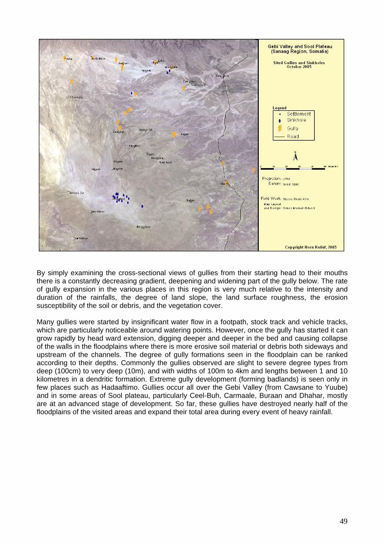
By simply examining the cross-sectional views of gullies from their starting head to their mouths there is a constantly decreasing gradient, deepening and widening part of the gully below. The rate of gully expansion in the various places in this region is very much relative to the intensity and duration of the rainfalls, the degree of land slope, the land surface roughness, the erosion susceptibility of the soil or debris, and the vegetation cover.
Many gullies were started by insignificant water flow in a footpath, stock track and vehicle tracks, which are particularly noticeable around watering points. However, once the gully has started it can grow rapidly by head ward extension, digging deeper and deeper in the bed and causing collapse of the walls in the floodplains where there is more erosive soil material or debris both sideways and upstream of the channels. The degree of gully formations seen in the floodplain can be ranked according to their depths. Commonly the gullies observed are slight to severe degree types from deep (100cm) to very deep (10m), and with widths of 100m to 4km and lengths between 1 and 10 kilometres in a dendritic formation. Extreme gully development (forming badlands) is seen only in few places such as Hadaaftimo. Gullies occur all over the Gebi Valley (from Cawsane to Yuube) and in some areas of Sool plateau, particularly Ceel-Buh, Carmaale, Buraan and Dhahar, mostly are at an adva troyed nearly half of the floodplains of heavy rainfall.
nced stage of development. So far, these gullies have desthe visited areas and expand their total area during every event of
49

Hadaaftimo gully The local community, the previous regime and the problems posed by gully formation but tend to neglect it. enough to affect the rangeland as well as various Mindigaale, Raad-Laako, Hadaaftimo, Yuube and Ceel-Buh.
2.3 Physical and Chemical Properties of Soil Samples Taken from the Gebi VallePlateau
he table in Annex 6 describes some of the physical and chemical properties of the typical soils in
soil surface of the Gebi Valley and Sool Plateau are e crumbly, powdery or granular textures which are present on most of the bare grounds replaced
bi Valley areas of Cawsane, Mindigaale, Raad-Laako, Badhan-Gungumaale, Hadaaftimo and Yuube are deep to very deep, and vary greatly in texture from surface to depth,
eed-Cilmi and Kalxileed), soil texture is finer and varies with depth often from silty clay loam to claylike, while in other parts it is
mphasis, during the chemical analysis, was placed on assessment of salinity through Electrical onductivity Measurement and exchangeable Sodium and other cations associated with the soil. ost of the soils in the region are calcareous or gypseous.
Cawsane gully
the current regional administrations are aware of As a result, gullies have become big
urban settlements like Waaciye, Ceel-Doofar,
y and Sool
Tthe area. The properties are less variable. Physical Properties The most obvious physical properties of thethby crusting and sealing. Surface crusts are generally well developed in all the areas where the texture is silty clay loam and therefore soft and friable. The presence of this crusting on sloping areas (gradient of more than 1%) is a sign of increased runoff water and erosion susceptibility. Surface sealing is also noticeable, as fine silt grains plug the pores, making it difficult for seeds to germinate, root penetration and water infiltration. The soils in the Ge
being often silt loam at the surface and changing to silty clay loam or clay with depth. In colour, these range from pink to pinkish white or reddish yellow. The structure of the surface soil (a horizon) consists of loose, powdery or fine-crumb soil. In soil profiles at crack and gully sites respectively in Xubeera and Mindigaale, the structure was massive throughout its depth and very friable. Owing to the silt loam texture on the surface and finer texture (having much smaller pores) at depth, they are infiltrated and permeated more slowly and moderately. Therefore a moderate storm often produces more runoff and these soils are liable to erosion because of being on gently sloping surfaces. In a larger part of Sool Plateau, in and around Carmaale, Ceel-Buh (Habar-Humbulle and Ceel-Haqay), Baraagaha-qol, Damala-Xagarre, Bali-Busle and Dhahar (G
claylike all through the depth. Soil colour is often reddish brown to reddish yellow. Water infiltration and permeability is slow, and it is more resistant to erosion; consequently there is rarely gully development. Chemical Properties ECM
50

Soil pH was measured in a suspension of ratio 1:2.5 soil to water, in the field and also in a boratory (ICRAF). Nearly all the soils in the Gebi Valley have a mild to alkaline pH ranging from
e non-saline (<1.2 mS) with no sodicity problems. However, in small ockets around Mindigaale, Gungumaale (near Badhan), Xubeera and Hadaaftimo areas, salinity aries with depth from slight to moderately saline (1.5-3.9 mS). In Sool Plateau, soils are alkaline
Concentrations of individual cations varied widely among different sites. The overall trends of the exchangeable cation contents, though, are worth noting: the dominant cations are calcium (ranging from between 16.20- 4.35 me/100g soil), followed by magnesium (1.3-7.6 me/100g) and do not regularly increase with depth. Exchangeable sodium is almost zero, giving low ESP readings. Levels of organic carbon in all the soils are high, meaning that much of the carbon is derived from inorganic materials. Total nitrogen is fairly low (0.02-0.09%), whereas the total phosphorous levels are fairly high. However, only little amounts of phosphorous are readily available, because at moderately high pH values, phosphate fixation is common due to the formation of highly insoluble
ence, the soils in the study areas are characterised by low soil fertility (low in organic matter content
is possible, in the form of flood water from seasonal streams (toggas), where soils are deep and well drained, until such time as an
maintain soil fertility and impede land and environmental
val of
alatable species of grasses were uprooted and swept
d Soil-Water Retention
source of water necessary for human domestic use, watering livestock and pasture and crop production. Rainfall is characterised by temporal and spatial variability from season to season and year to year. Often rainfall occurs in short periods of
la7.6 to 8.5. All the soils arpvand have no salinity or sodicity problems.
calcium phosphates. Hand deficient in macro nutrients such as nitrogen, phosphorus and potassium), high susceptibility to crusting and compaction, high soil-moisture deficits and a tendency to severe wind and water erosion. The soils of the Gebi Valley and Sool Plateau are suitable for grazing and must be preserved as rangeland. Introduction of crop irrigation intermittent acceptable system is used todegradation.
3. Major Causes of Environmental Degradation and their Impact
The available rainfall data shows that three heavy rainfall events have unleashed immensely powerful floods, causing some extensive damage including: settlement destruction (for example, Xubeera’s population was relocated to Badhan town by the Siyad Barre government); removegetation; and soil erosion, which formed huge gullies in places, and covered others in sediment.
“Hadaaftimo was a very rich flood plain before the cyclone. The cyclone destroyed the vegetation and the soils. The gullies transformed the area into a desert. All the water is lost with the gullies and the togga. Soil cannot produce vegetation because the water cannot stay anymore” (Hadaaftimo).
3.1 De-vegetation of Prime Grasslands in the Gebi Valley The oral memory of elders interviewed corroborates that the floods of 1971 and 1972 overflowed all riverbanks and submerged floodplains until water reached the margins of the surrounding hills. According to local oral memory, several paway, consequently disappearing from many areas (Sifaar from Ceel-Doofar, Dureemo from Raad-Laako, Gargaro from Raad-Laako, Doomar from Ceel-Doofar and Mindigaale; Xul from Mindigaale). 3.2. Decrease
The greatest resource constraint in the Gebi Valley and Sool Plateau is water and its retention in the soil. Throughout the year, rainfall is the sole
51
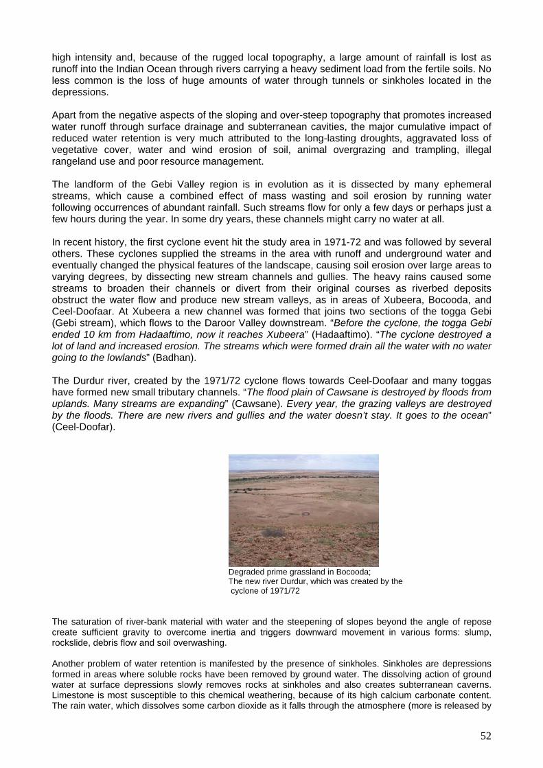
high intensity and, beca unt of rainfall is lost as runoff into the Indian Ocean through rivers carrying a heavy sediment load from the fertile soils. No less common is the loss of huge amounts of water through tunnels or sinkholes located in the
g droughts, aggravated loss of egetative cover, water and wind erosion of soil, animal overgrazing and trampling, illegal
urce management.
ll. Such streams flow for only a few days or perhaps just a few hours during the year. In some dry years, these channels might carry no water at all.
nt hit the study area in 1971-72 and was followed by several thers. These cyclones supplied the streams in the area with runoff and underground water and
Hadaaftimo, now it reaches Xubeera” (Hadaaftimo). “The cyclone destroyed a lot of land and increased erosion. The streams which were formed drain all the water with no water
h e foupland
n”
use of the rugged local topography, a large amo
depressions.
Apart from the negative aspects of the sloping and over-steep topography that promotes increased water runoff through surface drainage and subterranean cavities, the major cumulative impact of reduced water retention is very much attributed to the long-lastinvrangeland use and poor reso
The landform of the Gebi Valley region is in evolution as it is dissected by many ephemeral streams, which cause a combined effect of mass wasting and soil erosion by running water following occurrences of abundant rainfa
In recent history, the first cyclone eveoeventually changed the physical features of the landscape, causing soil erosion over large areas to varying degrees, by dissecting new stream channels and gullies. The heavy rains caused some streams to broaden their channels or divert from their original courses as riverbed deposits obstruct the water flow and produce new stream valleys, as in areas of Xubeera, Bocooda, and Ceel-Doofaar. At Xubeera a new channel was formed that joins two sections of the togga Gebi (Gebi stream), which flows to the Daroor Valley downstream. “Before the cyclone, the togga Gebi ended 10 km from
going to the lowlands” (Badhan).
The Durdur river, created by the 1971/72 cyclone flows towards Ceel-Doofaar and many toggas av rmed new small tributary channels. “The flood plain of Cawsane is destroyed by floods from
s. Many streams are expanding” (Cawsane). Every year, the grazing valleys are destroyed It goes to the oceaby the floods. There are new rivers and gullies and the water doesn’t stay.
(Ceel-Doofar).
Degraded prime grassland in Bocooda; The new river Durdur, which was created by the cyclone of 1971/72
The saturation of river-bank material with water and the steepening of slopes beyond the angle of repose reate sufficient gravity to overcome inertia and triggec
rors downward movement in various forms: slump,
ptible to this chemical weathering, because of its high calcium carbonate content. he rain water, which dissolves some carbon dioxide as it falls through the atmosphere (more is released by
ckslide, debris flow and soil overwashing.
Another problem of water retention is manifested by the presence of sinkholes. Sinkholes are depressions formed in areas where soluble rocks have been removed by ground water. The dissolving action of ground water at surface depressions slowly removes rocks at sinkholes and also creates subterranean caverns. Limestone is most susceT
52
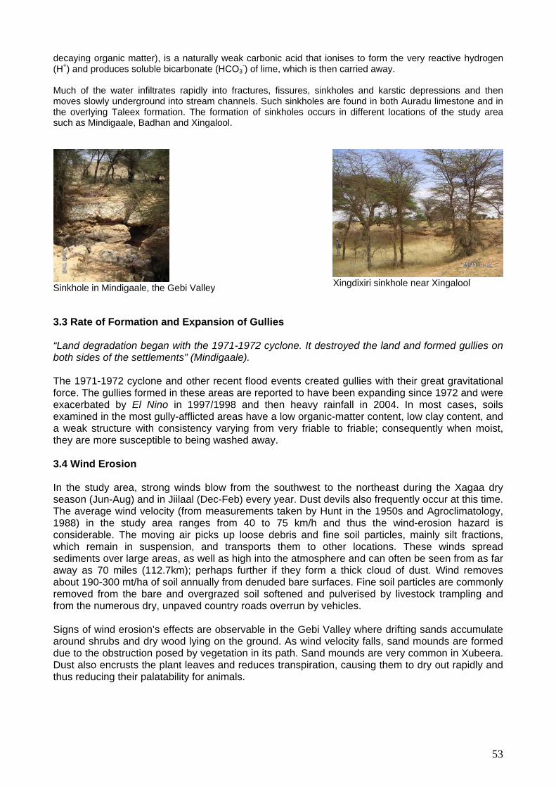
decaying organic matter), is a naturally weak carbonic acid that ionises to form the very reactive hydrogen which is then carried away. (H+) and produces soluble bicarbonate (HCO3
-) of lime, Much of the water infiltrates rapidly into fractures, fissures, sinkholes and karstic depressions and then moves slowly underground into stream channels. Such sinkholes are found in both Auradu limestone and in the overlying Taleex formation. The formation of sinkholes occurs in different locations of the study area such as Mindigaale, Badhan and Xingalool.
Sinkhole in Mindigaale, the Gebi Valley
Xingdixiri sinkhole near Xingalool
3.3 Rate of Formation and Expansion of Gullies “Land degradation began with the 1971-1972 cyclone. It destroyed the land and formed gullies on both sides of the settlements” (Mindigaale). The 1971-1972 cyclone and other recent flood events created gullies with their great gravitational force. The gullies formed in these areas are reported to have been expanding since 1972 and were exacerbated by El Nino in 1997/1998 and then heavy rainfall in 2004. In most cases, soils examined in the most gully-afflicted areas have a low organic-matter content, low clay content, and a weak structure with consistency varying from very friable to friable; consequently when moist, they are more susceptible to being washed away. 3.4 Wind Erosion
winds blow from the southwest to the northeast during the Xagaa dry
g them to dry out rapidly and us reducing their palatability for animals.
In the study area, strongseason (Jun-Aug) and in Jiilaal (Dec-Feb) every year. Dust devils also frequently occur at this time. The average wind velocity (from measurements taken by Hunt in the 1950s and Agroclimatology, 1988) in the study area ranges from 40 to 75 km/h and thus the wind-erosion hazard is considerable. The moving air picks up loose debris and fine soil particles, mainly silt fractions, which remain in suspension, and transports them to other locations. These winds spread sediments over large areas, as well as high into the atmosphere and can often be seen from as far away as 70 miles (112.7km); perhaps further if they form a thick cloud of dust. Wind removes about 190-300 mt/ha of soil annually from denuded bare surfaces. Fine soil particles are commonly removed from the bare and overgrazed soil softened and pulverised by livestock trampling and from the numerous dry, unpaved country roads overrun by vehicles.
Signs of wind erosion’s effects are observable in the Gebi Valley where drifting sands accumulate around shrubs and dry wood lying on the ground. As wind velocity falls, sand mounds are formed due to the obstruction posed by vegetation in its path. Sand mounds are very common in Xubeera. Dust also encrusts the plant leaves and reduces transpiration, causinth
53

Sand dunes covering Higlo trees in Hubera Also, those interviewed reported that during the last prolonged drought, dust storms made it very
excessive runoff from hills and ndulating surfaces and over flooding rivers.
region. Every year, soils of the grazing valleys with
tile soils have been damaged by expanding gullies, relative to
difficult to see anything even at a short distance. Dust blown from the study area is believed to have reached and obscured the atmosphere as far away as Bosaso. This occurred because the major vegetation cover of the region, grasses and forbs, perished as a consequence of the drought making soils more prone to wind erosion.
Conclusions
All over the Gebi Valley and Sool Plateau there is extensive active gully erosion, although it is more pronounced in the recent alluvial plains of areas within the constituencies of Ceel-Doofaar, Sherbi, and Waaciye villages in the east along the tarmac road to Bosaso and all through the area stretching south of the Golis mountain escarpment from east to west Cawsane, Mindigaale, Raad-Laako, Badhan, Hadaaftimo to Yuube village and other parts of the central and southern part of Sool Plateau, around Ceel-Buh, Buraan, Carmaale, Wardheer (Dooxada Qol), and Dhahar. The majority of active gullies are reported to have been formed following the 1971/72 cyclone, and since then many others have emerged after subsequent occurrences of heavy rain storms. Gully erosion is ongoing and has intensified over the years. By checking the source of runoff for each
ully, it was observed that all of the gullies had been caused bygu Erosion cause tremendous damage in thesprime grassland like Bocooda, Cawsane, Hadaaftimo, Yuube, Carmaale and Mindigaale are destroyed by floods; vegetation is devastated; plant nutrients are removed; soil texture is changed; structure deteriorates; the productive capacity of pasture is reduced; and land surface is dissected; valuable water resources flow away into the ocean and the sediments produced mostly end up in stream channels and in the Indian Ocean.
o date, large areas of the most ferTthe total area of potentially productive alluvial plain rangelands, and despite wide dispersal throughout the region. These gullies have already sharply changed the landscape and damaged the local environment in terms of accessibility and land use for rangelands, farming and settlements. Consequently, it is necessary to plan water-diversion drains and culvert outlets that can funnel water at non-erosive velocities to grazing lands.
54
Chapter 4: The Breakdown of Governance
Drought vulnerability has increased considerably in the Gebi Valley and Sool Plateau in part due to anthropogenic factors, especially overgrazing and commercial deforestation. After the presentation of a conceptual framework, this chapter will, based on interviews with pastoralists and field
. Conceptual Framework
erspectives critical of the mainstream paradigms of modernisation can be termed “alternative development thinking.” This study addresses the debate on one of these perspectives: pastoralists' management of their natural resources.
1.1. The Tragedy of the Commons For many years, a vast body of literature depicted pastoralist production as economically irrational, and nomadic livestock management systems as environmentally destructive. The old orthodoxy (Lane and Swift, 1989) and the dominant approach in terms of pastoral development (Standford, 1983) described herders as individuals without economic rationale using harmful land-tenure methods. They were inspired by the famous “tragedy of the commons” theory developed by Hardin in 1968. The main principles of this theory, which greatly influenced policy-makers in Africa can be summarised thus:
• In pastoralist areas, herds are owned individually and trekking routes (parlours) belong to
everybody and thus nobody • The pastoralists suffer from “the cattle complex” (Herkovits, 1926) and irrationally
accumulate herds for social and religious purposes rather than for economic purposes. Benefits accrue to the individual but all users assume the cost of over-grazing
• Pastoralists are not able to create their own management institutions • Resource privatisation is necessary and should be imposed from the outside
Hardin’s assumptions about free access land tenure regimes in pastoral areas were drawn from the “Theory of Games” and more specifically “The Prisoner Dilemma.” According to these: If two users in competition for the same common good have the choice between two strategies: conserve or degrade the resource, each of them will choose the latter assuming that if one of them conserves the resource, the other will cheat and use the caution of the other to maximise his own profits. In his study, he qualifies the second type of user as free riders (Morehead and Lane, 1994). In fact, Hardin confused the common-property regime, defined as a collective property, with a free-access regime in which common property is a rest nullius (a thing that does belong to anyone, a public property) and which he characterised, in the pastoral context, by the absence of rules regarding the use of the resource and the absence of institutions to enact sanctions and enforce them (Lane, 1996). This confusion legitimated the imposition of modern range management systems such as grazing blocks among the Somali of North-eastern Province in Kenya and in Northern Somalia (Helland, 1980, Unruh, 1996) and even privatisation of rangelands amongst the Maasai of Kajiado district of Kenya (Rutten, 1992). This paradigm has been seriously questioned and is now recognised as an erroneous base on which to establish future development for pastoral areas (Moorehead and Lane, 1995, p 421). New approaches, the school of property rights (Benkhe, 1988) or the approach of the insurance problem (Bromley, Cernea, 1989), insist on building on customary resource-management institutions.
observations, analyse the effects of sedentarisation of pastoralists on land use and tenure, especially following the overthrow of the Siyad Barre government. 1 P
55

1.2 Customary Pastoral Land Use and Tenure Since this shift, many recent studies have tried to understand pastoralists’ customary land use and tenure systems, defined as collective rules governing land occupation and land distribution. In fact, these rules usually apply to a vast range of resources beyond the soil and the land alone, including surface water and systems of access to underground water (shallow wells, hand-dug wells and modern deep water points), fauna and herbaceous or ligneous vegetation, crops, minerals, and wild-gathered products (Thébault, 1995a).
Yet, few studies have pinpointed the crucial role of access to water in pastoral natural-resource
anièle Kintz, any study of past as n important issue in the though
991). In fact, dry season herds can only access pater points and thus the water point is not a wealth but a means to access the true wealth at is pasture. This also means that water access management can regulate the influx of animals
ekking routes to wet-season grazing before returning to their sedentary base, where families live
sources such as permanent wells and riverside grazing, and specific areas bearing palatable
more detail the
management. For Duch as land, as a
oralist land tenure should consider water m t and the practice of the pastoralists (Kintz,
located within a radius of permanent 1 asturesin itselfw
thand control the rate of pasture depletion (Thébault, 1995b). This network of permanent water sources used in dry seasons represents a clear “land-tenure web” (trame foncière). Amongst transhumant pastoralists, Bourgeot identified specific transhumance patterns (“space economy”) with seasonal movements of herds and flocks accompanied by herdsmen along more or less fixed trpermanently in the dry seasons (Bourgeot, 1994). The territories of pastoral communities are closely associated with their permanent water points. Thébault makes a distinction between the large “territories of transhumance” (wet grazing areas) and the more restricted “territories of anchorage” (dry grazing areas), which enclose strategic resalty species. The resources found in dry grazing areas represent secure areas of withdrawal, and are subject to more defined access rights, which give priority to a restricted community and can even evolve toward individual appropriation (Thébault, 1995a). These dual pastoral territories are constituted by different types of groupings depending on the social organisation of each pastoral community. For example, Somalis practice patrilineal descent. However, the physical and social boundaries of these territorial groupings are flexible enough to adapt to climatic aridity as well as natural disasters such as droughts or floods. 1.3 Disruptive Factors Even if these new analyses can be considered a step in the right direction, they often underestimate the adverse effects of modern water development on customary pastoral-resource management: Thébault observed that the maitrises foncières5 of the herders was affected by the lack of recognition of the indigenous access rights and by the adverse effects of the modern pastoral hydraulic systems. In fact, the implementation of new water-tenure practices disrupted customary forms of grazing management: “Because of their public access, cemented wells and fuel-driven boreholes have contributed to dismantlement of the space management tools of the pastoral communities” (Thébault, 1995a and 1990). Daniele Kintz explains in changes brought about by modern water-tenure practices: The appropriation (by drilling, sale or allocation of ground water is individual, for a family or for the use of a restricted group, especially in dry areas. Only the wells and boreholes drilled by outsiders (administrative services, NGOs for example) are not subject to any explicit allocation. However, this trend is changing. These wells and boreholes are now distributed by name to specific groups, in order to limit the influx of herds and over-grazing at the vicinity of these water sources (Kintz, 1991).
5 The concept of “maitrises foncières” has been developed within Le Roy’s model of tenure relations. It is used in anthropology in an all-embracing sense, to describe all forms of appropriation, powers of management and social control over land, including customary or contractual forms and not only private ownership as recognised under the official laws (IIED Land Tenure Lexicon, 2000)
56

On the other hand, diversification into agriculture around new water infrastructure has also been associated with the physical enclosure of agricultural land and rangelands by a wealthy minority. When the self-perpetuating logic of enclosure gains momentum, even individuals who do not want to enclose are forced to do so to prevent others from expropriating all the communal land. The pastoralists also start to fence rangelands as reserved grazing areas to prevent agricultural encroachment and rangeland clearing (Behnke, 1988). The sharp increase in charcoal production due to urbanisation, overseas demand, and as a drought-coping strategy also contributes to palatable-tree deforestation and shrinking of rangelands (native grasses, forbs, shrubs and trees used for forage).
rom the literature review it is clear that anthropogenic range degradation is linked to changes in
settlement, grazing patterns and land use promoted by the introduction of new permanent water
ncentration of livestoc , mainly camels and shoats (FSAU Food Security Report, September 2002). Historically, the lack of permanent water on the So l Plateau meant that it could only be used as a
et-season pasture area and pastoralists spent the dry seasons near the permanent water sources n the edge of the plateau, particularly in the Gebi, Daroor, and Nugaal valleys. Consequently, the
2.1. Water Development and Settlements
In Sanaag region, the areas of influence of the three main m odifferent ecological zones used as seasonal grazing areas: Madow (Golis) and Karkar Mountains; and the Gebi Valley and the Sool Plateau (including Xadeed). Guban and Al-Madow/Karkar were used for dry-season grazing and the Gebi Valley and the Sool Plateau for wet-season grazing. However, according to local communities, prior to colonialism, the Gebi Valley used to be a reserved grazing area: “We had a traditional technique for range conservation. For centuries, the sultans of the Warsangeli sed to protect the grasslands of the Gebi Valley. They were reserved grazing (seere) to preserve
2. The Collapse of Range-management Systems
F
sources (boreholes, permanent wells) and water storage technologies (houses and underground berkeds). Historically, the plateau was used as a wet-season grazing area due to its low water table and lack of permanent water sources. However, the increasing number of livestock and people over the last decades has led to the proliferation of berkeds and an increase in water availability. The increasing population has clustered into villages where public agencies have drilled new boreholes to support additional people and animals. These developments and the proliferation of berkeds have converted the Sool Plateau into a year- round grazing area and attracted a relatively higher co
k
oworegular migratory patterns tended to restrict grazing pressure on the plateau and allow pasture near to permanent water to recover during the rains to be utilised later in the dry seasons. The advent of permanent water in the form of boreholes and berkeds changed the use pattern of the plateau dramatically. Instead of regular migration off and on the plateau, pastoralists were now able to stay throughout the year, and people were able to settle and create villages around water sources. The result of this, in combination with increased human and livestock population generally, has been the typical overgrazing pattern seen throughout Somalia. (IAA, 2003).
Warsangeli co munities enc mpassed Guban coastal areas; the Al
ugrazing for dry seasons and droughts. In Gu, when the rains came, we used to go and graze in Sool Plateau (Ogo and Xadeed) first to allow the grass of the Gebi Valley to grow and then come to the plains in the Gebi Valley. The British and the Somali governments maintained the system, which collapsed after the fall of Siyad Barre” (Hadaaftimo).
57

“In the old days, we had law and order. We, the Warsangeli, used to go far away from the Gebi Valley and from the permanent water sources (springs6, permanent wells and Laaso in riverbeds7) in rainy seasons and come back in dry seasons. The rule changed. The government of Somalia reduced the power of the Sultan, allowed permanent settlement for political reasons and drilled boreholes in the Sool Plateau” (Ceel-Buh).
“The Sool Plateau near Sarmaanyo was a thick waterless woodland, good for grazing and drought resistant. There were a lot of antelopes. Dhulbahante people use to migrate here from their permanent water points in the Nugaal Valley”8 (Sarmaanyo).
6 Badhan (Gebi Valley), Buran (Karkar), Qarajele (Karkar) 7 Warat, Got Rabobe, Bihin, Magebakarcho, Gabargeli, Labax Hadile, Buuk, Ceel Haralay, Ceel Cad,, Dudimo, Lasso Ingiye, Qohable, Buglore, Mingifa, Yalomaha, Rubadle, Afyer, Mindigale, Dudur, Domo, Lasso Edad, Togo Ror, Biyo Arare, Ebafure, Ceel Lahaley, Gardabaris, Sibayo for Warsangeli 8 Kalacat, Haran, Lasso Urban, Lasso daworo, Talex and Dobogley springs in the Nugal Valley
58

Old spring in Badhan Laaso in Dudh River, Mindigaale equipped by Johanitor in 1994 and rehabilitat
ed by Horn Relief
en tsystem
teau qol), mainly by providing engine-driven boreholes 00-250m) and permanent wells
During and Ce li government created four settlem 12 settlemBaraag
fter independence, many boreholes were drilled by the central government to ensure political upport from the local communities. In order to minimi overgrazing around the new settlements, the
national authorities enforced new range-management systems. For example in Ceel-Buh, pastoralists were instructed to follow a new rotational grazing system: “We used to supervise and control rangeland. We had a rotational grazing system. The road from Ceel-Buh to Xingalool was divided into two grazing areas. The pastoralists used to graze on one side and, after the rains they moved to the other side” (Ceel-Buh). Since the collapse of the government in 1991, settlement construction has been proceeding in a haphazard manner in the study area. Before the most-recent drought (2000-2004), at least six new villages were created in Sool Plateau North and South, Bali Busle 1 (1992-1993) and Bali Busle 2
Qoyan (1994), Gooran (1997), Jiingadda (19 ) and ere are at least , Raad
98) oralists clearly wish to remain near the pastures. Some ommunities such as the Warlable established Mindhicir to have a separate permanent anchorage on
tablishment of these settlements is that they of income. The elders of Bali Busle told us
under construction. Sweet water is trucked from Xingalool, Baraagaha-qol
(2002). Ev hough the British and the Somali governments both tried to maintain the traditional seere
, they also promoted permanent settlement both in the Gebi Valley (Yuube) and in the Sool (Carmaale, Ceel-Buh, Dhahar, Baraagaha-Pla
(1 .
the colonial period, four main settlements existed in the study area: Buraan in Sool Plateau; el-Doofaar, Xubeera, and Hadaaftimo in the Gebi Valley. The Somaents in the Gebi Valley: Badhan9, Mindigaale, Raad-Laako and Yuube; and at least ents in the Sool Plateau and Xadeed: Carmaale, Ceel-Buh, Alxamdulillah, Waaciye, Sherbi, aha-qol, Sarmaanyo, Shimbiraale, Sibaayo, Damala-Xagarre and Xingalool.
As se
(1995), Habar S
99), Awrboogays (1995), Mindhicir (1997nts: Carmo, (1995)hire (1999). In the Gebi Valley, th
an Cawsane 1 (1998). Pastthree new settleme
(19 dcthe Sool Plateau. However, the major reason for the esoffer ne opportunities for charcoal burning as a sourcewthat the settlement was created in 1992-1993 specifically for charcoal export.
This pattern of uncontrolled settlement continued during the drought as a coping strategy. For example, the village of Wardheer was established in 2002 by destitute people and pastoralists who remained with small herds and wished to stay close to the pastures. They rely on nine underground erkeds; another 15 areb
and Damala-Xagarre berkeds. Hard water is trucked from Xingalool borehole. (see annex 5).
9 Badhan was created after the 1971-1972 cyclones destroyed the settlement of Xubeera. Xubeera was the residence of sultan Mohamud Ali Shire from
25 to 1971. 19
59

Carmaale: created in 1962 following the drilling of a borehole (Sool Plateau North)
Wardheer: created in 2002 by destitutes (Sool Plateau South)
nderground or house berkeds and/or direct water trucking both for domestic and livestock
rage capacity of underground berkeds assessed in the s y area is 320 m . Meant as a seasonal water supply, berkeds have been converted into
All post-1991 permanent settlements on the Sool Plateau, except Awrboogays, rely entirely on private uconsumption. Reservoirs, generally lined with waterproof masonry walls, and berkeds have been constructed to harvest runoff and rain water. The ave
3 tudpermanent water storage tanks earmarked both for human and animal consumption. This development is associated with the introduction of water trucking. Filled with water from permanent water sources (springs and boreholes), the berked can now function almost perennially and allows permanent settlement in waterless areas such as the Sool Plateau (see annex 5).
In the study area, underground private berkeds appeared in the 1960s in Sherbi, Baraagaha-qol, Dhahar and Ceel-Buh. They are very expensive to build and only a small minority can afford them.
60

S y results indicate that on the Sool Plateau, an average of only 2.2% of households are equipped ith underground berkeds. The pastoralists typically build berkeds themselves with income from urve
wlivestock sales. Newer ones, with a capacity of 216m3, and which cost $4500, have been constructed with loans or funds from the diaspora. International NGOS such as COOPI and MPA have also provided berkeds in Sibaayo, Damala-Xagarre (Xadeed) and Sarmaanyo (Sool Plateau).
Oldest berked in the study area, located in Sherbi; dug in 1961 and covered with grass thatching
New-model berked with iron roof, constructed by COOPI in Sibaayo
House erkeds began to appear in the 1980s and are only use
d for domestic consumption of sweet bwater. However, an average of only 5.4% of households in the Sool Plateau are equipped with house berkeds, which are also expensive: a 64m3 house berked costs $1000.
Oldest house berked in Carmaale, constructed in 1983
In all the settlements visited, a large number of berkeds were under construction and the current number of berkeds is expected to double in a few years. However, in some locations, berkeds are nfeasible. Due to the soil composition (soft gypsum) in many locations, a large numbu er of berkeds uffer from cracks (Sherbi, Xingalool, Sarmaanyo, and Bali-Busle).
Waste Pollution
e d of t al grazing patterns and itutions, the vicinities rma m razing ped with boreholes
ale, Ce nga umero
The nomad in d g ool).
e the b le , the pastures are bet s oralists anymore” (Carmaale).
s
2.2. Overgrazing and
isruption Due to thf all pe
radition range-management i stno(Carma
nent settleel-Buh, Xi
ents suffer from overglool, and Dhahar) or n
, especially those equipus wells (Sibaayo).
“ s come ry seasons around the borehole and it affects the rassland” (Xingal
“Sinc orehole fai d (2003) ter. Carmaale doe not attract the past
61
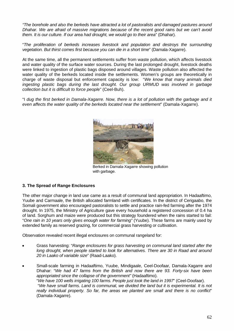
62
e time, all the permanent settlements suffer from waste pollution, which affects livestock and water quality of the surface water sources. During the last prolonged drought, livestock deaths were linked to ingestion of plastic bags disposed around villages. Waste pollution also affected the
ater quality of the berkeds located inside the settlements. Women’s groups are theoretically in harge of waste disposal but enforcement capacity is low: “We know that many animals died gesting plastic bags during the last drought. Our group URMUD was involved in garbage
collection but it is difficult to force people” (Ceel-Buh). “I dug the first berked in Damala-Xagarre. Now, there is a lot of pollution with the garbage and it even affects the water quality of the berkeds located near the settlement” (Damala-Xagarre).
Berked in Damala-Xagarre showing pollution
hum and maize were produced but this strategy foundered when the rains started to fail: gh water for farming” (Yuube). These farms are mainly used by for commercial grass harvesting or cultivation.
“We have 100 wells irrigating 100 farms. People just took the land in 1997” (Ceel-Doofaar). We have small farms. Land is communal, we divided the land but it is experimental. It is not ally individual property. So far, the areas we planted are small and there is no conflict”
(Damala-Xagarre).
“The borehole and also the berkeds have attracted a lot of pastoralists and damaged pastures around Dhahar. We are afraid of massive migrations because of the recent good rains but we can’t avoid them. It is our culture. If our area had drought, we would go to their area” (Dhahar).
“The proliferation of berkeds increases livestock and population and destroys the surrounding vegetation. But thirst comes first because you can die in a short time” (Damala-Xagarre).
At the sam
wcin
with garbage. 3. The Spread of Range Enclosures The other major change in land use came as a result of communal land appropriation. In Hadaaftimo, Yuube and Carmaale, the British allocated farmland with certificates. In the district of Cerigaabo, the Somali government also encouraged pastoralists to settle and practice rain-fed farming after the 1974 drought. In 1975, the Ministry of Agriculture gave every household a registered concession of 0.4 ha of land. Sorg“One rain in 10 years only gives enouextended family as reserved grazing, Observation revealed recent illegal enclosures on communal rangeland for: • Grass harvesting: “Range enclosures for grass harvesting on communal land started after the
long drought, when people started to look for alternatives. There are 30 in Raad and around 20 in Laako of variable size” (Raad-Laako).
• Small-scale farming in Hadaaftimo, Yuube, Mindigaale, Ceel-Doofaar, Damala-Xagarre and
Dhahar: “We had 47 farms from the British and now there are 93. Forty-six have been appropriated since the collapse of the government” (Hadaaftimo).
“re

Grassland concession near Yuube
Harvested grassland in an illegal private enclosure in Laako
4. Anthropogenic Deforestation and De-vegetation
Forage shortages during the last prolonged drought have been attributed to the high concentration of herds in reduced rangelands due to deforestation of palatable trees for charcoal production: The death rate among camels is on average 75%. The main cause has been shortage of fodder due to
clear cutting of trees and bushes for charcoal is rapid deforestation, soil
1. Deforestation
Until the late 1950s, it ap t on the environ 60 i r n areas such as Mogadishu and the accompanying demand for energy, combined witexports, meant deforestation was occurring at an alarming rate (FSAU, monthly re2003). Between 1969 and the So e ortation. During th , po in saw ibited lia (IR , O 0). With the collapse of the government, charcoal production and burning recommenced at ever more ala ates (F nthly r e 20
llapse of the Siyad Barre government, intense charcoal production has taken place, in astern Sanaag, due to lack of employment opportunities, and as a coping mechanism
during times of drought and hardship. 85% of the available acacia forests may have been cleared for ch xportat wiping cacia n th teau Valley pr are now clearing forests in the coastal and mountain areas [Al Madow] (IIA, 2003). P s interviewed confirmed that local communities formerly never cut or burned live trees:
arge t acts of Galool were found dead in some areas and it was suggested that these trees had died of old age (Hunt, 1951).
large-scale commercial production of charcoal, requiring cutting of Galool trees (Acacia bussei) (IAA, October 2003).
he effect of the mass Terosion and encroachment of desert in areas that were traditionally vital rangelands. Due to charcoal burning, trees that camels normally feed on have been greatly reduced. 70% of Acacia bussei, the species of Acacia camels prefer and depend on for fodder have already been lost (Horn Relief, Sanaag Drought Assessment Report, June / July 2003). Grass harvesting is also a major environmental issue, especially in the Gebi Valley: “We used to live in two very productive flood plains: Xubeera and Raad. The flood plains are damaged by tree cutting and grass harvesting. We are responsible. Beside natural factors, we are not sparing anything. We have destroyed everything” (Raad).
4.
pears that thment. This cha
e productionnged in the 19
of wood fuel and charcos when the
al had little noted imowth of populatio
pacs in urban
h charcoal port, June
ncreasing g
1991, s were proh
mali governm in Soma
nt banned charcoal expIN News
is regimewer cha ctober, 200
rming r
“Since the coparticular in E
SAU, mo eport, Jun 03).
arcoal eoducers
astoralist
ion. After out the a forests i e Sool Pla and Gebi , charcoal
L r
63

Galool (Acacia bussei) were debarked to make woven mats, water vessels and ropes. Gob (Ziziphus Mauritania) were debarked for animal feed. Dead Jiic (Acacia seya/baccarini) wood was used for hut construction; Meygaag (Boscia Miniimifolia) were used to make livestock
closures; and Qurac (Acacia tortillas) was used as firewood and in making charcoal. Following oncessioning of rangeland in Hadaaftimo and Yuube, people began to build huts and enclosures
l feed
l Association (NCA) and producers were only permitted to burn dead trees.
encwith stones.
Meygaag, used in Gooran for hut construction Damal debarked in Yuube for
anima
During the colonial and post-independence periods, charcoal production was limited and controlled by the National Range Management office. Licences were only available to cooperatives under the Noolay Charcoa
In the majority of the settlements visited, the charcoal industry began to spread among local communities in 1991, after the fall of the government, due to the lack of law and order, and as a new and lucrative source of livelihood fed by the demand for exports to Gulf States via the newly
64

created port of Bosaso. According to Linkenback, 80% of post-1991 charcoal production in Somalia was exported (Linkenback, 2001). In Buraan, elders spoke of greedy traders and truck-owners that sell items to locals and then load their empty trucks to ferry charcoal away from the ettlements.
The Sool Plateau used to be densely covered in Acacia bussei; which is, significantly, the best tree species for charcoal production. Consequently large-scale commercial exploitation of charcoal took place on the Sool Plateau with businessmen bringing gangs of youths from other areas to cut and burn trees for export out of Bosaso. The port authority banned charcoal exports in 1998 and has continued to implement the ban in all areas of production. Charcoal production, however, continues to supply local markets in Bosaso, Cerigaabo, Garoowe and Gaalkacyo, and some informants suggest that the supply goes even further south. What is clear is that the original dense cover has been severely depleted and the port and local community bans have to some extent slowed down the process. The fact remains, however, that for households who are currently without other income sources, charcoal production is their only means of survival. There have been no programmes for reforestation of the area to replenish the tree cover (IIA, 2003).
In the study area, charcoal burning decreased considerably after the 1998 export ban initiated by the Puntland administration but rose again during the drought as an alternative source of livelihood for destitute pastoralists and unemployed youth. Between 1992 and 2000, the village of Bali Busle exported 100 trucks of charcoal per day; since 2000 this has fallen to ten a day. In Mindhicir charcoal production began with the drought. Previously, the village exported ten trucks a day and now this is only one. It has been estimated that wood fuel provides 92% of domestic energy in Somalia (Inglis, 2002). In Buraan, elders mentioned that current charcoal production does not meet the demand of the main regional urban centres where it is sold: Bosaso, Gaalkacyo, Laascaanood, Garoowe, Cerigaabo, Qardho, Ceelaayo and Galdogob. Elders estimated that more than 1200 trucks of charcoal are still produced in the study area and exported every month to feed the local market, which is equivalent to approximately 400,000 trees cut a month. A truck contains on average 200 bags; one 50kg bag of charcoal is equivalent to 1.6 live trees (NOVIB, 2004). The villages that currently export massive quantities of charcoal for national consumption are: Dhahar, Baraagaha-qol and Wardheer located on the Sool Plateau. Dhahar exports 20 trucks a day and Baraagaha-qol exports 10. In fact, in Sarmaanyo, elders reported 50 active charcoal sites around the settlement. If the average production per site is 50 bags, then by the team’s calculation: 20 settlements x 50 sites per settlement area x 50 bags per month x 1.6 live trees = 80,000 trees cut every month, a slightly more credible figure. Charcoal prices Region Area Export centre Selling Price/ 50kg Reselling price/
50kg
s
Sool Plateau
Dhahar Qardho 40 000SShs ($2.70)
NA
Xingalool Bosaso and Laascaanood 40 000SShs ($2.70)
NA
Ceel-Buh Laascaanood, Bosaso $ 2.67USD/50 kg $ 6 USD/50 Kg B-Qol Bosaso, Garoowe, Qardho and
Laascaanood $ 2.67 USD/50 kg $ 6.67 USD/50kg
Carmaale Bosaso $ 2.67 USD/50 Kg $ 6.67 USD/50 kg
Source: Horn Relief, 2005 The tree species most affected by charcoal production is Galool (Acacia bussei), which is also the prime source of forage for camels. With the ongoing depletion of Galool, charcoal burners turned to other species (Qurac, Bilcil, Meygaag in Sarmaanyo), Damal (Mindigaale, Raad), Gob (Raad) Sosog/Yuube (Buraan, Wardheer, Hadaaftimo, Yuube), Mara (Hadaaftimo), Higlo (Sherbi, Sarmaanyo). Duur grass (Anthropogon Kelleri), known for its water-retention properties, is also affected because it is used to cover charcoal kilns. In the grasslands of Xadeed, due to tree
65
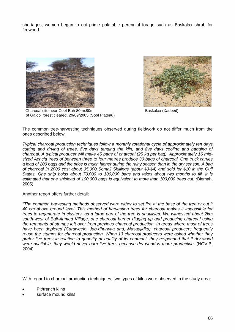
66
shortages, women began to cut prime palatable perennial forage such as Baskalax shrub for firewood.
Charcoal site near Ceel-Buh 80mx80m Baskalax (Xadeed) of Galool forest cleared, 29/09/2005 (Sool Plateau) The common tree-harvesting techniques observed during fieldwork do not differ much from the ones described below:
Typical charcoal production techniques follow a monthly rotational cycle of approximately ten days cutting and drying of trees, five days tending the kiln, and five days cooling and bagging of charcoal. A typical producer will make 45 bags of charcoal (25 kg per bag). Approximately 16 mid-sized Acacia trees of between three to four metres produce 30 bags of charcoal. One truck carries a load of 200 bags and the price is much higher during the rainy season than in the dry season. A bag of charcoal in 2000 cost about 35,000 Somali Shillings (about $3-$4) and sold for $10 in the Gulf States. One ship holds about 70,000 to 100,000 bags and takes about two months to fill. It is estimated that one shipload of 100,000 bags is equivalent to more than 100,000 trees cut. (Biemah, 2005)
Another report offers further detail:
“The common harvesting methods observed were either to set fire at the base of the tree or cut it 40 cm above ground level. This method of harvesting trees for charcoal makes it impossible for trees to regenerate in clusters, as a large part of the tree is unutilised. We witnessed about 2km south-west of Bali-Ahmed Village, one charcoal burner digging up and producing charcoal using the remnants of stumps left over from previous charcoal production. In areas where most of trees have been depleted (Caraweelo, Jab-dhurwaa and, Masaajidka), charcoal producers frequently reuse the stumps for charcoal production. When 13 charcoal producers were asked whether they prefer live trees in relation to quantity or quality of its charcoal, they responded that if dry wood were available, they would never burn live trees because dry wood is more productive. (NOVIB, 2004)
With regard to charcoal production techniques, two types of kilns were observed in the study area: • Pit/trench kilns • surface mound kilns

Pit kilns are typic ed where there is enough soil to cover them.
such as Duur grass so that fire spreads effectively through the pit during burning. Afterward, three or four iron bars or another strong metal a little longer than the
heets can be arranged on top.
re designed to resemble traditional Somali houses, with a strong pole rected at the centre and other poles of 1m in length positioned around the centre pole, covered by
With surface mound kilns it is important to open air lets when the upper part collapses.
PRODUCE 200
ally used in montane areas whereas surface mound kilns are us
Despite variations in the size of pit kilns, they are generally 1.30m deep, 1.70m wide and 2.60m long. Before wood is placed in the pit, it is cut into stumps of about 1m in length to minimise air penetration. Wood is arranged horizontally with open space left at the centre of the pit. This space is filled with a combustible material
pit are laid across it so that s The output of a medium pit kiln is 10 sacks per production. Two to three days are needed to dig the pit, another day to place the wood in the pit, one day to burn and one day to cool.
Surface mound kilns aesoil and sheets on top. Both types of kilns need to be closely supervised during the carbonation process to prevent charcoal being burned to ash. With pit kilns, it is necessary to reduce air access during strong winds, and the reverse when there is little wind.in During the study, an analysis was made to determine the number of live and dead trees respectively, of equal diameter required to produce 200 sacks of charcoal. The result: 20-donkey cartloads of dead trees or 100 trees, and 25 donkey cartloads of live trees or 125 trees, are needed to produce this amount. Dry wood is also more quickly processed into charcoal than live trees.
HARVESTING PERIOD
COLLECTION BURNING COOLING PREPARATION PERIOD TO
SACKS
LIVE TREES
30 DAYS 6 DAYS 6 DAYS 12 DAYS 1 DAY 55 DAYS
DEAD TREES WHERE
ABUNDANT
15 DAYS 2 DAYS 2 DAYS 2 DAYS 2 DAYS 23 DAYS
DEAD TREES
30 DAYS 15 DAYS 6 DAYS 6 DAYS 3 DAYS 60 DAYS
WHERE SCARCE
Other than the type of tree used (i.e. live or dead) for charcoal production, other factors thainfluence the amount of time needed for charcoal production are: labour, tools, mode otransportation, quantity and diameter of trees accessible. 4.2. Grass Har
t f
vesting
67

In the majority of settlements visited, grass harvesting began in 1991 as a result of the increased demand for livestock forage to be exported from the port of Bosaso. Before the last drought, in the
bi Valley, the main producing villages were Hadaaftimo and Badhan. On the Sool Plateau, tion was centred in Carmaale, Ceel-Buh, Min
yo, grass harvesting was only practiced from 1993-1995. In Mindhicir, grass harvesting was only practiced in 1996-1997. In Bali Busle, between 1990 and 2000, 30 to 40 trucks of grass
he destitute targeted Chrysopogon aucheri (Dureemo) and Sporobolus
farm
saso or we rent them from
(Gargaro), Sporobolus
GeproducSarma
dhicir, Bali Busle, Sarmaanyo and Sherbi. In an
(Dureemo and Sifaar) were exported per month to Bosaso and Ceelaayo. In Badhan, a 6-tonne truckload of grass sold for two million Somali shillings.
Grass harvesting sharply increased after the last prolonged drought due to two exceptionally good rainy seasons (Deyr 2004 and Gu 2005), and actually spread to new locations, such as Raad-Lako and Buraan. In Buraan tspp (Sifaar) for export to Bosaso. However, the market soon collapsed on the Sool Plateau, especially in Ceel-Buh and Bali Busle, due to traders’ preference for Cynodon Dactylon (Domar) and Siidal grass species, which are more widely available in the Gebi Valley. Grass harvesting is practiced in open rangeland but also in both legal enclosures (Hadaaftimo, Yuube, Carmaale, and Badhan) and illegal enclosures (Hadaaftimo, Yuube, Carmaale, Raad-Lako and Badhan).
Hadaaftimo, Yuube and Carmaale, grass harvesting is practiced on land concessions: “MyIn
was given to my grandfather by the British. In dry seasons, I let the animals graze inside but not all the people are like this. I grow Xul and Domar. I have 6 hectares; I inherited four hectares and added two. I harvest at the end of Gu and at the end of Deyr. I produced 12 trucks of grass last
u. Each truckload was sold for $500. They sent them from BoGHadaaftimo. We have to share the benefits among eight families” (Hadaaftimo). The most widely used species for grass harvesting are Echinocholoa colona (Doomaar Madow), Digitaria Scalarum (Doomaar Cad/Xul), Paspalidium desertorumArabicus (Sifaar) and Siidal
Grass harvesting in Raad-Lako (Gebi Valley) 5. Damage Caused by the Proliferation of Road Networks
In Ceel-Buh, Hadaaftimo, Bali-Busle and Sarmaanyo environmental degradation has been linked to increased road traffic, especially for water trucking and charcoal transportation: “Hundreds of trucks pass through Bali Busle every night. They created roads, which destroy the vegetation and increase wind erosion. They also create rills that capture water from the run-off” (Bali Busle).
68

Conclusions
The on oing build up of settlements disrupts range manage t systems and induces overgrazing and waste pollution, which in turn affects livestock and surface water sources. Enclosures are shrinking communal rangeland to the benefit of only a minority. Deforestation and grass harvesting have reduced vegetation cover, especially of palatable plants.
g men
69

Chapter 5: Conservation and Rehabilitation Initiatives
tion initiatives in the study area have been limited. However, recent initiatives, both by local communities and Horn Relief, have had a positive impact.
1. Community Initiatives The main focus of initiatives undertaken by local communities, especially elders, is stopping charcoal burning and grass harvesting within their own localities. In many settlements, villagers have also carried out small-scale reforestation. Some villages also are engaged in small water-conservation activities. Community Policing of Deforestation Local communities are well aware of the adverse effects of deforestation (lack of shade, lack of forage, k o irewo ies and wind erosion). Elders have discouraged villagers from destroying common property for commercial purposes and have tried,
lements visited, the elders tried to stop charcoal burning and export by the local residents. In some villages, especially in the Gebi Valley, these efforts seem to have been quite successful: “We started charcoal burning in 1991 but we stopped after the drought, in May 2004. We had a meeting between the different communities and we decided to stop cutting trees for export” (Cawsane).
“We started producing with the drought but we reduced charcoal burning. Now it is only for domestic consumption and not for export” (Badhan).
“Since we established the settlement, we, the elders, prohibited charcoal burning” (Damala-Xagarre). In several villages, the elders organised patrols, made arrests and meted out punishments: “The Puntland government banned charcoal export, but in our area —we are between Puntland and Somaliland—nobody has control. We, the civilians, rule our places with customary law. Charcoal burning started in 1991 but we decided to punish those found cutting or burning trees” (Raad-Laako).
“Since 1991, taxes are collected from the villagers for the payment of a local patrol. In 2001, an attempt to burn our protected Galool forest, near the town, was stopped. This Galool forest has been protected since 1991” (Sherbi).
“Charcoal burning was banned by the elders in 2003. In 2003, people were caught burning trees and arrested. Their animals were seized. Since then nobody has tried” (Ceel-Doofar). Since the last rains (Gu 2005), anyone found cutting trees is arrested and punished” (Mindhicir)
Following the collapse of Somali traditional authority (sultans and councils of elders) and in the absence of a national government, environmental conservation and rehabilita
lac f f od, reduced land cover, formation of gull
with very limited success, to organise patrols. Policing and Regulating Charcoal Burning In almo t all the setts
70

Protected Galool tree targeted by burners in 2001 in Sherbi (Sool Plateau)
Destroyed
Howev illages, the coercive powers of elders and patrols with respect to the destitute, especially youth, is limited: “Whenever, we contact the destitute, they say, that is OK, we realised that trees are important but we have children to sustain, can you provide us with an alternative source of livelihood?” (Ceel-Buh).
In Buraan, elders tried to prevent 150 unemployed young men from burning charcoal. However, they could not find an alternative livelihood for them and so some returned to charcoal burning. Elders led a regionwide effort to stop charcoal burning on several settlements of the Sool Plateau. Buraan, Mindhicir, Bali-Busle and Habra-Shire agreed to stop both charcoal burning and grass harvesting but Mindhicir contravened the pact. A delegation was sent from Buraan to Dhahar because Buraan truckers participated in charcoal transportation from Dhahar. However, the
re not receptive. The people of Baraagaha-qol also continue to burn charcoal; they ave c sle.
We stop them and they come back. Some villages
fused to honour the agreement we made in 2003 (Dhahar, Baraagaha-qol and Kaladhaca) and
aan to stop burning charcoal but we could not honour it. We have no lternative, no project, and no assistance” (Baraagaha-qol).
r, in many v
kiln near Sherbi (Sool Plateau)
e
truckers weh ali-Buleared their area of trees and moved on to B
“We try to intervene but we have no resources. rewhen they cleared their area of trees, they came here” (Bali-Busle). “We have 600 young men involved in charcoal burning. They don’t have jobs. We had an agreement with Bura
“There are conflicts when the elders go and talk to the young charcoal burners. Trucks are destroyed and people die. They tell you give me an alternative. There are no farms, nothing except livestock production and many destitute people” (Dhahar). “There are conflicts between the charcoal burners and the pastoralists” (Mindhicir).
71

Galool logs ready for charcoal burning near Dhahar (Sool Plateau North)
Active charcoal burning site in Mindigaale (Gebi Valley)
dditionally, elders and local patrols are frequently powerless in the
face of organised and armed roups of outsiders.
es you
er was killed between Mindhicir and Ceel-Buh” (Ceel-Buh).
le
of charcoal transportation on the main roads is non-existent. In Sherbi,
started: with the good ins of November 2004 (Buraan, Sibaayo, Ceel-Doofar, and Mindhicir). In Cawsane, over the last
en made to enclose rangeland for grass harvesting but elders h as
Ag
meeting to reduce charcoal burning but they burn in hiding. Sometim“In 2002, we had a
have to drive for 10 km to find them, but it’s not possible” (Mindigaale). “We managed to stop local residents from burning charcoal in 2004 but outsiders come with armedguards and we do not have any resources to keep organised patrols” (Wardheer)
“Before the government collapsed, we had patrols to control illegal tree cuttings. Community policing is difficult. They do it at night, in the bush and sometimes it is very dangerous. For example, four years ago, some people tried to burn charcoal. They were stopped by force and one
uck drivtr
“There are more than 50 charcoal sites guarded by armed guards in the area and it is not possibto intervene (Sarmaanyo). “Before 2003, we tried to stop charcoal production but Puntland officers have guns but no cars and no fuel to patrol and no salary” (Sarmaanyo).
ontrol and regulationC
while the team discussed charcoal burning, deforestation and community initiatives, a charcoal truck was seen parked in the middle of the village. Controlling Grass Harvesting
several locations, elders managed to stop grass harvesting as soon as it Inrafive years, attempts have beconsistently opposed such efforts: They are captured and given a warning. In many areas, sucHadaaftimo, grass harvesting is a source of conflict with pastoralists.
ss in Hadaaftimo e vested gra Burning h ap of har
72

1.1 Small-sca ntin
In several settlements (Mindigaale and B sle), villa e main roads, mainly fruit and Somali gum trees, which are a new
Lime tree In Bali-Busle (Sool Plateau N
Also noted wa e in oasis farming, with irrigatio ings in Buraan; wells in Ceel-Doofar and mala-Xagarre, Dhahar and S
le Homestead Tree-pla g
ali-Bu gers began planting trees at th source of income.
orth) s an increas n from different water sources: spr
Mindigaale: and berkeds in Hadaaftimo, Daherbi.
73

Buraan spring irrigates 150 small plots with palm trees (Timir) imported by the British from Saudi Arabia, lime trees and vegetables (Sool Plateau North)
One of the 100 private mechanised wells in Ceel-Doofar irrigating one of 100 private farms growing palm trees (Timir), Somali gum trees (Moxor), lime trees, guava trees, cotton trees and vegetables. It was dug in 1993 on communal rangeland in the Gebi Valley by a returnee from Jowhar (1973-1974 drought)
Berked irrigating a farm with lime trees, cotton trees, guava trees and Somali gum trees (Moxor) in Hadaaftimo (the Gebi Valley)
However, concerns have been raised about the use of water for irrigation when available drinking water is scarce, and because it is we gnificantly reduces the water levels of
In some villages of the Sool Plateau, enclosures for farming on communal rangelands are either prohibited (Cawsane, Xingalool) or constitute a source of conflict between pastoralists: “In 2002, camels belonging to a pastoralist entered a private e s were killed. Blood price of 240 camels was paid” (Hadaafti Lastly, in several settlements of the Gebi Valley s of grasshoppers and crickets were observed destroyin , Bali-Busle, Xingalool and Wardheer, Mindigaale): “The number of Jiriqaa (crickets) and Kabajaan (grasshoppers) is increasing. I planted two trees recently and they were eaten” (Wardheer).
“We have a problem with grasshoppers breeding in Qumbucul, Qoolo and Dawli. They damage farms and pastures” (Mindigaale).
ll known that irrigation siitigate this with wateaquifers. Therefore it is important to m
. r retention and detention structures to
recharge aquifers
nclosure in Hadaaftimo and two personmo).
and the Sool Plateau, large quantitg both trees and grassland (Ceel-Buh
ie
74

1.2 Soil Conservation
In Yuube, and Bali-Busle, elders mentioned that formerly, rock, stone, and sand embankments were used to divert water and these allowed the regeneration of vegetation in the flood plains. However, the only settlement that has recently tried to undertake some form of soil conservation and water harvesting is Sibaayo in Xadeed. The community plugged a sinkhole located near the wells with stones.
onitored long-term factors related to food security and pastoral livelihoods throughout more than eration in the area. This has included monitoring indicators such as the state of the
nvironment (particularly coastal areas and rangelands), water supply, animal health, access to
orn Relief’s close relationship with pastoralist communities enabled the agency to sound the
d coordinated response from the international community in order to avert a full-scale disaster. Following on these recommendations, international organisations and UN agencies including WFP, UNICEF, Horn Relief and VSF
xtended and increased interventions in Sanaag through distribution of food, water and provision of non-food items. Horn Relief chose a cash-based response due to the specific nature of the emergency, and in recognition of the need to empower the beneficiaries and enable them to meet their prioritised needs. The Emergency Relief and Drought Vulnerability Reduction (ERDVR) Programme in Sanaag implemented by Horn Relief utilised a cash component, namely a cash-for-work initiative to meet the humanitarian needs of the target population and to encourage them to undertake longer-term environmental rehabilitation activities as part of a solution to the emergency. Summary of Micro-Projects The following table summarises the micro-projects undertaken by Horn Relief and its partners during the first phase of the Emergency Relief Drought and Vulnerability Reduction Programme.
Site Intervention/Activity Cumulative Length/Meters
Impacts
2. Horn Relief’s Commitment to Environmental Health
an effort to promote sustainable livelihoods in the Sanaag region, Horn Relief has closely Inmten years of opemarkets, and the level of purchasing power among pastoralists. 2.1 The Emergency Relief and Drought Vulnerability Reduction Programme (ERDVR) Halarm about an impending humanitarian emergency. FSAU has also, over the years, been highlighting the region’s deteriorating food and livelihood security conditions. Horn Relief called for an assessment to gauge the level of humanitarian need in the Sanaag and Sool regions of northern Somalia. An OCHA-led interagency assessment was subsequently undertaken in October 2003, and it documented a humanitarian situation of crisis proportions. The assessment teams identified Sanaag as the most affected region, with a vulnerable population of 190,455 people. OCHA recommended an immediate, concerted an
e
Wardheer Circular soil bund Straight soil and stone bunds (diversion from road) Protected soil bunds/alternating
6600 2756 6880
Water diverted/detained/retained, improved infiltration/water conserved, vegetation regenerated, soil sediment deposition
Baragaha Qol
Soil bunds across old roads Stone protected soil bunds. Protected soil bunds
4870 1028 16860
Water diverted/detained/retained, improved infiltration/water conserved, vegetation regenerated, soil sediment
75

alternating/rock dams Planting of tree seedlings
10 deposition, Improved drainage (sanitation)
09 2504
Dhahar Soil bunds Rock dams Drop structures/gabion
l bunds Planting of tree seedlings
2400 4 1000 2518
Reduced erosion/advance of gully head; prevention of further gully, rill and sheet erosion; evidence of gully healing; Deposition of
Stone protected soi
350
soil/sediments/plant/grass seeds; regeneration of vegetation/pasture; Improved drainage of village
X
ation/pasture; Improved drainage/road network in the
ingalool Soil bunds Protected soil bunds Planting of tree seedlings
100 10681 2230
Reduced erosion/advance of gully head; prevention of further gully, rill and sheet erosion; evidence of gully healing; Deposition of soil/sediments/plant/grass seeds; regeneration of veget
village Ceel-Buh Soil bunds
Rock dams Check dams Protected soil bunds Stone protected soil bunds alternating with spillway rock dams Planting of tree seedlings
2280 3500 410 2254 260 2000
Reduced erosion/advance of gully head; prevention of further gully, rill and sheet erosion; evidence of gully healing; Deposition of soil/sediments/plant/grass seeds; regeneration of vegetation/pasture
ACheck dams 825
d erosion/advance of gully head; prevention of further gully, rill
wsane Rock dams 3500 Reduce
and sheet erosion; evidence of gully healing; Deposition of soil/sediments/plant/grass seeds; regeneration of vegetation/pasture
M
f soil/sediments/plant/grass seeds;
indigale Soil bunds Rock dams Check dams Protected soil bunds Planting of tree seedlings
106 2140 294 66 1700
Reduced erosion/advance of gully head; prevention of further gully, rill and sheet erosion; evidence of gully healing; Deposition o
regeneration of vegetation/pasture Badhan Soil bunds
Soil/Rock dams Rock dams Protected soil bunds Stone protected soil bunds alternating with spillway rock
4764 5773 2790 2670 950
Reduced erosion/advance of gully head; prevention of further gully, rill and sheet erosion; evidence of gully healing; Deposition of soil/sediments/plant/grass seeds;
dams circular soil bunds Planting of tree seedlings seedling pits
100 3000 2490 2005
regeneration of vegetation/pasture
HCheck dams
546 83
90 1700
Water diversion/detention/retention, improved infiltration/water conserved,
adaaftimo Rock dams
Protected soil bunds Gabion Diversion canal Planting of tree seedlings
1065 64
vegetation regenerated
C
Deposition of
armaale Soil bunds Rock dams Check dams
3000 1500 100
Reduced erosion/advance of gully head; prevention of further gully, rill and sheet erosion; evidence of gully healing;
76

soil/sediments/plant/grass seeds; regeneration of vegetation/pasture
terms of
Gebi Valley and Sool Plateau, the team observed numerous structures that had been constructed in the ten aforementioned villages as part of
abilitation of rangelands.
Where gullies have not formed, land degradation and further erosion was prevented by protective measures such as increasing the absorption capacity of the soil, protecting the land surface with vegetative cover and by diverting excess surface runoff from the watershed at a lower velocity through properly designed and maintained waterways. Focus was placed on diverting water away from the eroded area to adjacent rangelands as well as on safely disposing of excess water. ERDVR was implemented over an eight-month period, and thus was not intended to deliver a full-cale solution to the problem. However, it is has achieved valuable and concrete results in s
soil-erosion control and water conservation. Nonetheless, it is strongly recommended that similar programmes be undertaken and expanded in scale due to the vast and ongoing nature of the problem. During the survey undertaken in late 2005 in the
ERDVR for the conservation and reh Horn Relief also supports two tree nurseries run by community-based organisations in Ceel Buh and Badhan. The organisation has, additionally, introduced highly efficient solar cookers to Sanaag and Bari regions, which, once scaled up, hold great promise in curbing demand for charcoal, particularly in urban areas where charcoal demand is highest.
Check dam with gabion wire being put in place (Hadaftimo Gully)
Rock dam after the rains detaining rain water and improving vegetation regeneration (Awsane Valley)
Circular soil bunds near Damala-Xagarre (Xadeed denuded grassland)
Soil embankment around Xingdixiri sinkhole, near Xingalool, (Xadeed)
77

n Tree Nursery in Ceel-Buh
Conclusions Local commun oal trade and grass harvesting with limited resources and success. Settlers are also initiating small-scale homestead reforestation with potenti lucrto build range a real threat to At the e tsolutions. The logy and techniques utilised by the ERDVR have shown great success and should be replicated in more areas. CARE and a local partner have have also done some ll sHowever, some of these, along with a few structures from the ERDVR, have already been
estroyed or damaged from the heavy rains. There is a need for improvement of the construction of som trucstructures. Fu nstruction over a more extensive area, including Yuube, Bocooda, and Carmaale.
Sanaag Student Associatio (Sool Plateau, 29/09/2005)
ities are attempting to control the charc
ally ative tree species (lime, guava, cotton, Somali gum). However, the associated need enclosures is a source of conflict. Also, invasion by crickets and grasshoppers poses new livelihoods.
sam ime, Horn Relief has successfully implemented rangeland rehabilitation/restoration simple techno
sma cale envieronmental works, including enclosures around sinkholes in Hingalool.
de s tures through use of external material, such as gabion wires, to strengthen the
rthermore, there remains a demand for similar co
78

Overall Conclusions
Major iron
From the curre tal problem of the Gebi Valley
ffected the prime livelihood of the local m nces of the drought have been devastating.
ack of rainfall reduced vegetation cover and biodiversity of the land. Interpretation of satellite irms the loss of la quence there has been great
ss of livestock from starvatio migration to urban centres or
espi (Gu 2005 and Deyr 2004) that followed.
cen Firstly, In the Gebi Valley and Sool Plateau, the flood events (1971-1972
aceen lant nutrients have been
duAftoxo
nce on.
lan h affected the environment. The range-management systems of the past ettlements, especially
he reation of permanent
waste hich affects livestock by degrading the quality of surface water sources. The concessioning of land and land-grabbing processes have also contributed to the shrinking of ommunal rang and and overgrazing, especially in the Gebi Valley.
ment and the advent of the last prolonged drought, pastoralists
have engaged in alternative economic activities, the charcoal trade and grass harvesting, which endanger the environment and their traditional source of livelihood (pastoralism). In the study area, anecdotal evidence suggests that more than 1200 trucks of charcoal are produced and exported every month to feed the local market, equivalent to approximately 400,000 trees cut a month, but research indicates the number to be nearer 80,000 a month, which is still of tremendous concern.
The use of palatable Duur grass to cover charcoal kilns is an attendant problem that reduces forage, decreases water retention and diminishes soil protection from erosion on the Sool Plateau. Grass harvesting is associated with illegal enclosure of rangelands, which comes at the expense of the majority of the pastoralists. The proliferation of crickets and grasshoppers (Gryllidae and Acrididae) and the ensuing damage to pasture is another threat on the Sool Plateau and Xadeed, following two consecutive seasons of good rainfall (Deyr 2004 and Gu 2005). There is also a lack of village and settlement planning. Consequently, little or no protection measures are incorporated to separate areas for building houses from areas for the water reservoirs. Increasing waste pollution affects the water quality of the spring, wells and berkeds, which is also a major concern.
Env mental Issues
nt assessment, it is evident that the main environmenand Sool Plateau is the recent drought, which aom unities: transhumant pastoralism. The consequec
Limages conf nd and vegetation cover. As a conse
n or water stress (more than 80%), locamps, and tremendous suffering and loss of human life from starvation and malnutrition. Many palatable vegetation species that dried out during the prolonged drought have not fully regenerated
te the two good rainy seasons d
However, other factors both natural and anthropogenic have exacerbated drought vulnerability in t decades. re
cyclones, El Niño and cyclone floods in 1997-1998 and heavy rains in 2004) have had tremendous imp t on the landform, structure, soil and vegetation. The most serious consequence of this has
gully damage, but also soils and vegetation has been destroyed; pbremoved; soil texture has been negatively changed, resulting in reduced capacity of the land to pro ce pasture. In some floodplains there is a proliferation of unpalatable plant species (e.g.
lle), or of plants with little economic value (Keligii noole) in areas where nutritious pasture grew. Further, de-vegetation is conducive to wind erosio
Simultaneously, a breakdown in both customary and modern governance induced drastic changes
d uses, whicincollapsed with the progressive creation of numerous, scattered permanent sn t Sool Plateau and Xadeed. This process was exacerbated by the ciwater sources (boreholes) and by the local construction of new water storage facilities (berkeds), water trucking and increased transport routes. This in turn contributed to overgrazing and led to
pollution, w
c el
Since the collapse of the govern
79
nvironmental Awareness and Community Initiatives
In all settlements visited, the level of local environmental awareness was found to be extremely
igh, especially regarding anthropogenic factors such as the collapse of range-management systems and institutions, the rise of charcoal burning and grass harvesting. In the Gebi Valley and the Sool 80% of villagers, more d ervation and rehabilita charcoal burning and grass harvesting, typically through community policing. Due to a variety of constraints these efforts enjoy mixed results at best, and require considerable support. Natural impact of these on livelihoods have been classified as the second most serious environmental issue and threat. Preparedness, however, is very low and initiatives to minimise the consequences of these are financially or practicably unfeasible for local communities.
Government and NGO Initiatives
he two governments that claim jurisdiction over the studied area have sought to implement limited nvironmental conservation and rehabilitation initiatives, the best known and most efficient being
998 ban on charcoal export. In September 2001, the Transitional National Government arcoal export from Somalia.
oreign ships coming to Somalia to take on charcoal were warned that “they risk arrest, fire or both if t.” Enforcement of a complete charcoal ban would depend on the ability of various
rities to cooperate and set up an effective justice system. The TNG’s ban was ignored by harcoal traders. One Mogadishu charcoal buyer observed: “The government isn’t creating jobs. I am
not listening to them” (IRIN News, May, 2003). Similar initiatives have been launched in Puntland: Recognising the tration has recently banned the export of charcoal to the Gulf Sates and the Somaliland administration is considering new regulations West (FSAU, Monthly report, June 2003). Horn Relief is practical environmental conservation and rehabilitation a n small scale activities initiate such as CARE. Horn Relief undertook the ERDVR micro-projects initiative in 2003 to repair gullies and restore denuded land, at the same tim hit economically by the drought. Horn Relief has also undertaken anti-charcoal campaigns and has introduced solar cooker technolo
E
h
Plateau, charcoal burning is cited as the major environmental issue by amaging even than natural disasters. The main environmental constion initiatives being undertaken by communities relate to controlling or preventing
disasters, such as drought and flood and particularly the
TePuntland’s 1(TNG), through its Ministry of Livestock issued a directive banning all chFthey are caughSomali authoc
negative impacts on the environment, the Puntland adminis
to put an end to charcoal production in the North
the only development agency involved in long-termctivities in the study area, although there have bee
d by the local community and other agencies
e providing pay and work to local communities hard
gy to the areas.
80

Recommendations
Red cing Drought Vulnerability
Restock
u 1. pastoralists with pack camels to allow them to recover to allow
r
. reserved grazing lands and/or apply l grazing
. Support initiatives to increase water retention and soil conservat
Engage qualified environmental experts and extension w mmunity
plan soil-conservation structures so as to avoid sub-standard
enforcement of old specially the ut off drai and gabions
sediment
ankments o the flood plains, around gullies
. Rehabilitating the latter is cheaper and
rvesting to improve production and protection of the rangelands, and not vice versa.
. Combat commercial deforestation and illegal de-vegetation and promote reforestation.
Develop campaigns to ban the trade in charcoal both internationllay and locally
d others involved in the
ive sources of energy to charcoal (e.g. solar) in major towns, where ich in fact motivates many unemployed
rning trade for income generation
Establish range patrols and road checkpoints through community policing
more tree nurseries and distribute seedlings to villages and encourage eads, berkeds and grazing land for shade, wind break, fruit
d forage
human and livestock use
. servation structures
D
and floods
economically and migration to areas with good pasture and adequate wate
Restore the practice of
2 modern rotationa
ion:
systems to allow regeneration of vegetation
3
orkers to lead coworkers to design andactivities being carried out in the future
Emphasise maintenance and re- structures, e
ns, soil bunds rebuilding of broken rock dams, check dams, cburied by
Build new rock dams and sand emband sinkholes
n
Rehabilitate both big and small gullies
easier
Efforts should be made to increase water ha
4
Provide sustainable alternative livelihoods to the destitute an
charcoal trade
Provide alternatthere is high fuel demand for cooking, whyoung men to enter the charcoal bu
Create
planting around homestan
5. Monitor water availability and quality for
Monitor and evaluate the durability of soil-con6
rought Preparedness
1. Strengthen mechanisms for forecasting drought
81

Rehabilitate rainfall stations, and install rand SWALIM
ain gauges with support from FEWS-NET
Redefine FSAU livelihood zones according to landforms and indigenous s and improve indicators (e.g. rainfall data analysis and
urveillance mechanisms to monitor study as a baseline
Further Studies to be Undertaken
. Undertake land-cover mapping using most current data as land-cover changes can occur
2 rticularly to measure rate and size of expansion
. Undertake a hydro-geological survey to assess the sustainability of oasis farming as an initiatives
4. tegrated into future field studies to provide more comprehensive
gthen present efforts
d their long term implications for the
6 native livelihood 7. d baseline studies on vegetation to facilitate monitoring of change
over time
environmental classificationbaseline data on range conditions)
Establish frequent and more regular drought schanges and trends, using this
2. Promote consensus on interregional migration
1rapidly
. Undertake a more detailed assessment of gullies, pa
3
alternative livelihood and to expand current rehabilitation
Research work should be inunderstanding about the nature of the soil environment in order to strenand stabilise the environment over the next 30 years
5. Conduct a study of grasshoppers and crickets an
environment
. Conduct a study on fishing in coastal areas as an alter
Undertake more-detaile
82
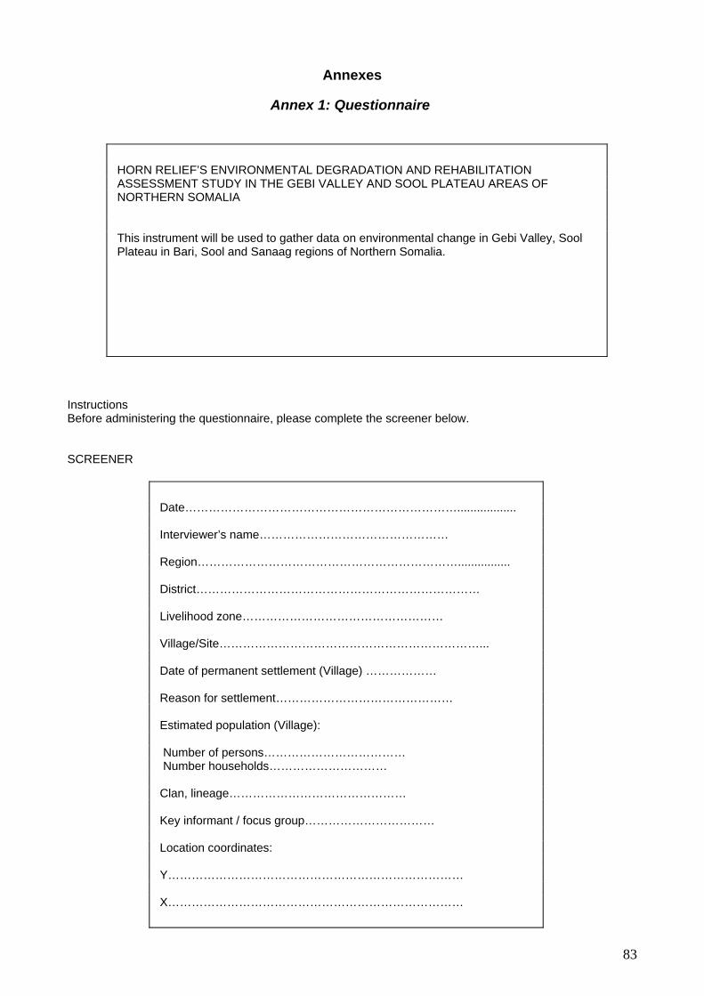
Annexes
Annex 1: Questionnaire
structions efore administering the questionnaire, please complete the screener below.
CREENER
HORN RELIEF’S ENVIRONMENTAL DEGRADATION AND REHABILITATION ASSESSMENT STUDY IN THE GEBI VALLEY AND SOOL PLATEAU AREAS OF NORTHERN SOMALIA This instrument will be used to gather data on environmental change in Gebi Valley, Sool Plateau in Bari, Sool and Sanaag regions of Northern Somalia.
InB S
Date…………………………………………………………….................. Interviewer’s name………………………………………… Region… … …… … … … . ..……… ………… …… …… …… …… ........ ..... District……………………………………………………………… Livelihood zone…………………………………………… Village/Site…………………………………………………………... Date of permanent settlement (Village) ……………… Reason for settlement……………………………………… Estimated population (Village): Number of persons……………………………… Number households………………………… Clan, lineage……………………………………… Key informant / focus group…………………………… Location coordinates: Y………………………………………………………………… X…………………………………………………………………
83

Part 1: Environmental Degradation and Resource Conservation: Qualitative questions
ation/drought/desertification – Issues, threats, egies
Indicative Evidence/Source Environmental Degradeffects, coping strat
1. What are the major environ radation problems in
blems stratified according to slope, aridity zones, soil types, and elevation?
major causes of environmental degradation in this area?
ught events predict
the strategies adopted before the drought to ct of the expected drought?
ere severe drough nced these ariods?
t has been the recent ught on the ment and the peopl
coping strategies currently used by om the variou up
t are the other steps ta n after the drought to reduce its
al production
10. Is charcoal harvesting practiced in the area?
rcoal production start in the area?
ie rvested? Are dead or live trees
13. Where are the main sites?
pact of charcoal production on the
ds in charcoal production
rass harvesting
16. Is grass harvesting practiced in the area?
17. When did grass harvesting start in the area?
18. Which are the main species harvested?
19. Which are the main markets? Rangeland degradation
Focus groups with local village leaders
Focus groups with pastoralists, especially around boreholes and trading centres
Focus groups with local authorities
Secondary data Key informant interviews with livestock traders
mental degthis area?
2. Are these pro
3. What are the
Droughts
4. Are dro
able?
5. If yes, what arepaminimise the im
6. When w ts experie in areas nd
over what pe
7. Wha impact of droenviron e?
8. What are the main
pastoralists fr s wealth gro s?
9. Wha keeffects?
Charco
11. When did cha
12. Which are the main spec s ha
cut?
14. What is the im
environment?
ted future tren15. What are the expecrketing? and ma
G
84

20. Where do herds move watered?
21. Where do herds move in wet seasons?
22. What is the condition of the surrounding main grazing areas?
23. What are the causes of range degradation? roug , o rsto in congestion ound water points
re n closures?)
4. What perma points a se in e ar ?
Ho se points distributed in the a ea?
Could these points have contribute to range degra ation?
Is rang encl ra en? By who? Why?
Awarene
28. Is the community aware about the effects of climatic changes (espec nfall variability and distribu ion) on your e iro ds?
Is the comm ity aware of the effects of deforestation on their e viro ent
30. What are the emerging threats to pastoralism in Northern Somalia?
31. If the commu enged to propose alternatives to pastorali , at ld y re m d? Are these alternatives sustainable
Rehabilitation initiatives
What a e some of the common traditional resource- conser ion que r Som lia Hav thesetechniques b en ffect ely sustain d in he a ea?
resource-conservation techni ues ave een ntrod d in the areas of Northern Somalia? Who i supporting these activities?
Are these techniques a iate, effect stainableHave these tech es rov d soil and vegetation productivity in affected areas?
nflic
35. What conflict occur over -resource management and use in the area?
What a e the esses in place for conflict resolution?
in dry seasons? Where are they
(D hts ve ck g, ar , defo statio , land en
2 nent watering re u d th ea
25. w are the r
26. d d
27. e osure p cticed? Since wh
ss
ially rai tnv nment and livelihoo
29. un
n nm ?
nity was chall
sm wh wou ou co men?
32. rvat techni s in northe n a ? e
e e iv e t r
33. What q h b i uces
34. ppropr ive and su ?
niqu imp e
Co ts
s natural
36. r proc
85

PART 2: Environmental information: Quantitative questions Palatable trees Palatability (high, medium, low) Botanical name
Local name
Camels Goats Cattle Sheep Species ne
c-
1950 (0-10)
declisin e 1940
Dry Dry Wet Dry Wet Dry Wet Wet Palatable shrubs Palatability (high, medium, low) Botani l
me Local name
Camels Sheep Species decline since 1940-1950 (0-10)
cana
Goats Cattle
Dry Wet Dr W t D Wet Dry Wet y e ry Palata e gra ses
Palatability (high, medium, low)
bl s
Botanical name
Local name
Camels
Goats Cattle Sheep Species decline since 1940-1950 (0-10)
Dry Wet Dry Wet Dry Wet Dry Wet
86

PART 3: Socio-economic inform Camels in Household Tic n 2000 2005
ation: quantitative questions
k only o e item
Hig 70) 3 h (+Medium (40 2 -70) Low (-40) 1 None 0 Cattle in Household Tick only one item 2000 2005 Hig 20) h (+ 3 Medium (10-20) 2 Low (-10) 1 None 0 Shoats in Household Tick only one item 2000 2005 High (+200) 3 Medium (70-200) 2 Low (-70) 1 None 0
keys in Household Tick only one item 2000 2005
Don
High ) (+5 3 Medium (2-5) 2 Low (-2) 1 None 0 Cha o ctioTick only one item High (+10 truck a month) 3 Medium (5-10 trucks a month) 2 Low (_5 trucks a month) 1 Non 0 e Grass harvesting production Tick only one item High (+10 tru onth) 3 ck a mMedium (5-10 trucks a month) 2 Low (_5 trucks a month) 1 None 0
rcoal pr du n
87
Annex 2: Drought Trends in Local Memory
Drought Rainfall
Zone village 1950 1951 1952 1953 1954 1955 1956 1957 1 9 1963 1964 1965 1966 1967 1968 958 195 1960 1961 1962
Ced Dafar Sign Case Durba
Caware
Miligale
Ral Lako
Balhal Ibera Sign Case
Gebi Valley Hadftim Adde
Yule Daba Dhey r
Sherti Augst
Buan
Dlair Sign Case Adde
Babusle Sign Case Day sare GariGari Sar
Ced Buh
sool 1 Midhir
Camale Adde Daba Dheyr
Xnglool Sign Case
Sbayo Adde
Xadeed Danala Xagere
Badtaq Sign Case Wajixum Adde
Wadleer Sign Case
sool 2 Samayo
Zone Village 70 71 197 73 1974 1975 19 77 1979 1980 1982 1983 1984 1985 1986 1987 1988 19 19 2 19 76 19 1978 1981
Ced Dafar Duf Gari Sa an Gari r Glungud
Caware Dufa QoraMabbe n Glungud
Miligale alDeyr Dab QoraMabbe Adde Glungud
Ral Lako
Balhal Ibera Dufan DabalDeyr Glungud
Hadftim Dufan
Gebi Valley Yule lDeyr Daba Caab Sare
Sherti Gaarale
Buan DabalDeyr
Dlair Dabal eyr D Glungud
Babusle Watqaso DabalDeyr Mat an Glunguld Adde
Ced Buh Gagarale Glungud Adde
Midhir Geger Qormaddabe
sool 1 Camale Caga Adle Glungud
Gazale Glunguld Xnglool
Sbayo garale Ga
Xadeed Danale Xa Cari Gai Sar gere
Badtaq
W Daba adleer lDeyr
Sool 2 Samayo D baa lDeyr
88

Village 1990 1991 1992 1993 1994 1995 199 19 98 19 001 002 2005 6 97 19 99 2000 2 2 2003 2004
Ced Dafar Jaweyn Tsunami
Caware Arbaca Kala Ayto Dulklat Tsunami
Miligale Kala Ayto Tsunami
Ral Lako Tur Aurto Tsunami
Balhal Ibera Di fanley
Hadftim Tur Aurto Tsunami
Yule Tsunami
Sherti Tsunami
Buan Tur Aurto
Dlair Arbaca Tukwaiyo Tukuat Tsunami
Tsunami Babusle Haba Cadi Gogale Tukwaiyo Tu at ku
Ced Buh Sansnti
Midhir Abarca
Camale Shitarra
Xnglool
Sbayo Heriro
Danala Xagere Abarca Ghara Dher
Cla Damaa
Badtaq Ditle Cisma
Wadleer Tukwaiyo Tukuat Tsunami
Samayo Tukwaiyo Tukuat
Hadftim Tur Aurto
89
Annex 3: Vegetation Decline Estimates
Camels Goats Cattle Sheep Botanical name
Local name Dry Wet Dry Wet Dry Wet Dry Wet
Location Species decline (1940/50-2005)
Cause of decline
Trees Acacia Bussei Galool H
Flower H Leaves
H H H H H H Mindigale Cawsane Hubera Raad-Lako Hadaaftimo Yuube Bali Busle Buran Carmale Ceel-Buh Mindihir Sherbi Wardheer Sarmanyo Damala-Xagare
10-0 10-3 10-2 10-1 10-1 10-4 10-2 10-0.5 10-2.5 10-1 10-1 10-5
1971 cyclone, drought Charcoal since 1991 Drought and charcoal Charcoal Drought and charcoal Charcoal Drought, charcoal Drought, charcoal Charcoal Drought, charcoal Drought, charcoal Charcoal Charcoal
Acacia Tortillis or Acacia Raaddiana
Qurac M Fruit
M Leaves
M M Leave
M Fruit
M Leave
M Fruit
M Leave
Ceel Dofar Mindigale Cawsane Hubera Hadaaftimo Yuube Bali Busle Buran Carmale Ceel-Buh Mindihir Sherbi Wardheer Sarmanyo Sibayo Damala Xagare
10-3 10-7 10-2 10-1 10-1 10-100 10-9 10-30 10-5 10-5 10-6 10-10 10-2 10-1 10-1 increased
Drought Fencing Cyclone and lack of water diverted by new river Gebi Before used for fencing but now burning Drought, used for fencing Drought Drought, charcoal Charcoal Fencing Not cut for charcoal
Acacia Mellifera
Bilcil H H H H Bali Busle Buran Ceel-Buh Sarmanyo Damala Xagare
10-8 10-20 10-2 10-5 10-9
Drought Cut for wood Charcoal burning
Acacia Seya/baccarini
Jiic H H H H Bali Busle Buran Ceel-Buh Sherbi Wardheer Sarmanyo Damala Xagare
10-4 10-1 10-1 10-5 10-2 10-10 10-1
Construction Construction Construction Construction Construction Construction
Moringa Oleifera
Damal H Fruit
H Leaves
H Fruit
H Leaves
Ceel Dofar Mindigale Causane Hubera Raad-Lako Yuube Bali Busle Sherbi Wardheer
10-3 10-50 10-3 10-2 10-100 10-10 10-10 10-10 10-3
Drought Increase in number after Galool depletion Lack water, only remains near river Drought and animal fencing
Boscia Minimifolia
Meygaag Picture cut
for construction
Goran
H H H H Mindigale Cawsane Raad-Lako Bali Busle Carmale Sherbi Wardheer Sarmanyo Damala Xagare
10-8 10-1 10-15 10-8 10-2 10-1 Reduced Reduced 10-2
Use building nomadic house Construction Construction Construction Construction Charcoal burning Construction
Sarmaan H H Cawsane 10-4 Salvadora persica
Cadey H H H Ceel Dofar Cawsane
10-7 10-0
Sold Bosaso, tooth brush
Ziziphus Mauritania or spinachristi
Gob H H H H Ceel Dofar Cawsane Raad-Laako Hadaaftimo Buran Sherbi
10-7 10-1 10-1 10-1 10-4 10-5
Uprooted by floods Human consumption Washed away by cyclone Cut for animal, destroyed by cyclone Cut for animals Floods, cut to feed animals
Cadaba Herterotricha
Higlo H H H Ceel Dofar Mindigale Cawsane Hubera Raad-Lako Carmale Sherbi Sarmanyo Sibayo Damala Xagare
10-0 10-5 10-4 10-3 10-10 10-2 10-4 Reduced 10-1
Drought, water diversion, overgrazing Lack of water Cyclone? Drought, overgrazing, only green plant during dry seasons Charcoal cover and overgrazing Charcoal burning Drought, wind, overgrazing Drought, overgrazed and covered with sand dunes
Juniperus Procera
Dayib Al-Madow 10-3 Timber since 1991
Duke H H Raad-Lako 10-12 Acacia Ebtaica
Sosog/yuube H H Hadaaftimo Yuube Buran Wardheer
10-4 10-10 10-5 10-2
Charcoal and fencing Just start burning Charcoal Charcoal
Acacia Nilotica Maraa H H H Hadaaftimo Wardheer Sarmnyo Damala Xagare
10-5 10-4 10-10 10-10
Charcoal Drought
Tamarix Aphylla
Dhuur H Ceel Dofar 10-8 Construction of Huts
Awo H Ceel Dofar 10-1 Construction huts, drought and floods
Phoenix Dactilifera
Timir Buran 2-200 Imported by British from Saudi Arabia
Acacia edgeworthii
Qansax H H H H H H H H Sherbi 10-1 Cut to fence berked
90

Camels Goats Cattle Sheep Botanical
name Somali Name Dry Wet Dry Wet Dry Wet Dry Wet
Location Decline Cause of Decline
Shrubs Cadaba Somalensis
Qalaanqal H H H H Ceel Dofar Mindigale Cawsame
Hubera Hadaftimo Bali Busle Wardheer Sarmanyo
Damala Xagare
10-1 10-8 10-0 10-4 10-1 10-10 10-3
10-1
Drought Cyclone, floods and drought Drought, overgrazing Charcoal burning Drought and overgrazing
Baskalax H H H H H H H H Carmale Sibayo Damala Hubera
10-1 10-1
Reduced 10-5
Drought, overgrazing Drought and firewood Drought
Grewia Tenax
Dhafaruur H H Ceel Dofar 10-1 Drought
Jafle H M Raad-Lako Damala
10-20 10-6
Drought
Chascanum Africana
Yubluluc H M Cawsane Raad-Lako
10-7 10-30
Larlajis H M Raad-Lako 10-20 Hiblola H H Hadaftimo 10-1 Cadaba Barbigera
Caanamacays H H H H Hadaftimo Yuube
10-1 10-10
Reduced by drought but regenerating
Halamash H M Raad-Lako 0-100 Intruder: Came after the cyclone1972 Dangerous for camels
Surat H H Yuube Bali Busle
10-10 10-10
Mirow H H Yuube 10-10
Reduced by drought but regenerating
Dhirindhir H H Ceel Dofar Ceel-Buh
Sherbi Wardheer Sarmanyp
10-5 10-3 10-7 10-4 10-2
Drought Drought Drought
Gawllalo Ceel Dofar Wardheer
Sibayo Damala Xagare
10-1 10-4 10-2 10-1
Drought Drought Drought Drought, and sand dunes
Garoon/Karoon H H Ceel Dofar Bali Busle Carmale Sherbi
Sarmanyo Damala Xagare
10-1 10-6 10-5 10-5 10-5 10-5
Drought Drought Drought, overgrazing Drought Drought Drought and overgrazing
Commiphora elenbechii
Didin H H Ceel Dofar Sherbi
Wardheer Damala Xagare
10-1 10-10
? 10-1
Drought Drought, gum collection Drought and overgrazing
Hamhama H H Bali Busle Sarmanyo
10-6 10-5
Insect Charcoal
Ilca Cade H H Bali Busle 10-10 Lamayolo H H H H Bali Busle 10-4 Construction Miro H H Bali Busle 10-10 Hill H H Carmale 10-4 Drought, overgrazing
Balanites orbicularis
Kulan H Carmale 10-3 Drought, overgrazing
Balanti H H Carmale 10-4 Drought, overgrazing Lantana Microfilla
Ged xamar H H H Carmale Sibayo Damala
10-8 10-1 10-9
Drought, overgrazing Drought
Commiphera spp
Hagar-Cad H H Sherbi Wardheer
10-4 10-3
Drought Drought
Kabraro H H Sherbi 10-2 Drought Grewia Erytherea
Murcaanyo H H Ceel Dofar Sherbi
Wardheer Sibayo
10-1 10-5 10-6 10-1
Drought Drought
Grewia Tanix
Dhafaruur H H Sherbi 10-3 Drought
Grewia Villose
Gomoshaa H H Sherbi 10-1 Drought
Muhude H H Sherbi 10-2 Drought Madoya H H Sherbi 10-4 Drought Muroho H H Sherbi 10-1 Drought Acacia Cadaad H H Sherbi 10-2 Drought
Tabok Wardheer Sarmanyo
Damala Xagare
10-4 10-2 10-9
Drought
Muqlo Wardheer Sarmanyo
10-4 10-8
Drought
Pistacia Lentisucs
Xamur Wardheer 10-2 Drought
Commphora Spp
Xagar Sarmanyo Damala Xagare
10-8 10-9
Mirafur Sarmanyo 10-8 Guure Sarmanyo 10-5 Jimbac Sarmanyo 10-5 Bulumbirle Sarmanyo 10-5
Pistacia Lentisucs
Xamur Sarmanyo 10-5
Acacia Edgeworthii
Qansax Sarmanyo 10-5
Charcoal
Dawa Haure L L L L Sibayo 10-0 Dalol H H H H Sibayo 10-1 Cali Bowye Damala Xagare 10-10
Xamur H H Sherbi Sibayo
10-10 1.1
Daray Sibayo 1.5 Dharkkayn Sarmanyo
91

Camels Goats Cattle Sheep Botanical
Name Somali Name Dry Wet Dry Wet Dry Wet Dry Wet
Location Decline Cause of Decline
Grasses Limorum Spp Daran H H H H Cawsane
Raad-Lako 10-1 10-5
Eaten by outside migrants at end of rains Overgrazing/Drought
Anthropogon Kelleri Duur H H H H H H H H Cawsane
Bali Busle Buran
Carmale Mindihir Sherbi
Wardheer Sarmanyo
Sibayo Damala
10-0
10-6 10-10 10-3 10.1 10-1 10-3 10-3 10-1 10-4
Drought, overgrazing and charcoal Drought, charcoal to cover kiln Drought, charcoal Drought, cover charcoal Drought and charcoal cover Drought and charcoal cover
Eragrostis Haraensis Gubungub H H H H Cawsane Yuube
Bali Busle Buran
Carmale
Sherbi
10-0 10-10 10-3 10-10 10-0
10-1
Drought, overgrazing Resistant to drought but finished by herds Last to survive drought but overgrazed
Weyrax H H H H Cawsane 10-0 Taaxug H H H H Cawsane
Bali Busle Sherbi
10-0 10-10 10-10
Sporobolus spp Duxi H H H H H H H H Ceel Dofar Cawsane Hubera
Raad-Lako Hadaftimo
Yuube Buran
Ceel-Buh Sherbi
Wardheer Sarmanyo Damala
10-2 10-0 10-0 10-10 10-9 10-1 10-10 10-1 10-1 10-0 10-2 10-1
Drought Drought Drought Drought Drought Drought
Chrysopogon Aucheri or melenis grandiflora Dureemo H H
H H H H H H Ceel Dofar Mindigale Cawsane
Raad-Lako Hadaftimo
Yuube Bali Busle
Buran Carmale Ceel-Buh Mindihir Sherbi
Wardheer Sarmanyo
Siabyo Damala
10-2 10-6 10-1 10-5 10-2
10-10 10-7 10-10 10-5 10-2 10-2 10-3 10-3 10-3 10-1 10-1
Drought Cyclone and drought Drought, over-cutting, car tracks, cant grow with Qurac tree, which multiplied after cyclone 1971 Drought Drought, overgrazing Drought Drought, cover charcoal Drought Drought
Paspalidium desertorum Gargoro/ Cagagaro H H H H H H H H Ceel Dofar Mindigale Cawsane
Raad-Lako
Sherbi Sarmanyo Damala
10-1 10-2 10-7 10-2
10-2 10-2 10-5
Drought Gulley Cyclone and overgrazing during drought Grass harvesting Drought, taken by gulley Drought Drought, overgrazing
Echinocholoa colona
Doomaar Madow
Ceel Dofar Mindigale
Cawsane
Raad-Lako Hadaftimo
Yuube
Carmale
10-2 10-6
10-0 10-10 10-1
10-10 10-4
Drought/floods Taken by floods, drought gullies Gully Harvested Destroyed by Gully, lack of soil Ok with land adjudication Drought, overgrazing
Ul or Doomaar Cad H H H H H H H H Mindigale
Cawsane Hubera
Raad-Lako Hadaftimo
Yuube Buran
10-3
10-0 10-0 10-10 0-7
10-10 10-10
Taken by floods, drought, gullies Gully Drought Harvested Came in 1987
Sifaar H H H H H H H H Ceel Dofar Mindigale Hubera Cawsane HaHadaftimo Yuube Bali Busle Buran Ceel-Buh Sherbi Wardheer Sarmanyo Sibayo Damala
10-5 10-5 10-0 10-0 10-9 10-20 10-7 10-10 10-2 10-1 10-1 10-2 10-1 10-1
Drought and floods, also reduced in size Before tall grass now short Drought Increased with land adjudication Drought Drought Drought Drought
Siidal H H H H H H H H Cawsane Raad-Lako
10-0 10-5
Covered by sand dunes or encroached on by Gully since 1972 cyclone , Harvested
92

Ramaas H H H H Mindigale Hubera Hadaftimo Sarmanyo
10-3 10-0 10-10 10-9
Drought
Aftoxolle Mindigale Raad
0-? Intruder non palatable
Alamash Yuble
Intruder from Ethiopia; came with locusts in 1950
Cayo H H Yuube 10-10 Hiil H H Yuube
Sibayo 10-10 10-1
Drought
Badhanti H H H H H Yuube 10-30 Dactylotenium Species Saddexo H H H H Hadaftimo
Bali Busle 10-8 10-50
Xarfo Bali Busle Buran Sherbi
Sarmanyo
10-10 10-20 10-10 10-30
Sarin Wardheer Damala
10-2 10-5
Drought
Dactylocetinium Scindicum Saddexo Sarmanyo 10-0 Drought Yamaarug Damala 10-0 Drought Waniiq Damala 10-1 Drought Sericocomopsis Food Cade Damala 10-5 Drought Urxaad Damala 10-5 Drought Geed Labeen Damala 10-5 Drought Qoraya-Xaaris Damala 10-5 Drought Dansaca Ure Damala 10-5 Drought
93

Annex 4: Estimates of Livestock Losses
Average size camels herd
Average size cattle herd
Average size shoat herd
Average size donkey herd
ID X Y Town/village Before drought
After drought
Before drought
After drought
Before drought
After drought
Before drought
After drought
1 226134 1179256 Badhan-Hubera 60 10 40 0 300 60 3 1 2 260043 1170707 Cawsane1 50 1 40 1 200 45 0 0 3 245810 1181990 Mindigale 30 2 10 2 100 15 2 0 4 233295 1185338 Raad-Lako 70 6 50 2 500 35 2 0 5 183441 1191499 Hadaftimo 70 6 40 1 300 60 2 1 6 819596 1189649 Yuube 50 3 30 2 250 50 8 1 7 205026 1131536 Ceel-Buh 90 2 18 0 300 50 7 1 8 217083 1120425 Mindihir 100 6 15 0 400 50 0 1 9 256206 1129640 Buran 50 3 20 0 250 80 0 1
10 236565 1109102 Bali Busle2 55 3 20 1 200 75 5 0 11 824062 1159844 Carmale 70 2 30 0 200 50 5 1 12 204997 1079387 Xingalool 13 186317 1102456 Sibayo 90 5 20 0 200 50 10 2 14 183631 1069370 Wardheer 80 1 20 0 200 30 20 2 15 823705 1086113 Damala Xagare 60 2 30 0 300 30 4 2 16 828859 1050364 Sarmanyo 80 2 20 0 200 40 5 2 17 224034 1057455 Baraktaqol 300 2 170 0 330 60 60 20 18 260920 1078158 Dahar 100 2 100 0 200 50 2 2 19 290756 1091000 Sherbi 75 11 60 0 200 40 3 0 20 286553 1175315 Ceel Dofar 100 5 0 0 200 60 3 1 Average loss 79 4 37 1 242 44 7 2 94.7% loss 97.7% loss 81.8% loss 71.4% loss
94

Annex 5: Berked information
ID X Y Village House
berkeds Underground
berkeds
Operational Underground
berked
underground berked under
construction First
constructed
Average capacity of underground berked in m3
1 260043 1170707 Cawsane1 0 0 0 0 0
2 245810 1181990 Mindigale 2 0 0 0 0
3 233295 1185338 Raad 16 0 0 0
4 236214 1187068 Lako NA 14 14 1996 427,4
5 183441 1191499 Hadaftimo 300 12 11 NA 1975 540
6 819596 1189649 Yuube NA 2 2 NA 1999 450
7 208500 1185043 Badhan NA 0 0 0 0
8 205026 1131536 Ceel-Buh 300 55 55 55 1968 345
9 217083 1120425 Mindihir 3 26 11 15 1997 81,4
10 256206 1129640 Buran NA 0 0 0 0
11 234800 1111150 Bali Busle 1 NA 3 1 2 1992
12 236565 1109102 Bali Busle2 6 20 20 17 1996 186,6
13 824062 1159844 Carmale 30 5 5 30 1971 183
14 204997 1079387 Xingalool 60 11 9 20 1978 broken since 1995 342
15 186317 1102456 Sibayo 5COOPI) NA 2 2 0 2004 84
16 183631 1069370 Wardheer 0 9 9 15 2000 191,7
17 823705 1086113 Damala Xagare
(7 COOPI) 20 70 70 40 1981 259
18 828859 1050364 Sarmanyo (1 MPA) 50 70 40 0 1970 333
19 224034 1057455 Baraktaqol NA 60 20 50 1967 680
20 260920 1078158 Dahar 350 38 35 20 1969 357
21 290756 1091000 Sherbi 145 120 20 1961 327,5
22 286553 1175315 Ceel Dofar 10 0 0 0 NA NA
23 225992 1132938 Harbar Shiro 10 10 20 NA NA
24 204436 1108404 Qoyan 10 4 10 NA NA
25 229285 1114259 Goran 3 3 10 NA NA
26 203841 1102786 Jingeda 4 4 14 NA NA
Average UG capacity : 320 m3
95

ID X Y Village
number of house berkeds
number of households Coverage
Operational Underground
berked number of
households Coverage
20 286553 1175315 Ceel- Dofar 10 400 0 400 0
1 260043 1170707 Cawsane1 0 70 0 0 70 0
2 245810 1181990 Mindigale 2 100 0 100 0
3 233295 1185338 Raad -Lako 16 450 14 450 3,1
4 183441 1191499 Hadaftimo 300 2000 11 2000 0,5
5 819596 1189649 Yuube NA 2 600 0,3
6 208500 1185043 Badhan NA 0 286 0
7 205026 1131536 Ceel- Buh 300 1700 55 1700 3,2
8 217083 1120425 Mindihir 3 60 11 60 18,3
9 256206 1129640 Buran NA 0 1500 0
10 236565 1109102 Bali- Busle 6 250 21 250 8,4
11 824062 1159844 Carmale 30 300 5 300 1,6
12 204997 1079387 Xingalool 60 3500 9 3500 0,2
13 186317 1102456 Sibayo 5 (COOPI) NA 2 500 0,4
14 183631 1069370 Wardheer 0 120 9 120 7,5
15 823705 1086113 Damala Xagare
(7 CO) 20 1000 70 1000 7
16 828859 1050364 Sarmanyo (1 MPA) 50 250 40 250 16
17 224034 1057455 Baraktaqol NA 20 645 3,1
18 260920 1078158 Dahar 350 5000 35 5000 0,7
19 290756 1091000 Sherbi 3000 120 3000 4
96

ID X Y Name Year of
construction Note Price 200l rain Price 200l from
WT 1 824171 1160199 Carmale B1 1971 15000 30000 2 824512 1160144 Carmale B2 2003 15000 30000 3 216479 1120402 Mindihir B1 1997 10000-15000 40000 4 216784 1120323 Mindihir B2 2005 10000-15000 40000 5 183972 1069653 Wardheer B1 2000 10000-15000 60000-70000 6 183300 1069566 Wardheer B2 2003 10000-15000 50000-60000 7 204534 1079837 Xingqlool B1 1978 20000 8 204169 1078859 Xingalool B2 1995 20000 9 224168 1057383 Baraktaqol B1 1967 10000 70000
10 224280 1057330 Baraktaqol B2 1996 10000 70000 11 236952 1108272 Balibusle B1 1996 10000 35000 12 236155 1107694 Balibusle B2 2005 10000 35000 13 205163 1131897 Ceel-Buh B1 1968 10000-15000 60000 14 204898 1132644 Ceel-Buh B2 2005 10000-15000 60000 15 828797 1050499 Sarmanyo B1 1970 10000 50000 16 829150 1050302 Sarmanyo B2 2000 10000 50000 17 825307 1191850 Qoralay 1999 NS NS
18 183960 1193019 Hadaftimo B1 1975 Irrigate
plot 19 236214 1187068 Lako B1 1996 15000 30000 20 234610 1186705 Lako B2 2001 15000 30000 21 186164 1102744 Sibayo B1 2004 5000 30000 22 290568 1091143 Sherbi B1 1961 10000 20000 23 291461 1090984 Sherbi B2 2005 10000 20000 24 260437 1078358 Dahar B1 1969 10000 10000
25 260691 1077462 Dahar B2 2005
Planned for
irrigation NS NS
26 260007 1077899 Dahar B3 In construction Irrigate
plot NS NS
27 823806 1086067 Damala-
Xagarre B1 1981 10000-15000 50000
28 823877 1085997 Damala-
Xagarre B2 2004 10000-15000 50000
29 823185 1086342 Damala-
Xagarre B3 1991 Irrigate
plot NS NS
97
Annex 6: Soil analysis
Latitude longitude
Elev. Site Depth CLAY (%)
SAND (%)
SILT (%)
Texture class
pH:H2O pH classes
EC1:2.5 Salinity class
Exchangeable calcium
(me/100g soil)
10◦34'57.7" N
47◦58' 13" E
1309 Carmaale 0 to 15 39.0 17.0 44.0 SiCL 8.4 moderately alkaline 0.2 non saline 8.80
Carmaale 15 to 60 51.0 13.0 36.0 C 8.3 moderately alkaline 0.2 non saline 8.75
Carmaale 65 to 115 53.0 15.0 32.0 C 8.2 moderately alkaline 0.4 non saline 8.40
10◦34'58" N
48◦48' 21" E Cawsane1 0 to 20 21.0 17.0 62.0 SiL 8.1
moderately alkaline 2.1 slightly saline 11.05
Cawsane1 20 to 40 35.0 19.0 46.0 CL 8.2 moderately alkaline 2.2 slightly saline 13.90
Cawsane1 40 to 60 27.0 21.0 52.0 SiL 8.2 moderately alkaline 2.1 slightly saline 14.20
Cawsane1 60 to 80 43.0 13.0 44.0 SiL 8.2 moderately alkaline 2.2 slightly saline 9.80
10◦01' 01" N
48◦36' 01" E Balli-busle 0 to 22 8.2
moderately alkaline 0.5 non saline 10.23
Baraagaha-qol/
Ceelka 0 to 26 8.2 moderately alkaline 0.2 non saline 9.51
Baraagaha-qol/
Ceelka 26 to 40 8.2 Moderately alkaline 0.2 non saline 6.44
Baraagaha-qol/
Ceelka 40 to 50 8 moderately alkaline 0.5 non saline 9.64
9◦ 48' 43" N
47◦57' 00" E
Beerta-gobley/
Damalaxagarre 0 to 15 7.7
mildly alkaline 1.1 non saline 9.81
Beerta-gobley/
Damalaxagarre 0 to 15 7.9
moderately alkaline 0.6 non saline 9.64
10◦ 18' 53" N
48◦ 17' 24" E
Ceel Hakay/
Ceel-buh 0 to 25 7.9 moderately alkaline 0.6 non saline 10.62
Ceel Hakay/
Ceel-buh 25 to 40 7.9 moderately alkaline 0.2 non saline 8.17
Ceel Haqay/
Ceel-buh 40 to 55 8.1 moderately alkaline 0.7 non saline 7.22
Geed-CilmiI 0 to 16 8.1
moderately alkaline 0.2 non saline 8.47
Latitude longitude
Elev. Site Depth CLAY (%)
SAND (%)
SILT (%)
Texture class
pH:H2O pH classes
EC1:2.5 Salinity class
Exchangeable calcium
(me/100g soil) 9◦ 42' 29"
N 48◦56' 57"
E Geed-CilmiI 16 to 42 8.2
moderately alkaline 0.2 non saline 11.88
Geed-CilmiI 42 to 86 8
moderately alkaline 0.4 non saline 7.71
10◦41'41" N
48◦17' 48" E
1156 Gunguma
ale 0 to 20 7.0 59.0 34.0 SL 8.1 moderately alkaline 2.3 slightly saline 9.80
Gunguma
ale 20 to 35 5.0 49.0 46.0 SL 8.2 moderately alkaline 2.6
moderately saline 9.20
Gunguma
ale 35 to 50 5.0 45.0 50.0 SiL 8.2 moderately alkaline 2.7
moderately saline 9.25
Habar/hu
mbule 0 to 20 8 moderately alkaline 0.6 non saline 10.15
98

Habar/hu
mbule 20 to 35 8.1 moderately alkaline 0.6 non saline 10.23
10◦39'28" N
48◦29' 48" E Xubeera 1 0 to 5 7.0 35.0 58.0 SiL 8.1
moderately alkaline 3
moderately saline 11.10
Xubeera 1 5 to 33 5.0 31.0 64.0 SiL 8 moderately alkaline 2.7
strongly saline 16.20
99

Latitude longitude Elev. Site
exchangeable sodium
(me/100g soil
Extractable phosphorus (mg P/kg) Carbon (%)
Nitrogen (%)
1034'57.7" N 47◦58' 13" E 1309 Carmaale 0.1 7.30 7.30 0.10 Carmaale 0 22.70 22.70 0.07 Carmaale 0.1 5.80 5.80 0.07
10◦34'58" N 48◦48' 21" E Cawsane 1 0.1 3.50 6.35 0.05 Cawsane 1 0.1 1.90 5.89 0.01 Cawsane 1 0.1 2.00 5.77 0.15 Cawsane 1 0.2 4.50 7.23 0.04
10o01' 01" N 48o 36' 01" E Balli-busle 7.6 Baraagaha-qol/Ceelka 5.62 Baraagaha-qol/Ceelka 4.27 Baraagaha-qol/Ceelka 2.85
9◦ 48' 43" N 47◦57' 00" E
Beerta-gobley/Damalaxagarre 1.97
Beerta-
gobley/Damalaxagarre 1.49 10◦ 18' 53" N 48◦ 17' 24" E Ceel Hakay/Ceel-buh 3.02 Ceel Hakay/Ceel-buh 4.88 Ceel Haqay/Ceel-buh 4.85 Geed-CilmiI 3.77
9◦ 42' 29" N 48◦56' 57" E Geed-CilmiI 3.56 Geed-CilmiI 2.61
10◦41'41" N 48◦17' 48" E 1156 Gungumaale 0.00 2.70 2.71 0.05 Gungumaale 0.10 5.30 2.81 0.05 Gungumaale 0.2 3.80 Latitude longitude Elev. Site
exchangeable sodium
(me/100g soil
Extractable phosphorus (mg P/kg) Carbon (%)
Nitrogen (%)
Habar/humbule 1.73 Habar/humbule 3.16
10◦39'28" N 48◦29' 48" E Xubeera 1 0.10 1.30 5.52 0.08 Xubeera 1 0.40 0.20 3.97 0.06
100

Latitude/ Longitude/ Elevation Site Depth
CLAY (%)
SAND (%) SILT (%)
Texture class pH:H2O pH classes
EC1:2.5
Salinity class
Exchangeable
calcium (me/100g
soil)
Xubeera 1 33 to 56 7.0 59.0 34.0 SL 8 moderately
alkaline 2.7 strongly saline 12.60
Xubeera 1 56 plus 7.0 87.0 6.0 S 8.2 moderately
alkaline 2.6 strongly saline 10.90
10◦44'54" N 48◦06' 57.7" E 1287 Hadaaftimo 0 to 28 27.0 19.0 54.0 L 8.2
moderately alkaline 1.5
slightly saline 9.80
Hadaaftimo 28 to 78 7.0 43.0 50.0 SiL 8.1 moderately
alkaline 2.4 slightly saline 8.50
Hadaaftimo 78 to 120 27.0 19.0 54.0 L 8 moderately
alkaline 2.6 moderately saline 8.50
Hiil-Buraan 0 to 25 7.9 moderately
alkaline 0.7 non saline 8.55
9◦47'23" N 48◦20' 40" E 915 Xin-Qori 0 to 30 7.9
moderately alkaline 0.419 non saline 10.90
Xin-Qori 30 to 47 8.1 moderately
alkaline 0.468 non saline 10.70
Xin-Qori 47 to 66 7.9 moderately
alkaline 1.11 non saline 10.14
9◦41' 33" N 48◦53' 02" E Kalxileed 0 to 10 7.7
Mildly alkaline 0.2 non saline 10.05
Kalxileed 10 to 20 8.1 moderately
alkaline 0.2 non saline 8.52
Kalxileed 20 to 80 8.2 moderately
alkaline 0.2 non saline 9.78
Kuri-
kuris/Cawasane 0 to 50 8.1 moderately
alkaline 0.8 non saline 11.24
9◦58' 04" N 49◦15' 55" E Lucda/Sherbi 0 to 26 8.2
moderately alkaline 0.2 non saline 7.95
Lucda/Sherbi 26 to 165 8.2 moderately
alkaline 0.2 non saline 7.69
10◦40' 05" N 48◦39' 47" E Mindigaale 2 0 to 25 5.0 29.0 66.0 SiL 8
moderately alkaline 2.3
slightly saline 9.55
Mingaale 2 25 to 40 5.0 31.0 64.0 SiL 8 moderately
alkaline 2.6 moderately saline 10.20
Mindigaale 2 40 to 62 5.0 29.0 66.0 SiL 8 moderately
alkaline 2.8 moderately saline 10.40
Mindigaale
1/Higlo-tuug 0 to 25 8.1 moderately
alkaline 2.3 moderately saline 12.379
10◦43'28" N 48◦33' 59" E RAAD 0 to 18 43.0 13.0 44.0 SiC 8.5
strongly alkaline 0.5 non saline 9.40
Latitude longitude Elev. Site Depth
CLAY (%)
SAND (%) SILT (%)
Texture class pH:H2O pH classes
EC1:2.5
Salinity class
Exchangeable
calcium (me/100g
soil)
RAAD 18 to 40 21.0 37.0 42.0 L 8.6 strongly alkaline 0.4 non saline 9.80
RAAD 40 to 62 43.0 15.0 42.0 SiC 8.7 strongly alkaline 0.6 non saline 9.40
10◦21'54" N 48◦21' 17" E 1135 Urur/Ceel-Buh 0 to 26 17.0 57.0 26.0 SL 8
moderately alkaline 0.5 non saline 4.35
Urur/Ceel-Buh 26 to 40 15.0 65.0 20.0 SL 8 moderately
alkaline 0.4 non saline 6.25
10◦40'32" N 48◦41' 39" E 1460
Yuube 0 to 26 37.0 19.0 44.0 SiCL 8 moderately
alkaline 0.5 non saline 8.90
Yuube 26 to 43 41.0 17.0 42.0 SiC 8.1 moderately
alkaline 0.5 non saline 8.70
Yuube 43 to 120 35.0 13.0 52.0 SiCL 8 moderately
alkaline 0.4 non saline 7.95
101

Latitude longitude Elev. Site
exchangeable sodium
(me/100g soil
Extractable phosphorus (mg P/kg) Carbon (%)
Nitrogen (%)
Xubeera 1 1.90 4.10 3.79 0.38 Xubeera 1 0.00 0.80 4.42 0.04
10◦44'54" N 48◦06' 57.7" E 1287 Hadaaftimo 0.00 4.30 6.35 0.07 Hadaaftimo 0.10 14.80 7.21 0.45 Hadaaftimo 0.00 7.13 0.06 Hiil-Buraan 3.17
9◦47'23" N 48◦20' 40" E 915 Xin-Qori 0.00 3.40 4.85 0.07 Xin-Qori 0.00 5.80 4.52 0.06 Xin-Qori 12.62
9◦41' 33" N 48◦53' 02" E Kalxileed 4.63 Kalxileed 0.78 Kalxileed 2.24
Kuri-
kuris/Cawasane 2.18
9◦58' 04" N 49◦15' 55" E Lucda/Sherbi 2.19 Lucda/Sherbi 3.85
10◦40' 05" N 48◦39' 47" E Mindigaale 2 0.00 1.80 5.66 0.05 Mingaale 2 0.00 1.40 5.67 0.04 Mindigaale 2 0.20 1.90 5.44 0.06
Mindigaale
1/Higlo-tuug 1.858928042
10◦43'28" N 48◦33' 59" E RAAD 0.00 3.60 5.67 0.09 RAAD 0.00 3.20 5.58 0.07 RAAD 0.10 15.00 5.57 0.08
10◦21'54" N 48◦21' 17" E 1135 Urur/Ceel-Buh 1.20 15.30 9.09 0.04 Urur/Ceel-Buh 2.60 2.00 9.52 0.02
Latitude longitude Elev. Site
exchangeable sodium
(me/100g soil
Extractable phosphorus (mg P/kg) Carbon (%)
Nitrogen (%)
10◦40'32" N 48◦41' 39" E 1460
Yuube 0.00 2.00 5.84 0.07 Yuube 0.10 0.00 5.95 0.06 Yuube 0.30 0.00 6.19 0.05
102

Annex 7: Charcoal Production Estimates
Estimate charcoal production/month (nbr of
trucks) Estimate grass harvesting
production/month(nbr of trucks) ID X Y Town/village
1 226134 1179256 Badhan-Hubera 0 0
2 260043 1170707 Cawsane 1 0 0 3 245810 1181990 Mindigale 0 0 4 233295 1185338 Raad-Lako 0 150 5 183441 1191499 Hadaftimo 0 NK 6 819596 1189649 Yuube 10 8 7 205026 1131536 Ceel-Buh 0 0 8 217083 1120425 Mindihir 1 0 9 256206 1129640 Buran 60 0
10 236565 1109102 Bali Busle 2 10 0 11 824062 1159844 Carmale 45 45 12 204997 1079387 Xingalool 0 0 13 186317 1102456 Sibayo 0 0 14 183631 1069370 Wardheer 100 0
15 823705 1086113 Damala Xagare 0 0
16 828859 1050364 Sarmanyo 120 0 17 224034 1057455 Baraktaqol 300 0 18 260920 1078158 Dahar 600 0 19 290756 1091000 Sherbi 0 0 20 286553 1175315 Ceel Dofar 0 0 1246 203
1 truck = 200 x 50kg bags
103

Bibliography
Ayan M.A., Somalia Environment and National Efforts. 1988. Barkhadle, A.M.I., The Somali Traditional Degaan (ecological) Classification Map. Estratto dalla (Rivista di Agricoltura subtropicale e tropicale) Anno LXXXVII n.1, Gennaio- Marso 1993. Behnke, R., Range enclosure in Central Somalia, London, ODI, 1988 Behnke, R., The implications of spontaneous Range enclosure for African Livestock Development Policy Addis-Ababa, ILRI, ALPAN Network Paper 12, 1989 Behnke, R., “Natural Resource Management in Pastoral Africa” Development Policy Review, 12, 1994, pp 5-27. Bird, Neil and Shepherd, Gill Charcoal in Somalia. A Wood fuel inventory in the Bay Region of Somalia London, ODNRI, 1989 Bromley D.W. and Cernea, M., The Management of common property natural resources: Some conceptual and operational fallacies” Document de travail de la banque mondiale no. 57 Washington DC, 1989, Banque Mondiale Bourgeot, A., “Une rupture du couple écologie-économie: La crise du pastoralisme touareg” in Chantal Blanc-Pamard and Jean Boutrais (dir): A la croisée des parcours, Pasteurs, éleveurs, cultivateursParis, IRD, Dynamique des systèmes agraires, 1994, pp 63-79. Bruce, J and Mearns, R., Natural Resource Management and Land Policy in Developing Countries. Lessons learned and New Challenges for the World Bank, London, IIED, Issue Paper 115, 2002 Bryden, M., Report on Mission to Hawd Area, Region V, Addis Ababa, UNDP-EU, 1994. PENHA and ICD, Survey on the state of Pastoralism in Somaliland. 2001 Cossin, N., Pastoralism under pressure. A Study of Somali Clans in the Jigjiga area of Ethiopia, Addis Ababa, LMB, Provisional Military Government, Addis Ababa, 1971. Crocket, J.J., “Preliminary Studies in the evaluation of grassland sampling techniques in tall grass prairie sites.” Proc. Okla, 1963,. Acad. Sci 43: 43-46.
104

De Haan, H. Steinfeld, and Blackburn, H., Livestock and the Environment: Finding a balance Brussels, European Commission, FAO and World Bank, 1998 Department of Agricultural Engineering, University of Nairobi, Soil and Water Conservation in Kenya. 1989 European Commission, Towards Sustainable Water Resources Management: A Strategic approach September 1998. Faillace, C and Faillace, ER., Water quality data book of Somalia. Hydrogeology and water quality of southern Somalia, vol. 1, Eschborn, GTZ, 1986 Faillace, C and Faillace, ER., Water quality data book of Somalia. Hydrogeology and water quality of Northern Somalia, vol. 2, Eschborn, GTZ, 1986 Farah, A., Impact of the insufficient deyr rains on Nomads’ Access to Food in the central Area of ESNRS, Addis Ababa, UNDP-EU, 1997. Fratkin E, Nathan M.A and Roth, E.A. “Health Consequences of pastoral sedentarisation among the Rendille of Northern Kenya” in David M Anderson and Vidgis Broch-Due : The poor are not us Oxford, James Currey, 1999 Frélechous, N. Pastoral Environment and Water Resources Development Loughborough University, Master of Science, 2002 FAO, Pastoralism in the new millennium Rome, Italia Animal production and health paper FAO, Soil Survey Manual. 1988, Rome. FAO, Multithematic Analogic interpretation of Landsat TM Imagery for the Rome Region. 1988, Rome. FAO, Remote Sensing Application to Land Resources. 1990, Rome. FAO-FSAU, 2005. 2005 Post Deyr Analysis, Technical Series Report No IV.3, Nairobi, Kenya. February, 2005. FSAU, Monthly Nutrition Updates March 2005 FSAU, Monthly Nutrition Updates January 2005 FSAU, Nutrition Survey, Sool/Sanaag, May/June 2004 FSAU Nutrition Update, June/July 2004 FSAU Nutrition Update, May 2004
105

FSAU Nutrition Update, March 2004 FSAU, Monthly Report, August 2003 FSAU, Monthly Report, July 2003 FSAU, Monthly Report, June 2003 FSAU, Monthly Report, May 2003 FSAU, Monthly Report, March 2003 FSAU, Monthly Report, February 2003 FSAU, Monthly Report, September 2002 FSAU, Monthly Report, August 2002 FSAU, Monthly Report, July 2002 FSAU, Monthly Report March 2002 FSAU, Monthly Report, February 2002 FSAU Flash: The Livestock Ban: Increasing vulnerability during the Jiilaal Season, March 2001 Glover, M., A Provisional Check-List of the British and Italian Somaliland. Trees, Shrubs and Herbs. London, Crown Agents for the Colonies, 1947. Gomes, N., Segmentarité, Territoire et Pouvoir. Les éleveurs Somali face à l’Etat Kenyan Paris, EHESS, thèse de doctorat de 3ème cycle, 2001. Gomes, N., Anthropological Report for the Water Rehabilitation and Development Programme in the context of Food and Health, Dhagax Buur Zone, ESNRS, Ethiopia Addis Ababa, MSF-B, 1998 Gomes, N., Water and Land Management in the Riverside Regions Of Southern Somalia Nairobi, SWALIM, 2004 Hardin, G., “The Tragedy of the Commons”, Science, 1968, 162, pp 1243-1248 Heady, H.N., Suggestions to KREMU for vegetation monitoring procedures. Berkeley, University of California, 1983, Unpublished manuscript) Helland, J., Some Aspects and Implications of Development of Grazing Blocks in North-Eastern Province of Kenya Nairobi, ILCA, Working Document 39, 1980 Herskovitz, M., “The Cattle Complex in East Africa” The American Anthropologist, 1926, 28, pp 230-272 Hogg, R., “Changing land use and resource conflict among Somali Pastoralists in the Haud of South-East Ethiopia “ in Richard Hogg (ed), Pastoralists, ethnicity and the State in Ethiopia London, Haan Publishing, 1997 Horn Relief, Hydrological Site Investigations, Five Sites [word missing?] Sool and Sanaag Regions by Ground Water Survey (Kenya) LTD. Nairobi, 2003
106

Horn Relief Final Report Emergency Relief and Drought Vulnerability Reduction Programme, Sanaag Region, Northern Somalia Nairobi, 2004-2005 Horn Relief, Socio-Economic Studies of Sool Plateau, Gebi Valley and Coastal areas of Sanaag – Progressive Interventions. Nairobi, 2005 Horn Relief, Tsunami Destruction to Solar Transformation: Solar Cooker Model Villages in Bender Beyla. Nairobi, 07 November 2005 Hunt, J.A., A General Survey of the Somaliland Protectorate, 1944-1950 Hargeisa, Somaliland, 1951 ICRC Berkad Evaluation Report Nairobi, ICRC Somalia Delegation, March 2005 Inglis, Liesl Karen An analysis of environmental problems in Post-conflict countries with special references to Somalia, Master of Sciences Edinburgh, Edinburgh University, 2002 Issar, A.S., and Golany, Z., The development of perennial water resources for the settling of the pastoral population and the introduction of irrigated agriculture in the ASALs of Kenya Report for the Ministry of Reclamation and Development of arid and semi-arid lands and wastelands, Nairobi, Government of Kenya, 1990 Inter-agency Assessment Nairobi, 2003 IUCN-EU Towards Environmentally Sound Water projects in Somalia. Introduction to EIA Nairobi, IUCN-EU, 2000 IUCN-EU Renewable Natural Resources and Production Systems: Issues and Priorities, Somali natural resources Management Programme Nairobi, IUCN-EU, 1997 Johnston, A., A comparison of the line interception, vertical point quadrant, and loop methods as used in measuring basal area of grassland vegetation. 1957, Canda. J. Plant Sci. 37: 35-42. Kenya Soil Survey Staff, Manual for Soil Survey and Land Evaluation. Nairobi, 1987 Kerr, C., Community Water Development London, Intermediate School Technology, 1989 Kintz, D.,
107
“Le foncier dans la pensée pratique des agro-pasteurs” in E Le Bris, E. Le Roy and P. Mathieu (eds): L’appropriation de la terre en Afrique Noire. Outils d’analyse, de decision et de gestion foncière Paris, Karthala, 1991, pp 37-48 Laird, P. A Study on Environmental Protection and Forestry for ANS in Garissa Nairobi, ANS, 1996 Lane, C., and Swift J., East African Pastoralism: Common land, Common Problems Dossier 8, Programme Roseaux des zones arides London, IIED, 1989 Linkenback, Laura Analysis of the socio-economic drivers behind the charcoal trade in Somalia. Dissertation for the degree of Master of Science Edinburgh, Edinburgh University, 2001 Nieuwolt, S., 1978. Rainfall variability and drought frequencies in East Africa. Erkunde 32: 81-88 Lutgens Frederick, K & Edward J. Tarbuc, Essentials of geology, 7th edition. 2000, pp 93-191; 233-240 Mathuva, Joseph Drought assessment in ASALS of Kenya Nanyuki, CETRAAD, 2003 McIntrye, G.A., “Estimation of Plant density using line transects” J. Ecol. 41, 1953, pp 319-330 Médard, Claire, “Les conflits ethniques au Kenya: Une question de vote ou de terres? Afrique contemporaine, numéro spécial, 1996, pp 62-74 Ministry of Livestock Development (MOLD) Range Management Handbook of Kenya, volume 2, 3: Wajir District Nairobi, MOLD, 1992 Mirreh, A., “Water Sources in Northern Somalia” in: East African Pastoralism: Anthropological perspectives and Development Needs Addis-Ababa, ILCA, 1977, pp 171-183 Mohamed Eggeh Killeh & Ahmed Ibrahim Awale, April, 2003, Impact Assessment Dulcad Communal Range Reserve Restoration Togdheer Region, Somaliland, Candlelight for Health, Education and Environment, April 2003 Moorehead, R. and Lane, C., “Nouvelles orientations en matière de tenure foncière” in Chantal Blanc Pamard and Luc Cambrezy (eds): Terre, Terroir, Territoire. Les Tensions foncières Paris, Orstom, Dynamique des systèmes agraires, 1995b, pp 421-453 Muchoki, C.H.K.
108

109
A Preliminary Survey of the Efficiency of Three Methods Used in Studying Rangeland Vegetation: The Quadrat, Point Center Quarter and Line Transect Methods. Nairobi, KREMU Technical Report NO.132, 1988 Niamir-Fuller M and Turner MD Managing Mobility in African rangelands-The legitimisation of transhumance London, Intermediate Technology Publication, 1999 Oxfam Netherlands (NOVIB), Case Study on impact of charcoal burning on socio-economy and environment in Somaliland Nairobi, Novib, 2004 Nunow, Cabdi Arale, Pastoralists and the Markets. Livestock Commercialisation and Food Security in Northeastern Kenya Leiden, Ph. D in Human Ecology, Leiden University, 2000 OXFAM-UK, Pastoralism under Pressure. The effect of the growth in Water Sources and Settlements on Nomadic Pastoralism in Wajir District Nairobi, OXFAM-UK, 1996 Prior, J., Pastoral Development Planning Oxford, 1974 Republic of Kenya Draft National Policy for the sustainable development of Arid and Semi-Arid lands of Kenya Nairobi, Ministry of State for Special Programmes, 2004 Rutten, M., Selling Wealth to buy property. The process of individualisation of landownership among the Maasai pastoralists, 1890-1900 Saabrucken, Verlagbrukenbach Publishers, 1992 Samatar, M., “Study on drought-induced migration and its impacts on land tenure and production in the inter-riverine region of Somalia” in : Sub-regional seminar on the dynamics of pastoral land and resource tenure in the Horn of Africa Report Nairobi, FAO, 1990, pp 43-47 Scoones, I (ed) Living with Uncertainty: New Directions in Pastoral Development in Africa London, Intermediate Technology, 1994 Shanmugaratnam, N., T. Vedeld, A. Mossige, M. Bovin, Resources Management and Pastoral Institutions Building in the West African Sahel. World Bank Discussion Paper no. 175 (Africa Technical Dept), 1992 Spang, S. and Zimmerman T., GRC Watsan project delegation, Northern Galgudud, Central Somalia, Geneva, ICRC, 1998 Spencer, P., The pastoral continuum. The marginalisation of tradition in East Africa Oxford, Clarendon Press, 1998 Somali Democratic Republic
110
Agro-climatology of Somalia Mogadishu, Ministry of Agriculture, 1988 Somali Democratic Republic, Daily, Monthly and annual Rainfall for the Northeast Regions of the Bari, Nugaal, Sanaag and Sool Mogadishu, Ministry of Agriculture and flood early Warning System Department (FEWS January 1989) Sandford, S., Management of Pastoral Development in the Third World London, ODI, 1983 Steffen, Philip et al., The Livestock Embargo by Saudi Arabia. 1998 Thébault, B., “Politique d’hydraulique pastorale et gestion de l’espace au Sahel” in Edmond Bernus and François Pouillon: Sociétés pastorals et développement Les Cahiers des Sciences Humaines, 1990, 26 (1-2), pp 13-31 Thébault, B., Land Tenure, Environmental Degradation and Desertification in Africa: Some thoughts based on the Sahelian example. London, IIED, Issue Paper no. 57, 1995a Thébault, B., “Le foncier dans le Sahel Pastoral. Situations and Perspectives” in Chantal Blanc Pamard and Luc Cambrezy (eds): Terre, Terroir, Territoire. Les Tensions foncières Paris, Orstom, Dynamique des systèmes agraires, 1995b, pp 37-56 Tiffen Mary et al., Environmental Recovery in Kenya. 1994, pp 178-212 Troeh, Frederik/ J. Arthur Hobbs/ Roy L. Donahue, Soil Conservation for Productivity and Environmental Protection. Prentice-Hall, Inc., Englewood Cliffs, New Jersey, 1980, pp 52-230, 320-486 UNDP Somalia Environmental CD 2 Nairobi, UNDP, 2001 UNDP/WB Socio-Economic Survey 2002, Somalia Nairobi, Somalia Watching Brief, Report 1, 2003 UNHCR, Water Manual for refugee situations Geneva, Programme and Technical Support Section, 1992 Walker, R & Sugule, J., Changing Pastoralism in the ESNRS Addis Ababa, UNDP-EU, 1998 Walker, Robert and Hassan G. Omar, Pastoralists under Pressure. The Politics of Sedentarisation and Marginalisation in Wajir District, Northeast Kenya Nairobi, OXFAM-UK, July 2002

111
Wajir District Water Sources Assessment and Mapping (WDWSAM) Nairobi, Rural Focus, January 2003 Westman, W.E., Mathematical Models of Catina and their Relation Density and Area Sampling Techniques. In G.P Patil, E.C. Pielon and W.E. Water (Eds). Statistical Distributions. Pennsylvania State University, University Park, 1984, pp 515-536
Wilhite, D.A., 2000. Drought Planning and Risk Assessment: Status and Future Directions. Annals of Arid Zone, 2000
Wilhite, D.A., Drought Preparedness and Response in the Context of Sub-Saharan Africa. Journal of Contingencies and Crisis Management, 2000 Wilhite, Donald A.; Wilhemi, Olga V., Assessing Vulnerability to Agricultural Drought: A Nebraska Case Study. Journal of the International Society for the Prevention and Mitigation of Natural Hazards, January 2002 WSP International, Rebuilding Somaliland: Issues and Possibilities. Hargeisa, 2005, pp 198-210