Embed Size (px)
Citation preview
P E R U M A L M U R P H Y A L E S S I Her i tage Consul tants
PM-12067
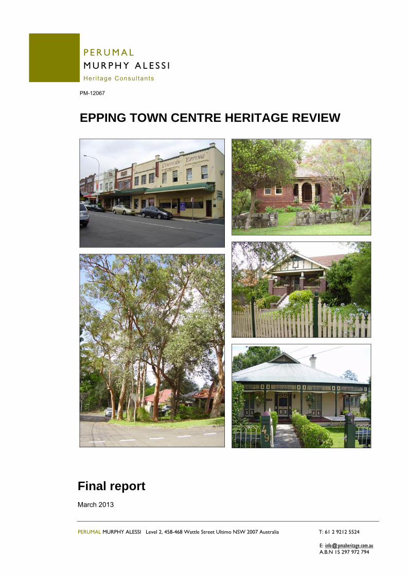
EPPING TOWN CENTRE HERITAGE REVIEW
Final report March 2013
PERUMAL MURPHY ALESSI Level 2, 458-468 Wattle Street Ultimo NSW 2007 Australia T: 61 2 9212 5524 E: [email protected] A.B.N 15 297 972 794
Final report ▪ Epping Town Centre Heritage Review March 2013
PERUMAL MURPHY ALESSI ▪ PM-12067 2
Executive Summary Perumal Murphy Alessi, Heritage Consultants was commissioned in December 2012 by the NSW Department of Planning and Infrastructure to undertake a review of three proposed heritage conservation areas (HCAs) located in Epping in the Hornsby Shire local government area (LGA) and to assess the heritage significance and condition of 23 potential heritage items including one group item located in the Parramatta LGA. The three proposed areas and potential items were identified in heritage reports prepared in 2001 and 2003 and as some time has lapsed since that time and in light of the recent preparation of the The Epping Town Centre Study (2011) and proposed intensification of the area, Council resolved in 2012 to progress the recommendations of the study including review of the following:
significance of the proposed East Epping and Essex Street HCA boundaries; significance of the individual properties nominated for heritage listing; and the impact of the proposed Cliff Avenue Residential Intensification Precinct on the
proposed Rosebank Avenue HCA. Council also prepared a separate brief for the assessment of a potential State listed archaeological site. The initial brief was also expanded to review and possibly extend the proposed areas. Inspections of the areas and external views of the identified individual properties were undertaken in January and February 2013 and analysis and assessment undertaken in accordance with best practice and guidelines contained in the NSW Heritage Manual. The history and development of the area has been previously and well documented and time constraints of this project did not allow for in depth additional research, however, some additional site specific research has been undertaken on the 23 potential items. The Department did not require the preparation of State Heritage Inventory forms as part of this project, however, a historical background, description and assessment of each of the areas and potential items have been included in this report. In summary in relation the three proposed HCAs this current assessment and review has found that:
the proposed boundary of the proposed East Epping HCA be retained and expanded to include Nos. 1 and 3 Essex Street, Nos. 6-22 Chester Street, Nos. 52-70 and 65-83 Chester Street, Nos. 40-48 Norfolk Road and Nos. 23-49 Surrey Street;
the proposed boundary of the proposed Essex Street HCA be retained and expanded to the south west to include Nos. 76-86 Essex Street; and
the proposed Rosebank Avenue HCA boundaries as proposed and including the properties, Nos. 1-21 Rosebank Avenue on the western side of the street and Nos. 2-18 Rosebank Avenue on the eastern side of the street be retained; and
a number of controls including for minimum setbacks, reduced heights and massing of potential new development on sites adjoining the Rosebank Avenue be introduced and proposed zoning amended.
In relation to the 23 identified potential items it is recommended that 22 of these, including the group at Nos. 2-14 Bridge Street be listed as heritage items due largely to their historic and aesthetic significance, representative and rarity values. The one exception is a good example of a modest dwelling of which there a number of similar buildings and better examples in the area. This item is recommended to be listed as a “contributory” item and will have a measure of protection as part of the proposed HCA.
Final report ▪ Epping Town Centre Heritage Review March 2013
PERUMAL MURPHY ALESSI ▪ PM-12067 3
Table of Contents Executive Summary ......................................................................................................... 2 1.0 Introduction ........................................................................................................... 4
1.1 Brief and context of the report ...................................................................................... 4 1.2 Background and study area .......................................................................................... 4 1.3 Methodology of the review ............................................................................................ 6 1.4 Documentary & photographic sources ......................................................................... 6 1.5 Limitations .................................................................................................................... 6 1.6 Authorship & acknowledgements ................................................................................. 7 1.7 Basis of the assessment & conclusions ....................................................................... 7
2.0 Proposed conservation areas ............................................................................... 9
2.1 Background development of the area ........................................................................... 9 2.2 East Epping HCA ........................................................................................................ 10 2.2 Essex Street HCA ....................................................................................................... 13 2.3 Rosebank Avenue HCA .............................................................................................. 15
3.0 Indentified potential heritage items ..................................................................... 18
3.1 Potential heritage items .............................................................................................. 18 4.0 Assessment & significance ................................................................................. 74
4.1 Evaluation criteria ....................................................................................................... 74 4.2 Proposed heritage conservation areas ....................................................................... 74 4.3 Identified potential heritage items ............................................................................... 78
5.0 Guidelines & recommendations .......................................................................... 80
5.1 East Epping HCA ........................................................................................................ 80 5.2 Essex Street HCA ....................................................................................................... 81 5.3 Rosebank Avenue HCA .............................................................................................. 82 5.4 Identified potential heritage items ............................................................................... 83
Final report ▪ Epping Town Centre Heritage Review March 2013
PERUMAL MURPHY ALESSI ▪ PM-12067 4
1.0 Introduction
1.1 Brief and context of the report This review was commissioned by the NSW Department of Planning and Infrastructure. The initial brief and scope of work was to:
1. undertake a review of three heritage conservation areas proposed for the Epping Town Centre by Hornsby Shire Council (East Epping, Essex Street and Rosebank Avenue) and review of the recommendations of previously prepared reports in relation to East Epping and Essex Street areas;
2. assess the heritage significance and physical condition of 13 potential heritage items located within the proposed areas and previously recommended in Hornsby Council heritage studies and 9 potential heritage items nominated in public submissions for their inclusion or exclusion from the LEP; and
3. assess the heritage significance of a heritage item (Nos. 2-14 Bridge Street) in Parramatta Local Environmental Plan 2011.
The brief was also expanded to review and possibly extend the proposed areas and to assess and consider the potential heritage impacts of the proposed Cliff Avenue Residential Intensification Precinct on the proposed Rosebank Avenue Heritage Conservation Area (HCA).
1.2 Background and study area With the exception of Nos. 2 -14 Bridge Street, the properties and areas reviewed are located within the Hornsby Shire and area known as the Epping Town Centre Study Area (refer Figure 1.1). There are 22 properties nominated for assessment as part of the review of items. Two of these are located outside the study area. In 2001, Council engaged heritage consultants Tropman and Tropman Architects to undertake an assessment of the heritage and streetscape qualities of the eastern side of Epping. A final report was submitted in October 2001 and recommended the progression of two HCAs – East Epping and Essex Street and individual heritage items in recognition of their significance. Heritage consultants, CPC Consulting, were also engaged by Council to undertake an assessment of the heritage and streetscape qualities of the Rosebank Avenue area in Epping. Their final report submitted in July 2003 also recommended the progression of the Rosebank Avenue HCA in recognition of the significance of the area. To establish the HCAs and the draft heritage items, draft LEPs were required to be prepared to amend Schedules D and E of the Hornsby Shire Local Environmental Plan 1994 (HSLEP). Draft LEPs were forwarded to the Department of Planning (DOP) in 2003 and 2004. In 2004, the DOP indicated its unwillingness to gazette the draft LEPs until the Department had undertaken a review of the HCAs and determined it position in consultation with the NSW Heritage Office. Further advice was received in April and September 2005 in relation to the NSW Government’s Standard Instrument. The Department advised that it would no progress the draft LEPs. Council was advised to allocate its resources to the preparation of a comprehensive LEP in which an investigation of the area could occur instead of progressing minor amendments to the existing HSLEP. Accordingly, Council deferred the establishment of the Essex Street, East Epping and Rosebank Avenue HCAs.
Final report ▪ Epping Town Centre Heritage Review March 2013
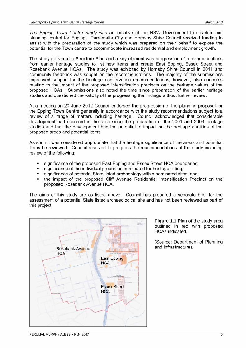
The Epping Town Centre Study was an initiative of the NSW Government to develop joint planning control for Epping. Parramatta City and Hornsby Shire Council received funding to assist with the preparation of the study which was prepared on their behalf to explore the potential for the Town centre to accommodate increased residential and employment growth. The study delivered a Structure Plan and a key element was progression of recommendations from earlier heritage studies to list new items and create East Epping, Essex Street and Rosebank Avenue HCAs. The study was exhibited by Hornsby Shire Council in 2011 and community feedback was sought on the recommendations. The majority of the submissions expressed support for the heritage conservation recommendations, however, also concerns relating to the impact of the proposed intensification precincts on the heritage values of the proposed HCAs. Submissions also noted the time since preparation of the earlier heritage studies and questioned the validity of the progressing the findings without further review. At a meeting on 20 June 2012 Council endorsed the progression of the planning proposal for the Epping Town Centre generally in accordance with the study recommendations subject to a review of a range of matters including heritage. Council acknowledged that considerable development had occurred in the area since the preparation of the 2001 and 2003 heritage studies and that the development had the potential to impact on the heritage qualities of the proposed areas and potential items. As such it was considered appropriate that the heritage significance of the areas and potential items be reviewed. Council resolved to progress the recommendations of the study including review of the following:
significance of the proposed East Epping and Essex Street HCA boundaries; significance of the individual properties nominated for heritage listing; significance of potential State listed archaeology within nominated sites; and the impact of the proposed Cliff Avenue Residential Intensification Precinct on the
proposed Rosebank Avenue HCA. The aims of this study are as listed above. Council has prepared a separate brief for the assessment of a potential State listed archaeological site and has not been reviewed as part of this project.
Figure 1.1 Plan of the study area outlined in red with proposed HCAs indicated. (Source: Department of Planning and Infrastructure).
Rosebank Avenue HCA East Epping
HCA Essex Street HCA
PERUMAL MURPHY ALESSI ▪ PM-12067 5
Final report ▪ Epping Town Centre Heritage Review March 2013
PERUMAL MURPHY ALESSI ▪ PM-12067 6
1.3 Methodology of the review This review has been undertaken in accordance with best practice and standard guidelines outlined in the Heritage Manual produced by the Heritage Branch of the NSW Office of Environment and Heritage. The overall basis of the review also relies on the principles and terminology contained in The Burra Charter: the Australia ICOMOS Charter for Places of Cultural Significance, known as The Burra Charter. The history and development of the area has been previously undertaken. In addition to a review of these some additional research was undertaken using sources listed below. An inspection of the identified proposed HCAs and immediate surrounds was undertaken. In the case of the East Epping Area the south western and eastern end of Chester Street was also inspected as part of the context of the identified area. The surrounding development around Rosebank Avenue was also noted. The inspection was undertaken street by street. Each property was viewed and rated as being a “contributory” item or not. The “contributory” items were marked up on a plan of the area and a preliminary report and plan supplied to the Department. Mapping of “contributory” items was used to define the recommended boundaries of the proposed areas. An external inspection of each of the 22 potential items in the Hornsby LGA and Nos. 2-14 Bridge Street was undertaken to note the condition and integrity of each and their relationship and contribution to the local area. Some detailed research was undertaken on the sites, particularly Nos. 2-14 Bridge Street, to assist the assessment. The Department advised that preparation of the standard heritage inventory form was not required as part of this project. 1.4 Documentary & photographic sources A review of the following reports was undertaken as part of the project:
East Epping Conservation Evaluation and Review for Hornsby Shire Council, Tropman & Tropman Architects (October 2001);
Heritage Assessment Rosebank Avenue, Epping, prepared by CPC Consulting for Hornsby Shire Council (July 2003);
Epping Town Centre Study, Volume 1, JBA Planning (August 2011); and Heritage Review – Epping Town Centre Study Review of Items and Proposed Heritage
Conservation Areas (from a draft brief prepared by Hornsby Shire Council). Documentary information was also sourced from the Mitchell and Local Studies Libraries, including a History of Epping by Walter G Hazlewood (1966), NSW Land and Property Information Office and Sydney Water Plan room. Area plans were supplied NSW Department of Planning and Infrastructure. Contemporary photographs included in this report, unless otherwise stated, were taken by Luisa Alessi of Perumal Murphy Alessi, Heritage Consultants, in January and February 2013, specifically as part of the review.
1.5 Limitations The history and development of the area has been well documented and covered in the previously prepared reports. Due to time constraints it was not considered necessary to rework or expand the historical outline, however, a summary has been provided.
Final report ▪ Epping Town Centre Heritage Review March 2013
PERUMAL MURPHY ALESSI ▪ PM-12067 7
The study areas, individual and group items reviewed were confined to those identified by maps and list provided by the Department at the commencement of the project. Some context was also reviewed and eastern end of Chester Street subsequently added on request of the Department. The assessment of the quality and condition of each of the properties in the proposed HCAs and identified potential items is based on an an external inspection from the public domain. It therefore was not possible to fully assess buildings which are not visible from the street. The interiors of the buildings were also not inspected. For the purposes of a review of heritage conservation areas the study has been limited to an assessment of the historic development of the streets, an assessment of it character and analysis of its intactness and whether these elements result in the streetscape having heritage significance. 1.6 Authorship & acknowledgements The review has been completed by Luisa Alessi of Perumal Murphy Alessi, Heritage Consultants. Luisa is a graduate architect with 18 years experience in the heritage field. She has worked on a number of review projects for a range of local Councils and authorities and prepared numerous Heritage Assessments, Statement of Heritage Impact reports, Conservation Plans and Conservation Management Plans for both the private and public sector. The author would like to thank NSW Department of Planning and Infrastructure staff for their assistance with this project. 1.7 Basis of the assessment & conclusions As noted above the review of the proposed HCAs included an external inspection of each of the properties in the nominated areas and immediate surrounds and context in order to verify and establish the HCA boundaries. Mapping of the “contributory” items assisted the definition of the area boundaries. The identification of contributory items is based on the style, condition and integrity of each property and how it relates to the historical development and identified cultural significance of the area. This process is consistent with standard heritage practice and guidelines. The visibility and visual contribution and presentation to the streetscape and area were also noted. As such a number of battleaxe type properties and buildings have not been identified as they largely make no visual contribution to the streetscapes and conservation areas. A fairly wide range of stylistic variations of Federation, Inter-war and Post-War period buildings are visible and contribute to the character and significance of the Epping area. Many of the items are modest scale residences which reflect the changing economic situation throughout the 20th century and the ever changing attitudes to housing and architectural styles within the community. This evolution has continued to the present with a number of highly modified and new houses also located in the area. These are generally considered to be “neutral” and have not been identified as they do not relate to the primary, early 20th century development of the identified areas. The criteria for potential items also follows the guidelines set out by the Heritage Branch and criteria including Historic, Associational, Aesthetic, Social and Technical significance. It is not necessary to fulfil all criteria, however, the item should show a measure of significance within one or more of the criteria.
Final report ▪ Epping Town Centre Heritage Review March 2013
PERUMAL MURPHY ALESSI ▪ PM-12067 8
The previous studies indicate that the significance of the area largely relates to historic and aesthetic values. The item could be a “rare” or “representative” example and the integrity, the form, fabric and style of the item, “substantially intact”. In other words, still retaining the majority of its fabric or having undergone alterations and additions which do not visually impact on the item, are sympathetic or are able to be reversed at a later time. Many of the identified potential items within this study are aged between 80 and 100 years old. Buildings of this age are rarely completely intact in their original form, fabric and style. It is recognised that modifications and additions are often necessary to allow the continued use of the building in a modern age. Consideration has been given to this requirement for change and both the contributory and potential items have been assessed with the consideration of the degree of change and its impact on the historical and visual character of the item when viewed from a public place. Alteration of the interiors was not a consideration within this review. Modifications such as intrusive colour schemes or cosmetic changes to detailing on a building have been treated as a minor intrusion as these changes are usually largely, if not fully reversible. Modifications where substantial changes, such as roof additions or façade remodelling, have altered the style or character of the building when viewed from the street are largely irreversible and these changes are considered as reasons for rejection. Where buildings are of a style or character which is common within the LGA and which better examples can be identified elsewhere within the suburb or LGA, this has been considered a legitimate reason for exclusion.
Final report ▪ Epping Town Centre Heritage Review March 2013
PERUMAL MURPHY ALESSI ▪ PM-12067 9
2.0 Proposed conservation areas
2.1 Background development of the area European use of the area dates back to the 1820s when timber getters started to open up the area and a timber sawing mill was established. Some orcharding and garden activities followed, however, prior to 1880 development was very limited and little evidence from this period survives to the present day. Most of the land on the eastern side of the railway line was part of the Field of Mars, an area of over 6000 acres dedicated in 1804 as Common Land for the use of the personnel of the NSW Regiment. The area to the west was granted to naval officers. Like most areas it was the opening of the railway line (in 1886) that proceeded a period of rapid development. The opening of the railway meant that local farmers had more access to markets. They prospered and constructed larger homes. Railway workers and wider population were attracted to the area and a wave of subdivision erased evidence of the earlier rural phase. The development of the railway and road networks traditionally and continues to bring about change in the area. In 1892 the railway line was upgraded and duplicated, providing improved and faster services to the Sydney region. The “bridge” over the railway line and creating Bridge Street and Epping township expanded with land opening up on the on the eastern side of the line. The East Epping HCA was part of a subdivision of the former Government Common in October 1886. The streets were all named after English towns or counties, probably due to the fact that subdivision occurred at the time of the 50th anniversary of Queen Victoria’s reign and population was mostly British. Subdivision of the area to the south and area including Essex Street was subdivided in 1899 when the name “Epping” was officially adopted for the area. The name was derived due to the many trees in the area after “Epping Forest” in England and area was described as being like a “country village” at this time. As most of the early development was on the eastern side of the railway, a number of shops also emerged in the area, particularly near the station. The growing population also resulted in the Education Department’s decision to construct a centralised public school in the area. In January 1900 a site of over 2 acres on the corner of Norfolk Road and Pembroke Street was purchased for £350. In July a tender was accepted for the erection of the building which was completed in June 1901. The first enrolment was for 94 pupils and by the end of the first month is number increased to 135. The School has continued to develop with more buildings added in 1911, 1913, 1922 and since that time. The early buildings largely remain in a bushland setting and school continues to be a local focus in the area. Major works were competed at Epping Station in 1900 when new platforms and main platform building (which remains today) were constructed. Like most of the rail network the Station continued to be developed, largely in accordance with improvements to the overall system, but also to cater for the needs of the local population. The works have continued to the present, with major cross country link and triplication of the line through Chatswood and major upgrade of the complex, including construction of new overhead bridges and lifts completed in 2009. Land to the west of the station remained bushland and orchards for some time, however, the area was gradually developed from 1900 to the Second World War. In early 1895 a block of land on the corner of Bridge Street and Railway Street (now Rawson Street) was offered for sale and Mrs D Nicholas and Mr J Stewart gave the land to the Presbyterian Church and a large a hall and later Church were built. From the Presbyterian Church in Bridge Street to the corner with Epping Road was vacant land with only some wattle growing on it. In 1895 a Mr Fox started a grocery business in a shop erected by James Sonter on the corner of High and Bridge Streets. This was later neighboured by three cottages (now occupied by Nos. 2-14 Bridge Street). The block was owned by James Sonter who wanted to sell it for £500. It was finally sold in 1914, to a Mr Nicholas, the station master at Epping who realised that the district was growing, because of the greater number of people travelling by train.
Final report ▪ Epping Town Centre Heritage Review March 2013
PERUMAL MURPHY ALESSI ▪ PM-12067 10
He sold the land one year later for £2,000 to John Howie, a builder, who in turn sold it to another builder H Pollock. The rising cost of the land being indicative of the growth of the area. The completion of Epping Road in 1940 and improvement of road networks recognised an increase in private car ownership and with mass car ownership came further development and an Inter-war period of subdivision and development in the area. The overall improvements continued into the Post-war period and building boom of the 1950s which saw a significant change in the character of the area, particularly the western side of the railway line. Like many established areas in Sydney some medium density residential development occurred, particularly near the railway line, in the 1960s to the 1980s. Further improvements of the road networks and addition of the M2 Motorway and improvements to the Station has also resulted in a recent resurgence of larger scale residential and commercial development in the area, a trend which continues and is being explored today due to Epping’s relatively “central” and easily accessible location.
2.2 East Epping HCA The proposed East Epping HCA is located on the eastern side of the railway line in the area generally bounded by Pembroke Street to the south and Somerset Street to the north. The area is generally characterised by wide, dual carriageways with parking on both sides of the street, wide grassed verges and pedestrian footpaths. A number of mature native and introduced, ornamental trees and plantings generally line the streets. The streets and subdivision mostly comprises a regular grid type pattern, the exception being the northern end of Oxford Street which cuts diagonally in a north east direction from the intersection with Surry and Derby Streets. Norfolk Road forms the main spine of the area, intersecting and accessing the all but one of the other streets in the proposed area. It generally rises as it extends north from Pembroke Street. The southern end is dominated by the Epping Public School site which was established in 1900 and comprises a mix of low scale 20th century buildings and elements and has been listed as a heritage item. The buildings are enhanced by a number of mature trees and plantings, particularly at the northern end of the site. The southern end of Norfolk Road also features a small corner shop with attached residence which is an unusual and distinctive feature in the area. Norfolk Road otherwise typifies the general character of the area and features a mix of Federation, Inter-war and Post-war development with some late 20th century development located between. Some “modern” development is particularly evident in the section between and around the intersections with Chester and Surry Streets. A number of heritage listed items are also located along the street, including the house and garden at No. 9, located opposite the Public School in the southern section of the street, also Nos. 33, 40, 44 and No. 93 Oxford Street (corner of Norfolk) are located in the proposed area. Most of these occupy prominent corner sites and make a positive visual contribution to the streetscapes and area. Chester Street is also a wide dual carriageway characterised by a mix of housing styles. The western end of the street features the Inter-war period Uniting Church complex with main bell tower forming a prominent feature of the intersection with Oxford and Essex Streets and has been listed as a heritage item. The remainder of the street features a uniform street pattern despite the various building styles with rows of Federation, Inter-war and Post-war period detached houses with some earlier Victorian and late 20th century development location between.
Final report ▪ Epping Town Centre Heritage Review March 2013
The built context is enhanced by a number of mature street trees, particularly toward the eastern end and also individual garden settings and plantings. A number of houses also retain original and complimentary fences which contribute to the suburban setting. The eastern end of the street retains evidence of the early character of the area with some rock outcrops and fall of the land evident in addition to native trees and plantings. No. 70 is an early, Victorian period stone cottage located at the eastern end of the street which has been listed as an item and is a distinctive and unusual feature of the street and area. Surrey Street is also characterised by Federation, Inter-war and Post-war period dwellings with some late 20th century buildings between enhanced by the wide street proportions, gardens and street trees and plantings. Some sub-division and alteration of the site and building is evident, however, the street retains a sense of the regular streetscape pattern and some earlier development including a timber weatherboard Federation period timber dwelling (No. 40) located at the eastern end of the street and which has been listed as a heritage item. Several timber weatherboard Federation period houses are also located in the northern section of Oxford Street. Here the diagonal orientation of the street has resulted in an irregular subdivision pattern, however, the built context comprising a mix of Federation, Inter-war bungalows and Post-war dwellings remains largely intact. The street is a wide dual carriageway, however, the street verges are narrower with fewer street trees than other streets in the area. The north eastern end of the street is dominated by a two storey Federation period dwelling located on the corner of Oxford and Norfolk (No. 93 Oxford Street) which has been listed as a heritage item. Sussex Street is characterised by a number of Inter-war Bungalows and Post-war development. The northern end of the street and block bounded by Somerset Street and Norfolk Road has largely been modified or redeveloped, however, the garden and green character of the area remains.
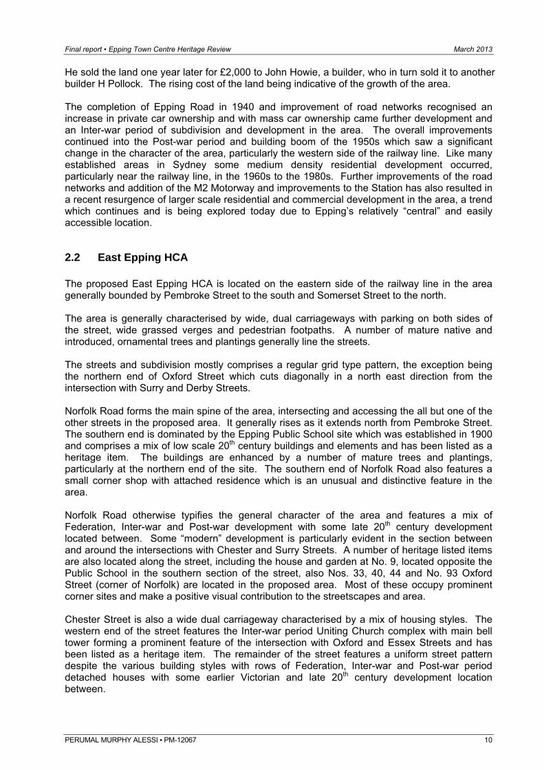
Figure 2.1 Unusual corner shop and attached dwelling (No. 25 Pembroke Street) located on the corner of Pembroke Street and corner of Norfolk Road.
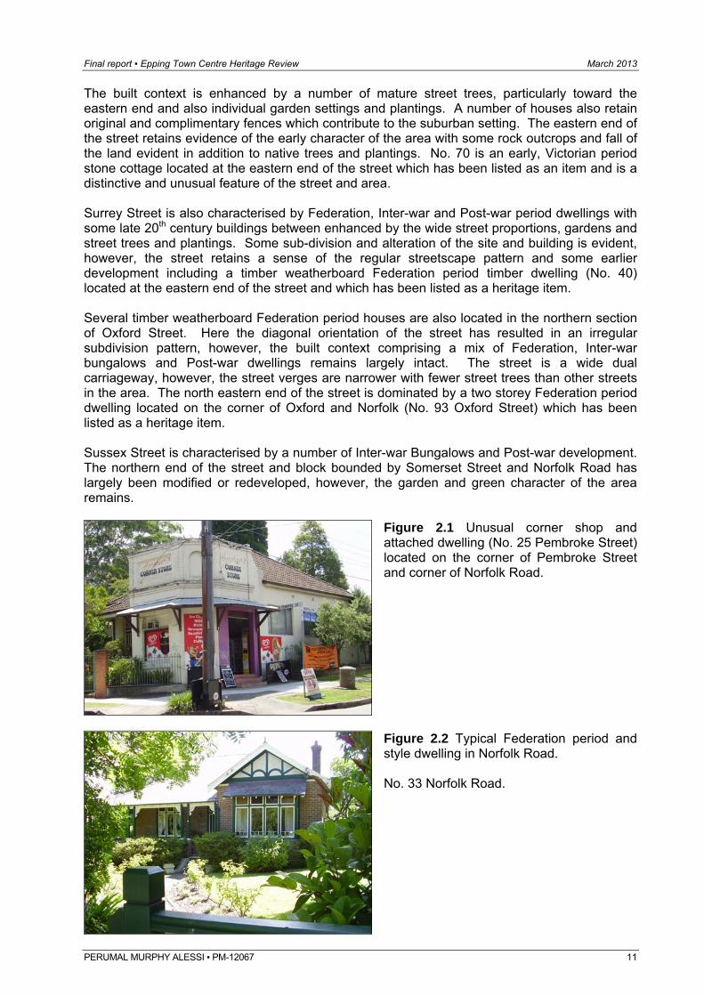
Figure 2.2 Typical Federation period and style dwelling in Norfolk Road. No. 33 Norfolk Road.
PERUMAL MURPHY ALESSI ▪ PM-12067 11
Final report ▪ Epping Town Centre Heritage Review March 2013
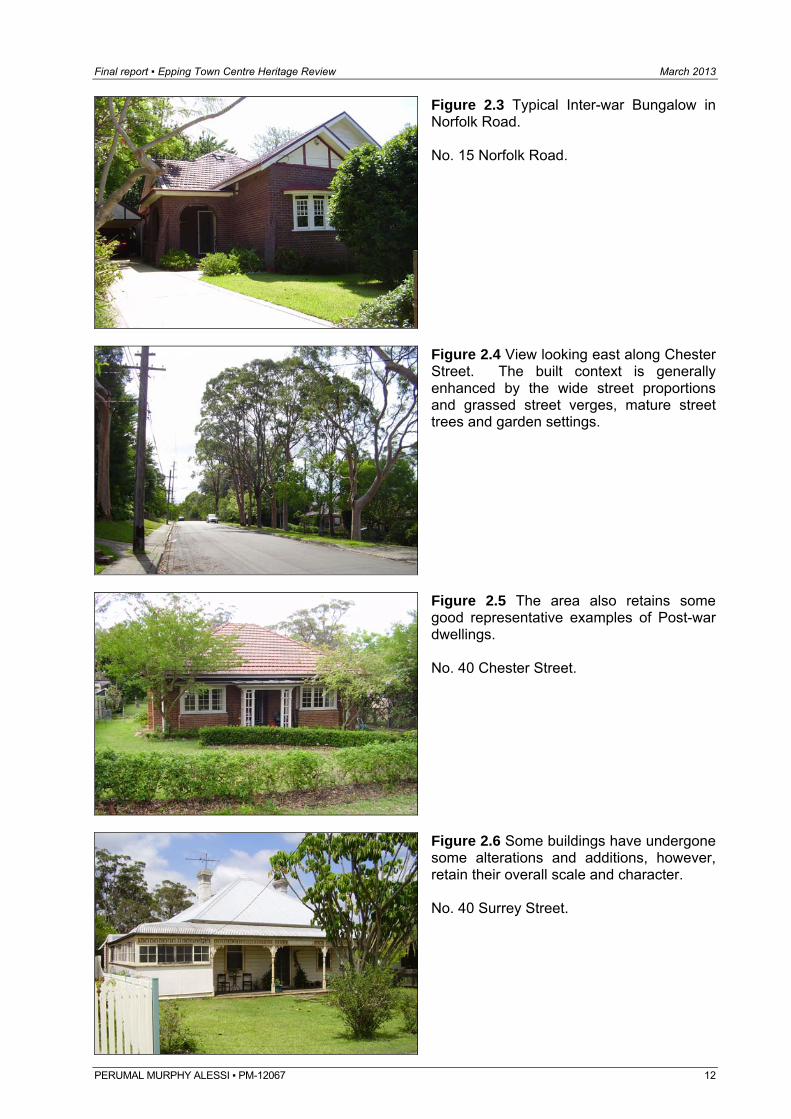
Figure 2.3 Typical Inter-war Bungalow in Norfolk Road. No. 15 Norfolk Road.
Figure 2.4 View looking east along Chester Street. The built context is generally enhanced by the wide street proportions and grassed street verges, mature street trees and garden settings.
Figure 2.5 The area also retains some good representative examples of Post-war dwellings. No. 40 Chester Street.
Figure 2.6 Some buildings have undergone some alterations and additions, however, retain their overall scale and character. No. 40 Surrey Street.
PERUMAL MURPHY ALESSI ▪ PM-12067 12
Final report ▪ Epping Town Centre Heritage Review March 2013
2.2 Essex Street HCA The proposed Essex Street HCA extends along both side of Essex Street between Epping Road to the north and and the intersection with Abuklea Road to the south. This section of Essex Street is a wide dual carriageway with wide grassed verges and some street trees and plantings. The street has a slight “S” curve and generally falls to the south from Epping Road. Some of the dwellings located in the north western section of the street are elevated well above street level. The built context is characterised by a mix of Federation and Inter-war period houses including substantial timber weatherboard and distinctive Federation red brick dwellings, liver brick and Inter-war Bungalows with a number of late 20th and early 21st century period dwellings and residential complexes between. The built context is generally enhanced by the streetscape pattern reinforced by regular setbacks, wide street proportions and garden settings. A number of the sites have been subdivided and buildings have been replaced or modified with alterations and additions evident, however, the overall early 20th century character and streetscape pattern and rhythm remains. Some later development is also located in the street and mostly concentrated in the mid section of this section of the street where a creek line appears to extend (below the street) and the street dips slightly.
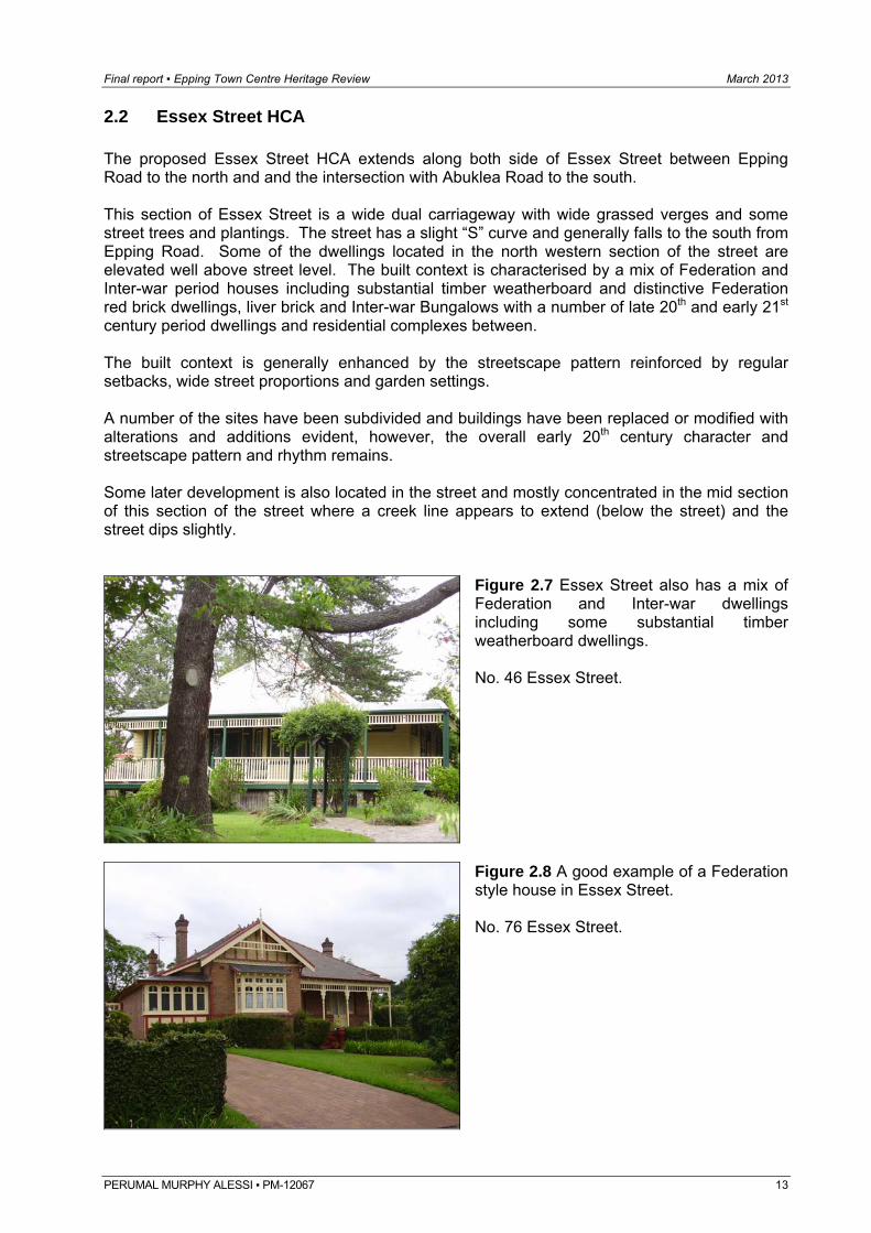
Figure 2.7 Essex Street also has a mix of Federation and Inter-war dwellings including some substantial timber weatherboard dwellings. No. 46 Essex Street.
Figure 2.8 A good example of a Federation style house in Essex Street. No. 76 Essex Street.
PERUMAL MURPHY ALESSI ▪ PM-12067 13
Final report ▪ Epping Town Centre Heritage Review March 2013
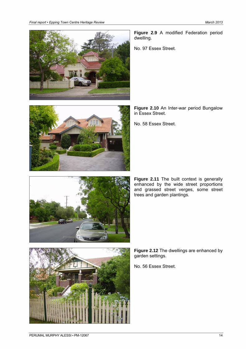
Figure 2.9 A modified Federation period dwelling. No. 97 Essex Street.
Figure 2.10 An Inter-war period Bungalow in Essex Street. No. 58 Essex Street.
Figure 2.11 The built context is generally enhanced by the wide street proportions and grassed street verges, some street trees and garden plantings.
Figure 2.12 The dwellings are enhanced by garden settings. No. 56 Essex Street.
PERUMAL MURPHY ALESSI ▪ PM-12067 14
Final report ▪ Epping Town Centre Heritage Review March 2013
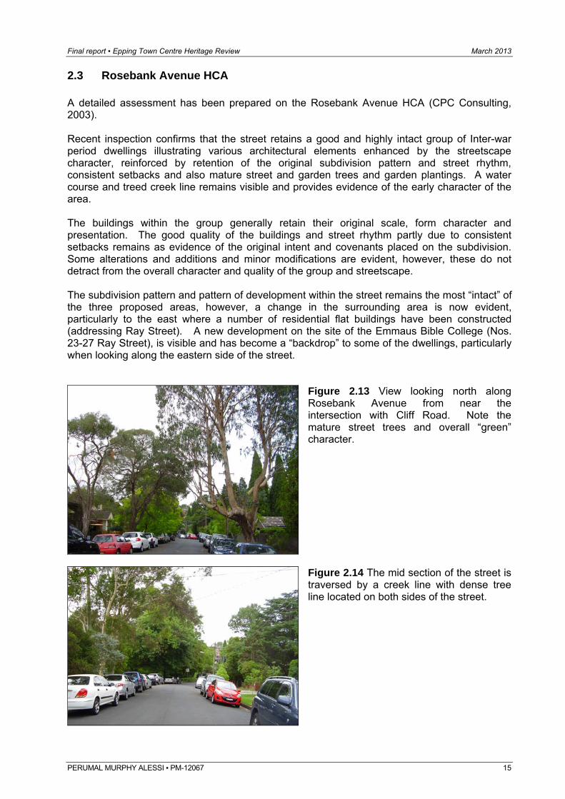
2.3 Rosebank Avenue HCA A detailed assessment has been prepared on the Rosebank Avenue HCA (CPC Consulting, 2003). Recent inspection confirms that the street retains a good and highly intact group of Inter-war period dwellings illustrating various architectural elements enhanced by the streetscape character, reinforced by retention of the original subdivision pattern and street rhythm, consistent setbacks and also mature street and garden trees and garden plantings. A water course and treed creek line remains visible and provides evidence of the early character of the area. The buildings within the group generally retain their original scale, form character and presentation. The good quality of the buildings and street rhythm partly due to consistent setbacks remains as evidence of the original intent and covenants placed on the subdivision. Some alterations and additions and minor modifications are evident, however, these do not detract from the overall character and quality of the group and streetscape. The subdivision pattern and pattern of development within the street remains the most “intact” of the three proposed areas, however, a change in the surrounding area is now evident, particularly to the east where a number of residential flat buildings have been constructed (addressing Ray Street). A new development on the site of the Emmaus Bible College (Nos. 23-27 Ray Street), is visible and has become a “backdrop” to some of the dwellings, particularly when looking along the eastern side of the street.
Figure 2.13 View looking north along Rosebank Avenue from near the intersection with Cliff Road. Note the mature street trees and overall “green” character.
Figure 2.14 The mid section of the street is traversed by a creek line with dense tree line located on both sides of the street.
PERUMAL MURPHY ALESSI ▪ PM-12067 15
Final report ▪ Epping Town Centre Heritage Review March 2013
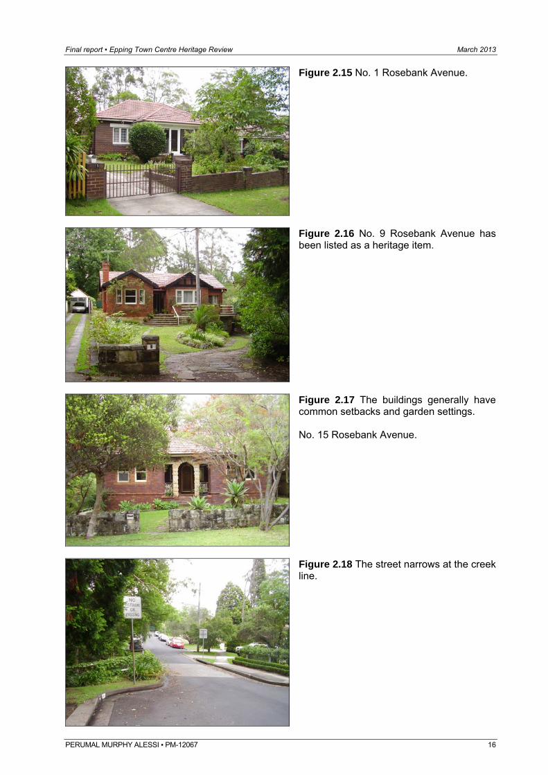
Figure 2.15 No. 1 Rosebank Avenue.
Figure 2.16 No. 9 Rosebank Avenue has been listed as a heritage item.
Figure 2.17 The buildings generally have common setbacks and garden settings. No. 15 Rosebank Avenue.
Figure 2.18 The street narrows at the creek line.
PERUMAL MURPHY ALESSI ▪ PM-12067 16
Final report ▪ Epping Town Centre Heritage Review March 2013
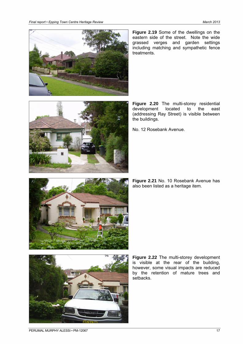
Figure 2.19 Some of the dwellings on the eastern side of the street. Note the wide grassed verges and garden settings including matching and sympathetic fence treatments.
Figure 2.20 The multi-storey residential development located to the east (addressing Ray Street) is visible between the buildings. No. 12 Rosebank Avenue.
Figure 2.21 No. 10 Rosebank Avenue has also been listed as a heritage item.
Figure 2.22 The multi-storey development is visible at the rear of the building, however, some visual impacts are reduced by the retention of mature trees and setbacks.
PERUMAL MURPHY ALESSI ▪ PM-12067 17
Final report ▪ Epping Town Centre Heritage Review March 2013
PERUMAL MURPHY ALESSI ▪ PM-12067 18
3.0 Indentified potential heritage items 3.1 Potential heritage items Thirteen potential items have been assessed in accordance with the recommendations of the East Epping Conservation Evaluation and Review (2001) and nine have been nominated by the Study and submission nominations since that time. The items reviewed are as follows: Address Recommended by:
10 Chester Street Submission
9 Cliff Road Submission
11 Cliff Road Submission
15 Cliff Road Submission
17 Cliff Road Submission
19 Cliff Road Submission
50 Dorset Street East Epping Conservation Evaluation and Review (2001)
4 Epping Road Submission
3 Essex Street Submission
6 Essex Street East Epping Conservation Evaluation and Review (2001)
42 Essex Street East Epping Conservation Evaluation and Review (2001)
86 Essex Street East Epping Conservation Evaluation and Review (2001)
39 Norfolk Road Submission
41 Norfolk Road East Epping Conservation Evaluation and Review (2001)
43 Norfolk Road East Epping Conservation Evaluation and Review (2001)
83 Norfolk Road East Epping Conservation Evaluation and Review (2001)
38 Oxford Street Submission
85 Oxford Street East Epping Conservation Evaluation and Review (2001)
91 Oxford Street East Epping Conservation Evaluation and Review (2001)
8 Surrey Street East Epping Conservation Evaluation and Review (2001)
18 Surrey Street East Epping Conservation Evaluation and Review (2001)
33 Surrey Street East Epping Conservation Evaluation and Review (2001) The Department also requested that Nos. 2-14 Bridge Street, Epping, located in the Parramatta LGA also be reviewed.
Final report ▪ Epping Town Centre Heritage Review March 2013
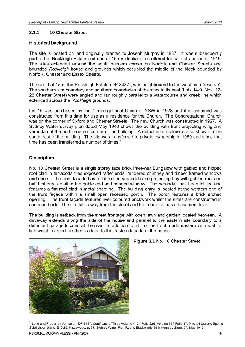
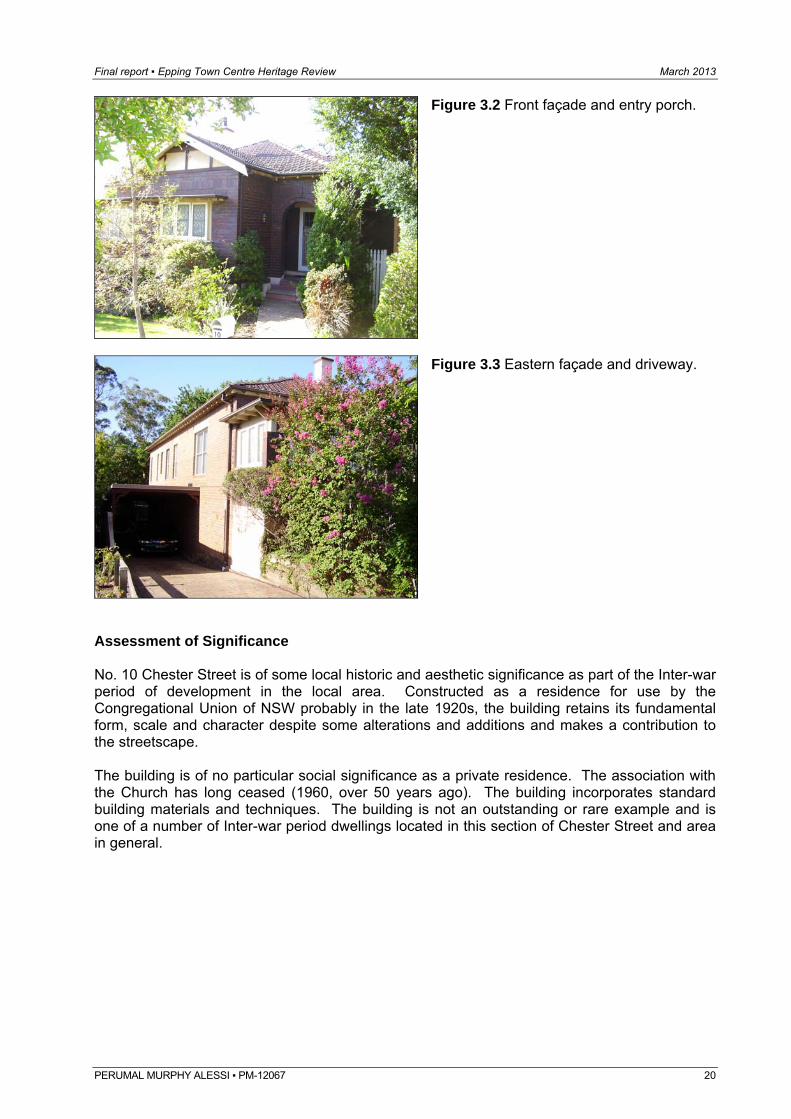
3.1.1 10 Chester Street Historical background The site is located on land originally granted to Joseph Murphy in 1887. It was subsequently part of the Rockleigh Estate and one of 15 residential sites offered for sale at auction in 1915. The sites extended around the south western corner on Norfolk and Chester Streets and bounded Rockleigh house and grounds which occupied the middle of the block bounded by Norfolk, Chester and Essex Streets. The site, Lot 15 of the Rockleigh Estate (DP 8487), was neighboured to the west by a “reserve”. The southern site boundary and southern boundaries of the sites to its east (Lots 14-9, Nos. 12-22 Chester Street) were angled and ran roughly parallel to a watercourse and creek line which extended across the Rockleigh grounds. Lot 15 was purchased by the Congregational Union of NSW in 1928 and it is assumed was constructed from this time for use as a residence for the Church. The Congregational Church was on the corner of Oxford and Chester Streets. The new Church was constructed in 1927. A Sydney Water survey plan dated May 1940 shows the building with front projecting wing and verandah at the north eastern corner of the building. A detached structure is also shown to the south east of the building. The site was transferred to private ownership in 1960 and since that time has been transferred a number of times.1 Description No. 10 Chester Street is a single storey face brick Inter-war Bungalow with gabled and hipped roof clad in terracotta tiles exposed rafter ends, rendered chimney and timber framed windows and doors. The front façade has a flat roofed verandah and projecting bay with gabled roof and half timbered detail to the gable end and hooded window. The verandah has been infilled and features a flat roof clad in metal sheeting. The building entry is located at the western end of the front façade within a small open recessed porch. The porch features a brick arched opening. The front façade features liver coloured brickwork whilst the sides are constructed in common brick. The site falls away from the street and the rear also has a basement level. The building is setback from the street frontage with open lawn and garden located between. A driveway extends along the side of the house and parallel to the eastern site boundary to a detached garage located at the rear. In addition to infill of the front, north eastern verandah, a lightweight carport has been added to the eastern façade of the house.
Figure 3.1 No. 10 Chester Street
1 Land and Property Information, DP 8487, Certificate of Titles Volume 4124 Folio 226, Volume 837 Folio 17, Mitchell Library, Epping Subdivision plans, E10/25, Hazlewood, p. 37, Sydney Water Plan Room, Blackwattle 991/ Hornsby Sheet 57, May 1940.
PERUMAL MURPHY ALESSI ▪ PM-12067 19
Final report ▪ Epping Town Centre Heritage Review March 2013
Figure 3.2 Front façade and entry porch.
Figure 3.3 Eastern façade and driveway.
Assessment of Significance No. 10 Chester Street is of some local historic and aesthetic significance as part of the Inter-war period of development in the local area. Constructed as a residence for use by the Congregational Union of NSW probably in the late 1920s, the building retains its fundamental form, scale and character despite some alterations and additions and makes a contribution to the streetscape. The building is of no particular social significance as a private residence. The association with the Church has long ceased (1960, over 50 years ago). The building incorporates standard building materials and techniques. The building is not an outstanding or rare example and is one of a number of Inter-war period dwellings located in this section of Chester Street and area in general.
PERUMAL MURPHY ALESSI ▪ PM-12067 20
Final report ▪ Epping Town Centre Heritage Review March 2013
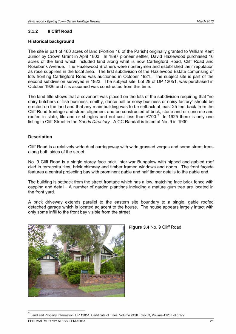
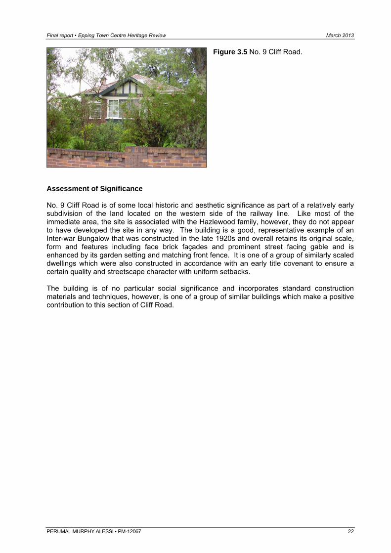
3.1.2 9 Cliff Road Historical background The site is part of 460 acres of land (Portion 16 of the Parish) originally granted to William Kent Junior by Crown Grant in April 1803. In 1897 pioneer settler, David Hazlewood purchased 16 acres of the land which included land along what is now Carlingford Road, Cliff Road and Rosebank Avenue. The Hazlewood Brothers were nurserymen and established their reputation as rose suppliers in the local area. The first subdivision of the Hazlewood Estate comprising of lots fronting Carlingford Road was auctioned in October 1921. The subject site is part of the second subdivision surveyed in 1923. The subject site, Lot 29 of DP 12051, was purchased in October 1926 and it is assumed was constructed from this time. The land title shows that a covenant was placed on the lots of the subdivision requiring that “no dairy butchers or fish business, smithy, dance hall or noisy business or noisy factory” should be erected on the land and that any main building was to be setback at least 25 feet back from the Cliff Road frontage and street alignment and be constructed of brick, stone and or concrete and roofed in slate, tile and or shingles and not cost less than £700.2 In 1925 there is only one listing in Cliff Street in the Sands Directory. A CC Randall is listed at No. 9 in 1930. Description Cliff Road is a relatively wide dual carriageway with wide grassed verges and some street trees along both sides of the street. No. 9 Cliff Road is a single storey face brick Inter-war Bungalow with hipped and gabled roof clad in terracotta tiles, brick chimney and timber framed windows and doors. The front façade features a central projecting bay with prominent gable and half timber details to the gable end. The building is setback from the street frontage which has a low, matching face brick fence with capping and detail. A number of garden plantings including a mature gum tree are located in the front yard. A brick driveway extends parallel to the eastern site boundary to a single, gable roofed detached garage which is located adjacent to the house. The house appears largely intact with only some infill to the front bay visible from the street
Figure 3.4 No. 9 Cliff Road.
2 Land and Property Information, DP 12051, Certificate of Titles, Volume 2420 Folio 33, Volume 4123 Folio 172.
PERUMAL MURPHY ALESSI ▪ PM-12067 21
Final report ▪ Epping Town Centre Heritage Review March 2013
Figure 3.5 No. 9 Cliff Road.
Assessment of Significance No. 9 Cliff Road is of some local historic and aesthetic significance as part of a relatively early subdivision of the land located on the western side of the railway line. Like most of the immediate area, the site is associated with the Hazlewood family, however, they do not appear to have developed the site in any way. The building is a good, representative example of an Inter-war Bungalow that was constructed in the late 1920s and overall retains its original scale, form and features including face brick façades and prominent street facing gable and is enhanced by its garden setting and matching front fence. It is one of a group of similarly scaled dwellings which were also constructed in accordance with an early title covenant to ensure a certain quality and streetscape character with uniform setbacks. The building is of no particular social significance and incorporates standard construction materials and techniques, however, is one of a group of similar buildings which make a positive contribution to this section of Cliff Road.
PERUMAL MURPHY ALESSI ▪ PM-12067 22
Final report ▪ Epping Town Centre Heritage Review March 2013
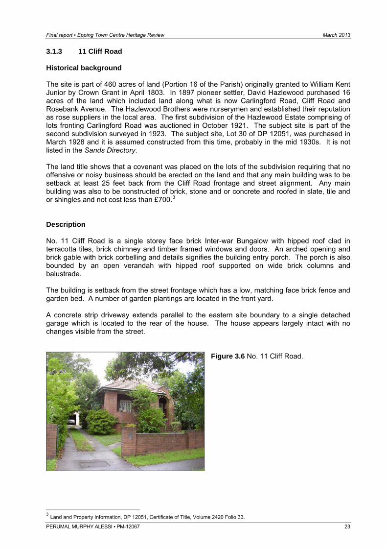
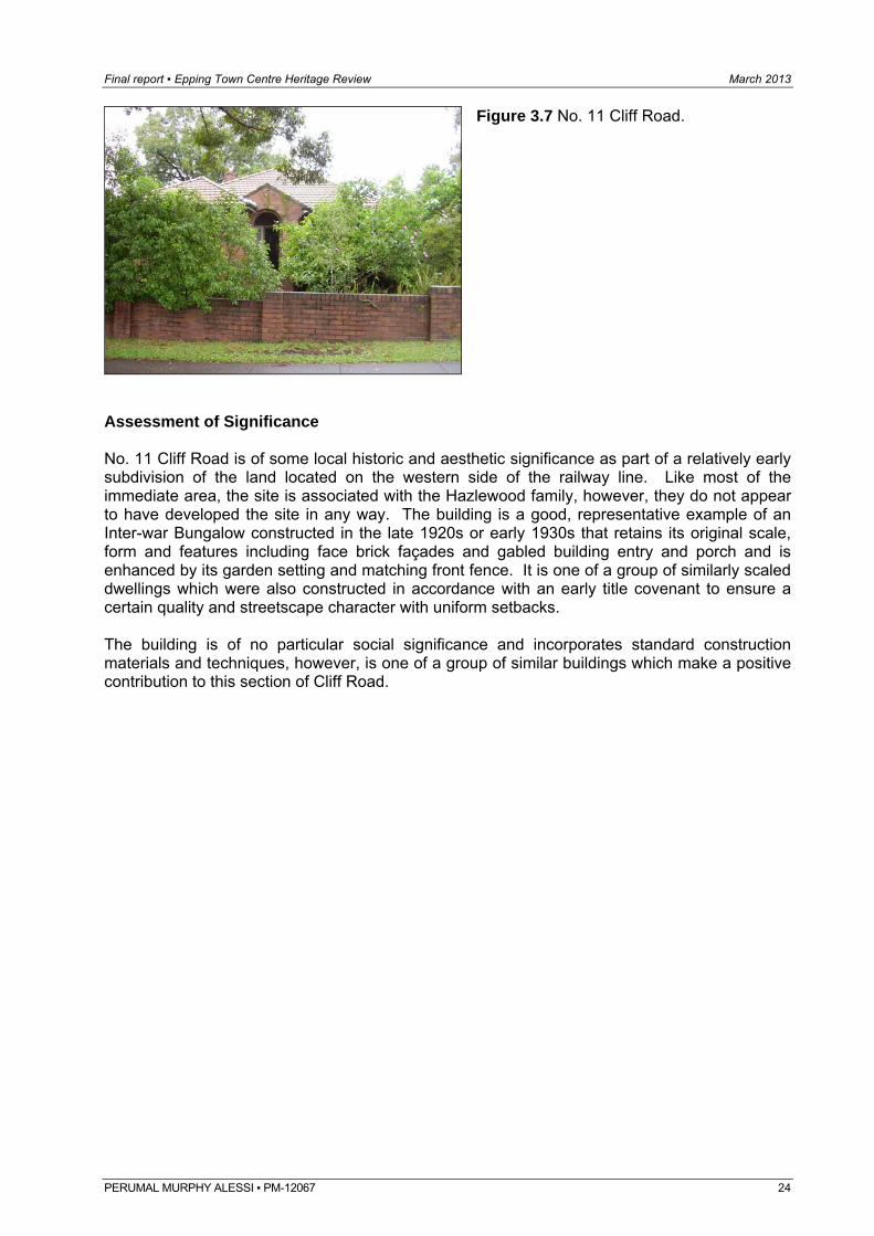
3.1.3 11 Cliff Road Historical background The site is part of 460 acres of land (Portion 16 of the Parish) originally granted to William Kent Junior by Crown Grant in April 1803. In 1897 pioneer settler, David Hazlewood purchased 16 acres of the land which included land along what is now Carlingford Road, Cliff Road and Rosebank Avenue. The Hazlewood Brothers were nurserymen and established their reputation as rose suppliers in the local area. The first subdivision of the Hazlewood Estate comprising of lots fronting Carlingford Road was auctioned in October 1921. The subject site is part of the second subdivision surveyed in 1923. The subject site, Lot 30 of DP 12051, was purchased in March 1928 and it is assumed constructed from this time, probably in the mid 1930s. It is not listed in the Sands Directory. The land title shows that a covenant was placed on the lots of the subdivision requiring that no offensive or noisy business should be erected on the land and that any main building was to be setback at least 25 feet back from the Cliff Road frontage and street alignment. Any main building was also to be constructed of brick, stone and or concrete and roofed in slate, tile and or shingles and not cost less than £700.3 Description No. 11 Cliff Road is a single storey face brick Inter-war Bungalow with hipped roof clad in terracotta tiles, brick chimney and timber framed windows and doors. An arched opening and brick gable with brick corbelling and details signifies the building entry porch. The porch is also bounded by an open verandah with hipped roof supported on wide brick columns and balustrade. The building is setback from the street frontage which has a low, matching face brick fence and garden bed. A number of garden plantings are located in the front yard. A concrete strip driveway extends parallel to the eastern site boundary to a single detached garage which is located to the rear of the house. The house appears largely intact with no changes visible from the street.
Figure 3.6 No. 11 Cliff Road.
3 Land and Property Information, DP 12051, Certificate of Title, Volume 2420 Folio 33.
PERUMAL MURPHY ALESSI ▪ PM-12067 23
Final report ▪ Epping Town Centre Heritage Review March 2013
Figure 3.7 No. 11 Cliff Road.
Assessment of Significance No. 11 Cliff Road is of some local historic and aesthetic significance as part of a relatively early subdivision of the land located on the western side of the railway line. Like most of the immediate area, the site is associated with the Hazlewood family, however, they do not appear to have developed the site in any way. The building is a good, representative example of an Inter-war Bungalow constructed in the late 1920s or early 1930s that retains its original scale, form and features including face brick façades and gabled building entry and porch and is enhanced by its garden setting and matching front fence. It is one of a group of similarly scaled dwellings which were also constructed in accordance with an early title covenant to ensure a certain quality and streetscape character with uniform setbacks. The building is of no particular social significance and incorporates standard construction materials and techniques, however, is one of a group of similar buildings which make a positive contribution to this section of Cliff Road.
PERUMAL MURPHY ALESSI ▪ PM-12067 24
Final report ▪ Epping Town Centre Heritage Review March 2013
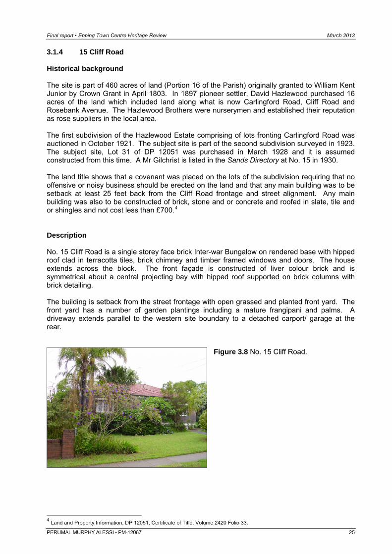
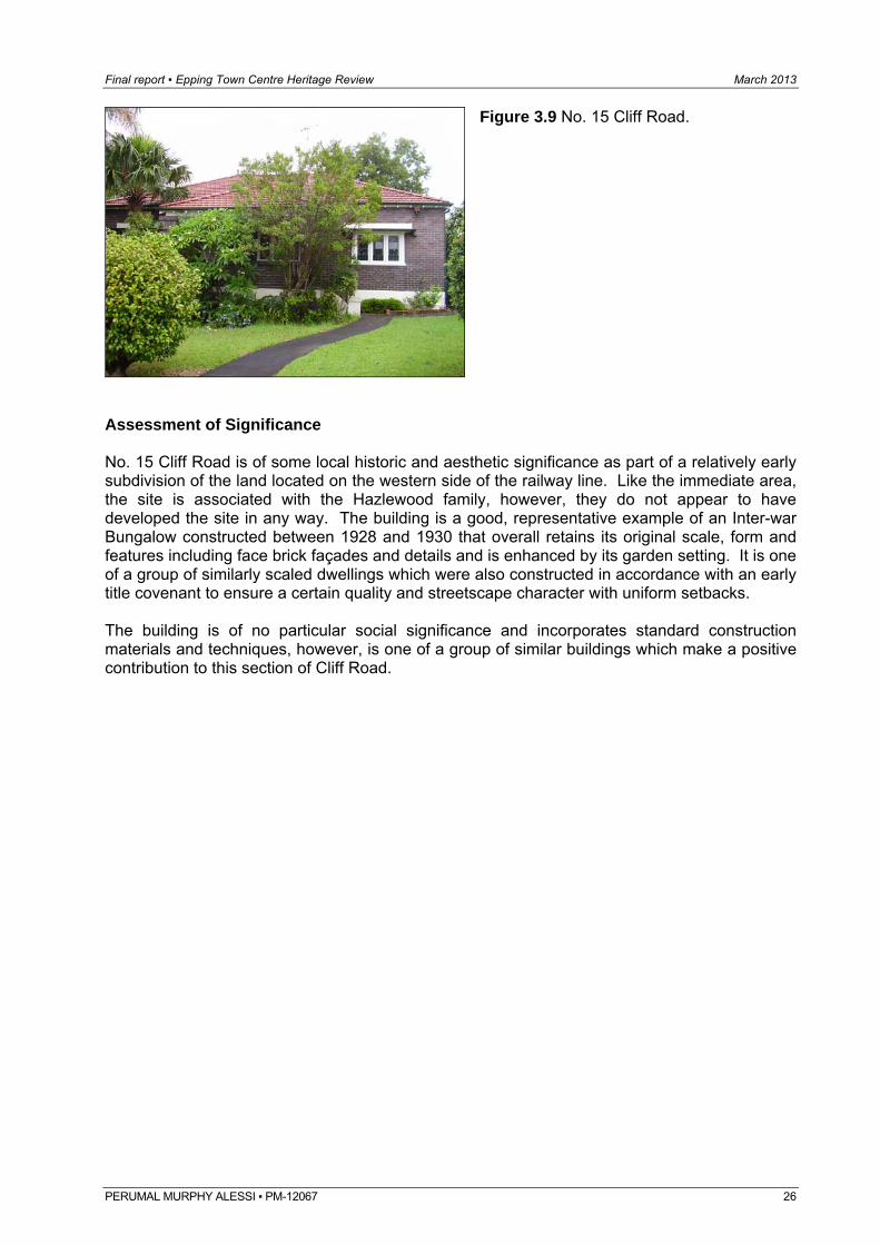
3.1.4 15 Cliff Road Historical background The site is part of 460 acres of land (Portion 16 of the Parish) originally granted to William Kent Junior by Crown Grant in April 1803. In 1897 pioneer settler, David Hazlewood purchased 16 acres of the land which included land along what is now Carlingford Road, Cliff Road and Rosebank Avenue. The Hazlewood Brothers were nurserymen and established their reputation as rose suppliers in the local area. The first subdivision of the Hazlewood Estate comprising of lots fronting Carlingford Road was auctioned in October 1921. The subject site is part of the second subdivision surveyed in 1923. The subject site, Lot 31 of DP 12051 was purchased in March 1928 and it is assumed constructed from this time. A Mr Gilchrist is listed in the Sands Directory at No. 15 in 1930. The land title shows that a covenant was placed on the lots of the subdivision requiring that no offensive or noisy business should be erected on the land and that any main building was to be setback at least 25 feet back from the Cliff Road frontage and street alignment. Any main building was also to be constructed of brick, stone and or concrete and roofed in slate, tile and or shingles and not cost less than £700.4 Description No. 15 Cliff Road is a single storey face brick Inter-war Bungalow on rendered base with hipped roof clad in terracotta tiles, brick chimney and timber framed windows and doors. The house extends across the block. The front façade is constructed of liver colour brick and is symmetrical about a central projecting bay with hipped roof supported on brick columns with brick detailing. The building is setback from the street frontage with open grassed and planted front yard. The front yard has a number of garden plantings including a mature frangipani and palms. A driveway extends parallel to the western site boundary to a detached carport/ garage at the rear.
Figure 3.8 No. 15 Cliff Road.
4 Land and Property Information, DP 12051, Certificate of Title, Volume 2420 Folio 33.
PERUMAL MURPHY ALESSI ▪ PM-12067 25
Final report ▪ Epping Town Centre Heritage Review March 2013
Figure 3.9 No. 15 Cliff Road.
Assessment of Significance No. 15 Cliff Road is of some local historic and aesthetic significance as part of a relatively early subdivision of the land located on the western side of the railway line. Like the immediate area, the site is associated with the Hazlewood family, however, they do not appear to have developed the site in any way. The building is a good, representative example of an Inter-war Bungalow constructed between 1928 and 1930 that overall retains its original scale, form and features including face brick façades and details and is enhanced by its garden setting. It is one of a group of similarly scaled dwellings which were also constructed in accordance with an early title covenant to ensure a certain quality and streetscape character with uniform setbacks. The building is of no particular social significance and incorporates standard construction materials and techniques, however, is one of a group of similar buildings which make a positive contribution to this section of Cliff Road.
PERUMAL MURPHY ALESSI ▪ PM-12067 26
Final report ▪ Epping Town Centre Heritage Review March 2013
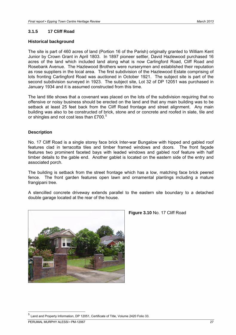
3.1.5 17 Cliff Road Historical background The site is part of 460 acres of land (Portion 16 of the Parish) originally granted to William Kent Junior by Crown Grant in April 1803. In 1897 pioneer settler, David Hazlewood purchased 16 acres of the land which included land along what is now Carlingford Road, Cliff Road and Rosebank Avenue. The Hazlewood Brothers were nurserymen and established their reputation as rose suppliers in the local area. The first subdivision of the Hazlewood Estate comprising of lots fronting Carlingford Road was auctioned in October 1921. The subject site is part of the second subdivision surveyed in 1923. The subject site, Lot 32 of DP 12051 was purchased in January 1934 and it is assumed constructed from this time. The land title shows that a covenant was placed on the lots of the subdivision requiring that no offensive or noisy business should be erected on the land and that any main building was to be setback at least 25 feet back from the Cliff Road frontage and street alignment. Any main building was also to be constructed of brick, stone and or concrete and roofed in slate, tile and or shingles and not cost less than £700.5 Description No. 17 Cliff Road is a single storey face brick Inter-war Bungalow with hipped and gabled roof features clad in terracotta tiles and timber framed windows and doors. The front façade features two prominent faceted bays with leaded windows and gabled roof feature with half timber details to the gable end. Another gablet is located on the eastern side of the entry and associated porch. The building is setback from the street frontage which has a low, matching face brick peered fence. The front garden features open lawn and ornamental plantings including a mature frangipani tree. A stencilled concrete driveway extends parallel to the eastern site boundary to a detached double garage located at the rear of the house.
Figure 3.10 No. 17 Cliff Road
5 Land and Property Information, DP 12051, Certificate of Title, Volume 2420 Folio 33.
PERUMAL MURPHY ALESSI ▪ PM-12067 27
Final report ▪ Epping Town Centre Heritage Review March 2013
Figure 3.11 No. 17 Cliff Road.
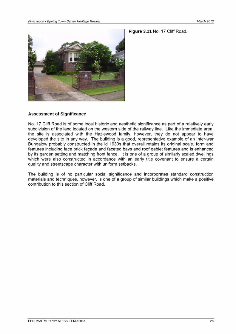
Assessment of Significance No. 17 Cliff Road is of some local historic and aesthetic significance as part of a relatively early subdivision of the land located on the western side of the railway line. Like the immediate area, the site is associated with the Hazlewood family, however, they do not appear to have developed the site in any way. The building is a good, representative example of an Inter-war Bungalow probably constructed in the id 1930s that overall retains its original scale, form and features including face brick façade and faceted bays and roof gablet features and is enhanced by its garden setting and matching front fence. It is one of a group of similarly scaled dwellings which were also constructed in accordance with an early title covenant to ensure a certain quality and streetscape character with uniform setbacks. The building is of no particular social significance and incorporates standard construction materials and techniques, however, is one of a group of similar buildings which make a positive contribution to this section of Cliff Road.
PERUMAL MURPHY ALESSI ▪ PM-12067 28
Final report ▪ Epping Town Centre Heritage Review March 2013
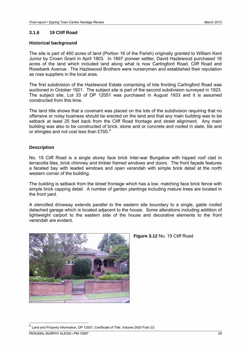
3.1.6 19 Cliff Road Historical background The site is part of 460 acres of land (Portion 16 of the Parish) originally granted to William Kent Junior by Crown Grant in April 1803. In 1897 pioneer settler, David Hazlewood purchased 16 acres of the land which included land along what is now Carlingford Road, Cliff Road and Rosebank Avenue. The Hazlewood Brothers were nurserymen and established their reputation as rose suppliers in the local area. The first subdivision of the Hazlewood Estate comprising of lots fronting Carlingford Road was auctioned in October 1921. The subject site is part of the second subdivision surveyed in 1923. The subject site, Lot 33 of DP 12051 was purchased in August 1933 and it is assumed constructed from this time. The land title shows that a covenant was placed on the lots of the subdivision requiring that no offensive or noisy business should be erected on the land and that any main building was to be setback at least 25 feet back from the Cliff Road frontage and street alignment. Any main building was also to be constructed of brick, stone and or concrete and roofed in slate, tile and or shingles and not cost less than £700.6 Description No. 19 Cliff Road is a single storey face brick Inter-war Bungalow with hipped roof clad in terracotta tiles, brick chimney and timber framed windows and doors. The front façade features a faceted bay with leaded windows and open verandah with simple brick detail at the north western corner of the building. The building is setback from the street frontage which has a low, matching face brick fence with simple brick capping detail. A number of garden plantings including mature trees are located in the front yard. A stencilled driveway extends parallel to the eastern site boundary to a single, gable roofed detached garage which is located adjacent to the house. Some alterations including addition of lightweight carport to the eastern side of the house and decorative elements to the front verandah are evident.
Figure 3.12 No. 19 Cliff Road
6 Land and Property Information, DP 12051, Certificate of Title, Volume 2420 Folio 33.
PERUMAL MURPHY ALESSI ▪ PM-12067 29
Final report ▪ Epping Town Centre Heritage Review March 2013
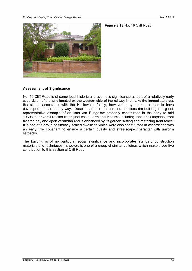
Figure 3.13 No. 19 Cliff Road.
Assessment of Significance No. 19 Cliff Road is of some local historic and aesthetic significance as part of a relatively early subdivision of the land located on the western side of the railway line. Like the immediate area, the site is associated with the Hazlewood family, however, they do not appear to have developed the site in any way. Despite some alterations and additions the building is a good, representative example of an Inter-war Bungalow probably constructed in the early to mid 1930s that overall retains its original scale, form and features including face brick façades, front faceted bay and open verandah and is enhanced by its garden setting and matching front fence. It is one of a group of similarly scaled dwellings which were also constructed in accordance with an early title covenant to ensure a certain quality and streetscape character with uniform setbacks. The building is of no particular social significance and incorporates standard construction materials and techniques, however, is one of a group of similar buildings which make a positive contribution to this section of Cliff Road.
PERUMAL MURPHY ALESSI ▪ PM-12067 30
Final report ▪ Epping Town Centre Heritage Review March 2013
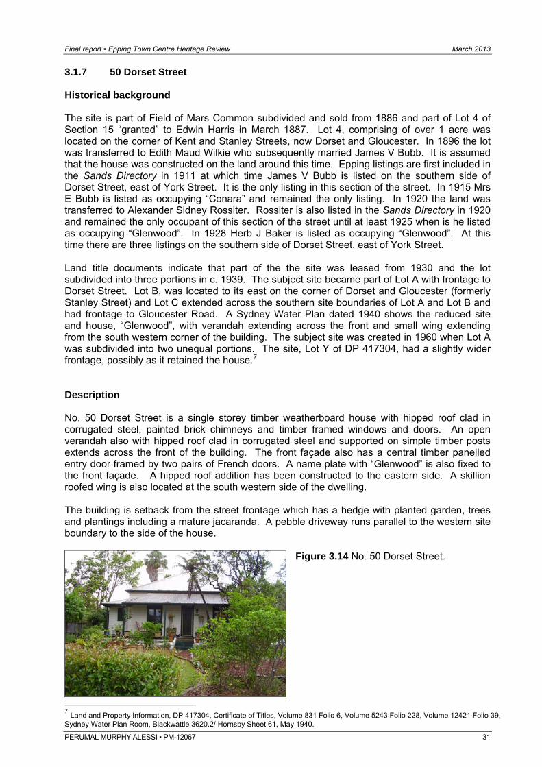
3.1.7 50 Dorset Street Historical background The site is part of Field of Mars Common subdivided and sold from 1886 and part of Lot 4 of Section 15 “granted” to Edwin Harris in March 1887. Lot 4, comprising of over 1 acre was located on the corner of Kent and Stanley Streets, now Dorset and Gloucester. In 1896 the lot was transferred to Edith Maud Wilkie who subsequently married James V Bubb. It is assumed that the house was constructed on the land around this time. Epping listings are first included in the Sands Directory in 1911 at which time James V Bubb is listed on the southern side of Dorset Street, east of York Street. It is the only listing in this section of the street. In 1915 Mrs E Bubb is listed as occupying “Conara” and remained the only listing. In 1920 the land was transferred to Alexander Sidney Rossiter. Rossiter is also listed in the Sands Directory in 1920 and remained the only occupant of this section of the street until at least 1925 when is he listed as occupying “Glenwood”. In 1928 Herb J Baker is listed as occupying “Glenwood”. At this time there are three listings on the southern side of Dorset Street, east of York Street. Land title documents indicate that part of the the site was leased from 1930 and the lot subdivided into three portions in c. 1939. The subject site became part of Lot A with frontage to Dorset Street. Lot B, was located to its east on the corner of Dorset and Gloucester (formerly Stanley Street) and Lot C extended across the southern site boundaries of Lot A and Lot B and had frontage to Gloucester Road. A Sydney Water Plan dated 1940 shows the reduced site and house, “Glenwood”, with verandah extending across the front and small wing extending from the south western corner of the building. The subject site was created in 1960 when Lot A was subdivided into two unequal portions. The site, Lot Y of DP 417304, had a slightly wider frontage, possibly as it retained the house.7 Description No. 50 Dorset Street is a single storey timber weatherboard house with hipped roof clad in corrugated steel, painted brick chimneys and timber framed windows and doors. An open verandah also with hipped roof clad in corrugated steel and supported on simple timber posts extends across the front of the building. The front façade also has a central timber panelled entry door framed by two pairs of French doors. A name plate with “Glenwood” is also fixed to the front façade. A hipped roof addition has been constructed to the eastern side. A skillion roofed wing is also located at the south western side of the dwelling. The building is setback from the street frontage which has a hedge with planted garden, trees and plantings including a mature jacaranda. A pebble driveway runs parallel to the western site boundary to the side of the house.
Figure 3.14 No. 50 Dorset Street.
7 Land and Property Information, DP 417304, Certificate of Titles, Volume 831 Folio 6, Volume 5243 Folio 228, Volume 12421 Folio 39, Sydney Water Plan Room, Blackwattle 3620.2/ Hornsby Sheet 61, May 1940.
PERUMAL MURPHY ALESSI ▪ PM-12067 31
Final report ▪ Epping Town Centre Heritage Review March 2013
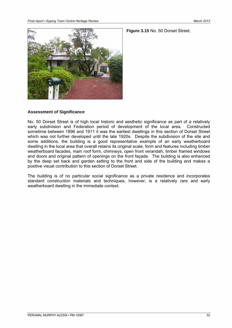
Figure 3.15 No. 50 Dorset Street.
Assessment of Significance No. 50 Dorset Street is of high local historic and aesthetic significance as part of a relatively early subdivision and Federation period of development of the local area. Constructed sometime between 1896 and 1911 it was the earliest dwellings in this section of Dorset Street which was not further developed until the late 1920s. Despite the subdivision of the site and some additions, the building is a good representative example of an early weatherboard dwelling in the local area that overall retains its original scale, form and features including timber weatherboard facades, main roof form, chimneys, open front verandah, timber framed windows and doors and original pattern of openings on the front façade. The building is also enhanced by the deep set back and garden setting to the front and side of the building and makes a positive visual contribution to this section of Dorset Street. The building is of no particular social significance as a private residence and incorporates standard construction materials and techniques, however, is a relatively rare and early weatherboard dwelling in the immediate context.
PERUMAL MURPHY ALESSI ▪ PM-12067 32
Final report ▪ Epping Town Centre Heritage Review March 2013
PERUMAL MURPHY ALESSI ▪ PM-12067 33
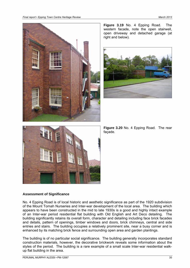
3.1.8 4 Epping Road Historical background The site is part of Portion 363 of the 1899 subdivision of the Field of Mars and part of portions 354, 355, 364, 356, 357 and 363 which were consolidated and subdivided in 1920. The site was part of Lots 2 and 3 of the subdivision which were amalgamated and subdivided into two equal portions, Lots A and B in 1924. The land was part of a large area occupied by Vollmer’s Nursery which was located on the eastern side of the railway line extending south of Laurel Avenue (now Epping Road) to Essex Street. MF Vollmer, a German, arrived in Australia in the 1880s and moved into the area in the 1890s. He took on a partner, CE Vessey and the firm became known as Vollmer and Vessey, Mount Tomah Nursery. Vessey took over after Vollmer’s death and retired in 1919 after which time his son Fred took over the business. Fred relocated the business to Eastwood and the land occupied by the nursery was subdivided in 1920 and subsequently developed. The subject site comprises Lot 2 and part of Lot 3 of the 1920 subdivision. Lot 2 was purchased by Ernest William Watts in July 1923 who also purchased the eastern half of Lot 3 in February 1924. The remainder of Lot 3 was purchased by Elizabeth Letitia Howie, wife of EJ Howie who had previously purchased Lot 4 to the east. The two parcels became Lot A and Lot B of DP 308804 in 1924. EJ Howie, a builder retained Lot B to the east (now No. 6 Epping Road). Howie is listed in the Sands Directory in Laurel Avenue (now Epping Road) until the early 1930s. It is not clear if Watts developed the site, Lot A with 99 feet frontage to Laurel Avenue (now Epping Road), however, the site was transferred to William Andrew Davidson and Thomas McCullough, builders of Epping, in 1934 and it is assumed that the subject building was constructed from this time. In 1937 the site was transferred to John Willie Edgard Larson of Epping, a nurseryman. A Sydney Water Plan dated May 1940 shows the building on the site, annotated as “Balmoral Court, brick flats” with U-shaped footprint and projecting bays to the two front wings and rear façade. The Larson family retained ownership of the site until 1981 when the current Strata title on the building was also created.8 No changes appear to have been undertaken to the building, however, a detached garage now occupies the rear yard. Description No. 4 Epping Road is a two storey with basement face brick residential flat building with parapeted and gabled roof forms clad in terracotta tiles, decorative brick chimneys and double hung multi-paned timber framed windows and timber framed doors. The building has a U-shaped footprint with front façade symmetrical about the recessed main entry. The two side wings feature prominent double gables with brick pilasters, corbelling and detailing to the façade and gable ends. The building facades also have decorative brickwork including corbelled detail at the eave line and herringbone brick window spandrels. Recessed, open stairwells located on each side of the building also provide access to the units. The rear façade also has a central, square projecting bay with decorative brick details. The building is setback from the street frontage which has a low, matching face brick fence/ retaining wall and high, thick hedge. The building is located below street level and fall of the site, away from the street, also allows the incorporation of basement garage and service areas. A driveway extends along the western side boundary to an open sealed area and grassed rear yard which also features a flat roofed, detached garage. Dense planting and a number of trees are located around the site perimeter, particularly along the eastern site boundary. 8 Land and Property Information, DP 10385, DP 308840, SP 16921, Certificate of Titles Volume 3575 Folio 89, Volume 3172, Folio 41, Volume 3481 Folio 231,Volume 3575 Folio 226, Hazlewood, p. 39-40, Sydney Water Plan Room, Blackwattle 3613/ Hornsby Sheet 49, May 1940.
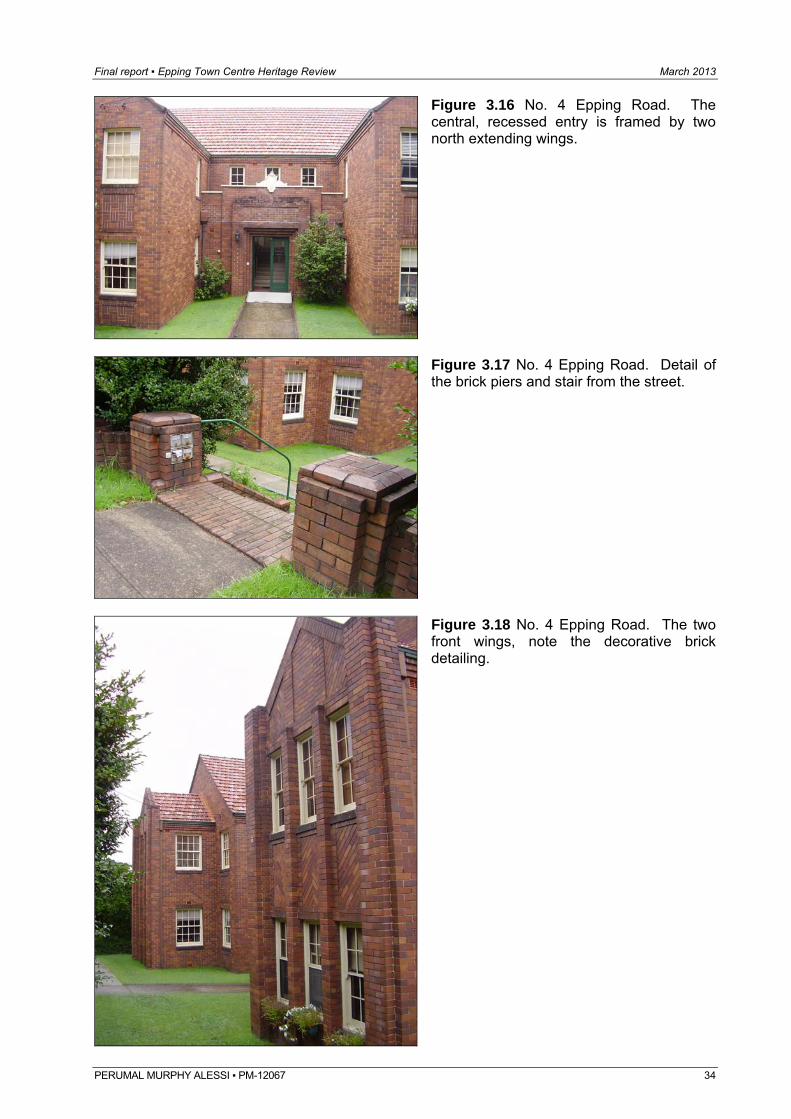
Final report ▪ Epping Town Centre Heritage Review March 2013
Figure 3.16 No. 4 Epping Road. The central, recessed entry is framed by two north extending wings.
Figure 3.17 No. 4 Epping Road. Detail of the brick piers and stair from the street.
Figure 3.18 No. 4 Epping Road. The two front wings, note the decorative brick detailing.
PERUMAL MURPHY ALESSI ▪ PM-12067 34
Final report ▪ Epping Town Centre Heritage Review March 2013
Figure 3.19 No. 4 Epping Road. The western facade, note the open stairwell, open driveway and detached garage (at ght and below).
ri
Figure 3.20 No. 4 Epping Road. The rear
çade.
ssessment of Significance
r and is nhanced by its matching brick fence and surrounding open area and garden plantings.
uilding is a rare example of a small scale Inter-war residential walk-up flat building in the area.
fa
A No. 4 Epping Road is of local historic and aesthetic significance as part of the 1920 subdivision of the Mount Tomah Nurseries and Inter-war development of the local area. The building which appears to have been constructed in the mid to late 1930s is a good and highly intact example of an Inter-war period residential flat building with Old English and Art Deco detailing. The building significantly retains its overall form, character and detailing including face brick facades and details, pattern of openings, timber windows and doors, brick chimneys, central and side entries and stairs. The building occupies a relatively prominent site, near a busy cornee The building is of no particular social significance. The building generally incorporates standard construction materials, however, the decorative brickwork reveals some information about the styles of the period. The b
PERUMAL MURPHY ALESSI ▪ PM-12067 35
Final report ▪ Epping Town Centre Heritage Review March 2013
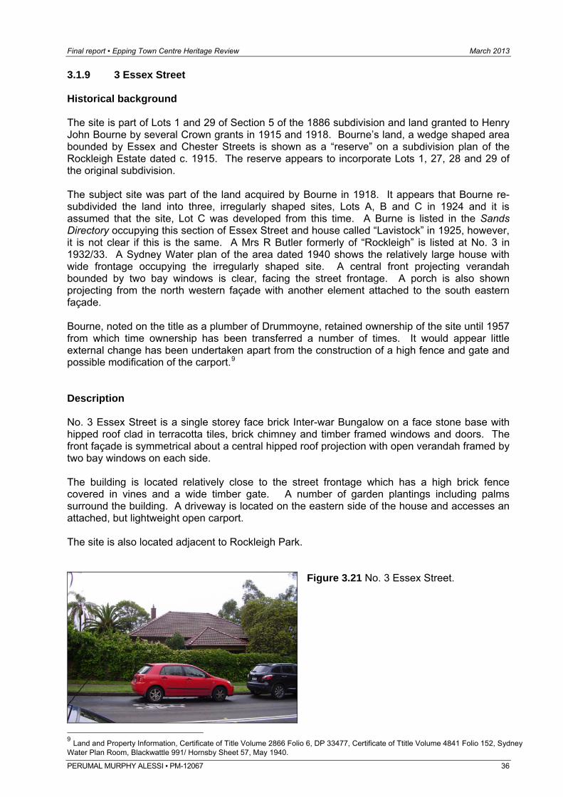
3.1.9 3 Essex Street Historical background The site is part of Lots 1 and 29 of Section 5 of the 1886 subdivision and land granted to Henry John Bourne by several Crown grants in 1915 and 1918. Bourne’s land, a wedge shaped area bounded by Essex and Chester Streets is shown as a “reserve” on a subdivision plan of the Rockleigh Estate dated c. 1915. The reserve appears to incorporate Lots 1, 27, 28 and 29 of the original subdivision. The subject site was part of the land acquired by Bourne in 1918. It appears that Bourne re-subdivided the land into three, irregularly shaped sites, Lots A, B and C in 1924 and it is assumed that the site, Lot C was developed from this time. A Burne is listed in the Sands Directory occupying this section of Essex Street and house called “Lavistock” in 1925, however, it is not clear if this is the same. A Mrs R Butler formerly of “Rockleigh” is listed at No. 3 in 1932/33. A Sydney Water plan of the area dated 1940 shows the relatively large house with wide frontage occupying the irregularly shaped site. A central front projecting verandah bounded by two bay windows is clear, facing the street frontage. A porch is also shown projecting from the north western façade with another element attached to the south eastern façade. Bourne, noted on the title as a plumber of Drummoyne, retained ownership of the site until 1957 from which time ownership has been transferred a number of times. It would appear little external change has been undertaken apart from the construction of a high fence and gate and possible modification of the carport.9 Description No. 3 Essex Street is a single storey face brick Inter-war Bungalow on a face stone base with hipped roof clad in terracotta tiles, brick chimney and timber framed windows and doors. The front façade is symmetrical about a central hipped roof projection with open verandah framed by two bay windows on each side. The building is located relatively close to the street frontage which has a high brick fence covered in vines and a wide timber gate. A number of garden plantings including palms surround the building. A driveway is located on the eastern side of the house and accesses an attached, but lightweight open carport. The site is also located adjacent to Rockleigh Park.
Figure 3.21 No. 3 Essex Street.
9 Land and Property Information, Certificate of Title Volume 2866 Folio 6, DP 33477, Certificate of Ttitle Volume 4841 Folio 152, Sydney Water Plan Room, Blackwattle 991/ Hornsby Sheet 57, May 1940.
PERUMAL MURPHY ALESSI ▪ PM-12067 36
Final report ▪ Epping Town Centre Heritage Review March 2013
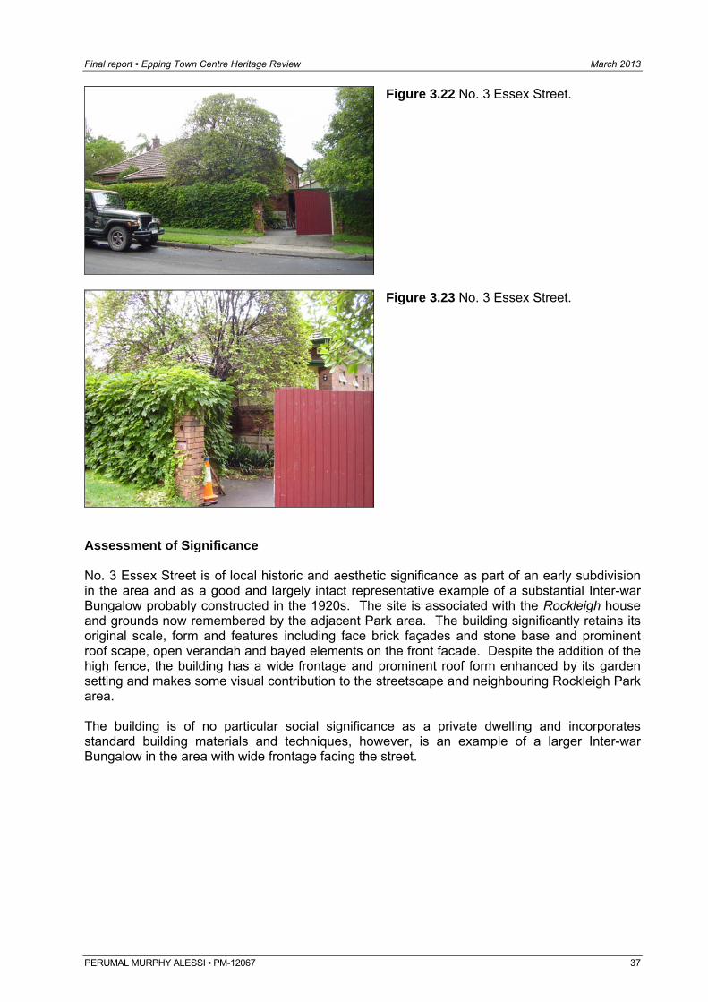
Figure 3.22 No. 3 Essex Street.
Figure 3.23 No. 3 Essex Street.
Assessment of Significance No. 3 Essex Street is of local historic and aesthetic significance as part of an early subdivision in the area and as a good and largely intact representative example of a substantial Inter-war Bungalow probably constructed in the 1920s. The site is associated with the Rockleigh house and grounds now remembered by the adjacent Park area. The building significantly retains its original scale, form and features including face brick façades and stone base and prominent roof scape, open verandah and bayed elements on the front facade. Despite the addition of the high fence, the building has a wide frontage and prominent roof form enhanced by its garden setting and makes some visual contribution to the streetscape and neighbouring Rockleigh Park area. The building is of no particular social significance as a private dwelling and incorporates standard building materials and techniques, however, is an example of a larger Inter-war Bungalow in the area with wide frontage facing the street.
PERUMAL MURPHY ALESSI ▪ PM-12067 37
Final report ▪ Epping Town Centre Heritage Review March 2013
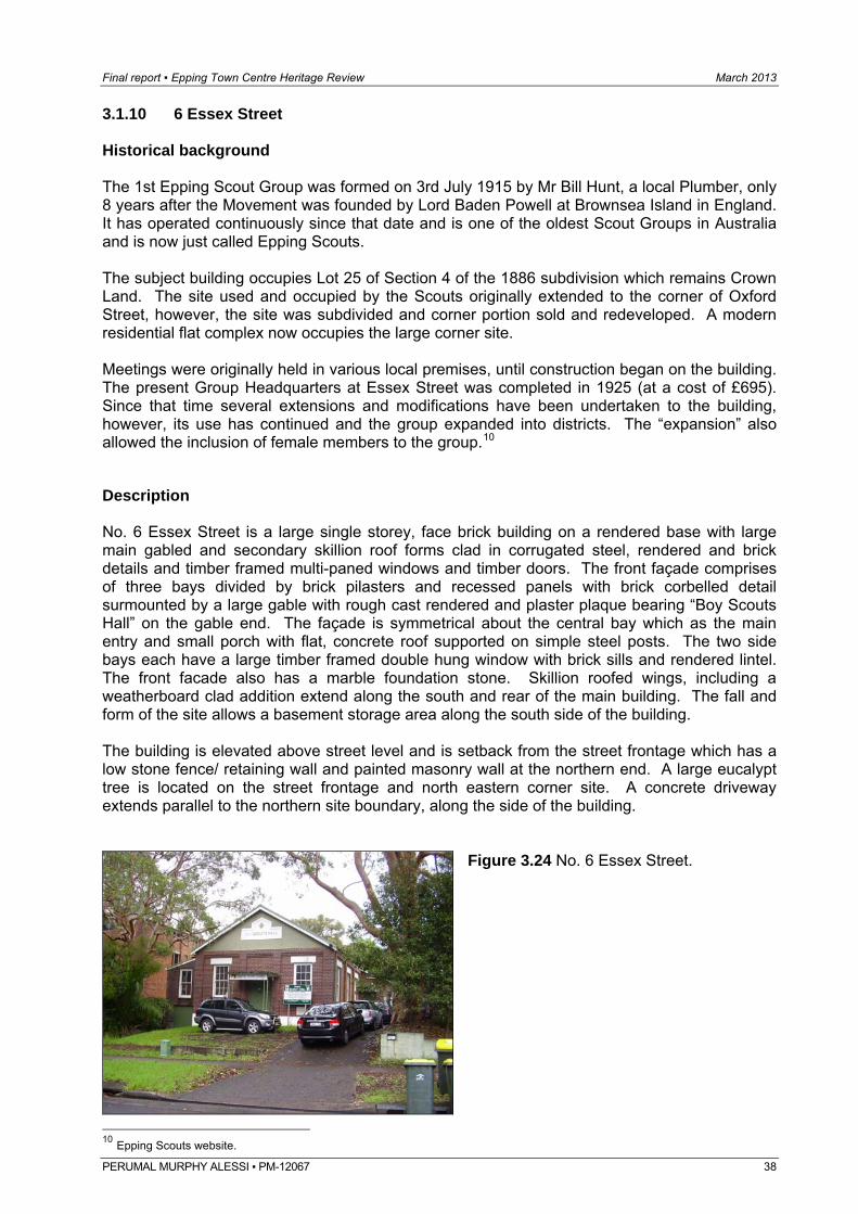
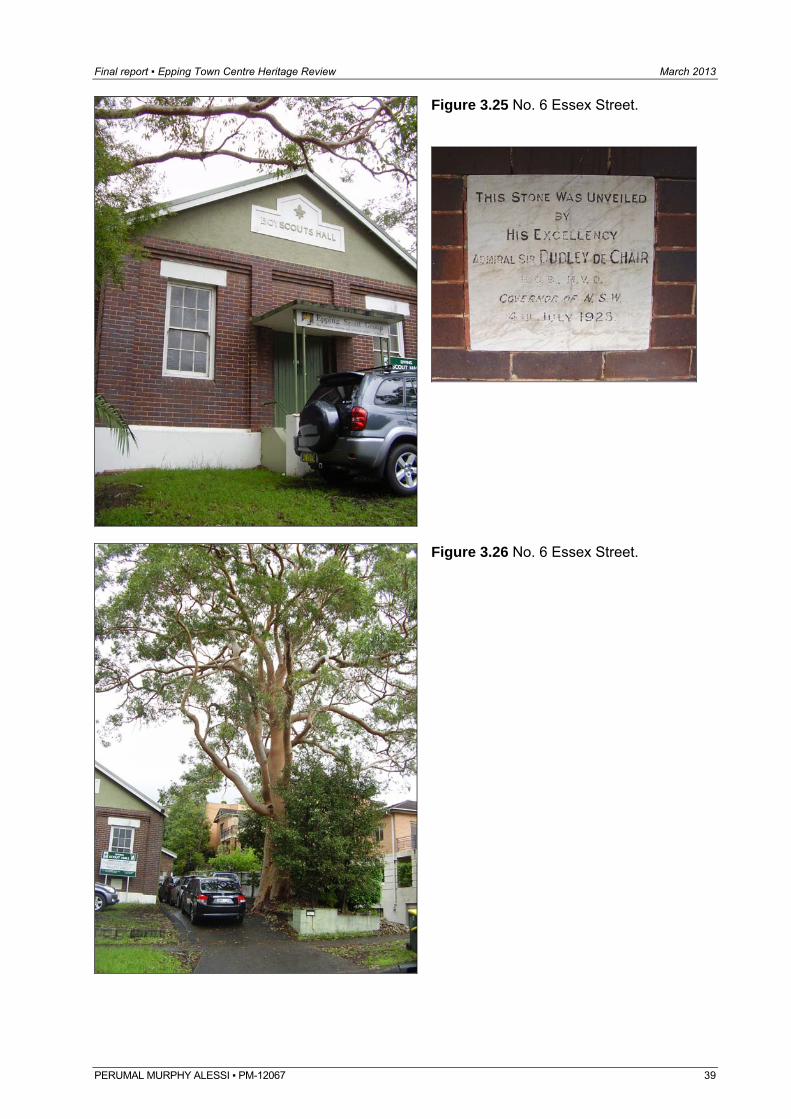
3.1.10 6 Essex Street Historical background The 1st Epping Scout Group was formed on 3rd July 1915 by Mr Bill Hunt, a local Plumber, only 8 years after the Movement was founded by Lord Baden Powell at Brownsea Island in England. It has operated continuously since that date and is one of the oldest Scout Groups in Australia and is now just called Epping Scouts. The subject building occupies Lot 25 of Section 4 of the 1886 subdivision which remains Crown Land. The site used and occupied by the Scouts originally extended to the corner of Oxford Street, however, the site was subdivided and corner portion sold and redeveloped. A modern residential flat complex now occupies the large corner site. Meetings were originally held in various local premises, until construction began on the building. The present Group Headquarters at Essex Street was completed in 1925 (at a cost of £695). Since that time several extensions and modifications have been undertaken to the building, however, its use has continued and the group expanded into districts. The “expansion” also allowed the inclusion of female members to the group.10 Description No. 6 Essex Street is a large single storey, face brick building on a rendered base with large main gabled and secondary skillion roof forms clad in corrugated steel, rendered and brick details and timber framed multi-paned windows and timber doors. The front façade comprises of three bays divided by brick pilasters and recessed panels with brick corbelled detail surmounted by a large gable with rough cast rendered and plaster plaque bearing “Boy Scouts Hall” on the gable end. The façade is symmetrical about the central bay which as the main entry and small porch with flat, concrete roof supported on simple steel posts. The two side bays each have a large timber framed double hung window with brick sills and rendered lintel. The front facade also has a marble foundation stone. Skillion roofed wings, including a weatherboard clad addition extend along the south and rear of the main building. The fall and form of the site allows a basement storage area along the south side of the building. The building is elevated above street level and is setback from the street frontage which has a low stone fence/ retaining wall and painted masonry wall at the northern end. A large eucalypt tree is located on the street frontage and north eastern corner site. A concrete driveway extends parallel to the northern site boundary, along the side of the building.
Figure 3.24 No. 6 Essex Street.
10 Epping Scouts website.
PERUMAL MURPHY ALESSI ▪ PM-12067 38
Final report ▪ Epping Town Centre Heritage Review March 2013
Figure 3.25 No. 6 Essex Street.
Figure 3.26 No. 6 Essex Street.
PERUMAL MURPHY ALESSI ▪ PM-12067 39
Final report ▪ Epping Town Centre Heritage Review March 2013
PERUMAL MURPHY ALESSI ▪ PM-12067 40
Assessment of Significance No. 6 Essex Street is of local historic, aesthetic and social significance as an early, purpose built Scout Hall established on this site in 1925. The building and site have had continuous use since its establishment and is significant as a good and highly intact representative example of an Inter-war period Hall that despite some alterations and additions retains its original form, character and details particularly its prominent gabled roof and gable end, plaques and stones, face brick facades, brick and rendered details. The building is elevated above the street and highly visible and is enhanced by an open setback and large native tree. The building is in contrast to its modern neighbours and makes a positive visual contribution to this section of the Essex Street streetscape. The building incorporates standard construction materials and techniques, however, is of high social significance due to its continuous use as a Scout and social hall and is rare in the local area.
Final report ▪ Epping Town Centre Heritage Review March 2013
PERUMAL MURPHY ALESSI ▪ PM-12067 41
3.1.11 42 Essex Street Historical background The site is part of Portion 355 of the 1889 subdivision of the Field of Mars Common that with Portion 356 was granted to Edward Symonds in December 1889. The two lots were transferred in 1891 to George Robert McIntosh, clerk in Holy Orders and in 1893 to Martin Frederick Vollmer, a nurseryman. Vollmer’s Nursery was located on the eastern side of the railway line extending south of Laurel Avenue (now Epping Road) to Essex Street. Vollmer, a German, arrived in Australia in the 1880s and moved into the area in the 1890s. It has been noted that he constructed a large weatherboard cottage on his land. He took on a partner, CE Vessey and the firm became known as Vollmer and Vessey, Mount Tomah Nursery. Vessey continued to manage the nursery after Vollmer’s death and retired in 1919 after which Vessey’s son Fred took over the business. Fred relocated the business to Eastwood and land occupied by the nursery was subdivided into residential allotments in 1920. The subject site, located on a bend on the western side of Essex Street, bordered but was not part of the 1920 nursery subdivision. In 1912 the site was transferred from Vollmer to Charles Euston Vessey. Charles E Vessey is listed in the Sands Directory, on the western side of Essex Street and south of Laurel Avenue (now Epping Road) in 1911 when Essex Street is first listed in the Sands Directory. This indicates that the house may have been constructed by Vollmer prior to the 1912 transfer. In 1915 the subject site was transferred to Frederick Charles Vessey. F Vessey is subsequently listed in the Sands and retained ownership until 1925. A Sydney Water plan dated 1940 shows the building with open verandah extending across the front and north eastern corner of the building. A projecting bay is visible on the northern façade. A small wing extends from the south western corner of the building bounded by a wide verandah (possibly a sleep-out) which extends across the remainder of rear façade. A small detached structure is also shown at the south western corner of the building. Ownership of the site has since been transferred a number of times and some minor changes and replacement of fabric appear to have been undertaken to the building, however, the overall character and garden setting remains.11 Description No. 42 Essex Street is a substantial, single storey timber weatherboard dwelling on brick footings with a hipped and gabled roof clad in corrugated steel and timber framed windows and doors. The building is well elevated above ground and street level. An open verandah with hipped roof clad in corrugated steel supported on simple timber posts with simple timber balustrade extends across the front and wraps around the north eastern corner of the building. The northern façade also features a projecting bay with gabled roof over. The building is setback from the street frontage which has a low stone flagged fence and edging and dense garden bed. Open lawn and a number of mature trees and shrubs are located in the front garden area. A sealed driveway extends along the northern site boundary to an attached open car port and separate structure at the rear.
11 Land and Property Information, DP10385, Certificate of titles, Volume 1043 Folio 119, Volume 2559 Folio 113, Volume 3111 Folio 28, Sydney Water Plan Room, Blackwattle 3613/ Hornsby Sheet 49, May 1940.
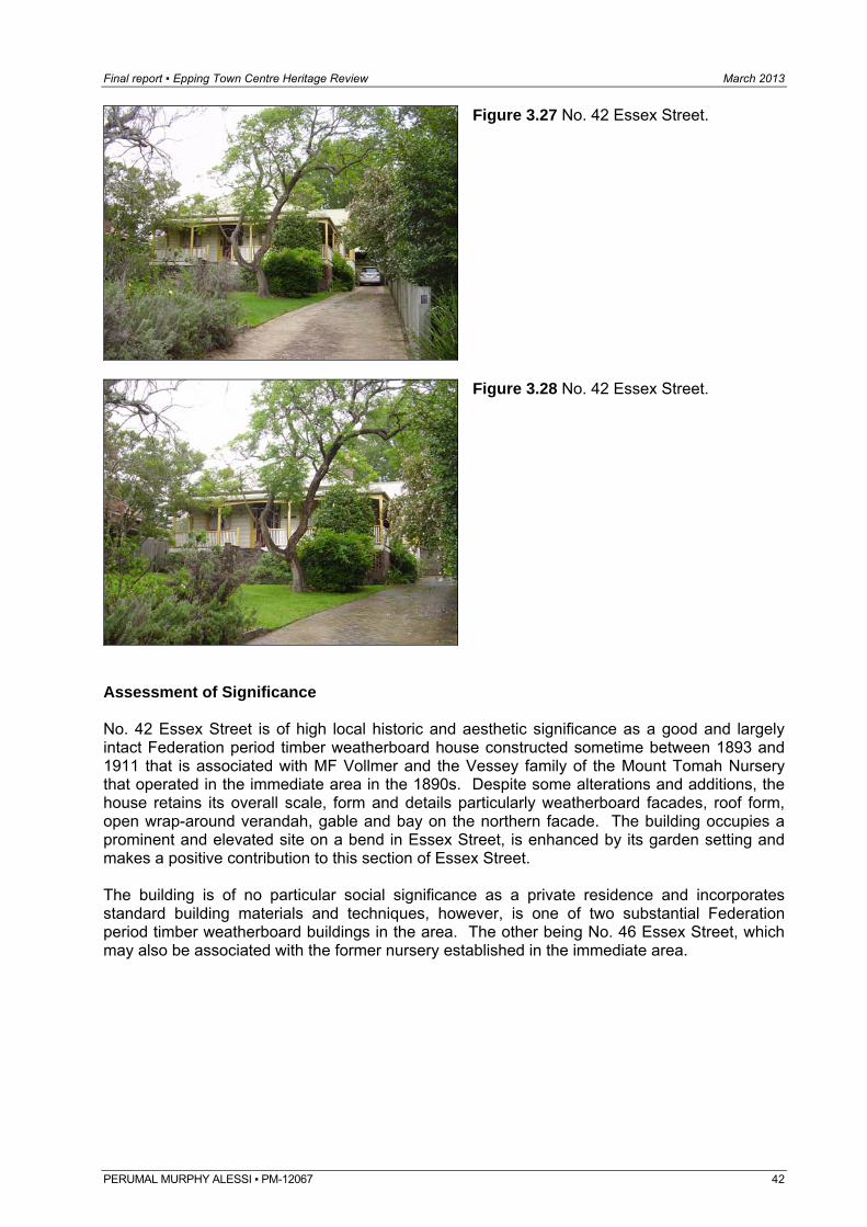
Final report ▪ Epping Town Centre Heritage Review March 2013
Figure 3.27 No. 42 Essex Street.
Figure 3.28 No. 42 Essex Street.
Assessment of Significance No. 42 Essex Street is of high local historic and aesthetic significance as a good and largely intact Federation period timber weatherboard house constructed sometime between 1893 and 1911 that is associated with MF Vollmer and the Vessey family of the Mount Tomah Nursery that operated in the immediate area in the 1890s. Despite some alterations and additions, the house retains its overall scale, form and details particularly weatherboard facades, roof form, open wrap-around verandah, gable and bay on the northern facade. The building occupies a prominent and elevated site on a bend in Essex Street, is enhanced by its garden setting and makes a positive contribution to this section of Essex Street. The building is of no particular social significance as a private residence and incorporates standard building materials and techniques, however, is one of two substantial Federation period timber weatherboard buildings in the area. The other being No. 46 Essex Street, which may also be associated with the former nursery established in the immediate area.
PERUMAL MURPHY ALESSI ▪ PM-12067 42
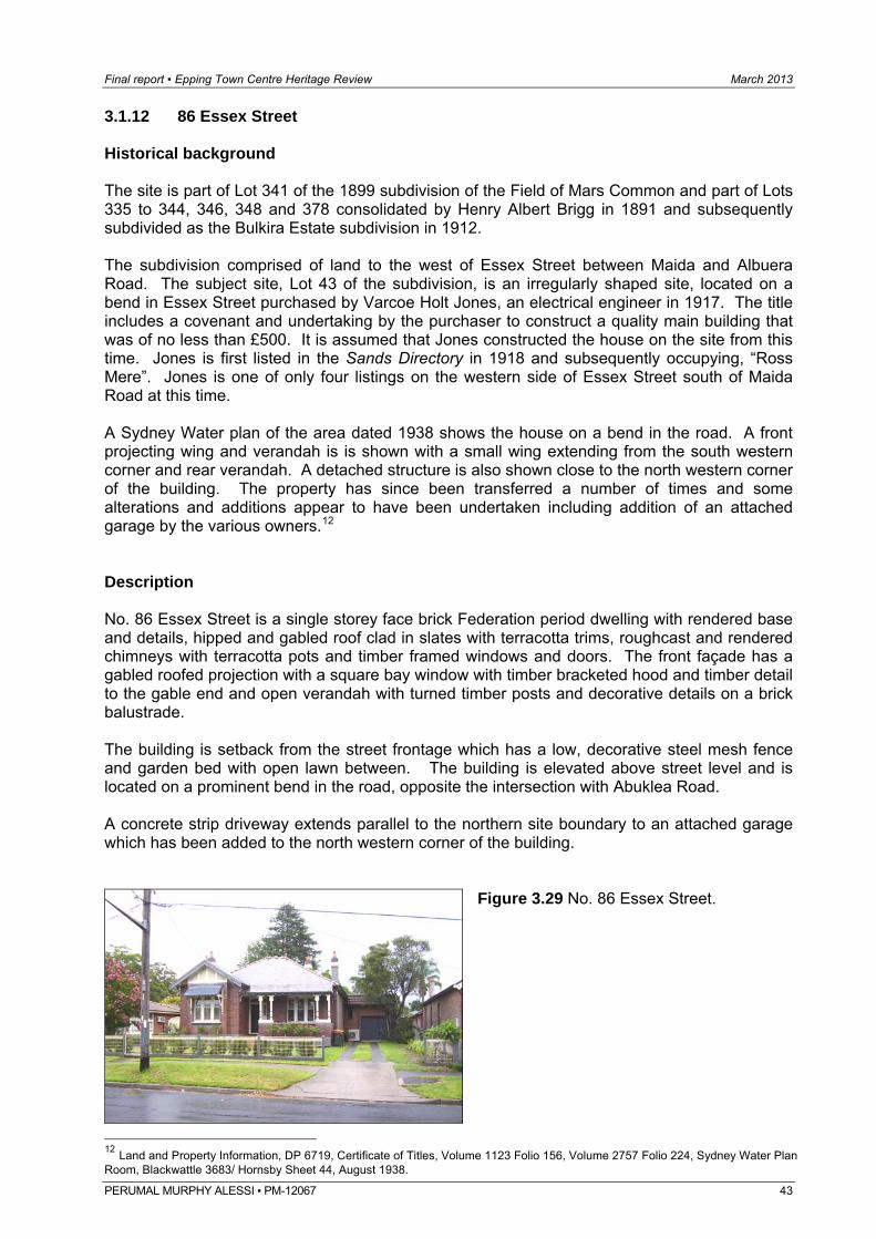
Final report ▪ Epping Town Centre Heritage Review March 2013
3.1.12 86 Essex Street Historical background The site is part of Lot 341 of the 1899 subdivision of the Field of Mars Common and part of Lots 335 to 344, 346, 348 and 378 consolidated by Henry Albert Brigg in 1891 and subsequently subdivided as the Bulkira Estate subdivision in 1912. The subdivision comprised of land to the west of Essex Street between Maida and Albuera Road. The subject site, Lot 43 of the subdivision, is an irregularly shaped site, located on a bend in Essex Street purchased by Varcoe Holt Jones, an electrical engineer in 1917. The title includes a covenant and undertaking by the purchaser to construct a quality main building that was of no less than £500. It is assumed that Jones constructed the house on the site from this time. Jones is first listed in the Sands Directory in 1918 and subsequently occupying, “Ross Mere”. Jones is one of only four listings on the western side of Essex Street south of Maida Road at this time. A Sydney Water plan of the area dated 1938 shows the house on a bend in the road. A front projecting wing and verandah is is shown with a small wing extending from the south western corner and rear verandah. A detached structure is also shown close to the north western corner of the building. The property has since been transferred a number of times and some alterations and additions appear to have been undertaken including addition of an attached garage by the various owners.12 Description No. 86 Essex Street is a single storey face brick Federation period dwelling with rendered base and details, hipped and gabled roof clad in slates with terracotta trims, roughcast and rendered chimneys with terracotta pots and timber framed windows and doors. The front façade has a gabled roofed projection with a square bay window with timber bracketed hood and timber detail to the gable end and open verandah with turned timber posts and decorative details on a brick balustrade. The building is setback from the street frontage which has a low, decorative steel mesh fence and garden bed with open lawn between. The building is elevated above street level and is located on a prominent bend in the road, opposite the intersection with Abuklea Road. A concrete strip driveway extends parallel to the northern site boundary to an attached garage which has been added to the north western corner of the building.
Figure 3.29 No. 86 Essex Street.
12 Land and Property Information, DP 6719, Certificate of Titles, Volume 1123 Folio 156, Volume 2757 Folio 224, Sydney Water Plan Room, Blackwattle 3683/ Hornsby Sheet 44, August 1938.
PERUMAL MURPHY ALESSI ▪ PM-12067 43
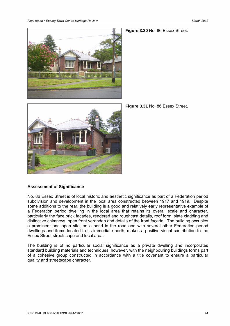
Final report ▪ Epping Town Centre Heritage Review March 2013
Figure 3.30 No. 86 Essex Street.
Figure 3.31 No. 86 Essex Street.
Assessment of Significance No. 86 Essex Street is of local historic and aesthetic significance as part of a Federation period subdivision and development in the local area constructed between 1917 and 1919. Despite some additions to the rear, the building is a good and relatively early representative example of a Federation period dwelling in the local area that retains its overall scale and character, particularly the face brick facades, rendered and roughcast details, roof form, slate cladding and distinctive chimneys, open front verandah and details of the front façade. The building occupies a prominent and open site, on a bend in the road and with several other Federation period dwellings and items located to its immediate north, makes a positive visual contribution to the Essex Street streetscape and local area. The building is of no particular social significance as a private dwelling and incorporates standard building materials and techniques, however, with the neighbouring buildings forms part of a cohesive group constructed in accordance with a title covenant to ensure a particular quality and streetscape character.
PERUMAL MURPHY ALESSI ▪ PM-12067 44
Final report ▪ Epping Town Centre Heritage Review March 2013
PERUMAL MURPHY ALESSI ▪ PM-12067 45
3.1.13 39 Norfolk Road Historical background The site is part of the 1886 subdivision of the former Government Common and part of Lots 6-11 of Section 7 subsequently consolidated by Heinrich Georg Menken and re-subdivided in c. 1909 as the “Norfolk Road Estate Epping” which was advertised for sale by auction in November of the same year. The subdivision advertisement describes the “10 choice building sites” as being the highest blocks in the district with easterly and northerly aspect. Lots 1-4 are irregularly shaped sites with frontage to Oxford Street. Lot 1 occupies the corner of Norfolk and Oxford Streets whilst Lots 5-10, with frontage to Norfolk “Street” (now Road) occupy the remainder of the block to Surrey Street. The estate advertisement and land titles refer to a covenant and building restriction placed on the sites. It is noted that the buyers need not build or fence but any residence erected must be of brick or stone or both with slate, shingle or tile roof and had to be of not less than £300 in value. The subject site, part of Lot 8 of DP 5910, is one of the four regular shaped sites (Lots 7-10) with 50 feet frontage to Norfolk Road which were consolidated by Arthur Alexander Blackwood from 1910. Lot 8 was transferred to Alfred Joshua Hammill in 1912 and to Robert Alfred Thompson of Epping, Congregational Minister in 1917. It is assumed that the house was constructed on the site sometime between 1912 and 1919. There are no street numbers in Norfolk Road in the Sands Directory during this period. Hammill is listed in the Sands on the western side of Norfolk Road in the block between Surrey and Oxford Streets in 1915 occupying “Chimo”. Thompson is first listed in the Sands in 1919 and subsequently as occupying “Lynfaine”. A Sydney Water plan dated 1940 shows the building setback from the front and southern side boundaries with projecting front wing and open front verandah and small projection at the rear, north western corner of the building. Ownership was transferred a number of times until 1958, when Lot 8 and two neighbouring sites to the south were subdivided into four lots by reducing the length of the three addressing Norfolk Road and forming an additional lot at the rear, with frontage to Surrey Street. The subject site became Lot D of the subdivision (DP 100750).13 Description No. 39 Norfolk Road is a single storey face brick with stone base Federation period dwelling with hipped and gabled roof clad in slates with terracotta trims, exposed rafter ends, brick chimneys and timber framed windows and doors. The front façade is constructed of the Federation red brick, whilst the sides are constructed of common brick. The front façade has a gabled roofed projection with faceted bay window with timber bracketed hood over and timber and roughcast detail to the gable end. The main roof extends over an open front verandah and is supported on decorative timber posts and brackets on a brick base. The front façade also has a faceted bay which projects into the verandah space and name plate bearing the name “Lynfaine”. The southern side window openings also feature timber bracketed timber hoods. The building is setback from the street frontage which has a timber picket fence with lawn and garden beds located between. A brick driveway extends parallel to the southern site boundary to a single gable roofed garage added to the south western corner of the building. The building is located on a prominent rise in Norfolk Road and is one of a group of three similar dwellings in this section of the street.
13 Land and Property Information, DP 5910, Certificate of Titles, Volume 823 Folio 237, Volume 1893 Folio 7, Volume 2309 Folio 30, Volume 7729 Folio 49, Mitchell Library, Epping Subdivision Plans E10/52, Sydney Water Plan Room, Blackwattle 3695, January 1940.
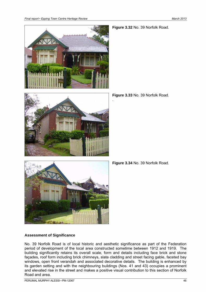
Final report ▪ Epping Town Centre Heritage Review March 2013
Figure 3.32 No. 39 Norfolk Road.
Figure 3.33 No. 39 Norfolk Road. .
Figure 3.34 No. 39 Norfolk Road.
Assessment of Significance No. 39 Norfolk Road is of local historic and aesthetic significance as part of the Federation period of development of the local area constructed sometime between 1912 and 1919. The building significantly retains its overall scale, form and details including face brick and stone façades, roof form including brick chimneys, slate cladding and street facing gable, faceted bay windows, open front verandah and associated decorative details. The building is enhanced by its garden setting and with the neighbouring buildings (Nos. 41 and 43) occupies a prominent and elevated rise in the street and makes a positive visual contribution to this section of Norfolk Road and area. PERUMAL MURPHY ALESSI ▪ PM-12067 46
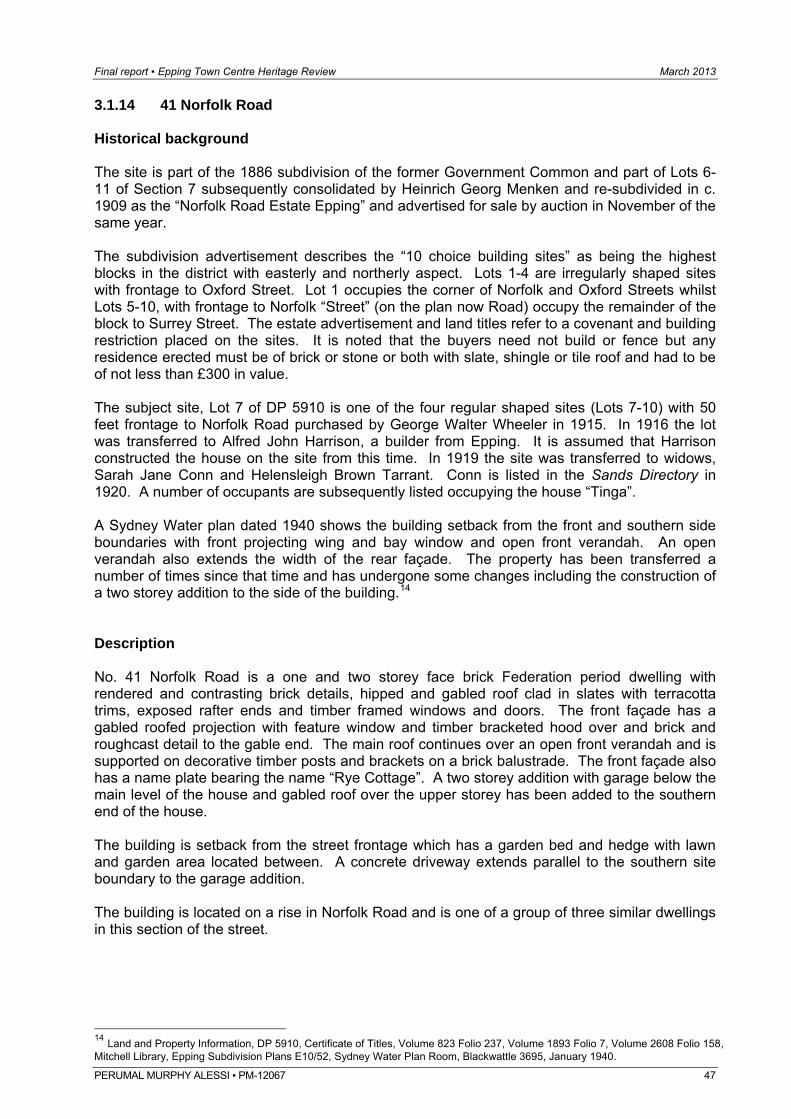
Final report ▪ Epping Town Centre Heritage Review March 2013
PERUMAL MURPHY ALESSI ▪ PM-12067 47
3.1.14 41 Norfolk Road Historical background The site is part of the 1886 subdivision of the former Government Common and part of Lots 6-11 of Section 7 subsequently consolidated by Heinrich Georg Menken and re-subdivided in c. 1909 as the “Norfolk Road Estate Epping” and advertised for sale by auction in November of the same year. The subdivision advertisement describes the “10 choice building sites” as being the highest blocks in the district with easterly and northerly aspect. Lots 1-4 are irregularly shaped sites with frontage to Oxford Street. Lot 1 occupies the corner of Norfolk and Oxford Streets whilst Lots 5-10, with frontage to Norfolk “Street” (on the plan now Road) occupy the remainder of the block to Surrey Street. The estate advertisement and land titles refer to a covenant and building restriction placed on the sites. It is noted that the buyers need not build or fence but any residence erected must be of brick or stone or both with slate, shingle or tile roof and had to be of not less than £300 in value. The subject site, Lot 7 of DP 5910 is one of the four regular shaped sites (Lots 7-10) with 50 feet frontage to Norfolk Road purchased by George Walter Wheeler in 1915. In 1916 the lot was transferred to Alfred John Harrison, a builder from Epping. It is assumed that Harrison constructed the house on the site from this time. In 1919 the site was transferred to widows, Sarah Jane Conn and Helensleigh Brown Tarrant. Conn is listed in the Sands Directory in 1920. A number of occupants are subsequently listed occupying the house “Tinga”. A Sydney Water plan dated 1940 shows the building setback from the front and southern side boundaries with front projecting wing and bay window and open front verandah. An open verandah also extends the width of the rear façade. The property has been transferred a number of times since that time and has undergone some changes including the construction of a two storey addition to the side of the building.14 Description No. 41 Norfolk Road is a one and two storey face brick Federation period dwelling with rendered and contrasting brick details, hipped and gabled roof clad in slates with terracotta trims, exposed rafter ends and timber framed windows and doors. The front façade has a gabled roofed projection with feature window and timber bracketed hood over and brick and roughcast detail to the gable end. The main roof continues over an open front verandah and is supported on decorative timber posts and brackets on a brick balustrade. The front façade also has a name plate bearing the name “Rye Cottage”. A two storey addition with garage below the main level of the house and gabled roof over the upper storey has been added to the southern end of the house. The building is setback from the street frontage which has a garden bed and hedge with lawn and garden area located between. A concrete driveway extends parallel to the southern site boundary to the garage addition. The building is located on a rise in Norfolk Road and is one of a group of three similar dwellings in this section of the street.
14 Land and Property Information, DP 5910, Certificate of Titles, Volume 823 Folio 237, Volume 1893 Folio 7, Volume 2608 Folio 158, Mitchell Library, Epping Subdivision Plans E10/52, Sydney Water Plan Room, Blackwattle 3695, January 1940.
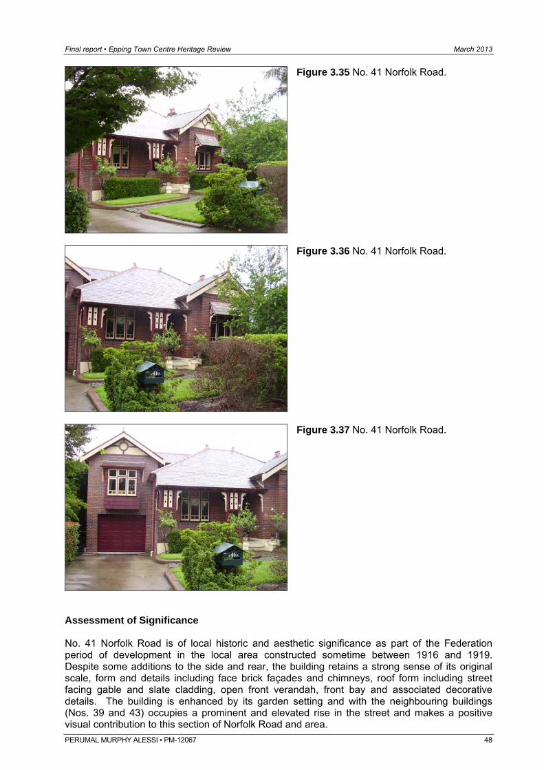
Final report ▪ Epping Town Centre Heritage Review March 2013
Figure 3.35 No. 41 Norfolk Road.
Figure 3.36 No. 41 Norfolk Road.
Figure 3.37 No. 41 Norfolk Road.
Assessment of Significance No. 41 Norfolk Road is of local historic and aesthetic significance as part of the Federation period of development in the local area constructed sometime between 1916 and 1919. Despite some additions to the side and rear, the building retains a strong sense of its original scale, form and details including face brick façades and chimneys, roof form including street facing gable and slate cladding, open front verandah, front bay and associated decorative details. The building is enhanced by its garden setting and with the neighbouring buildings (Nos. 39 and 43) occupies a prominent and elevated rise in the street and makes a positive visual contribution to this section of Norfolk Road and area. PERUMAL MURPHY ALESSI ▪ PM-12067 48
Final report ▪ Epping Town Centre Heritage Review March 2013
PERUMAL MURPHY ALESSI ▪ PM-12067 49
3.1.15 43 Norfolk Road Historical background The site is part of the 1886 subdivision of the former Government Common and part of Lots 6-11 of Section 7 subsequently consolidated by Heinrich Georg Menken and re-subdivided in c. 1909 as the “Norfolk Road Estate Epping” which was advertised for sale by auction in November of the same year. The subdivision advertisement describes the “10 choice building sites” as being the highest blocks in the district with easterly and northerly aspect. Lots 1-4 are irregularly shaped sites with frontage to Oxford Street. Lot 1 occupies the corner of Norfolk and Oxford Streets whilst Lots 5-10, with frontage to Norfolk “Street” (on the plan now Road) occupy the remainder of the block to Surrey Street. The estate advertisement and land titles refer to a covenant and building restriction placed on the sites. It is noted that the buyers need not build or fence but any residence erected must be of brick or stone or both with slate, shingle or tile roof and had to be of not less than £300 in value. The subject site, Lot 6 of DP 5910, had a slightly wider frontage than the four regular shaped sites (Lots 7-10) to its south as the north western corner of the lot was splayed. With most of the sites it was purchased by Arthur Alexander Blackwood in 1910 who resold it in 1911 to Irvine Greenstreet. In 1915 the site was transferred again to Cecil Edmund Baker, of Sydney, a foreman. It is assumed that the house was constructed on the site from this time. Baker is listed in the Sands Directory on the western side of Norfolk Road between Surry and Oxford Streets in 1917, occupying “Aleathea”. The site was transferred again in 1917 to Ellen Maria White and in 1919 to David Fraser. David Fraser is listed in the Sands in 1920 and subsequently as occupying “Montrose”. A Sydney Water plan dated 1940 shows the building setback from the front and wide setback from the southern site boundary, front projecting wing and bay and verandah. A small wing also extends from the south western corner of the building. Ownership has since been transferred and a number of changes, including the addition of a carport and additions to the rear of the dwelling have been undertaken.15 Description No. 43 Norfolk Road is a single storey face brick and rough cast rendered Federation period dwelling with hipped and gabled roof clad in slates with terracotta trims, exposed rafter ends, brick chimneys and timber framed windows and doors. The front façade is constructed of red brick, whilst the sides are constructed of common brick. The front façade has a gabled roofed projection with square bay window and timber bracketed hood over and timber and roughcast detail to the gable end. The main roof extends over an open front verandah and is supported on square timber posts and decorative brackets on a brick base. The front façade also has a name plate bearing the name “Montrose”. The building is setback from the street frontage which has a low face brick fence with lawn and garden beds including a row of palms at the front of the building. A brick driveway extends parallel to the southern site boundary to an open, attached carport which has been added to the southern façade of the house. Some additions have also been constructed to the rear. The building is located on a rise in Norfolk Road and is one of a group of three similar dwellings in this section of the street.
15 Land and Property Information, DP 5910, Certificate of Titles, Volume 823 Folio 237, Volume 1893 Folio 7, Volume 2179 Folio 203, Volume 2188 Folio 71, Mitchell Library, Epping Subdivision Plans E10/52, Sydney Water Plan Room, Blackwattle 3695, January 1940.
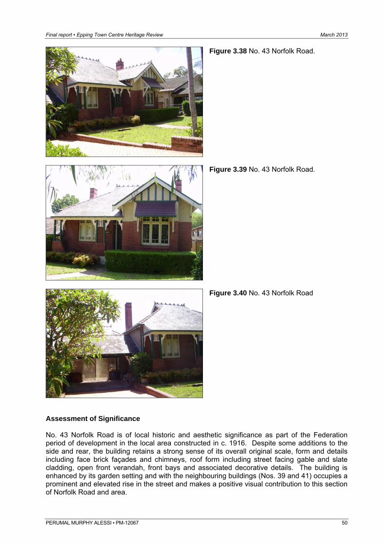
Final report ▪ Epping Town Centre Heritage Review March 2013
Figure 3.38 No. 43 Norfolk Road.
Figure 3.39 No. 43 Norfolk Road.
Figure 3.40 No. 43 Norfolk Road
Assessment of Significance No. 43 Norfolk Road is of local historic and aesthetic significance as part of the Federation period of development in the local area constructed in c. 1916. Despite some additions to the side and rear, the building retains a strong sense of its overall original scale, form and details including face brick façades and chimneys, roof form including street facing gable and slate cladding, open front verandah, front bays and associated decorative details. The building is enhanced by its garden setting and with the neighbouring buildings (Nos. 39 and 41) occupies a prominent and elevated rise in the street and makes a positive visual contribution to this section of Norfolk Road and area.
PERUMAL MURPHY ALESSI ▪ PM-12067 50
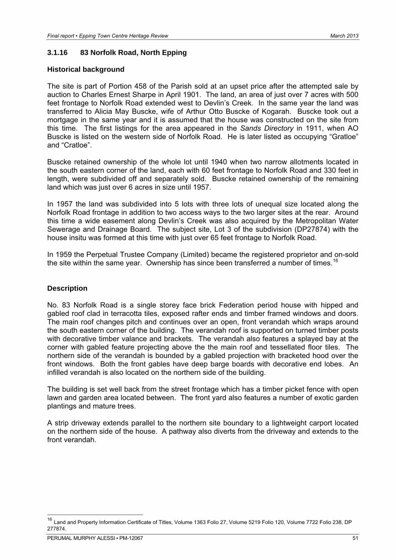
Final report ▪ Epping Town Centre Heritage Review March 2013
PERUMAL MURPHY ALESSI ▪ PM-12067 51
3.1.16 83 Norfolk Road, North Epping Historical background The site is part of Portion 458 of the Parish sold at an upset price after the attempted sale by auction to Charles Ernest Sharpe in April 1901. The land, an area of just over 7 acres with 500 feet frontage to Norfolk Road extended west to Devlin’s Creek. In the same year the land was transferred to Alicia May Buscke, wife of Arthur Otto Buscke of Kogarah. Buscke took out a mortgage in the same year and it is assumed that the house was constructed on the site from this time. The first listings for the area appeared in the Sands Directory in 1911, when AO Buscke is listed on the western side of Norfolk Road. He is later listed as occupying “Gratloe” and “Cratloe”. Buscke retained ownership of the whole lot until 1940 when two narrow allotments located in the south eastern corner of the land, each with 60 feet frontage to Norfolk Road and 330 feet in length, were subdivided off and separately sold. Buscke retained ownership of the remaining land which was just over 6 acres in size until 1957. In 1957 the land was subdivided into 5 lots with three lots of unequal size located along the Norfolk Road frontage in addition to two access ways to the two larger sites at the rear. Around this time a wide easement along Devlin’s Creek was also acquired by the Metropolitan Water Sewerage and Drainage Board. The subject site, Lot 3 of the subdivision (DP27874) with the house insitu was formed at this time with just over 65 feet frontage to Norfolk Road. In 1959 the Perpetual Trustee Company (Limited) became the registered proprietor and on-sold the site within the same year. Ownership has since been transferred a number of times.16 Description No. 83 Norfolk Road is a single storey face brick Federation period house with hipped and gabled roof clad in terracotta tiles, exposed rafter ends and timber framed windows and doors. The main roof changes pitch and continues over an open, front verandah which wraps around the south eastern corner of the building. The verandah roof is supported on turned timber posts with decorative timber valance and brackets. The verandah also features a splayed bay at the corner with gabled feature projecting above the the main roof and tessellated floor tiles. The northern side of the verandah is bounded by a gabled projection with bracketed hood over the front windows. Both the front gables have deep barge boards with decorative end lobes. An infilled verandah is also located on the northern side of the building. The building is set well back from the street frontage which has a timber picket fence with open lawn and garden area located between. The front yard also features a number of exotic garden plantings and mature trees. A strip driveway extends parallel to the northern site boundary to a lightweight carport located on the northern side of the house. A pathway also diverts from the driveway and extends to the front verandah.
16 Land and Property Information Certificate of Titles, Volume 1363 Folio 27, Volume 5219 Folio 120, Volume 7722 Folio 238, DP 277874.
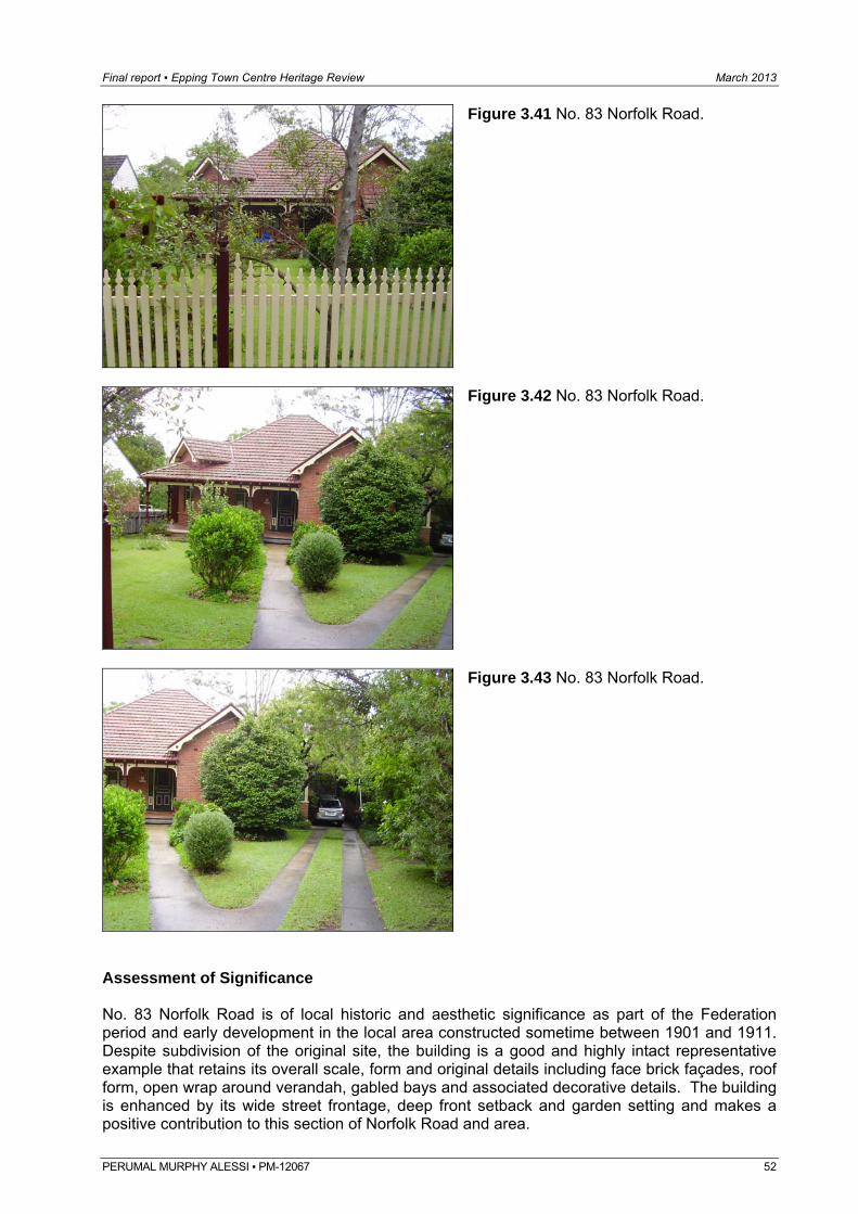
Final report ▪ Epping Town Centre Heritage Review March 2013
Figure 3.41 No. 83 Norfolk Road.
Figure 3.42 No. 83 Norfolk Road.
Figure 3.43 No. 83 Norfolk Road.
Assessment of Significance No. 83 Norfolk Road is of local historic and aesthetic significance as part of the Federation period and early development in the local area constructed sometime between 1901 and 1911. Despite subdivision of the original site, the building is a good and highly intact representative example that retains its overall scale, form and original details including face brick façades, roof form, open wrap around verandah, gabled bays and associated decorative details. The building is enhanced by its wide street frontage, deep front setback and garden setting and makes a positive contribution to this section of Norfolk Road and area. PERUMAL MURPHY ALESSI ▪ PM-12067 52
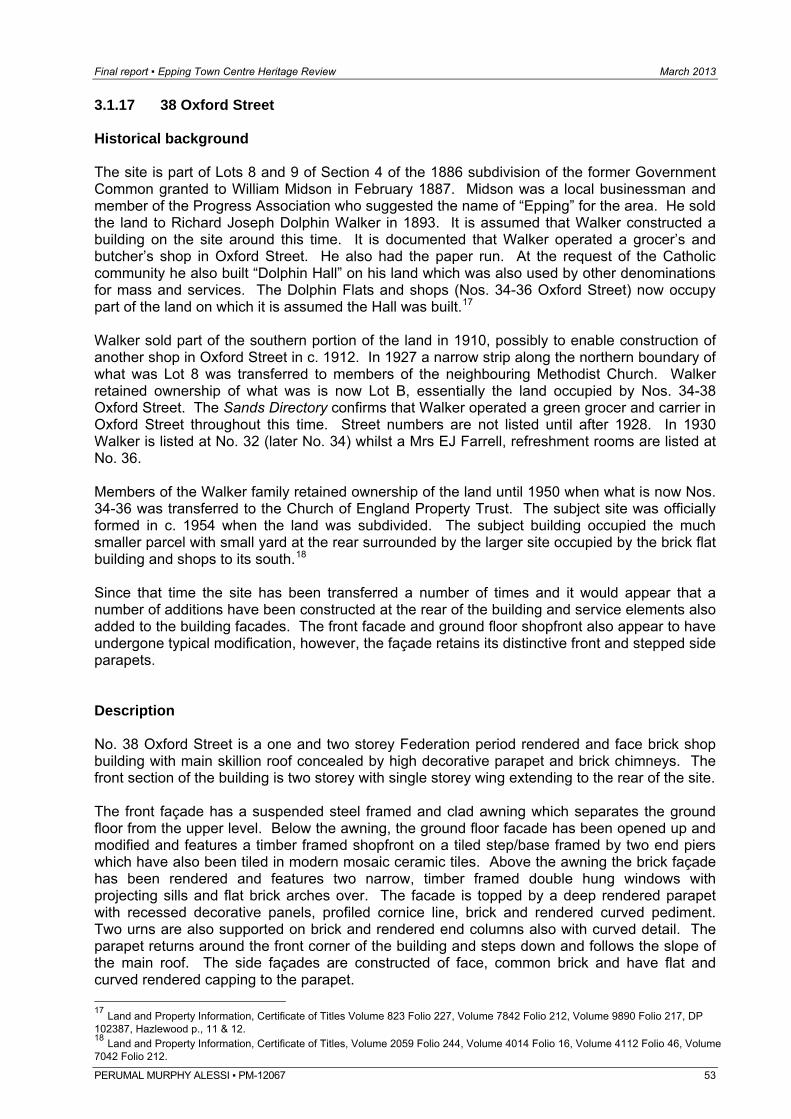
Final report ▪ Epping Town Centre Heritage Review March 2013
PERUMAL MURPHY ALESSI ▪ PM-12067 53
3.1.17 38 Oxford Street Historical background The site is part of Lots 8 and 9 of Section 4 of the 1886 subdivision of the former Government Common granted to William Midson in February 1887. Midson was a local businessman and member of the Progress Association who suggested the name of “Epping” for the area. He sold the land to Richard Joseph Dolphin Walker in 1893. It is assumed that Walker constructed a building on the site around this time. It is documented that Walker operated a grocer’s and butcher’s shop in Oxford Street. He also had the paper run. At the request of the Catholic community he also built “Dolphin Hall” on his land which was also used by other denominations for mass and services. The Dolphin Flats and shops (Nos. 34-36 Oxford Street) now occupy part of the land on which it is assumed the Hall was built.17 Walker sold part of the southern portion of the land in 1910, possibly to enable construction of another shop in Oxford Street in c. 1912. In 1927 a narrow strip along the northern boundary of what was Lot 8 was transferred to members of the neighbouring Methodist Church. Walker retained ownership of what was is now Lot B, essentially the land occupied by Nos. 34-38 Oxford Street. The Sands Directory confirms that Walker operated a green grocer and carrier in Oxford Street throughout this time. Street numbers are not listed until after 1928. In 1930 Walker is listed at No. 32 (later No. 34) whilst a Mrs EJ Farrell, refreshment rooms are listed at No. 36. Members of the Walker family retained ownership of the land until 1950 when what is now Nos. 34-36 was transferred to the Church of England Property Trust. The subject site was officially formed in c. 1954 when the land was subdivided. The subject building occupied the much smaller parcel with small yard at the rear surrounded by the larger site occupied by the brick flat building and shops to its south.18 Since that time the site has been transferred a number of times and it would appear that a number of additions have been constructed at the rear of the building and service elements also added to the building facades. The front facade and ground floor shopfront also appear to have undergone typical modification, however, the façade retains its distinctive front and stepped side parapets. Description No. 38 Oxford Street is a one and two storey Federation period rendered and face brick shop building with main skillion roof concealed by high decorative parapet and brick chimneys. The front section of the building is two storey with single storey wing extending to the rear of the site. The front façade has a suspended steel framed and clad awning which separates the ground floor from the upper level. Below the awning, the ground floor facade has been opened up and modified and features a timber framed shopfront on a tiled step/base framed by two end piers which have also been tiled in modern mosaic ceramic tiles. Above the awning the brick façade has been rendered and features two narrow, timber framed double hung windows with projecting sills and flat brick arches over. The facade is topped by a deep rendered parapet with recessed decorative panels, profiled cornice line, brick and rendered curved pediment. Two urns are also supported on brick and rendered end columns also with curved detail. The parapet returns around the front corner of the building and steps down and follows the slope of the main roof. The side façades are constructed of face, common brick and have flat and curved rendered capping to the parapet. 17 Land and Property Information, Certificate of Titles Volume 823 Folio 227, Volume 7842 Folio 212, Volume 9890 Folio 217, DP 102387, Hazlewood p., 11 & 12. 18 Land and Property Information, Certificate of Titles, Volume 2059 Folio 244, Volume 4014 Folio 16, Volume 4112 Folio 46, Volume 7042 Folio 212.
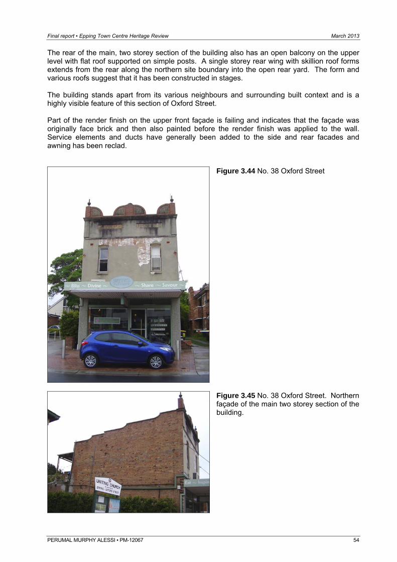
Final report ▪ Epping Town Centre Heritage Review March 2013
The rear of the main, two storey section of the building also has an open balcony on the upper level with flat roof supported on simple posts. A single storey rear wing with skillion roof forms extends from the rear along the northern site boundary into the open rear yard. The form and various roofs suggest that it has been constructed in stages. The building stands apart from its various neighbours and surrounding built context and is a highly visible feature of this section of Oxford Street. Part of the render finish on the upper front façade is failing and indicates that the façade was originally face brick and then also painted before the render finish was applied to the wall. Service elements and ducts have generally been added to the side and rear facades and awning has been reclad.
Figure 3.44 No. 38 Oxford Street
Figure 3.45 No. 38 Oxford Street. Northern façade of the main two storey section of the building.
PERUMAL MURPHY ALESSI ▪ PM-12067 54
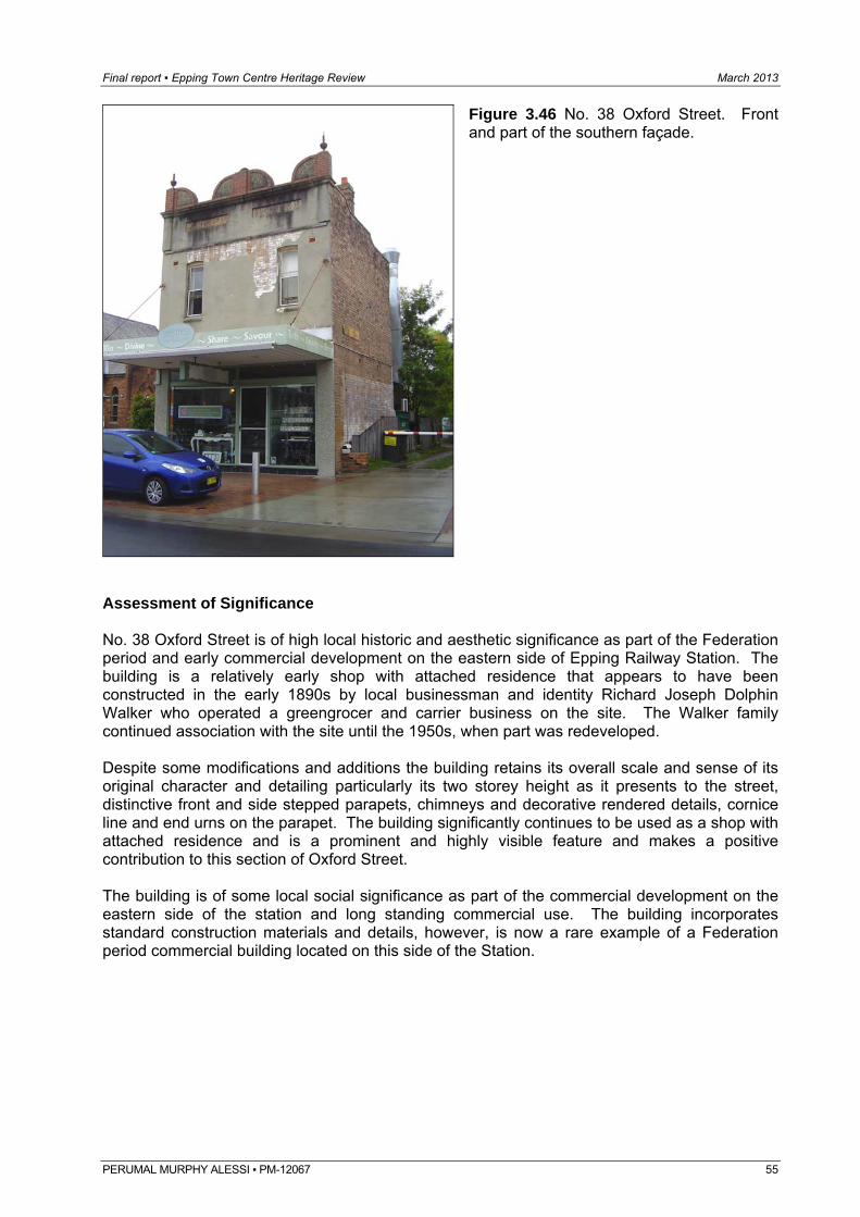
Final report ▪ Epping Town Centre Heritage Review March 2013
Figure 3.46 No. 38 Oxford Street. Front and part of the southern façade.
Assessment of Significance No. 38 Oxford Street is of high local historic and aesthetic significance as part of the Federation period and early commercial development on the eastern side of Epping Railway Station. The building is a relatively early shop with attached residence that appears to have been constructed in the early 1890s by local businessman and identity Richard Joseph Dolphin Walker who operated a greengrocer and carrier business on the site. The Walker family continued association with the site until the 1950s, when part was redeveloped. Despite some modifications and additions the building retains its overall scale and sense of its original character and detailing particularly its two storey height as it presents to the street, distinctive front and side stepped parapets, chimneys and decorative rendered details, cornice line and end urns on the parapet. The building significantly continues to be used as a shop with attached residence and is a prominent and highly visible feature and makes a positive contribution to this section of Oxford Street. The building is of some local social significance as part of the commercial development on the eastern side of the station and long standing commercial use. The building incorporates standard construction materials and details, however, is now a rare example of a Federation period commercial building located on this side of the Station.
PERUMAL MURPHY ALESSI ▪ PM-12067 55
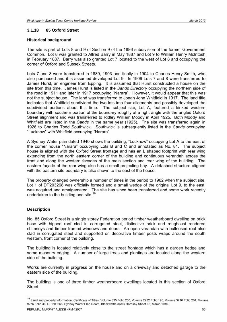
Final report ▪ Epping Town Centre Heritage Review March 2013
PERUMAL MURPHY ALESSI ▪ PM-12067 56
3.1.18 85 Oxford Street Historical background The site is part of Lots 8 and 9 of Section 9 of the 1886 subdivision of the former Government Common. Lot 8 was granted to Alfred Barry in May 1887 and Lot 9 to William Henry McIntosh in February 1887. Barry was also granted Lot 7 located to the west of Lot 8 and occupying the corner of Oxford and Sussex Streets. Lots 7 and 8 were transferred in 1889, 1903 and finally in 1904 to Charles Henry Smith, who also purchased and it is assumed developed Lot 9. In 1909 Lots 7 and 8 were transferred to James Hurst, an engineer from Epping. It is assumed that Hurst constructed a house on the site from this time. James Hurst is listed in the Sands Directory occupying the northern side of the road in 1911 and later in 1917 occupying “Narara”. However, it would appear that this was not the subject house. The land was transferred to Jonah John Whitfield in 1917. The land title indicates that Whitfield subdivided the two lots into four allotments and possibly developed the subdivided portions about this time. The subject site, Lot A, featured a kinked western boundary with southern portion of the boundary roughly at a right angle with the angled Oxford Street alignment and was transferred to Ridley William Moody in April 1925. Both Moody and Whitfield are listed in the Sands in the same year (1925). The site was transferred again in 1926 to Charles Todd Southwick. Southwick is subsequently listed in the Sands occupying “Lucknow” with Whitfield occupying “Narara”. A Sydney Water plan dated 1940 shows the building, ”Lucknow” occupying Lot A to the east of the corner house “Narara” occupying Lots B and C and annotated as No. 81. The subject house is aligned with the Oxford Street frontage and has an L shaped footprint with rear wing extending from the north eastern corner of the building and continuous verandah across the front and along the western facades of the main section and rear wing of the building. The eastern façade of the rear wing also has a small projecting bay. A detached structure aligned with the eastern site boundary is also shown to the east of the house. The property changed ownership a number of times in the period to 1962 when the subject site, Lot 1 of DP203268 was officially formed and a small wedge of the original Lot 9, to the east, was acquired and amalgamated. The site has since been transferred and some work recently undertaken to the building and site.19 Description No. 85 Oxford Street is a single storey Federation period timber weatherboard dwelling on brick base with hipped roof clad in corrugated steel, distinctive brick and roughcast rendered chimneys and timber framed windows and doors. An open verandah with bullnosed roof also clad in corrugated steel and supported on decorative timber posts wraps around the south western, front corner of the building. The building is located relatively close to the street frontage which has a garden hedge and some masonry edging. A number of large trees and plantings are located along the western side of the building. Works are currently in progress on the house and on a driveway and detached garage to the eastern side of the building. The building is one of three timber weatherboard dwellings located in this section of Oxford Street.
19 Land and property Information, Certificate of Titles, Volume 835 Folio 250, Volume 2232 Folio 195, Volume 3716 Folio 204, Volume 9276 Folio 36, DP 203268, Sydney Water Plan Room, Blackwattle 3646/ Hornsby Sheet 66, March 1940.
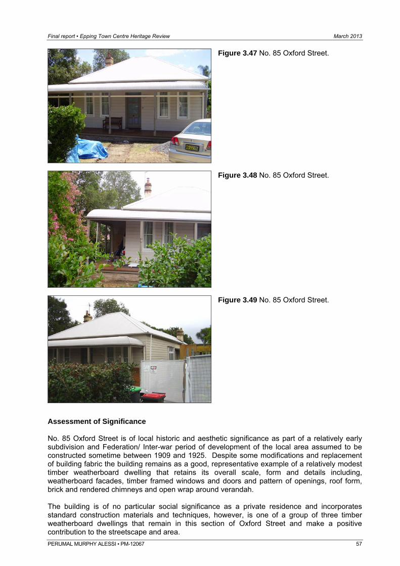
Final report ▪ Epping Town Centre Heritage Review March 2013
Figure 3.47 No. 85 Oxford Street.
Figure 3.48 No. 85 Oxford Street.
Figure 3.49 No. 85 Oxford Street.
Assessment of Significance No. 85 Oxford Street is of local historic and aesthetic significance as part of a relatively early subdivision and Federation/ Inter-war period of development of the local area assumed to be constructed sometime between 1909 and 1925. Despite some modifications and replacement of building fabric the building remains as a good, representative example of a relatively modest timber weatherboard dwelling that retains its overall scale, form and details including, weatherboard facades, timber framed windows and doors and pattern of openings, roof form, brick and rendered chimneys and open wrap around verandah. The building is of no particular social significance as a private residence and incorporates standard construction materials and techniques, however, is one of a group of three timber weatherboard dwellings that remain in this section of Oxford Street and make a positive contribution to the streetscape and area. PERUMAL MURPHY ALESSI ▪ PM-12067 57
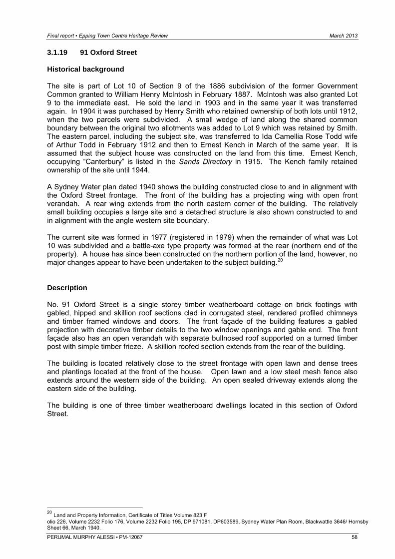
Final report ▪ Epping Town Centre Heritage Review March 2013
PERUMAL MURPHY ALESSI ▪ PM-12067 58
3.1.19 91 Oxford Street Historical background The site is part of Lot 10 of Section 9 of the 1886 subdivision of the former Government Common granted to William Henry McIntosh in February 1887. McIntosh was also granted Lot 9 to the immediate east. He sold the land in 1903 and in the same year it was transferred again. In 1904 it was purchased by Henry Smith who retained ownership of both lots until 1912, when the two parcels were subdivided. A small wedge of land along the shared common boundary between the original two allotments was added to Lot 9 which was retained by Smith. The eastern parcel, including the subject site, was transferred to Ida Camellia Rose Todd wife of Arthur Todd in February 1912 and then to Ernest Kench in March of the same year. It is assumed that the subject house was constructed on the land from this time. Ernest Kench, occupying “Canterbury” is listed in the Sands Directory in 1915. The Kench family retained ownership of the site until 1944. A Sydney Water plan dated 1940 shows the building constructed close to and in alignment with the Oxford Street frontage. The front of the building has a projecting wing with open front verandah. A rear wing extends from the north eastern corner of the building. The relatively small building occupies a large site and a detached structure is also shown constructed to and in alignment with the angle western site boundary. The current site was formed in 1977 (registered in 1979) when the remainder of what was Lot 10 was subdivided and a battle-axe type property was formed at the rear (northern end of the property). A house has since been constructed on the northern portion of the land, however, no major changes appear to have been undertaken to the subject building.20 Description No. 91 Oxford Street is a single storey timber weatherboard cottage on brick footings with gabled, hipped and skillion roof sections clad in corrugated steel, rendered profiled chimneys and timber framed windows and doors. The front façade of the building features a gabled projection with decorative timber details to the two window openings and gable end. The front façade also has an open verandah with separate bullnosed roof supported on a turned timber post with simple timber frieze. A skillion roofed section extends from the rear of the building. The building is located relatively close to the street frontage with open lawn and dense trees and plantings located at the front of the house. Open lawn and a low steel mesh fence also extends around the western side of the building. An open sealed driveway extends along the eastern side of the building. The building is one of three timber weatherboard dwellings located in this section of Oxford Street.
20 Land and Property Information, Certificate of Titles Volume 823 F olio 226, Volume 2232 Folio 176, Volume 2232 Folio 195, DP 971081, DP603589, Sydney Water Plan Room, Blackwattle 3646/ Hornsby Sheet 66, March 1940.
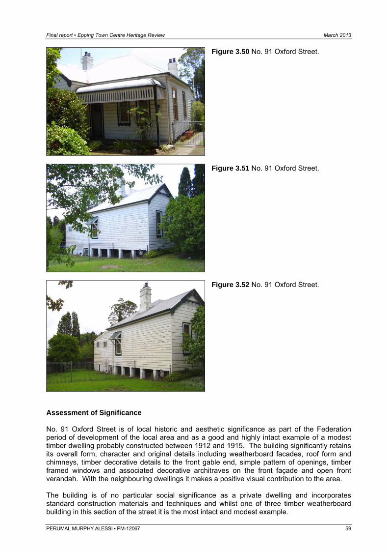
Final report ▪ Epping Town Centre Heritage Review March 2013
Figure 3.50 No. 91 Oxford Street.
Figure 3.51 No. 91 Oxford Street.
Figure 3.52 No. 91 Oxford Street.
Assessment of Significance No. 91 Oxford Street is of local historic and aesthetic significance as part of the Federation period of development of the local area and as a good and highly intact example of a modest timber dwelling probably constructed between 1912 and 1915. The building significantly retains its overall form, character and original details including weatherboard facades, roof form and chimneys, timber decorative details to the front gable end, simple pattern of openings, timber framed windows and associated decorative architraves on the front façade and open front verandah. With the neighbouring dwellings it makes a positive visual contribution to the area. The building is of no particular social significance as a private dwelling and incorporates standard construction materials and techniques and whilst one of three timber weatherboard building in this section of the street it is the most intact and modest example.
PERUMAL MURPHY ALESSI ▪ PM-12067 59
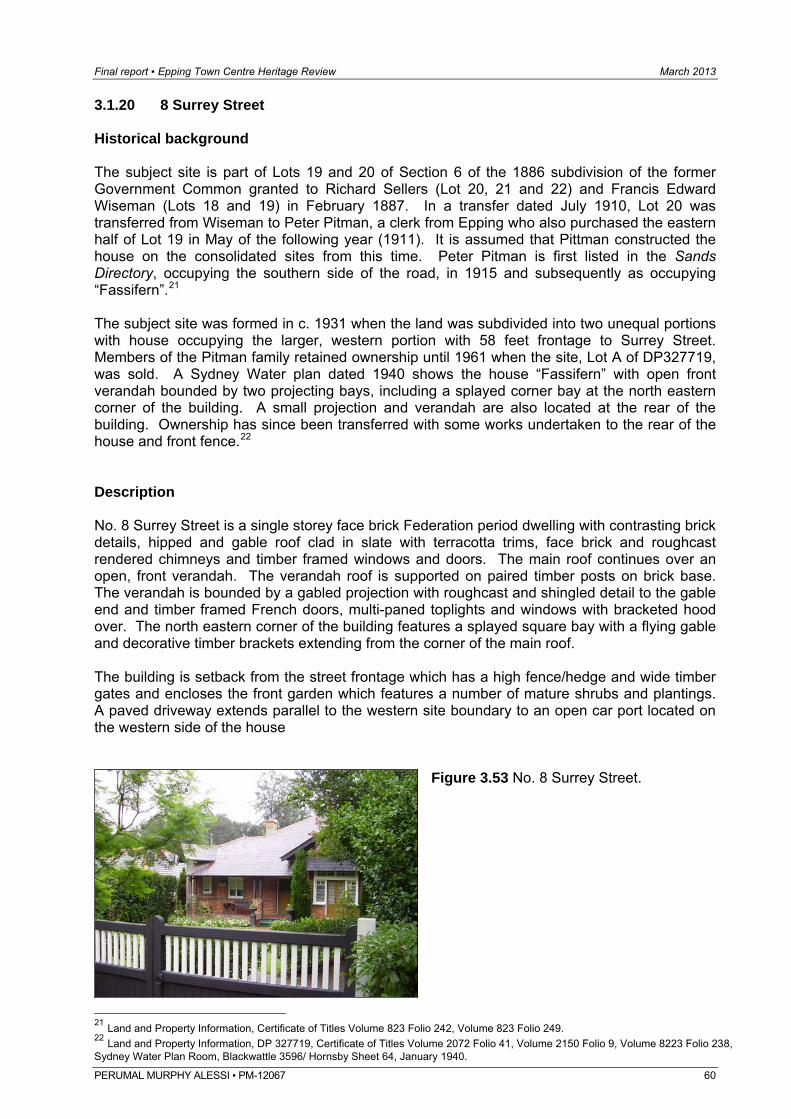
Final report ▪ Epping Town Centre Heritage Review March 2013
3.1.20 8 Surrey Street Historical background The subject site is part of Lots 19 and 20 of Section 6 of the 1886 subdivision of the former Government Common granted to Richard Sellers (Lot 20, 21 and 22) and Francis Edward Wiseman (Lots 18 and 19) in February 1887. In a transfer dated July 1910, Lot 20 was transferred from Wiseman to Peter Pitman, a clerk from Epping who also purchased the eastern half of Lot 19 in May of the following year (1911). It is assumed that Pittman constructed the house on the consolidated sites from this time. Peter Pitman is first listed in the Sands Directory, occupying the southern side of the road, in 1915 and subsequently as occupying “Fassifern”.21 The subject site was formed in c. 1931 when the land was subdivided into two unequal portions with house occupying the larger, western portion with 58 feet frontage to Surrey Street. Members of the Pitman family retained ownership until 1961 when the site, Lot A of DP327719, was sold. A Sydney Water plan dated 1940 shows the house “Fassifern” with open front verandah bounded by two projecting bays, including a splayed corner bay at the north eastern corner of the building. A small projection and verandah are also located at the rear of the building. Ownership has since been transferred with some works undertaken to the rear of the house and front fence.22 Description No. 8 Surrey Street is a single storey face brick Federation period dwelling with contrasting brick details, hipped and gable roof clad in slate with terracotta trims, face brick and roughcast rendered chimneys and timber framed windows and doors. The main roof continues over an open, front verandah. The verandah roof is supported on paired timber posts on brick base. The verandah is bounded by a gabled projection with roughcast and shingled detail to the gable end and timber framed French doors, multi-paned toplights and windows with bracketed hood over. The north eastern corner of the building features a splayed square bay with a flying gable and decorative timber brackets extending from the corner of the main roof. The building is setback from the street frontage which has a high fence/hedge and wide timber gates and encloses the front garden which features a number of mature shrubs and plantings. A paved driveway extends parallel to the western site boundary to an open car port located on the western side of the house
Figure 3.53 No. 8 Surrey Street.
21 Land and Property Information, Certificate of Titles Volume 823 Folio 242, Volume 823 Folio 249. 22 Land and Property Information, DP 327719, Certificate of Titles Volume 2072 Folio 41, Volume 2150 Folio 9, Volume 8223 Folio 238, Sydney Water Plan Room, Blackwattle 3596/ Hornsby Sheet 64, January 1940.
PERUMAL MURPHY ALESSI ▪ PM-12067 60
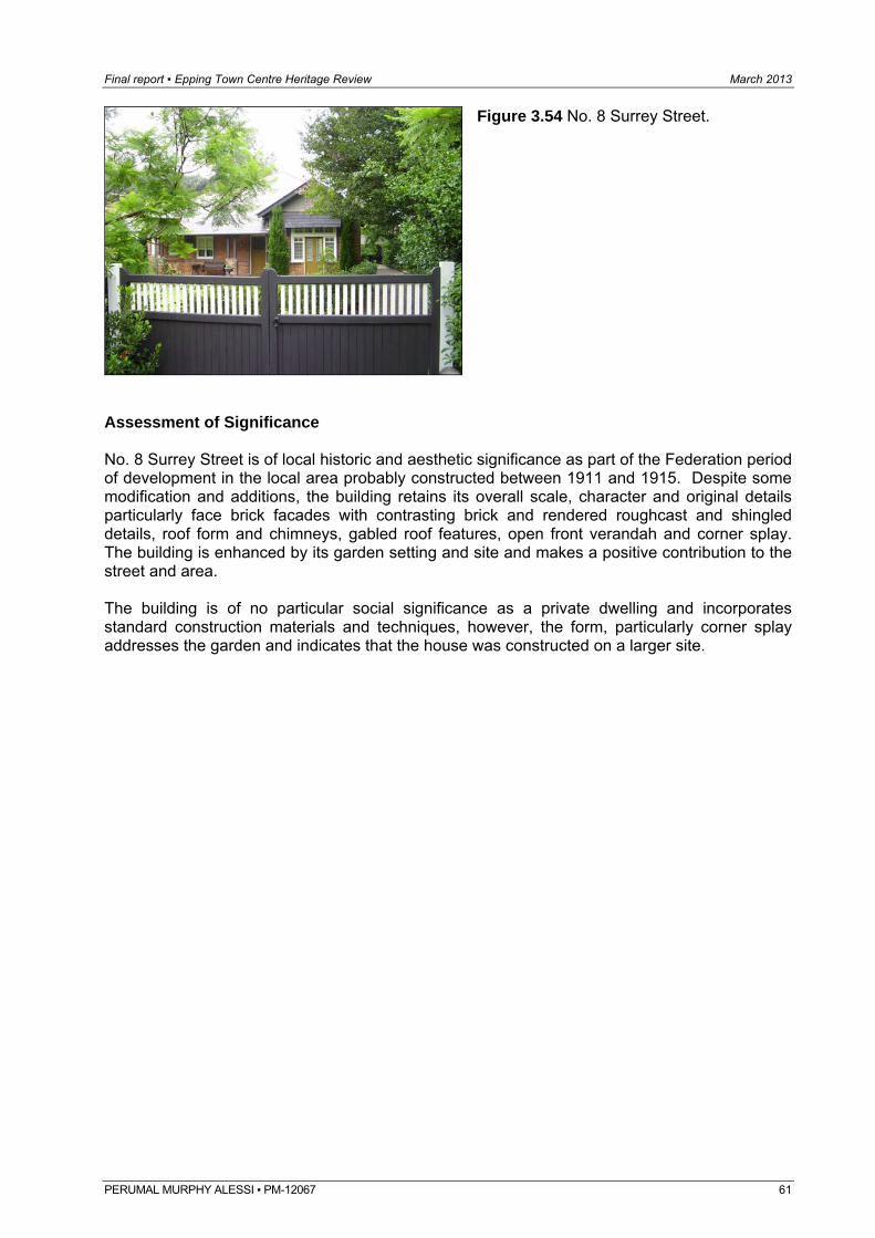
Final report ▪ Epping Town Centre Heritage Review March 2013
Figure 3.54 No. 8 Surrey Street.
Assessment of Significance No. 8 Surrey Street is of local historic and aesthetic significance as part of the Federation period of development in the local area probably constructed between 1911 and 1915. Despite some modification and additions, the building retains its overall scale, character and original details particularly face brick facades with contrasting brick and rendered roughcast and shingled details, roof form and chimneys, gabled roof features, open front verandah and corner splay. The building is enhanced by its garden setting and site and makes a positive contribution to the street and area. The building is of no particular social significance as a private dwelling and incorporates standard construction materials and techniques, however, the form, particularly corner splay addresses the garden and indicates that the house was constructed on a larger site.
PERUMAL MURPHY ALESSI ▪ PM-12067 61
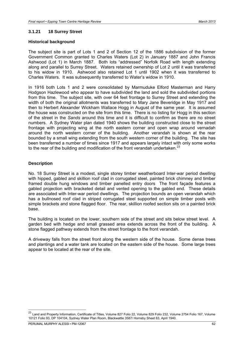
Final report ▪ Epping Town Centre Heritage Review March 2013
PERUMAL MURPHY ALESSI ▪ PM-12067 62
3.1.21 18 Surrey Street Historical background The subject site is part of Lots 1 and 2 of Section 12 of the 1886 subdivision of the former Government Common granted to Charles Waters (Lot 2) in January 1887 and John Francis Ashwood (Lot 1) in March 1887. Both lots “addressed” Norfolk Road with length extending along and parallel to Surrey Street. Waters retained ownership of Lot 2 until it was transferred to his widow in 1910. Ashwood also retained Lot 1 until 1902 when it was transferred to Charles Waters. It was subsequently transferred to Water’s widow in 1910. In 1916 both Lots 1 and 2 were consolidated by Marmuduke Elford Masterman and Harry Hodgson Hazlewood who appear to have subdivided the land and sold the subdivided portions from this time. The subject site, with over 64 feet frontage to Surrey Street and extending the width of both the original allotments was transferred to Mary Jane Beveridge in May 1917 and then to Herbert Alexander Wickham Wallace Hogg in August of the same year. It is assumed the house was constructed on the site from this time. There is no listing for Hogg in this section of the street in the Sands around this time and it is difficult to confirm as there are no street numbers. A Sydney Water plan dated 1940 shows the building constructed close to the street frontage with projecting wing at the north eastern corner and open wrap around vernadah around the north western corner of the building. Another verandah is shown at the rear bounded by a small wing extending from the south western corner of the building. The site has been transferred a number of times since 1917 and appears largely intact with only some works to the rear of the building and modification of the front verandah undertaken.23 Description No. 18 Surrey Street is a modest, single storey timber weatherboard Inter-war period dwelling with hipped, gabled and skillion roof clad in corrugated steel, painted brick chimney and timber framed double hung windows and timber panelled entry doors The front façade features a gabled projection with bracketed detail and vented opening to the gabled end. These details are associated with Inter-war period dwellings. The projection bounds an open verandah which has a bullnosed roof clad in striped corrugated steel supported on simple timber posts with simple brackets and stone flagged floor. The rear, skillion roofed section sits on a painted brick base. The building is located on the lower, southern side of the street and sits below street level. A garden bed with hedge and small grassed area extends across the front of the building. A stone flagged pathway extends from the street frontage to the front verandah. A driveway falls from the street front along the western side of the house. Some dense trees and plantings and a water tank are located on the eastern side of the house. Some large trees appear to be located at the rear of the site.
23 Land and Property Information, Certificate of Titles, Volume 827 Folio 22, Volume 829 Folio 232, Volume 2754 Folio 167, Volume 10121 Folio 93, DP 104104, Sydney Water Plan Room, Blackwattle 3587/ Hornsby Sheet 63, April 1940.
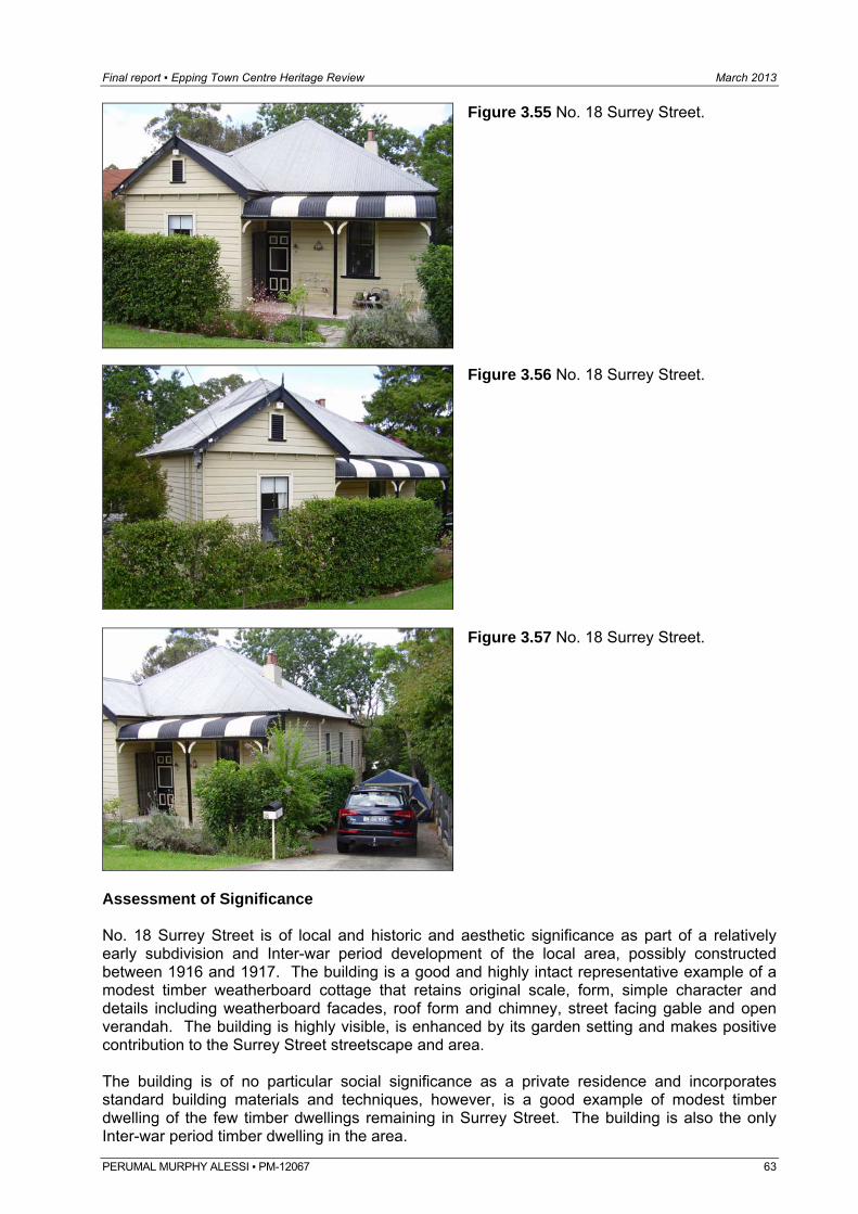
Final report ▪ Epping Town Centre Heritage Review March 2013
Figure 3.55 No. 18 Surrey Street.
Figure 3.56 No. 18 Surrey Street.
Figure 3.57 No. 18 Surrey Street.
Assessment of Significance No. 18 Surrey Street is of local and historic and aesthetic significance as part of a relatively early subdivision and Inter-war period development of the local area, possibly constructed between 1916 and 1917. The building is a good and highly intact representative example of a modest timber weatherboard cottage that retains original scale, form, simple character and details including weatherboard facades, roof form and chimney, street facing gable and open verandah. The building is highly visible, is enhanced by its garden setting and makes positive contribution to the Surrey Street streetscape and area. The building is of no particular social significance as a private residence and incorporates standard building materials and techniques, however, is a good example of modest timber dwelling of the few timber dwellings remaining in Surrey Street. The building is also the only Inter-war period timber dwelling in the area.
PERUMAL MURPHY ALESSI ▪ PM-12067 63
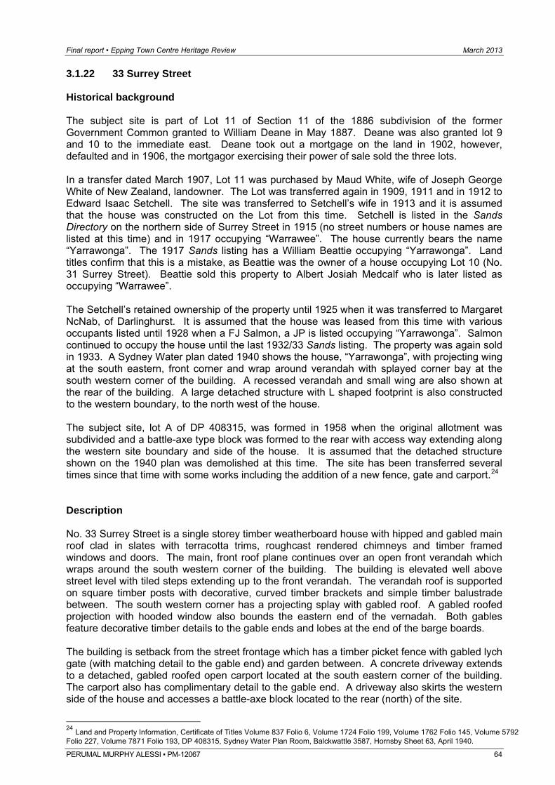
Final report ▪ Epping Town Centre Heritage Review March 2013
PERUMAL MURPHY ALESSI ▪ PM-12067 64
3.1.22 33 Surrey Street Historical background The subject site is part of Lot 11 of Section 11 of the 1886 subdivision of the former Government Common granted to William Deane in May 1887. Deane was also granted lot 9 and 10 to the immediate east. Deane took out a mortgage on the land in 1902, however, defaulted and in 1906, the mortgagor exercising their power of sale sold the three lots. In a transfer dated March 1907, Lot 11 was purchased by Maud White, wife of Joseph George White of New Zealand, landowner. The Lot was transferred again in 1909, 1911 and in 1912 to Edward Isaac Setchell. The site was transferred to Setchell’s wife in 1913 and it is assumed that the house was constructed on the Lot from this time. Setchell is listed in the Sands Directory on the northern side of Surrey Street in 1915 (no street numbers or house names are listed at this time) and in 1917 occupying “Warrawee”. The house currently bears the name “Yarrawonga”. The 1917 Sands listing has a William Beattie occupying “Yarrawonga”. Land titles confirm that this is a mistake, as Beattie was the owner of a house occupying Lot 10 (No. 31 Surrey Street). Beattie sold this property to Albert Josiah Medcalf who is later listed as occupying “Warrawee”. The Setchell’s retained ownership of the property until 1925 when it was transferred to Margaret NcNab, of Darlinghurst. It is assumed that the house was leased from this time with various occupants listed until 1928 when a FJ Salmon, a JP is listed occupying “Yarrawonga”. Salmon continued to occupy the house until the last 1932/33 Sands listing. The property was again sold in 1933. A Sydney Water plan dated 1940 shows the house, “Yarrawonga”, with projecting wing at the south eastern, front corner and wrap around verandah with splayed corner bay at the south western corner of the building. A recessed verandah and small wing are also shown at the rear of the building. A large detached structure with L shaped footprint is also constructed to the western boundary, to the north west of the house. The subject site, lot A of DP 408315, was formed in 1958 when the original allotment was subdivided and a battle-axe type block was formed to the rear with access way extending along the western site boundary and side of the house. It is assumed that the detached structure shown on the 1940 plan was demolished at this time. The site has been transferred several times since that time with some works including the addition of a new fence, gate and carport.24 Description No. 33 Surrey Street is a single storey timber weatherboard house with hipped and gabled main roof clad in slates with terracotta trims, roughcast rendered chimneys and timber framed windows and doors. The main, front roof plane continues over an open front verandah which wraps around the south western corner of the building. The building is elevated well above street level with tiled steps extending up to the front verandah. The verandah roof is supported on square timber posts with decorative, curved timber brackets and simple timber balustrade between. The south western corner has a projecting splay with gabled roof. A gabled roofed projection with hooded window also bounds the eastern end of the vernadah. Both gables feature decorative timber details to the gable ends and lobes at the end of the barge boards. The building is setback from the street frontage which has a timber picket fence with gabled lych gate (with matching detail to the gable end) and garden between. A concrete driveway extends to a detached, gabled roofed open carport located at the south eastern corner of the building. The carport also has complimentary detail to the gable end. A driveway also skirts the western side of the house and accesses a battle-axe block located to the rear (north) of the site.
24 Land and Property Information, Certificate of Titles Volume 837 Folio 6, Volume 1724 Folio 199, Volume 1762 Folio 145, Volume 5792 Folio 227, Volume 7871 Folio 193, DP 408315, Sydney Water Plan Room, Balckwattle 3587, Hornsby Sheet 63, April 1940.
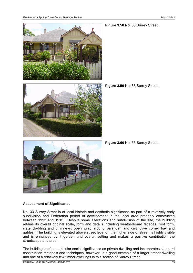
Final report ▪ Epping Town Centre Heritage Review March 2013
Figure 3.58 No. 33 Surrey Street.
Figure 3.59 No. 33 Surrey Street.
Figure 3.60 No. 33 Surrey Street.
Assessment of Significance No. 33 Surrey Street is of local historic and aesthetic significance as part of a relatively early subdivision and Federation period of development in the local area probably constructed between 1912 and 1915. Despite some alterations and subdivision of the site, the building retains its overall original scale, form and details including weatherboard facades, roof form, slate cladding and chimneys, open wrap around verandah and distinctive corner bay and gables. The building is elevated above street level on the higher side of street, is highly visible and is enhanced by it garden and overall setting and makes a positive contribution the streetscape and area. The building is of no particular social significance as private dwelling and incorporates standard construction materials and techniques, however, is a good example of a larger timber dwelling and one of a relatively few timber dwellings in this section of Surrey Street. PERUMAL MURPHY ALESSI ▪ PM-12067 65
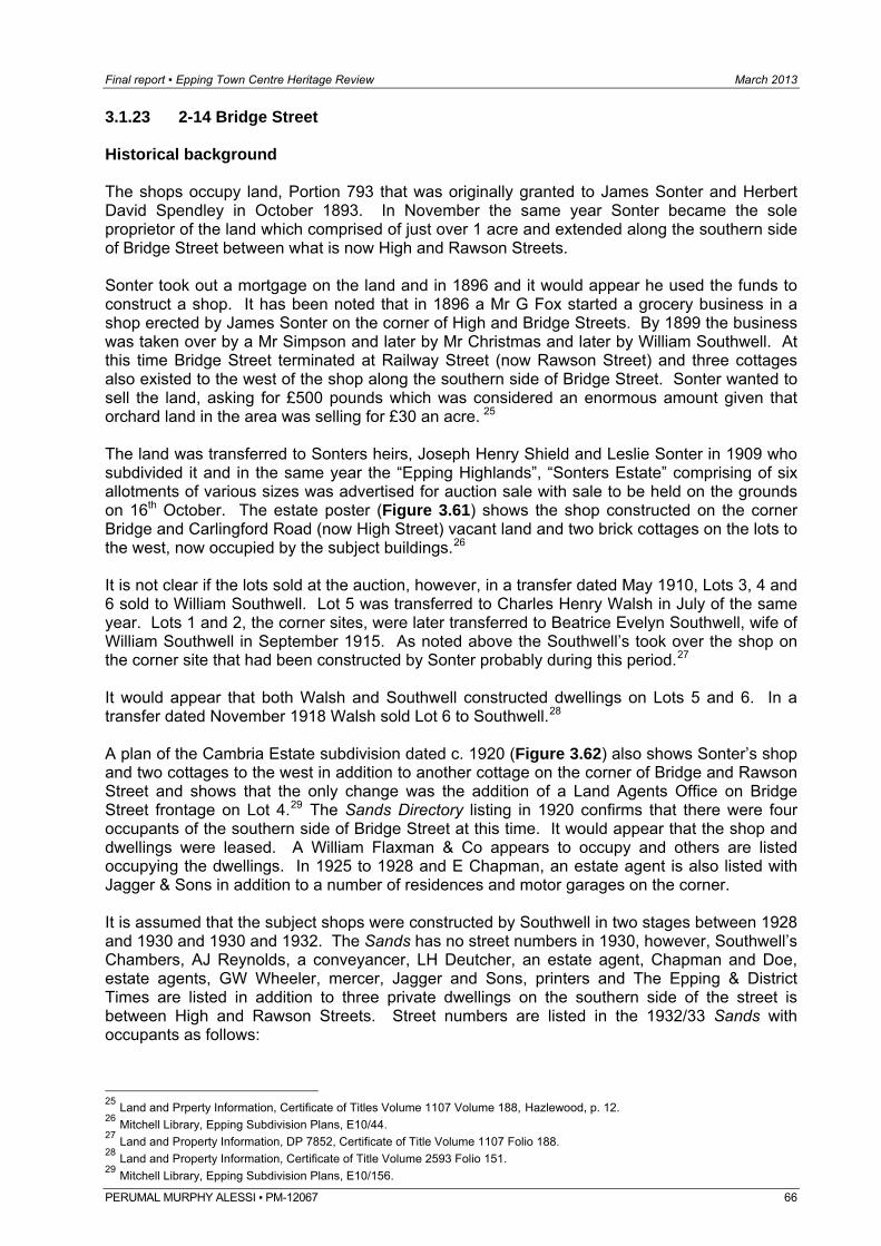
Final report ▪ Epping Town Centre Heritage Review March 2013
PERUMAL MURPHY ALESSI ▪ PM-12067 66
3.1.23 2-14 Bridge Street Historical background The shops occupy land, Portion 793 that was originally granted to James Sonter and Herbert David Spendley in October 1893. In November the same year Sonter became the sole proprietor of the land which comprised of just over 1 acre and extended along the southern side of Bridge Street between what is now High and Rawson Streets. Sonter took out a mortgage on the land and in 1896 and it would appear he used the funds to construct a shop. It has been noted that in 1896 a Mr G Fox started a grocery business in a shop erected by James Sonter on the corner of High and Bridge Streets. By 1899 the business was taken over by a Mr Simpson and later by Mr Christmas and later by William Southwell. At this time Bridge Street terminated at Railway Street (now Rawson Street) and three cottages also existed to the west of the shop along the southern side of Bridge Street. Sonter wanted to sell the land, asking for £500 pounds which was considered an enormous amount given that orchard land in the area was selling for £30 an acre. 25 The land was transferred to Sonters heirs, Joseph Henry Shield and Leslie Sonter in 1909 who subdivided it and in the same year the “Epping Highlands”, “Sonters Estate” comprising of six allotments of various sizes was advertised for auction sale with sale to be held on the grounds on 16th October. The estate poster (Figure 3.61) shows the shop constructed on the corner Bridge and Carlingford Road (now High Street) vacant land and two brick cottages on the lots to the west, now occupied by the subject buildings.26 It is not clear if the lots sold at the auction, however, in a transfer dated May 1910, Lots 3, 4 and 6 sold to William Southwell. Lot 5 was transferred to Charles Henry Walsh in July of the same year. Lots 1 and 2, the corner sites, were later transferred to Beatrice Evelyn Southwell, wife of William Southwell in September 1915. As noted above the Southwell’s took over the shop on the corner site that had been constructed by Sonter probably during this period.27 It would appear that both Walsh and Southwell constructed dwellings on Lots 5 and 6. In a transfer dated November 1918 Walsh sold Lot 6 to Southwell.28 A plan of the Cambria Estate subdivision dated c. 1920 (Figure 3.62) also shows Sonter’s shop and two cottages to the west in addition to another cottage on the corner of Bridge and Rawson Street and shows that the only change was the addition of a Land Agents Office on Bridge Street frontage on Lot 4.29 The Sands Directory listing in 1920 confirms that there were four occupants of the southern side of Bridge Street at this time. It would appear that the shop and dwellings were leased. A William Flaxman & Co appears to occupy and others are listed occupying the dwellings. In 1925 to 1928 and E Chapman, an estate agent is also listed with Jagger & Sons in addition to a number of residences and motor garages on the corner. It is assumed that the subject shops were constructed by Southwell in two stages between 1928 and 1930 and 1930 and 1932. The Sands has no street numbers in 1930, however, Southwell’s Chambers, AJ Reynolds, a conveyancer, LH Deutcher, an estate agent, Chapman and Doe, estate agents, GW Wheeler, mercer, Jagger and Sons, printers and The Epping & District Times are listed in addition to three private dwellings on the southern side of the street is between High and Rawson Streets. Street numbers are listed in the 1932/33 Sands with occupants as follows:
25 Land and Prperty Information, Certificate of Titles Volume 1107 Volume 188, Hazlewood, p. 12. 26 Mitchell Library, Epping Subdivision Plans, E10/44. 27 Land and Property Information, DP 7852, Certificate of Title Volume 1107 Folio 188. 28 Land and Property Information, Certificate of Title Volume 2593 Folio 151. 29 Mitchell Library, Epping Subdivision Plans, E10/156.
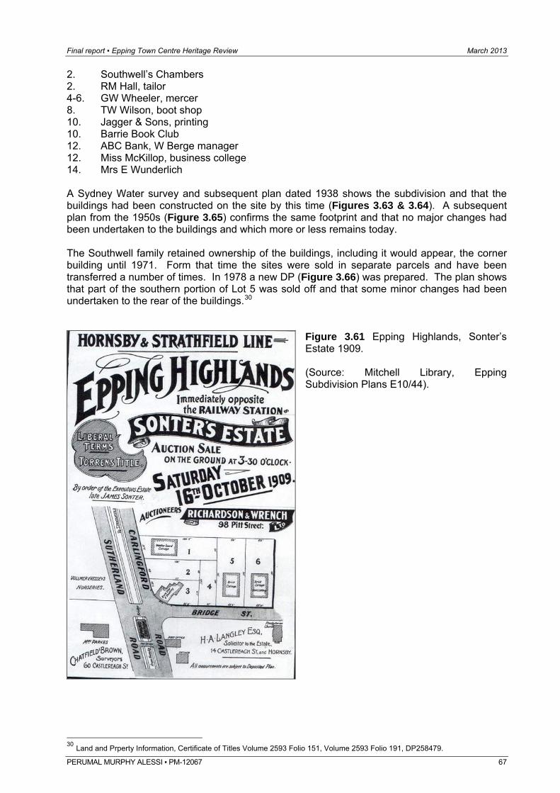
Final report ▪ Epping Town Centre Heritage Review March 2013
2. Southwell’s Chambers 2. RM Hall, tailor 4-6. GW Wheeler, mercer 8. TW Wilson, boot shop 10. Jagger & Sons, printing 10. Barrie Book Club 12. ABC Bank, W Berge manager 12. Miss McKillop, business college 14. Mrs E Wunderlich A Sydney Water survey and subsequent plan dated 1938 shows the subdivision and that the buildings had been constructed on the site by this time (Figures 3.63 & 3.64). A subsequent plan from the 1950s (Figure 3.65) confirms the same footprint and that no major changes had been undertaken to the buildings and which more or less remains today. The Southwell family retained ownership of the buildings, including it would appear, the corner building until 1971. Form that time the sites were sold in separate parcels and have been transferred a number of times. In 1978 a new DP (Figure 3.66) was prepared. The plan shows that part of the southern portion of Lot 5 was sold off and that some minor changes had been undertaken to the rear of the buildings.30
Figure 3.61 Epping Highlands, Sonter’s Estate 1909. (Source: Mitchell Library, Epping Subdivision Plans E10/44).
30 Land and Prperty Information, Certificate of Titles Volume 2593 Folio 151, Volume 2593 Folio 191, DP258479. PERUMAL MURPHY ALESSI ▪ PM-12067 67
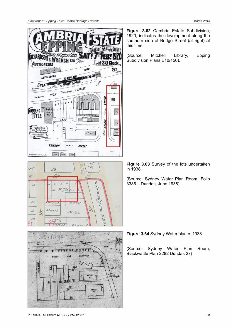
Final report ▪ Epping Town Centre Heritage Review March 2013
Figure 3.62 Cambria Estate Subdivision, 1920, indicates the development along the southern side of Bridge Street (at right) at this time. (Source: Mitchell Library, Epping Subdivision Plans E10/156).
PERUMAL MURPHY ALESSI ▪ PM-12067 68
Figure 3.63 Survey of the lots undertaken in 1938. (Source: Sydney Water Plan Room, Folio 3386 – Dundas, June 1938)
Figure 3.64 Sydney Water plan c. 1938 (Source: Sydney Water Plan Room, Blackwattle Plan 2282 Dundas 27)
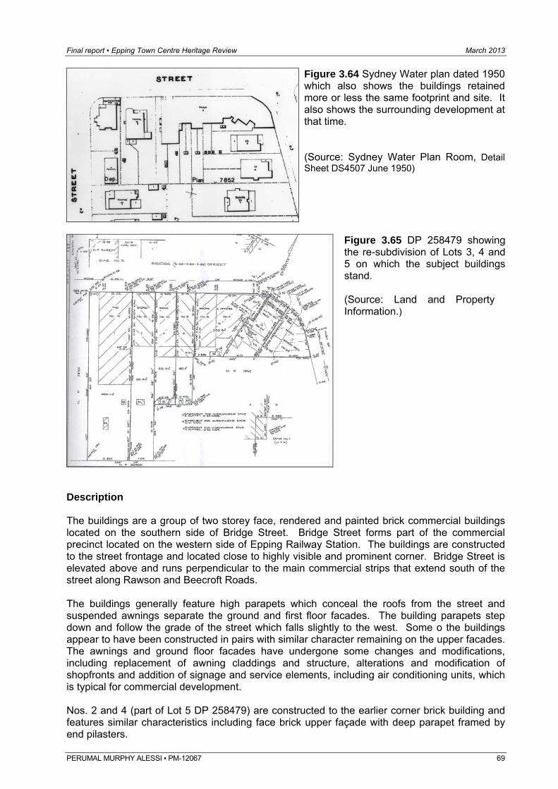
Final report ▪ Epping Town Centre Heritage Review March 2013
Figure 3.64 Sydney Water plan dated 1950 which also shows the buildings retained more or less the same footprint and site. It also shows the surrounding development at that time. (Source: Sydney Water Plan Room, Detail Sheet DS4507 June 1950)
Figure 3.65 DP 258479 showing the re-subdivision of Lots 3, 4 and 5 on which the subject buildings stand. (Source: Land and Property Information.)
Description The buildings are a group of two storey face, rendered and painted brick commercial buildings located on the southern side of Bridge Street. Bridge Street forms part of the commercial precinct located on the western side of Epping Railway Station. The buildings are constructed to the street frontage and located close to highly visible and prominent corner. Bridge Street is elevated above and runs perpendicular to the main commercial strips that extend south of the street along Rawson and Beecroft Roads. The buildings generally feature high parapets which conceal the roofs from the street and suspended awnings separate the ground and first floor facades. The building parapets step down and follow the grade of the street which falls slightly to the west. Some o the buildings appear to have been constructed in pairs with similar character remaining on the upper facades. The awnings and ground floor facades have undergone some changes and modifications, including replacement of awning claddings and structure, alterations and modification of shopfronts and addition of signage and service elements, including air conditioning units, which is typical for commercial development. Nos. 2 and 4 (part of Lot 5 DP 258479) are constructed to the earlier corner brick building and features similar characteristics including face brick upper façade with deep parapet framed by end pilasters.
PERUMAL MURPHY ALESSI ▪ PM-12067 69
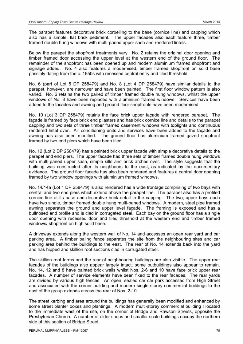
Final report ▪ Epping Town Centre Heritage Review March 2013
PERUMAL MURPHY ALESSI ▪ PM-12067 70
The parapet features decorative brick corbelling to the base (cornice line) and capping which also has a simple, flat brick pediment. The upper facades also each feature three, timber framed double hung windows with multi-paned upper sash and rendered lintels. Below the parapet the shopfront treatments vary. No. 2 retains the original door opening and timber framed door accessing the upper level at the western end of the ground floor. The remainder of the shopfront has been opened up and modern aluminium framed shopfront and signage added. No. 4 also features a modernised, timber framed shopfront on solid base possibly dating from the c. 1950s with recessed central entry and tiled threshold. No. 6 (part of Lot 5 DP 258479) and No. 8 (Lot 4 DP 258479) have similar details to the parapet, however, are narrower and have been painted. The first floor window pattern is also varied. No. 6 retains the two paired of timber framed double hung windows, whilst the upper windows of No. 8 have been replaced with aluminium framed windows. Services have been added to the facades and awning and ground floor shopfronts have been modernised. No. 10 (Lot 3 DP 258479) retains the face brick upper façade with rendered parapet. The façade is framed by face brick end pilasters and has brick cornice line and details to the parapet capping and two sets of three timber framed casement windows with toplights and continuous rendered lintel over. Air conditioning units and services have been added to the façade and awning has also been modified. The ground floor has aluminium framed gazed shopfront framed by two end piers which have been tiled. No. 12 (Lot 2 DP 258479) has a painted brick upper facade with simple decorative details to the parapet and end piers. The upper facade had three sets of timber framed double hung windows with multi-paned upper sash, simple sills and brick arches over. The style suggests that the building was constructed after its neighbours to the east, as indicated by the documentary evidence. The ground floor facade has also been rendered and features a central door opening framed by two window openings with aluminium framed windows. No. 14/14a (Lot 1 DP 258479) is also rendered has a wide frontage comprising of two bays with central and two end piers which extend above the parapet line. The parapet also has a profiled cornice line at its base and decorative brick detail to the capping. The two, upper bays each have two single, timber framed double hung multi-paned windows. A modern, steel pipe framed awning separates the ground and upper level façade. The framing is exposed and has a bullnosed end profile and is clad in corrugated steel. Each bay on the ground floor has a single door opening with recessed door and tiled threshold at the western end and timber framed windows/ shopfront on high solid base. A driveway extends along the western wall of No. 14 and accesses an open rear yard and car parking area. A timber paling fence separates the site from the neighbouring sites and car parking area behind the buildings to the east. The rear of No. 14 extends back into the yard and has hipped and skillion roof sections clad in corrugated steel. The skillion roof forms and the rear of neighbouring buildings are also visible. The upper rear facades of the buildings also appear largely intact, some outbuildings also appear to remain. No. 14, 12 and 8 have painted brick walls whilst Nos. 2-6 and 10 have face brick upper rear facades. A number of service elements have been fixed to the rear facades. The rear yards are divided by various high fences. An open, sealed car car park accessed from High Street and associated with the corner building and modern single storey commercial buildings to the east of the group extends across the rear of Nos. 2-10. The street kerbing and area around the buildings has generally been modified and enhanced by some street planter boxes and plantings. A modern multi-storey commercial building I located to the immediate west of the site, on the corner of Bridge and Rawson Streets, opposite the Presbyterian Church. A number of older shops and smaller scale buildings occupy the northern side of this section of Bridge Street.
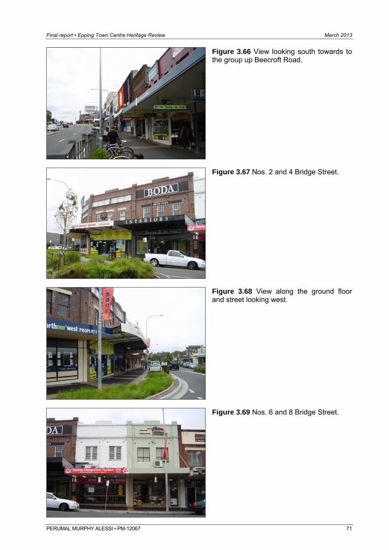
Final report ▪ Epping Town Centre Heritage Review March 2013
Figure 3.66 View looking south towards to the group up Beecroft Road.
Figure 3.67 Nos. 2 and 4 Bridge Street.
Figure 3.68 View along the ground floor and street looking west.
Figure 3.69 Nos. 6 and 8 Bridge Street.
PERUMAL MURPHY ALESSI ▪ PM-12067 71
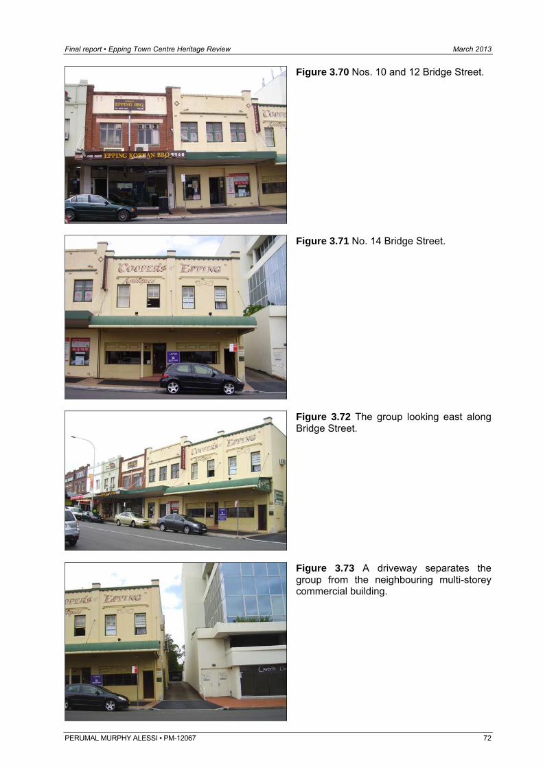
Final report ▪ Epping Town Centre Heritage Review March 2013
Figure 3.70 Nos. 10 and 12 Bridge Street.
Figure 3.71 No. 14 Bridge Street.
Figure 3.72 The group looking east along Bridge Street.
Figure 3.73 A driveway separates the group from the neighbouring multi-storey commercial building.
PERUMAL MURPHY ALESSI ▪ PM-12067 72
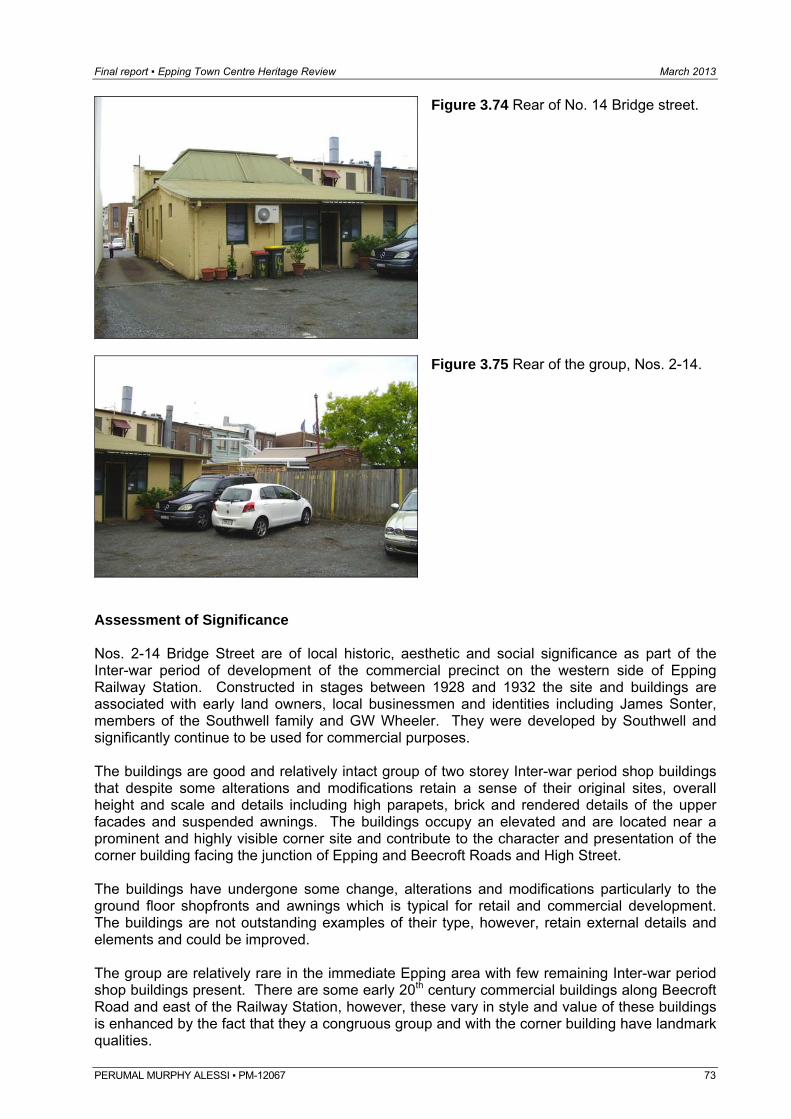
Final report ▪ Epping Town Centre Heritage Review March 2013
Figure 3.74 Rear of No. 14 Bridge street.
Figure 3.75 Rear of the group, Nos. 2-14.
Assessment of Significance Nos. 2-14 Bridge Street are of local historic, aesthetic and social significance as part of the Inter-war period of development of the commercial precinct on the western side of Epping Railway Station. Constructed in stages between 1928 and 1932 the site and buildings are associated with early land owners, local businessmen and identities including James Sonter, members of the Southwell family and GW Wheeler. They were developed by Southwell and significantly continue to be used for commercial purposes. The buildings are good and relatively intact group of two storey Inter-war period shop buildings that despite some alterations and modifications retain a sense of their original sites, overall height and scale and details including high parapets, brick and rendered details of the upper facades and suspended awnings. The buildings occupy an elevated and are located near a prominent and highly visible corner site and contribute to the character and presentation of the corner building facing the junction of Epping and Beecroft Roads and High Street. The buildings have undergone some change, alterations and modifications particularly to the ground floor shopfronts and awnings which is typical for retail and commercial development. The buildings are not outstanding examples of their type, however, retain external details and elements and could be improved. The group are relatively rare in the immediate Epping area with few remaining Inter-war period shop buildings present. There are some early 20th century commercial buildings along Beecroft Road and east of the Railway Station, however, these vary in style and value of these buildings is enhanced by the fact that they a congruous group and with the corner building have landmark qualities.
PERUMAL MURPHY ALESSI ▪ PM-12067 73
Final report ▪ Epping Town Centre Heritage Review March 2013
PERUMAL MURPHY ALESSI ▪ PM-12067 74
4.0 Assessment & significance
4.1 Evaluation criteria The assessment of heritage significance is based on the the current evaluation criteria published by the New South Wales Heritage Branch. Criterion (a) – An item is important in the course, or pattern, of NSW’s cultural or
natural history (or the cultural or natural history of the area) Criterion (b) - An item has strong or special association with the life or works of a
person, or group of persons, of importance in NSW’s cultural or natural history (or the cultural or natural history of the area)
Criterion (c) - An item is important in demonstrating aesthetic characteristics
and/or a high degree of creative or technical achievement in NSW (or the cultural or natural history of the area)
Criterion (d) - An item has strong or special association with a particular
community or cultural group in NSW (or area) for social, cultural or spiritual reasons
Criterion (e) - An item has potential to yield information that will contribute to an
understanding of NSW’s cultural or natural history (or the cultural or natural history of the area)
Criterion (f) - An item possesses uncommon, rare or endangered aspects of
NSW’s cultural or natural history (or the cultural or natural history of the area)
Criterion (g) - An item is important in demonstrating the principal characteristics
of a class of NSW’s (or area’s) • cultural or natural places; or • cultural or natural environments.
(or a class of the local area’s cultural or natural places; or
• cultural or natural environments) 4.2 Proposed heritage conservation areas Based on a review of the history and development of the area and current physical context, condition and integrity of the built environment, it is considered that the previous assessment for the proposed East Epping HCA, Essex Street HCA and Rosebank Avenue HCA stands. All areas continue to exhibit the early subdivision patterns and wave of residential development and retain good and highly intact examples of Federation, Inter-war and Post War housing. The built context is enhanced by the wide street proportions and street layout, native trees and plantings and a sense of the early character and topography of the area and garden settings which overall contribute to the character and significance of the area and Hornsby LGA
Final report ▪ Epping Town Centre Heritage Review March 2013
PERUMAL MURPHY ALESSI ▪ PM-12067 75
4.2.1 Assessment of Significance – East Epping HCA Criterion (a) – An item is important in the course, or pattern, of NSW’s cultural or
natural history (or the cultural or natural history of the area) The area is of local historic significance as one of the first subdivisions and parts of Epping to be subdivided for residential development. Despite some site amalgamations and re-subdivisions, the area largely retains its original subdivision and streetscape pattern. The area retains evidence of its major periods of development that reflect the growth and development and major changes in the local area and shift from a rural and farming community to centralised residential and low scale commercial area. Criterion (c) - An item is important in demonstrating aesthetic characteristics
and/or a high degree of creative or technical achievement in NSW (or the cultural or natural history of the area)
The area is characterised by good and largely intact examples of the Federation, Inter-war and Post-war detached housing in the Epping area. Some early buildings also remain. The built context is also enhanced by the wide street proportions, street trees and garden settings and plantings which make a positive contribution to the area. Criterion (d) - An item has strong or special association with a particular
community or cultural group in NSW (or area) for social, cultural or spiritual reasons
Epping Public School is a major feature of the area and is of some social significance to the local community. Established in 1900 as a result of the growth and development it has continued to be a local focus and has developed in accordance with local needs and requirements. The Uniting Church complex in Chester Street is also of some local social significance. Criterion (e) - An item has potential to yield information that will contribute to an
understanding of NSW’s cultural or natural history (or the cultural or natural history of the area)
The area retains some rock forms, undulating streets, sloping sites and a number of mature native trees and plantings which indicate the early natural character and topography of the area. Criterion (f) - An item possesses uncommon, rare or endangered aspects of
NSW’s cultural or natural history (or the cultural or natural history of the area)
The area retains a number of earlier timber weatherboard houses and one early stone dwelling which are relatively rare in the local area. Criterion (g) - An item is important in demonstrating the principal characteristics
of a class of NSW’s (or area’s) • cultural or natural places; or • cultural or natural environments.
(or a class of the local area’s
Final report ▪ Epping Town Centre Heritage Review March 2013
PERUMAL MURPHY ALESSI ▪ PM-12067 76
cultural or natural places; or
• cultural or natural environments) The area is a good and relatively intact representative example of late 19th and early 20th century suburban residential subdivision and development. Statement of Significance The East Epping Heritage Conservation Area is of high local historic and aesthetic significance as a good representative example of late 19th century subdivision that retains a good and relatively intact collection of Federation, Inter-war and Post-war period residential development that represents the major period of growth and development of the Epping area. The area significantly retains most of its original 1886 subdivision and streetscape pattern with mostly single detached houses including a number of good and highly intact examples of Federation and Inter-war period houses. The area also retains some earlier examples and overall built context is enhanced by the local topography and native plantings, wide street proportions, street trees and garden settings. The Church and School sites located in the area are also of some historic and social significance to the local community. 4.2.2 Assessment of Significance – Essex Street HCA Criterion (a) – An item is important in the course, or pattern, of NSW’s cultural or
natural history (or the cultural or natural history of the area) The area is of local historic significance as part of an early subdivision and early 20th residential development. Despite some site amalgamations and re-subdivisions, the area largely retains a sense of its original subdivision pattern that represents the early 20th century shift from a rural to a residential and suburban area. Criterion (c) - An item is important in demonstrating aesthetic characteristics
and/or a high degree of creative or technical achievement in NSW (or the cultural or natural history of the area)
The area is characterised by good and largely intact examples of the Federation and Inter-war period detached housing in the Epping area. Some good examples of Post-war development are also extant. The built context is also enhanced by the wide street proportions, street form and wide grassed verges, setbacks, garden settings and plantings which make a positive contribution to the area. Criterion (g) - An item is important in demonstrating the principal characteristics
of a class of NSW’s (or area’s) • cultural or natural places; or • cultural or natural environments.
(or a class of the local area’s cultural or natural places; or
• cultural or natural environments) The area is representative of the development of the Federation and Inter-war period suburban housing in the local area.
Final report ▪ Epping Town Centre Heritage Review March 2013
PERUMAL MURPHY ALESSI ▪ PM-12067 77
Statement of Significance The Essex Street Heritage Conservation Area is of local historic and aesthetic significance as part of an early subdivision in the local area and as a representative area of intact period housing mainly from the Federation and Inter-war periods which represents a major period of growth and development and shift from a rural to a suburban area. The area significantly retains a sense of the original subdivision pattern and and streetscape pattern with mostly single detached houses including a number of good and highly intact examples of Federation and Inter-war period houses. The built context is enhanced by the local topography, wide street proportions, setbacks and garden settings. 4.2.3 Assessment of Significance – Rosebank Avenue HCA Criterion (a) – An item is important in the course, or pattern, of NSW’s cultural or
natural history (or the cultural or natural history of the area) The area is of local historic significance as a fine and highly intact example of an Inter-war period housing development and streetscape that retains its original subdivision pattern, building stock and natural features. Criterion (c) - An item is important in demonstrating aesthetic characteristics
and/or a high degree of creative or technical achievement in NSW (or the cultural or natural history of the area)
The area is characterised by good and largely intact examples of the Inter-war period detached housing that retain their original form, character and details and a range of stylistic elements relating to that era. The buildings have common setbacks which contribute to the streetscape pattern and rhythm. The built context is also enhanced by the wide street proportions, street trees and creek line, garden settings and plantings which make a positive contribution to the area. Criterion (f) - An item possesses uncommon, rare or endangered aspects of
NSW’s cultural or natural history (or the cultural or natural history of the area)
Rosebank Avenue has been identified as being a rear and best example of an intact Inter-war housing development in the Hornsby LGA. Other examples exist in other parts of NSW and Australia. Criterion (g) - An item is important in demonstrating the principal characteristics
of a class of NSW’s (or area’s) • cultural or natural places; or • cultural or natural environments.
(or a class of the local area’s cultural or natural places; or
• cultural or natural environments) The area is a good and highly intact representative example of Inter-war period suburban subdivision and development that retains its original subdivision pattern, housing stock and associated gardens and features and natural features.
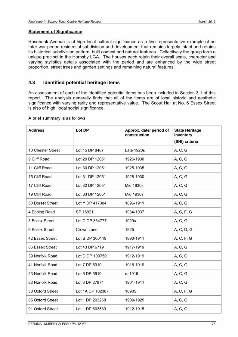
Final report ▪ Epping Town Centre Heritage Review March 2013
PERUMAL MURPHY ALESSI ▪ PM-12067 78
Statement of Significance Rosebank Avenue is of high local cultural significance as a fine representative example of an Inter-war period residential subdivision and development that remains largely intact and retains its historical subdivision pattern, built context and natural features. Collectively the group form a unique precinct in the Hornsby LGA. The houses each retain their overall scale, character and varying stylistics details associated with the period and are enhanced by the wide street proportion, street trees and garden settings and remaining natural features. 4.3 Identified potential heritage items An assessment of each of the identified potential items has been included in Section 3.1 of this report. The analysis generally finds that all of the items are of local historic and aesthetic significance with varying rarity and representative value. The Scout Hall at No. 6 Essex Street is also of high, local social significance. A brief summary is as follows: Address
Lot DP Approx. date/ period of construction
State Heritage Inventory (SHI) criteria
10 Chester Street Lot 15 DP 8487 Late 1920s A, C, G
9 Cliff Road Lot 29 DP 12051 1926-1930 A, C, G
11 Cliff Road Lot 30 DP 12051 1925-1935 A, C, G
15 Cliff Road Lot 31 DP 12051 1928-1930 A, C, G
17 Cliff Road Lot 32 DP 12051 Mid 1930s A, C, G
19 Cliff Road Lot 33 DP 12051 Mid 1930s A, C, G
50 Dorset Street Lot Y DP 417304 1896-1911 A, C, G
4 Epping Road SP 16921 1934-1937 A, C, F, G
3 Essex Street Lot C DP 334777 1920s A, C, G
6 Essex Street Crown Land 1925 A, C, D, G
42 Essex Street Lot B DP 300119 1890-1911 A, C, F, G
86 Essex Street Lot 43 DP 6719 1917-1919 A, C, G
39 Norfolk Road Lot D DP 100750 1912-1919 A, C, G
41 Norfolk Road Lot 7 DP 5910 1916-1919 A, C, G
43 Norfolk Road Lot 6 DP 5910 c. 1916 A, C, G
83 Norfolk Road Lot 3 DP 27874 1901-1911 A, C, G
38 Oxford Street Lot 1A DP 102387 1890S A, C, F, G
85 Oxford Street Lot 1 DP 203268 1909-1925 A, C, G
91 Oxford Street Lot 1 DP 603589 1912-1915 A, C, G
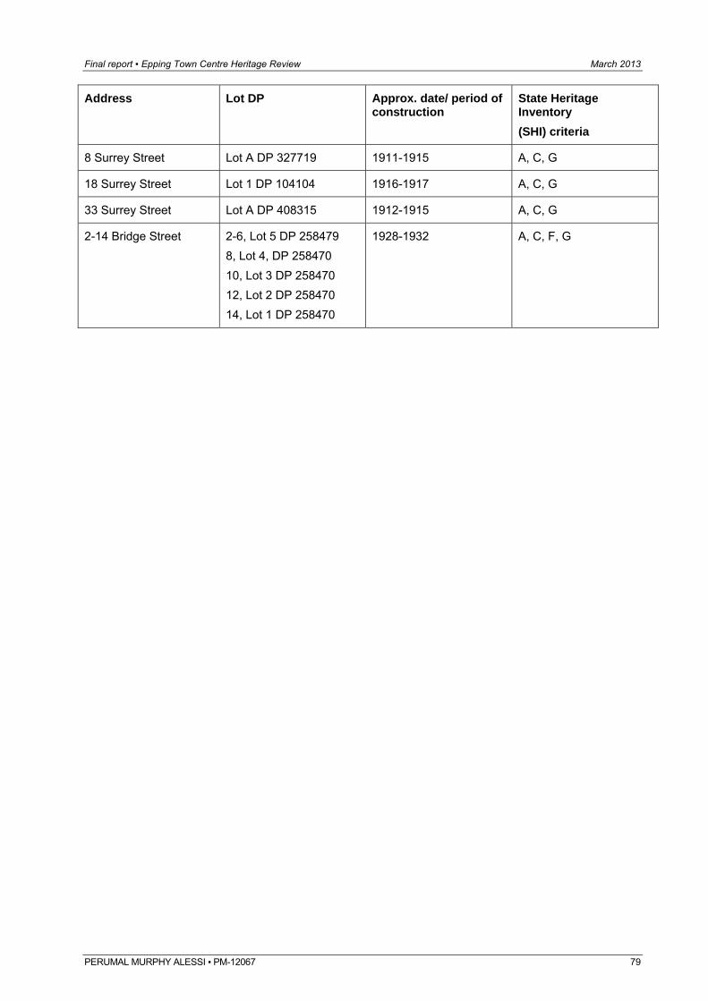
Final report ▪ Epping Town Centre Heritage Review March 2013
PERUMAL MURPHY ALESSI ▪ PM-12067 79
Address
Lot DP Approx. date/ period of construction
State Heritage Inventory (SHI) criteria
8 Surrey Street Lot A DP 327719 1911-1915 A, C, G
18 Surrey Street Lot 1 DP 104104 1916-1917 A, C, G
33 Surrey Street Lot A DP 408315 1912-1915 A, C, G
2-14 Bridge Street 2-6, Lot 5 DP 258479 8, Lot 4, DP 258470 10, Lot 3 DP 258470 12, Lot 2 DP 258470 14, Lot 1 DP 258470
1928-1932 A, C, F, G
Final report ▪ Epping Town Centre Heritage Review March 2013
PERUMAL MURPHY ALESSI ▪ PM-12067 80
5.0 Guidelines & recommendations
5.1 East Epping HCA Based on the recent inspection and above assessment, it is recommended that:
the proposed boundary be retained and expanded to include Nos. 1 and 3 Essex Street, Nos. 6-22 Chester Street, Nos. 52-70 and 65-83 Chester Street, Nos. 40-48 Norfolk Road and Nos. 23-49 Surrey Street.
Inclusion of the properties in the south eastern section of Chester Street (Nos. 6-22 Chester Street and Nos. 1 and 3 Essex Street) will protect the setting of the heritage item at the corner of Chester and Oxford Street (the Uniting Church) and streetscape character of this section of Chester Street. Similarly the eastern end of Chester Street should be included due to the number of contributory items and in a sense to protect the area around the heritage listed item at No. 70 Chester Street. Also the properties in the north eastern section of Surrey Street to protect heritage listed items in the block (Nos. 40 and 44 Norfolk Road) and streetscape character of that section of Norfolk Road and Surry Street. The contributory items are listed as follows: Pembroke Street: No. 25; Norfolk Road: Nos. 2-16, 9, 11, 15, 17, 19, 21, 24, 33, 36, 38, 35, 39, 41, 43, 45, 36, 38, 40, 42, 44, 46, 48; Essex Street: Nos. 1 and 3; Chester Street: Nos. 6, 8, 10, 12, 14, 16, 18, 20, 22, 17, 21, 23, 25, 25A, 33, 35, 37, 39, 41, 43, 45, 47, 49, 51, 55, 57, 58, 61, 26, 30, 32, 36, 38, 40, 48, 52, 58, 60, 62, 70, 65, 67, 69, 71, 73, 77, 79, 81 and 83; Surrey Street: 6, 8, 12, 15, 17, 18, 21, 23, 29, 31, 33, 35, 37, 39, 45, 49, 18, 30, 32, 34, 36, 38, 40, 44, 46, and 48; Oxford Street: 72, 72A, 74, 76, 78, 82, 84, 86, 73A, 75, 77, 79, 81, 85, 87, 91 and 93; Sussex Street: 1, 3, 7, 11, 15, 2, 4, 6, 8, 10; Somerset Street: 14.
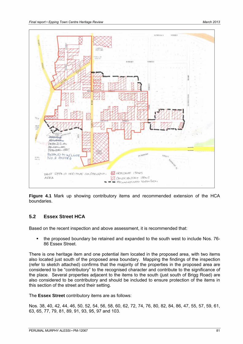
Final report ▪ Epping Town Centre Heritage Review March 2013
Figure 4.1 Mark up showing contributory items and recommended extension of the HCA boundaries.
5.2 Essex Street HCA Based on the recent inspection and above assessment, it is recommended that:
the proposed boundary be retained and expanded to the south west to include Nos. 76-86 Essex Street.
There is one heritage item and one potential item located in the proposed area, with two items also located just south of the proposed area boundary. Mapping the findings of the inspection (refer to sketch attached) confirms that the majority of the properties in the proposed area are considered to be “contributory” to the recognised character and contribute to the significance of the place. Several properties adjacent to the items to the south (just south of Brigg Road) are also considered to be contributory and should be included to ensure protection of the items in this section of the street and their setting. The Essex Street contributory items are as follows: Nos. 38, 40, 42, 44, 46, 50, 52, 54, 56, 58, 60, 62, 72, 74, 76, 80, 82, 84, 86, 47, 55, 57, 59, 61, 63, 65, 77, 79, 81, 89, 91, 93, 95, 97 and 103.
PERUMAL MURPHY ALESSI ▪ PM-12067 81
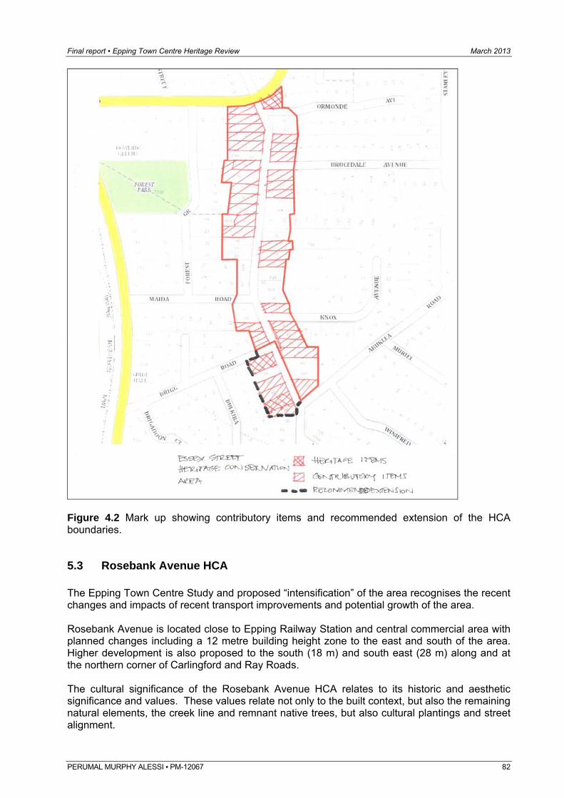
Final report ▪ Epping Town Centre Heritage Review March 2013
Figure 4.2 Mark up showing contributory items and recommended extension of the HCA boundaries.
5.3 Rosebank Avenue HCA The Epping Town Centre Study and proposed “intensification” of the area recognises the recent changes and impacts of recent transport improvements and potential growth of the area. Rosebank Avenue is located close to Epping Railway Station and central commercial area with planned changes including a 12 metre building height zone to the east and south of the area. Higher development is also proposed to the south (18 m) and south east (28 m) along and at the northern corner of Carlingford and Ray Roads. The cultural significance of the Rosebank Avenue HCA relates to its historic and aesthetic significance and values. These values relate not only to the built context, but also the remaining natural elements, the creek line and remnant native trees, but also cultural plantings and street alignment.
PERUMAL MURPHY ALESSI ▪ PM-12067 82
Final report ▪ Epping Town Centre Heritage Review March 2013
PERUMAL MURPHY ALESSI ▪ PM-12067 83
The proposed “density” changes will have no physical impact on the historic significance or subdivision pattern which will be retained and will be protected by the HCA provisions. Similarly the style, scale and architectural character and merit of the individual buildings will also be protected by the HCA provisions. The prime concern is the visual impacts on the group and area and retention of a suitable “breathing space” and curtilage so that the buildings and surrounding context are not overwhelmed and or isolated. Based on the recent inspection and above assessment, it is recommended that:
the HCA boundary as proposed and including the properties, Nos. 1-21 Rosebank Avenue on the western side of the street and Nos. 2-18 Rosebank Avenue on the eastern side of the street be retained; and
a number of controls including for minimum setbacks, reduced heights and massing of potential new development on sites adjoining the HCA be introduced.
It is recognised that the some multi-storey development exists to the immediate east of the area and whilst they are visible within the context of the area they are not “overbearing”, however, the bulk and scale of the buildings appear to be reduced by the land fall and levels also retention of mature trees and planted setbacks and buffer zones. The 18 metre height zone on the sites to the south of the area around Cliff Road is of some concern as land is relatively flat and and would have greater visual impact. As such consideration could be given to extending the 12 m height buffer zone along the northern side of Cliff Road (Nos. 18-50) and properties about Hazlewood Place (Nos. 1-16). This would also provide a buffer and transition zone from the creek/ tree line and reserve to the north of these properties. The 18 metre zone could be retained for the six properties at the eastern bend of Cliff Road (No. 16) and addressing Ray Street (Nos. 9-15A) to form a transition to the proposed 28 and 48 metre zoning on the corner of Carlingford and Ray Roads. Specific controls may include:
retention of all mature street trees, particularly natives and wide grassed verges around the area particularly along Cliff Road;
retention of lower scale or stepped building form about the entry to Rosebank Avenue to prevent a “tunnel” effect and retain open views when looking north from Cliff Road;
setback and reduced heights of any development near the shared boundaries with the HCA;
provision of open space and planted buffer zone about the multilevel development; and use of articulated facades, varied and lighter building materials and setbacks of the
upper levels on any new building to reduce any potential visual impacts.
5.4 Identified potential heritage items The NSW Heritage Manual guideline document for Assessing Heritage Significance outlines a number of guidelines for inclusion or exclusion for each of the criteria. As noted above, all of the potential items are generally of some local historic and aesthetic significance with varying levels of rarity and representative values. Based on the above assessment and analysis the following is recommended:
Final report ▪ Epping Town Centre Heritage Review March 2013
PERUMAL MURPHY ALESSI ▪ PM-12067 84
Address
State Heritage Inventory (SHI) criteria
Recommended for listing
Comments
10 Chester Street A, C, G No The building is a representative example of a modest Inter-war period Bungalow of which there are a number of similar and better examples in the local and wider area, but should be listed as a “contributory” item.
9 Cliff Road A, C, G Yes It is recommended that the Cliff Road items be listed as a group item as a good and highly intact congruous group representing the mid 1920s to mid 1930s development of the local area. The group demonstrate adherence to a building covenant that required a particular quality, streetscape character and setbacks which with the subdivision pattern remain evident today
11 Cliff Road A, C, G
15 Cliff Road A, C, G
17 Cliff Road A, C, G
19 Cliff Road A, C, G
50 Dorset Street A, C, G Yes The building is a good and intact representative example of an early timber Federation period dwelling in the area. It is one of the oldest remaining houses in Dorset Street and retains its original character and a sense of its original setting.
4 Epping Road A, C, F, G Yes The building is a good and highly intact Inter-war period residential flat building with Art Deco and Old English details that is rare in the local area.
3 Essex Street A, C, G Yes The building is a good and highly intact representative example of a larger scale Inter-war period Bungalow in contrast to the more “modest” examples in the area.
6 Essex Street A, C, D, G Yes The Hall is of local historic, aesthetic and social significance as a purpose built Scout Hall that has had continuous use and significantly remains as a focus of the local Scout community.
42 Essex Street A, C, F, G Yes The building is significant due to its association with the Vollmer and Vessey families and Mount Tomah Nursery which was an early and major nursery in the local area. The building remains highly intact and is only one of two remaining examples of early weatherboard dwellings in the immediate area.
86 Essex Street A, C, G Yes Located on a prominent bend in the road it is an early Federation dwelling and is part of a congruous and intact group that demonstrate adherence to the original subdivision covenants which intended to provide quality buildings and streetscape character and rhythm with regular setbacks and gardens which is now relatively rare in Essex Street.
Final report ▪ Epping Town Centre Heritage Review March 2013
PERUMAL MURPHY ALESSI ▪ PM-12067 85
Address
State Heritage Inventory (SHI) criteria
Recommended for listing
Comments
39 Norfolk Road A, C, G Yes, could be listed as part of a group with Nos. 41 and 43.
The building retains its original character and details, is located on a rise in Norfolk Road and is part of a prominent group of good and largely intact Federation period dwellings that make a positive visual contribution to the street and area.
41 Norfolk Road A, C, G Yes Retains original subdivision lot, original character and details of the house. With Nos. 39 and 43 it forms part of a prominent group that make a positive visual contribution to the street and area.
43 Norfolk Road A, C, G Yes Retains original subdivision lot and original character and details. With Nos. 41 and 39 it forms part of a prominent group that make a positive visual contribution to the street and area.
83 Norfolk Road A, C, G Yes The building is a relatively early Federation period dwelling that remains in this section of Norfolk Road. The building is highly intact and retains a sense of its original setting and wide street frontage.
38 Oxford Street A, C, F, G Yes The building is rare remaining example of a Federation period shop and residence located on the eastern side of Epping Station. The building is also associated with local identity and businessman Richard Walker.
85 Oxford Street A, C, G Yes The building is a good example of a Federation/ Inter-war period timber weatherboard building that remains part of prominent group and is relatively rare.
91 Oxford Street A, C, G Yes The building is a good and highly intact example of a modest, timber weather board building that is also part of prominent and rare group.
8 Surrey Street A, C, G Yes The building is a good and highly intact example of a Federation period dwelling that occupies a larger site and is a prominent feature in the street.
18 Surrey Street A, C, G Yes The building is a good and highly intact example of a more modest, timber weatherboard building from the Inter-war period which is rare in the local area.
33 Surrey Street A, C, G Yes The building is a good and highly intact example of a Federation period timber weatherboard building which retain a rear verandah detail and is one of few timber buildings remaining in Surrey Street.
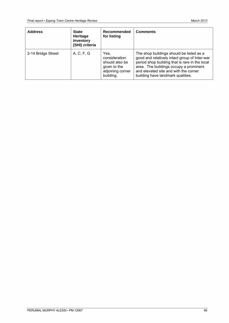
Final report ▪ Epping Town Centre Heritage Review March 2013
PERUMAL MURPHY ALESSI ▪ PM-12067 86
Address
State Heritage Inventory (SHI) criteria
Recommended for listing
Comments
2-14 Bridge Street A, C, F, G Yes, consideration should also be given to the adjoining corner building.
The shop buildings should be listed as a good and relatively intact group of Inter-war period shop building that is rare in the local area. The buildings occupy a prominent and elevated site and with the corner building have landmark qualities.