Embed Size (px)
Citation preview
rockE N G L A N D ’ S
The Prehistoric Rock Art of England:Recording, managing and enjoying our carved heritage
IntroductionAcross northern England the remains of thousands of enigmatic symbols can be foundcarved onto rocky outcrops and boulders. They range from simple circular hollows (known as ‘cups’) to complex combinations ofcups, rings, grooves, spirals, lozenges, andchevrons. Some occupy spectacular locations in the landscape, whilst others are found on prehistoric stone monuments or in burialmounds. These curious abstract designs werecreated by the Neolithic and Bronze Age peoplewho lived in these lands over four thousandyears ago. No-one knows their original purposeand they are one of the most intriguing elementsof the archaeological landscape.
Over the last few centuries the discovery andrecording of rock art in Britain has been pioneered by a handful of dedicated antiquariansand specialist amateur archaeologists. Increasinginterest has led to a huge increase in the quantityof carved stones recorded in recent years, and has drawn the attention of professional archaeologists and academics. At the same time, new recording technologies such as photogrammetry and laser scanning, togetherwith more established techniques such as excavation and surveying, are revealing newinformation and helping to shed fresh light onwhen and how rock art was used.
Although carved in stone, the rock art which survives in today’s landscape is very vulnerable.The condition of many rock art panels is deteriorating due to both human and naturalthreats. The creation of an accurate record of allrock art is fundamental to researching, protecting
and managing this fading link with our prehistoricpast. The England’s Rock Art (ERA) website and database:http://archaeologydataservice.ac.uk/eraprovide an important step towards this goal;starting with the pilot areas of Northumberlandand Durham, the intention is that it will eventuallyinclude a record of all rock art in England. The information for the pilot project wasgathered by trained volunteers over a three yearperiod, as part of the Northumberland andDurham Rock Art Project sponsored by EnglishHeritage and run by Northumberland andDurham County Councils. The project built onand incorporated the work of the NewcastleUniversity Beckensall Archive. As the geographical coverage of the database isextended across the country, using the bestpractices developed during the pilot project, the information collected will be used to inform management decisions which balance accessand education with conservation and protectionof this fragile resource.
This publication provides an overview of rock artin England, setting it in its wider British andEuropean context, and illustrates some of thechallenges of recording and protecting thisunique connection with our prehistoricancestors. Please remember: almost all our rockart is situated in the countryside and is privatelyowned. If you visit it, please treat it with respect;the responsibility for preserving these ancientcarvings rests with each one of us. Please respect property and always ensure youhave permission to access private land.
Dod Law, Northumberland. Photographed by T. Barnett.Dod Law, Northumberland. Photographed by T. Barnett.
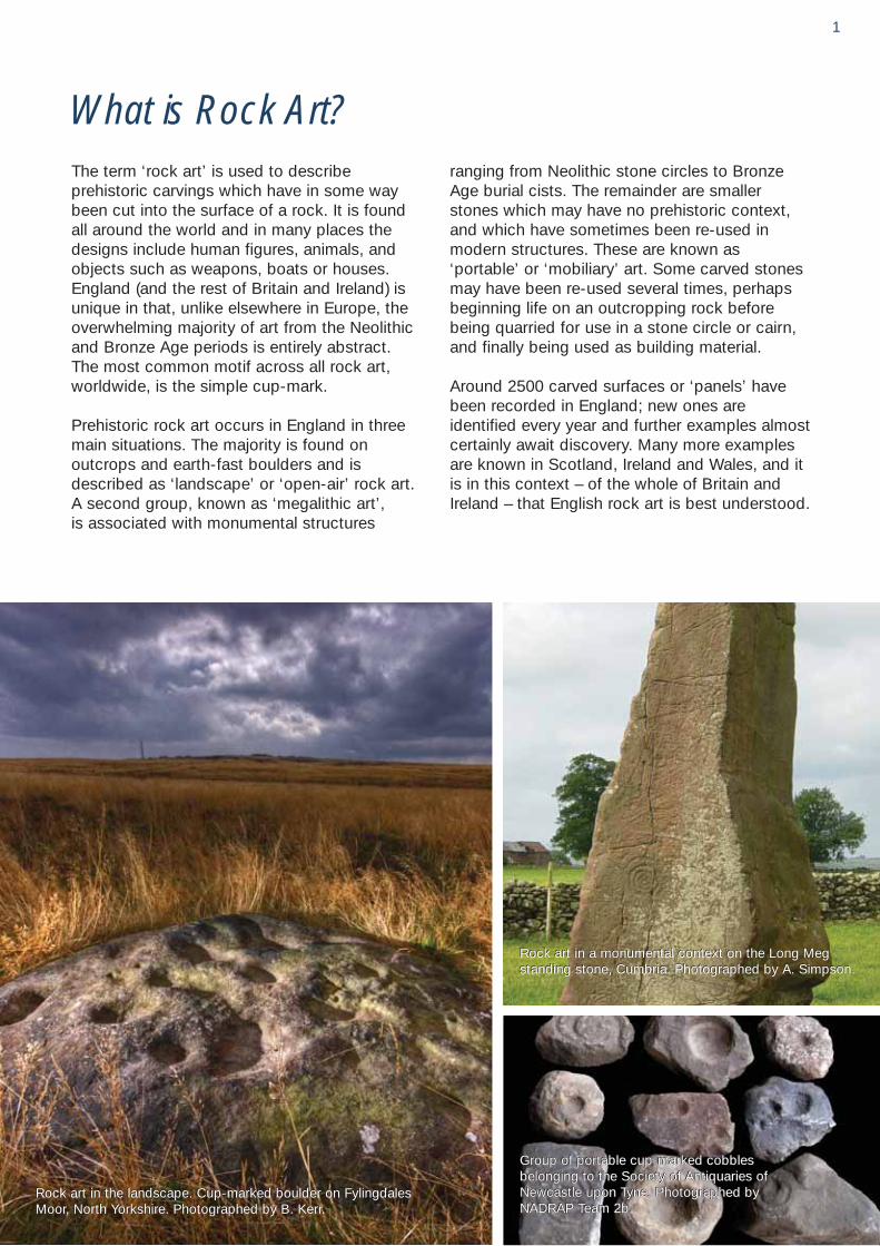
What is Rock Art?The term ‘rock art’ is used to describe prehistoric carvings which have in some waybeen cut into the surface of a rock. It is found all around the world and in many places thedesigns include human figures, animals, andobjects such as weapons, boats or houses.England (and the rest of Britain and Ireland) isunique in that, unlike elsewhere in Europe, theoverwhelming majority of art from the Neolithicand Bronze Age periods is entirely abstract. The most common motif across all rock art, worldwide, is the simple cup-mark.
Prehistoric rock art occurs in England in threemain situations. The majority is found on outcrops and earth-fast boulders and isdescribed as ‘landscape’ or ‘open-air’ rock art. A second group, known as ‘megalithic art’, is associated with monumental structures
ranging from Neolithic stone circles to BronzeAge burial cists. The remainder are smallerstones which may have no prehistoric context,and which have sometimes been re-used inmodern structures. These are known as‘portable’ or ‘mobiliary’ art. Some carved stonesmay have been re-used several times, perhapsbeginning life on an outcropping rock beforebeing quarried for use in a stone circle or cairn,and finally being used as building material.
Around 2500 carved surfaces or ‘panels’ havebeen recorded in England; new ones are identified every year and further examples almostcertainly await discovery. Many more examplesare known in Scotland, Ireland and Wales, and itis in this context – of the whole of Britain andIreland – that English rock art is best understood.
Group of portable cup-marked cobblesbelonging to the Society of Antiquaries ofNewcastle upon Tyne. Photographed byNADRAP Team 2b.
Group of portable cup-marked cobblesbelonging to the Society of Antiquaries ofNewcastle upon Tyne. Photographed byNADRAP Team 2b.
Group of portable cup-marked cobblesbelonging to the Society of Antiquaries ofNewcastle upon Tyne. Photographed byNADRAP Team 2b.
Rock art in a monumental context on the Long Megstanding stone, Cumbria. Photographed by A. Simpson.Rock art in a monumental context on the Long Megstanding stone, Cumbria. Photographed by A. Simpson.
Rock art in the landscape. Cup-marked boulder on FylingdalesMoor, North Yorkshire. Photographed by B. Kerr.Rock art in the landscape. Cup-marked boulder on FylingdalesMoor, North Yorkshire. Photographed by B. Kerr.
1
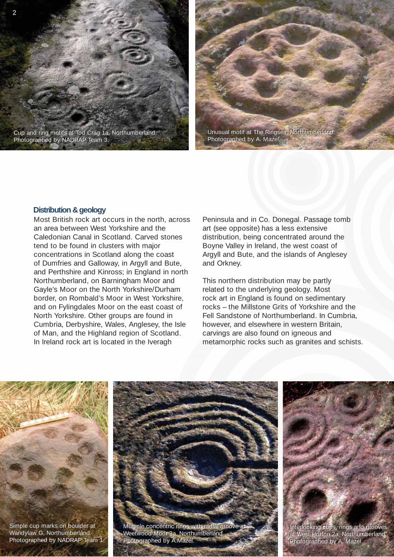
Most British rock art occurs in the north, acrossan area between West Yorkshire and theCaledonian Canal in Scotland. Carved stonestend to be found in clusters with major concentrations in Scotland along the coast of Dumfries and Galloway, in Argyll and Bute,and Perthshire and Kinross; in England in northNorthumberland, on Barningham Moor andGayle’s Moor on the North Yorkshire/Durhamborder, on Rombald’s Moor in West Yorkshire,and on Fylingdales Moor on the east coast ofNorth Yorkshire. Other groups are found inCumbria, Derbyshire, Wales, Anglesey, the Isle of Man, and the Highland region of Scotland. In Ireland rock art is located in the Iveragh
Peninsula and in Co. Donegal. Passage tomb art (see opposite) has a less extensive distribution, being concentrated around theBoyne Valley in Ireland, the west coast of Argyll and Bute, and the islands of Anglesey and Orkney.
This northern distribution may be partly related to the underlying geology. Most rock art in England is found on sedimentary rocks – the Millstone Grits of Yorkshire and theFell Sandstone of Northumberland. In Cumbria,however, and elsewhere in western Britain, carvings are also found on igneous and metamorphic rocks such as granites and schists.
Distribution & geology
Simple cup marks on boulder atWandylaw G, Northumberland.Photographed by NADRAP Team 1.
Simple cup marks on boulder atWandylaw G, Northumberland.Photographed by NADRAP Team 1.
Cup and ring motifs at Tod Crag 1a, Northumberland.Photographed by NADRAP Team 3.Cup and ring motifs at Tod Crag 1a, Northumberland.Photographed by NADRAP Team 3.
Unusual motif at The Ringses, Northumberland. Photographed by A. Mazel.Unusual motif at The Ringses, Northumberland. Photographed by A. Mazel.
Multiple concentric rings with radial groove atWeetwood Moor 3a. NorthumberlandPhotographed by A.Mazel.
Multiple concentric rings with radial groove atWeetwood Moor 3a. NorthumberlandPhotographed by A.Mazel.
Interlocking cups, rings and groovesat West Horton 2a, NorthumberlandPhotographed by A. Mazel.
Interlocking cups, rings and groovesat West Horton 2a, NorthumberlandPhotographed by A. Mazel.
12
By far the most common design element is thesimple cup-mark – a roughly circular hollow,usually between 3 and 10 cm in diameter andaround 2-3 cm deep. Also common in Britain are‘rings’ and ‘grooves’. These can occur individuallyor can be combined to form more complex motifssuch as the ‘cup-and-ring’ or ‘multiple, concentricrings’. Other, less common motifs includepenannulars (incomplete rings), spirals, ‘keyholes’,and ‘rosettes’. These can be combined in a varietyof ways and each panel appears to be unique,although two broad ‘traditions’ of rock art havebeen identified in Britain:
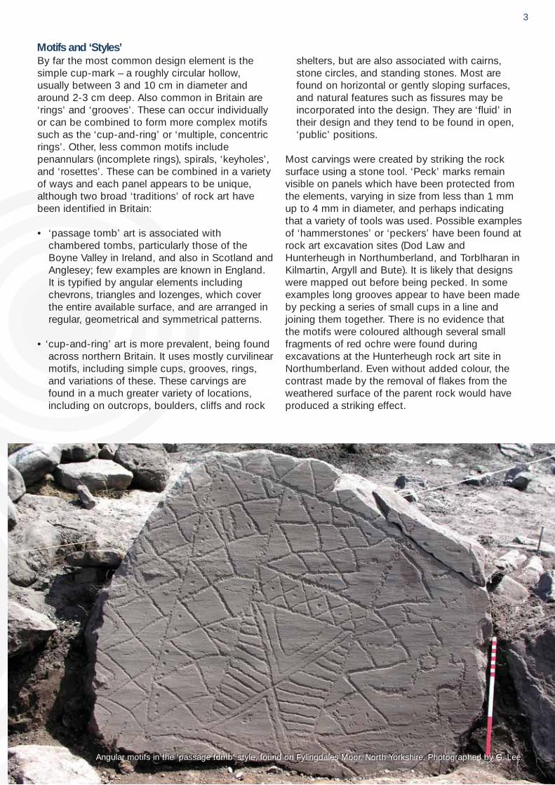
• ‘passage tomb’ art is associated with chambered tombs, particularly those of theBoyne Valley in Ireland, and also in Scotland andAnglesey; few examples are known in England. It is typified by angular elements includingchevrons, triangles and lozenges, which coverthe entire available surface, and are arranged inregular, geometrical and symmetrical patterns.
• ‘cup-and-ring’ art is more prevalent, being foundacross northern Britain. It uses mostly curvilinearmotifs, including simple cups, grooves, rings, and variations of these. These carvings arefound in a much greater variety of locations,including on outcrops, boulders, cliffs and rock
shelters, but are also associated with cairns,stone circles, and standing stones. Most arefound on horizontal or gently sloping surfaces,and natural features such as fissures may beincorporated into the design. They are ‘fluid’ intheir design and they tend to be found in open,‘public’ positions.
Most carvings were created by striking the rocksurface using a stone tool. ‘Peck’ marks remainvisible on panels which have been protected fromthe elements, varying in size from less than 1 mmup to 4 mm in diameter, and perhaps indicatingthat a variety of tools was used. Possible examplesof ‘hammerstones’ or ‘peckers’ have been found atrock art excavation sites (Dod Law andHunterheugh in Northumberland, and Torblharan inKilmartin, Argyll and Bute). It is likely that designswere mapped out before being pecked. In someexamples long grooves appear to have been madeby pecking a series of small cups in a line andjoining them together. There is no evidence thatthe motifs were coloured although several smallfragments of red ochre were found duringexcavations at the Hunterheugh rock art site inNorthumberland. Even without added colour, thecontrast made by the removal of flakes from theweathered surface of the parent rock would haveproduced a striking effect.
Motifs and ‘Styles’
Angular motifs in the ‘passage tomb’ style, found on Fylingdales Moor, North Yorkshire. Photographed by G. Lee.Angular motifs in the ‘passage tomb’ style, found on Fylingdales Moor, North Yorkshire. Photographed by G. Lee.
3
Understanding Rock ArtThe meaning of rock art has become lost in themists of time; no mention of it appears in thehistorical record until the late 17th century whenreference is first made to marks found on stonesfrom the Newgrange passage tomb in Ireland. In England it was not until the 1820s that the ‘cup-and-ring’ style of rock art was first noted at Old Bewick Hill in Northumberland by JohnCharles Langlands and reported by the localantiquarian, George Tate. Many theories havesince been put forward to account for the carvings but no-one has yet been able to unlock their secrets. However, researchers arenow extending the study of rock art to includethe surrounding topography, the soil beneath,and the wider archaeological landscape. Thisapproach is allowing us to explore questionssuch as the date of the carvings, whether different motif types reflect particular activitiesassociated with the use of a site, and whetherthere are regional traditions.
How old is it?Dating rock art precisely is extremely difficult;the abstract nature of the designs provides fewclues and they are rarely found with other typesof dateable evidence (although this partlyreflects the small number of excavations whichhave been undertaken at rock art sites). It hasbeen argued that the ‘cup-and-ring’ tradition is a Bronze Age phenomenon, but researchers nowbelieve that it is rooted firmly in the Neolithic(about 4000 to 6000 years ago). Simple cup-marks are known from undisputed earlierNeolithic contexts in Britain, for example in longcairns such as Dalladies in Aberdeenshire, datedto 3280 BC. Cup-marks and more complexmotifs also occur in Neolithic and Bronze Agemonuments and in some instances this may represent a re-use of stones which have beenremoved from their original context. A few examples of superimposition (where one motifoverlies an earlier one) have been identified but
these can only tell us about the relative age ofeach motif. Another way to determine the relative age of carvings is to look at the degreeof weathering visible (see Case Study 1).Comparisons with other types of decorated artifacts from other sites may provide furtherclues to the approximate age of rock art. The Late Neolithic Folkton Drums from EastYorkshire are elaborately carved with geometricalpatterns and designs resembling stylized humanfaces. Linear and hatched patterns have alsobeen found on pieces of chalk in various contexts, several dated to the Neolithic. These have been compared to the ‘passagetomb’ style of carvings and with the decorationon some types of Neolithic pottery. Many ofthese decorated objects can be considered‘special’ items, often found in what are considered to be ritual contexts. This may implythat the designs are related by more than simplya period in time or by geographical distribution.
The relationship between the ‘passage tomb’and ‘cup-and-ring’ traditions is unclear. There isa large degree of overlap, with ‘passage tomb’motifs occurring in other monuments, such asstone circles, and also in the landscape as atAchnabrek in Argyll, Scotland, and at Morwick inNorthumberland. Conversely, simple cups and‘cup-and-ring’ motifs are often found alongsidethe geometric designs of passage tombs. In general, the ‘cup-and-ring’ tradition in Britainappears to fall within the period between 4000and 1500 BC, with ‘passage tomb’ art occurringbetween 3500 and 2000 BC. However it isunlikely that British rock art was a uniform phenomenon, and the various practices probablyhad different life-spans in different regions, withsome motifs being more widespread or morepersistent than others.
4
Excavating rock artArchaeological investigations around rock artpanels in Scandinavia, Ireland, Scotland andEngland are challenging previously held viewsof how rock art was used. These investigationshave demonstrated considerable activity associated with some carved rocks and aroundclusters of rock art panels. Excavations haveuncovered pavements of mud and cobbles abutting carved panels, with huge quantities of stone tools scattered over them. These features were associated with pits containing burnt animal bone and other charred remains, and stone tools and waste material were deliberately jammed into natural fissures in the carved rock. The chronological relationshipbetween these features and the carvingsremains uncertain, but the data strongly suggest that rock art played a part in activitiesthat may have involved fire, feasting and offerings.
ConnectionsOne approach to understanding British rock arthas been to study similarities in style betweenthe rock art traditions of Britain and Ireland andthose of continental Europe. Some believe thetradition may have originated in Portugal andSpain and that the coastal distribution of rockart may reflect northwards maritime travel in thecurrents of the Gulf Stream, with northern connections to Scandinavia. But this would notaccount for inland clusters, such as those ofWest Yorkshire or the Derbyshire Peak District;nor would it explain the relative absence of rock art on the Cumbrian coast. So did British rockart develop in isolation, was it stimulated by diffusion of ideas or was it brought more directlyby colonising communities? There is little evidence to suggest where such ideas or peoplemay have originated. The ubiquitous cup-markappears to have developed in diverse and dispersed cultures across the world lendingweight to arguments that these simple designs(and the urge to create them) are somehowhard-wired into the human psyche.
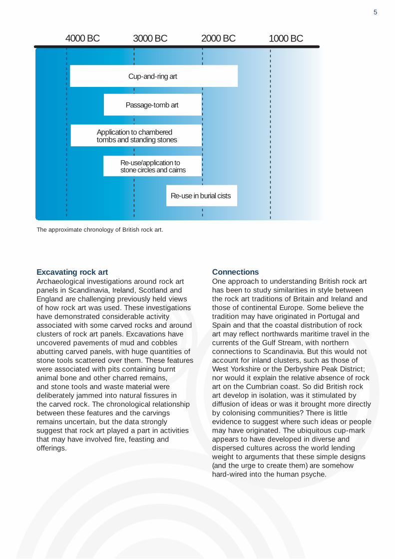
4000 BC 3000 BC 2000 BC 1000 BC
Cup-and-ring art
Passage-tomb art
Application to chamberedtombs and standing stones
Re-use/application tostone circles and cairns
Re-use in burial cists
The approximate chronology of British rock art.
5
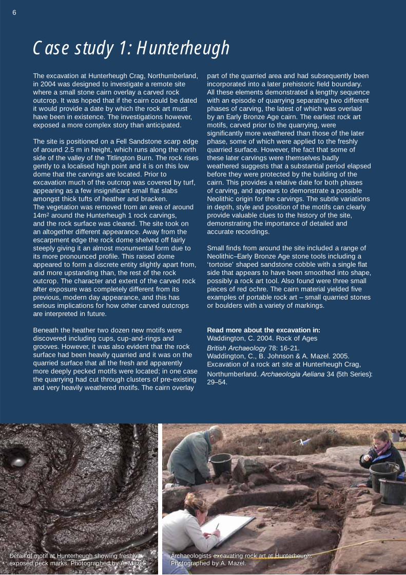
The excavation at Hunterheugh Crag, Northumberland,in 2004 was designed to investigate a remote sitewhere a small stone cairn overlay a carved rockoutcrop. It was hoped that if the cairn could be datedit would provide a date by which the rock art musthave been in existence. The investigations however,exposed a more complex story than anticipated.
The site is positioned on a Fell Sandstone scarp edgeof around 2.5 m in height, which runs along the northside of the valley of the Titlington Burn. The rock risesgently to a localised high point and it is on this lowdome that the carvings are located. Prior to excavation much of the outcrop was covered by turf,appearing as a few insignificant small flat slabsamongst thick tufts of heather and bracken. The vegetation was removed from an area of around 14m2 around the Hunterheugh 1 rock carvings, and the rock surface was cleared. The site took on an altogether different appearance. Away from theescarpment edge the rock dome shelved off fairlysteeply giving it an almost monumental form due toits more pronounced profile. This raised domeappeared to form a discrete entity slightly apart from,and more upstanding than, the rest of the rock outcrop. The character and extent of the carved rockafter exposure was completely different from its previous, modern day appearance, and this has serious implications for how other carved outcropsare interpreted in future.
Beneath the heather two dozen new motifs were discovered including cups, cup-and-rings andgrooves. However, it was also evident that the rocksurface had been heavily quarried and it was on thequarried surface that all the fresh and apparentlymore deeply pecked motifs were located; in one casethe quarrying had cut through clusters of pre-existingand very heavily weathered motifs. The cairn overlay
part of the quarried area and had subsequently beenincorporated into a later prehistoric field boundary. All these elements demonstrated a lengthy sequencewith an episode of quarrying separating two differentphases of carving, the latest of which was overlaid by an Early Bronze Age cairn. The earliest rock artmotifs, carved prior to the quarrying, were significantly more weathered than those of the laterphase, some of which were applied to the freshlyquarried surface. However, the fact that some ofthese later carvings were themselves badly weathered suggests that a substantial period elapsedbefore they were protected by the building of thecairn. This provides a relative date for both phases of carving, and appears to demonstrate a possibleNeolithic origin for the carvings. The subtle variationsin depth, style and position of the motifs can clearlyprovide valuable clues to the history of the site, demonstrating the importance of detailed and accurate recordings.
Small finds from around the site included a range ofNeolithic–Early Bronze Age stone tools including a‘tortoise’ shaped sandstone cobble with a single flatside that appears to have been smoothed into shape,possibly a rock art tool. Also found were three smallpieces of red ochre. The cairn material yielded fiveexamples of portable rock art – small quarried stonesor boulders with a variety of markings.
Read more about the excavation in: Waddington, C. 2004. Rock of Ages British Archaeology 78: 16-21. Waddington, C., B. Johnson & A. Mazel. 2005.Excavation of a rock art site at Hunterheugh Crag,Northumberland. Archaeologia Aeliana 34 (5th Series):29–54.
Case study 1: Hunterheugh
Archaeologists excavating rock art at Hunterheugh.Photographed by A. Mazel.Archaeologists excavating rock art at Hunterheugh.Photographed by A. Mazel.
Detail of motif at Hunterheugh showing freshlyexposed peck marks. Photographed by A. MazelDetail of motif at Hunterheugh showing freshlyexposed peck marks. Photographed by A. Mazel
6

The interpretation of prehistoric art as ‘information’ is problematic; most researchersacknowledge the impenetrable nature of the‘meaning’ within British rock art. The societieswhich created the carvings used systems ofcommunication and symbolism very differentfrom our own; our language is unable to capturethe hints, metaphors and nuances that may beembedded in the carvings. Yet both the restricted repertoire of symbols and their repeated use across the landscape suggest ashared vocabulary, which in turn implies that thesymbols or their various combinations had verydefinite meanings for the people who created it.
The situation is further complicated by regionalvariations with clusters showing differences inthe motifs used, the form of ‘canvas’ chosenand where rock art was placed in the landscape.In Scotland, spirals are more common in theeast than the west, and in some regions onlycup-marks are found. In Galloway, rock art has acoastal distribution and is found at low altitudesclose to sea level, whereas in West Yorkshire(and other inland clusters) it is found on elevatedmoors, but always below the highest ground.
In some areas complex designs are found on outcrops whereas cup-marks are restricted toboulders; elsewhere complex designs appear tobe restricted to higher elevations and cup-marksare found lower down the valleys.
All these variations suggest that the positioningand choice of motifs may mean different thingsin different areas. The emerging picture is complex with many subtle differences both within and between regions. Factors such asgeology, survival, and the incomplete nature of the record add further layers of uncertainty.Despite all these problems, a few archaeologistshave started to develop theories or suggestionswhich may help to untangle some of the meaning of rock art; you can read about some of these ideas on the next page. The fact thatthe practice of carving rocks flourished for sucha lengthy period suggests the symbols had enduring significance; their power and meaningundoubtedly evolved for the people who livedamongst them, and who developed from anomadic community to the sedentary, segmented and hierarchical society who eventually lost the need to use them.
The meaning of rock art
Deep cups on a boulder on Gayles Moor, North Yorkshire.Photographed by B. Kerr.Deep cups on a boulder on Gayles Moor, North Yorkshire.Photographed by B. Kerr.
Millstone Burn 2h, Northumberland. Photographed by NADRAP Team 2.Millstone Burn 2h, Northumberland. Photographed by NADRAP Team 2.
Concentric rings on Gayles Moor, North Yorkshire.Photographed by B. Kerr.Concentric rings on Gayles Moor, North Yorkshire.Photographed by B. Kerr.
Weathered rings at Chatton, Northumberland.Photographed by B. Kerr.Weathered rings at Chatton, Northumberland.Photographed by B. Kerr.
7
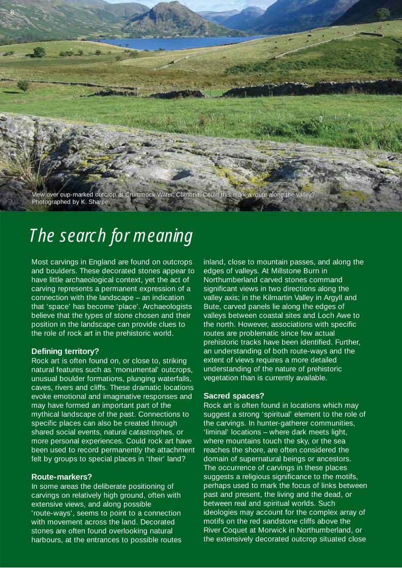
Most carvings in England are found on outcropsand boulders. These decorated stones appear tohave little archaeological context, yet the act ofcarving represents a permanent expression of aconnection with the landscape – an indicationthat ‘space’ has become ‘place’. Archaeologistsbelieve that the types of stone chosen and theirposition in the landscape can provide clues tothe role of rock art in the prehistoric world.
Defining territory?Rock art is often found on, or close to, strikingnatural features such as ‘monumental’ outcrops,unusual boulder formations, plunging waterfalls,caves, rivers and cliffs. These dramatic locationsevoke emotional and imaginative responses andmay have formed an important part of the mythical landscape of the past. Connections tospecific places can also be created throughshared social events, natural catastrophes, ormore personal experiences. Could rock art havebeen used to record permanently the attachmentfelt by groups to special places in ‘their’ land?
Route-markers?In some areas the deliberate positioning of carvings on relatively high ground, often withextensive views, and along possible ‘route-ways’, seems to point to a connectionwith movement across the land. Decoratedstones are often found overlooking natural harbours, at the entrances to possible routes
inland, close to mountain passes, and along theedges of valleys. At Millstone Burn inNorthumberland carved stones command significant views in two directions along the valley axis; in the Kilmartin Valley in Argyll andBute, carved panels lie along the edges of valleys between coastal sites and Loch Awe tothe north. However, associations with specificroutes are problematic since few actual prehistoric tracks have been identified. Further,an understanding of both route-ways and theextent of views requires a more detailed understanding of the nature of prehistoric vegetation than is currently available.
Sacred spaces?Rock art is often found in locations which maysuggest a strong ‘spiritual’ element to the role ofthe carvings. In hunter-gatherer communities,‘liminal’ locations – where dark meets light,where mountains touch the sky, or the seareaches the shore, are often considered thedomain of supernatural beings or ancestors. The occurrence of carvings in these placessuggests a religious significance to the motifs,perhaps used to mark the focus of links betweenpast and present, the living and the dead, orbetween real and spiritual worlds. Suchideologies may account for the complex array ofmotifs on the red sandstone cliffs above theRiver Coquet at Morwick in Northumberland, orthe extensively decorated outcrop situated close
The search for meaning
View over cup-marked outcrop at Crummock Water, Cumbria. Could this mark a route along the valley?Photographed by K. Sharpe.View over cup-marked outcrop at Crummock Water, Cumbria. Could this mark a route along the valley?Photographed by K. Sharpe.
8
to a waterfall at Roughting Linn, also inNorthumberland. Relationships are alsosuggested between the carved Boheh Stone andthe mountain of Croagh Patrick (later regardedas sacred) in Northern Ireland, and between thecarved boulders at Copt Howe in Cumbria andthe nearby Langdale Pikes.
The presence of rock art within ceremonial andburial monuments also suggests connectionswith ritual activity, although these associationstend to occur later in the Neolithic and into theBronze Age and may reflect a change in the significance of rock art.
Natural influences One recent strand of research which could provide new insights into the way carvings wereoriginally perceived has studied how the motifsrelate to the shape and fabric of the rock onwhich they are carved. Observations suggest themotif-makers looked closely at the rock surfaceto see what motifs would fit onto it, taking intoaccount features such as cracks, indentationsand other irregularities. Indeed, relationshipshave been identified between the size and natureof the motifs, and the size and shape of ‘frames’formed by natural fissures on the rock surface. It has been suggested that natural features, such
as hollows and cracks, may have been regardedas ancestral images to be incorporated, mimicked, or even erased by the application of new motifs, with both natural and artificial markings attracting the addition of new images.Natural features on the rock and their relationshipto the motifs may form an important part of ourunderstanding of the carvings themselves.
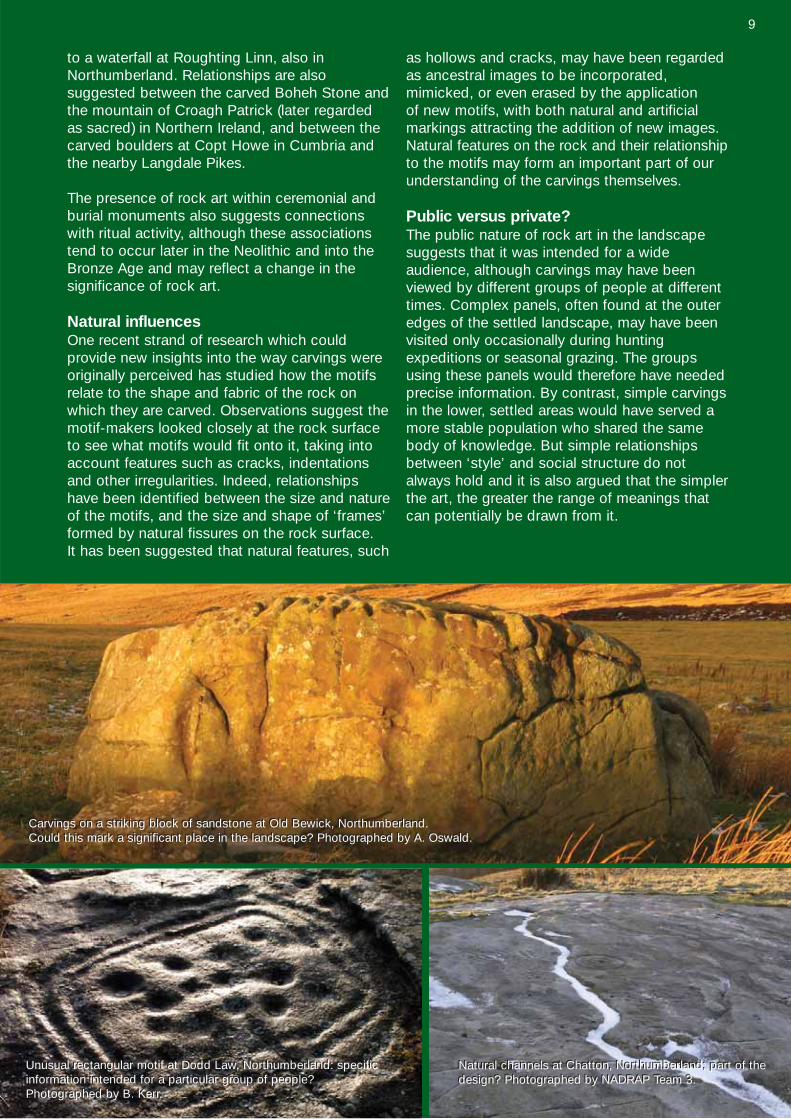
Public versus private?The public nature of rock art in the landscapesuggests that it was intended for a wide audience, although carvings may have beenviewed by different groups of people at differenttimes. Complex panels, often found at the outeredges of the settled landscape, may have beenvisited only occasionally during hunting expeditions or seasonal grazing. The groupsusing these panels would therefore have needed precise information. By contrast, simple carvingsin the lower, settled areas would have served amore stable population who shared the samebody of knowledge. But simple relationshipsbetween ‘style’ and social structure do notalways hold and it is also argued that the simplerthe art, the greater the range of meanings thatcan potentially be drawn from it.
Carvings on a striking block of sandstone at Old Bewick, Northumberland. Could this mark a significant place in the landscape? Photographed by A. Oswald.Carvings on a striking block of sandstone at Old Bewick, Northumberland. Could this mark a significant place in the landscape? Photographed by A. Oswald.
Natural channels at Chatton, Northumberland; part of thedesign? Photographed by NADRAP Team 3.Natural channels at Chatton, Northumberland; part of thedesign? Photographed by NADRAP Team 3.
Unusual rectangular motif at Dodd Law, Northumberland: specificinformation intended for a particular group of people?Photographed by B. Kerr.
Unusual rectangular motif at Dodd Law, Northumberland: specificinformation intended for a particular group of people?Photographed by B. Kerr.
9
Today rock art is an important element of the cultural landscape of northern England. Dedicatedinternet forums and websites have made rock artwidely accessible both intellectually and physically.This has inevitably led to an increase in visitornumbers to fragile rock art sites already at riskfrom natural threats. Strategies for recording,conservation and management are required in order to ensure that rock art survives to bestudied and enjoyed by future generations.
English Heritage and the England’s Rock Art WebsiteSince 1999, English Heritage has been developinga strategy for the management and understandingof rock art in England. A review of rock art studieswas commissioned from Bournemouth Universityand University College London, and the resultingreport set out six proposals for improving the current state of British rock art. These formed thebasis for English Heritage’s Rock Art Management,Access, Study & Education Strategy (RAMASES),which provided a framework for directing futurework on rock art. The first of these proposalsrecommended the development of a national
database of all known rock carvings in England.The Northumberland and Durham Rock ArtProject (NADRAP) was developed byNorthumberland and Durham County Councils atthe request of English Heritage as a pilot for thecreation of a standardised recording strategy androck art archive that would be publicly accessiblethrough the Internet. Over sixty local volunteerswere recruited and a recording ‘package’ was developed over a three year period. This methodology is now being rolled out nationally to enable standardised baseline data to be gathered in all regions of the country andadded to the database. You can search the website and find out more about the project at: http://archaeologydataservice.ac.uk/era
Some of the key components of the NADRAPmethodology and their applicability are discussedhere, but since our understanding andtechnological capability are evolving rapidly, theserepresent only a basic framework for recordingand a benchmark for future development.
Valuing rock art today
Carved cobble built into stonework at Paine’s Bridge, Wallington, Northumberland. Photographed by A. Mazel.Carved cobble built into stonework at Paine’s Bridge, Wallington, Northumberland. Photographed by A. Mazel.
10
Gled Law 3, Northumberland. Photographed by B.Kerr.Gled Law 3, Northumberland. Photographed by B.Kerr.
11
The creation of a reliable and accurate record isan essential part of researching, protecting andmanaging rock art. A wide range of recordingapproaches have been developed over time bydifferent individuals and organizations in thiscountry and around the world, all of which haverelative merits and limitations. British rock art is a fragile resource and repeated contact with it contributes to its decay. Some recording techniques are harmful and inappropriate. The most important guideline for rock art documentation is that it should be non-destructive. It should also aim to:
• provide a lasting record of rock art that maybecome damaged or destroyed;
• be as comprehensive and objective as possible; and
• provide a consistent, standardised record to allow for comparative assessment and monitoring.
WHAT should we record?Traditionally, documentation of rock art hasfocused on the individual motifs and the designsthey form on the rock surface. In recent years,however, there has also been a growing interestin the context in which rock art is found. It is nowrecognized that rock art recording should includethe rock surface itself, its wider situation, and its condition.
The surface record should include natural features such as fissures, which may be an integral part of the overall design, and may addsignificance to the rock art. Other aspects of therock itself may also be important, including itsshape, colour and texture, its orientation, and the pattern of any water flow over its surface.
The record also needs to consider the wider context of each panel. In many rock art locations, the prehistoric context has been substantially altered through time. Stone is animportant resource and, through human interference, has become a dynamic aspect ofthe landscape. Whether deliberately or not,carved stones have been incorporated into burialmonuments, standing stones, field clearancecairns, field boundaries, stone walls, superstructures of hill forts, buildings, millstonesand even milestones.
Exploring and documenting the physical and cultural contexts of rock art can help us understand how its significance and value havechanged through time.
The recording of benchmark data on the condition of carvings is also essential in order tomonitor decay, and explore the causes and rateof surface loss. Condition recording also enablesus to identify those carvings most at risk, andalerts us to where conservation and management resources should best be deployed.
HOW should we record rock art?Since British rock art is non-representational andits meaning is obscure, our records will inevitablybe subjective. Recording techniques musttherefore aim to reduce or eliminate subjective interpretation by the recorder, however experienced, in order to capture a faithful representation.
The methods used to record rock art are shapedby the nature of the rock art (including the natureof the panel and its location), its vulnerability, andhow the record will be used. The informationrecorded should aim to satisfy questions thatmay be asked of it by a range of users. Those responsible for caring for rock art need a precise, detailed and measurable record of therock art, its condition and its surroundings;researchers want a wide range of information onthe content and context of the rock art; interested members of the general public want aclear and accurate record of where the rock art isand what it looks like; and a wider audience,including school children, want a visually exciting and engaging record that stimulates theirimagination and learning.
Contact recordingVisual recording can be described as either contact or non-contact. Contact methods suchas wax rubbing, tracing, and the creation of replica moulds have traditionally been used tocapture a visual record of carvings. All thesemethods impact on the rock surface and are notnormally recommended. Contact methods alsorequire varying degrees of interpretation by therecorder and are therefore liable to be subjective.The removal of moss, turf and lichens and ‘cleaning’ the rock surface before recording canhave a substantial impact, especially wherechemical cleaners-Continued on p16
Recording Rock Art
12
13
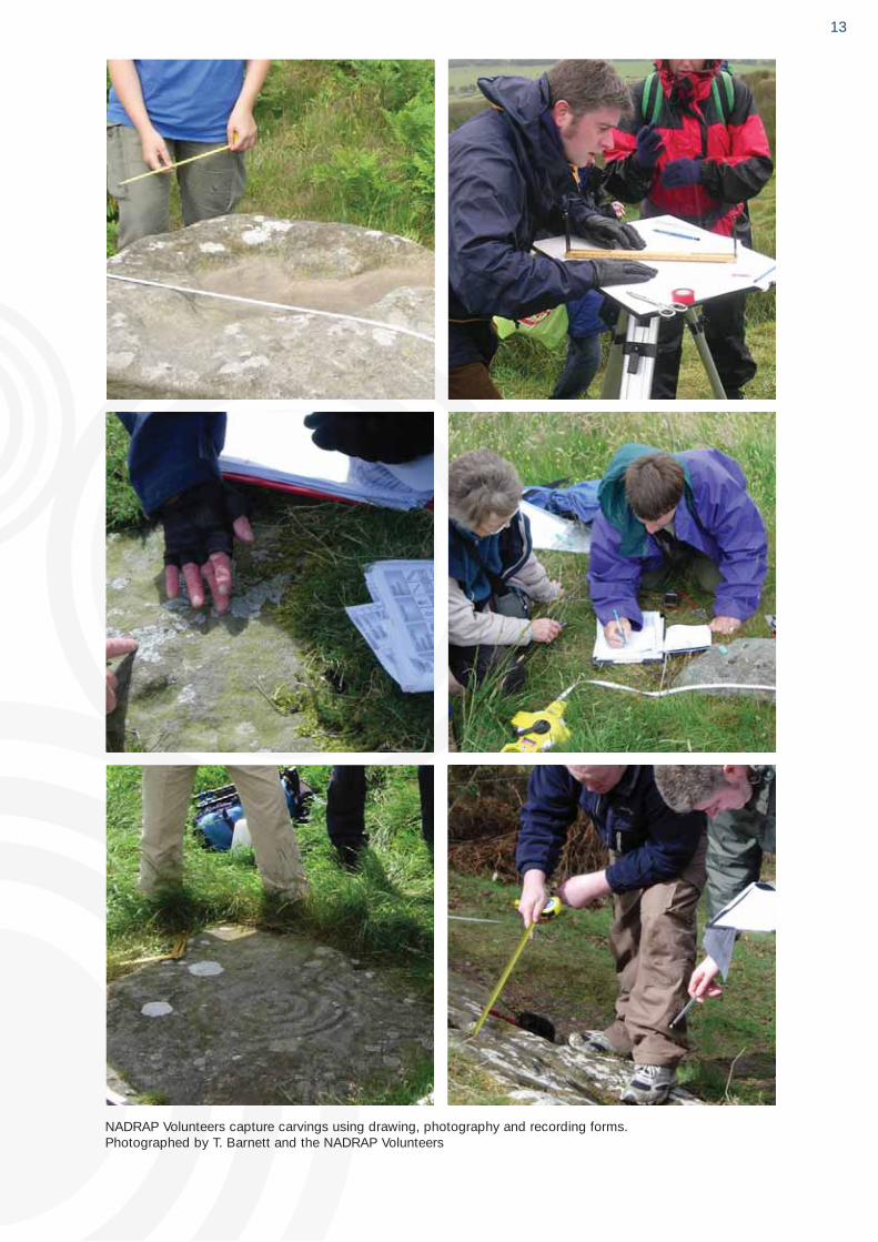
NADRAP Volunteers capture carvings using drawing, photography and recording forms. Photographed by T. Barnett and the NADRAP Volunteers
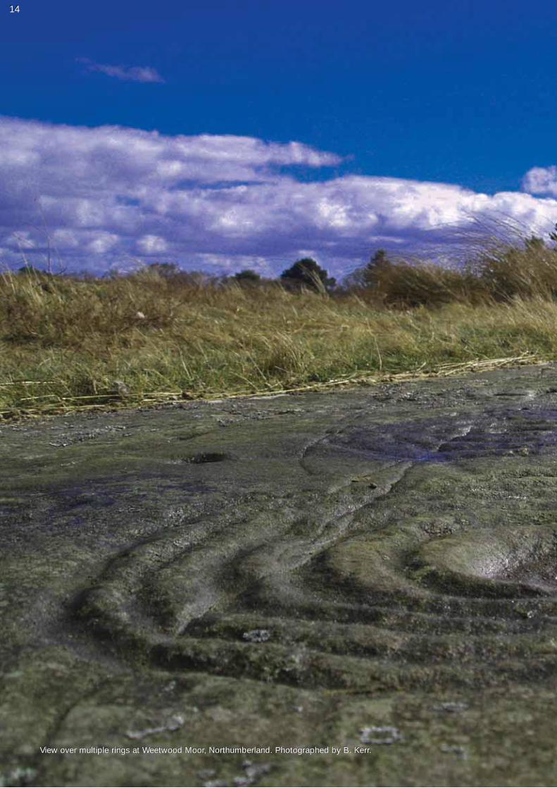
View over multiple rings at Weetwood Moor, Northumberland. Photographed by B. Kerr.
1414
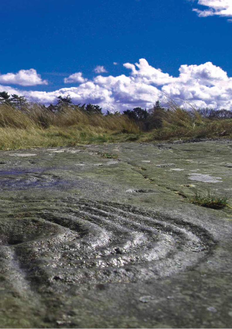
View over multiple rings at Weetwood Moor, Northumberland. Photographed by B. Kerr.
and hard implements or repeated scrubbingactions are used. Removal of organisms such aslichens can destabilise the rock surface andaccelerate deterioration. Repeated cleaning and exposure of carved surfaces can be highlydamaging and should not be undertakenwithout professional advice.
Recording Rock Art: The Northumberland and DurhamRock Art Project Methodology
The recording methodology developed by theNADRAP volunteers uses a combination of visual techniques, site survey and mapping, and textual recording. The recommended techniques are outlined below. Further detailsare available from the ERA websitehttp://archaeologydataservice/era
1) Preliminary surveyA walkover survey of each site and surroundingarea was undertaken to establish the physicaland cultural setting of the carvings and to identify all rock art panels in the vicinity. For siteswith more than one rock art panel, an overviewsketch was made detailing the spatialrelationship between rock art panels, topographyand archaeological features. This was supportedby annotated digital photographs.
2) Textual recordingA standardised recording form was completed.This included a written description of the rock art and context.
3) PhotographyPhotography is an essential part of recording. A range of images was taken, capturing thecarvings and their surroundings. This is an inexpensive and non-specialist technique available to anyone. With the tips suggestedopposite you could begin capturing rock art right away!
4) Photogrammetry This technique, typically using stereo-pairs ofphotographs, provides a means for accuratemeasurement of archaeological features and artifacts through 3D documentation and visualization. Whilst this is a more demandingtechnique, inexpensive solutions are now available, utilising both consumer-grade digitalcameras and specialist software to process thestereo-images, which are relatively easily pickedup after some initial training. You can find outmore on page 18.
5) Measured sketchesScaled sketch drawings were made, incorporating key measurements. These showedthe patterns of the motifs on the rock surfaceand their relationship to the natural featuresusing standardised conventions.
6) GeoreferencingThe location of each panel was determinedusing a hand-held Global Positioning Systemdevice to produce a 12-figure grid reference.
7) Specialist recordingIn some instances, baseline recording was supplemented by detailed, specialist investigation of selected panels considered atrisk or in need of more stringent management.Laser scanning was used to record and monitorsome high risk panels. This is a relatively expensive method which captures images atresolutions of less than 1 mm. Other approachesused included detailed archaeological survey ofthe surrounding area and detailed geologicalassessment (for evaluating the rate and nature ofdecay processes). Specialists were alsoconsulted regarding the removal of vegetationsuch as lichens.
Recording Rock Art cont. from pg 12
16
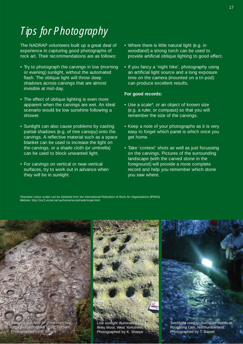
The NADRAP volunteers built up a great deal ofexperience in capturing good photographs ofrock art. Their recommendations are as follows:
• Try to photograph the carvings in low (morningor evening) sunlight, without the automatedflash. The oblique light will throw deep shadows across carvings that are almost invisible at mid-day.
• The effect of oblique lighting is even moreapparent when the carvings are wet. An idealscenario would be low sunshine following ashower.
• Sunlight can also cause problems by castingpartial shadows (e.g. of tree canopy) onto thecarvings. A reflective material such as a spaceblanket can be used to increase the light onthe carvings, or a shade cloth (or umbrella) can be used to block unwanted light.
• For carvings on vertical or near-vertical surfaces, try to work out in advance when they will be in sunlight.
• Where there is little natural light (e.g. in woodland) a strong torch can be used to provide artificial oblique lighting to good effect.
• If you fancy a ‘night hike’, photography usingan artificial light source and a long exposuretime on the camera (mounted on a tri-pod) can produce excellent results.
For good records:
• Use a scale*, or an object of known size (e.g. a ruler, or compass) so that you willremember the size of the carvings.
• Keep a note of your photographs as it is veryeasy to forget which panel is which once youget home.
• Take ‘context’ shots as well as just focussingon the carvings. Pictures of the surroundinglandscape (with the carved stone in the foreground) will provide a more completerecord and help you remember which stoneyou saw where.
*Standard colour scales can be obtained from the International Federation of Rock Art Organisations (IFRAO). Website: http://mc2.vicnet.net.au/home/record/web/scale.html
Tips for Photography
Rain and sun help to show cups andrings on Barningham Moor, Durham.Photographed by R. Stroud
Rain and sun help to show cups andrings on Barningham Moor, Durham.Photographed by R. Stroud
Low sunlight illuminates cups onIlkley Moor, West Yorkshire.Photographed by K. Sharpe
Low sunlight illuminates cups onIlkley Moor, West Yorkshire.Photographed by K. Sharpe
Torchlight used to illuminate motifs atRoughting Linn, Northumberland.Photographed by T. Barnett
Torchlight used to illuminate motifs atRoughting Linn, Northumberland.Photographed by T. Barnett
17
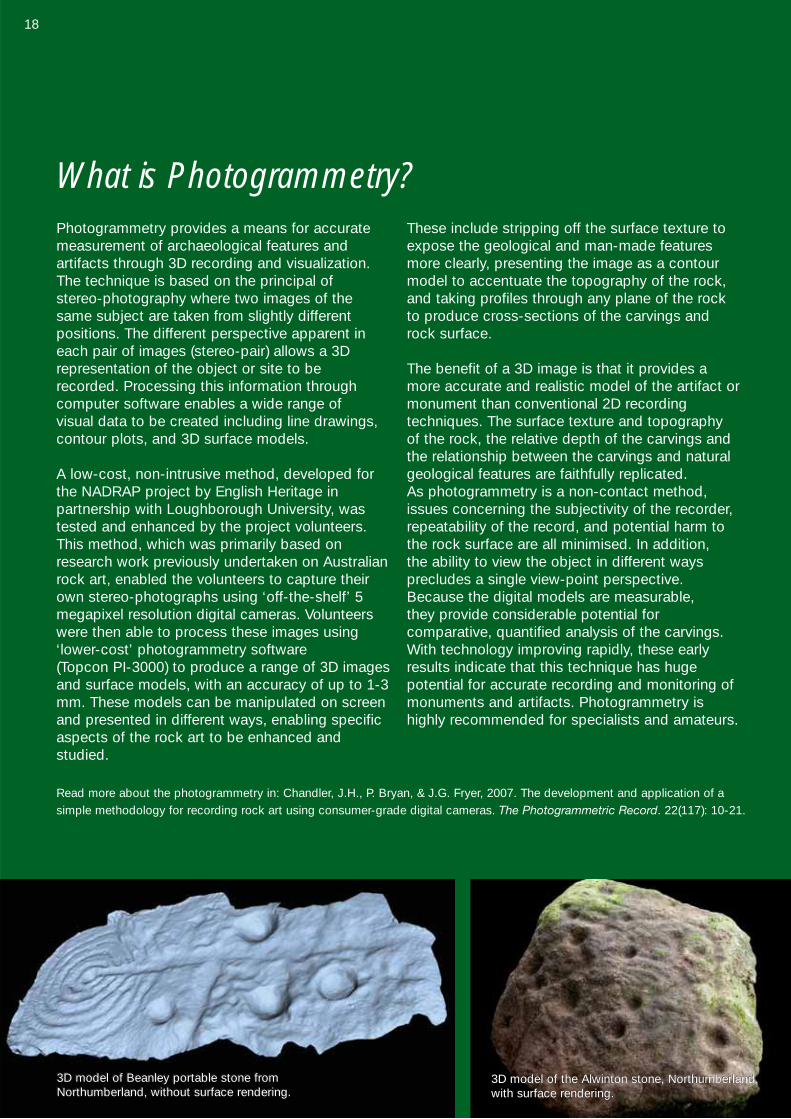
Photogrammetry provides a means for accuratemeasurement of archaeological features and artifacts through 3D recording and visualization.The technique is based on the principal of stereo-photography where two images of thesame subject are taken from slightly different positions. The different perspective apparent ineach pair of images (stereo-pair) allows a 3D representation of the object or site to be recorded. Processing this information throughcomputer software enables a wide range of visual data to be created including line drawings,contour plots, and 3D surface models.
A low-cost, non-intrusive method, developed forthe NADRAP project by English Heritage in partnership with Loughborough University, wastested and enhanced by the project volunteers.This method, which was primarily based onresearch work previously undertaken on Australianrock art, enabled the volunteers to capture theirown stereo-photographs using ‘off-the-shelf’ 5megapixel resolution digital cameras. Volunteerswere then able to process these images using‘lower-cost’ photogrammetry software (Topcon PI-3000) to produce a range of 3D imagesand surface models, with an accuracy of up to 1-3mm. These models can be manipulated on screenand presented in different ways, enabling specificaspects of the rock art to be enhanced and studied.
These include stripping off the surface texture toexpose the geological and man-made featuresmore clearly, presenting the image as a contourmodel to accentuate the topography of the rock,and taking profiles through any plane of the rockto produce cross-sections of the carvings androck surface.
The benefit of a 3D image is that it provides amore accurate and realistic model of the artifact ormonument than conventional 2D recording techniques. The surface texture and topography of the rock, the relative depth of the carvings andthe relationship between the carvings and natural geological features are faithfully replicated. As photogrammetry is a non-contact method,issues concerning the subjectivity of the recorder,repeatability of the record, and potential harm tothe rock surface are all minimised. In addition, the ability to view the object in different ways precludes a single view-point perspective.Because the digital models are measurable, they provide considerable potential for comparative, quantified analysis of the carvings.With technology improving rapidly, these earlyresults indicate that this technique has hugepotential for accurate recording and monitoring ofmonuments and artifacts. Photogrammetry ishighly recommended for specialists and amateurs.
Read more about the photogrammetry in: Chandler, J.H., P. Bryan, & J.G. Fryer, 2007. The development and application of asimple methodology for recording rock art using consumer-grade digital cameras. The Photogrammetric Record. 22(117): 10-21.
What is Photogrammetry?
3D model of the Alwinton stone, Northumberland,with surface rendering.
3D model of Beanley portable stone fromNorthumberland, without surface rendering.3D model of Beanley portable stone fromNorthumberland, without surface rendering.
18
3D model of the Alwinton stone, Northumberland,with surface rendering.
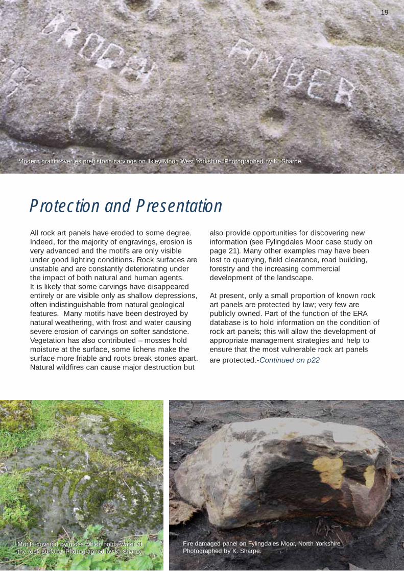
Protection and PresentationAll rock art panels have eroded to some degree.Indeed, for the majority of engravings, erosion isvery advanced and the motifs are only visibleunder good lighting conditions. Rock surfaces are unstable and are constantly deteriorating underthe impact of both natural and human agents. It is likely that some carvings have disappearedentirely or are visible only as shallow depressions,often indistinguishable from natural geological features. Many motifs have been destroyed bynatural weathering, with frost and water causingsevere erosion of carvings on softer sandstone.Vegetation has also contributed – mosses holdmoisture at the surface, some lichens make thesurface more friable and roots break stones apart.Natural wildfires can cause major destruction but
also provide opportunities for discovering new information (see Fylingdales Moor case study onpage 21). Many other examples may have beenlost to quarrying, field clearance, road building,forestry and the increasing commercial development of the landscape.
At present, only a small proportion of known rockart panels are protected by law; very few are publicly owned. Part of the function of the ERAdatabase is to hold information on the condition ofrock art panels; this will allow the development ofappropriate management strategies and help toensure that the most vulnerable rock art panels are protected.-Continued on p22
Modern graffiti overlies prehistoric carvings on Ilkley Moor, West Yorkshire. Photographed by K. SharpeModern graffiti overlies prehistoric carvings on Ilkley Moor, West Yorkshire. Photographed by K. Sharpe.
Motifs covered by moss which holds water atthe rock surface. Photographed by K. SharpeMotifs covered by moss which holds water atthe rock surface. Photographed by K. SharpeMotifs covered by moss which holds water atthe rock surface. Photographed by K. Sharpe.
Fire damaged panel on Fylingdales Moor, North YorkshirePhotographed by K. Sharpe.
19
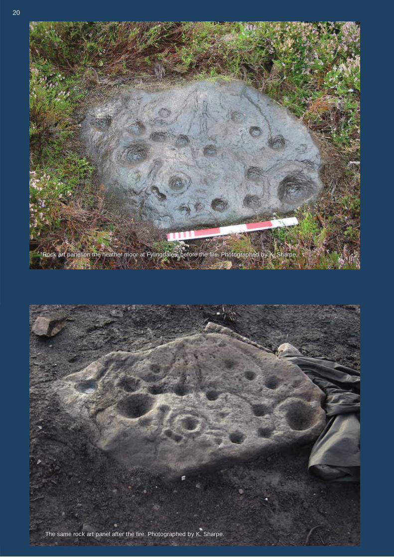
The same rock art panel after the fire. Photographed by K. Sharpe.The same rock art panel after the fire. Photographed by K. Sharpe.
Rock art panel on the heather moor at Fylingdales, before the fire. Photographed by K. Sharpe.Rock art panel on the heather moor at Fylingdales, before the fire. Photographed by K. Sharpe.
2020
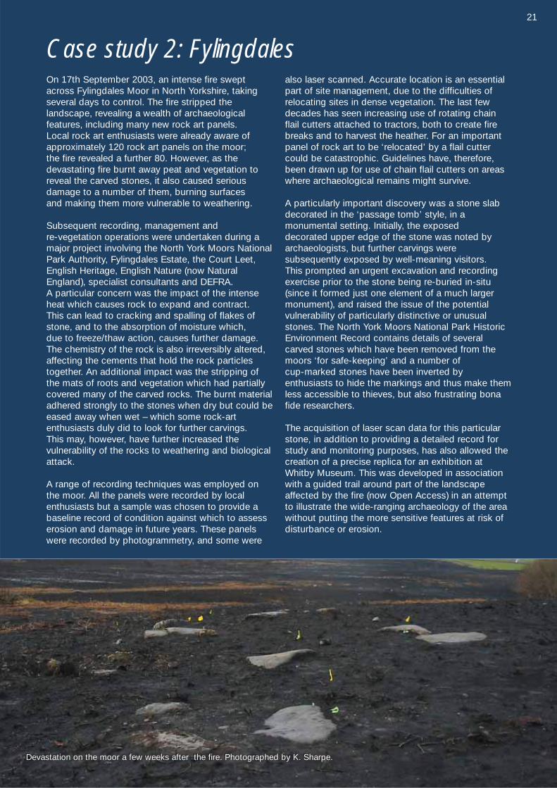
On 17th September 2003, an intense fire sweptacross Fylingdales Moor in North Yorkshire, takingseveral days to control. The fire stripped the landscape, revealing a wealth of archaeological features, including many new rock art panels. Local rock art enthusiasts were already aware of approximately 120 rock art panels on the moor; the fire revealed a further 80. However, as the devastating fire burnt away peat and vegetation toreveal the carved stones, it also caused serious damage to a number of them, burning surfaces and making them more vulnerable to weathering.
Subsequent recording, management and re-vegetation operations were undertaken during amajor project involving the North York Moors NationalPark Authority, Fylingdales Estate, the Court Leet,English Heritage, English Nature (now NaturalEngland), specialist consultants and DEFRA. A particular concern was the impact of the intenseheat which causes rock to expand and contract. This can lead to cracking and spalling of flakes ofstone, and to the absorption of moisture which, due to freeze/thaw action, causes further damage. The chemistry of the rock is also irreversibly altered,affecting the cements that hold the rock particlestogether. An additional impact was the stripping ofthe mats of roots and vegetation which had partiallycovered many of the carved rocks. The burnt materialadhered strongly to the stones when dry but could beeased away when wet – which some rock-art enthusiasts duly did to look for further carvings. This may, however, have further increased thevulnerability of the rocks to weathering and biologicalattack.
A range of recording techniques was employed onthe moor. All the panels were recorded by localenthusiasts but a sample was chosen to provide abaseline record of condition against which to assesserosion and damage in future years. These panelswere recorded by photogrammetry, and some were
also laser scanned. Accurate location is an essentialpart of site management, due to the difficulties ofrelocating sites in dense vegetation. The last fewdecades has seen increasing use of rotating chainflail cutters attached to tractors, both to create firebreaks and to harvest the heather. For an importantpanel of rock art to be ‘relocated’ by a flail cuttercould be catastrophic. Guidelines have, therefore,been drawn up for use of chain flail cutters on areaswhere archaeological remains might survive.
A particularly important discovery was a stone slabdecorated in the ‘passage tomb’ style, in a monumental setting. Initially, the exposed decorated upper edge of the stone was noted by archaeologists, but further carvings were subsequently exposed by well-meaning visitors. This prompted an urgent excavation and recording exercise prior to the stone being re-buried in-situ(since it formed just one element of a much largermonument), and raised the issue of the potential vulnerability of particularly distinctive or unusualstones. The North York Moors National Park HistoricEnvironment Record contains details of severalcarved stones which have been removed from themoors ‘for safe-keeping’ and a number of cup-marked stones have been inverted by enthusiasts to hide the markings and thus make themless accessible to thieves, but also frustrating bonafide researchers.
The acquisition of laser scan data for this particularstone, in addition to providing a detailed record forstudy and monitoring purposes, has also allowed thecreation of a precise replica for an exhibition atWhitby Museum. This was developed in associationwith a guided trail around part of the landscapeaffected by the fire (now Open Access) in an attemptto illustrate the wide-ranging archaeology of the areawithout putting the more sensitive features at risk ofdisturbance or erosion.
Case study 2: Fylingdales
Devastation on the moor a few weeks after the fire. Photographed by K. SharpeDevastation on the moor a few weeks after the fire. Photographed by K. Sharpe.
21
Protection and Presentation cont. from pg 19
Natural threatsThe most significant threat to rock art is water.This acts on the chemical and physical structureof the rock to dissolve and weaken the cementmatrix. The problem is increased by:
• removal of cover which protects the rock surface, such as turf or lichens;
• encouragement of cover that retains moistureor attracts it to the surface, such as vegetation,mosses, and some artificial coverings;
• abrasion or impact on weakened surfaces, for example by animals or humans, or evenstrong winds; and
• repeated episodes of exposure followed byconcealment, which prevents the formation of a protective patina.
Human impactWe can’t do much about the destructive Englishweather but we can ensure that we do no additional damage so that the carvings have abetter chance of surviving. Experiencing rock art
in its original context in the countryside is generally the most appealing option for physicallyable people, but human impact represents potentially the most profound short-term threat torock art. Increasing visitor numbers are starting tohave a noticeable effect on rock carvings in moreaccessible areas such as Ilkley Moor in WestYorkshire. The following approaches have beensuccessfully applied in some areas and may helpto limit the damage caused by increased publicattention.
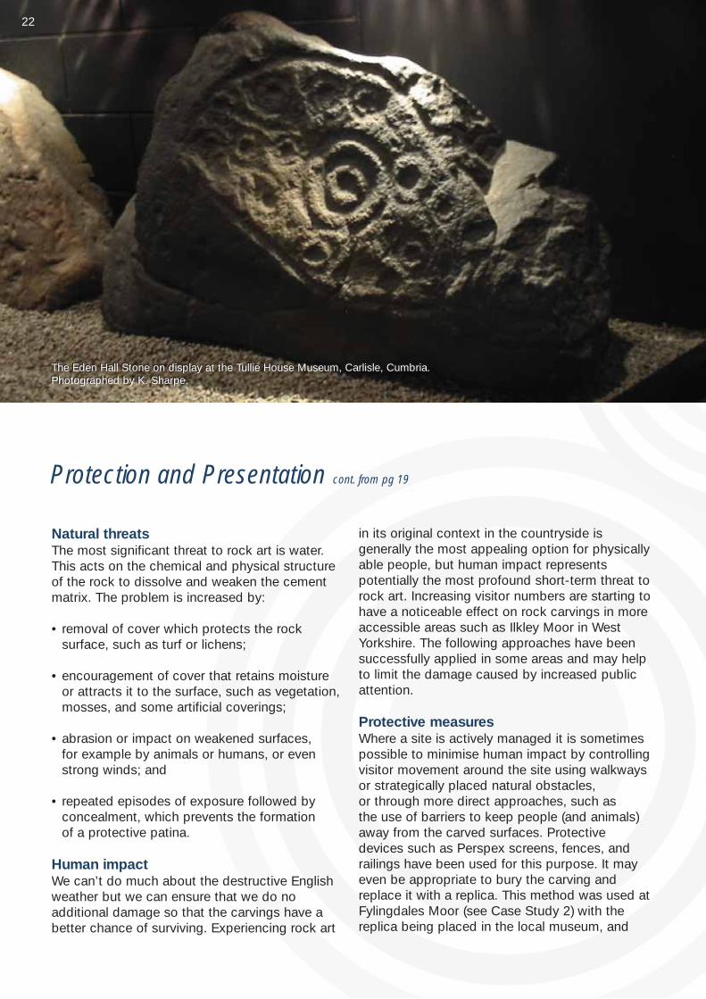
Protective measuresWhere a site is actively managed it is sometimespossible to minimise human impact by controllingvisitor movement around the site using walkwaysor strategically placed natural obstacles, or through more direct approaches, such as the use of barriers to keep people (and animals) away from the carved surfaces. Protectivedevices such as Perspex screens, fences, andrailings have been used for this purpose. It mayeven be appropriate to bury the carving andreplace it with a replica. This method was used atFylingdales Moor (see Case Study 2) with thereplica being placed in the local museum, and
The Eden Hall Stone on display at the Tullie House Museum, Carlisle, Cumbria.Photographed by K. Sharpe.The Eden Hall Stone on display at the Tullie House Museum, Carlisle, Cumbria.Photographed by K. Sharpe.
22
Page 26
What can you do to help?
As very little of the rock art in England is publiclyowned, heritage managers are limited in the waysin which these sites can be managed. The responsibility for preserving the rock art restswith each one of us and there are a number ofways in which we can ensure the carvings surviveto be studied and enjoyed by future generations.The guidelines on page 27 have been developedbased on experience and current understanding
of the way carvings are impacted upon by humanactivities. Should you have any concerns aboutthe protection of any of the carved panels youhave visited please contact the relevant localCounty Archaeology Department. Current contactdetails can be found on the ALGAO websiteat http://www.algao.org.uk/
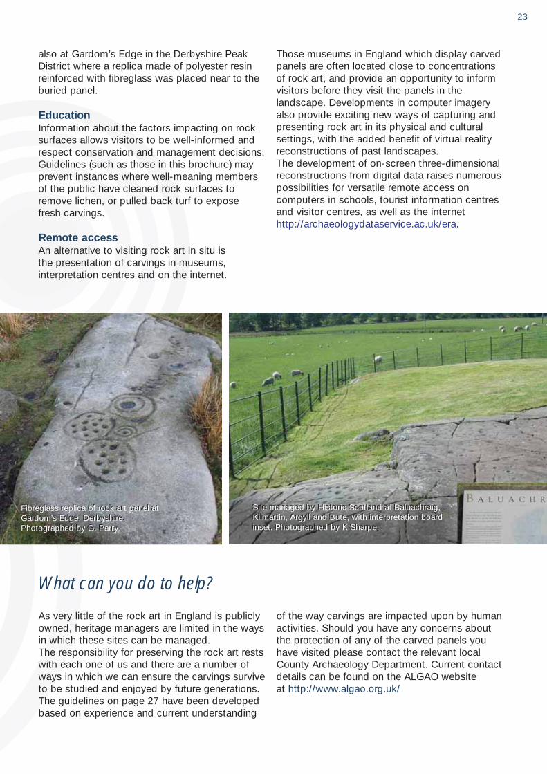
also at Gardom’s Edge in the Derbyshire PeakDistrict where a replica made of polyester resinreinforced with fibreglass was placed near to theburied panel.
EducationInformation about the factors impacting on rocksurfaces allows visitors to be well-informed andrespect conservation and management decisions.Guidelines (such as those in this brochure) mayprevent instances where well-meaning membersof the public have cleaned rock surfaces toremove lichen, or pulled back turf to expose fresh carvings.
Remote accessAn alternative to visiting rock art in situ is the presentation of carvings in museums, interpretation centres and on the internet.
Those museums in England which display carvedpanels are often located close to concentrationsof rock art, and provide an opportunity to informvisitors before they visit the panels in the landscape. Developments in computer imageryalso provide exciting new ways of capturing andpresenting rock art in its physical and culturalsettings, with the added benefit of virtual realityreconstructions of past landscapes. The development of on-screen three-dimensionalreconstructions from digital data raises numerouspossibilities for versatile remote access on computers in schools, tourist information centresand visitor centres, as well as the internethttp://archaeologydataservice.ac.uk/era.
Fibreglass replica of rock art panel atGardom’s Edge, Derbyshire.Photographed by G. Parry
Fibreglass replica of rock art panel atGardom’s Edge, Derbyshire.Photographed by G. Parry.
Site managed by Historic Scotland at Baluachraig,Kilmartin, Argyll and Bute, with interpretation boardinset. Photographed by K Sharpe.
23
Site managed by Historic Scotland at Baluachraig,Kilmartin, Argyll and Bute, with interpretation boardinset. Photographed by K Sharpe.
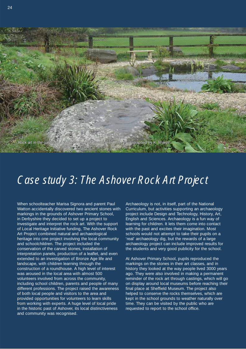
Case study 3: The Ashover Rock Art Project
When schoolteacher Marisa Signora and parent PaulWatton accidentally discovered two ancient stones withmarkings in the grounds of Ashover Primary School, in Derbyshire they decided to set up a project to investigate and interpret the rock art. With the supportof Local Heritage Initiative funding, The Ashover RockArt Project combined natural and archaeological heritage into one project involving the local communityand schoolchildren. The project included the conservation of the carved stones, installation of interpretation panels, production of a leaflet, and evenextended to an investigation of Bronze Age life andlandscape, with children learning through the construction of a roundhouse. A high level of interestwas aroused in the local area with almost 500 volunteers involved from across the community, including school children, parents and people of manydifferent professions. The project raised the awarenessof both local people and visitors to the area and provided opportunities for volunteers to learn skillsfrom working with experts. A huge level of local pride in the historic past of Ashover, its local distinctivenessand community was recognised.
Archaeology is not, in itself, part of the NationalCurriculum, but activities supporting an archaeologyproject include Design and Technology, History, Art,English and Sciences. Archaeology is a fun way oflearning for children. It lets them come into contactwith the past and excites their imagination. Mostschools would not attempt to take their pupils on a‘real’ archaeology dig, but the rewards of a largearchaeology project can include improved results forthe students and very good publicity for the school.
At Ashover Primary School, pupils reproduced themarkings on the stones in their art classes, and in history they looked at the way people lived 3000 yearsago. They were also involved in making a permanentreminder of the rock art through castings, which will goon display around local museums before reaching theirfinal place at Sheffield Museum. The project alsohelped to conserve the rocks themselves, which arekept in the school grounds to weather naturally overtime. They can be visited by the public who arerequested to report to the school office.
24
Rock art in the garden at Ashover Primary School, Derbyshire. Photographed by K. Sharpe.Rock art in the garden at Ashover Primary School, Derbyshire. Photographed by K. Sharpe.Rock art in the garden at Ashover Primary School, Derbyshire. Photographed by K. Sharpe.
25
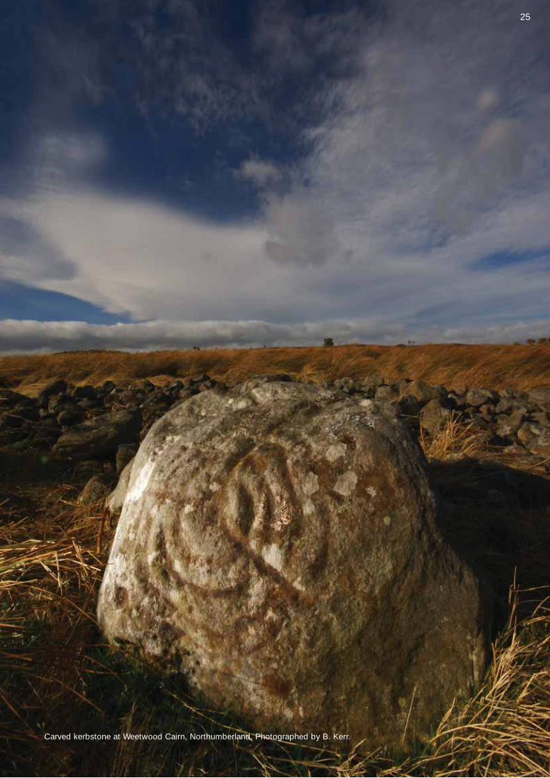
Carved kerbstone at Weetwood Cairn, Northumberland. Photographed by B. Kerr.
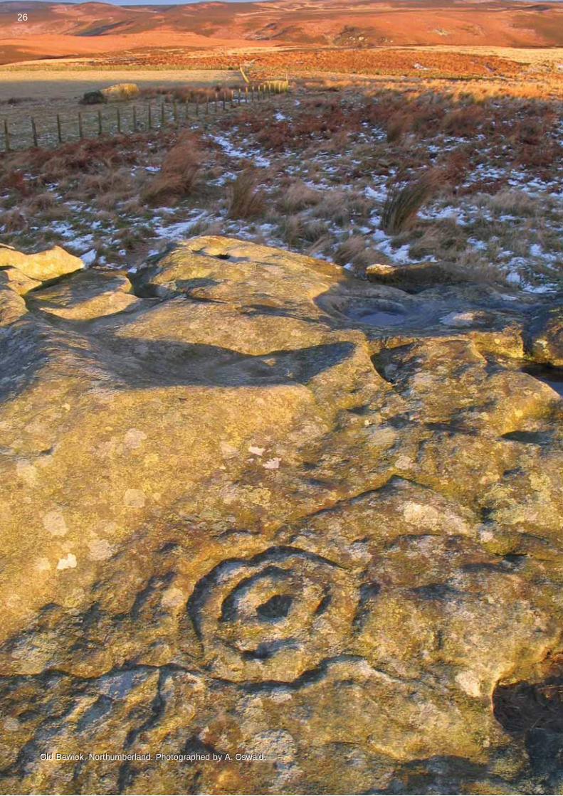
Old Bewick, Northumberland. Photographed by A. Oswald.Old Bewick, Northumberland. Photographed by A. Oswald.
26
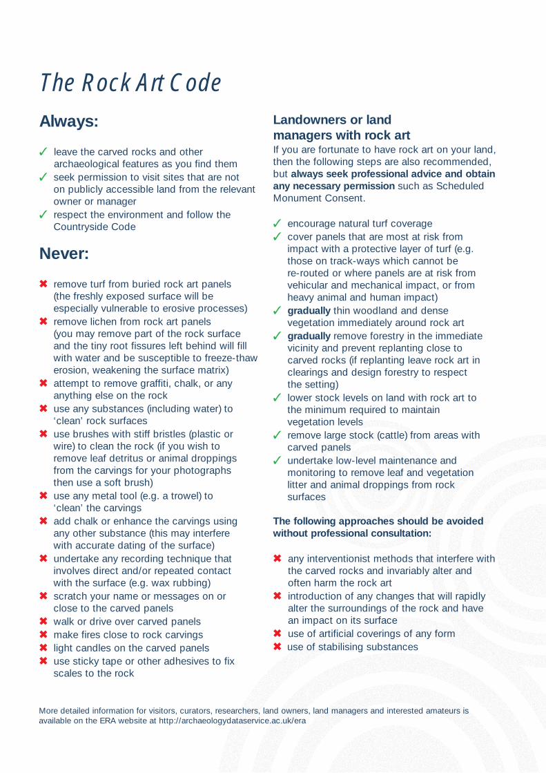
Always:
� leave the carved rocks and other archaeological features as you find them
� seek permission to visit sites that are not on publicly accessible land from the relevantowner or manager
� respect the environment and follow the Countryside Code
Never:
� remove turf from buried rock art panels (the freshly exposed surface will be especially vulnerable to erosive processes)
� remove lichen from rock art panels (you may remove part of the rock surface and the tiny root fissures left behind will fill with water and be susceptible to freeze-thawerosion, weakening the surface matrix)
� attempt to remove graffiti, chalk, or any anything else on the rock
� use any substances (including water) to ‘clean’ rock surfaces
� use brushes with stiff bristles (plastic or wire) to clean the rock (if you wish to remove leaf detritus or animal droppings from the carvings for your photographs then use a soft brush)
� use any metal tool (e.g. a trowel) to ‘clean’ the carvings
� add chalk or enhance the carvings using any other substance (this may interfere with accurate dating of the surface)
� undertake any recording technique that involves direct and/or repeated contact with the surface (e.g. wax rubbing)
� scratch your name or messages on or close to the carved panels
� walk or drive over carved panels � make fires close to rock carvings� light candles on the carved panels� use sticky tape or other adhesives to fix
scales to the rock
Landowners or land managers with rock artIf you are fortunate to have rock art on your land,then the following steps are also recommended,but always seek professional advice and obtainany necessary permission such as ScheduledMonument Consent.
� encourage natural turf coverage � cover panels that are most at risk from
impact with a protective layer of turf (e.g.those on track-ways which cannot be re-routed or where panels are at risk fromvehicular and mechanical impact, or fromheavy animal and human impact)
� gradually thin woodland and dense vegetation immediately around rock art
� gradually remove forestry in the immediatevicinity and prevent replanting close tocarved rocks (if replanting leave rock art inclearings and design forestry to respect the setting)
� lower stock levels on land with rock art to the minimum required to maintain vegetation levels
� remove large stock (cattle) from areas withcarved panels
� undertake low-level maintenance and monitoring to remove leaf and vegetation litter and animal droppings from rock surfaces
The following approaches should be avoidedwithout professional consultation:
� any interventionist methods that interfere withthe carved rocks and invariably alter andoften harm the rock art
� introduction of any changes that will rapidlyalter the surroundings of the rock and havean impact on its surface
� use of artificial coverings of any form � use of stabilising substances
The Rock Art Code
More detailed information for visitors, curators, researchers, land owners, land managers and interested amateurs isavailable on the ERA website at http://archaeologydataservice.ac.uk/era
27
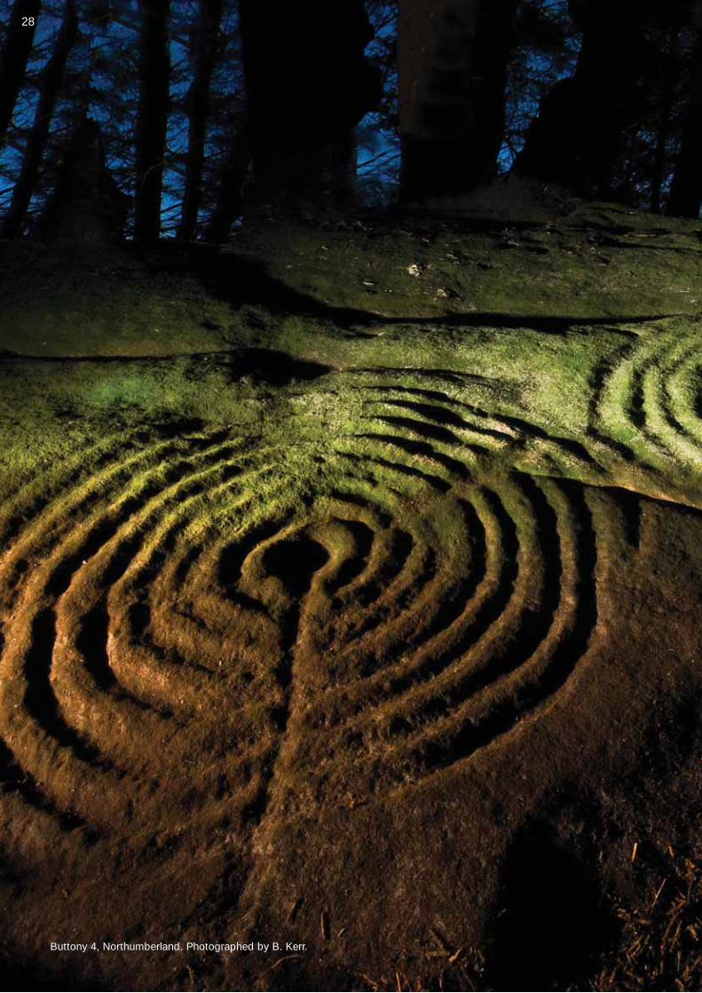
Buttony 4, Northumberland. Photographed by B. Kerr.Buttony 4, Northumberland. Photographed by B. Kerr.
28
The Northumberland and Durham Rock Art Pilot Project was sponsored byEnglish Heritage and managed by Northumberland and Durham County Councils.
The NADRAP Team were:• Kate Sharpe, Project Officer• Tertia Barnett, Project Officer (2004-2006)• Sara Rushton, NCC Conservation Team Manager• Chris Burgess, NCC Conservation Team Manager• David Mason, DCC County Archaeologist• Richard Stroud, Volunteer Co-ordinator• Paul Bryan, Metric Survey Team, English Heritage• The NADRAP Volunteers:
Caroline Allott, Kenneth Allott, Mike Allport, Marie Armstrong, Alan Atkinson,Bryan John Atkinson, Jean Atkinson, Mike Atkinson, Tom Barkas, SamanthaBelcher, Paul Bell, Graham Benfell, Jo Bird, Kenneth Black, Yvonne Black, Ruth Brewis, Graham Bristow, Shirley Brown, Vic Brown, Belinda Burke, Jeff Canavan, Lynsey Capper, Linda Carpenter, Keith Cooper, Steven Cooper,Peter Cornish, Ian Craig, Mark Alan Creighton, Andy Curtis, Russell Dawson, Alan Dougherty, Carol Dougherty, Helen Chimirri-Russell, Keith Elliott, Ken Fairless, Jean Findlay, Mike Findlay, Susan Findlay, Joanne Foster, Amanda Gadema, Oscar Gates, Joseph Garbarino, Joe Gibson, ChristineGoodwin, Belinda Goyder, Bill Goyder, Derek Gunby, Hattie Hammersmith, Bob Harrison, Susan Haywood, Tessa Heads, Mike Hoadley, Mike Hodgson,Teresa Hodgson, Sara Holland, Alfred Hughes Harris, James Jackson, Anne Jenner, David Jones, Matt Kerr, John Leslie Knight, Frigga Kruse, Maureen Lazzari, Jenny Lee, James Lynn, Jeff Lynn, Kevin Malloy, Richard McDonough, Bernard O’Neill, Brian Oliver, James Outterson, Laura Parkin, Colin Pearson, Annie Robinson, David Robinson, Jonathon Shotton,Paul Southgate, Fraser Stewart, Richard Stroud, Peter Swailes, Mollie Taylor,Brian Thompson, David Thomson, Sue Thompson, David Tuck, Gwen Tuck, Paul Twinn, Joanne Walton, Susan Veitch, Neil Wallace, Janet Wilkinson, Lynette Willoughby, Kate Wilson, and Andrew Wood.
Acknowledgements
The Northumberland and Durham Rock Art Project was funded by EnglishHeritage and managed by Northumberland and Durham County Councils. The website and database have been created and hosted by Archaeology DataServices, University of York and special thanks are due to Catherine Hardman,Stewart Waller, Jen Mitcham and Jonathan Bateman. Web design was byHeritage Media. The database and website incorporate material from theNewcastle University Beckensall Archive Project for which grateful thanks areextended to Stan Beckensall. Special thanks are due to Aron Mazel of theBeckensall Archive Project for his substantial contribution to the success of theproject. Paul Bryan (English Heritage Metric Survey Team), Stewart Ainsworth and Al Oswald (English Heritage Archaeological Survey and Investigation Team) provided invaluable advice and training throughout the project. The role of theProject Steering Group (Aron Mazel, Clive Waddington, Jon Mills, Sally Foster,Emma Carver, Gail Graham, Gill Grayson, Jack Stevenson, Kate Wilson, Lindsay Allason-Jones, Margarita Díaz-Andreu, Myra Tolan-Smith, Paul Bryan,Pete Topping, Petra Wade, Philip Deakin, and Stewart Ainsworth) and theDatabase Steering Group (Aron Mazel, Clive Waddington, Glynn Godrick,Professor Geoff Bailey, and Lindsay Allason-Jones) in supporting and guiding the project is gratefully acknowledged. We would also like to thank the EnglishHeritage RAMASES advisory group for their continued help and support: Kate Wilson, Alex Gibson, Jonathan Last, Barney Sloane, Stan Beckensall, John Coles, Sally Foster, Graham Lee, Jan Magnusson, Sebastian Payne, Eric Robinson, Jack Stevenson and Robert White. Finally, we would like toacknowledge all the farmers and landowners whose assistance and co-operationwas critical for the completion of the recording work.
Contact Us
Further details of the NADRAP Project and additional copies of this brochure can be obtained from Northumberland County Council. Please contact [email protected] or write to Conservation Team, County Hall, Morpeth, Northumberland NE61 2EF
British Rock Art on the Internet
The ERA website: http://archaeologydataservice.ac.uk/eraThe British Rock Art Collection www.rockartuk.fotopic.netThe British Rock Art Blog www.rockartuk.wordpress.com/The British Rock Art Group brag.archanth.cam.ac.uk/The Modern Antiquarian www.themodernantiquarian.com/The Megalithic Portal www.megalithic.co.uk/Megalithics www.megalithics.com/Yorkshire Rock Art www.cupstones.f9.co.uk/Gardom’s Edge, Derbyshirewww.gardomsedge.group.shef.ac.uk/rart.htm
Kilmartin House Museum www.kilmartin.org/Knowth & Newgrange www.knowth.com/index.htm
Books on British Rock Art
(A more comprehensive reading list is available on the ERA website – see above)
Beckensall, S. 2001. Prehistoric Rock Art in Northumberland.Tempus, Stroud.
Beckensall, S. 2002. Prehistoric Rock Art in Cumbria. Tempus, Stroud.
Beckensall, S. 2005. The Prehistoric Rock Art of Kilmartin. Kilmartin Trust.
Beckensall, S. 2006. Circles in Stone. A British Prehistoric Mystery.Tempus, Stroud.
Beckensall, S. & T. Laurie. 1998. Prehistoric Rock Art of County Durham,Swaledale, and Wensleydale. Durham County Books, Durham.
Boughey, K. & E. Vickerman. 2003. Prehistoric Rock Art of the West Riding.Cup-and-ring-marked rocks of the valleys of the Aire, Wharfe, Washburnand Nidd. West Yorkshire Archaeological Services, Leeds.
Bradley, R. 1997. Rock Art and the Prehistory of Atlantic Europe: Signingthe Land. Routledge, London.
Brown, P. & B. Brown. 2008. Prehistoric Rock Art in the Northern Dales,The History Press Ltd., Stroud.
Brown, P. & G. Chappell. 2005. Prehistoric Rock Art of North Yorkshire.Tempus, Stroud.
Butter, R. 1999. Kilmartin. Scotland's richest prehistoric landscape.Kilmartin House Trust, Kilmartin, Argyll.
Mazel, A., G. Nash & C. Waddington. 2007. Art as Metaphor. The Prehistoric Rock-art of Britain. Archaeopress, Oxford.
Walker, A. & B. Smith. 2008. Rock Art and Ritual. The History Press Ltd.,Stroud.
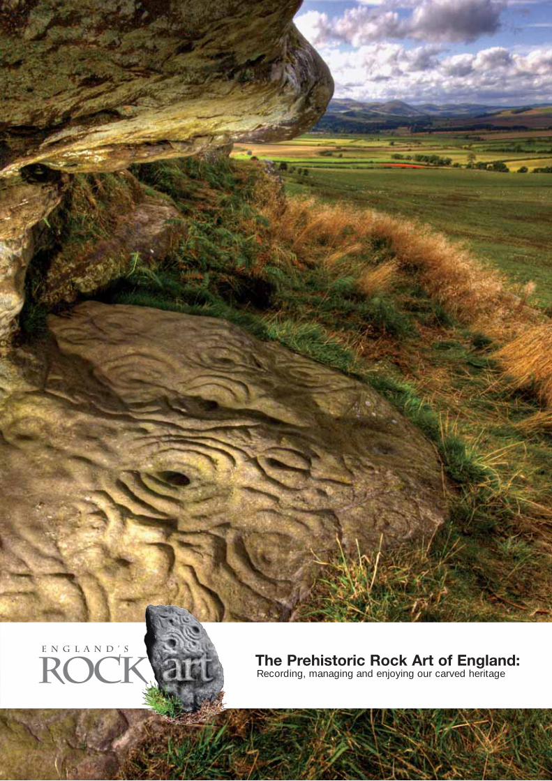
This brochure was written by Kate Sharpe, Tertia Barnett, and Sara Rushton, with contributions from Paul Bryan (English Heritage),Graham Lee (North York Moors National Park), and Aron Mazel(International Centre for Cultural and Heritage Studies, NewcastleUniversity). The text was improved by comments from Kate Wilson, Alex Gibson, Jonathan Last, Robert White, Sally Foster, and Liz Williams.Images are credited in the text. The cover image by Brian Kerr, shows the Ketley Crag rock shelter in Northumberland.
ISBN 1-873402-28-7. (July 2008) Copyright English Heritage and Northumberland County Council. Designed and printed by Braybridge Ltd. 0191 261 0006