Embed Size (px)
Citation preview

eRAMSeRAMS AWeb‐Technology for ConservationA Web Technology for Conservation
Planning and Watershed Management
Mazdak Arabi Department of Civil & Environmental Engineering

Watershed Management
• Water quality (environmental)q y ( ) – Sediment – Nutrients – Pesticides – Pathogens
• Economic Criteria – Cost – Benefits
• Institutional Criteria

Nonpoint Source Pollution Control
• Implementation of conservation practices / BMPs p p / – Prevent or minimize pollution rather than retrospectivelyrespond to it.
• Current Approaches – Cost‐sharing – Targeting

developing sound resource management alternatives
set of management actions
– Planning: scenario analysis and system optimization forPlanning: scenario analysis and system optimization for
Overall Goal
• Develop a decision support system to p pp y – Establish baseline conditions for a field/watershed
– Assessment: costs and environmental benefits of a givenAssessment: costs and environmental benefits of a given
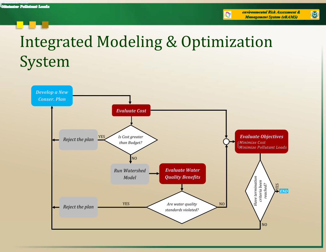
Integrated Modeling & Optimization SystemSystem
Develop a New
Evaluate Cost
p
Conser. Plan
Is Cost greater than Budget?
NO
YES Evaluate Objectives Reject the plan
Evaluate Water Quality Benefits
Run Watershed
Model
NO
mination
a been
hed?
YES
YES Are water quality standards violated?
NOReject the plan H
ave term
criteria
reach END
Y
NO

Integrated Modeling & Optimization SystemSystem
Implementation
Develop a New
Evaluate Cost
p
Conser. Plan
Is Cost greater than Budget?
NO
YES Evaluate Objectives Reject the plan
Evaluate Water Quality Benefits
Run Watershed
Model
NO
mination
a been
hed?
YES
YES Are water quality standards violated?
NOReject the plan H
ave term
criteria
reach END
Y
NO

Integrated Modeling & Optimization System Reduced crop Productivity: System Reduced crop Productivity:
• Land out of production, • Reduction of fertilizer application
Develop a New
Evaluate Cost
p
Conser. Plan
Is Cost greater than Budget?
NO
YES Evaluate Objectives Reject the plan
Evaluate Water Quality Benefits
Run Watershed
Model
NO
mination
a been
hed?
YES
YES Are water quality standards violated?
NOReject the plan H
ave term
criteria
reach END
Y
NO

Integrated Modeling & Optimization System for Watershed ManagementSystem for Watershed Management
Develop a New
Evaluate Cost
p
Conser. Plan
Is Cost greater than Budget?
NO
YES Evaluate Objectives Reject the plan
Evaluate Water Quality Benefits
Run Watershed
Model
NO
mination
a been
hed?
YES
C 10 /
YES Are water quality standards violated?
NOReject the plan H
ave term
criteria
reach END
Y
CNO3-N ≤ 10 mg/L NO
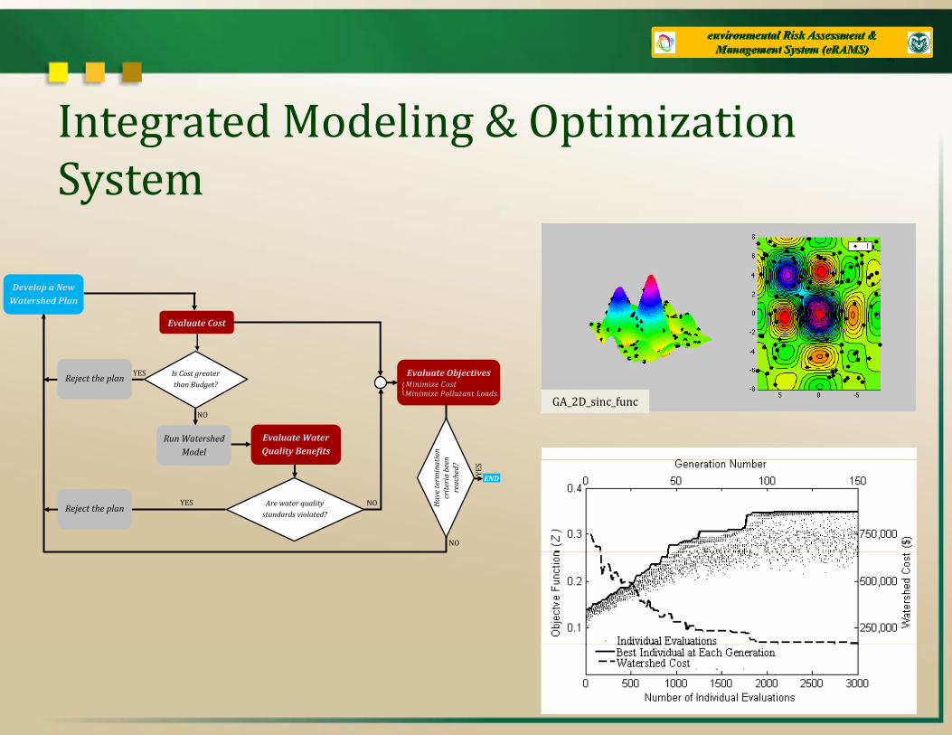
Integrated Modeling & Optimization SystemSystem
Evaluate Cost
Develop a New
Watershed Plan
Is Cost greater than Budget?
Evaluate Water Quality Benefits
Run Watershed
Model
NO
YES Evaluate Objectives Reject the plan
tion n
GA_2D_sinc_func
YES Are water quality standards violated?
NOReject the plan H
ave terminat
criteria
been
reached?
NO
ENDYES

Watershed Planning: Tradeoffs & Targets
1
A B: Cost Sharing
onst
rain
t
C
Water Quality Target
Optimal
Budg
et C
oOptimal Tradeof f Curve
D
0.6
0.8
0 2
0.4
0 0.5 1 1.5 2 2.5 3 3.5 0
0.2
Cost (Million $) Cost (Million $)
NNor
mal
ized
Polllu
tant
Loa
ds

eRAMS: Participatory GIS
• Facilitate collection, organization and sharing of , g ggeospatial data – Identify problems – Determine stakeholders’ objectives, preferences and values – Location and type of practices

eRAMS: Participatory GIS
• Facilitate automation of complex modeling and p gsystem analysis processes – Conservation assessment and planning: natural resource models, e.g., APEX /SWAT and MODFLOW
– Plug‐in applications for diverse set of problems “D t li d” f– “Decentralized” group of users

Technology Drivers
• No specific hardware or software requirements p q – Reduce training requirements – Eliminating the collection of duplicate data across agencies – Reduce long‐term development and maintenance costs – Mobile system accessible, end‐to‐end, on the web
• Compatibility with existing databases/GIS technologiestechnologies – Take advantage of readily available data

Technology Drivers
• Benefit from Google products and other commonly‐g p yused internet technologies – Common “look and feel” interface – High resolution aerial photos, etc.
• Compatibility with long‐term vision of institutions Compatibility with long term vision of institutions involved with management of natural resources
• Working across scales: field to watershed • Working across scales: field to watershed

Data
User Login
Field
Digitization
Assessment
Watershed
Scenario Anal.
Planning
Optimization
Visualization
www.erams.com
User
(www Browser)
M t d t /
NRCS ,USGS, NWS Data Resources
eRAMS Web Portal equipped with
Google Zoom & Maps / High Resolution Aerial Photos
Spatial Extent
Metadata / Data
Data
User Login
User Upload Data
Standardization Module
Storage Resource
Field
Location/Attribute of BMPs Digitization
Assessment Digitize Field Boundary
Specify Watershed Outlet(s)
Watershed Watershed Delineation /
Model Input Creation Module
Scenario Anal.
Specify Watershed Outlet(s)
Planning
Optimization
Visualization
Field Scale
Watershed Scale
Distributed Computing
eRAMS Architecture for Conservation Planning and Assessment

Spatial Extent, Data Identification, Extraction and Upload
www.erams.com
User
(www Browser)
Metadata /
NRCS ,USGS, NWS Data Resources
eRAMS Web Portal equipped with
Google Zoom & Maps / High Resolution Aerial Photos
Spatial Extent
Metadata / Data
User Login
Standardization Module
Storage Resource
Data User Upload Data
Module Resource
Identification – What relevant data are available? Semantically rich metadatay – CLIPS, SWEET, GeoSemantic Extraction /Transformation: different sources, different formats and scales

Data
User Login
Field
Digitization
Assessment
Watershed
Scenario Anal.
Planning
Optimization
Visualization
www.erams.com
User
(www Browser)
M t d t /
NRCS ,USGS, NWS Data Resources
eRAMS Web Portal equipped with
Google Zoom & Maps / High Resolution Aerial Photos
Spatial Extent
Metadata / Data
Data
User Login
User Upload Data
Standardization Module
Storage Resource
Field
Location/Attribute of BMPs Digitization
Assessment Digitize Field Boundary
Specify Watershed Outlet(s)
Watershed Watershed Delineation /
Model Input Creation Module
Scenario Anal.
Specify Watershed Outlet(s)
Planning
Optimization
Visualization
Field Scale
Watershed Scale
Distributed Computing
eRAMS Architecture for Conservation Planning and Assessment

Storage Resource
Digitization
Field
W t h dWatershed Delineation /
d l i
Assessment Digitize Field Boundary
Specify Watershed Outlet(s)
Visualization
WatershedModel Input Creation Module
Fi ld W t h dField Scale
Watershed Scale
Representation of Practices
Assessment Module: Costs and Environmental Benefits

Storage Resource
Watershed Delineation / Model Input Creation
Module
Planning
Optimization
Scenario Anal.
Field Scale
Watershed Scale
Distributed Computing
Planning Module: Scenario Analysis / Optimization
Visualization
Planning Module: Scenario Analysis / Optimization


Biomass Energy

Biomass Energy

Biomass Energy

Biomass Energy

t t t t
se e
dec s o o eac co u a d ca be a
Efficient Communication / Outputs Economic Conservation Practice Placement to Reduce Atrazine Concentration Levels in the Wildcat Creek Watershed
Wildcat Creek Watershed Objective: reduction of atrazine loads into the Kokomo reservoir by 10% (Concentration reduction target from average 3.31 µg/L to 3.0 µg/L, EPA MCL).
Atrazine Concentrations and Targets
Source of Pollutant in Drinking Water Runoff from herbicide used on row crops Baseline
Finding a balance between cost and environmental improvements. Thi d i h
p
Maximum Contami-nant Level (MCL) 0.003 milligrams per Liter (mg/L) or 3 parts per billion (ppb)
Maximum Contami-nant Level Goal This recommendation on where to target con
servation implementation (provided in the map to the right) is based on the above cost / benefit placement. As demonstrated by the curve, reducing pesticide concentration generally requires the increased cost of conservation practices installation. Choosing how to address water quality concerns is a unique decision for each community, and can be af
nant Level Goal (MCLG) 0.003 mg/L or 3 ppb
Health Effects Some people who drink water containing atrazine in excess of the MCL over many years could experience problems ty,
fected by a water quality improvement goal, or the budgetary resources available.
Cost Breakdown of Recommendation
with their cardiovascular system or reproductive difficulties.
More information http://epa.gov/ogwdw/ contaminants/ basicinformation/ atrazine.html#one
Practice Cost ($)
Targeted Conservation Practice Influences on Water Quality
Practice Cost ($)
Pesticide Management
Filter Strips
Residue Management
Tillage– No Till
Practice Influence Estimated Benefit(s) Across Watershed Pesticide Management Reduces application rates, etc. xxx ug/L Filter Strips Filters surface xxx ug/L Residue Management/No Till Reduces erosion xxx ug/L TOTAL COST ($) $ xxxx.xx

�US EPA M d k A bi �US EPA
�NRCS
Mazdak Arabi Assistant Professor
Civil and Environmental EngineeringColorado State University
�USDA CSREES Colorado State [email protected]
Funding Agencies
Voice: (970) 491‐4639
�USDA AES
�NSF�NSF