Embed Size (px)
Citation preview
Sawagaki, T. and Hirakawa, K. (1997): Erosion of bedrock by subglacial meltwater, Soya Coast, East Antaractica. Geografiska Annaler, 79A(4), 223-238.
1
Erosion of bedrock by subglacial meltwater, Soya Coast, East Antarctica
BY
TAKANOBU SAWAGAKI (1) and KAZUOMI HIRAKAWA (2)
(1) Research Fellow of the Japan Society for the Promotion of Science,
National Institute of Polar Research, Tokyo, Japan
(2) Graduate School of Environmental Earth Science, Hokkaido University,
Sapporo, Japan
Sawagaki, T. and Hirakawa, K., 1997: Erosion of bedrock by subglacial meltwater,
Soya Coast, East Antarctica. Geogr. Ann.
Sawagaki, T. and Hirakawa, K. (1997): Erosion of bedrock by subglacial meltwater, Soya Coast, East Antaractica. Geografiska Annaler, 79A(4), 223-238.
2
Abstract
The formation of the glacial erosional bedforms at the Soya Coast of Lützow-Holm
Bay, East Antarctica is discussed. The streamlined bedforms in the studied area are
classified into crescentic transverse ridges and tadpole rocks, and these bedforms are
accompanied by small erosional marks (s-forms) which support the interpretation of
subglacial meltwater erosion. Some tadpole rocks are superimposed on a large roches
moutonnée, and these two kinds of landforms are interpreted to have different modes of
formation. Observations and interpretations of these bedforms are used to reconstruct
the historical development of the glacial erosional bedforms, and to draw attention to
the significance and implications of subglacial meltwater erosion on the marginal area
of the Antarctic Ice Sheet in the past. An initial episode of glacial plucking and
abrasion produced roches moutonnées and basic large-scale landforms. Subglacial
meltwater flowing periodically into the Lützow-Holm Bay sculptured s-forms and
streamlined bedforms in bedrock over much of the area. During this period, except for
water flowing phases, ice again come in contact with the bedrock to form striations
superimposed on the s-forms and the hillocks.
Sawagaki, T. and Hirakawa, K. (1997): Erosion of bedrock by subglacial meltwater, Soya Coast, East Antaractica. Geografiska Annaler, 79A(4), 223-238.
3
Introduction
The coastal ice-free areas along the Soya Coast, Queen Maud Land, East Antarctica
(Figs. 1 and 2) are covered by scoured bedrock and represent zones of pronounced
glacial erosion. Preserved morainic detritus is thin or limited to depressions between
rockhills. In these areas, subglacial erosional bedforms have been discussed by several
authors (cf. Yoshikawa and Toya, 1957; Tatsumi and Kikuchi, 1959a,b; Koaze, 1964;
Fujiwara, 1973; Yoshida, 1973; Moriwaki, 1976; Omoto, 1977; Yoshida and Moriwaki,
1979; Yoshida, 1983). Yoshida (1983) reviewed these studies and summarized that
most of the area had been exposed to areal scouring (Sugden and John, 1984). He also
pointed out that the existence of a former wet-based ice sheet is demonstrated by glacial
grooves, glacial striae, roches moutonnées and stoss-and-lee topographies. Thus, all
previous studies have attributed the erosional bedforms along the Soya Coast to
subglacial abrasion.
In the field surveys of the 34th and 35th Japanese Antarctic Research Expeditions
(1991-1993), the authors found small-scale erosional marks and drumlin-shaped hills
sculptured in bedrocks on ice-free areas along the Soya Coast (Fig. 2). While the
sculptured bedforms have been recognized in the areas of previously glaciated terrain in
the northern hemisphere, few similar features have been recognized in the Antarctic
continent. The few and small ice-free areas in the vast Antarctic continent have made
the investigation of Antarctic geomorphic development difficult. Since various
debates regarding subglacial erosional bedforms and their formation processes have
been discussed in the last decade (Menzies and Rose, 1989; Dardis, and MacCabe,
1994), it is also important to describe and discuss the origin of drumlins and related
forms in Antarctica, which have received little attention in the previous studies.
In this paper, we first describe the classification and distribution of glacially
sculptured landforms along the Soya Coast. Secondly, we assess a subglacial water
erosion hypothesis accounting for the particular subglacial erosional bedforms along the
Soya Coast. Finally, the historical development of the glacial erosional bedforms is
discussed.
Sawagaki, T. and Hirakawa, K. (1997): Erosion of bedrock by subglacial meltwater, Soya Coast, East Antaractica. Geografiska Annaler, 79A(4), 223-238.
4
Study area
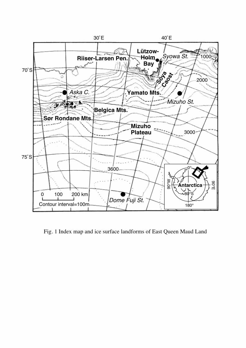
The areas of present interest are the Soya Coast and its inland area, in eastern Queen
Maud Land, East Antarctica (Fig. 1).
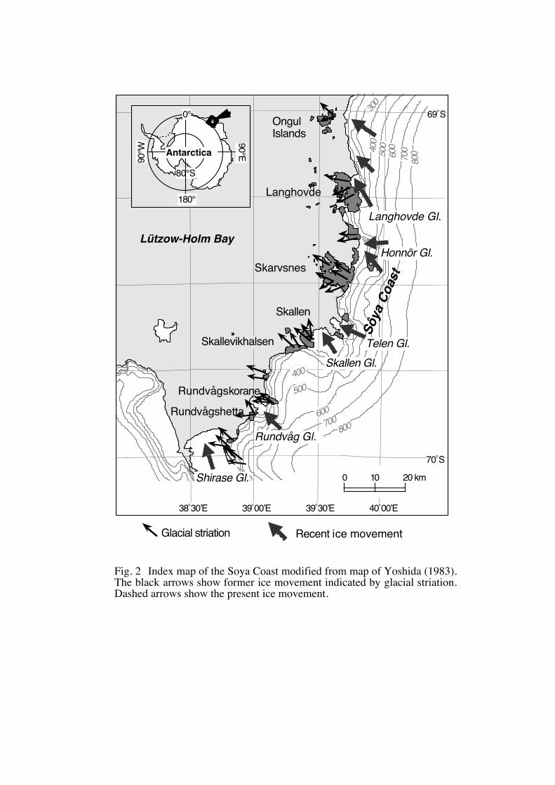
The Soya Coast is the eastern coast of the large embayment of Lützow-Holm Bay
bounded by the Riiser-Larsen Peninsula on the west and by the massive Enderby Land
on the east (Fig. 2). The coast consists of a marginal slope of the ice sheet, ice streams,
scattered ice-free areas, and a peripheral sea ice zone (Fig. 2). The bedrock of the ice-
free areas is composed of crystalline gneisses including marble and skarn, with E-W or
ESE-WNW trending structure (Yoshida et al., 1976; Ishikawa et al., 1977; Motoyoshi et
al., 1986). The bedrock surface is well polished, and these areas are inferred from
their topographic features to have been covered by a formerly more extended ice sheet
and subjected to glacial erosion (Yoshida, 1983).
Behind the coast, there is the second highest dome of the Antarctic Ice Sheet at
77˚22’S, 39˚37’E with an elevation of 3807 m (Shimizu et al., 1978) (Fig. 1). The
northeastern slope of the dome continues to the Mizuho Plateau.
Regionally, the present-day ice sheet at its margin flows approximately perpendicular
to the coast line, from east to west or from southeast to northwest. Some outlet
glaciers, such as Telen Glacier, Skallen Glacier, Rundvågs Glacier and Shirase Glacier,
flow into the sea between the ice free areas (Fig. 2). Their flowing directions are SSE-
NNW to SE-NW. Striations found on the deglaciated surface beyond the modern
margin show that the flow directions of the formerly extended ice sheet were ranged
northwestward to southwestward (Moriwaki and Yoshida, 1983; Yoshida, 1983) (Fig. 2).
The ice-free areas along the Soya Coast have been photographed several times by the
Japanese Antarctic Research Expeditions, and the studied area is well covered by air
photographs. Color prints were used to identify the glacial erosional landforms in a
larger scale than a few tens of metres. The distribution and alignment of the
sculptured erosional forms were mapped in the field, supplemented by aerial photograph
interpretation.
Sawagaki, T. and Hirakawa, K. (1997): Erosion of bedrock by subglacial meltwater, Soya Coast, East Antaractica. Geografiska Annaler, 79A(4), 223-238.
5
Subglacial erosional bedforms
A number of different types of streamlined bedforms, ice-moulded depressions and
smooth rock surfaces at scale ranging from less than a few metres to more than tens
meters were found in the ice-free areas of Skarvsnes, Skallen, Skallevikhalsen, and
Rundvågshetta districts (Fig. 2). These erosional bedforms are sculptured into
bedrocks, mainly on the gneisses and less frequent in the calcareous rocks that have
subsequently become more reshaped. They are generally better preserved along the
southern part of the coast (Yoshida, 1983). We thus concentrated the study on these
ice-free areas where the erosional bedforms are well developed.
The streamlined bedforms are ranging from less than one metre to several metres in
height. A typical streamlined bedform is the rock hill with steeper stoss slope pointing
up-ice. Judging from the morphology, the streamlined bedforms which we identified
along the Soya Coast seem to be classified as drumlins. However, to avoid confusion
with other drumlin-like features these bedforms should be called tadpole rock (Dionne,
1987) or crescentic transverse ridge (Kor et al., 1991). Especially for tadpole rock,
this form has a relatively similar form to that of roche moutonnée although the steeper
slope is oriented in the opposite direction. This is the most important point which we
note, because of the use of these forms in determining the direction of glacier movement.
Several kinds of small erosional marks were found on the streamline bedforms.
Since they are similar to s-forms described by Kor et al. (1991), we describe the
erosional marks using the terms defined by Kor et al. (1991). Assemblages of
individual small erosional marks are closely related to the morphology of larger relief
features. Sichelwanne and comma-forms (Kor et al., 1991) are found on the steep stoss
slopes of tadpole rocks or transverse rises. Furrows and spindles (Kor et al., 1991) are
found on the gentle lee slopes of tadpole rocks. In addition, crescentic s-forms (Kor et
al., 1991) tend to be replaced downglacier by longitudinal forms.
Rundvågshetta
The small erosional marks are especially frequent and well developed in
Sawagaki, T. and Hirakawa, K. (1997): Erosion of bedrock by subglacial meltwater, Soya Coast, East Antaractica. Geografiska Annaler, 79A(4), 223-238.
6
Rundvågshetta (Fig. 2). Similar features have been known to occur in
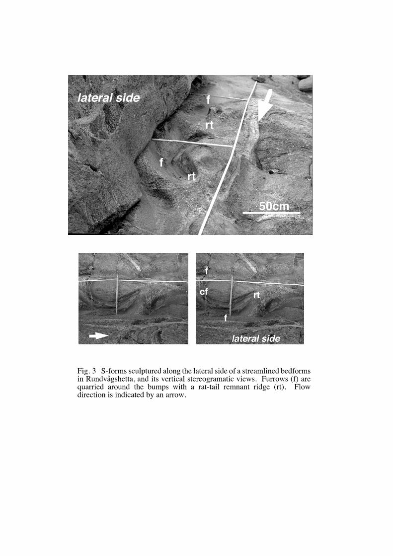
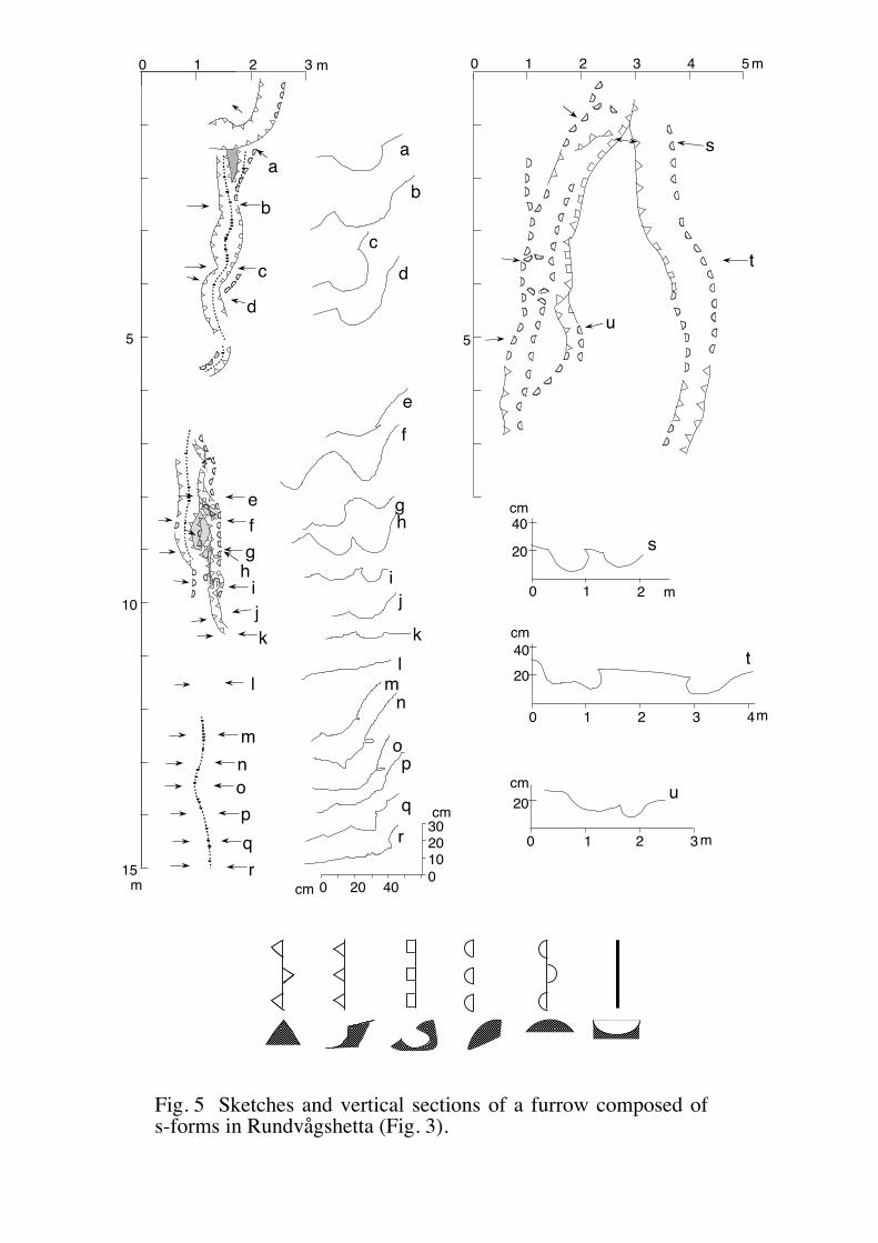
Rundvågskorane (Yoshida, 1983). Figures 3, 4 and 5 show typical examples of theses
features, consisting of a variety of s-forms and remnant ridges on the flat bed surface of
a furrow. The furrow is approximately 20 m long and 50 cm wide and its surface
gradient is less than 3 degrees. Lateral rims of the furrow are sharp and convex (Fig.
5). In contrast to this, upflow and downflow margins are merging imperceptibly with
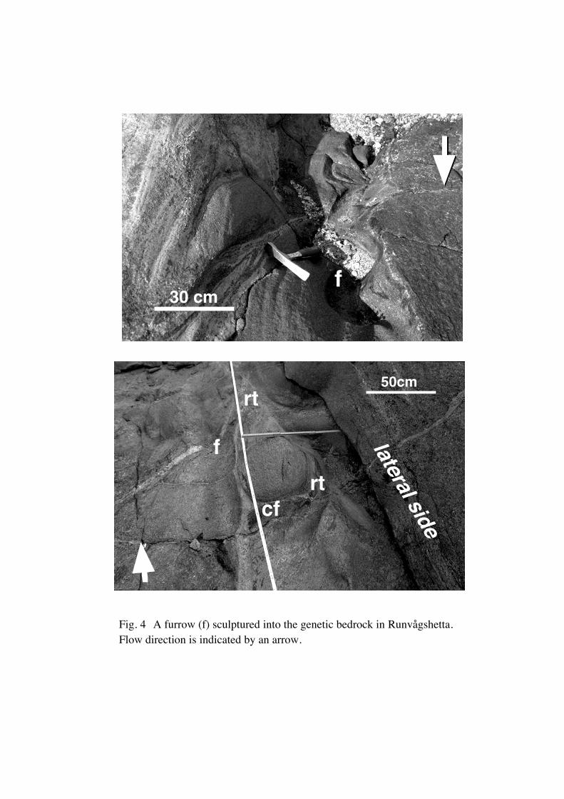
adjacent rock surface. The most remarkable s-form features are obstacle marks which
consist of a proximal crescentic furrow (cf) wrapped around an upstanding obstacle of
resistant bedrock, and a remnant ridge with rat-tail forms (rt) (Prest, 1983) (Fig. 3).
The arms of the crescentic furrow extend leeward in a pair of furrows (f) that become
shallow and wider downflow.
Skallen and Skallevikhalsen
Because the topography of these areas is rather smooth and low-relief, and because
most of these forms are interpolated by geological fluctuations (Yoshida, 1983), the
streamlined hills do not show distinctive stoss-and-lee forms presuming the upper
reaches of the former ice flow (Figs. 6 and 7). Although it is thus rather difficult to
identify the forms even from air photographs, site scale (1-10 m) forms are recognizable
in the field, where the former ice flow direction can be inferred from spindle flutes (sf)
on the lateral side. These forms point in the upflow direction and are broaden
downflow (Fig. 8).
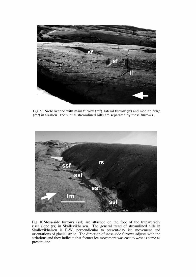
Individual hills are separated by troughs such as sichelwannen and comma-forms
(Fig. 9) These troughs were quarried along the gneissic banding or foliation on the
upper riser slope of the hills, which suggests a strong control on erosion by the bedrock
structure.
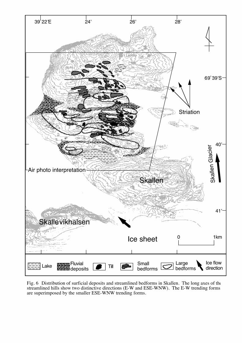
The long axes of the streamlined hills show two distinctive directions; E-W and ESE-
WNW. The smaller ESE-WNW trending forms seem to be superimposed on the E-W
trending forms (Fig. 6). These cross-cutting relationships could be interpreted as a
change both of glacial energy and the ice flow direction, during deglaciation (Rose
Sawagaki, T. and Hirakawa, K. (1997): Erosion of bedrock by subglacial meltwater, Soya Coast, East Antaractica. Geografiska Annaler, 79A(4), 223-238.
7
and Letzer, 1977; Rose, 1987; Mitchell, 1994). Beside of this, glacial striae are
oriented S-N, ESE-WNW and SE-NW (Fig. 6). The S-N trending striations are thus
perpendicular to the long axis of the larger streamlined bedforms.
The general trend of streamlined hills in Skallevikhalsen is E-W, perpendicular to the
present-day ice movement and orientations of the glacial striae. Because of this,
transverse ridges are significant streamlined bedforms in this region. On the
transversely riser slope (rs) (Kor et al., 1991) of these hills, stoss-side furrows (ssf)
(Kor et al., 1991) with directions parallel to that of the striae were found (Fig. 10).
Skarvsnes
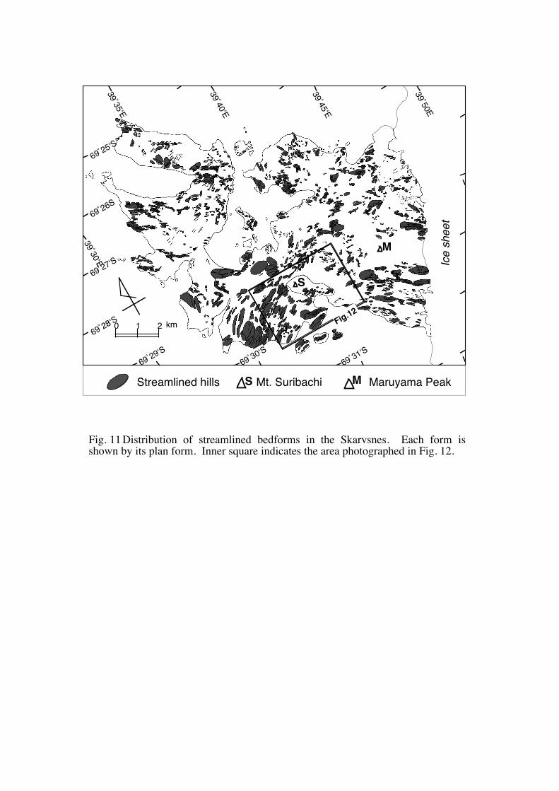
In Figure 11, the streamlined hills in Skarvsnes were mapped from interpretation of
air-photographs and maps. More than 2600 examples of streamlined bedforms were
found. In some cases these forms have been modified by the formation of smaller
forms superimposed on the crest and flanks of the larger bedforms. These
superimposed forms were also included in the population.
Most of the erosional bedforms are found in the gneisses, and the distribution of the
streamlined bedforms in this region seem to be independent of the kinds of basement
gneissic rocks. On the contrary to this, these bedforms were rare around the
Maruyama Peak, within the eastern part of Skarvsnes (Fig. 11). This feature probably
indicates that some kind of unfavorable condition for the formation of the erosional
bedforms existed beneath the ice sheet on this area (e.g. basal ice would be frozen to the
bedrock beneath cold-based ice sheet, which prevented the bedrock from glacial
erosion).
The streamlined bedforms in Skarvsnes are classified as roches moutonnées, tadpole
rocks and transverse ridges. The tadpole rocks are 5-1000 m long, and thus the larger
ones are just recognizable on airphotos (Fig. 12). Longitudinal troughs parallel to the
tadpole rocks form furrows. They appear on airphotos as a fluting pattern, 10-1000 m
in length, 1-30 m wide, and up to 10 m deep.
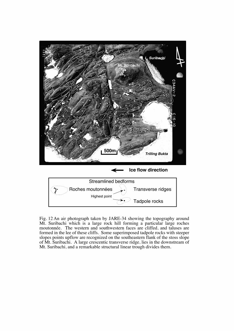
Mt. Suribachi is a large rock hill, about 1500 m long and 300 m high, forming a
Sawagaki, T. and Hirakawa, K. (1997): Erosion of bedrock by subglacial meltwater, Soya Coast, East Antaractica. Geografiska Annaler, 79A(4), 223-238.
8
particular large roche moutonnée in the central part of this study area (Figs. 11, 12).
The western and southwestern faces are cliffed, and talus slopes lie the foot of these
cliffs. Some superimposed tadpole rocks were recognized on the southeastern flank of
the stoss slope of Mt. Suribachi (Figs. 11, 12). Tadpole rocks and roches
moutonnées are two glacial landforms both formed by erosion in bedrock, they display
relatively similar shape, but the steeper slopes are oriented in opposite directions in
relation to the ice movement. Thus, we believe that they have been formed in different
way. Further interpretation of the two bedforms will be discussed later.
Large crescentic transverse ridges, 300-500 m long and 200 m wide, lie downglacier
(west) of Mt. Suribachi, and a remarkable structural linear trough divides them (Fig. 12).
Since the stoss side of the ridges curves gently, this ridges seem to be wrapped by a
large-scale furrow. Tadpole rocks and furrows of medium-scale size (1-10 m) cluster
on the stoss side of the ridges. Large tadpole rocks are found further downglacier.
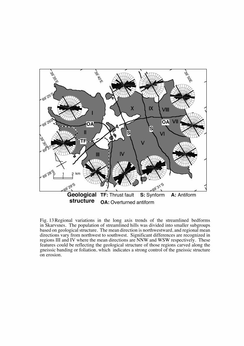
In Figure 13, the population of streamlined bedforms was divided into smaller
subgroups based on geological structure, and the orientations of their long axis were
determined. The mean orientation is NW, but local mean directions vary from NNW
to SW. Significant differences, however, are recognized in regions III and IV (Fig. 13)
where the mean directions are SSE-NNW and ENE-WSW respectively (p<0.01, �‘2 -
2 sample test). In contrast, in region III, where the general geological structure trends
north to south, the most of the streamlined bedforms are elongated perpendicular to the
ice flow direction. They are thus classified as crescentic transverse ridges. The
streamlined bedforms in the other regions are dominated by tadpole rocks, except in the
transitional region (IV) where both types of streamlined bedforms exist. These
features could be reflecting the geological structure of those regions carved along the
gneissic banding or foliation. This fact indicates a strong control of the gneissic
structure on erosion.
Sawagaki, T. and Hirakawa, K. (1997): Erosion of bedrock by subglacial meltwater, Soya Coast, East Antaractica. Geografiska Annaler, 79A(4), 223-238.
9
Discussion
The origin of the landforms
There is no doubt that the subglacial erosional bedforms in the Soya Coast are very
similar features to drumlin-shaped rockhills which have been recognized in the formerly
glaciated areas in the northern hemisphere (cf. Menzies and Rose, 1989; Dardis, and
MacCabe, 1994), and that they show excellent examples of wet-based subglacial
erosional forms. However, there have been considerable controversy surrounding the
origin of drumlin-shaped bedforms or s-forms; some authors attribute them to the action
of saturated till (Gjessing, 1965) and some to normal processes of subglacial abrasion
(Boulton, 1974, 1979), or to meltwater activity (Dahl, 1965).
Besides this, we particularly note that the drumlin-shaped bedforms in the Soya
Coast are accompanied by s-forms. Assemblages of individual s-forms are closely
related to the larger morphologic features, on where they are superimposed, short and
strongly curved forms are found on the steep stoss slopes of rock rises and tadpole rocks,
and long and straight forms are found on the gentle slopes of rock rises and tadpole
rocks. These features are similar to the morphologic relations stated by Kor et al.
(1991) who classified erosional certain marks in bedrock in Canadian shield.
In seeking an explanation for origin for these bedforms, there have been some studies
arguing in favor of a meltwater; using detailed morphological descriptions, experiments
reproducing erosional marks, and analogies with bedforms created by turbulent flows
(Dahl, 1965; Allen, 1982; Shaw and Kvill, 1984; Shaw and Sharpe, 1987; Shaw, 1988;
Sharpe and Shaw, 1989; Shaw et al., 1989; Shaw and Gilbert, 1990; Kor et al., 1991;
Shaw, 1994). Following Shaw (1983) and Kor et al. (1991), the distribution of
erosional forms of several different scales is controlled by bed topography and the
different scales of flow structure with some feedback between the two. In particular to
the formation of drumlins in bedrock, following Allen's (1971) conclusion, Shaw (1983)
proposed a local-scale (100-1000 m) flow structure of separated flows. Further more,
Shaw and Sharpe (1987), Sharpe and Shaw (1989), Shaw et al. (1989) and Shaw (1994)
Sawagaki, T. and Hirakawa, K. (1997): Erosion of bedrock by subglacial meltwater, Soya Coast, East Antaractica. Geografiska Annaler, 79A(4), 223-238.
10
discussed horseshoe vortices in terms of several kinds of erosional bedforms. These
studies rejected a glacial origin because the required vortex flow is unlikely in ice.
These discussions are attributable to the bedforms along the Soya Coast.
In previously glaciated terrain, linear morphological forms aligned parallel to former
ice flow are common. On the contrary to this, the trend of the streamlined bedforms in
the Soya Coast regionally changes in response to geological structures, and it is clear
that their directions do not always reflect the former ice sheet movement. This feature
is thus also applicable to the Shaw (1983)'s model implicating that drumlins may not be
oriented in the direction of glacier flow.
Consequently, the meltwater erosion may also explain the tadpole rocks, transverse
ridges, s-forms and absence of drift in these areas, despite the erosional bedforms along
the Soya Coast have been attributed to subglacial abrasion (Yoshida, 1983). The
presumed subglacial water flow should be a regional scale sheet flow, because the
streamlined bedforms occur over whole regions of the investigated areas. We thus
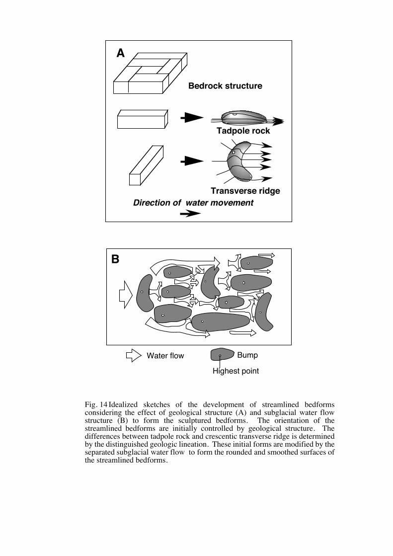
propose an erosion model showing the development sequence of the streamlined
bedforms (Fig. 14). In this Figure, the orientations of the streamlined bedforms are
initially controlled by geological structure. The differences between tadpole rocks and
crescentic transverse ridges are determined by the distinguished geologic lineation.
These initial forms are modified by the subglacial water flow such as inferred by Shaw
(1983) to form the rounded and smoothed surfaces of the streamlined bedforms.
Subglacial floods and landforms
There is a problem concerning the origin of the meltwater. In a theoretical study,
Shoemaker (1991, 1992a, b) considered that the sources for large floods for the
Laurentide ice sheet are thought to have emanated from a mega-subglacial lake in the
Hudson Bay basin. Such water pondings or subglacial drainages are unlikely beneath
the Antarctic ice sheet in the coastal zone, where the ice may be cold-based under thin
ice. In contrast, subglacial lakes are known to exist beneath the interior of the
Antarctic ice sheet, and presumably existed beneath Pleistocene ice sheets (Oswald and
Sawagaki, T. and Hirakawa, K. (1997): Erosion of bedrock by subglacial meltwater, Soya Coast, East Antaractica. Geografiska Annaler, 79A(4), 223-238.
11
Robin, 1973; Robin et al., 1977; Cudlip and McIntyre, 1987; Ellis-Evans and Wynn-
Williams, 1996; Kapitsa et al., 1996).
Sugden et al. (1991), who investigated channels in part of Asgard Range in
Antarctica, pointed out that it is improbable that discharges associated with steady state
pressure melting can produce the volume required to cut large channels. They instead
suggested that the meltwater could be produced by sudden outbursts reflecting periodic
drainage of sub-glacial lakes beneath the thick ice or by sub-glacial drainage of surface
lakes.
In particular along the Shirase drainage basin, the ice temperature was calculated by
Nishio et al. (1989), and their result indicates that the base temperature is at pressure
melting point between 20 km and 260 km from the coast, and the basal ice of the upper
part of the basin beyond 260 km from the coast is frozen to the bed. Moreover, Mae
and Naruse (1978) pointed out the possible basal sliding beneath the ice sheet of the
Shirase drainage basin 200 km inland from the coast. It is also notable that
unconsolidated deposits are poorly preserved in the ice-free areas along the Soya Coast.
Overriding by a temperate ice sheet, and meltwater produced by sudden outbursts
reflecting periodic drainage of subglacial lakes would most likely have removed any
loose sediments.
Consequently, it may thus be possible to assume that ponded water in subglacial
lakes in the upper reaches of the coast was evacuated to the margin by discrete
subglacial floods along the basal sliding zone. Although such lakes have not been
revealed up to now, we will made the further investigation on this matter in a separate
paper.
Historical development of the landforms in Skarvsnes
We pointed out that the large roche moutonnée in the vicinity of Mt. Suribachi was
sculpted in a way different from the superimposing tadpole rocks. The evaluation of
these two kinds of bedforms gives information about temporal succession of the
erosional landform generations.
Sawagaki, T. and Hirakawa, K. (1997): Erosion of bedrock by subglacial meltwater, Soya Coast, East Antaractica. Geografiska Annaler, 79A(4), 223-238.
12
In the evolution of large roches moutonnées, the link between plucking and
subglacial meltwater is emphasized (Röthlisberger and Iken, 1981; Sugden et al., 1992).
On the contrary to this, subglacial water flow is emphasized for the tadpole rocks in this
study. Accordingly, two processes can be recognized for the development of Mt.
Suribachi: glacial plucking forming the steep lee slope pointing downglacier and
subglacial meltwater erosion forming the superimposed tadpole rocks. Since the
superimposed tadpole rocks are concentrated on the southern flank of Mt. Suribachi, the
subglacial water flow forming the tadpole rocks should have been converged into this
area. This feature indicates that the distribution of the erosional bedforms and the
water flow pattern were controlled by the large scale bed topography (Mt. Suribachi).
Sugden et al. (1992) suggested that favorable conditions for plucking had existed in a
zone of thin ice near the margin of ice sheets. Although they studied to mid-latitude
ice sheets, their explanation also leads us to an assumption that the margin of the ice
sheet was situated near the western edge of the present ice-free areas along the Soya
Coast. Concerning the Holocene marine limit in this region, which reflects the
regional isostatic rebound, Hayashi and Yoshida (1994) suggested that the ice sheet
covering the present ice-free areas was not thick during the Last Glacial Maximum, and
that the ice sheet retreated from the main areas during the period prior to 35000 yr BP.
Consequently, both processes took place near the margin of the ice sheet and these
two processes must have been active almost simultaneously this large roche moutonnée
could be interpreted as an older form than the superimposed tadpole rocks.
Historical development of the landforms in Skallen
The present-day movement of Skallen Glacier is northward, and three major
orientations of glacial striae in Skallen had been changed from SE-NW to S-N. On the
other hand, two trends of the streamlined bedforms were revealed, pointing westward
for the larger bedforms, and northwestward for the smaller bedforms. Based on these
features, the glacial flow direction was reconstructed to have changed from westward to
northward.
Sawagaki, T. and Hirakawa, K. (1997): Erosion of bedrock by subglacial meltwater, Soya Coast, East Antaractica. Geografiska Annaler, 79A(4), 223-238.
13
The historical change of basal processes is also inferred. Thus, in the earliest stage,
the bedrock was eroded by glacial abrasion and plucking beneath the wet-based ice
sheet, in the same way as in Skarvsnes. In the following stage, subglacial meltwater
was evacuated to the ice-margin and the pre-existed bedforms should have been
destroyed or have been deformed into the larger streamlined bedforms and s-forms.
This flow should be terminated in short period and was followed by glacial abrasion
processes which formed the striations parallel to the larger bedforms. When the ice
flow direction changed to the northwestward, another water sheet flow occurred again,
which should have smaller energy than the former one, to form superimposed smaller
bedforms. The last stage was dominated by glacial abrasion to form the striations
parallel to the northward ice-flow directions of the present Skallen glacier. It is also
assumed that the ice sheet flow in this stage has changed into a local ice stream as same
as the present state of Skallen glacier. Thus, the Skallen district has been influenced
by Skallen glacier until quiet recently.
The bedform evolution along the Soya Coast
Although the exact time when the erosional forms were created is still unknown, the
fine preservations of the eroded bedrock along the Soya Coast probably represent the
last major geomorphic activity of the Antarctic Ice Sheet, and strongly suggest an event
of the subglacial water erosion of bedrock.
The above discussions are summarized in Figure 15, and we interpret and conclude
bedform evolution along the Soya Coast as follows.
An initial episode of glacial plucking and abrasion produced roches moutonnées and
basic large-scale landforms. Then till was probably deposited on the abraded and
plucked bedrock. Later meltwater flowing into the Lützow-Holm Bay eroded s-forms
and streamlined hillocks in bedrock of the greater part of the studied areas. Ice again
came in contact with the bedrock, and striations were superimposed on the s-forms and
the hills. Consequently, this region seems to have experienced single subglacial water
flood. It is probably because the retreat of ice sheet from this region should be earlier
Sawagaki, T. and Hirakawa, K. (1997): Erosion of bedrock by subglacial meltwater, Soya Coast, East Antaractica. Geografiska Annaler, 79A(4), 223-238.
14
than Skallen.
It is expected that detailed examinations and observations are required to reveal
historical change of basal thermal regime of the ice sheet which affects existence of the
subglacial lake or subglacial water sheet flood in relation to the global climatic change.
In addition to this, it is necessary that the distribution pattern of the bedforms is
explained by subglacial water flow before we come to our final decision for subglacial
meltwater genesis.
Sawagaki, T. and Hirakawa, K. (1997): Erosion of bedrock by subglacial meltwater, Soya Coast, East Antaractica. Geografiska Annaler, 79A(4), 223-238.
15
Conclusions
Followings are the revealed features and the reconstructed historical development of
the erosional bedforms along the Soya Coast, in relation to the possible subglacial water
erosion processes.
(1) The streamlined bedforms were observed over whole regions of in the southern part
of the Soya Coast. They are composed of tadpole rocks, transverse ridges and
roches moutonnées, and those are accompanied by s-forms.
(2) The streamlined bedforms are classified into several groups based on their
orientation and scale, which are basically controlled by the basement rock structure
and secondly modified by subglacial erosion processes.
(3) The sculptured bedforms strongly suggest the subglacial water erosion for their
genesis, and the inferred subglacial water flow must have been a water sheet-flow,
judging from the areal distribution of the erosional bedforms in the Soya Coast.
(4) The source of meltwater should be attributed to the subglacial lakes beneath the
upper reaches of the Mizuho Plateau. However, existence of these lakes has not
been revealed yet.
(5) The link between plucking and subglacial meltwater is emphasized in the evolution
of the large roches moutonnée and the superimposing tadpole rocks. The
subglacial condition required for the evolution of roches moutonnées supports the
assumption that the former ice sheet that took part in the development of the
drumlin-shaped hills extended to the western edge of the present ice-free areas
along the Soya Coast.
(6) The bedform evolution along the Soya Coast was reconstructed as follows: An
initial episode of glacial plucking and abrasion produced roches moutonnées and
basic large-scale landforms. Meltwater flowing periodically into the Lützow-
Holm Bay sculptured s-forms and streamlined bedforms in bedrock of the greater
part of the areas. During this period, except for water flowing phases, ice again
come contact with the bedrock to form striations superimposed on the s-forms and
the hills.
Sawagaki, T. and Hirakawa, K. (1997): Erosion of bedrock by subglacial meltwater, Soya Coast, East Antaractica. Geografiska Annaler, 79A(4), 223-238.
16
Acknowledgements
This research was supported by a grant-in-aid for scientific research from the Japan
Society for the Promotion of Science. We would like to acknowledge the members of
the 33th, 34th and 35th Japanese Antarctic Research Expeditions for their kind
collaboration in the field. We gratefully acknowledge the sincere advice and
discussion of .Prof. Y. Ono, Prof. R. Naruse, Prof. T. Watanabe, and Dr. Y. Kurashige
of Hokkaido University. Thanks are also due to Prof. Y. Yoshida of Rissho University,
Prof. K. Moriwaki of Japanese National Institute of Polar Research, and Dr. D. Zwartz
of the Australian National University for their help for improving this paper.
Sawagaki, T. and Hirakawa, K. (1997): Erosion of bedrock by subglacial meltwater, Soya Coast, East Antaractica. Geografiska Annaler, 79A(4), 223-238.
17
References cited
Allen, J. R. L., 1971: Transverse erosional marks of mud and rock: their physical basis
and geological significance. Sedimentary Geology, 5, Spec. Issue Nos. 3-4,
167-385.
------- 1982: Sedimentary Structures, 2 vols. Amsterdam: Elsevier.
Boulton, G. S., 1974: Processes and patterns of glacial erosion. In D. R. Coates (Eds.),
Glacial geomorphology (pp. 41-87) New York: State University of New
York.
-------1979: Processes of glacier erosion on different substrata. Journal of Glaciology,
23, 15-37.
Cudlip, W. and McIntyre, N. F., 1987: Seasat altimeter observations of an Antarctic
"lake". Annals of Glaciology, 9, 55-59.
Dahl, R., 1965: Plastically sculptured detail forms on rock surface in northern Nordland,
Norway. Geogr. Ann., 47A, 83-140.
Dardis, G. F., and MacCabe, A. M., 1994: Subglacial processes, sediments and
landforms-an introduction. Sedimentary Geology, 91, 1-5.
Dionne, J. C., 1987: Tadpole rock (rocdrumlin): A glacial stream moulded form. In
Menzies, J. and Rose, J. (Eds), Drumlin Symposium (pp. 149-159)
Rotterdam: Balkema.
Ellis-Evans, C. J. and Wynn-Williams, D., 1996: A great lake under the ice. Nature , 381,
644-646.
Fujiwara, K., 1973:The landforms of the Mizukumi Zawa near Syowa Station, East
Antarctica). Nankyoku Shiryo (Antarct. Rec.), 46, 44-66 (in Japanese).
Gjessing, J., 1965: On "plastic scouring" and "subglacial erosion". Norsk Geografisk
Tidsskrift, 20, 1-37.
Hayashi, M. and Yoshida, Y., 1994: Holocene raised beaches in the Lützow-Holm Bay
region, East Antarctica. Mem. Natl Inst. Polar Res. Spec. Issue., 50, 49-84.
Ishikawa, T., Yanai, K., Matsumoto, Y., Kizaki, K., Kojima, S., Tatsumi, T., Kikuchi, T.
and Yoshida, M., 1977: Geological map of Skarvsnes, Antarctica.
Sawagaki, T. and Hirakawa, K. (1997): Erosion of bedrock by subglacial meltwater, Soya Coast, East Antaractica. Geografiska Annaler, 79A(4), 223-238.
18
Explanatory text. In Tokyo: Natl Inst. Polar Res.
Kapitsa, A. P., Ridley, J. K., Robin, G. D. Q., Siegert, M. J. and Zotikov, I. A., 1996: A
large deep freshwater lake beneath the ice of central East Antarctica. Nature,
381, 684-686.
Koaze, T., 1964: The landform of the northern part of Prince Harald Coast, East
Antarctica). Nankyoku Shiryo (Antarc. Rec.), 20, 61-74 (in Japanese).
Kor, P. S. G., Shaw, J. and Sharpe, D. R., 1991: Erosion of bedrock by subglacial
meltwater, Georgian Bay, Ontario: A regional view. Canadian Journal of
Earth Science, 28, 623-642.
Mae, S. and Naruse, R., 1978: Possible cause of ice sheet thinning in the Mizuho
Plateau. Nature , 273, 291-292.
Menzies, J., and Rose, J., 1989: Subglacial Bedforms - an introduction. Sedimentary
Geology, 62, 117-122.
Mitchell, W. A., 1994: Drumlins in ice sheet reconstructions, with reference to the
western Penines, northern England. Sedimentary Geology, 91, 313-331.
Moriwaki, K., 1976: Glacio-geomorphological observations in and around ice-free areas
in the vicinity of Syowa Station, Antarctica. Nankyoku Shiryo (Antarct.
Rec.), 57, 24-55 (in Japanese).
Moriwaki, K. and Yoshida, Y., 1983: Submarine topography of Lützow-Holm Bay,
Antarctica. Mem. Natl Inst. Polar Res. Spec. Issue, 28, 247-258.
Motoyoshi, Y., Matsueda, H., Matsubara, S., Sasaki, K. and Moriwaki, K., 1986:
Geological Map of Rundvågskollane and Rundvågshetta. In Tokyo: Natl
Inst. Polar Res.
Nishio, F., Mae, S., Ohmae, H., Takahashi, S., Nakawo, M. and Kawada, K., 1989:
Dynamical behavior of the ice sheet in Mizuho Plateau, East Antarctica.
Proc. NIPR Symp. Polar Meteorol. Glaciol., 2, 97-104.
Omoto, K., 1977: Geomorphic development of Soya Coast, East Antarctica -
Chronological interpretation of raised beaches based on levellings and radio
carbon datings. Sic. Rep. Tohoku Univ. 7th Ser (Geogr.), 24, 205-209.
Sawagaki, T. and Hirakawa, K. (1997): Erosion of bedrock by subglacial meltwater, Soya Coast, East Antaractica. Geografiska Annaler, 79A(4), 223-238.
19
Oswald, G. K. and Robin, G. D. Q., 1973: Lakes beneath the Antarctic ice sheet. Nature,
245, 251-254.
Prest, V. K., 1983: Canada's heritage of glacial features. Geological Survey of Canada
Miscellaneous Report, 28, 119.
Robin, G. D. Q., Drewry, D. J. and Meldrum, D. T., 1977: International studies of ice
sheet and bedrock. Philosophical Transactions of the Royal Society of
London, Series B , 279, 185-196.
Rose, J., 1987: Drumlins as part of a glacier bedform continuum.form. In Menzies, J.
and Rose J. (Eds.), Drumlin Symposium (pp. 103-116) Rotterdam: Balkema.
Rose, J. and Letzer, J. M., 1977: Superimposed drumlins. Journal of Glaciology, 18(80),
471-480.
Röthlisberger, H. and Iken, A., 1981: Plucking as an effect of water-pressure variations
at the glacier bed. Annals of Glaciology, 2, 57-62.
Sharpe, D. R. and Shaw, J., 1989: Erosion of bedrock by subglacial meltwater, Cantley,
Quebec. Geological Society of America Bulletin, 101, 1011-1020.
Shaw, J., 1983: Drumlin formation related to inverted melt-water erosional marks.
Journal of Glaciology, 29(103), 461-479.
-------1988: Subglacial erosional marks, Wilton Creek, Ontario. Canadian Journal of
Earth Science, 25, 1256-1267.
-------1994: Hairpin erosional marks, horseshoe vortices and subglacial erosion.
Sedimentary Geology, 91, 269-283.
Shaw, J. and Gilbert, R., 1990: Evidence for large-scale subglacial meltwater flood
events in southern Ontario and northern New York State. Geology, 18,
1169-1172.
Shaw, J. and Kvill, D., 1984: A glaciofluvial origin for drumlins of the Livingston Lake
area, Saskatchewan. Canadian Journal of Earth Science, 21, 1442-1459.
Shaw, J., Kvill, D. and Rains, B., 1989: Drumlins and catastrophic subglacial floods.
Sedimentary Geology, 62, 177-202.
Shaw, J. and Sharpe, D. R., 1987: Drumlin formation by subglacial meltwater erosion.
Sawagaki, T. and Hirakawa, K. (1997): Erosion of bedrock by subglacial meltwater, Soya Coast, East Antaractica. Geografiska Annaler, 79A(4), 223-238.
20
Canadian Journal of Earth Science, 24, 2316-2322.
Shimizu, H., Yoshimura, A., Naruse, R., and Yokoyama, K., 1978: Morphological
features of the ice sheet in Mizuho Plateau. Mem. Natl Inst. Polar Res. Spec.
Issue, 7, 14-25.
Shoemaker, E. M., 1991: On the formation of large subglacial lakes. Canadian Journal
of Earth Science, 28, 1975-1981.
------1992a: Subglacial floods and the origin of low-relief ice-sheet lobes. Journal of
Glaciology, 38(128), 105-112.
------1992b: Water sheet outburst floods from the Laurentide Ice Sheet. Canadian
Journal of Earth Science, 29, 1250-1264.
Sugden, D. E., Denton, G. H. and Marchant, D. R., 1991: Subglacial meltwater channel
systems and ice sheet overriding, Asgard Range, Antarctica. Geogr. Ann.,
73A (2), 109-121.
Sugden, D. E., Glasser, N. and Clapperton, C. M., 1992: Evolution of large roches
moutonneés. Geogr. Ann., 74A (2-3), 253-264.
Sugden, D. E. and John, B. S., 1984: Glaciers and Landscape. New York: Edward
Arnold.
Tatsumi, T. and Kikuchi, T., 1959a: Report of geomorphological and geological studies
of the wintering team (1957-58) of the first Japanese Antarctic Research
Expedition, Part 1. Nankyoku Shiryo (Antarct. Rec.), 7, 1-16 (in Japanese).
-------1959b: Report of geomorphological and geological studies of the wintering team
(1957-1958) of the first Japanese Antarctic Research Expedition, Part 2.
Nankyoku Shiryo (Antarct. Rec.), 8, 1-21 (in Japanese).
Yoshida, M., Yoshida, Y., Ando, H., Ishikawa, T. and Tatsumi, T., 1976: Geological map
of Skallen. In Tokyo: Natl Inst. Polar Res.
Yoshida, Y., 1973: Geomorphology of the ice-free areas and fluctuation of the ice sheet,
In K. Kusunoki (Eds.), Nankyoku (pp. 237-381) Tokyo: Kyoritsu Shuppan
(in Japanese).
-------1983: Physiography of the Prince Olav and the Prince Harald Coasts, East
Sawagaki, T. and Hirakawa, K. (1997): Erosion of bedrock by subglacial meltwater, Soya Coast, East Antaractica. Geografiska Annaler, 79A(4), 223-238.
21
Antarctica. Mem. Natl Inst.Polar Res. Series C (Earth Science), 13, 1-76.
Yoshida, Y. and Moriwaki, K., 1979: Some consideration on elevated coastal features
and their dates round Syowa Station Antarctica. Mem. Natl Inst. Polar Res.
Spec. Issue, 13, Proceedings of the seminar III on Dry Valley Drilling
Project, 202-226.
Yoshikawa, Y. and Toya, H., 1957: Report on geomorphological results of Japanese
Antarctic Research Expedition, 1956-57. Nankyoku Shiryo (Antarct. Rec.), 1,
1-13 (in Japanese).
Sawagaki, T. and Hirakawa, K. (1997): Erosion of bedrock by subglacial meltwater, Soya Coast, East Antaractica. Geografiska Annaler, 79A(4), 223-238.
22
Figure Captions
Fig. 1 Index map and ice surface landforms of East Queen Maud Land.
Fig. 2 Index map of the Soya Coast modified from map of Yoshida (1983). The
black arrows show former ice movement indicated by glacial striation.
Dashed arrows show the present ice movement.
Fig. 3 S-forms sculptured along the lateral side of a streamlined bedforms in
Rundvågshetta, and its vertical stereogramatic views. Furrows (f) are
quarried around the bumps with a rat-tail remnant ridge (rt). Flow direction
is indicated by an arrow.
Fig. 4 A furrow (f) sculptured into the genetic bedrock in Runvågshetta. Flow
direction is indicated by an arrow.
Fig. 5 Sketches and vertical sections of a furrow composed of s-forms in
Rundvågshetta (Fig. 3).
Fig. 6 Distribution of surficial deposits and streamlined bedforms in Skallen. The
long axes of the streamlined hills show two distinctive directions (E-W and
ESE-WNW). The E-W trending forms are superimposed by the smaller
ESE-WNW trending forms.
Fig. 7 Streamlined bedforms in Skallen. The inferred ice flow direction is
approximately from right to left.
Fig. 8 Spindle flutes (sf) and lateral furrow (lf) cut into a lateral side of a streamlined
hill in Skallen. Former ice flow direction (arrow) is inferred from these
marks which points in the upflow direction and broaden downflow.
Fig. 9 Sichelwanne with main furrow (mf), lateral furrow (lf) and median ridge (mr)
in Skallen. Individual streamlined hills are separated by these furrows.
Fig. 10 Stoss-side furrows (ssf) are attached on the foot of the transversely riser slope
(rs) in Skallevikhalsen. The general trend of streamlined hills in
Skallevikhalsen is E-W, perpendicular to present-day ice movement and
orientations of glacial striae. The direction of stoss-side furrows adjusts with
the striations and they indicate that former ice movement was east to west as
Sawagaki, T. and Hirakawa, K. (1997): Erosion of bedrock by subglacial meltwater, Soya Coast, East Antaractica. Geografiska Annaler, 79A(4), 223-238.
23
same as present one.
Fig. 11 Distribution of streamlined bedforms in the Skarvsnes. Each form is shown
by its plan form. Inner square indicates the area photographed in Fig. 12.
Fig. 12 An air photograph taken by JARE-34 showing the topography around Mt.
Suribachi which is a large rock hill forming a particular large roches
moutonnée. The western and southwestern faces are cliffed, and taluses are
formed in the lee of these cliffs. Some superimposed tadpole rocks with
steeper slopes points upflow are recognized on the southeastern flank of the
stoss slope of Mt. Suribachi. A large crescentic transverse ridge, lies in the
downstream of Mt. Suribachi, and a remarkable structural linear trough divides
them.
Fig. 13 Regional variations in the long axis trends of the streamlined bedforms in
Skarvsnes. The population of streamlined hills was divided into smaller
subgroups based on geological structure. The mean direction is
northwestward, and regional mean directions vary from northwest to southwest.
Significant differences are recognized in regions III and IV where the mean
directions are NNW and WSW respectively. These features could be
reflecting the geological structure of those regions carved along the gneissic
banding or foliation, which indicates a strong control of the gneissic
structure on erosion.
Fig. 14 Idealized sketches of the development of streamlined bedforms considering the
effect of geological structure (A) and subglacial water flow structure (B) to
form the sculptured bedforms. The orientation of the streamlined bedforms
are initially controlled by geological structure. The differences between
tadpole rock and crescentic transverse ridge is determined by the distinguished
geologic lineation. These initial forms are modified by the separated
subglacial water flow to form the rounded and smoothed surfaces of the
streamlined bedforms.
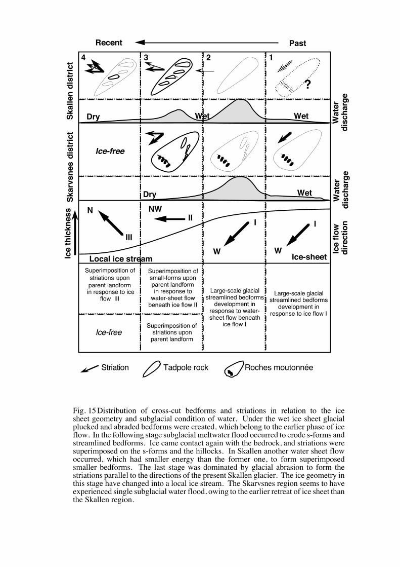
Fig. 15 Distribution of cross-cut bedforms and striations in relation to the ice sheet
Sawagaki, T. and Hirakawa, K. (1997): Erosion of bedrock by subglacial meltwater, Soya Coast, East Antaractica. Geografiska Annaler, 79A(4), 223-238.
24
geometry and subglacial condition of water. Under the wet ice sheet glacial
plucked and abraded bedforms were created, which belong to the earlier phase
of ice flow. In the following stage subglacial meltwater flood occurred to
erode s-forms and streamlined bedforms. Ice came contact again with the
bedrock, and striations were superimposed on the s-forms and the hillocks. In
Skallen another water sheet flow occurred, which had smaller energy than the
former one, to form superimposed smaller bedforms. The last stage was
dominated by glacial abrasion to form the striations parallel to the directions of
the present Skallen glacier. The ice geometry in this stage have changed into
a local ice stream. The Skarvsnes region seems to have experienced single
subglacial water flood, owing to the earlier retreat of ice sheet than the Skallen
region.
Aska C.Mizuho St.
30˚E 40˚E
70˚S
75˚S
1000
2000
3000
3600
Sør Rondane Mts.Belgica Mts.
Yamato Mts.
Syowa St.
Sôya
Ca
ost
Lützow-Holm Bay
Riiser-Larsen Pen.
MizuhoPlateau
Dome Fuji St.80°S
90°W
90°E
0°
180°
Antarctica
0 100 200 km
Contour interval=100m
Fig. 1 Index map and ice surface landforms of East Queen Maud Land.
400
500
600700
800
300
400
500
600
700
800
Ongul Islands
Langhovde
Skarvsnes
Skallen
Rundvågshetta
Skallevikhalsen
Lützow-Holm Bay
Langhovde Gl.
Honnör Gl.
Telen Gl.Skallen Gl.
Rundvåg Gl.
Shirase Gl.
Sôya
Coa
stRundvågskorane
80°S
90°W
90°E
0°
180°
Antarctica
38˚30’E 40˚00’E
69˚S
70˚S
39˚30’E39˚00’E
0 10 20 km
Glacial striation Recent ice movement
Fig. 2 Index map of the Soya Coast modified from map of Yoshida (1983). The black arrows show former ice movement indicated by glacial striation. Dashed arrows show the present ice movement.
rt
rtf
flateral side
50cm
rtcf
f
f
lateral side
Fig. 3 S-forms sculptured along the lateral side of a streamlined bedforms in Rundvågshetta, and its vertical stereogramatic views. Furrows (f) are quarried around the bumps with a rat-tail remnant ridge (rt). Flow direction is indicated by an arrow.
f30 cm
rt
rtf
cf
lateral side
50cm
Fig. 4 A furrow (f) sculptured into the genetic bedrock in Runvågshetta. Flow direction is indicated by an arrow.
5
10
15m
0 1 2 3 m
cm 0 20 400102030cm
0 1 2 3 4 5m
5
a
b
c
d
efghijk
l
mnopqr
s
t
u
a
b
cd
f
h
ij
e
g
kl
mn
op
rq
s
0 1 2
20
40
m
cm
t
0 1 2 3 4
2040cm
m
u20cm
0 1 2 3m
Fig. 5 Sketches and vertical sections of a furrow composed of s-forms in Rundvågshetta (Fig. 3).
39˚22’E 24’ 26’ 28’
69˚39’S
40’
41’
0 1km
FluvialdepositsLake Small
bedformsLargebedformsTill
Air photo interpretation
Striation
Skallen
SkallevikhalsenSk
alle
n G
lacie
r
Ice sheet
Ice flowdirection
Fig. 6 Distribution of surficial deposits and streamlined bedforms in Skallen. The long axes of the streamlined hills show two distinctive directions (E-W and ESE-WNW). The E-W trending forms are superimposed by the smaller ESE-WNW trending forms.
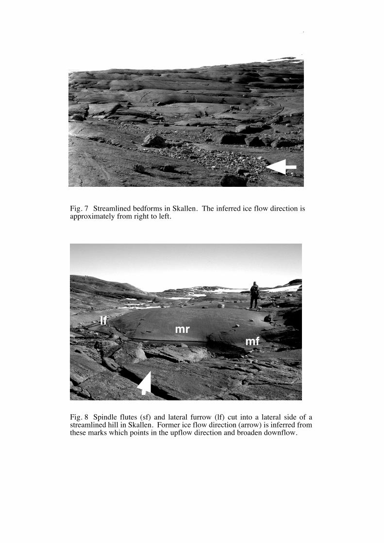
Fig. 7 Streamlined bedforms in Skallen. The inferred ice flow direction is approximately from right to left.
mfmrlf
Fig. 8 Spindle flutes (sf) and lateral furrow (lf) cut into a lateral side of a streamlined hill in Skallen. Former ice flow direction (arrow) is inferred from these marks which points in the upflow direction and broaden downflow.
sfsf
lf
ssfssf
ssf
ssf
rs
1m
Fig. 9 Sichelwanne with main furrow (mf), lateral furrow (lf) and median ridge (mr) in Skallen. Individual streamlined hills are separated by these furrows.
Fig. 10 Stoss-side furrows (ssf) are attached on the foot of the transversely riser slope (rs) in Skallevikhalsen. The general trend of streamlined hills in Skallevikhalsen is E-W, perpendicular to present-day ice movement and orientations of glacial striae. The direction of stoss-side furrows adjusts with the striations and they indicate that former ice movement was east to west as same as present one.
1 2 km0
39˚50E
39˚35‘E
39˚40‘E
39˚45‘E
69˚30‘S69˚31‘S
69˚29‘S
69˚28‘S
69˚27‘S
69˚26S
69˚25‘S
39˚30‘E
Streamlined hills
Fig.12
Ice
shee
t
S
M
S MMt. Suribachi Maruyama Peak
Fig. 11 Distribution of streamlined bedforms in the Skarvsnes. Each form is shown by its plan form. Inner square indicates the area photographed in Fig. 12.
500m
Mt. Suribachi
L. Suribachi
Trilling Bukta
Ice flow direction
Streamlined bedforms
Tadpole rocks
Transverse ridgesRoches moutonnéesHighest point
Fig. 12 An air photograph taken by JARE-34 showing the topography around Mt. Suribachi which is a large rock hill forming a particular large roches moutonnée. The western and southwestern faces are cliffed, and taluses are formed in the lee of these cliffs. Some superimposed tadpole rocks with steeper slopes points upflow are recognized on the southeastern flank of the stoss slope of Mt. Suribachi. A large crescentic transverse ridge, lies in the downstream of Mt. Suribachi, and a remarkable structural linear trough divides them.
OASA
TF
OA
S
Geologicalstructure OA: Overturned antiform
A: AntiformS: SynformTF: Thrust fault
N
N
NN
N
N
N
N
NN
I
II
III IV
V
VI
VII
VIIIIXX
1 2 km0
39˚50E
39˚35‘E
39˚40‘E
69˚31‘S69˚29‘S
69˚28‘S
69˚27‘S
69˚26S
69˚25‘S
39˚30‘E
Fig. 13 Regional variations in the long axis trends of the streamlined bedforms in Skarvsnes. The population of streamlined hills was divided into smaller subgroups based on geological structure. The mean direction is northwestward, and regional mean directions vary from northwest to southwest. Significant differences are recognized in regions III and IV where the mean directions are NNW and WSW respectively. These features could be reflecting the geological structure of those regions carved along the gneissic banding or foliation, which indicates a strong control of the gneissic structure on erosion.
Direction of water movement
Tadpole rock
Transverse ridge
Bedrock structure
A
Bump
Highest point
Water flow
B
Fig. 14 Idealized sketches of the development of streamlined bedforms considering the effect of geological structure (A) and subglacial water flow structure (B) to form the sculptured bedforms. The orientation of the streamlined bedforms are initially controlled by geological structure. The differences between tadpole rock and crescentic transverse ridge is determined by the distinguished geologic lineation. These initial forms are modified by the separated subglacial water flow to form the rounded and smoothed surfaces of the streamlined bedforms.
Wat
erdi
scha
rge
Wat
erdi
scha
rge
1234Sk
alle
n di
stric
tSk
arvs
nes
dist
rict
?
Ice-free
Large-scale glacialstreamlined bedforms
development in response to water-sheet flow beneath
ice flow I
Superimposition of small-forms upon parent landformin response to
water-sheet flow beneath ice flow II
Large-scale glacialstreamlined bedforms
development in response to ice flow I
Superimposition of striations upon
parent landform
Superimposition of striations upon parent landform
in response to ice flow III
Ice-free
IIII
II I
Ice
thic
knes
s
Ice
flow
di
rect
ion
N NW
W W
Striation Tadpole rock Roches moutonnée
PastRecent
Local ice stream Ice-sheet
Wet
Wet
Dry
Dry
Wet
Fig. 15 Distribution of cross-cut bedforms and striations in relation to the ice sheet geometry and subglacial condition of water. Under the wet ice sheet glacial plucked and abraded bedforms were created, which belong to the earlier phase of ice flow. In the following stage subglacial meltwater flood occurred to erode s-forms and streamlined bedforms. Ice came contact again with the bedrock, and striations were superimposed on the s-forms and the hillocks. In Skallen another water sheet flow occurred, which had smaller energy than the former one, to form superimposed smaller bedforms. The last stage was dominated by glacial abrasion to form the striations parallel to the directions of the present Skallen glacier. The ice geometry in this stage have changed into a local ice stream. The Skarvsnes region seems to have experienced single subglacial water flood, owing to the earlier retreat of ice sheet than the Skallen region.