Embed Size (px)
Citation preview
Erosion rates at the Mars Exploration Rover landing sites
and long-term climate change on Mars
M. P. Golombek,1 J. A. Grant,2 L. S. Crumpler,3 R. Greeley,4 R. E. Arvidson,5
J. F. Bell III,6 C. M. Weitz,7 R. Sullivan,6 P. R. Christensen,4 L. A. Soderblom,8
and S. W. Squyres6
Received 17 May 2006; revised 17 August 2006; accepted 22 September 2006; published 8 December 2006.
[1] Erosion rates derived from the Gusev cratered plains and the erosion of weak sulfatesby saltating sand at Meridiani Planum are so slow that they argue that the present dryand desiccating environment has persisted since the Early Hesperian. In contrast,sedimentary rocks at Meridiani formed in the presence of groundwater and occasionalsurface water, and many Columbia Hills rocks at Gusev underwent aqueous alterationduring the Late Noachian, approximately coeval with a wide variety of geomorphicindicators that indicate a wetter and likely warmer environment. Two-toned rocks,elevated ventifacts, and perched and undercut rocks indicate localized deflation of theGusev plains and deposition of an equivalent amount of sediment into craters to formhollows, suggesting average erosion rates of �0.03 nm/yr. Erosion of Hesperian craters,modification of Late Amazonian craters, and the concentration of hematite concretions inthe soils of Meridiani yield slightly higher average erosion rates of 1–10 nm/yr in theAmazonian. These erosion rates are 2–5 orders of magnitude lower than the slowestcontinental denudation rates on Earth, indicating that liquid water was not an activeerosional agent. Erosion rates for Meridiani just before deposition of the sulfate-richsediments and other eroded Noachian areas are comparable with slow denudation rates onEarth that are dominated by liquid water. Available data suggest the climate change at thelanding sites from wet and likely warm to dry and desiccating occurred sometime betweenthe Late Noachian and the beginning of the Late Hesperian (3.7–3.5 Ga).
Citation: Golombek, M. P., et al. (2006), Erosion rates at the Mars Exploration Rover landing sites and long-term climate change on
Mars, J. Geophys. Res., 111, E12S10, doi:10.1029/2006JE002754.
1. Introduction
[2] The geomorphology of a surface and the erosionaland depositional processes that have acted on a surfaceprovide clues to the climatic and environmental conditionsthat have affected it through time. At the first three landingsites on Mars (Viking Lander 1, Viking Lander 2, and MarsPathfinder), the nature of features observed from the sur-face, when combined with the regional geologic setting of
the landing sites derived from orbital data and ages from thedensity of impact craters, were used to infer the net change(erosion or deposition) as a means of quantifying the ratesof geomorphic change. Because erosional and depositionalprocesses that involve liquid water typically operate so muchfaster than eolian processes, the net change in the surfacealong with the presence or absence of process specific mor-phologies can be used to infer whether liquid water wasinvolved and thus the climatic conditions. Arvidson et al.[1979] used Viking Lander 1 images of a crater rim to showthat its rim height versus diameter ratio is close to thatexpected for a fresh crater in agreement with the populationof fresh craters seen in orbiter images, thereby limiting thenet erosion to less than a few meters over the lifetime ofthe surface. At the Viking Lander 2 site, inspection of thesurface in concert with orbiter images of pedestal cratersmore loosely limited the amount of deflation to roughly300 m over the lifetime of the surface [Arvidson et al.,1979]. At the Mars Pathfinder landing site, the surfaceinvestigated by the lander and rover appears similar to thatexpected after formation by catastrophic floods and smallnet deflation of 3–7 cm is indicated by exhumed soilhorizons, sculpted wind tails, pebble lag deposits andventifacts [Golombek and Bridges, 2000]. Because all of
JOURNAL OF GEOPHYSICAL RESEARCH, VOL. 111, E12S10, doi:10.1029/2006JE002754, 2006
1Jet Propulsion Laboratory, California Institute of Technology,Pasadena, California, USA.
2Center for Earth and Planetary Studies, National Air and SpaceMuseum, Smithsonian Institution, Washington, DC, USA.
3New Mexico Museum of Natural History and Science, Albuquerque,New Mexico, USA.
4Department of Geological Sciences, Arizona State University, Tempe,Arizona, USA.
5Department of Earth and Planetary Sciences, Washington University,St. Louis, Missouri, USA.
6Department of Astronomy, Cornell University, Ithaca, New York,USA.
7Planetary Science Institute, Tucson, Arizona, USA.8U. S. Geological Survey, Flagstaff, Arizona, USA.
Copyright 2006 by the American Geophysical Union.0148-0227/06/2006JE002754
E12S10 1 of 14
these surfaces date from the Late Hesperian or EarlyAmazonian [Tanaka et al., 2005], the inferred small netchange over time coupled with the occurrence of only eolianerosional features argues that only the wind has acted on thesurfaces and by inference that the climate has been dry anddesiccating, similar to today, for the past �3 Ga [Hartmannand Neukum, 2001].[3] In contrast to the small changes to Hesperian and
Amazonian surfaces visited by the Viking Landers and MarsPathfinder, a wide variety of geomorphic indicators arguethat certain older Noachian terrains were subject to apossible warmer and wetter environment in which liquidwater was more stable than it is at present [e.g., Carr, 1996].Many large Noachian craters are rimless and have shallowflat floors arguing they have been eroded and filled in bysediment [Craddock and Maxwell, 1993; Grant and Schultz,1993; Craddock et al., 1997]. Erosion of these craters,including many crater lakes [Cabrol and Grin, 1999; Irwinet al., 2002, 2005; Howard et al., 2005], and the formationof valley networks [Baker et al., 1992] argue for relativelyhigh erosion rates [Grant and Schultz, 1990; Carr, 1992;Craddock and Maxwell, 1993; Craddock et al., 1997]involving liquid water, possibly driven by precipitation[Craddock and Howard, 2002; Grant and Parker, 2002;Hynek and Phillips, 2001]. The presence of widespreadregularly layered sedimentary rocks and distributary, mean-dering channels have also been used to argue for thepersistent flow of water and deposition in standing bodiesof water in the Noachian [Malin and Edgett, 2000a, 2003].These eroded Noachian terrains and sedimentary rocksargue strongly for early wet and possibly warm conditions,a scenario that is also supported by identification of phyllo-silicates and sulfates in Noachian and layered terrain byOMEGA [Bibring et al., 2006]. Because most of the valleynetworks trend down the topographic gradient produced byTharsis loading in the Noachian (producing the negativegravity ring and antipodal dome that explains the first-ordertopography and gravity of the planet), volatiles releasedwith the magma that created the Tharsis load might have ledto an early warm and wet Martian climate [Phillips et al.,2001].[4] In this paper, we consider the surficial geology and
geomorphology of the landing sites explored by the MarsExploration Rovers (MERs), with context provided bymapping from orbit, to constrain the erosional and deposi-tional processes that have acted on their surfaces. We makespecial use of impact crater morphology and morphometry,as fresh craters have a well-understood geometry and havebeen observed by the rovers at both landing sites. There arealso a variety of craters in differing states of degradation atboth sites. These observations allow us to place broadconstraints on the types and vigor of erosional and deposi-tional processes that have modified the surfaces, therebyconstraining the environment and climatic conditions overtime. We start by discussing the geologic setting from orbitand the surface geology from the rovers for each landingsite, then derive erosion rates for each landing site, andfinally discuss the results in terms of long-term climaticconditions over time. Our results support previous inferen-ces that Mars likely had a warm and wet climate in theNoachian, but that a dry and desiccating environment
similar to current conditions has been active for the LateHesperian and all of the Amazonian.
2. Geology of Meridiani Planum
[5] The Mars Exploration Rover (MER) Opportunitylanded in Meridiani Planum (Figure 1), a low-lying regionof the heavily cratered highlands on the eastern edge of thewestern hemisphere of Mars [Golombek et al., 2003].Mapping of the area shows valley networks that trendnorthwest, down the topographic gradient that was createdby the flexure surrounding Tharsis [Phillips et al., 2001].The region experienced extensive erosion and denudationthat extended into the Late Noachian [Hynek and Phillips,2001; Grant and Parker, 2002]. The Opportunity roverlanded on plains that are near the top of a broad section ofhundreds of meters thick layered, likely sedimentary mate-rials [Arvidson et al., 2003; Hynek, 2004; Edgett, 2005](Figure 2), that disconformably overly the Noachian cra-tered terrain in this area [Hynek et al., 2002; Arvidson et al.,2003], but may be interbedded elsewhere [Edgett, 2005].The layered rocks generally bury the valley networks in thecratered terrain, implying they are younger [Hynek et al.,2002]. Measurement of the size-frequency distribution of apopulation of degraded craters >1 km in diameter clearlyshows that the layered materials are also Noachian in age[Lane et al., 2003; Arvidson et al., 2006b], suggesting thatthe layered materials formed in the Late Noachian after theperiod of denudation that stripped the region. The apparentamount of material stripped from the highlands and theinferred rate of denudation prior to deposition of the layeredmaterials suggest that precipitation and sapping or runoffmay have been responsible during a wet and likely warmerclimate in the Late Noachian [Hynek and Phillips, 2001;Grant and Parker, 2002].[6] The plains surface that Opportunity has explored
(Figure 2) is dominated by granule ripples formed bysaltation induced creep of a lag of 1–2 mm diameter he-matite spherules (called blueberries) underlain by a poorlysorted mix of fine to very fine basaltic sand [Soderblom etal., 2004; Sullivan et al., 2005; Weitz et al., 2006]. Thehematite spherules are concretions derived from the saltat-ing sand eroding the underlying weak layered sulfate-richsedimentary rocks [Arvidson et al., 2004b; Soderblom et al.,2004] (Figure 3) that form the top of the section of LateNoachian layered materials documented from orbit [Hyneket al., 2002; Arvidson et al., 2003; Edgett, 2005]. Theunderlying sedimentary rocks, known as the Burns forma-tion are ‘‘dirty evaporites’’ that were likely deposited in acidicsaline interdune playas [Squyres et al., 2004; Grotzingeret al., 2005; Clark et al., 2005]. Sediments were subse-quently reworked by wind and in some locations surfacewater and later underwent extensive diagenesis (includingformation of the hematite concretions) via interaction withgroundwater of varying chemistry [McLennan et al., 2005].The lower and middle units of the Burns formation likelywere deposited by eolian dunes and sand sheets, respec-tively; the upper unit of the Burns formation includes smallfestoon cross beds that indicate deposition in flowing sur-face water [Grotzinger et al., 2005]. By analogy with sim-ilar deposits on Earth that formed in saltwater playas orsabkhas, deposition of sediments of the Burns formation
E12S10 GOLOMBEK ET AL.: CLIMATE CHANGE FROM THE MARS ROVERS
2 of 14
E12S10
probably occurred in a wet and likely warm environment inthe Late Noachian on Mars.[7] Eolian erosion of the weak sulfate bedrock is also
revealed by a number of impact craters in a variety of stagesof degradation that were visited by Opportunity (Figure 4).The craters observed range from fresh, relatively unmodi-fied craters such as Vega, Viking and Fram to highly erodedand infilled craters such as Eagle and Vostok and documentprogressive eolian erosion of the weak sulfate bedrock andinfilling by basaltic sand [Grant et al., 2006a]. Counts ofthese craters including those <250 m in diameter, which areclearly sparse in orbital images (Figure 2), demonstrate thatthe average surface age of the basaltic sand and granuleripple surface is Late Amazonian [Lane et al., 2003].Furthermore, comparison of the measured crater density atMeridiani Planum with Hesperian age surfaces such asViking Lander 1 and 2, Mars Pathfinder, and Gusev showsdramatically fewer craters. The dearth of craters at Mer-idiani argues that the entire Hesperian cratering record hasbeen erased, further attesting to the erosion of older Noa-
chian craters and terrain at Meridiani and of layered terrainsin general [Malin and Edgett, 2000a; Edgett, 2005].
3. Surficial Geology in Gusev Crater
[8] The Mars Exploration Rover Spirit landed on theGusev cratered plains [Golombek et al., 2003]. The mor-phology of Gusev crater strongly suggests that a lakeoccupied the crater as a result of water and sedimentdischarge from the 800-km-long channel Ma’adim Vallisthat drained through the highlands and breached the south-ern rim (with mesas interpreted to be deltas near the channeldischarge area) [Cabrol et al., 1998a, 1998b; Irwin et al.,2002]. Mars Orbital Camera (MOC) images did not showobvious sedimentary layers on the floor of Gusev, butinstead showed a cratered surface. Mapping and crater den-sities show the exposed Gusev floor formed near the begin-ning of the Late Hesperian [Cabrol et al., 1998a; Kuzmin etal., 2000; Greeley et al., 2005] and is thus slightly older thanLate Hesperian surfaces of the Viking 1 and Mars Pathfinder
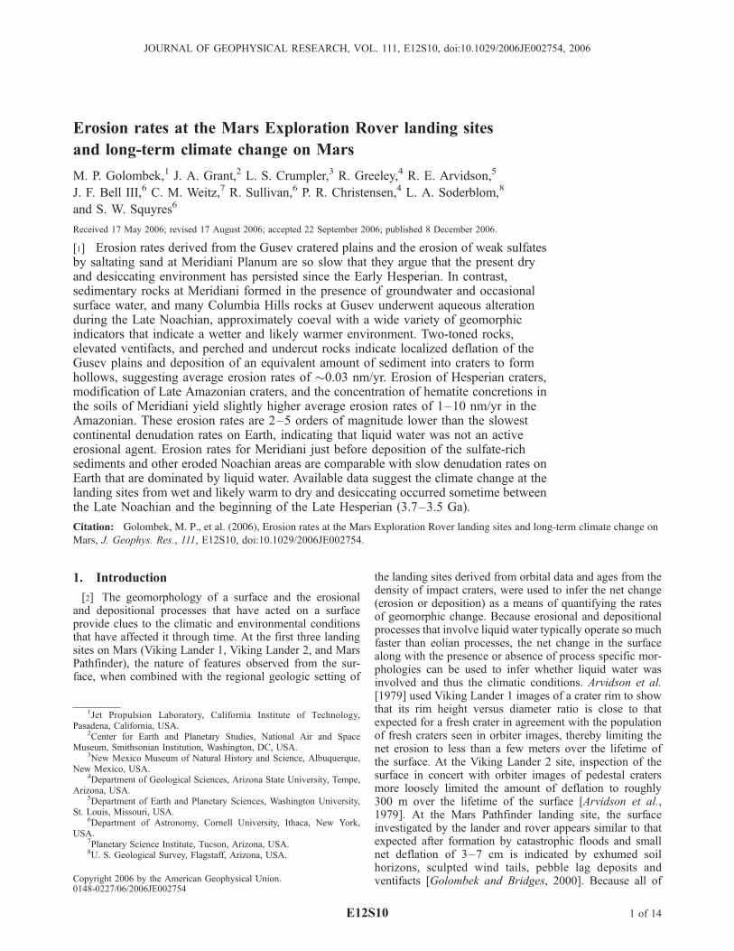
Figure 1. Regional setting of Meridiani Planum in shaded relief map derived from Mars Orbiter LaserAltimeter 128 gridded pixels per degree data. Note smooth, lightly cratered (Amazonian) plains on whichOpportunity landed (cross), which bury underlying heavily cratered (Noachian) terrain with valleynetworks that trend to the northwest. Note large degraded craters in the smooth plains indicate the sulfaterocks below the basaltic sand and granule ripple surface are Late Noachian in age. Image is �850 kmwide; north is up.
E12S10 GOLOMBEK ET AL.: CLIMATE CHANGE FROM THE MARS ROVERS
3 of 14
E12S10
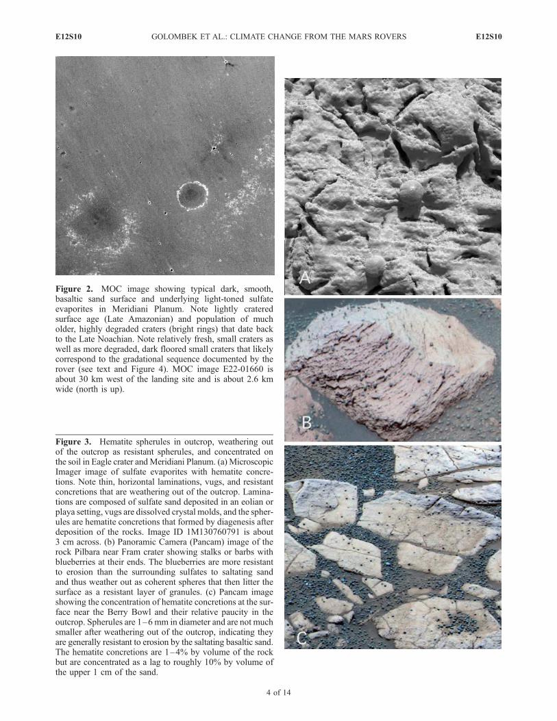
Figure 2. MOC image showing typical dark, smooth,basaltic sand surface and underlying light-toned sulfateevaporites in Meridiani Planum. Note lightly crateredsurface age (Late Amazonian) and population of mucholder, highly degraded craters (bright rings) that date backto the Late Noachian. Note relatively fresh, small craters aswell as more degraded, dark floored small craters that likelycorrespond to the gradational sequence documented by therover (see text and Figure 4). MOC image E22-01660 isabout 30 km west of the landing site and is about 2.6 kmwide (north is up).
Figure 3. Hematite spherules in outcrop, weathering outof the outcrop as resistant spherules, and concentrated onthe soil in Eagle crater andMeridiani Planum. (a) MicroscopicImager image of sulfate evaporites with hematite concre-tions. Note thin, horizontal laminations, vugs, and resistantconcretions that are weathering out of the outcrop. Lamina-tions are composed of sulfate sand deposited in an eolian orplaya setting, vugs are dissolved crystal molds, and the spher-ules are hematite concretions that formed by diagenesis afterdeposition of the rocks. Image ID 1M130760791 is about3 cm across. (b) Panoramic Camera (Pancam) image of therock Pilbara near Fram crater showing stalks or barbs withblueberries at their ends. The blueberries are more resistantto erosion than the surrounding sulfates to saltating sandand thus weather out as coherent spheres that then litter thesurface as a resistant layer of granules. (c) Pancam imageshowing the concentration of hematite concretions at the sur-face near the Berry Bowl and their relative paucity in theoutcrop. Spherules are 1–6 mm in diameter and are not muchsmaller after weathering out of the outcrop, indicating theyare generally resistant to erosion by the saltating basaltic sand.The hematite concretions are 1–4% by volume of the rockbut are concentrated as a lag to roughly 10% by volume ofthe upper 1 cm of the sand.
E12S10 GOLOMBEK ET AL.: CLIMATE CHANGE FROM THE MARS ROVERS
4 of 14
E12S10
and the early Early Amazonian surface of Viking 2 [Tanakaet al., 2003, 2005].[9] Spirit’s observations of the surficial geology of the
cratered volcanic plains at Gusev indicates they weremodified chiefly by impact and lesser eolian activity [Grantet al., 2004]. Spirit showed the plains are dominated byshallow circular depressions called ‘‘hollows,’’ that haverocky rims and smooth, soil-filled centers (Figure 5).Perched, fractured and split rocks are more numerous
around hollows than elsewhere and lighter toned (redder)rocks are more common near eolian drifts [Grant et al.,2004]. Hollow morphology and size-frequency distributionindicate they are impact craters that were rapidly filled in byeolian material [Grant et al., 2004; Golombek et al., 2006].Rocks are generally poorly sorted and angular and awayfrom craters, pebbles appear embedded and cemented in thesoil or perched above, suggestive of a crusted gravel armoror lag [Greeley et al., 2004, 2006a].
Figure 4
E12S10 GOLOMBEK ET AL.: CLIMATE CHANGE FROM THE MARS ROVERS
5 of 14
E12S10
[10] Spirit’s observations of rock mineralogy, chemistryand texture (from microscopic images) revealed dark, fine-grained olivine basalts with thin coatings of dust andweathering rinds [McSween et al., 2004, 2006; Haskin etal., 2005]. The basalts appear to have been emplaced asrelatively fluid lava flows [Greeley et al., 2005] withvesicular clasts and rare scoria similar to inflated lava flowtops [Crumpler et al., 2005; Golombek et al., 2006].Observations of the interior of the relatively fresh craterBonneville indicate that it impacted into a rubble layerlocally up to 10 m thick, likely derived from impactgardening of the basalt flows [Grant et al., 2004, 2006a;Golombek et al., 2006].
[11] The reddish soils appear to be weakly cemented fineswith sand and granules that have been sorted into eolian bedforms [Greeley et al., 2004, 2006a]. Bed forms consistprimarily of meter-size ripples in which the crests have asurface layer of subangular to rounded granules and thetroughs consist of poorly sorted fine to coarse sand. Thesand does not appear to be currently active, based on thepresence of surface crusts and dust cover on the bed formsand the absence of sand dunes and steep slip faces [Greeleyet al., 2004, 2006a].[12] Many of the rocks at Gusev show evidence for partial
or complete burial, followed by exhumation [Grant et al.,2004; Greeley et al., 2004, 2006a] (Figure 6). These include
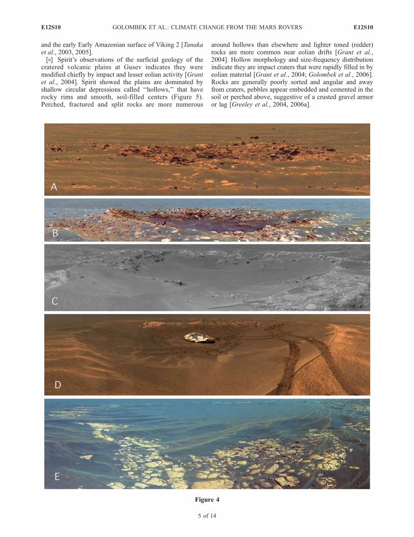
Figure 4. Rover images of small, young craters on Meridiani Planum in various states of degradation by saltating basalticsand. All impacts expose underlying sulfates and range from fresh (top) with blocky ejecta and little sand fill to highlydegraded (bottom) with completely planed off ejecta and filled in centers. (a) Color Pancam mosaic of fresh, 8 m diameterVega crater, which has fresh blocky ejecta and little sand fill (>0.5 m deep). Only some ejecta blocks (foreground) havebeen planed off. (b) False color Pancam mosaic of the relatively fresh, 15 m diameter Viking crater, with blocky rim, planedoff ejecta and minor sand fill (3 m deep). (c) Navigation Camera (Navcam) mosaic of partially degraded 18 m diameterVoyager crater, with completely planed off ejecta, more subdued rim and significant sand fill (�1 m deep). (d) ColorPancam mosaic of highly degraded 22 m diameter Eagle crater, with ripple covered rim, sand fill (2 m deep), and littleexposed outcrop. Note lander inside crater and sulfate outcrop on far side that Opportunity studied for the first 50 sols of themission. (e) False color Pancam mosaic showing highly degraded 40 m diameter Vostock crater that has been almostcompletely filled in with basaltic sand (<1 m deep), leaving a ring of flat-lying bright blocks of sulfate that have beencompletely planed off.
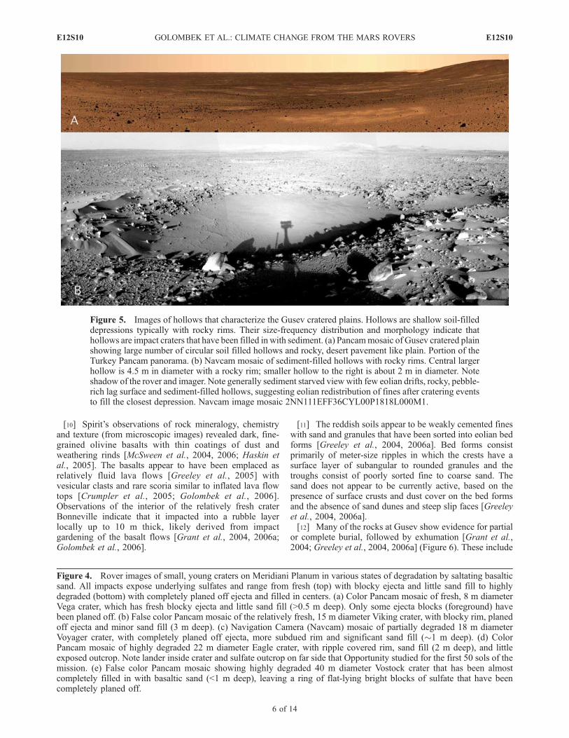
Figure 5. Images of hollows that characterize the Gusev cratered plains. Hollows are shallow soil-filleddepressions typically with rocky rims. Their size-frequency distribution and morphology indicate thathollows are impact craters that have been filled in with sediment. (a) Pancammosaic of Gusev cratered plainshowing large number of circular soil filled hollows and rocky, desert pavement like plain. Portion of theTurkey Pancam panorama. (b) Navcam mosaic of sediment-filled hollows with rocky rims. Central largerhollow is 4.5 m in diameter with a rocky rim; smaller hollow to the right is about 2 m in diameter. Noteshadow of the rover and imager. Note generally sediment starved viewwith few eolian drifts, rocky, pebble-rich lag surface and sediment-filled hollows, suggesting eolian redistribution of fines after cratering eventsto fill the closest depression. Navcam image mosaic 2NN111EFF36CYL00P1818L000M1.
E12S10 GOLOMBEK ET AL.: CLIMATE CHANGE FROM THE MARS ROVERS
6 of 14
E12S10
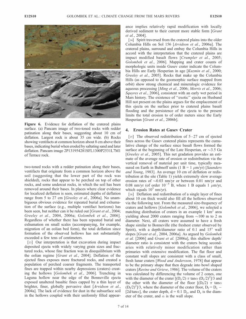
two-toned rocks with a redder patination along their bases,ventifacts that originate from a common horizon above thesoil (suggesting that the lower part of the rock wasshielded), rocks that appear to be perched on top of otherrocks, and some undercut rocks, in which the soil has beenremoved around their bases. In places where clear evidencefor localized deflation is seen, estimated depths of deflationrange from 5 to 27 cm [Greeley et al., 2006a]. No unam-biguous obvious evidence for repeated burial and exhuma-tion of the surface (e.g., multiple ventifact horizons) hasbeen seen, but neither can it be ruled out [Grant et al., 2004;Greeley et al., 2004, 2006a; Golombek et al., 2006].Regardless of whether there has been repeated burial andexhumation on small scales (accompanying, for example,migration of an eolian bed form), the total deflation sinceformation of the observed hollows has not substantiallyexceeded a few tens of centimeters.[13] Our interpretation is that excavation during impact
deposited ejecta with widely varying grain sizes and frac-tured rocks, whose fine fraction was in disequilibrium withthe eolian regime [Grant et al., 2004]. Deflation of theejected fines exposes more fractured rocks, and created apopulation of perched coarser fragments. The transportedfines are trapped within nearby depressions (craters) creat-ing the hollows [Golombek et al., 2006]. Trenching inLaguna hollow near the edge of the Bonneville ejectaexposed unaltered basaltic fines capped by a thin layer ofbrighter, finer, globally pervasive dust [Arvidson et al.,2004a]. The lack of evidence for dust in the subsurface soilin the hollows coupled with their uniformly filled appear-
ance implies relatively rapid modification with locallyderived sediment to their current more stable form [Grantet al., 2004].[14] Spirit traversed from the cratered plains into the older
Columbia Hills on Sol 156 [Arvidson et al., 2006a]. Thecratered plains, surround and embay the Columbia Hills inaccord with the interpretation that the cratered plains areimpact modified basalt flows [Crumpler et al., 2005;Golombek et al., 2006]. Mapping and crater counts ofmorphologic units inside Gusev crater indicate the Colum-bia Hills are Early Hesperian in age [Kuzmin et al., 2000;Greeley et al., 2005]. Rocks that make up the ColumbiaHills (as opposed to the geomorphic surface mapped fromorbit) show strong chemical and mineralogic evidence foraqueous processing [Ming et al., 2006; Morris et al., 2006;Squyres et al., 2006], consistent with an early wet period inMars history. The existence of ‘‘exotic’’ ejecta on HusbandHill not present on the plains argues for the emplacement ofthis ejecta on the surface prior to cratered plains basaltflooding and the persistence of the ejecta to the presentlimits the total erosion to of order meters since the EarlyHesperian [Grant et al., 2006b].
4. Erosion Rates at Gusev Crater
[15] The observed redistribution of 5–27 cm of ejectedfines across the Gusev cratered plains represents the cumu-lative change of the surface since basalt flows formed thesurface at the beginning of the Late Hesperian, or �3.5 Ga[Greeley et al., 2005]. This net gradation provides an esti-mate of the average rate of erosion or redistribution via thevertical removal of material per unit time, typically mea-sured on Earth in Bubnoff units (1 B = 1 mm/yr) [Saundersand Young, 1983]. An average 10 cm of deflation or redis-tribution at the site (Table 1) yields extremely slow averageerosion rates of �0.03 nm/yr or between 0.01 nm/yr and0.08 nm/yr (of order 10�5 B, where 1 B equals 1 mm/yr,which equals 103 nm/yr).[16] Deflation and redistribution of a single layer of fines
about 10 cm thick would also fill all the hollows observedvia the following test. From the measured size-frequency ofcraters and hollows [Golombek et al., 2006], we selected amatching distribution of craters in an example 1 km2 areayielding about 2000 craters ranging from �100 m to 2 mdiameter. Next, all craters were assumed to have a freshshape similar to Bonneville (the freshest crater observed bySpirit), with a depth/diameter ratio of 0.1 and 15� wallslopes [Grant et al., 2004, 2006a]. As argued by Golombeket al. [2006] and Grant et al. [2006a], this shallow depth/diameter ratio is consistent with the craters being second-aries with relatively minor modification rather thanprimaries with extensive modification. The flat floor andconstant wall slopes are consistent with a class of small,fresh lunar craters [Wood and Andersson, 1978] that appearto be the primary shape that then degrade into bowl shapedcraters [Ravine and Grieve, 1986]. The volume of the craterswas calculated by differencing the volume of 2 cones, onewith the diameter of the crater [(Dc/2) p tana (Dc/2)
2]/3 andthe other with the diameter of the floor [(Df/2) p tana(Df/2)
2]/3, where the diameter of the crater floor, Df = Dc �[2d/tana], the crater depth, d = 0.1 Dc, and Dc is the diam-eter of the crater, and a is the wall slope.
Figure 6. Evidence for deflation of the cratered plainssurface. (a) Pancam image of two-toned rocks with redderpatination along their bases, suggesting about 10 cm ofdeflation. Largest rock is about 35 cm wide. (b) Rocksshowing ventifacts at common horizon about 8 cm above theirbases, indicating burial when eroded by saltating sand and laterdeflation. Pancam image 2P131954281SFL1300P2531L7M1of Terrace rock.
E12S10 GOLOMBEK ET AL.: CLIMATE CHANGE FROM THE MARS ROVERS
7 of 14
E12S10
[17] The volume of all 2000 craters was then related tothe thickness of a uniform surface layer over the 1 km2 areathat would fill the craters. The result is that a layer of ma-terial roughly 10 cm thick (with a volume of �100,000 m3)would fill the craters. This matches the average estimate ofdeflation from two-toned rocks and elevated ventifacts of�10 cm and argues that little has happened at the site exceptperiodically high deflation (following impacts) of locallyderived surface fines to fill the impact craters and create thehollows. Again, this argues for extremely slow averagelong-term erosion rates.[18] The persistence of exotic ejecta on Husband Hill
emplaced prior to the basalt flows of the cratered plains,limits erosion of the Columbia Hills to of order meters[Grant et al., 2006b] since the mapped surface age of EarlyHesperian. Erosion of several meters of material since theend of the Early Hesperian (3.6 Ga [Hartmann and Neukum,2001]), yields erosion rates of �0.8 nm/yr for Husband Hill.
5. Erosion Rates at Meridiani Planum
[19] Slightly higher Amazonian erosion rates are impliedat Meridiani Planum [Soderblom et al., 2004; Arvidson etal., 2004b] (and other exhumed Noachian layered terrainson Mars [Malin and Edgett, 2000a; Edgett, 2005; McEwenet al., 2005]). The loss of Hesperian craters indicated by themeasured size-frequency distribution of craters recordserosion loosely bracketed between 10 m and 80 m basedon the following argument. Arvidson et al. [2006b] measurea decrease in the number of craters smaller than �400 mdiameter associated with the loss of Hesperian craters. Afresh primary crater 400 m diameter is roughly 80 m deep(from the 0.2 depth/diameter ratio of small fresh craters[Pike, 1980; Wood and Andersson, 1978]), so to erodecraters 400 m and smaller requires removal of �80 m ofmaterial. This represents the maximum erosion as moreerosion would remove larger craters than 400 m diameter,which is not observed in the measured size-frequencydistribution [Arvidson et al., 2006b]. If, however, not allthe craters are removed but instead many are filled in, lessmaterial can be removed. Because Opportunity has visitedrelatively intact sections of outcrop, at least the ejecta of theHesperian craters must have been removed. From the Gusevcratered plains and the observed rubble layer in the wall ofBonneville crater, we estimate the ejected layer of Hespe-rian craters could be �10 m thick [Grant et al., 2004;Golombek et al., 2006]. Loss of 10–80 m of material atMeridiani Planum since the Hesperian (�3.0 Ga [HartmannandNeukum, 2001]), suggests erosion rates of 3.3–26.7 nm/yr(Table 1). We note that higher erosion rates are expected inweak, easily erodible deposits [e.g., Maxwell and Irwin,2004] and higher erosion rates are consistent with very lightlycratered layered deposits on Mars in general [Malin andEdgett, 2000a; McEwen et al., 2005].[20] Estimates of erosion rates derived in this manner are
comparable with those resulting from the observed erosionand modification of young craters and ejecta by the saltatingMeridiani sand (Figure 4). The hematite bearing plains havevery few impact craters and counts of small craters indicatea surface age of Late Amazonian [Lane et al., 2003]. Inhigh-resolution images (e.g., Mars Orbiter Camera) thecraters appear fresh (Figure 2), but observations by Oppor-
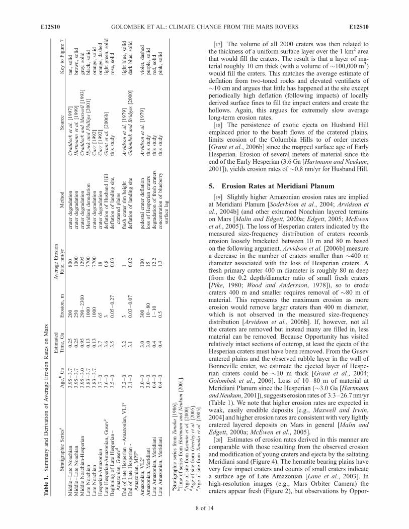
Table
1.SummaryandDerivationofAverageErosionRates
onMars
Stratigraphic
Seriesa
Age,bGa
Estim
ated
Tim
e,Ga
Erosion,m
AverageErosion
Rate,
nm/yr
Method
Source
Key
toFigure
7
Middle–LateNoachian
3.95–3.7
0.25
200
800
crater
degradation
Craddock
etal.[1997]
tan,solid
Middle–LateNoachian
3.95–3.7
0.25
250
1000
crater
degradation
Hartmannet
al.[1999]
brown,solid
Middle
Noachian-H
esperian
3.95–3.0
0.95
290–2300
1295
crater
degradation
Craddock
andMaxw
ell[1993]
grey,
solid
LateNoachian
3.83–3.7
0.13
1000
7700
Meridianidenudation
Hynek
andPhillips[2001]
black,solid
LateNoachian
3.83–3.7
0.13
1000
7700
crater
degradation
Carr
[1992]
orange,
solid
Hesperian-A
mazonian
3.7–0
3.7
65
18
crater
degradation
Carr
[1992]
orange,
dashed
LateHesperian-A
mazonian,Gusevc
3.6–0
3.6
30.8
deflationofHusbandHill
Grantet
al.[2006b]
lightgreen,solid
BeginningofLateHesperian–
Amazonian,Gusevd
3.5–0
3.5
0.05–0.27
0.03
deflationoflandingsite,
cratered
plains
thisstudy
rose,solid
EndofLateHesperian–Amazonian,VL1e
3.2–0
3.2
31
freshcrater
rim
height
Arvidsonet
al.[1979]
lightblue,
solid
EndofLateHesperian-
Amazonian,MPFe
3.1–0
3.1
0.03–0.07
0.02
deflationoflandingsite
Golombek
andBridges
[2000]
darkblue,
solid
Amazonian,VL2e
3.0–0
3.0
300
100
pedestalcrater
deflation
Arvidsonet
al.[1979]
violet,dashed
Amazonian,Meridiani
3.0–0
3.0
10–80
15
loss
ofHesperiancraters
thisstudy
purple,solid
LateAmazonian,Meridiani
0.4–0
0.4
1–10
12.2
degradationoffreshcraters
thisstudy
red,solid
LateAmazonian,Meridiani
0.4–0
0.4
0.5
1.3
concentrationofblueberry
surfacelag
thisstudy
pink,solid
aStratigraphic
series
from
Tanaka
[1986].
bTim
eofseries
from
HartmannandNeukum
[2001].
cAgeofsite
from
Kuzm
inet
al.[2000].
dAgeofsite
from
Greeley
etal.[2005].
eAgeofsite
from
Tanaka
etal.[2005].
E12S10 GOLOMBEK ET AL.: CLIMATE CHANGE FROM THE MARS ROVERS
8 of 14
E12S10
tunity suggest they are being eroded and modified by thesaltating sand. The sulfate evaporites are weak (inferredfrom the grind energy needed by the Rock Abrasion Tool[Arvidson et al., 2004b] and the observed hematite spheruleblueberry ‘‘stalks’’ or ventifacts) and easily erodible by thesaltating sand [Soderblom et al., 2004; Grant et al., 2006a].Opportunity visited about a dozen craters in various stagesof erosion and modification (Figure 4). The freshest crater,Vega, has a blocky rim and a rocky ejecta blanket and doesnot have sand ripples that overtop the rim. Slightly moreeroded craters such as Viking, Voyager and Fram still haveblocky rims and rocky ejecta, but much of the ejecta isplaned off level with the surface and their interiors havebeen partially filled with sand. It is noteworthy that sulfaterocks at Fram have particularly well exposed blueberry‘‘barb’’ or ‘‘stalk’’ ventifacts (Figure 3b) near planed offejecta blocks. Craters such as Naturaliste and Geographe arecharacterized by ejecta and rim relief that is planed to thelevel of the sand and ripples cover their rims and sand fillstheir interiors. More eroded craters such as Endurance,Eagle, Jason and Alvin have no ejecta (completely erodedaway), have back-wasted and eroded rims and have interiorswith significant deposits of sand. Finally, the rim of Vostokhas been almost completely eroded (expressed as a very lowring of planed-off sulfate blocks) and the interior is almostcompletely filled. This degradational sequence shows thatso-called ‘‘fresh craters’’ in orbital images constitute asequence of craters in various states of erosion and infilling(Figures 4 and 2).[21] Consideration of current crater diameters, original
fresh crater depths, and ejecta thicknesses [Grant et al.,2006a], and the amount of erosion and infilling needed toproduce the observed modification of craters bounds theamount of erosion to between 1 and 10 m. For example,Vostok, the most eroded crater, is about 45 m in diameterand retains only about a meter of relief at most, so about 8 mof sand would fill it if it was a primary crater with anoriginal depth/diameter ratio of 0.2 [Pike, 1980; Wood andAndersson, 1978] (Figure 4). The largest crater, Endurance,is 150 m diameter, has had its ejecta blanket (estimated to be�2 m thickness) eroded away, suffered back wasting of itsrim by 5–10 m, and had about 5 m of sand deposited in itsinterior [Grant et al., 2006a, 2006b]. All the other cratersare less than �22 m diameter and record erosion and backwasting of their rims and ejecta, and deposition of sand intheir interiors of 1–5 m. More than 10 m of erosion wouldhave completely erased some of these craters, so thatrepresents the maximum erosion, and less than 1 m oferosion would not have modified others, so that representsthe minimum. Erosion of 1–10 m needed to modify thecraters over the Late Amazonian age of the surface (�400Ma[Hartmann and Neukum, 2001]), yields erosion rates of 2.5–25 nm/yr (Table 1), which are comparable to those estimatedfrom the loss of Hesperian craters.[22] The concentration of hematite-rich spherules (so
called blueberries) on the surface as a granule lag [Soderblomet al., 2004; Sullivan et al., 2005; Weitz et al., 2006], alsoyields comparable erosion rates. The blueberries make uponly 1–4% of the volume of sulfate outcrop exposed inEagle, Fram and Endurance craters [McLennan et al., 2005],but make up about �10% of the volume of the upper 1 cmof the sand [Soderblom et al., 2004] (Figure 3). For a 1%
volume in the outcrop to produce a 10% volume in theupper 1 cm requires about 10 cm of erosion. However, thisestimate assumes that the volume fraction of blueberrieswithin the overlying strata that eroded away was the same asin the outcrop observed below. Sulfate sedimentary rocks atErebus crater appear blueberry free (blueberry size in theoutcrop and soils decreases to the south from Endurancecrater [Weitz et al., 2006]), so it is possible that more rockeroded but did not leave as many blueberries behind. Alsosome angular, smaller and likely eroded blueberries are alsopresent in the soil at the surface, suggesting that althoughthe hematite-rich concretions are more resistant to erosionthan the sulfate outcrop, some fraction of the concretionpopulation may be eroding with time [Soderblom et al.,2004; Weitz et al., 2006]. In an example scenario, if the totalerosion of sulfates needed to produce the blueberry con-centration near the surface were increased to 50 cm, theindicated erosion rate would be only 1.3 nm/yr (Table 1) inthe Late Amazonian (�400 Ma). This calculation couldrepresent a minimum, but given the inherent uncertainties, itappears more poorly constrained than the other estimates.
6. Discussion
[23] Long term average erosion rates during theHesperian and Amazonian from deflation and filling ofcraters in the Gusev plains and those derived from erosionof Hesperian craters, modification of Amazonian craters,and the concentration of hematite-rich spherules in the soilsof Meridiani (Table 1) are so low (Figure 7) that theyindicate a dry and desiccating climate similar to today’sfor the past 3.5 Ga. These erosion rates vary from order 0.01to 10 nm/yr and are 2–5 orders of magnitude below theslowest continental denudation rates on the Earth [Judsonand Ritter, 1964; Saunders and Young, 1983; Summerfield,2005]. Stable cratons and passive continental margins onEarth have recorded denudation rates as low as a fewBubnoff units (mm/yr) [Summerfield, 2005]. Althoughslower erosion rates have been reported in the literaturefor cratons of Gondwanaland [King, 1962; Twidale, 1978;Fairbridge and Finkl, 1980; Young, 1983], quantitativeapatite fission track data have shown rates of 10–1000 Bfor the Gondwanaland margins of Australia [Bishop andGoldrick, 2000], South America [Brown et al., 2000] andAfrica [Brown et al., 2002]. The slowest erosion rates onEarth are recorded in both wet and dry environmentswithout significant relief and are typically 10–100 B(104–105 nm/yr) [Saunders and Young, 1983; Judson andRitter, 1964]. They are calculated over hundreds of millionsof years time intervals (generally comparable to thosedetermined on Mars) and are determined for low-relief areassimilar to existing landing sites on Mars.[24] Average erosion rates determined for the Gusev
cratered plains (0.03 nm/yr) are comparable to those esti-mated in a similar manner for the Mars Pathfinder landingsite (�0.02 nm/yr) [Golombek and Bridges, 2000] and forthe Viking Lander 1 site (�1 nm/yr) [Arvidson et al., 1979]and argue for very little net change of these surfacesthroughout the Amazonian and much of the Late Hesperian[Golombek and Bridges, 2000] or since �3.5 Ga [Hartmannand Neukum, 2001] (Table 1 and Figure 7). These rates areso low that taken literally they indicate an average loss of a
E12S10 GOLOMBEK ET AL.: CLIMATE CHANGE FROM THE MARS ROVERS
9 of 14
E12S10
layer about a one atom thick per year from the surface. Inreality, this very low net erosion is almost certainly a resultof more rapid cycles of erosion, mantling and deflation thatoccurred over shorter periods. These cycles would befollowed by no further erosion yielding the extremely slowcalculated long-term rates. Further, the rates likely representredistribution or localized deflation rather than true denu-dation, although they can be compared to average erosionrates as a coarse indicator of the climatic conditions activesince the Hesperian. The calculated deflation rates for theViking 1, Pathfinder and Spirit landing sites are about 3–5 orders of magnitude below the slowest erosion rates onEarth [Saunders and Young, 1983] and argue that liquidwater was not an active erosional agent at these locations.
[25] Average erosion rates indicated from the loss ofHesperian craters, degradation of Late Amazonian craters,and concentration of hematite concretions from the LateNoachian evaporites at Meridiani Planum are around 1–10 nm/yr (Table 1 and Figure 7). These erosion rates areslightly higher than those estimated from the Viking 1,Pathfinder and Spirit landing sites, but higher erosion ratesare expected in weak, easily erodible deposits [e.g.,Maxwelland Irwin, 2004] like the Meridiani sulfates and such highererosion rates are consistent with the very lightly crateredlayered deposits on Mars in general [Malin and Edgett,2000a; McEwen et al., 2005]. Even so, these erosion ratesare about 2–3 orders of magnitude lower than the slowesterosion rates on Earth (including the centers of low-relief
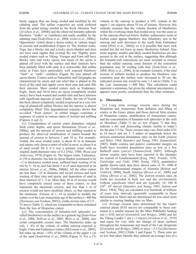
Figure 7. Erosion and redistribution rates versus time for the Spirit and Opportunity landing sitescompared with other landing sites and terrains for the three epochs of Mars history: Noachian (N)>3.7 Ga, Hesperian (H) 3.7–3.0 Ga, and Amazonian (A) <3.0 Ga [Hartmann and Neukum, 2001]. Averageerosion rates derived from the sources in Table 1 (includes the key for each estimate shown) have beenrecalculated for this timescale: Noachian are rates in black, orange, brown and tan; Noachian-Hesperianrate is in gray; Late Hesperian through Amazonian rates are in blue, rose, purple, and green (and dashed);and Late Amazonian rates are in pink and red. Vertical green and yellow rates with arrow end points arepresent-day slow continental denudation rates on Earth and present-day dust deposition and removal rates(�2–100 B), respectively, on Mars from the rovers and as inferred from dust devils observed by Spirit(see text for discussion and references). Average erosion rates from Noachian terrains on Mars arecomparable to slow continental denudation rates on Earth, suggesting a wet and warm environment.Average erosion rates after the Hesperian are 2–5 orders of magnitude lower and are consistent with thedry and desiccating environment of today.
E12S10 GOLOMBEK ET AL.: CLIMATE CHANGE FROM THE MARS ROVERS
10 of 14
E12S10
cratons calculated over comparably times) involving liquidwater [Saunders and Young, 1983].[26] Average erosion rates of 0.01–10 nm/yr contrast
greatly with the rapid redistribution or cycling of dust(Figure 7) from the atmosphere to the surface and thenback into the atmosphere (often leaving little trace on thesurface). Mars Pathfinder and the two MERs measuredmaximum dust accumulation over extended periods of0.29% per day [Landis and Jenkins, 2000; Arvidson et al.,2004a, 2004b], which translates to a deposition rate of order104 nm/yr [Golombek and Bridges, 2000] for the observeddust particle size [Tomasko et al., 1999; Lemmon et al.,2004]. Deposition of 104 nm/yr would result in metersthick accumulations of dust within a comparatively shortspan of a million years. Because such accumulations arenot observed at any of the landing sites, dust must beremoved as rapidly as it is being deposited over relativelyshort timescales. This is particularly true at the Meridianisite, which has a very low albedo, indicating very littledust on the surface [Golombek et al., 2005] even thoughthe rover solar panels recorded these high deposition rates.Frequent dust devils observed at the Mars Pathfinder andSpirit landing sites as well as other dust cleaning eventsclearly play a role in the removal of dust from somesurfaces. Analysis of dust devils observed by Spirit atGusev crater showed they are easily capable of removingcomparable amounts of dust from the surface with order100 mm of dust removed during one dust devil season[Greeley et al., 2006b].[27] An environment in which liquid water is not stable is
consistent with the very low erosion rates determined for theLate Hesperian and Amazonian and is also in accord withthe lack of chemical weathering indicated by exposures ofolivine basalt at Gusev [McSween et al., 2004, 2006] andthroughout equatorial Mars [Hoefen et al., 2003;Christensenet al., 2003]. Soils of Gusev and Meridiani [Yen et al., 2005;Christensen et al., 2004a, 2004b] as well as the atmosphericdust [Goetz et al., 2005] are also basaltic and therefore haveexperienced limited aqueous alteration to form clays. Theseresults do not necessarily contradict more recent wet condi-tions indicated by valley networks and gullies on Hesperianand Amazonian surfaces that may have been localized andover short periods [e.g., Mangold et al., 2004; Quantin etal., 2005; Gulick and Baker, 1990; Malin and Edgett,2000b]. OMEGA results also show the atmospheric dustis not hydrated and thus has formed in the present dryenvironment [Bibring et al., 2006]. Minor weathering rindson basaltic rocks on the Gusev cratered plains are observed,as are concentrations of soluble elements and salts in nearsurface soils [Yen et al., 2005; Haskin et al., 2005], but bothcould have been accomplished via thin films of water underpresent climatic conditions [e.g., Yen et al., 2005; Hurowitzet al., 2006]. No evidence for liquid water interactions inexposed sulfate outcrop at Meridiani (e.g., leached surfacesalts) has been found [Clark et al., 2005] and the observedpattern of crater gradation at Gusev and Meridiani shows noevidence for erosion by liquid water [Grant et al., 2006a].As a result, the dry and desiccating environment indicatedby the very low erosion rates at both landing sites is sup-ported by mineralogical and geochemical data throughoutMars that limits the role of liquid water since the Hesperian.
[28] By comparison, erosion rates estimated from changesinNoachian age crater distributions andmorphologies onMars(Table 1) are 3–5 orders of magnitude higher [Craddockand Maxwell, 1993; Craddock et al., 1997; Carr, 1992;Hynek and Phillips, 2001; Hartmann et al., 1999] than thosederived from the landing sites and are comparable to slowdenudation rates on the Earth (�5 B) that are dominatedby liquid water [Summerfield., 2005; Saunders and Young,1983] (Figure 7). An estimate of the erosion rates applicableto Meridiani in the Late Noachian just prior to when thesulfates investigated by Opportunity were deposited is about8 B, or 8,000 nm/yr from denudation in western Arabia Terra[Hynek and Phillips, 2001]. The Meridiani evaporites weredeposited after this Late Noachian denudation event, and thuscould represent the tail end of the wet climatic conditions inthe latest Noachian or sporadically through the Hesperian onMars [Howard et al., 2005; Irwin et al., 2005, and referencestherein].[29] Erosion rates during the Noachian are �5 orders of
magnitude higher than those estimated for the Amazoniancratered plains of Gusev and are consistent with the wet andlikely warm environment documented in Meridiani Planumduring the Late Noachian. A wet environment in theNoachian is also indicated by the strong chemical andmineralogic evidence for aqueous processing of the olderrocks of the Columbia Hills at Gusev crater [Ming et al.,2006; Morris et al., 2006; Squyres et al., 2006]. The erosionrates from the Gusev cratered plains and Meridiani plains aswell as those from Viking 1 and Pathfinder, limit thiswarmer and wetter period to before the Late Hesperian,around 3.5 Ga, and a dry and desiccating climate since.OMEGA results suggest that phyllosilicates formed in thepresence of liquid water in the Noachian, sulfates formedin an acid aqueous environment in the Early Hesperian(�3.6 Ga), with a dry and desiccating environment since[Bibring et al., 2006]. A wet Late Noachian period is alsoindicated by the age of valley network formation [Baker etal., 1992; Baker and Partridge, 1986], layered sedimentaryrocks, including the Meridiani sulfate evaporites [Malin andEdgett, 2000a; Edgett, 2005], as well as the timing of higherosion rates [Grant and Schultz, 1990, 1993; Carr, 1996;Craddock et al., 1997; Hynek and Phillips, 2001] and mayhave been produced by outgassing associated with the for-mation of Tharsis [Phillips et al., 2001].
7. Conclusions
[30] 1. An early warm and wet environment in the LateNoachian (>3.7 Ga) on Mars is indicated by Opportunityrover results on sulfate-rich ‘‘dirty’’ evaporites that werelikely deposited in acid, saline interdune playas or sabkhas,roughly coeval with a wide variety of geomorphic indicatorssuch as valley networks, degraded craters, highly erodedterrain, crater lakes and widespread layered sedimentaryrocks.[31] 2. Spirit’s observations of the surficial geology of the
Late Hesperian cratered volcanic plains at Gusev indicate thatthey were only modified by impact and lesser eolian activity.Localized eolian deflation of 5–27 cm of fines is indicated bytwo-toned rocks with a redder patination along their bases,ventifacts that originate from a common horizon above thesurface, and perched and undercut rocks, and suggests eolian
E12S10 GOLOMBEK ET AL.: CLIMATE CHANGE FROM THE MARS ROVERS
11 of 14
E12S10
redistribution of an equivalent amount of sediment to fillimpact craters to form the ubiquitous hollows. This deflationyields the cumulative change of the surface since the plainswere deposited in the Late Hesperian (�3.5 Ga) and yields anaverage erosion rate of �0.03 nm/yr.[32] 3. Slightly higher erosion rates (�1–10 nm/yr) are
implied since the Hesperian at Meridiani Planum. Loss ofHesperian craters indicated by the sparsely cratered surfaceand Late Noachian age of the sulfates suggests 10–80 m oferosion. Modification and erosion of young, Late Amazo-nian craters by the saltating sand that progressively planesoff ejecta blocks, back wastes and covers blocky rims withsand and granule ripples, and fills crater interiors with sand,indicates 1–10 m of erosion and redistribution of sand inthe Late Amazonian (since �0.4 Ga). Concentration ofhematite concretions (‘‘blueberries’’) as a surface lag inthe soils indicates 0.1–0.5 m of erosion. These highererosion rates are consistent with eolian erosion of weaksulfates by saltating basaltic sand.[33] 4. Long-term erosion rates of �0.01–10 nm/yr since
the Hesperian are consistent with erosion rates calculated ina similar manner for the Viking 1 and Mars Pathfinderlanding sites and are 2–5 orders of magnitude lower thanthe slowest continental denudation rates on Earth. Theseerosion rates are so low that they preclude liquid water as anactive erosional agent and argue for a dry and desiccatingclimate. Such a climate is also consistent with the lack ofchemical weathering affecting olivine basalt; olivine basaltsand; basaltic, nonhydrated dust; the lack of salt leaching ofexposed sulfates at Meridinai; and the lack of evidence forerosion by liquid water from the gradation of craters at bothlanding sites.[34] 5. Erosion rates derived from previous studies of
changes in Noachian age crater distributions and shapes anddenudation of Terra Meridiani just before the sulfates weredeposited are 2–5 orders of magnitude higher (103–104 nm/yr)than those from the Late Hesperian and Amazonian. TheseNoachian erosion rates are comparable to slow continentaldenudation rates on Earth that are dominated by liquid water.Erosion rates this high are consistent with a wet and warmenvironment in the Late Noachian and the deposition of sul-fates at Meridiani Planum in salt water evaporitic playas orsabkhas.[35] 6. Analyses of the geology and gradation histories of
the landing sites and calculated erosion rates indicates theclimatic change from wet and likely warm to dry anddesiccating occurred sometime between the end of the LateNoachian and the beginning of the Late Hesperian or about3.7–3.5 Ga.
[36] Acknowledgments. Research described in this paper was doneby the MER project, Jet Propulsion Laboratory, California Institute ofTechnology, under a contract with NASA. This paper benefited fromreviews by V. Baker and W. Goetz.
ReferencesArvidson, R., E. Guiness, and S. Lee (1979), Differential aeolian redistri-bution rates on Mars, Nature, 278, 533–535.
Arvidson, R. E., et al. (2003), Mantled and exhumed terrains in TerraMeridiani, Mars, J. Geophys. Res., 108(E12), 8073, doi:10.1029/2002JE001982.
Arvidson, R. E., et al. (2004a), Localization and physical properties experi-ments conducted by Spirit at Gusev crater, Science, 305, 821–824,doi:10.1126/science.1099922.
Arvidson, R. E., et al. (2004b), Localization and physical properties experi-ments conducted by Opportunity at Meridiani Planum, Science, 306,1730–1733, doi:10.1126/science.1104211.
Arvidson, R. E., et al. (2006a), Overview of the Spirit Mars ExplorationRover Mission to Gusev crater: Landing site to Backstay Rock in theColumbia Hills, J. Geophys. Res., 111, E02S01, doi:10.1029/2005JE002499.
Arvidson, R. E., et al. (2006b), Nature and origin of the hematite-bearingplains of Terra Meridiani based on analyses of orbital and Mars Explora-tion rover data sets, J. Geophys. Res., 111, E12S08, doi:10.1029/2006JE002728.
Baker, V. R., and J. B. Partridge (1986), Small Martian valleys: Pristine anddegraded morphology, J. Geophys. Res., 91, 3561–3572.
Baker, V. R., M. H. Carr, V. C. Gulick, C. R. Williams, and M. S. Marley(1992), Channels and valley networks, inMars, edited by H. H. Kieffer etal., pp. 493–522, Univ. of Ariz. Press, Tucson.
Bibring, J.-P., et al. (2006), Global mineralogical and aqueous Mars historyderived from OMEGA/Mars Express data, Science, 312, 400 –404,doi:10.1126/science.1122659.
Bishop, P., and G. Goldrick (2000), Geomorphological evolution of the eastAustralia continental margin, in Geomorphology and Global Tectonics,edited by M. A. Summerfield, pp. 225–254, John Wiley, Hoboken, N. J.
Brown, R. W., K. Gallagher, A. J. W. Gleadow, and M. Summerfield(2000), Morphotectonic evolution of the South Atlantic margins of Africaand South America, in Geomorphology and Global Tectonics, edited byM. A. Summerfield, pp. 255–281, John Wiley, Hoboken, N. J.
Brown, R. W., M. A. Summerfield, and A. J. W. Gleadow (2002), Denuda-tional history along a transect across the Drakensberg Escarpment ofsouthern Africa derived from apatite fission track thermochronology,J. Geophys. Res., 107(B12), 2350, doi:10.1029/2001JB000745.
Cabrol, N. A., and E. A. Grin (1999), Distribution, classification and agesof Martian impact crater lakes, Icarus, 142, 160–172.
Cabrol, N. A., E. A. Grin, R. Landheim, R. O. Kuzmin, and R. Greeley(1998a), Duration of the Ma’adim Vallis/Gusev crater hydrologic system,Icarus, 133, 98–108.
Cabrol, N. A., E. A. Grin, and R. Landheim (1998b), Ma’adim Vallisevolution: Geometry and models of discharge rate, Icarus, 132, 362–377.
Carr, M. H. (1992), Post-Noachian erosion rates: Implications for Marsclimate change, Lunar Planet. Sci., XXIII, 205–206.
Carr, M. H. (1996), Water on Mars, 229 pp., Oxford Univ. Press, NewYork.
Christensen, P. R., et al. (2003), Morphology and composition of the sur-face of Mars: Mars Odyssey THEMIS results, Science, 300, 2056–2061,doi:10.1126/science.1080885.
Christensen, P. R., et al. (2004a), Mineralogy at Meridiani Planum from theMini-TES experiment on the Opportunity rover, Science, 306, 1733–1739.
Christensen, P. R., et al. (2004b), Initial results from the Miniature ThermalEmission Spectrometer experiment at the Spirit landing site at Gusevcrater, Science, 305, 837–842.
Clark, B. C., et al. (2005), Chemistry and mineralogy of outcrops at Mer-idiani Planum, Earth Planet. Sci. Lett., 240, 73 – 94, doi:10.1016/j.epsl.2005.09.040.
Craddock, R. A., and A. D. Howard (2002), The case for rainfall on awarm, wet early Mars, J. Geophys. Res., 107(E11), 5111, doi:10.1029/2001JE001505.
Craddock, R. A., and T. A. Maxwell (1993), Geomorphic evolution of theMartian highlands through ancient fluvial processes, J. Geophys. Res.,98, 3453–3468.
Craddock, R. A., T. A. Maxwell, and A. D. Howard (1997), Crater mor-phology and modification in the Sinus Sabaeus and Margaritifer Sinusregions of Mars, J. Geophys. Res., 102, 13,321–13,340.
Crumpler, L. S., et al. (2005), Mars Exploration Rover geologic traverse bythe Spirit rover in the plains of Gusev crater, Mars, Geology, 33(10),809–812, doi:10.1130/G21673.1.
Edgett, K. S. (2005), The sedimentary rocks of Sinus Meridiani: Five keyobservations from data acquired by the Mars Global Surveyor and MarsOdyssey orbiters, Mars, 1, 5–58, doi:10.1555/mars.2005.0002.
Fairbridge, R. W., and C. W. Finkl Jr. (1980), Cratonic erosional unconfor-mities and peneplains, J. Geol., 88, 69–85.
Goetz, W., et al. (2005), Indication of drier periods on Mars from thechemistry and mineralogy of atmospheric dust, Nature, 436, 62–65,doi:10.1038/nature03807.
Golombek, M. P., and N. T. Bridges (2000), Erosion rates on Mars andimplications for climate change: Constraints from the Pathfinder landingsite, J. Geophys. Res., 105, 1841–1853.
Golombek, M. P., et al. (2003), Selection of the Mars Exploration Roverlanding sites, J. Geophys. Res., 108(E12), 8072, doi:10.1029/2003JE002074.
E12S10 GOLOMBEK ET AL.: CLIMATE CHANGE FROM THE MARS ROVERS
12 of 14
E12S10
Golombek, M. P., et al. (2005), Assessment of Mars Exploration Roverlanding site predictions, Nature, 436, 44–48, doi:10.1038/nature03600.
Golombek, M. P., et al. (2006), Geology of the Gusev cratered plains fromthe Spirit rover transverse, J. Geophys. Res., 111, E02S07, doi:10.1029/2005JE002503.
Grant, J. A., and T. J. Parker (2002), Drainage evolution of the MargaritiferSinus region, Mars, J. Geophys. Res., 107(E9), 5066, doi:10.1029/2001JE001678.
Grant, J. A., and P. H. Schultz (1990), Gradational epochs onMars: Evidencefrom west-northwest of Isidis basin and Electris, Icarus, 84, 166–195.
Grant, J. A., and P. H. Schultz (1993), Gradation of selected terrestrial andMartian impact craters, J. Geophys. Res., 98, 11,025–11,042.
Grant, J. A., et al. (2004), Surficial deposits at Gusev crater along Spiritrover traverses, Science, 305, 807–810, doi:10.1126/science.1099849.
Grant, J. A., et al. (2006a), Crater gradation in Gusev crater and MeridianiPlanum, Mars, J. Geophys. Res., 111, E02S08, doi:10.1029/2005JE002465.
Grant, J. A., S. A. Wilson, S. W. Ruff, M. P. Golombek, and D. L. Koestler(2006b), Distribution of rocks on the Gusev Plains and on Husband Hill,Mars, Geophys. Res. Lett., 33, L16202, doi:10.1029/2006GL026964.
Greeley, R., et al. (2004), Wind-related processes detected by the Spiritrover at Gusev crater, Mars, Science, 305, 810 –813, doi:10.1126/science.1100108.
Greeley, R., B. H. Foing, H. Y. McSween, G. Neukum, P. Pinet, M. vanKan, S. C. Werner, D. A. Williams, and T. E. Zegers (2005), Fluid lavaflows in Gusev crater, Mars, J. Geophys. Res., 110, E05008, doi:10.1029/2005JE002401.
Greeley, R., et al. (2006a), Gusev crater: Wind-related features and pro-cesses observed by the Mars Exploration Rover Spirit, J. Geophys. Res.,111, E02S09, doi:10.1029/2005JE002491.
Greeley, R., et al. (2006b), Active dust devils in Gusev crater, Mars: Ob-servations from the Mars Exploration Rover Spirit, J. Geophys. Res., 111,E12S09, doi:10.1029/2006JE002743.
Grotzinger, J. P., et al. (2005), Stratigraphy and sedimentology of a dry towet eolian depositional system, Burns formation, Meridiani Planum,Mars, Earth Planet. Sci. Lett., 240, 11–72, doi:10.1016/j.epsl.2005.09.039.
Gulick, V. C., and V. R. Baker (1990), Origin and evolution of valleys onMartian volcanoes, J. Geophys. Res., 95, 14,325–14,344.
Haskin, L. A., et al. (2005), Water alteration of rocks and soils on Mars atthe Spirit rover site in Gusev crater, Nature, 436, 66–69, doi:10.1038/nature03640.
Hartmann, W. K., and G. Neukum (2001), Cratering chronology and evolu-tion of Mars, Space Sci. Rev., 96, 165–194.
Hartmann,W. K., M.Malin, A.McEwen,M. Carr, L. Soderblom, P. Thomas,E. Danielson, P. James, and J. Veverka (1999), Evidence for recent volcan-ism on Mars from crater counts, Nature, 397, 586–589.
Hoefen, T., R. N. Clark, J. L. Bandfield, M. D. Smith, J. C. Pearl, and P. R.Christensen (2003), Discovery of olivine in the Nili Fossae region ofMars, Science, 302, 627–630.
Howard, A. D., J. M. Moore, and R. P. Irwin III (2005), An intense terminalepoch of widespread fluvial activity on early Mars: 1. Valley networkincision and associated deposits, J. Geophys. Res., 110, E12S14,doi:10.1029/2005JE002459.
Hurowitz, J. A., S. M. McLennan, N. J. Tosca, R. E. Arvidson, J. R.Michalski, D. W. Ming, C. Schroder, and S. W. Squyres (2006), In situand experimental evidence for acidic weathering of rocks and soils onMars, J. Geophys. Res., 111, E02S19, doi:10.1029/2005JE002515.
Hynek, B. M. (2004), Implications for hydrologic processes on Mars fromextensive bedrock outcrops throughout Terra Meridiani, Nature, 431,156–159.
Hynek, B. M., and R. J. Phillips (2001), Evidence for extensive denudationof the Martian highlands, Geology, 29, 407–410.
Hynek, B. M., R. E. Arvidson, and R. J. Phillips (2002), Geologic settingand origin of Terra Meridiani hematite deposit on Mars, J. Geophys. Res.,107(E10), 5088, doi:10.1029/2002JE001891.
Irwin, R. P. I., T. A. Maxwell, A. D. Howard, R. A. Craddock, and D. W.Leverington (2002), A large paleolake basin at the head of Ma’adimVallis, Mars, Science, 296, 2209–2212.
Irwin, R. P., III, A. D. Howard, R. A. Craddock, and J. M. Moore (2005),An intense terminal epoch of widespread fluvial activity on early Mars: 2.Increased runoff and paleolake development, J. Geophys. Res., 110,E12S15, doi:10.1029/2005JE002460.
Judson, S., and D. F. Ritter (1964), Rates of regional denudation in theUnited States, J. Geophys. Res., 69, 3395–3401.
King, L. C. (1962), The Morphology of the Earth, Oliver and Boyd, WhitePlains, N. Y.
Kuzmin, R. O., R. Greeley, R. Landheim, N. A. Cabrol, and J. Farmer(2000), Geologic map of the MTM-15182 and MTM 15187 Quadrangles,Gusev crater-Ma’adim Valles region, Mars, U. S. Geol. Surv. Misc. Invest.Map, I-2666.
Landis, G. A., and P. P. Jenkins (2000), Measurement of the settling rate ofatmospheric dust on Mars by the MAE instrument on Mars Pathfinder,J. Geophys. Res., 105, 1855–1857.
Lane, M. D., P. R. Christensen, and W. K. Hartmann (2003), Utilization ofthe THEMIS visible and infrared imaging data for crater populationstudies of the Meridiani Planum landing site, Geophys. Res. Lett.,30(14), 1770, doi:10.1029/2003GL017183.
Lemmon, M. T., et al. (2004), Atmospheric imaging results from the MarsExploration Rovers: Spirit and Opportunity, Science, 306, 1753–1756.
Malin, M. C., and K. S. Edgett (2000a), Sedimentary rocks of early Mars,Science, 290, 1927–1937.
Malin, M. C., and K. S. Edgett (2000b), Evidence for recent groundwaterseepage and surface runoff on Mars, Science, 288, 2330–2335.
Malin, M. C., and K. S. Edgett (2003), Evidence for persistent flow andaqueous sedimentation on early Mars, Science, 302, 1931 – 1934,doi:10.1126/science.1090544.
Mangold, N., C. Quantin, V. Ansan, C. Delacourt, and P. Allmand (2004),Evidence for precipitation on Mars from dendritic valleys in the VallesMarineris area, Science, 305, 78–81.
Maxwell, T. A., and R. Irwin III (2004), The fate of channel deposits undershifting climate conditions on Earth and Mars, paper presented at SecondConference on Early Mars, Lunar and Planet. Inst., Jackson Hole, Wyo.,11–15 Oct.
McEwen, A. S., B. S. Preblich, E. P. Turtle, N. A. Artemieva, M. P.Golombek, M. Hurst, R. L. Kirk, D. M. Burr, and P. R. Christensen(2005), The rayed crater Zunil and interpretations of small impact craterson Mars, Icarus, 176, 351–381.
McLennan, S. M., et al. (2005), Provenance and diagenesis of the evapor-ite-bearing Burns formation, Meridiani Planum, Mars, Earth Planet. Sci.Lett., 240, doi:10.1016/j.epsl.2005.09.041.
McSween, H. Y., et al. (2004), Basaltic rocks analyzed by the Spirit rover inGusev crater, Science, 305, 842–845.
McSween, H. Y., et al. (2006), Characterization and petrologic interpreta-tion of olivine-rich basalts at Gusev crater, Mars, J. Geophys. Res., 111,E02S10, doi:10.1029/2005JE002477.
Ming, D. W., et al. (2006), Geochemical and mineralogical indicators foraqueous processes in the Columbia Hills of Gusev crater, Mars, J. Geo-phys. Res., 111, E02S12, doi:10.1029/2005JE002560.
Morris, R. V., et al. (2006), Mossbauer mineralogy of rock, soil, and dust atGusev crater, Mars: Spirit’s journey through weakly altered olivine basalton the plains and pervasively altered basalt in the Columbia Hills,J. Geophys. Res., 111, E02S13, doi:10.1029/2005JE002584.
Phillips, R. J., et al. (2001), Ancient geodynamics and global-scale hydrol-ogy on Mars, Science, 291, 2587–2591.
Pike, R. J. (1980), Control of crater morphology by gravity and target type:Mars, Earth, Moon, Proc. Lunar Planet. Sci. Conf., 11th, 2159–2189.
Quantin, C., P. Allemand, N. Mangold, G. Dromart, and C. Delacourt(2005), Fluvial and lacustrine activity on layered deposits in MelasChasma, Valles Marineris, Mars, J. Geophys. Res., 110, E12S19,doi:10.1029/2005JE002440.
Ravine, M. A., and R. A. F. Grieve (1986), An analysis of morphologicvariations in simple lunar craters, Proc. Lunar Planet. Sci. Conf. 17th,Part 1, J. Geophys. Res., 91, E75–E83.
Saunders, I., andA.Young (1983), Rates of surface processes on slopes, sloperetreat and denudation, Earth Surf. Processes Landforms, 8, 473–501.
Soderblom, L. A., et al. (2004), Soils of Eagle crater and Meridiani Planumat the Opportunity rover landing site, Science, 306, 1723 – 1726,doi:10.1126/science.1105127.
Squyres, S. W., et al. (2004), In-situ evidence for an ancient aqueous en-vironment on Mars, Science, 306, 1709–1714.
Squyres, S. W., et al. (2006), Rocks of the Columbia Hills, J. Geophys.Res., 111, E02S11, doi:10.1029/2005JE002562.
Sullivan, R., et al. (2005), Aeolian processes at the Mars Exploration RoverMeridiani Planum landing site, Nature, 436, 58–61, doi:10.1038/nature03641.
Summerfield, M. A. (2005), A tale of two scales, or the two geomorphol-ogies, Trans. Inst. Br. Geogr., 30, 402–415.
Tanaka, K. L. (1986), The stratigraphy of Mars, Proc. Lunar. Planet. Sci.Conf. 17th, Part 1, J. Geophys. Res., 91, suppl., E139–E158.
Tanaka, K. L., J. A. Skinner Jr., T. M. Hare, T. Joyal, and A. Wenker(2003), Resurfacing history of the northern plains of Mars based ongeologic mapping of Mars Global Surveyor data, J. Geophys. Res.,108(E4), 8043, doi:10.1029/2002JE001908.
Tanaka, K. L., J. A. Skinner Jr., and T. M. Hare (2005), Geologic map of thenorthern plains of Mars, U.S. Geol. Surv. Sci. Invest. Map, SIM 2888.
Tomasko, M. G., L. R. Doose, M. Lemmon, P. H. Smith, and E. Wegryn(1999), Properties of dust in the Martian atmosphere from the Imager forMars Pathfinder, J. Geophys. Res., 104, 8987–9007.
Twidale, C. R. (1978), On the origin of Ayer’s Rock, Z. Geomorphol., 31,177–206.
E12S10 GOLOMBEK ET AL.: CLIMATE CHANGE FROM THE MARS ROVERS
13 of 14
E12S10
Weitz, C. M., R. C. Anderson, J. F. Bell III, W. H. Farrand, K. E. Herkenhoff,J. R. Johnson, B. L. Jolliff, R. V. Morris, S. W. Squyres, and R. J. Sullivan(2006), Soil grain analyses at Meridiani Planum, Mars, J. Geophys. Res.,111, E12S04, doi:10.1029/2005JE002541.
Wood, C. A., and L. Andersson (1978), New morphometric data for freshlunar craters, Proc. Lunar Planet. Sci. Conf., 9th, 3669–3689.
Yen, A. S., et al. (2005), An integrated view of the chemistry and miner-alogy of Martian soils, Nature, 436, 49–54, doi:10.1038/nature03637.
Young, R. W. (1983), The tempo of geomorphological change, J. Geol., 91,221–230.
�����������������������R. E. Arvidson, Department of Earth and Planetary Sciences, Washington
University, Campus Box 1169, One Brookings Drive, St. Louis, MO 63130,USA.
J. F. Bell III, S. W. Squyres, and R. Sullivan, Department of Astronomy,Cornell University, Ithaca, NY 14853, USA.P. R. Christensen and R. Greeley, Department of Geological Sciences,
Arizona State University, Tempe, AZ 85287, USA.L. S. Crumpler, New Mexico Museum of Natural History and Science,
1801 Mountain Road NW, Albuquerque, NM 87104, USA.M. P. Golombek, Jet Propulsion Laboratory, California Institute of
Technology, Pasadena, CA 91109, USA. ([email protected])J. A. Grant, Center for Earth and Planetary Studies, National Air and
Space Museum, Smithsonian Institution, 6th and Independence SW,Washington, DC 20560, USA.L. A. Soderblom, U. S. Geological Survey, 2255 North Gemini Drive,
Flagstaff, AZ 86001, USA.C. M. Weitz, Planetary Science Institute, 1700 East Fort Lowell, Suite
106, Tucson, AZ 85719, USA.
E12S10 GOLOMBEK ET AL.: CLIMATE CHANGE FROM THE MARS ROVERS
14 of 14
E12S10