Embed Size (px)
Citation preview
ERSAT - EAV ERTMS on SATELLITE – Enabling Application Validation
Pacific PNT May 2-4, 2017
Honolulu, Hawaii
Alessandro Neri1, Gianluigi Fontana2, Salvatore Sabina2, Francesco Rispoli2, Roberto Capua 3, Giorgia Olivieri3, Fabio Fritella3, Andrea Coluccia1, Veronica Palma1, Cosimo Stallo1, Alessia Vennarini1
1 RADIOLABS, Rome Italy 2 Ansaldo STS Genoa Italy
3 SOGEI S.p.A., Italy
ERSAT – EAV
Contents
• Introduction • ERSAT-EAV architecture • Sardinia test bed description • Experiment description • Experimental results • Conclusions
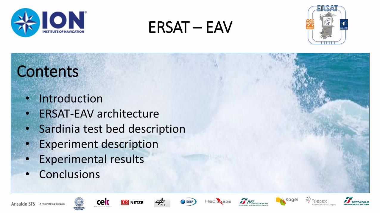
ATP legacy Automatic Train Control
STRENGHTS Challenges
CAPACITY
PERFORMANCE
SAFETY
Economical Sustainabiity for Local-Regional lines
ERSAT – EAV Introduction
ERTMS/ETCS The European Rail Traffic Management System/
European Train Control System

Provides in output
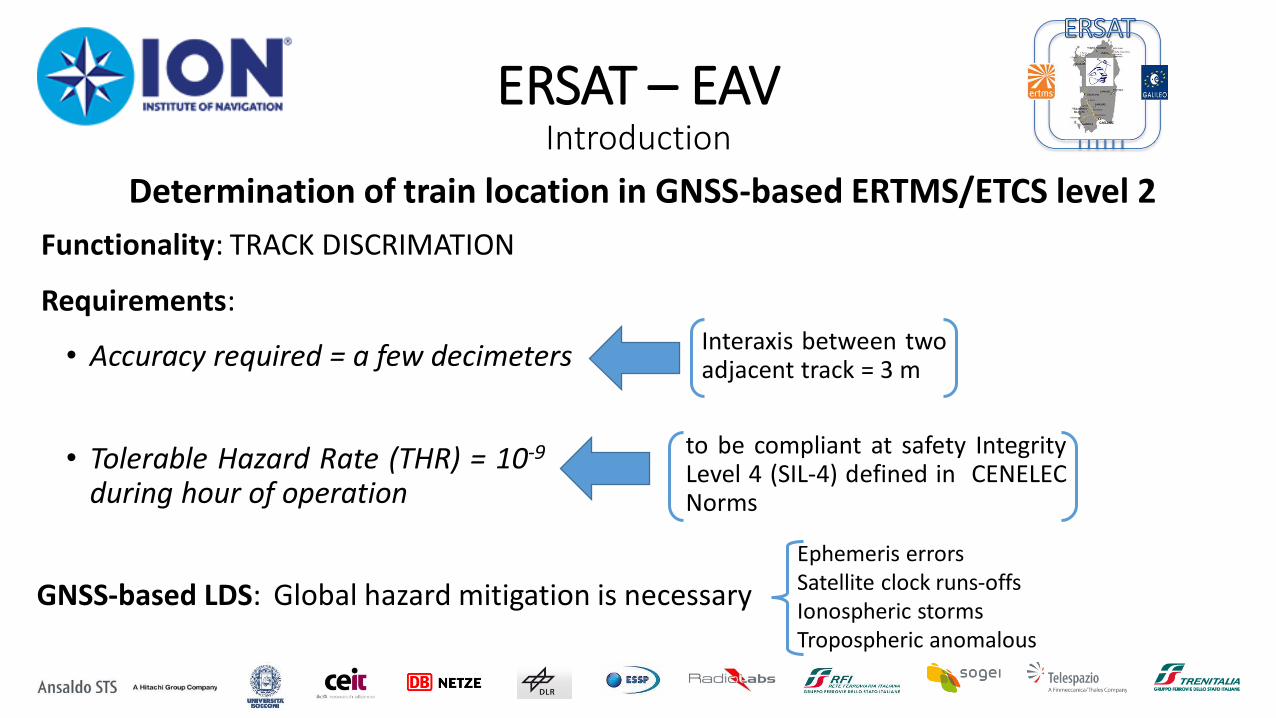
Determination of train location in GNSS-based ERTMS/ETCS level 2
Eurobalises – BTM
Odometry ERSAT – EAV
Project
Virtual Balises – Virtual Balise Reader
Odometry
Estimate of the travelled distance +
accuracy
Provides in output
ERSAT – EAV Introduction
Estimate of the travelled distance +
accuracy
ERSAT – EAV Introduction
• Accuracy required = a few decimeters
Functionality: TRACK DISCRIMATION
• Tolerable Hazard Rate (THR) = 10-9 during hour of operation
to be compliant at safety Integrity Level 4 (SIL-4) defined in CENELEC Norms
Requirements:
GNSS-based LDS: Global hazard mitigation is necessary
Ephemeris errors Satellite clock runs-offs Ionospheric storms Tropospheric anomalous
Interaxis between two adjacent track = 3 m
Determination of train location in GNSS-based ERTMS/ETCS level 2
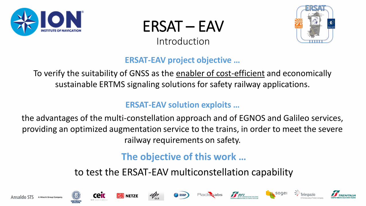
ERSAT-EAV project objective …
To verify the suitability of GNSS as the enabler of cost-efficient and economically sustainable ERTMS signaling solutions for safety railway applications.
ERSAT – EAV Introduction
ERSAT-EAV solution exploits …
the advantages of the multi-constellation approach and of EGNOS and Galileo services, providing an optimized augmentation service to the trains, in order to meet the severe
railway requirements on safety.
The objective of this work …
to test the ERSAT-EAV multiconstellation capability
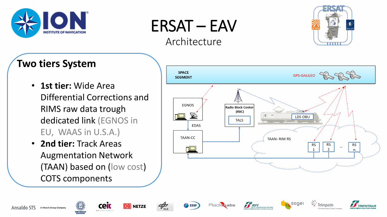
ERSAT – EAV Architecture
Two tiers System
• 1st tier: Wide Area Differential Corrections and RIMS raw data trough dedicated link (EGNOS in EU, WAAS in U.S.A.)
• 2nd tier: Track Areas Augmentation Network (TAAN) based on (low cost) COTS components
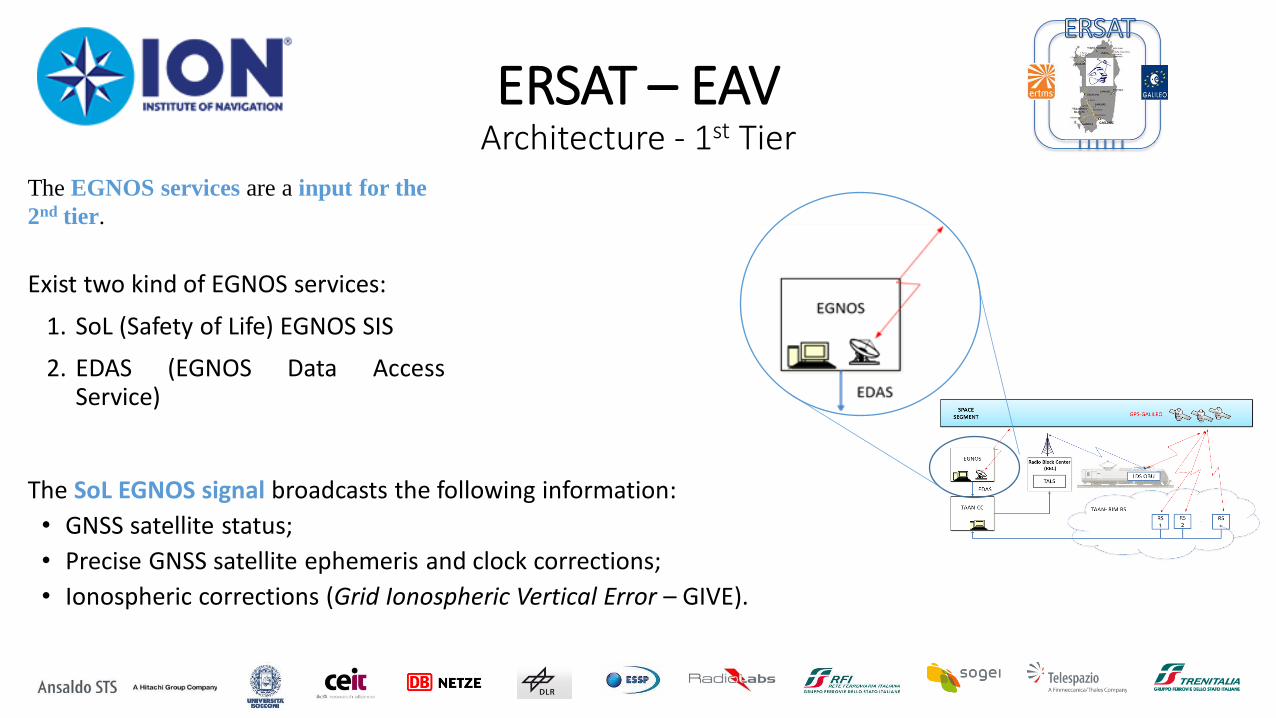
ERSAT – EAV Architecture - 1st Tier
The EGNOS services are a input for the
2nd tier.
Exist two kind of EGNOS services:
1. SoL (Safety of Life) EGNOS SIS
2. EDAS (EGNOS Data Access Service)
The SoL EGNOS signal broadcasts the following information:
• GNSS satellite status;
• Precise GNSS satellite ephemeris and clock corrections;
• Ionospheric corrections (Grid Ionospheric Vertical Error – GIVE).
ERSAT – EAV Architecture - 1st Tier
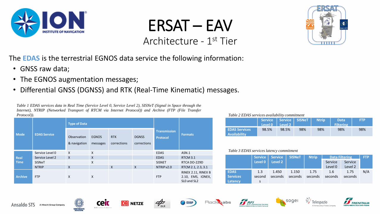
The EDAS is the terrestrial EGNOS data service the following information:
• GNSS raw data;
• The EGNOS augmentation messages;
• Differential GNSS (DGNSS) and RTK (Real-Time Kinematic) messages.
Mode EDAS Service
Type of Data
Transmission
Protocol Formats
Observation
& navigation
EGNOS
messages
RTK
corrections
DGNSS
corrections
Real Time
Service Level 0 X X EDAS ASN.1
Service Level 2 X X EDAS RTCM 3.1
SISNeT X SISNET RTCA DO-229D
NTRIP X X X NTRIP v2.0 RTCM 2.1, 2.3, 3.1
Archive FTP X X FTP
RINEX 2.11, RINEX B 2.10, EMS, IONEX, SL0 and SL2
Table 1 EDAS services data in Real Time (Service Level 0, Service Level 2), SISNeT (Signal in Space through the
Internet), NTRIP (Networked Transport of RTCM via Internet Protocol)) and Archive (FTP (File Transfer
Protocol)).
Service Level 0
Service Level 2
SISNeT Ntrip Data Filtering
FTP
EDAS Services Availability
98.5% 98.5% 98% 98% 98% 98%
Service Level 0
Service Level 2
SISNeT Ntrip Data Filtering FTP
Service Level 0
Service Level 2
EDAS Services Latency
1.3 second
s
1.450 seconds
1.150 seconds
1.75 seconds
1.6 seconds
1.75 seconds
N/A
Table 2 EDAS services availability commitment
Table 3 EDAS services latency commitment
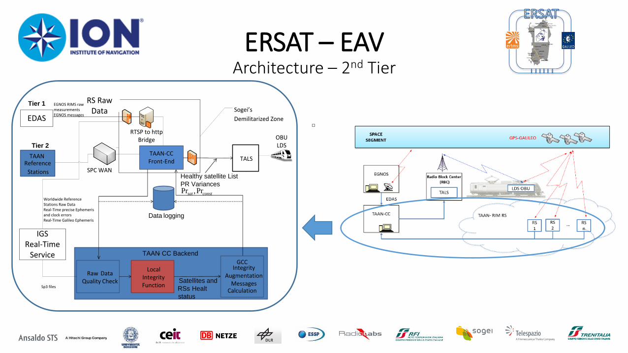
ERSAT – EAV Architecture – 2nd Tier
TAANReference
Stations
TALS
Raw Data Quality Check
Local IntegrityFunction
Healthy satellite List
PR Variances
Satellites and
RSs Healt
status
TAAN- CC Backend
Data logging
Tier 2
Tier 1
GCCIntegrity
AugmentationMessages
Calculation
SPC WAN
TAAN-CCFront-End
EDAS
RTSP to httpBridge
RS Raw Data Sogei’s
Demilitarized Zone
ASTSSingle
Frequency RSs
OBULDS
constsat Pr,Pr
IGSReal-Time
Service
Worldwide Reference Stations Raw DataReal-Time precise Ephemeris and clock errorsReal-Time Galileo Ephemeris
Sp3 files
EGNOS RIMS raw measurementsEGNOS messages
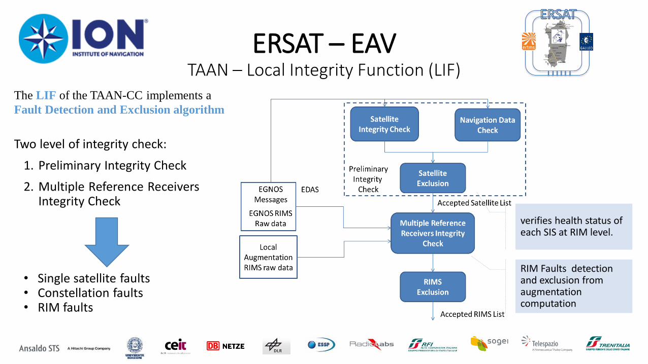
ERSAT – EAV TAAN – Local Integrity Function (LIF)
RIM Faults detection and exclusion from augmentation computation
verifies health status of each SIS at RIM level.
Two level of integrity check:
1. Preliminary Integrity Check
2. Multiple Reference Receivers Integrity Check
• Single satellite faults • Constellation faults • RIM faults
The LIF of the TAAN-CC implements a
Fault Detection and Exclusion algorithm
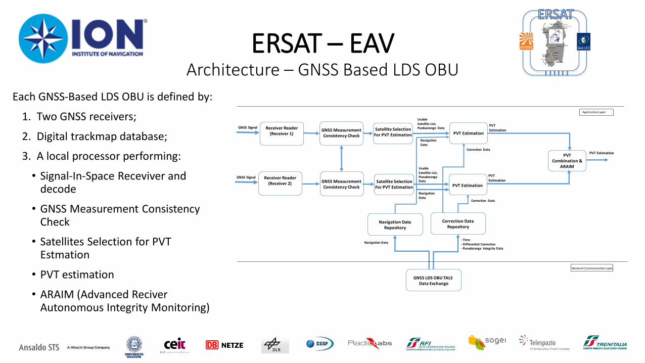
ERSAT – EAV Architecture – GNSS Based LDS OBU
PVT Estimation
GNSS Signal Receiver Reader(Receiver 1)
Navigation Data
GNSS LDS OBU TALS Data Exchange
PVT Estimation
PVT Combination &
ARAIM
PVT Estimation
Usable Satellite List, Pseduorange Data
GNSS Signal Receiver Reader(Receiver 2) PVT Estimation
Satellite SelectionFor PVT Estimation
GNSS MeasurementConsistency Check
GNSS MeasurementConsistency Check
PVT Estimation
Correction Data Repository
Navigation Data Repository
Satellite SelectionFor PVT Estimation
Application Layer
Network Communication Layer
- Time- Differential Correction- Pseudorange Integrity Data
Usable Satellite List, Pseudorange Data
Navigation Data
Navigation Data
Correction Data
Correction Data
Each GNSS-Based LDS OBU is defined by:
1. Two GNSS receivers;
2. Digital trackmap database;
3. A local processor performing:
• Signal-In-Space Receviver and decode
• GNSS Measurement Consistency Check
• Satellites Selection for PVT Estmation
• PVT estimation
• ARAIM (Advanced Reciver Autonomous Integrity Monitoring)
ERSAT – EAV Architecture – GNSS Based LDS OBU
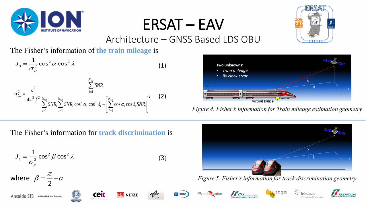
Figure 4. Fisher’s information for Train mileage estimation geometry
Figure 5. Fisher’s information for track discrimination geometry
2 2
2
1cos cossJ
(1)
22 1
22 2
2 2
1 1 1
4cos cos cos cos
Sat
Sat Sat Sat
N
i
is
N N N
i i i i i i i
i i i
SNRc
fSNR SNR SNR
(2)
The Fisher’s information of the train mileage is
2 2
2
1cos cossJ
The Fisher’s information for track discrimination is
(3)
2
where
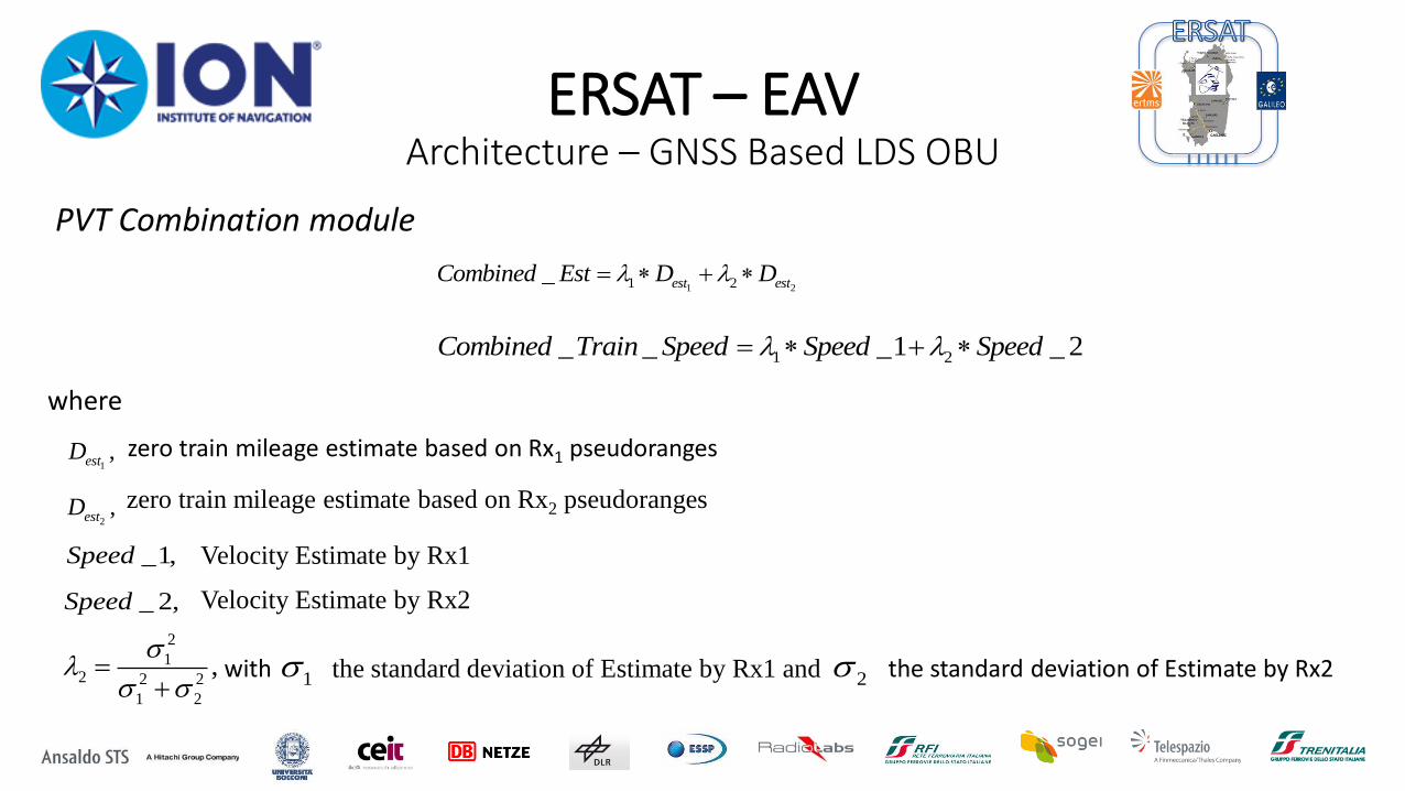
ERSAT – EAV Architecture – GNSS Based LDS OBU
where
1 21 2_ est estCombined Est D D
1 2_ _ _1 _ 2Combined Train Speed Speed Speed
zero train mileage estimate based on Rx1 pseudoranges 1,estD
2,estD zero train mileage estimate based on Rx2 pseudoranges
_1,Speed
_ 2,Speed
Velocity Estimate by Rx1
Velocity Estimate by Rx2
2
12 2 2
1 2
,
where
PVT Combination module
the standard deviation of Estimate by Rx1 and the standard deviation of Estimate by Rx2 21with
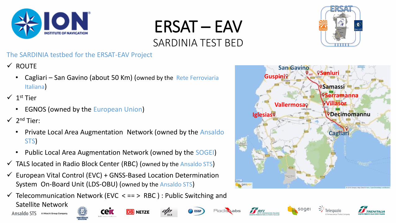
ERSAT – EAV SARDINIA TEST BED
where
The SARDINIA testbed for the ERSAT-EAV Project
ROUTE
• Cagliari – San Gavino (about 50 Km) (owned by the Rete Ferroviaria
Italiana)
1st Tier
• EGNOS (owned by the European Union)
2nd Tier:
• Private Local Area Augmentation Network (owned by the Ansaldo STS)
• Public Local Area Augmentation Network (owned by the SOGEI)
TALS located in Radio Block Center (RBC) (owned by the Ansaldo STS)
European Vital Control (EVC) + GNSS-Based Location Determination System On-Board Unit (LDS-OBU) (owned by the Ansaldo STS)
Telecommunication Network (EVC < == > RBC ) : Public Switching and Satellite Network
Cagliari
Serramanna
Vallermosa
Guspini
Iglesias
Sanluri San Gavino
Samassi
Villasor
Decimomannu
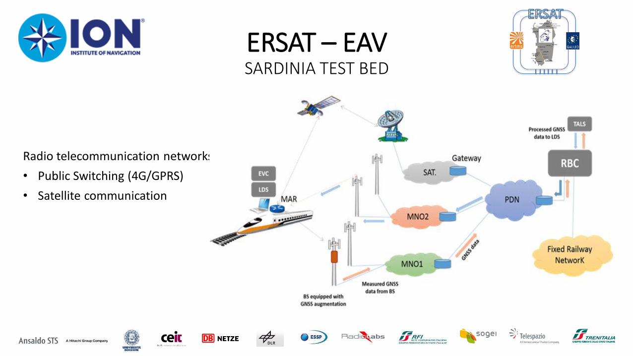
ERSAT – EAV SARDINIA TEST BED
where
Radio telecommunication networks
• Public Switching (4G/GPRS)
• Satellite communication
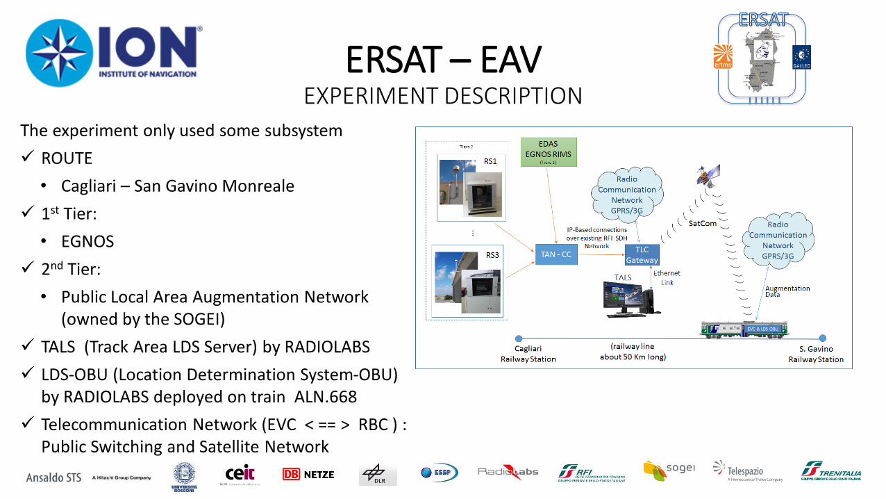
ERSAT – EAV EXPERIMENT DESCRIPTION
where
The experiment only used some subsystem
ROUTE
• Cagliari – San Gavino Monreale
1st Tier:
• EGNOS
2nd Tier:
• Public Local Area Augmentation Network (owned by the SOGEI)
TALS (Track Area LDS Server) by RADIOLABS
LDS-OBU (Location Determination System-OBU) by RADIOLABS deployed on train ALN.668
Telecommunication Network (EVC < == > RBC ) : Public Switching and Satellite Network
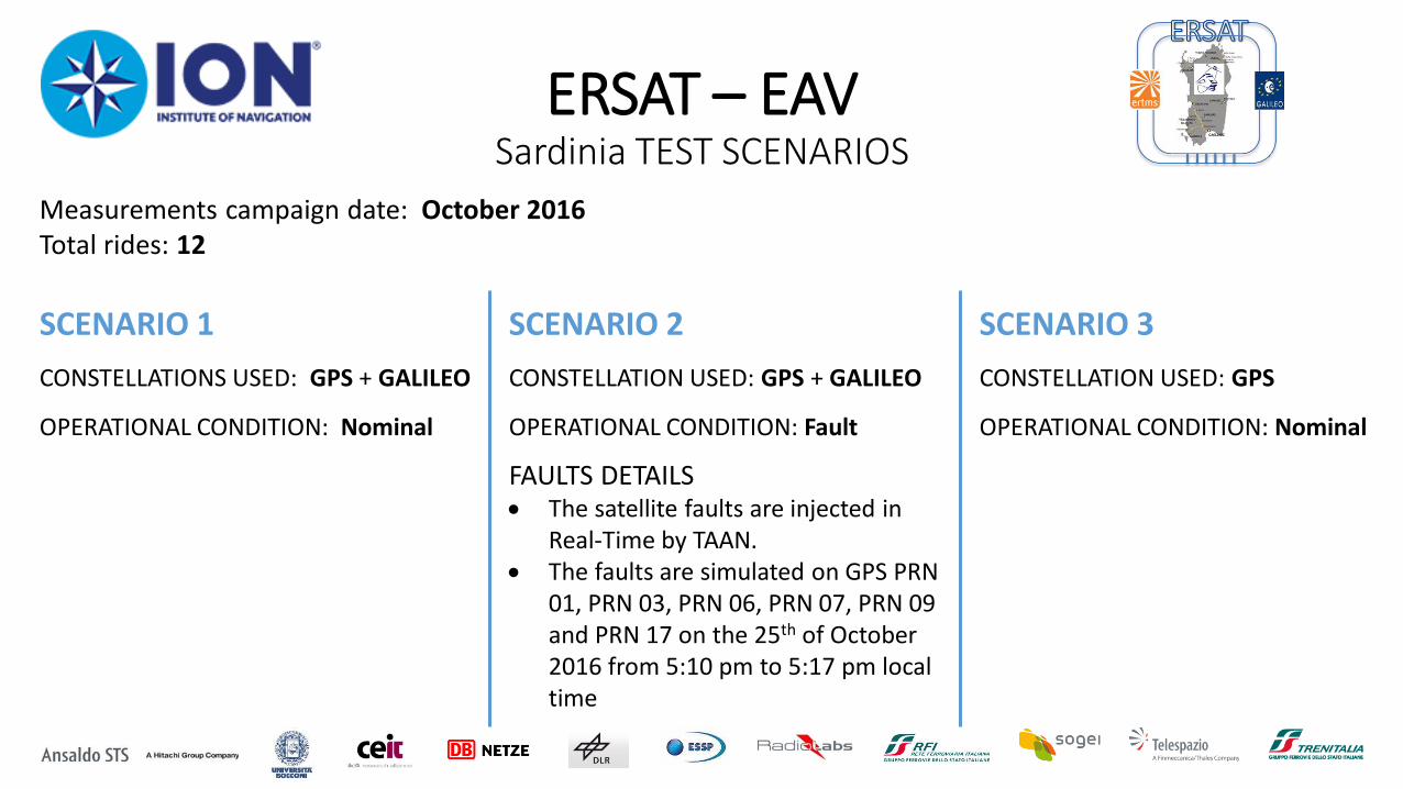
ERSAT – EAV Sardinia TEST SCENARIOS
SCENARIO 1
CONSTELLATIONS USED: GPS + GALILEO
OPERATIONAL CONDITION: Nominal
SCENARIO 2
CONSTELLATION USED: GPS + GALILEO
OPERATIONAL CONDITION: Fault
SCENARIO 3
CONSTELLATION USED: GPS
OPERATIONAL CONDITION: Nominal
FAULTS DETAILS The satellite faults are injected in
Real-Time by TAAN. The faults are simulated on GPS PRN
01, PRN 03, PRN 06, PRN 07, PRN 09 and PRN 17 on the 25th of October 2016 from 5:10 pm to 5:17 pm local time
Measurements campaign date: October 2016 Total rides: 12
ERSAT – EAV EXPERIMENTAL RESULTS
where
0 10 20 30 40 500
5
10
15
20
25
30
35
40
45
50
0
1
2
3
5
6
7
8
MIepochs: 0
MIepochs: 0
HMIepochs: 0
HMIepochs: 0
System UnavailableAlarm Epochs: 0
System UnavailableAlarm Epochs: 0
Error (m)
Stanford Diagram (1260 epochs)
MIepochs: 0
MIepochs: 0
Normal OperationNormal Operation
Pro
tection L
evel (m
)
Nu
mb
er
of P
oin
ts p
er
Pix
el
100
101
SCENARIO 1
CONSTELLATIONS USED: GPS + GALILEO
OPERATIONAL CONDITION: Nominal
Figure 12 Stanford diagram Figure 13 Number of satellites used for
PVT estimation
First GALILEO Fix
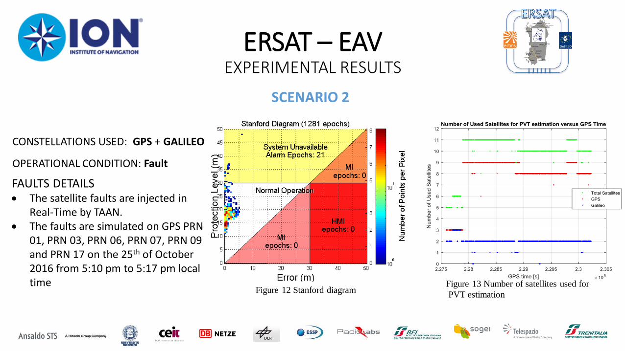
ERSAT – EAV EXPERIMENTAL RESULTS
where
SCENARIO 2
CONSTELLATIONS USED: GPS + GALILEO
OPERATIONAL CONDITION: Fault
FAULTS DETAILS The satellite faults are injected in
Real-Time by TAAN. The faults are simulated on GPS PRN
01, PRN 03, PRN 06, PRN 07, PRN 09 and PRN 17 on the 25th of October 2016 from 5:10 pm to 5:17 pm local time
Figure 12 Stanford diagram Figure 13 Number of satellites used for
PVT estimation
ERSAT – EAV EXPERIMENTAL RESULTS
where
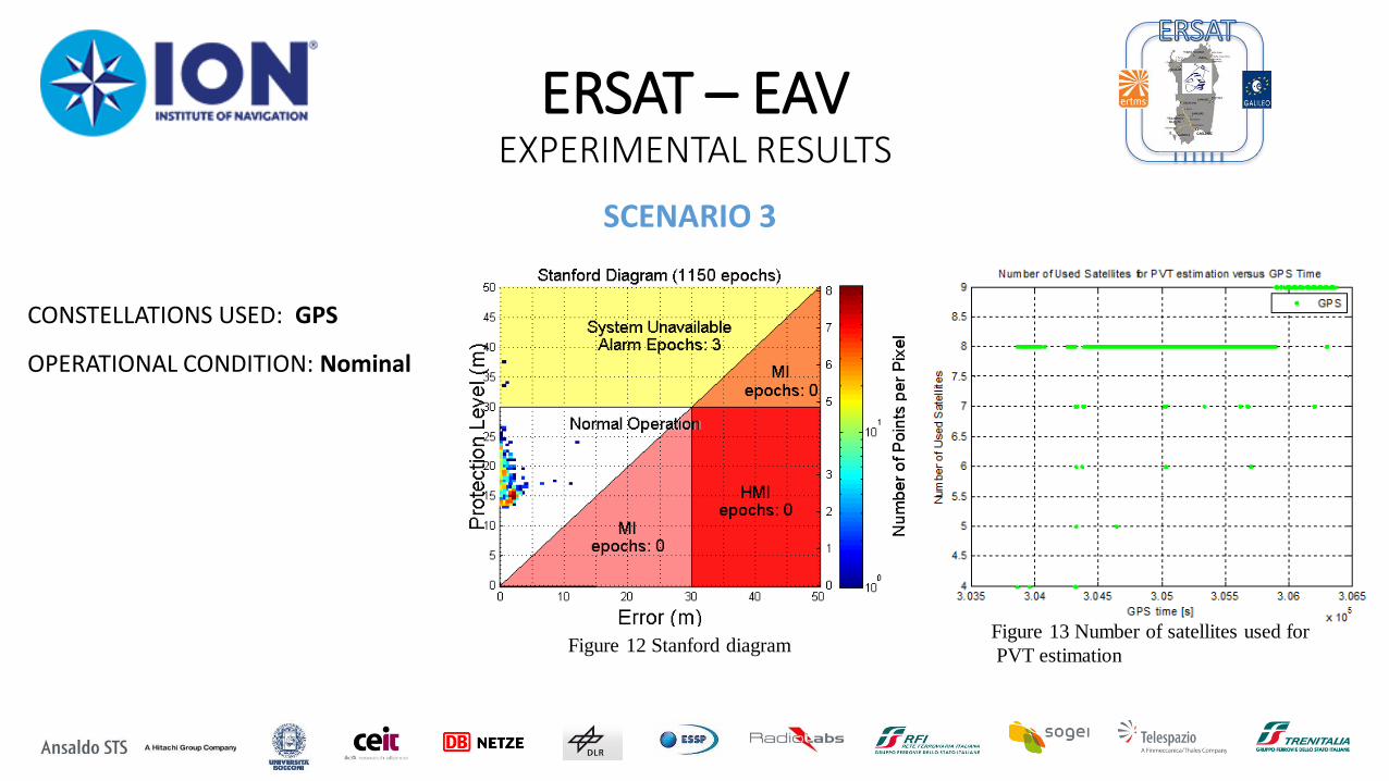
SCENARIO 3
CONSTELLATIONS USED: GPS
OPERATIONAL CONDITION: Nominal
Figure 12 Stanford diagram Figure 13 Number of satellites used for
PVT estimation
ERSAT – EAV CONCLUSIONS
where
Multi-layer approach to the design and implementation of an
augmentation network supporting railway applications has been verified in a
real operational environment
Additional tests will be carried out with the Galileo constellation entering
into pre-operational service
Results will be contributing to the ERTMS roadmap for adopting the
GNSS

THANKS FOR YOUR ATTENTION


![0804 EAV (CFA610)[1]](https://img.pdfslide.net/doc/110x75/577d39a41a28ab3a6b9a3fc6/0804-eav-cfa6101.jpg)