Embed Size (px)
Citation preview
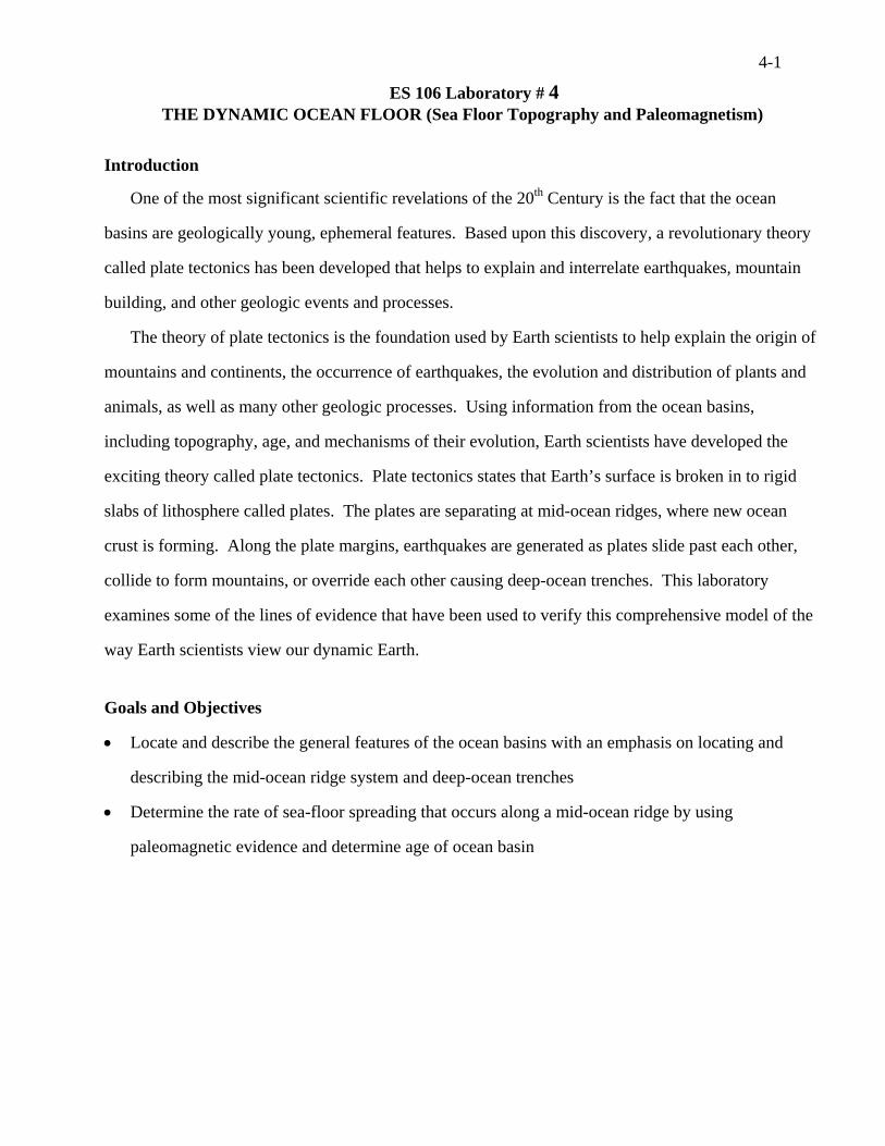
4-1
ES 106 Laboratory # 4 THE DYNAMIC OCEAN FLOOR (Sea Floor Topography and Paleomagnetism)
Introduction
One of the most significant scientific revelations of the 20th Century is the fact that the ocean
basins are geologically young, ephemeral features. Based upon this discovery, a revolutionary theory
called plate tectonics has been developed that helps to explain and interrelate earthquakes, mountain
building, and other geologic events and processes.
The theory of plate tectonics is the foundation used by Earth scientists to help explain the origin of
mountains and continents, the occurrence of earthquakes, the evolution and distribution of plants and
animals, as well as many other geologic processes. Using information from the ocean basins,
including topography, age, and mechanisms of their evolution, Earth scientists have developed the
exciting theory called plate tectonics. Plate tectonics states that Earth’s surface is broken in to rigid
slabs of lithosphere called plates. The plates are separating at mid-ocean ridges, where new ocean
crust is forming. Along the plate margins, earthquakes are generated as plates slide past each other,
collide to form mountains, or override each other causing deep-ocean trenches. This laboratory
examines some of the lines of evidence that have been used to verify this comprehensive model of the
way Earth scientists view our dynamic Earth.
Goals and Objectives
• Locate and describe the general features of the ocean basins with an emphasis on locating and
describing the mid-ocean ridge system and deep-ocean trenches
• Determine the rate of sea-floor spreading that occurs along a mid-ocean ridge by using
paleomagnetic evidence and determine age of ocean basin
4-2 Name_____KEY_______________
Lab Day/Time_________________
Pre-lab Questions – Complete these questions before coming to lab. 1. Write a brief statement that describes each of the following ocean floor features:
A. Continental shelf FLOODED EDGE OF CONTINENTAL CRUST. SHALLOW
PORTION OF OCEAN.
B. Continental slope TOPOGRAPHIC DROPOFF OF CONTINENTAL SHELF TO
DEEP OCEAN FLOOR, WHERE THE CONTINENTAL CRUST TRANSITIONS TO
OCEANIC CRUST.
C. Abyssal plain FLAT DEEP OCEAN FLOOR COVERED WITH ABYSSAL CLAYS
AND BIOGENIC SEDIMENT
D. Seamount UNDERSEA VOLCANIC PEAK THAT MAY BE ASSOCIATED WITH
THE OCEANIC RIDGE SYSTEM.
E. Deep-ocean trench TOPOGRAPHIC DEPRESSIONS ON SEA FLOOR CREATED
BY CONVERGENT LITHOSPHERIC PLATES, AND THE SUBDUCTION OF
OCEANIC PLATE INTO THE MANTLE.
F. Mid-ocean ridge TOPOGRAPHIC HIGH ON THE SEA FLOOR CREATED BY
DIVERGENT LITHOSPHERIC PLATE, LIFTED BY THE HEAT OF THE MAGMA
RISING FROM THE RELEASE OF PRESSURE ON THE UNDERLYING MANTLE. 2. Suppose that the scale on a map is 1:50,000. If you measure the following distances on the map
using a ruler, convert the map distances to the real world distances indicated below. Remember to show your formulas with units to convert. Conversion factors can be found in the appendix of your textbook.
A. 3 inches = _____2.37____ miles mift
miinftinin 37.2
52801
121150000500003 =⋅⋅=⋅
B. 2 cm = ____1_____ km kmm
kmcm
mcmcm 11000
1100
1100000500002 =⋅⋅=⋅
C. 10 cm = ____3.1_____ miles mikm
mim
kmcm
mcmcm 1.361.11
10001
10015000005000010 =⋅⋅⋅=⋅
4-3 Part A – Ocean Basin Topography
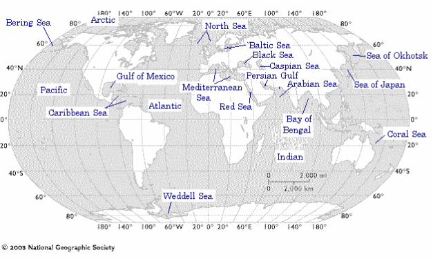
Understanding the topography of the ocean basins has been critical to developing the theory of plate tectonics. In the mid-20th century oceanographic research vessels mapped the sea floor and by the 1960s research concerning rock magnetism, the cause and distribution of earthquakes, and the age of ocean sediments lead to the development of the theory of plate tectonics. Various features are located along the continental margins and ocean basin floor. Study the maps (the World Ocean Floor map, the Pacific Ocean map, and the Mid-Atlantic Ridge map) and refer to your textbook as needed to answer the following questions. 1. On the world map provided on the following page, draw the global mid-ocean ridge system in red.
2. Locate and label the following deep-ocean trenches. Draw a blue line to represent the trench and
label with the letter of each trench on the map.
Deep Ocean Trenches: Puerto Rico, Cayman, Peru-Chile, Aleutian, Kuril, Japan, Mariana, Tonga, Kermadec, Java
3. What is the approximate average ocean depth along the continental shelves bordering North
America? LESS THAN 150 m
4. Approximately how high above the adjacent ocean floor does the Mid-Atlantic Ridge rise? 1500 TO 2000 m
5. Approximately how deep are most of the deep-ocean trenches (give an average depth for a sampling of trenches)? 6000-10000 m
6. Write a brief statement comparing the width of the continental shelf along the east coast, west coast, and gulf coast of North America.
THE CONTINENTAL SHELF OFF THE WEST COAST OF NORTH AMERICA IS QUITE NARROW COMPARED TO THE SHELF ON THE OTHER COASTS OF NORTH AMERICA.
4-5
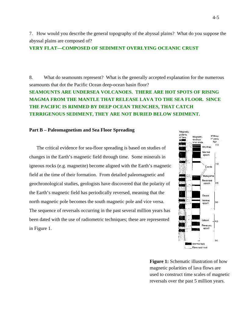
7. How would you describe the general topography of the abyssal plains? What do you suppose the abyssal plains are composed of? VERY FLAT—COMPOSED OF SEDIMENT OVERLYING OCEANIC CRUST
8. What do seamounts represent? What is the generally accepted explanation for the numerous seamounts that dot the Pacific Ocean deep-ocean basin floor? SEAMOUNTS ARE UNDERSEA VOLCANOES. THERE ARE HOT SPOTS OF RISING MAGMA FROM THE MANTLE THAT RELEASE LAVA TO THE SEA FLOOR. SINCE THE PACIFIC IS RIMMED BY DEEP OCEAN TRENCHES, THAT CATCH TERRIGENOUS SEDIMENT, THEY ARE NOT BURIED BELOW SEDIMENT.
Part B – Paleomagnetism and Sea Floor Spreading
The critical evidence for sea-floor spreading is based on studies of
changes in the Earth’s magnetic field through time. Some minerals in
igneous rocks (e.g. magnetite) become aligned with the Earth’s magnetic
field at the time of their formation. From detailed paleomagnetic and
geochronological studies, geologists have discovered that the polarity of
the Earth’s magnetic field has periodically reversed, meaning that the
north magnetic pole becomes the south magnetic pole and vice versa.
The sequence of reversals occurring in the past several million years has
been dated with the use of radiometric techniques; these are represented
in Figure 1. Figure 1: Schematic illustration of how magnetic polarities of lava flows are used to construct time scales of magnetic reversals over the past 5 million years.
4-6
Study Figure 1 and answer the following questions.
1. How many times has the magnetic field of the Earth reversed in the past 5 million years?
____13 TIMES TO REVERSE, 25 TIMES BACK AND FORTH_______ times
2. Approximately how long ago did the current normal epoch (Bruhnes Normal epoch) begin?
____700,000_________________________ years ago
3. Two million years ago, what direction would a compass needle have pointed – north or south?
__________SOUTH__________________________
4. Based on the pattern, does it appear as though Earth is due for another magnetic polarity reversal
in the near future? Briefly explain your reasoning.
PERHAPS IN THE NEXT HALF MILLION YEARS, OR LESS, BASED ON FIGURE ONE
SHOWING A PERIOD OF POLARITY LASTS 800,000 TO 1.5 MILLION YEARS
Activity: Calculate rate of spreading and age of ocean basins.
As tectonic plates separate along a mid-ocean ridge, magma from the mantle rises to the surface
and creates new ocean floor. As the magma cools, the minerals assume a magnetic orientation equal
to the prevailing magnetic field. The plates continue to separate and if Earth’s magnetic field reverses
polarity, new material forming at the ridge is magnetized in the opposite direction. This process
results in magnetic striping of the ocean crust running parallel to the mid-ocean ridge.
Earth scientists can measure the magnetic striping by towing a device called a magnetometer
behind a ship. The magnetometer records the strength of the magnetic field in a given location.
Figure 2 shows magnetic records for the North Pacific Ocean basin and the South Atlantic Ocean
basin. Where the rocks have the same magnetic polarity as the present-day field, we find stronger than
average magnetic field (represented as a peak called a positive anomaly); where the rocks preserve
reverse polarity, we measure weaker than average magnetic field (represented as a trough called called
a negative anomaly).
Using the known time scale of magnetic reversals, we can determine the age of a magnetic
anomaly. By dividing the distance from the ridge crest to the magnetic anomaly by the age of the
magnetic anomaly, we can determine the spreading rate at the ridge.
4-7
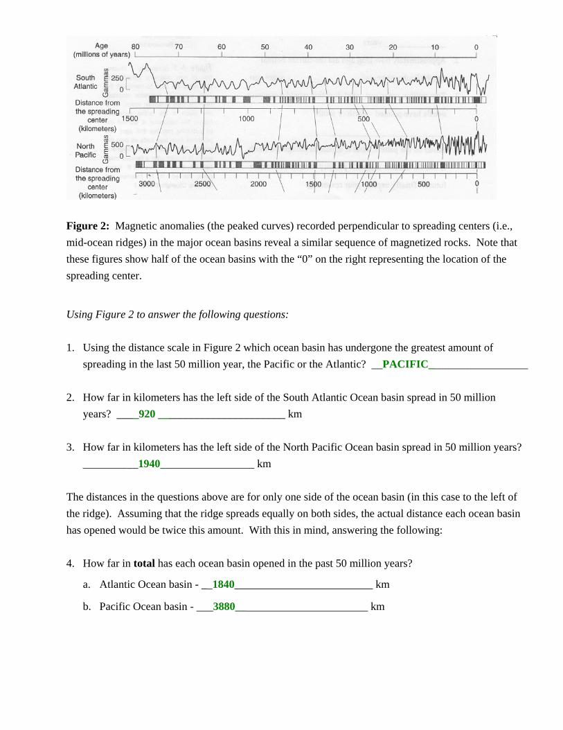
Figure 2: Magnetic anomalies (the peaked curves) recorded perpendicular to spreading centers (i.e., mid-ocean ridges) in the major ocean basins reveal a similar sequence of magnetized rocks. Note that these figures show half of the ocean basins with the “0” on the right representing the location of the spreading center.
Using Figure 2 to answer the following questions: 1. Using the distance scale in Figure 2 which ocean basin has undergone the greatest amount of
spreading in the last 50 million year, the Pacific or the Atlantic? __PACIFIC__________________ 2. How far in kilometers has the left side of the South Atlantic Ocean basin spread in 50 million
years? ____920 _______________________ km 3. How far in kilometers has the left side of the North Pacific Ocean basin spread in 50 million years?
__________1940_________________ km The distances in the questions above are for only one side of the ocean basin (in this case to the left of the ridge). Assuming that the ridge spreads equally on both sides, the actual distance each ocean basin has opened would be twice this amount. With this in mind, answering the following: 4. How far in total has each ocean basin opened in the past 50 million years?
a. Atlantic Ocean basin - __1840_________________________ km
b. Pacific Ocean basin - ___3880________________________ km
4-8
By knowing both the distance that each ocean basin has opened and the time it took to open that distance, the rate of sea-floor spreading can be calculated. (Useful conversion factors: 1 km = 1000 meters and 1 m = 100 cm) 5. Determine the spreading rate in centimeters per year for the two areas shown in Figure 2. (show
formulas for calculations, with units) a. North Pacific
(3900 km/50,000,000 yr) x (1000m/km)x(100 cm/m) = 7.8 cm/yr
b. South Atlantic 1900 km/50,000,000 yr = 3.8 cm/yr
The rate you calculated above for the South Atlantic Ocean can be used to determine the age of both the South Atlantic Ocean and North Atlantic Ocean basins. Essentially, you will estimate how many millions of years ago the North Atlantic and South Atlantic Ocean basins began to form. 6. On the large wall map posted in the lab room, measure the seaward edges of the continental
shelves from eastern North America near North Carolina to northwestern Africa at Mauritania (20°N latitude). Determine the distance in centimeters in the real world.
16 cm * 38,931,000 =622,896,000 cm 7. To determine the age of the ocean basin, divide the distance in centimeters separating the
continental shelves by the rate of sea-floor spreading for the Atlantic Ocean basin. Age of the North Atlantic Ocean basin: ______164 million years______________ years (show formulas for calculations, with units)
622,896,000 cm /(3.8 cm/yr)
4-9
8. Now determine the distance between South Africa and South America (in centimeters) by measuring from the eastern edge of the continental shelf of Brazil directly east to Africa. (show formulas for calculations, with units)
13.5 cm * 38,931,000 =525,568,000 cm 9. As you did above, use the rate of sea-floor spreading for the South Atlantic basin to calculate the
age of the South Atlantic basin. Age of the South Atlantic Ocean basin: ______138 million years_________________ years
(show formulas for calculations, with units) 525,568,000 cm/(3.8 cm/yr) 10. Jurassic rocks (represented by basalt dikes and lava flows) occur in New Jersey. These are
interpreted to represent the rocks that formed when North America and Africa were rifted apart. Refer to the diagram of the rifting process in your textbook (Figure 8.11, Tarbuck and Lutgens, 11th ed., page 227), why would you expect to find volcanic rocks associated with the onset of rifting?
BASALTIC MAGMA RISES FROM THE MELTING CAUSED BY PRESSURE RELEASE AT THE DIVERGENCE OF LITHOSPHERE AT THE OCEANIC RIDGES. 11. Is your calculated age consistent with this geologic data? Refer to the geologic time scale on the
last page of the lab manual. Explain your answer. YES, THE AGE CALCULATED IS WITHIN THE JURASSIC TIME
4-10
Part C – Pillow Lavas Watch the brief video snippet of pillow lavas erupting near Hawaii on the computer. 1. Study the sample of pillow lava. In the space below, sketch and describe the sample. FINE GRAINED, DARK VOLCANIC ROCK WITH GLASSY SURFACE, AND A DISTINCTIVE RIM WITH WHITE STRUCTURES PERPENDICULAR TO SURFACE SHOWN ON BROKEN SIDE. 2. Interpret how the pillow lava formed. PILLOW LAVA FORMS BY THE QUENCHING OF LAVA BY SEA WATER TO COOL IT IMMEDIATELY. THE RIND OF PILLOW LAVA OFTEN IS GLASSY, BECAUSE IT COOLED SO QUICKLY THAT IT DID NOT CREATE MINERALS. 3. Pillow lavas can be observed at several locations in the Coast Range of western Oregon, including
on Mary’s Peak west of Corvallis and in Depoe Bay. What does the presence of pillow lavas on peaks in the Coast Range tell us about the geologic history of the Coast Range?
THE COAST RANGE CONTAINS PORTIONS OF THE SEA FLOOR THAT HAVE BEEN UPLIFTED BY TECTONIC PROCESSES.
4-11 Name_______KEY____________
Lab Day/Time_________________
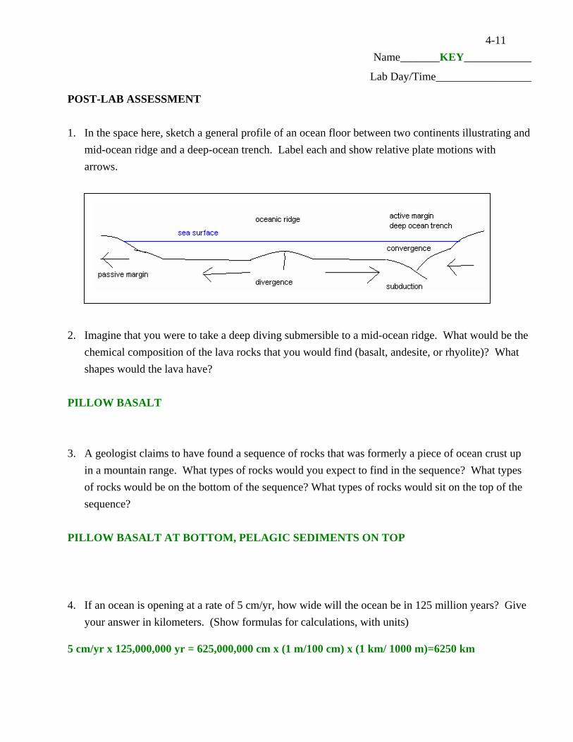
POST-LAB ASSESSMENT 1. In the space here, sketch a general profile of an ocean floor between two continents illustrating and
mid-ocean ridge and a deep-ocean trench. Label each and show relative plate motions with arrows.
2. Imagine that you were to take a deep diving submersible to a mid-ocean ridge. What would be the
chemical composition of the lava rocks that you would find (basalt, andesite, or rhyolite)? What shapes would the lava have?
PILLOW BASALT 3. A geologist claims to have found a sequence of rocks that was formerly a piece of ocean crust up
in a mountain range. What types of rocks would you expect to find in the sequence? What types of rocks would be on the bottom of the sequence? What types of rocks would sit on the top of the sequence?
PILLOW BASALT AT BOTTOM, PELAGIC SEDIMENTS ON TOP 4. If an ocean is opening at a rate of 5 cm/yr, how wide will the ocean be in 125 million years? Give
your answer in kilometers. (Show formulas for calculations, with units) 5 cm/yr x 125,000,000 yr = 625,000,000 cm x (1 m/100 cm) x (1 km/ 1000 m)=6250 km