Embed Size (px)
Citation preview

Project No. CC0714 Third Set of Locks
ES1
ES.0 EXECUTIVE SUMMARY
ES.1 GENERAL INFORMATION ABOUT THE COMPANY
The Environmental Impact Study (EIS) for the Panama Canal Expansion Project – Third Set of Locks, is hereby presented to the National Environmental Authority (ANAM) by the Panama Canal Authority. This document, developed by a consulting team comprised of URS Holdings, Inc. (URS), the University of Panama Foundation (FUDEP) and the University of Chiriqui Foundation (UNACHI), complies with Executive Decree Nº 209 of 2006 (G. O. 25,625). This Executive Decree sets forth regulations to implement Chapter II, Title IV of Law 41 of July 1 st , 1998, which refers to the processes for Environmental Impact Assessments, and repeals Executive Decree Nº 59 of 2000.
The Project promoter is the Panama Canal Authority (ACP), whose general information is as follows:
Promoter: Panama Canal Authority Location: ACP’s Administration Building, Balboa Heights, Ancon, Panama. Legal Representative: Alberto Aleman Zubieta, Eng. Personal Identity No: 8404837 Webpage: www.pancanal.com Contact: Daniel Muschett Email: [email protected] Telephone 2761292 Fax: 2761291
Consulting Team’s General Information:
URS Holdings Inc.: Registration No. IAR00198 Location: Generali Tower, 15th Floor, Office No. 3. Samuel Lewis Avenue & 54th
Street, Panama Legal Representative: Juan Carlos Vallarino Personal Identity No: 8365252 Email: [email protected] Telephone/Fax: 265 0601/ 265 0605
University of Panama Foundation (FUDEP): Location: Octavio Mendez Pereira University Campus– Panama City Legal Representative: Samuel Lewis Galindo Personal Identity No: 849942 Email: [email protected] Telephone/Fax: 2237353
Category III Environmental Impact Study Project No. CC0714 Executive Summary Third Set of Locks
ES2 URS Holdings, Inc. July 2007
University of Chiriqui Foundation (UNACHI): Location: Brencan Building, across from Cervantes Park – David City (Chiriqui). Legal Representative: Camilo Brenes Personal Identity No: 470158 Email: [email protected] Telephone/Fax: 7741620

Project No. CC0714 Category III Environmental Impact Study Third Set of Locks Executive Summary
URS Holdings, Inc. ES3 July 2007
ES.2 BRIEF PROJECT DESCRIPTION; DEVELOPMENT AREA; COST ESTIMATE
Brief Project Description and Development Area The analysis of several alternatives studied by the ACP resulted in the Panama Canal Expansion Project – Third Set of Locks Study Report. The details of each component are described and discussed in the 2005 2025 Panama Canal Master Plan and in the research studies conducted for this objective.
The Project’s objectives are to guarantee the Panama Canal’s position as a growing and competitive business, to increase the Canal’s capacity to better serve the growing demand for its services, to ensure the long term sustainability and growth of the Panama Canal’s contributions to the National Treasury, and to maintain the waterway’s status as the cornerstone of the country’s maritime development.
In summary e, the Panama Canal Expansion Project – Third Set of Locks consists of three major components:
i) The construction of two locks facilities (Figure ES.1), one at each end of the Canal. Each facility will include three consecutive chambers and three lateral water saving basins per chamber. The Atlantic locks complex will be located east of the existing Gatun Locks (Figure ES.2); the Pacific locks complex will be located southwest of the existing Miraflores Locks (Figure ES.3). The location of both locks complexes make use of an extensive section of the excavations performed by the U.S. Government for the third set of locks project started in 1939. The new locks chambers will be 427 m (1,400 ft) long, 55 m (180 ft) wide and 18.3m (60 ft) deep.
ii) The excavation of new navigational channels to allow access between the new locks and the existing channels and the deepening and widening of the existing channels. Widening the existing channels to 218 m (715 ft) will allow navigation of postPanamax vessels through these channels in one direction at a time. Gaillard’s Cut and the Gatun Lake’s navigation channels will be deepened by 1.2 m (4 ft), to a PLD level of 9.2 m (30 ft); and
iii) Raising the maximum operational level of Gatun Lake by 0.45 m (1.5 ft), from its existing 26.7 m (87.5 ft) PLD to 27.1 m (89 ft) PLD. This Project component will increase Gatun Lake’s functional water reserve capacity.
The Project’s activities and the required temporary work areas, as well as the dredged and excavated material disposal sites are within designated Canal operating areas, according to the Land Use Plan established by the Interoceanic Region Authority (ARI) through Law 21 of 1997. These lands were part of the former Canal Zone, a strip of land conceded to the US Government for activities related to Canal operations and defense.
The Panama Canal Expansion Project – Third Set of Locks involves the removal of approximately 133 million cubic meters (83 Mm 3 excavation, 50 Mm 3 dredging) of material. The Project is primarily an open pit excavation effort and dredging of a well studied and cleared geologic area. The Project does not include underground or underwater construction activities.
The main activities during the construction phase will be:
• Mobilization and construction of temporary work facilities, material acquisition, aggregate fabrication and other related construction activities
• Construction of temporary and permanent access roads
Category III Environmental Impact Study Project No. CC0714 Executive Summary Third Set of Locks
ES4 URS Holdings, Inc. July 2007
• Site clearing
• Excavation and fill
• Blasting operations
• Slope and bank stabilization
• Dredging and deepening of existing channels
• Management of disposal sites for dredging and excavation material
• Construction of locks and water saving basins
• Construction of the Borinquen dikes
• Elevation of Gatun Lake level
• Management of mechanical and electromechanical equipment and control and navigation systems
Construction support facilities include several structures and components to ease access and transportation of materials and equipment and ensure their proper maintenance, such as the fabrication of concrete and aggregates, among others. Other important structures required are quays at both the Atlantic and the Pacific sides of the Canal, a crushing plant on the Pacific side, and at least two concrete plants (on the Pacific and Atlantic sides), each capable of producing 2 million cubic meters of concrete for the construction of the locks, water saving basins and facilities around the locks.
Essential temporary facilities include field offices, galleys, shops, first aid stations, cafeterias, employee transfer stations and soil and concrete laboratories. The Project does not include camp sites to house the workforce, since the project is located near the most important urban hubs in the country; however, the Project does take into account transportation services for the workforce.
The materials for fill, impervious cores for dikes and aggregate fabrication will be obtained primarily from the excavations and processed in the aforementioned plants.
Twenty three sites have been selected as disposal sites for excavated and dredged material, 16 of which are on the Pacific side and 7 on the Atlantic side (Figures RE.4 and RE.5). All sites are within ACP operating areas. The construction of the locks and water saving basins on the Atlantic and Pacific sides will require approximately 4.45 Mm 3 of concrete.
Main Project activities during the operational phase include the following:
• Operation of the postPanamax locks with the water saving basins • Management of the new Gatun Lake operational level
• Maintenance of the new locks with their water saving basins
• Maintenance of channels and waterways
Anticipated Project Schedule and Cost Estimate The Project construction phase will take approximately seven to eight years to finalize, with operations schedule to begin in 2014 (Figure ES.6). The Project’s Program Schedule was developed based on a thorough and detailed construction feasibility study that implemented the most advanced practices of the construction industry, allowing for the most appropriate equipment, technology and building processes for the Project scope and type. The Construction Plan, which was used as a basis for the Cost Estimate,
Project No. CC0714 Category III Environmental Impact Study Third Set of Locks Executive Summary
URS Holdings, Inc. ES5 July 2007
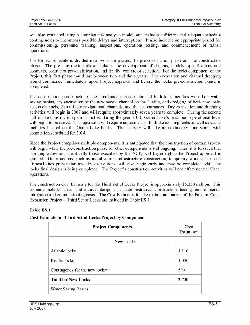
was also evaluated using a complex risk analysis model, and includes sufficient and adequate schedule contingencies to encompass possible delays and interruptions. It also includes an appropriate period for commissioning, personnel training, inspections, operations testing, and commencement of transit operations.
The Project schedule is divided into two main phases: the preconstruction phase and the construction phase. The preconstruction phase includes the development of designs, models, specifications and contracts, contractor prequalification, and finally, contractor selection. For the locks component of the Project, this first phase could last between two and three years. Dry excavation and channel dredging would commence immediately upon Project approval and before the locks preconstruction phase is completed.
The construction phase includes the simultaneous construction of both lock facilities with their water saving basins, dry excavation of the new access channel on the Pacific, and dredging of both new locks access channels, Gatun Lake navigational channels, and the sea entrances. Dry excavation and dredging activities will begin in 2007 and will require approximately seven years to complete. During the second half of the construction period, that is, during the year 2011, Gatun Lake’s maximum operational level will begin to be raised. This operation will require adjustment of both the existing locks as well as Canal facilities located on the Gatun Lake banks. This activity will take approximately four years, with completion scheduled for 2014.
Since the Project comprises multiple components, it is anticipated that the construction of certain aspects will begin while the preconstruction phase for other components is still ongoing. Thus, it is foreseen that dredging activities, specifically those executed by the ACP, will begin right after Project approval is granted. Other actions, such as mobilization, infrastructure construction, temporary work spaces and disposal sites preparation and dry excavations, will also begin early and may be completed while the locks final design is being completed. The Project’s construction activities will not affect normal Canal operations.
The construction Cost Estimate for the Third Set of Locks Project is approximately $5,250 million. This estimate includes direct and indirect design costs, administrative, construction, testing, environmental mitigation and commissioning costs. The Cost Estimates for the main components of the Panama Canal Expansion Project – Third Set of Locks are included in Table ES.1.
Table ES.1 Cost Estimate for Third Set of Locks Project by Component
Project Components Cost Estimate*
New Locks
Atlantic locks 1,110
Pacific locks 1,030
Contingency for the new locks** 590
Total for New Locks 2,730
Water Saving Basins
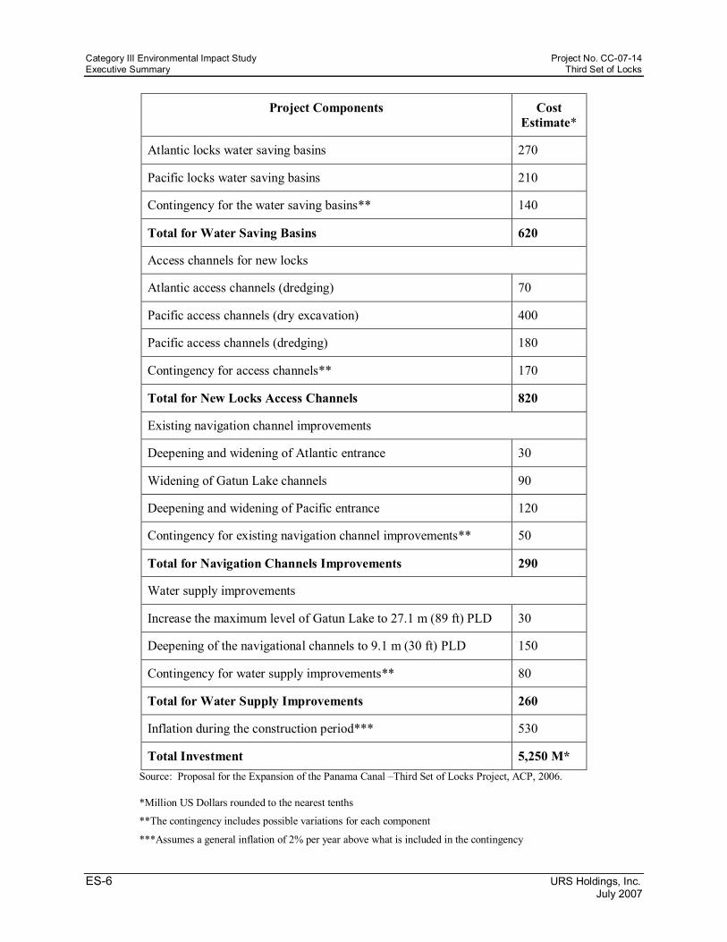
Category III Environmental Impact Study Project No. CC0714 Executive Summary Third Set of Locks
ES6 URS Holdings, Inc. July 2007
Project Components Cost Estimate*
Atlantic locks water saving basins 270
Pacific locks water saving basins 210
Contingency for the water saving basins** 140
Total for Water Saving Basins 620
Access channels for new locks
Atlantic access channels (dredging) 70
Pacific access channels (dry excavation) 400
Pacific access channels (dredging) 180
Contingency for access channels** 170
Total for New Locks Access Channels 820
Existing navigation channel improvements
Deepening and widening of Atlantic entrance 30
Widening of Gatun Lake channels 90
Deepening and widening of Pacific entrance 120
Contingency for existing navigation channel improvements** 50
Total for Navigation Channels Improvements 290
Water supply improvements
Increase the maximum level of Gatun Lake to 27.1 m (89 ft) PLD 30
Deepening of the navigational channels to 9.1 m (30 ft) PLD 150
Contingency for water supply improvements** 80
Total for Water Supply Improvements 260
Inflation during the construction period*** 530
Total Investment 5,250 M* Source: Proposal for the Expansion of the Panama Canal –Third Set of Locks Project, ACP, 2006.
*Million US Dollars rounded to the nearest tenths
**The contingency includes possible variations for each component
***Assumes a general inflation of 2% per year above what is included in the contingency

Project No. CC0714 Category III Environmental Impact Study Third Set of Locks Executive Summary
URS Holdings, Inc. ES7 July 2007
It is important to point out that this cost includes enough contingencies to cover risks and unforeseen expenses caused by accidents, changes in design, cost increases and possible delays, among others. The amount estimated for contingencies is suitable and sufficient for this type of project and progress achieved in the conceptual designs. Finally, the Cost Estimate also incorporates potential inflation effects during the construction phase.
ES.3 SUMMARY OF THE PROJECT INFLUENCE AREA’S CHARACTERISTICS
Study Area
The study area (Figure ES.7), a necessary concept to identify possible effects of a project on its surrounding physical, biological and social environment, is defined as the area where construction, operation and maintenance impacts of the expanded canal could arise. Based on the proximity and relation with the abovementioned activities, an Environmental Study Area (AEA – Figure ES.8) and a Socioeconomic Study Area (AES – Figure ES.9) were defined.
The AEA includes 421,868 ha and has been divided into three categories: a General Study Area (AEG), which includes the areas east and west of the Canal basin and has a surface area of 267,190 ha; the Specific Study Area (AEE) which includes a geographic region of 142,604 ha; and the Direct Impact Area (AID), defined as the sum of the work spaces, transportation, construction, operation and maintenance areas for the Project, which covers 12,074 ha and is within ACP areas of jurisdiction.
The AES group includes areas that could be socioeconomically affected either positively or negatively, and includes a geographic region a little larger than the one used in the environmental configuration (Figure ES.8). The AES covers a surface of 454,050 ha.
Physical Baseline Characteristics Geology Geologically, the Panama Canal Basin is part of a well defined sedimentary basin extending from the Pacific to the Caribbean, through the Isthmus, forming a wall of interconnected narrow, elongated basins. On the Atlantic side, the study area’s geology is dominated by sedimentary rocks (limestone, sandstone, lutite and tuffs), while volcanic rocks (igneous, extrusive, basalts and calcareous banks) dominate on the Pacific side. Basalt excavated from the Pacific side will be used to obtain aggregate for the construction of the locks and water saving basins.
Soils Soil characteristics in the AEG are generally dominated by acidic soils developed from parental material from rocks and igneous conglomerates under intense weathering processes classified as Ultisols. These soils are acidic, sterile and most of them have lost their surface layer due to recurrent erosion processes. Those soils have less erodibility; that is, they are less susceptible to water erosion than other types of soils in the area. Recent alluvial soils classified as Entisols can be found in the alluvial plains of the main rivers, such as the Chagres, Gatun and Gatuncillo rivers. Those soils have a coarser texture, namely, they are less claylike and more fertile. In areas with parental material made of calcareous rock, soils with more organic matter and fecundity have developed; however, they are less resistant to water erosion.
Several types of soils, which constantly receive sediments and materials removed from Panama Canal operation sites can be found in the AID. Specifically in the case of Gatun Lake dredging, sediments contain higher concentrations of silts, which is perfectly normal and expected in lacustrine sediments. However, variations due to anthropic interactions make their characterization difficult due to the

Category III Environmental Impact Study Project No. CC0714 Executive Summary Third Set of Locks
ES8 URS Holdings, Inc. July 2007
variability of the materials extracted and then disposed of on the site surfaces; these layers are then altered into parental material for soil formation, which in turn are further altered by the contribution of newly disposed layers of material. From an edaphologic point of view, these soils are classified as Entisols, since they are of recent formation and do not display any diagnostic horizon.
It is well worth mentioning that, as far as soil utilization is concerned, most of the Project’s directly impacted sites are within areas legally defined as exclusive sites for Canal operation activities.
According to ACP’s Land Use Plan (ACP’s Board of Directors Agreement No. 102, August 25 th 2005), the Project is located within the ACP’s compatibility zone, in a Type 1 operation area, which is either ACP property or inalienable State property under private ACP management and of critical importance to the Canal’s operation, modernization, and efforts directly related to these functions. Moreover, in the Territorial Zoning established by Law 21, which includes Regional Planning for the Interoceanic Region Development, the areas proposed for the Expansion Project are areas reserved for Canal improvements and the construction of the new Third Set of Locks. In general, the main limitations for soil utilization in the study area are slopes, fertility and drainage. There are no Class I soils in the studied area and only 5 ha of Class II soils, located on the Atlantic Coastal Zone. Alluvial soils (Class III and IV) from the plains and calcareous rockoriginated soils show the highest function potential. Alluvial soils are fairly flat with fair to good depth, while calcareous soils are more fertile, albeit shallower and more prone to erosion.
Weather
Köppen’s climate classification system identifies three weather types in the AEG:
• Tropical Rain Forest (Afi): Prevalent in the northeast and northwest regions of the AEG. This climate is characterized by heavy rains all year long. During the driest month, rainfall averages more than 60 mm, the mean temperature in the coolest month is above 18ºC, and the temperature differential between the mean temperature of the warmest month and the mean temperature of the coolest one is less than 5ºC.
• Tropical Monsoon (Ami): Located all along the AEG, it is present on the entire Atlantic coast area and in a large portion of the Pacific area as well. Approximately 90% of the AEG is under this type of climate, characterized by a mean average annual rainfall above 2,500 mm, a distinct threemonth long dry season and a mean annual temperature between 24 o C and 26 o C.
• Tropical savanna (Awi): Present in the Pacific sector of the AEG. It is characterized by a mean annual rainfall below 2,500 mm, a long dry season (months with less than 60 mm of rainfall) during winter in the northern hemisphere, mean temperature of the coolest month above 18 o C, and a temperature differential of less than 5º C between the mean temperature of the warmest month and the mean temperature of the coolest month.
Water Quality and Sediments With regards to water quality and sediments in the Atlantic Zone, Limon Bay and the Atlantic coastal plains were once the mouth of the Chagres River. The bay is mainly used for Canal operations and has historically been used for disposing of dredged material. Sampling program results performed in this area (D’Croz et al. 1994) demonstrate that water quality is acceptable and the heavy metals concentration in the sediments is within the normal range for coastal areas (ACPESM/PAC 2003).
An area of 45,000 hectares was flooded for the creation of Gatun Lake. The lake receives from its main
Project No. CC0714 Category III Environmental Impact Study Third Set of Locks Executive Summary
URS Holdings, Inc. ES9 July 2007
tributaries an annual average of 2,744 million m 3 of water. Studies conducted (ACP, 2006; URS, 2005c; Delft Hydraulics 2005 and others) determine that although the water’s physicochemical composition varies within the lake, water quality in Gatun Lake ranges from good to excellent, with quality parameters below the maximum limits allowed for human consumption, as required by entities such as the World Health Organization (WHO) (chlorides = 250 mg/l and total dissolved solids = 1000 mg/l) (United States Army Corps of Engineers, 2000).
Application of the Water Quality Index (WQI) by the ACP’s Water Quality Unit to water samples taken in Gatun Lake show that 53.71% of all samples fall within the excellent category, 45.71% are considered good and only 0.57% are considered moderate. According to the calculated index values, the Gatun Lake waters are suitable for public and recreational usage and for the preservation of aquatic life.
Water from approximately 39 bodies of water flow into Gatun Lake, mainly from rivers and creeks. According to samples and analysis by ACP’s Water Quality Unit (ACP, 2006h), water quality of the main rivers in the Canal basin is rated as good.
Approximately 15 bodies of water have been identified in the Gaillard Cut area. These include creeks such as Aguas Azules, Aguas de Oro, Aguas del Gaso; and rivers such as Cabuya, Camacho, Cabaya, Cuevas, Grande (northern branch), Mandinga, Mariposa, Obispo and Sardinilla, among others.
Pedro Miguel and Miraflores locks are separated by the small, artificial Miraflores Lake (1.6 km 2 ); this lake was created by the construction of a dam that crosses the Rio Grande valley (southern branch). This lake receives water from Gatun Lake through Pedro Miguel Locks and also from its own basin. The Lake’s level (16.5 m PLD) is controlled by a spillway, which allows discharged water to flow through a channel located north of Miraflores Locks.
Miraflores Lake is classified as a brackish water lake. Salinity studies for Miraflores Lake performed by the ACP (2004) show salinity levels between 0 and 2 ppt; while conductivity ranges between 153 and 3672 uS/cm. The hydrographic network in this zone is composed of more than 10 rivers and creeks, among them the Conga and Victoria creeks and the Cocoli, Pedro Miguel, Perico, Sierpe, Velasquez and Grande rivers.
In 2006, the ACP monitored 4 different sites in the water bodies in this zone, which were representative of the conditions in Grande and Cocoli rivers. The results obtained from this sampling showed that the water quality of these rivers is, in most cases, within acceptable ranges to sustain aquatic life.
The Pacific Coastal Zone is dominated by ship transits through the Canal and Balboa area port operations. Approximately 25 km of the coastal zone are destined for port, industrial or urban use. Few vegetation covered areas, an extensive marsh with a mangrove strip and small secondary forest and elephant grass areas remain only on the southwest end.
In the estuary area nearest sea, and in shallow waters on both sides of the Canal, the combined wave action and currents produce erosion and sediment circulation. Therefore, these zones have been identified as highsedimentation areas. The estuary receives nontreated sewage from Balboa, Ancon and other Panama City urban areas, through rivers, channels and sewage pipe systems; as a result, contamination levels are very high (organic solids, bacteria, pathogens, etc.) in this area Accurate measurements of stalling times or final destination of contaminated matter have not been determined for this area; however, the dispersion vector is related to navigation, the seas, prevailing area currents, fine sediment circulation and dredging activities.

Category III Environmental Impact Study Project No. CC0714 Executive Summary Third Set of Locks
ES10 URS Holdings, Inc. July 2007
Sediments on the Pacific show very specific characteristics and are mostly composed of clay (50.4%) and silts (29.2%), with sand (15.8%) and gravel (4.6%) present in lesser proportions 1 .
Sediments in this area show the highest levels of organic carbon, with an average distribution of 3.1% of the soil composition, and just as in Gatun Lake, the weak relationship between this parameter and particle sizes imply the existence of nondiffused sources.
Generally speaking, low levels of pesticides, as well as polycyclic aromatic hydrocarbons and metals were found in the sediments. The average concentration of each of these parameters was low.
Groundwater
Information regarding groundwater in the AEE is very limited. This is mostly because the main studies carried out have focused on surface water bodies, since these are the most utilized resources. According to Berger (2004), the phreatic subsurface in the AEE displays seasonal behavior wherein during the dry season it falls to 5 meters below the surface. However, due to a soil texture rich in plastic clays, and the existence of an argilic horizon (clay accumulation), a shallow phreatic subsurface of less than 1 meter below the surface is generated. During the rainy season, these levels rise to up to 50 cm below surface, causing problems with surface drainage and at some point, even rising aboveground. Deep borings have shown that permanent groundwater levels range between 4 to 5 meters below ground surface (The Louis Berger Group, 2004).
Recent ACP studies near the proposed Borinquen dams area indicate the existence of groundwater at levels varying from 0.5 to 16.6 meters and phreatic subsurfaces between 12 and 26.4 meters.
Currents, Tides and Swells
On the Atlantic Coast or Zone 1, there is little tidal variation (~0.3 m) and the resulting currents are equally feeble. There is nevertheless, an oceanic current, generated by the Caribbean Sea circulation, which flows almost permanently to the east at a speed of ~0.25 m/s. Also, due to the trade winds, a moderatestrong swell (>2 m high, 50% occurrence, with a nodal period of 810 seconds) is present.
Water circulation on the Pacific coast is dominated by movements induced by the tides (semidiurnals), which have amplitude of up to 5.0 m in spring tides and 2.7 m in neap tides. This circulation causes currents with maximum speeds ranging from 0.2 to 0.3 m/s normally at the estuaries. In the estuarine zones nearest to the sea and in shallow waters on both sides of the Canal, the combined action of waves and currents produces erosion and sediment circulation in the Bay of Panama. That area has been identified as having high sedimentation levels.
Air Quality
The baseline for air quality was obtained from previous samples and a study performed for different projects by the University of Panama’s Specialized Analysis Institute, and supplemented with a series of samples collected specifically for the development of this EIS. The emissions inventory was based on information collected by Parsons Brinckerhoff (2006).
The majority of the recorded data is within the acceptable ranges indicated in the appropriate reference standards. The exceptions are the data obtained for PM10, which does not comply with the new Pan American Health Organization (OPS) World Health Organization (WHO) requirements at almost every site; and sulfuric dioxide, which exceeds the new OPSWHO requirement at the Gatun Locks site.
1 ACP / PB Consult, 2006. EIS Category II – Widening and Deepening of the Pacific Entrance Channel of the Panama Canal

Project No. CC0714 Category III Environmental Impact Study Third Set of Locks Executive Summary
URS Holdings, Inc. ES11 July 2007
According to calculations made by Parsons Brinckerhoff (2006) on emission sources, it has been inferred that, for all the parameters evaluated, the main sources of emissions are those related to maritime operations, particularly the transit of ships through the Canal.
Noise
The noise baseline was determined using secondary information generated from the Parsons Brinckerhoff (2006) Study and through additional monitoring by the University of Panama. The data was obtained from 15 different sites, which could be affected by noise during the construction phase. These sites have been classified as follows: eleven (11) residences, one (1) church (Crossroads Bible Church) and three (3) recreational areas.
The selected monitoring sites provide wide geographic coverage in order to characterize the range of existing noise conditions in the most sensitive receptors present around the Project’s proposed area.
Recorded noise readings vary from a Leq range of 44 to 73 dBA at daytime and 46 to 53 dBA at nighttime.
The most relevant results obtained according to each of the zones defined in the AEE are described in the following section. These results are compared to the existing standards for environmental noise (Executive Decree Nº306 of 2002 2 ).
The Atlantic Coast was not monitored since the construction performed in this area will be aquatic; hence, the noise levels produced will not be significant when compared to the existing port and commercial activity in the area, which occurs very close to residential areas.
Around the Gatun Locks area, results vary from a Leq of 44 to 53 dBA. Hence, it can be concluded that the zone is not significantly affected by noise. The recorded data never exceeded the daytime limits established by the environmental noise standard (60 dBA).
In the Gatun Lake area, the main noise sources identified are the Dredging Division located in Gamboa, cargo and passenger trains, and local vehicular traffic. The recorded data varied from a Leq of 50 to 66 dBA at daytime, and a Leq 46 dBA at nighttime. These results demonstrate that the allowable limit was sometimes exceeded; however it was established that those particular records were affected by specific actions such as the train passing by or people engaged in conversations.
In the Gaillard Cut area, only daytime data was recorded; the results varied between a Leq of 50 – 54.9 dBA. This site is relatively far from the access channel and the main source of noise is generated by sporadic vehicle traffic. The results show compliance with the allowed daytime readings defined in the national standards.
In the Pacific Locks area, the daytime readings varied between a Leq of 47 – 73 dBA, and nighttime readings between a Leq of 46 – 69 dBA. This zone is mainly residential; hence the main noise sources are originated from residential related activities and other sources such as the train and constant vehicular traffic. Nighttime readings fall within the allowed results for environmental noise (50 dBA); whereas at daytime, only site M5 complies with the maximum value allowed.
Finally, on the Pacific Coast zone, daytime readings vary from a Leq 52–67 dBA; and nighttime readings vary from a Leq 46 53 dBA. The sites with the highest noise levels were Diablo, with a Leq of 63.5,
2 Modified by Executive Decree Nº1 of 2004.

Category III Environmental Impact Study Project No. CC0714 Executive Summary Third Set of Locks
ES12 URS Holdings, Inc. July 2007
and Los Rios, with a Leq of 67 dBA, with both records exceeding the maximum allowed daytime reading of 63 dBA. With regards to nighttime readings, the only site where the allowed 50dBA record was not exceeded was in Clayton, where a Leq of 46dBA was obtained.
Odors
Odor is an organoleptic attribute perceptible by the sense of olfaction through the breathing of some volatile substances. Odors are characterized by different factors: i) Intensity: which is the strength of the sensation; ii) Acceptability: which is the degree of like or dislike of an olfactory sensation; and iii) Odor threshold: which determines the minimum concentration of an odor required to cause a response 3 . Odors can be generated from different types of sources, such as natural sources, anthropogenic sources, and industrial activities, etc.
In order to characterize the odors in the AEE of the Panama Canal Expansion Project as part of this EIS, a bibliographical research of studies performed in the country was conducted. This bibliography turned out to be very limited. Most of the information was obtained from a study carried out by URS Holdings, Inc. in 2004. Application of the methodology and criteria recommended in that study resulted in the selection of locations of the AEE, which were monitored during March 2007. Thirty two locations representative of the six study zones defined in the present EIS were selected as monitoring points.
Following is a brief summary of the results of the offensive odor intensity measured in the 32 selected monitoring points.
In the Atlantic Coast, the odors are related to economic activities developed in the surrounding communities, such as wastewater and solid waste (garbage) collection.
No offensive odors were detected in the Gatun Locks and Gatun Lake areas; while at Gaillard Cut, odor intensities were fairly low. The most characteristic odors were associated with humid soil.
In the Pacific Locks area, nine locations were assessed as sources of offensive odors, eight in Ancon, mainly in the communities of Paraiso and Pedro Miguel, and one location in the Cocoli area. The monitored sites were located mainly in residential areas, close to parks and playing fields, as well as residences nearby to the Pedro Miguel locks. The monitored site in Cocoli was close to a Canal operation area.
The intensity values reported (0 being imperceptible and 60 being very strong) for the sites located in the community of Paraiso varied from 4 to 30. The prevalent odor was associated with vehicle emissions from the Omar Torrijos Avenue. At Pedro Miguel, values ranging from 0 to 60 were found. Odors described here were those of vehicles emissions, humid soil and garbage. In Cocoli, values of 0 were reported. In the Pedro Miguel community, the most prevalent offensive odors were those related to stagnant waters and accumulated garbage.
On the Pacific Coast area, twelve locations were assessed as sources of offensive odors: three in the community of Los Rios, four in the community of Diablo, three in La Boca and two in the Rodman area. Values of 0 were obtained for the majority of the sites, and only two sites reported intensities ranging between 30 and 60, found in the dock area and in the residential area of the community of Diablo. The prevailing offensive odors were related to shellfish.
3 Elements of Successful Odor /Odour Laws. St. Croix Sensory Inc., 2004.
Project No. CC0714 Category III Environmental Impact Study Third Set of Locks Executive Summary
URS Holdings, Inc. ES13 July 2007
Natural Threats
Natural threats related to seismic activity, forest fires, floods, erosion occurrence and large landslides were studied.
The Project’s AEG is located in a convergence zone of structurally complex tectonic plates. This, according to experts of the Geosciences Institute of the University of Panama, is an area of seismic risk albeit having low seismic activity; historically there have been events experienced by communities close to Panama City.
According to the study “The earthquakes on the Panama Isthmus” (Camacho, 2006), seismic activity in the region known as Central Panama, where the Panama Canal is located, is very low. Historically, there has been only one destructive event, which occurred on May 2 nd , 1621. This event caused serious damages in Panama City, where the intensity reached VII on the Modified Mercali Intensity Scale (Viquez and Camacho, 1993), and its aftershocks were felt almost daily from May to August.
Another threat that may occur in the AEG, which is not always natural in origin, is that of forest fires. In most cases, these fires are generated in stubbly or weedy areas, which is the dominant type of vegetation in the AEE.
According to the information reported by ANAM (2002) for the Forest Fires Prevention and Control Program, during the period of 1996 – 1999, many incidents related to fires were detected in the AEE. However, the recurrence or frequency of fires being repeated in the same area during several consecutive years has been low. Hence, during the period of 1996 – 1999, the recurrence of fires was high at the west side of the Pacific Coast sector and very low at the east of the Pacific Locks and Gaillard Cut areas, and equally very low west of the Gatun Lake zone.
Based on the available information for flood potential, areas prone to flooding were not identified in any of the six zones analyzed at the AEE. Also, no flood sensitive areas have been identified in the Project area (AID), since it is mostly located inside the Panama Canal Operating zones, where adequate flood control programs exist.
Soil loss due to water erosion is a function of rainfall intensity, soil erodability, length and pitch of the slope, the soil’s vegetation cover and the soil’s usage. Generally, secondary basins with the highest water erosion levels are related to regions with the most pronounced slopes and which contain highly erodable soils, such as those of calcareous rock origin in the secondary basins of Gatuncillo and Agua Salud, with more than 200 tons per hectare per year (ARO, 1996). When the specific situation prevalent at the exposed parts of the Gaillard Cut, or in the Pacific Locks with slopes above 45%, or in sites with an unstable rocky stratum like the Cucaracha formation and little vegetation cover are considered, the erosion levels exceed 280 tons per hectare per year 4 .
Landslides are produced in unstable soils as a consequence of soil saturation reaching the liquid limit, which is the amount of humidity necessary for the soil to flow down the slope. The existence of unstable rocky beds due to fractures or orientation parallel to the slope, such as the one at the Cucaracha Formation, are factors that frequently produce landslides (ACP, 19932003). The occurrence of geological faults is also an important factor. Additionally, the infiltration of groundwater into embankments also contributes to the development of landslides.
4 Estimate based on ARI data, 1996

Category III Environmental Impact Study Project No. CC0714 Executive Summary Third Set of Locks
ES14 URS Holdings, Inc. July 2007
According to the Geotechnical Advisory Board, which since 1993 has been in charge of documenting and reviewing risk conditions associated to the Panama Canal operation and expansion, the most vulnerable areas are the following:
• Gold Hill
• Gaillard Cut in the areas with Cucaracha and Pedro Miguel formations
• Other areas with Cucaracha and Pedro Miguel formations
For 2001, ACP’s geotechnical consultants indicated the following as active Gaillard Cut landslide sites:
• Cucaracha’s Southern Extension: This area displayed the greatest movement, with 934 mm of displacement in six years (1993 to 1999) and a total displacement of 300 mm between 1995 and 2001.
• Northeast of Gaillard: Displacement in 1998 due to torrential rain. • South of La Pita: Displacement reactivated on 10th August 1999. • Model Slope: A 4 mm displacement was reported in one year. • Borinquen: Landslide reported in 1997
All these events were properly handled by the Panama Canal Commission, the agency formerly in charge of administering the Canal, following the Landslide Remediation and Control Plan approved by the Geotechnical Advisory Board.
Biological Baseline Characteristics The Biological Baseline has been based on the information collected from previous studies conducted on the existing flora and fauna for the AEE of the Panama Canal Expansion Project. The technical studies, monitoring programs and inventories used included intensive field studies as well as review of secondary sources, which used different methodologies and criteria to meet their objectives.
Flora and Vegetation
The data related to the AEE was obtained after reviewing listings of previous studies for the area. This was done in order to catalog existing knowledge of the flora and to identify potentially endangered species that would need to be protected.
The natural vegetation of this region consisted formerly of forests, and its floristic composition varied according to the local climate conditions, drainage, soils and human activity. In the Pacific, the forest is presently classified as semideciduous to tropical deciduous, whereas in the Atlantic, the tropical broadleaf evergreen rainforest is predominant. Existing vegetation reflects the long history of human presence in the area.
Unlike remote areas of the Panama Canal basin, those areas surrounding the Canal and nearby cities no longer have intact mature forests. These areas now show a variety of secondary and intermediate secondary forests, with large areas of brushwood, stubble, grassland and scrubland.
Table ES.2 shows that brushwood and grassland are the dominant types of vegetation in the AID; these two combined occupy an area of 2,078.72 ha, whereas the sum of all forest types occupy 902.54 ha, which corresponds to 28.2% of the total AID area.

Project No. CC0714 Category III Environmental Impact Study Third Set of Locks Executive Summary
URS Holdings, Inc. ES15 July 2007
Table ES.2 Surface Area (ha) According to Type of Vegetation Cover in the Direct Impact Area
Zone Bm Bsm Bsi Bmg C M PH Sd U A
1 0 0 75.98 0 0 50.82 122.26 0.98 1.58 325.25
2 0 0 190.29 0 0 7.52 242.22 3.92 28.12 123.51
3 0 4.11 0 0 0 0.85 4.28 1.64 1.31 3,911.14
4 0 7.73 159.40 0 0 86.81 524.26 50.04 26.24 219.18
5 0 15.18 250.66 13.30 0 93.38 712.69 0.22 51.58 199.59
6 0 0 161.05 24.84 0 110.97 122.66 0 55.87 4,092.18
Total 0 27.02 837.38 38.14 0 350.35 1,728.37 56.80 164.70 8,870.85
Notes: Bm = mature forest, Bsm = secondary mature forest, Bsi = secondary intermediate forest, Bmg = mangrove forest, C= cativales, M =brushwood, PH = grassland and scrubland, Sd= naked soil U= urban, A= water
Source: URS Holdings, Inc.
Forest Inventory Secondary and intermediate secondary forests in the Project footprint total approximately 470.6 ha, 55.7 of which correspond to the EIS for the earthwork and Cartagena Hill leveling efforts, approved by ANAM through resolution DIEORAIA2192007. These forests include some species of commercial value such as wild plum (jobo), wild cashew (espave), tachuelo, laurel, zorro, cedar and corotu. Tree density (trunk diameter > 10 cm at chest height) is about 433.5 trees per hectare (secondary mature forest).
Terrestrial Fauna There are roughly 1,000 species of terrestrial vertebrates in the General Study Area, with approximately 159 of these species being mammals, approximately 650 birds, 98 reptile species and 93 amphibians (ANCON, 1995; Condit et al., 2001).
Within the AID, the field studies conducted by CEREBUP (2005) reported 293 total terrestrial vertebrates in zones 2 and 5. This information is presented in Table ES.3.

Category III Environmental Impact Study Project No. CC0714 Executive Summary Third Set of Locks
ES16 URS Holdings, Inc. July 2007
Table ES.3 Vertebrate Species Found in Zones 2 and 5 of the Direct Impact Areas of the Panama Canal Expansion Project, according to CEREBUP (2005)
Source: Final Report, Compilation and Presentation of the Biotic Inventory for Vegetation, Flora and Fauna in areas inside and surrounding the Panama Canal Expansion Conceptual Project. CEREBUP, 2005.
Aquatic Fauna
There are four types of aquatic habitats in the AEG: 1) marine (Atlantic and Pacific oceans); 2) brackish (Miraflores Lake); 3) freshwater lakes (Gatun Lake) and 4) freshwater rivers and creeks.
The various studies reviewed allow an approximation to the diversity of the aquatic biota in the Environmental Study Area.
Marine fish species prevail in the Caribbean and Pacific area; however, a few marine species are present in the Canal’s freshwater bodies. The presence of the majority of the marine species in the lakes is seasonal, with most of them responding to conditions at the nearest marine geographic area.
The freshwater fish species are, as expected, predominant in number and variety in the freshwater bodies. Native and exotic species can be found in these water bodies (FACINET/CCML.ACP 2004 y 2005).
The AEE and the AID together exhibit an excellent development of aquatic invertebrates, with a large biodiversity and the presence of marine, brackish and freshwater species. Among these, some introduced species and other species possibly linked to the locks operation can be found.
Coral reef development, as expected, is only found in marine environments, with a greater diversity found in the Caribbean area. Finally, the following have also been observed: one marine mammal (the manatee), 2 crocodile species (babillo and lagarto aguja) and three turtle species (tortuga lagarto, jicotea and tortuga amarilla).
Endemic and Endangered Flora and Fauna Species According to the STRIUSAIDANAM (1999) study, the data from the Watershed Monitoring Project (PMCC) indicates that 50 out of the 1,125 plant species registered at the Canal Watershed are endemic of the Country, based on the Panama Flora listing of 1987.
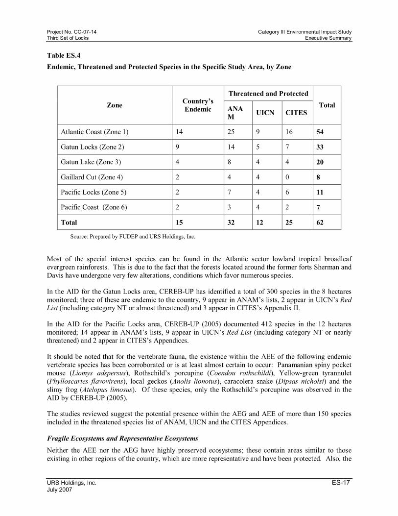
For the AEE, 15 plant species have been identified as endemic of the country, and 62 species are listed as threatened or protected in one of the ANAM, UICN or CITES listings (Table RE.4). Usually, the majority of these species are located in the Atlantic Coast zone and in the Atlantic drainage (Zones 1 to 3), with a reduced presence in the Pacific drainage (Zones 56).
TAXA
Zone 2 (Atlantic Locks)
Zone 5 (Pacific Locks) Totals
Birds 99 143 176 Mammals 23 39 47 Reptiles 25 32 38 Amphibians 24 27 32 Totals 171 241 293
Project No. CC0714 Category III Environmental Impact Study Third Set of Locks Executive Summary
URS Holdings, Inc. ES17 July 2007
Table ES.4 Endemic, Threatened and Protected Species in the Specific Study Area, by Zone
Zone Country’s Endemic
Threatened and Protected Total ANA
M UICN CITES
Atlantic Coast (Zone 1) 14 25 9 16 54
Gatun Locks (Zone 2) 9 14 5 7 33
Gatun Lake (Zone 3) 4 8 4 4 20
Gaillard Cut (Zone 4) 2 4 4 0 8
Pacific Locks (Zone 5) 2 7 4 6 11
Pacific Coast (Zone 6) 2 3 4 2 7
Total 15 32 12 25 62
Source: Prepared by FUDEP and URS Holdings, Inc.
Most of the special interest species can be found in the Atlantic sector lowland tropical broadleaf evergreen rainforests. This is due to the fact that the forests located around the former forts Sherman and Davis have undergone very few alterations, conditions which favor numerous species.
In the AID for the Gatun Locks area, CEREBUP has identified a total of 300 species in the 8 hectares monitored; three of these are endemic to the country, 9 appear in ANAM’s lists, 2 appear in UICN’s Red List (including category NT or almost threatened) and 3 appear in CITES’s Appendix II.
In the AID for the Pacific Locks area, CEREBUP (2005) documented 412 species in the 12 hectares monitored; 14 appear in ANAM’s lists, 9 appear in UICN’s Red List (including category NT or nearly threatened) and 2 appear in CITES’s Appendices.
It should be noted that for the vertebrate fauna, the existence within the AEE of the following endemic vertebrate species has been corroborated or is at least almost certain to occur: Panamanian spiny pocket mouse (Liomys adspersus), Rothschild’s porcupine (Coendou rothschildi), Yellowgreen tyrannulet (Phylloscartes flavovirens), local geckos (Anolis lionotus), caracolera snake (Dipsas nicholsi) and the slimy frog (Atelopus limosus). Of these species, only the Rothschild’s porcupine was observed in the AID by CEREBUP (2005).
The studies reviewed suggest the potential presence within the AEG and AEE of more than 150 species included in the threatened species list of ANAM, UICN and the CITES Appendices.
Fragile Ecosystems and Representative Ecosystems Neither the AEE nor the AEG have highly preserved ecosystems; these contain areas similar to those existing in other regions of the country, which are more representative and have been protected. Also, the

Category III Environmental Impact Study Project No. CC0714 Executive Summary Third Set of Locks
ES18 URS Holdings, Inc. July 2007
AEE environments have endured alterations on different occasions. However, in order to ensure water in the quantity and quality required by ACP and the Metropolitan Region, it is important to at least maintain a healthy flora within this zone.
In the Project’s AID, where the different expansion works will take place, there have been, for the last 100 years, recurrent interventions in the environments surrounding the Canal infrastructure. This can be seen in areas with soil contention works and the like; therefore, they are not very representative environments of fragile ecosystems. The vegetation in the AID is mainly secondary forest, brushwood, grassland or scrubland. This is especially true for zones 4, 5 and 6, where the vegetation has undergone more alterations than that in the Atlantic drainage. In this sense, the affected environments are not very relevant or fragile.
Protected Areas and Connectivity
For the section corresponding to the protected areas and their connectivity, the review consisted of the available literature regarding the country’s protected areas and especially to those adjoining the AEE and AID of the Panama Canal Expansion Project. Among the protected areas of special interest due to their proximity to the project are: the San Lorenzo Protective Forest and Protected Landscape, the Galeta Island Protected Landscape, the Gatun Lake Recreation Area, the Barro Colorado Natural Monument, the Soberania National Park, the Chagres National Park and the Camino de Cruces National Park. Certain interconnectivity exists among several of these conservation units inside the Canal basin area and/or with the neighboring sectors. In this sense, the preservation of the natural reserves of the region being studied becomes even more important because of their role as crucial links in a long chain still under construction.
Socioeconomic Baseline Characteristics This section presents the general conditions and characteristics of the existing population in the Socio economic Study Area (AES). Demographic, social and other indicators that provide information about the quality of life of the Project’s surrounding communities have been contemplated.
Considering the extent of the Project area, its proximity to the Gatun Lake and to the transIsthmian Corridor, as well as the range of expansion that its execution may reach, the AES has been divided into six zones: 1) Urban – East Pacific; 2) Urban – West Pacific; 3) Urban – Atlantic; 4) transIsthmian Corridor; 5) Gatun Lake and Colon’s Lower Coast; and 6) Taboga. For each one of these zones, the following aspects were considered:
Current Land Use in Adjacent Areas
The areas adjacent to the Project are mostly Canal operating areas. According to the division established for the AES, only three of these zones (Urban – East Pacific, Urban – West Pacific, and Gatun Lake and Colon’s Lower Coast) have within them, locations that are part of the Project’s Direct Impact Area.
Activities in the Urban – East Pacific include: navigation channels deepening and the use of the disposal site known as T4. Regarding land use adjacent to deepening activities area, these include secondary forests, brushwood, grassland and urban zones.
Activities in the Urban – West Pacific include: new locks construction, use of the Farfan, Velasquez, Rousseau, Victoria, and South Cocoli 1, 2, 4, 5 and T6 disposal sites. The majority of the disposal sites are adjacent to zones dominated by secondary forests, brushwood and grasslands. However, four of these sites (Velasquez, Rousseau, Victoria and Farfan) are adjacent to urban zones. Adjacent to the Farfan site is Rodman, a port area with piers, industrial buildings and some currently unoccupied infrastructures.
Project No. CC0714 Category III Environmental Impact Study Third Set of Locks Executive Summary
URS Holdings, Inc. ES19 July 2007
The rest of the disposal sites are adjacent to Cocoli, a former residential area for Canal employees which is now mostly unoccupied.
The activities at the Urban – Gatun Lake and Colon’s Lower Coast include: use of disposal sites, channel deepening works, new Atlantic locks construction and the activities at the proposed areas to be affected by the elevation of the Gatun Lake level. This zone includes some terrestrial disposal sites (T3, T5, T2, Mindi, Tanque Negro North and South) and some aquatic disposal sites (Frijoles, Peña Blanca West, Peña Blanca East and Monte Lirio). Land uses in locations adjacent to the deepening activities area include the Gatun Lake waters, secondary forests, grasslands and the Barro Colorado Natural Monument. Also, located near the limits of the construction activities in the Atlantic sector, are some Canal operation areas, the former town of Gatun where the majority of the residences are currently uninhabited, Cristobal, an industrial and port services zone, and the Jose Dominador Bazan area (Former Fort Davis), which is a former military zone currently being used as a residential and government facilities area.
Population Characteristics
The zone with the largest population is the East Pacific Zone, with 896,584 inhabitants, whereas Taboga, with 908 inhabitants, is the least populated zone. The population density varies significantly between the different zones that make up the AES; areas with completely opposite behaviors were found due to very little surface and large populations, as is the case of the Atlantic Urban Zone, where in an area of 2.4 km 2 the community of Barrio Norte has a population density of 18,476.7 inhab/km² and the community of Barrio Sur, a population density of 13,081.2 inhab/km².
With respect to education, literacy rates are quite high in all zones compared to the national average of 95 %. The UrbanPacific East Zone has the highest level, rating 99.3%, whereas the Gatun Lake and Colon’s Lower Coast has the lowest rating at 86.3%.
Demographic and Social Indicators
Most of the zones included in the AES display a decreasing average annual growth rate. The Urban – Pacific East Zone shows both the lowest (3.58 in the San Felipe Community) and the highest (7.01 in the Arnulfo Arias Community) average annual growth rate. In the other Zones, the following communities stand out for their high average annual growth rate: in the transIsthmian Corridor, Nueva Providencia Community with 5.33; and in the Urban – Pacific West Zone, Vista Alegre with and average annual growth rate of 4.78.
Although there is an indigenous population present in the different zones of the AES, they are not within protected zones, and they are not favored by any special dispositions. According to 2000 data from the Register and Statistics Bureau National Office of the Comptroller, the largest indigenous population is located in the Urban – Pacific East Zone, with 15,700 inhabitants related to the Kuna, Embera, Wounan and Ngöbe groups. At the Urban – Pacific West Zone, the indigenous population reaches 10,050 inhabitants, whereas at all other zones, the indigenous population are less than 1,500. Taboga is an exception, since no indigenous inhabitants are registered.
Mortality and Morbidity Rates
The mortality rates (2005) in the districts that are part of the AES’s Zones range between 5.2 for the district of Colon and 2.4 for Taboga. With regards to morbidity, the main cause of death is malignant tumors, except for the district of Colon, where the main causes of death are accidents, selfinflicted wounds and homicides.
Category III Environmental Impact Study Project No. CC0714 Executive Summary Third Set of Locks
ES20 URS Holdings, Inc. July 2007
Employment Indicators and Others
The Urban – Pacific East Zone, with average annual per capita revenue of $4,092 for the district of Panama, is the zone with the highest average annual revenue, which is much higher than the national average of $2,377. On the other hand, the lowest annual revenue was found in the Gatun Lake and Colon’s Lower Coast Zone, where the average annual revenue reached a low of $255.00 at the community of Ciri de los Sotos, located in the district of Capira.
The main economic activities found in the AES are commerce, fishing, transport, construction, hotels and services, and agriculture. Agriculture was only reported as a major activity at the Gatun Lake and Colon’s Lower Coast Zone.
The highest unemployment rates among the zones that make up the AES were found in the Gatun Lake and Colon’s Lower Coast Zone, where at some communities the rate is as high as 50%. High unemployment rates were also found in the Urban – Pacific East Zone and in the Urban – Atlantic Zone, where at some communities rates of up to 20% were found, contrasting with the national average of 12.3%.
Basic Services and Infrastructure For available services at the AES, the Urban – Pacific East Zone has the largest IDAAN’s municipal water distribution system, where communities such as Bella Vista, Betania, Rio Abajo, Mateo Iturralde among others, have 100% coverage; whereas at the Gatun Lake and Colon’s Lower Coast Zone, there are communities such as Ciri de los Sotos and Mendoza that do not receive this service.
That same proportion is observed in other utilities, such as electricity and waste collection. For instance, at the Urban – Pacific East Zone, electricity coverage is close to 100%, whereas at the Gatun Lake and Colon’s Lower Coast Zone, the average electricity coverage is 44.69%.
In the Urban – Pacific West Zone, most residences are connected to IDAAN’s water distribution system, with approximately 83.8% of the total 66,549 residences receiving this service. In this zone, electrical service coverage is approximately 92%.
The Urban Atlantic Zone has high potable water coverage, provided by both IDAAN and local aqueducts. The coverage ratio of both service providers at Barrio Norte is 94% for the first one and 5% for the second one, whereas for Barrio Sur the coverage is 95% by IDAAN, 4% by local aqueducts, and 1% by private aqueducts. With regards to electrical service, there is a 100% residential coverage.
In the transIsthmian Corridor Zone, water distribution by IDAAN is very uneven, ranging from 95% in Cativa, to 1% at Nueva Providencia, 2% in Salamanca and 9% in Santa Rosa. Concerning electricity, the average zone coverage is 80%.
In Taboga, the percentage of residences without water service is negligible when compared to the whole country; the service is provided by IDAAN (94% residential coverage), and local aqueducts (2%). For electricity, the zone’s electric coverage is 100%.
All zones within the AES have access roads, except for Taboga, which can only be accessed by sea. The main transportation infrastructures in the AES’s Urban – Pacific East Zone are the Tocumen International Airport, the Marcos A. Gelabert Airport and Albrook’s Bus Station. Among the main access roads of the AES worth mentioning are the Tocumen highway, the access roads for the Centennial Bridge, the trans Isthmian road and the PanAmerican road.

Project No. CC0714 Category III Environmental Impact Study Third Set of Locks Executive Summary
URS Holdings, Inc. ES21 July 2007
Local Perception about the Project, Work or Activity
In order to record citizen perception within the study area, many surveys were conducted in the AES’s communities. These surveys consisted of a series of standardized interviews at local homes and individual interviews with local leaders and key participants in the social, political and economic environment inside and outside of the AES, because of their bearing on the subject matter studied in the EIS.
A total of 670 interviews were conducted in homes located in the AES. Among the results it was mentioned that the Expansion Project will bring benefits to the country, including more employment, revenues and economic activities. It is important to highlight that the Urban Atlantic Zone and the Gatun Lake and Colon’s Lower Coast Zone are the zones where the most positive opinions about the Project were recorded. Regarding the benefits that the Project would bring to their homes, people in almost every zone showed apprehension about the possibility of obtaining direct benefits from the project, some of them even mentioning that the revenues generated by the economic activity will not be perceived at their homes. The people interviewed from all zones agreed that the main negative impact to the environment will be deforestation and trauma to the local fauna.
Local government, provincial and protected areas officials maintained that the Project will generate both positive and negative impacts. Among the positive impacts mentioned are more employment, commerce and economic growth, tourism development opportunities, more competitive horizons, as well as more productivity and efficiency. Those who cited negative impacts mentioned primarily damage to the environment. In the Urban – East Pacific, West Pacific and the Taboga Zones, there was some concern about the possibility of not being considered to work on the Project, and the consequences that the imminent immigration would have on the availability of the basic services, since in some places the actual demand exceeds the service capacity. Local authorities from the Gatun Lake, Urban Atlantic and trans Isthmian Corridor Zones declared their concern about the elevation of the Gatun Lake since according to them some residents may have to abandon their homes.
About 25 organizations were consulted, including commercial, professional, religious and labor organizations; most of them signaled that the project would have a positive impact in the form of more employment opportunities and revenues for the Country. The negative comments suggested that the project may be tainted by political decisions, some residents may lose their homes, the introduction of foreign professionals to fill job vacancies, and finally, damage to the environment generated by the loss of forests and local fauna species.
In general, most people and organizations consulted believe that the Project will bring more positive than negative effects; however, they also consider that these benefits will not profit them directly.
Historic, Cultural and Archeological Sites
The studies conducted at the historic, cultural and archeological sites located within the Project area were targeted to obtain, as much information about the location of archeological sites, not only preHispanic and colonial, but also historic sites that could be affected by the Project. Not all the zones that make up the AES have PreColumbian, Colonial and Historic Resources. Among the zones that do have the above mentioned resources are: the UrbanPacific East Zone, the UrbanPacific West Zone and the Gatun Lake and Colon’s Lower Coast Zone. Other zones, such as the transIsthmian Corridor, have preColumbian and Colonial resources. The UrbanAtlantic Zone only has Historic Resources and finally, Taboga has preColumbian resources only.
The PacificWest Zone has the most sites, with the Cocoli, El Faro, Farfan, Playa Venado, Playa Kobbe I and II, Punta Bruja I and II, and Palo Seco Sites. In contrast, the UrbanPacific West Zone has only one
Category III Environmental Impact Study Project No. CC0714 Executive Summary Third Set of Locks
ES22 URS Holdings, Inc. July 2007
known site, the Panama Viejo site, which is actually one of the most important sites of the Southern Coast of the Great Darien.
ES.4 INFORMATION ABOUT CRITICAL ENVIRONMENTAL PROBLEMS GENERATED BY THE PROJECT; WORK OR ACTIVITY
Currently, the areas surrounding the Canal present optimal conditions for the preservation of the flora and fauna of the Isthmus’s central region. These conditions are present due to the existing controls and restrictions for agricultural and urban development activities such as crops, cattle raising, logging, illegal hunting, commercial fishing, and other activities that may significantly or permanently affect the natural habitat. These activities are the main causes of the environmental damage in other regions of the country. It is also worth mentioning that most of the Canal watershed area is actually defined as a protected area for safeguarding the water resources necessary for human consumption and Canal operations.
Currently, the deforestation rate in the Canal watershed has been reduced in such a dramatic way that the Gatun Lake shores are presenting large areas of forest regeneration. However, around the Gaillard Cut area where the vegetation cover is different due to the land use change related to Canal operation activities, the area has been greatly disturbed. The Panama Canal watershed is considered a zone of great biological diversity; its unique geographical and ecological position allows for an abundance of biological resources, such as forests and vertebrates.
Bearing in mind the latter, a major potential problem identified for the Project is the land use change or conversion; that is, converting areas currently in different sequential vegetation regeneration stages into deforested areas. Additionally, sedimentation could be generated along the Canal watershed. However, the Project has been devised to affect the natural environment as little as possible; moreover, this EIS contains mitigation and compensation measures for unavoidable impacts.
ES.5 BRIEF DESCRIPTION OF POSITIVE AND NEGATIVE IMPACTS FOR THE PROJECT, WORK OR ACTIVITY
One of the main goals of the Environmental Impact Study (EIS) is to objectively identify the effects and repercussions on the existing socioenvironmental conditions of the selected Project construction site and its influence area. The identification process considers the possible interactions between the elements and sensitive receptors in the study area with the processes and activities associated with the project. The different project interactions with the physical, biological, socioeconomic and culturalhistorical environment components determine whether impacts will be positive or negative. This impact identification stage is done using matrices, and during the process, these impacts are assessed according to their type (positive or negative), presence, duration, magnitude, synergy, and cumulative risk.
The matrix procedure used is based on Leopold’s traditional matrix generation methodology. For its application to the EIS, a modification to Leopold’s matrix has been proposed (Garmendia et al., 2005); in this modification, the development activities in the Project’s influence area (Matrix columns) intersect with the existing biophysical, socioeconomic and cultural elements (Matrix rows).
For the quantification of impact values based on their analysis, a Significance Index was calculated. Also, the impact qualification and hierarchization is based on the impact assessment results, which consider the project activities, existing conditions (baseline), and the suitable methodologies for each subject assessed. The applied method is a modified version of the Relevant Criteria Method (Buroz, 1994; SWECOINGENSACALI, 1997; Walsh Peru, S.A. 2005; Garmendia et al., 2005); a method where a series of impact indicators are calculated and then consolidated through a function that provides a unique index called “Significance Index (S)”.

Project No. CC0714 Category III Environmental Impact Study Third Set of Locks Executive Summary
URS Holdings, Inc. ES23 July 2007
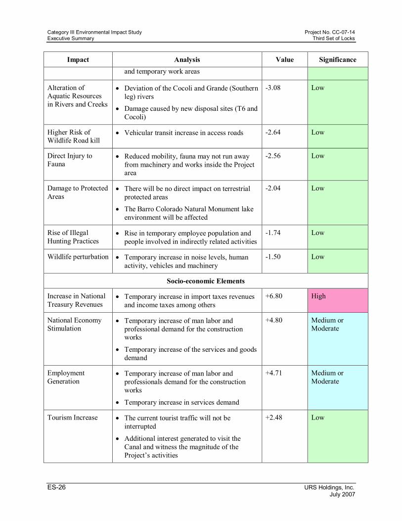
As a result, 45 impacts (40 negative and 5 positive) were identified during the construction phase, the latter corresponding to the socioeconomic element. Meanwhile, 43 impacts were identified for the operational phase: 34 negative and 9 positive. Of these nine, 2 were related to the physical aspects, 5 to the socioeconomic aspect and 2 to transboundary components.
Regarding the quantification of impact values, of the 40 negative impacts found for the construction phase, 2 were considered of high importance, 11 of medium importance, 25 of low importance and 2 of very low importance. Whereas, of the 5 positive impacts found, 1 was considered of high importance, 2 of medium importance and 2 of low importance (Table ES.5). On the other hand, of the 34 negative impacts found for the operation phase, 5 were considered of medium importance, 24 low importance and 5 of very low importance. For the 9 positive impacts found, 3 were considered of high importance, 2 of medium importance and 4 of low importance (Table ES.6)
Table ES.5
Analysis, Valuation and Hierarchy of Significant Impacts caused by the Construction Phase of the Panama Canal Expansion Project
Impact Analysis Value Significance
Physical Elements
Higher Landslide Risks
• Increase in magnitude and occurrence of landslides in excavation embankments and channel deepening
7.50 High
Higher Soil Erosion • Soil surface exposure due to vegetation removal
• Local increment in the slopes of excavations and fill embankments
6.30 High
Higher Noise and Vibration Levels
• Noise generation by construction equipment and machinery
• Noise and vibrations generated by blasting and other Project activities
5.74 Medium or Moderate
Water Quality Deterioration
• Rise of turbidity levels due to the increase in suspended solids
• Trace metals in sediments
• Other activities with contamination potential
5.54 Medium or Moderate
Air Quality Deterioration
• Emission of contaminating gases and particles by construction equipment and machinery
• Particle generation caused by earth moving, excavations and blasting
3.43 Medium or Moderate
Microclimatic Change
• Loss of vegetation cover and change in soil use
3.10 Low

Category III Environmental Impact Study Project No. CC0714 Executive Summary Third Set of Locks
ES24 URS Holdings, Inc. July 2007
Impact Analysis Value Significance
• Local ambient temperature increase
Soil Compaction • Equipment and machinery mobilization
• Excavated material and landfill disposal
• Loss of soil infiltration capacity due to vegetation removal
3.04 Low
Higher Sedimentation
• Soil erosion caused by soil surface exposure due to vegetation removal
• Soil erosion caused by the local increment of slopes in excavations and fill embankments
2.93 Low
Drainage Pattern Alteration
• Land disposal of excavated and dredged material
• Deviation of the Cocoli and Grande (Southern leg) rivers
• Construction of hydraulic works
2.40 Low
Loss of Carbon Capture Potential
• Change in soil use and loss of vegetation covered areas
• Loss of soil biomass
• Higher carbon dioxide emissions
2.38 Low
Decrease in Soil Use Aptitude
• The diverse construction activities affect diverse soil properties such as erosion, compaction, contamination and water storage capacity
2.16 Low
Higher Odor Perception
• Offensive odors caused by harmful gas emissions from blasting activities and heavy machinery mobilization
• Odor generating liquid and solid residues
1.96 Low
Soil Contamination • Accidental oil spills, fuels, greases, chemicals and other contaminants
• Disposal of the excavated and dredged material at dump sites
• Basaltic type igneous rock blasting
1.27 Low
Alteration of the Natural Water Flow Regime
• Land disposal of excavated and dredged material
• Deviation of the Cocoli and Grande (Southern leg) rivers
• Construction of hydraulic structures, field
1.20 Low

Project No. CC0714 Category III Environmental Impact Study Third Set of Locks Executive Summary
URS Holdings, Inc. ES25 July 2007
Impact Analysis Value Significance offices and quarry operation
Caving and Subsidence
• Potential modification to local geological and/or hydrogeological characteristics
• Tension liberation in soil and rock
• Loads generated due to fills
0.15 Very Low
Biological Elements
Miraflores Lake Aquatic Resources Alteration
• Lake volume and area loss
• Cocoli river deviation
• Increase or Decrease of sediments in suspension
5.78 Medium or Moderate
Alteration of Coastal Marine Ecosystems
• Increase of sediments in suspension
• Sedimentation increase
• Lake bottom alteration due to navigation channels deepening
• Vibrations caused by blasting
5.60 Medium or Moderate
Vegetation Cover Loss
• Permanent vegetation cover loss at the new access channels, locks, water saving basins and other permanent infrastructure sites
• Temporary vegetation cover loss in new disposal sites and temporary work areas
4.20 Medium or Moderate
Terrestrial Habitat Loss
• Permanent terrestrial habitat loss of the new access channels, locks, water saving basins and other permanent infrastructure sites
• Temporary terrestrial habitat transformation at the new disposal sites and temporary work areas
3.87 Medium or Moderate
Gatun Lake Aquatic Resources Alteration
• New disposal sites
• Increase of solids in suspension
• Lake bottom alteration due to navigation channels deepening
• Vibrations caused by blasting
3.50 Medium or Moderate
Loss of Forest Potential
• Permanent forest loss at the new access channels, locks, water saving basins and other permanent infrastructure sites
• Temporary forest loss in new disposal sites
3.24 Low
Category III Environmental Impact Study Project No. CC0714 Executive Summary Third Set of Locks
ES26 URS Holdings, Inc. July 2007
Impact Analysis Value Significance and temporary work areas
Alteration of Aquatic Resources in Rivers and Creeks
• Deviation of the Cocoli and Grande (Southern leg) rivers
• Damage caused by new disposal sites (T6 and Cocoli)
3.08 Low
Higher Risk of Wildlife Road kill
• Vehicular transit increase in access roads 2.64 Low
Direct Injury to Fauna
• Reduced mobility, fauna may not run away from machinery and works inside the Project area
2.56 Low
Damage to Protected Areas
• There will be no direct impact on terrestrial protected areas
• The Barro Colorado Natural Monument lake environment will be affected
2.04 Low
Rise of Illegal Hunting Practices
• Rise in temporary employee population and people involved in indirectly related activities
1.74 Low
Wildlife perturbation • Temporary increase in noise levels, human activity, vehicles and machinery
1.50 Low
Socioeconomic Elements
Increase in National Treasury Revenues
• Temporary increase in import taxes revenues and income taxes among others
+6.80 High
National Economy Stimulation
• Temporary increase of man labor and professional demand for the construction works
• Temporary increase of the services and goods demand
+4.80 Medium or Moderate
Employment Generation
• Temporary increase of man labor and professionals demand for the construction works
• Temporary increase in services demand
+4.71 Medium or Moderate
Tourism Increase • The current tourist traffic will not be interrupted
• Additional interest generated to visit the Canal and witness the magnitude of the Project’s activities
+2.48 Low

Project No. CC0714 Category III Environmental Impact Study Third Set of Locks Executive Summary
URS Holdings, Inc. ES27 July 2007
Impact Analysis Value Significance
Real Estate Valuation
• Property valuation due to the higher demand for goods and services and the development of new activities
+1.30 Low
Higher Risk of Labor Accidents
• Workforce Increase
• Medical attention increase in the cities of Panama and Colon
5.33 Medium or Moderate
Waste Generation Increase
• The increase in the number of employees will both produce and increase waste generation, putting pressure on the existing waste collection and disposal system.
• The use of heavy machinery and equipment generates dangerous nonorganic waste which requires special disposal procedures
3.98 Medium or Moderate
Public Services Overload
• Medical attention increase in the cities of Panama and Colon
• Higher public services utilization by the Contractor’s employees and their families; as well as of other government services such as work permits, customs procedures, and the like.
3.24 Low
Higher Vehicular Traffic due to the Higher Transportation Demand
• Total estimated daily journeys for employees and associated population: 5,316, 36% of these in their own vehicles and the remaining 64% in Public Transport
3.14 Low
Changes in Land Use
• Increase in the demand of land for new settlements in some zones of the AES
2.86 Low
Population Increase and Migratory Flows
• Temporary population increase due to the arrival of foreign manpower and a shifting population seeking employment
2.76 Low
Affected Structures • Relocation and replacement of structures pertaining to communities and third parties
2.72 Low
Increase in the Risk of Occupational Diseases
• Generation of insect and other harmful vectors breeding sites
• Deterioration of workers’ health
1.42 Low
Changes in Landscape
• Landscape alterations caused by excavations, land retreading and the construction of the
1.18 Low
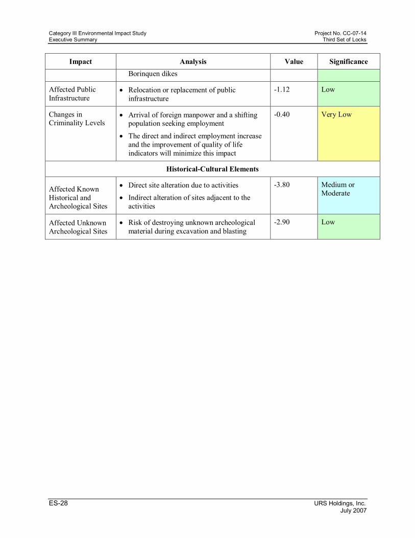
Category III Environmental Impact Study Project No. CC0714 Executive Summary Third Set of Locks
ES28 URS Holdings, Inc. July 2007
Impact Analysis Value Significance Borinquen dikes
Affected Public Infrastructure
• Relocation or replacement of public infrastructure
1.12 Low
Changes in Criminality Levels
• Arrival of foreign manpower and a shifting population seeking employment
• The direct and indirect employment increase and the improvement of quality of life indicators will minimize this impact
0.40 Very Low
HistoricalCultural Elements
Affected Known Historical and Archeological Sites
• Direct site alteration due to activities
• Indirect alteration of sites adjacent to the activities
3.80 Medium or Moderate
Affected Unknown Archeological Sites
• Risk of destroying unknown archeological material during excavation and blasting
2.90 Low

Project No. CC0714 Category III Environmental Impact Study Third Set of Locks Executive Summary
URS Holdings, Inc. ES29 July 2007
Table ES.6 Analysis, Valuation and Hierarchy of Significant Impacts caused by the Operation Phase of the Panama Canal Expansion Project
Impact Analysis Value Significance
Physical Elements
Loss of Carbon Capture Potential
• Change of vegetation covered areas due to the Gatun Lake level elevation
• Worldwide emissions reduction in maritime and terrestrial routes
+1.39 Low
Air Quality Deterioration
• Ship transit increase through the Canal
• Periodical maintenance activities or material disposal sites management
4.07 Medium or Moderate
Higher Landslide Risks
• Embankment and fill instability due to vibration, overload and water action effects
2.88 Low
Microclimatic change • Vegetation change or adaptation due to the Gatun Lake level elevation
2.77 Low
Water Quality Deterioration
• Rise of turbidity levels due to increase in suspended solids
• Trace metals in sediments
• Gatun Lake level fluctuation
• Third set of locks operation
2.72 Low
Higher Noise and Vibration Levels
• Vessels lockage
• Routine maintenance works
2.60 Low
Drainage Patterns Alteration
• Land disposal of excavated and dredged material
2.08 Low
Higher Odor Perception
• Gas emissions caused by the operation of maintenance equipment and machinery
1.56 Low
Higher Sedimentation • Soil erosion due to changes of use and to embankment with steep slopes
1.30 Low
Soil Contamination • Maintenance and operation of maintenance machinery and equipment
• Disposal of excavated and dredged material
1.18 Low

Category III Environmental Impact Study Project No. CC0714 Executive Summary Third Set of Locks
ES30 URS Holdings, Inc. July 2007
Impact Analysis Value Significance
Soil Compaction • Management of disposal sites for dredged and excavated material from maintenance activities
1.14 Low
Alteration of the Natural Water Flow Regime
• Dredged material disposal
• Gatun Lake level fluctuation
0.98 Low
Caving and Subsidence
• Long term effects due to construction activities (excavations, landfills)
0.12 Very Low
Biological Elements
Alteration of Coastal Marine Ecosystems
• Maintenance activities for navigation channels and the risks associated to ship transit increase slightly as the number and size of the ships transiting through the Canal increase
4.16 Medium or Moderate
Higher Risk of Wildlife Road Kill
• Vehicular transit will be reduced compared to the construction phase. However, it will be higher than the actual transit levels due to the increase of general activities associated with the expanded Canal.
2.90 Low
Alteration of Aquatic Resources in Rivers and Creeks
• The deviation and canalization of the Cocoli and Grande (southern branch) rivers is a permanent condition during the operation phase that will not allow recovery to the original conditions.
• Discharges to the lower Chagres river through the Gatun spillway will be affected by the elevation of the Gatun Lake level
2.54 Low
Miraflores Lake Aquatic Resources Alteration
• It has been pointed out that the main risk during the operation phase is a rise in the Miraflores Lake eutrophication level
• An increase in the salinity level of the Miraflores Lake during the operation phase has been considered and discarded
2.35 Low
Terrestrial Habitat Loss
• The changes in the minimum and maximum Gatun Lake operation levels will cause alterations to the terrestrial habitat
2.24 Low

Project No. CC0714 Category III Environmental Impact Study Third Set of Locks Executive Summary
URS Holdings, Inc. ES31 July 2007
Impact Analysis Value Significance
Vegetation Cover Loss
• Construction phase temporary work areas will be reforested
• The maintenance or eventual expansion of the disposal sites could affect the vegetation cover and prevent its regeneration
• The changes in the minimum and maximum Gatun Lake operation levels will cause changes in vegetation cover depending on their direction and duration
2.06 Low
Wildlife perturbation • Noise, vibration levels and heavy equipment transport activities will be reduced to similar actual levels
• Canal transit and activities associated with the locks will slightly increase wildlife perturbation levels compared to current levels
1.30 Low
Direct Injury to Fauna • As long as the disposal sites are operational during Canal maintenance, some limited mobility species will continue to be impacted
1.16 Low
Damage to Protected Areas
• The permanent population rise due to the expanded Canal operations may slightly increase illegal hunting practices
1.12 Low
Gatun Lake Aquatic Resources Alteration
• Gatun Lake level fluctuation up to 2.44 m
• The general effect of the larger level fluctuation will be a reduction in submerged aquatic plants and benthic organisms
• An increase in the salinity level of Gatun Lake during the operation phase has been discarded
0.48 Very Low
Rise of Illegal Hunting Practices
• The permanent population rise due to the expanded Canal operations may slightly increase illegal hunting practices
0.48 Very Low
Socioeconomic Elements
Increase in National Treasury Revenues
• Total contributions of up to $4,190 million to the National Treasury, in net
+7.42 High

Category III Environmental Impact Study Project No. CC0714 Executive Summary Third Set of Locks
ES32 URS Holdings, Inc. July 2007
Impact Analysis Value Significance tonnage fees, public services fees and surplus
• During the first 11 years of operations, total contributions to the National Treasury are projected at $8,500 million more than if the Canal were not expanded
National Economy Stimulation
• The additional economic activities would cause an additional 26% GDP growth
• For 2025, Canal contributions to total exports would be 19.5% higher than the No expansion alternative
• For that same year, fiscal revenues would be 31.8% larger with the expanded Canal
+6.40 High
Employment Generation
• Additional manpower demand will fall to current levels with the exception of the manpower required for the new locks operation and maintenance
• Higher impact will be observed with expansion of services and complementary activities due to Canal transit increase
+6.40 High
Changes in Landscape • Landscape alteration due to larger ship transits
+5.50 Medium or Moderate
Tourism Increase • Once the activities are completed and the security restrictions eased, an even higher interest in visiting the Canal is expected
+3.64 Medium or Moderate
Real Estate valuation • Valuation caused by the change in conditions and the development of new activities
+1.40 Low
Population Increase and Migratory Flows
• Population growth and migratory flow stimulation are expected consequence of the regional economic growth
3.63 Medium or Moderate
Changes in Land Use • The Project impact on the dynamics of land use will depend mainly on the development of complementary and/or additional activities to the Canal operations, such as the Canal Conglomerate, the residential boom and
3.51 Medium or Moderate

Project No. CC0714 Category III Environmental Impact Study Third Set of Locks Executive Summary
URS Holdings, Inc. ES33 July 2007
Impact Analysis Value Significance the general economy performance
Public Services Overload
• The population increase will require more public services and better coverage
• It is assumed that the additional electricity required for the operation of the third set of locks will be provided by ACP, hence there will be no additional pressure on this resource
3.45 Medium or Moderate
Higher Vehicular Traffic due to the Higher Transportation Demand
• The increase in transportation demand during the operation phase will be offset by a greater financial capacity for roadway improvement
2.21 Low
Waste Generation Increase
• Waste generation increase due to a slight increase in the area workforce, tourism and the use of more equipment in the lockage and maintenance activities
0.93 Low
Risk of Occupational Diseases Increase
• Large scale workforce requirements will have ceased and therefore increased risk of occupational diseases caused by the Project will be virtually nonexistent
1.12 Low
Higher Risk of Labor Accidents
• Due to the high security standards demanded in the ACP, the additional employment are not expected to increase labor accidents
1.45 Low
Changes in Criminal Activity Levels
• A rise in criminal activity levels would not be directly attributable to the Project but to the development of related activities
0.09 Very Low
TransBoundaries Aspects
Reduction in Maritime Transportation Costs due to the Use of post Panamax Vessels
• Shortened distances and cargo capacity increment may generate cost reductions
+2.23 Low
Increased Reliability for Shipping Lines Using the Canal
• Transit time reduction and larger cargo capacities offer better services
+1.77 Low
Consequences of Toll Raises for Some
• Toll raises may have a negative effect on the economy of certain countries
1.66 Low
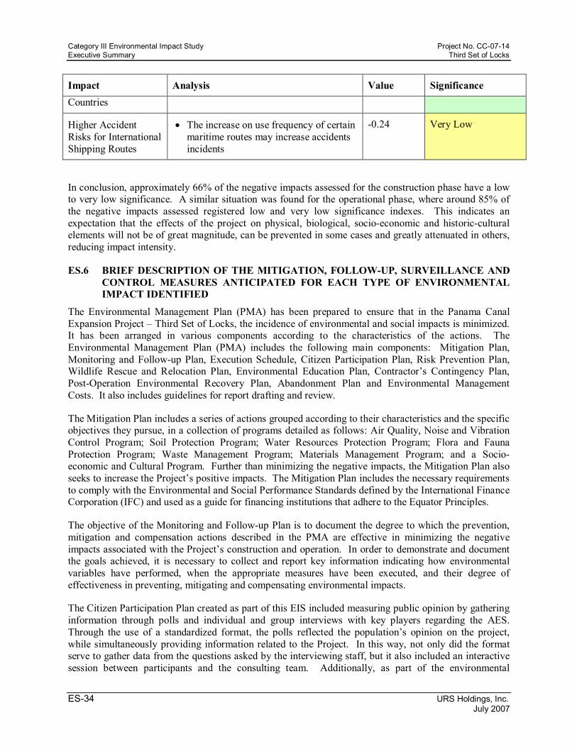
Category III Environmental Impact Study Project No. CC0714 Executive Summary Third Set of Locks
ES34 URS Holdings, Inc. July 2007
Impact Analysis Value Significance Countries
Higher Accident Risks for International Shipping Routes
• The increase on use frequency of certain maritime routes may increase accidents incidents
0.24 Very Low
In conclusion, approximately 66% of the negative impacts assessed for the construction phase have a low to very low significance. A similar situation was found for the operational phase, where around 85% of the negative impacts assessed registered low and very low significance indexes. This indicates an expectation that the effects of the project on physical, biological, socioeconomic and historiccultural elements will not be of great magnitude, can be prevented in some cases and greatly attenuated in others, reducing impact intensity.
ES.6 BRIEF DESCRIPTION OF THE MITIGATION, FOLLOWUP, SURVEILLANCE AND CONTROL MEASURES ANTICIPATED FOR EACH TYPE OF ENVIRONMENTAL IMPACT IDENTIFIED
The Environmental Management Plan (PMA) has been prepared to ensure that in the Panama Canal Expansion Project – Third Set of Locks, the incidence of environmental and social impacts is minimized. It has been arranged in various components according to the characteristics of the actions. The Environmental Management Plan (PMA) includes the following main components: Mitigation Plan, Monitoring and Followup Plan, Execution Schedule, Citizen Participation Plan, Risk Prevention Plan, Wildlife Rescue and Relocation Plan, Environmental Education Plan, Contractor’s Contingency Plan, PostOperation Environmental Recovery Plan, Abandonment Plan and Environmental Management Costs. It also includes guidelines for report drafting and review.
The Mitigation Plan includes a series of actions grouped according to their characteristics and the specific objectives they pursue, in a collection of programs detailed as follows: Air Quality, Noise and Vibration Control Program; Soil Protection Program; Water Resources Protection Program; Flora and Fauna Protection Program; Waste Management Program; Materials Management Program; and a Socio economic and Cultural Program. Further than minimizing the negative impacts, the Mitigation Plan also seeks to increase the Project’s positive impacts. The Mitigation Plan includes the necessary requirements to comply with the Environmental and Social Performance Standards defined by the International Finance Corporation (IFC) and used as a guide for financing institutions that adhere to the Equator Principles.
The objective of the Monitoring and Followup Plan is to document the degree to which the prevention, mitigation and compensation actions described in the PMA are effective in minimizing the negative impacts associated with the Project’s construction and operation. In order to demonstrate and document the goals achieved, it is necessary to collect and report key information indicating how environmental variables have performed, when the appropriate measures have been executed, and their degree of effectiveness in preventing, mitigating and compensating environmental impacts.
The Citizen Participation Plan created as part of this EIS included measuring public opinion by gathering information through polls and individual and group interviews with key players regarding the AES. Through the use of a standardized format, the polls reflected the population’s opinion on the project, while simultaneously providing information related to the Project. In this way, not only did the format serve to gather data from the questions asked by the interviewing staff, but it also included an interactive session between participants and the consulting team. Additionally, as part of the environmental

Project No. CC0714 Category III Environmental Impact Study Third Set of Locks Executive Summary
URS Holdings, Inc. ES35 July 2007
assessment process, two public forums on the Project’s EIS were held, one in the Atlantic and the other one in the Pacific sector.
In order to give continuity to the Citizen Participation process once the construction works begin, two community relations offices, one in the Atlantic and the other one in the Pacific sector, will be established.
The Risks Prevention Plan objectives are to identify the environmental risk types and the measures to be implemented as a result of these risks during the construction and operation phases of the Panama Canal Expansion Project – Third Set of Locks. Emphasis shall be given to the fact that, in addition to the regulations presented in this Plan, the Contractors shall also comply with current ACP regulations.
The objective of the Wildlife Rescue and Relocation Plan is to capture the largest amount possible of animals that could lose their habitat, be injured or disturbed during the construction phase, and relocate them to habitats suitable to ensure their survival. To accomplish this, various capture methods have been proposed according to the animal group (mammal, bird, reptile or amphibian). Also, the relocation of the captured specimens to better conserved forest habitat zones is to be coordinated with ANAM.
The Environmental Education Plan is presented in order to minimize the possible negative impacts (illegal hunting, illegal logging, and contamination, among others) that could be caused due to the human presence in the Project sites. The project objectives are to instruct, educate, and create awareness of the obligations resulting from this EIS, and give the employees the necessary tools to comply with the Country’s existing environmental protection measures.
The Contingency Plan objective is to reduce the possibility of damage to people, property, environment and Canal operations due to activities related to the Panama Canal Expansion Project – Third Set of Locks. This plan contains basic aspects to be considered by the Project’s staff, and has been structured in a way such that it integrates the activities the construction staff must develop and the measures to be taken when faced with a contingency. The main components of this Plan are: action priorities; establishment of responsibilities; coordination with local authorities; contacts list; action plans in case of emergencies; emergency response measures; equipment and materials necessary for emergency control; and revising and updating the contingency plan.
In general terms, the PMA will be conducted throughout the Project’s life, including the design, planning, construction and operation phases. Many activities will begin during the Project’s design and planning phases, including protection measures and controls as fundamental design elements, continuous public consultation and information disclosure to communities and interested groups. Table RE.7 presents the general schedule for the PMA’s activities.

Category III Environmental Impact Study Project No. CC0714 Executive Summary Third Set of Locks
ES36 URS Holdings, Inc. July 2007
Table ES.7 General Schedule for the PMA’s activities
Activity Beginning End Duration
Air Quality and Noise Control Program
Construction Operation Indefinite
Soil Protection Program
Construction Operation Indefinite
Water Quality Control Program
Construction Operation Indefinite
Flora and Fauna Protection Program
Construction Operation Indefinite
Waste Management Program
Construction Operation Indefinite
Materials Management Program
Construction Operation Indefinite
Socioeconomic and Cultural Plan
Design and Planning phase
Operation Indefinite
Wildlife Rescue and Relocation Plan
Previous to site cleaning and clearing in each work area
Commencement of Construction works
Construction phase
Risks Prevention Plan Design and Planning phase Operation Indefinite
Contingencies Plan Design and Planning phase Operation Indefinite
Citizen Participation Plan
Design and Planning phase Operation Indefinite
Environmental Education Plan
Construction works beginning
Construction works finished
Construction phase
Monitoring and Followup Plan
PreConstruction Operation Indefinite
Postoperation Environmental Recovery Plan
Construction End of Construction activities
Construction phase
Reports Design and Planning phase
Operation Indefinite
PMA Review Design and Planning phase
Operation Indefinite
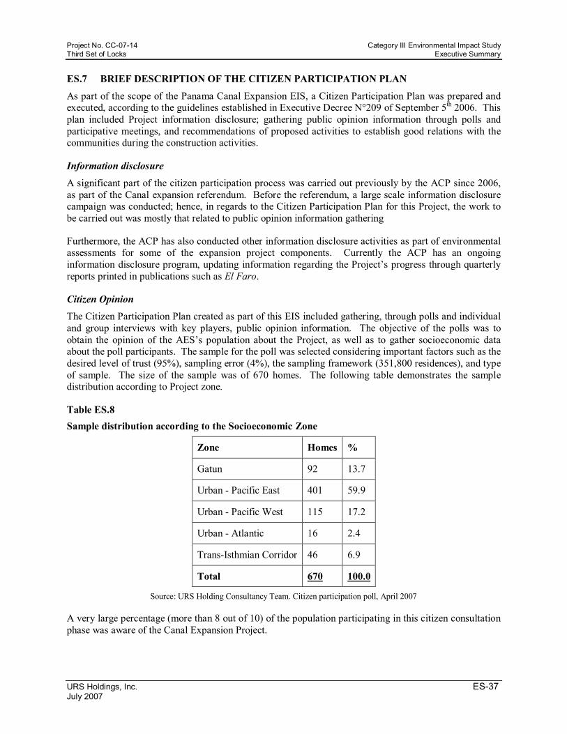
Project No. CC0714 Category III Environmental Impact Study Third Set of Locks Executive Summary
URS Holdings, Inc. ES37 July 2007
ES.7 BRIEF DESCRIPTION OF THE CITIZEN PARTICIPATION PLAN
As part of the scope of the Panama Canal Expansion EIS, a Citizen Participation Plan was prepared and executed, according to the guidelines established in Executive Decree N°209 of September 5 th 2006. This plan included Project information disclosure; gathering public opinion information through polls and participative meetings, and recommendations of proposed activities to establish good relations with the communities during the construction activities.
Information disclosure
A significant part of the citizen participation process was carried out previously by the ACP since 2006, as part of the Canal expansion referendum. Before the referendum, a large scale information disclosure campaign was conducted; hence, in regards to the Citizen Participation Plan for this Project, the work to be carried out was mostly that related to public opinion information gathering
Furthermore, the ACP has also conducted other information disclosure activities as part of environmental assessments for some of the expansion project components. Currently the ACP has an ongoing information disclosure program, updating information regarding the Project’s progress through quarterly reports printed in publications such as El Faro.
Citizen Opinion
The Citizen Participation Plan created as part of this EIS included gathering, through polls and individual and group interviews with key players, public opinion information. The objective of the polls was to obtain the opinion of the AES’s population about the Project, as well as to gather socioeconomic data about the poll participants. The sample for the poll was selected considering important factors such as the desired level of trust (95%), sampling error (4%), the sampling framework (351,800 residences), and type of sample. The size of the sample was of 670 homes. The following table demonstrates the sample distribution according to Project zone.
Table ES.8 Sample distribution according to the Socioeconomic Zone
Zone Homes %
Gatun 92 13.7
Urban Pacific East 401 59.9
Urban Pacific West 115 17.2
Urban Atlantic 16 2.4
TransIsthmian Corridor 46 6.9
Total 670 100.0
Source: URS Holding Consultancy Team. Citizen participation poll, April 2007
A very large percentage (more than 8 out of 10) of the population participating in this citizen consultation phase was aware of the Canal Expansion Project.
Category III Environmental Impact Study Project No. CC0714 Executive Summary Third Set of Locks
ES38 URS Holdings, Inc. July 2007
The residents’ general opinion was that the impact on their homes and workplaces would be imperceptible or that there would be no impact at all. When asked about their specific jobs, the answer was very similar. A high percentage more than 60%, considered that their job would not be affected (negatively or positively), whereas a 15.2% considered their jobs would be positively impacted, and only 2.1% thought their jobs would be negatively affected.
When asked about their answers, they explained that although the Project would bring a more dynamic economy, generate millions of dollars in revenues and generate more employment, they did not see very clearly how this would directly benefit them, a member of their family or their communities.
When considering only those that indicated there would be some sort of impact with the execution of the works, it was observed that the highest expectation among the consulted sample was that the project would generate a higher employment level (70%) and other income generating activities; this was the opinion of 13% of the total sample.
For environmental issues, those that thought the project would cause negative impacts manifested their concern that the forest areas would be reduced, causing either an immediate or long term reduction in the region’s fauna and flora. Finally, it was observed that when mentioning the possible environmental impacts of the project, only in the Urban Atlantic Zone, that is, in Colon City, a negative environmental impact of some significance was identified. In effect, those surveyed mentioned the possibility that the expansion works may affect the flora and fauna of the surrounding areas. Almost a third of the consulted sample of that zone had that opinion.
According to the type of impact indicated, the population surveyed considered necessary the following mitigation measures: transparency and public information disclosure, and consideration of the local workforce for employment opportunities and a good economic resources management policy, this last one being highly related to the first measure mentioned above.
The polls included a control question (Question No. 23 of the poll to heads of home), where persons were asked whether they favored or rejected the Project. The results of this question generally indicated a remarkably high project acceptance rate, with more than 75% of the sample reporting a positive opinion.
Opinion of Organizations and Institutions
In addition to the general public opinion polls, a series of interviews were conducted with members of different organizations and institutions, such as organizations that are attuned to the general perception of the communities or who generate points of view in them. These interviews were conducted using a standardized questionnaire in group or individual interviews. A total of 39 representatives from different organizations and institutions (more than 80 were contacted) were consulted, 14 of these from governmental organizations or institutions, and the remaining 25 of the nongovernmental type.
In relation to the diverse points of view expressed in these interviews, it was assessed that the interviewed institutions and organizations stated that the Canal expansion would bring mostly positive impacts since it would generate more employment and there would be more revenues for the population. Those that mentioned that the project would generate negative impacts stated that there would be political interests involved that some people would have to abandon their homes, and also that the work vacancies generated would be given to foreigners. Other organizations considered that the project would cause no impact at all.
Project No. CC0714 Category III Environmental Impact Study Third Set of Locks Executive Summary
URS Holdings, Inc. ES39 July 2007
The organizations’ opinion about the Project’s environmental impacts considered that the impact would be negative, particularly as it relates to ecological damage, the salinity of the Gatun Lake, species migration and perturbation, and deforestation.
Equally, in relation to negative impacts, some considered that the Project would cost more than the estimated and that this debt would have to be paid by the whole nation. Also, some stated that the project was not necessary since the Canal modernization plan currently executed would be adequate to ease transit of the larger ships.
Concerning the possible socioeconomic impacts, the participants of these polls stated that the Canal expansion would have a positive impact, since it will generate more tourism, there will be a better maritime transit management, new competitive horizons, and higher productivity and efficiency.
Finally, there was some concern regarding the consequences of national and international migration to the urban zones of the metropolitan areas, like the case of Colon and Arraijan, where the public services are currently struggling to cope with the current demand.
Opinion of Key Stakeholders at the Community Level
To complement the information obtained from the population, it was deemed necessary to hold interviews with people regarded as key stakeholders due to their political, social or economic role inside the AES. When comparing the perception of the communities’ residents interviewed with that of key people from those communities, the similarity between them is evident. The employment to be generated and the higher economical activity which would produce more revenues are the type of impacts identified as relevant by both.
The key stakeholders, at the local level, also indicated as a positive impact, the possibility of more education or training. This however, was not indicated by the community residents nor by other key people consulted. There was also agreement concerning the proposed mitigation measures for negative impacts or to maximize the Project’s benefits.
The similarity of the opinions was reiterative, even when the consulting team asked how they perceived the Project. More than 80% of the participants favored the Project. This percentage is not very far from the acceptance rate obtained in the community resident polls.
Summarizing, and in accord with the results from polls and interviews, the population favored the Project, even when they considered that there could also be some damage to the environment. The population, residents and key people alike, are expecting changes in the political and institutional policies that may help to maximize the benefits in terms of equity for their respective communities and homes.
Community Relations The Citizen Participation Plan also includes a Community Relations component. The objective of this Community Relations section is to define the procedures and mechanisms necessary in order to keep the communities informed about the main elements of the project, as well as to hear and consider community concerns. The main recommendations in order to maintain good community relations include:
• The establishment of community offices, both in the Atlantic and the Pacific, to receive inquiries and/or complaints. These offices shall serve as liaison offices between the Project managers and the communities neighboring the project work areas. The community relation offices shall include staff in charge of responding to and receiving communications from the

Category III Environmental Impact Study Project No. CC0714 Executive Summary Third Set of Locks
ES40 URS Holdings, Inc. July 2007
communities, as well as making sure that the community concerns are received and forwarded to the appropriate responsible party.
• Registration of all calls or visits received, including name, telephone number, community, date and time of the communication, complaint/request description, and response provided, among others.
• Local disclosure of information through flyers and other media, in order to keep the communities informed about current activities and alert them to any situation that warrants special attention or disclosure. The flyers should include a contact name and phone number of appropriate personnel who are able to respond to queries and concerns.
• Strategies for the solution of conflicts. The citizen participation plan created includes the description of a series of established techniques such as mediation, conciliation and arbitration.
Presentation of Reports Finally, the Citizen Participation Plan recommends the presentation of periodic reports summarizing the degree of effectiveness in applying the recommended actions.
Environmental Management Costs Table RE.9 summarizes the costs associated with the Environmental Management Plan. For the Construction Phase these costs amount to a total of $27.7 million, whereas for the operation phase there is an annual cost of $0.5 million.
Table ES.9 Summary of the Environmental Management Costs
CONSTRUCTION PHASE
Description Cost (Dollars)
Global Annual
Surveillance and Control for the Implementation of Mitigation Measures
Physical Aspects 8,991,500.00
Biological Aspects 5,558,433.07
Socioeconomic Aspects 4,840,000.00
Environmental Monitoring Plan
Air Quality, Noise and Vibrations 1,172,000.00
Soil Protection 910,000.00
Water Quality and Sediments 3,271,000.00
Wildlife Rescue and Relocation Plan 1,024,000.00

Project No. CC0714 Category III Environmental Impact Study Third Set of Locks Executive Summary
URS Holdings, Inc. ES41 July 2007
Environmental Education Plan 270,000.00
PostOperation Environmental Recovery Plan 1,000,000.00
TOTAL CONSTRUCTION PHASE COSTS 27,036,933.07
OPERATION PHASE
Surveillance and Control for the Implementation of Mitigation Measures
Physical Aspects 100,000.00
Biological Aspects
Socioeconomic Aspects 70,000.00
Environmental Monitoring Plan
Air Quality, Noise and Vibrations 30,500.00
Soil Protection 180,000.00
Water Quality and Sediments 225,000.00
TOTAL OPERATION PHASE COSTS 70,000.00 535,500
ES.8 CONCLUSIONS AND RECOMMENDATIONS
After analyzing the activities associated with the Panama Canal Expansion Project – Third Set of Locks, described in the EIS, the following conclusions and recommendations are presented:
Conclusions • The Project is considered socially and environmentally viable as long as the prevention,
mitigation, monitoring and compensation measures identified in the Environmental Management Plan are applied.
• The proposed Project is the expansion of an ongoing activity, which has been developed for more than 90 years, and in an area reserved for this purpose by national legislation.
• The Project’s Specific Study Area has been modified historically since colonial times and particularly since the Canal’s construction in the early XX century, and is an aquatic and terrestrial corridor of worldwide importance; hence the Project is consistent with the historical use of the area.
• The Project’s Direct Impact Area is located mainly in an area reserved exclusively for the ACP’s private use and includes mainly areas historically used for the Canal construction, operation and maintenance. Hence, the resulting impacts in these areas tend to be of low or moderate significance.
• Gatun Lake’s water quality, typical of tropical freshwater lakes, will keep its freshwater characteristics with the existing threestep lock system. According to studies and simulations performed, the addition of the Third Set of Locks will not affect the lake’s water quality.
Category III Environmental Impact Study Project No. CC0714 Executive Summary Third Set of Locks
ES42 URS Holdings, Inc. July 2007
• The restrictions imposed by Canal operations to dwellings and activities in areas exclusively reserved for ACP’s private use has contributed to the conservation of the natural vegetation that emerged after the original construction activities and has allowed the growth of intermediate secondary forests and the emergence of some fragments of mature secondary forests of importance as probable biological corridors. This condition will be preserved in the areas surrounding the new set of locks.
• The secondary forest areas affected by the Project’s footprint represent approximately 0.35% of the total forest covered areas inside the General Study Area and 1.04% of the aggregate of the Specific Study and Direct Impact Areas. Also, the project’s footprint will not affect the connectivity of the forests and Protected Areas inside the Specific Study Area. As part of its environmental commitment, an area twice as large as the forest area cut for the Project’s construction will be reforested.
• The few endemic species reported inside the Direct Impact Area have a wide national distribution, hence it is not expected that their populations will be affected. None of the species protected by national legislation or included in international threatened species listings have significant populations within the Project’s Direct Impact Area.
• The Project will significantly increase the country’s revenues in tolls as well as in the positive effect in the general economy growth, and direct and indirect employment.
• With an expanded Panama Canal, the route’s competitiveness on the international maritime transportation will increase.
• The Project will be completely developed in areas reserved exclusively for ACP’s private use. However, there are a few structures and residences belonging to third parties (9 residences and 57 structures of other type in the shores of the Gatun Lake, 4 residences in the former town of Gatun, and 6 structures in town of Cocoli) in those areas.
• The Citizen Participation Plan implemented for the Project included polling of different interest groups (communities, organizations and institutions) within the Socioeconomic Study Area. The results of these polls indicated a favorable opinion and support of the project, similar to what was evidenced during the National Referendum held in 2006. Additionally, two public forums will be held in the cities of Panama and Colon to present this EIS and receive public comments and suggestions. Also community offices will be established in the cities of Panama and Colon. The Environmental Impact Study includes an Environmental Management Plan which includes a mitigation program to minimize adverse impacts and to maximize the positive ones.
• The Project will follow the Equator Principles and the International Finance Corporation Performance Standards. This is a commitment made by the ACP to ensure the protection of the environment, and that the Project is a benefit for everyone.
Recommendations • The Project should implement the Environmental Management Plan and each of its programs and
plans, including the Monitoring and Followup Plan during the Project’s construction and operation, in order to ensure that all impacts are controlled and that all necessary actions included in the Environmental Management Plan are executed. It is then highly important to include in the construction contracts all environmental obligations as well as the monitoring mechanisms and/or sanctions that will be implemented by the ACP in order to guarantee their execution by the Contractors.
• Before commencing the construction of any particular component of the Canal expansion project, the ACP shall ensure the submission, by the specific Contractor, of a detailed Plan indicating all
Project No. CC0714 Category III Environmental Impact Study Third Set of Locks Executive Summary
URS Holdings, Inc. ES43 July 2007
the facilities he intends to build, in order to have prior knowledge of all the activities that could have a negative effect on the environment. This Plan should detail the spatial distribution of their facilities and indicate the location of material and waste storage sites. Also, ACP should update the Waste Management Plan presented in this study in order to make the Plan specific to the development activities. The Plan presented by each Contractor shall be meticulously reviewed to verify the techniques and procedures employed comply with the measures required in the PMA, and do not produce additional environmental impacts, or, when not covered by these, complementary mitigation and environmental management measures are proposed.
• The ACP should appoint an independent expert whose task would be to help in the monitoring process and reports submission all along the Project’s life. The reports should include information, for the general public or other interested parties, about the project’s progress and its social and environmental performance during the Project’s construction and implementation. This information should be public, procuring its disclosure through diverse media and guaranteeing the population the opportunity to request explanations or additional information.