Embed Size (px)
Citation preview

ES3D4 / ES4D5 Construction Management
Surveying
1
Tony Price&
Nikki Meads
ES3D4 / ES4D5 Construction Management
Surveying
• The main object of surveying is the preparation of maps or plans which are the basis in the planning and design of engineering projects such as route location, e.g. roads, railway lines, pipelines, tunnels, etc.

ES3D4 / ES4D5 Construction Management
Classification of Surveys
• Surveying is divided into two main categories-i) Plane survey ii) Geodetic Survey

ES3D4 / ES4D5 Construction Management
Geodetic Survey • Where a survey extends over a
large area greater than 200 sq. km. and the required degree of accuracy is also great.
• The curvature of earth is taken into account.
• Used to provide control points to which small surveys can be connected.
• Not common in Civil works.

ES3D4 / ES4D5 Construction Management
Plane Survey • For small projects
covering an area less than 200 sq.km.
• Earth’s curvature is not accounted for in distances. Earth surface is considered as a plane. (Angular error of 1” in 200 sq. km. area by assuming plane).
ww
w.t
ekto
nics
.org
/af/
flate
arth
.jpg
ES3D4 / ES4D5 Construction Management
Basic Principles in Surveying
• Ruling principles of surveying are :i) “ to work from whole to part”. For surveying you should establish control points of high precision by use of triangulation and precise levelling. This area is further divided into smaller triangles which are surveyed with less accuracy.ii) to fix the position of new stations by at least two independent processes – e.g. linear and angular
ES3D4 / ES4D5 Construction Management
Setting-out• Whereas surveying maps the
existing world, setting-out establishes points for the control of construction processes, e.g.– Positioning foundations– Placing the line of a road or service– Controlling levels and gradients on
earthworks
7

ES3D4 / ES4D5 Construction Management
Health & Safety
8
http
://w
ww
.kem
peng
inee
rings
urve
y.co
.uk/
land
-sur
veys
/roa
d-su
rvey
s.ht
ml

ES3D4 / ES4D5 Construction Management
Health & Safety
Police said the surveyor was pinned beneath a 12-wheel truck Friday morning for more than an hour.
The truck was backing up when it struck the worker.
A 60-year-old man was taken to hospital with critical injuries. He was pronounced dead Friday afternoon.
9
http
://u
k.ne
ws.
yaho
o.co
m/q
ue-s
urve
yor-
kille
d-ro
ad-c
onst
ruct
ion-
acci
dent
-010
5480
47.h
tml
ES3D4 / ES4D5 Construction Management
Health & SafetySurveyor electrocuted - Employer fined20 year old Surveyor Russell Donald died after
he was electrocuted passing under a high-voltage power line with a metal pole in Echt, Aberdeenshire. His employer, W A Fairhurst and Partner, has been fined £25,200.
The Glasgow based engineering firm were charged with failing to instruct Mr Donald that it was inappropriate to use a long surveying pole in the vicinity of electric lines.
10
htt
p://
ww
w.d
prh
d.c
o.u
k/n
ew
s/2
010
/jan
/su
rve
yor-
ele
ctro
cute
d-e
mp
loye
r-fin
ed
ES3D4 / ES4D5 Construction Management
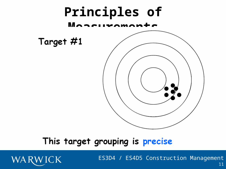
Principles of Measurements
11
ES3D4 / ES4D5 Construction Management
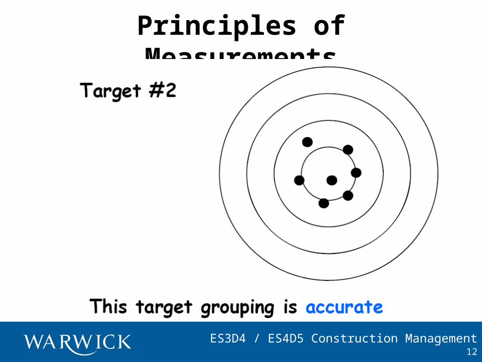
Principles of Measurements
12
ES3D4 / ES4D5 Construction Management
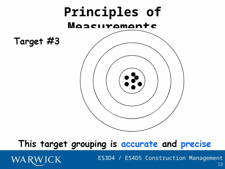
Principles of Measurements
13
ES3D4 / ES4D5 Construction Management
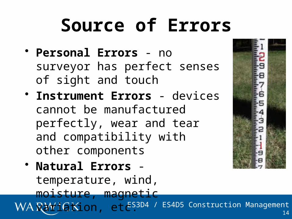
Source of Errors• Personal Errors - no surveyor
has perfect senses of sight and touch
• Instrument Errors - devices cannot be manufactured perfectly, wear and tear and compatibility with other components
• Natural Errors - temperature, wind, moisture, magnetic variation, etc.
14
ES3D4 / ES4D5 Construction Management
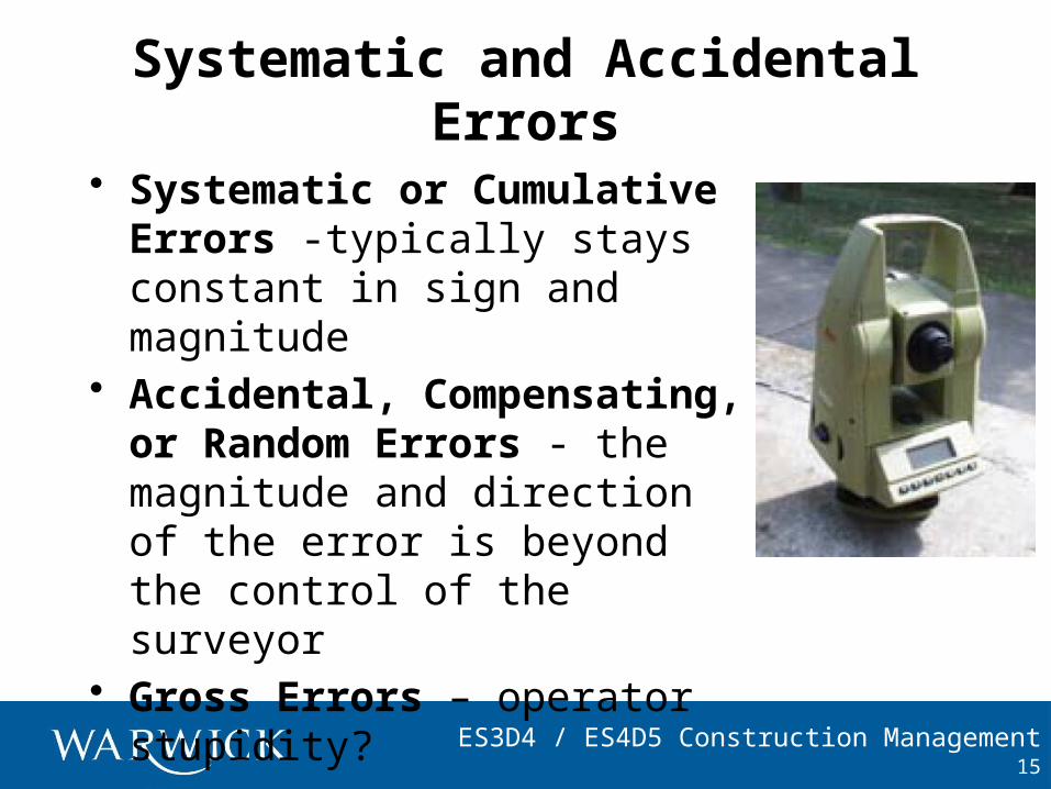
Systematic and Accidental Errors
• Systematic or Cumulative Errors -typically stays constant in sign and magnitude
• Accidental, Compensating, or Random Errors - the magnitude and direction of the error is beyond the control of the surveyor
• Gross Errors – operator stupidity?
15
ES3D4 / ES4D5 Construction Management
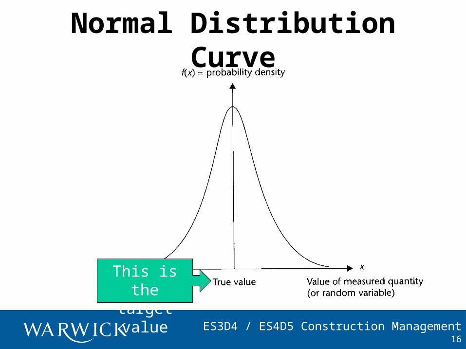
Normal Distribution Curve
16
This is the target value
ES3D4 / ES4D5 Construction Management
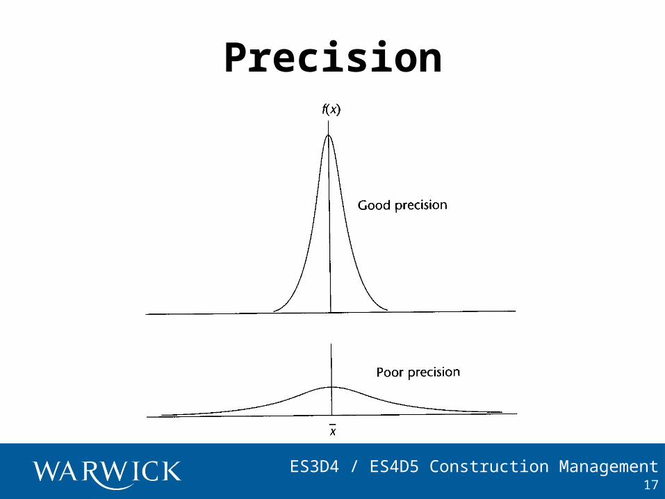
Precision
17
ES3D4 / ES4D5 Construction Management
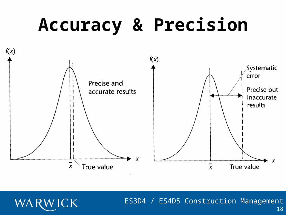
Accuracy & Precision
18
ES3D4 / ES4D5 Construction Management
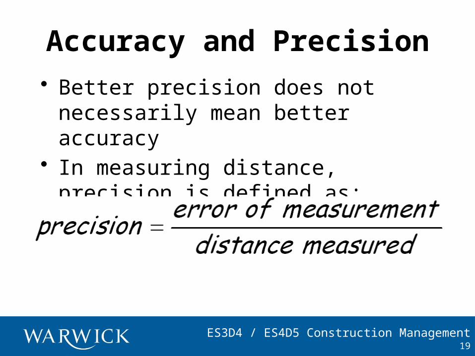
Accuracy and Precision• Better precision does not
necessarily mean better accuracy• In measuring distance, precision is
defined as:
19
ES3D4 / ES4D5 Construction Management
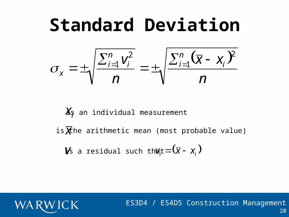
Standard Deviation
20
n
xx
n
v inii
ni
x
21
21
v
x
xi is an individual measurement
is the arithmetic mean (most probable value)
is a residual such that ii xxv
ES3D4 / ES4D5 Construction Management
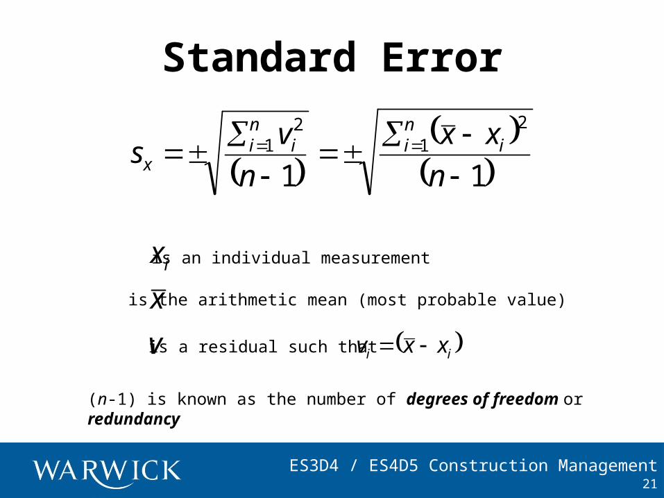
Standard Error
21
11
21
21
n
xx
n
vs i
nii
ni
x
v
x
xi is an individual measurement
is the arithmetic mean (most probable value)
is a residual such that ii xxv
(n-1) is known as the number of degrees of freedom or redundancy
ES3D4 / ES4D5 Construction Management
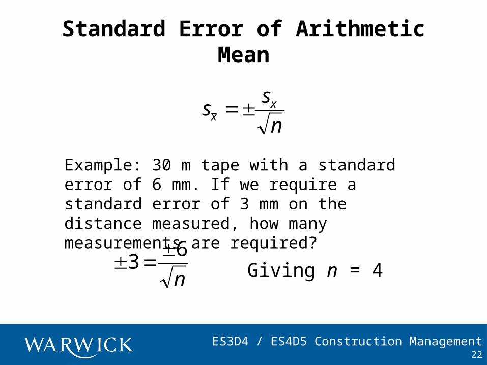
Standard Error of Arithmetic Mean
22
Example: 30 m tape with a standard error of 6 mm. If we require a standard error of 3 mm on the distance measured, how many measurements are required?
n
63
n
ss xx
Giving n = 4
ES3D4 / ES4D5 Construction Management
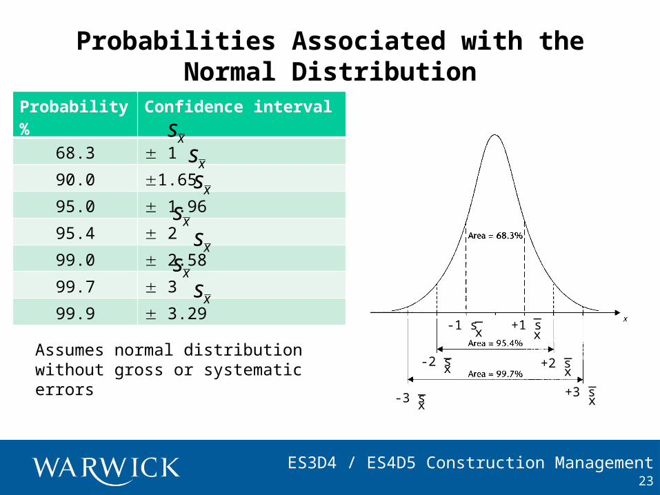
Probabilities Associated with the Normal Distribution
23
-1 s x_
+1 sx
_
-2 sx_
-3 sx_
+2 sx
_
+3 sx
_
Probability % Confidence interval
68.3 1
90.0 1.65
95.0 1.96
95.4 2
99.0 2.58
99.7 3
99.9 3.29
xsxsxs
xsxs
xsxs
Assumes normal distribution without gross or systematic errors
ES3D4 / ES4D5 Construction Management
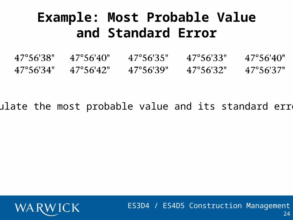
Example: Most Probable Value and Standard Error
24
Calculate the most probable value and its standard error.
ES3D4 / ES4D5 Construction Management
Solution
25
The most probable value is given by the arithmetic mean as:
ES3D4 / ES4D5 Construction Management
Solution cont.
26
Based upon the most probable value, the residuals and squares of these are calculated:
ES3D4 / ES4D5 Construction Management
Solution cont.
27
Therefore the most probable value of the angle is:
ES3D4 / ES4D5 Construction Management
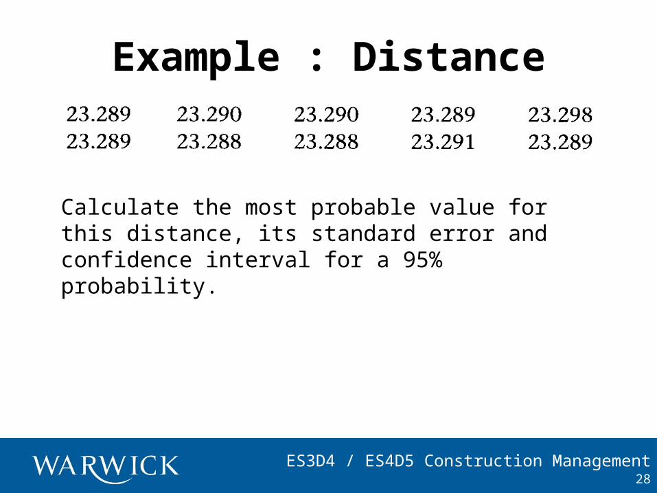
Example : Distance
28
Calculate the most probable value for this distance, its standard error and confidence interval for a 95% probability.
ES3D4 / ES4D5 Construction Management
Solution
29
ES3D4 / ES4D5 Construction Management30
For 95% probability level the confidence interval for the true value is:
REJECT
ES3D4 / ES4D5 Construction Management31
Recalculate with remaining measurements:
ES3D4 / ES4D5 Construction Management
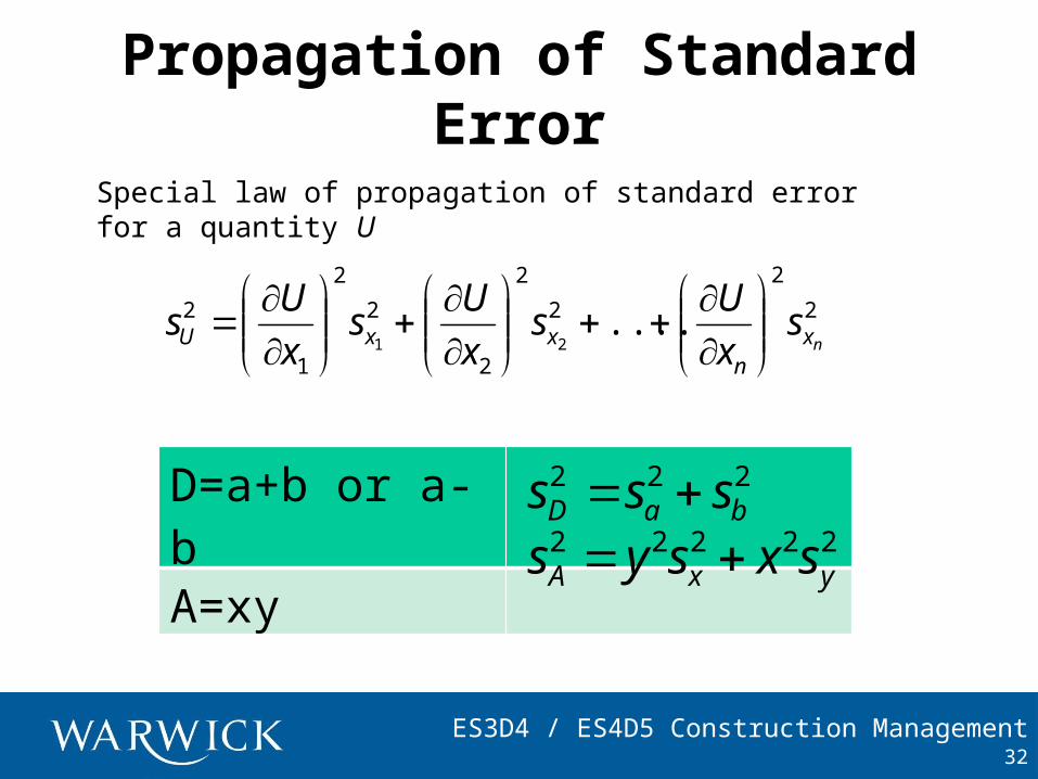
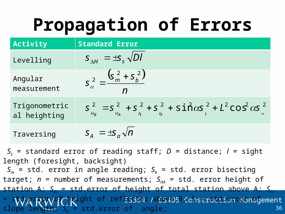
Propagation of Standard Error
32
Special law of propagation of standard error for a quantity U
2
2
2
2
2
2
2
1
2 ....21 nx
nxxU s
x
Us
x
Us
x
Us
D=a+b or a-b
A=xy
222baD sss
22222yxA sxsys
ES3D4 / ES4D5 Construction Management
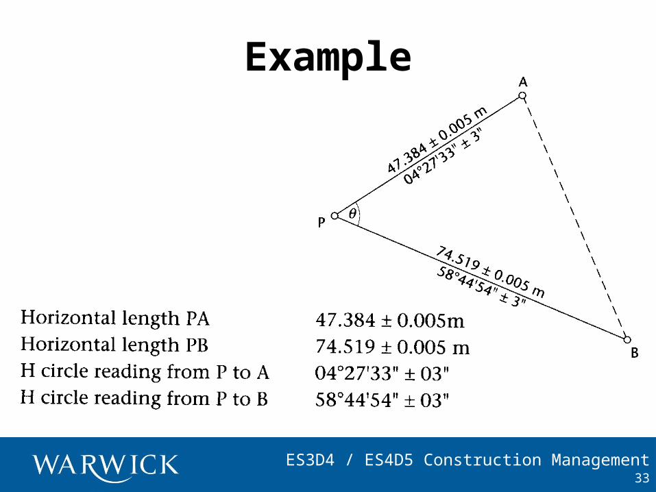
Example
33
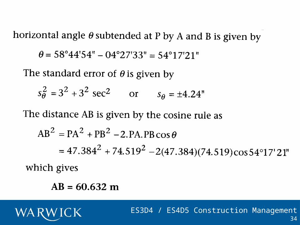
ES3D4 / ES4D5 Construction Management34
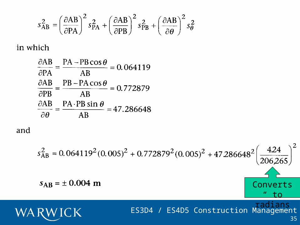
ES3D4 / ES4D5 Construction Management35
Converts “ to radians
ES3D4 / ES4D5 Construction Management
Propagation of Errors
36
Activity Standard Error
Levelling
Angular measurement
Trigonometrical heighting
Traversing
Dlss sH
Ss = standard error of reading staff; D = distance; l = sight length (foresight, backsight) Sm = std. error in angle reading; Sb = std. error bisecting target; n = number of measurements; SHA = std. error height of station A; Shi = std.error of height of total station above A; Shr = std.error of height of reflector above B; SL = std.error of slope length; Sa = std.error of angle;
nss
s bm22
2
222222222
sLsssss
LrhihAHBHcossin
nss aA
ES3D4 / ES4D5 Construction Management
Example
37
If total station has a precision of 6” and targets and observers are such that Sb = 7.5” how many readings must be taken to achieve a precision of 5” in ?
nss
s bm22
2
Sm = 6, hence
n
222
5765
.
693.n
4 readings are required.
ES3D4 / ES4D5 Construction Management
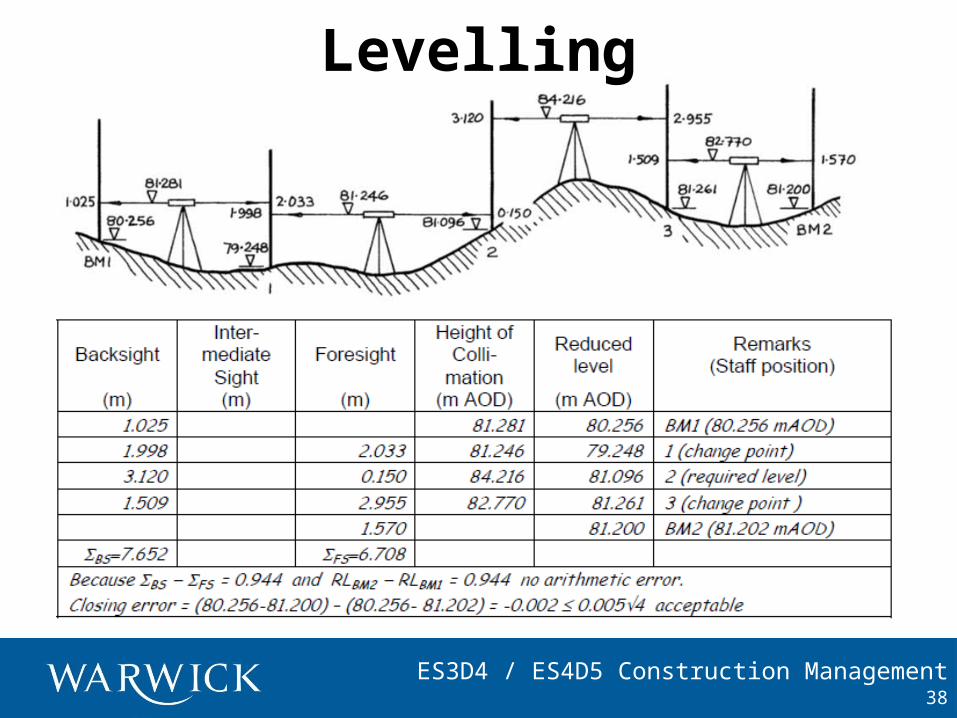
Levelling
38
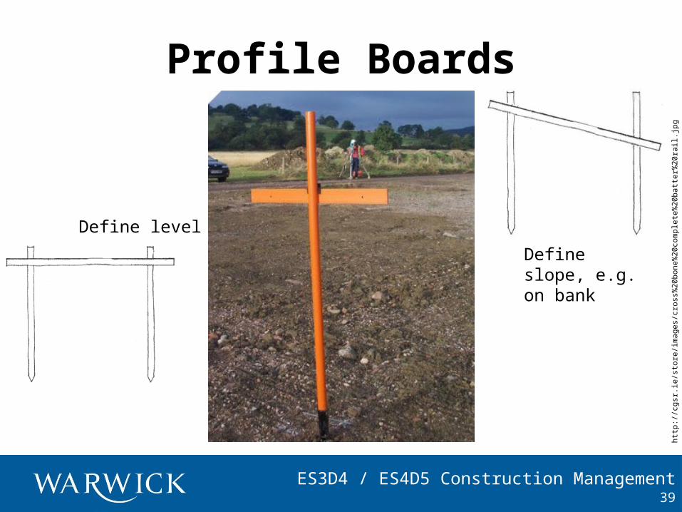
ES3D4 / ES4D5 Construction Management
Profile Boards
39
http
://c
gsr.
ie/s
tore
/imag
es/c
ross
%20
bone
%20
com
plet
e%20
batt
er%
20ra
il.jp
g
Define level
Define slope, e.g. on bank
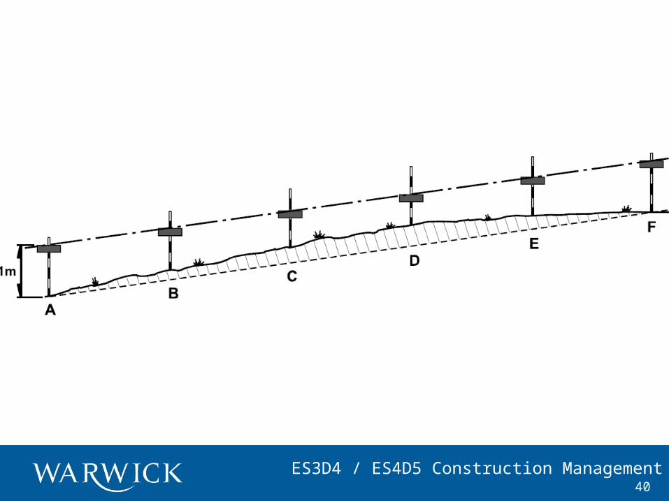
ES3D4 / ES4D5 Construction Management40
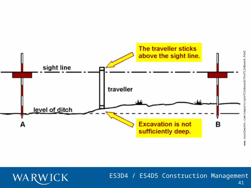
ES3D4 / ES4D5 Construction Management41
ww
w.r
ural
wor
ks.c
om/r
epor
ts/p
rofil
eboa
rd/P
rofil
eBoa
rd.h
tml
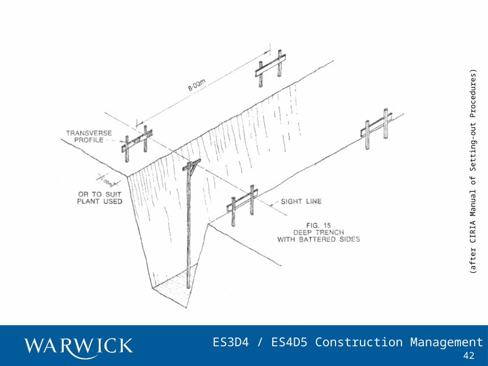
ES3D4 / ES4D5 Construction Management42
(aft
er C
IRIA
Man
ual o
f S
ettin
g-ou
t P
roce
dure
s)
ES3D4 / ES4D5 Construction Management
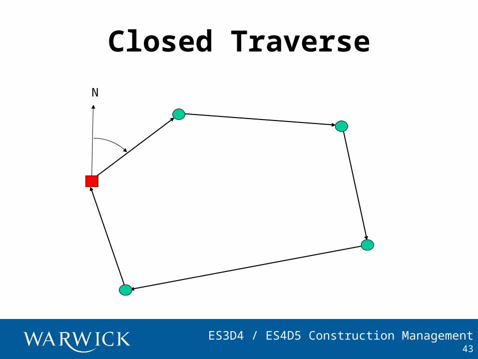
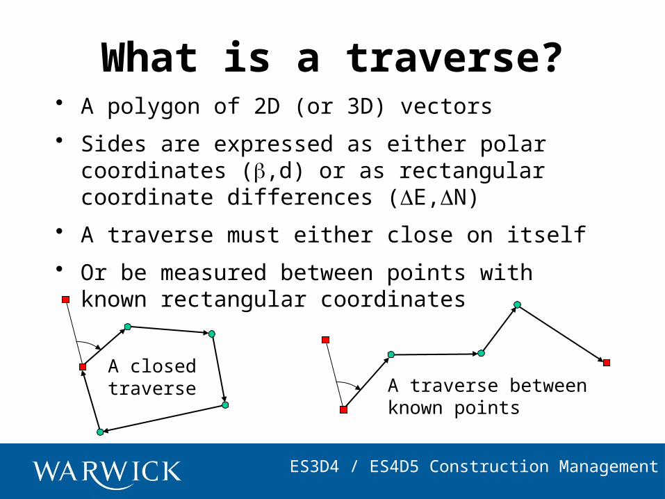
Closed Traverse
43
N
ES3D4 / ES4D5 Construction Management
What is a traverse?• A polygon of 2D (or 3D) vectors
• Sides are expressed as either polar coordinates (,d) or as rectangular coordinate differences (E,N)
• A traverse must either close on itself
• Or be measured between points with known rectangular coordinates
A closedtraverse A traverse between
known points
ES3D4 / ES4D5 Construction Management
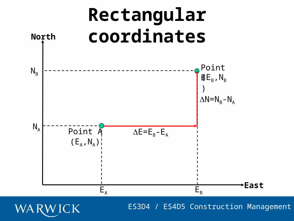
Rectangular coordinates
E=EB-EA
EA
NA
(EA,NA)
EB
NB (EB,NB)
Point A
Point B
North
East
N=NB-NA
ES3D4 / ES4D5 Construction Management
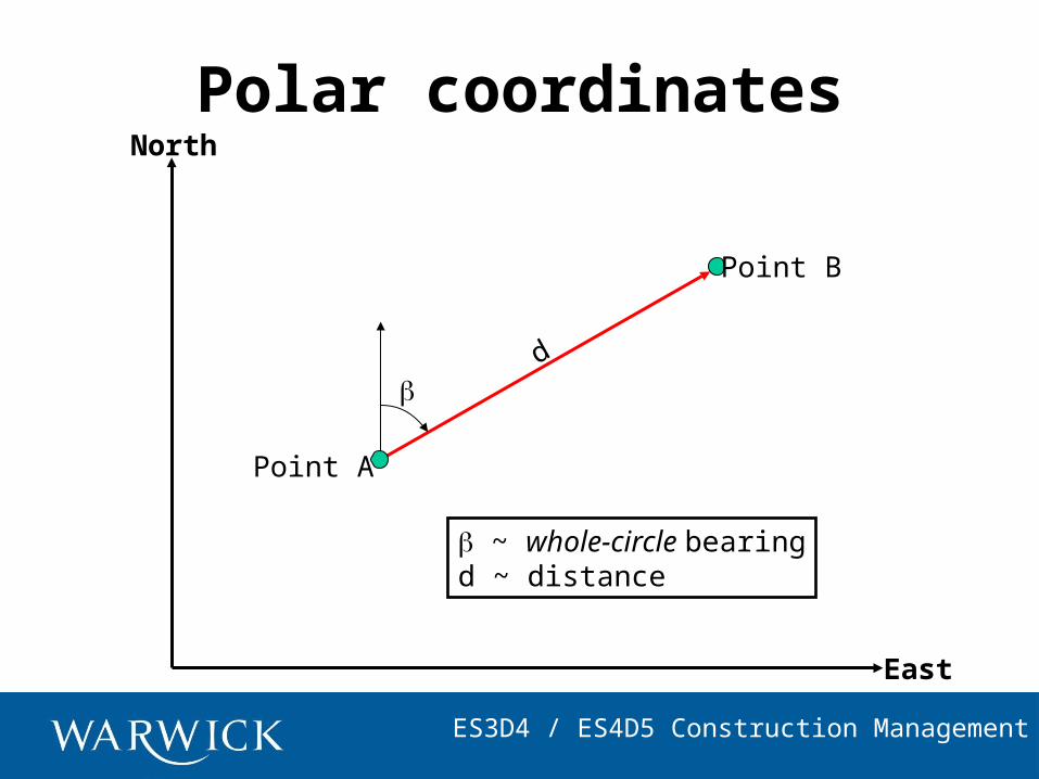
Polar coordinates
d
North
East
Point A
Point B
~ whole-circle bearingd ~ distance
ES3D4 / ES4D5 Construction Management
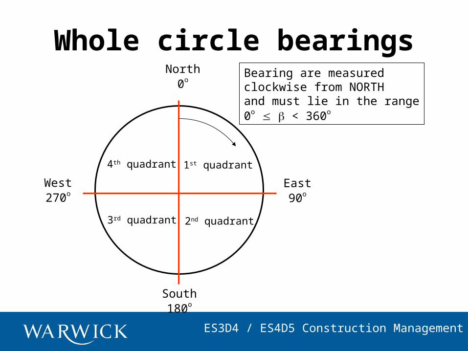
Whole circle bearingsBearing are measuredclockwise from NORTHand must lie in the range0o < 360o
North0o
East90o
South180o
West270o
1st quadrant
2nd quadrant3rd quadrant
4th quadrant
ES3D4 / ES4D5 Construction Management
Coordinate conversions
22
1
NEd
NE
tan
cosdN
sindE
Rectangular to polar Polar to rectangular
d
E
N d
E
N
ES3D4 / ES4D5 Construction Management
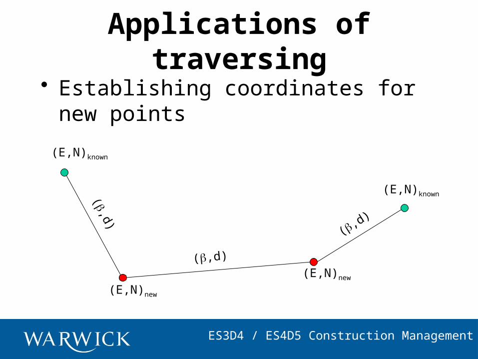
Applications of traversing
• Establishing coordinates for new points
(,d)
(,d)
(,d)
(E,N)new
(E,N)new
(E,N)known
(E,N)known
ES3D4 / ES4D5 Construction Management
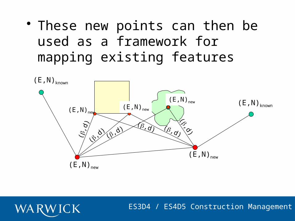
• These new points can then be used as a framework for mapping existing features
(,d
)
(,d) (,d
)(,d) (,d)
(,d)(E,N)new
(E,N)new
(E,N)new
(E,N)new
(E,N)new
(E,N)known
(E,N)known
ES3D4 / ES4D5 Construction Management
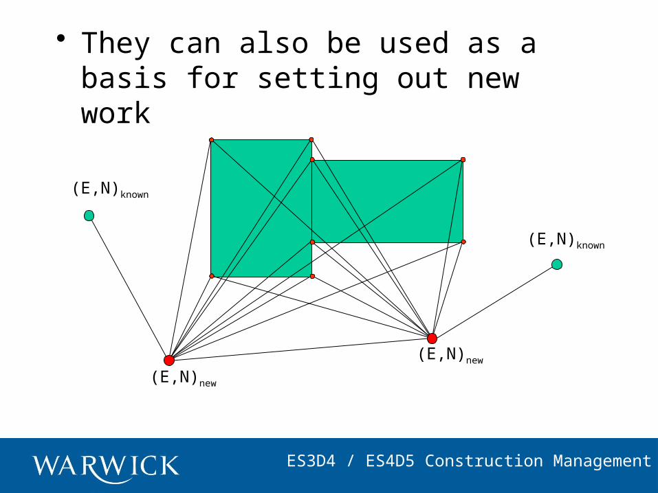
• They can also be used as a basis for setting out new work
(E,N)new
(E,N)new
(E,N)known
(E,N)known
ES3D4 / ES4D5 Construction Management
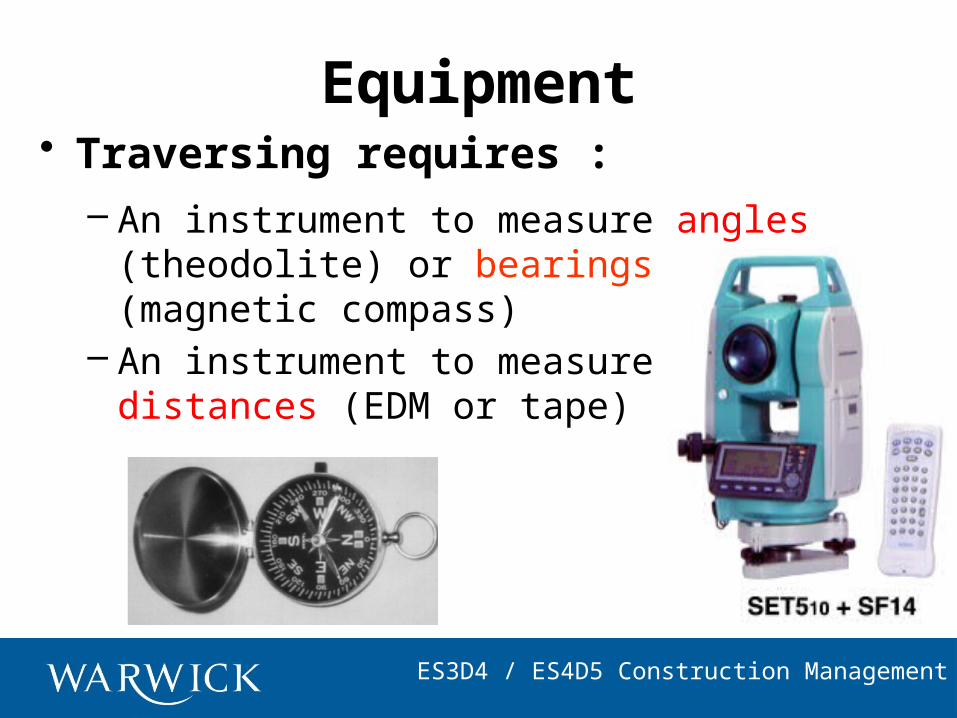
Equipment• Traversing requires :
– An instrument to measure angles (theodolite) or bearings (magnetic compass)
– An instrument to measure distances (EDM or tape)
ES3D4 / ES4D5 Construction ManagementES3D4 / ES4D5 Construction Management
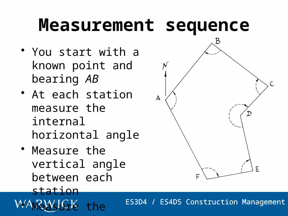
Measurement sequence• You start with a
known point and bearing AB
• At each station measure the internal horizontal angle
• Measure the vertical angle between each station
• Measure the distance between each station

ES3D4 / ES4D5 Construction ManagementES3D4 / ES4D5 Construction Management
• Whole circle bearing A to B: WCBAB
= 038° 17’ 34”• Point A has coordinates:
322.600E, 742.800N
• Sum of internal angles= (2n – 4)x90° = 720°because n = 6
114° 04’ 38”
090° 33’ 04”
083° 58’ 44”
237° 11’ 31”
088° 13’ 30”
105° 59’ 45”
ES3D4 / ES4D5 Construction Management
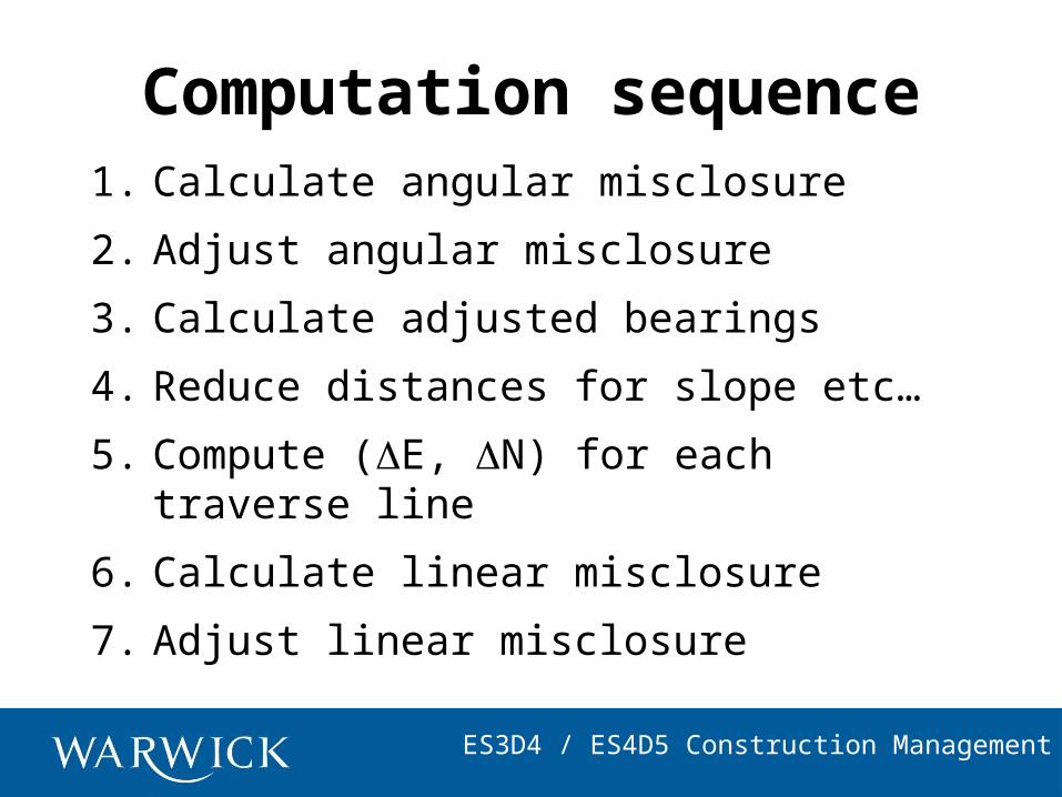
Computation sequence1. Calculate angular misclosure
2. Adjust angular misclosure
3. Calculate adjusted bearings
4. Reduce distances for slope etc…
5. Compute (E, N) for each traverse line
6. Calculate linear misclosure
7. Adjust linear misclosure
ES3D4 / ES4D5 Construction Management
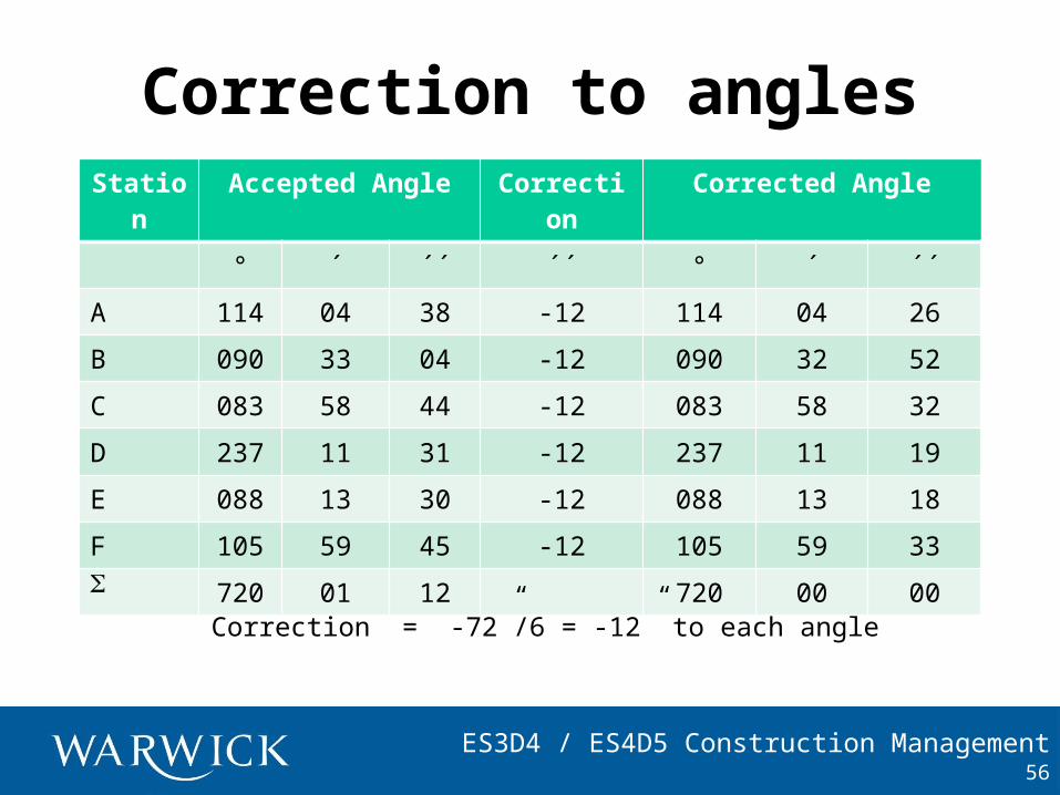
Correction to anglesStatio
nAccepted Angle Correctio
nCorrected Angle
° ´ ´´ ´´ ° ´ ´´
A 114 04 38 -12 114 04 26
B 090 33 04 -12 090 32 52
C 083 58 44 -12 083 58 32
D 237 11 31 -12 237 11 19
E 088 13 30 -12 088 13 18
F 105 59 45 -12 105 59 33 720 01 12 720 00 00
56
Correction = -72”/6 = -12” to each angle
ES3D4 / ES4D5 Construction Management
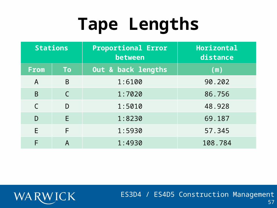
Tape LengthsStations Proportional Error
betweenHorizontal distance
From To Out & back lengths (m)
A B 1:6100 90.202
B C 1:7020 86.756
C D 1:5010 48.928
D E 1:8230 69.187
E F 1:5930 57.345
F A 1:4930 108.784
57
ES3D4 / ES4D5 Construction Management
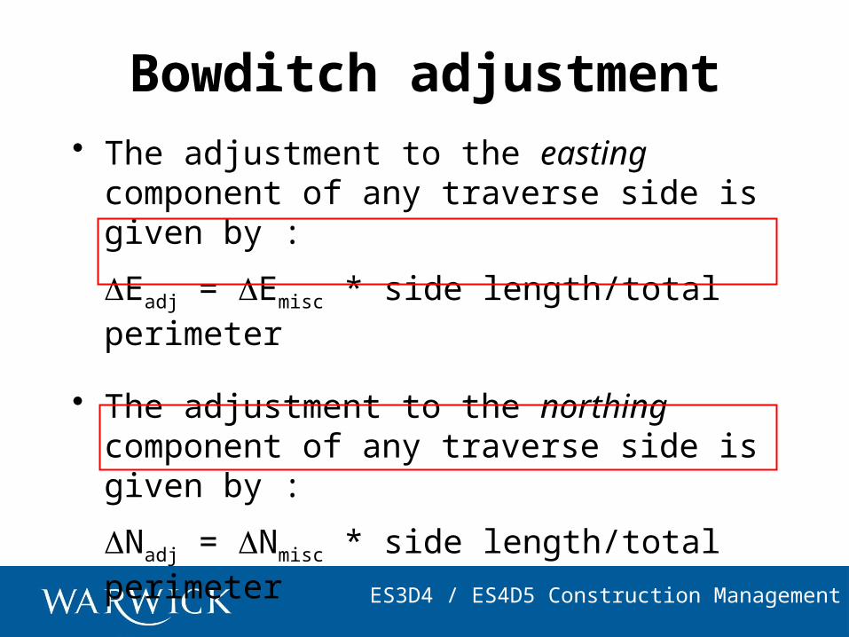
Bowditch adjustment• The adjustment to the easting
component of any traverse side is given by :
Eadj = Emisc * side length/total perimeter
• The adjustment to the northing component of any traverse side is given by :
Nadj = Nmisc * side length/total perimeter
ES3D4 / ES4D5 Construction Management
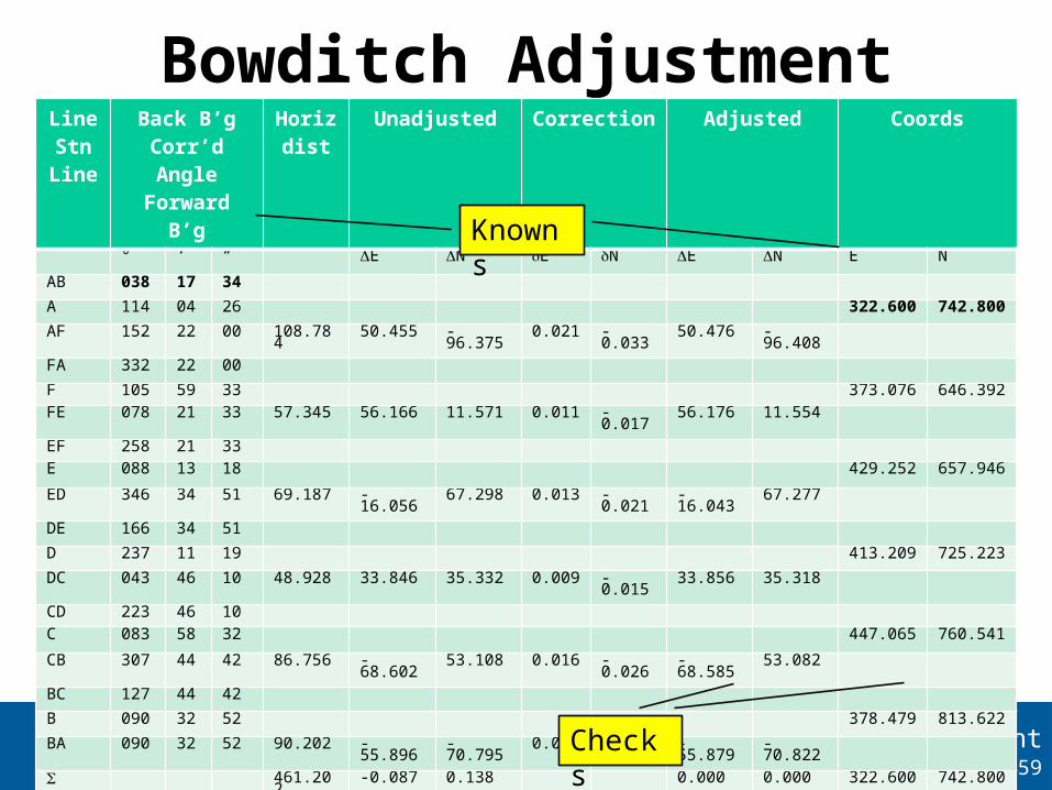
Bowditch AdjustmentLineStnLine
Back B’gCorr’d Angle
Forward B’g
Horizdist
Unadjusted Correction Adjusted Coords
° ‘ “ E N E N E N E N
AB 038 17 34
A 114 04 26 322.600
742.800
AF 152 22 00 108.784
50.455 -96.375 0.021 -0.033 50.476 -96.408
FA 332 22 00
F 105 59 33 373.076 646.392
FE 078 21 33 57.345 56.166 11.571 0.011 -0.017 56.176 11.554
EF 258 21 33
E 088 13 18 429.252 657.946
ED 346 34 51 69.187 -16.056 67.298 0.013 -0.021 -16.043 67.277
DE 166 34 51
D 237 11 19 413.209 725.223
DC 043 46 10 48.928 33.846 35.332 0.009 -0.015 33.856 35.318
CD 223 46 10
C 083 58 32 447.065 760.541
CB 307 44 42 86.756 -68.602 53.108 0.016 -0.026 -68.585 53.082
BC 127 44 42
B 090 32 52 378.479 813.622
BA 090 32 52 90.202 -55.896 -70.795 0.017 -0.027 -55.879 -70.822
461.202
-0.087 0.138 0.000 0.000 322.600 742.800
59Checks
Knowns
ES3D4 / ES4D5 Construction Management
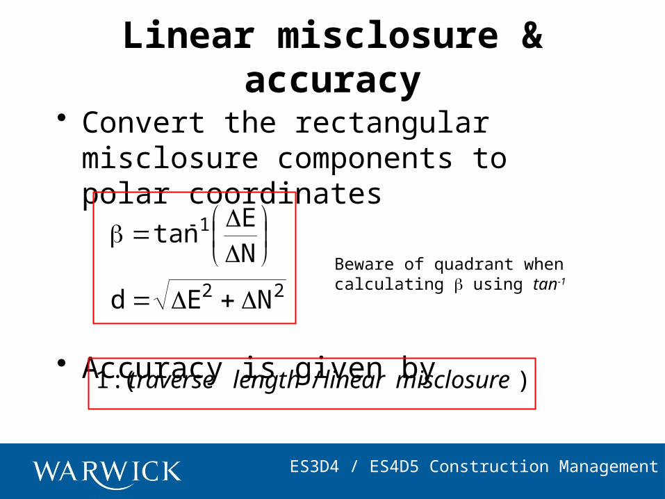
Linear misclosure & accuracy
• Convert the rectangular misclosure components to polar coordinates
• Accuracy is given by
22
1
NEd
NE
tan
)/(: misclosurelinearlengthtraverse1
Beware of quadrant whencalculating using tan-1
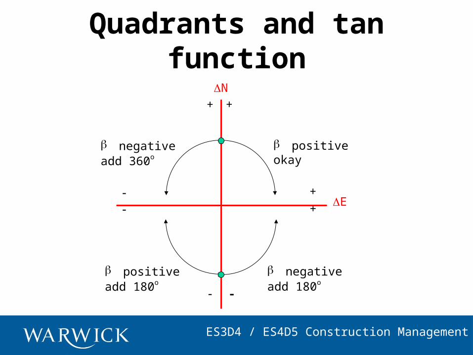
ES3D4 / ES4D5 Construction Management
N
E
b positiveadd 180o
Quadrants and tan function
+
b negativeadd 180o
+
b negativeadd 360o
+
+
b positiveokay
ES3D4 / ES4D5 Construction Management
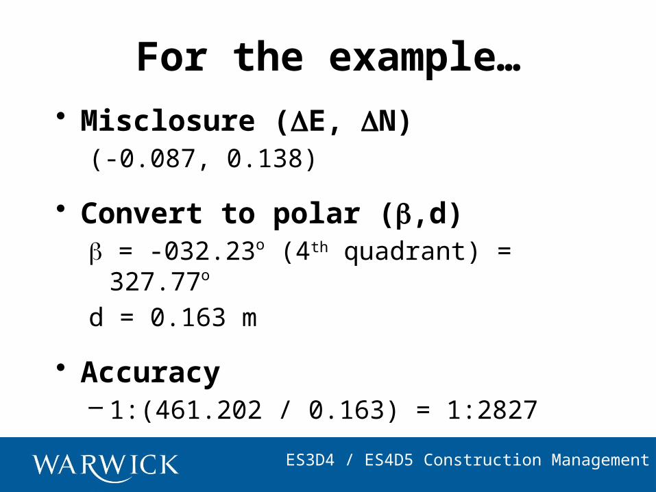
For the example…• Misclosure (E, N)
(-0.087, 0.138)
• Convert to polar (,d) = -032.23o (4th quadrant) = 327.77o d = 0.163 m
• Accuracy– 1:(461.202 / 0.163) = 1:2827
ES3D4 / ES4D5 Construction Management
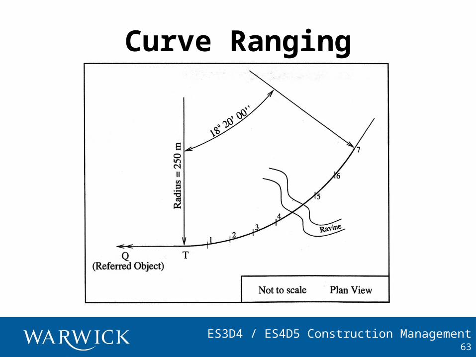
Curve Ranging
63
ES3D4 / ES4D5 Construction Management
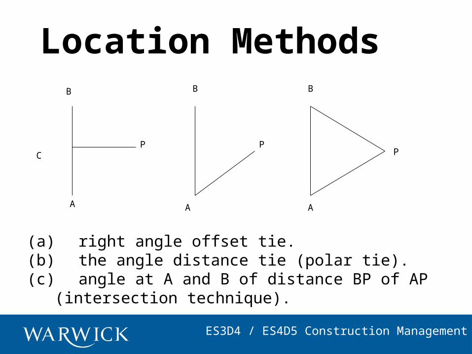
Location Methods
(a) right angle offset tie.(b) the angle distance tie (polar tie).(c) angle at A and B of distance BP of AP
(intersection technique).
A
B
A A
B B
C PPP
ES3D4 / ES4D5 Construction Management
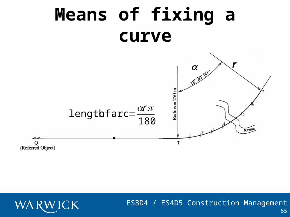
Means of fixing a curve
65
ra
180
rarc of length
ES3D4 / ES4D5 Construction Management
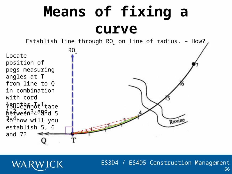
Means of fixing a curve
66
Establish line through ROr on line of radius. – How?
Locate position of pegs measuring angles at T from line to Q in combination with cord lengths T-1, 1-2, 2-3 and 3-4.
You cannot tape between 4 and 5 so how will you establish 5, 6 and 7?
ROr
ES3D4 / ES4D5 Construction Management
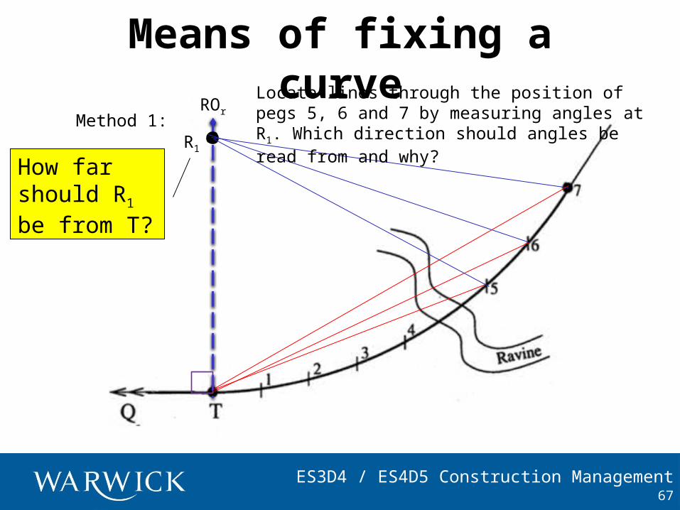
Means of fixing a curve
67
R1
Method 1:
How far should R1 be from T?
ROr
Locate lines through the position of pegs 5, 6 and 7 by measuring angles at R1. Which direction should angles be read from and why?
ES3D4 / ES4D5 Construction Management
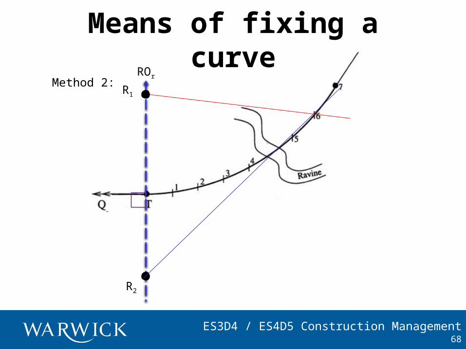
Means of fixing a curve
68
R2
Method 2:R1
ROr
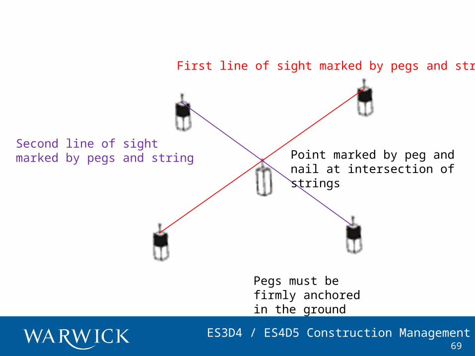
ES3D4 / ES4D5 Construction Management69
First line of sight marked by pegs and string
Second line of sight marked by pegs and string Point marked by peg and
nail at intersection of strings
Pegs must be firmly anchored in the ground