Embed Size (px)
Citation preview
Essentials of Oceanography, Thurman and Trujillo
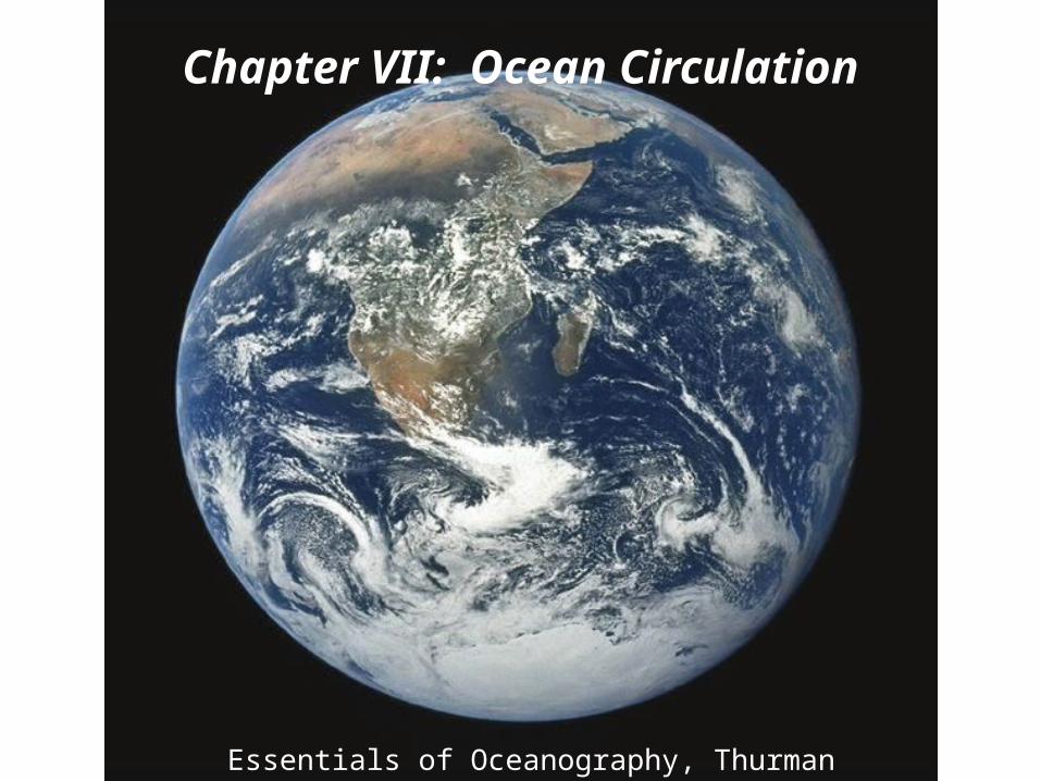
Chapter VII: Ocean Circulation
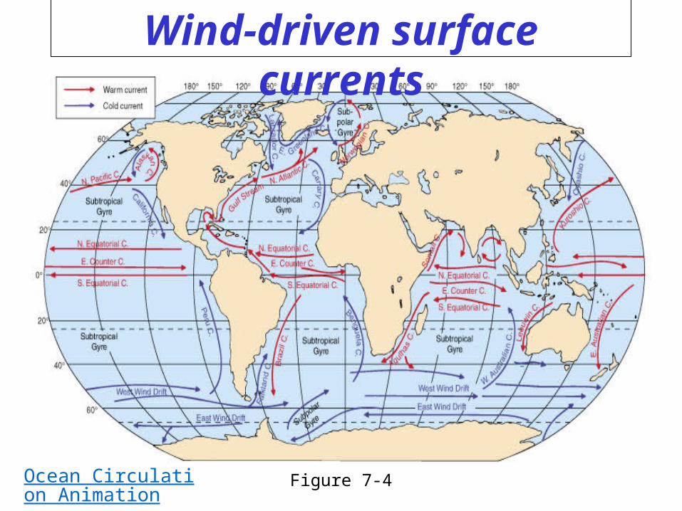
Wind-driven surface currents
Figure 7-4Ocean Circulation Animation
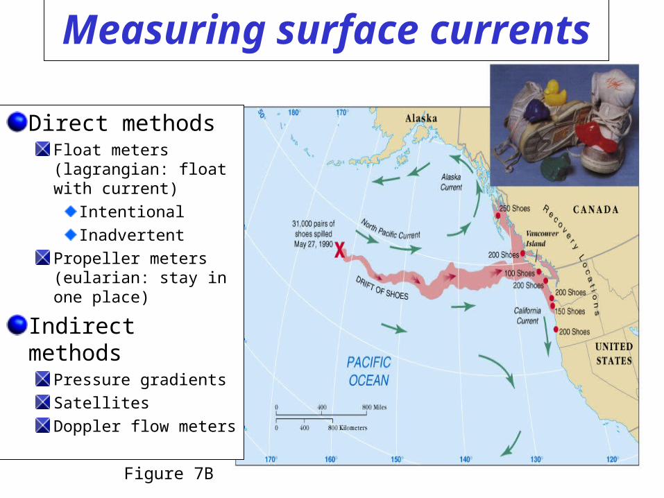
Measuring surface currents
Direct methodsFloat meters (lagrangian: float with current)
Intentional
Inadvertent
Propeller meters (eularian: stay in one place)
Indirect methodsPressure gradients
Satellites
Doppler flow meters
Figure 7B
Ocean currentsSurface currents
Affect surface water within and above the pycnocline (10% of ocean water…I think it is more like 25% of ocean water)Driven by major wind belts of the world
Deep currentsAffect deep water below pycnocline (90% of ocean water…I think it is more like 75%)Driven by density differencesLarger and slower than surface currents
NO CLEAR CUT DELINEATION
Deep water masses and currents
Deep water masses:Form in subpolar regions at the surfaceAre created when high density surface water sinksFactors affecting density of surface water:
Temperature (most important factor)Salinity
Deep currents which transport deep waters are also known as thermohaline circulation
Characteristics of deep waters are determined AT THE SURFACE
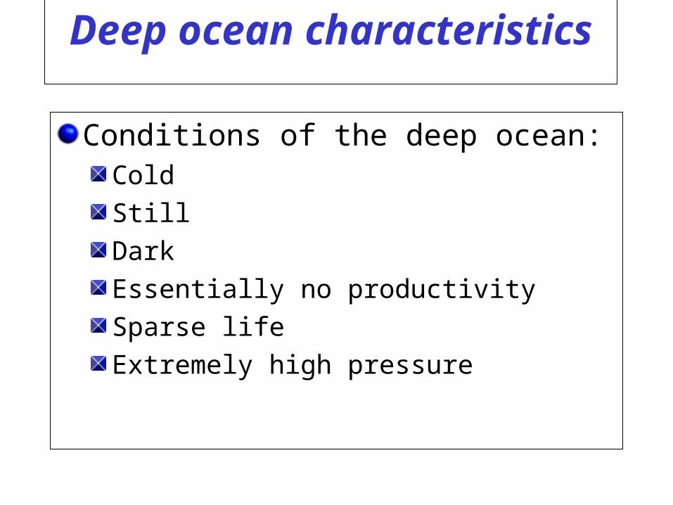
Deep ocean characteristics
Conditions of the deep ocean:Cold
Still
Dark
Essentially no productivity
Sparse life
Extremely high pressure
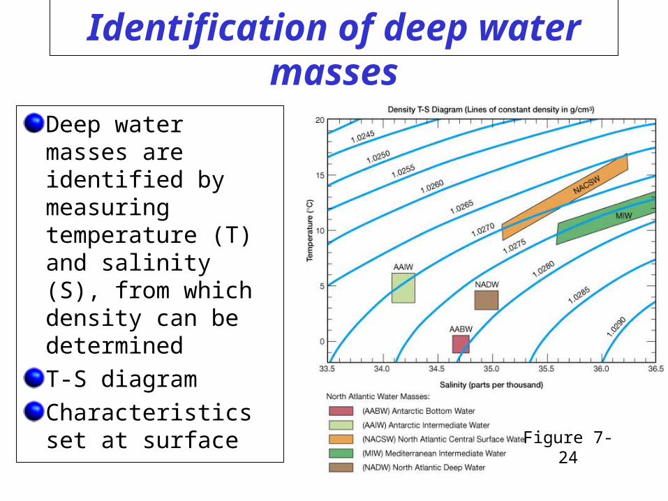
Identification of deep water masses
Deep water masses are identified by measuring temperature (T) and salinity (S), from which density can be determined
T-S diagram
Characteristics set at surface
Figure 7-24
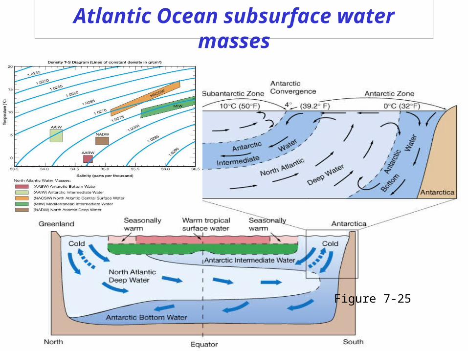
Atlantic Ocean subsurface water masses
Figure 7-25
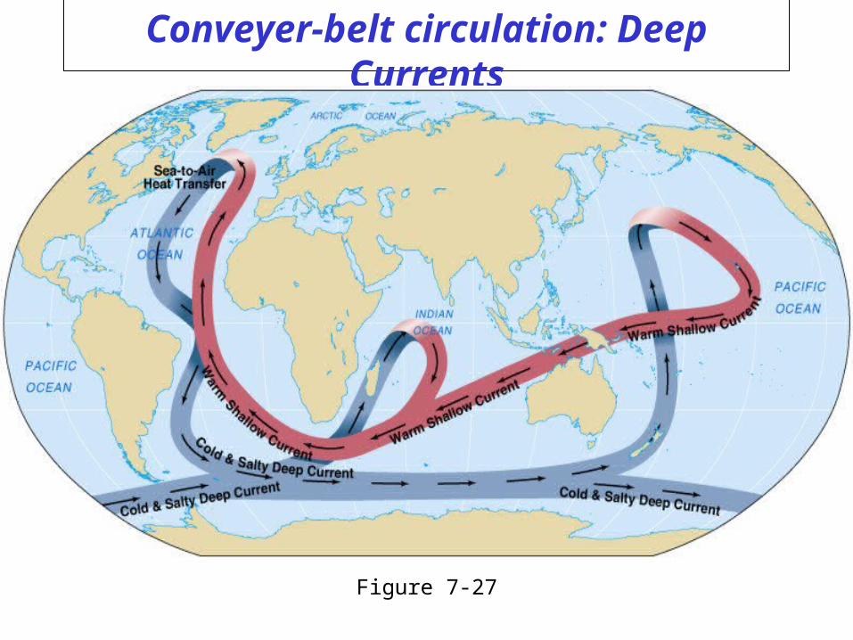
Conveyer-belt circulation: Deep Currents
Figure 7-27
Understanding the formation of SURFACE currents
4 Primary things that need to be understood
- Ekman transport (and spiral)
- The idea of Convergence
- Conservation of Vorticity
- Geostrophic Balance
What drove Deep Currents?
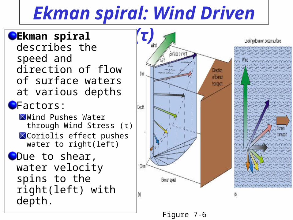
Ekman spiral: Wind Driven (τ)Ekman spiral describes the speed and direction of flow of surface waters at various depthsFactors:
Wind Pushes Water through Wind Stress (τ)Coriolis effect pushes water to right(left)
Due to shear, water velocity spins to the right(left) with depth.
Figure 7-6
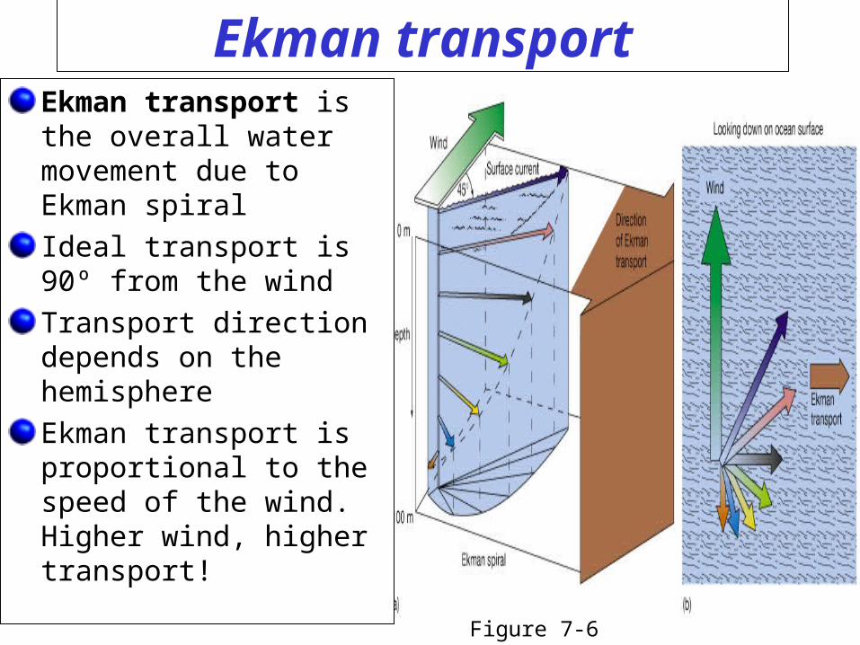
Ekman transportEkman transport is the overall water movement due to Ekman spiral
Ideal transport is 90º from the wind
Transport direction depends on the hemisphere
Ekman transport is proportional to the speed of the wind. Higher wind, higher transport!
Figure 7-6
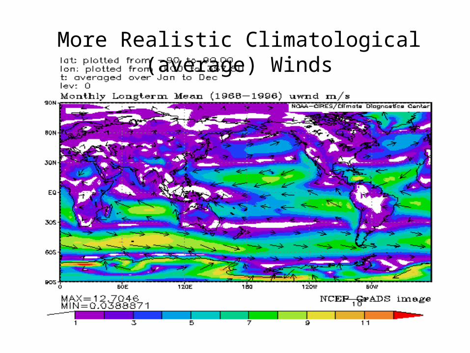
More Realistic Climatological (average) Winds
Understanding the formation of currents
4 Primary things that need to be understood
- Ekman transport (and spiral)
- The idea of Convergence
- Conservation of Vorticity
- Geostrophic Balance
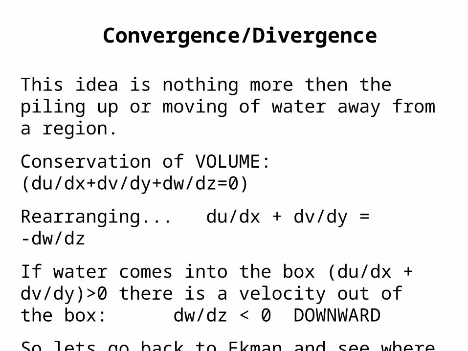
Convergence/Divergence
This idea is nothing more then the piling up or moving of water away from a region.
Conservation of VOLUME: (du/dx+dv/dy+dw/dz=0)
Rearranging... du/dx + dv/dy = -dw/dz
If water comes into the box (du/dx + dv/dy)>0 there is a velocity out of the box: dw/dz < 0 DOWNWARD
So lets go back to Ekman…and see where water is piled up and where it is emptied.
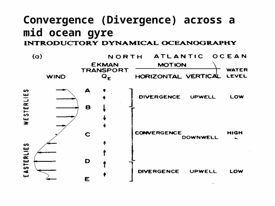
Convergence (Divergence) across a mid ocean gyre
Understanding the formation of currents
4 Primary things that need to be understood
- Ekman transport (and spiral)
- The idea of Convergence
- Conservation of Vorticity
- Geostrophic Balance
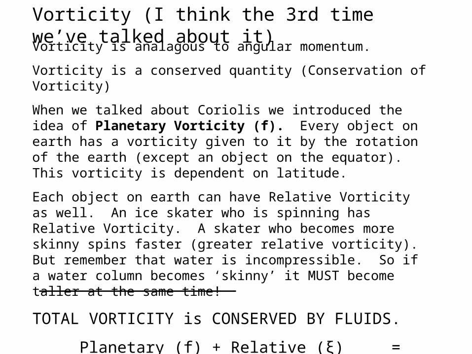
Vorticity (I think the 3rd time we’ve talked about it)
Vorticity is analagous to angular momentum.
Vorticity is a conserved quantity (Conservation of Vorticity)
When we talked about Coriolis we introduced the idea of Planetary Vorticity (f). Every object on earth has a vorticity given to it by the rotation of the earth (except an object on the equator). This vorticity is dependent on latitude.
Each object on earth can have Relative Vorticity as well. An ice skater who is spinning has Relative Vorticity. A skater who becomes more skinny spins faster (greater relative vorticity). But remember that water is incompressible. So if a water column becomes ‘skinny’ it MUST become taller at the same time!
TOTAL VORTICITY is CONSERVED BY FLUIDS.
Planetary (f) + Relative (ξ) = Constant H
H is the (tallness, or depth of water column)
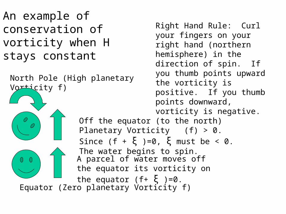
North Pole (High planetary Vorticity f)
Equator (Zero planetary Vorticity f)
A parcel of water moves off the equator its
vorticity on the equator (f+ ξ )=0.
Off the equator (to the north) Planetary Vorticity
(f) > 0. Since (f + ξ )=0, ξ must be < 0. The water begins to spin.
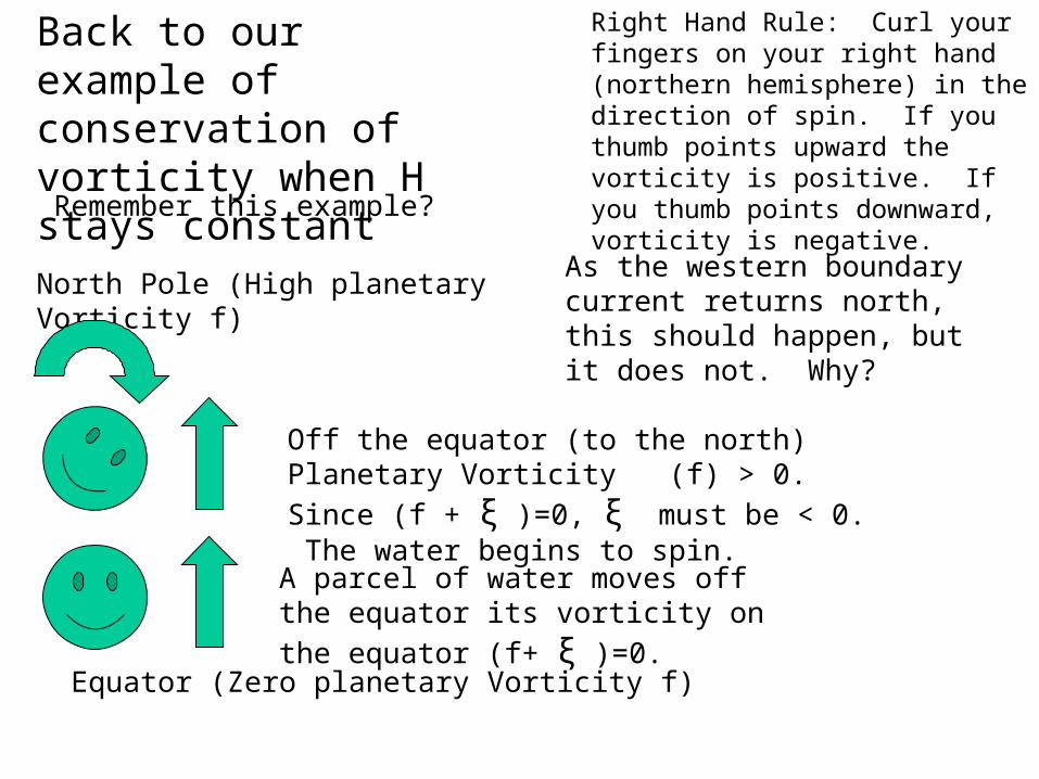
Right Hand Rule: Curl your fingers on your right hand (northern hemisphere) in the direction of spin. If you thumb points upward the vorticity is positive. If you thumb points downward, vorticity is negative.
An example of conservation of vorticity when H stays constant
Ocean Surface
Ocean bottom
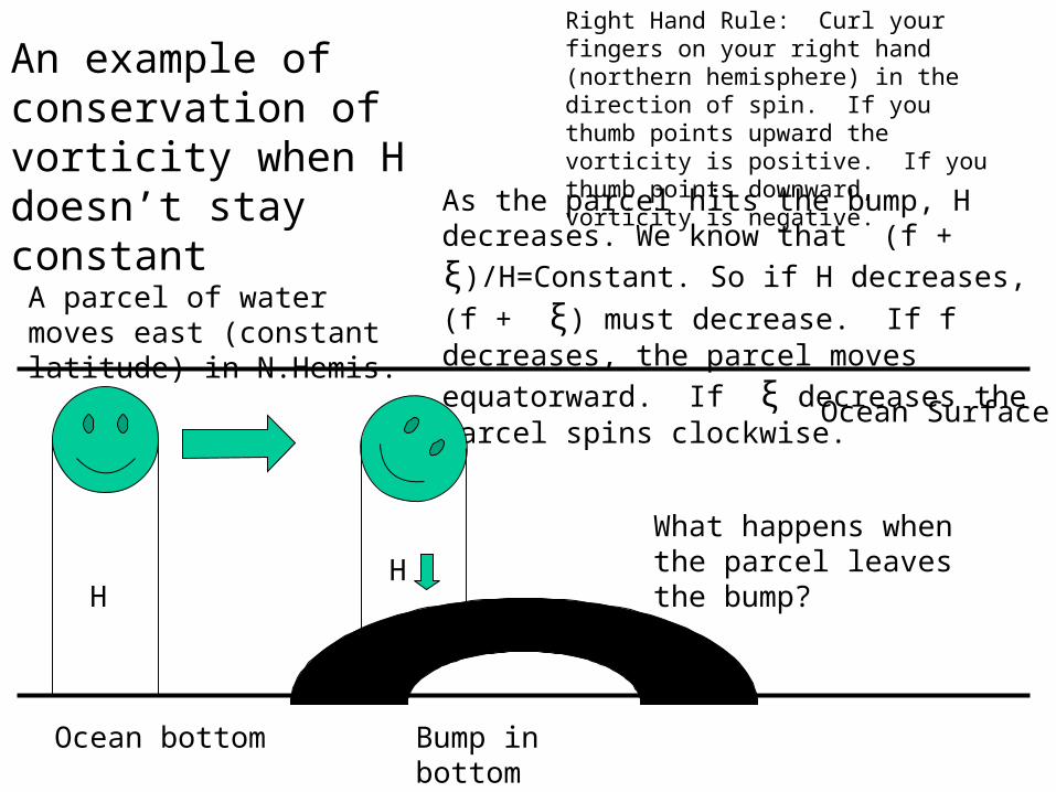
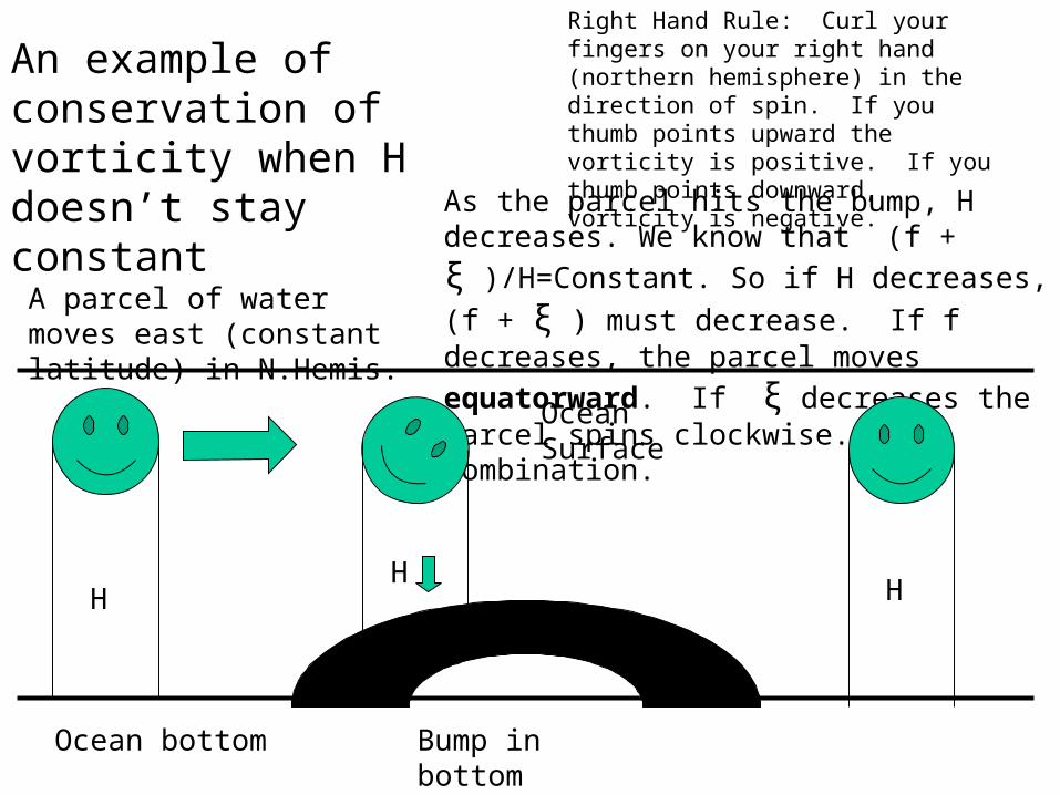
A parcel of water moves east (constant latitude) in N.Hemis.
As the parcel hits the bump, H decreases. We
know that (f + ξ)/H=Constant. So if H decreases,
(f + ξ) must decrease. If f decreases, the parcel
moves equatorward. If ξ decreases the parcel spins clockwise.
Right Hand Rule: Curl your fingers on your right hand (northern hemisphere) in the direction of spin. If you thumb points upward the vorticity is positive. If you thumb points downward, vorticity is negative.
An example of conservation of vorticity when H doesn’t stay constant
H
Bump in bottom
H
What happens when the parcel leaves the bump?
Ocean Surface
Ocean bottom
A parcel of water moves east (constant latitude) in N.Hemis.
As the parcel hits the bump, H decreases. We
know that (f + ξ )/H=Constant. So if H decreases,
(f + ξ ) must decrease. If f decreases, the parcel
moves equatorward. If ξ decreases the parcel spins clockwise. Or a combination.
Right Hand Rule: Curl your fingers on your right hand (northern hemisphere) in the direction of spin. If you thumb points upward the vorticity is positive. If you thumb points downward, vorticity is negative.
An example of conservation of vorticity when H doesn’t stay constant
H
Bump in bottom
H H
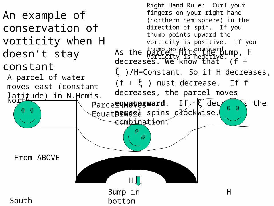
North
South
A parcel of water moves east (constant latitude) in N.Hemis.
As the parcel hits the bump, H decreases. We
know that (f + ξ )/H=Constant. So if H decreases,
(f + ξ ) must decrease. If f decreases, the parcel
moves equatorward. If ξ decreases the parcel spins clockwise. Or a combination.
Right Hand Rule: Curl your fingers on your right hand (northern hemisphere) in the direction of spin. If you thumb points upward the vorticity is positive. If you thumb points downward, vorticity is negative.
An example of conservation of vorticity when H doesn’t stay constant
Bump in bottom
H
H
From ABOVE
Parcel Moves Equatorward
Understanding the formation of currents
4 Primary things that need to be understood
- Ekman transport (and spiral)
- The idea of Convergence
- Conservation of Vorticity
- Geostrophic Balance
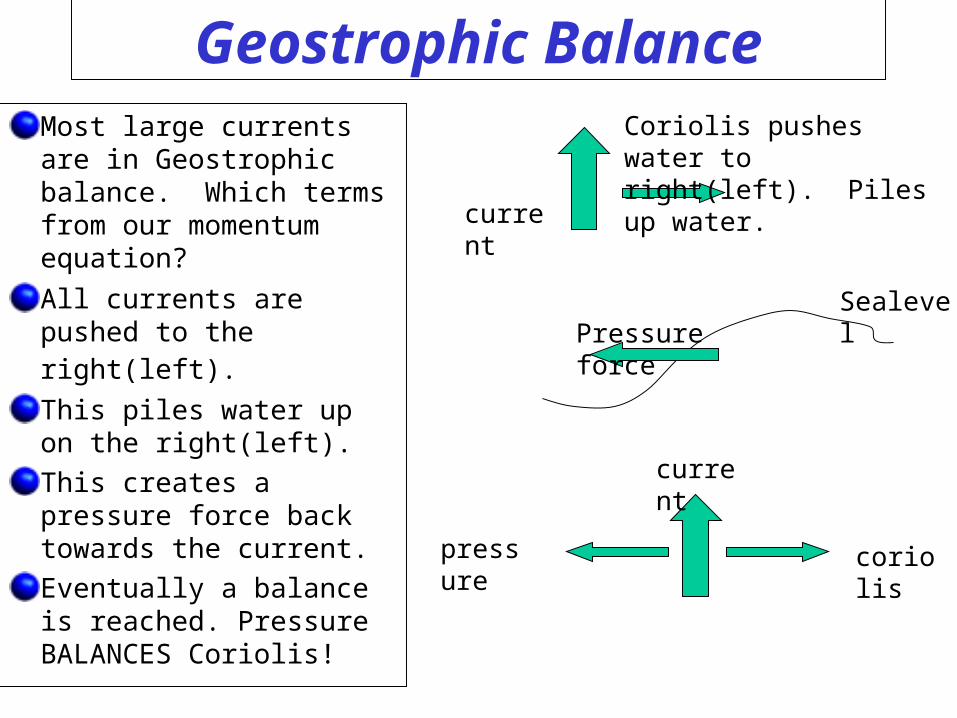
Geostrophic BalanceMost large currents are in Geostrophic balance. Which terms from our momentum equation?
All currents are pushed to the right(left). This piles water up on the right(left).
This creates a pressure force back towards the current.
Eventually a balance is reached. Pressure BALANCES Coriolis!
current
Coriolis pushes water to right(left). Piles up water.
SealevelPressure force
current
coriolispressure
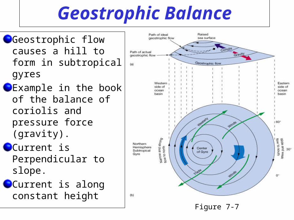
Geostrophic Balance
Geostrophic flow causes a hill to form in subtropical gyres
Example in the book of the balance of coriolis and pressure force (gravity).
Current is Perpendicular to slope.
Current is along constant height
Figure 7-7
Understanding the formation of currents
We’ve been introduced to the 4 Primary things that need to be understood. Let’s put them all together to understand what drives our ocean currents!
- Ekman transport (and spiral)
- The idea of Convergence
- Conservation of Vorticity
- Geostrophic Balance
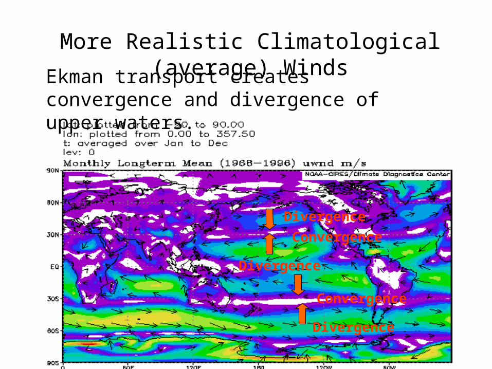
More Realistic Climatological (average) Winds
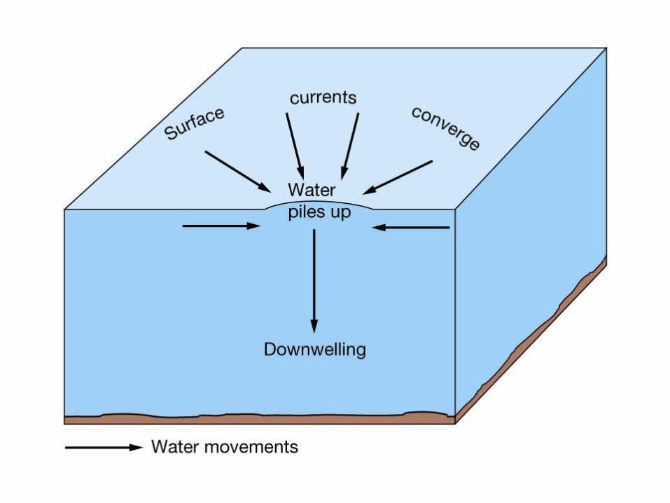
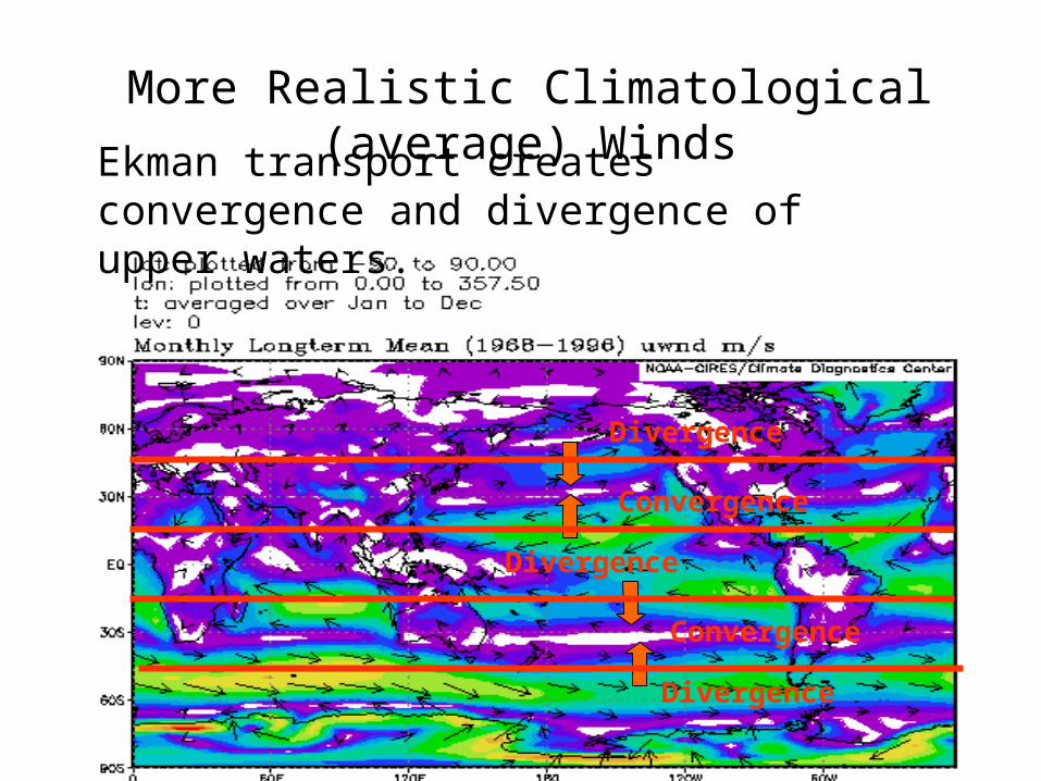
Ekman transport creates convergence and divergence of upper waters.
Convergence
Convergence
Divergence
Divergence
Divergence
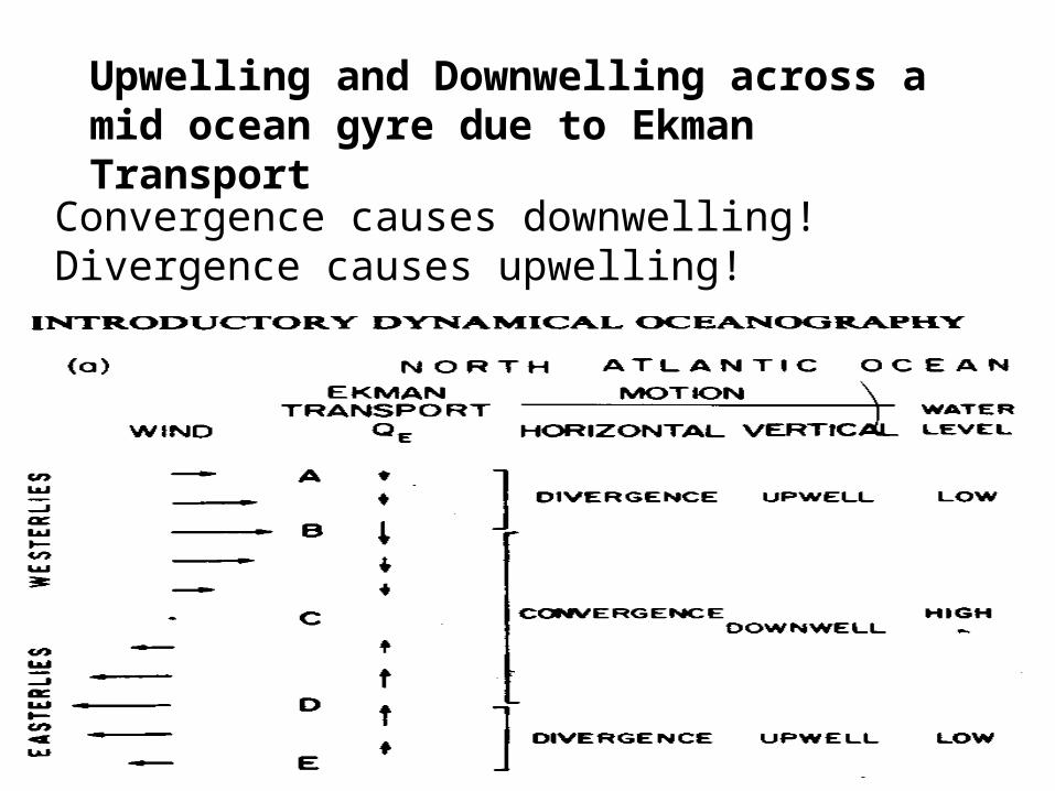
Upwelling and Downwelling across a mid ocean gyre due to Ekman Transport
Convergence causes downwelling! Divergence causes upwelling!
Ocean Surface
Mixed Layer
Ocean bottom
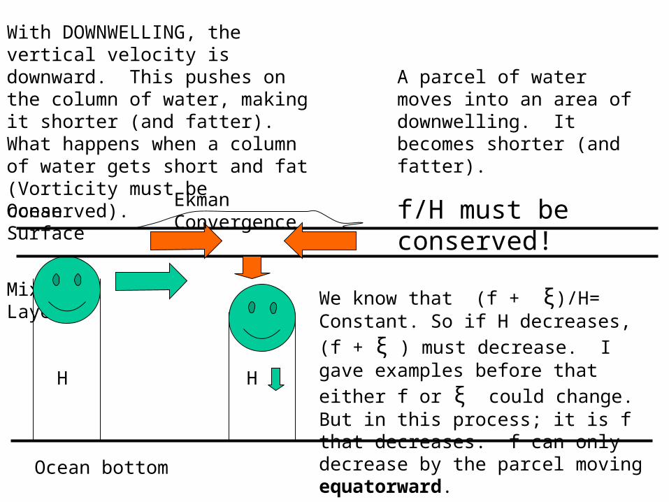
A parcel of water moves into an area of downwelling. It becomes shorter (and fatter).
f/H must be conserved!
We know that (f + ξ)/H= Constant. So if H
decreases, (f + ξ ) must decrease. I gave
examples before that either f or ξ could change. But in this process; it is f that decreases. f can only decrease by the parcel moving equatorward.
With DOWNWELLING, the vertical velocity is downward. This pushes on the column of water, making it shorter (and fatter). What happens when a column of water gets short and fat (Vorticity must be conserved).
H H
Ekman Convergence
More Realistic Climatological (average) Winds
Ekman transport creates convergence and divergence of upper waters.
Convergence
Convergence
Divergence
Divergence
Divergence
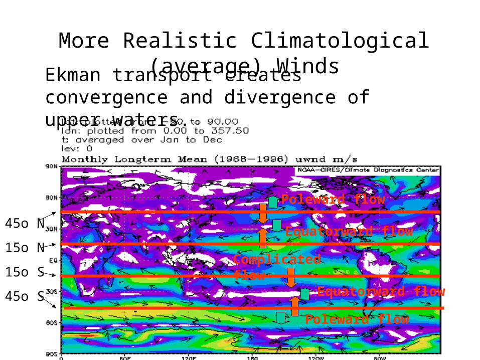
More Realistic Climatological (average) Winds
Ekman transport creates convergence and divergence of upper waters.
Equatorward flow
Equatorward flow
Poleward flow
Poleward flow
Complicated flow
45o N
15o N
15o S
45o S
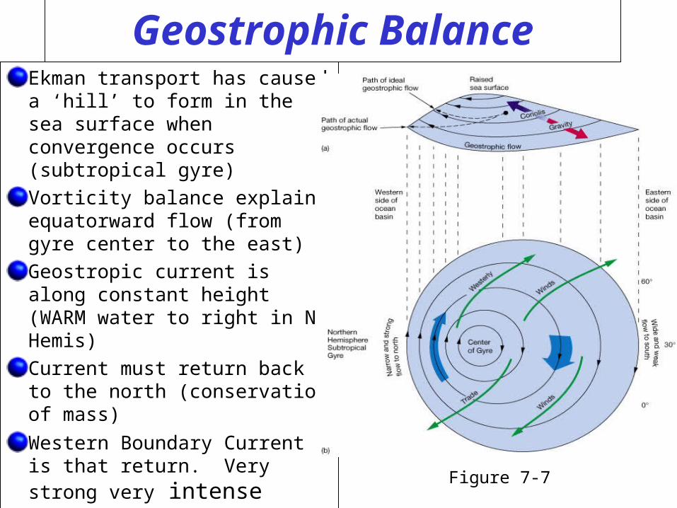
Geostrophic BalanceEkman transport has caused a ‘hill’ to form in the sea surface when convergence occurs (subtropical gyre)
Vorticity balance explains equatorward flow (from gyre center to the east)
Geostropic current is along constant height (WARM water to right in N Hemis)
Current must return back to the north (conservation of mass)
Western Boundary Current is that return. Very strong very intense
Figure 7-7
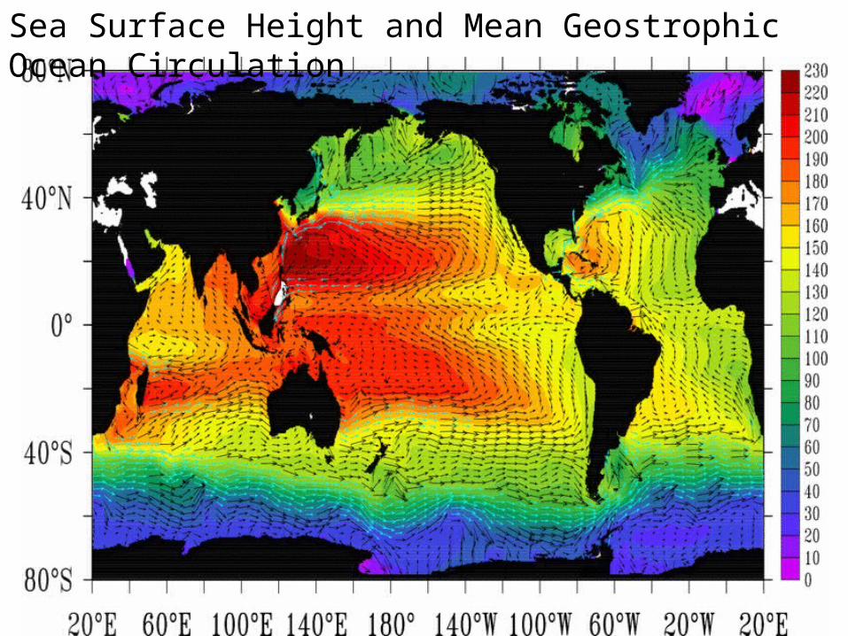
Sea Surface Height and Mean Geostrophic Ocean Circulation
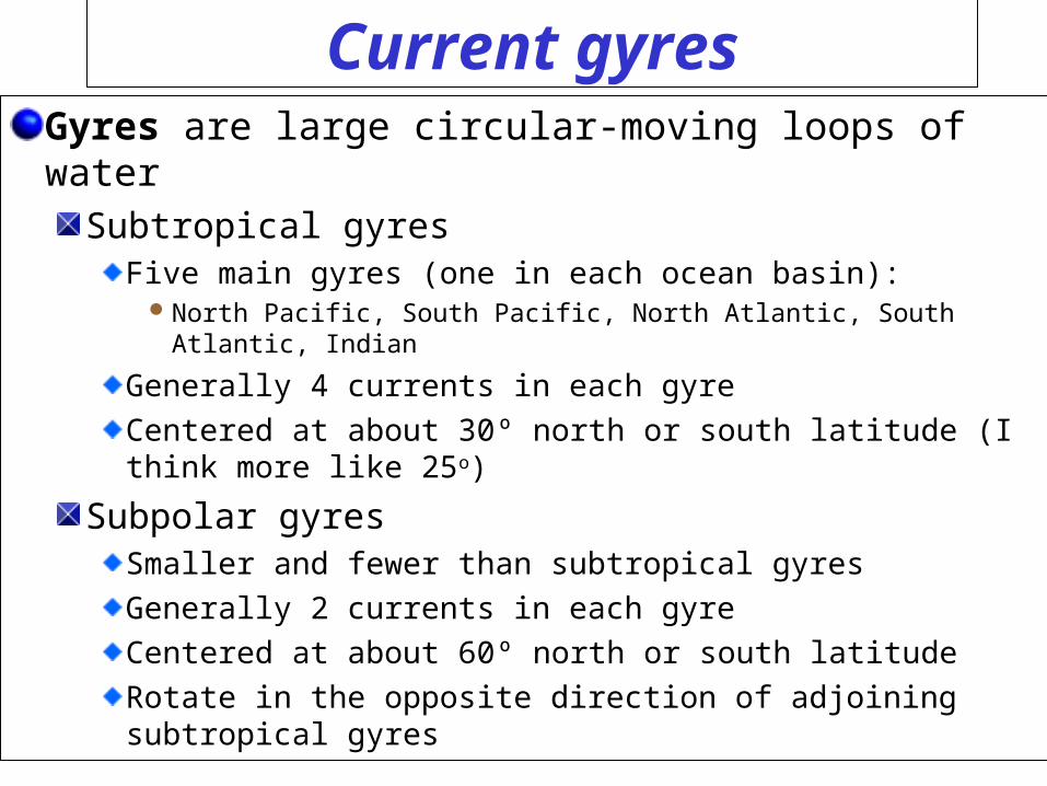
Current gyresGyres are large circular-moving loops of water
Subtropical gyresFive main gyres (one in each ocean basin):
North Pacific, South Pacific, North Atlantic, South Atlantic, Indian
Generally 4 currents in each gyre
Centered at about 30º north or south latitude (I think more like 25o)
Subpolar gyresSmaller and fewer than subtropical gyres
Generally 2 currents in each gyre
Centered at about 60º north or south latitude
Rotate in the opposite direction of adjoining subtropical gyres
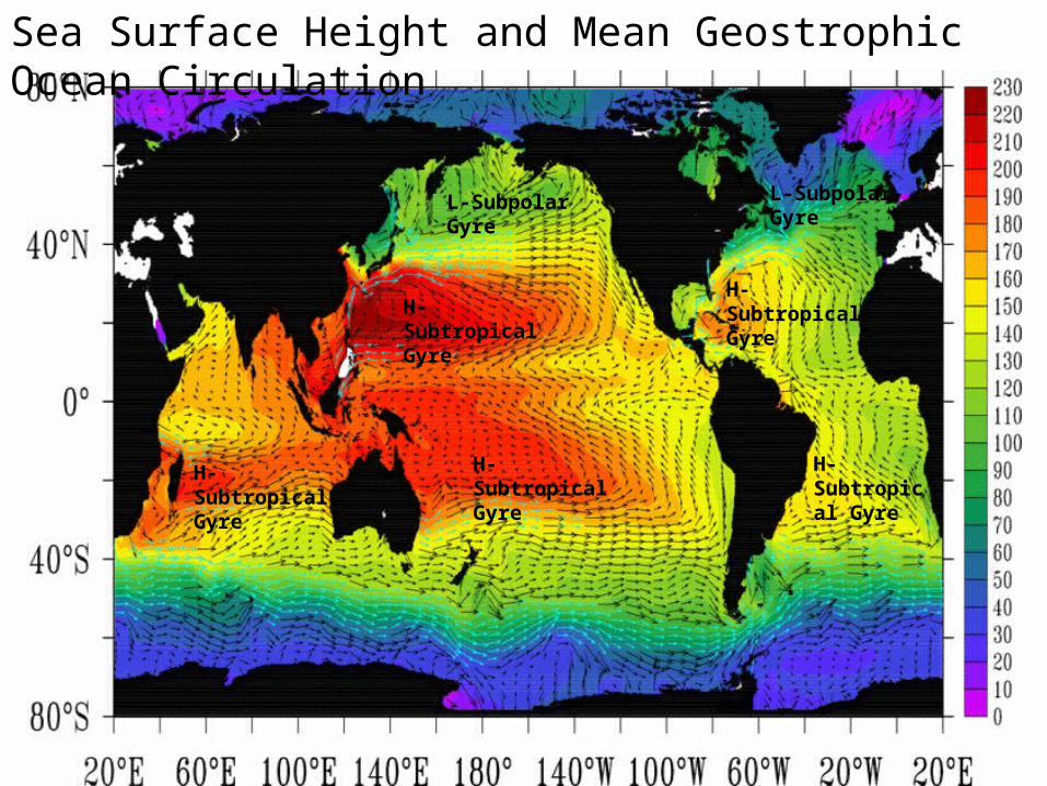
Sea Surface Height and Mean Geostrophic Ocean Circulation
H-Subtropical Gyre
L-Subpolar Gyre
H-Subtropical Gyre
H-Subtropical Gyre
H-Subtropical Gyre
H-Subtropical Gyre
L-Subpolar Gyre
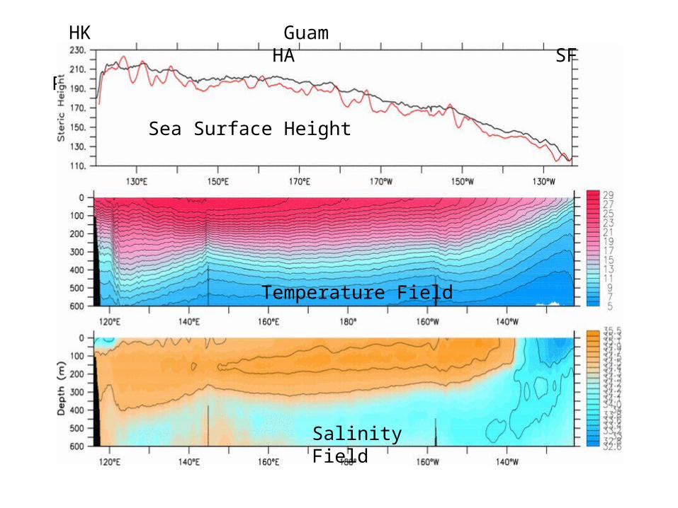
P37 mean dyht and temperature field
HK Guam HA SF
Sea Surface Height
Temperature Field
Salinity Field
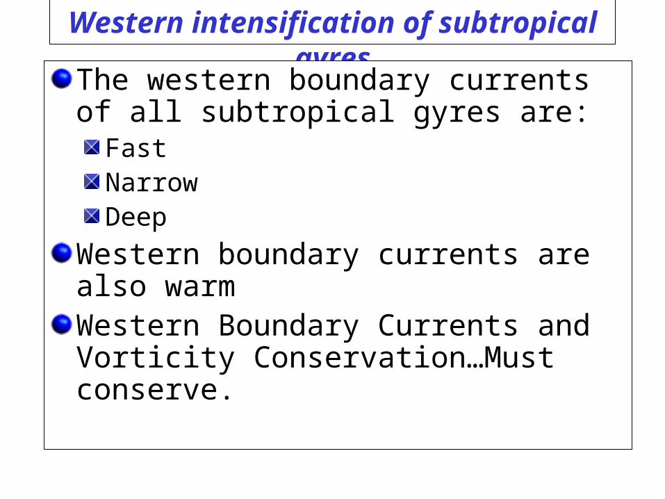
Western intensification of subtropical gyres
The western boundary currents of all subtropical gyres are:
FastNarrowDeep
Western boundary currents are also warmWestern Boundary Currents and Vorticity Conservation…Must conserve.
North Pole (High planetary Vorticity f)
Equator (Zero planetary Vorticity f)
A parcel of water moves off the equator its
vorticity on the equator (f+ ξ )=0.
Off the equator (to the north) Planetary Vorticity
(f) > 0. Since (f + ξ )=0, ξ must be < 0. The water begins to spin.
Right Hand Rule: Curl your fingers on your right hand (northern hemisphere) in the direction of spin. If you thumb points upward the vorticity is positive. If you thumb points downward, vorticity is negative.
Back to our example of conservation of vorticity when H stays constant
Remember this example?
As the western boundary current returns north, this should happen, but it does not. Why?
North Pole (High planetary Vorticity f)
Equator (Zero planetary Vorticity f)
A parcel of water moves off the equator its
vorticity on the equator (f+ ξ )=0.
Off the equator (to the north) Planetary Vorticity
(f) > 0. Since (f + ξ )=0, ξ must be < 0. The water begins to spin.
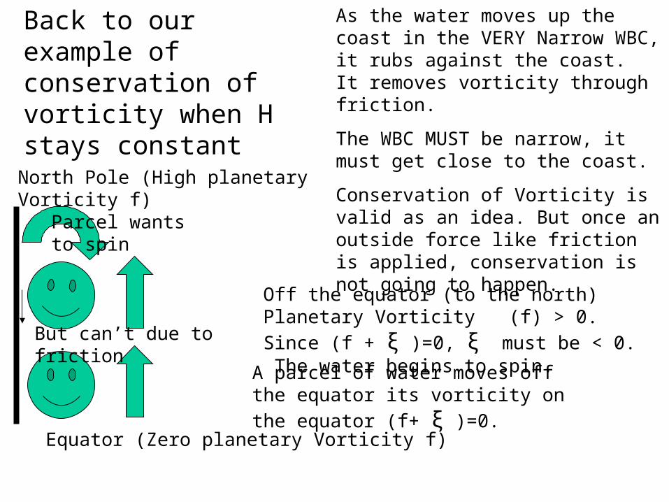
Back to our example of conservation of vorticity when H stays constant
As the water moves up the coast in the VERY Narrow WBC, it rubs against the coast. It removes vorticity through friction.
The WBC MUST be narrow, it must get close to the coast.
Conservation of Vorticity is valid as an idea. But once an outside force like friction is applied, conservation is not going to happen.
Parcel wants to spin
But can’t due to friction
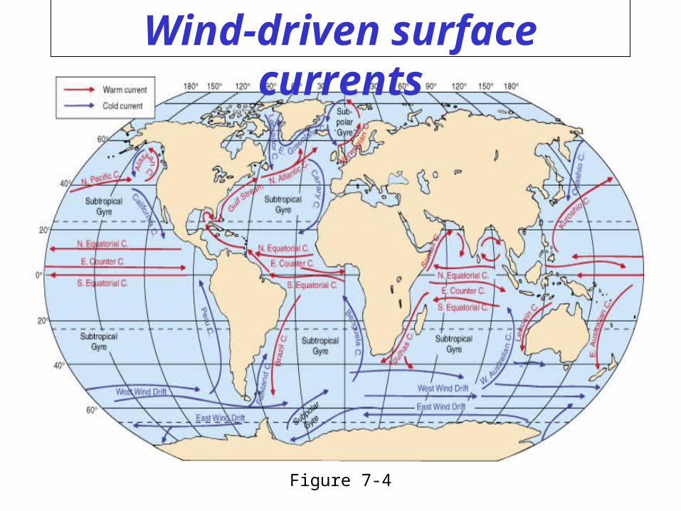
Wind-driven surface currents
Figure 7-4
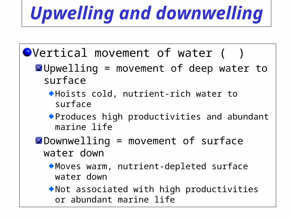
Upwelling and downwelling
Vertical movement of water ()Upwelling = movement of deep water to surface
Hoists cold, nutrient-rich water to surface
Produces high productivities and abundant marine life
Downwelling = movement of surface water downMoves warm, nutrient-depleted surface water down
Not associated with high productivities or abundant marine life
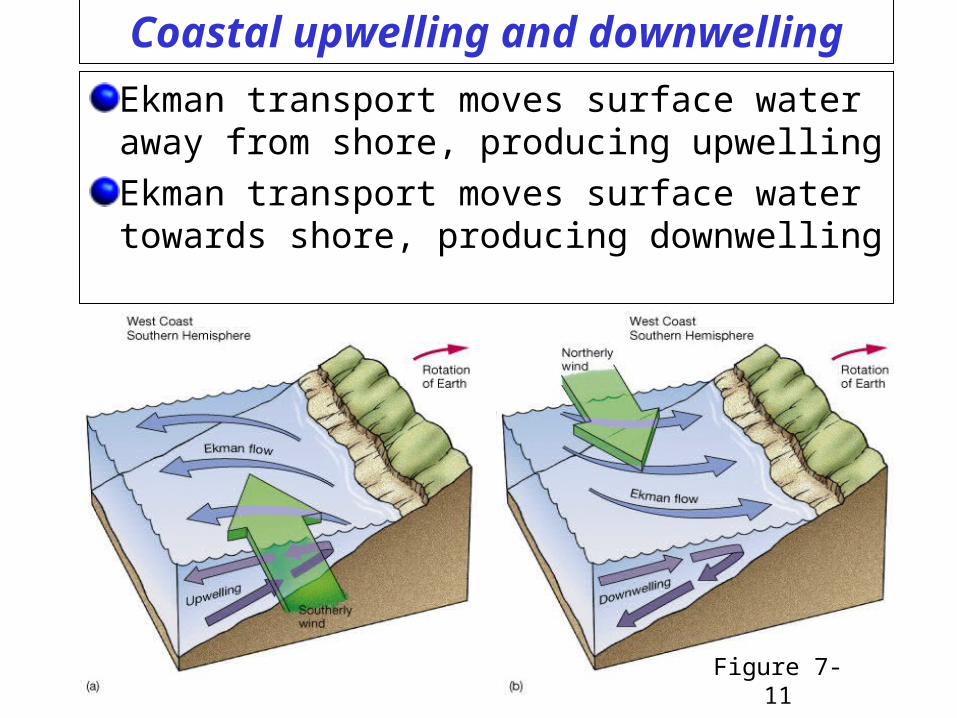
Coastal upwelling and downwelling
Ekman transport moves surface water away from shore, producing upwelling
Ekman transport moves surface water towards shore, producing downwelling
Figure 7-11
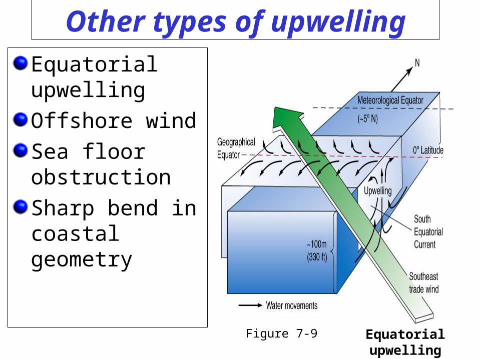
Other types of upwellingEquatorial upwelling
Offshore wind
Sea floor obstruction
Sharp bend in coastal geometry
Figure 7-9 Equatorial upwelling
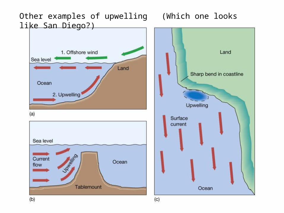
Other examples of upwelling (Which one looks like San Diego?)
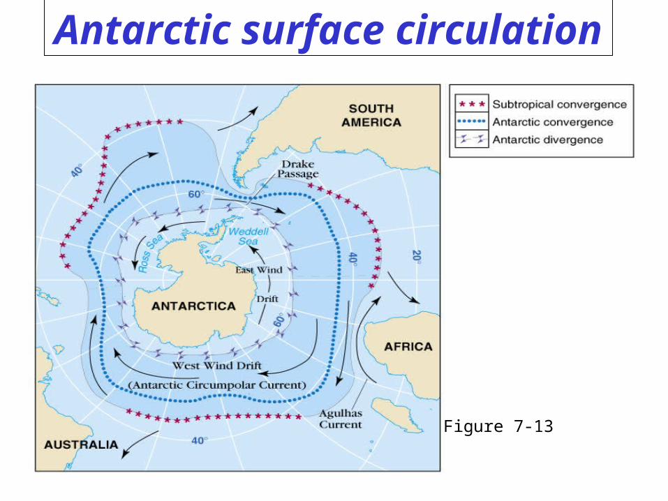
Antarctic surface circulation
Figure 7-13
Ocean surface currents
What Currents do you need to know?
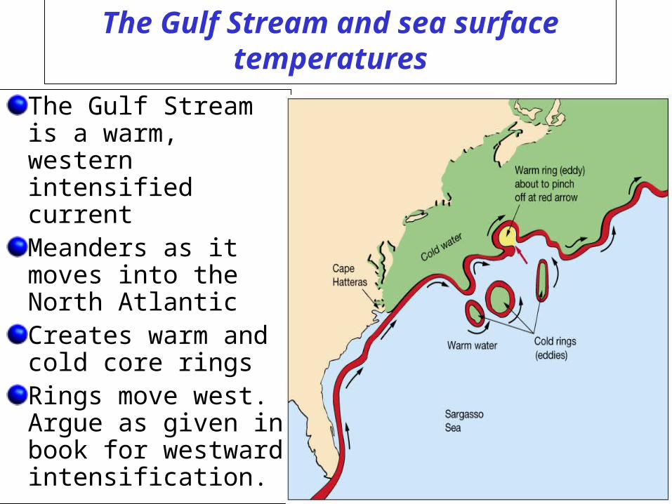
The Gulf Stream and sea surface temperatures
The Gulf Stream is a warm, western intensified currentMeanders as it moves into the North AtlanticCreates warm and cold core ringsRings move west. Argue as given in book for westward intensification.
Figure 7-16
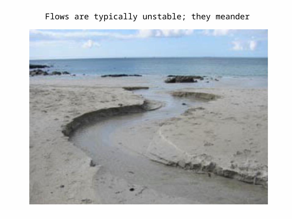
Flows are typically unstable; they meander
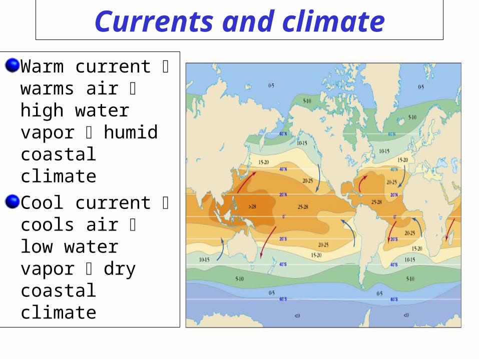
Currents and climate
Warm current warms air high water vapor humid coastal climate
Cool current cools air low water vapor dry coastal climate
Figure 7-8a
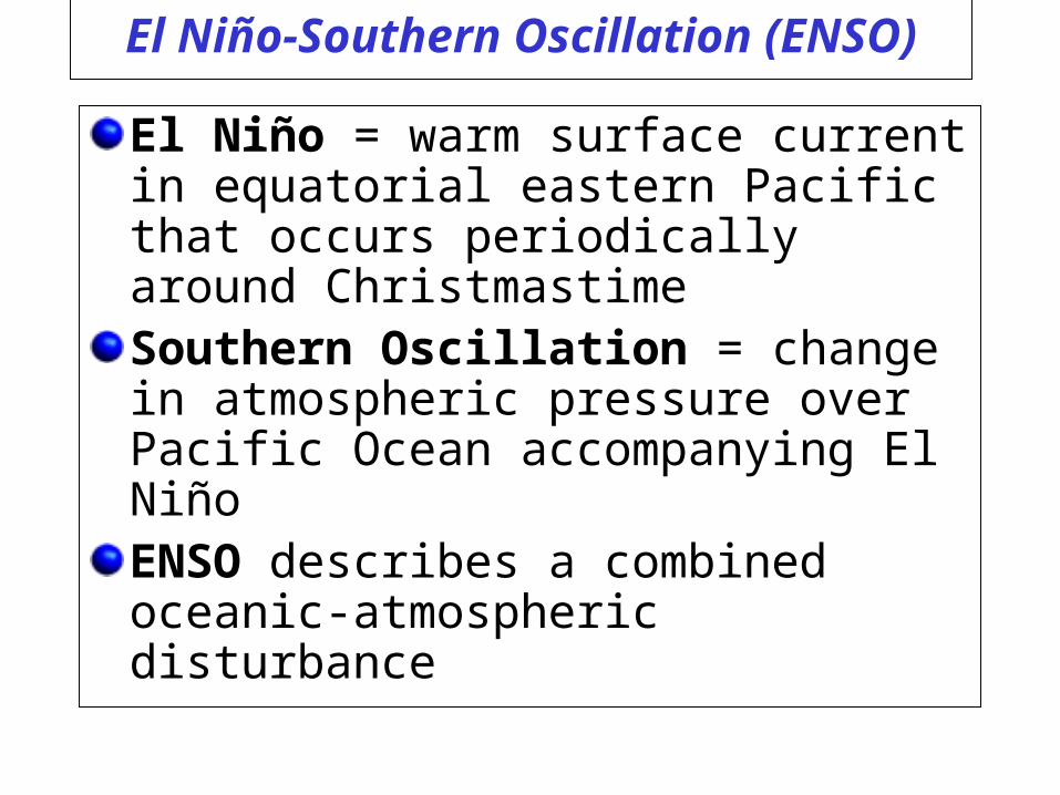
El Niño-Southern Oscillation (ENSO)
El Niño = warm surface current in equatorial eastern Pacific that occurs periodically around ChristmastimeSouthern Oscillation = change in atmospheric pressure over Pacific Ocean accompanying El NiñoENSO describes a combined oceanic-atmospheric disturbance
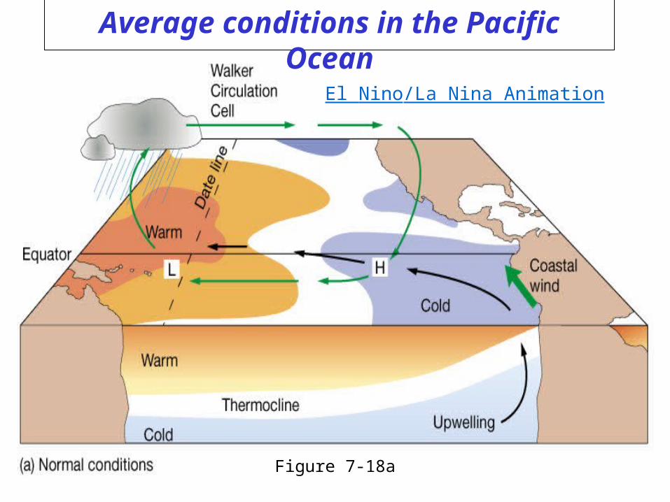
Average conditions in the Pacific Ocean
Figure 7-18a
El Nino/La Nina Animation
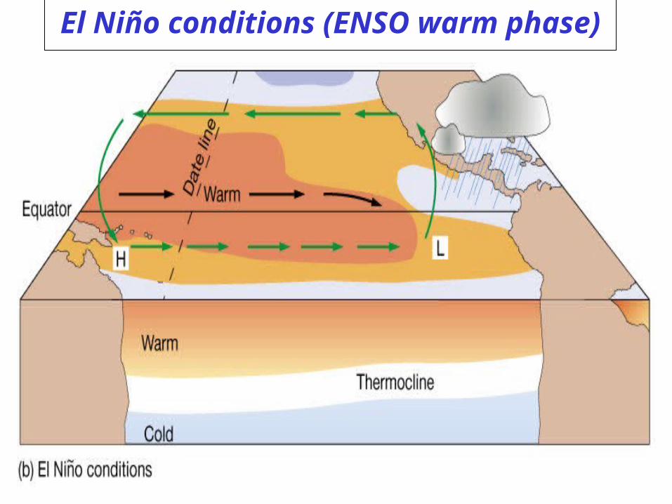
El Niño conditions (ENSO warm phase)
Figure 7-18b
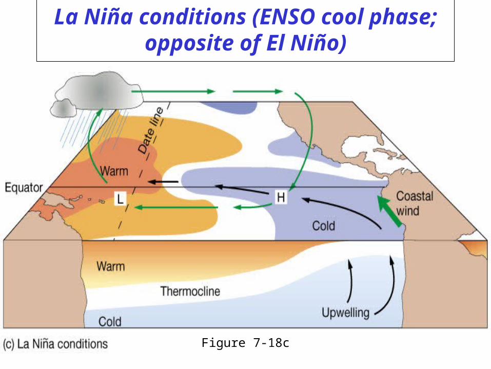
La Niña conditions (ENSO cool phase; opposite of El Niño)
Figure 7-18c
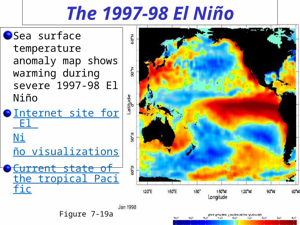
The 1997-98 El NiñoSea surface temperature anomaly map shows warming during severe 1997-98 El Niño
Internet site for El Niño visualizations
Current state of the tropical Pacific
Figure 7-19a
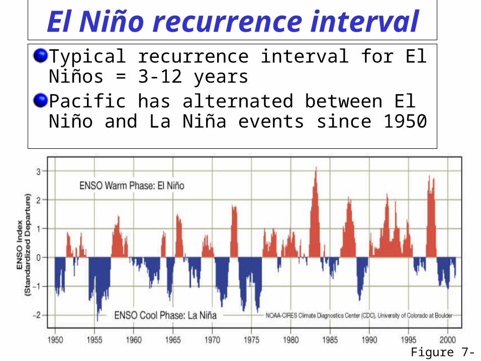
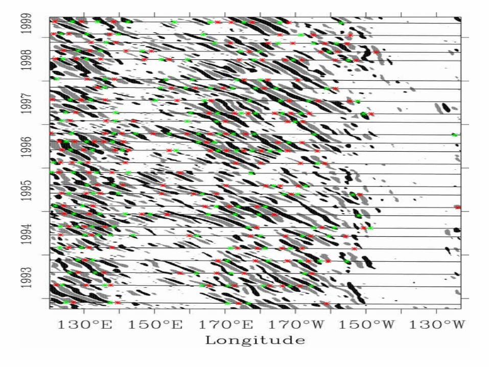
El Niño recurrence intervalTypical recurrence interval for El Niños = 3-12 yearsPacific has alternated between El Niño and La Niña events since 1950
Figure 7-20
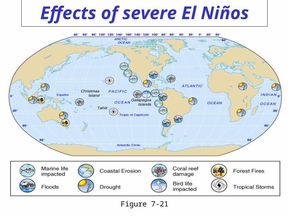
Effects of severe El Niños
Figure 7-21
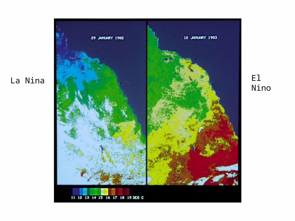
El NinoLa Nina
Essentials of Oceanography, Thurman and Trujillo
End of Chapter VII

Measuring currents through satellite
Red: High sea level…High sea level is warmer water (water expands when warm)…In N Hemisphere warm water is on the right. ONLY measures anomaly, Must add GEOID.
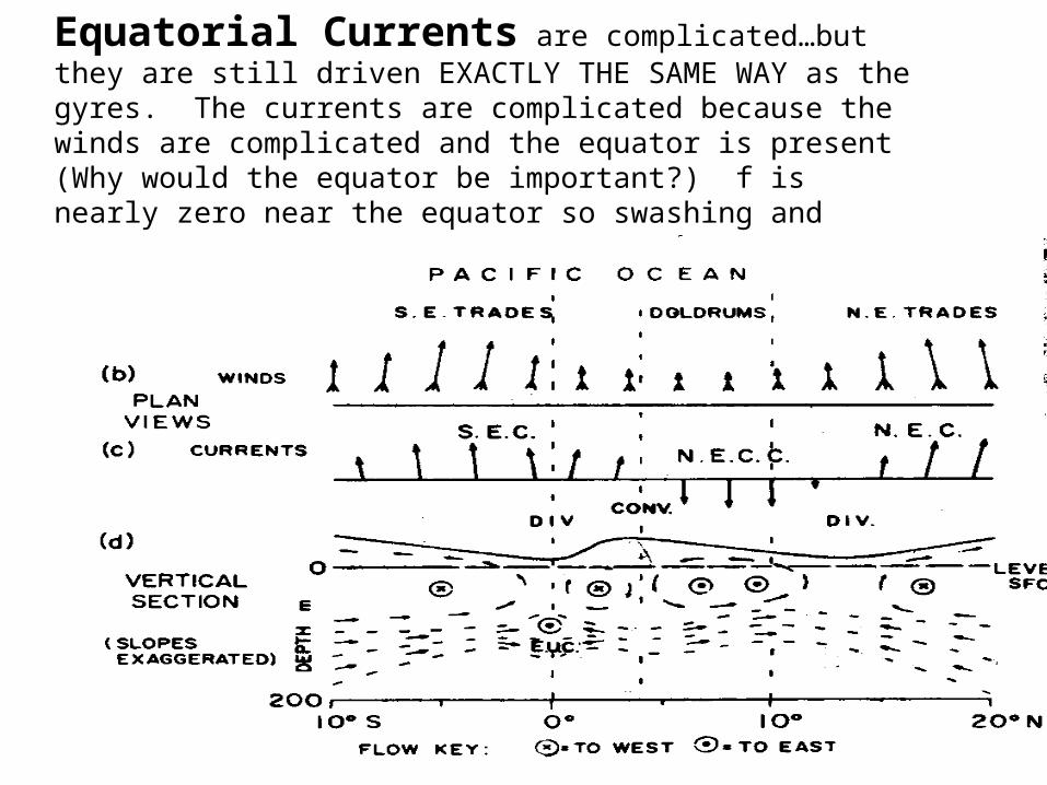
Equatorial Currents are complicated…but they are still driven EXACTLY THE SAME WAY as the gyres. The currents are complicated because the winds are complicated and the equator is present (Why would the equator be important?) f is nearly zero near the equator so swashing and stretching of water columns isn’t the driving force. The process is just ekman convergence/divergence and pressure forces.
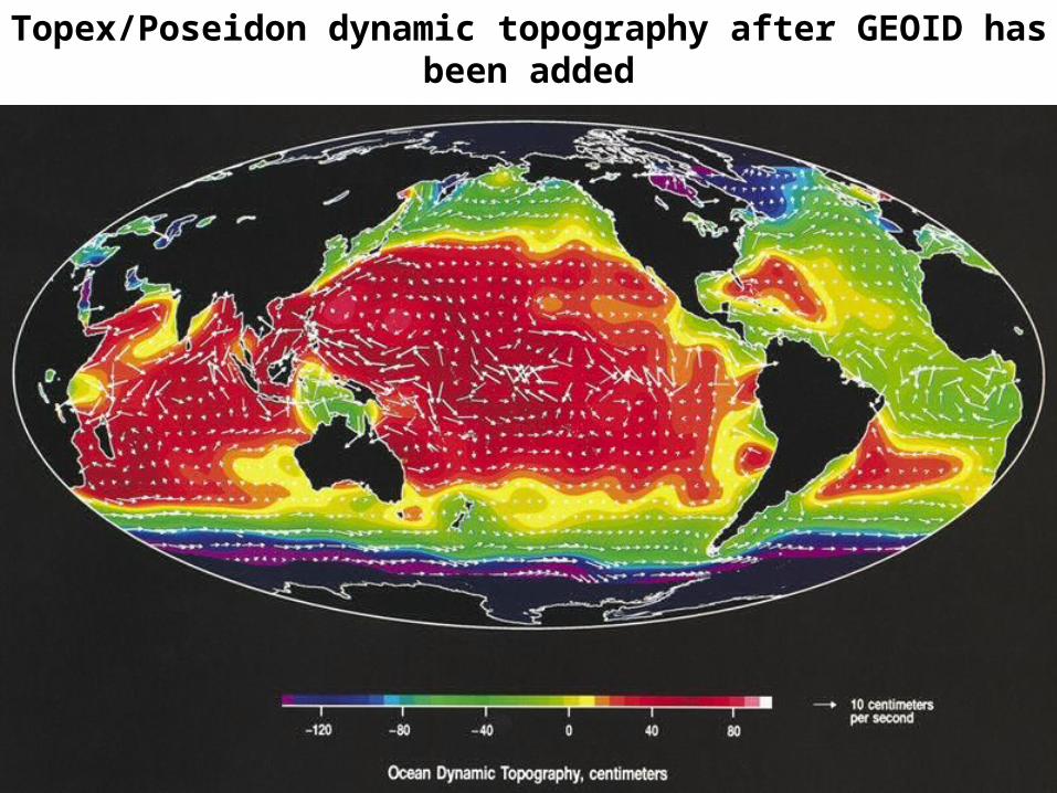
Topex/Poseidon dynamic topography after GEOID has been added
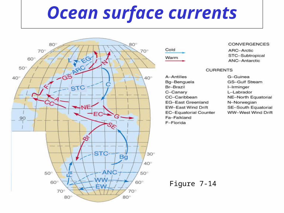
Ocean surface currents
Figure 7-14
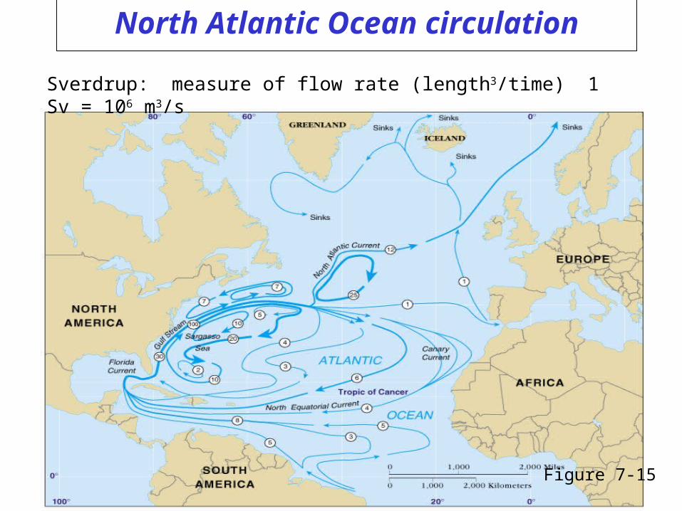
North Atlantic Ocean circulation
Figure 7-15
Sverdrup: measure of flow rate (length3/time) 1 Sv = 106 m3/s
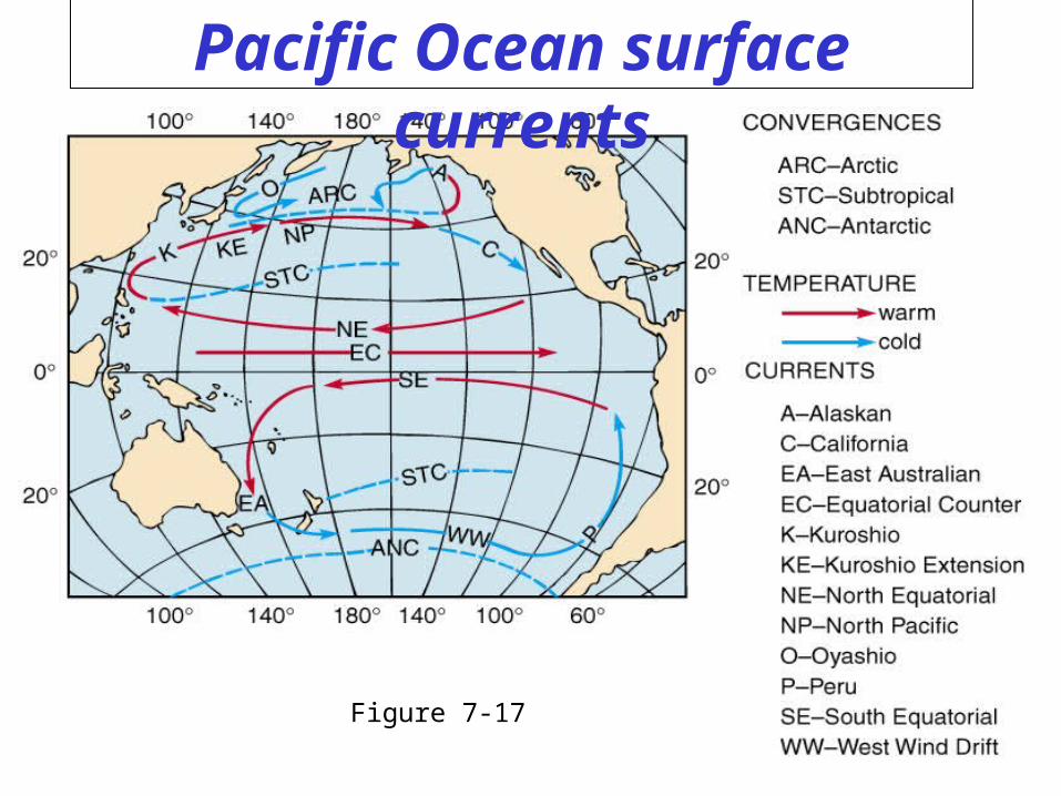
Pacific Ocean surface currents
Figure 7-17
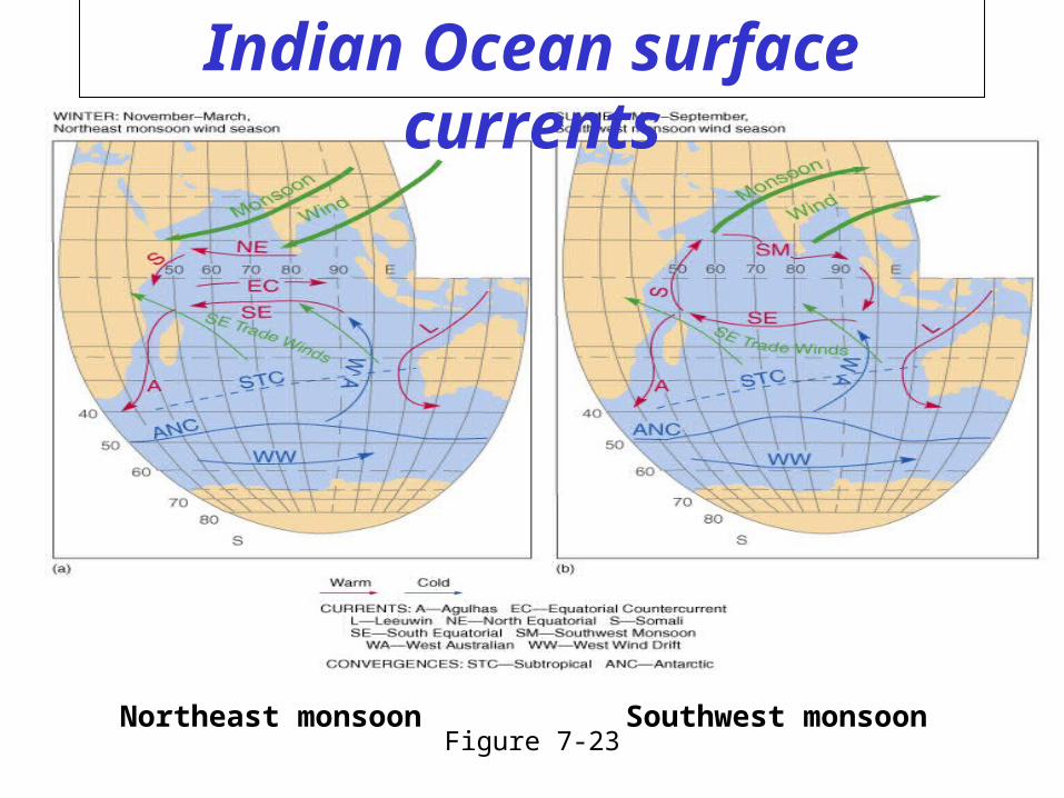
Indian Ocean surface currents
Figure 7-23Northeast monsoon Southwest monsoon