Embed Size (px)
Citation preview

Establishing SEA Guideline for
Environment friendly Water Resource
Development
Young-Il SongYoung-Il Song

Overview of Long-Term Plans for Dam Construction
Strategic Environmental Assessment
22
SEA of Long-Term Plans for Dam Construction
Overview of Plans for Water Resources
11
33
Conclusion44
Outline of presentation

Overview
Function
- Establish the Strategies for National Water Resource Management - Supervise Water Use and Flood Control
Legal Bases - Consist of 4 laws : River law, Stream Improvement law, Rural Improvement law, Dam Construction & Surrounding Area Support law - Includes 14 Administrative Plans
Target Area for Planning 1) Multi purpose Dam Construction 2) Dam Construction for Agriculture Use 3) River Maintenance 4) Stream Restoration
Overview of Plans for Water Resources11

System of Plans for Water ResourcesSystem of Plans for Water ResourcesSystem of Plans for Water ResourcesSystem of Plans for Water Resources
Longtime Master Plans for Water Resources
Master Plans for Stream
Improvement
Mid-Term Master Plans for Stream
Improvement
Basic Plans for River
Improvement
Long-Term Plan for Dam
construction
Master Plans for River Basin of Flood
Control
Basis Plans for Dam Construction
Implementation Plans for Dam Construction
Improvement Plans for Agriculture
Production
Master Plans for Rural
ImprovementFlood Control Water Utilization
DamRiver Maintenance
Implementation Plans for Stream
Improvement
Implementation Plans for River Improvement
Basic Plans for Improvement
Project
Implementation Plans for
Improvement Project

22
Longtime Master Plan for Water Resources
• Supreme Plan for Water Resource Management including Development, conservation maintenance• Formulate Every 20 Years• Establish Strategy for Water & Conservation Development
Long-Term Plan for Dam construction
• Establish Strategy for Environmental-friendly Dam Construction• Formulate Every 10 years
OverviewOverview
Overview of Long-Term Plans for Dam Overview of Long-Term Plans for Dam ConstructionConstruction

Longtime Master Plan for Water Resources
Water Shortage Regional
Regional Demand for Dam Construction
Review of Potential Dam Site
Flood Control Counter plan for Basin
Selection of Dam Site(1st)
Plan for Environmental friendly DevelopmentFinancial Plan
Selection of Dam Site(2nd)
Plan for regional Development
Long-Term Plan for Dam construction (Draft)
Confirmation of the plan
• Public Hearing• Consultation with Relative Agencies
Professional Consultation
Singular Purpose Dam: Household, Industry and etc.
Multi Purpose DamFlood Control Dam
Purpose of Flood Control Purpose of Water utilization
Site (Final)
Deliberation of Central River Council
Long-Term Plan for Dam constructionLong-Term Plan for Dam construction : Planning ProcedurePlanning ProcedureLong-Term Plan for Dam constructionLong-Term Plan for Dam construction : Planning ProcedurePlanning Procedure
SEA (Review of Possibility of Supplement Water Resources: Consider Alternatives)
SEA (Review of National Environmental Map)
SEA (Field Survey: Biodiversity,
Geology, Landscape, etc)
SEA (Technical Review : Amount of Water Supply and etc.)

Analysis of Alternatives for Water utilizationAnalysis of Alternatives for Water utilization
Water Shortage for useWater Shortage for use
Confirmation of Alternative Water Confirmation of Alternative Water UtilizationUtilization
NO
Reconstruction of Existing Dam
Review the Possibility of Additional Water Intake
Review the Possibility of Water Transfer
YES
Check the New Water Resource
Development (Underground
Dam, etc)
Construction of New Dam
Potential Site
YES
YES
NO
NO

1. Overview of Long-Term Plan
For Dam Construction
1.1 Background of Plan
1.2 Substance of the Plan
1.3 Implementation Strategy of the Plan
2. Overview of SEA for the Plan
2.1 Legal Basis for SEA Implementation
2.2 Procedures of SEA
2.3 Target Area
3. Determination of Alternatives and Environmental Indicators
3.1 Management of SEA Council
3.2 Scoping and Selection of Analyzing Methods
3.3 Confirmation of Alternatives
4. Prediction and Evaluation4.1 Appropriateness of the Plan
4.2 Adequacy of the Site
5. Collection of Opinion
5.1 Committee
5.2 Consultation
5.3 Public Hearing Meeting
6. Conclusion5.1 Evaluation
5.2 Monitoring
Contents of SEA ReportContents of SEA Report
33 SEA of Long-Term Plans for Dam ConstructionSEA of Long-Term Plans for Dam Construction
SEA ProcessSEA Process
Environmental Assessment
Conceptual Stage of Planning Process
Formation of PERS Committee
PERS Committee Consultation
Preparation of Alternative of Plan
Collection of Opinions
Final PERS Statement
Draft PERS Statement
Review and Consultation of PERS Statement
Conformation of the Plan by Reflection of the PERS results
Presidential decree, Article 8-2-Formulate the PERS Committee consist of Expert, NGO, Officials, Representative of Civil Group, Stakeholder, and etc.
Presidential decree, Article 8-2-Demonstrate the draft PERS statement for more than 20days- Public hearing should be hold upon request
FAEP, Article 25-3
Presidential decree, Article 8-2Consultation Periods should not exceed 30 days
- Scoping- Alternatives of Plan- Determine the Range of Public Participation

SEA Committee SEA Committee
Consist of 10 members including government officer, NGO, experts and etc
Formation of SEA Committee
Review of General Subjects for SEA
- Review of General Aspects of the Plan
- Review of Environmental Indicators for SEA
- Review of Alternatives
Confirmation for General Procedure for SEA
- Scoping
- Methods for Analysis
- Scope of Analysis, etc
Management SEA Committee

Indicators Assessment Area
◦ Policy for Dam Construction
∙ Analysis of the Background and Purpose of the Plan on Environmental Aspect
∙ Improvement of Policy for Dam Construction
∙ Correspondence with Environment Policy
∙ Sustainability
◦ Consistency of the Plan
∙ Consistency with Existing Plan relation & relation between relevant plans
◦ Dam Site ∙ Environmental Appropriateness of the Sites
Selection of Indications for the SEA Selection of Indications for the SEA (Scoping)-1(Scoping)-1 Selection of Indications for the SEA Selection of Indications for the SEA (Scoping)-1(Scoping)-1
Preparation of Check-Preparation of Check-ListList
Appropriateness of the PlanAppropriateness of the Plan

Environmental AdequacyEnvironmental Adequacy
Selection of Indications for the SEA Selection of Indications for the SEA (Scoping)-2(Scoping)-2 Selection of Indications for the SEA Selection of Indications for the SEA (Scoping)-2(Scoping)-2
Indicators Assessment Area
◦ Natural Environment
∙ Impacts to Ecological Soundness
∙ Impacts to the habitat (Flood, fauna)
∙ Impacts to the natural landscape
◦ Ambient Environment
∙ Impacts to the Environmental Standard
∙ Impacts to the Human
◦ Land use ∙ Impacts to the Conservation Area
∙ Possibility of Urban sprawl

Evaluation of Alternatives
Prediction and Evaluation-Appropriateness of Prediction and Evaluation-Appropriateness of the Sitesthe Sites Prediction and Evaluation-Appropriateness of Prediction and Evaluation-Appropriateness of the Sitesthe Sites
Selected Sites on 4 Major River Basin Where Water Shortage Happened
Compare the Sites with National Environmental Map
Exclusion of Sites (Environmentally Sensitive Area)
Selection of Sites through Field Survey
Selected 8 Sites from 4 Major River Basin

Assessment Methods for SEA & Assessment Methods for SEA & EIAEIA
PERS EIA
Environment
al Indicators
for natural
resources &
Local
environment
Geology & Topography
Biodiversity
Land use
Climate & Air Quality
Water
Soil
Waste
Noisy
Landscape
Environmental
indicators for
natural
resources
Geology & Topography
Marine Ecosystem
Hydrology
Land use
Air Quality
Water Quality
Soil
Waste
Climate
Flora & Fauna
Noisy
Odor
Electric Wave
Shading
Landscape
Health
Environmental
Indicators for
local
environment
Link of Assessment Items for SEA & EIA

Assessment Methods for Each Environmental Assessment Methods for Each Environmental IndicatorsIndicators
Items SEA EIA
Geology, topography
o Description of geology & topography necessary to preserveo Characterization of geology & topography o Affected area and measures
o Loss prevention and use of surficial soil or fertile soilo Restoration or use plan of borrow pito Estimation & measures due to soil loss and sedimentation o Conservation of excessively slant area
Flora, Fauna
o Identification of species distribution, species diversity, and designation of conservation siteso Establishment of conservation measures 8th grade of degree of green naturalityo Establishment of conservation measures in 1st grade of ecologial degree of naturality
o Change estimation and measures of flora and faunao Estimation and measures due to hot water dischargeo Consideration of breeding season, habitat of migrant birds and so ono Effects and estimation due to habitat destruction of flora and faunao Measures of natural vegetation conservation and share of green zone
Hydrology
o Status of water resource use and water supply plano Effect and measure of quantity on river network
o Effects and measures of river bed and watershedo Estimation and measures of rive maintenance flow

Assessment Methods for Each Environmental Assessment Methods for Each Environmental IndicatorsIndicators
Items SEA EIA
Land useo Analysis & evaluation of site selection considering near land use
Air Quality
o Investigation for sufficient distance from the project site to the impact area, and formation of buffer zoneo Identification the relationship between wind velocity and pollutant dispersion
o Identification emission sourceo Comparison of emission source and emission rate with national ambient levelso Identification of mitigation measureso Estimation effects of scattering dust at construction or operation o Review of fuel plan and heat supply process
Water
o Analysis of relationship between water supply plan and water consumptiono Relationship between master plan of sewer and wastewater treatment plano Analysis & measures of determining to meet the total water pollution load management standard
o Measure of wastewater treatmento Estimation of water quality and measure of water quality conservationo Mitigation measures of non-point source pollutiono Measure of leachate treatmento Conservation measures of ground water quality and quantity
Noise, Vibration
o Estimation & measures of mobile source (traffic, airplane and so on) noise levels
o Identification & measures of Noise sourceo Estimation & mitigation measures of noise and vibration due to explosive use and so ono Layout plan on fixed source pollution (Factory, facilities and so on)
Landscapeo Use of the existing landscape and making plan considering the characteristics of land use are
o Quantitative review and measures of effects due to change in main view points

Assessment Methods for Each Environmental Assessment Methods for Each Environmental IndicatorsIndicators
Items SEA EIA
Populationo Measures to densely in habitual districto Environmental effects & measures to densely in habitual district
Housingo Connection plan of road network in residential area
o Environmental effects estimation & measures of residential area
Industryo Estimate the change in industrial structure
o Estimation & measures to fishing right, farms, crop and so on
Public Facilities
o Effects & measures of capacity topublic facilities
Education o Effects & measures of capacity to education facilities
TrafficO Analysis & measure of relationship between change of traffic volume and transportation plan
o Review of the suitability of site, and capacity for parking lots and transfero Selection and adequate lay out of line of trees
Cultural properties
o Effects & measures of cultural or historic sites in relation to the project
o Identification of surficial geology in historic siteso Protection measure of any historical or cultural resources etc.
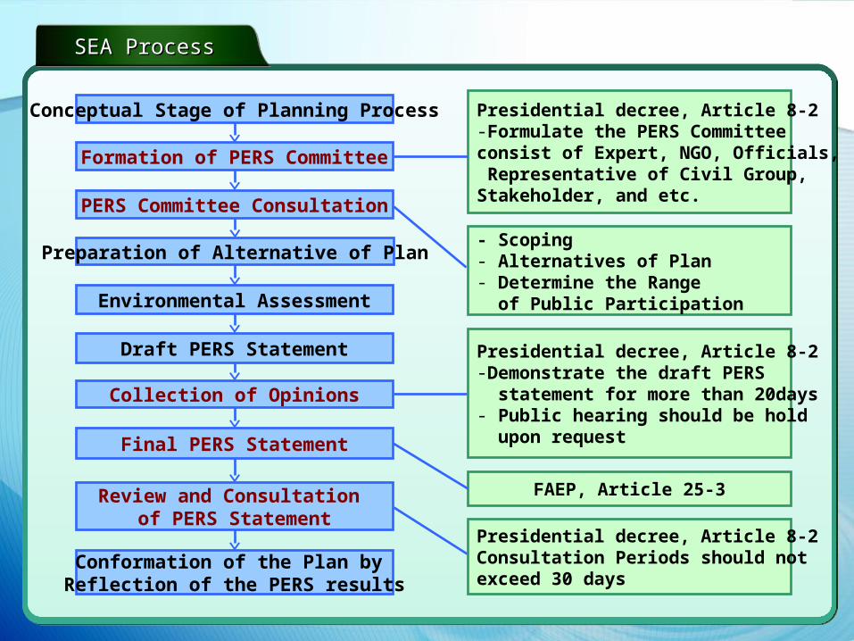
Implementation of SEA & Implementation of SEA & EIAEIA
Achieve systematical management of SEA and EIA Achieve systematical management of SEA and EIA • • Links between EIA & SEALinks between EIA & SEA
EIA
Policy
Plan
Program
Project
SEA Results
Plan Review
SEA Results
Public Consultation
Baseline Study
ProgramReview
SEA Results
Policy Review
SEAResults
SEA Results
SEA Results
Possible to skip
Simplification
SEA
EIA

Government established policy direction for implementation of the SEA by enhancing the PERS
The new PERS has been implemented by June, 2006
Established the implementation methods for SEA and EIA to cope with the dispute associated with implementation of the two EA system
Developed assessment methods for the SEA and EIA based on the characteristics and data availability at the stage of policy, plan, program, and project-established tiering system
SEA Guideline for water resources is under developing
Conclusion44