Embed Size (px)
Citation preview
Full Terms & Conditions of access and use can be found athttp://www.tandfonline.com/action/journalInformation?journalCode=tjde20
Download by: [Sitthisak Moukomla] Date: 19 November 2016, At: 06:06
International Journal of Digital Earth
ISSN: 1753-8947 (Print) 1753-8955 (Online) Journal homepage: http://www.tandfonline.com/loi/tjde20
Estimating the Great Lakes net radiation usingsatellite remote sensing and MERRA reanalysis
Sitthisak Moukomla & Peter D. Blanken
To cite this article: Sitthisak Moukomla & Peter D. Blanken (2016): Estimating the Great Lakesnet radiation using satellite remote sensing and MERRA reanalysis, International Journal ofDigital Earth, DOI: 10.1080/17538947.2016.1252432
To link to this article: http://dx.doi.org/10.1080/17538947.2016.1252432
Published online: 18 Nov 2016.
Submit your article to this journal
View related articles
View Crossmark data
Estimating the Great Lakes net radiation using satellite remotesensing and MERRA reanalysisSitthisak Moukomla a and Peter D. Blanken b
aGeo-Informatics and Space Technology Development Agency (GISTDA), Lak Si Bangkok, Thailand; bDepartment ofGeography and Environmental Studies Program, University of Colorado, Boulder, CO, USA
ABSTRACTThe net all-wave radiation of the Great Lakes (GL) is a key to understandingthe effects of climate change on the GL. There is a high possibility ofunderestimating the net all-wave radiation of the GL when usingexisting methodologies with inputs from near-shore and land-basedmeteorological data. This study provides the first technique to estimatenet all-wave radiation over the GL from July 2001 to December 2014using a combination of data from satellite remote sensing, reanalysisdata sets, and direct measurements. The components of the surfaceradiation budget estimated from the proposed method showed goodstatistical agreement. The instantaneous net radiation estimated by ourmethods was compared with the in situ measurements from June 2008to April 2012 (Stannard Rock Lighthouse: SR) and September 2009–April2011 (Spectacle Reef Lighthouse: SP). The comparisons from SR and SPalso showed strong statistic agreement (R2 = 0.74 and 0.7; RMSE = 9.26and 10.60 W m−2 respectively). Monthly spatial variations of netshortwave radiation varied with cloud cover and surface albedo whilenet longwave radiation varied with the temperature difference betweenthe water surface and the atmosphere.
ARTICLE HISTORYReceived 19 April 2016Accepted 20 October 2016
KEYWORDSThe Great Lakes; net all-waveradiation; satellite remotesensing; MERRA reanalysis
1. Introduction
The North American Laurentian Great Lakes (GL) are among the most valuable freshwater resourcein the world. The study of the surface energy of the GL system will increase our limited understand-ing of how the warming climate affects the hydroclimate of the Great Lake. Net surface radiation isthe main input component of the GL’s energy that controlled by surface albedo and cloud cover(Lofgren and Zhu 2000). In addition, due to the massive size of the GL, the greatest challenge inunderstanding the energy balances of the GL is how to quantify the net radiation over the water sur-face accurately. However, acquiring the dynamics of the net radiation requires not only direct over-lake measurements but also further assessment of the spatial variability across the entire lake surface.The concept of digital earth system (Grossner, Goodchild, and Clarke 2008) can be applied to dealwith mentioned challenges, for example, recent reports also showed the use of machine learningtechniques or artificial neural network associated with remote sensing and/or in situ measurementsto estimate net radiation over the various surfaces (e.g. Jiang et al. 2014; Mahalakshmi et al. 2014;Mahalakshmi et al. 2016; Qin et al. 2011). The results from such methods also show the promisingcorrelation with the conventional measurements.
© 2016 Informa UK Limited, trading as Taylor & Francis Group
CONTACT Sitthisak Moukomla [email protected] Geo-Informatics and Space Technology Development Agency(GISTDA), 120 The Government Complex Building B, Chaeng Wattana Road, Lak Si Bangkok 10210, ThailandAll authors contributed equally to this work.
INTERNATIONAL JOURNAL OF DIGITAL EARTH, 2016http://dx.doi.org/10.1080/17538947.2016.1252432
The study of the surface hydroclimate of lakes using remote sensing techniques has advanced sig-nificantly over the past three decades. The fundamental variables in the lake’s surface energy balanceare derivable through remote sensing at a variety of spatial and temporal resolutions (Tang et al.2009). Although satellite remote sensing techniques can generate continuous and up-to-datemeasurements with vast spatial coverage, they also rely on in situ observations for algorithm devel-opment and validation. Remote sensing techniques are also capable of estimating the temporal andspatial distribution of the surface energy budget. For example, Stroeve et al. (2005) used MODIS16-day albedo products (MOD43B3) associated with ground-based albedo observations from 16automatic weather stations over spatially homogeneous snow and semi-homogeneous ice coveredsurfaces on the Greenland ice sheet from 2000 to 2003. The results showed that the MOD43B3albedo product was capable of retrieving snow albedo with a slightly difference from the in situmeasurements. Bisht et al. (2005) proposed a simple approach to estimate instantaneous net radi-ation over large diverse surface types for clear-sky days using only remotely sensed data. Thismethod developed an algorithm using various land and atmospheric data products available fromTerra–MODIS. The results also showed a significant statistical agreement with ground-basedobservations.
Many recent studies (e.g. Bisht et al. 2005; Gusain, Mishra, and Arora 2014; Hou et al. 2014;Hwang et al. 2013; Long, Gao, and Singh 2010; Sun, Gebremichael, et al. 2013; Wang and Liang2010) used only data from clear-sky conditions in quantifying net radiation and its componentsfrom remote sensing. However, an accurate estimation of the surface energy budget requires theincorporation of cloudy periods, and the application of remote sensing to detect cloud and cloudfraction is also a significant challenge. With current satellite remote sensing technology, it is possibleto retrieve net radiation under both clear and cloudy skies. Bisht and Bras (2010) presented a tech-nique to derive net radiation components from only MODIS data. They also demonstrated the feasi-bility of using MODIS products for estimating atmospheric optical depth, cloud optical depth andcloud emissivity, surface temperature and surface emissivity, and air temperature and dew pointtemperature over the Southern Great Plains. They also successfully applied this approach in the Con-tinental United States (Bisht and Bras 2011), with results that compared well with the in situmeasurements.
However, even when using only MODIS data, the technique described by Bisht and Bras (2010)still requires intensive data processing and may not be suitable for the study areas where the direct insitu surface measurements are sparse. Although the satellite remote sensing approach offers sophis-ticated tools to derive net radiation, the detection of many variables still needs improvement. In fact,data from satellite remote sensing alone do not efficiently obtain net radiation over large bodies ofwater. Therefore, the main objective of this paper is to provide the technique to estimate instan-taneous net radiation in all sky condition by combining satellite remote sensing and reanalysisdata over the GL. To achieve this, only three MODIS products; MOD03L2, MOD11L2, andMOD06L2, were used. Air temperature, dew point temperature, and the ambient vapor pressurewere derived from Modern Era Retrospective-analysis for Research and Applications (MERRA) rea-nalysis data. The results were then compared with the direct measurements from net radiometer. Thespatial and temporal variations of each component of the radiation balance are discussed.
2. Methods
2.1. Data and data processes
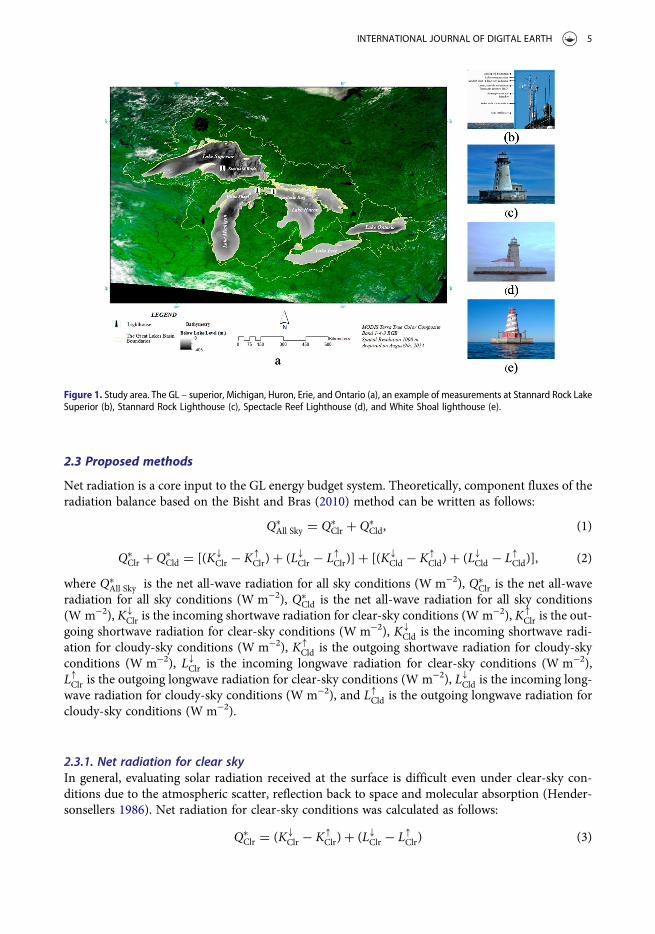
2.2.1. Direct measurements dataThree meteorological stations are equipped with a suite of atmospheric sensors on the rooftop of thelighthouse (a structure with a beacon light to guide ship) namely Stannard Rock Lighthouse (LakeSuperior), Spectacle Reef Lighthouse (Lake Huron), and White Shoal Lighthouse (Lake Michigan) tomeasure year-round the sensible heat and latent heat fluxes (evaporation), air temperature,
2 S. MOUKOMLA AND P. D. BLANKEN
humidity, wind speed and direction, barometric pressure, rain rate, incoming shortwave and long-wave radiation as well as lake surface temperature. In this paper, CNR-1 net radiometers (CampbellScientific, Inc., Logan UT) were used to measure incoming shortwave and longwave radiation. Allequipment was mounted at the top of the lighthouses, approximately 30 m above the lake surface.All hydro-meteorological data were collected by a data logger connected with telecommunicationsystem. Data are continuously collected from Stannard Rock Lighthouse in Lake Superior (2008–pre-sent), Spectacle Reef Lighthouse in Lake Huron (2009–present), and White Shoal Lighthouse in LakeMichigan (2012–present) respectively.
2.1.2. MODIS productTerra–MODIS was launched on 18 December 1999, and orbits at an altitude of 705 km with a broadswath width of 2330 km and global coverage every 1 or 2 days with 36 spectral bands between 0.405and 14.385 μm. The spatial resolutions range is from 250 to 500 and 1,000 m. MODIS offers 44 dataproducts in 5 categories that are: (1) calibration, (2) atmospheric, (3) land, (4) cryosphere, and (5)ocean products. The MODIS products used to derive net radiation are presented in Table 1. MODISproducts in hierarchical data format (HDF) were obtained from the NASA website (ftp://ladsftp.nascom.nasa.gov). In this study, the daily swath files from 6 July 2001 to 31 December 2014 weredownloaded, as a result, total 28,242 scenes were obtained (9373, 9434, and 9345 scenes forMOD11L2, MOD06L2, and MOD03L2, respectively). The coverage that requires more than twoscenes in one day was mosaicked. All data were re-gridded with Projection Utility on MODIS Con-version Toolkit then clipped with the GL boundary vector.
Cloud information from MOD06L2 (i.e. Cloud fraction, cloud optical thickness, cloud emissivity,cloud temperature, and water surface temperature) were extracted using the MODIS ConversionToolkit plug in ENVI software platform (Boulder, CO, USA) using IDL programing language. AllMODIS data used in this study were converted into a geospatial database then processed for eachlayer in the geographic information system by the geospatial overlay technique. We also resizedthe 5-km spatial resolution of MODIS cloud products into 1-km spatial resolution.
2.1.3. Reanalysis data MERRAThe MERRA is a long-term NASA atmospheric reanalysis product with the focus of the atmos-pheric assimilation being the hydrological cycle using a major new version of the GoddardEarth Observing System Data Assimilation System Version 5 (GEOS-5) (Pillai and Sahai2014; Su and Feng 2014; Yoo et al. 2013). The period covers from 1979 through the presentwith a spatial resolution of ½° latitude by ⅔° longitude with 72 hybrid model levels in the ver-tical (Abhik et al. 2013). The products are based on the integration of in situ and remote sen-sing observations into numerical models of the global atmosphere and land surface. MERRAfiles are available in both NetCDF and HDF format. Data ranging from 6 July 2001 to 31December 2014 were pulled from the NASA website (http://disc.sci.gsfc.nasa.gov/). MERRAprovides high temporal resolution available as hourly average; however, in this study, weonly selected MERRA products during the satellite overpass. Lindsay et al. (2014) evaluated
Table 1. MODIS products use in this study.
MODIS products Resolution Quantities estimated Equations ConditionsSpatial Temporal
MOD03L2 (Geolocationproduct)
1 km Daily Solar zenith angle 5 and 12 All
MOD11L2 (Land surfacetemperature product)
1 km Daily Water surface temperature 10 Clear
MOD06L2 (Cloud product) 5 km Daily Cloud fraction, cloud optical thickness, cloudemissivity and cloud temperature and watersurface temperature
12, 13, 14 Cloudy
INTERNATIONAL JOURNAL OF DIGITAL EARTH 3
different atmospheric parameters (i.e. sea level pressure, near-surface air temperatures, surfaceshortwave and longwave radiative fluxes, precipitation, and wind speed) in the Arctic from rea-nalysis products namely National Centers for Environmental Prediction (NCEP), NationalCenter for Atmospheric Research Reanalysis 1 (NCEP-R1), NCEP–U.S. Department of EnergyReanalysis 2 (NCEP-R2), Climate Forecast System Reanalysis (CFSR), Twentieth-Century Rea-nalysis (20CR), MERRA, ECMWF Interim Re-Analysis (ERA-Interim), and Japanese 25-yearReanalysis Project (JRA-25). The atmospheric parameters from each reanalysis productswere compared with in situ data. The results suggested that MERRA gave the best correlationfor near-surface air temperature. Also, MERRA yields the best spatial resolution (∼ 65 km)among those reanalysis products. For spatial–temporal analysis, the individual file was con-verted into ERDAS Imagine (Madison, AL, USA) IMG format. MERRA products used inthis study are presented in Table 2.
The estimated air temperatures from MERRA at the 10-m height were converted to the samemeasurement height as the meteorological observations made at the offshore lighthouses, approxi-mately 30 m above the water surface whereas an ambient lapse rate equal to −6.5°C/km was assumed(0.13°C cooler). Year-round air temperature (Ta; °C) and humidity (vapor pressure, ea; kPa) weremeasured with a shielded probe (model HMP45C, Vaisala, Helsinki) from the lighthouses (Blankenet al. 2011).
2.2. Study area
The surface radiation balance of the GL – Superior, Michigan, Huron, Erie, and Ontario – is uniquedue to their sheer size and its water storage (Figure 1). The primary input to the energy system issolar insolation, which peaks at the summer solstice (∼ 21 June). A large portion of the daytimeenergy is being used to heat the water in the summertime (Blanken et al. 2011). At night and duringthe fall/winter, this stored energy becomes the source of energy that supports an upward flow of heatfrom the water into the overlying atmosphere. In Lake Superior, large summertime heat storageresults in a five-month delay between maximum net radiation energy inputs in summer and energyrelease in the form of latent heat fluxes of evaporation and sensible heat fluxes in winter (Blankenet al. 2011). During the winter, when the air temperature decreases, ice usually forms in most ofthe GL except Lake Ontario. Since Lake Ontario is located in lower latitude with the averagedepth being approximately 86 m and it also located near the North Atlantic Ocean thus it retainsmore heat than the other four Lakes. As such, the GL do not ordinarily freeze over completely,due to the large heat storage (Rumer et al. 1983). Ice plays a significant role in lake-atmosphereenergy balance as it considerably increases the surface albedo and decreases the ability of thewater body to absorb shortwave radiation. This absorbed solar radiation is the primary agent thatwarms the lakes. The regular seasonal ice formation begins in the shallow shore areas of the GLand extends through the deeper area. The GL first ice usually onsets in Lake Erie during Decemberthrough January. The deeper lakes usually form extensive ice cover in February and March. Then, iceis lost from all lake areas during the last half of March through April. The large heat storage in thelakes prevents and reduces ice formation and shifts the evaporation into the late fall and early winterperiods.
Table 2. MERRA data used in this study.
MERRA
Resolution
Quantities estimated EquationsSpatial Temporal
IAU 2D atmospheric single-leveldiagnostics (tavg1_2d_slv_Nx)
0.5 × 0.67 degree Daily T10M (Temperature at 10 m abovethe displacement height)
5, 6, 7, 8,and 9
IAU 2D surface and TOA radiation fluxes(tavg1_2d_rad_Nx)
0.5 × 0.67 degree Daily ALBEDO (Surface albedo) 4 and 11
4 S. MOUKOMLA AND P. D. BLANKEN
2.3 Proposed methods
Net radiation is a core input to the GL energy budget system. Theoretically, component fluxes of theradiation balance based on the Bisht and Bras (2010) method can be written as follows:
Q∗All Sky = Q∗
Clr + Q∗Cld, (1)
Q∗Clr + Q∗
Cld = [(K�Clr − K�
Clr)+ (L�Clr − L�Clr)]+ [(K�Cld − K�
Cld)+ (L�Cld − L�Cld)], (2)
where Q∗All Sky is the net all-wave radiation for all sky conditions (W m−2), Q∗
Clr is the net all-waveradiation for all sky conditions (W m−2), Q∗
Cld is the net all-wave radiation for all sky conditions(W m−2), K�
Clr is the incoming shortwave radiation for clear-sky conditions (W m−2), K�Clr is the out-
going shortwave radiation for clear-sky conditions (W m−2), K�Cld is the incoming shortwave radi-
ation for cloudy-sky conditions (W m−2), K�Cld is the outgoing shortwave radiation for cloudy-sky
conditions (W m−2), L�Clr is the incoming longwave radiation for clear-sky conditions (W m−2),L�Clr is the outgoing longwave radiation for clear-sky conditions (W m−2), L�Cld is the incoming long-wave radiation for cloudy-sky conditions (W m−2), and L�Cld is the outgoing longwave radiation forcloudy-sky conditions (W m−2).
2.3.1. Net radiation for clear skyIn general, evaluating solar radiation received at the surface is difficult even under clear-sky con-ditions due to the atmospheric scatter, reflection back to space and molecular absorption (Hender-sonsellers 1986). Net radiation for clear-sky conditions was calculated as follows:
Q∗Clr = (K�
Clr − K�Clr)+ (L�Clr − L�Clr) (3)
Figure 1. Study area. The GL – superior, Michigan, Huron, Erie, and Ontario (a), an example of measurements at Stannard Rock LakeSuperior (b), Stannard Rock Lighthouse (c), Spectacle Reef Lighthouse (d), and White Shoal lighthouse (e).
INTERNATIONAL JOURNAL OF DIGITAL EARTH 5
or
Q∗Clr = (K�
Clr(1− a))+ (L�Clr − L�Clr), (4)
where α is the surface albedo from reanalysis data (see Section 2.1.3).For incoming shortwave radiation (K�
Clr)estimation, we used the method developed by Zillman(1972). This approach used only near-surface vapor pressure and solar zenith angle (in radians)to compute K�
Clr
K�Clr = SE sin2 u [(sin u+ 2. 7)0. 001ea + 1. 085 sin u+ b]−1, (5)
where SE is the solar constant at the top of the atmosphere (1367 W m−2), ea is the near-surfacevapor pressure (h Pa), θ is the solar zenith angle (in radians), and β is a coefficient equal to 0.2.
The near-surface vapor pressure was calculated from the dew point temperature (Td) using theClausius–Clapeyron equation as follows:
ea = 6.11expLvRv
1273.15
− 1Td
( )[ ], (6)
where Lv is the latent heat of vaporization (2.5×10⁶ J kg−1), Rv is the gas constant for water vapor(461 J kg−1 K−1), and Td is dew point temperature (K ) estimated from MERRA reanalysis data(detailed in Section 3.1).
Incoming longwave radiation was calculated using near-surface air emissivity and air temperatureas follows:
L�Clr = s1aT4a , (7)
where σ is the Stefan–Boltzmann constant (5.67 × 10⁻⁸W m−2 K−4), 1a is air emissivity, and Ta is airtemperature (K ).
Air emissivity was parameterized using a scheme proposed by Prata (1996)
1a = 1− (1+ j) exp (−����������1.2+ 3j
√), (8)
where
j = 46.5Ta
ea. (9)
Outgoing longwave radiation from the lake surface was calculated as
L�Clr = 1wsT4W , (10)
where 1w is the emissivity of the lake’s surface (0.98), σ is the Stefan–Boltzmann constant (5.67 × 10⁻⁸ W m−2 K−4), and Tw is lake surface temperature (K ) derived from remote sensing data.
2.3.2. Net radiation for cloudy skyClouds play a significant role in the climate system. The surface area covered by clouds is one of thekey variables that affects net radiation. Clouds also interact with solar radiation by scattering andabsorbing shortwave radiation as well as absorbing and emitting infrared longwave radiation. Theamount of shortwave radiation clouds reflect back to space and the amount of longwave radiationclouds absorb and emit depends on variables such as cloud-top temperature. Cloud fraction is animportant variable that is required in both downward shortwave and downward longwave equations.Under cloudy skies, net radiation can be written as
Q∗Cld = (K�
Cld(1− a)+ ((L�Cld − L�Cld). (11)
6 S. MOUKOMLA AND P. D. BLANKEN
The outgoing shortwave radiation in cloudy condition was estimated as a function of surfacealbedo and the incoming shortwave radiation. Here, we adopt the same surface albedo as used inclear-sky outgoing shortwave radiation estimation. The incoming shortwave radiation in the cloudycondition was estimated using the method proposed by Slingo (1989). In such a method, the incom-ing shortwave radiation in the cloudy condition was assumed to be a linear combination of the fluxesfrom clear sky and cloudy sky, weighted by cloud fraction according to the parameterization as
K�Cld = K�
Clr[(1− fc)+ fc e−tc/ cos u], (12)
where fc is the cloud fraction from MOD06L2 MODIS Cloud products and τ is cloud optical thick-ness from MOD06L2 MODIS Cloud products.
Incoming longwave radiation for cloudy skies was estimated as a combination of incoming radi-ation from near-surface conditions and clouds as proposed by Forman and Margulis (2009), whilethe outgoing longwave radiation for cloudy conditions followed a similar approach as for clear-skyconditions:
L�Cld = s1aT4a + s(1− 1a)1cT
4c (13)
L�Cld = s1wT4w, (14)
where 1c is the cloud emissivity obtained from MOD06L2 MODIS Cloud products, Tc (K) is thecloud temperature derived from MOD06L2 MODIS Cloud products, and Tw is the lake surfacetemperature (K) derived from remote sensing data. We merged surface temperature derived fromMODIS Cloud product with surface temperature from MODIS Land Surface Temperature product.The method is explained in detail in Moukomla and Blanken (2016).
From all the equations above, radiation components are then given by the sum of the clear- andcloudy-sky components:
K� = K�Clr + K�
Cld, (15)
K� = K�Clr + K�
Cld, (16)
L� = L�Clr + L�Cld, (17)
L� = L�Clr + L�Cld. (18)
3. Results and discussion3.1. The estimation of dew point temperatures from MERRA air temperatures
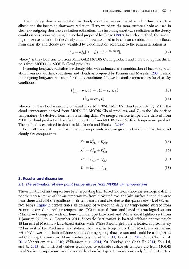
The estimation of air temperature by interpolating land-based and near-shore meteorological data ispoorly representative of the air temperatures from measured over the lake surface due to the largenear-shore and offshore gradients in air temperature and also due to the sparse network of GL sur-face buoys. Figure 2 demonstrates an example of year-round daily air temperature average from30 min observed interval air temperatures (°C) measured from land-based meteorological station(Mackinaw) compared with offshore stations (Spectacle Reef and White Shoal lighthouses) from1 January 2014 to 31 December 2014. Spectacle Reef station is located offshore approximately18 km east of Mackinaw land-based station while White Shoal Lighthouse is located approximately32 km west of the Mackinaw land station. However, air temperature from Mackinaw station are∼5–10°C lower than both offshore stations during spring thaw season and could be as higher as∼4°C during the summer. Many studies (e.g. Fu et al. 2011; Lin et al. 2012; Sun, Chen, et al.2013; Vancutsem et al. 2010; Williamson et al. 2014; Xu, Knudby, and Chak Ho 2014; Zhu, Lű,and Jia 2013) demonstrated various techniques to estimate surface air temperature from MODISLand Surface Temperature over the several land surface types. However, our study found that surface
INTERNATIONAL JOURNAL OF DIGITAL EARTH 7
air temperature over the GL was poorly correlated with MODIS-derived skin temperature. For theabove-mentioned reasons, we decided to use air temperature from MERRA reanalysis in this study.
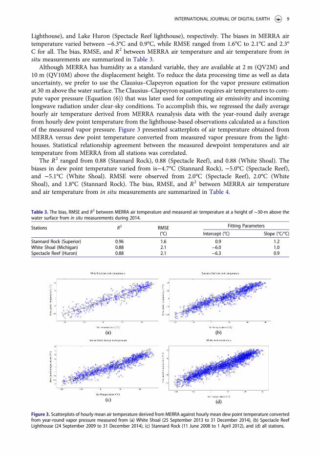
To estimate dew point temperature accurately, we first validated hourly mean air temperaturederived from MERRA reanalysis with ½ hourly mean air temperatures obtained from year-roundmeasurements from the lighthouses during 2014. For the purpose of comparison, only data duringsatellite overpass (∼17:00 UTC) were selected. Overall, air temperature estimated from MERRAshowed a good agreement with measured air temperature. The correlation coefficients (R2) were0.96, 0.88, and 0.88 from Lake Superior (Stannard Rock lighthouse), Lake Michigan (White Shoal
Figure 2. Mean daily air temperature (°C) average from 30-minutes interval observed from land-based (Mackinaw) and offshoremeteorological stations (White Shoal and spectacle reef) during 1 January 2014 to 31 December 2014 (a) shows the different temp-erature between mackinaw and White shoal and between Mackinaw and Spectacle reef, and stations location (b).
8 S. MOUKOMLA AND P. D. BLANKEN
Lighthouse), and Lake Huron (Spectacle Reef lighthouse), respectively. The biases in MERRA airtemperature varied between −6.3°C and 0.9°C, while RMSE ranged from 1.6°C to 2.1°C and 2.3°C for all. The bias, RMSE, and R2 between MERRA air temperature and air temperature from insitu measurements are summarized in Table 3.
Although MERRA has humidity as a standard variable, they are available at 2 m (QV2M) and10 m (QV10M) above the displacement height. To reduce the data processing time as well as datauncertainty, we prefer to use the Clausius–Clapeyron equation for the vapor pressure estimationat 30 m above the water surface. The Clausius–Clapeyron equation requires air temperatures to com-pute vapor pressure (Equation (6)) that was later used for computing air emissivity and incominglongwave radiation under clear-sky conditions. To accomplish this, we regressed the daily averagehourly air temperature derived from MERRA reanalysis data with the year-round daily averagefrom hourly dew point temperature from the lighthouse-based observations calculated as a functionof the measured vapor pressure. Figure 3 presented scatterplots of air temperature obtained fromMERRA versus dew point temperature converted from measured vapor pressure from the light-houses. Statistical relationship agreement between the measured dewpoint temperatures and airtemperature from MERRA from all stations was correlated.
The R2 ranged from 0.88 (Stannard Rock), 0.88 (Spectacle Reef), and 0.88 (White Shoal). Thebiases in dew point temperature varied from is−4.7°C (Stannard Rock), −5.0°C (Spectacle Reef),and −5.1°C (White Shoal). RMSE were observed from 2.0°C (Spectacle Reef), 2.0°C (WhiteShoal), and 1.8°C (Stannard Rock). The bias, RMSE, and R2 between MERRA air temperatureand air temperature from in situ measurements are summarized in Table 4.
Table 3. The bias, RMSE and R2 between MERRA air temperature and measured air temperature at a height of ∼30-m above thewater surface from in situ measurements during 2014.
Stations R2 RMSE Fitting Parameters
(°C) Intercept (°C) Slope (°C/°C)
Stannard Rock (Superior) 0.96 1.6 0.9 1.2White Shoal (Michigan) 0.88 2.1 −6.0 1.0Spectacle Reef (Huron) 0.88 2.1 −6.3 0.9
Figure 3. Scatterplots of hourly mean air temperature derived from MERRA against hourly mean dew point temperature convertedfrom year-round vapor pressure measured from (a) White Shoal (25 September 2013 to 31 December 2014), (b) Spectacle ReefLighthouse (24 September 2009 to 31 December 2014), (c) Stannard Rock (11 June 2008 to 1 April 2012), and (d) all stations.
INTERNATIONAL JOURNAL OF DIGITAL EARTH 9
3.2. Radiation components
In this section, we used the measured radiation component data, including incoming (insolation)and outgoing (reflected) shortwave radiation and incoming and outgoing longwave radiationfrom the Spectacle Reef Lighthouse to validate our methods. Based on the 2010–2011 recordsfrom Spectacle Reef Lighthouse, outgoing longwave showed the highest R2 (0.87) followed by incom-ing longwave radiation, incoming shortwave radiation and outgoing shortwave radiation (R2 = 0.73,0.62, and 0.20) with the bias of 22.6, 76.1, 93.6, and −55.4 W m−2, respectively. RMSEs ranged from3.8 W m−2 (outgoing longwave) to 14.4 W m−2 (incoming shortwave). The fitting parameters arepresented in Table 5.
The incident shortwave radiation was computed as a function of humidity, cloud cover, surfacealbedo, and solar zenith angle (Berk et al. 1998; Masuda, Leighton, and Li 1995; Tang, Li, and Zhang2006) while longwave radiation emitted from the atmosphere and the GL’s surfaces were derived as afunction of the MODIS-derived water surface temperature (Hou et al. 2014; Schmid, Hunziker, andWuest 2014). Clouds play a critical role by constantly changing incoming solar radiation. Qian et al.(2012) demonstrated the significant effect of cloud fraction and its radiative effects in three differentclimate regimes. In another word, low, thick clouds reflect solar radiation to the atmosphere whilehigh thin clouds allow incoming solar radiation to reach the surface. Low-altitude clouds also giveout the largest contribution to the net energy balance of the earth because of their large spatialand temporal coverage and their albedo effect on the emitted thermal radiation. High altitude cloudscan also optically reduce the solar energy because of their high albedo. On the other hand, their lowtemperatures can reduce longwave emission from the atmosphere (Hartmann, Ockertbell, andMichelsen 1992; Ockertbell and Hartmann 1992). During summer, as the incoming solar radiationis at its maximum while surface albedo and percent of cloud cover over the GL is at its minimum,therefore, the radiation over the GL shows a peak in the summer (Moukomla and Blanken 2016).Therefore, shortwave radiation can change rapidly due to the clouds especially during a partly cloudyday, but satellite remote sensing can measure only an instantaneous ‘snapshot’ of shortwave radi-ation. The weak correlation between observed and estimated incoming solar radiation (R2 = 0.62)may be due to cloud cover effects. Another possible source could come from the intrinsic error inparameterization. The proposed method adopted only near-surface vapor pressure and solar zenithangle for estimating incoming solar radiation for clear-sky condition while cloudy condition merelybased on cloud fraction and cloud optical thickness. The relationship between modeled andmeasured outgoing shortwave radiation indicated a relative low R2 (0.20). This may be because ofthe surface albedo (α), the ratio of reflected to incident solar radiation. Because the CNR1 net
Table 4. The bias, RMSE, and R2 between MERRA air temperatures and dew point temperatures from in situ measurements(p-value < .0001)
Station NameR2
RMSE Bias Coefficients
(°C) (°C) Intercept (°C) Slope (°C/°C)
White Shoal 0.88 2.0 −5.1 −3.9 0.8Spectacle Reef 0.88 2.0 −5.0 −4.5 0.8Stannard Rock 0.88 1.8 −4.7 −3.7 0.8
Table 5. Statistics for linear regressions of the relationship between estimated instantaneous radiation components and 30-minmean in situ measurements observed from spectacle reef lighthouse during 2010–2011 (p-value < .0001).
Components R2 RMSE (Wm−2)
Coefficients
Bias (Wm−2) Intercept (Wm−2) Slope (Wm−2/ Wm−2)
Incoming shortwave 0.62 14.4 93.6 168.4 0.9Outgoing shortwave 0.20 4.8 −55.4 28.0 0.2Incoming longwave 0.73 31.4 76.1 2.7 0.9Outgoing longwave 0.87 3.8 22.6 103.7 0.7
10 S. MOUKOMLA AND P. D. BLANKEN
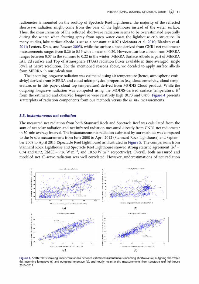
radiometer is mounted on the rooftop of Spectacle Reef Lighthouse, the majority of the reflectedshortwave radiation might come from the base of the lighthouse instead of the water surface.Thus, the measurements of the reflected shortwave radiation seems to be overestimated especiallyduring the winter when freezing spray from open water coats the lighthouse crib structure. Inmany studies, lake surface albedo is set as a constant at 0.07 (Alcântara et al. 2010; Blanken et al.2011; Lenters, Kratz, and Bowser 2005), while the surface albedo derived from CNR1 net radiometermeasurements ranges from 0.26 to 0.16 with a mean of 0.20. However, surface albedo from MERRAranges between 0.07 in the summer to 0.22 in the winter. MERRA Surface Albedo is part of MERRAIAU 2d surface and Top of Atmosphere (TOA) radiation fluxes available in time averaged, singlelevel, at native resolution. For the mentioned reasons above, we decided to apply surface albedofrom MERRA in our calculation.
The incoming longwave radiation was estimated using air temperature (hence, atmospheric emis-sivity) derived from MERRA and cloud microphysical properties (e.g. cloud emissivity, cloud temp-erature, or in this paper, cloud-top temperature) derived from MODIS Cloud product. While theoutgoing longwave radiation was computed using the MODIS-derived surface temperature. R2
from the estimated and observed longwave were relatively high (0.73 and 0.87). Figure 4 presentsscatterplots of radiation components from our methods versus the in situ measurements.
3.3. Instantaneous net radiation
The measured net radiation from both Stannard Rock and Spectacle Reef was calculated from thesum of net solar radiation and net infrared radiation measured directly from CNR1 net radiometerin 30-min average interval. The instantaneous net radiation estimated by our methods was comparedto the in situmeasurements from June 2008 to April 2012 (Stannard Rock Lighthouse) and Septem-ber 2009 to April 2011 (Spectacle Reef Lighthouse) as illustrated in Figure 5. The comparisons fromStannard Rock Lighthouse and Spectacle Reef Lighthouse showed strong statistic agreement (R2 =0.74 and 0.72; RMSE = 9.26 W m−2; and 10.60 W m−2 respectively). Overall, both measured andmodeled net all-wave radiation was well correlated. However, underestimations of net radiation
Figure 4. Scatterplots showing linear correlations between estimated instantaneous incoming shortwave (a), outgoing shortwave(b), incoming longwave (c) and outgoing longwave (d), and hourly mean in situ measurements from spectacle reef lighthouse2010–2011.
INTERNATIONAL JOURNAL OF DIGITAL EARTH 11
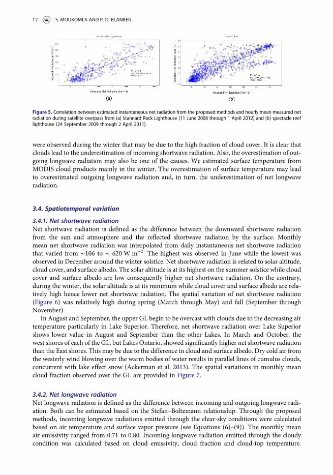
were observed during the winter that may be due to the high fraction of cloud cover. It is clear thatclouds lead to the underestimation of incoming shortwave radiation. Also, the overestimation of out-going longwave radiation may also be one of the causes. We estimated surface temperature fromMODIS cloud products mainly in the winter. The overestimation of surface temperature may leadto overestimated outgoing longwave radiation and, in turn, the underestimation of net longwaveradiation.
3.4. Spatiotemporal variation
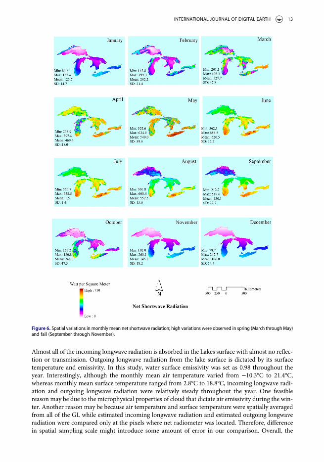
3.4.1. Net shortwave radiationNet shortwave radiation is defined as the difference between the downward shortwave radiationfrom the sun and atmosphere and the reflected shortwave radiation by the surface. Monthlymean net shortwave radiation was interpolated from daily instantaneous net shortwave radiationthat varied from ∼106 to ∼ 620 W m−2. The highest was observed in June while the lowest wasobserved in December around the winter solstice. Net shortwave radiation is related to solar altitude,cloud cover, and surface albedo. The solar altitude is at its highest on the summer solstice while cloudcover and surface albedo are low consequently higher net shortwave radiation. On the contrary,during the winter, the solar altitude is at its minimum while cloud cover and surface albedo are rela-tively high hence lower net shortwave radiation. The spatial variation of net shortwave radiation(Figure 6) was relatively high during spring (March through May) and fall (September throughNovember).
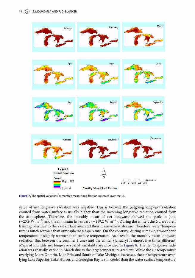
In August and September, the upper GL begin to be overcast with clouds due to the decreasing airtemperature particularly in Lake Superior. Therefore, net shortwave radiation over Lake Superiorshows lower value in August and September than the other Lakes. In March and October, thewest shores of each of the GL, but Lakes Ontario, showed significantly higher net shortwave radiationthan the East shores. This may be due to the difference in cloud and surface albedo. Dry cold air fromthe westerly wind blowing over the warm bodies of water results in parallel lines of cumulus clouds,concurrent with lake effect snow (Ackerman et al. 2013). The spatial variations in monthly meancloud fraction observed over the GL are provided in Figure 7.
3.4.2. Net longwave radiationNet longwave radiation is defined as the difference between incoming and outgoing longwave radi-ation. Both can be estimated based on the Stefan–Boltzmann relationship. Through the proposedmethods, incoming longwave radiations emitted through the clear-sky conditions were calculatedbased on air temperature and surface vapor pressure (see Equations (6)–(9)). The monthly meanair emissivity ranged from 0.71 to 0.80. Incoming longwave radiation emitted through the cloudycondition was calculated based on cloud emissivity, cloud fraction and cloud-top temperature.
Figure 5. Correlation between estimated instantaneous net radiation from the proposed methods and hourly mean measured netradiation during satellite overpass from (a) Stannard Rock Lighthouse (11 June 2008 through 1 April 2012) and (b) spectacle reeflighthouse (24 September 2009 through 2 April 2011).
12 S. MOUKOMLA AND P. D. BLANKEN
Almost all of the incoming longwave radiation is absorbed in the Lakes surface with almost no reflec-tion or transmission. Outgoing longwave radiation from the lake surface is dictated by its surfacetemperature and emissivity. In this study, water surface emissivity was set as 0.98 throughout theyear. Interestingly, although the monthly mean air temperature varied from −10.3°C to 21.4°C,whereas monthly mean surface temperature ranged from 2.8°C to 18.8°C, incoming longwave radi-ation and outgoing longwave radiation were relatively steady throughout the year. One feasiblereason may be due to the microphysical properties of cloud that dictate air emissivity during the win-ter. Another reason may be because air temperature and surface temperature were spatially averagedfrom all of the GL while estimated incoming longwave radiation and estimated outgoing longwaveradiation were compared only at the pixels where net radiometer was located. Therefore, differencein spatial sampling scale might introduce some amount of error in our comparison. Overall, the
Figure 6. Spatial variations in monthly mean net shortwave radiation; high variations were observed in spring (March through May)and fall (September through November).
INTERNATIONAL JOURNAL OF DIGITAL EARTH 13
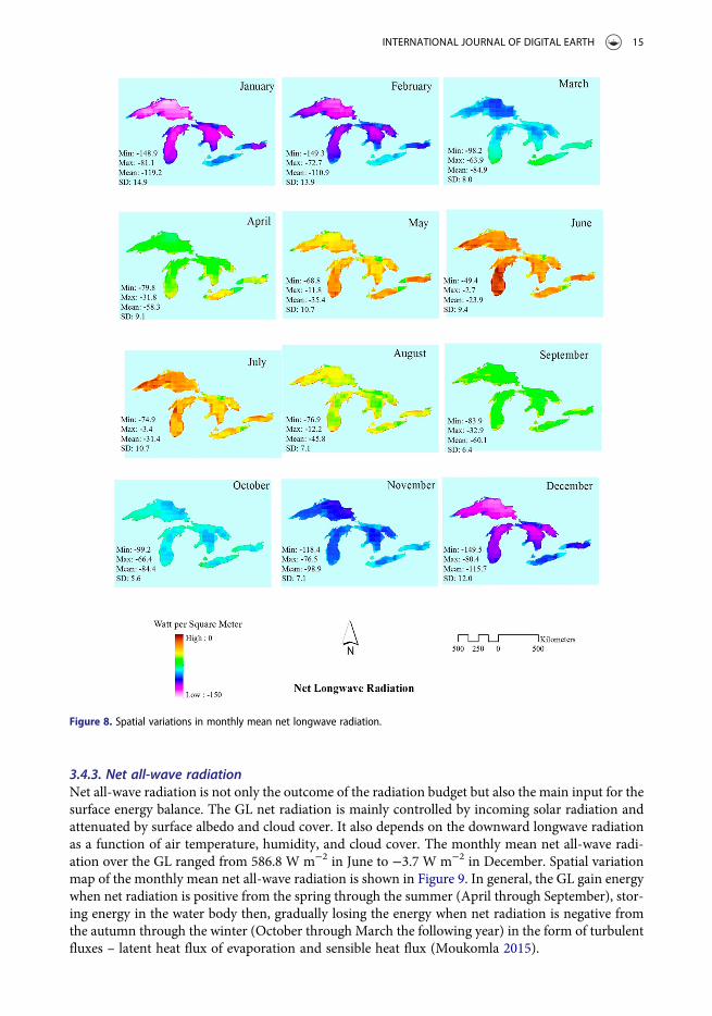
value of net longwave radiation was negative. This is because the outgoing longwave radiationemitted from water surface is usually higher than the incoming longwave radiation emitted fromthe atmosphere. Therefore, the monthly mean of net longwave showed the peak in June(−23.9 W m−2) and the minimum in January (−119.2 W m−2). During the winter, the GL are rarelyfreezing over due to the vast surface area and their massive heat storage. Therefore, water tempera-ture is much warmer than atmospheric temperature. On the contrary, during summer, atmospherictemperature is slightly warmer than surface temperature. As a result, the monthly mean longwaveradiation flux between the summer (June) and the winter (January) is almost five times different.Maps of monthly net longwave spatial variability are provided in Figure 8. The net longwave radi-ation was spatially varied in March due to the large temperature gradient. While the air temperatureoverlying Lakes Ontario, Lake Erie, and South of Lake Michigan increases, the air temperature over-lying Lake Superior, Lake Huron, and Georgian Bay is still cooler than the water surface temperature.
Figure 7. The spatial variations in monthly mean cloud fraction observed over the GL.
14 S. MOUKOMLA AND P. D. BLANKEN
3.4.3. Net all-wave radiationNet all-wave radiation is not only the outcome of the radiation budget but also the main input for thesurface energy balance. The GL net radiation is mainly controlled by incoming solar radiation andattenuated by surface albedo and cloud cover. It also depends on the downward longwave radiationas a function of air temperature, humidity, and cloud cover. The monthly mean net all-wave radi-ation over the GL ranged from 586.8 W m−2 in June to −3.7 W m−2 in December. Spatial variationmap of the monthly mean net all-wave radiation is shown in Figure 9. In general, the GL gain energywhen net radiation is positive from the spring through the summer (April through September), stor-ing energy in the water body then, gradually losing the energy when net radiation is negative fromthe autumn through the winter (October through March the following year) in the form of turbulentfluxes – latent heat flux of evaporation and sensible heat flux (Moukomla 2015).
Figure 8. Spatial variations in monthly mean net longwave radiation.
INTERNATIONAL JOURNAL OF DIGITAL EARTH 15
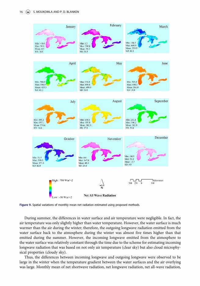
During summer, the differences in water surface and air temperature were negligible. In fact, theair temperature was only slightly higher than water temperature. However, the water surface is muchwarmer than the air during the winter; therefore, the outgoing longwave radiation emitted from thewater surface back to the atmosphere during the winter was almost five times higher than thatemitted during the summer. However, the incoming longwave emitted from the atmosphere tothe water surface was relatively constant through the time due to the scheme for estimating incominglongwave radiation that was based on not only air temperature (clear sky) but also cloud microphy-sical properties (cloudy sky).
Thus, the differences between incoming longwave and outgoing longwave were observed to belarge in the winter when the temperature gradient between the water surfaces and the air overlyingwas large. Monthly mean of net shortwave radiation, net longwave radiation, net all-wave radiation,
Figure 9. Spatial variations of monthly mean net radiation estimated using proposed methods.
16 S. MOUKOMLA AND P. D. BLANKEN
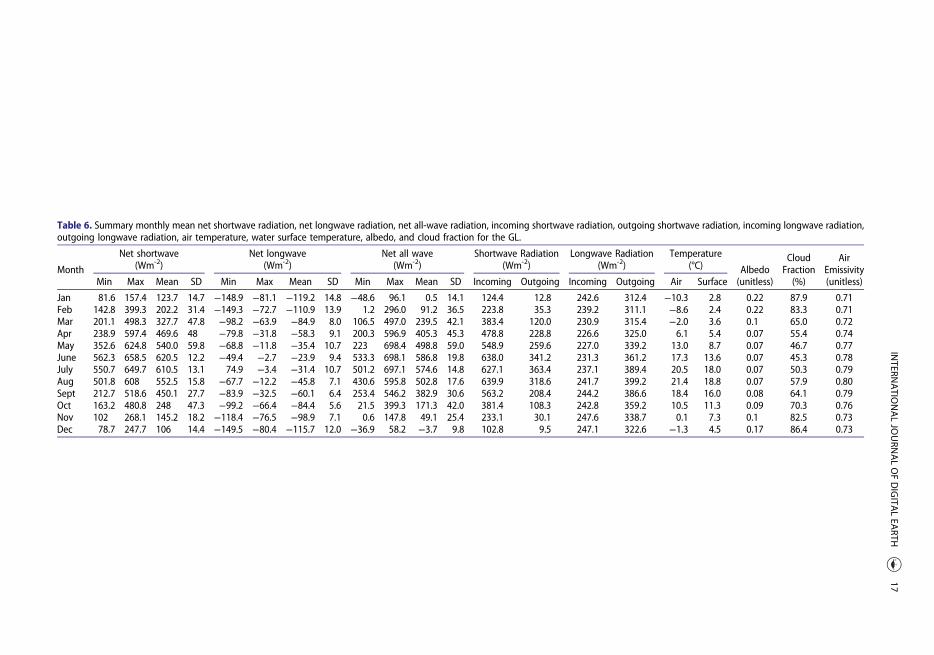
Table 6. Summary monthly mean net shortwave radiation, net longwave radiation, net all-wave radiation, incoming shortwave radiation, outgoing shortwave radiation, incoming longwave radiation,outgoing longwave radiation, air temperature, water surface temperature, albedo, and cloud fraction for the GL.
Month
Net shortwave(Wm-2)
Net longwave(Wm-2)
Net all wave(Wm-2)
Shortwave Radiation(Wm-2)
Longwave Radiation(Wm-2)
Temperature(°C) Albedo
CloudFraction
AirEmissivity
Min Max Mean SD Min Max Mean SD Min Max Mean SD Incoming Outgoing Incoming Outgoing Air Surface (unitless) (%) (unitless)
Jan 81.6 157.4 123.7 14.7 −148.9 −81.1 −119.2 14.8 −48.6 96.1 0.5 14.1 124.4 12.8 242.6 312.4 −10.3 2.8 0.22 87.9 0.71Feb 142.8 399.3 202.2 31.4 −149.3 −72.7 −110.9 13.9 1.2 296.0 91.2 36.5 223.8 35.3 239.2 311.1 −8.6 2.4 0.22 83.3 0.71Mar 201.1 498.3 327.7 47.8 −98.2 −63.9 −84.9 8.0 106.5 497.0 239.5 42.1 383.4 120.0 230.9 315.4 −2.0 3.6 0.1 65.0 0.72Apr 238.9 597.4 469.6 48 −79.8 −31.8 −58.3 9.1 200.3 596.9 405.3 45.3 478.8 228.8 226.6 325.0 6.1 5.4 0.07 55.4 0.74May 352.6 624.8 540.0 59.8 −68.8 −11.8 −35.4 10.7 223 698.4 498.8 59.0 548.9 259.6 227.0 339.2 13.0 8.7 0.07 46.7 0.77June 562.3 658.5 620.5 12.2 −49.4 −2.7 −23.9 9.4 533.3 698.1 586.8 19.8 638.0 341.2 231.3 361.2 17.3 13.6 0.07 45.3 0.78July 550.7 649.7 610.5 13.1 74.9 −3.4 −31.4 10.7 501.2 697.1 574.6 14.8 627.1 363.4 237.1 389.4 20.5 18.0 0.07 50.3 0.79Aug 501.8 608 552.5 15.8 −67.7 −12.2 −45.8 7.1 430.6 595.8 502.8 17.6 639.9 318.6 241.7 399.2 21.4 18.8 0.07 57.9 0.80Sept 212.7 518.6 450.1 27.7 −83.9 −32.5 −60.1 6.4 253.4 546.2 382.9 30.6 563.2 208.4 244.2 386.6 18.4 16.0 0.08 64.1 0.79Oct 163.2 480.8 248 47.3 −99.2 −66.4 −84.4 5.6 21.5 399.3 171.3 42.0 381.4 108.3 242.8 359.2 10.5 11.3 0.09 70.3 0.76Nov 102 268.1 145.2 18.2 −118.4 −76.5 −98.9 7.1 0.6 147.8 49.1 25.4 233.1 30.1 247.6 338.7 0.1 7.3 0.1 82.5 0.73Dec 78.7 247.7 106 14.4 −149.5 −80.4 −115.7 12.0 −36.9 58.2 −3.7 9.8 102.8 9.5 247.1 322.6 −1.3 4.5 0.17 86.4 0.73
INTERN
ATIO
NALJO
URN
ALOFDIGITA
LEA
RTH17
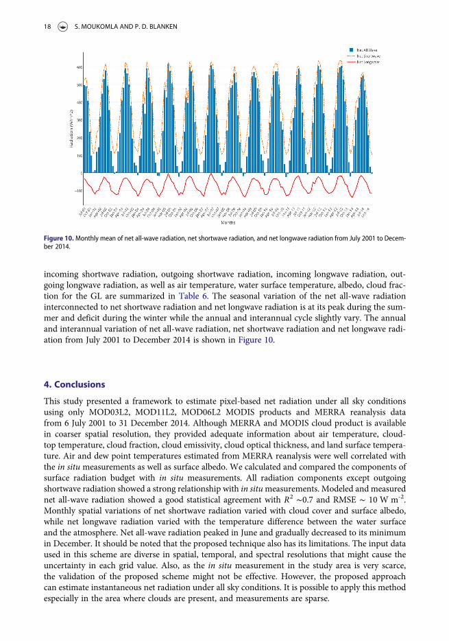
incoming shortwave radiation, outgoing shortwave radiation, incoming longwave radiation, out-going longwave radiation, as well as air temperature, water surface temperature, albedo, cloud frac-tion for the GL are summarized in Table 6. The seasonal variation of the net all-wave radiationinterconnected to net shortwave radiation and net longwave radiation is at its peak during the sum-mer and deficit during the winter while the annual and interannual cycle slightly vary. The annualand interannual variation of net all-wave radiation, net shortwave radiation and net longwave radi-ation from July 2001 to December 2014 is shown in Figure 10.
4. Conclusions
This study presented a framework to estimate pixel-based net radiation under all sky conditionsusing only MOD03L2, MOD11L2, MOD06L2 MODIS products and MERRA reanalysis datafrom 6 July 2001 to 31 December 2014. Although MERRA and MODIS cloud product is availablein coarser spatial resolution, they provided adequate information about air temperature, cloud-top temperature, cloud fraction, cloud emissivity, cloud optical thickness, and land surface tempera-ture. Air and dew point temperatures estimated from MERRA reanalysis were well correlated withthe in situ measurements as well as surface albedo. We calculated and compared the components ofsurface radiation budget with in situ measurements. All radiation components except outgoingshortwave radiation showed a strong relationship with in situmeasurements. Modeled and measurednet all-wave radiation showed a good statistical agreement with R2 ∼0.7 and RMSE ∼ 10 W m-2.Monthly spatial variations of net shortwave radiation varied with cloud cover and surface albedo,while net longwave radiation varied with the temperature difference between the water surfaceand the atmosphere. Net all-wave radiation peaked in June and gradually decreased to its minimumin December. It should be noted that the proposed technique also has its limitations. The input dataused in this scheme are diverse in spatial, temporal, and spectral resolutions that might cause theuncertainty in each grid value. Also, as the in situ measurement in the study area is very scarce,the validation of the proposed scheme might not be effective. However, the proposed approachcan estimate instantaneous net radiation under all sky conditions. It is possible to apply this methodespecially in the area where clouds are present, and measurements are sparse.
Figure 10.Monthly mean of net all-wave radiation, net shortwave radiation, and net longwave radiation from July 2001 to Decem-ber 2014.
18 S. MOUKOMLA AND P. D. BLANKEN
Acknowledgements
We also thank anonymous reviewers who provided insight and expertise that greatly improve this manuscript.
Disclosure statement
No potential conflict of interest was reported by the authors.
ORCID
Sitthisak Moukomla http://orcid.org/0000-0003-4054-4670Peter D. Blanken http://orcid.org/0000-0002-7405-2220
References
Abhik, S., M. Halder, P. Mukhopadhyay, X. Jiang, and B. N. Goswami. 2013. “A Possible New Mechanism forNorthward Propagation of Boreal Summer Intraseasonal Oscillations Based on TRMM and MERRAReanalysis.” Climate Dynamics 40 (7–8): 1611–1624. doi:10.1007/s00382-012-1425-x.
Ackerman, S. A., A. Heidinger, M. J. Foster, and B. Maddux. 2013. “Satellite Regional Cloud Climatology over theGreat Lakes.” Remote Sensing 5 (12): 6223–6240. doi:10.3390/rs5126223.
Alcântara, Enner Herenio, José Luiz Stech, João Antônio Lorenzzetti, Marie Paule Bonnet, Xavier Casamitjana, ArcilanTrevenzoli Assireu, and Evlyn Márcia Leão de Moraes Novo. 2010. “Remote Sensing of Water Surface Temperatureand Heat Flux over a Tropical Hydroelectric Reservoir.” Remote Sensing of Environment 114 (11): 2651–2665.doi:10.1016/j.rse.2010.06.002.
Berk, A., L. S. Bernstein, G. P. Anderson, P. K. Acharya, D. C. Robertson, J. H. Chetwynd, and S. M. Adler-Golden.1998. “MODTRAN Cloud and Multiple Scattering Upgrades with Application to AVIRIS.” Remote Sensing ofEnvironment 65 (3): 367–375. doi:10.1016/S0034-4257(98)00045-5.
Bisht, Gautam, and Rafael L. Bras. 2010. “Estimation of Net Radiation from the MODIS Data Under All SkyConditions: Southern Great Plains Case Study.” Remote Sensing of Environment 114 (7): 1522–1534. doi:10.1016/j.rse.2010.02.007.
Bisht, G., and R. L. Bras. 2011. “Estimation of Net Radiation from the Moderate Resolution Imaging SpectroradiometerOver the Continental United States.” Ieee Transactions on Geoscience and Remote Sensing 49 (6): 2448–2462. doi:10.1109/Tgrs.2010.2096227.
Bisht, G., V. Venturini, S. Islam, and L. Jiang. 2005. “Estimation of the Net Radiation Using MODIS (ModerateResolution Imaging Spectroradiometer) Data for Clear Sky Days.” Remote Sensing of Environment 97 (1): 52–67.doi:10.1016/j.rse.2005.03.014.
Blanken, Peter D., Christopher Spence, Newell Hedstrom, and John D. Lenters. 2011. “Evaporation from LakeSuperior: 1. Physical Controls and Processes.” Journal of Great Lakes Research 37 (4): 707–716. doi:10.1016/j.jglr.2011.08.009.
Forman, B. A., and S. A. Margulis. 2009. “High-resolution Satellite-Based Cloud-Coupled Estimates of TotalDownwelling Surface Radiation for Hydrologic Modelling Applications.” Hydrology and Earth System Sciences13 (7): 969–986.
Fu, Gang, Zhenxi Shen, Xianzhou Zhang, Peili Shi, Yangjian Zhang, and Jianshuang Wu. 2011. “Estimating AirTemperature of an Alpine Meadow on the Northern Tibetan Plateau Using MODIS Land SurfaceTemperature.” Acta Ecologica Sinica 31 (1): 8–13. doi:10.1016/j.chnaes.2010.11.002.
Grossner, Karl E., Michael F. Goodchild, and Keith C. Clarke. 2008. “Defining a Digital Earth System.” Transactions inGIS 12 (1):145–160.
Gusain, H. S., V. D. Mishra, and M. K. Arora. 2014. “Estimation of Net Shortwave Radiation Flux of WesternHimalayan Snow Cover During Clear sky Days Using Remote Sensing and Meteorological Data.” RemoteSensing Letters 5 (1): 83–92. doi:10.1080/2150704x.2013.866287.
Hartmann, D. L., M. E. Ockertbell, and M. L. Michelsen. 1992. “The Effect of Cloud Type on Earths Energy-Balance –Global Analysis.” Journal of Climate 5 (11): 1281–1304. doi:10.1175/1520-0442(1992)005<1281:Teocto>2.0.Co;2.
Hendersonsellers, B. 1986. “Calculating the Surface-Energy Balance for Lake and Reservoir Modeling – A Review.”Reviews of Geophysics 24 (3): 625–649. doi:10.1029/RG024i003p00625.
Hou, J. T., G. S. Jia, T. B. Zhao, H. S. Wang, and B. H. Tang. 2014. “Satellite-based Estimation of Daily Average NetRadiation Under Clear-sky Conditions.” Advances in Atmospheric Sciences 31 (3): 705–720. doi:10.1007/s00376-013-3047-6.
INTERNATIONAL JOURNAL OF DIGITAL EARTH 19
Hwang, K., M. Choi, S. O. Lee, and J. W. Seo. 2013. “Estimation of Instantaneous and Daily net Radiation fromMODISData Under Clear sky Conditions: A Case Study in East Asia.” Irrigation Science 31 (5): 1173–1184. doi:10.1007/s00271-012-0396-3.
Jiang, Bo, Yi Zhang, Shunlin Liang, Xiaotong Zhang, and Zhiqiang Xiao. 2014. “Surface Daytime Net RadiationEstimation Using Artificial Neural Networks.” Remote Sensing 6 (11): 11031–11050. doi:10.3390/rs61111031.
Lenters, J. D., T. K. Kratz, and C. J. Bowser. 2005. “Effects of Climate Variability on Lake Evaporation: Results from aLong-Term Energy Budget Study of Sparkling Lake, Northern Wisconsin (USA).” Journal of Hydrology 308 (1–4):168–195. doi:10.1016/j.jhydrol.2004.10.028.
Lin, Shengpan, Nathan J. Moore, Joseph P. Messina, Mark H. DeVisser, and Jiaping Wu. 2012. “Evaluation ofEstimating Daily Maximum and Minimum air Temperature with MODIS Data in East Africa.” InternationalJournal of Applied Earth Observation and Geoinformation 18: 128–140. doi:10.1016/j.jag.2012.01.004.
Lindsay, R., M. Wensnahan, A. Schweiger, and J. Zhang. 2014. “Evaluation of Seven Different Atmospheric ReanalysisProducts in the Arctic*.” Journal of Climate 27 (7): 2588–2606. doi:10.1175/jcli-d-13-00014.1.
Lofgren, B. M., and Y. C. Zhu. 2000. “Surface Energy Fluxes on the Great Lakes Based on Satellite-Observed SurfaceTemperatures 1992 to 1995.” Journal of Great Lakes Research 26 (3): 305–314.
Long, D., Y. C. Gao, and V. P. Singh. 2010. “Estimation of Daily Average Net Radiation from MODIS Data and DEMover the Baiyangdian Watershed in North China for Clear sky Days.” Journal of Hydrology 388 (3–4): 217–233.doi:10.1016/j.jhydrol.2010.04.042.
Mahalakshmi, D. V., A. Paul, D. Dutta, M. M. Ali, C. S. Jha, and V. K. Dadhwal. 2014. “Net Surface Radiation RetrievalUsing Earth Observation Satellite Data and Machine Learning Algorithm.” ISPRS Annals of Photogrammetry,Remote Sensing and Spatial Information Sciences II-8: 9–12. doi:10.5194/isprsannals-II-8-9-2014.
Mahalakshmi, D. V., A. Paul, D. Dutta, M. M. Ali, R. S. Reddy, C. S. Jha, V. K. Dadhwal, and J. R. Sharma. 2016.“Estimation of Net Surface Radiation from Eddy Flux Tower Measurements Using Artificial Neural Network forCloudy Skies.” Sustainable Environment Research 26 (1): 44–50. doi:10.1016/j.serj.2015.09.002.
Masuda, K., H. G. Leighton, and Z. Q. Li. 1995. “A New Parameterization for the Determination of Solar FluxAbsorbed at the Surface from Satellite Measurements.” Journal of Climate 8 (6): 1615–1629. doi:10.1175/1520-0442(1995)008<1615:Anpftd>2.0.Co;2.
Moukomla, Sitthisak. 2015. “The Estimation of the Surface Energy Balance of the North American Laurentian GreatLakes Using Satellite Remote Sensing and MERRA Reanalysis.” Ph.D., University of Colorado at Boulder.
Moukomla, Sitthisak, and Peter Blanken. 2016. “Remote Sensing of the North American Laurentian Great Lakes’Surface Temperature.” Remote Sensing 8 (4): 286. doi:10.3390/rs8040286.
Ockertbell, M. E., and D. L. Hartmann. 1992. “The Effect of Cloud Type on Earths Energy-Balance – Results forSelected Regions.” Journal of Climate 5 (10): 1157–1171. doi:10.1175/1520-0442(1992)005<1157:Teocto>2.0.Co;2.
Pillai, P. A., and A. K. Sahai. 2014. “Moist Dynamics of Active/Break Cycle of Indian Summer Monsoon Rainfall fromNCEPR2 and MERRA Reanalysis.” International Journal of Climatology 34 (5): 1429–1444. doi:10.1002/joc.3774.
Prata, A. J. 1996. “A New Long-Wave Formula for Estimating Downward Clear-sky Radiation at the Surface.”Quarterly Journal of the Royal Meteorological Society 122 (533): 1127–1151. doi:10.1002/qj.49712253306.
Qian, Y., C. N. Long, H. Wang, J. M. Comstock, S. A. McFarlane, and S. Xie. 2012. “Evaluation of Cloud Fraction andits Radiative Effect Simulated by IPCC AR4 Global Models Against ARM Surface Observations.” AtmosphericChemistry and Physics 12 (4): 1785–1810. doi:10.5194/acp-12-1785-2012.
Qin, Jun, Zhuoqi Chen, Kun Yang, Shunlin Liang, and Wenjun Tang. 2011. “Estimation of Monthly-Mean DailyGlobal Solar Radiation Based on MODIS and TRMM Products.” Applied Energy 88 (7): 2480–2489. doi:10.1016/j.apenergy.2011.01.018.
Rumer, R. R., W. F. Bialas, F. H. Quinn, R. A. Assel, and D. W. Gaskill. 1983. “Niagara River Ice Boom – Effects onEnvironment.” Journal of Technical Topics in Civil Engineering-Asce 109 (2): 105–116.
Schmid, M., S. Hunziker, and A. Wuest. 2014. “Lake Surface Temperatures in a Changing Climate: A Global SensitivityAnalysis.” Climatic Change 124 (1–2): 301–315. doi:10.1007/s10584-014-1087-2.
Slingo, A. 1989. “A GCM Parameterization for the Shortwave Radiative Properties of Water Clouds.” Journal of theAtmospheric Sciences 46 (10): 1419–1427. doi:10.1175/1520-0469(1989)046<1419:Agpfts>2.0.Co;2.
Stroeve, J. C., M. C. Serreze, F. Fetterer, T. Arbetter, W. Meier, J. Maslanik, and K. Knowles. 2005. “Tracking theArctic’s Shrinking Ice Cover: Another Extreme September Minimum in 2004.” Geophysical Research Letters 32(4). doi:ArtnL0450110.1029/2004gl021810.
Su, T., and G. L. Feng. 2014. “The Characteristics of the Summer Atmospheric Water Cycle Over China andComparison of ERA-Interim and MERRA Reanalysis.” Acta Physica Sinica 63 (24). doi:ARTN24920110.7498/aps.63.249201.
Sun, Hao, Yunhao Chen, Adu Gong, Xiang Zhao, Wenfeng Zhan, and Mengjie Wang. 2013. “Estimating Mean airTemperature Using MODIS day and Night Land Surface Temperatures.” Theoretical and Applied Climatology118 (1–2): 81–92. doi:10.1007/s00704-013-1033-7.
Sun, Z. G., M. Gebremichael, Q. X. Wang, J. M. Wang, T. W. Sammis, and A. Nickless. 2013. “Evaluation of Clear-SkyIncoming Radiation Estimating Equations Typically Used in Remote Sensing Evapotranspiration Algorithms.”Remote Sensing 5 (10): 4735–4752. doi:10.3390/rs5104735.
20 S. MOUKOMLA AND P. D. BLANKEN
Tang, Q., H. Gao, H. Lu, and D. P. Lettenmaier. 2009. “Remote Sensing: Hydrology.” Progress in Physical Geography 33(4): 490–509. doi:10.1177/0309133309346650.
Tang, B. H., Z. L. Li, and R. H. Zhang. 2006. “A Direct Method for Estimating net Surface Shortwave Radiation fromMODIS Data.” Remote Sensing of Environment 103 (1): 115–126. doi:10.1016/j.rse.2006.04.008.
Vancutsem, Christelle, Pietro Ceccato, Tufa Dinku, and Stephen J. Connor. 2010. “Evaluation of MODIS Land SurfaceTemperature Data to Estimate air Temperature in Different Ecosystems over Africa.” Remote Sensing ofEnvironment 114 (2): 449–465. doi:10.1016/j.rse.2009.10.002.
Wang, W. H., and S. L. Liang. 2010. “A Method for Estimating Clear-Sky Instantaneous Land-Surface LongwaveRadiation with GOES Sounder and GOES-R ABI Data.” Ieee Geoscience and Remote Sensing Letters 7 (4): 708–712. doi:10.1109/Lgrs.2010.2046472.
Williamson, Scott, David Hik, John Gamon, Jeffrey Kavanaugh, and Gwenn Flowers. 2014. “Estimating TemperatureFields from MODIS Land Surface Temperature and Air Temperature Observations in a Sub-Arctic AlpineEnvironment.” Remote Sensing 6 (2): 946–963. doi:10.3390/rs6020946.
Xu, Yongming, Anders Knudby, and Hung Chak Ho. 2014. “Estimating Daily Maximum air Temperature fromMODIS in British Columbia, Canada.” International Journal of Remote Sensing 35 (24): 8108–8121. doi:10.1080/01431161.2014.978957.
Yoo, J. M., Y. I. Won, M. J. Jeong, K. M. Kim, D. B. Shin, Y. R. Lee, and Y. J. Cho. 2013. “Intensity of Climate VariabilityDerived from the Satellite and MERRA Reanalysis Temperatures: AO, ENSO, and QBO.” Journal of Atmosphericand Solar-Terrestrial Physics 95–96: 15–27. doi:10.1016/j.jastp.2013.01.002.
Zhu, Wenbin, Aifeng Lű, and Shaofeng Jia. 2013. “Estimation of Daily Maximum and Minimum Air TemperatureUsing MODIS Land Surface Temperature Products.” Remote Sensing of Environment 130: 62–73. doi:10.1016/j.rse.2012.10.034.
Zillman, J. W. 1972. A study of some aspects of the radiation and heat budgets of the southern hemisphere oceans. Editedby Meteorology Commonwealth Bureau of Meteorological Study; no. 26. Canberra: Australian GovernmentPublishing Service.
INTERNATIONAL JOURNAL OF DIGITAL EARTH 21


![Estimating the Atlantic overturning at 26N using satellite altimetry [IUGG]](https://img.pdfslide.net/doc/110x75/55c996bfbb61eb2e328b46f1/estimating-the-atlantic-overturning-at-26n-using-satellite-altimetry-iugg.jpg)