Embed Size (px)
Citation preview
ENVIRONMENTAL ASSESSMENTAugust 2013
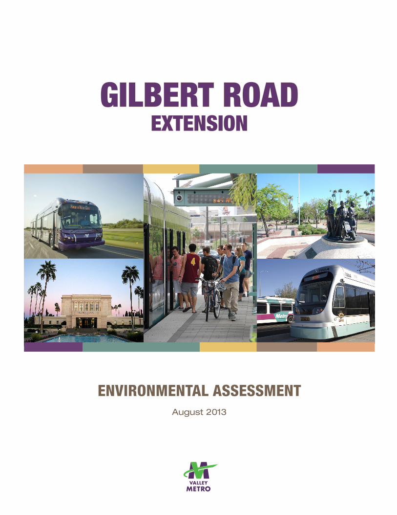
GILBERT ROADEXTENSION

Page Intentionally Left Blank
Environmental Assessment i August 2013
Gilbert Road Extension
GILBERT ROAD EXTENSION ENVIRONMENTAL ASSESSMENT
Prepared in accordance with:
National Environmental Policy Act of 1969 (42 U.S.C. § 4332 et seq.), as amended
Federal Transit Act (49 U.S.C. § 5301 et seq.) as amended
Moving Ahead for Progress in the 21st Century (MAP-21) (Public Law 112-141)
By the: Federal Transit Administration, U.S. Department of Transportation, and Valley Metro
Responsible Agencies Lead Agencies: Federal Transit Administration and Valley Metro
For additional information concerning this document, contact: Robert Forrest Environmental Planner III Valley Metro 101 N. 1st Avenue, Suite 1300 Phoenix, AZ 85003 (602) 322-4514
Paul Page Federal Transit Administration, Region IX 201 Mission Street, Suite 1650 San Francisco, CA, 94105-1831 (415) 744-2734
Abstract The proposed project consists of a 1.9-mile extension to the region’s Light Rail Transit (LRT) system from the future eastern terminus near the intersection of Main Street/Mesa Drive (part of the Central Mesa Extension project currently under construction) east to the intersection of Main Street/Gilbert Road, in Mesa, Arizona. The proposed project initially considered two Build Alternatives, each on Main Street, but with two different traffic configurations (i.e., two lanes providing one through traffic lane in each direction; and four lanes maintaining the existing two through traffic lanes in each direction). A design option for the two-lane configuration using modern roundabouts at quarter-mile and mid-block neighborhood street intersections, instead of traffic signals, was also considered. The initial evaluation of the alternatives described above did not result in any alternative emerging with a clear community consensus. Each alternative had positive characteristics along with consequences, effectively creating a set of tradeoffs.
Environmental Assessment ii August 2013
Gilbert Road Extension
Following further consultation with community leaders, a refined alternative emerged which includes elements of each alternative considered in this EA, the so-called Build Alternative (Hybrid). This alternative narrows the roadway to two traffic lanes (one lane in each direction) where traffic congestion is not an issue and employs four traffic lanes (two lanes in each direction) where the highest potential for congestion would occur. It also incorporates modern roundabouts at two intersections to allow traffic to make full u-turns to access connecting neighborhood streets and businesses on both the north and south sides of the light rail alignment. On April 4, 2013 the Mesa City Council voted to recommend the Build Alternative (Hybrid) as the Preferred Alternative (PA), and the evaluation of this alternative is included in Chapter 5 of this EA. A park-and-ride facility at the project’s eastern terminus at Gilbert Road is also planned. Two optional sites were initially considered and evaluated in this EA. The Park-and-Ride (North Option) is located at the northwest corner of the Gilbert Road/Main Street intersection. The Park-and-Ride (South Option) is located at the southwest corner of that same intersection. On April 4, 2013, the Mesa City Council also voted to recommend the Park-and-Ride (South Option) as part of the PA. This Environmental Assessment (EA) considers potential long-term, short-term, indirect and cumulative effects on local traffic, bicycles and pedestrians, land use, economics, neighborhoods, environmental justice, visual and aesthetic resources, ecosystems, air quality, water quality, noise, vibration, energy, hazardous materials, historic and cultural resources, and resources protected by Section 4(f).
Environmental Assessment iii August 2013
Gilbert Road Extension
TABLE OF CONTENTS ACRONYMS EXECUTIVE SUMMARY Page 1.0 INTRODUCTION AND PURPOSE AND NEED FOR THE PROPOSED PROJECT.......................................................................................................... 1-1
1.1 What is the Proposed Project and Why is an Environmental Assessment Being Prepared? ................................................................ 1-1
1.2 Why Do We Need High-Capacity Transit in the Study Area? ................. 1-3 1.3 What is the Purpose of the Proposed Project? ....................................... 1-5 1.4 What are the Goals for the Proposed Project? ....................................... 1-6
2.0 ALTERNATIVES TO THE PROPOSED PROJECT .......................................... 2-1 2.1 What alternatives have been considered and how did we get to the
alternatives selected for evaluation in this EA? ...................................... 2-1 2.2 What alternatives are evaluated in this EA? ........................................... 2-7 2.3 Build alternative transit network ............................................................ 2-17
3.0 ENVIRONMENTAL IMPACTS—WHAT IMPACTS ARE LIKELY
TO OCCUR AND HOW WILL MAJOR ADVERSE IMPACTS BE AVOIDED OR MINIMIZED? .............................................................................. 3-1 3.1 Land Acquisition and Relocation ............................................................. 3-2 3.2 Existing Land Use ................................................................................. 3-11 3.3 Consistency with Local Plans ............................................................... 3-13 3.4 Economic Effects .................................................................................. 3-16 3.5 Secondary Development ....................................................................... 3-20 3.6 Transportation ....................................................................................... 3-23 3.7 Air Quality ............................................................................................. 3-34 3.8 Noise and Vibration .............................................................................. 3-36 3.9 Energy Requirements and Potential for Conservation .......................... 3-43 3.10 Historic and Cultural Properties ............................................................ 3-44 3.11 Parklands and Section 4(f)/6(f) ............................................................. 3-53 3.12 Visual and Aesthetics............................................................................ 3-55 3.13 Community Disruption........................................................................... 3-60 3.14 Environmental Justice ........................................................................... 3-61 3.15 Hazardous Materials ............................................................................. 3-70 3.16 Safety and Security ............................................................................... 3-74 3.17 Water Quality ........................................................................................ 3-76 3.18 Ecologically Sensitive Areas/Threatened and Endangered Species ..... 3-78 3.19 Wetlands/Flooding/Navigable Waterways and Coastal Zones .............. 3-79 3.20 Construction .......................................................................................... 3-79 3.21 Cumulative Impacts .............................................................................. 3-84
Environmental Assessment iv August 2013
Gilbert Road Extension
4.0 WHO ARE THE AGENCIES AND PERSONS CONSULTED? ......................... 4-1
4.1 Introduction ............................................................................................. 4-1 4.2 Staff and Agency Coordination Meetings ................................................ 4-1 4.3 Public Meetings ...................................................................................... 4-2 4.4 Boards/Committees/City Council Meetings ............................................. 4-4 4.5 Direct Mail, E-Mail and Canvassing Outreach Activities ......................... 4-5 4.6 Public Review of the Environmental Assessment ................................... 4-6
5.0 CONCLUSIONS AND RECOMMENDATION FOR A PREFERRED
ALTERNATIVE FOR IMPLEMENTATION ........................................................ 5-1 5.1 Introduction ............................................................................................. 5-1 5.2 Background ............................................................................................. 5-1 5.3 Definition of the Build Alternative (Hybrid) or PA .................................... 5-2 5.4 Evaluation of the Build Alternative (Hybrid) and How it Compares
to the Other Build Alternatives Evaluated ............................................... 5-3 5.5 Mitigation .............................................................................................. 5-10
6.0 HOW MUCH WILL THE PREFERRED ALTERNATIVE COST AND
HOW WILL IT BE FUNDED? ................................................................. 6.1 7.0 SOURCES AND REFERENCES CITED ........................................................... 7.1 APPENDICES A Conceptual Engineering Drawings B Gilbert Road Extension: Park-and-Ride Facility Size Recommendations
Memorandum C Transportation Technical Report D Air Quality Technical Report E Noise and Vibration Technical Report F Inventory and Evaluation of Historic Resources and SHPO Concurrence G Section 4(f) and 6(f) Technical Memorandum H Visual and Aesthetics Technical Memorandum I Environmental Justice Technical Memorandum J Preliminary Initial Site Assessment K List of Preparers L Responses to Public Comments Received on the Environmental Assessment LIST OF FIGURES 1-1 High Capacity/Light Rail Transit Corridors ......................................................... 1-2 1-2 Gilbert Road Extension Study Area ................................................................... 1-2 2-1 Alternatives Development Process .................................................................... 2-1 2-2 No-Build Alternative (2031) ............................................................................... 2-7 2-3 Build Alternatives ............................................................................................. 2-10
Environmental Assessment v August 2013
Gilbert Road Extension
2-4 Build Alternative (4-Lane) ................................................................................ 2-12 2-5 Build Alternative (2-Lane) ................................................................................ 2-13 2-6 Modern Roundabout – Salt Lake City LRT ...................................................... 2-14 2-7 Build Alternative (2-Lane Roundabouts) .......................................................... 2-15 2-8 Park-and-Ride Options .................................................................................... 2-15 2-9 Build Alternative Transit Service Network (2031) ............................................ 2-18 3-1 Existing Corridor Land Uses ............................................................................ 3-12 3-2 Build Alternatives (4-Lane) and (2-Lane) – Intersections Studied.................... 3-25 3-3 Build Alternative (2-Lane Roundabouts) – Intersections Studied .................... 3-26 3-4 Noise and Vibration Measurement Sites ......................................................... 3-38 3-5 Typical Outdoor and Indoor Noise Levels ........................................................ 3-38 3-6 Gilbert Road Extension Area (1937 to Present) and Area of Potential Effects ............................................................................................................. 3-45 3-7 Visual Units...................................................................................................... 3-55 3-8 Representative Land Uses within the Visual Units .......................................... 3-57 3-9 Study Area Minority Population (% Comparison)............................................. 3-64 3-10 Study Area Low-Income Population (% Comparison) ...................................... 3-64 3-11 Potential Sites of Concern ............................................................................... 3-73 LIST OF TABLES 1-1 Goals and Objectives for the Proposed Project ................................................. 1-6 2-1 Tier 1 Screening Criteria and Measurements .................................................... 2-3 2-2 Results of Tier 1 Screening ............................................................................... 2-3 2-3 Tier 1 Alternatives Advanced to Tier 2 Evaluation ............................................. 2-4 2-4 Tier 2 Alternatives Descriptions ......................................................................... 2-5 2-5 Tier 2 Screening Criteria and Measurements .................................................... 2-5 2-6 Results of Tier 2 Screening ............................................................................... 2-6 2-7 Tier 2 Alternatives Advanced for EA Analysis.................................................... 2-6 2-8 No-Build Roadway Projects (2031) .................................................................... 2-8 2-9 No-Build Transit Facilities (2031) ....................................................................... 2-9 2-10 No-Build Transit Network (2031) ....................................................................... 2-9 2-11 Features Common to the Build Alternatives .................................................... 2-10 3-1 Comparison of Potential Property Acquisitions .................................................. 3-3 3-2 Build Alternative (4-Lane) Property Acquisitions................................................ 3-5 3-3 Build Alternative (2-Lane) Property Acquisitions................................................ 3-7 3-4 Build Alternative (2-Lane Roundabouts) Property Acquisitions ......................... 3-8 3-5 Park-and-Ride (North Option) Property Acquisitions ......................................... 3-9 3-6 Park-and-Ride (South Option) Property Acquisitions ....................................... 3-10 3-7 Existing Land Use Characteristics (Study Area) .............................................. 3-12 3-8 Consistency with Local Plans .......................................................................... 3-14 3-9 Comparison of Economic Effects of the Alternatives ....................................... 3-16 3-10 Intersection Level of Service Results – PM Peak Hour (Existing and 2031) .... 3-24 3-11 On-Street Parking Impacts .............................................................................. 3-27
Environmental Assessment vi August 2013
Gilbert Road Extension
3-12 Noise Evaluation Approach ............................................................................. 3-37 3-13 Vibration Evaluation Approach ........................................................................ 3-39 3-14 Comparison of Potential Noise and Vibration Impacts ..................................... 3-40 3-15 Findings of Effects on Individual Properties in the APE ................................... 3-49 3-16 Comparison of Visual Unit Characteristics ...................................................... 3-56 3-17 Comparison of Effects on Traffic and Parking ................................................. 3-65 3-18 Comparison of Noise and Vibration Impacts (Without Mitigation) .................... 3-66 3-19 High Risk Sites of Potential Concern ............................................................... 3-71 3-20 Indeterminate Risk Sites of Potential Concern Historic Drycleaners and Service Stations ........................................................................................ 3-72 3-21 Moderate Risk Sites of Potential Concern ....................................................... 3-72 3-22 Gilbert Road Extension – Construction Activities............................................. 3-80 3-23 Options to Minimize Construction Duration ..................................................... 3-81 3-24 Construction Related Impacts/Standard Practices .......................................... 3-82 3-25 Cumulative Impacts Analysis ........................................................................... 3-86 4-1 Objectives of the Public Involvement Program .................................................. 4-1 4-2 Staff and Agency Meetings ................................................................................ 4-2 4-3 General Public Meetings ................................................................................... 4-2 4-4 Stakeholder Meetings ........................................................................................ 4-4 4-5 Public Boards and City Committees Meetings ................................................... 4-5 4-6 Direct Mail, E-Mail and Canvassing Outreach Activities .................................... 4-6 5-1 Build Alternative (Hybrid) Property Acquisitions ............ …………………….…...5-5 5-2 Build Alternative (Hybrid) Findings of Effect on Individual Properties in the APE ........................................................................................ 5-9 5-3 Mitigation Options and Standard Construction Practices for Adverse Effects of the Build Alternative (Hybrid) ........................................................... 5-10
Environmental Assessment vii August 2013
Gilbert Road Extension
LIST OF ACRONYMS AA Alternatives Analysis ADA American with Disabilities Act APE Area of Potential Effect BRT Bus Rapid Transit CBD Central Business District CP/EV Central Phoenix/East Valley CEQ Council on Environmental Quality CFR Code of Federal Regulations CHPO Mesa City Historic Preservation Office CMAQ Congestion Management Air Quality CME Central Mesa Extension DEIS Draft Environmental Impact Statement DOT U.S. Department of Transportation EA Environmental Assessment EIS Environmental Impact Statement EPA Environmental Protection Agency EVIT East Valley Institute of Technology FEIS Final Environmental Impact Statement FHWA Federal Highway Administration FONSI Finding of No Significant Impact FTA Federal Transit Administration GRE Gilbert Road Extension HCT High Capacity Transit HOV High Occupancy Vehicle LOS Level of Service LPA Locally Preferred Alternative LRT Light Rail Transit MAG Maricopa Association of Governments, also the MPO MAP-21 Moving Ahead for Progress in the 21st Century Act METRO Previously Valley Metro Rail, Inc., now part of Valley Metro MPO Metropolitan Planning Organization NAAQS National Ambient Air Quality Standards NEPA National Environmental Policy Act NOI Notice of Intent NRHP National Register of Historic Places O&M Operations and Maintenance OCS Overhead Contact System OMC Operations and Maintenance Center PA Preferred Alternative PE Preliminary Engineering PD Project Development
Environmental Assessment viii August 2013
Gilbert Road Extension
PIP Public Involvement Program ROD Record of Decision ROW Right-of-Way RPTA Regional Public Transportation Authority RTFS Regional Transit Framework Study RTP Regional Transportation Plan SAFETEA-LU Safe, Accountable, Flexible, Efficient Transportation Equity
Act: A Legacy for Users SHPO Arizona State Historic Preservation Office STP Surface Transportation Plan T&E Threatened, Endangered and Candidate Species TIP Transportation Improvement Program TOD Transit-Oriented Development TPSS Traction Power Substation TSM Transportation System Management VMT Vehicle Miles Traveled
Environmental Assessment Page 1 August 2013
Gilbert Road Extension
EXECUTIVE SUMMARY
ES.1 WHAT IS THE GILBERT ROAD EXTENSION AND WHERE IS IT LOCATED?
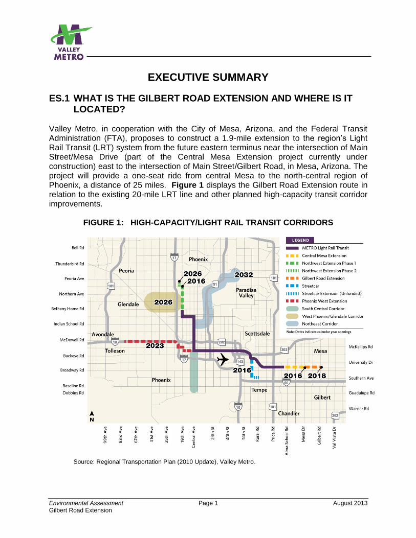
Valley Metro, in cooperation with the City of Mesa, Arizona, and the Federal Transit Administration (FTA), proposes to construct a 1.9-mile extension to the region’s Light Rail Transit (LRT) system from the future eastern terminus near the intersection of Main Street/Mesa Drive (part of the Central Mesa Extension project currently under construction) east to the intersection of Main Street/Gilbert Road, in Mesa, Arizona. The project will provide a one-seat ride from central Mesa to the north-central region of Phoenix, a distance of 25 miles. Figure 1 displays the Gilbert Road Extension route in relation to the existing 20-mile LRT line and other planned high-capacity transit corridor improvements.
FIGURE 1: HIGH-CAPACITY/LIGHT RAIL TRANSIT CORRIDORS
Source: Regional Transportation Plan (2010 Update), Valley Metro.
Environmental Assessment Page 2 August 2013
Gilbert Road Extension
This Environmental Assessment (EA) initially considered two Build Alternatives, each on Main Street (Figure 2), but with different traffic configurations (i.e., two lanes providing one through traffic lane in each direction; and four lanes maintaining the existing two through traffic lanes in each direction). A design option for the two-lane configuration using modern roundabouts at quarter-mile and mid-block neighborhood street intersections was also considered. On April 4, 2013, the City of Mesa City Council adopted a preferred alternative which combines elements of all the Build Alternatives initially considered.
FIGURE 2: BUILD ALTERNATIVES
Major characteristics of the proposed project are displayed in Table 1.
ES.2 WHY WAS THE ENVIRONMENTAL ASSESSMENT WRITTEN AND WHAT DOES IT INCLUDE?
It is anticipated that federal funding will be available to Valley Metro from the sources discussed in Section ES.6 for the Gilbert Road Extension. To use these federal funds, the National Environmental Policy Act (NEPA) requires evaluation of effects on the human and natural environment that would result from development of the project. Additionally, NEPA requires that the Build Alternative be compared with a No-Build Alternative, meaning no light rail would be constructed east of Mesa Drive in Mesa. This EA provides the results of the evaluation.
Environmental Assessment Page 3 August 2013
Gilbert Road Extension
TABLE 1: GILBERT ROAD EXTENSION AT-A-GLANCE Feature Additional Information
Route distance
Beginning point
Termination point
1.9 miles
Main Street - East of Mesa Drive (near Edgemont)
Main Street at Gilbert Road
Operations begin Late 2018
Trackwork 2 median-running tracks (1 in each direction)
Continuously welded steel rails.
Track rail embedded in a concrete slab for aesthetic purposes and
provides level and smooth crossings for autos and pedestrians where
such crossings are allowed.
Stations 2 stations provided:
- Stapley Drive/Main Street
- Gilbert Road/Main Street
Light Rail Vehicles Same vehicles as used on the existing LRT line.
Carry 175 passengers per vehicle.
Operating speed in corridor=same as posted speed limit or 35 mph
maximum. Maximum speed of vehicles=55 mph.
Could operate as a two- or three-car train depending on demand. A two-
car train will be the most common configuration.
Headways/Hours of Operation (2031) Weekdays – 10 minutes all day service from 4:40 AM-12:00 AM
Overhead Catenary System (OCS) Distributes electricity to LRT vehicles, traction power substations, and
signaling and communication systems.
Steel or concrete poles support power line. Poles about 25 feet tall and
typically installed at intervals from 90 to 170 feet.
Poles normally located between the two bi-directional tracks. Sometimes
located on the side of the LRT trackway with the overhead electrical line
suspended over the LRT tracks.
Traction Power Substation (TPSS) Supplies electricity for LRT operations.
An enclosed structure about 20-by-40 feet (30-by-60 feet including the
grounding mat around the substation).
2 TPSSs will be required. One to be located at the end-of-line in the
planned park-and-ride facility at Gilbert Road and one approximately mid-
way along the route.
Operations and Maintenance Uses existing LRT Operations and Maintenance Center (OMC).
Sidewalks/Bicycle Lanes Bi-directional to be provided as currently exists.
Park-and-Ride A park-and-ride at the end-of-line at Gilbert Road/Main Street.
Likely to be surface parking. A structure may also be considered.
Two optional locations being considered:
- Park-and-Ride (North Option – north of Main Street)
- Park-and-Ride (South Option – south of Main Street)
This EA has been prepared in accordance with the Council on Environmental Quality Regulations (40 Code of Federal Regulations [CFR] 1500), Regulations for Implementing the Procedural Provisions of the National Environmental Policy Act (NEPA), and the joint Federal Transit Administration (FTA)/Federal Highway Administration (FHWA) regulations (23 CFR 771), Environmental Impact and Related Procedures.
Environmental Assessment Page 4 August 2013
Gilbert Road Extension
The major chapters of the EA and a synopsis of each are presented below. This executive summary outlines the information provided in the EA. For additional information on a specific topic, please refer to the EA document itself. Chapter 1: Introduction and Purpose and Need for Proposed Project – Presents a discussion of why an EA is being prepared and defines the purpose of the project, the need for mobility improvements, and the goals for the project. Chapter 2: Alternatives to the Proposed Project – Discusses the alternatives screening process used to select the initial alternatives evaluated in this EA. The chapter also defines the initial alternatives selected for evaluation as well as the two options being considered for a park-and-ride facility at the Gilbert Road/Main Street intersection. Chapter 3: Environmental Impacts – Describes the anticipated impacts associated with the No-Build Alternative and Build Alternatives, including the roundabouts design option, that were defined in Chapter 2. Also assesses and compares the potential impacts of the two options for park-and-ride. Potential mitigation measures are identified for adverse impacts. Mitigation measures will be finalized in the Revised EA. Chapter 4: Who are the Agencies and Persons Consulted? – Describes the community outreach process and specific stakeholders and others consulted as part of project development. Chapter 5: Conclusions and Recommendation for a Preferred Alternative for Implementation – Summarizes the major findings of the alternatives evaluated in the EA and recommends a refined alternative for implementation that is a “hybrid” of all of the Build Alternatives initially considered. The chapter also evaluates the effects of the Preferred Alternative. Chapter 6: How Much Will the Proposed Alternative Cost and How Will it Be Funded? – Outlines the federal and local sources of funding anticipated to be used to construct and operate the Gilbert Road Extension. Chapter 7: References and Sources – Lists the references and sources used in this EA.
ES.3 WHY IS THE PROJECT NEEDED AND WHAT ISSUES WOULD IT ADDRESS?
The purpose and need for the project is summarized as follows. Additional information can be found in Chapter 1 of the EA.
Environmental Assessment Page 5 August 2013
Gilbert Road Extension
The need for the proposed project is to:
Accommodate the travel needs of a growing population.
Improve local and regional mobility, especially during peak travel times.
Provide a reliable transportation service and improve regional transit efficiencies.
Link Mesa and East Valley populations with regional employment centers and activity destinations.
Maximize the economic development potential of the corridor. The purpose of the project is to provide high-capacity, efficient transit service that:
Improves the level of transit service and increases transit ridership by directly linking central Mesa and East Valley populations with destinations travelers currently reach by car.
Enables access and mobility to regional job and activity centers, including the Mesa central business district, and provides a reliable reverse-commute option.
Provides a cost-competitive, effective travel option capable of attracting new riders to the transit system with reliable travel time savings to encourage greater mode split.
Enjoys a wide-range of public and stakeholder support, encourages public-private partnerships, supports local businesses.
ES.4 WHAT ALTERNATIVES HAVE BEEN CONSIDERED AND HOW DID WE GET TO THE ALTERNATIVES NOW PROPOSED?
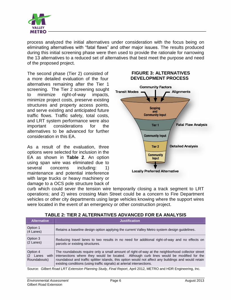
A series of alternative LRT design concepts were developed for evaluation that were capable of integrating with the Central Mesa Extension of the original 20-mile LRT system. The Central Mesa Extension is currently under construction and, when completed, will extend from the current eastern LRT end-of-line station at Sycamore in west Mesa along Main Street through Downtown Mesa and eastward to Mesa Drive. The development of alternatives for the Gilbert Road Extension was a collaborative process involving technical evaluation led by Valley Metro and the City of Mesa, with input from the public and corridor stakeholders on key design elements and environmental issues. Refer to Chapter 4 for additional information about public outreach. Initially, 13 LRT build alternatives were developed for consideration. The primary difference between each alternative was in the number of vehicle travel lanes provided on Main Street. The alternatives had either four travel lanes as currently exists (two lanes in both the eastbound and westbound directions) or two travel lanes (one lane in each direction). A two-tiered alternatives development process (Figure 3) was used to evaluate conceptual alternatives on Main Street. The first phase (Tier 1) of the evaluation
Environmental Assessment Page 6 August 2013
Gilbert Road Extension
FIGURE 3: ALTERNATIVES DEVELOPMENT PROCESS
process analyzed the initial alternatives under consideration with the focus being on eliminating alternatives with “fatal flaws” and other major issues. The results produced during this initial screening phase were then used to provide the rationale for narrowing the 13 alternatives to a reduced set of alternatives that best meet the purpose and need of the proposed project. The second phase (Tier 2) consisted of a more detailed evaluation of the four
alternatives remaining after the Tier 1 screening. The Tier 2 screening sought to minimize right-of-way impacts, minimize project costs, preserve existing structures and property access points, and serve existing and anticipated future traffic flows. Traffic safety, total costs, and LRT system performance were also important considerations for the alternatives to be advanced for further consideration in this EA. As a result of the evaluation, three options were selected for inclusion in the EA as shown in Table 2. An option using span wire was eliminated due to several concerns including: 1) maintenance and potential interference with large trucks or heavy machinery or damage to a OCS pole structure back of curb which could sever the tension wire temporarily closing a track segment to LRT operations; and 2) wires crossing Main Street could be a concern to Fire Department vehicles or other city departments using large vehicles knowing where the support wires were located in the event of an emergency or other construction project.
TABLE 2: TIER 2 ALTERNATIVES ADVANCED FOR EA ANALYSIS
Alternative Justification
Option 1 (4 Lanes)
Retains a baseline design option applying the current Valley Metro system design guidelines.
Option 3 (2 Lanes)
Reducing travel lanes to two results in no need for additional right-of-way and no effects on parcels or existing structures.
Option 4 (2 Lanes with Roundabouts)
The roundabouts require only a small amount of right-of-way at the neighborhood collector street intersections where they would be located. Although curb lines would be modified for the roundabout and traffic splitter islands, this option would not affect any buildings and would retain existing conditions (using traffic signals) at arterial intersections.
Source: Gilbert Road LRT Extension Planning Study, Final Report, April 2012, METRO and HDR Engineering, Inc.
Environmental Assessment Page 7 August 2013
Gilbert Road Extension
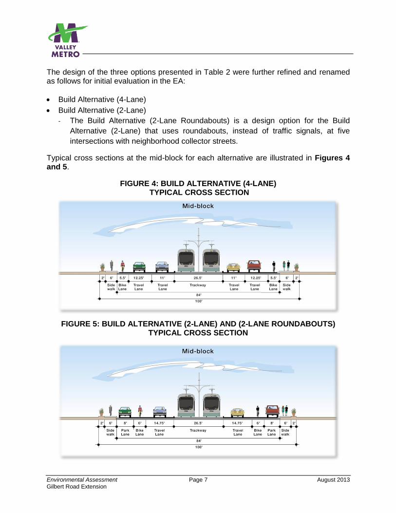
The design of the three options presented in Table 2 were further refined and renamed as follows for initial evaluation in the EA:
Build Alternative (4-Lane)
Build Alternative (2-Lane)
- The Build Alternative (2-Lane Roundabouts) is a design option for the Build
Alternative (2-Lane) that uses roundabouts, instead of traffic signals, at five
intersections with neighborhood collector streets.
Typical cross sections at the mid-block for each alternative are illustrated in Figures 4 and 5.
FIGURE 4: BUILD ALTERNATIVE (4-LANE) TYPICAL CROSS SECTION
FIGURE 5: BUILD ALTERNATIVE (2-LANE) AND (2-LANE ROUNDABOUTS) TYPICAL CROSS SECTION
Environmental Assessment Page 8 August 2013
Gilbert Road Extension
In addition, it was determined that a park-and-ride facility would be needed at the end-of-line station at Gilbert Road. Two optional sites were developed for evaluation in the EA. The Park-and-Ride (North Option) would be located on the north side of Main Street, while the Park-and-Ride (South Option) would be located on the south side of that same street.
The initial evaluation of the alternatives described above did not result in any alternative emerging with a clear community consensus. Each alternative had positive characteristics along with consequences, effectively creating a set of tradeoffs. Following further consultation with community leaders, a refined alternative emerged which includes elements of each alternative considered in this EA, the so-called Build Alternative (Hybrid). This alternative narrows the roadway to two traffic lanes (one lane in each direction) where traffic congestion is not an issue and employs four traffic lanes (two lanes in each direction) where the highest potential for congestion would occur. It also incorporates modern roundabouts at two intersections to allow traffic to make full U-turns to access connecting neighborhood streets and businesses on both the north and south sides of the light rail alignment. On April 4, 2013 the Mesa City Council voted to recommend the Build Alternative (Hybrid) as the Preferred Alternative (PA), and the Park-and-Ride (South Option) was also endorsed as the parking element of the PA. For further information about the alternatives’ evaluation process and definitions of alternatives evaluated in the EA, refer to Chapters 2 and 5 of the EA.
ES.5 WOULD THERE BE ANY SIGNIFICANT ENVIRONMENTAL IMPACTS?
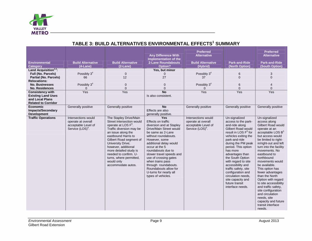
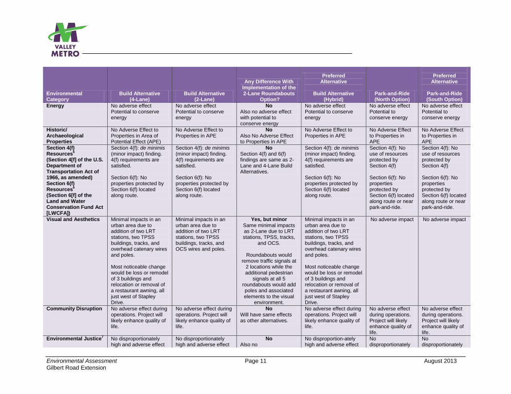
Technical studies summarized in the EA and also included as appendices to the EA have determined that the Build Alternatives (including the roundabout design option) and the two Park-and-Ride Options would not result in any significant adverse impacts. However, the alternatives would still have some effects, both positive and negative, as summarized in Table 3. Options to mitigate adverse impacts as well as standard construction practices are listed in Table 4. In all cases, measures are available to reduce adverse impacts to levels that are below significant. Specific mitigation measures will be identified in the Revised EA. Refer to Chapters 3 and 5 of the EA for additional information regarding impacts and mitigation strategies.
Environmental Assessment Page 9 August 2013
Gilbert Road Extension
TABLE 3: BUILD ALTERNATIVES ENVIRONMENTAL EFFECTS1 SUMMARY
Environmental Category
Build Alternative (4-Lane)
Build Alternative (2-Lane)
Any Difference With Implementation of the 2-Lane Roundabouts
Option?
Preferred Alternative
Build Alternative
(Hybrid) Park-and-Ride (North Option)
Preferred
Alternative
Park-and-Ride (South Option)
Land Acquisition2,3
: Full (No. Parcels) Partial (No. Parcels) Relocations: No. Businesses No. Residences
Possibly 3
4
66
Possibly 34
0
0 12
0 0
Yes, but minor 0 27
0 0
Possibly 3
4
37
Possibly 34
0
6 0 6 0
3 0 4 0
Consistency with Existing Land Uses and Local Plans Related to Corridor
Yes Yes No Is also consistent.
Yes Yes Yes
Economic Impacts/Secondary Development
Generally positive Generally positive No Effects are also generally positive.
Generally positive Generally positive Generally positive
Traffic Operations
Intersections would operate at overall acceptable Level of Service (LOS)
5.
The Stapley Drive/Main Street intersection would operate at LOS F
5.
Traffic diversion may be an issue along the eastbound Harris to Gilbert Road segment of University Drive; however, additional more detailed study is needed to confirm. U-turns, where permitted, would only accommodate autos.
Yes Effects on traffic diversion and at Stapley Drive/Main Street would be same as 2-Lane without roundabouts. However, some additional delay would occur at the 5 roundabouts due to slower travel speeds and use of crossing gates when trains pass through roundabouts. Roundabouts allow for U-turns for nearly all types of vehicles.
Intersections would operate at overall acceptable Level of Service (LOS)
5.
Un-signalized access to the park-and-ride along Gilbert Road would result in LOS F
5 for
vehicles exiting the park-and-ride during the PM peak period. This option has more advantages than the South Option with regard to site accessibility and traffic safety, site configuration and circulation needs, site capacity and future transit interface needs.
Un-signalized access along Gilbert Road would operate at an acceptable LOS B
5
but access would be limited to right-in/right-out and left turn into the facility movements. No eastbound to northbound movements would be available. This option has fewer advantages than the North Option with regard to site accessibility and traffic safety, site configuration and circulation needs, site capacity and future transit interface needs.

Environmental Assessment Page 10 August 2013
Gilbert Road Extension
Environmental Category
Build Alternative (4-Lane)
Build Alternative (2-Lane)
Any Difference With Implementation of the 2-Lane Roundabouts
Option?
Preferred Alternative
Build Alternative
(Hybrid) Park-and-Ride (North Option)
Preferred
Alternative
Park-and-Ride (South Option)
On-Street Parking Total Spaces Available No. Spaces Removed
0 212
92 120
Yes 149 63
92 120
N/A N/A
Freight Mobility No adverse effect No adverse effect No No adverse effect
No adverse effect N/A N/A
Pedestrians/Bicyclists No adverse effect. Existing bicycle lanes would be retained.
No adverse effect. Existing bicycle lanes would be retained.
Yes Bicycle lanes would be eliminated in the 5 roundabouts and cyclists would likely share sidewalks with pedestrians.
Bicycle lanes would be eliminated in the 2 roundabouts and cyclists would likely share sidewalks with pedestrians.
No adverse effect No adverse effect
Emergency Services and Vehicles Access
Reduced left turn access across tracks could affect services.
Reduced left turn access across tracks and potential for increased response times at some locations during peak congestion could affect services.
No Left turn access and potential response time issues same as 2-Lane without roundabouts.
Reduced left turn access across tracks could
affect services.
N/A N/A
Other Transit Services No adverse effect. Improved connections to LRT would make all transit in study area more efficient.
No adverse effect. Improved connections to LRT would make all transit in study area more efficient.
No Also no adverse effect and more efficient transit service.
No adverse effect. Improved connections to LRT would make all transit in study area more efficient.
N/A N/A
Air Quality No adverse effect No adverse effect No Also no adverse effect.
No adverse effect No adverse effect No adverse effect
Noise and Vibration - Noise
- Vibration
Moderate noise impact: - El Rancho Motel - Motel at 1045 Main - Frontier Motel - Days Inn Hotel - Suit You Trailer Park - Shady Grove Trailer
Park Vibration impact: - Motel at 1045 Main - Frontier Motel - Days Inn Hotel - Suit You Trailer Park
Moderate noise impact: - Frontier Motel - Shady Grove Trailer
Park Vibration impact: - Motel at 1045 Main - Frontier Motel - Days Inn Hotel - Suit You Trailer Park
No
Noise impact same as 2-Lane without roundabouts
No Vibration impact same as 2-Lane without roundabouts
Moderate noise impact: - Motel at 1045 Main - Frontier Motel - Shady Grove Trailer
Park Vibration impact: - Motel at 1045 Main - Frontier Motel - Days Inn Hotel - Suit You Trailer Park
No noise or vibration impact
No noise or vibration impact
Environmental Assessment Page 11 August 2013
Gilbert Road Extension
Environmental Category
Build Alternative (4-Lane)
Build Alternative (2-Lane)
Any Difference With Implementation of the 2-Lane Roundabouts
Option?
Preferred Alternative
Build Alternative
(Hybrid) Park-and-Ride (North Option)
Preferred
Alternative
Park-and-Ride (South Option)
Energy No adverse effect Potential to conserve energy
No adverse effect Potential to conserve energy
No Also no adverse effect with potential to conserve energy
No adverse effect Potential to conserve energy
No adverse effect Potential to conserve energy
No adverse effect Potential to conserve energy
Historic/ Archaeological Properties
No Adverse Effect to Properties in Area of Potential Effect (APE)
No Adverse Effect to Properties in APE
No Also No Adverse Effect to Properties in APE
No Adverse Effect to Properties in APE
No Adverse Effect to Properties in APE
No Adverse Effect to Properties in APE
Section 4(f) Resources
6
(Section 4[f] of the U.S. Department of Transportation Act of 1966, as amended) Section 6(f) Resources
6
(Section 6[f] of the Land and Water Conservation Fund Act [LWCFA])
Section 4(f): de minimis (minor impact) finding. 4(f) requirements are satisfied. Section 6(f): No properties protected by Section 6(f) located along route.
Section 4(f): de minimis (minor impact) finding. 4(f) requirements are satisfied. Section 6(f): No properties protected by Section 6(f) located along route.
No Section 4(f) and 6(f) findings are same as 2-Lane and 4-Lane Build Alternatives.
Section 4(f): de minimis (minor impact) finding. 4(f) requirements are satisfied. Section 6(f): No properties protected by Section 6(f) located along route.
Section 4(f): No use of resources protected by Section 4(f) Section 6(f): No properties protected by Section 6(f) located along route or near park-and-ride.
Section 4(f): No use of resources protected by Section 4(f) Section 6(f): No properties protected by Section 6(f) located along route or near park-and-ride.
Visual and Aesthetics Minimal impacts in an urban area due to addition of two LRT stations, two TPSS buildings, tracks, and overhead catenary wires and poles. Most noticeable change would be loss or remodel of 3 buildings and relocation or removal of a restaurant awning, all just west of Stapley Drive.
Minimal impacts in an urban area due to addition of two LRT stations, two TPSS buildings, tracks, and OCS wires and poles.
Yes, but minor Same minimal impacts as 2-Lane due to LRT stations, TPSS, tracks,
and OCS.
Roundabouts would remove traffic signals at
2 locations while the additional pedestrian
signals at all 5 roundabouts would add poles and associated elements to the visual
environment.
Minimal impacts in an urban area due to addition of two LRT stations, two TPSS buildings, tracks, and overhead catenary wires and poles. Most noticeable change would be loss or remodel of 3 buildings and relocation or removal of a restaurant awning, all just west of Stapley Drive.
No adverse impact No adverse impact
Community Disruption No adverse effect during operations. Project will likely enhance quality of life.
No adverse effect during operations. Project will likely enhance quality of life.
No Will have same effects as other alternatives.
No adverse effect during operations. Project will likely enhance quality of life.
No adverse effect during operations. Project will likely enhance quality of life.
No adverse effect during operations. Project will likely enhance quality of life.
Environmental Justice7
No disproportionately high and adverse effect
No disproportionately high and adverse effect
No Also no
No disproportion-ately high and adverse effect
No disproportionately
No disproportionately
Environmental Assessment Page 12 August 2013
Gilbert Road Extension
Environmental Category
Build Alternative (4-Lane)
Build Alternative (2-Lane)
Any Difference With Implementation of the 2-Lane Roundabouts
Option?
Preferred Alternative
Build Alternative
(Hybrid) Park-and-Ride (North Option)
Preferred
Alternative
Park-and-Ride (South Option)
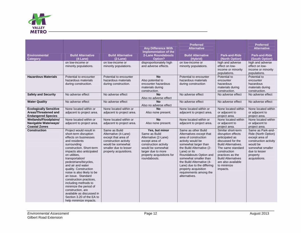
on low-income or minority populations.
on low-income or minority populations.
disproportionately high and adverse effects.
on low-income or minority populations.
high and adverse effect on low-income or minority populations.
high and adverse effect on low-income or minority populations.
Hazardous Materials Potential to encounter hazardous materials during construction.
Potential to encounter hazardous materials during construction.
No Also potential to encounter hazardous materials during construction.
Potential to encounter hazardous materials during construction
Potential to encounter hazardous materials during construction.
Potential to encounter hazardous materials during construction.
Safety and Security No adverse effect No adverse effect No Also no adverse effect
No adverse effect No adverse effect No adverse effect
Water Quality No adverse effect No adverse effect No Also no adverse effect
No adverse effect No adverse effect No adverse effect
Ecologically Sensitive Areas/Threatened and Endangered Species
None located within or adjacent to project area.
None located within or adjacent to project area.
No Also none present.
None located within or adjacent to project area.
None located within or adjacent to project area.
None located within or adjacent to project area.
Wetlands/Floodplains/ Navigable Waterways/ Coastal Zones
None located within or adjacent to project area.
None located within or adjacent to project area.
No Also none present.
None located within or adjacent to project area.
None located within or adjacent to project area.
None located within or adjacent to project area.
Construction
Project would result in short-term disruption effects on businesses and residents surrounding construction. Short-term impacts also anticipated on utilities, transportation/ pedestrians/bicycles, and air and water quality. Construction noise is also likely to be an issue. Standard construction practices, including methods to minimize the period of construction, are available as discussed in Section 3.20 of the EA to help minimize impacts.
Same as Build Alternative (4-Lane) except that area of construction activity would be somewhat smaller due to lesser property acquisitions.
Yes, but minor Same as Build Alternative (2-Lane) except area of construction activity would be somewhat larger due to more property acquisitions for roundabouts.
Same as other Build Alternatives except that area of construction activity would be somewhat larger than the Build Alternative (2-Lane) or its Roundabouts Option and somewhat smaller than the Build Alternative (4-Lane) due to the differing property acquisition requirements among the alternatives.
Similar short-term disruption effects anticipated as discussed for the Build Alternatives. The same standard construction practices as the Build Alternatives are also available to minimize impacts.
Same as Park-and-Ride (North Option) except area of construction activity would be somewhat smaller due to lesser property acquisitions.
Environmental Assessment Page 13 August 2013
Gilbert Road Extension
Environmental Category
Build Alternative (4-Lane)
Build Alternative (2-Lane)
Any Difference With Implementation of the 2-Lane Roundabouts
Option?
Preferred Alternative
Build Alternative
(Hybrid) Park-and-Ride (North Option)
Preferred
Alternative
Park-and-Ride (South Option)
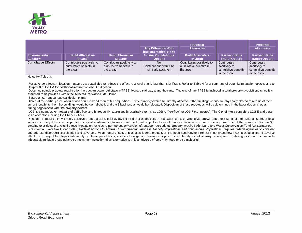
Cumulative Effects Contributes positively to cumulative benefits in the area.
Contributes positively to cumulative benefits in the area.
No Contributions would be
similarly positive.
Contributes positively to cumulative benefits in the area.
Contributes positively to cumulative benefits in the area.
Contributes positively to cumulative benefits in the area.
Notes for Table 3: 1For adverse effects, mitigation measures are available to reduce the effect to a level that is less than significant. Refer to Table 4 for a summary of potential mitigation options and to
Chapter 3 of the EA for additional information about mitigation. 2Does not include property required for the traction power substation (TPSS) located mid way along the route. The end-of-line TPSS is included in total property acquisitions since it is
assumed to be provided within the selected Park-and-Ride Option. 3Based on current conceptual design plans.
4Three of the partial parcel acquisitions could instead require full acquisition. Three buildings would be directly affected. If the buildings cannot be physically altered to remain at their
current locations, then the buildings would be demolished, and the 3 businesses would be relocated. Disposition of these properties will be determined in the latter design phases during negotiations with the property owners. 5LOS is a quantitative measure of traffic flow and is frequently expressed in qualitative terms as LOS A (free-flow) to LOS F (congested). The City of Mesa considers LOS E and better
to be acceptable during the PM peak hour. 6Section 4(f) requires FTA to only approve a project using publicly owned land of a public park or recreation area, or wildlife/waterfowl refuge or historic site of national, state, or local
significance only if there is no prudent or feasible alternative to using that land, and project includes all planning to minimize harm resulting from use of the resource. Section 6(f) pertains to projects that would cause impacts on, or require permanent conversion of, outdoor recreational property acquired with Land and Water Conservation Fund Act assistance. 7Presidential Executive Order 12898, Federal Actions to Address Environmental Justice in Minority Populations and Low-Income Populations, requires federal agencies to consider
and address disproportionately high and adverse environmental effects of proposed federal projects on the health and environment of minority and low-income populations. If adverse effects of a project fall disproportionately on these populations, additional mitigation measures beyond those already identified may be required. If strategies cannot be taken to adequately mitigate these adverse effects, then selection of an alternative with less adverse effects may need to be considered.
Environmental Assessment Page 14 August 2013
Gilbert Road Extension
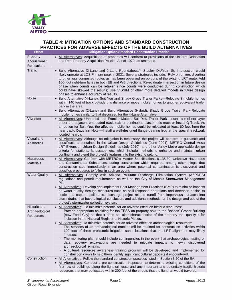
TABLE 4: MITIGATION OPTIONS AND STANDARD CONSTRUCTION PRACTICES FOR ADVERSE EFFECTS OF THE BUILD ALTERNATIVES
Effect Mitigation Option/Standard Construction Practice
Property
Acquisitions/
Relocations
All Alternatives: Acquisitions of properties will conform to provisions of the Uniform Relocation and Real Property Acquisition Policies Act of 1970, as amended.
Traffic Build Alternative (2-Lane and 2-Lane Roundabouts): Stapley Dr./Main St. intersection would likely operate at LOS F in pm peak in 2031. Several strategies include: Rely on drivers diverting to other less congested routes as has been observed on portions of the existing LRT route; Add 100-foot right-turn lanes in both EB and WB directions; Re-evaluate intersection in future design phase when counts can be retaken since counts were conducted during construction which could have skewed the results; Use VISSIM or other more detailed models in future design phases to enhance accuracy of results.
Noise Build Alternative (4-Lane): Suit You and Shady Grove Trailer Parks—Relocate 8 mobile homes within 140 feet of track outside this distance or move mobile homes to another equivalent trailer park in the area.
Build Alternative (2-Lane) and Build Alternative (Hybrid): Shady Grove Trailer Park-Relocate mobile homes similar to that discussed for the 4-Lane Alternative.
Vibration All Alternatives: Unnamed and Frontier Motels, Suit You Trailer Park—Install a resilient layer under the adjacent embedded track slab or continuous elastomeric mats or install Q Track. As an option for Suit You, the affected mobile homes could be relocated at least 60 feet from the near track. Days Inn Hotel—Install a well-designed flange-bearing frog at the special trackwork located nearby.
Visual and
Aesthetics
All Alternatives: Although no mitigation is necessary, the project will conform to guidance and specifications contained in the Urban Design Guidelines (June 2001), METRO Central Mesa LRT Extension Urban Design Guidelines (July 2010), and other Valley Metro applicable design criteria for stations, landscape, etc. which include methods to enhance and maintain urban continuity and blend the project’s features into the existing setting.
Hazardous
Materials
All Alternatives: Conform with METRO’s Master Specifications 01.35.30, Unknown Hazardous and Contaminated Substances, during construction which requires, among other things, that construction stop immediately in an area where potential contamination is discovered and specifies procedures to follow in such an event.
Water Quality All Alternatives: Comply with Arizona Pollutant Discharge Elimination System (AZPDES) regulations and permit requirements as well as the City of Mesa’s Stormwater Management Plan.
All Alternatives: Develop and implement Best Management Practices (BMP) to minimize impacts on water quality through measures such as spill response operations and detention basins to settle and capture pollutants, discharge project-related runoff from impervious surfaces into storm drains that have a logical conclusion, and additional methods for the design and use of the project’s stormwater collection system.
Historic and
Archaeological
Resources
All Alternatives: To minimize potential for an adverse effect on historic resources: - Provide appropriate shielding for the TPSS on property next to the Bashas’ Grocer Building
(now Food City) so that it does not alter characteristics of the property that qualify it for inclusion in the National Register of Historic Places.
All Alternatives: To minimize potential for an adverse effect on archaeological resources: - The services of an archaeological monitor will be retained for construction activities within
100 feet of three prehistoric irrigation canal locations that the LRT alignment may likely intersect.
- The monitoring plan should include contingencies in the event that archaeological testing or data recovery excavations are needed to mitigate impacts to newly discovered archaeological remains.
- A cultural resources awareness training program will be developed and implemented for construction crews to help them identify significant cultural deposits if encountered.
Construction All Alternatives: Follow the standard construction practices listed in Section 3.20 of the EA.
All Alternatives: Conduct a pre-construction inspection to determine existing conditions of the first row of buildings along the light rail route and any important and potentially fragile historic resources that may be located within 200 feet of the streets that the light rail would traverse.
Environmental Assessment Page 15 August 2013
Gilbert Road Extension
ES.6 HOW MUCH WOULD THE PROJECT COST AND HOW WOULD IT BE FUNDED?
Capital Costs and Funding Sources The estimated capital costs for the 1.9-mile Preferred Alternative for the LRT extension is $143 million (Year of Expenditure $) and is based on construction beginning in early 2015. The City of Mesa intends to use previously appropriated federal Surface Transportation Program (STP) and Congestion Mitigation and Air Quality Improvement Program (CMAQ) funds to help pay for the majority (about 94.3 percent) of the construction of the Gilbert Road Extension project. The STP funds amount to approximately 82.7 percent, and the CMAQ funds amount to approximately 11.6 percent of the capital cost for the project. Working with the Maricopa Association of Governments (MAG), the City of Mesa identified sixteen roadway improvement projects for which Surface Transportation Program (STP) funds had been previously committed. These projects were considered either low priority projects for the city, no longer necessary, or already completed. For these reasons, the City of Mesa approved (with MAG concurrence) the re-purposing of these federal funds for use in constructing the Gilbert Road Extension project. The re-purposing of these funds was also approved by the Maricopa County Board of Supervisors, and the State Transportation Board. Approximately 5.7 percent of the funds for capital costs for this project would come from the City of Mesa as a local match. No funds from the State of Arizona will be used for this project. Operating Costs and Funding Sources The estimated annual operating cost for the Preferred Alternative is approximately $3.2 million. Approximately 72 percent of the funds that will be used for the PA are expected to come from the City of Mesa General Fund. Farebox revenue is anticipated to cover the remaining 28 percent of the operating costs. Valley Metro estimates the farebox revenues are a conservative share due to the large number of fare media and employer, school, and special event programs available to riders. Forecasts of farebox revenue recovery between fiscal years 2013 and 2017, based on anticipated ridership and future changes in fares, suggest a system revenue recovery of approximately 33%. ES.7 WHAT COMMENTS WERE RECEIVED ON THE EA? The EA was released for public comment on June 7, 2013 for the customary 30-day comment period. Copies of the document were available at the Mesa Main Library and at Valley Metro headquarters and were available for download from the Valley Metro web site at www.valleymetro.org/gilbertroad.
Environmental Assessment Page 16 August 2013
Gilbert Road Extension
During the comment period, a public meeting was held on June 13, 2013 at the Mesa Church of Christ Fellowship Hall that is located centrally within the project area. Notification for this meeting included advertisements in local newspapers including The Arizona Republic (Mesa section), The East Valley Tribune, and La Voz. In addition, 10,650 doorhangers were delivered to residents and businesses within the corridor from University Drive to Broadway Road and from 24th Street to Mesa Drive notifying of the document’s release and the opportunities to provide comments. The Valley Metro Project Team also published the meeting notification on the Valley Metro web site and sent via a mass email message to all Gilbert Road stakeholders in Valley Metro’s database.
Valley Metro received 49 comments during the comment period. The specific comments and Valley Metro responses may be found in Appendix L of the Revised EA.
Environmental Assessment Page 1-1 August 2013
Gilbert Road Extension
1.0 INTRODUCTION AND PURPOSE AND NEED FOR THE PROPOSED PROJECT
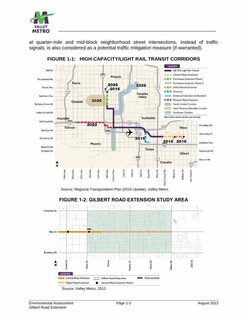
1.1 WHAT IS THE PROPOSED PROJECT AND WHY IS AN ENVIRONMENTAL ASSESSMENT BEING PREPARED? Valley Metro, in cooperation with the City of Mesa, Arizona, and the Federal Transit Administration (FTA), proposes to construct the Gilbert Road Extension project. The proposed project will extend the region’s Light Rail Transit (LRT) system from the future eastern terminus at Mesa Drive (part of the Central Mesa Extension project currently under construction) east to the intersection of Main Street and Gilbert Road, in Mesa, Arizona. The purpose of this Environmental Assessment (EA) is to analyze and report the potential environmental effects of the Proposed Action, or Build Alternatives, and reasonable alternatives (including a No-Build Alternative) in accordance with the National Environmental Policy Act (NEPA). Because the project will be federally funded, the proposed project must be evaluated per the Council on Environmental Quality (CEQ) regulations and FTA guidance for implementation of NEPA. Chapter 5 provides additional information about the project funding. In May, 2009, the City of Mesa Council (the Council) approved a Locally Preferred Alternative (LPA) to extend the region’s current LRT system by 3.1 miles from the existing Sycamore Station to Mesa Drive (currently under construction). As part of this decision, the Council also approved funding for analysis of a future LRT extension east along Main Street to Gilbert Road, given the strong ridership demand, regional bus network optimization opportunities, connections with major highways, quality-of-life improvements for central Mesa, and its preference as a long-range site for a park-and-ride facility to capitalize on emerging travel demand markets. The Gilbert Road Extension project, although not part of the 2004 voter-approved Regional Transportation Plan (RTP), is a contributing element to the regional concept of building 57 miles of high-capacity/light rail transit improvements in the Maricopa Association of Governments (MAG) region. Valley Metro plans to begin LRT operations to Gilbert Road in 2018. Figure 1-1 displays the proposed project’s route in relation to the 20-mile LRT Starter Line and other planned high-capacity transit corridor improvements. The project study area is displayed in Figure 1-2. The study area is defined as the area bounded by University Drive to the north, Broadway Road to the south, Gilbert Road to the east, and Mesa Drive to the west. The project study area encompasses a land area of approximately 2 square miles in central Mesa. The proposed project is a 1.9-mile easterly extension to Gilbert Road, and considers two Build Alternatives sharing the same alignment but different traffic lane configurations that will provide a one-seat ride from central Mesa to the north-central region of Phoenix, a distance of 28 miles. A design option using modern roundabouts
Environmental Assessment Page 1-2 August 2013
Gilbert Road Extension
at quarter-mile and mid-block neighborhood street intersections, instead of traffic signals, is also considered as a potential traffic mitigation measure (if warranted).
FIGURE 1-1: HIGH-CAPACITY/LIGHT RAIL TRANSIT CORRIDORS
Source: Regional Transportation Plan (2010 Update), Valley Metro.
FIGURE 1-2: GILBERT ROAD EXTENSION STUDY AREA
Source: Valley Metro, 2012.
Environmental Assessment Page 1-3 August 2013
Gilbert Road Extension
Chapter 2 discusses the alternatives considered in this EA and the process used to define the scale and scope of proposed improvements in greater detail. The chapter also summarizes the results of an earlier planning study for the Gilbert Road Extension which considered and evaluated an array of additional alternatives. This study1 is hereby incorporated by reference into this EA. 1.2 WHY DO WE NEED HIGH-CAPACITY TRANSIT IN THE STUDY AREA? The need for the Gilbert Road Extension project is based on several present opportunities and anticipated future transportation deficiencies that have been identified during previous studies of the Main Street corridor. The need for the project is demonstrated in five areas:
Accommodating the travel needs of a growing population
Improving local and regional mobility, especially during peak travel times
Providing a reliable transportation service and improve regional transit efficiencies
Linking Mesa and East Valley populations with regional employment centers and activity destinations
Maximizing the economic development potential of the corridor For decades, the predominant form of transportation in Mesa and the East Valley region has been the private automobile. While regional travel has been improved by the construction of limited access highways, the continued development of central Mesa and the East Valley region has resulted in dramatic traffic growth and congested roadway conditions, particularly during peak travel periods. The need to drive between destinations has been reinforced by low-density land development sprawling across the landscape. While public transportation services are currently available along Main Street and within the study area, the effectiveness of local transit services has diminished in recent years. Incremental system changes (principally in the form of transit service reductions) have increased transit travel times and reduced transit capacities, which can be discouraging to regular and/or potential transit system users. Despite some targeted investments in transit services and facilities, these improvements have continued to be overshadowed by years of continued investment in highway infrastructure and arterial roadway capacity. But as community dynamics have changed, local leaders now recognize the value of a balanced transportation network that offers travelers a range of mobility options, along with the social and economic dividends accrued to communities. The City of Mesa has embraced transit, and specifically LRT, as a means of increasing mobility for local residents, employees, and visitors. As evidenced by the success of daily ridership and
1 Gilbert Road LRT Extension Planning Study, Final Report, April 2012, Valley Metro and HDR Engineering, Inc.
Environmental Assessment Page 1-4 August 2013
Gilbert Road Extension
park-and-ride utilization at the Sycamore Station in Mesa, the city has desired the extension of LRT further east into Mesa to capitalize on the significant ridership potential of the city and East Valley. The city has also realized the land development investment potential based on several private-sector developments and investments around transit facilities, with businesses relocating to downtown Mesa expressly because of future light rail connections and several private colleges opening soon in the vicinity of downtown. The city has enacted several land development policies and actions to increase sustainable urban mixed-use focused around light rail. These actions include the adoption of the Central Main Street Plan and a Form-Based Code zoning ordinance, both of which support urban mixed-use development, minimum development densities within station areas, and provisions for shared parking. Additional information on the city’s planning and zoning changes to support transit are documented in Chapter 3. Accommodate the Travel Needs of a Growing Population The need for a mixture of transportation choices in Mesa and the East Valley is driven by the region’s rapid population and employment growth. Between 1990 and 2010, Mesa grew by 52% in total population. Forecasting growth surrounding the corridor projects that both population and employment will increase by 21%, respectively, between 2010 and 2030. As the population and employment base of the city increase, traffic congestion is anticipated to worsen, exerting additional pressure on the existing transportation network. Without satisfactory travel options, increased traffic congestion has several spill-over effects, including impacts to the local economy, the region’s environmental health, and quality-of-life impacts. Improve Local and Regional Mobility, Especially during Peak Travel Times Traffic conditions within the study area are anticipated to worsen by 2031, especially during peak travel times. According to current traffic counts, Main Street currently carries approximately 22,000 vehicles daily. A conservative estimate of traffic growth based on historic traffic growth trends (and accounting for future population increases) suggests that Main Street could carry over 28,000 vehicles daily in year 2030, a growth of 27%. No opportunities exist to expand study area roadways without unacceptable impacts to the built environment at a significant cost. As Main Street has been widened over time, traffic levels of service (LOS) have typically reverted to pre-build conditions. As a result, the business displacement impacts and costs accrued with the purchase of right-of-way are incurred without any real long-term benefit. Furthermore, the widening of Main Street has resulted in property build lines abutting the roadway. Any future widening of Main Street would require the demolition of several structures. The extension of LRT would provide commuters with a high-capacity travel option capable of minimizing impacts to congested local streets and freeways. Interlined as part of the regional LRT system, extension of LRT into central Mesa will help capture trips that otherwise must be made by car today. Current travel forecasts anticipate over 2,800 daily trips from a station at Gilbert Road alone.
Environmental Assessment Page 1-5 August 2013
Gilbert Road Extension
Provide a Reliable Transportation Service and Improve Regional Transit Efficiencies Although Mesa and other East Valley communities benefit from relatively low-cost housing, the cost of housing is inversely proportional to the distance from major employment centers and activity destinations. Transit service in the study area is predominantly available along urban arterial roads with modest service levels and hours of operation. Extension of the LRT system would provide a viable alternative to automobile travel, and will provide a convenient and reliable transportation mode to transit-dependent populations. Link Central Mesa and East Valley Populations with Regional Employment Centers and Activity Destinations Current analysis of regional travel demand patterns indicates that the majority of trips originating from central and east Mesa are destined for the regional employment centers of downtown Tempe, Arizona State University, Sky Harbor International Airport, and downtown Phoenix. Additionally, several regional activity centers are clustered around the existing LRT starter line, including the Phoenix Convention Center, Phoenix Art Museum, Chase Field, and the US Airways Center. Extension of the LRT system to Gilbert Road would provide residents of central and east Mesa (and residents of the East Valley) with a one-seat transit ride to these employment centers and popular regional destinations. Maximizing the Economic Development Potential of the Corridor The city’s new Central Main Street Plan provides policy guidance for future investments and the design of Main Street between Sycamore and Gilbert Road. East of Mesa Drive, Gilbert Road is the busiest north-south arterial road in the city. Coupled with the city’s form-based code ordinance, local land use and zoning policies have been adopted to encourage transit-supportive developments and facilities surrounding LRT. Significant opportunities for economic development are possible within the project study area. Introduction of LRT to Gilbert Road, in coordination with local land use planning, can support the community’s goals for promoting concentrated urban development and revitalizing the east side of downtown Mesa. 1.3 WHAT IS THE PURPOSE OF THE PROPOSED PROJECT? The purpose of the Gilbert Road Extension project is to provide high-capacity, efficient transit service that:
Improves the level of transit service and increases transit ridership by directly linking central Mesa and East Valley populations with destinations travelers currently reach by car.
Enables access and mobility to regional job and activity centers, including the Mesa central business district, and provides a reliable reverse-commute option.
Environmental Assessment Page 1-6 August 2013
Gilbert Road Extension
Provides a cost-competitive, effective travel option capable of attracting new riders to the transit system with reliable travel time savings to encourage greater mode split.
Enjoys a wide-range of public and stakeholder support, encourages public-private partnerships, supports local businesses.
1.4 WHAT ARE THE GOALS FOR THE PROPOSED PROJECT? In addition to the purpose and need, the goals and objectives stated in Table 1-1 were determined for the project based on public and stakeholder input to guide project development.
TABLE 1-1: GOALS AND OBJECTIVES FOR THE PROPOSED PROJECT
Goal Objectives
1—Improve transit reliability and mobility of the residential, business, and visitor communities within the project corridor and region.
Enhance connectivity to major employment, recreational, cultural, commercial, and educational activity centers within the corridor and greater metropolitan region.
Improve access for transit-dependent populations.
2—Maximize efficiency and effectiveness of the transportation system and accommodate travel-demand growth.
Maintain an acceptable and reliable level of transportation service.
Facilitate continued growth and development of a comprehensive, multimodal regional transit network.
Provide expanded public transportation choices in anticipation of travel demand.
Provide improved transit travel times between central and east Mesa with desired regional activity centers and downtown Mesa.
Attract new riders to the transit system.
3—Achieve a transportation system consistent with local, state and federal initiatives by supporting local and regional land use and development goals and enhancing the use of transit-supported land use, planning and design strategies.
Ensure consistency with local and regional plans.
Ensure compliance with Mesa-adopted economic, transportation, and community development policies as stated in the 2030 General Plan and Central Main Street Plan.
Continue development of the regional, 57-mile high-capacity transit system contained in the Regional Transportation Plan (RTP) 2010 Update adopted by MAG in July 2010.
Support and serve as a catalyst for economic development and enhanced connectivity among emerging transit-oriented development, high density land uses, activity centers and attractions in the study area.
4—Provide a public transportation project that is compatible with and enhances the local general plans.
Promote a pedestrian and bicycle-friendly environment.
Promote economic vitality in the project corridor.
Connect major activity centers within the project corridor.
Environmental Assessment Page 2-1 August 2013
Gilbert Road Extension
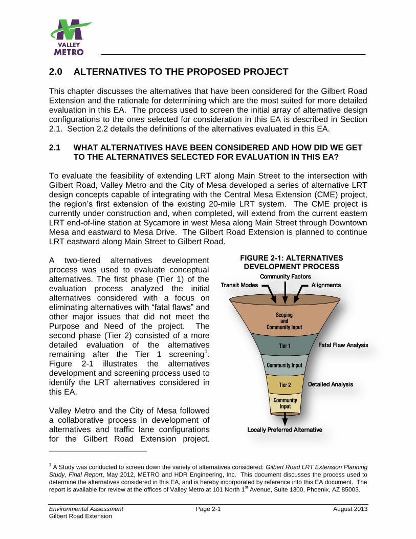
FIGURE 2-1: ALTERNATIVES DEVELOPMENT PROCESS
2.0 ALTERNATIVES TO THE PROPOSED PROJECT This chapter discusses the alternatives that have been considered for the Gilbert Road Extension and the rationale for determining which are the most suited for more detailed evaluation in this EA. The process used to screen the initial array of alternative design configurations to the ones selected for consideration in this EA is described in Section 2.1. Section 2.2 details the definitions of the alternatives evaluated in this EA. 2.1 WHAT ALTERNATIVES HAVE BEEN CONSIDERED AND HOW DID WE GET
TO THE ALTERNATIVES SELECTED FOR EVALUATION IN THIS EA? To evaluate the feasibility of extending LRT along Main Street to the intersection with Gilbert Road, Valley Metro and the City of Mesa developed a series of alternative LRT design concepts capable of integrating with the Central Mesa Extension (CME) project, the region’s first extension of the existing 20-mile LRT system. The CME project is currently under construction and, when completed, will extend from the current eastern LRT end-of-line station at Sycamore in west Mesa along Main Street through Downtown Mesa and eastward to Mesa Drive. The Gilbert Road Extension is planned to continue LRT eastward along Main Street to Gilbert Road.
A two-tiered alternatives development process was used to evaluate conceptual alternatives. The first phase (Tier 1) of the evaluation process analyzed the initial alternatives considered with a focus on eliminating alternatives with “fatal flaws” and other major issues that did not meet the Purpose and Need of the project. The second phase (Tier 2) consisted of a more detailed evaluation of the alternatives remaining after the Tier 1 screening1. Figure 2-1 illustrates the alternatives development and screening process used to identify the LRT alternatives considered in this EA. Valley Metro and the City of Mesa followed a collaborative process in development of alternatives and traffic lane configurations for the Gilbert Road Extension project.
1 A Study was conducted to screen down the variety of alternatives considered: Gilbert Road LRT Extension Planning
Study, Final Report, May 2012, METRO and HDR Engineering, Inc. This document discusses the process used to
determine the alternatives considered in this EA, and is hereby incorporated by reference into this EA document. The
report is available for review at the offices of Valley Metro at 101 North 1st Avenue, Suite 1300, Phoenix, AZ 85003.
Environmental Assessment Page 2-2 August 2013
Gilbert Road Extension
Contributing to the development of the Build Alternatives were available data on highway congestion, transit service levels and ridership information, and population and employment demographic forecasts. Initially, 13 LRT build alternatives were developed for consideration. The primary difference between each alignment was in the number of travel lanes provided. Each alternative provided either four travel lanes as currently exists (two lanes in both the eastbound and westbound directions) or two travel lanes (one lane in each direction). The 13 alternatives included:
Four alternatives based on current Valley Metro LRT design standards for the 20-mile Starter Line, with four travel lanes (two 11-foot left thru lanes and two 10-foot right turn lanes), and two 6-foot bicycle lanes.
Four alternatives employing a span wire overhead catenary system (OCS), instead of using poles in the center median. The configuration includes four 10-foot travel lanes and two 6-foot bicycle lanes.
Five alternatives featuring a reduction to two travel lanes as follows:
Two alternatives with left turn lanes One alternative with left turn lanes and two-way bicycle lanes
Two alternatives using modern roundabout intersections that could increase traffic carrying capacity at certain intersections, maintain automobile progression, and improve LRT train run speeds. Roundabouts are further defined in Section 2.2.2.3 below.
Throughout the process, the public provided input on the development and design elements of the proposed project. Valley Metro and the City of Mesa coordinated public involvement activities that included public open houses and meetings, stakeholder briefings with neighborhood associations and local businesses. The process used to identify the alternatives considered in this EA is described in greater detail below. 2.1.1 Alternatives Analysis – Tier 1 The Tier 1 analysis identified a universe of reasonable alternatives that best met the Purpose and Need of the proposed project. The evaluation considered several factors including: 1) station accessibility; 2) right-of-way requirements; 3) traffic safety and mobility; and 4) parking availability. The measurements used to evaluate these factors are presented in Table 2-1.
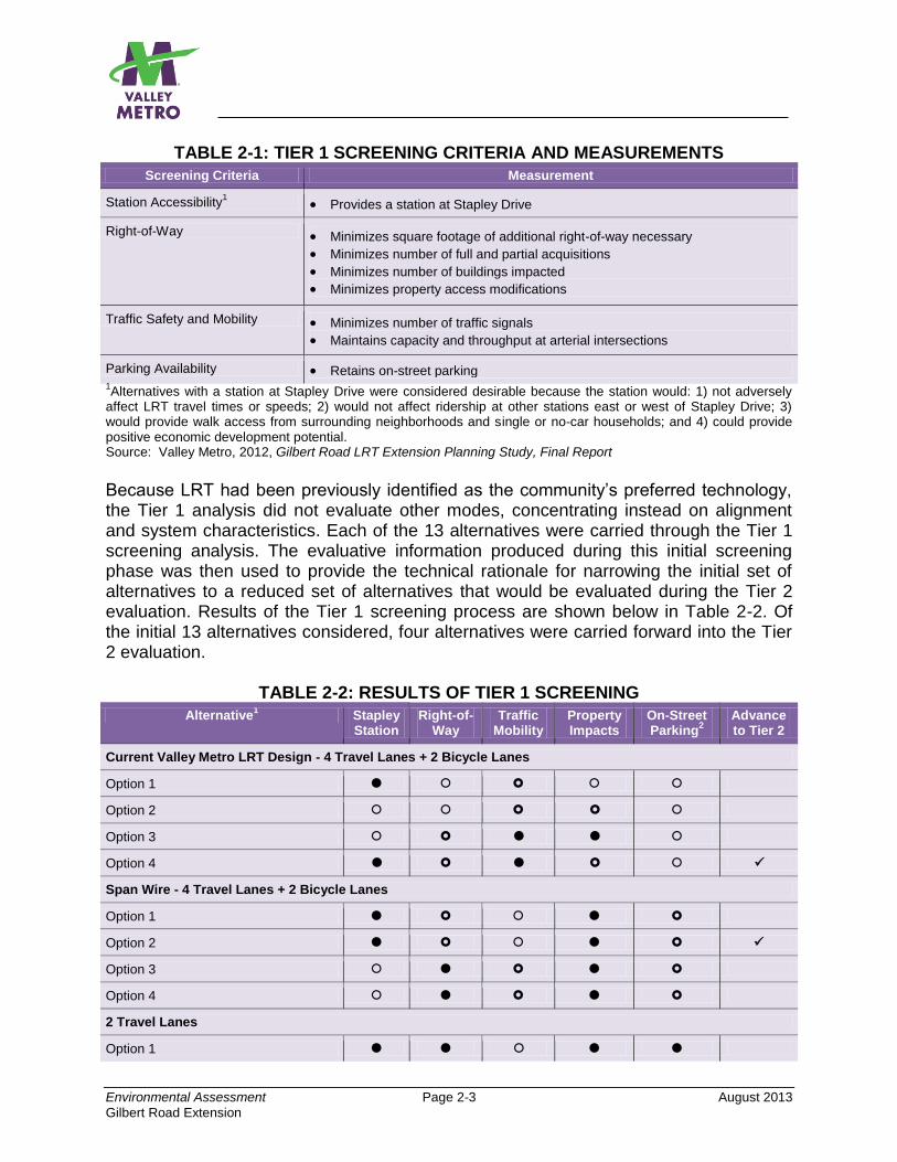
Environmental Assessment Page 2-3 August 2013
Gilbert Road Extension
TABLE 2-1: TIER 1 SCREENING CRITERIA AND MEASUREMENTS
Screening Criteria Measurement
Station Accessibility1 Provides a station at Stapley Drive
Right-of-Way Minimizes square footage of additional right-of-way necessary
Minimizes number of full and partial acquisitions
Minimizes number of buildings impacted
Minimizes property access modifications
Traffic Safety and Mobility Minimizes number of traffic signals
Maintains capacity and throughput at arterial intersections
Parking Availability Retains on-street parking 1Alternatives with a station at Stapley Drive were considered desirable because the station would: 1) not adversely
affect LRT travel times or speeds; 2) would not affect ridership at other stations east or west of Stapley Drive; 3) would provide walk access from surrounding neighborhoods and single or no-car households; and 4) could provide positive economic development potential. Source: Valley Metro, 2012, Gilbert Road LRT Extension Planning Study, Final Report
Because LRT had been previously identified as the community’s preferred technology, the Tier 1 analysis did not evaluate other modes, concentrating instead on alignment and system characteristics. Each of the 13 alternatives were carried through the Tier 1 screening analysis. The evaluative information produced during this initial screening phase was then used to provide the technical rationale for narrowing the initial set of alternatives to a reduced set of alternatives that would be evaluated during the Tier 2 evaluation. Results of the Tier 1 screening process are shown below in Table 2-2. Of the initial 13 alternatives considered, four alternatives were carried forward into the Tier 2 evaluation.
TABLE 2-2: RESULTS OF TIER 1 SCREENING
Alternative1 Stapley
Station Right-of-
Way Traffic
Mobility Property Impacts
On-Street Parking
2
Advance to Tier 2
Current Valley Metro LRT Design - 4 Travel Lanes + 2 Bicycle Lanes
Option 1
Option 2
Option 3
Option 4
Span Wire - 4 Travel Lanes + 2 Bicycle Lanes
Option 1
Option 2
Option 3
Option 4
2 Travel Lanes
Option 1

Environmental Assessment Page 2-4 August 2013
Gilbert Road Extension
Alternative1 Stapley
Station Right-of-
Way Traffic
Mobility Property Impacts
On-Street Parking
2
Advance to Tier 2
Option 2
Option 3
Option 4 (with Roundabouts)
Option 5 (with Roundabouts)
= Favorable = Fair = Unfavorable 1Several options were created for each design standard. In many cases, only minor design differences separated the
options; however, the minor design changes sometimes resulted in right-of-way savings or roadway improvements that could be beneficial to the corridor. 2Note: None of the 4-lane design alternatives (Options 1-4 above) include on-street parking. The alternatives using
span wire include minimal on-street parking. The alternatives reducing travel lanes to two include the most on-street parking. Source: Valley Metro, 2012, Gilbert Road LRT Extension Planning Study, Final Report
2.1.2 Alternatives Analysis – Tier 2 The four alternatives that were carried forward into the Tier 2 analysis are shown in Table 2-3. The Tier 2 evaluation was a more detailed screening process involving the four alternatives that best met the Tier 1 criteria. The design for the alternatives were further refined and renamed for convenience. The major features of these four options are portrayed in Table 2-4.
TABLE 2-3: TIER 1 ALTERNATIVES ADVANCED TO TIER 2 EVALUATION1
Alternative Justification
Valley Metro LRT Design Option 4 Minimizes total amount of additional right-of-way needed based on the current Valley Metro LRT design standards. This option includes a station at Stapley Drive.
Span Wire Option 2 Of the span wire alternatives, this option minimizes total amount of additional right-of-way and minimizes potential impacts on buildings and parcels.
Two Travel Lanes Option 2 By reducing the number of travel lanes, this option requires no additional right-of-way and does not affect any buildings or parcels.
Two Travel Lanes Option 5 with Roundabouts
Alternative requires a small amount of right-of-way only at the neighborhood collector street intersections where the curb lines would be modified to accommodate the roundabouts and traffic splitter islands. Alternative is not anticipated to affect any buildings, and it retains existing conditions at arterial intersections.
1All alternatives recommended for advancement include a station at Stapley Drive.
Source: Valley Metro, 2012, Gilbert Road LRT Extension Planning Study, Final Report
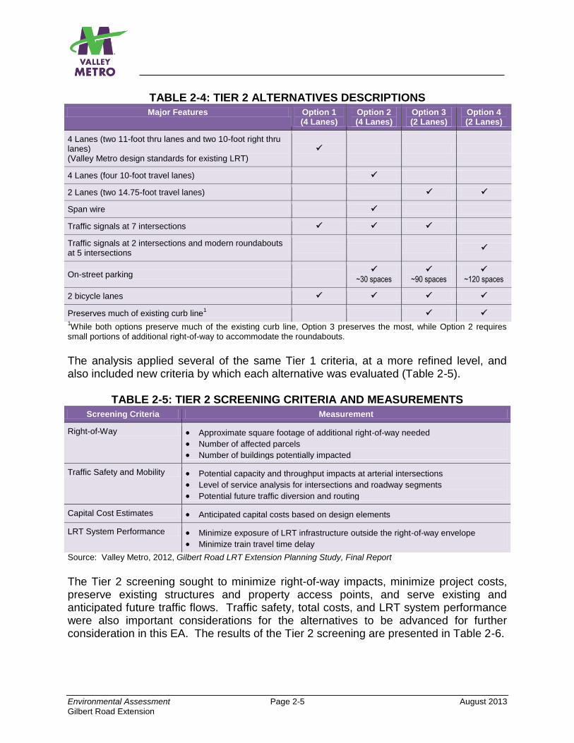
Environmental Assessment Page 2-5 August 2013
Gilbert Road Extension
TABLE 2-4: TIER 2 ALTERNATIVES DESCRIPTIONS
Major Features Option 1 (4 Lanes)
Option 2 (4 Lanes)
Option 3 (2 Lanes)
Option 4 (2 Lanes)
4 Lanes (two 11-foot thru lanes and two 10-foot right thru lanes) (Valley Metro design standards for existing LRT)
4 Lanes (four 10-foot travel lanes)
2 Lanes (two 14.75-foot travel lanes)
Span wire
Traffic signals at 7 intersections
Traffic signals at 2 intersections and modern roundabouts at 5 intersections
On-street parking
~30 spaces
~90 spaces
~120 spaces
2 bicycle lanes
Preserves much of existing curb line1
1While both options preserve much of the existing curb line, Option 3 preserves the most, while Option 2 requires
small portions of additional right-of-way to accommodate the roundabouts.
The analysis applied several of the same Tier 1 criteria, at a more refined level, and also included new criteria by which each alternative was evaluated (Table 2-5).
TABLE 2-5: TIER 2 SCREENING CRITERIA AND MEASUREMENTS
Screening Criteria Measurement
Right-of-Way Approximate square footage of additional right-of-way needed
Number of affected parcels
Number of buildings potentially impacted
Traffic Safety and Mobility Potential capacity and throughput impacts at arterial intersections
Level of service analysis for intersections and roadway segments
Potential future traffic diversion and routing
Capital Cost Estimates Anticipated capital costs based on design elements
LRT System Performance Minimize exposure of LRT infrastructure outside the right-of-way envelope
Minimize train travel time delay
Source: Valley Metro, 2012, Gilbert Road LRT Extension Planning Study, Final Report
The Tier 2 screening sought to minimize right-of-way impacts, minimize project costs, preserve existing structures and property access points, and serve existing and anticipated future traffic flows. Traffic safety, total costs, and LRT system performance were also important considerations for the alternatives to be advanced for further consideration in this EA. The results of the Tier 2 screening are presented in Table 2-6.
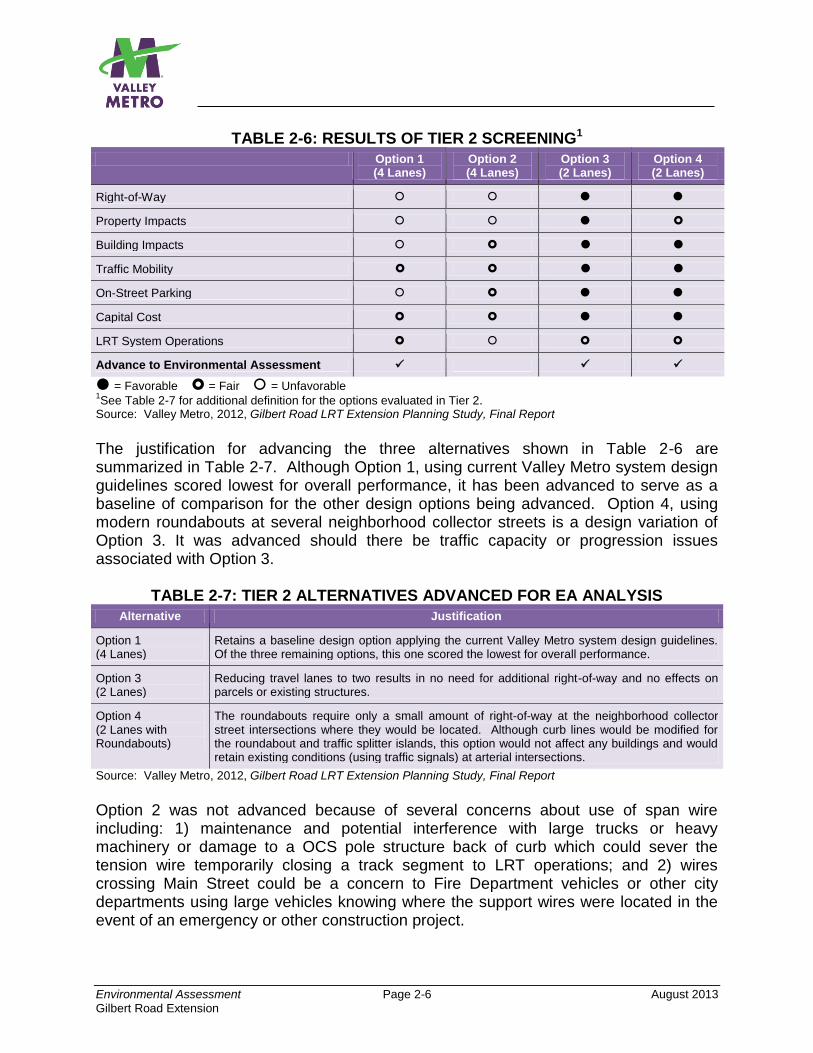
Environmental Assessment Page 2-6 August 2013
Gilbert Road Extension
TABLE 2-6: RESULTS OF TIER 2 SCREENING1
Option 1 (4 Lanes)
Option 2 (4 Lanes)
Option 3 (2 Lanes)
Option 4 (2 Lanes)
Right-of-Way
Property Impacts
Building Impacts
Traffic Mobility
On-Street Parking
Capital Cost
LRT System Operations
Advance to Environmental Assessment
= Favorable = Fair = Unfavorable 1See Table 2-7 for additional definition for the options evaluated in Tier 2.
Source: Valley Metro, 2012, Gilbert Road LRT Extension Planning Study, Final Report
The justification for advancing the three alternatives shown in Table 2-6 are summarized in Table 2-7. Although Option 1, using current Valley Metro system design guidelines scored lowest for overall performance, it has been advanced to serve as a baseline of comparison for the other design options being advanced. Option 4, using modern roundabouts at several neighborhood collector streets is a design variation of Option 3. It was advanced should there be traffic capacity or progression issues associated with Option 3.
TABLE 2-7: TIER 2 ALTERNATIVES ADVANCED FOR EA ANALYSIS
Alternative Justification
Option 1 (4 Lanes)
Retains a baseline design option applying the current Valley Metro system design guidelines. Of the three remaining options, this one scored the lowest for overall performance.
Option 3 (2 Lanes)
Reducing travel lanes to two results in no need for additional right-of-way and no effects on parcels or existing structures.
Option 4 (2 Lanes with Roundabouts)
The roundabouts require only a small amount of right-of-way at the neighborhood collector street intersections where they would be located. Although curb lines would be modified for the roundabout and traffic splitter islands, this option would not affect any buildings and would retain existing conditions (using traffic signals) at arterial intersections.
Source: Valley Metro, 2012, Gilbert Road LRT Extension Planning Study, Final Report
Option 2 was not advanced because of several concerns about use of span wire including: 1) maintenance and potential interference with large trucks or heavy machinery or damage to a OCS pole structure back of curb which could sever the tension wire temporarily closing a track segment to LRT operations; and 2) wires crossing Main Street could be a concern to Fire Department vehicles or other city departments using large vehicles knowing where the support wires were located in the event of an emergency or other construction project.
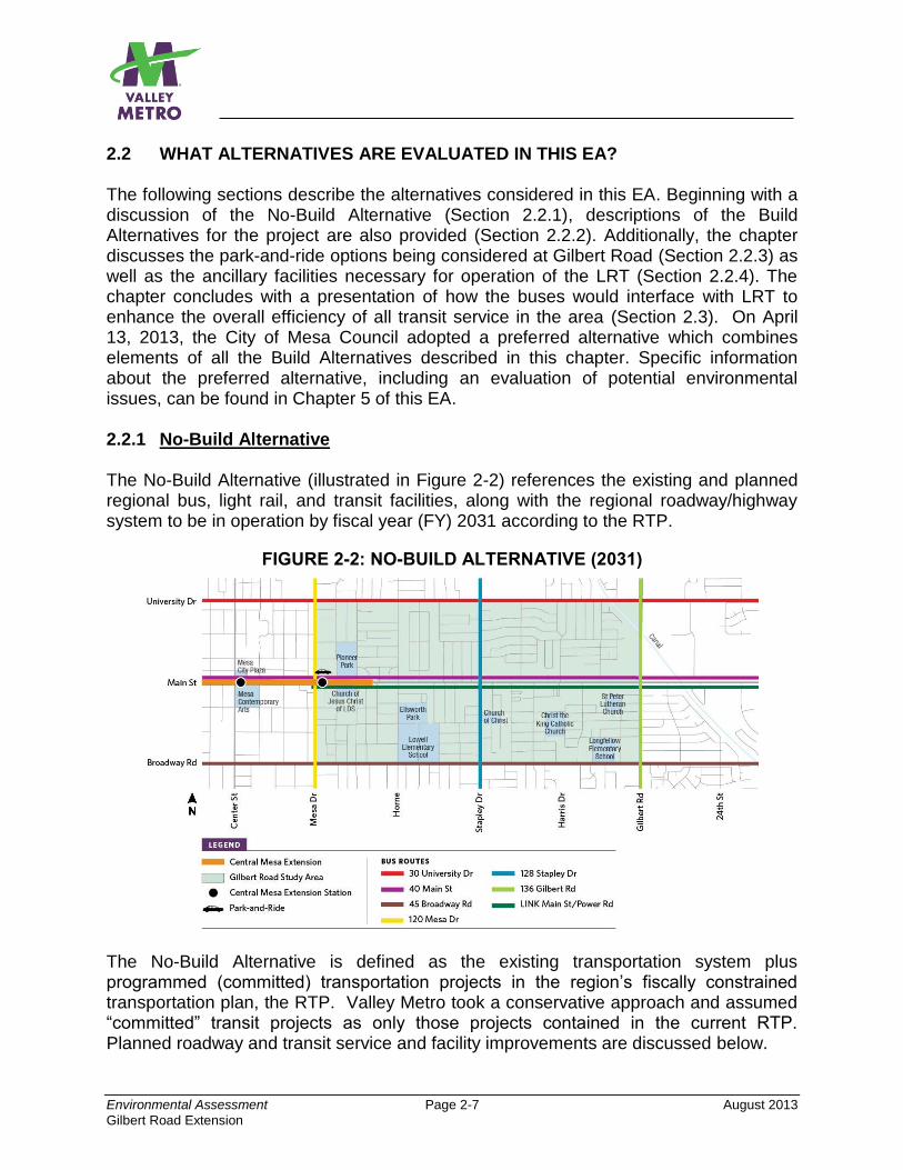
Environmental Assessment Page 2-7 August 2013
Gilbert Road Extension
2.2 WHAT ALTERNATIVES ARE EVALUATED IN THIS EA? The following sections describe the alternatives considered in this EA. Beginning with a discussion of the No-Build Alternative (Section 2.2.1), descriptions of the Build Alternatives for the project are also provided (Section 2.2.2). Additionally, the chapter discusses the park-and-ride options being considered at Gilbert Road (Section 2.2.3) as well as the ancillary facilities necessary for operation of the LRT (Section 2.2.4). The chapter concludes with a presentation of how the buses would interface with LRT to enhance the overall efficiency of all transit service in the area (Section 2.3). On April 13, 2013, the City of Mesa Council adopted a preferred alternative which combines elements of all the Build Alternatives described in this chapter. Specific information about the preferred alternative, including an evaluation of potential environmental issues, can be found in Chapter 5 of this EA. 2.2.1 No-Build Alternative The No-Build Alternative (illustrated in Figure 2-2) references the existing and planned regional bus, light rail, and transit facilities, along with the regional roadway/highway system to be in operation by fiscal year (FY) 2031 according to the RTP.
FIGURE 2-2: NO-BUILD ALTERNATIVE (2031)
The No-Build Alternative is defined as the existing transportation system plus programmed (committed) transportation projects in the region’s fiscally constrained transportation plan, the RTP. Valley Metro took a conservative approach and assumed “committed” transit projects as only those projects contained in the current RTP. Planned roadway and transit service and facility improvements are discussed below.
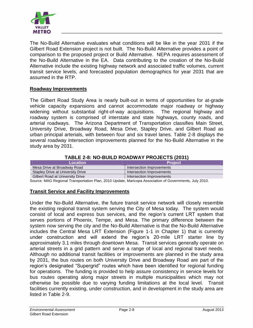
Environmental Assessment Page 2-8 August 2013
Gilbert Road Extension
The No-Build Alternative evaluates what conditions will be like in the year 2031 if the Gilbert Road Extension project is not built. The No-Build Alternative provides a point of comparison to the proposed project or Build Alternative. NEPA requires assessment of the No-Build Alternative in the EA. Data contributing to the creation of the No-Build Alternative include the existing highway network and associated traffic volumes, current transit service levels, and forecasted population demographics for year 2031 that are assumed in the RTP. Roadway Improvements The Gilbert Road Study Area is nearly built-out in terms of opportunities for at-grade vehicle capacity expansions and cannot accommodate major roadway or highway widening without substantial right-of-way acquisitions. The regional highway and roadway system is comprised of interstate and state highways, county roads, and arterial roadways. The Arizona Department of Transportation classifies Main Street, University Drive, Broadway Road, Mesa Drive, Stapley Drive, and Gilbert Road as urban principal arterials, with between four and six travel lanes. Table 2-8 displays the several roadway intersection improvements planned for the No-Build Alternative in the study area by 2031.
TABLE 2-8: NO-BUILD ROADWAY PROJECTS (2031) Location Project
Mesa Drive at Broadway Road Intersection Improvements
Stapley Drive at University Drive Intersection Improvements
Gilbert Road at University Drive Intersection Improvements Source: MAG Regional Transportation Plan, 2010 Update, Maricopa Association of Governments, July 2010.
Transit Service and Facility Improvements Under the No-Build Alternative, the future transit service network will closely resemble the existing regional transit system serving the City of Mesa today. The system would consist of local and express bus services, and the region’s current LRT system that serves portions of Phoenix, Tempe, and Mesa. The primary difference between the system now serving the city and the No-Build Alternative is that the No-Build Alternative includes the Central Mesa LRT Extension (Figure 1-1 in Chapter 1) that is currently under construction and will extend the region’s 20-mile LRT starter line by approximately 3.1 miles through downtown Mesa. Transit services generally operate on arterial streets in a grid pattern and serve a range of local and regional travel needs. Although no additional transit facilities or improvements are planned in the study area by 2031, the bus routes on both University Drive and Broadway Road are part of the region’s designated “Supergrid” routes which have been identified for regional funding for operations. The funding is provided to help assure consistency in service levels for bus routes operating along major streets in multiple municipalities which may not otherwise be possible due to varying funding limitations at the local level. Transit facilities currently existing, under construction, and in development in the study area are listed in Table 2-9.
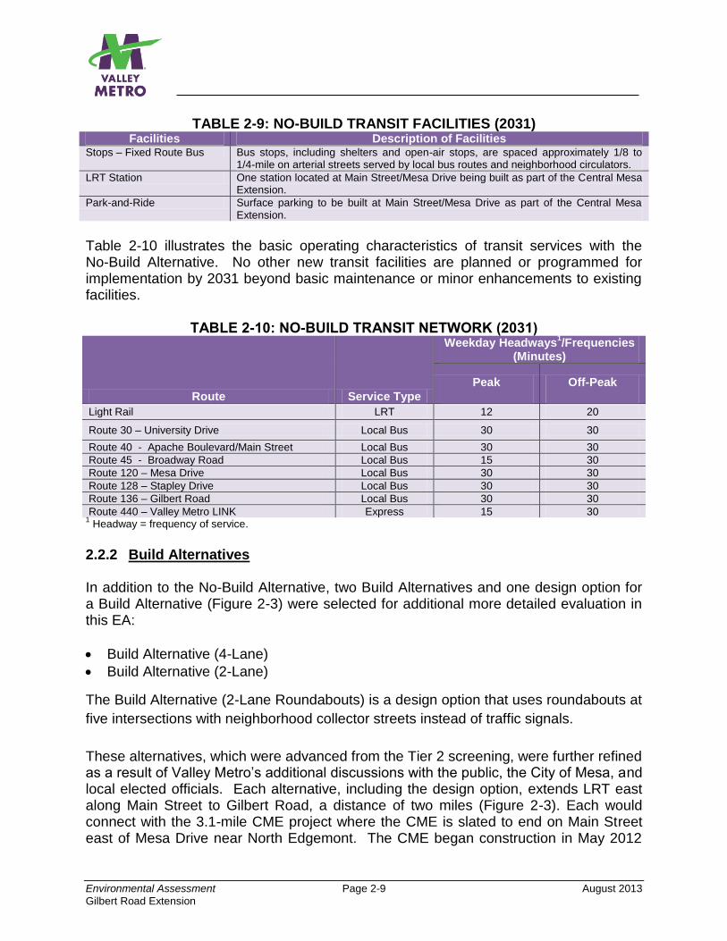
Environmental Assessment Page 2-9 August 2013
Gilbert Road Extension
TABLE 2-9: NO-BUILD TRANSIT FACILITIES (2031) Facilities Description of Facilities
Stops – Fixed Route Bus Bus stops, including shelters and open-air stops, are spaced approximately 1/8 to 1/4-mile on arterial streets served by local bus routes and neighborhood circulators.
LRT Station One station located at Main Street/Mesa Drive being built as part of the Central Mesa Extension.
Park-and-Ride Surface parking to be built at Main Street/Mesa Drive as part of the Central Mesa Extension.
Table 2-10 illustrates the basic operating characteristics of transit services with the No-Build Alternative. No other new transit facilities are planned or programmed for implementation by 2031 beyond basic maintenance or minor enhancements to existing facilities.
TABLE 2-10: NO-BUILD TRANSIT NETWORK (2031)
Route Service Type
Weekday Headways1/Frequencies
(Minutes)
Peak Off-Peak
Light Rail LRT 12 20
Route 30 – University Drive Local Bus 30 30
Route 40 - Apache Boulevard/Main Street Local Bus 30 30
Route 45 - Broadway Road Local Bus 15 30
Route 120 – Mesa Drive Local Bus 30 30
Route 128 – Stapley Drive Local Bus 30 30
Route 136 – Gilbert Road Local Bus 30 30
Route 440 – Valley Metro LINK Express 15 30 1 Headway = frequency of service.
2.2.2 Build Alternatives In addition to the No-Build Alternative, two Build Alternatives and one design option for a Build Alternative (Figure 2-3) were selected for additional more detailed evaluation in this EA:
Build Alternative (4-Lane)
Build Alternative (2-Lane)
The Build Alternative (2-Lane Roundabouts) is a design option that uses roundabouts at
five intersections with neighborhood collector streets instead of traffic signals.
These alternatives, which were advanced from the Tier 2 screening, were further refined as a result of Valley Metro’s additional discussions with the public, the City of Mesa, and local elected officials. Each alternative, including the design option, extends LRT east along Main Street to Gilbert Road, a distance of two miles (Figure 2-3). Each would connect with the 3.1-mile CME project where the CME is slated to end on Main Street east of Mesa Drive near North Edgemont. The CME began construction in May 2012
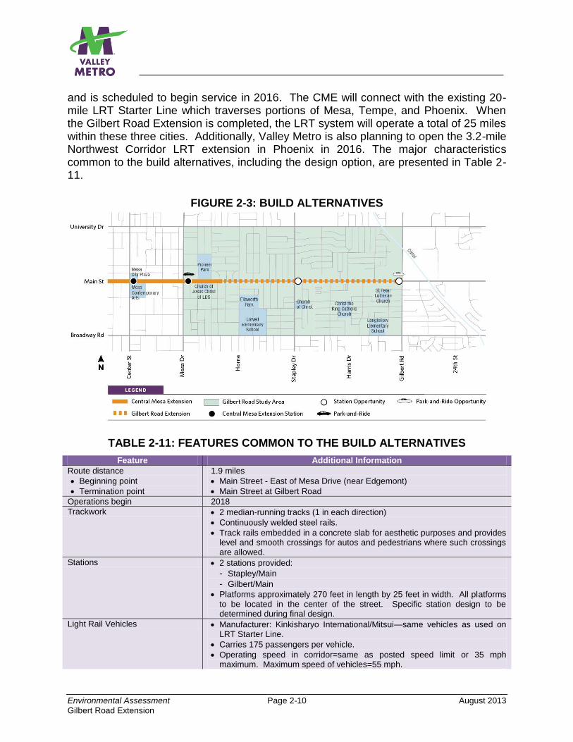
Environmental Assessment Page 2-10 August 2013
Gilbert Road Extension
and is scheduled to begin service in 2016. The CME will connect with the existing 20-mile LRT Starter Line which traverses portions of Mesa, Tempe, and Phoenix. When the Gilbert Road Extension is completed, the LRT system will operate a total of 25 miles within these three cities. Additionally, Valley Metro is also planning to open the 3.2-mile Northwest Corridor LRT extension in Phoenix in 2016. The major characteristics common to the build alternatives, including the design option, are presented in Table 2-11.
FIGURE 2-3: BUILD ALTERNATIVES
TABLE 2-11: FEATURES COMMON TO THE BUILD ALTERNATIVES
Feature Additional Information
Route distance
Beginning point
Termination point
1.9 miles
Main Street - East of Mesa Drive (near Edgemont)
Main Street at Gilbert Road
Operations begin 2018
Trackwork 2 median-running tracks (1 in each direction)
Continuously welded steel rails.
Track rails embedded in a concrete slab for aesthetic purposes and provides level and smooth crossings for autos and pedestrians where such crossings are allowed.
Stations 2 stations provided:
- Stapley/Main
- Gilbert/Main
Platforms approximately 270 feet in length by 25 feet in width. All platforms to be located in the center of the street. Specific station design to be determined during final design.
Light Rail Vehicles Manufacturer: Kinkisharyo International/Mitsui—same vehicles as used on LRT Starter Line.
Carries 175 passengers per vehicle.
Operating speed in corridor=same as posted speed limit or 35 mph maximum. Maximum speed of vehicles=55 mph.
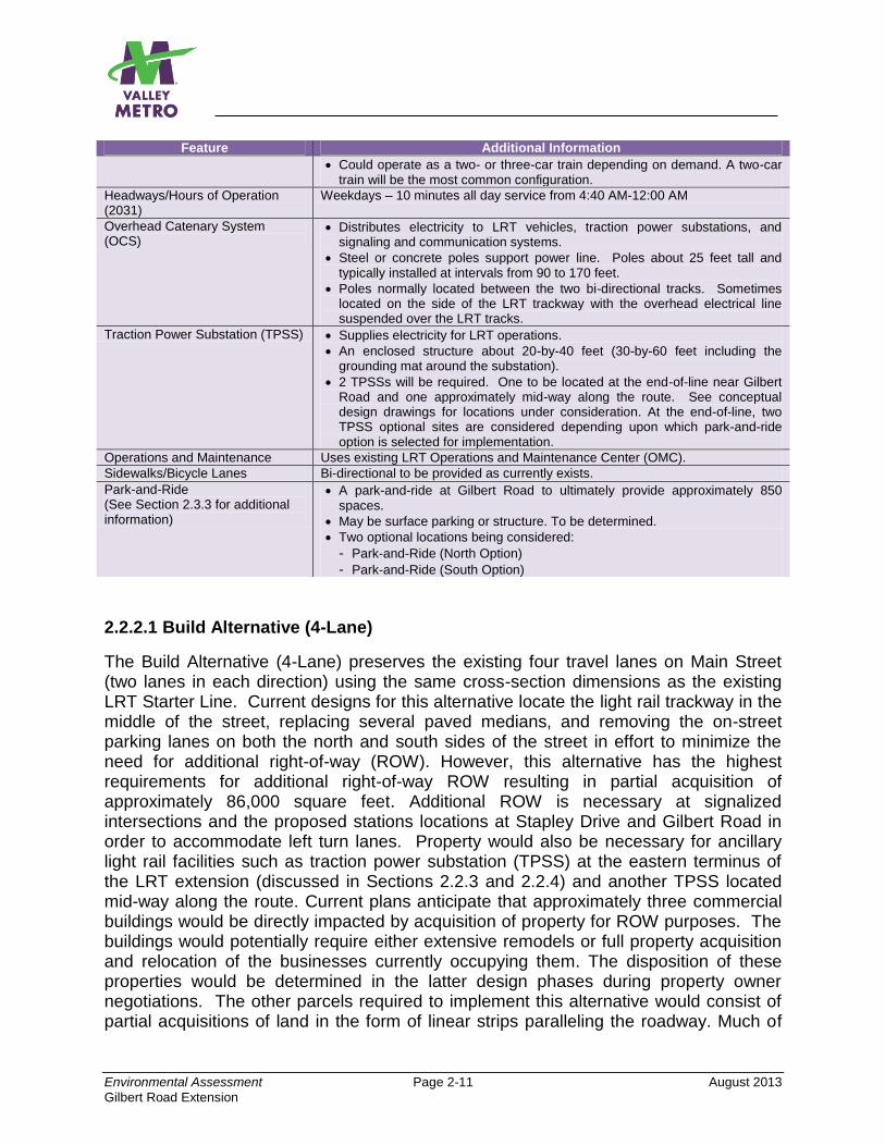
Environmental Assessment Page 2-11 August 2013
Gilbert Road Extension
Feature Additional Information
Could operate as a two- or three-car train depending on demand. A two-car train will be the most common configuration.
Headways/Hours of Operation (2031)
Weekdays – 10 minutes all day service from 4:40 AM-12:00 AM
Overhead Catenary System (OCS)
Distributes electricity to LRT vehicles, traction power substations, and signaling and communication systems.
Steel or concrete poles support power line. Poles about 25 feet tall and typically installed at intervals from 90 to 170 feet.
Poles normally located between the two bi-directional tracks. Sometimes located on the side of the LRT trackway with the overhead electrical line suspended over the LRT tracks.
Traction Power Substation (TPSS) Supplies electricity for LRT operations.
An enclosed structure about 20-by-40 feet (30-by-60 feet including the grounding mat around the substation).
2 TPSSs will be required. One to be located at the end-of-line near Gilbert Road and one approximately mid-way along the route. See conceptual design drawings for locations under consideration. At the end-of-line, two TPSS optional sites are considered depending upon which park-and-ride option is selected for implementation.
Operations and Maintenance Uses existing LRT Operations and Maintenance Center (OMC).
Sidewalks/Bicycle Lanes Bi-directional to be provided as currently exists.
Park-and-Ride (See Section 2.3.3 for additional information)
A park-and-ride at Gilbert Road to ultimately provide approximately 850 spaces.
May be surface parking or structure. To be determined.
Two optional locations being considered:
- Park-and-Ride (North Option)
- Park-and-Ride (South Option)
2.2.2.1 Build Alternative (4-Lane)
The Build Alternative (4-Lane) preserves the existing four travel lanes on Main Street (two lanes in each direction) using the same cross-section dimensions as the existing LRT Starter Line. Current designs for this alternative locate the light rail trackway in the middle of the street, replacing several paved medians, and removing the on-street parking lanes on both the north and south sides of the street in effort to minimize the need for additional right-of-way (ROW). However, this alternative has the highest requirements for additional right-of-way ROW resulting in partial acquisition of approximately 86,000 square feet. Additional ROW is necessary at signalized intersections and the proposed stations locations at Stapley Drive and Gilbert Road in order to accommodate left turn lanes. Property would also be necessary for ancillary light rail facilities such as traction power substation (TPSS) at the eastern terminus of the LRT extension (discussed in Sections 2.2.3 and 2.2.4) and another TPSS located mid-way along the route. Current plans anticipate that approximately three commercial buildings would be directly impacted by acquisition of property for ROW purposes. The buildings would potentially require either extensive remodels or full property acquisition and relocation of the businesses currently occupying them. The disposition of these properties would be determined in the latter design phases during property owner negotiations. The other parcels required to implement this alternative would consist of partial acquisitions of land in the form of linear strips paralleling the roadway. Much of
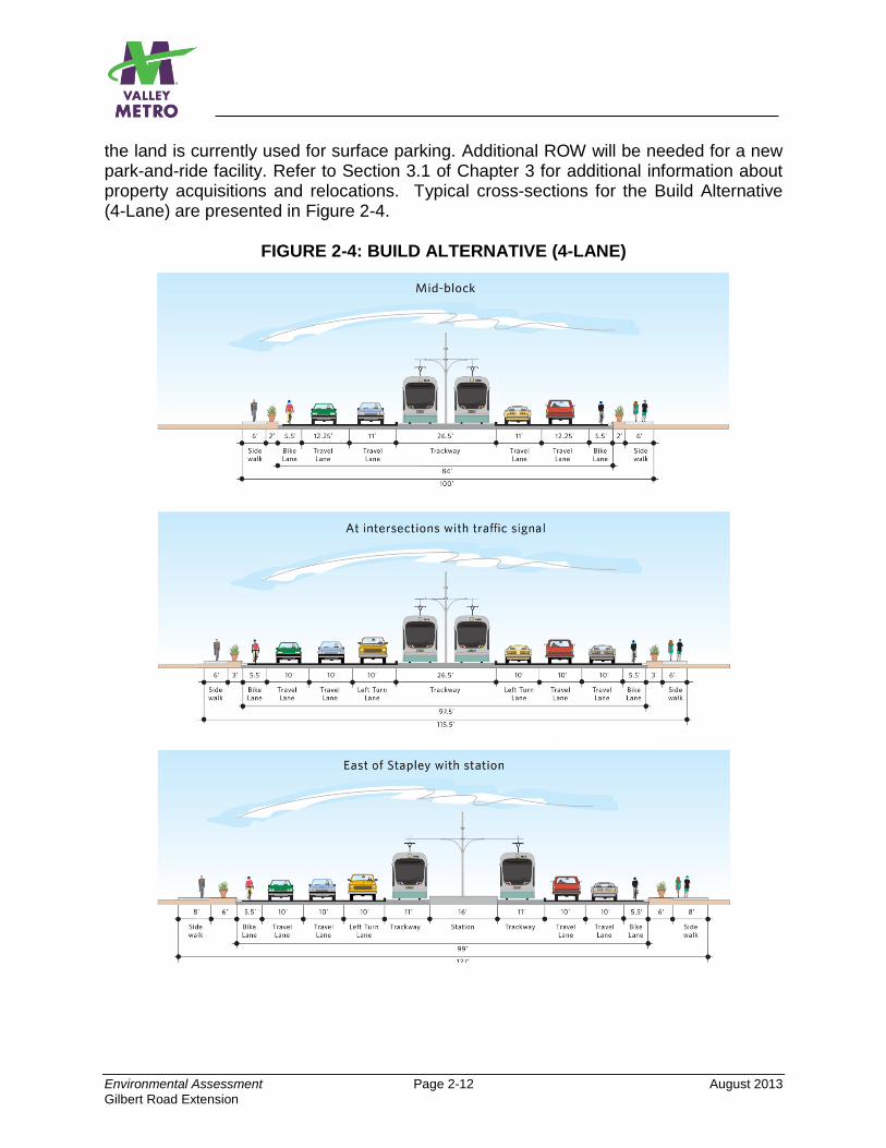
Environmental Assessment Page 2-12 August 2013
Gilbert Road Extension
the land is currently used for surface parking. Additional ROW will be needed for a new park-and-ride facility. Refer to Section 3.1 of Chapter 3 for additional information about property acquisitions and relocations. Typical cross-sections for the Build Alternative (4-Lane) are presented in Figure 2-4.
FIGURE 2-4: BUILD ALTERNATIVE (4-LANE)
Environmental Assessment Page 2-13 August 2013
Gilbert Road Extension
2.2.2.2 Build Alternative (2-Lane)
The main difference between the Build Alternative (2-Lane) and the Build Alternative (4-Lane) is that this alternative eliminates two through travel lanes (one in each direction) providing a total of two travel lanes. This alternative has the least requirements for additional right-of-way (approximately 26,000 square feet consisting of partial acquisitions). No business or residential relocations would be needed. Additional right-of-way will be required for a new park-and-ride facility and TPSS at the eastern terminus of the LRT extension and another TPSS located mid-way along the route. Typical cross sections for the Build Alternative (2-Lane) are presented in Figure 2-5 below.
FIGURE 2-5: BUILD ALTERNATIVE (2-LANE)
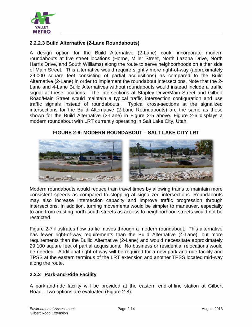
Environmental Assessment Page 2-14 August 2013
Gilbert Road Extension
2.2.2.3 Build Alternative (2-Lane Roundabouts)
A design option for the Build Alternative (2-Lane) could incorporate modern roundabouts at five street locations (Horne, Miller Street, North Lazona Drive, North Harris Drive, and South Williams) along the route to serve neighborhoods on either side of Main Street. This alternative would require slightly more right-of-way (approximately 29,000 square feet consisting of partial acquisitions) as compared to the Build Alternative (2-Lane) in order to implement the roundabout intersections. Note that the 2-Lane and 4-Lane Build Alternatives without roundabouts would instead include a traffic signal at these locations. The intersections at Stapley Drive/Main Street and Gilbert Road/Main Street would maintain a typical traffic intersection configuration and use traffic signals instead of roundabouts. Typical cross-sections at the signalized intersections for the Build Alternative (2-Lane Roundabouts) are the same as those shown for the Build Alternative (2-Lane) in Figure 2-5 above. Figure 2-6 displays a modern roundabout with LRT currently operating in Salt Lake City, Utah.
FIGURE 2-6: MODERN ROUNDABOUT – SALT LAKE CITY LRT
Modern roundabouts would reduce train travel times by allowing trains to maintain more consistent speeds as compared to stopping at signalized intersections. Roundabouts may also increase intersection capacity and improve traffic progression through intersections. In addition, turning movements would be simpler to maneuver, especially to and from existing north-south streets as access to neighborhood streets would not be restricted. Figure 2-7 illustrates how traffic moves through a modern roundabout. This alternative has fewer right-of-way requirements than the Build Alternative (4-Lane), but more requirements than the Builld Alternative (2-Lane) and would necessitate approximately 29,100 square feet of partial acquisitions. No business or residential relocations would be needed. Additional right-of-way will be required for a new park-and-ride facility and TPSS at the eastern terminus of the LRT extension and another TPSS located mid-way along the route. 2.2.3 Park-and-Ride Facility A park-and-ride facility will be provided at the eastern end-of-line station at Gilbert Road. Two options are evaluated (Figure 2-8):
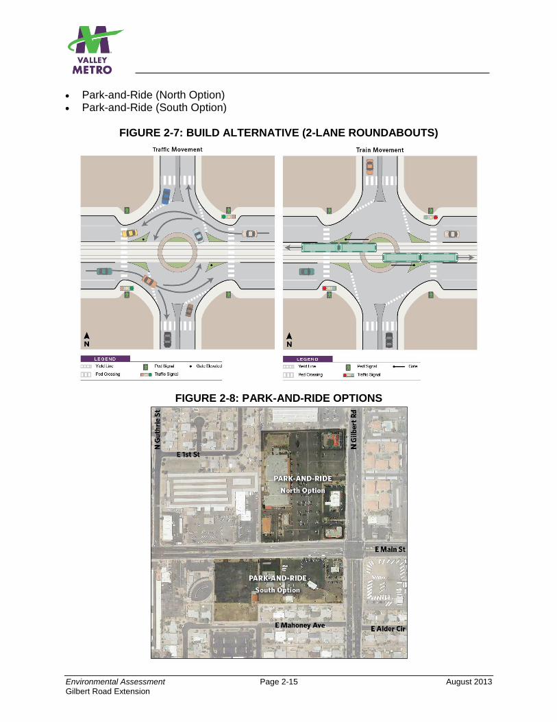
Environmental Assessment Page 2-15 August 2013
Gilbert Road Extension
Park-and-Ride (North Option) Park-and-Ride (South Option)
FIGURE 2-7: BUILD ALTERNATIVE (2-LANE ROUNDABOUTS)
FIGURE 2-8: PARK-AND-RIDE OPTIONS
Environmental Assessment Page 2-16 August 2013
Gilbert Road Extension
The Park-and-Ride (North Option) is located at the northwest corner of Gilbert Road/Main Street. It consists of six parcels comprising 10.2 acres and would necessitate demolition of several permanent structures and business relocations. The Park-and-Ride (South Option) is located at the southwest corner of Gilbert Road/Main Street. It consists of three parcels comprising 6.9 acres also necessitating relocation of several businesses. All permanent and temporary structures on the parcels would be removed. Section 3.1 of the EA provides additional information about the acquisition and relocation associated with both park-and-ride options. Current demand estimates for the year 2031 indicate a need for a facility providing approximately 850 parking spaces. These estimates are based on the MAG Regional Travel Demand Model. The facility could either be surface parking or a structure depending on final estimates of demand as well as the availability and costs of additional property to accommodate the required demand. This will be determined during Project Development. The 850-space estimate assumes that Gilbert Road remains the eastern terminus for the LRT system. With the likelihood that LRT will be further extended prior to 2031, the number of parking spaces needed here would likely be less than 850 spaces since a high proportion of the parking demand has been found to originate from locations further east of Gilbert Road. The park-and-ride to be provided for the ultimate terminus would be sized to accommodate this demand; thus the requirements for the facility at Gilbert Road would be reduced since parkers originating from portions of the region closer to the ultimate LRT terminus would most likely use the park-and-ride located closest to them. For this reason, it is assumed that the Gilbert Road park-and-ride would be phased to initially provide an estimated 500 spaces. This park-and-ride could later be expanded if necessary to accommodate additional vehicles by either building a multi-level structure at this location or possibly acquiring additional property adjacent to the selected Park-and-Ride Option to provide additional surface parking. For additional information, refer to Appendix B, Gilbert Road Park-and-Ride Facility Size Recommendations. Note also that the park-and-ride site may have potential market value for transit-oriented development sometime in the future. In addition to the park-and-ride at Gilbert Road, a park-and-ride facility has also been planned and programmed at the future Mesa Drive Station, a part of the Central Mesa Extension project (currently in construction). Appendix B provides an estimate of the parking demand at the Mesa Drive Station and Park-and-Ride. The estimation of parking demand at Mesa Drive considered the future parking demand at the Gilbert Road Station. Likewise, the Gilbert Road Park-and-Ride demand estimate considers the sizing at Mesa Drive. The construction of a park-and-ride at Gilbert Road is anticipated to reduce the demand for parking at Mesa Drive. In addition to auto parking, the Gilbert Road Park-and-Ride would also provide a turn-around location for the LINK express buses and possibly buses from other local routes so they can continue their routes in the opposite direction. All buses would use the
Environmental Assessment Page 2-17 August 2013
Gilbert Road Extension
existing or slightly shifted bus stops on the street to load and unload passengers. Refer to Section 2.3.4 for more information. 2.2.4 Traction Power Substations (TPSS) As discussed above, the right-of-way required for the Build Alternatives varies by alternative. In addition to the lane configurations and right-of-way required for LRT stations, right-of-way would be necessary for traction power substations (TPSS) for each Build Alternative. TPSS facilities would be spaced approximately one-mile apart from one another to provide electrical power for trains and stations. The TPSS facilities convert existing electrical current to an appropriate type (AC to DC) and level to power LRT vehicles. Typically, TPSS facilities are approximately 80 feet by 120 feet. The proposed general locations for TPSSs are shown on the conceptual design drawings in Appendix A. The proposed locations were sited to minimize impacts to the surrounding properties; however, the locations are subject to change during preliminary engineering and final design. TPSS sites are selected to balance safety, reliability, cost, and operational efficiency requirements. 2.3 BUILD ALTERNATIVE TRANSIT NETWORK This project would support a transit network that would provide riders with a seamless, convenient connection between local and express buses and LRT. Figure 2-9 displays the planned bus and LRT system in the vicinity of the proposed project in 2031. The bus routes and headways (service frequencies) will be the same as shown for the No-Build Alternative in Table 2-2. The major difference between the No-Build and Build Alternatives is construction of the Gilbert Road Extension. The LINK express route serving Main Street and Power Road to the Superstition Springs Transit Center would be truncated on Main Street at Gilbert Road requiring LINK riders destined for areas further west to transfer to LRT at this location. With the No-Build Alternative, LINK would terminate at Mesa Drive, the eastern terminus of the Central Mesa Extension of the LRT system when it is completed in 2016. Pending further study, Routes 30 (University Drive) and 45 (Broadway Road) may be diverted to the park-and-ride facility at Gilbert Road to provide a convenient connection for riders of both transit modes. This will be determined as design advances during Project Development. Routes 40 (Main Street) and 136 (Gilbert Road) would directly serve the Gilbert Road LRT Station along their current routes. Routes 40 and 128 (Stapley Drive) would directly serve the Stapley Drive LRT Station.
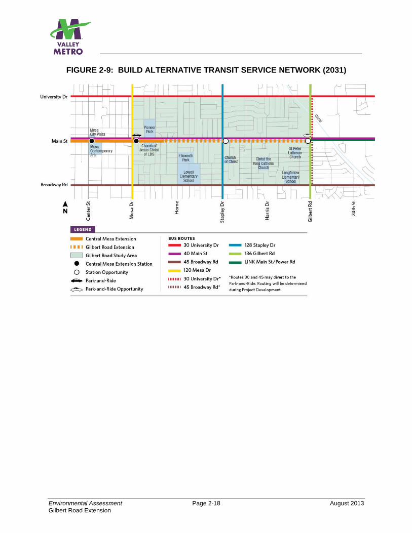
Environmental Assessment Page 2-18 August 2013
Gilbert Road Extension
FIGURE 2-9: BUILD ALTERNATIVE TRANSIT SERVICE NETWORK (2031)
Page Intentionally Left Blank
Environmental Assessment Page 3-1 August 2013
Gilbert Road Extension
3.0 ENVIRONMENTAL IMPACTS—WHAT IMPACTS ARE LIKELY TO OCCUR AND HOW WILL MAJOR ADVERSE IMPACTS BE AVOIDED OR MINIMIZED?
The purpose of this chapter is to compare the potential environmental impacts, both beneficial and adverse, of the No-Build Alternative to those expected to occur as a result of construction and operation of the proposed project. The EA evaluates the following traffic configuration alternatives along Main Street between east of Mesa Drive and Gilbert Road:
Build Alternative (4-Lane)
Build Alternative (2-Lane) and its design option, Build Alternative (2-Lane
Roundabouts), which includes roundabouts at selected intersections
The chapter also evaluates two possible locations for a park-and-ride (known as the North Option and the South Option) at the route’s eastern terminus at Gilbert Road. See Chapter 2 for definitions of the No-Build and Build Alternatives and the Park-and-Ride Options. The base year for comparison of the alternatives is 2031 since this corresponds with the build out year of 2031 for the MAG Regional Transportation Plan. The environmental features analyzed include the following:
3.1 Land Acquisition and Relocation 3.2 Existing Land Use 3.3 Consistency with Local Plans 3.4 Economic Impacts 3.5 Secondary Development 3.6 Transportation 3.7 Air Quality 3.8 Noise and Vibration 3.9 Energy Requirements and Potential for Conservation 3.10 Historic and Cultural Properties 3.11 Parklands and Section 4(f)/6(f) Resources
3.12 Visual and Aesthetics 3.13 Community Disruption 3.14 Environmental Justice 3.15 Hazardous Materials 3.16 Safety and Security 3.17 Water Quality 3.18 Ecologically Sensitive Areas/Endangered Species 3.19 Wetlands/Flooding/Navigable Waterways and Coastal Zones 3.20 Construction 3.21 Cumulative Impacts
Based on the technical analysis conducted for this EA, the resources listed below either are not present within the study area, or the project will not adversely affect them. This statement applies to the Build Alternatives (4-Lane, 2-Lane, and 2-Lane Roundabouts Option), as well as the two park-and-ride (North and South) options.
Environmental Assessment Page 3-2 August 2013
Gilbert Road Extension
Because it is anticipated that federal funds will be available for the Gilbert Road Extension, the National Environmental Policy Act (NEPA) requires evaluation of the proposed project’s impacts on the human and natural environment.
The proposed project, or Build Alternative, must be compared with a No-Build Alternative, which provides the baseline conditions for analysis so the project’s impacts can be determined.
Consistency with Local Plans
Economic Impacts/Secondary Development
Air Quality
Energy
Historic and Archaeological Resources
Parklands/Section 4(f)/6(f)
Community Disruption (Long Term)
Safety and Security
Ecologically Sensitive Areas/Endangered Species
Wetlands/Flooding/Navigable Waterways and Coastal Zones
Cumulative Impacts
Where adverse impacts have been identified, potential strategies to minimize the impacts are listed at the end of the specific environmental category section where mitigation is proposed. For those resources that are adversely impacted, the proposed mitigations would reduce the impacts to levels that are below significant. Note that technical reports or memorandums have been prepared, where needed, to provide more detailed analysis for several of the categories listed above. They are all included in the appendices of the EA with the specific appendix referenced at the beginning of those discussions in this chapter which have supporting documentation. In cases where the technical reports or memorandums may differ from what is reported in the EA, the EA supersedes, as it was prepared subsequent to the technical reports and contains the most up-to-date information. 3.1 LAND ACQUISITION AND RELOCATION This section discusses the potential right-of-way (ROW) acquisition impacts for the Gilbert Road Extension project based on the conceptual design drawings presented in Appendix A. As project design becomes further refined, the extent of property acquisitions and displacements/relocations will also be subject to refinement. It may also be necessary to acquire property or obtain temporary construction easements to accommodate staging of equipment and materials during construction of the project. The need for this would be determined by the contractor selected to build the project, and the contractor would be responsible for clearing the site(s) environmentally.
3.1.1 No-Build Alternative The No-Build Alternative would require no additional property acquisition to accommodate the planned roadway and transit improvements discussed in Section 2.1 of this EA. Therefore, the No-Build Alternative would have no impact related to Land Acquisition and Relocations.
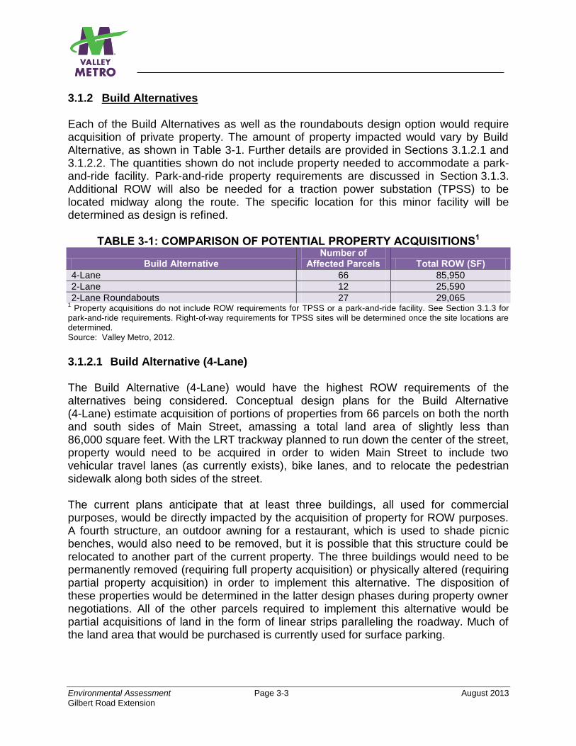
Environmental Assessment Page 3-3 August 2013
Gilbert Road Extension
3.1.2 Build Alternatives Each of the Build Alternatives as well as the roundabouts design option would require acquisition of private property. The amount of property impacted would vary by Build Alternative, as shown in Table 3-1. Further details are provided in Sections 3.1.2.1 and 3.1.2.2. The quantities shown do not include property needed to accommodate a park-and-ride facility. Park-and-ride property requirements are discussed in Section 3.1.3. Additional ROW will also be needed for a traction power substation (TPSS) to be located midway along the route. The specific location for this minor facility will be determined as design is refined.
TABLE 3-1: COMPARISON OF POTENTIAL PROPERTY ACQUISITIONS1
Build Alternative Number of
Affected Parcels Total ROW (SF)
4-Lane 66 85,950
2-Lane 12 25,590
2-Lane Roundabouts 27 29,065 1 Property acquisitions do not include ROW requirements for TPSS or a park-and-ride facility. See Section 3.1.3 for
park-and-ride requirements. Right-of-way requirements for TPSS sites will be determined once the site locations are determined. Source: Valley Metro, 2012.
3.1.2.1 Build Alternative (4-Lane) The Build Alternative (4-Lane) would have the highest ROW requirements of the alternatives being considered. Conceptual design plans for the Build Alternative (4-Lane) estimate acquisition of portions of properties from 66 parcels on both the north and south sides of Main Street, amassing a total land area of slightly less than 86,000 square feet. With the LRT trackway planned to run down the center of the street, property would need to be acquired in order to widen Main Street to include two vehicular travel lanes (as currently exists), bike lanes, and to relocate the pedestrian sidewalk along both sides of the street. The current plans anticipate that at least three buildings, all used for commercial purposes, would be directly impacted by the acquisition of property for ROW purposes. A fourth structure, an outdoor awning for a restaurant, which is used to shade picnic benches, would also need to be removed, but it is possible that this structure could be relocated to another part of the current property. The three buildings would need to be permanently removed (requiring full property acquisition) or physically altered (requiring partial property acquisition) in order to implement this alternative. The disposition of these properties would be determined in the latter design phases during property owner negotiations. All of the other parcels required to implement this alternative would be partial acquisitions of land in the form of linear strips paralleling the roadway. Much of the land area that would be purchased is currently used for surface parking.
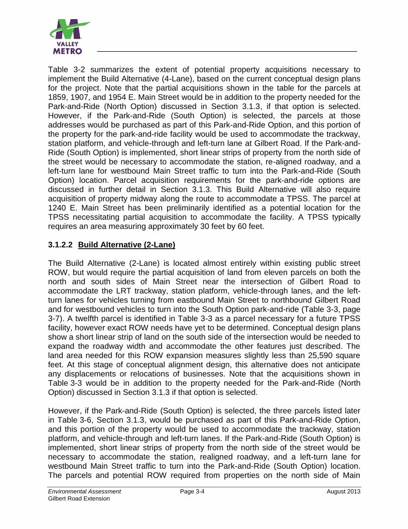
Environmental Assessment Page 3-4 August 2013
Gilbert Road Extension
Table 3-2 summarizes the extent of potential property acquisitions necessary to implement the Build Alternative (4-Lane), based on the current conceptual design plans for the project. Note that the partial acquisitions shown in the table for the parcels at 1859, 1907, and 1954 E. Main Street would be in addition to the property needed for the Park-and-Ride (North Option) discussed in Section 3.1.3, if that option is selected. However, if the Park-and-Ride (South Option) is selected, the parcels at those addresses would be purchased as part of this Park-and-Ride Option, and this portion of the property for the park-and-ride facility would be used to accommodate the trackway, station platform, and vehicle-through and left-turn lane at Gilbert Road. If the Park-and-Ride (South Option) is implemented, short linear strips of property from the north side of the street would be necessary to accommodate the station, re-aligned roadway, and a left-turn lane for westbound Main Street traffic to turn into the Park-and-Ride (South Option) location. Parcel acquisition requirements for the park-and-ride options are discussed in further detail in Section 3.1.3. This Build Alternative will also require acquisition of property midway along the route to accommodate a TPSS. The parcel at 1240 E. Main Street has been preliminarily identified as a potential location for the TPSS necessitating partial acquisition to accommodate the facility. A TPSS typically requires an area measuring approximately 30 feet by 60 feet. 3.1.2.2 Build Alternative (2-Lane) The Build Alternative (2-Lane) is located almost entirely within existing public street ROW, but would require the partial acquisition of land from eleven parcels on both the north and south sides of Main Street near the intersection of Gilbert Road to accommodate the LRT trackway, station platform, vehicle-through lanes, and the left-turn lanes for vehicles turning from eastbound Main Street to northbound Gilbert Road and for westbound vehicles to turn into the South Option park-and-ride (Table 3-3, page 3-7). A twelfth parcel is identified in Table 3-3 as a parcel necessary for a future TPSS facility, however exact ROW needs have yet to be determined. Conceptual design plans show a short linear strip of land on the south side of the intersection would be needed to expand the roadway width and accommodate the other features just described. The land area needed for this ROW expansion measures slightly less than 25,590 square feet. At this stage of conceptual alignment design, this alternative does not anticipate any displacements or relocations of businesses. Note that the acquisitions shown in Table 3-3 would be in addition to the property needed for the Park-and-Ride (North Option) discussed in Section 3.1.3 if that option is selected. However, if the Park-and-Ride (South Option) is selected, the three parcels listed later in Table 3-6, Section 3.1.3, would be purchased as part of this Park-and-Ride Option, and this portion of the property would be used to accommodate the trackway, station platform, and vehicle-through and left-turn lanes. If the Park-and-Ride (South Option) is implemented, short linear strips of property from the north side of the street would be necessary to accommodate the station, realigned roadway, and a left-turn lane for westbound Main Street traffic to turn into the Park-and-Ride (South Option) location. The parcels and potential ROW required from properties on the north side of Main
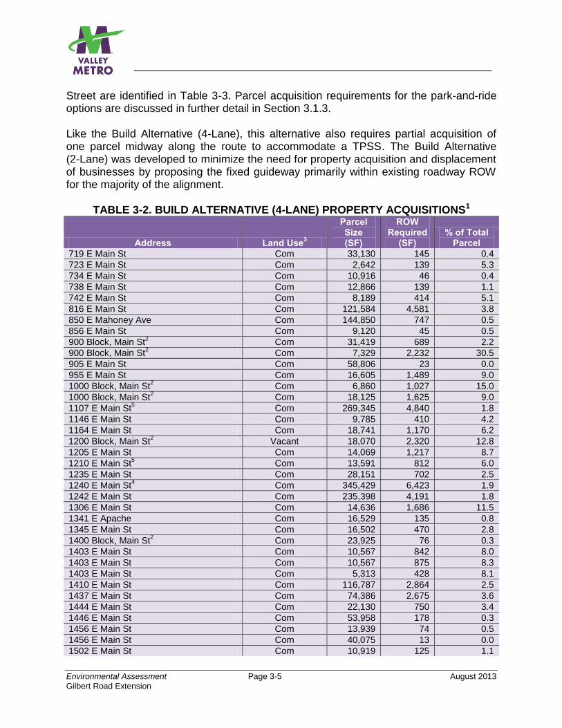
Environmental Assessment Page 3-5 August 2013
Gilbert Road Extension
Street are identified in Table 3-3. Parcel acquisition requirements for the park-and-ride options are discussed in further detail in Section 3.1.3. Like the Build Alternative (4-Lane), this alternative also requires partial acquisition of one parcel midway along the route to accommodate a TPSS. The Build Alternative (2-Lane) was developed to minimize the need for property acquisition and displacement of businesses by proposing the fixed guideway primarily within existing roadway ROW for the majority of the alignment.
TABLE 3-2. BUILD ALTERNATIVE (4-LANE) PROPERTY ACQUISITIONS1
Address Land Use3
Parcel Size (SF)
ROW Required
(SF) % of Total
Parcel 719 E Main St Com 33,130 145 0.4
723 E Main St Com 2,642 139 5.3
734 E Main St Com 10,916 46 0.4
738 E Main St Com 12,866 139 1.1
742 E Main St Com 8,189 414 5.1
816 E Main St Com 121,584 4,581 3.8
850 E Mahoney Ave Com 144,850 747 0.5
856 E Main St Com 9,120 45 0.5
900 Block, Main St2 Com 31,419 689 2.2
900 Block, Main St2 Com 7,329 2,232 30.5
905 E Main St Com 58,806 23 0.0
955 E Main St Com 16,605 1,489 9.0
1000 Block, Main St2 Com 6,860 1,027 15.0
1000 Block, Main St2 Com 18,125 1,625 9.0
1107 E Main St5 Com 269,345 4,840 1.8
1146 E Main St Com 9,785 410 4.2
1164 E Main St Com 18,741 1,170 6.2
1200 Block, Main St2 Vacant 18,070 2,320 12.8
1205 E Main St Com 14,069 1,217 8.7
1210 E Main St5 Com 13,591 812 6.0
1235 E Main St Com 28,151 702 2.5
1240 E Main St4 Com 345,429 6,423 1.9
1242 E Main St Com 235,398 4,191 1.8
1306 E Main St Com 14,636 1,686 11.5
1341 E Apache Com 16,529 135 0.8
1345 E Main St Com 16,502 470 2.8
1400 Block, Main St2 Com 23,925 76 0.3
1403 E Main St Com 10,567 842 8.0
1403 E Main St Com 10,567 875 8.3
1403 E Main St Com 5,313 428 8.1
1410 E Main St Com 116,787 2,864 2.5
1437 E Main St Com 74,386 2,675 3.6
1444 E Main St Com 22,130 750 3.4
1446 E Main St Com 53,958 178 0.3
1456 E Main St Com 13,939 74 0.5
1456 E Main St Com 40,075 13 0.0
1502 E Main St Com 10,919 125 1.1
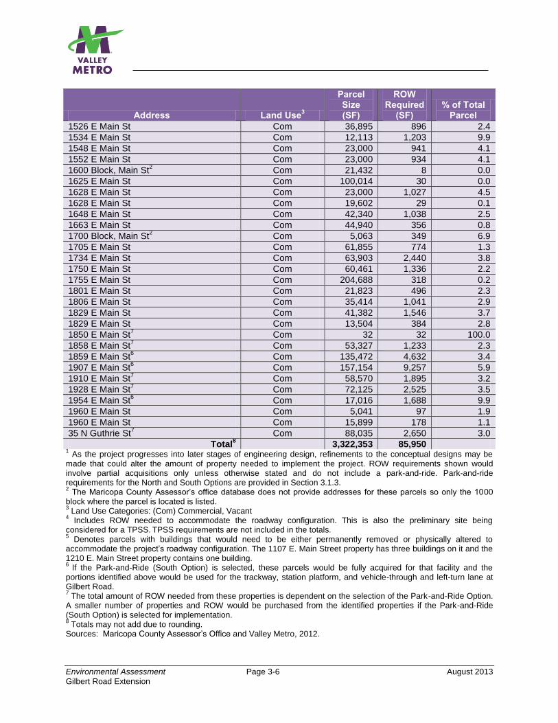
Environmental Assessment Page 3-6 August 2013
Gilbert Road Extension
Address Land Use3
Parcel Size (SF)
ROW Required
(SF) % of Total
Parcel
1526 E Main St Com 36,895 896 2.4
1534 E Main St Com 12,113 1,203 9.9
1548 E Main St Com 23,000 941 4.1
1552 E Main St Com 23,000 934 4.1
1600 Block, Main St2 Com 21,432 8 0.0
1625 E Main St Com 100,014 30 0.0
1628 E Main St Com 23,000 1,027 4.5
1628 E Main St Com 19,602 29 0.1
1648 E Main St Com 42,340 1,038 2.5
1663 E Main St Com 44,940 356 0.8
1700 Block, Main St2 Com 5,063 349 6.9
1705 E Main St Com 61,855 774 1.3
1734 E Main St Com 63,903 2,440 3.8
1750 E Main St Com 60,461 1,336 2.2
1755 E Main St Com 204,688 318 0.2
1801 E Main St Com 21,823 496 2.3
1806 E Main St Com 35,414 1,041 2.9
1829 E Main St Com 41,382 1,546 3.7
1829 E Main St Com 13,504 384 2.8
1850 E Main St7 Com 32 32 100.0
1858 E Main St7 Com 53,327 1,233 2.3
1859 E Main St6 Com 135,472 4,632 3.4
1907 E Main St6 Com 157,154 9,257 5.9
1910 E Main St7 Com 58,570 1,895 3.2
1928 E Main St7 Com 72,125 2,525 3.5
1954 E Main St6 Com 17,016 1,688 9.9
1960 E Main St Com 5,041 97 1.9
1960 E Main St Com 15,899 178 1.1
35 N Guthrie St7 Com 88,035 2,650 3.0
Total8 3,322,353 85,950
1 As the project progresses into later stages of engineering design, refinements to the conceptual designs may be
made that could alter the amount of property needed to implement the project. ROW requirements shown would involve partial acquisitions only unless otherwise stated and do not include a park-and-ride. Park-and-ride requirements for the North and South Options are provided in Section 3.1.3. 2 The Maricopa County Assessor’s office database does not provide addresses for these parcels so only the 1000
block where the parcel is located is listed. 3 Land Use Categories: (Com) Commercial, Vacant
4 Includes ROW needed to accommodate the roadway configuration. This is also the preliminary site being
considered for a TPSS. TPSS requirements are not included in the totals.
5 Denotes parcels with buildings that would need to be either permanently removed or physically altered to
accommodate the project’s roadway configuration. The 1107 E. Main Street property has three buildings on it and the 1210 E. Main Street property contains one building. 6
If the Park-and-Ride (South Option) is selected, these parcels would be fully acquired for that facility and the portions identified above would be used for the trackway, station platform, and vehicle-through and left-turn lane at Gilbert Road. 7 The total amount of ROW needed from these properties is dependent on the selection of the Park-and-Ride Option.
A smaller number of properties and ROW would be purchased from the identified properties if the Park-and-Ride (South Option) is selected for implementation. 8 Totals may not add due to rounding.
Sources: Maricopa County Assessor’s Office and Valley Metro, 2012.
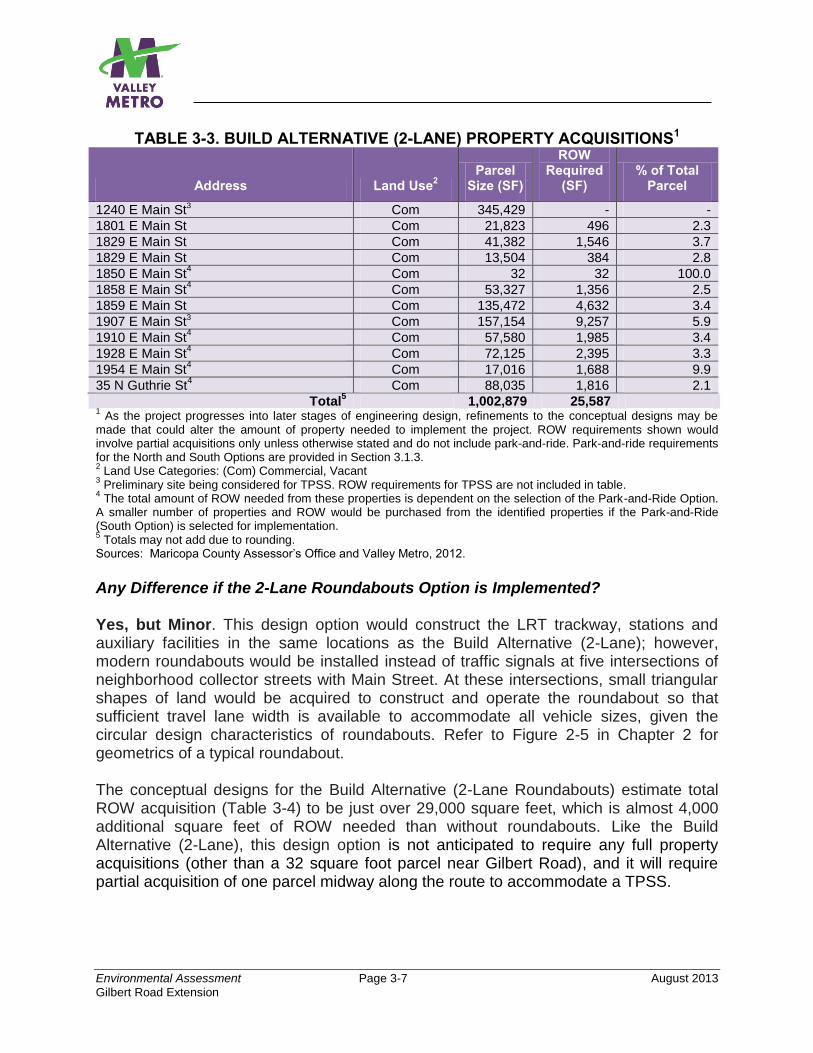
Environmental Assessment Page 3-7 August 2013
Gilbert Road Extension
TABLE 3-3. BUILD ALTERNATIVE (2-LANE) PROPERTY ACQUISITIONS1
Address Land Use2
Parcel Size (SF)
ROW Required
(SF) % of Total
Parcel
1240 E Main St3 Com 345,429 - -
1801 E Main St Com 21,823 496 2.3
1829 E Main St Com 41,382 1,546 3.7
1829 E Main St Com 13,504 384 2.8
1850 E Main St4 Com 32 32 100.0
1858 E Main St4 Com 53,327 1,356 2.5
1859 E Main St Com 135,472 4,632 3.4
1907 E Main St3 Com 157,154 9,257 5.9
1910 E Main St4 Com 57,580 1,985 3.4
1928 E Main St4 Com 72,125 2,395 3.3
1954 E Main St4 Com 17,016 1,688 9.9
35 N Guthrie St4 Com 88,035 1,816 2.1
Total5 1,002,879 25,587
1 As the project progresses into later stages of engineering design, refinements to the conceptual designs may be
made that could alter the amount of property needed to implement the project. ROW requirements shown would involve partial acquisitions only unless otherwise stated and do not include park-and-ride. Park-and-ride requirements for the North and South Options are provided in Section 3.1.3. 2 Land Use Categories: (Com) Commercial, Vacant
3 Preliminary site being considered for TPSS. ROW requirements for TPSS are not included in table.
4 The total amount of ROW needed from these properties is dependent on the selection of the Park-and-Ride Option.
A smaller number of properties and ROW would be purchased from the identified properties if the Park-and-Ride (South Option) is selected for implementation. 5 Totals may not add due to rounding.
Sources: Maricopa County Assessor’s Office and Valley Metro, 2012.
Any Difference if the 2-Lane Roundabouts Option is Implemented? Yes, but Minor. This design option would construct the LRT trackway, stations and auxiliary facilities in the same locations as the Build Alternative (2-Lane); however, modern roundabouts would be installed instead of traffic signals at five intersections of neighborhood collector streets with Main Street. At these intersections, small triangular shapes of land would be acquired to construct and operate the roundabout so that sufficient travel lane width is available to accommodate all vehicle sizes, given the circular design characteristics of roundabouts. Refer to Figure 2-5 in Chapter 2 for geometrics of a typical roundabout. The conceptual designs for the Build Alternative (2-Lane Roundabouts) estimate total ROW acquisition (Table 3-4) to be just over 29,000 square feet, which is almost 4,000 additional square feet of ROW needed than without roundabouts. Like the Build Alternative (2-Lane), this design option is not anticipated to require any full property acquisitions (other than a 32 square foot parcel near Gilbert Road), and it will require partial acquisition of one parcel midway along the route to accommodate a TPSS.
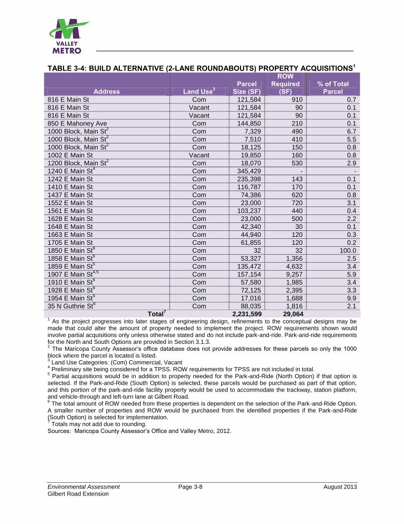
Environmental Assessment Page 3-8 August 2013
Gilbert Road Extension
TABLE 3-4: BUILD ALTERNATIVE (2-LANE ROUNDABOUTS) PROPERTY ACQUISITIONS1
Address Land Use3
Parcel Size (SF)
ROW Required
(SF) % of Total
Parcel
816 E Main St Com 121,584 910 0.7
816 E Main St Vacant 121,584 90 0.1
816 E Main St Vacant 121,584 90 0.1
850 E Mahoney Ave Com 144,850 210 0.1
1000 Block, Main St2 Com 7,329 490 6.7
1000 Block, Main St2 Com 7,510 410 5.5
1000 Block, Main St2 Com 18,125 150 0.8
1002 E Main St Vacant 19,850 160 0.8
1200 Block, Main St2 Com 18,070 530 2.9
1240 E Main St4 Com 345,429 - -
1242 E Main St Com 235,398 143 0.1
1410 E Main St Com 116,787 170 0.1
1437 E Main St Com 74,386 620 0.8
1552 E Main St Com 23,000 720 3.1
1561 E Main St Com 103,237 440 0.4
1628 E Main St Com 23,000 500 2.2
1648 E Main St Com 42,340 30 0.1
1663 E Main St Com 44,940 120 0.3
1705 E Main St Com 61,855 120 0.2
1850 E Main St6 Com 32 32 100.0
1858 E Main St6 Com 53,327 1,356 2.5
1859 E Main St5 Com 135,472 4,632 3.4
1907 E Main St4,5
Com 157,154 9,257 5.9
1910 E Main St6 Com 57,580 1,985 3.4
1928 E Main St6 Com 72,125 2,395 3.3
1954 E Main St5 Com 17,016 1,688 9.9
35 N Guthrie St6 Com 88,035 1,816 2.1
Total7 2,231,599 29,064
1 As the project progresses into later stages of engineering design, refinements to the conceptual designs may be
made that could alter the amount of property needed to implement the project. ROW requirements shown would involve partial acquisitions only unless otherwise stated and do not include park-and-ride. Park-and-ride requirements for the North and South Options are provided in Section 3.1.3. 2 The Maricopa County Assessor’s office database does not provide addresses for these parcels so only the 1000
block where the parcel is located is listed. 3 Land Use Categories: (Com) Commercial, Vacant
4 Preliminary site being considered for a TPSS. ROW requirements for TPSS are not included in total.
5 Partial acquisitions would be in addition to property needed for the Park-and-Ride (North Option) if that option is
selected. If the Park-and-Ride (South Option) is selected, these parcels would be purchased as part of that option, and this portion of the park-and-ride facility property would be used to accommodate the trackway, station platform, and vehicle-through and left-turn lane at Gilbert Road. 6 The total amount of ROW needed from these properties is dependent on the selection of the Park-and-Ride Option.
A smaller number of properties and ROW would be purchased from the identified properties if the Park-and-Ride (South Option) is selected for implementation. 7 Totals may not add due to rounding.
Sources: Maricopa County Assessor’s Office and Valley Metro, 2012.

Environmental Assessment Page 3-9 August 2013
Gilbert Road Extension
3.1.3 Park-and-Ride In addition to the ROW needed for the LRT trackway, stations, and auxiliary facilities, the project intends to construct a park-and-ride facility at the proposed Gilbert Road Station. Current travel forecasts of parking demand at the Gilbert Road Station suggest the need for at least 500 spaces in the opening year of the project, with a 20-year need of 850 spaces should the Gilbert Road Station remain the eastern terminus of the LRT line within that time frame. The City of Mesa intends to construct a park-and-ride capable of accommodating the opening year demand, with some additional capacity, and phase the implementation of the parking facility over time to accommodate the 20-year demand (if warranted). Two park-and-ride site options are currently being considered—a North Option and a South Option. Additionally, project plans anticipate that one of the two TPSS facilities needed for the project would be constructed at the park-and-ride facility. The implementation of a park-and-ride facility would require the acquisition of privately owned property. Descriptions of sites considered and the property needs for each option are provided below. 3.1.3.1 Park-and-Ride (North Option) The North Option is located on the northwest quadrant of the Main Street and Gilbert Road intersection and is comprised of six parcels, amassing a total land area of approximately 10.2 acres, or about 481,100 square feet. Much of the land area is currently occupied by an existing surface parking lot serving a mixture of retail commercial businesses, restaurants, an insurance office, and a dental clinic. Current plans for the project anticipate the full acquisition of all six parcels necessitating relocation of the six businesses currently operating there. A former restaurant, now closed, is also located within this site. The North Option has sufficient size to accommodate the 20-year demand of 850 parking stalls without a parking structure. Table 3-5 details the parcel acquisitions necessary to implement the North Option Park-and-Ride facility.
TABLE 3-5: PARK-AND-RIDE (NORTH OPTION) PROPERTY ACQUISITIONS Full Acquisitions
Address Land Use1
Parcel Size (SF)
ROW Required
(SF) % of Total
Parcel
1910 E Main St Com 58,570 58,570 100
30 N Gilbert Rd Com 40,946 40,946 100
1944 E Main St Com 288,545 288,545 100
1928 E Main St Com 72,125 72,125 100
1960 E Main St Com 5,041 5,041 100
1960 E Main St Com 15,899 15,899 100
Total2 481,126 481,126
1 Land Use Categories: (Com) Commercial, Vacant
2 Totals may not add due to rounding.
Sources: Maricopa County Assessor’s Office and Valley Metro, 2012.
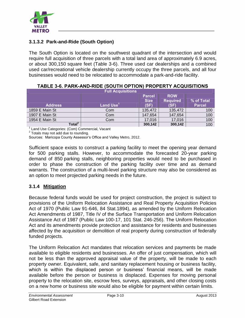
Environmental Assessment Page 3-10 August 2013
Gilbert Road Extension
3.1.3.2 Park-and-Ride (South Option) The South Option is located on the southwest quadrant of the intersection and would require full acquisition of three parcels with a total land area of approximately 6.9 acres, or about 300,150 square feet (Table 3-6). Three used car dealerships and a combined used car/recreational vehicle dealership currently occupy the three parcels, and all four businesses would need to be relocated to accommodate a park-and-ride facility.
TABLE 3-6. PARK-AND-RIDE (SOUTH OPTION) PROPERTY ACQUISITIONS Full Acquisitions
Address Land Use1
Parcel Size (SF)
ROW Required
(SF) % of Total
Parcel
1859 E Main St Com 135,472 135,472 100
1907 E Main St Com 147,654 147,654 100
1954 E Main St Com 17,016 17,016 100 Total
2 300,142 300,142 100
1 Land Use Categories: (Com) Commercial, Vacant
2 Totals may not add due to rounding.
Sources: Maricopa County Assessor’s Office and Valley Metro, 2012.
Sufficient space exists to construct a parking facility to meet the opening year demand for 500 parking stalls. However, to accommodate the forecasted 20-year parking demand of 850 parking stalls, neighboring properties would need to be purchased in order to phase the construction of the parking facility over time and as demand warrants. The construction of a multi-level parking structure may also be considered as an option to meet projected parking needs in the future. 3.1.4 Mitigation Because federal funds would be used for project construction, the project is subject to provisions of the Uniform Relocation Assistance and Real Property Acquisition Policies Act of 1970 (Public Law 91-646, 84 Stat.1894), as amended by the Uniform Relocation Act Amendments of 1987, Title IV of the Surface Transportation and Uniform Relocation Assistance Act of 1987 (Public Law 100-17, 101 Stat. 246-256). The Uniform Relocation Act and its amendments provide protection and assistance for residents and businesses affected by the acquisition or demolition of real property during construction of federally funded projects. The Uniform Relocation Act mandates that relocation services and payments be made available to eligible residents and businesses. An offer of just compensation, which will not be less than the approved appraisal value of the property, will be made to each property owner. Equivalent, safe, and sanitary replacement housing or business facility, which is within the displaced person or business’ financial means, will be made available before the person or business is displaced. Expenses for moving personal property to the relocation site, escrow fees, surveys, appraisals, and other closing costs on a new home or business site would also be eligible for payment within certain limits.
Environmental Assessment Page 3-11 August 2013
Gilbert Road Extension
Based on field reviews of the project area, several properties located along Main Street appear vacant, inactive, or abandoned, with no signs of regular employment activity. Should business relocations be required, sufficient commercial space exists within the corridor to provide these businesses with suitable commercial space and parking. In general, the build lines of existing structures are setback at sufficient distances from the street such that most ROW acquisitions would not directly affect these structures. Implementation of the project is also anticipated to positively affect the development potential of properties along the proposed route, particularly near proposed station locations. Candidate locations for TPSS facilities have been identified and are shown on the drawings in Appendix A. One of the TPSS facilities will be located within the selected park-and-ride option. The other TPSS would be located midway along the route east of Stapley Drive. Properties for the TPSS facilities have been selected to minimize potential adverse impacts to surrounding properties. 3.2 EXISTING LAND USE Existing land uses within the study area may be broadly characterized as a mix of urban and suburban uses. These uses include residential neighborhoods, retail commercial developments, light warehousing and storage facilities, and undeveloped lands (Figure 3-1). Main Street between Mesa Drive and Gilbert Road is lined with neighborhood convenience stores, supermarkets, restaurants, second-hand furniture and appliance retailers, automobile repair-oriented businesses, and used car auto sales. Residential neighborhoods, while not immediately adjacent to the Main Street corridor, are located just behind the commercial establishments abutting the corridor. Residential land uses constitute the predominant land use type in the study area, followed by retail commercial properties. Despite the relatively limited amount of vacant land in the study area, many commercial establishments along Main Street have been vacated for some time, creating a ripe opportunity for future infill and redevelopment. Many of these properties are fronted by parking lots that may be redeveloped easily. Table 3-7 outlines existing land uses within the study area. 3.2.1 No-Build Alternative The No-Build Alternative is located entirely within existing City of Mesa public street ROW and would have no adverse effect on current land uses.
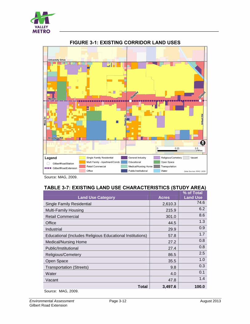
Environmental Assessment Page 3-12 August 2013
Gilbert Road Extension
FIGURE 3-1: EXISTING CORRIDOR LAND USES
Source: MAG, 2009.
TABLE 3-7: EXISTING LAND USE CHARACTERISTICS (STUDY AREA)
Land Use Category Acres % of Total Land Use
Single Family Residential 2,610.3 74.6
Multi-Family Housing 215.9 6.2
Retail Commercial 301.0 8.6
Office 44.5 1.3
Industrial 29.9 0.9
Educational (Includes Religious Educational Institutions) 57.8 1.7
Medical/Nursing Home 27.2 0.8
Public/Institutional 27.4 0.8
Religious/Cemetery 86.5 2.5
Open Space 35.5 1.0
Transportation (Streets) 9.8 0.3
Water 4.0 0.1
Vacant 47.8 1.4
Total 3,497.6 100.0 Source: MAG, 2009.

Environmental Assessment Page 3-13 August 2013
Gilbert Road Extension
3.2.2 Build Alternatives (4-Lane, 2-Lane, 2-Lane Roundabouts Option) Both Build Alternatives, including the roundabouts design option, would also be located within existing City of Mesa public street ROW with the exception of the property acquisitions required as presented in Section 3.1. Although the Build Alternative (4-Lane) would require more ROW than the Build Alternative (2-Lane) or its roundabouts design option, with implementation of the measures listed in that section, none would result in an adverse effect on current land uses. However, all are ultimately anticipated to positively influence land use changes as further discussed in Sections 3.4 and 3.5.
3.2.3 Park-and-Ride (North and South Options) Neither park-and-ride option is anticipated to result in an adverse effect on existing land uses. Both sites are zoned as C-3 commercial properties, a zoning classification that allows park-and-ride facilities. Although each option would require full acquisition of several parcels and demolition or removal of existing structures and relocations of businesses as discussed in Section 3.1, the mitigation measures listed in that section would result in no adverse effect on existing land uses. The selected park-and-ride option would be designed and constructed to comply with current code requirements. In addition, the selected option would likely be planned to accommodate future joint development as further discussed in Sections 3.4 and 3.5. 3.2.4 Mitigation No mitigation is necessary. 3.3 CONSISTENCY WITH LOCAL PLANS This section discusses the consistency of each alternative with the adopted land use and transportation plans of the City of Mesa and regional governmental agencies. A summary of the proposed project’s compatibility with adopted local and regional plans is presented in Table 3-8. 3.3.1 No-Build Alternative The No-Build Alternative maintains the status quo and would therefore not address the stated goals and objectives of the community as outlined in the local and regional plans identified in Table 3-8 and also for the proposed project as discussed in Section 1.2. Therefore, the No-Build Alternative would have an effect on consistency with local plans, but the effect would not rise to the level of adverse or significant.
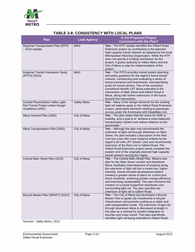
Environmental Assessment Page 3-14 August 2013
Gilbert Road Extension
TABLE 3-8: CONSISTENCY WITH LOCAL PLANS
Plan Lead Agency Is the Proposed Project
Consistent with the Plan?
Regional Transportation Plan (RTP) – 2010 Update
MAG Yes – The RTP Update identifies the Gilbert Road
Extension project as contributing to the planned high-capacity transit network as adopted by the local Metropolitan Planning Organization. While the RTP does not specify a funding mechanism for the project, it grants authority to Valley Metro and the City of Mesa to plan for implementation of the project.
Regional Transit Framework Study (RTFS) (2010)
MAG Yes – The RTFS provides transit system planning
and policy guidance for the region’s future transit network, constructing and evaluating a series of transit scenarios and investments, and specifying goals for transit service. Two of the scenarios considered identify LRT being extended to the intersection of Main Street and Gilbert Road in Mesa, along with further extensions in the future beyond this intersection.
Central Phoenix/East Valley Light Rail Transit Project Urban Design Guidelines (2001)
Valley Metro Yes – Many of the design elements for the existing
light rail stations apply to the Gilbert Road Extension project, particularly elements relating to passenger access under the Americans with Disabilities Act.
Mesa General Plan (2002) City of Mesa Yes – The plan states that the vision for 2030 is
livability, and a goal is to “achieve a more balanced transportation system and reduce reliance on the automobile.”
Mesa Transportation Plan (2002) City of Mesa Yes – Although the plan only recommends the
extension of light rail through downtown on Main Street, the plan includes a discussion of the Red Line bus route (the route replaced entirely by the region’s 20-mile LRT Starter Line) and recommends extension of the Red Line to Gilbert Road. The Gilbert Road Extension project would complete the eastern end of the originally planned high-capacity transit network serving the region.
Central Main Street Plan (2012) City of Mesa Yes – The Central Main Street Plan, Mesa’s new
plan for the Main Street corridor and downtown Mesa, facilitates redevelopment of property along the extension of light rail into a mixed-use, higher intensity, transit-oriented development pattern creating a greater sense of place for current and future residents, achieving greater energy efficiency, and improving sustainability. The plan envisions the creation of a transit-supportive downtown core surrounding light rail. The plan specifies the extension of light rail to Gilbert Road.
Bicycle Master Plan (DRAFT) (2012) City of Mesa Yes – The City of Mesa has developed a Bicycle
Master Plan to guide city investments in bicycle infrastructure and promote cycling as a viable and safe transportation mode. The extension of light rail through downtown Mesa is discussed at length in this plan as a method for greater integration of bicycles and mass transit. This plan specifically identifies light rail being extended to Gilbert Road.
Sources: Valley Metro, 2012.
Environmental Assessment Page 3-15 August 2013
Gilbert Road Extension
3.3.2 Build Alternatives (4-Lane, 2-Lane, 2-Lane Roundabouts Option) The Build Alternative (4-Lane) and Build Alternative (2-Lane), including the 2-Lane Roundabouts design option, are consistent with the major local and regional plans as shown in Table 3-8. The City of Mesa’s planning documents and land development ordinances include goals, objectives, and policies intended to promote land use development consistent with the implementation of high-capacity transit along the Main Street corridor. Coupled with the city’s new form-based code zoning ordinance, the city is focused on pursuing transit-supportive land use development in the downtown core and along emerging high-capacity transit corridors elsewhere in the city. Many of the plans listed in Table 3-8 have been developed by the city to encourage growth and sustainability and to help provide a balanced transportation system throughout the city. A central element of station area planning is a broad concept of transit-oriented development. LRT has the proven potential to boost land development around stations. The land use and transportation plans listed in Table 3-8 emphasize the city’s commitment to transit and transit-oriented development intended to enhance livability, encourage mixed-use high-density development, and create pedestrian-friendly environments along Main Street in Mesa. The implementation of LRT along Main Street in Mesa is anticipated to act as a catalyst for future development, particularly around transit stations. The current availability of unused or underutilized1 land surrounding the corridor and proposed station locations presents a prime opportunity for developers and the city to capitalize on. The City of Mesa’s Central Main Street Plan, which provides a vision for Main Street between Alma School and Gilbert Roads, indicates that a 2-lane street configuration is preferred within a ¼-mile to ½-mile radius of the intersections at Main Street/Stapley Drive and Main Street/Gilbert Road. The city envisions both of these intersections as anchoring the east side of downtown Mesa, creating a dense, walkable urban environment. Part of the plan’s strategy is to reduce traffic speeds and conflict points between vehicles and pedestrians. Beyond these immediate intersection areas, the Central Main Street Plan identifies two options, a 4-Lane and 2-Lane option, as potential cross-sections for Main Street. Therefore, the Build Alternatives (4-Lane) and (2-Lane), including the 2-Lane Roundabouts Option, are consistent with current land use plans. 3.3.3 Park-and-Ride (North and South Options) While some regional and local plans identify a park-and-ride facility at the proposed Gilbert Road Station, others do not specify a preferred site. The city has envisioned a park-and-ride at the Gilbert Road/Main Street Station, and current zoning for either
1Underutilized land is defined as low-density commercial uses. Examples include properties containing excess
surface parking or small buildings on properties.
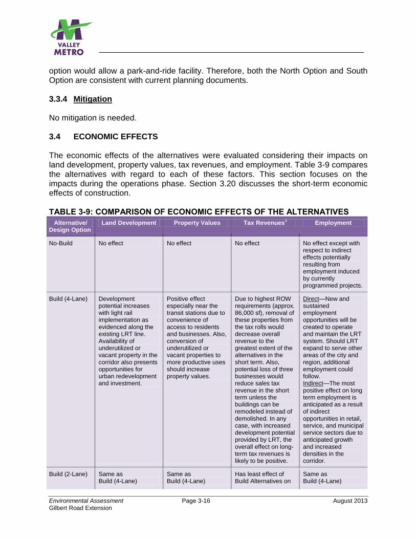
Environmental Assessment Page 3-16 August 2013
Gilbert Road Extension
option would allow a park-and-ride facility. Therefore, both the North Option and South Option are consistent with current planning documents. 3.3.4 Mitigation No mitigation is needed. 3.4 ECONOMIC EFFECTS The economic effects of the alternatives were evaluated considering their impacts on land development, property values, tax revenues, and employment. Table 3-9 compares the alternatives with regard to each of these factors. This section focuses on the impacts during the operations phase. Section 3.20 discusses the short-term economic effects of construction. TABLE 3-9: COMPARISON OF ECONOMIC EFFECTS OF THE ALTERNATIVES
Alternative/ Design Option
Land Development Property Values Tax Revenues1 Employment
No-Build No effect No effect No effect No effect except with respect to indirect effects potentially resulting from employment induced by currently programmed projects.
Build (4-Lane) Development potential increases with light rail implementation as evidenced along the existing LRT line. Availability of underutilized or vacant property in the corridor also presents opportunities for urban redevelopment and investment.
Positive effect especially near the transit stations due to convenience of access to residents and businesses. Also, conversion of underutilized or vacant properties to more productive uses should increase property values.
Due to highest ROW requirements (approx. 86,000 sf), removal of these properties from the tax rolls would decrease overall revenue to the greatest extent of the alternatives in the short term. Also, potential loss of three businesses would reduce sales tax revenue in the short term unless the buildings can be remodeled instead of demolished. In any case, with increased development potential provided by LRT, the overall effect on long-term tax revenues is likely to be positive.
Direct—New and sustained employment opportunities will be created to operate and maintain the LRT system. Should LRT expand to serve other areas of the city and region, additional employment could follow. Indirect—The most positive effect on long term employment is anticipated as a result of indirect opportunities in retail, service, and municipal service sectors due to anticipated growth and increased densities in the corridor.
Build (2-Lane) Same as Build (4-Lane)
Same as Build (4-Lane)
Has least effect of Build Alternatives on
Same as Build (4-Lane)
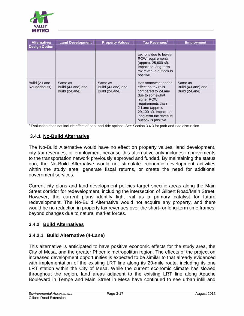
Environmental Assessment Page 3-17 August 2013
Gilbert Road Extension
Alternative/ Design Option
Land Development Property Values Tax Revenues1 Employment
tax rolls due to lowest ROW requirements (approx. 25,600 sf). Impact on long-term tax revenue outlook is positive.
Build (2-Lane Roundabouts)
Same as Build (4-Lane) and Build (2-Lane)
Same as Build (4-Lane) and Build (2-Lane)
Has somewhat added effect on tax rolls compared to 2-Lane due to somewhat higher ROW requirements than 2-Lane (approx. 29,100 sf). Impact on long-term tax revenue outlook is positive.
Same as Build (4-Lane) and Build (2-Lane)
1 Evaluation does not include effect of park-and-ride options. See Section 3.4.3 for park-and-ride discussion.
3.4.1 No-Build Alternative The No-Build Alternative would have no effect on property values, land development, city tax revenues, or employment because this alternative only includes improvements to the transportation network previously approved and funded. By maintaining the status quo, the No-Build Alternative would not stimulate economic development activities within the study area, generate fiscal returns, or create the need for additional government services. Current city plans and land development policies target specific areas along the Main Street corridor for redevelopment, including the intersection of Gilbert Road/Main Street. However, the current plans identify light rail as a primary catalyst for future redevelopment. The No-Build Alternative would not acquire any property, and there would be no reduction in property tax revenues over the short- or long-term time frames, beyond changes due to natural market forces. 3.4.2 Build Alternatives 3.4.2.1 Build Alternative (4-Lane) This alternative is anticipated to have positive economic effects for the study area, the City of Mesa, and the greater Phoenix metropolitan region. The effects of the project on increased development opportunities is expected to be similar to that already evidenced with implementation of the existing LRT line along its 20-mile route, including its one LRT station within the City of Mesa. While the current economic climate has slowed throughout the region, land areas adjacent to the existing LRT line along Apache Boulevard in Tempe and Main Street in Mesa have continued to see urban infill and
Environmental Assessment Page 3-18 August 2013
Gilbert Road Extension
revitalization. As of December 2011, approximately $4.2 billion in new development has been completed or is under construction along the LRT route (within ½ mile of a station), and an additional $2.7 billion in projects have been proposed or are in the planning stages. New development in the study area is anticipated to capture an increasing share of forecasted residential and employment growth as densities increase. A combination of vacant, underdeveloped, and potentially obsolete sites along the corridor provide ample opportunity for new development within the ½-mile station area radii that conforms to the City of Mesa’s vision of a sustainable transit-supportive urban development pattern. As noted in Section 3.2, several large parcels are available for redevelopment along the proposed LRT alignment. The city is actively pursuing reinvestment opportunities of parcels along Main Street, and the availability of vacant (nearly 685,000 square feet2) and underutilized land within ½ mile of the route creates a significant land development opportunity for developers. The city has also experienced a renaissance in downtown Mesa between Country Club Drive and Mesa Drive, where private colleges, civic spaces, and small businesses have relocated to downtown, some specifically because of the future LRT connection made possible by the Central Mesa Extension project. In addition to the abundant land available for infill and/or redevelopment in the corridor, the implementation of fixed-guideway rail stations and reliable transit service, as well as convenient connections to adjacent bus routes, will help encourage greater visitation to station areas. This, in turn, will further attract developer interest to the area. Property values are anticipated to increase due to the convenience and range of access to the transit services just mentioned, which could encourage more residents and businesses to move here, thus increasing the demand for housing and commercial properties. The conversion of property from vacant or underutilized land to more productive uses is also expected to positively influence property values within the study area. In the short term, the Build Alternative (4-Lane) would have the most impact on city and county property taxes due to the permanent removal of approximately 86,000 square feet of property from the tax rolls as well as the reduction of sales tax revenues due to the potential loss of up to three businesses, unless the buildings housing those businesses can be remodeled instead of demolished. However, the increased development potential offered by LRT would more than likely offset any such tax revenue losses and result in a positive effect over the long term. This alternative will have both direct and indirect employment impacts. The direct impacts would be derived through the new jobs required to operate and maintain the
2 Sources: City of Mesa and 2012 Maricopa County Assessors database.
Environmental Assessment Page 3-19 August 2013
Gilbert Road Extension
stations, trackway, and vehicles. These new earnings will translate into a proportional increase in consumer demand as these new workers purchase goods and services in the local community and the region. A further increase of new employment across a wide variety of industrial sectors and occupational classifications is expected as employers hire to meet this increase in local and regional consumer demand. This type of hiring represents the project’s indirect impact. 3.4.2.2 Build Alternative (2-Lane) Similar to the Build Alternative (4-Lane), this alternative is anticipated to have positive economic effects for the study area, the City of Mesa, and the greater Phoenix metropolitan region because this alternative shares the same characteristics that result in positive economic effects. Because this alternative requires the least amount of additional ROW of the Build Alternatives (approximately 25,600 square feet), it would have the least effect on tax rolls in the short term. However, over the long term, the total tax revenues of both Build Alternatives would be similar and positive. Any Difference if the 2-Lane Roundabouts Option is Implemented? No. The 2-Lane Roundabouts Option is expected to have similar positive economic benefits as those accrued by the Build Alternative (2-Lane) because the characteristics that make the Build Alternative (2-Lane) beneficial with regard to economic effects would also apply regardless of implementation of roundabouts. Although this design option would have a somewhat increased effect on tax rolls in the short term due to its slightly higher need for additional ROW (approximately 3,500 additional square feet), in the long term, the effect on total tax revenues of this design option would be similar to the Build Alternative (2-Lane) without roundabouts and would be positive. 3.4.3 Park-and-Ride (North and South Options) Both park-and-ride options are anticipated to have positive economic effects on the study area. The economic effects of the proposed park-and-ride facility at Gilbert Road/Main Street are principally tied to the joint development opportunities at the site. As facilities intended to transfer passengers between modes, park-and-rides alone are typically not vibrant economic development generators. However, current land use plans for this intersection support substantial employment growth, coupled with some residential growth, helping to create the potential for shopping and activity trips to the intersection/station. While the park-and-ride is intended to serve LRT system users, it is likely that some travelers will use the park-and-ride for trips to the intersection for business-related activities. Despite the size differences between the North Option and South Option, 10.2 acres and 6.9 acres, respectively, both options present opportunities for joint development that could be capitalized on by the City of Mesa and land developers.
Environmental Assessment Page 3-20 August 2013
Gilbert Road Extension
The direct connections that both candidate locations have with major freeways, including the US 60 and Loop 202, coupled with the current commercial zoning designations of the parcels, make both sites ideal candidates for transit-oriented joint development. Both sites have similar street frontage, critical in encouraging private development. The availability of land with the North Option offers greater flexibility when locating a parking facility on the site as well as opportunities to incorporate parking as part of a joint development effort. The smaller size of the South Option would likely necessitate that additional property be acquired as part of any joint development. Construction of a multi-level parking structure may also be considered as an option to accommodate future joint development. With regard to effect on tax revenues, the North Option would have more impact than the South Option over the short term due to loss of six businesses and more property than the South Option, which involves loss of four businesses and fewer property acquisitions. However, as with the rest of the project, the long-term outlook on tax revenues would be similar and positive because of the economic development potential that the project would bring. 3.4.4 Mitigation No mitigation is necessary.
3.5 SECONDARY DEVELOPMENT 3.5.1 No-Build Alternative The No-Build Alternative is not expected to promote secondary development. This alternative contains only those transportation improvements reflected in the MAG Regional Transportation Plan that have been funded and approved for development by 2031. Much of the project area is characterized by urban streets surrounded by suburban development. Past development trends are likely to continue, and a substantial permanent change to the physical environment of the project area is not expected to occur. 3.5.2 Build Alternatives 3.5.2.1 Build Alternative (4-Lane) Implementation of this alternative is anticipated to have positive local and regional economic and secondary development effects, with the potential to influence existing development conditions adjacent to the corridor. Land use changes are anticipated to be concentrated around the proposed station areas. The project would enhance the potential for land use intensification by improving transit accessibility throughout the study area and by providing connections with other parts of the existing and planned transit system.
Environmental Assessment Page 3-21 August 2013
Gilbert Road Extension
For secondary development to occur, two complementary components are necessary: available land near the proposed project and supportive public policies to create demand and promote development near stations. As discussed in Section 3.4, ample land exists to support development and/or redevelopment. In addition, the project is an integral part of approved city plans and future transit system plans to connect central Mesa and the East Valley with job and activity centers in downtown Mesa and across the metropolitan region. As discussed in Section 3.3, the City of Mesa has enacted several proactive plans and land development policies to guide future growth and development of the city. Mesa’s General Plan (2002), approved through voter referendum, provides a comprehensive city vision for growth, development, and livability to the year 2030. A goal of the General Plan is to “achieve a more balanced transportation system and reduce reliance on the automobile.” Numerous statements throughout the General Plan emphasize a commitment to transit-oriented development, including: “Emphasize movement of people and goods instead of movement of cars,” “provide transportation options for access to work opportunities, essential services, and recreational opportunities,” and “encourage people to walk and shop in areas near their workplaces, transit stops, residences or schools.” More recently, the Central Main Street Plan (2012) provides a detailed vision for the future of the Main Street corridor. This plan places special emphasis on light rail as a primary catalyst for land use change, stating “the catalyst with the most potential to effect change is the introduction of a high quality and efficient light rail system that connects Mesa to Phoenix.” Among the core objectives of the plan, the City specifies the need for economic development and job creation policies related to land development. “Putting in place the policy and regulatory framework that allows an urban development pattern with vertical building forms on vacant or under-utilized land” of a community of vital neighborhoods, visually attractive, transit sensitive, with resident participation in making crucial decisions about the future.” Both the General Plan and the Central Main Street Plan place an emphasis on creating a physical environment that respects the surrounding land use conditions, namely residential neighborhoods located immediately beyond Main Street to the north and south. Each plan also discusses the importance of a balanced transportation system that encourages alternative connections. While land use plans outline a desired vision for the future of central Mesa, the city’s zoning ordinance provides the policy structure for implementing change. The City of Mesa recently adopted a form-based code zoning ordinance to help regulate development throughout the city in an effort to achieve a desired urban form. These types of zoning codes are intended to provide flexibility and predictability for developers while ensuring developments meet a desired design standard and area aesthetic. In addition to the desired vision outlined in the City of Mesa’s plans, the form-based code provides the policy guidance necessary to foster transit-supportive land uses in the city, particularly along streets such as Main Street where investments in high-capacity transit facilities are planned and programmed.
Environmental Assessment Page 3-22 August 2013
Gilbert Road Extension
3.5.2.2 Build Alternative (2-Lane) Implementation of this alternative would result in positive effects similar to that discussed for the Build Alternative (4-Lane) since the characteristics of this alternative are the same as that of the 4-Lane Alternative with regard to inducing secondary development effects. Similar property exists to attract development to the area, and the City of Mesa’s public supportive policies to promote development are the same, regardless of alternative. The only potential difference between these two alternatives is that the Build Alternative (4-Lane) could potentially create a somewhat less friendly pedestrian experience, as the number of traffic lanes could accommodate higher traffic volumes and possibly higher vehicle speeds than a narrowed alternative only providing two lanes. Additionally, the wider roadway width of the 4-Lane configuration, combined with the planned LRT trackway, further separates both the north and south sides of the street in some locations, which could discourage pedestrian crossings. Any Difference if the 2-Lane Roundabouts Option is Implemented? No. This option would be expected to also have positive benefits because this option has the same characteristics that make the 4-Lane and 2-Lane Build Alternatives beneficial with regard to secondary development effects. 3.5.3 Park-and-Ride 3.5.3.1 Park-and-Ride (North Option) Implementation of the Park-and-Ride (North Option) is anticipated to have positive local and regional economic and secondary development effects, with the potential to influence existing development conditions adjacent to the corridor. The direct connections with two major freeways, coupled with the current commercial zoning designations of the parcels, make this site an ideal candidate for transit-oriented joint development opportunities. This site also has the necessary street frontage that is critical in encouraging private development. The greater availability of land with the North Option offers more flexibility when locating a parking facility on the site and opportunities to incorporate parking as part of a joint development effort. Commercial properties front both Main Street and Gilbert Road to the north and west of the North Option, while a residential neighborhood is located to the northwest. 3.5.3.2 Park-and-Ride (South Option) Like the North Option, the South Option is expected to have positive local and regional economic and secondary development effects with the potential to influence existing development conditions adjacent to the corridor. This option has the same direct
Environmental Assessment Page 3-23 August 2013
Gilbert Road Extension
Level of Service (LOS) is a quantitative measure that traffic engineers use to determine the level of traffic congestion. It is often expressed in qualitative terms as LOS A (free-flow) to LOS F (congested).
connections with two major freeways and the necessary commercial zoning designations to make it a good candidate for transit-oriented joint development. In addition, this option has similar street frontage that is critical in encouraging private development. The South Option would be located on land currently used for automobile and recreational vehicle commercial sales. A residential neighborhood abuts the southern side of the proposed South Option. The smaller size of the South Option would likely require construction of a parking structure to satisfy parking demand. 3.5.4 Mitigation Changes in land use and denser development near stations are anticipated, consistent with existing plans and policies. Overall, positive economic and secondary development effects are anticipated with any of the Build Alternatives or Park-and-Ride Options. No mitigation is required. 3.6 TRANSPORTATION This section evaluates the effects of the alternatives with regard to the following factors: 1) traffic; 2) on-street parking; 3) bicyclists/pedestrians; 4) freight movements; 5) emergency services access; and 6) other transit services. For additional information refer to Appendix C, Transportation Technical Report. An evaluation was conducted for Existing Conditions, the No-Build Alternative, and each of the Build Alternatives to determine whether any will increase congestion and motorist delay at the existing and proposed signalized intersections or those intersections provided with roundabouts along the Gilbert Road Extension. Table 3-10 presents the results of the overall PM peak hour average intersection Level of Service (LOS) and delay (expressed as seconds per vehicle) for existing conditions, the No-Build Alternative, and the Build Alternatives, including the roundabouts design option. The City of Mesa Transportation Department considers LOS E acceptable during the PM peak hour for this study. Locations of the intersections studied along Main Street are shown in Figures 3-2 and 3-3. Note that both of these figures show an “existing” signal at Lesueur. While signals do not currently exist at this location, they will be installed as part of the Central Mesa Extension which is currently under construction. The effects of the alternatives with regard to on-street parking along Main Street are compared in Table 3-11.
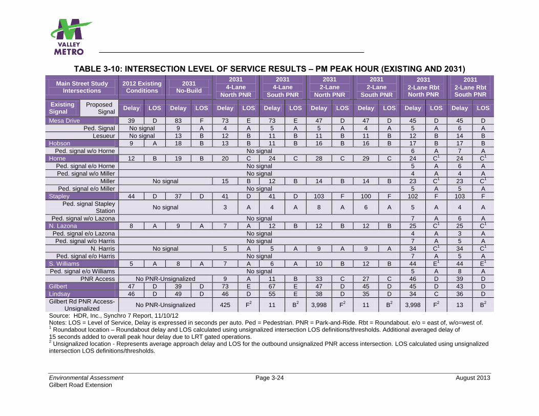
Environmental Assessment Page 3-24 August 2013
Gilbert Road Extension
TABLE 3-10: INTERSECTION LEVEL OF SERVICE RESULTS – PM PEAK HOUR (EXISTING AND 2031)
Main Street Study Intersections
2012 Existing Conditions
2031 No-Build
2031
4-Lane
North PNR
2031
4-Lane
South PNR
2031
2-Lane
North PNR
2031
2-Lane
South PNR
2031
2-Lane Rbt North PNR
2031
2-Lane Rbt South PNR
Existing Signal
Proposed Signal
Delay LOS Delay LOS Delay LOS Delay LOS Delay LOS Delay LOS Delay LOS Delay LOS
Mesa Drive 39 D 83 F 73 E 73 E 47 D 47 D 45 D 45 D
Ped. Signal No signal 9 A 4 A 5 A 5 A 4 A 5 A 6 A
Lesueur No signal 13 B 12 B 11 B 11 B 11 B 12 B 14 B
Hobson 9 A 18 B 13 B 11 B 16 B 16 B 17 B 17 B
Ped. signal w/o Horne No signal 6 A 7 A
Horne 12 B 19 B 20 C 24 C 28 C 29 C 24 C1 24 C
1
Ped. signal e/o Horne No signal 5 A 6 A
Ped. signal w/o Miller No signal 4 A 4 A
Miller No signal 15 B 12 B 14 B 14 B 23 C1 23 C
1
Ped. signal e/o Miller No signal 5 A 5 A
Stapley 44 D 37 D 41 D 41 D 103 F 100 F 102 F 103 F
Ped. signal Stapley Station
No signal 3 A 4 A 8 A 6 A 5 A 4 A
Ped. signal w/o Lazona No signal 7 A 6 A
N. Lazona 8 A 9 A 7 A 12 B 12 B 12 B 25 C1 25 C
1
Ped. signal e/o Lazona No signal 4 A 3 A
Ped. signal w/o Harris No signal 7 A 5 A
N. Harris No signal 5 A 5 A 9 A 9 A 34 C1 34 C
1
Ped. signal e/o Harris No signal 7 A 5 A
S. Williams 5 A 8 A 7 A 6 A 10 B 12 B 44 E1 44 E
1
Ped. signal e/o Williams No signal 5 A 8 A
PNR Access No PNR-Unsignalized 9 A 11 B 33 C 27 C 46 D 39 D
Gilbert 47 D 39 D 73 E 67 E 47 D 45 D 45 D 43 D
Lindsay 46 D 49 D 46 D 55 E 38 D 35 D 34 C 36 D
Gilbert Rd PNR Access-Unsignalized
No PNR-Unsignalized 425 F2 11 B
2 3,998 F
2 11 B
2 3,998 F
2 13 B
2
Source: HDR, Inc., Synchro 7 Report, 11/10/12 Notes: LOS = Level of Service, Delay is expressed in seconds per auto. Ped = Pedestrian. PNR = Park-and-Ride. Rbt = Roundabout. e/o = east of, w/o=west of. 1 Roundabout location – Roundabout delay and LOS calculated using unsignalized intersection LOS definitions/thresholds. Additional averaged delay of
15 seconds added to overall peak hour delay due to LRT gated operations. 2 Unsignalized location - Represents average approach delay and LOS for the outbound unsignalized PNR access intersection. LOS calculated using unsignalized
intersection LOS definitions/thresholds.

Environmental Assessment Page 3-25 August 2013
Gilbert Road Extension
FIGURE 3-2: BUILD ALTERNATIVES (4-LANE) AND (2-LANE) – INTERSECTIONS STUDIED
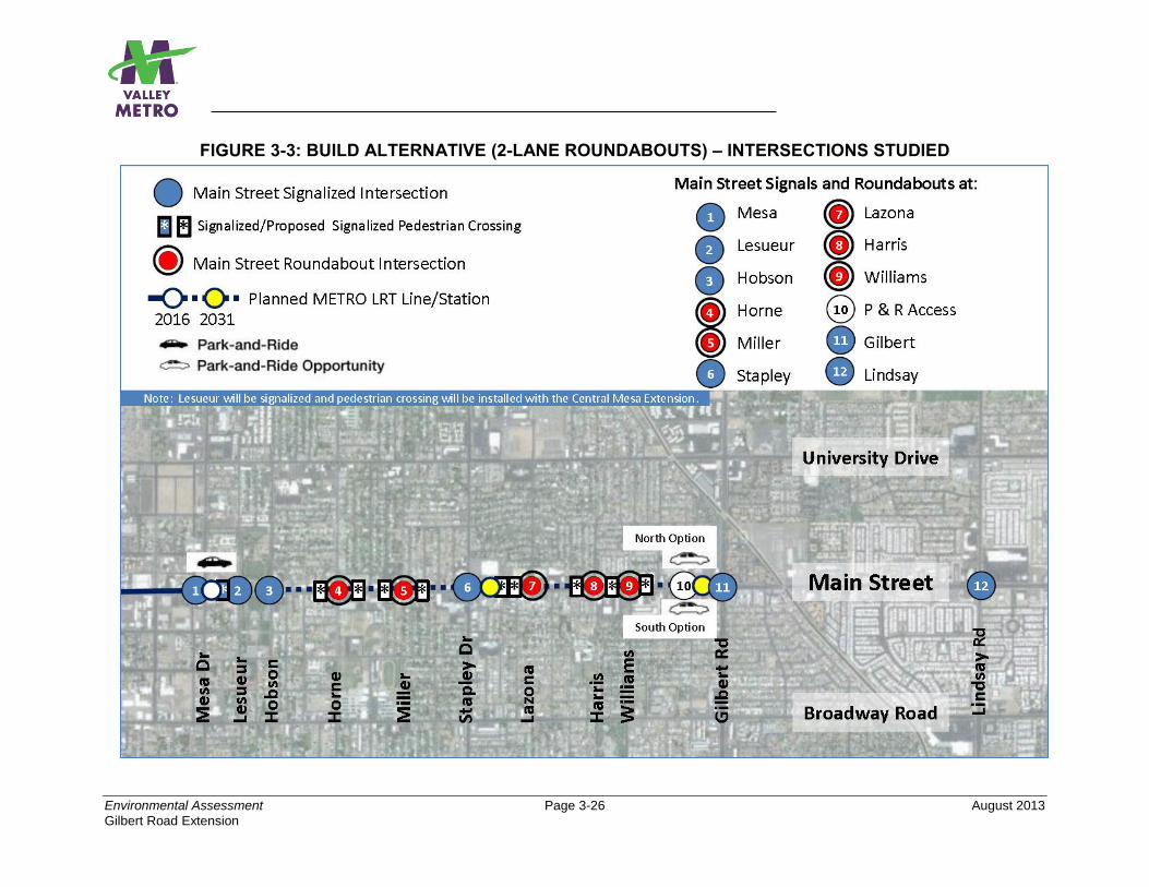
Environmental Assessment Page 3-26 August 2013
Gilbert Road Extension
FIGURE 3-3: BUILD ALTERNATIVE (2-LANE ROUNDABOUTS) – INTERSECTIONS STUDIED
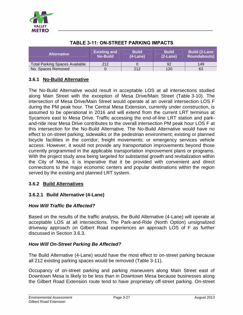
Environmental Assessment Page 3-27 August 2013
Gilbert Road Extension
TABLE 3-11: ON-STREET PARKING IMPACTS
Alternative Existing and
No-Build Build
(4-Lane) Build
(2-Lane) Build (2-Lane Roundabouts)
Total Parking Spaces Available 212 0 92 149
No. Spaces Removed 0 212 120 63
3.6.1 No-Build Alternative The No-Build Alternative would result in acceptable LOS at all intersections studied along Main Street with the exception of Mesa Drive/Main Street (Table 3-10). The intersection of Mesa Drive/Main Street would operate at an overall intersection LOS F during the PM peak hour. The Central Mesa Extension, currently under construction, is assumed to be operational in 2016 and will extend from the current LRT terminus at Sycamore east to Mesa Drive. Traffic accessing the end-of-line LRT station and park-and-ride near Mesa Drive contributes to the overall intersection PM peak hour LOS F at this intersection for the No-Build Alternative. The No-Build Alternative would have no effect to on-street parking; sidewalks or the pedestrian environment; existing or planned bicycle facilities in the corridor; freight movements; or emergency services vehicle access. However, it would not provide any transportation improvements beyond those currently programmed in the applicable transportation improvement plans or programs. With the project study area being targeted for substantial growth and revitalization within the City of Mesa, it is imperative that it be provided with convenient and direct connections to the major economic centers and popular destinations within the region served by the existing and planned LRT system. 3.6.2 Build Alternatives 3.6.2.1 Build Alternative (4-Lane) How Will Traffic Be Affected? Based on the results of the traffic analysis, the Build Alternative (4-Lane) will operate at acceptable LOS at all intersections. The Park-and-Ride (North Option) unsignalized driveway approach on Gilbert Road experiences an approach LOS of F as further discussed in Section 3.6.3. How Will On-Street Parking Be Affected? The Build Alternative (4-Lane) would have the most effect to on-street parking because all 212 existing parking spaces would be removed (Table 3-11).
Occupancy of on-street parking and parking maneuvers along Main Street east of Downtown Mesa is likely to be less than in Downtown Mesa because businesses along the Gilbert Road Extension route tend to have proprietary off-street parking. On-street
Environmental Assessment Page 3-28 August 2013
Gilbert Road Extension
parking in the Main Street study area primarily serves as a convenience to business patrons.
How Will Bicyclists and Pedestrians Be Affected?
Bicycle lanes on Main Street would be mostly retained, as shown in the conceptual design plans in Appendix A and in the typical cross sections presented in Chapter 2. The Build Alternative (4-Lane) design’s proposed elimination of numerous uncontrolled left-turn opportunities and the on-street parking would reduce the potential hazards faced by bicyclists on Main Street.
The Build Alternative (4-Lane) would have no adverse effect on pedestrian facilities. Sidewalks would be retained along both sides of Main Street. The existing curb would be relocated in some areas, and in these areas the sidewalk would be reconstructed behind the curb. Sidewalk reconstruction would conform to current Americans with Disabilities Act standards. Valley Metro has developed a Design Criteria Manual that identifies landscaping requirements 350 feet on either end of the station platform to provide an enhanced streetscape and shade for pedestrians along the alignment. Valley Metro has also developed urban design guidelines which include, among other things, criteria for station design for pedestrian comfort that apply to the entire LRT system and also completed, as a companion piece, additional guidelines that apply to the Central Mesa LRT extension, currently in construction. These guidelines will also be applied to the Gilbert Road Extension. Those documents include measures to enhance pedestrian comfort and safety to those walking in the vicinity of the stations from the surrounding community as well as from the park-and-ride facilities. Shading techniques are also included in these guidelines.
At the proposed park-and-ride locations west of Gilbert Road, sidewalks along Main Street would cross the access road to the park-and-ride lot. The access road into the park-and-ride would be designed as a signalized intersection with full curb returns and pedestrian signals.
Crosswalks would be maintained at all signalized intersections on Main Street. Specific changes proposed for the Build Alternative (4-Lane) would be as follows:
Miller – Crosswalks would be added at this new signalized intersection.
East of Stapley Drive – New signalized crosswalks on each end of the center platform LRT station (near Allen and Lazona Drive) would provide pedestrian access across Main Street and to the LRT station.
Harris – Crosswalks would be added at this new signalized intersection.
Williams – Crosswalk would be added on the east leg of the existing signalized intersection.
Environmental Assessment Page 3-29 August 2013
Gilbert Road Extension
Gilbert Road Station Park-and-Ride Access – Crosswalks would be added to this new signalized intersection on Main Street; they would also provide access to the center platform station.
For information regarding the potential effects on school children crossing Main Street and the LRT tracks, refer to Section 3.16, Safety and Security.
How Will Freight Mobility Be Affected?
The City of Mesa does not have any designated arterial truck routes in the city. The arterials, such as Main Street, Broadway Road, University Drive, Stapley Drive, and Gilbert Road within the study area, do accommodate commercial freight truck traffic. However, Main Street in the project study area has little regional significance in terms of freight mobility. Main Street plays a more important role for pick-up and delivery of goods to businesses along Main Street and the adjacent neighborhoods.
Truck deliveries to businesses along Main Street may be affected by light rail due to elimination of many left-turn access points and U-turning opportunities as well as the loss of some on-street loading opportunities afforded by on-street parking spaces, most notably for the Build Alternative (4-Lane) since all on-street parking would be removed. However, neither of these impacts is considered to be significant. Truck deliveries could be made from off-street locations within proprietary or shared parking lots or from alleys behind buildings fronting Main Street and/or loading docks. Regarding left-turn access and U-turn movements, these are not considered significant impacts as typically trucks can change their routes so these movements can be avoided.
Will Emergency Services and Vehicles Access Be Affected?
The introduction of light rail to the Main Street corridor may potentially affect how emergency service providers (e.g., police, fire, ambulances) respond to calls within or near the study area. For the Build Alternative (4-Lane), the main concern would be reduced left-turn access across the light rail guideway. The measures discussed in Section 3.6.4 would minimize adverse effects.
How Will Existing Transit Services Be Affected?
The transit system in the study area would not be adversely affected and would be made more efficient for the riders who use the system. Bus Route 40 (Main Street) would be retained. Valley Metro’s Main Street LINK bus service would no longer serve the Main Street corridor west of Gilbert Road since it would terminate at the proposed Gilbert Road LRT station. LINK passengers wishing to continue west would transfer to the LRT at Gilbert Road where they could continue their ride to any destination in Mesa, Tempe, or Phoenix served by LRT. Route 30 (University Drive) and Route 45 (Broadway Road) may divert on Gilbert Road to serve the end-of-line LRT station at Gilbert Road. Potential diversion of these two routes will be determined during Project Development. Cross street bus routes on Mesa Drive (Route 120), Stapley Drive
Environmental Assessment Page 3-30 August 2013
Gilbert Road Extension
(Route 128), and Gilbert Road (Route 136) would continue to operate as they do for the No-Build Alternative. Section 2.3.4 of the EA provides additional information about the transit network associated with the Build Alternatives.
3.6.2.2 Build Alternative (2-Lane) How Will Traffic Be Affected? Except for the intersection of Stapley Drive/Main Street, the intersections along Main Street (Figure 3-2) would all operate at an acceptable LOS (Table 3-10) during the PM peak periods. The Stapley Drive/Main Street intersection would operate at an overall average LOS F during the PM peak period. Suggested mitigation is discussed in Section 3.6.4. The Gilbert Road access to the end-of-line Park-and-Ride (North Option) would also operate at LOS F as an unsignalized driveway for the traffic exiting the park-and-ride. Section 3.6.3 discusses this in more detail. Traffic diversion, as a result of narrowing Main Street from four lanes to two lanes, is not anticipated to adversely affect the roadway link (i.e., roadway segment) LOS along the nearest parallel streets (University Drive and Broadway Road), with the possible exception of the roadway link of eastbound University Drive between Harris and Gilbert Road. Along this eastbound segment of University Drive, the MAG Travel Demand Model (TDM) data predicts link LOS to change from E to F in 2031. Since the TDM methods to determine the LOS for traffic diversion of roadway links along University Drive and Broadway Road are based on high level volume to capacity ratios, additional detailed traffic studies should be performed as design advances to confirm this change in LOS, similar to the methodology used to study the intersections along Main Street. How Will On-Street Parking Be Affected? As shown previously in Table 3-11, the Build Alternative (2-Lane) would require removal of 120 spaces, leaving 92 on-street parking spaces along Main Street. While this alternative does not remove all parking like the Build Alternative (4-Lane) does, it would remove 57 more spaces than the Roundabouts Option. As previously mentioned, an adverse impact is not likely since ample off-street parking exists at most businesses along the route. How Will Bicyclists and Pedestrians Be Affected?
Similar to the Build Alternative (4-Lane), the Build Alternative (2-Lane) will retain most of the existing bicycle lanes, and the design’s proposed elimination of numerous uncontrolled left-turn opportunities would reduce the potential hazards faced by bicyclists on Main Street. The pedestrian facilities for the Build Alternative (2-Lane) will be the same as those planned for the 4-Lane design, so the potential impacts will also be the same.
Environmental Assessment Page 3-31 August 2013
Gilbert Road Extension
How Will Freight Mobility Be Affected?
Impacts on freight movements will not be adverse for the same reasons discussed above for the Build Alternative (4-Lane). Will Emergency Services and Vehicles Access Be Affected?
As with the Build Alternative (4-Lane), this alternative may potentially affect how emergency service providers respond to calls within or near the study area. For the Build Alternative (2-Lane), the concern would be reduced left-turn access across the light rail guideway as well as potential for reduced response time due to increased peak hour congestion on Main Street at some locations. The measures discussed in Section 3.6.4 would minimize adverse effects.
How Will Existing Transit Services Be Affected?
Transit services will operate the same as described for the Build Alternative (4-Lane). Any Difference if the 2-Lane Roundabouts Option is Implemented? Each transportation factor is discussed below:
Traffic: Yes. The intersection of Stapley Drive/Main Street would operate at the same LOS F as the 2-Lane design without the roundabouts (Table 3-10). Although all the other intersections (Figure 3-3) would operate at an acceptable LOS, the five roundabout intersections would experience more delay in the PM peak than those same intersections without the roundabouts. This is due to slower design/posted speeds of 20 mph through the roundabout and the additional delay incurred due to crossing gates coming down when trains pass through the roundabouts restricting automobile traffic moving in the north-south direction and also restricting east-west bound traffic from making left turns north or south across the tracks. In addition, traffic diversion impacts are expected to be the same as the 2-Lane design without roundabouts due to the narrowing of the roadway from four to two lanes. The 2-Lane Roundabouts Option also allows for U-turns for most types of vehicles traveling along Main Street, whereas the 2-Lane without roundabouts alternative only allows for passenger vehicle U-turn movements.
On-Street Parking: Yes, but Minor. This design option would remove the least amount of on-street parking (63 spaces), leaving 149 parking spaces along Main Street. As with the Build Alternative (2-Lane), the Roundabouts Option will have no adverse effect to on-street parking.
Bicyclists and Pedestrians: Yes. For optimal bicycle facility design and safety reasons, the bicycle lanes should be dropped on the approach to the roundabout intersections as studies have shown that bicycle lanes continuing through a roundabout expose the rider to an increased risk of collisions with vehicles that are turning right to exit the roundabout. Therefore, bicyclists may merge into the stream
Environmental Assessment Page 3-32 August 2013
Gilbert Road Extension
of motorized traffic or move to and from the sidewalk with pedestrians. For pedestrians crossing Main Street or the cross streets at the roundabout locations, the roundabouts design would be designed differently than typical signalized intersections. The roundabouts’ crosswalks would be set back away from the intersection location, and all pedestrian crossings across Main Street would be signalized to ensure protected crossings in coordination with LRT operations. The current crossing design, as shown in Appendix A, would require a substantial “out-of-direction” path of 150 to 200 feet for pedestrians intending to cross Main Street east or west of each roundabout. Further design concepts would be evaluated in future design phases to determine if the crosswalks can be located closer to the intersection/roundabout to minimize north-south pedestrian walk time. Special consideration will also be given to sidewalks and curb ramps at the roundabouts due to the potential shared use of these facilities with bicycles since bicycle lanes would not be provided within the roundabouts.
Freight Mobility: No. Impacts on freight movements would not be adverse for the same reasons as discussed for the other Build Alternatives.
Emergency Services: No. Impacts on these services and vehicle access would be the same as the 2-lane design without the roundabouts for the same reasons discussed for that alternative.
Transit Services: No. Transit services will operate the same as they will with the other Build Alternatives.
3.6.3 Park-and-Ride 3.6.3.1 Park-and-Ride (North Option)
As shown previously in Table 3-10, this option is similar to the South Option with regard to traffic delay and LOS along Main Street. Based on a study of both options, which assessed site accessibility and traffic safety, site configuration and circulation needs, site capacity and future transit interface needs, the Park-and-Ride (North Option) presents more advantages than the South Option. See Appendix B for additional information. Although the current design includes signalized access to the park-and-ride along Main Street, it includes unsignalized access to the park-and-ride along Gilbert Road. As shown in Table 3-10, this Gilbert Road access would result in a park-and-ride access LOS F for vehicles exiting the park-and-ride during the PM peak period. Mitigation measures are discussed in Section 3.6.4 to minimize the adverse effect.
3.6.3.2 Park-and-Ride (South Option)
As mentioned, this option is similar to the North Option with regard to traffic delay and LOS along Main Street. However, the study of park-and-ride options presented in Appendix B found that this option has fewer advantages than the North Option. Although this option’s design also currently features unsignalized access along Gilbert Road, the vehicles entering and exiting at this access location would operate at an
Environmental Assessment Page 3-33 August 2013
Gilbert Road Extension
acceptable LOS B but would be limited to right-in/right-out and left turn into the facility movements. No eastbound to northbound movements would be available.
3.6.4 Mitigation All Build Alternatives including the Roundabouts Option: The project could affect emergency service provider response. The main concern would be reduced left-turn access across the light rail guideway. For the Build Alternative (2-Lane) and its roundabouts design option, there would also be the potential for reduced response time due to increased peak hour congestion along Main Street. The following measures would minimize the adverse effect:
Valley Metro and the City of Mesa would coordinate with the Fire, Life, Safety agencies and provide revised routes and emergency access plans.
Valley Metro and the City of Mesa will continue to use opticom traffic control at all existing and new signalized intersections by providing intersection priority to emergency vehicles.
Build Alternative (2-Lane) and Build Alternative (2-Lane Roundabouts): The intersection of Stapley Drive/Main Street would operate at an average overall intersection LOS F during the PM peak period in 2031. The following potential strategies would minimize the adverse effect:
Allow this intersection to go unmitigated. Drivers may divert to other less congested intersections so they are not “stuck in traffic.” In this area, there are other corridors that have the capacity to handle additional traffic volumes. This has been observed to occur at some locations along the existing 20-mile LRT line where there are nearby parallel facilities with excess capacity.
Add 100-foot right-turn lanes along Main Street at Stapley Drive in both the eastbound and westbound directions. This would improve the LOS to an acceptable LOS E.
Continue to evaluate this intersection in future design phases, including collecting new traffic counts at Stapley Drive. The traffic counts used as a basis for the traffic evaluation at this intersection were conducted when construction was occurring along nearby roadways which may have influenced the turning movement counts at this location.
Use more sophisticated software in future design phases, such as VISSIM and its more detailed analysis capabilities, to reanalyze the intersection and corridor since that software better addresses LRT operations along with auto operations and may achieve more accurate results.
Environmental Assessment Page 3-34 August 2013
Gilbert Road Extension
Traffic diversion, as a result of narrowing Main Street from four lanes to two lanes, is anticipated to result in a roadway segment along eastbound University Drive between Harris and Gilbert Road to change from roadway link LOS E to LOS F. Since the methodology used to determine this roadway link LOS change is less detailed/accurate than the method used to study intersection LOS along Main Street, further traffic analysis should be conducted during the more advanced design stages to confirm whether or not the roadway and intersections at the above location will be impacted by traffic diversion for the 2-Lane with and without Roundabouts Options. If the link LOS F is confirmed, then measures such as revising or optimizing the traffic signal phasing may be sufficient to improve LOS to E or better. Build Alternative (2-Lane Roundabouts): The current design of the five roundabouts would require pedestrians to walk approximately 150 to 200 feet out of direction to cross Main Street. For safety reasons, the roundabouts are not designed with bicycle lanes thus shared bicycle use of the roundabout intersections’ sidewalks and curb ramps with pedestrians is likely.
As the project advances through the more refined design stages, concepts will be developed and considered to locate the crosswalks closer to the intersection/roundabout to minimize pedestrian walk time. The concepts will also consider optimal design of the sidewalks and curb ramps to safely accommodate both bicyclists and pedestrians.
Park-and-Ride (North Option) The unsignalized access from the park-and-ride to Gilbert Road would result in a LOS F and long delays for vehicles exiting the park-and-ride during the PM peak period. This is mainly due to autos becoming backed up within the park-and-ride as they wait for traffic along Gilbert Road to clear so they can exit east onto that roadway. Either of the following measures would minimize the adverse effect:
Install a traffic signal at this location.
Add two access locations (driveways) along Gilbert Road so the outbound traffic volume can “disperse” between three locations.
3.7 AIR QUALITY For additional information, refer to Appendix D, Air Quality Technical Report. The federal and state ambient air quality standards are applicable to the Maricopa County region. The National Ambient Air Quality Standards (NAAQS) were established by the federal Clean Air Act of 1970, as amended in 1977 and 1990. The NAAQS represent the maximum levels of pollution considered safe, with an adequate margin of
Environmental Assessment Page 3-35 August 2013
Gilbert Road Extension
safety, to protect public health and welfare. The six primary air pollutants of concern for which NAAQS have been established are carbon monoxide (CO), ozone (O3), particulate matter (PM) equal to or smaller than 10 microns (PM-10) or 2.5 microns (PM-2.5) in diameter, sulfur dioxide (SO2), nitrogen dioxide (NO2), and lead (Pb). The State of Arizona’s ambient air quality standards are identical to the federal NAAQS. The Maricopa County area is currently designated as a federal nonattainment area for 8-hour O3 and PM-10, maintenance area for CO, and unclassifiable/attainment for SO2, Pb, NO2, and PM-2.5. 3.7.1 No-Build Alternative Based on the analysis provided in the Air Quality Technical Report (Appendix D), the No-Build Alternative is not expected to have an adverse impact on air quality. No violations of the current CO standards are projected. However, because the No-Build Alternative would not attract the ridership associated with the proposed light rail project, it would not be as supportive of the need for attainment and maintenance of air quality standards in the region. 3.7.2 Build Alternatives (4-Lane, 2-Lane, 2-Lane Roundabouts Option) Neither the Build Alternative (4-Lane) nor the Build Alternative (2-Lane) or its Roundabouts design option, will adversely affect air quality during LRT operations. The Clean Air Act requires that Federal agencies and Metropolitan Planning Organizations not approve any transportation project, program, or plan which does not conform to the approved State Implementation Plan. The Federal Transportation Conformity Rule requires that FHWA/FTA projects must be found to conform before they are adopted, accepted, approved, or funded. The rule requires both a regional and project-level hot-spot analysis.
Regional Analysis: On March 27, 2013, MAG approved the latest New Finding of Conformity for the FY 2011-2015 MAG Transportation Improvement Program (TIP) and Regional Transportation Plan (RTP) 2010 Update, As Amended. The analysis demonstrates that the criteria specified in the federal transportation conformity rule for a conformity determination are satisfied by the TIP and RTP 2010. A finding of conformity for the FY 2011-2015 MAG TIP and RTP 2010 Update, As Amended, is therefore supported. It is important to note that the Gilbert Road Extension, including the park-and-ride facility, was included in the MAG TIP/RTP and conformity analysis adopted by the MAG Regional Council in March 2013. The MAG regional emissions analysis was conducted for the horizon year 2031 for CO, eight-hour O3, and PM-10. The conformity demonstration complies with the Federal Transportation Rule and indicates that the TIP/RTP will not (i) cause or contribute to any new violation of any standard in any area; (ii) increase the frequency or severity of any existing violation of any standard in any area; or
Environmental Assessment Page 3-36 August 2013
Gilbert Road Extension
(iii) delay timely attainment of any standard or any required interim emission reductions or other milestones in any area. The MAG TIP/RTP, As Amended, and the latest conformity analysis were approved by the MAG Regional Council on March 27, 2013.
Hot-Spot Analysis: The Environmental Protection Agency (EPA) Guideline for Modeling Carbon Monoxide was followed for the study area. Two intersections met the screening criteria and were selected for air quality modeling. The carbon monoxide analysis demonstrated that the estimated total concentrations for the Build Alternatives are approximately 45 percent below the standard.
The PM-10 screening documented that the project was determined NOT to be a Project of Air Quality Concern; therefore, no further PM-10 analysis was necessary. Construction-related activities were not included in the hot-spot analysis because the construction period is less than five years and considered temporary under the Federal Transportation Conformity Rule. Further information on air quality impacts during construction may be found in Section 3.20. 3.7.3 Park-and-Ride (North and South Options) The air quality evaluation discussed above included consideration of both Park-and-Ride Options (North and South) and determined that the proposed project, including park-and-ride, would have no adverse effect on air quality during operations. 3.7.4 Mitigation No mitigation is needed.
3.8 NOISE AND VIBRATION The Noise and Vibration Technical Report, Gilbert Road Extension Environmental Assessment, March 2013, included as Appendix E, follows the guidelines of FTA’s manual, Transit Noise and Vibration Impact Assessment, May 2006. To assist the reader in an understanding of the findings of the noise and vibration analysis, this section begins by summarizing the basic principles of noise and vibration and the FTA methodologies used to evaluate effects. More detailed information may be found in the appendix cited above. Noise. The approach to analyzing noise impact is summarized in Table 3-12.
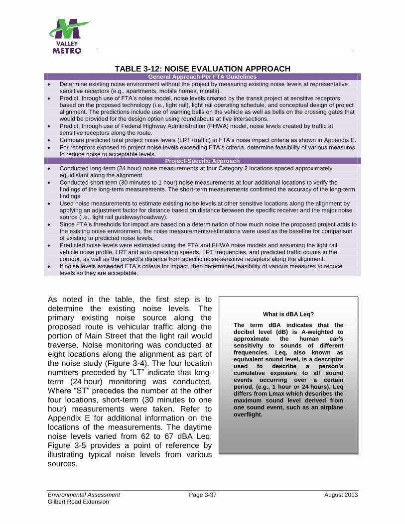
Environmental Assessment Page 3-37 August 2013
Gilbert Road Extension
What is dBA Leq?
The term dBA indicates that the decibel level (dB) is A-weighted to approximate the human ear’s sensitivity to sounds of different frequencies. Leq, also known as equivalent sound level, is a descriptor used to describe a person’s cumulative exposure to all sound events occurring over a certain period, (e.g., 1 hour or 24 hours). Leq differs from Lmax which describes the maximum sound level derived from one sound event, such as an airplane
overflight.
TABLE 3-12: NOISE EVALUATION APPROACH General Approach Per FTA Guidelines
Determine existing noise environment without the project by measuring existing noise levels at representative sensitive receptors (e.g., apartments, mobile homes, motels).
Predict, through use of FTA’s noise model, noise levels created by the transit project at sensitive receptors based on the proposed technology (i.e., light rail), light rail operating schedule, and conceptual design of project alignment. The predictions include use of warning bells on the vehicle as well as bells on the crossing gates that would be provided for the design option using roundabouts at five intersections.
Predict, through use of Federal Highway Administration (FHWA) model, noise levels created by traffic at sensitive receptors along the route.
Compare predicted total project noise levels (LRT+traffic) to FTA’s noise impact criteria as shown in Appendix E.
For receptors exposed to project noise levels exceeding FTA’s criteria, determine feasibility of various measures to reduce noise to acceptable levels.
Project-Specific Approach
Conducted long-term (24 hour) noise measurements at four Category 2 locations spaced approximately equidistant along the alignment.
Conducted short-term (30 minutes to 1 hour) noise measurements at four additional locations to verify the findings of the long-term measurements. The short-term measurements confirmed the accuracy of the long-term findings.
Used noise measurements to estimate existing noise levels at other sensitive locations along the alignment by applying an adjustment factor for distance based on distance between the specific receiver and the major noise source (i.e., light rail guideway/roadway).
Since FTA’s thresholds for impact are based on a determination of how much noise the proposed project adds to the existing noise environment, the noise measurements/estimations were used as the baseline for comparison of existing to predicted noise levels.
Predicted noise levels were estimated using the FTA and FHWA noise models and assuming the light rail vehicle noise profile, LRT and auto operating speeds, LRT frequencies, and predicted traffic counts in the corridor, as well as the project’s distance from specific noise-sensitive receptors along the alignment.
If noise levels exceeded FTA’s criteria for impact, then determined feasibility of various measures to reduce levels so they are acceptable.
As noted in the table, the first step is to determine the existing noise levels. The primary existing noise source along the proposed route is vehicular traffic along the portion of Main Street that the light rail would traverse. Noise monitoring was conducted at eight locations along the alignment as part of the noise study (Figure 3-4). The four location numbers preceded by “LT” indicate that long-term (24 hour) monitoring was conducted. Where “ST” precedes the number at the other four locations, short-term (30 minutes to one hour) measurements were taken. Refer to Appendix E for additional information on the locations of the measurements. The daytime noise levels varied from 62 to 67 dBA Leq. Figure 3-5 provides a point of reference by illustrating typical noise levels from various sources.
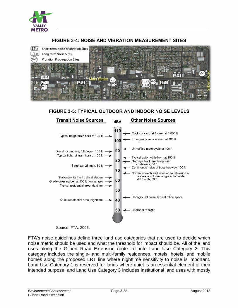
Environmental Assessment Page 3-38 August 2013
Gilbert Road Extension
FIGURE 3-4: NOISE AND VIBRATION MEASUREMENT SITES
FIGURE 3-5: TYPICAL OUTDOOR AND INDOOR NOISE LEVELS
Source: FTA, 2006.
FTA’s noise guidelines define three land use categories that are used to decide which noise metric should be used and what the threshold for impact should be. All of the land uses along the Gilbert Road Extension route fall into Land Use Category 2. This category includes the single- and multi-family residences, motels, hotels, and mobile homes along the proposed LRT line where nighttime sensitivity to noise is important. Land Use Category 1 is reserved for lands where quiet is an essential element of their intended purpose, and Land Use Category 3 includes institutional land uses with mostly
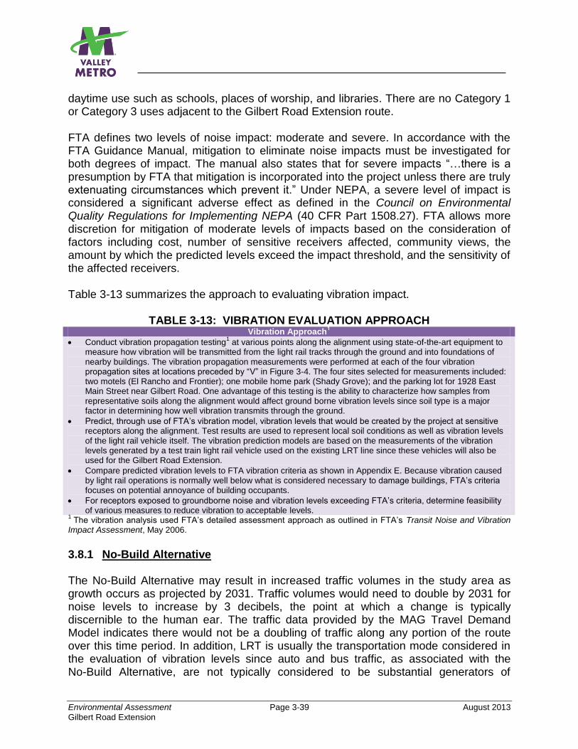
Environmental Assessment Page 3-39 August 2013
Gilbert Road Extension
daytime use such as schools, places of worship, and libraries. There are no Category 1 or Category 3 uses adjacent to the Gilbert Road Extension route. FTA defines two levels of noise impact: moderate and severe. In accordance with the FTA Guidance Manual, mitigation to eliminate noise impacts must be investigated for both degrees of impact. The manual also states that for severe impacts “…there is a presumption by FTA that mitigation is incorporated into the project unless there are truly extenuating circumstances which prevent it.” Under NEPA, a severe level of impact is considered a significant adverse effect as defined in the Council on Environmental Quality Regulations for Implementing NEPA (40 CFR Part 1508.27). FTA allows more discretion for mitigation of moderate levels of impacts based on the consideration of factors including cost, number of sensitive receivers affected, community views, the amount by which the predicted levels exceed the impact threshold, and the sensitivity of the affected receivers. Table 3-13 summarizes the approach to evaluating vibration impact.
TABLE 3-13: VIBRATION EVALUATION APPROACH Vibration Approach
1
Conduct vibration propagation testing1 at various points along the alignment using state-of-the-art equipment to
measure how vibration will be transmitted from the light rail tracks through the ground and into foundations of nearby buildings. The vibration propagation measurements were performed at each of the four vibration propagation sites at locations preceded by “V” in Figure 3-4. The four sites selected for measurements included: two motels (El Rancho and Frontier); one mobile home park (Shady Grove); and the parking lot for 1928 East Main Street near Gilbert Road. One advantage of this testing is the ability to characterize how samples from representative soils along the alignment would affect ground borne vibration levels since soil type is a major factor in determining how well vibration transmits through the ground.
Predict, through use of FTA’s vibration model, vibration levels that would be created by the project at sensitive receptors along the alignment. Test results are used to represent local soil conditions as well as vibration levels of the light rail vehicle itself. The vibration prediction models are based on the measurements of the vibration levels generated by a test train light rail vehicle used on the existing LRT line since these vehicles will also be used for the Gilbert Road Extension.
Compare predicted vibration levels to FTA vibration criteria as shown in Appendix E. Because vibration caused by light rail operations is normally well below what is considered necessary to damage buildings, FTA’s criteria focuses on potential annoyance of building occupants.
For receptors exposed to groundborne noise and vibration levels exceeding FTA’s criteria, determine feasibility of various measures to reduce vibration to acceptable levels.
1 The vibration analysis used FTA’s detailed assessment approach as outlined in FTA’s Transit Noise and Vibration
Impact Assessment, May 2006.
3.8.1 No-Build Alternative The No-Build Alternative may result in increased traffic volumes in the study area as growth occurs as projected by 2031. Traffic volumes would need to double by 2031 for noise levels to increase by 3 decibels, the point at which a change is typically discernible to the human ear. The traffic data provided by the MAG Travel Demand Model indicates there would not be a doubling of traffic along any portion of the route over this time period. In addition, LRT is usually the transportation mode considered in the evaluation of vibration levels since auto and bus traffic, as associated with the No-Build Alternative, are not typically considered to be substantial generators of
Environmental Assessment Page 3-40 August 2013
Gilbert Road Extension
vibration. Therefore, no noise and vibration impacts would result from the No-Build Alternative. 3.8.2 Build Alternatives A comparison of the potential noise and vibration impacts of the Build Alternatives, including the roundabouts design option, is provided in Table 3-14. The potential impacts of each alternative are discussed below.
TABLE 3-14: COMPARISON OF POTENTIAL NOISE AND VIBRATION IMPACTS1 Impact Build Alternative
(4-Lane) Build Alternative
(2-Lane) Build Alternative
(2-Lane Roundabouts)
Noise Impact - Moderate - El Rancho Motel
- Unnamed motel
- Frontier Motel
- Days Inn Hotel
- Suit You Trailer Park
- Shady Grove Trailer
Park
- Frontier Motel
- Shady Grove Trailer
Park
- Frontier Motel
- Shady Grove Trailer
Park
- Severe None None None
Vibration Impact - Unnamed motel
- Frontier Motel
- Days Inn Hotel
- Suit You Trailer Park
- Unnamed motel
- Frontier Motel
- Days Inn Hotel
- Suit You Trailer Park
- Unnamed motel
- Frontier Motel
- Days Inn Hotel
- Suit You Trailer Park 1
Impact thresholds per FTA criteria as defined in Transit Noise and Vibration Impact Assessment, FTA, May 2006. Source: ATS Consultants, 2012.
3.8.2.1 Build Alternative (4-Lane) Where Would the Noise Impacts Potentially Occur? The predicted total project noise exceeds the FTA thresholds for moderate impacts at three motels, two trailer parks, and one hotel. The thresholds for severe impacts (also considered significant per NEPA) are not exceeded anywhere along the route. The total project noise includes that caused by the light rail vehicles and vehicle-mounted bells as well as automobile traffic operating on Main Street. The affected receivers are: El Rancho Motel (near Bellview), the unnamed motel (near Matlock), Frontier Motel (near Allen), Suit You Trailer Park (near Hunt), Shady Grove Trailer Park (near Harris), and the Days Inn Hotel (near Guthrie). The moderate impacts include 18 first-floor rooms and four second-floor rooms at the three motels and the Days Inn Hotel. It also includes eight mobile homes at the two trailer parks. The major contributor to the moderate noise impact is traffic rather than LRT due to the existing four-lane roadway configuration being moved somewhat closer to these receivers to accommodate LRT tracks in the middle of Main Street.
Environmental Assessment Page 3-41 August 2013
Gilbert Road Extension
Two TPSS units are required along the proposed alignment. The locations of the TPSS units are shown in conceptual design drawings in Appendix A. One of the TPSS units would be located about midpoint along the route across from the Frontier Motel and within 130 feet of the motel setback distance. The TPSS noise level is predicted to be more than 10 dBA below the existing nighttime dBA Leq at the Frontier Motel, thus no level of noise impact as defined by FTA is anticipated. The second TPSS unit would be located within the Gilbert Road Park-and-Ride Option selected for implementation. Since no sensitive receivers would be located within 200 feet of the TPSS, no matter which park-and-ride option is selected, this TPSS also would not result in any FTA-defined level of noise impact. Where Would the Vibration Impacts Potentially Occur? A potential for impacts from groundborne vibration was found at four receivers which include: the unnamed motel (near Matlock); Frontier Motel (near Allen); Days Inn Hotel (near Guthrie); and Suit You Trailer Park (near Hunt). The vibration would potentially affect 14 first-floor units and four second-floor units at the two motels and one hotel. Four mobile homes at the Suit You Trailer Park also have the potential for groundborne vibration impact. The vibration impact at the Days Inn is due to the hotel rooms being within 100 feet of special trackwork, which is assumed to amplify the vibration. At the remaining three receivers (two motels and a trailer park), vibration impacts are due to the receivers being within 50 feet of the near track. 3.8.2.2 Build Alternative (2-Lane) Where Would the Noise Impacts Potentially Occur? The predicted total project noise level exceeds the FTA threshold for moderate impacts at the Frontier Motel and the Shady Grove trailer park (near Harris). Moderate noise impacts are predicted at six units at the motel and four mobile homes within the trailer park. The impacts at the trailer park are mainly due to the proposed traffic signal at the Main Street and Harris Drive intersection. No severe noise impacts are predicted anywhere along the alignment. The noise levels of the two TPSS units would be the same as that discussed for the Build Alternative (4-Lane) since the TPSSs would be similarly located; thus the FTA-defined thresholds for impacts would not be exceeded. Where Would the Vibration Impacts Potentially Occur? The potential for impacts are the same as those found for the Build Alternative (4-Lane) because the LRT track is in the same location relative to sensitive receptors for each alternative. Any Difference if the 2-Lane Roundabouts Option is Implemented? Each factor is discussed below:
Environmental Assessment Page 3-42 August 2013
Gilbert Road Extension
Noise: No. The noise impact of the 2-Lane Roundabouts Option is anticipated to be the same as that predicted for Build Alternative (2-lane). Vibration: No. The potential for impacts are the same as the 2-Lane and 4-Lane Build Alternatives because the LRT track is in the same location relative to vibration-sensitive receptors for each alternative. 3.8.3 Park-and-Ride (North and South Options) Neither the North Option nor the South Option is expected to result in an adverse noise or vibration impact on sensitive uses since no sensitive uses are located close enough to either park-and-ride option to be adversely affected. In addition, autos are not considered to be substantial producers of vibration. 3.8.4 Mitigation Build Alternative (4-Lane) This alternative would not result in a noise impact that FTA defines as severe, also considered significant per NEPA. However, FTA’s moderate threshold for impact is likely to occur at six locations (four motels/hotels and two trailer parks). FTA requires consideration of measures to mitigate moderate noise impacts but indicates that other factors, as mentioned earlier, may also be considered to determine their feasibility for implementation. In addition, vibration impacts have the potential to occur at four locations (three motels/hotels and one trailer park).
El Rancho, Frontier, and Unnamed Motels (Noise). The motels have limited outdoor land use, and easy access to Main Street is critical for the motel business. Use of sound walls as mitigation is not feasible because, to be effective, the sound walls must be continuous with no breaks for driveways, etc., in the noise-affected area. Therefore, the sound walls would block access to the motels. For these reasons, no mitigation is recommended for the moderate impacts at any of these motels.
Days Inn Hotel (Noise). The noise impact at the Days Inn Hotel is within 0.1 dB of the moderate noise impact threshold. Installation of a special frog, as discussed for mitigation of vibration impacts, would eliminate the noise impact at this hotel.
Suit You and Shady Grove Trailer Parks (Noise). Relocating the eight mobile homes that are within 140 feet of the near track to a farther distance, or moving the homes to another trailer park in the general area that is equivalent to the existing trailer park would eliminate the predicted moderate noise impacts. These measures would be explored during project development to determine if either is feasible.
Unnamed and Frontier Motels, Suit You Trailer Park (Vibration). Install a resilient layer under the embedded track slab such as Tire-Derived Aggregate (shredded tires) or continuous elastomeric mats or install QTrack. Approximately
Environmental Assessment Page 3-43 August 2013
Gilbert Road Extension
150, 250, and 160 linear feet of resilient layer would be needed for each of the three uses, respectively. Another option to eliminate the vibration impact at the trailer park would be to relocate the mobile homes at least 60 feet from the near track.
Days Inn (Vibration). Install a well-designed flange-bearing frog at the special trackwork that would be located within 40 feet of the hotel. This would eliminate the vibration impact.
Build Alternative (2-Lane) and Build Alternative (2-Lane Roundabouts) This alternative would not result in a noise impact that FTA defines as severe. However, a moderate impact as defined by FTA is likely to occur at a trailer park and the Frontier Motel. In addition, vibration impacts have the potential to occur at four locations (three motels/hotels and one trailer park).
Shady Grove Trailer Park (Noise). Use the same noise mitigation measures listed for the Build Alternative (4-Lane).
Frontier Motel (Noise). No mitigation is recommended for the same reasons listed for the Build Alternative (4-Lane).
Unnamed and Frontier Motels, Days Inn Hotel, and Suit You Trailer Park (Vibration). Use the same vibration mitigation measures listed for the Build Alternative (4-Lane).
3.9 ENERGY REQUIREMENTS AND POTENTIAL FOR CONSERVATION 3.9.1 No-Build Alternative The No-Build Alternative does nothing to reduce dependence on oil because this alternative continues to rely on the existing motorized transportation modes in the study area (automobiles, motorcycles, buses, LRT) and does not provide any new options. 3.9.2 Build Alternatives (4-Lane, 2-Lane, 2-Lane Roundabouts Option) Both the Build Alternative (4-Lane) and the Build Alternative (2-Lane), as well as its roundabouts design option, will result in an overall conservation of energy that would otherwise be required to transport people within the project area. The potential for conservation in the project area will be derived from the following:
Extension of a more energy efficient transportation mode than buses since LRT is electrically powered and has a larger passenger capacity.
Increased load factors created by consolidating transit service in the study area.
Scheduled optimized connections between LRT and other transit modes (i.e., bus) along its route to conserve energy.
Environmental Assessment Page 3-44 August 2013
Gilbert Road Extension
Energy conservation could be achieved in facility planning, construction, operation, and maintenance. Various energy conservation elements are identified in METRO’s Urban Design Guidelines, June 2001, and include bike racks at stations, bike storage on trains, pedestrian-friendly station access, station design to maximize shade, and use of heat-reflective surfaces to minimize heat gain. In July 2010, METRO prepared Mesa-specific design guidelines for the Central Mesa LRT Extension Project to identify and supplement several of the original design guidelines, and to include recommended system design changes based on the LRT starter line. All of these elements have been incorporated into the LRT Starter Line and the Central Mesa LRT Extension projects, and it is anticipated they will continue to be incorporated into the proposed project. In addition, the LRT system incorporates modern technology in both its communications and traction electrification systems which are more energy efficient than many of the older LRT systems in operation today. Schedule coordination and modal interface between LRT and local and limited-stop buses will be optimized to conserve energy. Valley Metro’s policy for LRT has been to maximize the feasible use of recycled materials in the construction and operation of the LRT system. This policy would be extended to the Gilbert Road Extension project. 3.9.3 Park-and-Ride (North and South Options) Both park-and-ride options would also equally result in an overall conservation of energy since the park-and-ride facility would allow drivers to considerably shorten their one- or two-person auto trips by providing a convenient location for drivers and their passengers to park and continue their trip on LRT or on the several bus routes that will serve the Gilbert Road LRT Station. 3.9.4 Mitigation No mitigation is needed. 3.10 HISTORIC AND CULTURAL PROPERTIES This section evaluates the potential effects of the project on historic and archaeological resources. For additional information, refer to Appendix F, Inventory and Evaluation of Historic Resources, Gilbert Road Extension Environmental Assessment, April 2013. Valley Metro, with the authorization of the FTA, commenced Section 106 consultation with the Arizona State Historic Preservation Office (SHPO), Mesa Historic Preservation Office (CHPO), and several Native American tribes to request their input on the project and potential to impact significant cultural resources. Valley Metro, in consultation with SHPO and CHPO, has defined the Area of Potential Effects (APE) for the proposed project and the methodology for determining project effects. The boundary of the APE for historic properties includes the LRT ROW and the individual properties and historic districts immediately adjacent to the Build Alternative’s alignment and associated
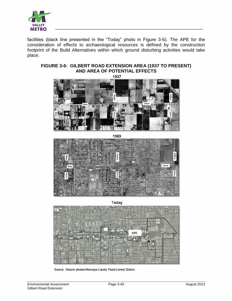
Environmental Assessment Page 3-45 August 2013
Gilbert Road Extension
facilities (black line presented in the “Today” photo in Figure 3-6). The APE for the consideration of effects to archaeological resources is defined by the construction footprint of the Build Alternatives within which ground disturbing activities would take place.
FIGURE 3-6: GILBERT ROAD EXTENSION AREA (1937 TO PRESENT) AND AREA OF POTENTIAL EFFECTS
APE
Environmental Assessment Page 3-46 August 2013
Gilbert Road Extension
Historic Resources. The study of historic resources evaluates resources within the APE built between about 1948 and 1968. As presented in the 1937 photo in Figure 3-6, few buildings had been built in the area adjacent to Main Street by 1937. Most construction did not begin to occur until the 1940s. The year 1968 was selected as the threshold for study because it is 50 years prior to the planned opening of the proposed project. The National Register of Historic Preservation (or NRHP, the nation’s official list of cultural resources worthy of preservation) criteria for Evaluation of Eligibility exclude properties that achieved significance within the last 50 years unless they are of exceptional importance. Fifty years is a general estimate for the time needed to develop historical perspective and to evaluate significance. The eligibility evaluation of historic properties identified in the APE includes:
0 NRHP-listed historic districts, buildings, or structures
0 historic districts recommended eligible for NRHP listing
2 buildings previously recommended eligible for NRHP listing as part of the separate
Central Mesa Extension project
9 buildings recommended eligible for NRHP listing
2 objects (signs) recommended eligible for NRHP listing. The buildings associated
with the 2 signs are not recommended as eligible
For a complete listing of the historic properties within the APE, refer to Appendix F of the EA.
The urban setting of the APE along East Main Street is a predominantly commercial landscape that is flanked by a large number of residential subdivisions. Two trailer parks established in the 1950s and 1960s also occur within the APE. A review of aerial photographs indicates that the APE was transformed from a rural to urban landscape from the 1940s through the 1960s. As such, the bulk of inventoried properties were constructed in the post World War II period, reflecting a midcentury modern character. A large number of modern buildings are also evident within the APE, many of which were constructed in the last three decades, replacing earlier structures that had once occupied the parcels. Within the 2-mile linear boundary of the current APE on Main Street, there is no vestige of the fields of cotton and citrus that once defined the rural character of Mesa. Through the middle decades of the twentieth century (1930–1960), Main Street was a major transportation corridor from which US Highways 60, 70, 80, and 89 entered the Salt River Valley. In the postwar period, auto travel along the paved highways of Arizona increased substantially. Within the APE, commercial businesses were established to serve the travelers, including motels and auto courts, restaurants, and service stations. Simultaneously, postwar residential development occurred on both
Environmental Assessment Page 3-47 August 2013
Gilbert Road Extension
sides of Main Street as Mesa was transformed into a municipality. Intermixed with the commercial tourist businesses on Main Street were large grocery stores that catered to the expanding neighborhoods, as well as strip malls, banks, and fast food restaurants. In this period of urban expansion, Main Street functioned not only as a major regional highway corridor, but also a municipal arterial street. Sidewalks and curbs were constructed for more effective pedestrian use, and medians were constructed in the roadway with centrally located streetlights. Today, Main Street, as it extends east of the original townsite, is a four-lane arterial corridor, and no longer claims shared use with the major US highways that historically passed through the Mesa townsite. In recent years, bus stops have been added along Main Street, along with on-street parking. Archaeological Resources. As mentioned, the project study area is an established urban setting that was first developed for agriculture and later redeveloped for residential and commercial uses. As a result, the natural ground surface has been covered over with buildings, paved streets and sidewalks, landscaping, and the like, which precludes meaningful archaeological survey. Therefore, the assessment relied on a review of existing records for previous projects and sites documented in the area. The review found few surveys mainly because this portion of Mesa was largely built-out prior to compliance surveys being required by state or federal law. As a result, most development projects during that time were performed without any assessment of archaeological resources. Two historic linear sites, a canal and a highway, have been previously documented within the project study area: 1) the Consolidated Canal East Branch and 2) the alignment of old US 80, later to also become part of designated routes US 60, 70, and 89. This alignment is also known as Main Street and Apache Trail through the City of Mesa. By 1992, Main Street and Apache Trail were removed from the national and state highway networks, and Main Street functions today as a major arterial roadway in an urban area and no longer as a state or federal highway. Because the design and function of the highway has been substantially transformed, this segment of old US 80 is, therefore, recommended as not eligible for listing on the NRHP as a noncontributing component of the Historic State Highway System. The Consolidated Canal East Branch has been previously designated as eligible for listing on the NRHP. However, this Canal is located outside the construction footprint and APE for this project, so none of the alternatives would have an effect on this canal. Although the project area was developed for agriculture and then built over with urban sprawl, there remains potential for prehistoric sites and canals to be preserved below the urban layers and plow zones within the APE. These resources are likely to be eligible for the NRHP for their potential to yield important information on a variety of prehistoric and historic period research themes.
Environmental Assessment Page 3-48 August 2013
Gilbert Road Extension
3.10.1 No-Build Alternative
The No-Build Alternative will not have impacts on cultural resources because this alternative only includes improvements to the transportation network that have already been approved and included in the RTP. Alternatively, improvements will be assessed by others, and appropriate avoidance or mitigation treatment, where avoidance cannot be accomplished, will be developed prior to implementation.
3.10.2 Build Alternatives
Since initiation of the conceptual design effort, the design of the Gilbert Road Extension has been carried out with considerable thought given to avoiding historic and archaeological properties within the APE where possible, or to minimize adverse effects where avoidance is not possible. Additional efforts to avoid adverse effects will continue through final design. A comparison of the findings of effect for each alternative is presented in Table 3-15.
3.10.2.1 Build Alternative (4-Lane)
Historic Resources
The proposed project is nearly all within the existing street ROW, with the exception of minimal ROW acquisitions to accommodate the somewhat widened roadway cross section along portions of the alignment to maintain the existing four-lane configuration as well as LRT trackway in the median. Because the existing on-street parking would be removed with this Build Alternative, the cross section width is not substantially larger than under existing conditions.
The widened cross section will require small strips of ROW from the parking areas of four properties eligible for listing in the NRHP. An LRT station would be placed in the middle of the roadway in front of one eligible property and one eligible sign on another property (buildings are not eligible). A TPSS would be placed on a property adjacent to one eligible property. The Build Alternative (4-Lane) also avoids physical and visual impact to the other historic properties within the APE. Therefore:
The Build Alternative (4-Lane) is found overall to have No Adverse Effect on historic properties and districts within the APE, for the undertaking does not alter, either directly or indirectly, any of the characteristics of historic properties that qualify those properties for inclusion in the National Register in a manner that would diminish their integrity.
For additional information on the findings for each listed or eligible property in the APE, refer to Table 5-1 in Appendix F, Inventory and Evaluation of Historic Resources.
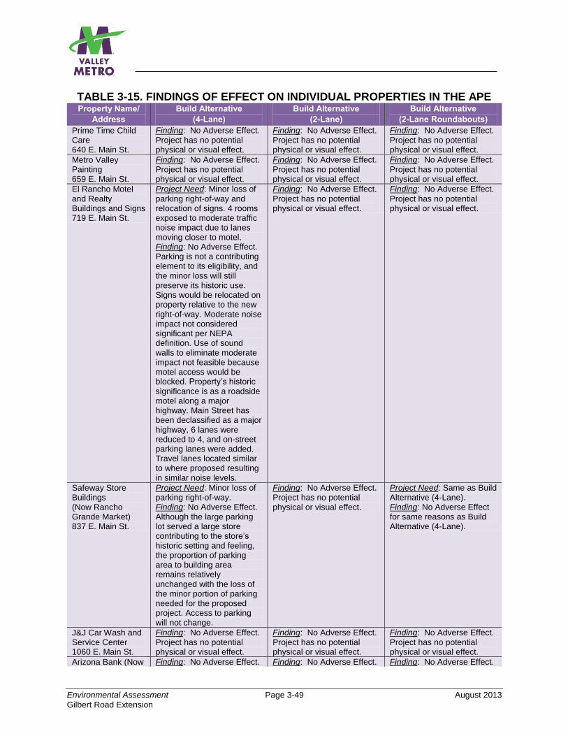
Environmental Assessment Page 3-49 August 2013
Gilbert Road Extension
TABLE 3-15. FINDINGS OF EFFECT ON INDIVIDUAL PROPERTIES IN THE APE Property Name/
Address
Build Alternative
(4-Lane)
Build Alternative
(2-Lane)
Build Alternative
(2-Lane Roundabouts)
Prime Time Child Care 640 E. Main St.
Finding: No Adverse Effect. Project has no potential physical or visual effect.
Finding: No Adverse Effect. Project has no potential physical or visual effect.
Finding: No Adverse Effect. Project has no potential physical or visual effect.
Metro Valley Painting 659 E. Main St.
Finding: No Adverse Effect. Project has no potential physical or visual effect.
Finding: No Adverse Effect. Project has no potential physical or visual effect.
Finding: No Adverse Effect. Project has no potential physical or visual effect.
El Rancho Motel and Realty Buildings and Signs 719 E. Main St.
Project Need: Minor loss of
parking right-of-way and relocation of signs. 4 rooms exposed to moderate traffic noise impact due to lanes moving closer to motel. Finding: No Adverse Effect. Parking is not a contributing element to its eligibility, and the minor loss will still preserve its historic use. Signs would be relocated on property relative to the new right-of-way. Moderate noise impact not considered significant per NEPA definition. Use of sound walls to eliminate moderate impact not feasible because motel access would be blocked. Property’s historic significance is as a roadside motel along a major highway. Main Street has been declassified as a major highway, 6 lanes were reduced to 4, and on-street parking lanes were added. Travel lanes located similar to where proposed resulting in similar noise levels.
Finding: No Adverse Effect.
Project has no potential physical or visual effect.
Finding: No Adverse Effect.
Project has no potential physical or visual effect.
Safeway Store Buildings (Now Rancho Grande Market) 837 E. Main St.
Project Need: Minor loss of parking right-of-way. Finding: No Adverse Effect. Although the large parking lot served a large store contributing to the store’s historic setting and feeling, the proportion of parking area to building area remains relatively unchanged with the loss of the minor portion of parking needed for the proposed project. Access to parking will not change.
Finding: No Adverse Effect. Project has no potential physical or visual effect.
Project Need: Same as Build Alternative (4-Lane). Finding: No Adverse Effect for same reasons as Build Alternative (4-Lane).
J&J Car Wash and Service Center 1060 E. Main St.
Finding: No Adverse Effect. Project has no potential physical or visual effect.
Finding: No Adverse Effect. Project has no potential physical or visual effect.
Finding: No Adverse Effect. Project has no potential physical or visual effect.
Arizona Bank (Now Finding: No Adverse Effect. Finding: No Adverse Effect. Finding: No Adverse Effect.
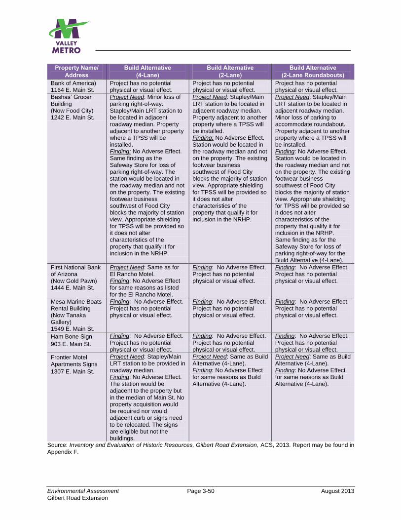
Environmental Assessment Page 3-50 August 2013
Gilbert Road Extension
Property Name/
Address
Build Alternative
(4-Lane)
Build Alternative
(2-Lane)
Build Alternative
(2-Lane Roundabouts)
Bank of America) 1164 E. Main St.
Project has no potential physical or visual effect.
Project has no potential physical or visual effect.
Project has no potential physical or visual effect.
Bashas’ Grocer Building (Now Food City) 1242 E. Main St.
Project Need: Minor loss of
parking right-of-way. Stapley/Main LRT station to be located in adjacent roadway median. Property adjacent to another property where a TPSS will be installed. Finding: No Adverse Effect. Same finding as the Safeway Store for loss of parking right-of-way. The station would be located in the roadway median and not on the property. The existing footwear business southwest of Food City blocks the majority of station view. Appropriate shielding for TPSS will be provided so it does not alter characteristics of the property that qualify it for inclusion in the NRHP.
Project Need: Stapley/Main
LRT station to be located in adjacent roadway median. Property adjacent to another property where a TPSS will be installed. Finding: No Adverse Effect. Station would be located in the roadway median and not on the property. The existing footwear business southwest of Food City blocks the majority of station view. Appropriate shielding for TPSS will be provided so it does not alter characteristics of the property that qualify it for inclusion in the NRHP.
Project Need: Stapley/Main
LRT station to be located in adjacent roadway median. Minor loss of parking to accommodate roundabout. Property adjacent to another property where a TPSS will be installed. Finding: No Adverse Effect. Station would be located in the roadway median and not on the property. The existing footwear business southwest of Food City blocks the majority of station view. Appropriate shielding for TPSS will be provided so it does not alter characteristics of the property that qualify it for inclusion in the NRHP. Same finding as for the Safeway Store for loss of parking right-of-way for the Build Alternative (4-Lane).
First National Bank of Arizona (Now Gold Pawn) 1444 E. Main St.
Project Need: Same as for El Rancho Motel. Finding: No Adverse Effect for same reasons as listed for the El Rancho Motel.
Finding: No Adverse Effect. Project has no potential physical or visual effect.
Finding: No Adverse Effect. Project has no potential physical or visual effect.
Mesa Marine Boats Rental Building (Now Tanaka Gallery) 1549 E. Main St.
Finding: No Adverse Effect. Project has no potential physical or visual effect.
Finding: No Adverse Effect. Project has no potential physical or visual effect.
Finding: No Adverse Effect. Project has no potential physical or visual effect.
Ham Bone Sign
903 E. Main St.
Finding: No Adverse Effect.
Project has no potential physical or visual effect.
Finding: No Adverse Effect.
Project has no potential physical or visual effect.
Finding: No Adverse Effect.
Project has no potential physical or visual effect.
Frontier Motel Apartments Signs
1307 E. Main St.
Project Need: Stapley/Main LRT station to be provided in roadway median. Finding: No Adverse Effect. The station would be adjacent to the property but in the median of Main St. No property acquisition would be required nor would adjacent curb or signs need to be relocated. The signs are eligible but not the buildings.
Project Need: Same as Build Alternative (4-Lane). Finding: No Adverse Effect for same reasons as Build Alternative (4-Lane).
Project Need: Same as Build Alternative (4-Lane). Finding: No Adverse Effect for same reasons as Build Alternative (4-Lane).
Source: Inventory and Evaluation of Historic Resources, Gilbert Road Extension, ACS, 2013. Report may be found in
Appendix F.
Environmental Assessment Page 3-51 August 2013
Gilbert Road Extension
Archaeological Resources
The Build Alternative (4-Lane) is found overall to have No Adverse Effect on archaeological resources within the APE. Although there is potential to encounter unrecorded archaeological deposits and features preserved below the urban layer, the measures developed and listed in Section 3.10.4.3 would result in this alternative having No Adverse Effect because of the required testing and recovery that would be undertaken in the event of encountering unanticipated archaeological resources. 3.10.2.2 Build Alternative (2-Lane) Historic Resources The proposed project is nearly all within the existing street ROW, with the exception of small partial acquisitions of a few properties along the route, and none of them would be on properties eligible for listing. An LRT station would be placed in the middle of the roadway in front of one potentially eligible property and one eligible sign on another property (buildings are not eligible).
A TPSS would be placed on a property adjacent to one potentially eligible property. The Build Alternative (2-lane) also avoids physical and visual impact to the other historic properties within the APE. Therefore:
The Build Alternative (2-Lane) is found overall to have No Adverse Effect on historic properties and districts within the APE for the same reasons listed for the Build Alternative (4-Lane).
Archaeological Resources The Build Alternative (2-Lane) is found overall to have No Adverse Effect on archaeological resources within the APE for the same reasons listed for the Build Alternative (4-Lane). Any Difference if the 2-Lane Roundabouts Option is Implemented?
Each element is discussed below.
Historic Resources: No. The Build Alternative (2-Lane Roundabouts) is also found overall to have No Adverse Effect on historic properties and districts within the APE. Although there are somewhat different project needs for properties within the APE, the overall finding of No Adverse Effect is still the same. The roundabouts at Horne and Lazona Drive will require small strips of ROW from the parking areas of two properties which are eligible for listing in the NRHP. An LRT station would be placed in the middle of the roadway in front of one eligible property and one eligible sign on another property (buildings are not eligible). A TPSS would be placed on a property
Environmental Assessment Page 3-52 August 2013
Gilbert Road Extension
adjacent to one eligible property. This design also avoids physical and visual impact to the other historic properties within the APE.
Archaeological Resources. No. The Build Alternative (2-Lane Roundabouts) is found overall to have No Adverse Effect on archaeological resources within the APE for the same reasons as the design without roundabouts.
3.10.3 Park-and-Ride (North and South Options)
3.10.3.1 Historic Resources No potentially eligible properties are located within the APE in the vicinity of either the Park-and-Ride (North Option) or the Park-and-Ride (South Option). Since there would be no direct or indirect impact on these properties, both options would result in a finding of No Adverse Effect. 3.10.3.2 Archaeological Resources Both the Park-and-Ride (North Option) and the Park-and-Ride (South Option) are found overall to have No Adverse Effect on archaeological resources within the APE. Although there is potential to encounter unrecorded archaeological deposits and features preserved below the urban layer, the measures developed and listed in Section 3.10.4.3 would result in either park-and-ride option having No Adverse Effect because of the required testing and recovery that would be undertaken in the event of encountering unanticipated archaeological resources. 3.10.4 Recommended Treatment 3.10.4.1 What Steps Is the Project Sponsor Taking to Coordinate and Consult
with Parties Interested in Cultural Resources? Section 106 consultation was initiated in November 2012, and the process is continuing. Consulted agencies include the SHPO and CHPO. To date, Valley Metro staff has presented the project once to the City of Mesa Historic Preservation Committee and will attend additional meetings to solicit their input on eligible resources, potential project effects, and recommendations for continuing coordination through the design and construction process. The Salt River Pima-Maricopa Indian Community, the Gila River Indian Community, the Fort McDowell-Yavapai Nation, the Ak-Chin Indian Community, and the Hopi Tribe have also been contacted as potentially interested parties. In addition, the two public meetings held during the course of the EA study have requested community input on cultural resources. The cultural resources reports have been submitted to SHPO for formal concurrence. SHPO concurred with the FTA’s Area of Potential Effect and finding of no adverse effect to historic and archaeological resources.
Environmental Assessment Page 3-53 August 2013
Gilbert Road Extension
3.10.4.2 Treatment for Historic Resources Build Alternative (4-Lane)
To quality as no adverse effect requires relocating the eligible El Rancho Motel signs on property relative to the new ROW.
All Build Alternatives including the Roundabouts Design Option
Provide appropriate shielding for the TPSS on property next to the Bashas’ Grocer Building (now Food City) so that it does not alter characteristics of the property that qualify it for inclusion in the NRHP.
3.10.4.3 Treatment for Archaeological Resources All Build Alternatives including the Roundabouts Design Option
The services of an archaeological monitor will be retained for construction activities within 100 feet of three prehistoric irrigation canal locations that the LRT alignment may likely intersect.
The monitoring plan should include contingencies in the event that archaeological testing or data recovery excavations are needed to mitigate impacts to newly discovered archaeological remains.
A cultural resources awareness training program will be developed and implemented for construction crews to help them identify significant cultural deposits if encountered.
3.11 PARKLANDS AND SECTION 4(f)/6(f) For additional information, refer to Appendix G, Gilbert Road Extension Project, Parklands and Section 4(f)/6(f) Technical Memorandum. Section 4(f) of the U.S. Department of Transportation Act of 1966, as amended, states that FTA “may approve a transportation program or project requiring publicly owned land of a public park or recreation area, or wildlife and waterfowl refuge of national, state, or local significance, or land of a historic site of national, state, or local significance (as determined by the Federal, State, or local officials having jurisdiction over the park, area, or site) only if there is no prudent or feasible alignment to using that land and the program or project includes all possible planning to minimize harm to the park, recreation area, wildlife or waterfowl refuge, or historic site resulting from the use” (49 United States Code [USC] 303). No public parks, recreation areas, or wildlife or waterfowl refuges are located along the route of the Gilbert Road Extension. There are, however, several historic properties located along the alignment as identified in Section 3.10.

Environmental Assessment Page 3-54 August 2013
Gilbert Road Extension
Recent amendments to the Section 4(f) legislation at 23 USC 138 and 49 USC 303, simplify the processing and approval of projects that would result in de minimis impacts (minor impacts) on lands protected by Section 4(f). The requirements of Section 4(f) would be considered satisfied if it is determined that the project would have only a “de minimis impact” on the Section 4(f) resource. The provision allows avoidance, minimization, and mitigation or enhancement measures to be considered in making a de minimis determination. A de minimis impact from a project is defined for historic sites as one where no historic property is affected by the project or the project would have “no adverse effect” on the property in question.
Section 6(f) of the Land and Water Conservation Fund Act (LWCFA), administered by the Interagency Committee for Outdoor Recreation and the Department of the Interior’s National Park Service, pertains to projects that would cause impacts on, or the permanent conversion of, outdoor recreational property acquired with LWCFA assistance. There are no properties along the route of the Gilbert Road Extension that are protected by Section 6(f) and, therefore, the project would have no effect on Section 6(f) properties.
3.11.1 No-Build Alternative Under the No-Build Alternative, the transportation capital improvements that have already been approved and funded would result in no “use” of Section 4(f) resources. For those other capital improvements not yet approved or funded, impacts on Section 4(f) resources may occur should those projects be built. An analysis of the impacts would be conducted as part of the environmental studies prepared for those projects as they are implemented.
3.11.2 Build Alternatives (4-Lane, 2-Lane, 2-Lane Roundabouts Option) As discussed in Section 3.10.2, all of the Build Alternatives (including the Roundabouts Option), would result in an overall finding of no adverse effect to historic and archaeological properties. The Build Alternative (4-lane) results in a de minimis impact to four historic properties within the APE and the roundabouts design option results in a de minimis impact to two historic properties; therefore, the requirements of Section 4(f) are considered to be satisfied. Additional information can be found in Appendix G. Furthermore, none of the alternatives would result in a constructive use which “…occurs when the transportation project does not incorporate land from a Section 4(f) property, but the project’s proximity impacts are so severe that the protected activities, features, or attributes that qualify the property for protection under Section 4(f) are substantially impaired.” In addition, none of the alternatives would result in a temporary use or occupancy of resources protected by Section 4(f). In summary, the project will result in no adverse effects to Section 4(f) resources and requirements of Section 4(f) are considered to be satisfied.
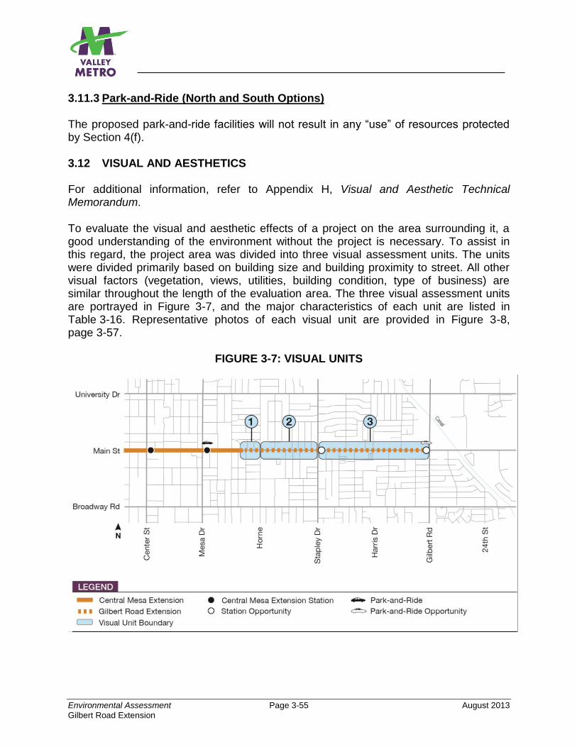
Environmental Assessment Page 3-55 August 2013
Gilbert Road Extension
3.11.3 Park-and-Ride (North and South Options) The proposed park-and-ride facilities will not result in any “use” of resources protected by Section 4(f). 3.12 VISUAL AND AESTHETICS For additional information, refer to Appendix H, Visual and Aesthetic Technical Memorandum. To evaluate the visual and aesthetic effects of a project on the area surrounding it, a good understanding of the environment without the project is necessary. To assist in this regard, the project area was divided into three visual assessment units. The units were divided primarily based on building size and building proximity to street. All other visual factors (vegetation, views, utilities, building condition, type of business) are similar throughout the length of the evaluation area. The three visual assessment units are portrayed in Figure 3-7, and the major characteristics of each unit are listed in Table 3-16. Representative photos of each visual unit are provided in Figure 3-8, page 3-57.
FIGURE 3-7: VISUAL UNITS
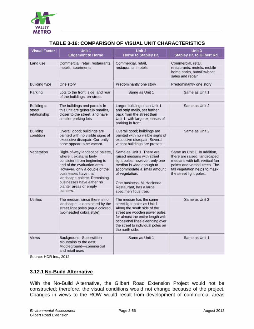
Environmental Assessment Page 3-56 August 2013
Gilbert Road Extension
TABLE 3-16: COMPARISON OF VISUAL UNIT CHARACTERISTICS
Visual Factor Unit 1 Edgemont to Horne
Unit 2 Horne to Stapley Dr.
Unit 3 Stapley Dr. to Gilbert Rd.
Land use Commercial, retail, restaurants, motels, apartments
Commercial, retail, restaurants, motels
Commercial, retail, restaurants, motels, mobile home parks, auto/RV/boat sales and repair
Building type One story Predominantly one story Predominantly one story
Parking Lots to the front, side, and rear of the buildings; on-street
Same as Unit 1 Same as Unit 1
Building to street relationship
The buildings and parcels in this unit are generally smaller, closer to the street, and have smaller parking lots
Larger buildings than Unit 1 and strip malls, set further back from the street than Unit 1, with large expanses of parking in front
Same as Unit 2
Building condition
Overall good; buildings are painted with no visible signs of excessive disrepair. Currently, none appear to be vacant.
Overall good; buildings are painted with no visible signs of excessive disrepair. Several vacant buildings are present.
Same as Unit 2
Vegetation Right-of-way landscape palette, where it exists, is fairly consistent from beginning to end of the evaluation area. However, only a couple of the businesses have this landscape palette. Remaining businesses have either no planter areas or empty planters.
Same as Unit 1. There are raised medians with street light poles; however, only one median is wide enough to accommodate a small amount of vegetation.
One business, Mi Hacienda Restaurant, has a large specimen ficus tree.
Same as Unit 1. In addition, there are raised, landscaped medians with tall, vertical fan palms and vertical trees. The tall vegetation helps to mask the street light poles.
Utilities The median, since there is no landscape, is dominated by the street light poles (aqua colored, two-headed cobra style)
The median has the same street light poles as Unit 1. Along the south side of the street are wooden power poles for almost the entire length with occasional lines extending over the street to individual poles on the north side.
Same as Unit 2
Views Background--Superstition Mountains to the east; Middleground—commercial and retail uses
Same as Unit 1 Same as Unit 1
Source: HDR Inc., 2012.
3.12.1 No-Build Alternative With the No-Build Alternative, the Gilbert Road Extension Project would not be constructed; therefore, the visual conditions would not change because of the project. Changes in views to the ROW would result from development of commercial areas
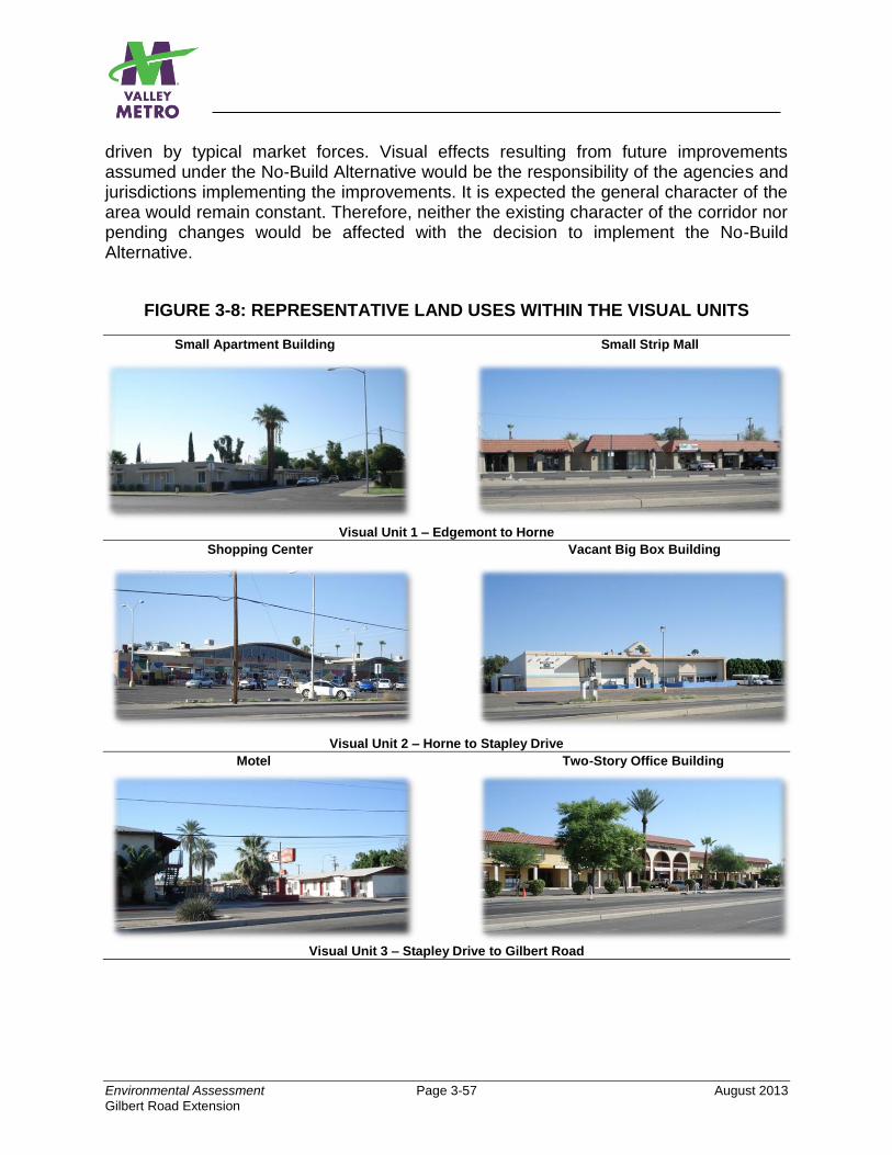
Environmental Assessment Page 3-57 August 2013
Gilbert Road Extension
driven by typical market forces. Visual effects resulting from future improvements assumed under the No-Build Alternative would be the responsibility of the agencies and jurisdictions implementing the improvements. It is expected the general character of the area would remain constant. Therefore, neither the existing character of the corridor nor pending changes would be affected with the decision to implement the No-Build Alternative.
FIGURE 3-8: REPRESENTATIVE LAND USES WITHIN THE VISUAL UNITS
Small Apartment Building Small Strip Mall
Visual Unit 1 – Edgemont to Horne
Shopping Center Vacant Big Box Building
Visual Unit 2 – Horne to Stapley Drive
Motel Two-Story Office Building
Visual Unit 3 – Stapley Drive to Gilbert Road
Environmental Assessment Page 3-58 August 2013
Gilbert Road Extension
3.12.2 Build Alternatives 3.12.2.1 Build Alternative (4-Lane)
Once constructed, this alternative would not substantially alter the general urban visual character. It would result in moderate impact to viewers. The most noticeable change would be the loss, or remodeling of three buildings and one structure (an awning) all located at or near the Stapley Drive/Main Street intersection (Unit 2). In addition, the streetlight poles, overhead wires, and tall palms and other trees in the median of Main Street would be replaced with LRT overhead catenary power poles and wires. However, the LRT poles and wires would not be as tall as the existing streetlight poles and wires. Streetlight poles would be installed on the sides of the street. LRT stations would be built in the median at Stapley Drive and Gilbert Road, and a pocket track would also be added to the median at Gilbert Road.
The station elements would result in the placement of large vertical, partially opaque, elements in what is now essentially a flat, open median. However, these are busy, urban intersections with an existing abundance of visual distraction. In addition, the views east to the Superstitions Mountains would not be obstructed, and the viewers in this area are predominantly motorists passing through or customers making short trips to the businesses, neither group considered to be sensitive viewers. The addition of sensitively designed stations would not cause a significant change to the aesthetics of the area.
New trees and shrubs would be located at the stations and in some locations along the sides of the street. Given that there are already power poles and overhead wires along the south side of the street for most of the route, the impact would be predominantly perceived as a change in visual clutter, rather than substantially more or less clutter. In summary, the Build Alternative (4-Lane) would have no adverse effect on the visual or aesthetic character of the area.
3.12.2.2 Build Alternative (2-Lane)
This Build Alternative would result in the least change to the visual environment because the three buildings and awning near Main Street and Stapley Drive would not be remodeled or demolished. All of the other effects mentioned for the Build Alternative (4-Lane) would be the same for this alternative because the major project elements, such as the overhead catenary, tracks, station platforms, lighting, and pocket track, will be the same. The Build Alternative (2-Lane) would result in no adverse effect on the visual or aesthetic character of the area.
Any Difference if the 2-Lane Roundabouts Option is Implemented?
Yes, but minor. The 2-Lane Roundabouts Option adds roundabouts to five intersections. The roundabouts would reduce or remove poles and other features associated with traffic signals at two intersections where they now exist—Horne/Main
Environmental Assessment Page 3-59 August 2013
Gilbert Road Extension
Street and Lazona Drive/Main Street. While this would help to visually declutter those intersections, the addition of signal poles for the pedestrian crossings at each roundabout would increase the number of poles overall along the street, adding to the visual clutter. At all the roundabout locations there would be space for decorative landscape which would be a visual enhancement. As with the other Build Alternatives, the 2-Lane Roundabouts Option would result in no adverse effect on the visual or aesthetic character of the area.
3.12.3 Park-and-Ride 3.12.3.1 Park-and-Ride (North Option) A park-and-ride facility would not be that dissimilar to the existing shopping center. In the case of surface parking only, the buildings would be removed, creating a noticeable change, but there would still be large expanses of asphalt with parking lot lights. In the event that a park-and-ride structure would be built, the structure would replace the existing bulk of the shopping center buildings, resulting in little change. The heaviest hours of activity would be predominantly during the daytime and evening, similar to the activity of the existing shopping center. The park-and-ride facility would be an improvement over the existing parking lot as they typically include a substantial amount of interior and perimeter landscaping, providing more shade and softening the impact of a parking structure, should that be included. 3.12.3.2 Park-and-Ride (South Option) The park-and-ride option on the southwest corner of Main Street and Gilbert Road would displace three automobile sales businesses and one recreational vehicle/auto sales business. The existing use is visually distracting with cars up against the back of the sidewalk, banners, tall light poles, and virtually no landscape. A surface park-and-ride lot would be similar to what exists but would be an improvement since the design would include interior and perimeter landscape to screen the vehicles. In the event that a park-and-ride structure is built on this site, it would be visually taller and larger than anything in the current condition, creating a more noticeable impact. This would be balanced by new perimeter landscaping and trees to mitigate the building. 3.12.4 Mitigation
Although no mitigation is necessary to reduce the visual and aesthetic impacts of the project to a no adverse effects level, the final design of the project will include incorporating specific aesthetic station, platform, TPSS, overhead catenary poles and wires, and trackway guidelines into the project where possible. The project will conform to the guidance and specifications contained in the Urban Design Guidelines (June 2001) and METRO Central Mesa LRT Extension Urban Design Guidelines (July 2010), as well as Valley Metro’s applicable design criteria for stations, landscape, etc. These documents include methods to enhance and maintain the urban continuity
Environmental Assessment Page 3-60 August 2013
Gilbert Road Extension
and to blend the project’s features into the existing setting. Methods that could be adopted are listed below.
Integrate new facilities with area redevelopment plans.
Minimize the height of facilities to the extent possible to reduce their visibility.
Use plant materials to provide screening for sensitive visual resources and viewers
Use light fixtures that will not cause light spillover into residential areas.
Carefully select TPSS sites, provide screening, and use architecture of a style that is compatible with the surrounding environment.
Provide new landscape to create continuity throughout the project area.
Connect the stations to the surrounding neighborhoods with sidewalks and paths within a ¼-mile radius of each station.
3.13 COMMUNITY DISRUPTION 3.13.1 No-Build Alternative The No-Build Alternative would not result in a disruption of the following characteristics:
Neighborhood or community boundaries will not be split or altered.
Community facility service areas will not be reduced.
Community area access will not be reduced.
Existing circulation patterns will not be disrupted.
Physical or psychological separation or barriers in the community will not be created. The quality of life, however, would be reduced by increased transit travel time and reduced mobility. In summary, the No-Build Alternative would have no adverse effect with regard to disruption of the community. 3.13.2 Build Alternatives (4-Lane, 2-Lane, 2-Lane Roundabouts Option) Similar to the No-Build Alternative, the operation of the Build Alternatives, including the roundabouts design option, would not disrupt the same characteristics listed above. The quality of life, however, would be increased by providing the community with a one-seat transit ride to employment centers and other popular regional destinations. Introduction of LRT to Gilbert Road, in coordination with local land use planning, can support the community’s goals for promoting concentrated urban development and revitalizing the east side of downtown Mesa. In summary, the Build Alternatives, including the roundabouts design option, would have no adverse effect with regard to disruption of the community and would result in positive effects through enhanced community access. Temporary disruptions may occur during construction. Impacts during construction are discussed in Section 3.20.
Environmental Assessment Page 3-61 August 2013
Gilbert Road Extension
3.13.3 Park-and-Ride (North and South Options) Similar to the No-Build and Build Alternatives, operation of the Park-and-Ride (North and South Options) would not disrupt the same characteristics listed in Section 3.13.1. The quality of life would be increased by providing riders who park here with a one-seat transit ride to employment centers and other popular regional destinations without having to drive all the way to those centers or to drive the additional distance to the next nearest park-and-ride serving LRT. Temporary disruptions may occur during construction. Impacts during construction are discussed in Section 3.20. 3.13.4 Mitigation No mitigation is necessary. 3.14 ENVIRONMENTAL JUSTICE For additional information, refer to Appendix I, Gilbert Road Extension Project, Environmental Justice Technical Memorandum. To assist the reader in an understanding of the principles of environmental justice, this section begins by summarizing the regulatory framework and approach to evaluating effects of the project on environmental justice populations. More detailed information may be found in the appendix cited above. Regulatory Framework:. Executive Order (EO) 12898, Federal Actions to Address Environmental Justice (EJ) in Minority Populations and Low-Income Populations, requires that federal agencies consider and address disproportionately high and adverse environmental effects of proposed federal projects on the health and environment of minority and low-income populations to the greatest extent practicable by law. Following the direction of EO 12898, Federal agencies developed their own guidelines for implementing EJ. In May 2012, the United States Department of Transportation (USDOT) issued Order 5610.2(a) which defines the fundamental principles of EJ. In August 2012, FTA issued Circular 4703.1, Environmental Justice Policy Guidance for Federal Transit Administration Recipients. The guiding EJ principles followed by USDOT and FTA are summarized as follows:
Avoid, minimize, or mitigate disproportionately high and adverse human health or environmental effects, including social and economic effects, on minority and low-income populations;
Ensure the full and fair participation by all potentially affected communities in the transportation decision-making process; and
Prevent the denial of, reduction in or significant delay in the receipt of benefits by minority and low-income populations.
USDOT Order 5610.2(a) requires the following:
Environmental Assessment Page 3-62 August 2013
Gilbert Road Extension
Identifying and evaluating environmental, public health, and interrelated social and economic effects of USDOT programs, policies, and activities,
Proposing measures to avoid, minimize and/or mitigate disproportionately high and adverse environmental and public health effects and interrelated social and economic effects, and providing offsetting benefits and opportunities to enhance communities, neighborhoods, and individuals affected by USDOT programs, policies, and activities, where permitted by law and consistent with EO 12898,
Considering alternatives to proposed programs, policies, and activities, where such alternatives would result in avoiding and/or minimizing disproportionately high and adverse human health or environmental impacts, consistent with EO 12898, and
Eliciting public involvement opportunities and considering the results thereof, including soliciting input from affected minority and low-income populations in considering alternatives.
Evaluation Methodology. The FTA Circular 4703.1 guidance defines a ‘minority person’ as any individual who is a member of any of the following populations groups: American Indian, Alaska Native, Asian, Pacific Islander, Black, or Hispanic. Low-income is defined as a person whose household income is at or below the U.S. Census Bureau’s annual statistical poverty threshold, which is based on the U.S. Department of Health and Human Services poverty guidelines. The methodology for analyzing the effects of the proposed project on EJ populations (any identifiable population group meeting the requirements for minority or low-income) consists of the following steps:
Define the unit of geographic analysis impacted by the proposed project. The boundaries of the geographic unit should be large enough to include the area likely to experience adverse effects, but not so large as to artificially dilute the minority and/or low-income population;
Gather the relevant demographic data from a reliable source such as U.S. Census data or American Community Survey (ACS) data at the census tract or block group (BG) level;
Analyze the severity of impacts associated with the project alternatives;
Identify the mitigation to avoid or minimize the impacts;
Identify the project benefits; and
Determine disproportionately high adverse impacts (if any). Information to evaluate minority populations within the project corridor is based on the 2010 U.S. Decennial Census data for minority populations. The low-income populations are based on the 2011 ACS data. Those populations identified as having an income at or below 150 percent of the income that the U.S. Department of Health and Human Services defines as poverty levels are considered low-income.
Maricopa County has been selected as the unit of geographic analysis for comparison to the study area level. The study area level identified for this analysis is approximately
Environmental Assessment Page 3-63 August 2013
Gilbert Road Extension
½ mile around the project alignment and other facilities associated with the Gilbert Road Extension project and coincides with the boundaries of the census BG. Fourteen BGs make up the study area. Four BGs are immediately west of the western end of the light rail transit (LRT) alignment and two BGs are immediately east of the eastern end of the alignment and are within the ½-mile buffer of the project alignment (See Figures 3-9 and 3-10). As shown in the figures, EJ populations reside throughout the area of interest. Determination of Disproportionately High and Adverse Environmental Effects. USDOT Order 5610.2(a) defines a disproportionately high and adverse effect on minority and low-income populations as an adverse effect that:
Is predominantly borne by a minority populations and/or a low-income population, or
Will be suffered by the minority population and/or low-income population and is appreciably more severe or greater in magnitude than the adverse effect that will be suffered by the non-minority population and/or non-low-income population.
The identification of whether a project will have disproportionately high and adverse environmental effects on minority and low-income populations depends on a number of factors including: 1) identifying and evaluating environmental, public health, and interrelated social and economic effects, 2) proposing measures to avoid, minimize and/or mitigate the effects and provide offsetting benefits and opportunities to enhance communities, neighborhoods, and individuals impacted, 3) the alternatives considered, and 4) the public involvement process itself. Potential adverse effects, as identified in this EA, were examined in these critical areas because they are the ones with the most potential to result in adverse effects: 1) displacements and relocations; 2) transportation; 3) noise and vibration; 4) community facilities/parklands; and 5) construction impacts.
3.14.1 Identification of Potential Adverse Effects and Measures to Avoid,
Minimize, and/or Mitigate
3.14.1.1 Displacements and Relocations
The displacements and relocations that may be required as a result of this project are all commercial properties. No residential properties will be acquired resulting in impacts or relocations. Therefore, there are no environmental justice impacts. 3.14.1.2 Transportation
The potential effects of the alternatives on traffic, on-street parking, and other transit services are summarized in this discussion. For additional information, refer to Section 3.6 of this EA and Appendix I.
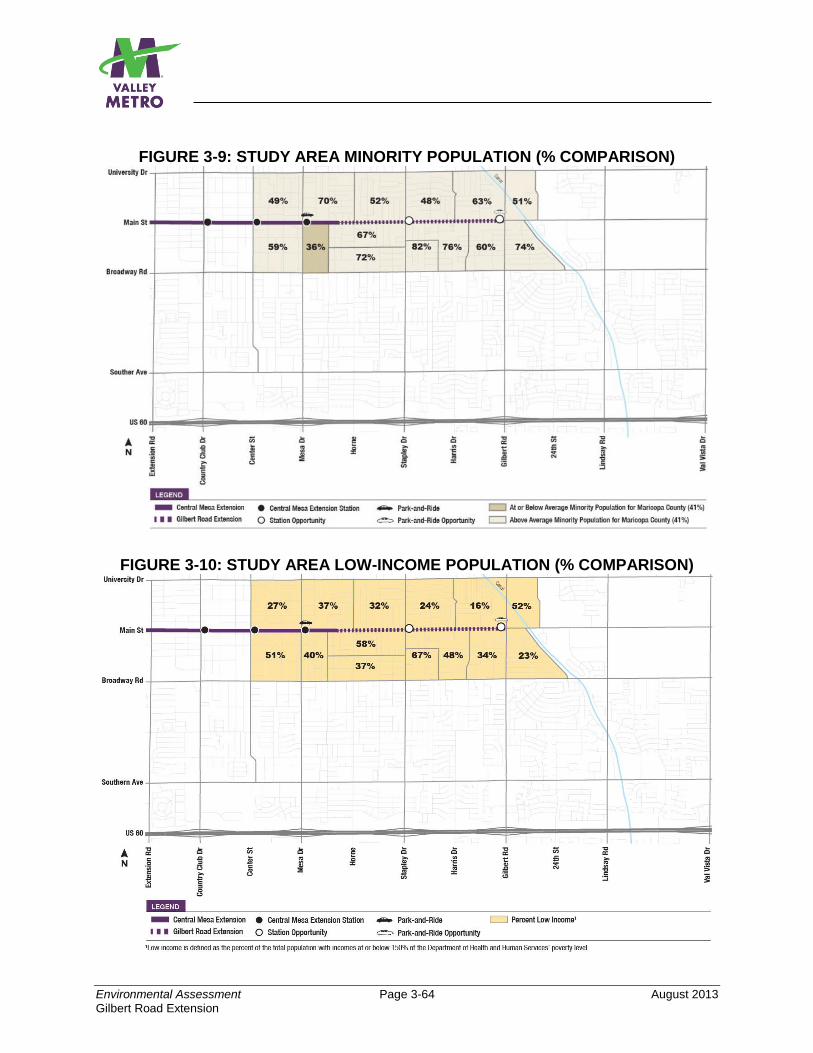
Environmental Assessment Page 3-64 August 2013
Gilbert Road Extension
FIGURE 3-9: STUDY AREA MINORITY POPULATION (% COMPARISON)
FIGURE 3-10: STUDY AREA LOW-INCOME POPULATION (% COMPARISON)
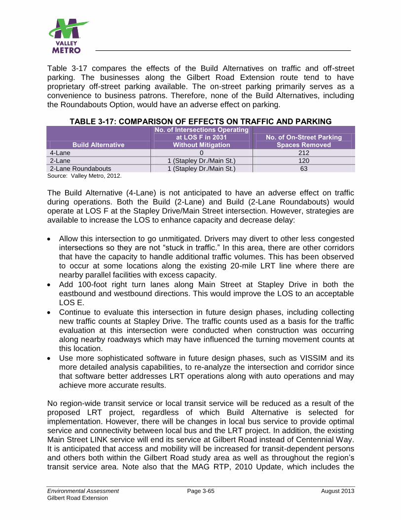
Environmental Assessment Page 3-65 August 2013
Gilbert Road Extension
Table 3-17 compares the effects of the Build Alternatives on traffic and off-street parking. The businesses along the Gilbert Road Extension route tend to have proprietary off-street parking available. The on-street parking primarily serves as a convenience to business patrons. Therefore, none of the Build Alternatives, including the Roundabouts Option, would have an adverse effect on parking.
TABLE 3-17: COMPARISON OF EFFECTS ON TRAFFIC AND PARKING
Build Alternative
No. of Intersections Operating at LOS F in 2031
Without Mitigation No. of On-Street Parking
Spaces Removed
4-Lane 0 212
2-Lane 1 (Stapley Dr./Main St.) 120
2-Lane Roundabouts 1 (Stapley Dr./Main St.) 63 Source: Valley Metro, 2012.
The Build Alternative (4-Lane) is not anticipated to have an adverse effect on traffic during operations. Both the Build (2-Lane) and Build (2-Lane Roundabouts) would operate at LOS F at the Stapley Drive/Main Street intersection. However, strategies are available to increase the LOS to enhance capacity and decrease delay:
Allow this intersection to go unmitigated. Drivers may divert to other less congested intersections so they are not “stuck in traffic.” In this area, there are other corridors that have the capacity to handle additional traffic volumes. This has been observed to occur at some locations along the existing 20-mile LRT line where there are nearby parallel facilities with excess capacity.
Add 100-foot right turn lanes along Main Street at Stapley Drive in both the eastbound and westbound directions. This would improve the LOS to an acceptable LOS E.
Continue to evaluate this intersection in future design phases, including collecting new traffic counts at Stapley Drive. The traffic counts used as a basis for the traffic evaluation at this intersection were conducted when construction was occurring along nearby roadways which may have influenced the turning movement counts at this location.
Use more sophisticated software in future design phases, such as VISSIM and its more detailed analysis capabilities, to re-analyze the intersection and corridor since that software better addresses LRT operations along with auto operations and may achieve more accurate results.
No region-wide transit service or local transit service will be reduced as a result of the proposed LRT project, regardless of which Build Alternative is selected for implementation. However, there will be changes in local bus service to provide optimal service and connectivity between local bus and the LRT project. In addition, the existing Main Street LINK service will end its service at Gilbert Road instead of Centennial Way. It is anticipated that access and mobility will be increased for transit-dependent persons and others both within the Gilbert Road study area as well as throughout the region’s transit service area. Note also that the MAG RTP, 2010 Update, which includes the
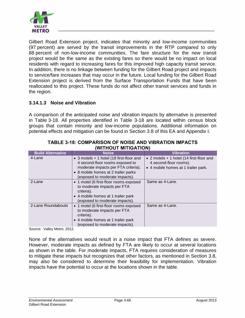
Environmental Assessment Page 3-66 August 2013
Gilbert Road Extension
Gilbert Road Extension project, indicates that minority and low-income communities (97 percent) are served by the transit improvements in the RTP compared to only 88 percent of non-low-income communities. The fare structure for the new transit project would be the same as the existing fares so there would be no impact on local residents with regard to increasing fares for this improved high capacity transit service. In addition, there is no linkage between funding for the Gilbert Road project and impacts to service/fare increases that may occur in the future. Local funding for the Gilbert Road Extension project is derived from the Surface Transportation Funds that have been reallocated to this project. These funds do not affect other transit services and funds in the region. 3.14.1.3 Noise and Vibration
A comparison of the anticipated noise and vibration impacts by alternative is presented in Table 3-18. All properties identified in Table 3-18 are located within census block groups that contain minority and low-income populations. Additional information on potential effects and mitigation can be found in Section 3.8 of this EA and Appendix I.
TABLE 3-18: COMPARISON OF NOISE AND VIBRATION IMPACTS (WITHOUT MITIGATION)
Build Alternative Noise Vibration
4-Lane 3 motels + 1 hotel (18 first-floor and 4 second-floor rooms exposed to moderate impacts per FTA criteria).
8 mobile homes at 2 trailer parks (exposed to moderate impacts).
2 motels + 1 hotel (14 first-floor and 4 second-floor rooms).
4 mobile homes at 1 trailer park.
2-Lane 1 motel (6 first-floor rooms exposed to moderate impacts per FTA criteria).
4 mobile homes at 1 trailer park (exposed to moderate impacts).
Same as 4-Lane.
2-Lane Roundabouts 1 motel (6 first-floor rooms exposed to moderate impacts per FTA criteria).
4 mobile homes at 1 trailer park (exposed to moderate impacts).
Same as 4-Lane.
Source: Valley Metro, 2012.
None of the alternatives would result in a noise impact that FTA defines as severe. However, moderate impacts as defined by FTA are likely to occur at several locations as shown in the table. For moderate impacts, FTA requires consideration of measures to mitigate these impacts but recognizes that other factors, as mentioned in Section 3.8, may also be considered to determine their feasibility for implementation. Vibration impacts have the potential to occur at the locations shown in the table.

Environmental Assessment Page 3-67 August 2013
Gilbert Road Extension
For the Build Alternative (4-Lane), the noise impact at the hotel is within 0.1 dB of the moderate noise impact threshold. Installing a special frog, as discussed earlier in Section 3.8.4 for mitigation of vibration impacts, would also eliminate the noise impact.
For the three motels affected by noise from the Build Alternative (4-Lane) and the one motel affected by the Build Alternative (2-Lane and 2-Lane Roundabouts), use of sound walls as mitigation is not feasible because, to be effective, the sound walls must be continuous with no breaks for driveways, etc., in the noise-affected area. Because the sound walls would block access to the motels, no mitigation is recommended for the moderate impacts at these motels. For the eight mobile homes closest (within 140 feet) to the Build Alternative (4-Lane) and the four mobile homes closest to the Build Alternative (2-Lane and 2-Lane Roundabouts), moving the mobile homes further from the proposed project or moving them to another trailer park in the general area that is equivalent to the existing trailer park would eliminate the predicted moderate noise impacts. Several other mobile home and trailer parks exist along the Main Street corridor, so if relocating within the existing trailer park is not possible, then relocation to another park could be a feasible option. With regard to vibration, several rooms at two motels, one hotel, and four mobile homes at a trailer park would likely be exposed to vibration impacts, no matter which Build Alternative is selected for implementation. For the motels and mobile homes, a resilient layer could be placed under the embedded track slab such as Tire-Derived Aggregate (shredded tires) or continuous elastomeric mats, or QTrack could be installed in the vicinity of each property. Another option to eliminate the vibration impact at the trailer park would be to relocate the four mobile homes at least 60 feet from the near track. For the hotel, the vibration impact could be eliminated by installing a well-designed flange-bearing frog at the special trackwork that would be located within 40 feet of the hotel. 3.14.1.4 Community Facilities/Parklands
The project would have no adverse impact on community facilities, including parklands. As discussed in Section 3.13, the project would not result in long-term community disruption. Potential impacts on the community during construction are discussed below. 3.14.1.5 Construction
The major impacts during construction would be in the areas of air quality, noise, and traffic. Specific impacts and standard construction practices are discussed in Section 3.20 of this EA. The adverse impacts would be temporary and last the period of construction for the entire length of the project. Although the proposed standard construction practices listed in Section 3.20 of the EA would lessen the severity of the impacts, some adverse impacts would still exist during the construction period.
Environmental Assessment Page 3-68 August 2013
Gilbert Road Extension
3.14.1.6 Benefits
Extension of the LRT system to Gilbert Road would provide residents of central and east Mesa (and residents of the East Valley) with a one-seat transit ride to employment centers and other popular regional destinations. Current analysis of regional travel demand patterns indicates that the majority of trips originating from central and east Mesa are destined for the regional employment centers of downtown Tempe, Arizona State University, Sky Harbor International Airport, and downtown Phoenix. Additionally, several other regional activity centers are clustered around the existing LRT starter line, including the Phoenix Convention Center, Phoenix Art Museum, Chase Field, and the US Airways Center.
The city’s new Central Main Street Plan provides policy guidance for future investments and the design of Main Street between Sycamore and Gilbert Road. East of Mesa Drive, Gilbert Road is the busiest north-south arterial road in the city. Coupled with the city’s form-based code ordinance, local land use and zoning policies have been adopted to encourage transit-supportive developments and facilities surrounding LRT. Significant opportunities for economic development are possible within the project study area. Introduction of LRT to Gilbert Road, in coordination with local land use planning, can support the community’s goals for promoting concentrated urban development and revitalizing the east side of downtown Mesa. 3.14.1.7 Public Engagement
The public involvement program has been designed and executed to reach the affected population, including the Environmental Justice populations who reside throughout the study area. Refer to Chapter 4 of the EA and Appendix I for additional information on community outreach. 3.14.1.8 Determination of Whether EJ Populations Would Be Subjected to
Disproportionately High and Adverse Effects Minority and low-income residents are present throughout the ½-mile area around the proposed project. The adverse effects caused by property acquisition for all three Build Alternatives, impacts on traffic for the 2-Lane Alternative with or without roundabouts, and noise and vibration impacts as a result of all Build Alternatives, including the roundabouts design option, would be minimized through the mitigation measures identified above. Temporary adverse impacts caused by construction activities to residents and businesses along the light rail route would also be minimized through use of the standard construction practices identified later in Table 3-25 of the EA and also through the programs listed below. For the LRT Starter Line and Central Mesa LRT Extension Project, Valley Metro implemented programs to help minimize the impacts of construction including:
Environmental Assessment Page 3-69 August 2013
Gilbert Road Extension
Business outreach: Valley Metro and its member cities, including Mesa, offered a variety of business outreach programs that included:
Low interest loan programs in partnership with financial institutions.
A-frame signs or banners to let customers know businesses are open.
METRO Max discount card program. Businesses listings are free on the Valley Metro web site.
Postcard marketing program for businesses to advertise to customers.
Maps to inform customers of the best routes to reach businesses Community Advisory Board Program: Composed of citizens, property owners, and business owners directly impacted by LRT construction. The group met monthly to evaluate construction contractors with regard to: 1) traffic management; 2) contractor response; 3) property restoration; and 4) public outreach. Construction Outreach Support: During construction, a Valley Metro public involvement coordinator was on-call 24 hours a day, seven days a week. The coordinator provided day-to-day contact with businesses and residents, answered construction questions, and helped to solve construction-related problems.
Valley Metro intends to continue similar programs for construction of the Gilbert Road Extension project.
As stated above, the adverse effects on traffic, as well as adverse impacts due to property acquisition and noise and vibration, would be mitigated to minimize the adverse effects. As noted in Section 3.21 of the EA, the project is not anticipated to result in adverse cumulative impacts and may contribute to beneficial impacts in a cumulative sense. The benefits would apply equally to all populations in the vicinity of the light rail project.
The adverse impacts and temporary construction impacts from the proposed project would be equally shared (placement of track, LRT stations, ROW requirements, and construction activities) by all populations within the study area. The standard construction practices that would be applied to minimize impacts would also be applied throughout the project and not concentrated in any particular area. The adverse impacts from construction activities would be temporary and end when construction is complete and would be minimized through use of the standard construction practices identified later in Table 3-25 of the EA, and also through the programs listed above. Valley Metro will work with the contractor, residents, and property and business owners most affected before construction begins to create a construction plan and schedule that best addresses concerns of nearby businesses and residents.
In view of the considerable project benefits and local support for implementing a high capacity transit alternative on Main Street in Mesa, the temporary adverse impacts from construction on the low-income and minority populations would not be disproportionate to the improved consistency and reliability of transit service, increased mobility, regional connectivity, and economic gains that the proposed project would offer.
Environmental Assessment Page 3-70 August 2013
Gilbert Road Extension
3.15 HAZARDOUS MATERIALS For additional information on hazardous materials impacts, refer to Appendix J, Preliminary Initial Site Assessment. A Preliminary Initial Site Assessment (PISA) was conducted for the Build Alternatives. The purpose of the PISA is to determine whether sufficient risk exists from sites located near the project area to warrant further investigation under a subsequent, more detailed Phase I Environmental Site Assessment (ESA). The project area is located in an urban area of mixed use development, including retail and commercial properties, auto repair facilities, automobile and RV sales lots, restaurants, unoccupied buildings, hotels, medical plazas, vacant lots, and former service/gas stations. A data base search identified 31 sites considered to be of concern to the Build Alternatives. The sites include former service stations, drycleaners, and areas of known contamination as defined by the EPA. The sites are located throughout the entire length of the Gilbert Road Extension project. Figure 3-11, page 3-74, displays locations of the sites rated high, indeterminate, and moderate risk. Tables 3-19, 3-20, and 3-21 list these sites by type of risk. High-risk sites are those that have a high potential for releasing hazardous materials to the soil or groundwater, or have a recorded release issue. Examples of high-risk sites include current service stations, violation sites listed in the environmental database, or a known release. An example would be the site of a train derailment with associated hazardous materials release. Indeterminate-risk sites are those which, at the time of report preparation, did not include sufficient information to include a high, moderate or low ranking. Indeterminate sites often require additional file review to determine the details of any related environmental issues at the site. A site may also be considered a moderate-risk if an underground storage tank (UST) is (or was) located onsite. Subsurface contamination can often be present near tanks not otherwise classified as a leaking underground storage tank (LUST). Six sites were classified as moderate-risk. All six were considered to be moderate-risk because the tanks have been removed from the sites, and the sites lack any associated LUST listing.
A review of the Arizona Department of Water Resources mapping indicates that groundwater in the vicinity of the project area ranges between 140 and 150 feet below the ground surface. Soil borings conducted west of the project did not encounter groundwater to the explored depth of 20 feet. Excavation activities associated with the proposed project are anticipated to average about four to five feet in depth. Note also that new underground sewer and water lines were recently installed in 2012 along Main Street along the length of the proposed LRT alignment. The City of Mesa will conduct a Phase 1 ESA for any property or ROW that will be acquired for the project during design. The additional investigative steps of a Phase I
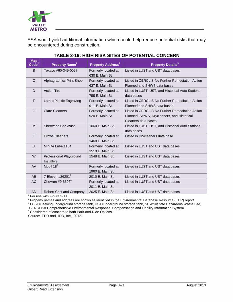
Environmental Assessment Page 3-71 August 2013
Gilbert Road Extension
ESA would yield additional information which could help reduce potential risks that may be encountered during construction.
TABLE 3-19: HIGH RISK SITES OF POTENTIAL CONCERN Map
Code1
Property Name2
Property Address2
Property Details3
B Texaco #60-349-0097 Formerly located at
630 E. Main St.
Listed in LUST and UST data bases
C Alphagraphics Print Shop Formerly located at
637 E. Main St.
Listed in CERCLIS-No Further Remediation Action
Planned and SHWS data bases
D Action Tire Formerly located at
755 E. Main St.
Listed in LUST, UST, and Historical Auto Stations
data bases
F Lamro Plastic Engraving Formerly located at
911 E. Main St.
Listed in CERCLIS-No Further Remediation Action
Planned and SHWS data bases
G Clare Cleaners Formerly located at
920 E. Main St.
Listed in CERCLIS-No Further Remediation Action
Planned, SHWS, Drycleaners, and Historical
Cleaners data bases
M Sherwood Car Wash 1060 E. Main St. Listed in LUST, UST, and Historical Auto Stations
data bases
T Crows Cleaners Formerly located at
1460 E. Main St.
Listed in Drycleaners data base
U Minute Lube 1134 Formerly located at
1519 E. Main St.
Listed in LUST and UST data bases
W Professional Playground
Installers
1548 E. Main St. Listed in LUST and UST data bases
AA Mobil 184 Formerly located at
1960 E. Main St.
Listed in LUST and UST data bases
AB 7-Eleven #262014 2010 E. Main St. Listed in LUST and UST data bases
AC Chevron #9-86984 Formerly located at
2011 E. Main St.
Listed in LUST and UST data bases
AD Robert Crist and Company 2025 E. Main St. Listed in LUST and UST data bases 1
For use with Figure 3-11. 2
Property names and address are shown as identified in the Environmental Database Resource (EDR) report. 3
LUST= leaking underground storage tank, UST=underground storage tank, SHWS=State Hazardous Waste Site, CERCLIS= Comprehensive Environmental Response, Compensation and Liability Information System.
4 Considered of concern to both Park-and-Ride Options.
Source: EDR and HDR, Inc., 2012.
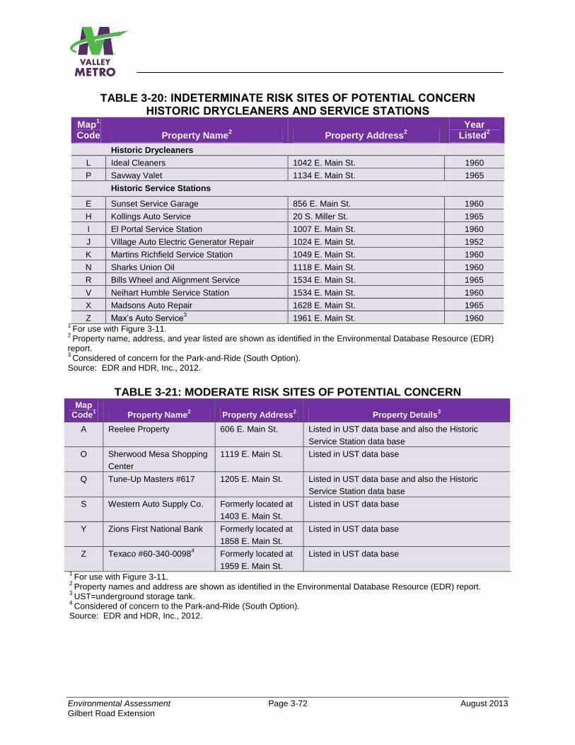
Environmental Assessment Page 3-72 August 2013
Gilbert Road Extension
TABLE 3-20: INDETERMINATE RISK SITES OF POTENTIAL CONCERN HISTORIC DRYCLEANERS AND SERVICE STATIONS
Map1
Code Property Name2
Property Address2
Year Listed
2
Historic Drycleaners
L Ideal Cleaners 1042 E. Main St. 1960
P Savway Valet 1134 E. Main St. 1965
Historic Service Stations
E Sunset Service Garage 856 E. Main St. 1960
H Kollings Auto Service 20 S. Miller St. 1965
I El Portal Service Station 1007 E. Main St. 1960
J Village Auto Electric Generator Repair 1024 E. Main St. 1952
K Martins Richfield Service Station 1049 E. Main St. 1960
N Sharks Union Oil 1118 E. Main St. 1960
R Bills Wheel and Alignment Service 1534 E. Main St. 1965
V Neihart Humble Service Station 1534 E. Main St. 1960
X Madsons Auto Repair 1628 E. Main St. 1965
Z Max’s Auto Service3 1961 E. Main St. 1960
1 For use with Figure 3-11.
2 Property name, address, and year listed are shown as identified in the Environmental Database Resource (EDR)
report. 3
Considered of concern for the Park-and-Ride (South Option). Source: EDR and HDR, Inc., 2012.
TABLE 3-21: MODERATE RISK SITES OF POTENTIAL CONCERN
Map Code
1 Property Name
2 Property Address
2 Property Details
3
A Reelee Property 606 E. Main St. Listed in UST data base and also the Historic
Service Station data base
O Sherwood Mesa Shopping
Center
1119 E. Main St. Listed in UST data base
Q Tune-Up Masters #617 1205 E. Main St. Listed in UST data base and also the Historic
Service Station data base
S Western Auto Supply Co. Formerly located at
1403 E. Main St.
Listed in UST data base
Y Zions First National Bank Formerly located at
1858 E. Main St.
Listed in UST data base
Z Texaco #60-340-00984 Formerly located at
1959 E. Main St.
Listed in UST data base
1 For use with Figure 3-11.
2 Property names and address are shown as identified in the Environmental Database Resource (EDR) report.
3 UST=underground storage tank.
4 Considered of concern to the Park-and-Ride (South Option).
Source: EDR and HDR, Inc., 2012.

Environmental Assessment Page 3-73 August 2013
Gilbert Road Extension
FIGURE 3-11: POTENTIAL SITES OF CONCERN
Source: HDR, Inc. and EDR, 2012
3.15.1.1 No-Build Alternative
No adverse impacts are anticipated as a result of the No-Build Alternative because this alternative only includes improvements to the transportation network that have already been approved and included in the RTP, or improvements will be assessed by others, and appropriate measures would be included in those projects to avoid adverse impacts. 3.15.1.2 Build Alternatives (4-Lane, 2-Lane, and 2-Lane Roundabouts Option)
Both Build Alternatives, as well as the Roundabouts Option, have similar potential for encountering contamination during construction.
3.15.1.3 Park-and-Ride (North and South Options)
The potential to encounter contamination during construction is similar for both the North and South Options. As footnoted in Tables 3-19, 3-20 and 3-21, three sites are of potential concern for the North Option, and two additional sites, or a total of five, are of potential concern for the South Option.
3.15.1.4 Mitigation
Although the amount of subsurface disturbance for the project is expected to be low to moderate, the following strategy is recommended to minimize potential for encountering hazardous materials during construction and operation:
Environmental Assessment Page 3-74 August 2013
Gilbert Road Extension
In the event that potentially hazardous materials are encountered, an odor is identified, or significantly stained soil is visible, all construction contractors would be instructed to immediately stop all subsurface activities in the potentially affected area. Contractors would be required to conform with METRO’s Master Specifications 01.35.30, Unknown Hazardous and Contaminated Substances, which, in addition to stopping construction, requires specific procedures be followed in such an event.
3.16 SAFETY AND SECURITY 3.16.1 No-Build Alternative
The No-Build Alternative is not expected to have an adverse impact on safety and security since adequate safety and security measures have already been established for the transit services included in this alternative. 3.16.2 Build Alternatives (4-Lane, 2-Lane, 2-Lane Roundabouts Option)
Neither Build Alternative, nor the roundabouts design option, would have an adverse effect on safety and security. The proposed project is located within the existing public street ROW and will operate in a fixed guideway separated from vehicular traffic by a barrier. Security personnel would patrol the stations and trains and conduct fare inspections. Security services would be provided through an existing contract between Valley Metro and a private security service for light rail service in the valley. Light rail operators and security personnel would be trained to spot potentially suspicious activities and take appropriate action. The City of Mesa Police and Fire Departments would respond to criminal incidents, collisions, and fire and rescue emergencies. The project’s stations would be designed to provide good visibility to the public and would follow Crime Prevention Through Environmental Design (CPTED) guidelines. The light rail vehicles include passenger emergency reporting devices that allow passengers to communicate with the operator. The interior and exterior of the light rail vehicles are equipped with closed-circuit television. The operator would have the ability to report problems directly to the Operations Control Center. The vehicles contain bells, horns, and flashing headlights to provide both audible and visible warnings to alert drivers and pedestrians of an approaching train when needed. The vehicles are designed with energy-absorbing bumpers to lessen potential impacts in the event of a collision and would have low ground clearance to reduce the likelihood of a pedestrian sliding underneath the train in the event that the train strikes a pedestrian. Measures would be taken similar to what is being done for the LRT starter line to discourage pedestrians from illegally crossing the tracks and to enhance safety at
Environmental Assessment Page 3-75 August 2013
Gilbert Road Extension
permitted crossing locations. Additional measures may be taken at some stop locations, if warranted. The following four Valley Metro documents, which address safety and security for the light rail system, will be updated as needed to include safety and security activities for the Gilbert Road Extension:
System Security Program Plan
System Safety Program Plan
Emergency Management Plan
Accident/Investigation Plan Within the study area are three schools: Lowell Elementary, Longfellow Elementary, and Christ the King. The student attendance zones3 for both public elementary schools have Main Street as a northern boundary so students would not need to cross Main Street and the LRT tracks in their trip between home and school. Christ the King School does not have attendance boundaries so it is possible that some students may need to cross the street and tracks to go to school. Both Kino and Poston Junior High Schools are located north and outside of the study area; however, portions of each school’s attendance boundaries are on both sides of Main Street. So while there is potential that some junior high students may need to cross Main Street and the tracks to go to school, the probability is low because of the longer distance between home and school. These students are more likely to ride the bus or be driven to school. To minimize the accident potential for children crossing Main Street and the LRT tracks, Valley Metro will conduct a safety education program to target elementary and junior high school students. The program would be similar to that carried out prior to operation of the current 20-mile LRT line. That program included distribution to the schools of age-appropriate safety-related materials such as coloring books, word hunts, crossword puzzles, maze worksheets, bookmarks, and build-your-own-train with safety messages. In addition, Valley Metro maintains a website4 which allows anyone accessing the site to download most of the materials and includes a link for school teachers or administrators to request Valley Metro staff to provide a presentation to their classrooms.
With implementation of these measures, the proposed project is not anticipated to result in adverse impacts on safety and security. 3.16.3 Park-and-Ride (North and South Options) Neither park-and-ride option would have an adverse effect on safety and security. The same security personnel and services and City of Mesa Police and Fire Department
3 Student attendance zones as provided at http://www.mpsaz.org/schools/locator accessed on November 7, 2012.
4 Valley Metro Kids’ Safety Spot website http://www.valleymetro.org/safety/kids_safety_spot
Environmental Assessment Page 3-76 August 2013
Gilbert Road Extension
emergency response would be provided for the park-and-ride facility as discussed for the other project elements above for the Build Alternatives. Like the LRT stations, the park-and-ride would be designed to provide good visibility to the public and would follow CPTED guidelines. 3.16.4 Mitigation With implementation of the measures discussed above, which are already parts of the current LRT system, no adverse effects on safety or security are anticipated. 3.17 WATER QUALITY No surface waters occur within the project area; however, the Salt River is located approximately three miles to the northwest of the western terminus of the project. In addition, there are no designated Waters of the U.S. or principal or sole-source aquifers, per Section 1424(e) of the Safe Drinking Water Act, located in the project area. 3.17.1 No-Build Alternative The No-Build Alternative would have no adverse operational impacts on floodplain, stormwater or irrigation water conveyance, groundwater wells, or water quality conditions. 3.17.2 Build Alternatives 3.17.2.1 Build Alternative (4-Lanes) This alternative is not expected to adversely affect water resources during operations. The potential for surface water quality impacts is minimal for the following reasons:
The proposed project and associated facilities would not impact Waters of the U.S.
No designated principal or sole-source aquifer, per Section 1424(e) of the Safe Drinking Water Act, is located near the study area.
The proposed project would not adversely affect storm or sanitary sewers.
Because light rail vehicles include provisions for containing possible pollutants such as oil and grease, only incidental losses of these contaminants as well as sediment could occur, and the likelihood of them entering any body of water or functioning groundwater well is negligible. However, infiltration of these small losses into the groundwater aquifer is possible.
Project design would adhere to drainage and other related requirements specified in Valley Metro’s design criteria manual to minimize impacts on water quality.
Section 3.20 discusses potential water quality impacts during construction.
Environmental Assessment Page 3-77 August 2013
Gilbert Road Extension
3.17.2.2 Build Alternative (2-Lanes) This alternative is also not anticipated to adversely affect water resources during operations for the same reasons identified above for the 4-lane roadway configuration. The only difference between the 2-lane and 4-lane roadway configurations is minor and is based on property acquisition requirements for each. Because this alternative needs less additional property than the 4-lane roadway configuration, it may have slightly less impervious surface overall which may somewhat decrease runoff. Any Difference if the 2-Lane Roundabouts Option is Implemented? Minor. The only difference compared to the 2-lane roadway configuration without roundabouts will be because of the additional property needed for the roundabouts and the potential that some of this additional ROW may slightly increase the amount of impervious surface that will increase runoff. 3.17.3 Park-and-Ride (North and South Options) Neither park-and-ride option is expected to adversely affect water quality during the LRT operations phase for the same reasons discussed in Section 3.17.2.1. 3.17.4 Mitigation
Because ground disturbing activities are greater than one acre in size, an Arizona Pollution Discharge Elimination System (AZPDES) permit would be required. The contractor would also be required to comply with the City of Mesa’s Stormwater Management Plan. The AZPDES also requires a Storm Water Pollution Prevention Plan be developed that includes Best Management Practices that may include, but are not limited to, the following: o Limiting removal of vegetation and soil disturbance to areas required for actual
construction, access, and construction staging areas. o Diverting storm runoff from areas disturbed by construction to temporary
sedimentation basins to settle silt and sediments before discharging the runoff to surface water and storm runoff drainage facilities.
o Designing retention/detention basins as part of the Build Alternative to enable silt to settle out before controlled discharge of the water from the detention basins.
o Sweeping and cleaning the roadway to reduce the first-flush concentration of pollutants at the completion of the Build Alternative construction.
o Capping, abandoning, or replacing any existing groundwater wells, as necessary, within the proposed Build Alternative ROW in accordance with Arizona Department of Water Resources regulations.

Environmental Assessment Page 3-78 August 2013
Gilbert Road Extension
3.18 ECOLOGICALLY SENSITIVE AREAS/THREATENED AND ENDANGERED SPECIES
The most recent U.S. Fish and Wildlife Service list of endangered, threatened, and candidate species for Maricopa County (February 5, 2013) was reviewed by a qualified biologist to determine species with the potential to occur within the study area. Within the area are eleven threatened and endangered species, five candidate species, and four delisted species listed for Maricopa County. In addition, the Arizona Game and Fish Department’s On-Line Environmental Review Tool was accessed and did not indicate the presence of any threatened, endangered, or candidate species within two miles of the project. However, it did indicate that Bald Eagles have been observed in the project vicinity. Bald Eagles are no longer listed as a threatened or endangered species, but they are protected under the Bald and Golden Eagle Act. Bald Eagles are known to occur nearby along the Salt River between the Loop 101 and 202 interchange and Sky Harbor International Airport. The Gilbert Road Extension study area does not have any habitat upon which the Bald Eagle relies, and the project is a long distance from any known nesting area. Therefore, this project would not impact the Bald Eagle, and a Bald and Golden Eagle Act permit is not required. 3.18.1 No-Build Alternative The No-Build Alternative would not adversely affect any ecologically sensitive area or threatened or endangered species. 3.18.2 Build Alternatives (4-Lane, 2-Lane, 2-Lane Roundabouts Option) Neither Build Alternative, nor the Roundabouts Option, would adversely affect ecologically sensitive areas, threatened and endangered species, or their habitat. The Gilbert Road Extension study area is not located within or near ecologically sensitive areas that include woodlands, prairies, marshes, bogs, lakes, streams, scenic areas, landforms and geological formations, and pristine natural areas. Therefore, the proposed project would have no effect on any ecologically sensitive area. Construction of the street/trackwork, stations, TPSS, and park-and-ride facility, and the operations of the light rail system, would be located exclusively within existing paved areas and otherwise developed sites. The project area does not contain any suitable habitat for any threatened and/or endangered species listed for Maricopa County. Therefore, the proposed project would not have an effect on any threatened and/or endangered species.
3.18.3 Park-and-Ride (North and South Option) Neither Park-and-Ride Option is expected to adversely affect ecologically sensitive areas nor threatened nor endangered species for the same reasons discussed in Section 3.18.2.
Environmental Assessment Page 3-79 August 2013
Gilbert Road Extension
3.18.4 Mitigation No mitigation will be needed. 3.19 WETLANDS/FLOODING/NAVIGABLE WATERWAYS AND COASTAL ZONES 3.19.1 No-Build Alternative The No-Build Alternative will have no effect on these resources since none occur in the study area. The Salt River lies approximately three miles to the northwest of the western terminus of the project, and the No-Build Alternative would have no effect on the river. 3.19.2 Build Alternatives (4-Lane, 2-Lane, 2-Lane Roundabouts Option) Neither Build Alternative, nor the Roundabouts Option, will have any effect on these resources since none occur in the study area. 3.19.3 Park-and-Ride (North and South Options) Neither Park-and-Ride Option will have an effect on these resources since none occur in the study area. 3.19.4 Mitigation No mitigation is needed. 3.20 CONSTRUCTION
3.20.1 No-Build Alternative The No-Build Alternative would not include any construction-related activities since this alternative only includes improvements to the transportation network that have already been approved and funded (see Section 2.1 for additional information). Therefore, no adverse impacts would occur. However, this alternative also would not provide any short-term benefits, such as residual employment related to construction that would be associated with the Build Alternative. 3.20.2 Build Alternatives (4-Lane, 2-Lane, 2-Lane Roundabouts Option) The construction activities and impacts of the Build Alternatives, including the roundabouts design option, would generally be the same. The only difference would be that the Build Alternative (4-Lane) and Build Alternative (2-Lane Roundabouts) would require disturbance of a somewhat larger area than the Build Alternative (2-Lane) because of their higher ROW requirements (see Section 3.1 for more information).
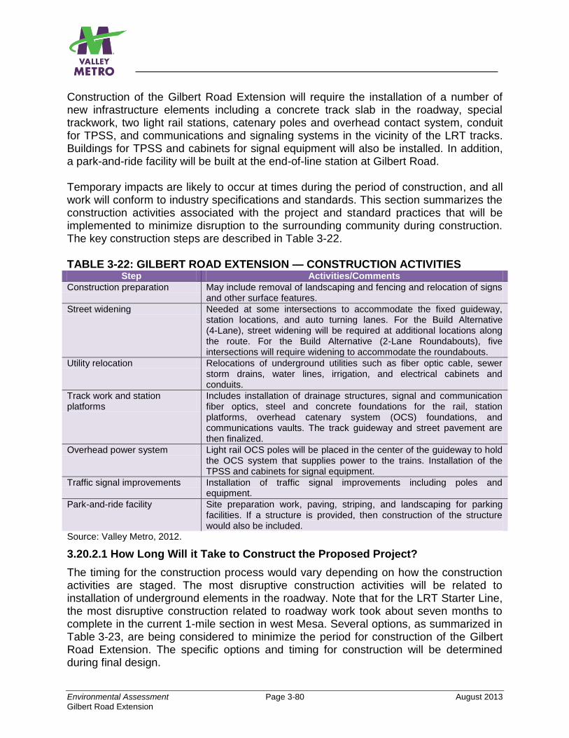
Environmental Assessment Page 3-80 August 2013
Gilbert Road Extension
Construction of the Gilbert Road Extension will require the installation of a number of new infrastructure elements including a concrete track slab in the roadway, special trackwork, two light rail stations, catenary poles and overhead contact system, conduit for TPSS, and communications and signaling systems in the vicinity of the LRT tracks. Buildings for TPSS and cabinets for signal equipment will also be installed. In addition, a park-and-ride facility will be built at the end-of-line station at Gilbert Road. Temporary impacts are likely to occur at times during the period of construction, and all work will conform to industry specifications and standards. This section summarizes the construction activities associated with the project and standard practices that will be implemented to minimize disruption to the surrounding community during construction. The key construction steps are described in Table 3-22. TABLE 3-22: GILBERT ROAD EXTENSION — CONSTRUCTION ACTIVITIES
Step Activities/Comments
Construction preparation May include removal of landscaping and fencing and relocation of signs and other surface features.
Street widening Needed at some intersections to accommodate the fixed guideway, station locations, and auto turning lanes. For the Build Alternative (4-Lane), street widening will be required at additional locations along the route. For the Build Alternative (2-Lane Roundabouts), five intersections will require widening to accommodate the roundabouts.
Utility relocation Relocations of underground utilities such as fiber optic cable, sewer storm drains, water lines, irrigation, and electrical cabinets and conduits.
Track work and station platforms
Includes installation of drainage structures, signal and communication fiber optics, steel and concrete foundations for the rail, station platforms, overhead catenary system (OCS) foundations, and communications vaults. The track guideway and street pavement are then finalized.
Overhead power system Light rail OCS poles will be placed in the center of the guideway to hold the OCS system that supplies power to the trains. Installation of the TPSS and cabinets for signal equipment.
Traffic signal improvements Installation of traffic signal improvements including poles and equipment.
Park-and-ride facility Site preparation work, paving, striping, and landscaping for parking facilities. If a structure is provided, then construction of the structure would also be included.
Source: Valley Metro, 2012.
3.20.2.1 How Long Will it Take to Construct the Proposed Project?
The timing for the construction process would vary depending on how the construction activities are staged. The most disruptive construction activities will be related to installation of underground elements in the roadway. Note that for the LRT Starter Line, the most disruptive construction related to roadway work took about seven months to complete in the current 1-mile section in west Mesa. Several options, as summarized in Table 3-23, are being considered to minimize the period for construction of the Gilbert Road Extension. The specific options and timing for construction will be determined during final design.
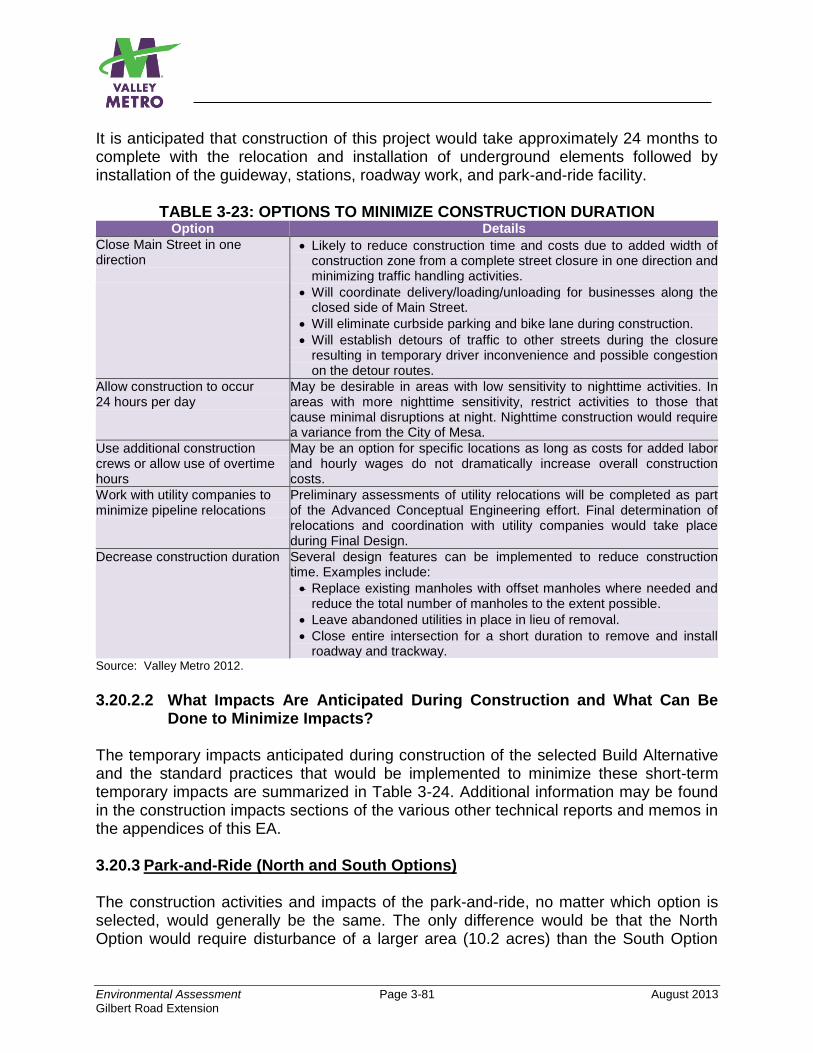
Environmental Assessment Page 3-81 August 2013
Gilbert Road Extension
It is anticipated that construction of this project would take approximately 24 months to complete with the relocation and installation of underground elements followed by installation of the guideway, stations, roadway work, and park-and-ride facility.
TABLE 3-23: OPTIONS TO MINIMIZE CONSTRUCTION DURATION Option Details
Close Main Street in one direction
Likely to reduce construction time and costs due to added width of construction zone from a complete street closure in one direction and minimizing traffic handling activities.
Will coordinate delivery/loading/unloading for businesses along the closed side of Main Street.
Will eliminate curbside parking and bike lane during construction.
Will establish detours of traffic to other streets during the closure resulting in temporary driver inconvenience and possible congestion on the detour routes.
Allow construction to occur 24 hours per day
May be desirable in areas with low sensitivity to nighttime activities. In areas with more nighttime sensitivity, restrict activities to those that cause minimal disruptions at night. Nighttime construction would require a variance from the City of Mesa.
Use additional construction crews or allow use of overtime hours
May be an option for specific locations as long as costs for added labor and hourly wages do not dramatically increase overall construction costs.
Work with utility companies to minimize pipeline relocations
Preliminary assessments of utility relocations will be completed as part of the Advanced Conceptual Engineering effort. Final determination of relocations and coordination with utility companies would take place during Final Design.
Decrease construction duration Several design features can be implemented to reduce construction time. Examples include:
Replace existing manholes with offset manholes where needed and reduce the total number of manholes to the extent possible.
Leave abandoned utilities in place in lieu of removal.
Close entire intersection for a short duration to remove and install roadway and trackway.
Source: Valley Metro 2012.
3.20.2.2 What Impacts Are Anticipated During Construction and What Can Be
Done to Minimize Impacts? The temporary impacts anticipated during construction of the selected Build Alternative and the standard practices that would be implemented to minimize these short-term temporary impacts are summarized in Table 3-24. Additional information may be found in the construction impacts sections of the various other technical reports and memos in the appendices of this EA. 3.20.3 Park-and-Ride (North and South Options) The construction activities and impacts of the park-and-ride, no matter which option is selected, would generally be the same. The only difference would be that the North Option would require disturbance of a larger area (10.2 acres) than the South Option
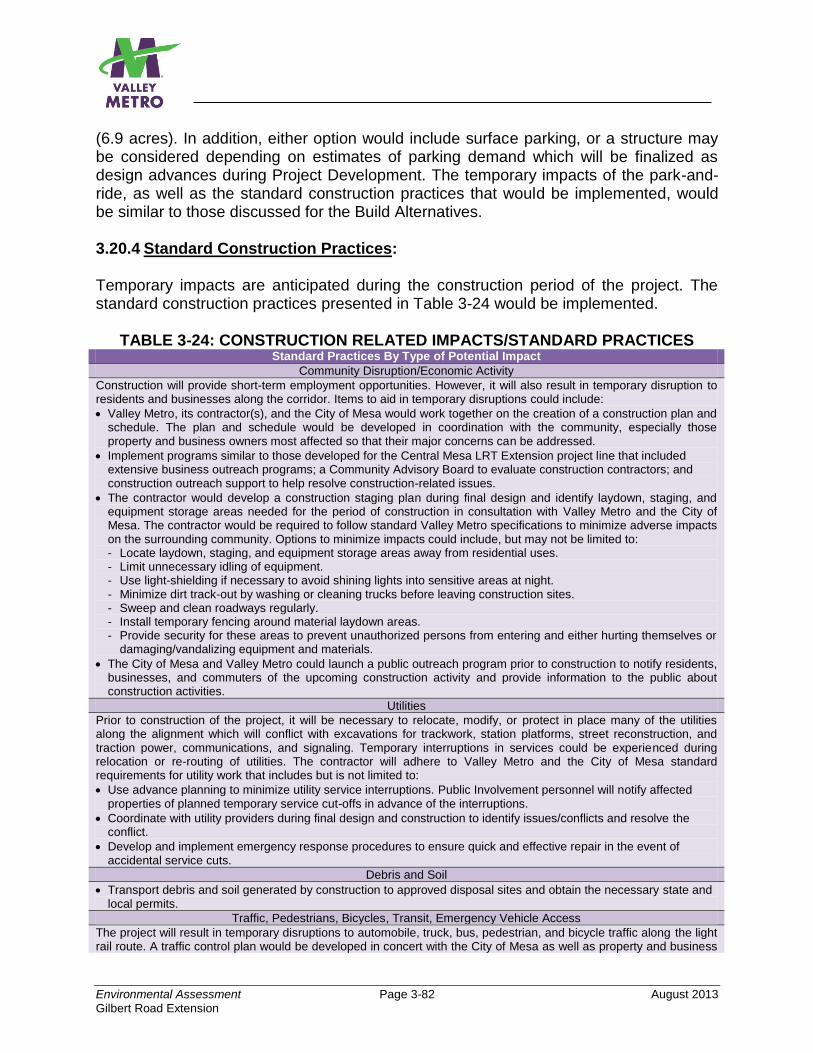
Environmental Assessment Page 3-82 August 2013
Gilbert Road Extension
(6.9 acres). In addition, either option would include surface parking, or a structure may be considered depending on estimates of parking demand which will be finalized as design advances during Project Development. The temporary impacts of the park-and-ride, as well as the standard construction practices that would be implemented, would be similar to those discussed for the Build Alternatives.
3.20.4 Standard Construction Practices: Temporary impacts are anticipated during the construction period of the project. The standard construction practices presented in Table 3-24 would be implemented.
TABLE 3-24: CONSTRUCTION RELATED IMPACTS/STANDARD PRACTICES Standard Practices By Type of Potential Impact
Community Disruption/Economic Activity
Construction will provide short-term employment opportunities. However, it will also result in temporary disruption to residents and businesses along the corridor. Items to aid in temporary disruptions could include:
Valley Metro, its contractor(s), and the City of Mesa would work together on the creation of a construction plan and schedule. The plan and schedule would be developed in coordination with the community, especially those property and business owners most affected so that their major concerns can be addressed.
Implement programs similar to those developed for the Central Mesa LRT Extension project line that included extensive business outreach programs; a Community Advisory Board to evaluate construction contractors; and construction outreach support to help resolve construction-related issues.
The contractor would develop a construction staging plan during final design and identify laydown, staging, and equipment storage areas needed for the period of construction in consultation with Valley Metro and the City of Mesa. The contractor would be required to follow standard Valley Metro specifications to minimize adverse impacts on the surrounding community. Options to minimize impacts could include, but may not be limited to: - Locate laydown, staging, and equipment storage areas away from residential uses. - Limit unnecessary idling of equipment. - Use light-shielding if necessary to avoid shining lights into sensitive areas at night. - Minimize dirt track-out by washing or cleaning trucks before leaving construction sites. - Sweep and clean roadways regularly. - Install temporary fencing around material laydown areas. - Provide security for these areas to prevent unauthorized persons from entering and either hurting themselves or
damaging/vandalizing equipment and materials.
The City of Mesa and Valley Metro could launch a public outreach program prior to construction to notify residents, businesses, and commuters of the upcoming construction activity and provide information to the public about construction activities.
Utilities
Prior to construction of the project, it will be necessary to relocate, modify, or protect in place many of the utilities along the alignment which will conflict with excavations for trackwork, station platforms, street reconstruction, and traction power, communications, and signaling. Temporary interruptions in services could be experienced during relocation or re-routing of utilities. The contractor will adhere to Valley Metro and the City of Mesa standard requirements for utility work that includes but is not limited to:
Use advance planning to minimize utility service interruptions. Public Involvement personnel will notify affected properties of planned temporary service cut-offs in advance of the interruptions.
Coordinate with utility providers during final design and construction to identify issues/conflicts and resolve the conflict.
Develop and implement emergency response procedures to ensure quick and effective repair in the event of accidental service cuts.
Debris and Soil
Transport debris and soil generated by construction to approved disposal sites and obtain the necessary state and local permits.
Traffic, Pedestrians, Bicycles, Transit, Emergency Vehicle Access
The project will result in temporary disruptions to automobile, truck, bus, pedestrian, and bicycle traffic along the light rail route. A traffic control plan would be developed in concert with the City of Mesa as well as property and business
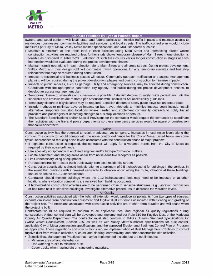
Environmental Assessment Page 3-83 August 2013
Gilbert Road Extension
Standard Practices By Type of Potential Impact
owners, and would conform with local, state, and federal policies to minimize traffic impacts and maintain access to residences, businesses, community facilities and services, and local streets. The traffic control plan would include measures per City of Mesa, Valley Metro master specifications, and MAG standards such as:
Maintain a minimum of one traffic lane in each direction along Main Street and intersecting streets where construction activities are required unless further study shows temporary closure of Main Street in one direction is feasible as discussed in Table 3-23. Evaluation of such full closures versus longer construction in stages at each intersection would be evaluated during the project development phases.
Maintain transit operations in each direction along Main Street and all cross streets. During project development, Valley Metro and their design staff will coordinate transit operations for any temporary reroutes and bus stop relocations that may be required during construction.
Impacts to residential and business access will occur. Community outreach notification and access management planning will be required during the project development phases and during construction to minimize impacts.
Impacts to public services, such as garbage, utility and emergency services, may be affected during construction. Coordinate with the appropriate contractor, city agency, and public during the project development phases, to develop an access management plan.
Temporary closure of sidewalks and crosswalks is possible. Establish detours to safely guide pedestrians until the sidewalks and crosswalks are restored per Americans with Disabilities Act accessibility guidelines.
Temporary closure of bicycle lanes may be required. Establish detours to safely guide bicyclists on detour route.
Include methods to minimize adverse impacts on bus travel. Methods to minimize impacts could include: install alternative temporary bus stop locations where needed and implement community outreach to notify transit providers and passengers of upcoming changes to bus stop locations or detours.
The Standard Specifications and/or Special Provisions for the contractor would require the contractor to coordinate their activities with the fire and police departments so these emergency services would be aware of construction that could affect them.
Noise
Construction activity has the potential to result in adverse, yet temporary, increases in local noise levels along the corridor. The contractor would comply with the noise control ordinance for the City of Mesa. Listed below are some typical approaches to reducing noise levels associated with the construction phase of major projects:
If nighttime construction is required, the contractor will apply for a variance permit from the City of Mesa as required by their noise ordinance.
Use specialty equipment with enclosed engines and/or high-performance mufflers.
Locate equipment and staging areas as far from noise-sensitive receptors as possible.
Limit unnecessary idling of equipment.
Reroute construction-related truck traffic away from local residential streets.
Construction specifications should limit vibration to a maximum of 0.5 inches/second for buildings in the corridor. In the event that buildings with increased sensitivity to vibration occur along the route, vibration at these buildings should be limited to 0.12 inches/second.
Contractor should monitor buildings where the 0.12 inches/second limit may need to be imposed or at other locations where vibration complaints are received from building occupants.
If high-vibration construction activities are to be performed close to sensitive structures (e.g., vibration compaction or hoe rams next to sensitive buildings), investigate alternative procedures to decrease the vibration levels.
Air Quality
Construction activities associated with the light rail extension would produce air pollutants from two types of sources: exhaust emissions from construction equipment and fugitive dust emissions associated with clearing and grading of the project site. The emissions associated with construction activities are of short-term duration and will cease when the project is built. Contractors would be required to conform to all applicable local and regional air quality regulations during construction. A dust control plan will be developed and implemented per Rule 310 for Fugitive Dust of the Maricopa County Air Quality Department. The contractor must also conform to MAG’s Uniform Standard Specifications for Public Works Construction, Section 225, as well as with Valley Metro’s master specifications for dust control, applicable City of Mesa construction specifications, and the approved Erosion and Sediment Control Plan or Program as applicable. These regulations and specifications require implementation of Best Management Practices to control fugitive dust from various activities, such as land clearing, earthmoving, and other construction site activities.
Specific Best Management Practices that may be implemented include, but are not limited to: - Minimize area of land disturbance. - Use watering trucks to minimize dust. - Cover trucks when hauling dirt or transferring materials.
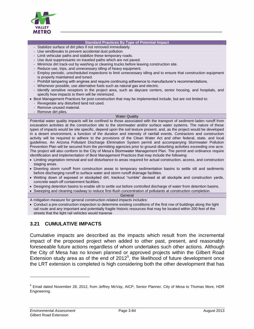
Environmental Assessment Page 3-84 August 2013
Gilbert Road Extension
Standard Practices By Type of Potential Impact
- Stabilize surface of dirt piles if not removed immediately. - Use windbreaks to prevent accidental dust pollution. - Limit vehicular paths and stabilize these temporary roads. - Use dust suppressants on traveled paths which are not paved. - Minimize dirt track-out by washing or cleaning trucks before leaving construction site. - Reduce use, trips, and unnecessary idling of heavy equipment. - Employ periodic, unscheduled inspections to limit unnecessary idling and to ensure that construction equipment
is properly maintained and tuned. - Prohibit tampering with engines and require continuing adherence to manufacturer’s recommendations. - Whenever possible, use alternative fuels such as natural gas and electric. - Identify sensitive receptors in the project area, such as daycare centers, senior housing, and hospitals, and
specify how impacts to them will be minimized.
Best Management Practices for post construction that may be implemented include, but are not limited to: - Revegetate any disturbed land not used. - Remove unused material. - Remove dirt piles.
Water Quality
Potential water quality impacts will be confined to those associated with the transport of sediment-laden runoff from excavation activities at the construction site to the stormwater and/or surface water systems. The nature of these types of impacts would be site specific, depend upon the soil texture present, and, as the project would be developed in a desert environment, a function of the duration and intensity of rainfall events. Contractors and construction activity will be required to adhere to the provisions of the Clean Water Act and other federal, state, and local guidelines. An Arizona Pollutant Discharge Elimination System permit and accompanying Stormwater Pollution Prevention Plan will be secured from the permitting agencies prior to ground-disturbing activities exceeding one acre. The project will also conform to the City of Mesa’s Stormwater Management Plan. The permit and ordinance require identification and implementation of Best Management Practices that may include the following:
Limiting vegetation removal and soil disturbance to areas required for actual construction, access, and construction staging areas.
Diverting storm runoff from construction areas to temporary sedimentation basins to settle silt and sediments before discharging runoff to surface water and storm runoff drainage facilities.
Wetting down of exposed or stockpiled dirt, trackout “rumble” devised at all stockpile and construction yards, concrete wash-off containment facilities.
Designing detention basins to enable silt to settle out before controlled discharge of water from detention basins.
Sweeping and cleaning roadway to reduce first-flush concentration of pollutants at construction completion.
General
A mitigation measure for general construction-related impacts includes:
Conduct a pre-construction inspection to determine existing conditions of the first row of buildings along the light rail route and any important and potentially fragile historic resources that may be located within 200 feet of the streets that the light rail vehicles would traverse
3.21 CUMULATIVE IMPACTS Cumulative impacts are described as the impacts which result from the incremental impact of the proposed project when added to other past, present, and reasonably foreseeable future actions regardless of whom undertakes such other actions. Although the City of Mesa has no known planned or approved projects within the Gilbert Road Extension study area as of the end of 20125, the likelihood of future development once the LRT extension is completed is high considering both the other development that has
5 Email dated November 28, 2012, from Jeffrey McVay, AICP, Senior Planner, City of Mesa to Thomas More, HDR
Engineering.
Environmental Assessment Page 3-85 August 2013
Gilbert Road Extension
occurred in the vicinity of the existing 20-mile LRT line and the other reasons discussed in Sections 3.4, Economic Effects, and 3.5, Secondary Development.
Cumulative impacts can result from individually minor but collectively significant actions taking place over a period of time and can result in either beneficial or adverse impacts or both. If a proposed project’s mitigation measures alleviate the adverse cumulative impact caused by the project’s contribution, then the project would not result in an adverse cumulative impact. In addition, a project's incremental contribution to a cumulative effect is not cumulatively adverse if the project will comply with the requirements in a previously approved plan or mitigation program (such as a water quality control plan, air quality attainment or maintenance plan, integrated waste management plan, habitat conservation plan, etc.) that provides specific requirements that will avoid or substantially lessen the cumulative problem.
3.21.1 No-Build Alternative The No-Build Alternative would not include any major service improvements or new transportation infrastructure beyond what is shown in the MAG RTP update for 2031. The transit network within the project area would be largely the same as it is now. Therefore, the No-Build Alternative would not contribute to cumulative effects. 3.21.2 Build Alternatives (4-Lane, 2-Lane, 2-Lane Roundabouts Option) The analysis of the proposed project with regard to cumulative impacts is presented in Table 3-25. The analysis is the same for both Build Alternatives as well as the Roundabouts Option. The possibility of extending light rail farther through Mesa has been discussed but, to date, no funds are available to extend the project beyond what is discussed in this EA. If such a project becomes viable in the future, it would be analyzed as part of a separate study, and, if federal funds are sought, would be evaluated in a separate NEPA environmental document. This section discusses the potential for cumulative impacts for an extended project. In summary, the Gilbert Road Extension and potential light rail extensions that may be proposed at a later date are expected to contribute to beneficial impacts in a cumulative sense, but not anticipated to contribute to cumulatively adverse impacts.
3.21.3 Park-and-Ride (North and South Options) Like the Build Alternatives, both Park-and-Ride Options have the potential to contribute to beneficial impacts in a cumulative sense, but are not anticipated to contribute to cumulatively adverse impacts. Any future LRT extensions would most likely provide park-and-ride at the end-of-line terminus and possibly other locations along the planned route as well. Based on previous studies of the existing park-and-ride at Sycamore (the current LRT end-of-line in Mesa), a substantial portion of that parking facility’s users come from areas in the very eastern portion of the region. Providing new park-and-ride facilities in these areas would tend to reduce auto vehicle miles traveled since many

Environmental Assessment Page 3-86 August 2013
Gilbert Road Extension
transit users could drive shorter distances from their homes to access park-and-ride and the LRT.
TABLE 3-25: CUMULATIVE IMPACTS ANALYSIS
Potential Impacts
Project’s Contribution
to Cumulative Impacts
1 Findings
Land Use/ Economic
Development
The LRT extension would tend to integrate the community within the corridor and encourage transit-oriented development which would also likely be more pedestrian friendly. As discussed in Section 3.3, the project would be compatible with local land use plans and policies and, as a result, would further the City of Mesa’s plan goals and policies which promote land use development consistent with implementation of high-capacity transit such as LRT in selected corridors. The City of Mesa recently adopted a Form-Based Code zoning ordinance, which, among other things, provides the policy guidance needed to foster transit-supportive land uses in the city, particularly along streets where investments in high-capacity transit facilities are planned and programmed. Mesa’s General Plan (2002) states that the vision for 2030 is livability, and a goal is to “achieve a more balanced transportation system and reduce reliance on the automobile.” MAG’s Regional Transit Framework Study (2010) provides regional transit system planning and policy guidance and two of the future scenarios included in the study identify LRT being extended to Gilbert Road/Main Street in Mesa as well as future extensions beyond this intersection.
Traffic ◒
Development could be accelerated within the Gilbert Road Extension corridor as a result of the project which would primarily represent decisions of businesses and residents to locate within the corridor, rather than to locate in other areas of the region. However, this could tend to reduce vehicular trips and vehicle miles per capita. Any future extensions would likely further accelerate development near the rail corridor and may also result in reduced vehicular trips and vehicle miles per capita. In any case, any future extensions would require additional traffic studies to be conducted, and measures would need to be developed to avoid or minimize potential adverse traffic impacts that may occur.
Air Quality ◒
The project’s air quality analysis showed no adverse impacts. Analysis was based on MAG’s Regional Transportation Plan (RTP) 2010 update that includes all reasonably foreseeable transportation projects in the region for the forecast year of 2031. The RTP is based on regionally adopted population and employment forecasts which are consistent with adopted regional and local land use and development plans. Therefore, the project would result in no cumulatively adverse impacts. If a future LRT extension beyond Gilbert Road is proposed, it would require separate air quality studies. While it is unlikely that the future extension would result in adverse impacts, measures would be developed, if necessary, to avoid or minimize potential adverse impacts on air quality.
Water Quality ◒
Planned and approved projects, including the LRT extensions, have potential to result in short-term construction-related impacts on surface waters and groundwater. Because all facilities will be constructed pursuant to requirements of Sections 401, 402, and 404 of the Clean Water Act, and will follow the most current guidance within the Arizona Pollutant Discharge Elimination System program, the project is not expected to result in cumulatively adverse impacts. Any future extensions that may be proposed also would require conformance with these requirements.
Energy As previously discussed in Section 3.9, LRT has the potential to conserve energy; therefore, the Gilbert Road Extension, as well as any future
Environmental Assessment Page 3-87 August 2013
Gilbert Road Extension
extensions, would not result in cumulative adverse impacts and is likely to provide benefits.
1 = Beneficial ◒ = No Effect = Adverse. Findings are the same for all Build Alternatives.
3.21.4 Mitigation No mitigation is needed.
Environmental Assessment Page 4-1 August 2013 Gilbert Road Extension
4.0 WHO ARE THE AGENCIES AND PERSONS CONSULTED?
4.1 INTRODUCTION A comprehensive public involvement program (PIP) for the Gilbert Road Extension project is being conducted to coordinate with, and obtain input from, public agencies, private interests, community organizations, and the public at-large. The objectives of the PIP are presented in Table 4-1.
TABLE 4-1: OBJECTIVES OF THE PUBLIC INVOLVEMENT PROGRAM Major Objectives
Obtain full and continuous public participation and involvement throughout the project.
Assure that the process is open and fair and that community concerns are incorporated into the project planning.
Comply with FTA, NEPA, and Section 106 of the National Historic Preservation Act (NHPA) requirements for public participation.
Develop and continue a program for public participation and community involvement in the subsequent phases of the project.
Achieve consensus, to the maximum extent possible, on ongoing project development.
Community outreach has occurred throughout the project’s development to help identify a preferred alternative. Public scoping officially began in August 2012 with the publication of meeting announcements in local newspapers announcing the preparation of the EA for the project, with a Scoping Meeting held on September 11, 2012. It was determined that an Environmental Assessment would be the appropriate NEPA document to prepare given the scale and scope of the project.
Public involvement activities will continue during subsequent phases of the project’s development. This chapter summarizes the coordination and public involvement activities and approaches conducted to date as follows:
Staff and agency meetings
Public meetings
City of Mesa boards and committees
Mesa City Council
Community stakeholder meetings 4.2 STAFF AND AGENCY COORDINATION MEETINGS
Table 4-2 provides a summary of the meetings held with various local, state, and federal agencies and staff.
Environmental Assessment Page 4-2 August 2013 Gilbert Road Extension
TABLE 4-2: STAFF AND AGENCY MEETINGS Staff/Agency Additional Information
Project Management Team meetings 2011-Present. Bi-weekly Project Team meetings between Valley Metro project team and City of Mesa staff to provide opportunity for staff to inform the project team about community and stakeholders interests.
Technical Advisory Committee meetings June, 2011-May, 2012. Quarterly meetings between project team and local technical city staff provided an opportunity for city staff to inform the project team about technical issues.
Public involvement coordination meetings Ongoing since 2011. Valley Metro and City of Mesa public involvement and communications meetings.
Agency EA scoping meeting September 11, 2012. A combined public and agency Scoping Meeting was held to solicit input on the proposed project and its purpose and need, alternatives for consideration, and other issues or concerns. State and federal agencies contacted and invited to comment/participate included the U.S. Department of Army, Corps of Engineers; U.S. Department of Housing and Urban Development; U.S. Department of Interior; National Park Service; Bureau of Reclamation; U.S. Environmental Protection Agency; Arizona State Land Department; Arizona Department of Environmental Quality; Arizona Game and Fish Department; Arizona Department of Transportation; Arizona State University; Maricopa Association of Governments; City of Mesa; City of Tempe; City of Chandler; City of Phoenix.
City of Mesa department presentations/briefings
Departments briefed include: Ongoing briefings and coordination meetings with the City Manager, Traffic Engineering and Transportation, Planning, Finance, Real Estate, Community Development, Community Services, Economic Development, Police, Fire.
State Historic Preservation Office (SHPO)/ City Historic Preservation Office (CHPO)
Ongoing process since 2012. Valley Metro is the delegated representative for FTA in coordination of Section 106 of the National Historic Preservation Act. Valley Metro is consulting with both the SHPO and CHPO on the Area of Potential Effect; identification of eligible resources; evaluation of effects on resources; and development of appropriate treatments for historic properties as may be needed.
Consultation/coordination with other agencies
Ongoing. Items for which input was sought include: existing environmental conditions; quality of resources with potential to be affected; extent or severity of potential impacts; and review of mitigation strategies proposed to offset project-related impacts. Public agencies or representative groups that have been notified of the project include the Ak-Chin Indian Community, Fort McDowell-Yavapai Nation, Gila River Indian Community, Hopi Tribe, Inter-tribal Council of Arizona, Salt River-Pima-Maricopa Indian Community.
4.3 PUBLIC MEETINGS
Table 4-3 summarizes the public meetings held to date.
TABLE 4-3: GENERAL PUBLIC MEETINGS Public Meeting Date/Number of Attendees
Scoping Meeting September 11, 2012. 55 attendees.
Public Open House October 30, 2012. 40 attendees.
Environmental Assessment Page 4-3 August 2013 Gilbert Road Extension
4.3.1 Public Meetings The Scoping Meeting, held in September 2012, initiated the first set of public meetings for the EA study process and was designed to inform the public, interest groups, and government agencies about the proposed project, its purpose and need, alternatives considered, and environmental issues including historic resources and to solicit their input on the project. The primary goals of scoping are to encourage active participation of the public and agencies early in the decision-making process, and establish a means of communication between the public, agencies, and the project team. Public notification of the scoping process was widely publicized through:
The Scoping Information Brochure.
Individual outreach to key businesses, residents, government officials and other stakeholders.
Group outreach to community groups, government agencies, chambers of commerce, churches, schools and neighborhood/homeowner’s groups.
Media outreach through press releases in local media including Wrangler News, Arizona Republic, East Valley Tribune, and Spanish language publications LaVoz, Latino Perspectives, Monitor Hispano, Prensa Hispana.
City of Mesa and Valley Metro websites which post public meeting and project details.
During the public scoping meeting, a formal presentation was conducted by members of the project team to provide the public with information about the project. After the presentation, the audience was invited to ask the project team questions and view project display boards available. The public was also encouraged to submit comments and survey forms following the public meetings via the website, e-mail, mail or telephone. In addition to the project’s initial Scoping Meeting, a public open house meeting was held to provide the public with updates on the status of the project (refer to Table 4-3). The project update meeting was held to address specific concerns and issues related to the project’s development. Spanish translation and ADA-accessible facilities were made available at both the Scoping Meeting and the public open house meeting. In addition, all project informational and meeting materials were printed in both English and Spanish or in other alternative formats for those who requested them. All scoping activities, including a summary of public and agency comments received, from the Scoping Meeting initiating the EA process are documented in a separate Scoping Summary Report that is available for review at the offices of Valley Metro101 N. 1st Avenue, Suite 1300, Phoenix, AZ 85003.
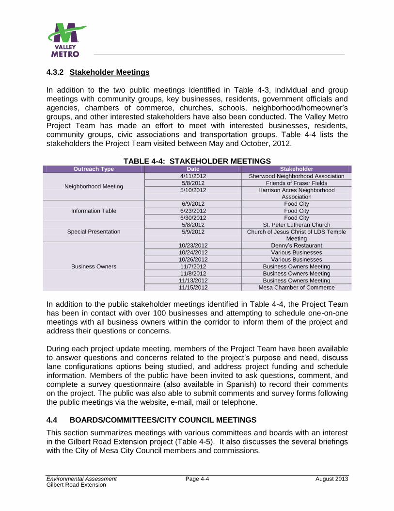
Environmental Assessment Page 4-4 August 2013 Gilbert Road Extension
4.3.2 Stakeholder Meetings In addition to the two public meetings identified in Table 4-3, individual and group meetings with community groups, key businesses, residents, government officials and agencies, chambers of commerce, churches, schools, neighborhood/homeowner’s groups, and other interested stakeholders have also been conducted. The Valley Metro Project Team has made an effort to meet with interested businesses, residents, community groups, civic associations and transportation groups. Table 4-4 lists the stakeholders the Project Team visited between May and October, 2012.
TABLE 4-4: STAKEHOLDER MEETINGS Outreach Type Date Stakeholder
Neighborhood Meeting
4/11/2012 Sherwood Neighborhood Association
5/8/2012 Friends of Fraser Fields
5/10/2012 Harrison Acres Neighborhood Association
Information Table
6/9/2012 Food City
6/23/2012 Food City
6/30/2012 Food City
Special Presentation
5/8/2012 St. Peter Lutheran Church
5/9/2012 Church of Jesus Christ of LDS Temple Meeting
Business Owners
10/23/2012 Denny’s Restaurant
10/24/2012 Various Businesses
10/26/2012 Various Businesses
11/7/2012 Business Owners Meeting
11/8/2012 Business Owners Meeting
11/13/2012 Business Owners Meeting
11/15/2012 Mesa Chamber of Commerce
In addition to the public stakeholder meetings identified in Table 4-4, the Project Team has been in contact with over 100 businesses and attempting to schedule one-on-one meetings with all business owners within the corridor to inform them of the project and address their questions or concerns. During each project update meeting, members of the Project Team have been available to answer questions and concerns related to the project’s purpose and need, discuss lane configurations options being studied, and address project funding and schedule information. Members of the public have been invited to ask questions, comment, and complete a survey questionnaire (also available in Spanish) to record their comments on the project. The public was also able to submit comments and survey forms following the public meetings via the website, e-mail, mail or telephone. 4.4 BOARDS/COMMITTEES/CITY COUNCIL MEETINGS
This section summarizes meetings with various committees and boards with an interest in the Gilbert Road Extension project (Table 4-5). It also discusses the several briefings with the City of Mesa City Council members and commissions.
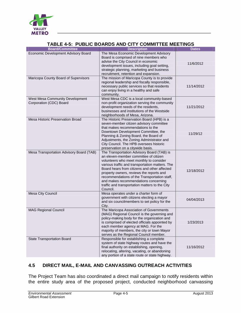
Environmental Assessment Page 4-5 August 2013 Gilbert Road Extension
TABLE 4-5: PUBLIC BOARDS AND CITY COMMITTEE MEETINGS Board/Committee Description Dates
Economic Development Advisory Board The Mesa Economic Development Advisory Board is comprised of nine members who advise the City Council in economic development issues, including goal setting, strategic planning, marketing and business recruitment, retention and expansion.
11/6/2012
Maricopa County Board of Supervisors The mission of Maricopa County is to provide regional leadership and fiscally responsible, necessary public services so that residents can enjoy living in a healthy and safe community.
11/14/2012
West Mesa Community Development Corporation (CDC) Board
West Mesa CDC is a local community-based non-profit organization serving the community development needs of the residents, businesses and institutions of the Westside neighborhoods of Mesa, Arizona.
11/21/2012
Mesa Historic Preservation Broad The Historic Preservation Board (HPB) is a seven-member citizen advisory committee that makes recommendations to the Downtown Development Committee, the Planning & Zoning Board, the Board of Adjustments, the Zoning Administrator and City Council. The HPB oversees historic preservation on a citywide basis.
11/29/12
Mesa Transportation Advisory Board (TAB) The Transportation Advisory Board (TAB) is an eleven-member committee of citizen volunteers who meet monthly to consider various traffic and transportation matters. The Board hears from citizens and other affected property owners, reviews the reports and recommendations of the Transportation staff, and makes recommendations concerning traffic and transportation matters to the City Council.
12/18/2012
Mesa City Council Mesa operates under a charter form of government with citizens electing a mayor and six councilmembers to set policy for the City.
04/04/2013
MAG Regional Council The Maricopa Association of Governments (MAG) Regional Council is the governing and policy-making body for the organization and is comprised of elected officials appointed by each member agency at MAG. For the majority of members, the city or town Mayor serves as the Regional Council member.
1/23/2013
State Transportation Board Responsible for establishing a complete system of state highway routes and have the final authority on establishing, opening, relocating, altering, vacating, or abandoning any portion of a state route or state highway.
11/16/2012
4.5 DIRECT MAIL, E-MAIL AND CANVASSING OUTREACH ACTIVITIES The Project Team has also coordinated a direct mail campaign to notify residents within the entire study area of the proposed project, conducted neighborhood canvassing
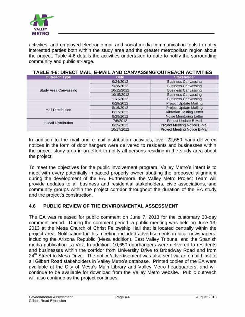
Environmental Assessment Page 4-6 August 2013 Gilbert Road Extension
activities, and employed electronic mail and social media communication tools to notify interested parties both within the study area and the greater metropolitan region about the project. Table 4-6 details the activities undertaken to-date to notify the surrounding community and public at-large.
TABLE 4-6: DIRECT MAIL, E-MAIL AND CANVASSING OUTREACH ACTIVITIES Outreach Type Date Stakeholder
Study Area Canvassing
9/24/2012 Business Canvassing
9/28/2012 Business Canvassing
10/12/2012 Business Canvassing
10/15/2012 Business Canvassing
11/1/2012 Business Canvassing
Mail Distribution
6/28/2012 Project Update Mailing
8/16/2012 Project Update Mailing
8/17/2012 Vibration Testing Letter
8/29/2012 Noise Monitoring Letter
E-Mail Distribution 7/5/2012 Project Update E-Mail
8/29/2012 Project Meeting Notice E-Mail
10/17/2012 Project Meeting Notice E-Mail
In addition to the mail and e-mail distribution activities, over 22,650 hand-delivered notices in the form of door hangers were delivered to residents and businesses within the project study area in an effort to notify all persons residing in the study area about the project. To meet the objectives for the public involvement program, Valley Metro’s intent is to meet with every potentially impacted property owner abutting the proposed alignment during the development of the EA. Furthermore, the Valley Metro Project Team will provide updates to all business and residential stakeholders, civic associations, and community groups within the project corridor throughout the duration of the EA study and the project’s construction. 4.6 PUBLIC REVIEW OF THE ENVIRONMENTAL ASSESSMENT The EA was released for public comment on June 7, 2013 for the customary 30-day comment period. During the comment period, a public meeting was held on June 13, 2013 at the Mesa Church of Christ Fellowship Hall that is located centrally within the project area. Notification for this meeting included advertisements in local newspapers, including the Arizona Republic (Mesa addition), East Valley Tribune, and the Spanish media publication La Voz. In addition, 10,650 doorhangers were delivered to residents and businesses within the corridor from University Drive to Broadway Road and from 24th Street to Mesa Drive. The notice/advertisement was also sent via an email blast to all Gilbert Road stakeholders in Valley Metro’s database. Printed copies of the EA were available at the City of Mesa’s Main Library and Valley Metro headquarters, and will continue to be available for download from the Valley Metro website. Public outreach will also continue as the project continues.
Environmental Assessment Page 4-7 August 2013 Gilbert Road Extension
Valley Metro received 49 comments during the comment period. The specific comments and Valley Metro responses may be found in Appendix L of the Revised EA.

Page Intentionally Left Blank
Environmental Assessment Page 5-1 August 2013
Gilbert Road Extension
5.0 CONCLUSIONS AND RECOMMENDATION FOR A PREFERRED ALTERNATIVE FOR IMPLEMENTATION
5.1 INTRODUCTION Valley Metro and the City of Mesa have considered the results of the Build Alternative traffic configurations evaluation, including the roundabouts design option, as discussed in the previous chapters of this EA. Both agencies determined that each alternative has positive aspects and have requested that a refined alternative be developed and evaluated which is actually a “hybrid” of the alternatives considered. For purposes of this analysis, this alternative is termed as the Build Alternative (Hybrid). Section 5.2 of this chapter begins with a background of how and why this alternative was developed and the action taken by the Mesa City Council to recommend this as the Preferred Alternative (PA) for implementation. A definition of the Build Alternative (Hybrid), or PA, is presented in Section 5.3. The chapter concludes with an evaluation of the hybrid alternative in Section 5.4 and finds that it does not introduce any new adverse impacts not previously considered with the other Build Alternatives and, in some instances, has fewer adverse effects and more benefits than one or more of the alternatives previously considered. Potential strategies to minimize the adverse effects are listed in Section 5.5. Like the other alternatives previously evaluated, the proposed mitigations would reduce the impacts to resources that are adversely impacted to levels that are below significant. Prior to formal adoption of the Build Alternative (Hybrid) as the PA for implementation, the EA will be distributed to the public for consideration and input. The EA includes the analyses of all the original alternatives, including the No-Build Alternative, as well as this refined Build Alternative which is being recommended as the PA. This will give the public an opportunity to consider and comment on any or all of the alternatives considered. 5.2 BACKGROUND The evaluation of the two alternatives and the roundabouts design option in this EA yielded stark differences between alternatives in terms of the anticipated impacts to the study area resulting from the project’s implementation. City of Mesa staff and the public participated in the environmental review process, providing comments on design elements and features of each alternative. A primary concern shared by City staff and the public with the Build Alternative (4-Lane) was the amount of new right-of-way needed to accommodate two traffic lanes in either direction, left-turn lanes at signalized intersections, the LRT trackway, and stations. Based on the conceptual engineering drawings and preliminary estimates of right-of-way requirements, the Build Alternative (4-Lane) will require approximately 86,000 square feet. Conversely, while the Build Alternative (2-Lane) minimized the amount of right-of-way needed for the project (approximately 26,000 square feet), several concerns were raised regarding traffic progression, particularly at the intersection of Main Street and Stapley Drive. The traffic
Environmental Assessment Page 5-2 August 2013
Gilbert Road Extension
analysis completed for the EA determined that disruptions to traffic operations, particularly at the Stapley Drive intersection with Main Street, were anticipated with implementation of the Build Alternative (2-Lane) (refer to Appendix C – Transportation Technical Report). Regarding roundabouts, the public generally supported traditional signalized intersections; however, support was also voiced for roundabouts in order to maintain traffic progression, especially to businesses on the opposite side of the roadway. In essence, a “trade-off” emerged—the Build Alternative (4-Lane) provided more vehicle access but at a higher cost, while the Build Alternative (2-Lane) saved cost but reduced vehicle access. Surveys administered to attendees at public events, business owners, and stakeholders, along with comments received at public open houses and related public events, were almost evenly split with regard to a preference of Build Alternative. Recognizing that there was no clear community consensus for any of the Build Alternatives because each has its pros and cons, the City of Mesa opted to consider an alternative that would combine elements of each Build Alternative previously developed, while maintaining consistency with recently adopted policies and plans for downtown Mesa. Valley Metro worked with City staff to create the Build Alternative (Hybrid), described in Section 5.3 below. 5.3 DEFINITION OF THE BUILD ALTERNATIVE (HYBRID) OR PA The Build Alternative (Hybrid) represents a community-adopted compromise between the Build Alternatives and roundabouts design option evaluated in this EA. Similar to the other Build Alternatives considered, light rail would operate down the center of Main Street, with stations at Stapley Drive and Gilbert Road. An overhead catenary system would provide power to trains operating along the corridor. The alternative maintains bicycle lanes in both the east and west directions and some on-street parking along Main Street. Like the other Build Alternatives, two TPSS facilities would be constructed, spaced approximately one mile apart. The Park-and-Ride (South Option), as defined and evaluated in Chapters 2 and 3 of this EA, was also recommended to be included as part of the PA. The hybrid alternative features a unique combination of elements from both the Build Alternative (4-Lane), the Build Alternative (2-Lane), and the roundabouts design option (all described in Chapter 2). The Build Alternative (Hybrid) would reduce the roadway down to two traffic lanes (one lane in each direction) from the end point of the Central Mesa Extension project, at the intersection of Main Street and Hobson Road, to Main Street and Miller Street. On-street parking would be provided where sufficient space is available. From Miller Street to Lazona Drive, the existing four traffic lanes (two lanes in each direction) and left-turn lanes will be maintained to help offset the LOS F impacts that the intersection at Stapley Drive experiences under the Build Alternative (2-Lane) and the Build Alternative (2-Lane) roundabouts design option. Miller Street and Lazona Drive are approximately one-quarter mile to the west and east of Stapley Drive, respectively. East of Lazona Drive, Main Street would be narrowed back down to two
Environmental Assessment Page 5-3 August 2013
Gilbert Road Extension
travel lanes (one lane in either direction) to the intersection of Main Street and Guthrie Street. On-street parking would be provided where sufficient space is available. From Guthrie Street to Gilbert Road the existing four traffic lanes (two lanes in each direction) and turn lanes will be maintained Additionally, this alternative would include the installation of two modern roundabouts at the intersections of Horne and Harris Avenue with Main Street. Modern roundabouts at these intersections would provide continuous traffic flow in the east and west travel directions, and these roundabouts would enable traffic to make full U-turns in order to access connecting neighborhood streets and business on both the north and south sides of the proposed light rail alignment. The continuous traffic flow would help maintain traffic progression along Main Street, while helping to manage traffic flow at major intersections along the corridor controlled by traffic signals. At other collector street intersections, traffic signals would be used to manage traffic flow. These intersections would include left-turn lanes to allow traffic to cross the trackway or make U-turns to access businesses or other residential side streets along Main Street. Appendix A provides the conceptual design drawings for this alternative. On April 4, 2013, the City of Mesa Council approved the Build Alternative (Hybrid) as the PA for the project. 5.4 EVALUATION OF THE BUILD ALTERNATIVE (HYBRID) AND HOW IT
COMPARES TO THE OTHER BUILD ALTERNATIVES EVALUATED This section compares the effects of the Build Alternative (Hybrid) to the Build Alternatives and Roundabouts Option discussed and evaluated in the preceding chapters of this EA. The conclusion of the evaluation is that, like the other Build Alternatives, where adverse impacts have been identified, potential mitigation strategies have also been identified. The strategies, as summarized in Section 5.5, would reduce the impacts to levels that are below significant. Please refer to the section of Chapter 3 cited below for additional information about specific effects.
5.4.1 Environmental Impact Categories with the Same Effects Regardless of Alternative
The effects of the Build Alternative (Hybrid) are the same as the Build Alternatives (4-Lane, 2-Lane, and 2-Lane with Roundabouts) in the following areas:
Existing Land Use. No adverse effects to existing land uses are anticipated with any alternative, and all alternatives are expected to positively influence land use changes – See Section 3.2.2.
Consistency with Local Plans. All alternatives are consistent with local plans; thus no adverse effect – See Section 3.3.2.
Economic Effects. All alternatives have positive effects on the local economy – See Section 3.4.2.
Environmental Assessment Page 5-4 August 2013
Gilbert Road Extension
Secondary Effects. All alternatives have positive effects on secondary development – See Section 3.5.2.
Transportation – Freight Mobility. No adverse effects are anticipated with any alternative – See Section 3.6.2.
Transportation – Transit Services. No adverse effects are anticipated with any alternative – See Section 3.6.2.
Air Quality. No adverse effects on air quality during operations are anticipated – See Section 3.7.2.
Vibration. With measures listed in Section 3.8.4, there would be no adverse effects with implementation of any alternative – See Section 3.8.2.
Energy Requirements and Potential for Conservation. No adverse effects are anticipated with any alternative – See Section 3.9.2.
Archaeological Resources. With recommended treatment listed in Section 3.10.4, there would be no adverse effects with implementation of any alternative – See Section 3.10.2.
Visual and Aesthetics. No adverse effects are anticipated with any alternative – See Section 3.12.2.
Community Disruption. No adverse effects during the operations phase of the project are anticipated with any alternative – See Section 3.13.2.
Environmental Justice. No disproportionately high and adverse effects on minority or low-income populations are anticipated with any alternative. Mitigation strategies are available for adverse effects and would be applied equally where needed, regardless of population living nearby. Project benefits to environmental justice populations are also the same for all alternatives – See Section 3.14.
Hazardous Materials. With measures listed in Section 3.15.4, no adverse effects are anticipated with implementation of any alternative – See Section 3.15.2.
Safety and Security. No adverse effects are anticipated with any alternative – See Section 3.16.2.
Water Quality. With measures listed in Section 3.17.4, there would be no adverse effects with implementation of any alternative – See Section 3.17.2.
Ecologically Sensitive Areas/Threatened and Endangered Species. No adverse effects – See Section 3.18.2.
Wetlands/Flooding/Navigable Waterways and Coastal Zones. No adverse effects – See Section 3.19.2.
Construction Impacts. Similar temporary impacts are anticipated regardless of alternative selected for implementation – See Section 3.20.2. The standard construction practices listed in Section 3.20.4 would minimize construction disruptions.
Cumulative Effects. Expected to result in cumulative benefits, and is not anticipated to have adverse cumulative impacts – See Section 3.21.2.
Refer to the portions of Chapter 3 cited above for specific information on effects. Where mitigation is needed, the same measures listed in Chapter 3 for the other alternatives
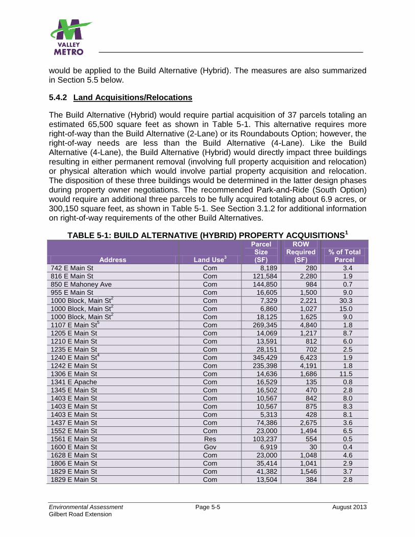
Environmental Assessment Page 5-5 August 2013
Gilbert Road Extension
would be applied to the Build Alternative (Hybrid). The measures are also summarized in Section 5.5 below.
5.4.2 Land Acquisitions/Relocations
The Build Alternative (Hybrid) would require partial acquisition of 37 parcels totaling an estimated 65,500 square feet as shown in Table 5-1. This alternative requires more right-of-way than the Build Alternative (2-Lane) or its Roundabouts Option; however, the right-of-way needs are less than the Build Alternative (4-Lane). Like the Build Alternative (4-Lane), the Build Alternative (Hybrid) would directly impact three buildings resulting in either permanent removal (involving full property acquisition and relocation) or physical alteration which would involve partial property acquisition and relocation. The disposition of these three buildings would be determined in the latter design phases during property owner negotiations. The recommended Park-and-Ride (South Option) would require an additional three parcels to be fully acquired totaling about 6.9 acres, or 300,150 square feet, as shown in Table 5-1. See Section 3.1.2 for additional information on right-of-way requirements of the other Build Alternatives.
TABLE 5-1: BUILD ALTERNATIVE (HYBRID) PROPERTY ACQUISITIONS1
Address Land Use3
Parcel Size (SF)
ROW Required
(SF) % of Total
Parcel
742 E Main St Com 8,189 280 3.4
816 E Main St Com 121,584 2,280 1.9
850 E Mahoney Ave Com 144,850 984 0.7
955 E Main St Com 16,605 1,500 9.0
1000 Block, Main St2 Com 7,329 2,221 30.3
1000 Block, Main St2 Com 6,860 1,027 15.0
1000 Block, Main St2 Com 18,125 1,625 9.0
1107 E Main St5 Com 269,345 4,840 1.8
1205 E Main St Com 14,069 1,217 8.7
1210 E Main St Com 13,591 812 6.0
1235 E Main St Com 28,151 702 2.5
1240 E Main St4 Com 345,429 6,423 1.9
1242 E Main St Com 235,398 4,191 1.8
1306 E Main St Com 14,636 1,686 11.5
1341 E Apache Com 16,529 135 0.8
1345 E Main St Com 16,502 470 2.8
1403 E Main St Com 10,567 842 8.0
1403 E Main St Com 10,567 875 8.3
1403 E Main St Com 5,313 428 8.1
1437 E Main St Com 74,386 2,675 3.6
1552 E Main St Com 23,000 1,494 6.5
1561 E Main St Res 103,237 554 0.5
1600 E Main St Gov 6,919 30 0.4
1628 E Main St Com 23,000 1,048 4.6
1806 E Main St Com 35,414 1,041 2.9
1829 E Main St Com 41,382 1,546 3.7
1829 E Main St Com 13,504 384 2.8
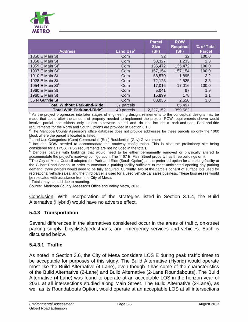
Environmental Assessment Page 5-6 August 2013
Gilbert Road Extension
Address Land Use3
Parcel Size (SF)
ROW Required
(SF) % of Total
Parcel
1850 E Main St Com 32 32 100.0
1858 E Main St Com 53,327 1,233 2.3
1859 E Main St6 Com 135,472 135,472 100.0
1907 E Main St6 Com 157,154 157,154 100.0
1910 E Main St Com 58,570 1,895 3.2
1928 E Main St Com 72,125 2,525 3.5
1954 E Main St6 Com 17,016 17,016 100.0
1960 E Main St Com 5,041 97 1.9
1960 E Main St Com 15,899 178 1.1
35 N Guthrie St Com 88,035 2,650 3.0
Total Without Park-and-Ride7
37 parcels 65,497
Total With Park-and-Ride6,7
40 parcels 2,227,152 359,562 1 As the project progresses into later stages of engineering design, refinements to the conceptual designs may be
made that could alter the amount of property needed to implement the project. ROW requirements shown would involve partial acquisitions only unless otherwise stated and do not include a park-and-ride. Park-and-ride requirements for the North and South Options are provided in Section 3.1.3. 2 The Maricopa County Assessor’s office database does not provide addresses for these parcels so only the 1000
block where the parcel is located is listed. 3 Land Use Categories: (Com) Commercial, (Res) Residential, (Gov) Government
4 Includes ROW needed to accommodate the roadway configuration. This is also the preliminary site being
considered for a TPSS. TPSS requirements are not included in the totals.
5 Denotes parcels with buildings that would need to be either permanently removed or physically altered to
accommodate the project’s roadway configuration. The 1107 E. Main Street property has three buildings on it. 6
The City of Mesa Council adopted the Park-and-Ride (South Option) as the preferred option for a parking facility at the Gilbert Road Station. In order to construct a parking facility sufficient to meet anticipated opening day parking demand, three parcels would need to be fully acquired. Currently, two of the parcels consist of surface lots used for recreational vehicle sales, and the third parcel is used for a used vehicle car sales business. These businesses would be relocated with assistance from the City of Mesa. 7 Totals may not add due to rounding.
Source: Maricopa County Assessor’s Office and Valley Metro, 2013.
Conclusion: With incorporation of the strategies listed in Section 3.1.4, the Build Alternative (Hybrid) would have no adverse effect.
5.4.3 Transportation
Several differences in the alternatives considered occur in the areas of traffic, on-street parking supply, bicyclists/pedestrians, and emergency services and vehicles. Each is discussed below.
5.4.3.1 Traffic
As noted in Section 3.6, the City of Mesa considers LOS E during peak traffic times to be acceptable for purposes of this study. The Build Alternative (Hybrid) would operate most like the Build Alternative (4-Lane), even though it has some of the characteristics of the Build Alternative (2-Lane) and Build Alternative (2-Lane Roundabouts). The Build Alternative (4-Lane) was found to operate at an acceptable LOS in the horizon year of 2031 at all intersections studied along Main Street. The Build Alternative (2-Lane), as well as its Roundabouts Option, would operate at an acceptable LOS at all intersections
Environmental Assessment Page 5-7 August 2013
Gilbert Road Extension
with the exception of Main Street/Stapley Drive. That intersection would operate at LOS F during peak periods. Because the Build Alternative (Hybrid) would be widened to four lanes in the vicinity of Stapley Drive, this alternative is expected to operate at an acceptable LOS at all intersections similar to the Build Alternative (4-Lane).
Conclusion: Build Alternative (Hybrid) is not anticipated to have any adverse effects on traffic intersection LOS.
The Build Alternative (Hybrid) offers roundabouts at two of the intersections (Horne and Harris) also identified in the Build Alternative (2-Lane roundabouts).
Conclusion: Build Alternative (Hybrid) would be beneficial for vehicle U-turn movements at the two intersections with roundabouts and would not result in an adverse effect as identified in Section 3.6.2.2.
5.4.3.2 On-Street Parking
The existing Main Street configuration contains 212 on-street parking spaces, of which the Build Alternative (Hybrid) design will maintain approximately 92 on-street parking spaces. As the project is refined in the later stages of project development and design, it may be possible to retain more on-street parking spaces. Comparatively, the Build Alternative (4-Lane) would remove all 212 spaces leaving no on-street parking; the Build Alternative (2-Lane) would maintain 92 spaces; and the Build Alternative (2-Lane Roundabouts) would maintain 149 spaces. As noted in Section 3.6.2, none of the alternatives would result in an adverse impact to on-street parking because businesses along Main Street tend to have proprietary off-street parking, and the on-street parking primarily serves as a convenience to business patrons.
Conclusion: Build Alternative (Hybrid) would have no adverse effect to provision of on-street parking.
5.4.3.3 Bicyclists/Pedestrians
The main issues related to the Build Alternative (Hybrid) are the same as that of the Build Alternative (2-Lane Roundabouts) as discussed in Section 3.6.2.2 and have to do with the roundabouts’ current design. Note that the Build Alternative (Hybrid) incorporates roundabouts at two intersections while the Build Alternative (2-Lane Roundabouts) uses roundabouts at five intersections. The bicycle lanes should be dropped on the approach to the roundabout intersections to minimize potential conflicts between bicyclists and vehicles turning right to exit the roundabout. Bicyclists could either merge into the stream of motorized traffic or move to and from the sidewalk with pedestrians. Also, the roundabouts’ crosswalks would be designed differently than typical signalized intersections and be set back away from the intersection location, and the Main Street crossings would be signalized. The current crossing design would require a substantial “out-of-direction” path.
Environmental Assessment Page 5-8 August 2013
Gilbert Road Extension
Conclusion: With incorporation of the strategies listed in Section 3.6.4, the Build Alternative (Hybrid) would have no adverse effect on pedestrians or bicyclists.
5.4.3.4 Emergency Services and Vehicles
Like all the Build Alternatives, including the Roundabouts Option, the Build Alternative (Hybrid) could affect emergency service provider response because of reduced left-turn access across the light rail trackway. The Build Alternative (2-Lane) and its Roundabouts Option would also potentially reduce response time due to increased peak hour congestion along Main Street. However, the Build Alternative (Hybrid), like the Build Alternative (4-Lane), would not result in unacceptable congestion levels along Main Street, a condition that can slow response times. Conclusion: With incorporation of the strategies listed in Section 3.6.4, the Build Alternative (Hybrid) would have no adverse effect on emergency services and vehicles. 5.4.4 Noise
Based on a comparison of the traffic and LRT configurations and operational characteristics of the previous alternatives evaluated in Section 3.8.2, the potential noise impacts of the Build Alternative (Hybrid) were estimated. The potential impacts of this alternative are:
Like the Build Alternative (4-Lane), the hybrid alternative will result in a moderate impact per FTA criteria on the unnamed motel and Frontier Motel.
Like the Build Alternative (2-Lane Roundabouts), the hybrid alternative will result in a moderate impact per FTA criteria on the Shady Grove Trailer Park. However, because the LRT trackway is shifted somewhat north (further away from the trailer park) for the Build Alternative (Hybrid), the projected LRT sound levels may actually be somewhat less than that projected for the Build Alternative (2-Lane Roundabouts).
This alternative, like all the other Build Alternatives, would not result in a noise impact that FTA defines as severe, also considered significant per NEPA. For moderate noise impacts, FTA requires consideration of measures to mitigate the impact but also indicates that other factors may be considered to determine their feasibility for implementation. For the motels, the use of sound walls is not feasible because the walls must be continuous, with no breaks for driveways, to be effective, meaning the walls would block access to the motels. No mitigation is recommended for the moderate impacts at the motels. For the Shady Grove Trailer Park, relocating the mobile homes within 140 feet of the near track to a farther distance or moving the mobile homes to another trailer park in the general area would eliminate the impact. These measures would be explored during project development to determine if either is feasible. Conclusion: Build Alternative (Hybrid) would have no adverse noise impacts.
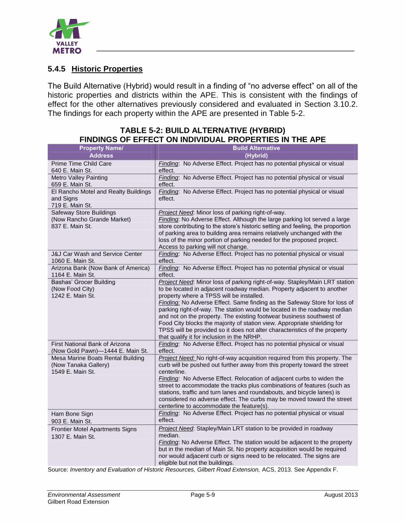
Environmental Assessment Page 5-9 August 2013
Gilbert Road Extension
5.4.5 Historic Properties
The Build Alternative (Hybrid) would result in a finding of “no adverse effect” on all of the historic properties and districts within the APE. This is consistent with the findings of effect for the other alternatives previously considered and evaluated in Section 3.10.2. The findings for each property within the APE are presented in Table 5-2.
TABLE 5-2: BUILD ALTERNATIVE (HYBRID) FINDINGS OF EFFECT ON INDIVIDUAL PROPERTIES IN THE APE Property Name/
Address
Build Alternative
(Hybrid)
Prime Time Child Care 640 E. Main St.
Finding: No Adverse Effect. Project has no potential physical or visual effect.
Metro Valley Painting 659 E. Main St.
Finding: No Adverse Effect. Project has no potential physical or visual effect.
El Rancho Motel and Realty Buildings and Signs 719 E. Main St.
Finding: No Adverse Effect. Project has no potential physical or visual effect.
Safeway Store Buildings (Now Rancho Grande Market) 837 E. Main St.
Project Need: Minor loss of parking right-of-way. Finding: No Adverse Effect. Although the large parking lot served a large store contributing to the store’s historic setting and feeling, the proportion of parking area to building area remains relatively unchanged with the loss of the minor portion of parking needed for the proposed project. Access to parking will not change.
J&J Car Wash and Service Center 1060 E. Main St.
Finding: No Adverse Effect. Project has no potential physical or visual
effect.
Arizona Bank (Now Bank of America) 1164 E. Main St.
Finding: No Adverse Effect. Project has no potential physical or visual effect.
Bashas’ Grocer Building (Now Food City) 1242 E. Main St.
Project Need: Minor loss of parking right-of-way. Stapley/Main LRT station to be located in adjacent roadway median. Property adjacent to another property where a TPSS will be installed. Finding: No Adverse Effect. Same finding as the Safeway Store for loss of
parking right-of-way. The station would be located in the roadway median and not on the property. The existing footwear business southwest of Food City blocks the majority of station view. Appropriate shielding for TPSS will be provided so it does not alter characteristics of the property that qualify it for inclusion in the NRHP.
First National Bank of Arizona (Now Gold Pawn)—1444 E. Main St.
Finding: No Adverse Effect. Project has no potential physical or visual effect.
Mesa Marine Boats Rental Building (Now Tanaka Gallery) 1549 E. Main St.
Project Need: No right-of-way acquisition required from this property. The curb will be pushed out further away from this property toward the street centerline. Finding: No Adverse Effect. Relocation of adjacent curbs to widen the
street to accommodate the tracks plus combinations of features (such as stations, traffic and turn lanes and roundabouts, and bicycle lanes) is considered no adverse effect. The curbs may be moved toward the street centerline to accommodate the feature(s).
Ham Bone Sign
903 E. Main St.
Finding: No Adverse Effect. Project has no potential physical or visual effect.
Frontier Motel Apartments Signs
1307 E. Main St.
Project Need: Stapley/Main LRT station to be provided in roadway median. Finding: No Adverse Effect. The station would be adjacent to the property but in the median of Main St. No property acquisition would be required nor would adjacent curb or signs need to be relocated. The signs are eligible but not the buildings.
Source: Inventory and Evaluation of Historic Resources, Gilbert Road Extension, ACS, 2013. See Appendix F.
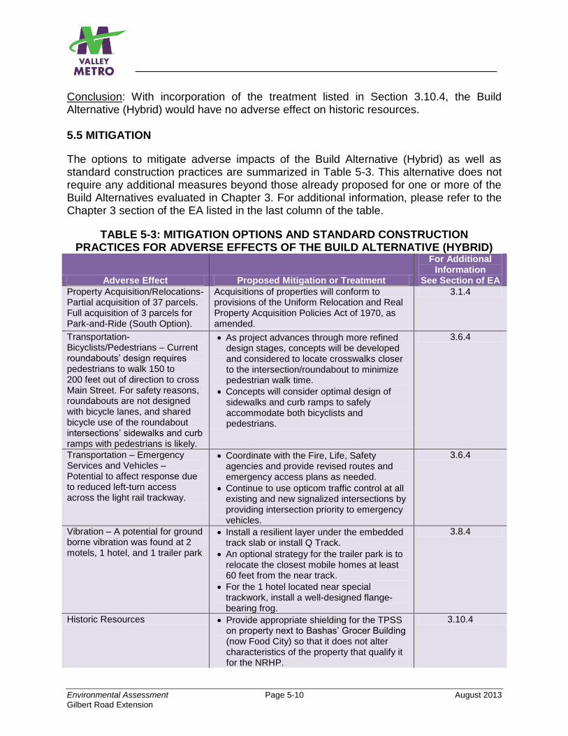
Environmental Assessment Page 5-10 August 2013
Gilbert Road Extension
Conclusion: With incorporation of the treatment listed in Section 3.10.4, the Build Alternative (Hybrid) would have no adverse effect on historic resources. 5.5 MITIGATION
The options to mitigate adverse impacts of the Build Alternative (Hybrid) as well as standard construction practices are summarized in Table 5-3. This alternative does not require any additional measures beyond those already proposed for one or more of the Build Alternatives evaluated in Chapter 3. For additional information, please refer to the Chapter 3 section of the EA listed in the last column of the table.
TABLE 5-3: MITIGATION OPTIONS AND STANDARD CONSTRUCTION PRACTICES FOR ADVERSE EFFECTS OF THE BUILD ALTERNATIVE (HYBRID)
Adverse Effect Proposed Mitigation or Treatment
For Additional Information
See Section of EA
Property Acquisition/Relocations- Partial acquisition of 37 parcels. Full acquisition of 3 parcels for Park-and-Ride (South Option).
Acquisitions of properties will conform to provisions of the Uniform Relocation and Real Property Acquisition Policies Act of 1970, as amended.
3.1.4
Transportation-Bicyclists/Pedestrians – Current roundabouts’ design requires pedestrians to walk 150 to 200 feet out of direction to cross Main Street. For safety reasons, roundabouts are not designed with bicycle lanes, and shared bicycle use of the roundabout intersections’ sidewalks and curb ramps with pedestrians is likely.
As project advances through more refined design stages, concepts will be developed and considered to locate crosswalks closer to the intersection/roundabout to minimize pedestrian walk time.
Concepts will consider optimal design of sidewalks and curb ramps to safely accommodate both bicyclists and pedestrians.
3.6.4
Transportation – Emergency Services and Vehicles – Potential to affect response due to reduced left-turn access across the light rail trackway.
Coordinate with the Fire, Life, Safety agencies and provide revised routes and emergency access plans as needed.
Continue to use opticom traffic control at all existing and new signalized intersections by providing intersection priority to emergency vehicles.
3.6.4
Vibration – A potential for ground borne vibration was found at 2 motels, 1 hotel, and 1 trailer park
Install a resilient layer under the embedded track slab or install Q Track.
An optional strategy for the trailer park is to relocate the closest mobile homes at least 60 feet from the near track.
For the 1 hotel located near special trackwork, install a well-designed flange-bearing frog.
3.8.4
Historic Resources Provide appropriate shielding for the TPSS on property next to Bashas’ Grocer Building (now Food City) so that it does not alter characteristics of the property that qualify it for the NRHP.
3.10.4
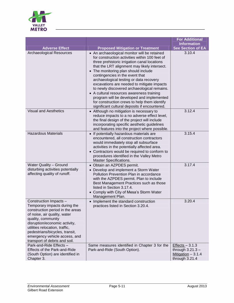
Environmental Assessment Page 5-11 August 2013
Gilbert Road Extension
Adverse Effect Proposed Mitigation or Treatment
For Additional Information
See Section of EA
Archaeological Resources An archaeological monitor will be retained for construction activities within 100 feet of three prehistoric irrigation canal locations that the LRT alignment may likely intersect.
The monitoring plan should include contingencies in the event that archaeological testing or data recovery excavations are needed to mitigate impacts to newly discovered archaeological remains.
A cultural resources awareness training program will be developed and implemented for construction crews to help them identify significant cultural deposits if encountered.
3.10.4
Visual and Aesthetics Although no mitigation is necessary to reduce impacts to a no adverse effect level, the final design of the project will include incorporating specific aesthetic guidelines and features into the project where possible.
3.12.4
Hazardous Materials If potentially hazardous materials are encountered, all construction contractors would immediately stop all subsurface activities in the potentially affected area.
Contractors would be required to conform to procedures identified in the Valley Metro Master Specifications.
3.15.4
Water Quality – Ground disturbing activities potentially affecting quality of runoff.
Obtain an AZPDES permit.
Develop and implement a Storm Water Pollution Prevention Plan in accordance with the AZPDES permit. Plan to include Best Management Practices such as those listed in Section 3.17.4.
Comply with City of Mesa’s Storm Water Management Plan.
3.17.4
Construction Impacts – Temporary impacts during the construction period in the areas of noise, air quality, water quality, community disruption/economic activity, utilities relocation, traffic, pedestrians/bicycles, transit, emergency vehicle access, and transport of debris and soil.
Implement the standard construction practices listed in Section 3.20.4.
3.20.4
Park-and-Ride Effects – Effects of the Park-and-Ride (South Option) are identified in Chapter 3.
Same measures identified in Chapter 3 for the Park-and-Ride (South Option).
Effects – 3.1.3 through 3.21.3 – Mitigation – 3.1.4 through 3.21.4

Page Intentionally Left Blank
Environmental Assessment Page 6-1 August 2013
Gilbert Road Extension
6.0 HOW MUCH WILL THE PREFERRED ALTERNATIVE COST AND HOW WILL IT BE FUNDED?
This chapter provides the estimated capital and operating costs associated with construction and operation of the PA for the Gilbert Road Extension project, and also discusses the federal and local financial resources used to construct and operate the proposed project. The estimated total capital cost of the Gilbert Road Extension PA is approximately $143 million. This estimate reflects the year of expenditure costs for the project and is based on the current project schedule that forecasts construction beginning in early 2015. The City of Mesa intends to use previously appropriated federal Surface Transportation Program (STP) and Congestion Mitigation and Air Quality Improvement Program (CMAQ) funds to help pay for the majority (about 94.3 percent) of the construction of the Gilbert Road Extension project. The STP funds amount to approximately 82.7 percent, and the CMAQ funds amount to approximately 11.6 percent of the capital cost for the project. Working with the Maricopa Association of Governments (MAG), the City of Mesa identified sixteen roadway improvement projects for which Surface Transportation Program (STP) funds had been previously committed. These projects were considered either low priority projects for the city, no longer necessary, or already completed. For these reasons, the City of Mesa approved (with MAG concurrence) the re-purposing of these federal funds for use in constructing the Gilbert Road Extension project. The re-purposing of these funds was also approved by the Maricopa County Board of Supervisors, and the State Transportation Board. Approximately 5.7 percent of the funds for capital costs for this project would come from the City of Mesa as a local match. No funds from the State of Arizona will be used for this project. The estimated annual operating cost for the PA is approximately $3.2 million. Approximately 72 percent of the funds that will be used for the PA are expected to come from the City of Mesa General Fund. Farebox revenue is anticipated to cover the remaining 28 percent of the operating costs. Valley Metro estimates the farebox revenues are a conservative share due to the large number of fare media and employer, school, and special event programs available to riders. Forecasts of farebox revenue recovery between fiscal years 2013 and 2017, based on anticipated ridership and future changes in fares, suggest a system revenue recovery of approximately 33%.

Page Intentionally Left Blank
Environmental Assessment Page 7-1 August 2013
Gilbert Road Extension
7.0 SOURCES AND REFERENCES CITED EXECUTIVE SUMMARY Council on Environmental Quality Regulations (40 Code of Federal Regulations [CFR] 1500). 1978. Regulations for Implementing the Procedural Provisions of the National Environmental Policy Act (NEPA). Available online: http://ceq.hss.doe.gov/ceq_regulations/regulations.html Federal Transit Administration (FTA)/Federal Highway Administration (FHWA) regulations (23 CFR 771). 2013. Environmental Impact and Related Procedures. Maricopa Association of Governments. 2010. Regional Transportation Plan, 2010 Update. Valley Metro. May, 2012. Gilbert Road LRT Extension Planning Study, Final Report. CHAPTER 1 Maricopa Association of Governments. 2010. Regional Transportation Plan, 2010 Update. Valley Metro (Formerly Valley Metro Rail, Inc). May, 2012. Gilbert Road LRT Extension Planning Study, Final Report. CHAPTER 2 Maricopa Association of Governments. 2010. Regional Transportation Plan, 2010 Update. Valley Metro. May, 2012. Gilbert Road LRT Extension Planning Study, Final Report. CHAPTER 3 16 USC 4601. Public Law 88-578. Land and Water Conservation Fund Act of 1965. 42 USC Section 7401 et seq. November 15, 1990. Clean Air Act of 1990, as amended. 49 USC 1653(f) (Later amended to Section 303). Public Law 89-670. Department of Transportation Act of 1966.
42 USC Chapter 61. Public Law 91-646. Uniform Relocation Assistance and Real Property Acquisition Policies Act of 1970.
Environmental Assessment Page 7-2 August 2013
Gilbert Road Extension
16 USC 470, Section 106. Public Law 89-665. National Historic Preservation Act of 1966. 16 USC 668-668d. 1940. Bald and Golden Eagle Protection Act. Arizona Game and Fish Department. 2012. Online Environmental Review Tool. Available online at http://www.azgfd.gov/hgis/. Archeological Consulting Services. 2013. Inventory and Evaluation of Historic Resources. Refer to Appendix F. ATS Consultants. 2012. Table 3-14: Comparison of Potential Noise and Vibration Impacts. ATS Consultants. December, 2012. Noise and Vibration Technical Report. Refer to Appendix E. Cari Anderson Consulting. December, 2012. Gilbert Road Extension Air Quality Technical Report. Refer to Appendix D. City of Mesa. 2002. Mesa General Plan. City of Mesa. 2002. Mesa Transportation Plan. City of Mesa. 2012. Central Main Street Plan. City of Mesa. 2012. Draft Bicycle Master Plan. City of Mesa. 1996-2010. Traffic Volume Maps. City of Mesa. 2012. Title XI - Zoning Ordinance. Environmental Database Resource (EDR), and HDR, Inc. 2012. Table 3-19: High Risk Sites of Potential Concern. Federal Transit Administration, Office of Planning and Environment. May, 2006. Transit Noise and Vibration Impact Assessment. Document FTA-VA-90-1003-06. Forrest, R. (Valley Metro). 2012. Memo to Project Files, re: Gilbert Road Extension Project: Section 4(f) Technical Memo. Refer to Appendix G. Forrest, R. (Valley Metro). 2013. Memo to Project Files, re: Gilbert Road Extension Project: Environmental Justice Technical Memorandum. Refer to Appendix I.
Environmental Assessment Page 7-3 August 2013
Gilbert Road Extension
Grijalva Engineering, and HDR, Inc. 2012. Transportation Technical Report. Refer to Appendix C. HDR, Inc. 2012. Gilbert Road Extension: Preliminary Initial Site Assessment. Refer to Appendix J. HDR, Inc. 2012. Comparison of Visual Unit Characteristics. HDR, Inc. 2012. Trafficware Synchro 7 Traffic Analysis Report. Maricopa County Assessor’s Office. 2012. Maricopa County Assessor GIS Online Data. The Flood Control District of Maricopa County. Historic Aerial Photographs, 1937 and 1969. Available through the Flood Control District of Maricopa County GIS Portal, http://www.fcd.maricopa.gov/GIS/gis.aspx. Maricopa Association of Governments. 2009. MAG Regional Land Use Shapefile. Maricopa Association of Governments. 2010. Regional Transportation Plan, 2010 Update. Maricopa Association of Governments. 2010. Regional Transit Framework Study. More, A. (HDR, Inc.). 2012. Memo to Forrest, R. re: Gilbert Road Extension: Park-and-Ride Facility Size Recommendations. Refer to Appendix B. Paty, L. (HDR, Inc.). 2012. Memo to Forrest, R. re: Gilbert Road Extension Environmental Assessment: Visual and Aesthetics Evaluation. Refer to Appendix H. Valley Metro. 2012. Multiple tables throughout the chapter. Valley Metro. 2001. Central Phoenix/East Valley Light Rail Transit Project Urban Design Guidelines. U.S. Department of Transportation, Federal Transit Administration. 2012. Advisory Circular 4703.1, Environmental Justice Policy Guidance for Federal Transit Administration Recipients. U.S. Census Bureau. 2010. American FactFinder, 2010 Decennial Census. U.S. Census Bureau. 2012. 2006-2010 American Community Survey 5-year Estimates.
Environmental Assessment Page 7-4 August 2013
Gilbert Road Extension
U.S. Fish and Wildlife Service. 2012. Endangered Species online database. Available online at http://www.fws.gov/endangered/.