Embed Size (px)
Citation preview

Evaluating the ecological outcomes of
the Penobscot River Restoration Project
Rory Saunders, Mathias Collins,
Josh Royte, and Tim Sheehan
Northeast Region
January 11, 2013
Diadromous Species Research and Restoration Network, Science Meeting

George Apponte Clark
Barbara Arter
Charlie Baeder
Dan Belknap
Mike Chelminski
Steve Coghlan
Oliver Cox
Richard Dill
David Hart
Dan Hayes
James Hawkes
Alice Kelly
John Kocik
Blaine Kopp
Brandon Kulik
Dan Kusnierz
Dan McCaw
Jeff Murphy
Julie Nieland
Jeff Reardon
Catherine Schmidt
Joan Trial
Tara Trinko Lake
Karen Wilson
Gayle Zydlewski
Joe Zydlewski
Acknowledgements
U.S. Department of Commerce | National Oceanic and Atmospheric Administration | NOAA Fisheries | Page 2

Outline
• Background
• PRRP 101
• Guiding images of success
• Palmer‟s 5 criteria
• Progression of science interests
• Pre-removal snapshots
• Abiotic
• Biotic
• Take Home Messages
U.S. Department of Commerce | National Oceanic and Atmospheric Administration | NOAA Fisheries | Page 3

Take Home Messages
• Right project at the right time?
• Success is no accident
• Scientists should be in communication with implementers and funders
• Plan should be what you need, not what you have
• Socio-economics requires more attention
• We need a mutually agreed upon guiding image…soon.
• If the fish do respond, we will have evidence to show that dam removal works.
• If the fish do not respond, we should be able to figure out why.
• What about the shad?
U.S. Department of Commerce | National Oceanic and Atmospheric Administration | NOAA Fisheries | Page 4

U.S. Department of Commerce | National Oceanic and Atmospheric Administration | NOAA Fisheries | Page 5
Penobscot River
Restoration Project
(PRRP)
• upper basin: storage reservoirs
• ~ 1,600 m relief
• lower basin: run-of-river hydro
• ~ 22,000 km2 watershed
• average annual Q ~ 400 m3/s
0 5 km
N

PiscataquisStillwater Branch
U.S. Department of Commerce | National Oceanic and Atmospheric Administration | NOAA Fisheries | Page 6
PRRP Mainstem
West Enfield
Milford
Great Works
Veazie
Howland
Stillwater
Orono
Gilman Falls diversion
river is tidal for ~40 km to here
USGS 01034500:
~ 110 year record
USGS 01036390:
~ 30 year record 0 5 km
N

U.S. Department of Commerce | National Oceanic and Atmospheric Administration | NOAA Fisheries | Page 7
dam removalfish passage (fp)
fp + eeenhanced energy (ee)
Veazie
2013-14
Great Works
2012!
PRRT
MMI
Milford fish lift 2014
PR
RT
Howland bypass channel
0 5 km
N
PRRP
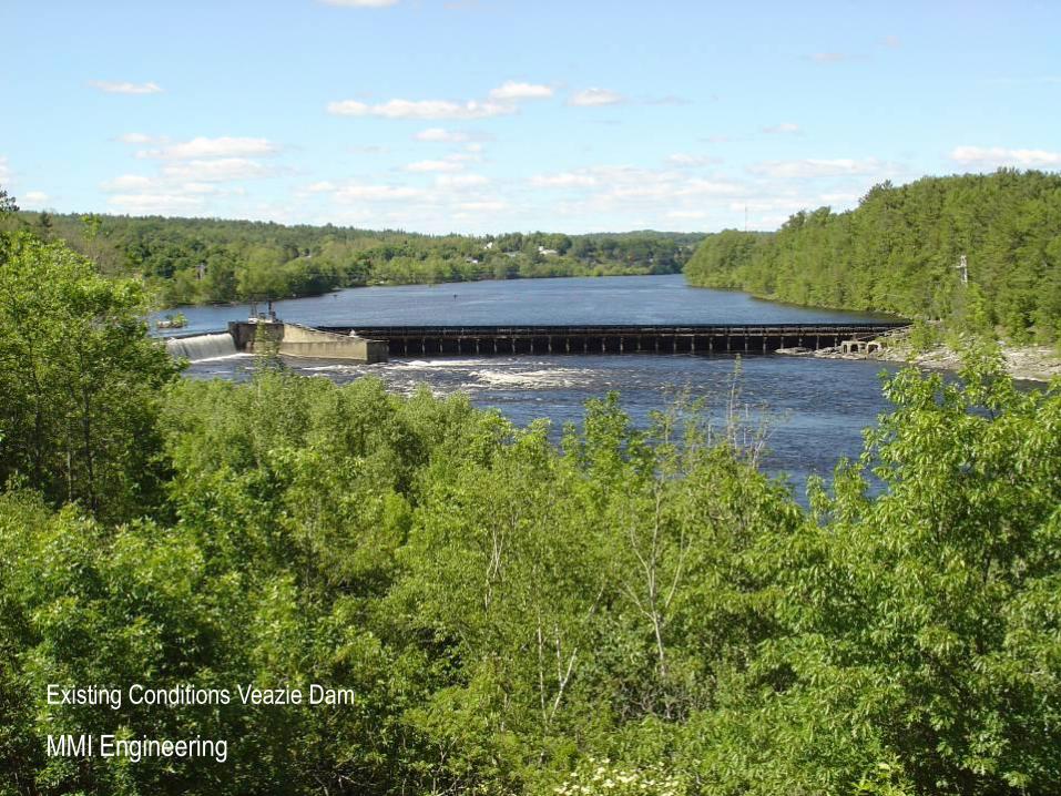
Existing Conditions Veazie Dam
MMI Engineering

Projected Conditions Veazie Dam
MMI Engineering

Existing Conditions Great Works Dam
MMI Engineering
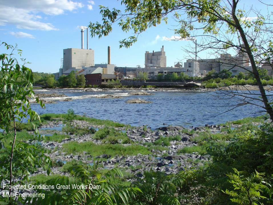
Projected Conditions Great Works Dam
MMI Engineering

Great Works Dam Removal, July 2012
Steve Shepard, USFWS

Project context – why here? Slide courtesy of TNC
U.S. Department of Commerce | National Oceanic and Atmospheric Administration | NOAA Fisheries | Page 13
Num
ber
of d
ams
(Blu
e B
ars)
Wat
ersh
ed s
ize
(mi2 )
• Comparison of rivers in the Northeast U.S.

U.S. Department of Commerce | National Oceanic and Atmospheric Administration | NOAA Fisheries | Page 14

Screen capture 7 January 2013

Open up vs. Improved access
• Let’s take an
objective
look….

Penobscot_HUC12s
Passage?, # Fishways
No
Yes, 5-7
Yes, 4
Yes, 3
Yes, 2
Yes, 1
Yes, 0
Pre- PRRP
Trinko Lake et al. 2012. Marine
and Coastal Fisheries 4:284–
293

Penobscot_HUC12s
Passage?, # Fishways
No
Yes, 5-7
Yes, 4
Yes, 3
Yes, 2
Yes, 1
Yes, 0
Post- PRRP
Trinko Lake et al. 2012. Marine
and Coastal Fisheries 4:284–
293

5-7
0
500
1000
1500
2000
2500
3000
0 1 2 3 4 5
Number of Fishways
Str
ea
m K
ilo
me
ters
Pre-PRRP
5-7
Trinko Lake et al. 2012. Marine and Coastal Fisheries 4:284–293

5-7
Post-PRRP
5-7
0
500
1000
1500
2000
2500
3000
0 1 2 3 4 5
Number of Fishways
Str
ea
m K
ilo
me
ters
Trinko Lake et al. 2012. Marine and Coastal Fisheries 4:284–293

U.S. Department of Commerce | National Oceanic and Atmospheric Administration | NOAA Fisheries | Page 21

• Lower river species (sturgeon, smelt, and striped bass) will regain 100% unimpeded access to historic habitat
• American shad and blueback herring will gain access to over 93% of historic habitat IF they pass up to five fishways (including Milford)
• The majority (66%) of alewife habitat is still inaccessible after implementation of PRRP
• Most habitat for highly migratory species (e.g., salmon) will be above 2-5 dams instead of 4-7 dams
•The science helps us understand:
•The PRRP is a great first step,•The PRRP will open an additional11 miles of habitat AND improve access to 1000s of miles of habitat
•We need to do more in order to see the PRRP live up to its potential.
•We need to do more work on developing the “guiding image”
•If you don’t know what you want, that is about what you get.
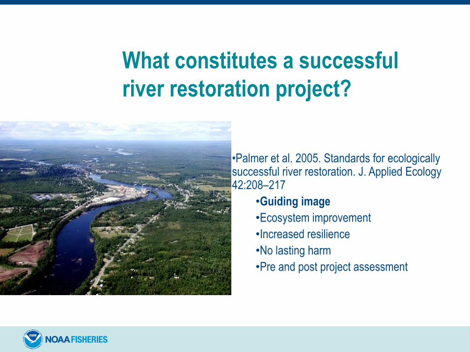
What constitutes a successful
river restoration project?
•Palmer et al. 2005. Standards for ecologically successful river restoration. J. Applied Ecology 42:208–217
•Guiding image
•Ecosystem improvement
•Increased resilience
•No lasting harm
•Pre and post project assessment

• We have come a long way
• Alewife restoration
• Pre-removal science
• Great Works is out
• We should be proud of our accomplishments
• But…we need to do more if the PRRP is to live up to its potential.
U.S. Department of Commerce | National Oceanic and Atmospheric Administration | NOAA Fisheries | Page 25

U.S. Department of Commerce | National Oceanic and Atmospheric Administration | NOAA Fisheries | Page 26
Guiding Image –Penobscot River
Restoration Trust
dam removalfish passage (fp)
fp + eeenhanced energy (ee)
• Improve access to upstream habitat for 6 “upper river” species by reducing barriers;
• Reconnect trophic linkages between headwater areas and the Gulf of Maine;
• Restore natural fluvial processes to the former impoundments;
• Improve recreational and Penobscot Indian Nation cultural opportunities;
• Maintain basin hydropower generation
• Unobstructed access to the entire historic riverine range for 5 “lower river” diadromousspecies (~15 km);
0 5 km
N

U.S. Department of Commerce | National Oceanic and Atmospheric Administration | NOAA Fisheries | Page 27
Guiding Image –Me. Dept. Marine Resources
• Species-specific objectives, measures, and
strategies
•$30M worth of good things to do
• Funding uncertainty
• Regulatory uncertainty
• Staffing changes
• Provide “safe, timely, and effective” passage
• “Part of the difficulty with passage is the
ambiguity in „safe, timely, and effective.‟ There
is no „black and white‟ in the sense that a
facility needs to perform at a standard and if it
does not, alternatives need to be pursued.”
•So how much is enough?

U.S. Department of Commerce | National Oceanic and Atmospheric Administration | NOAA Fisheries | Page 28
Guiding Image – NOAA Fisheries Service
•Salmon-specific performance standards at Black Bear
Hydro‟s remaining dams (Exclusive of the West Branch)
•96% downstream survival, 95% upstream passage
0
1000
2000
3000
4000
5000
6000
7000
8000
Gen 1 Gen 2 Gen 3 Gen 4 Gen 5 Gen 6 Gen 7 Gen 8 Gen 9 Gen 10
Current PRRP SPP Full Passage
MS
W F
emal
es
Guiding Image Needs To Be• Developed soon
• Broad enough to be meaningful
• Specific enough to be useful
• Measurable
• Achievable
• Realistic
• Mutually agreeable
• NGOs
• Agencies• Funding
• Regulatory
• Stakeholders
U.S. Department of Commerce | National Oceanic and Atmospheric Administration | NOAA Fisheries | Page 29

Some ideas for a defensible guiding image• Abundance metrics for “umbrella” species
• MDMR‟s phase 1 goals for alewives• Roughly 3.4M alewives per year to Milford
• Alosines as the engines that make the river work (MDNE)
• Fish community metrics smoothed
• Trophic linkages restored
• Relative biomass of diadromous fish is a cline not a cliff
• Focal species become more resilient (self-sufficient)
• Performance standards will help salmon, but what about the shad?
• Resilience in endangered species?
• Any feedback and discussion is most welcome here
U.S. Department of Commerce | National Oceanic and Atmospheric Administration | NOAA Fisheries | Page 30
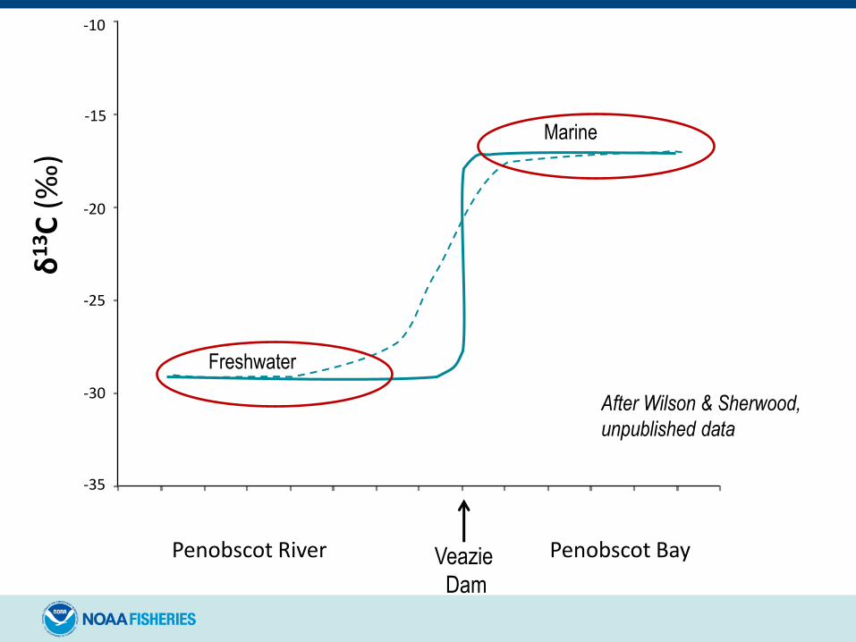
-35
-30
-25
-20
-15
-10
Penobscot Bay
δ1
3C
(‰
)
Veazie
Dam
Penobscot River
After Wilson & Sherwood,
unpublished data
Freshwater
Marine

Why no guiding image to date
• It‟s hard.
• Temporal scale – changing cast of characters.
• Spatial scale – it is a big river with a lot of habitat
and a lot of stakeholders.
• No one is charge.
• No one has done this before.
• PRRP grew out of a settlement agreement.
U.S. Department of Commerce | National Oceanic and Atmospheric Administration | NOAA Fisheries | Page 32

Outline
• Background
• PRRP 101
• Guiding images of success
• Palmer‟s 5 criteria
• Progression of science interests
• Pre-removal snapshots
• Abiotic
• Biotic
• Take Home Messages
U.S. Department of Commerce | National Oceanic and Atmospheric Administration | NOAA Fisheries | Page 33

Progression of science interests• 2002 – USGS and Maine DMR install and operate PIT array – fish migration studies begin
• 2003 – Penobscot Agreement announced
• 2004 – Penobscot Science Forum
• 2005 - 2008 – Penobscot Science Steering Committee (SSC)
• 2005 – Ultrasonic telemetry array installed (NOAA, USGS, and UMaine)
• 2007 – Key publications
• Barrier Removal Monitoring Guide published – Gulf of Maine Council
• Penobscot SSC Monitoring Framework
• 2008
• NOAA Priorities for PRRP Monitoring published
• NOAA and TNC begin substantial investments in monitoring (roughly $100k)
• 2009 - American Recovery and Re-investment Act (ARRA)
• Penobscot River Restoration Trust proposal for Great Works Dam removal ($6.1M)
• $1.3M – Infrastructure, student salary and tuition, PI salary, contracts, etc.
• 2010-Present – ARRA-funded projects underway (TNC and NOAA funding)
• 2012 – Great Works removed
• 2013 – Veazie to be removed and post-removal evaluations to begin
U.S. Department of Commerce | National Oceanic and Atmospheric Administration | NOAA Fisheries | Page 34

Outline
• Background
• PRRP 101
• Guiding images of success
• Palmer‟s 5 criteria
• Progression of science interests
• Pre-removal snapshots
• Abiotic
• Biotic
• Take Home Messages
U.S. Department of Commerce | National Oceanic and Atmospheric Administration | NOAA Fisheries | Page 35
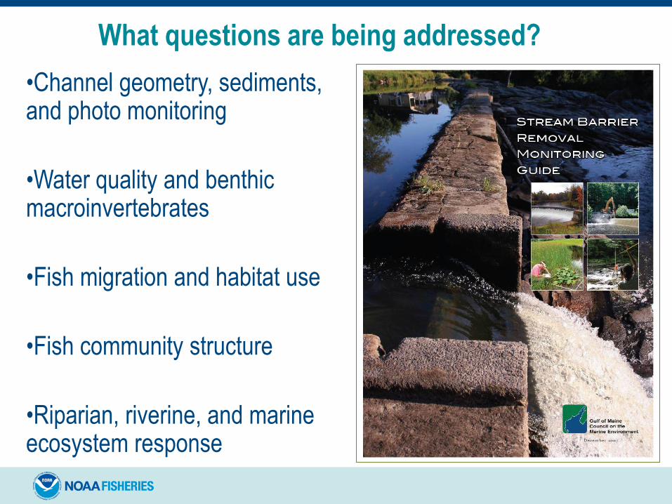
•Channel geometry, sediments, and photo monitoring
•Water quality and benthic macroinvertebrates
•Fish migration and habitat use
•Fish community structure
•Riparian, riverine, and marine ecosystem response
What questions are being addressed?

•Principal Investigator: Alice Kelley, UMaine
•Objectives:
•Sediment grain size distribution survey
•Cross section elevation survey
•Bathymetric survey
•Photographic monitoring stations
Channel geometry, sediments, and photo monitoring

•Principal Investigator: Dan Kusnierz, Penobscot Nation
•Objectives:
•Benthic macroinvertebrate community composition•Maine DEP aquatic life model
•Indices of community structure
•Water quality changes•Temp, DO, conductivity, BOD,
E. coli bacteria, total coliform,
total suspended solids, turbidity,
secchi disc visibility, total P,
chlorophyll a, pH
Water quality and benthic macroinvertebrates

•Principal Investigator: Joseph Zydlewski, USGS
•Objectives:
•Homing efficiency
•Migratory delay at fishways
•Passage rates
•Environmental and operational
variables effecting connectivity
New funding from USGS for radio telemetry!
Upstream passage of diadromous fish

•Principal Investigators: Joseph Zydlewski, USGS
•Objectives:
•Characterize downstream survival
•Focus on areas of higher loss
•Evaluate path choice
•Wild vs hatchery
Downstream passage of salmon

•Principal Investigator: Stephen Coghlan, UMaine
•Objectives:
•Quantify “pre-removal” fish community structure
•Continue and expand 2008 and 2009 data sets (Kleinschmidt Assoc.)
•Spring/Fall sampling on 19 “transects”
Fish community – Upper River

Fish community – Upper River
Figure 9b. Fish assemblage compostiion, biomass
Penobscot River at Milford Tailwater, September 2008
56%
14%
8%
6%
4%
4%4%
3%
smallmouth bass adult
redbreast sunfish adult
American eel adult
fallfish adult
white sucker juvenile
smallmouth bass juvenile
smallmouth bass YOY
common shiner juvenile
other*
*common shiner adult, fallfish juvenile, redbreast sunfish YOY, white sucker YOY
After Kulik et al 2008. Kleinschmidt Associates

Fish community – Upper RiverFigure 13b. Fish assemblage composition - biomass
Penobscot River at Veazie tailwater, September 2008
39%
20%
13%
11%
9%
4%
Atlantic salmon adult
Striped bass adult
American eel juvenile
white sucker adult
smallmouth bass adult
white sucker juvenile
smallmouth bass juvenile
chain pickerel adult
redbreast sunfish adult
other*
*smallmouth bass YOY, redbreast sunfish juvenile, fallfish adult & YOY, pumpkinseed adult,
golden shiner adult, banded killifish adult, American eel elver
After Kulik et al 2008. Kleinschmidt Associates

Riparian, riverine, and marine ecosystem
response
• Assessing Marine‐Freshwater Food Web Linkages Using Stable Isotopes – Wilson and Sherwood, GMRI
• More trophic levels =• more diverse predator‐prey interactions
• greater prey availability
• greater ecosystem complexity (i.e., more pathways for food web interactions)
• Wetland and Riparian Habitat Mapping – Boyle and associates
• Bird Community Monitoring – Hunter and Call, UMaine
• Estuarine Fish Community Monitoring – Lipsky, O‟Malley, Stevens, Kocik, and Saunders; NOAA

What about the shad?
• Prior to 2008 (MDMR 2008), no one had looked.
• Now we know:
• Adult shad are present (Ann Grote, unpublished data)
• Shad are successfully reproducing in the lower Penobscot River (Christine Lipsky, unpublished data)
• American shad will have access to 93% of their historic habitat IF they pass Milford and West Enfield (Trinko Lake et al. 2012)
• Fishways that “pass” shad (Haro and Castro-Santos 2012)
• Artificial propagation (Hasselman and Limburg 2012)
U.S. Department of Commerce | National Oceanic and Atmospheric Administration | NOAA Fisheries | Page 45

Take Home Messages
• Right project at the right time?
• Success is no accident
• Scientists should be in communication with implementers and funders
• Plan should be what you need, not what you have
• Socio-economics requires more attention
• We need a mutually agreed upon guiding image…soon.
• If the fish do respond, we will have evidence to show that dam removal works.
• If the fish do not respond, we should be able to figure out why.
• What about the shad?
U.S. Department of Commerce | National Oceanic and Atmospheric Administration | NOAA Fisheries | Page 46

George Apponte Clark
Barbara Arter
Charlie Baeder
Dan Belknap
Mike Chelminski
Steve Coghlan
Oliver Cox
Richard Dill
David Hart
Dan Hayes
James Hawkes
Alice Kelly
John Kocik
Blaine Kopp
Brandon Kulik
Dan Kusnierz
Dan McCaw
Jeff Murphy
Julie Nieland
Jeff Reardon
Catherine Schmidt
Joan Trial
Tara Trinko Lake
Karen Wilson
Gayle Zydlewski
Joe Zydlewski
Acknowledgements
U.S. Department of Commerce | National Oceanic and Atmospheric Administration | NOAA Fisheries | Page 47

Slide Title
• List item 1
• List item 2
U.S. Department of Commerce | National Oceanic and Atmospheric Administration | NOAA Fisheries | Page 48

Slide Title
• List item 1
• List item 2
U.S. Department of Commerce | National Oceanic and Atmospheric Administration | NOAA Fisheries | Page 49

Slide Title
• List item 1
• List item 2
U.S. Department of Commerce | National Oceanic and Atmospheric Administration | NOAA Fisheries | Page 50

Slide Title
• List item 1
• List item 2
U.S. Department of Commerce | National Oceanic and Atmospheric Administration | NOAA Fisheries | Page 51

U.S. Department of Commerce | National Oceanic and Atmospheric Administration | NOAA Fisheries | Page 52
Guiding Image –Me. Dept. Marine Resources
Species-specific objectives, measures, and
strategies
17.1 Measure: Improve upstream and
downstream fish passage effectiveness at
tributary dams for juvenile and adult Atlantic
salmon within 10 years.
17.1.1 Strategy: Review FERC licenses,
exemptions and MPA
17.1.2 Strategy: Review need/process to install
or improve fish passage facilities at FERC non-
jurisdictional dams
17.1.3 Strategy: Review existing studies and
information
17.1.5 Strategy: Undertake fish passage
improvements
17.1.6 Strategy: Assess fish passage
improvements

U.S. Department of Commerce | National Oceanic and Atmospheric Administration | NOAA Fisheries | Page 53
Guiding Image –
Diadromous fish objectives
Species-specific objectives, measures, and strategies
6.0 Objective: Restore alewife populations to self-sustaining levels in historical habitat within 48 years.
6.1 Measure: Restore populations to 13 Phase 1 historical lakes in 16 years (four generations) or less
beginning in 2010 or 2011.
6.1.3 Strategy: Stock approximately six adult alewives per surface acre (97,500 total) in Phase 1 lakes
annually from 2010 (2011) to 2026 (2027) or until annual return rates to each lake are at least 35 adult
per acre for four successive years, which equals annual adult returns at Milford of at least 532,000 fish.
6.1.5 Strategy: Assess and improve if needed upstream and downstream passage at barriers (with
cross-reference to other sections of the plan).
6.2 Measure: Restore populations to 18-22 historical lakes (Table 1; Fig. 1) approximately every 16 years
after annual return rates to each Phase1 lake is at least 35 adult per acre for four successive years.
6.2.1 Strategy: Use computer model (e.g., USFWS barrier model) to prioritizeremaining lakes to be
stocked by lake size, trophic status, number of downstream hydropower and nonhydropower dams,
potential natural barriers, and distance to the ocean or to Milford Dam.


![Outcomes from the ‘Resilient Tenerife’ Workshop: a ... · Ruth Acosta Trujillo Coordinadora Ecologista El Rincón [‘El Rincón’ ecological organisation] 4 . 5 ‘We vote once](https://img.pdfslide.net/doc/110x75/5e92613acbaaf76b9273c017/outcomes-from-the-aresilient-tenerifea-workshop-a-ruth-acosta-trujillo.jpg)