Embed Size (px)
Citation preview
EVALUATING THE EFFECTIVENESS OF BURNED AREA EMERGENCY RESPONSE (BAER) EFFORTS AFTER THE 2003 WILDFIRES, SOUTHERN CALIFORNIA Peter M. Wohlgemuth, Pacific Southwest Research Station, USDA Forest Service, Riverside, CA [email protected] R. Hubbert, Hubbert and Associates, Apple Valley, CA [email protected] L. Beyers, Pacific Southwest Research Station, USDA Forest Service, Riverside, CA [email protected] R. Weise, Pacific Southwest Research Station, USDA Forest Service, Riverside, CA [email protected] ABSTRACT Wildfires burned approximately 300,000 hectares (750,000 acres) across southern California in the fall of 2003. Over 10 million dollars were spent on Burned Area Emergency Response (BAER) treatments following these fires. To support the BAER efforts, we designed a comprehensive strategy with standardized protocols to evaluate the effectiveness of various erosion control techniques. Road treatments, to control runoff and protect the roadbed, were monitored using photo points. Hillslope treatments, to control runoff and surface erosion from the hillsides, were monitored using repeat photography and silt fences to measure erosion from both treated and untreated plots. Stream channel treatments, to control scour and trap transported sediment, were monitored using photo points. Results indicate that the road treatments were generally successful. Straw mulching applied both by hand and aerially, was an effective erosion control technique if the straw was not first removed by wind erosion. Fiber rolls controlled erosion on the hillsides, but not in swales or drainages. Aerial hydromulch, both complete coverage and 50 percent strips, reduced hillslope erosion compared to untreated controls. Channel treatments, both straw bale check dams and log check dams, trapped some sediment, but were prone to failure and were unable to prevent subsequent downstream channel scour. KEYWORDS Erosion control, erosion monitoring, post-fire erosion, BAER treatments, wildfires INTRODUCTION The wildfires that began in late October 2003 consumed more than 300,000 hectares (750,000 acres) across southern California (Figure 1). Wildfire can dramatically alter the erosion response of upland landscapes by removing the protective vegetation canopy and surface organic material. In addition, the combustion of soil organic matter can create a subsurface water-repellent layer that restricts infiltration and promotes overland flow (DeBano 1981), enhancing sediment yield (Wells 1981). In southern California, first-year post-fire sediment yield is 35 times greater on average than comparable unburned annual levels (Rowe et al. 1954). Nearly 40 percent of the 2003 southern California burned area is on federal lands, triggering the Burned Area Emergency Response (BAER) program (Robichaud et al. 2000). BAER teams assess the fire damage and determine if rehabilitation treatments are necessary to protect both onsite and downstream life and property; water quality; roads and trails; heritage resources; and threatened or endangered plant and animal species. After the assessment, funds are requested for the implementation of treatments specific to the individual burned areas. Included in this funding request is money to monitor the effectiveness of these erosion control treatments. However, a recent federal General Accounting Office report (GAO 2003) found that current monitoring practices need improvement in consistency, coordination, and information reporting. Consequently, the USDA Forest Service, Pacific Southwest Research Station took the lead in developing a comprehensive monitoring plan with standardized protocols to evaluate the effectiveness of the various rehabilitation treatments applied across the burned area (Hubbert 2004).
129
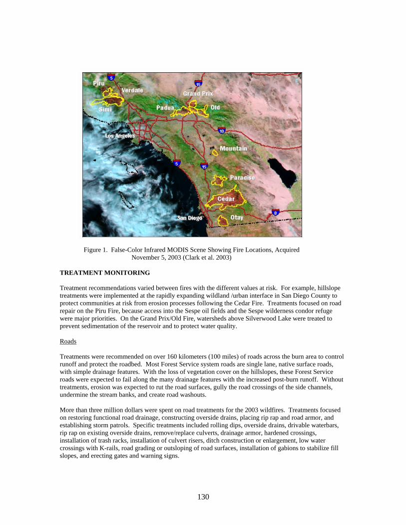
Figure 1. False-Color Infrared MODIS Scene Showing Fire Locations, Acquired November 5, 2003 (Clark et al. 2003)
TREATMENT MONITORING Treatment recommendations varied between fires with the different values at risk. For example, hillslope treatments were implemented at the rapidly expanding wildland /urban interface in San Diego County to protect communities at risk from erosion processes following the Cedar Fire. Treatments focused on road repair on the Piru Fire, because access into the Sespe oil fields and the Sespe wilderness condor refuge were major priorities. On the Grand Prix/Old Fire, watersheds above Silverwood Lake were treated to prevent sedimentation of the reservoir and to protect water quality. Roads Treatments were recommended on over 160 kilometers (100 miles) of roads across the burn area to control runoff and protect the roadbed. Most Forest Service system roads are single lane, native surface roads, with simple drainage features. With the loss of vegetation cover on the hillslopes, these Forest Service roads were expected to fail along the many drainage features with the increased post-burn runoff. Without treatments, erosion was expected to rut the road surfaces, gully the road crossings of the side channels, undermine the stream banks, and create road washouts. More than three million dollars were spent on road treatments for the 2003 wildfires. Treatments focused on restoring functional road drainage, constructing overside drains, placing rip rap and road armor, and establishing storm patrols. Specific treatments included rolling dips, overside drains, drivable waterbars, rip rap on existing overside drains, remove/replace culverts, drainage armor, hardened crossings, installation of trash racks, installation of culvert risers, ditch construction or enlargement, low water crossings with K-rails, road grading or outsloping of road surfaces, installation of gabions to stabilize fill slopes, and erecting gates and warning signs.
130
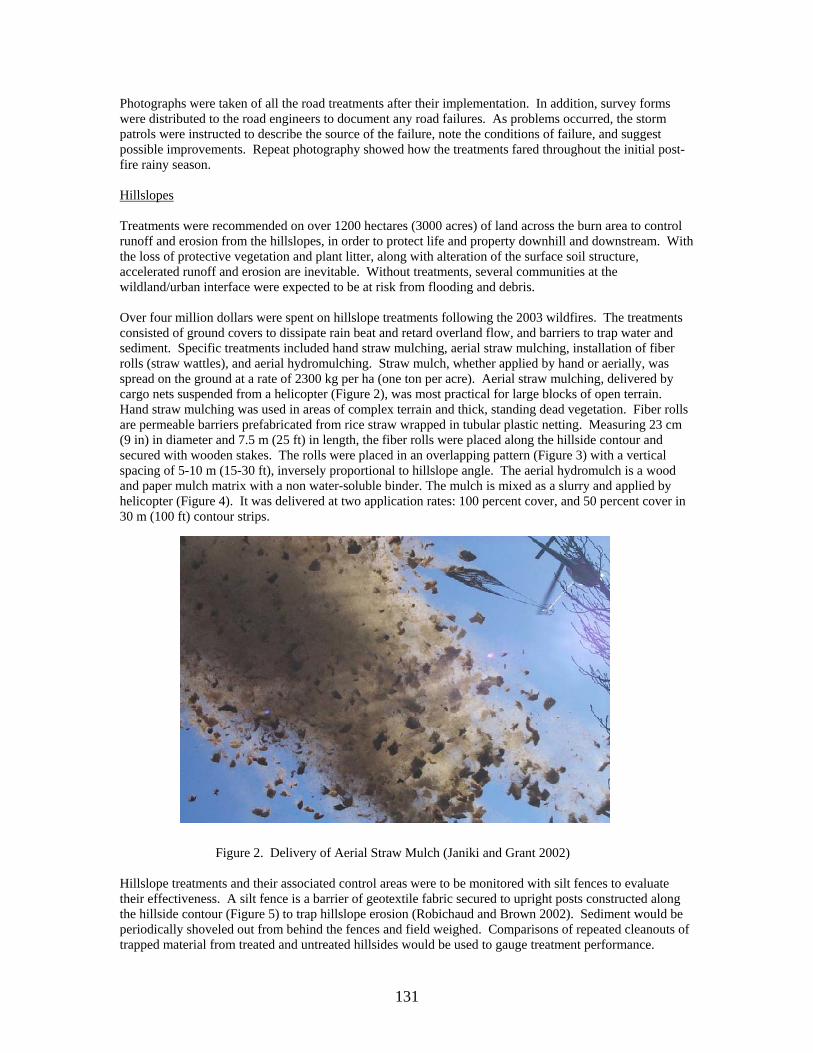
Photographs were taken of all the road treatments after their implementation. In addition, survey forms were distributed to the road engineers to document any road failures. As problems occurred, the storm patrols were instructed to describe the source of the failure, note the conditions of failure, and suggest possible improvements. Repeat photography showed how the treatments fared throughout the initial post-fire rainy season. Hillslopes Treatments were recommended on over 1200 hectares (3000 acres) of land across the burn area to control runoff and erosion from the hillslopes, in order to protect life and property downhill and downstream. With the loss of protective vegetation and plant litter, along with alteration of the surface soil structure, accelerated runoff and erosion are inevitable. Without treatments, several communities at the wildland/urban interface were expected to be at risk from flooding and debris. Over four million dollars were spent on hillslope treatments following the 2003 wildfires. The treatments consisted of ground covers to dissipate rain beat and retard overland flow, and barriers to trap water and sediment. Specific treatments included hand straw mulching, aerial straw mulching, installation of fiber rolls (straw wattles), and aerial hydromulching. Straw mulch, whether applied by hand or aerially, was spread on the ground at a rate of 2300 kg per ha (one ton per acre). Aerial straw mulching, delivered by cargo nets suspended from a helicopter (Figure 2), was most practical for large blocks of open terrain. Hand straw mulching was used in areas of complex terrain and thick, standing dead vegetation. Fiber rolls are permeable barriers prefabricated from rice straw wrapped in tubular plastic netting. Measuring 23 cm (9 in) in diameter and 7.5 m (25 ft) in length, the fiber rolls were placed along the hillside contour and secured with wooden stakes. The rolls were placed in an overlapping pattern (Figure 3) with a vertical spacing of 5-10 m (15-30 ft), inversely proportional to hillslope angle. The aerial hydromulch is a wood and paper mulch matrix with a non water-soluble binder. The mulch is mixed as a slurry and applied by helicopter (Figure 4). It was delivered at two application rates: 100 percent cover, and 50 percent cover in 30 m (100 ft) contour strips.
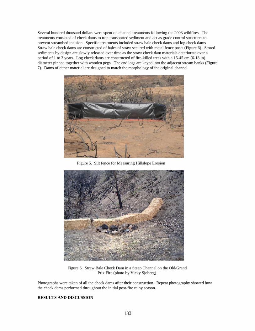
Figure 2. Delivery of Aerial Straw Mulch (Janiki and Grant 2002) Hillslope treatments and their associated control areas were to be monitored with silt fences to evaluate their effectiveness. A silt fence is a barrier of geotextile fabric secured to upright posts constructed along the hillside contour (Figure 5) to trap hillslope erosion (Robichaud and Brown 2002). Sediment would be periodically shoveled out from behind the fences and field weighed. Comparisons of repeated cleanouts of trapped material from treated and untreated hillsides would be used to gauge treatment performance.
131

Unfortunately, only the aerial hydromulch treatment was monitored with silt fences. Silt fences were not able to be constructed in a timely manner for either of the straw mulch treatments. Suitable control sites were unavailable for the fiber rolls. The performance of these latter treatments was monitored by repeat photography.
Figure 3. Fiber Rolls in an Overlapping Pattern with Spacing Inversely Proportional to Slope Angle on the Cedar Fire
Figure 4. Delivery of Aerial Hydromulch on the Cedar Fire Channels Treatments were recommended on over 1.6 kilometers (one mile) of stream channels in two burned watersheds, both to control runoff and trap sediment before they reached downstream values at risk. With the accelerated runoff and erosion from the hillsides, the potential for debris flows in these steep watersheds was deemed extremely high. Without treatments, a resort and a water supply reservoir were expected to be at risk from flooding and debris flows.
132
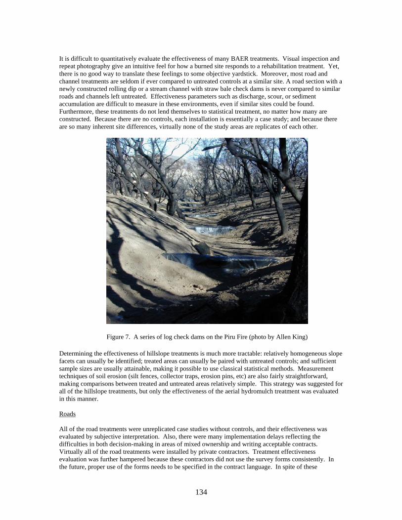
Several hundred thousand dollars were spent on channel treatments following the 2003 wildfires. The treatments consisted of check dams to trap transported sediment and act as grade control structures to prevent streambed incision. Specific treatments included straw bale check dams and log check dams. Straw bale check dams are constructed of bales of straw secured with metal fence posts (Figure 6). Stored sediments by design are slowly released over time as the straw check dam materials deteriorate over a period of 1 to 3 years. Log check dams are constructed of fire-killed trees with a 15-45 cm (6-18 in) diameter pinned together with wooden pegs. The end logs are keyed into the adjacent stream banks (Figure 7). Dams of either material are designed to match the morphology of the original channel.
Figure 5. Silt fence for Measuring Hillslope Erosion
Figure 6. Straw Bale Check Dam in a Steep Channel on the Old/Grand Prix Fire (photo by Vicky Sjoberg)
Photographs were taken of all the check dams after their construction. Repeat photography showed how the check dams performed throughout the initial post-fire rainy season. RESULTS AND DISCUSSION
133
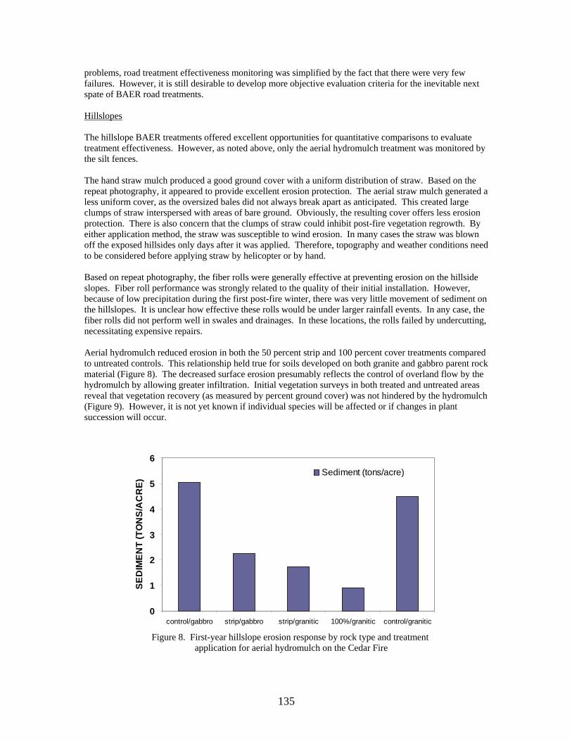
It is difficult to quantitatively evaluate the effectiveness of many BAER treatments. Visual inspection and repeat photography give an intuitive feel for how a burned site responds to a rehabilitation treatment. Yet, there is no good way to translate these feelings to some objective yardstick. Moreover, most road and channel treatments are seldom if ever compared to untreated controls at a similar site. A road section with a newly constructed rolling dip or a stream channel with straw bale check dams is never compared to similar roads and channels left untreated. Effectiveness parameters such as discharge, scour, or sediment accumulation are difficult to measure in these environments, even if similar sites could be found. Furthermore, these treatments do not lend themselves to statistical treatment, no matter how many are constructed. Because there are no controls, each installation is essentially a case study; and because there are so many inherent site differences, virtually none of the study areas are replicates of each other.
Figure 7. A series of log check dams on the Piru Fire (photo by Allen King) Determining the effectiveness of hillslope treatments is much more tractable: relatively homogeneous slope facets can usually be identified; treated areas can usually be paired with untreated controls; and sufficient sample sizes are usually attainable, making it possible to use classical statistical methods. Measurement techniques of soil erosion (silt fences, collector traps, erosion pins, etc) are also fairly straightforward, making comparisons between treated and untreated areas relatively simple. This strategy was suggested for all of the hillslope treatments, but only the effectiveness of the aerial hydromulch treatment was evaluated in this manner. Roads All of the road treatments were unreplicated case studies without controls, and their effectiveness was evaluated by subjective interpretation. Also, there were many implementation delays reflecting the difficulties in both decision-making in areas of mixed ownership and writing acceptable contracts. Virtually all of the road treatments were installed by private contractors. Treatment effectiveness evaluation was further hampered because these contractors did not use the survey forms consistently. In the future, proper use of the forms needs to be specified in the contract language. In spite of these
134
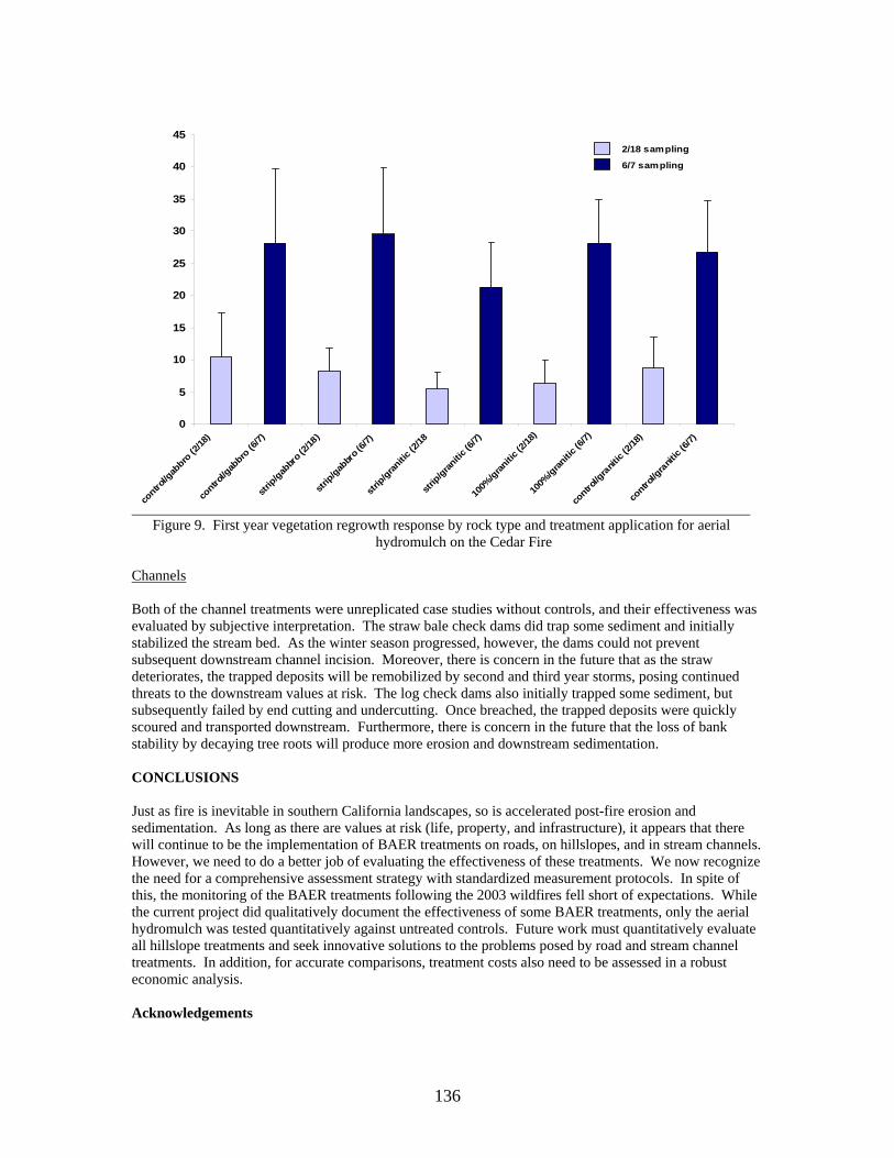
problems, road treatment effectiveness monitoring was simplified by the fact that there were very few failures. However, it is still desirable to develop more objective evaluation criteria for the inevitable next spate of BAER road treatments. Hillslopes The hillslope BAER treatments offered excellent opportunities for quantitative comparisons to evaluate treatment effectiveness. However, as noted above, only the aerial hydromulch treatment was monitored by the silt fences. The hand straw mulch produced a good ground cover with a uniform distribution of straw. Based on the repeat photography, it appeared to provide excellent erosion protection. The aerial straw mulch generated a less uniform cover, as the oversized bales did not always break apart as anticipated. This created large clumps of straw interspersed with areas of bare ground. Obviously, the resulting cover offers less erosion protection. There is also concern that the clumps of straw could inhibit post-fire vegetation regrowth. By either application method, the straw was susceptible to wind erosion. In many cases the straw was blown off the exposed hillsides only days after it was applied. Therefore, topography and weather conditions need to be considered before applying straw by helicopter or by hand. Based on repeat photography, the fiber rolls were generally effective at preventing erosion on the hillside slopes. Fiber roll performance was strongly related to the quality of their initial installation. However, because of low precipitation during the first post-fire winter, there was very little movement of sediment on the hillslopes. It is unclear how effective these rolls would be under larger rainfall events. In any case, the fiber rolls did not perform well in swales and drainages. In these locations, the rolls failed by undercutting, necessitating expensive repairs. Aerial hydromulch reduced erosion in both the 50 percent strip and 100 percent cover treatments compared to untreated controls. This relationship held true for soils developed on both granite and gabbro parent rock material (Figure 8). The decreased surface erosion presumably reflects the control of overland flow by the hydromulch by allowing greater infiltration. Initial vegetation surveys in both treated and untreated areas reveal that vegetation recovery (as measured by percent ground cover) was not hindered by the hydromulch (Figure 9). However, it is not yet known if individual species will be affected or if changes in plant succession will occur.
0
1
2
3
4
5
6
control/gabbro strip/gabbro strip/granitic 100%/granitic control/granitic
SED
IMEN
T (T
ON
S/A
CR
E)
Sediment (tons/acre)
Figure 8. First-year hillslope erosion response by rock type and treatment application for aerial hydromulch on the Cedar Fire
135
0
5
10
15
20
25
30
35
40
45
contro
l/gab
bro (2
/18)
contro
l/gab
bro (6
/7)
strip/gab
bro (
2/18)
strip/gab
bro (
6/7)
strip/gran
itic (2
/18
strip/gran
itic (6
/7)
100%
/granitic
(2/18
)
100%
/granitic
(6/7)
contro
l/gra
nitic
(2/18
)
contro
l/gra
nitic
(6/7)
2/18 sampling
6/7 sampling
Figure 9. First year vegetation regrowth response by rock type and treatment application for aerial hydromulch on the Cedar Fire
Channels Both of the channel treatments were unreplicated case studies without controls, and their effectiveness was evaluated by subjective interpretation. The straw bale check dams did trap some sediment and initially stabilized the stream bed. As the winter season progressed, however, the dams could not prevent subsequent downstream channel incision. Moreover, there is concern in the future that as the straw deteriorates, the trapped deposits will be remobilized by second and third year storms, posing continued threats to the downstream values at risk. The log check dams also initially trapped some sediment, but subsequently failed by end cutting and undercutting. Once breached, the trapped deposits were quickly scoured and transported downstream. Furthermore, there is concern in the future that the loss of bank stability by decaying tree roots will produce more erosion and downstream sedimentation. CONCLUSIONS Just as fire is inevitable in southern California landscapes, so is accelerated post-fire erosion and sedimentation. As long as there are values at risk (life, property, and infrastructure), it appears that there will continue to be the implementation of BAER treatments on roads, on hillslopes, and in stream channels. However, we need to do a better job of evaluating the effectiveness of these treatments. We now recognize the need for a comprehensive assessment strategy with standardized measurement protocols. In spite of this, the monitoring of the BAER treatments following the 2003 wildfires fell short of expectations. While the current project did qualitatively document the effectiveness of some BAER treatments, only the aerial hydromulch was tested quantitatively against untreated controls. Future work must quantitatively evaluate all hillslope treatments and seek innovative solutions to the problems posed by road and stream channel treatments. In addition, for accurate comparisons, treatment costs also need to be assessed in a robust economic analysis. Acknowledgements
136
We thank the others on the Strategic Planning Team: Pete Robichaud, Sherry Hazelhurst, and Mary O’Dea. We also thank Wes Christensen, Valerie Oriel, Lynne Casal, Erin Kreutz and the Cleveland National Forest Engine Crew E47 for valuable field assistance. We further thank Allen King and Vicky Sjoberg for their photo-documentary expertise. Literature Cited Clark, J., A. Parsons, T. Zajkowski and K.Lannom. 2003. Remote Sensing Imagery Support for Burned Area Emergency Response Teams on 2003 Southern California Wildfires. RSAC-2003-RPT1 Remote Sensing Applications Center, Salt Lake City, UT DeBano, L.F. 1981. Water repellent soils: A-state-of-the-art. U.S. Department of Agriculture, Forest Service, Pacific Southwest Forest and Range Experiment Station, General Technical Report PSW-46. 21 pp. GAO. 2003. Wildland fires: Better information needed on effectiveness of emergency stabilization and rehabilitation treatments. Report No. GAO-03-430. Washington, DC: U. S. General Accounting Office. 55 pp. Hubbert, K.R. 2004. Treatment effectiveness monitoring for southern California wildfires: 2003 to 2004. Report to Region 5, U.S. Department of Agriculture, Forest Service. 236 pp. Janicki, A. and S. Grant. 2002. Heli-mulching on the Darby Fire: A Case Study. U.S.Department of Agriculture, Forest Service, Stanislaus National Forest. 12 pp. Robichaud, P.R., J.L. Beyers and D.G. Neary. 2000. Evaluating the effectiveness of postfire rehabilitation treatments. U.S. Department of Agriculture, Forest Service, Rocky Mountain Research Station, General Technical Report RMRS-GTR-63. 85 pp. Robichaud, P.R. and R.E. Brown. 2002. Silt fences: An economical technique for measuring hillslope soil erosion. U.S.Department of Agriculture, Forest Service, Rocky Mountain Research Station, General Technical Report RMRS-GTR-94. 24 pp. Rowe, P.B., C.M. Countryman and H.C. Storey. 1954. Hydrologic analysis used to determine effects of fire on peak discharge and erosion rates in southern California watersheds. U.S. Department of Agriculture, Forest Service, California Forest and Range Experiment Station. 49 pp. Wells, W.G, II. 1981. Some Effects of Brushfires on Erosion Processes in Coastal Southern California. Pages 305-342 in: Erosion and Sediment Transport in Pacific Rim Steeplands. IAHS Publ. 132.
137