Embed Size (px)
Citation preview
University of Nebraska - LincolnDigitalCommons@University of Nebraska - LincolnConference Presentations and White Papers:Biological Systems Engineering Biological Systems Engineering
6-2009
Evaluation of a Terrain Attribute Model forLocating Areas Suitable for Grassed Waterways inAgricultural SettingsJoe D. LuckUniversity of Nebraska-Lincoln, [email protected]
Adam C. PikePhoto Science, Lexington, KY
Santosh PitlaUniversity of Nebraska-Lincoln, [email protected]
Tom MuellerPlant and Soil Sciences, Lexington, KY
Scott A. ShearerUniversity of Kentucky, [email protected]
Follow this and additional works at: https://digitalcommons.unl.edu/biosysengpres
Part of the Bioresource and Agricultural Engineering Commons
This Article is brought to you for free and open access by the Biological Systems Engineering at DigitalCommons@University of Nebraska - Lincoln. Ithas been accepted for inclusion in Conference Presentations and White Papers: Biological Systems Engineering by an authorized administrator ofDigitalCommons@University of Nebraska - Lincoln.
Luck, Joe D.; Pike, Adam C.; Pitla, Santosh; Mueller, Tom; and Shearer, Scott A., "Evaluation of a Terrain Attribute Model for LocatingAreas Suitable for Grassed Waterways in Agricultural Settings" (2009). Conference Presentations and White Papers: Biological SystemsEngineering. 62.https://digitalcommons.unl.edu/biosysengpres/62
The authors are solely responsible for the content of this technical presentation. The technical presentation does not necessarily reflect the official position of the American Society of Agricultural and Biological Engineers (ASABE), and its printing and distribution does not constitute an endorsement of views which may be expressed. Technical presentations are not subject to the formal peer review process by ASABE editorial committees; therefore, they are not to be presented as refereed publications. Citation of this work should state that it is from an ASABE meeting paper. EXAMPLE: Author's Last Name, Initials. 2009. Title of Presentation. ASABE Paper No. 09----. St. Joseph, Mich.: ASABE. For information about securing permission to reprint or reproduce a technical presentation, please contact ASABE at [email protected] or 269-429-0300 (2950 Niles Road, St. Joseph, MI 49085-9659 USA).
An ASABE Meeting Presentation Paper Number: 096801
Evaluation of a Terrain Attribute Model for Locating Areas Suitable for Grassed Waterways in Agricultural
Settings Joe D. Luck, P.E., Engineer Associate
Biosystems and Agricultural Engineering, 128 C.E. Barnhart Building, Lexington, KY 40546, [email protected]
Adam C. Pike, GIS and Remote Sensing Analyst Photo Science, Inc., 2670 Wilhite Drive, Lexington, KY 40503
Santosh K. Pitla, Engineer Associate Biosystems and Agricultural Engineering, 128 C.E. Barnhart Building, Lexington, KY 40546
Tom Mueller, Ph.D., Associate Professor Plant and Soil Sciences, 1100 Nicholasville Road, Lexington, KY 40546
Scott A. Shearer, Ph.D., P.E., Professor and Chair Biosystems and Agricultural Engineering, 128 C.E. Barnhart Building, Lexington, KY 40546
Written for presentation at the 2009 ASABE Annual International Meeting
Sponsored by ASABE Grand Sierra Resort and Casino
Reno, Nevada June 21 – June 24, 2009
Abstract. Grassed waterways placed in high water flow zones substantially reduce erosion in agricultural fields. A recent study proposed a statistical model for waterway planning for a farm in the Outer Bluegrass physiographic region of Kentucky. The logistic regression model identified where channel erosion was likely to occur based on elevation-derived terrain attributes. The objective of this study was to test their model in fields located in the Western Coal Fields physiographic region where soils differ substantially. Model predictions corresponded well with known areas of concentrated flow (i.e., maps of existing waterways, surface drains, and observations of erosion). The geographic inference space of the waterway planning model was large. Overall, the results indicated that the geographic inference space of the waterway planning model was larger than expected. This analysis suggested that the proposed modeling procedure was robust and has the potential to be an effective tool to help conservationists identify areas where waterways should be located on some Kentucky landscapes.

The authors are solely responsible for the content of this technical presentation. The technical presentation does not necessarily reflect the official position of the American Society of Agricultural and Biological Engineers (ASABE), and its printing and distribution does not constitute an endorsement of views which may be expressed. Technical presentations are not subject to the formal peer review process by ASABE editorial committees; therefore, they are not to be presented as refereed publications. Citation of this work should state that it is from an ASABE meeting paper. EXAMPLE: Author's Last Name, Initials. 2009. Title of Presentation. ASABE Paper No. 09----. St. Joseph, Mich.: ASABE. For information about securing permission to reprint or reproduce a technical presentation, please contact ASABE at [email protected] or 269-429-0300 (2950 Niles Road, St. Joseph, MI 49085-9659 USA).
Keywords. Erosion, Soil conservation, Precision agriculture, Logistic regression.
2
Introduction Grassed waterways (GWWs) are commonly used in North America and provide a number of environmental benefits (Chow et al. 1999). They reduce erosion (NRC 1986) by trapping sediment and reducing runoff (Fiener and Auerswald 2003). They have also been shown to reduce off-site movement of herbicide residues when compared to non-grassed waterways (Briggs et al. 1999).
If a region in a field has sufficient erosion resulting from concentrated water flow, the United States Department of Agriculture (USDA) Natural Resources Conservation Service (NRCS) provides funding to producers for the establishment and maintenance of approved waterways in these areas (NRCS 2008a). The first step in successfully establishing a grassed waterway is for an NRCS conservationist to make a site assessment to determine if sufficient erosion exists to warrant mitigation. This involves traversing fields to locate physical evidence of prior erosion which can be a time consuming and expensive process. If GWWs are enrolled into the continuous Conservation Reserve Program (CRP), typically NRCS requires the eroded channel to be reshaped and graded prior to seeding and buffered with additional vegetation (NRCS 2008b).
Precision agriculture technologies such as global positioning systems (GPS) and geographic information systems (GIS) may improve the efficiency of locating areas for location of GWWs per NRCS guidelines. In a previous study, a model was developed with considerable predictive capacity that identified where erosion resulting from concentrated water flow was likely to occur (Pike et al. 2009). The model was developed with data from five fields located in the Outer Bluegrass physiographic region of Kentucky, each containing extensive GWWs. For model input, they used a 4.0 by 4.0 meter grid of terrain attribute values (i.e., length-slope factor, topographic wetness index, and plan curvature) that corresponded to digital elevation model (DEM) grid points derived from real-time kinematic (RTK) GPS elevation measurements. For each grid value, they assigned a logit variable a value of 1.0 if terrain attributes were located within eroded waterways and a value of 0.0 if they were outside the waterway. Logistic regression and neural network analyses were used to fit these data and leave-one-field-out validation procedures were used to confirm their results. Their validation analyses demonstrated that most of the eroded features requiring GWWs could be identified with this procedure. They concluded that the erosion probability maps had excellent predictive capacity.
The focus of this study was to test the logistic regression model developed by Pike et al. (2009) on agricultural fields located in a different physiographic region of Kentucky to better understand the limitations of this approach. The premise of this manuscript was the logistic regression model would be useful to planners if predictions matched with the locations of existing waterways, surface drains, or field observations of erosion associated with concentrated water flow.
Materials and Methods The model was tested on two fields in Hopkins County located in the Western Coal Fields physiographic region of Kentucky. These fields were selected because GWWs had previously been installed as delineated by an NRCS Conservationist and others installed by the producer without input from NRCS personnel. Field A (38° 26.3’ N, 87° 26.1’ W; 27 ha) contained several GWWs delineated by the producer. Field B (37° 27.5’ N, 87° 33.7’ W; 22.7 ha) contained multiple GWWs that were delineated by the NRCS Conservationist. Some grading and reshaping was performed prior to seeding for each waterway under the direction of the NRCS
3
Conservationist. The typical width of the GWWs in field B was approximately 25 m. Both study fields have been in a corn (Zea mays) and soybean (Glycine max) rotation and managed with no-till practices for the past 5 years.
The soils of the fields in this study were developed primarily from loess or silty alluvium and generally consist of Belknap, Grenada, and Loring silt loam soils (SCS, 1977). In contrast, soils in the fields where the model was developed (i.e., the Outer Bluegrass region) primarily formed in limestone residuum overlain by loess and generally consisted of Lowell, Nicholson, and Shelbyville silt loam soils (SCS, 1980).
Real-time kinematic (RTK) GPS was used to collect elevation data for field A in 2001 and field B in 2008. The RTK GPS setup included an AgGPS 214 receiver (Trimble Ltd., Sunnyvale, CA) which was used as the base station with an identical receiver used as the rover. Elevation measurements were logged each second along parallel passes with approximately 3 to 4 m between consecutive measurements and a separation of 10 m between passes. The geographic coordinates were recorded (latitude and longitude in WGS84 decimal degrees format) along with the elevation (in meters).
The elevation data for both fields were pre-processed prior to calculating terrain attributes according to methods described by Pike et al. (2009). This consisted of downloading the United States Geological Survey (USGS) 9.1 m DEMs and calculating the distance between the USGS elevation value and the RTK GPS measurements recorded during the field surveys. Then the RTK GPS measurements were corrected using the average difference between the two datasets and 1 m contour maps were created for each field from these corrected DEMs. Next, a 4 m DEM was created from the contour map for each field with no drainage enforcement. These DEMs were used as input for the TAPESG for Windows 7.1 (University of Southern California, Los Angeles, CA) software in order to calculate the required terrain attributes. The FD8 flow direction algorithm and the finite difference slope estimation procedure were used. After successfully calculating the terrain attributes, the analysis proceeded with calculating the probability of erosion for each field.
Pike et al. (2009) presented a logistic regression model using three terrain attributes; length-slope factor (LS), topographic wetness index (WET), and plan curvature (PLAN) for calculating the probability of erosion.
From Pike et al. (2009), the probability of erosion was calculated as:
High quality aerial photographs taken in 2006 (KDGI, 2006) were downloaded for each field and imported into ArcMap® (ESRI, v9.3) along with the probability of erosion maps previously calculated using Eq. (1). Areas of each field with a probability of erosion between 0.5 and 1.0 were plotted as overlays on the aerial photographs. Field boundaries and existing GWW boundaries were overlain on each map. A site visit was conducted for both study fields during April of 2009. During the site visits, areas where erosion channels had developed without existing GWWs for protection were observed. Photographs were taken in these areas and the locations were denoted on the aerial imagery with arrows indicating the viewpoint of the camera.
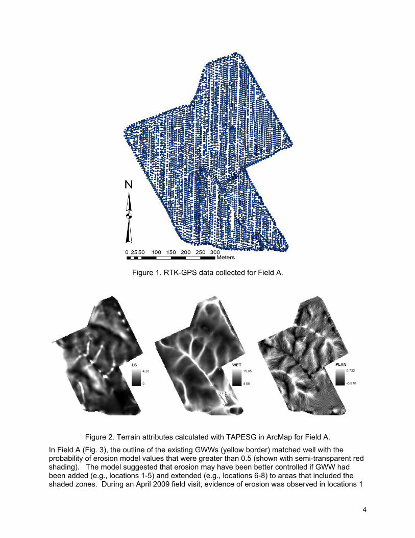
Results and Discussion Fig. 1 displays the RTK-GPS points that were recorded for Field A. These data were imported into ArcMap for terrain analysis. The results of the terrain analysis for the three terrain attributes (LS, WET, and PLAN) used in the probability of erosion calculation (Eq. 1) are shown in Fig. 2.
4
Figure 1. RTK-GPS data collected for Field A.
Figure 2. Terrain attributes calculated with TAPESG in ArcMap for Field A.
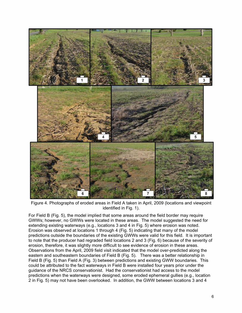
In Field A (Fig. 3), the outline of the existing GWWs (yellow border) matched well with the probability of erosion model values that were greater than 0.5 (shown with semi-transparent red shading). The model suggested that erosion may have been better controlled if GWW had been added (e.g., locations 1-5) and extended (e.g., locations 6-8) to areas that included the shaded zones. During an April 2009 field visit, evidence of erosion was observed in locations 1
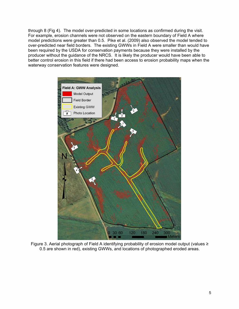
5
through 8 (Fig 4). The model over-predicted in some locations as confirmed during the visit. For example, erosion channels were not observed on the eastern boundary of Field A where model predictions were greater than 0.5. Pike et al. (2009) also observed the model tended to over-predicted near field borders. The existing GWWs in Field A were smaller than would have been required by the USDA for conservation payments because they were installed by the producer without the guidance of the NRCS. It is likely the producer would have been able to better control erosion in this field if there had been access to erosion probability maps when the waterway conservation features were designed.
Figure 3. Aerial photograph of Field A identifying probability of erosion model output (values ≥
0.5 are shown in red), existing GWWs, and locations of photographed eroded areas.
6
Figure 4. Photographs of eroded areas in Field A taken in April, 2009 (locations and viewpoint
identified in Fig. 1).
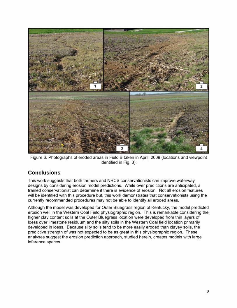
For Field B (Fig. 5), the model implied that some areas around the field border may require GWWs; however, no GWWs were located in these areas. The model suggested the need for extending existing waterways (e.g., locations 3 and 4 in Fig. 5) where erosion was noted. Erosion was observed at locations 1 through 4 (Fig. 5) indicating that many of the model predictions outside the boundaries of the existing GWWs were valid for this field. It is important to note that the producer had regraded field locations 2 and 3 (Fig. 6) because of the severity of erosion, therefore, it was slightly more difficult to see evidence of erosion in these areas. Observations from the April, 2009 field visit indicated that the model over-predicted along the eastern and southeastern boundaries of Field B (Fig. 5). There was a better relationship in Field B (Fig. 5) than Field A (Fig. 3) between predictions and existing GWW boundaries. This could be attributed to the fact waterways in Field B were installed four years prior under the guidance of the NRCS conservationist. Had the conservationist had access to the model predictions when the waterways were designed, some eroded ephemeral gullies (e.g., location 2 in Fig. 5) may not have been overlooked. In addition, the GWW between locations 3 and 4
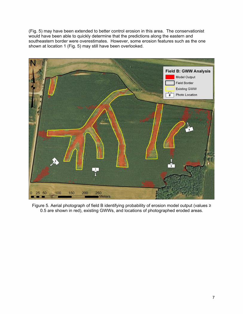
7
(Fig. 5) may have been extended to better control erosion in this area. The conservationist would have been able to quickly determine that the predictions along the eastern and southeastern border were overestimates. However, some erosion features such as the one shown at location 1 (Fig. 5) may still have been overlooked.
Figure 5. Aerial photograph of field B identifying probability of erosion model output (values ≥
0.5 are shown in red), existing GWWs, and locations of photographed eroded areas.
8
Figure 6. Photographs of eroded areas in Field B taken in April, 2009 (locations and viewpoint
identified in Fig. 3).
Conclusions This work suggests that both farmers and NRCS conservationists can improve waterway designs by considering erosion model predictions. While over predictions are anticipated, a trained conservationist can determine if there is evidence of erosion. Not all erosion features will be identified with this procedure but, this work demonstrates that conservationists using the currently recommended procedures may not be able to identify all eroded areas.
Although the model was developed for Outer Bluegrass region of Kentucky, the model predicted erosion well in the Western Coal Field physiographic region. This is remarkable considering the higher clay content soils at the Outer Bluegrass location were developed from thin layers of loess over limestone residuum and the silty soils in the Western Coal field location primarily developed in loess. Because silty soils tend to be more easily eroded than clayey soils, the predictive strength of was not expected to be as great in this physiographic region. These analyses suggest the erosion prediction approach, studied herein, creates models with large inference spaces.

9
References Briggs, J.A., T. Whitwell, and M.B. Riley. 1999. Remediation of herbicides in runoff water from
container plant nurseries utilizing grassed waterways. Weed Tech. 13: 157-164 Chow, T.L., H.W. Rees, and J.L. Daigle. 1999. Effectiveness of terraces/grassed waterway
systems for soil and water conservation: a field evaluation. J. Soil Water Cons. 54: 577-583.
Fiener, P., and K. Auerswald. 2003. Effectiveness of grassed waterways in reducing runoff and sediment delivery from agricultural watersheds. J. Env. Qual. 32: 927-936.
Kentucky Division of Geographic Information. 2006. Digital Ortho Photo Imagery for Kentucky. Available at: ftp://ftp.kymartian.ky.gov. Accessed 4 May 2009.
NRC (National Research Council, Board on Agriculture, Committee on Conservation Needs and Opportunities). 1986. Soil Conservation. Assessing the National Resources Inventory, Vol. 1. Washington, D.C., National Academy Press.
NRCS (Natural Resources Conservation Service). 2008a. Continuous CRP: A Soil Saving Bargain for Corn-Soybean Growers. Available at: www.ia.nrcs.usda.gov. Accessed 21 April 2009.
NRCS (Natural Resources Conservation Service). 2008b. Grassed Waterways. Field Office Technical Guide: Conservation Practice Standard. Code 412. Available at: ftp://ftp-fc.sc.egov.usda.gov/NHQ/practice-standards/standards/412.pdf. Accessed 21 April 2009.
Pike, A.C., T.G. Mueller, A. Schorgendorfer, S.A. Shearer, and A.D. Karathanasis. Erosion indicies derived from terrain attributes using logistic regression and neural networks. Agronomy J. 101(5): 1068-1079.
SCS (Soil Conservation Service). 1977. Soil survey of Hopkins County, Kentucky. USDA, NRCS, Fort Worth, TX.
SCS (Soil Conservation Service). 1980. Soil survey of Shelby County, Kentucky. USDA, NRCS, Fort Worth, TX.